For so many of us, memories of the Loma Prieta quake crystallized around Candlestick Park, where Game 3 of the 1989 A’s-Giants World Series was about to begin.
Many in the Bay Area had rushed home from work to watch on TV. As they waited for the first pitch to be thrown, broadcasters Al Michaels and Tim McCarver analyzed highlights from the previous game. Suddenly, the image of Jose Canseco flickered out, followed by an audio-only pronouncement of Michaels:
“I tell ya what, I think we’re having an earth-”
Again, the transmission cut, before the audio returned. “I don’t know if we’re on the air or not, and I’m not sure I care at this particular moment … ” Michaels said.
Major League Baseball canceled the game. Players and fans, in a state of shock, made their way home. People already at home were glued to the radio or TV news as damage reports poured in. Fires broke out in San Francisco’s Marina District. The Cypress Viaduct pancaked. A section of the Bay Bridge caved in. A department store in Santa Cruz’s Pacific Garden Mall collapsed. The 6.9 magnitude quake killed at least 63 people and caused $6-10 billion dollars in property loss.
Beyond the public eye, away from the news teams, plenty more was going on. What happened there in the days, months and years following Oct. 17, 1989 would rewrite our understanding of how the ground moves and what we need to do to stay safe.
Quake Throws Scientists for a Loop
“Loma Prieta was in many ways a transformative earthquake,” said Bill Ellsworth, a professor of geophysics at Stanford. In 1989, he worked as a researcher at the U.S. Geological Survey headquarters in Menlo Park.
At 5:03 p.m., Ellsworth had been preparing to leave work for the day and go home to watch the ball game. At 5:04, he said, “I felt the ground begin to move.”
He knew instantly this was no ordinary small-scale temblor.
“Often we feel earthquakes and there’s kind of a sharp rattle. This was a much lower-frequency motion, and really quite large amplitude. Putting those two together told me immediately that this was going to be a significant earthquake.”
He got up, braced himself in the doorframe, and “rode through the earthquake.”
The USGS snapped into action. Its first task was to determine the source. The agency’s automated network of sensors had gone out, as had the power and all the computers.
“We actually did it the old-fashioned way,” said Tom Holzer, a USGS geologist. At the time Holzer was the branch chief for the team that did much of the work documenting the earthquake.
“We had these old recording drums . . . they’re what earthquakes used to look like before we had all the digital stuff.”
Within the hour, his team had pinpointed the epicenter near Santa Cruz.
“The next step was to to get organized to have people go out and document what had happened,” Holzer says. “We actually sent one person out that night. He volunteered to drive to Santa Cruz to see if the fault intersected any of the roads he was on.”
Other USGS staff went to work supporting responders. Some of the most severe damage took place at the Cypress Viaduct, a two-tiered freeway that connected West Oakland to the MacArthur Maze. Its top level collapsed onto the bottom, and 42 people — two-thirds of the earthquake’s death toll — lost their lives there.
“It clearly needed to be taken down but to do that was dangerous and were another strong earthquake to occur while people were working on that, they would really be in harm’s way,” Ellsworth said.
Within days, engineers built the first earthquake early warning system used in the United States, to alert demolition crews about coming aftershocks.
“We placed instruments in the Loma Prieta region,” Ellsworth said, “and then if shaking were strong we would send a radio signal to the Cypress Structure, to tell people that sound an alarm to tell people that they needed to take action to be safe.”
Fortunately, there were no aftershocks during the demolition. But Ellsworth says the earthquake threw scientists for a loop in other ways. For starters, the earthquake struck in a location they had not expected.
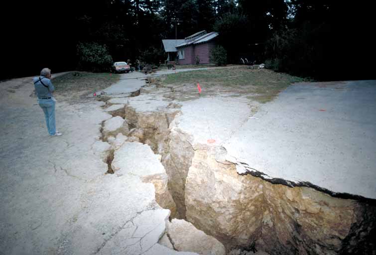
A dangerous quake had seemed likely on the southern part of the 1906 rupture along the San Andreas Fault. The Loma Prieta quake was close to that, “but it was on an unknown fault we had never seen before,” Ellsworth said. “So it really reminded us that we don’t know where all the faults are.”
Ground Motion Illuminated
Before the quake, engineers generally modeled earthquake intensity the way they did volume. The closer you are to the source, the stronger the signal. The 1989 disaster showed clearly in the Bay Area how certain regions, particularly areas built on fill, or unstable soil, can amplify the motion of the ground.
“There was severe damage 100 kilometers away from the epicenter. So that is much farther than we would generally expect for this size, this magnitude earthquake,” said Annemarie Baltay, a current USGS researcher.
“Just as if you have a bowl of Jell-O and you shake it once. You stop touching it. It continues to wiggle, right?” Baltay says. “But if you took a rock and you shook it and you stopped shaking, it would just stop.”
This kind of extreme shaking happened in San Francisco’s Marina District, at the Cypress Viaduct, and along the Bay at the San Francisco and Oakland airports.
“The [building] code didn’t have a very good accommodation of what soft soils could do to modify the shaking,” Holzer says.
The insights that came out of studying this quake spurred a lot of research. In 1990, Congress directed $40 million to the USGS to study earthquakes and reduce their hazards. Scientists reassessed the earthquake threat to the region. What they learned informed new building codes and spurred retrofits and rebuilds around the state.
“And if we look at the way that we designed freeways before then, and now they are very different,” Ellsworth said. “I think the earthquake really helped educate the public about the reality of earthquakes and over the following years we’ve made a lot of progress in California in terms of addressing many of those problems.”