window.__IS_SSR__=true
window.__INITIAL_STATE__={
"attachmentsReducer": {
"audio_0": {
"type": "attachments",
"id": "audio_0",
"imgSizes": {
"kqedFullSize": {
"file": "https://ww2.kqed.org/news/wp-content/themes/KQED-unified/img/audio_bgs/background0.jpg"
}
}
},
"audio_1": {
"type": "attachments",
"id": "audio_1",
"imgSizes": {
"kqedFullSize": {
"file": "https://ww2.kqed.org/news/wp-content/themes/KQED-unified/img/audio_bgs/background1.jpg"
}
}
},
"audio_2": {
"type": "attachments",
"id": "audio_2",
"imgSizes": {
"kqedFullSize": {
"file": "https://ww2.kqed.org/news/wp-content/themes/KQED-unified/img/audio_bgs/background2.jpg"
}
}
},
"audio_3": {
"type": "attachments",
"id": "audio_3",
"imgSizes": {
"kqedFullSize": {
"file": "https://ww2.kqed.org/news/wp-content/themes/KQED-unified/img/audio_bgs/background3.jpg"
}
}
},
"audio_4": {
"type": "attachments",
"id": "audio_4",
"imgSizes": {
"kqedFullSize": {
"file": "https://ww2.kqed.org/news/wp-content/themes/KQED-unified/img/audio_bgs/background4.jpg"
}
}
},
"placeholder": {
"type": "attachments",
"id": "placeholder",
"imgSizes": {
"thumbnail": {
"file": "https://cdn.kqed.org/wp-content/uploads/2024/12/KQED-Default-Image-816638274-2000x1333-1-160x107.jpg",
"width": 160,
"height": 107,
"mimeType": "image/jpeg"
},
"medium": {
"file": "https://cdn.kqed.org/wp-content/uploads/2024/12/KQED-Default-Image-816638274-2000x1333-1-800x533.jpg",
"width": 800,
"height": 533,
"mimeType": "image/jpeg"
},
"medium_large": {
"file": "https://cdn.kqed.org/wp-content/uploads/2024/12/KQED-Default-Image-816638274-2000x1333-1-768x512.jpg",
"width": 768,
"height": 512,
"mimeType": "image/jpeg"
},
"large": {
"file": "https://cdn.kqed.org/wp-content/uploads/2024/12/KQED-Default-Image-816638274-2000x1333-1-1020x680.jpg",
"width": 1020,
"height": 680,
"mimeType": "image/jpeg"
},
"1536x1536": {
"file": "https://cdn.kqed.org/wp-content/uploads/2024/12/KQED-Default-Image-816638274-2000x1333-1-1536x1024.jpg",
"width": 1536,
"height": 1024,
"mimeType": "image/jpeg"
},
"fd-lrg": {
"file": "https://cdn.kqed.org/wp-content/uploads/2024/12/KQED-Default-Image-816638274-2000x1333-1-1536x1024.jpg",
"width": 1536,
"height": 1024,
"mimeType": "image/jpeg"
},
"fd-med": {
"file": "https://cdn.kqed.org/wp-content/uploads/2024/12/KQED-Default-Image-816638274-2000x1333-1-1020x680.jpg",
"width": 1020,
"height": 680,
"mimeType": "image/jpeg"
},
"fd-sm": {
"file": "https://cdn.kqed.org/wp-content/uploads/2024/12/KQED-Default-Image-816638274-2000x1333-1-800x533.jpg",
"width": 800,
"height": 533,
"mimeType": "image/jpeg"
},
"post-thumbnail": {
"file": "https://cdn.kqed.org/wp-content/uploads/2024/12/KQED-Default-Image-816638274-2000x1333-1-672x372.jpg",
"width": 672,
"height": 372,
"mimeType": "image/jpeg"
},
"twentyfourteen-full-width": {
"file": "https://cdn.kqed.org/wp-content/uploads/2024/12/KQED-Default-Image-816638274-2000x1333-1-1038x576.jpg",
"width": 1038,
"height": 576,
"mimeType": "image/jpeg"
},
"xxsmall": {
"file": "https://cdn.kqed.org/wp-content/uploads/2024/12/KQED-Default-Image-816638274-2000x1333-1-160x107.jpg",
"width": 160,
"height": 107,
"mimeType": "image/jpeg"
},
"xsmall": {
"file": "https://cdn.kqed.org/wp-content/uploads/2024/12/KQED-Default-Image-816638274-2000x1333-1-672x372.jpg",
"width": 672,
"height": 372,
"mimeType": "image/jpeg"
},
"small": {
"file": "https://cdn.kqed.org/wp-content/uploads/2024/12/KQED-Default-Image-816638274-2000x1333-1-672x372.jpg",
"width": 672,
"height": 372,
"mimeType": "image/jpeg"
},
"xlarge": {
"file": "https://cdn.kqed.org/wp-content/uploads/2024/12/KQED-Default-Image-816638274-2000x1333-1-1020x680.jpg",
"width": 1020,
"height": 680,
"mimeType": "image/jpeg"
},
"full-width": {
"file": "https://cdn.kqed.org/wp-content/uploads/2024/12/KQED-Default-Image-816638274-2000x1333-1-1920x1280.jpg",
"width": 1920,
"height": 1280,
"mimeType": "image/jpeg"
},
"guest-author-32": {
"file": "https://cdn.kqed.org/wp-content/uploads/2025/01/KQED-Default-Image-816638274-1333x1333-1-160x160.jpg",
"width": 32,
"height": 32,
"mimeType": "image/jpeg"
},
"guest-author-50": {
"file": "https://cdn.kqed.org/wp-content/uploads/2025/01/KQED-Default-Image-816638274-1333x1333-1-160x160.jpg",
"width": 50,
"height": 50,
"mimeType": "image/jpeg"
},
"guest-author-64": {
"file": "https://cdn.kqed.org/wp-content/uploads/2025/01/KQED-Default-Image-816638274-1333x1333-1-160x160.jpg",
"width": 64,
"height": 64,
"mimeType": "image/jpeg"
},
"guest-author-96": {
"file": "https://cdn.kqed.org/wp-content/uploads/2025/01/KQED-Default-Image-816638274-1333x1333-1-160x160.jpg",
"width": 96,
"height": 96,
"mimeType": "image/jpeg"
},
"guest-author-128": {
"file": "https://cdn.kqed.org/wp-content/uploads/2025/01/KQED-Default-Image-816638274-1333x1333-1-160x160.jpg",
"width": 128,
"height": 128,
"mimeType": "image/jpeg"
},
"detail": {
"file": "https://cdn.kqed.org/wp-content/uploads/2025/01/KQED-Default-Image-816638274-1333x1333-1-160x160.jpg",
"width": 160,
"height": 160,
"mimeType": "image/jpeg"
},
"kqedFullSize": {
"file": "https://cdn.kqed.org/wp-content/uploads/2024/12/KQED-Default-Image-816638274-2000x1333-1.jpg",
"width": 2000,
"height": 1333
}
}
},
"quest_53214": {
"type": "attachments",
"id": "quest_53214",
"meta": {
"index": "attachments_1716263798",
"site": "quest",
"id": "53214",
"found": true
},
"parent": 53213,
"imgSizes": {
"thumbnail": {
"file": "https://ww2.kqed.org/app/uploads/sites/39/2013/04/calaverasdam-400x225.jpg",
"width": 400,
"mimeType": "image/jpeg",
"height": 225
},
"kqedFullSize": {
"file": "https://ww2.kqed.org/app/uploads/sites/39/2013/04/calaverasdam.jpg",
"width": 640,
"height": 360
},
"guest-author-96": {
"file": "https://ww2.kqed.org/app/uploads/sites/39/2013/04/calaverasdam-96x96.jpg",
"width": 96,
"mimeType": "image/jpeg",
"height": 96
},
"guest-author-64": {
"file": "https://ww2.kqed.org/app/uploads/sites/39/2013/04/calaverasdam-64x64.jpg",
"width": 64,
"mimeType": "image/jpeg",
"height": 64
},
"detail": {
"file": "https://ww2.kqed.org/app/uploads/sites/39/2013/04/calaverasdam-75x75.jpg",
"width": 75,
"mimeType": "image/jpeg",
"height": 75
},
"guest-author-32": {
"file": "https://ww2.kqed.org/app/uploads/sites/39/2013/04/calaverasdam-32x32.jpg",
"width": 32,
"mimeType": "image/jpeg",
"height": 32
},
"guest-author-128": {
"file": "https://ww2.kqed.org/app/uploads/sites/39/2013/04/calaverasdam-128x128.jpg",
"width": 128,
"mimeType": "image/jpeg",
"height": 128
}
},
"publishDate": 1366914478,
"modified": 1366914478,
"caption": "The hill on the right, where the landslide was discovered, is Observation Hill. Both it and the smaller hill at center are composed of Temblor Formation sandstone. Photo by Andrew Alden",
"description": null,
"title": "calaverasdam",
"credit": null,
"status": "inherit",
"fetchFailed": false,
"isLoading": false
},
"quest_46864": {
"type": "attachments",
"id": "quest_46864",
"meta": {
"index": "attachments_1716263798",
"site": "quest",
"id": "46864",
"found": true
},
"parent": 46863,
"imgSizes": {
"thumbnail": {
"file": "https://ww2.kqed.org/app/uploads/sites/39/2012/11/slide-400x225.jpg",
"width": 400,
"mimeType": "image/jpeg",
"height": 225
},
"kqedFullSize": {
"file": "https://ww2.kqed.org/app/uploads/sites/39/2012/11/slide.jpg",
"width": 640,
"height": 360
},
"guest-author-96": {
"file": "https://ww2.kqed.org/app/uploads/sites/39/2012/11/slide-96x96.jpg",
"width": 96,
"mimeType": "image/jpeg",
"height": 96
},
"guest-author-64": {
"file": "https://ww2.kqed.org/app/uploads/sites/39/2012/11/slide-64x64.jpg",
"width": 64,
"mimeType": "image/jpeg",
"height": 64
},
"detail": {
"file": "https://ww2.kqed.org/app/uploads/sites/39/2012/11/slide-75x75.jpg",
"width": 75,
"mimeType": "image/jpeg",
"height": 75
},
"guest-author-32": {
"file": "https://ww2.kqed.org/app/uploads/sites/39/2012/11/slide-32x32.jpg",
"width": 32,
"mimeType": "image/jpeg",
"height": 32
},
"guest-author-128": {
"file": "https://ww2.kqed.org/app/uploads/sites/39/2012/11/slide-128x128.jpg",
"width": 128,
"mimeType": "image/jpeg",
"height": 128
}
},
"publishDate": 1352404406,
"modified": 1352404406,
"caption": "U.S. Geological Survey researcher Ed Harp records a small rockfall triggered by the 2011 Virginia earthquake. USGS photo by Randall Jibson",
"description": null,
"title": "slide",
"credit": null,
"status": "inherit",
"fetchFailed": false,
"isLoading": false
},
"quest_39564": {
"type": "attachments",
"id": "quest_39564",
"meta": {
"index": "attachments_1716263798",
"site": "quest",
"id": "39564",
"found": true
},
"parent": 39562,
"imgSizes": {
"thumbnail": {
"file": "https://ww2.kqed.org/app/uploads/sites/39/2012/06/landslide-dysi-400x225.jpg",
"width": 400,
"mimeType": "image/jpeg",
"height": 225
},
"kqedFullSize": {
"file": "https://ww2.kqed.org/app/uploads/sites/39/2012/06/landslide-dysi.jpg",
"width": 640,
"height": 360
},
"guest-author-96": {
"file": "https://ww2.kqed.org/app/uploads/sites/39/2012/06/landslide-dysi-96x96.jpg",
"width": 96,
"mimeType": "image/jpeg",
"height": 96
},
"guest-author-64": {
"file": "https://ww2.kqed.org/app/uploads/sites/39/2012/06/landslide-dysi-64x64.jpg",
"width": 64,
"mimeType": "image/jpeg",
"height": 64
},
"detail": {
"file": "https://ww2.kqed.org/app/uploads/sites/39/2012/06/landslide-dysi-75x75.jpg",
"width": 75,
"mimeType": "image/jpeg",
"height": 75
},
"guest-author-32": {
"file": "https://ww2.kqed.org/app/uploads/sites/39/2012/06/landslide-dysi-32x32.jpg",
"width": 32,
"mimeType": "image/jpeg",
"height": 32
},
"guest-author-128": {
"file": "https://ww2.kqed.org/app/uploads/sites/39/2012/06/landslide-dysi-128x128.jpg",
"width": 128,
"mimeType": "image/jpeg",
"height": 128
}
},
"publishDate": 1339645166,
"modified": 1339645166,
"caption": "Landslide in eastern Del Puerto Canyon, near Patterson. Now anyone can easily report a landslide to a centralized database for the whole country. All photos by Andrew Alden",
"description": null,
"title": "landslide-dysi",
"credit": null,
"status": "inherit",
"fetchFailed": false,
"isLoading": false
},
"quest_35637": {
"type": "attachments",
"id": "quest_35637",
"meta": {
"index": "attachments_1716263798",
"site": "quest",
"id": "35637",
"found": true
},
"parent": 35632,
"imgSizes": {
"thumbnail": {
"file": "https://ww2.kqed.org/app/uploads/sites/39/2012/04/cachecreekcut-400x225.jpg",
"width": 400,
"mimeType": "image/jpeg",
"height": 225
},
"kqedFullSize": {
"file": "https://ww2.kqed.org/app/uploads/sites/39/2012/04/cachecreekcut.jpg",
"width": 640,
"height": 360
},
"guest-author-96": {
"file": "https://ww2.kqed.org/app/uploads/sites/39/2012/04/cachecreekcut-96x96.jpg",
"width": 96,
"mimeType": "image/jpeg",
"height": 96
},
"guest-author-64": {
"file": "https://ww2.kqed.org/app/uploads/sites/39/2012/04/cachecreekcut-64x64.jpg",
"width": 64,
"mimeType": "image/jpeg",
"height": 64
},
"detail": {
"file": "https://ww2.kqed.org/app/uploads/sites/39/2012/04/cachecreekcut-75x75.jpg",
"width": 75,
"mimeType": "image/jpeg",
"height": 75
},
"guest-author-32": {
"file": "https://ww2.kqed.org/app/uploads/sites/39/2012/04/cachecreekcut-32x32.jpg",
"width": 32,
"mimeType": "image/jpeg",
"height": 32
},
"guest-author-128": {
"file": "https://ww2.kqed.org/app/uploads/sites/39/2012/04/cachecreekcut-128x128.jpg",
"width": 128,
"mimeType": "image/jpeg",
"height": 128
}
},
"publishDate": 1334797577,
"modified": 1334797577,
"caption": "Recently accelerated erosion in the bed of Cache Creek testifies to a big change upstream: a switch in the drainage of Clear Lake. Photos by Andrew Alden",
"description": null,
"title": "cachecreekcut",
"credit": null,
"status": "inherit",
"fetchFailed": false,
"isLoading": false
},
"quest_15411": {
"type": "attachments",
"id": "quest_15411",
"meta": {
"index": "attachments_1716263798",
"site": "quest",
"id": "15411",
"found": true
},
"parent": 15399,
"imgSizes": {
"kqedFullSize": {
"file": "https://ww2.kqed.org/app/uploads/sites/39/2011/06/stinsontop2.jpg",
"width": 300,
"height": 200
},
"guest-author-96": {
"file": "https://ww2.kqed.org/app/uploads/sites/39/2011/06/stinsontop2-96x96.jpg",
"width": 96,
"mimeType": "image/jpeg",
"height": 96
},
"guest-author-64": {
"file": "https://ww2.kqed.org/app/uploads/sites/39/2011/06/stinsontop2-64x64.jpg",
"width": 64,
"mimeType": "image/jpeg",
"height": 64
},
"detail": {
"file": "https://ww2.kqed.org/app/uploads/sites/39/2011/06/stinsontop2-75x75.jpg",
"width": 75,
"mimeType": "image/jpeg",
"height": 75
},
"guest-author-32": {
"file": "https://ww2.kqed.org/app/uploads/sites/39/2011/06/stinsontop2-32x32.jpg",
"width": 32,
"mimeType": "image/jpeg",
"height": 32
},
"guest-author-128": {
"file": "https://ww2.kqed.org/app/uploads/sites/39/2011/06/stinsontop2-128x128.jpg",
"width": 128,
"mimeType": "image/jpeg",
"height": 128
}
},
"publishDate": 1308855475,
"modified": 1308855475,
"caption": null,
"description": "\u003cp class=\"attachment\">\u003ca href='http://ww2.kqed.org/quest/wp-content/uploads/sites/39/2011/06/stinsontop2.jpg' title='stinsontop'>\u003cimg width=\"300\" height=\"200\" src=\"http://ww2.kqed.org/quest/wp-content/uploads/sites/39/2011/06/stinsontop2.jpg\" class=\"attachment-medium\" alt=\"stinsontop\" title=\"stinsontop\" />\u003c/a>\u003c/p>",
"title": "stinsontop",
"credit": null,
"status": "inherit",
"fetchFailed": false,
"isLoading": false
},
"quest_13417": {
"type": "attachments",
"id": "quest_13417",
"meta": {
"index": "attachments_1716263798",
"site": "quest",
"id": "13417",
"found": true
},
"parent": 13416,
"imgSizes": {
"kqedFullSize": {
"file": "https://ww2.kqed.org/app/uploads/sites/39/2011/03/landslideintro2.jpg",
"width": 300,
"height": 200
},
"guest-author-96": {
"file": "https://ww2.kqed.org/app/uploads/sites/39/2011/03/landslideintro2-96x96.jpg",
"width": 96,
"mimeType": "image/jpeg",
"height": 96
},
"guest-author-64": {
"file": "https://ww2.kqed.org/app/uploads/sites/39/2011/03/landslideintro2-64x64.jpg",
"width": 64,
"mimeType": "image/jpeg",
"height": 64
},
"detail": {
"file": "https://ww2.kqed.org/app/uploads/sites/39/2011/03/landslideintro2-75x75.jpg",
"width": 75,
"mimeType": "image/jpeg",
"height": 75
},
"guest-author-32": {
"file": "https://ww2.kqed.org/app/uploads/sites/39/2011/03/landslideintro2-32x32.jpg",
"width": 32,
"mimeType": "image/jpeg",
"height": 32
},
"guest-author-128": {
"file": "https://ww2.kqed.org/app/uploads/sites/39/2011/03/landslideintro2-128x128.jpg",
"width": 128,
"mimeType": "image/jpeg",
"height": 128
}
},
"publishDate": 1301532307,
"modified": 1301532307,
"caption": null,
"description": "\u003cp class=\"attachment\">\u003ca href='http://ww2.kqed.org/quest/wp-content/uploads/sites/39/2011/03/landslideintro2.jpg' title='landslideintro'>\u003cimg width=\"300\" height=\"200\" src=\"http://ww2.kqed.org/quest/wp-content/uploads/sites/39/2011/03/landslideintro2.jpg\" class=\"attachment-medium\" alt=\"landslideintro\" title=\"landslideintro\" />\u003c/a>\u003c/p>",
"title": "landslideintro",
"credit": null,
"status": "inherit",
"fetchFailed": false,
"isLoading": false
}
},
"audioPlayerReducer": {
"postId": "stream_live",
"isPaused": true,
"isPlaying": false,
"pfsActive": false,
"pledgeModalIsOpen": true,
"playerDrawerIsOpen": false
},
"authorsReducer": {
"laurensommer": {
"type": "authors",
"id": "239",
"meta": {
"index": "authors_1716337520",
"id": "239",
"found": true
},
"name": "Lauren Sommer",
"firstName": "Lauren",
"lastName": "Sommer",
"slug": "laurensommer",
"email": "lsommer@kqed.org",
"display_author_email": false,
"staff_mastheads": [],
"title": "KQED Contributor",
"bio": "Lauren is a radio reporter formerly covering environment, water, and energy for KQED Science. As part of her day job, she has scaled Sierra Nevada peaks, run from charging elephant seals, and desperately tried to get her sea legs - all in pursuit of good radio. Her work has appeared on Marketplace, Living on Earth, Science Friday and NPR's Morning Edition and All Things Considered. You can find her on Twitter at \u003ca href=\"https://twitter.com/lesommer\">@lesommer\u003c/a>.",
"avatar": "https://secure.gravatar.com/avatar/33aa3772bb86c6ad45b8aca6a238bbdf?s=600&d=blank&r=g",
"twitter": null,
"facebook": null,
"instagram": null,
"linkedin": null,
"sites": [
{
"site": "news",
"roles": [
"author"
]
},
{
"site": "science",
"roles": [
"editor",
"manage_content_types",
"manage_taxonomies"
]
},
{
"site": "quest",
"roles": [
"editor"
]
}
],
"headData": {
"title": "Lauren Sommer | KQED",
"description": "KQED Contributor",
"ogImgSrc": "https://secure.gravatar.com/avatar/33aa3772bb86c6ad45b8aca6a238bbdf?s=600&d=blank&r=g",
"twImgSrc": "https://secure.gravatar.com/avatar/33aa3772bb86c6ad45b8aca6a238bbdf?s=600&d=blank&r=g"
},
"isLoading": false,
"link": "/author/laurensommer"
},
"andrew-alden": {
"type": "authors",
"id": "6228",
"meta": {
"index": "authors_1716337520",
"id": "6228",
"found": true
},
"name": "Andrew Alden",
"firstName": "Andrew",
"lastName": "Alden",
"slug": "andrew-alden",
"email": "alden@andrew-alden.com",
"display_author_email": false,
"staff_mastheads": [],
"title": null,
"bio": "Andrew Alden earned his geology degree at the University of New Hampshire and moved back to the Bay Area to work at the U.S. Geological Survey for six years. He has \u003ca href=\"http://geology.about.com/\">written on geology for About.com\u003c/a> since its founding in 1997. In 2007, he started the Oakland Geology blog, which won recognition as \"Best of the East Bay\" from the \u003ci>East Bay Express\u003c/i> in 2010. In writing about geology in the Bay Area and surroundings, he hopes to share some of the useful and pleasurable insights that geologists give us—not just facts about the deep past, but an attitude that might be called the \u003ci>deep present\u003c/i>.\r\n\r\nRead his \u003ca href=\"http://science.kqed.org/quest/author/andrew-alden/\">previous contributions\u003c/a> to \u003ca href=\"http://http://science.kqed.org/quest/\">QUEST\u003c/a>, a project dedicated to exploring the Science of Sustainability.",
"avatar": "https://secure.gravatar.com/avatar/9eaa0afc32f98c5fc7ce634437334a64?s=600&d=blank&r=g",
"twitter": null,
"facebook": null,
"instagram": null,
"linkedin": null,
"sites": [
{
"site": "science",
"roles": [
"author"
]
},
{
"site": "quest",
"roles": [
"subscriber"
]
}
],
"headData": {
"title": "Andrew Alden | KQED",
"description": null,
"ogImgSrc": "https://secure.gravatar.com/avatar/9eaa0afc32f98c5fc7ce634437334a64?s=600&d=blank&r=g",
"twImgSrc": "https://secure.gravatar.com/avatar/9eaa0afc32f98c5fc7ce634437334a64?s=600&d=blank&r=g"
},
"isLoading": false,
"link": "/author/andrew-alden"
},
"chris-bauer": {
"type": "authors",
"id": "10169",
"meta": {
"index": "authors_1716337520",
"id": "10169",
"found": true
},
"name": "Chris Bauer",
"firstName": "Chris",
"lastName": "Bauer",
"slug": "chris-bauer",
"email": "cbauer@kqed.org",
"display_author_email": false,
"staff_mastheads": [],
"title": null,
"bio": "Chris Bauer is a Freelance Media Producer with over 20 years experience working in broadcast television; producing sports, history, technology, science, environment and adventure related programming. He is a two-time winner of the international Society of Environmental Journalists Award for Outstanding Television Story and has received multiple Northern California Emmy Awards. Some of his Quest stories have been featured in the San Francisco Ocean Film Festival, Jackson Hole Wildlife Film Festival, United Nations Association Film Festival, the BLUE Ocean Film Festival and the Environmental Film Festival in Washington DC. A 5th generation Bay Area resident and a graduate of St. Mary's College of California, his hobbies include canoeing, snowboarding, wood-working and trying to play the ukulele. He and his family live in Alameda, CA.",
"avatar": "https://secure.gravatar.com/avatar/d606424d49e072570290f2ab542490b0?s=600&d=blank&r=g",
"twitter": null,
"facebook": null,
"instagram": null,
"linkedin": null,
"sites": [
{
"site": "quest",
"roles": [
"subscriber"
]
}
],
"headData": {
"title": "Chris Bauer | KQED",
"description": null,
"ogImgSrc": "https://secure.gravatar.com/avatar/d606424d49e072570290f2ab542490b0?s=600&d=blank&r=g",
"twImgSrc": "https://secure.gravatar.com/avatar/d606424d49e072570290f2ab542490b0?s=600&d=blank&r=g"
},
"isLoading": false,
"link": "/author/chris-bauer"
},
"brian-romans": {
"type": "authors",
"id": "10171",
"meta": {
"index": "authors_1716337520",
"id": "10171",
"found": true
},
"name": "Brian Romans",
"firstName": "Brian",
"lastName": "Romans",
"slug": "brian-romans",
"email": "romansbrian@gmail.com",
"display_author_email": false,
"staff_mastheads": [],
"title": null,
"bio": "Brian Romans is the author the popular geoscience blog Clastic Detritus where he writes about topics in the field of sedimentary and marine geology and shares photographs of geologic field work from around the world. He is fascinated by the dynamic processes that shape our planet and the science of reconstructing ancient landscapes preserved in the geologic record. Brian came to the Bay Area in 2003 and completed a Ph.D. in geology at Stanford University in 2008. He lives in Berkeley with his wife, a high school science teacher, and is currently working as a research scientist in the energy industry. Follow him on \u003ca href=\"http://www.twitter.com/clasticdetritus\">Twitter\u003c/a>.",
"avatar": "https://secure.gravatar.com/avatar/17c56b6efae79164ca77ee5cb5021bb1?s=600&d=blank&r=g",
"twitter": null,
"facebook": null,
"instagram": null,
"linkedin": null,
"sites": [
{
"site": "quest",
"roles": [
"subscriber"
]
}
],
"headData": {
"title": "Brian Romans | KQED",
"description": null,
"ogImgSrc": "https://secure.gravatar.com/avatar/17c56b6efae79164ca77ee5cb5021bb1?s=600&d=blank&r=g",
"twImgSrc": "https://secure.gravatar.com/avatar/17c56b6efae79164ca77ee5cb5021bb1?s=600&d=blank&r=g"
},
"isLoading": false,
"link": "/author/brian-romans"
},
"elizabeth-pepin": {
"type": "authors",
"id": "10181",
"meta": {
"index": "authors_1716337520",
"id": "10181",
"found": true
},
"name": "Elizabeth Pepin",
"firstName": "Elizabeth",
"lastName": "Pepin",
"slug": "elizabeth-pepin",
"email": "epepin@kqed.org",
"display_author_email": false,
"staff_mastheads": [],
"title": null,
"bio": "Elizabeth Pepin is an \u003cstrong>Associate Producer on QUEST\u003c/strong>, in addition to producing her own independent documentaries. Elizabeth has more than eleven years of production experience in the Bay Area and has won four regional Emmy Awards for her documentary film work. Her numerous projects include: Coastal Clash; One Winter Story; American Family Portraits; Bay Window: Hope on the Street and The Fillmore: The Hidden Cities of San Francisco.\r),(\r),(In addition to being a filmmaker, Elizabeth is a freelance photographer and a journalist. Her first book as an author, Harlem of the West: The San Francisco Fillmore Jazz Era was published by Chronicle Books in 2006. Elizabeth's photographs have appeared in numerous museums, galleries, newspapers, websites, and magazines, and in four books on women's surfing including, Sister Surfer and Surfing: Women of the Waves. She holds a B.A. in Journalism from San Francisco State University and was born and raised in the San Francisco Bay Area.",
"avatar": "https://secure.gravatar.com/avatar/f2347a20c629b8b52e84ddd7bbc88780?s=600&d=blank&r=g",
"twitter": null,
"facebook": null,
"instagram": null,
"linkedin": null,
"sites": [
{
"site": "quest",
"roles": [
"subscriber"
]
}
],
"headData": {
"title": "Elizabeth Pepin | KQED",
"description": null,
"ogImgSrc": "https://secure.gravatar.com/avatar/f2347a20c629b8b52e84ddd7bbc88780?s=600&d=blank&r=g",
"twImgSrc": "https://secure.gravatar.com/avatar/f2347a20c629b8b52e84ddd7bbc88780?s=600&d=blank&r=g"
},
"isLoading": false,
"link": "/author/elizabeth-pepin"
}
},
"breakingNewsReducer": {},
"pagesReducer": {},
"postsReducer": {
"stream_live": {
"type": "live",
"id": "stream_live",
"audioUrl": "https://streams.kqed.org/kqedradio",
"title": "Live Stream",
"excerpt": "Live Stream information currently unavailable.",
"link": "/radio",
"featImg": "",
"label": {
"name": "KQED Live",
"link": "/"
}
},
"stream_kqedNewscast": {
"type": "posts",
"id": "stream_kqedNewscast",
"audioUrl": "https://www.kqed.org/.stream/anon/radio/RDnews/newscast.mp3?_=1",
"title": "KQED Newscast",
"featImg": "",
"label": {
"name": "88.5 FM",
"link": "/"
}
},
"quest_53213": {
"type": "posts",
"id": "quest_53213",
"meta": {
"index": "posts_1716263798",
"site": "quest",
"id": "53213",
"score": null,
"sort": [
1366935583000
]
},
"parent": 0,
"labelTerm": {
"site": "quest"
},
"blocks": [],
"publishDate": 1366935583,
"format": "aside",
"disqusTitle": "Landslide at the Calaveras Reservoir",
"title": "Landslide at the Calaveras Reservoir",
"headTitle": "QUEST | KQED Science",
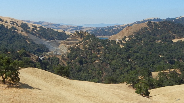
"content": "\u003cp>Big construction projects are rarely straightforward. The new San Francisco–Oakland Bay Bridge is a prime example, thanks to unexpected problems with the steel. But there, at least, nature was not to blame. This week a long-running dam project made the news when a geological discovery forced the San Francisco Public Utilities Commission to move millions of dollars around and push back its schedule by three years. Big excavations are like exploratory surgery, no matter how carefully planned, because mapping the underground is never certain.\u003c/p>\n\u003cp>The Calaveras Reservoir dam, east of Milpitas, is a massive earthen structure built across Calaveras Creek in 1925. These traditional dam designs are generally robust—the Crystal Springs Reservoir on the Peninsula has one that easily weathered the 1906 earthquake while the fault moved beneath it. However, the Calaveras Dam needed more work. The reservoir needs to be a reliable six-month backup water supply in case the Hetch Hetchy Aqueduct is out of action. And what could damage the aqueduct? Among other things, a major earthquake on the Calaveras fault, which happens to run right under the Calaveras Reservoir next to the dam.\u003c/p>\n\u003cp>The plan for meeting this dire scenario was to build a new dam just downstream of the old one. It will use the existing hills on either side of the creek as buttresses and be largely made of the rock excavated from the hills. The work was proceeding without incident until June of last year when excavators on the western buttress found signs of a huge, ancient landslide in the Temblor Formation. \u003c/p>\n\u003cp>Cutting into the hillslope under those circumstances would risk reactivating the slide, which could endanger the workers and threaten the new dam ever afterward. So now they will cut deeper to create a shallower slope, producing about a million and a half cubic yards of extra rubble and pushing the construction schedule back three years.\u003c/p>\n\u003cp>Here's a view of the project as seen looking south from \u003ca href=\"http://ww2.kqed.org/quest/2012/07/19/geological-outings-around-the-bay-sunol-regional-wilderness/\">Sunol Regional Wilderness\u003c/a> in July 2012. The reservoir, its water level drawn down for safety reasons, is just visible between the two cuts making up the buttresses for the new dam. The cut on the left (the right bank of Calaveras Creek) is in bluish metamorphic rock of the Franciscan Complex, and the cut on the right is in the much younger brown sandstone of the Temblor Formation. (The chopped-up hill in the middle is downstream from the dam site; the creek runs around it on the left side.)\u003c/p>\n\u003cfigure id=\"attachment_53214\" class=\"wp-caption aligncenter\" style=\"max-width: 640px\">\u003ca href=\"http://ww2.kqed.org/quest/2013/04/25/landslide-at-the-calaveras-reservoir/calaverasdam/\" rel=\"attachment wp-att-53214\">\u003cimg src=\"http://ww2.kqed.org/quest/wp-content/uploads/sites/39/2013/04/calaverasdam.jpg\" alt=\"Calaveras Dam project\" width=\"640\" height=\"360\" class=\"size-full wp-image-53214\" srcset=\"https://ww2.kqed.org/app/uploads/sites/39/2013/04/calaverasdam.jpg 640w, https://ww2.kqed.org/app/uploads/sites/39/2013/04/calaverasdam-400x225.jpg 400w\" sizes=\"(max-width: 640px) 100vw, 640px\">\u003c/a>\u003cfigcaption class=\"wp-caption-text\">The hill on the right, where the landslide was discovered, is Observation Hill. Both it and the smaller hill at center are composed of Temblor Formation sandstone. Photo by Andrew Alden\u003c/figcaption>\u003c/figure>\n\u003cp>The landslide was discovered in the Temblor Formation. Here's the part of the Alameda County geologic map that covers the area. The photo above was taken from roughly the \"25\" mark at the top of the map. The solid black lines running north-south down the middle are major strands of the Calaveras fault.\u003c/p>\n\u003cfigure id=\"attachment_53215\" class=\"wp-caption aligncenter\" style=\"max-width: 600px\">\u003ca href=\"http://ww2.kqed.org/quest/2013/04/25/landslide-at-the-calaveras-reservoir/calaverasdamgeomap/\" rel=\"attachment wp-att-53215\">\u003cimg src=\"http://ww2.kqed.org/quest/wp-content/uploads/sites/39/2013/04/calaverasdamgeomap.png\" alt=\"Geologic map of the Calaveras Dam area.\" width=\"600\" height=\"341\" class=\"size-full wp-image-53215\" srcset=\"https://ww2.kqed.org/app/uploads/sites/39/2013/04/calaverasdamgeomap.png 600w, https://ww2.kqed.org/app/uploads/sites/39/2013/04/calaverasdamgeomap-400x227.png 400w\" sizes=\"(max-width: 600px) 100vw, 600px\">\u003c/a>\u003cfigcaption class=\"wp-caption-text\">From oldest to youngest: KJfm, Franciscan melange; Ks, sandstone of Cretaceous age; Ttem, Temblor Formation (Miocene age); Tcs, Claremont Shale (cousin of the \u003ca href=\"http://ww2.kqed.org/quest/2012/11/29/the-mighty-monterey-formation-in-your-future/\">Monterey Formation\u003c/a>); To, Oursan Sandstone; Tbr, Briones Formation.\u003c/figcaption>\u003c/figure>\n\u003cp>The amended dam plan, filed with the San Francisco Public Utilities Commission last December, shows an east-west cross section of the dam site. The extra digging will happen on the left side to create a slope that is less steep and more stable.\u003c/p>\n\u003cfigure id=\"attachment_53216\" class=\"wp-caption aligncenter\" style=\"max-width: 600px\">\u003ca href=\"http://ww2.kqed.org/quest/2013/04/25/landslide-at-the-calaveras-reservoir/calaverasdamdiagram/\" rel=\"attachment wp-att-53216\">\u003cimg src=\"http://ww2.kqed.org/quest/wp-content/uploads/sites/39/2013/04/calaverasdamdiagram.jpg\" alt=\"From the Addendum to Environmental Impact Report (Dec. 13, 2012), San Francisco Public Utilities Commission\" width=\"600\" height=\"337\" class=\"size-full wp-image-53216\" srcset=\"https://ww2.kqed.org/app/uploads/sites/39/2013/04/calaverasdamdiagram.jpg 600w, https://ww2.kqed.org/app/uploads/sites/39/2013/04/calaverasdamdiagram-400x225.jpg 400w\" sizes=\"(max-width: 600px) 100vw, 600px\">\u003c/a>\u003cfigcaption class=\"wp-caption-text\">From the Addendum to Environmental Impact Report (Dec. 13, 2012), San Francisco Public Utilities Commission\u003c/figcaption>\u003c/figure>\n\u003cp>I have to say a little about the Temblor Formation, which occurs mostly in the southern Central Valley beneath the Monterey Formation. It gets its name from the Temblor Range, where its type section was described. And the Temblor Range got its name after the great 1857 earthquake ripped through the area. It's a coarse-grained marine sandstone full of fossils, and this spot appears to be its northernmost outcrop—right next to another earthquake fault. \u003c/p>\n\u003cp>[ad fullwidth]\u003c/p>\n\u003cp>\u003c/p>\n\u003cp>The Temblor is strong stone, but landslides can affect any kind of rock if it's fractured enough. And around major faults like the Calaveras, everything can be assumed to be fractured. The mountains of the Bay Area look beautiful and strong, but watch them for a few thousand years and you'll find them rather crumbly. Alternatively, scientists with the right equipment can survey the ground with millimeter precision. In the Bay Area's steeper hills they have detected many large, old landslides that are creeping very slowly, as they have for centuries. Maybe the landslide at the dam site was just pausing for breath. Better for the Calaveras Reservoir project to get this one out of the way.\u003c/p>\n\n",
"disqusIdentifier": "53213 http://science.kqed.org/quest/?p=53213",
"disqusUrl": "https://ww2.kqed.org/quest/2013/04/25/landslide-at-the-calaveras-reservoir/",
"stats": {
"hasVideo": false,
"hasChartOrMap": false,
"hasAudio": false,
"hasPolis": false,
"wordCount": 797,
"hasGoogleForm": false,
"hasGallery": false,
"hasHearkenModule": false,
"iframeSrcs": [],
"paragraphCount": 11
},
"modified": 1367424358,
"excerpt": "The long-running dam replacement project must pause to deal with a sleeping monster.",
"headData": {
"twImgId": "",
"twTitle": "",
"ogTitle": "",
"ogImgId": "",
"twDescription": "",
"description": "The long-running dam replacement project must pause to deal with a sleeping monster.",
"title": "Landslide at the Calaveras Reservoir | KQED",
"ogDescription": "",
"schema": {
"@context": "https://schema.org",
"@type": "Article",
"headline": "Landslide at the Calaveras Reservoir",
"datePublished": "2013-04-25T17:19:43-07:00",
"dateModified": "2013-05-01T09:05:58-07:00",
"image": "https://cdn.kqed.org/wp-content/uploads/2020/02/KQED-OG-Image@1x.png"
}
},
"guestAuthors": [],
"slug": "landslide-at-the-calaveras-reservoir",
"status": "publish",
"path": "/quest/53213/landslide-at-the-calaveras-reservoir",
"audioTrackLength": null,
"parsedContent": [
{
"type": "contentString",
"content": "\u003cdiv class=\"post-body\">\u003cp>\u003cp>Big construction projects are rarely straightforward. The new San Francisco–Oakland Bay Bridge is a prime example, thanks to unexpected problems with the steel. But there, at least, nature was not to blame. This week a long-running dam project made the news when a geological discovery forced the San Francisco Public Utilities Commission to move millions of dollars around and push back its schedule by three years. Big excavations are like exploratory surgery, no matter how carefully planned, because mapping the underground is never certain.\u003c/p>\n\u003cp>The Calaveras Reservoir dam, east of Milpitas, is a massive earthen structure built across Calaveras Creek in 1925. These traditional dam designs are generally robust—the Crystal Springs Reservoir on the Peninsula has one that easily weathered the 1906 earthquake while the fault moved beneath it. However, the Calaveras Dam needed more work. The reservoir needs to be a reliable six-month backup water supply in case the Hetch Hetchy Aqueduct is out of action. And what could damage the aqueduct? Among other things, a major earthquake on the Calaveras fault, which happens to run right under the Calaveras Reservoir next to the dam.\u003c/p>\n\u003cp>The plan for meeting this dire scenario was to build a new dam just downstream of the old one. It will use the existing hills on either side of the creek as buttresses and be largely made of the rock excavated from the hills. The work was proceeding without incident until June of last year when excavators on the western buttress found signs of a huge, ancient landslide in the Temblor Formation. \u003c/p>\n\u003cp>Cutting into the hillslope under those circumstances would risk reactivating the slide, which could endanger the workers and threaten the new dam ever afterward. So now they will cut deeper to create a shallower slope, producing about a million and a half cubic yards of extra rubble and pushing the construction schedule back three years.\u003c/p>\n\u003cp>Here's a view of the project as seen looking south from \u003ca href=\"http://ww2.kqed.org/quest/2012/07/19/geological-outings-around-the-bay-sunol-regional-wilderness/\">Sunol Regional Wilderness\u003c/a> in July 2012. The reservoir, its water level drawn down for safety reasons, is just visible between the two cuts making up the buttresses for the new dam. The cut on the left (the right bank of Calaveras Creek) is in bluish metamorphic rock of the Franciscan Complex, and the cut on the right is in the much younger brown sandstone of the Temblor Formation. (The chopped-up hill in the middle is downstream from the dam site; the creek runs around it on the left side.)\u003c/p>\n\u003cfigure id=\"attachment_53214\" class=\"wp-caption aligncenter\" style=\"max-width: 640px\">\u003ca href=\"http://ww2.kqed.org/quest/2013/04/25/landslide-at-the-calaveras-reservoir/calaverasdam/\" rel=\"attachment wp-att-53214\">\u003cimg src=\"http://ww2.kqed.org/quest/wp-content/uploads/sites/39/2013/04/calaverasdam.jpg\" alt=\"Calaveras Dam project\" width=\"640\" height=\"360\" class=\"size-full wp-image-53214\" srcset=\"https://ww2.kqed.org/app/uploads/sites/39/2013/04/calaverasdam.jpg 640w, https://ww2.kqed.org/app/uploads/sites/39/2013/04/calaverasdam-400x225.jpg 400w\" sizes=\"(max-width: 640px) 100vw, 640px\">\u003c/a>\u003cfigcaption class=\"wp-caption-text\">The hill on the right, where the landslide was discovered, is Observation Hill. Both it and the smaller hill at center are composed of Temblor Formation sandstone. Photo by Andrew Alden\u003c/figcaption>\u003c/figure>\n\u003cp>The landslide was discovered in the Temblor Formation. Here's the part of the Alameda County geologic map that covers the area. The photo above was taken from roughly the \"25\" mark at the top of the map. The solid black lines running north-south down the middle are major strands of the Calaveras fault.\u003c/p>\n\u003cfigure id=\"attachment_53215\" class=\"wp-caption aligncenter\" style=\"max-width: 600px\">\u003ca href=\"http://ww2.kqed.org/quest/2013/04/25/landslide-at-the-calaveras-reservoir/calaverasdamgeomap/\" rel=\"attachment wp-att-53215\">\u003cimg src=\"http://ww2.kqed.org/quest/wp-content/uploads/sites/39/2013/04/calaverasdamgeomap.png\" alt=\"Geologic map of the Calaveras Dam area.\" width=\"600\" height=\"341\" class=\"size-full wp-image-53215\" srcset=\"https://ww2.kqed.org/app/uploads/sites/39/2013/04/calaverasdamgeomap.png 600w, https://ww2.kqed.org/app/uploads/sites/39/2013/04/calaverasdamgeomap-400x227.png 400w\" sizes=\"(max-width: 600px) 100vw, 600px\">\u003c/a>\u003cfigcaption class=\"wp-caption-text\">From oldest to youngest: KJfm, Franciscan melange; Ks, sandstone of Cretaceous age; Ttem, Temblor Formation (Miocene age); Tcs, Claremont Shale (cousin of the \u003ca href=\"http://ww2.kqed.org/quest/2012/11/29/the-mighty-monterey-formation-in-your-future/\">Monterey Formation\u003c/a>); To, Oursan Sandstone; Tbr, Briones Formation.\u003c/figcaption>\u003c/figure>\n\u003cp>The amended dam plan, filed with the San Francisco Public Utilities Commission last December, shows an east-west cross section of the dam site. The extra digging will happen on the left side to create a slope that is less steep and more stable.\u003c/p>\n\u003cfigure id=\"attachment_53216\" class=\"wp-caption aligncenter\" style=\"max-width: 600px\">\u003ca href=\"http://ww2.kqed.org/quest/2013/04/25/landslide-at-the-calaveras-reservoir/calaverasdamdiagram/\" rel=\"attachment wp-att-53216\">\u003cimg src=\"http://ww2.kqed.org/quest/wp-content/uploads/sites/39/2013/04/calaverasdamdiagram.jpg\" alt=\"From the Addendum to Environmental Impact Report (Dec. 13, 2012), San Francisco Public Utilities Commission\" width=\"600\" height=\"337\" class=\"size-full wp-image-53216\" srcset=\"https://ww2.kqed.org/app/uploads/sites/39/2013/04/calaverasdamdiagram.jpg 600w, https://ww2.kqed.org/app/uploads/sites/39/2013/04/calaverasdamdiagram-400x225.jpg 400w\" sizes=\"(max-width: 600px) 100vw, 600px\">\u003c/a>\u003cfigcaption class=\"wp-caption-text\">From the Addendum to Environmental Impact Report (Dec. 13, 2012), San Francisco Public Utilities Commission\u003c/figcaption>\u003c/figure>\n\u003cp>I have to say a little about the Temblor Formation, which occurs mostly in the southern Central Valley beneath the Monterey Formation. It gets its name from the Temblor Range, where its type section was described. And the Temblor Range got its name after the great 1857 earthquake ripped through the area. It's a coarse-grained marine sandstone full of fossils, and this spot appears to be its northernmost outcrop—right next to another earthquake fault. \u003c/p>\n\u003cp>\u003c/p>\u003c/div>",
"attributes": {
"named": {},
"numeric": []
}
},
{
"type": "component",
"content": "",
"name": "ad",
"attributes": {
"named": {
"label": "fullwidth"
},
"numeric": [
"fullwidth"
]
}
},
{
"type": "contentString",
"content": "\u003cdiv class=\"post-body\">\u003cp>\u003c/p>\n\u003cp>\u003c/p>\n\u003cp>The Temblor is strong stone, but landslides can affect any kind of rock if it's fractured enough. And around major faults like the Calaveras, everything can be assumed to be fractured. The mountains of the Bay Area look beautiful and strong, but watch them for a few thousand years and you'll find them rather crumbly. Alternatively, scientists with the right equipment can survey the ground with millimeter precision. In the Bay Area's steeper hills they have detected many large, old landslides that are creeping very slowly, as they have for centuries. Maybe the landslide at the dam site was just pausing for breath. Better for the Calaveras Reservoir project to get this one out of the way.\u003c/p>\n\n\u003c/div>\u003c/p>",
"attributes": {
"named": {},
"numeric": []
}
}
],
"link": "/quest/53213/landslide-at-the-calaveras-reservoir",
"authors": [
"6228"
],
"categories": [
"quest_8",
"quest_11"
],
"tags": [
"quest_3492",
"quest_3608",
"quest_1608",
"quest_13202",
"quest_9979"
],
"featImg": "quest_53214",
"label": "quest"
},
"quest_46863": {
"type": "posts",
"id": "quest_46863",
"meta": {
"index": "posts_1716263798",
"site": "quest",
"id": "46863",
"score": null,
"sort": [
1352405710000
]
},
"parent": 0,
"labelTerm": {
"site": "quest"
},
"blocks": [],
"publishDate": 1352405710,
"format": "aside",
"disqusTitle": "Earthquake Landslides: A Widespread Hazard",
"title": "Earthquake Landslides: A Widespread Hazard",
"headTitle": "QUEST | KQED Science",
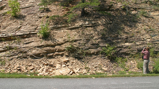
"content": "\u003cp>Every kind of natural disaster has its own built-in, unavoidable threat. For storms, it's flooding as the waters rise. For drought, it's ground settling as the water table falls. And for earthquakes of all sizes, it's landslides as the hills come tumbling down.\u003c/p>\n\u003cp>When the magnitude-6 Parkfield earthquake of September 2004 occurred, witnesses in the tiny Central California town remarked that the hillsides all around erupted in clouds of landslide dust. Seven years later in Virginia, the magnitude-5.8 quake of August 23, 2011, didn't raise a lot of dust in that humid region. But thousands of rock slides occurred, mostly small ones, over a surprisingly large region. \u003c/p>\n\u003cp>Landslide specialists with the U.S. Geological Survey took it upon themselves to look closely at Virginia, just as they did in Haiti the year before. In the weeks that followed the quake, \u003ca href=\"https://profile.usgs.gov/jibson\">Randall Jibson\u003c/a> drove with Ed Harp in systematic transects away from the epicenter, checking every rocky slope and documenting each example of landslides classified as \u003ca href=\"http://geology.about.com/od/naturalhazardsclimate/ig/Landslides/slide-rockfall.htm\">rockfalls\u003c/a>. \u003c/p>\n\u003cfigure id=\"attachment_46864\" class=\"wp-caption aligncenter\" style=\"max-width: 640px\">\u003ca href=\"http://ww2.kqed.org/quest/2012/11/08/earthquake-landslides-a-widespread-hazard/slide/\" rel=\"attachment wp-att-46864\">\u003cimg src=\"http://ww2.kqed.org/quest/wp-content/uploads/sites/39/2012/11/slide.jpg\" alt=\"\" title=\"slide\" width=\"640\" height=\"360\" class=\"size-full wp-image-46864\" srcset=\"https://ww2.kqed.org/app/uploads/sites/39/2012/11/slide.jpg 640w, https://ww2.kqed.org/app/uploads/sites/39/2012/11/slide-400x225.jpg 400w\" sizes=\"(max-width: 640px) 100vw, 640px\">\u003c/a>\u003cfigcaption class=\"wp-caption-text\">U.S. Geological Survey researcher Ed Harp records a small rockfall triggered by the 2011 Virginia earthquake. USGS photo by Randall Jibson\u003c/figcaption>\u003c/figure>\n\u003cp>They checked the fallen rocks carefully for signs of freshness, like the ripped-up sapling in the photo above, or the presence of still-green grass underneath stones. Where the rocky slopes stopped failing, they drew a line on the map to mark the rockfall limit.\u003c/p>\n\u003cp>This simple but intensive bit of fieldwork allowed Jibson and Harp to test their model of earthquake landslides with a good set of data. The models were built on data from Western areas with lots of earthquakes, where fresh slides are not always easy to notice, but in Virginia the 2011 quake was the largest in 114 years and left clean evidence everywhere. \u003c/p>\n\u003cp>[ad fullwidth]\u003c/p>\n\u003cp>The two researchers found fresh rockfalls four times as far away as their model predicted for a magnitude-5.8 event. Rockfalls occurred in an area 20 times as large as expected. Jibson \u003ca href=\"https://gsa.confex.com/gsa/2012AM/webprogram/Paper205161.html\">talked about their results this week\u003c/a> at the Geological Society of America's annual meeting in Charlotte, and a paper about it will appear in the \u003ci>Seismological Society of America Bulletin\u003c/i> next month.\u003c/p>\n\u003cfigure id=\"attachment_46866\" class=\"wp-caption aligncenter\" style=\"max-width: 600px\">\u003ca href=\"http://ww2.kqed.org/quest/2012/11/08/earthquake-landslides-a-widespread-hazard/vaeqslidemap/\" rel=\"attachment wp-att-46866\">\u003cimg src=\"http://ww2.kqed.org/quest/wp-content/uploads/sites/39/2012/11/VAEQslidemap.png\" alt=\"\" title=\"VAEQslidemap\" width=\"600\" height=\"347\" class=\"size-full wp-image-46866\" srcset=\"https://ww2.kqed.org/app/uploads/sites/39/2012/11/VAEQslidemap.png 600w, https://ww2.kqed.org/app/uploads/sites/39/2012/11/VAEQslidemap-400x231.png 400w\" sizes=\"(max-width: 600px) 100vw, 600px\">\u003c/a>\u003cfigcaption class=\"wp-caption-text\">US Geological Survey image\u003c/figcaption>\u003c/figure>\n\u003cp>Scientifically, this result made sense in two ways. First, it's already well known that earthquakes are felt much more widely in the cold, hard crust east of the Rockies. Jibson and Harp's rockfall evidence matches the human evidence—in fact, human reports of the Virginia quake show that it was felt by more Americans than any previous earthquake.\u003c/p>\n\u003cfigure id=\"attachment_46865\" class=\"wp-caption aligncenter\" style=\"max-width: 600px\">\u003ca href=\"http://ww2.kqed.org/quest/2012/11/08/earthquake-landslides-a-widespread-hazard/uslandslidequakes/\" rel=\"attachment wp-att-46865\">\u003cimg src=\"http://ww2.kqed.org/quest/wp-content/uploads/sites/39/2012/11/USlandslidequakes.png\" alt=\"\" title=\"USlandslidequakes\" width=\"600\" height=\"390\" class=\"size-full wp-image-46865\" srcset=\"https://ww2.kqed.org/app/uploads/sites/39/2012/11/USlandslidequakes.png 600w, https://ww2.kqed.org/app/uploads/sites/39/2012/11/USlandslidequakes-400x260.png 400w\" sizes=\"(max-width: 600px) 100vw, 600px\">\u003c/a>\u003cfigcaption class=\"wp-caption-text\">US Geological Survey image\u003c/figcaption>\u003c/figure>\n\u003cp>Second, the rockfall limit did not form a circle on the map, but an ellipse elongated along the Appalachian Mountains. That is, the regional geology, not just the basic structure of the Earth's crust, affected the pattern of shaking. Those two new pieces of knowledge will help in reassessing historical earthquakes as well as preparing for future ones in different places.\u003c/p>\n\u003cp>\u003c/p>\n\u003cp>Slowly but surely, Americans are joining Californians in becoming earthquake-aware. The broken Washington Monument, damaged in the 2011 Virginia quake, is a peerless consciousness raiser. The growing participation in \u003ca href=\"http://www.shakeout.org/\">ShakeOut programs\u003c/a> across the country is helping, too. Earthquake resistance can be engineered into our buildings and infrastructure, but landslides will never change. Speaking of which, California has its own special hazard of earthquakes related to landslides: valley fever. Jibson documented an outbreak of this disease, caused by a soil-dwelling fungus, \u003ca href=\"https://profile.usgs.gov/myscience/upload_folder/ci2009Apr211713254273778-Valley%20fever,%20Surveys%20in%20Geophysics.pdf\">after the 1994 Northridge earthquake\u003c/a>. Face masks might be a good addition to your earthquake kit.\u003c/p>\n\n",
"disqusIdentifier": "46863 http://science.kqed.org/quest/?p=46863",
"disqusUrl": "https://ww2.kqed.org/quest/2012/11/08/earthquake-landslides-a-widespread-hazard/",
"stats": {
"hasVideo": false,
"hasChartOrMap": false,
"hasAudio": false,
"hasPolis": false,
"wordCount": 602,
"hasGoogleForm": false,
"hasGallery": false,
"hasHearkenModule": false,
"iframeSrcs": [],
"paragraphCount": 11
},
"modified": 1353013062,
"excerpt": "Earthquakes will always produce landslides, but new knowledge will help us deal with them better.",
"headData": {
"twImgId": "",
"twTitle": "",
"ogTitle": "",
"ogImgId": "",
"twDescription": "",
"description": "Earthquakes will always produce landslides, but new knowledge will help us deal with them better.",
"title": "Earthquake Landslides: A Widespread Hazard | KQED",
"ogDescription": "",
"schema": {
"@context": "https://schema.org",
"@type": "Article",
"headline": "Earthquake Landslides: A Widespread Hazard",
"datePublished": "2012-11-08T12:15:10-08:00",
"dateModified": "2012-11-15T12:57:42-08:00",
"image": "https://cdn.kqed.org/wp-content/uploads/2020/02/KQED-OG-Image@1x.png"
}
},
"guestAuthors": [],
"slug": "earthquake-landslides-a-widespread-hazard",
"status": "publish",
"path": "/quest/46863/earthquake-landslides-a-widespread-hazard",
"audioTrackLength": null,
"parsedContent": [
{
"type": "contentString",
"content": "\u003cdiv class=\"post-body\">\u003cp>\u003cp>Every kind of natural disaster has its own built-in, unavoidable threat. For storms, it's flooding as the waters rise. For drought, it's ground settling as the water table falls. And for earthquakes of all sizes, it's landslides as the hills come tumbling down.\u003c/p>\n\u003cp>When the magnitude-6 Parkfield earthquake of September 2004 occurred, witnesses in the tiny Central California town remarked that the hillsides all around erupted in clouds of landslide dust. Seven years later in Virginia, the magnitude-5.8 quake of August 23, 2011, didn't raise a lot of dust in that humid region. But thousands of rock slides occurred, mostly small ones, over a surprisingly large region. \u003c/p>\n\u003cp>Landslide specialists with the U.S. Geological Survey took it upon themselves to look closely at Virginia, just as they did in Haiti the year before. In the weeks that followed the quake, \u003ca href=\"https://profile.usgs.gov/jibson\">Randall Jibson\u003c/a> drove with Ed Harp in systematic transects away from the epicenter, checking every rocky slope and documenting each example of landslides classified as \u003ca href=\"http://geology.about.com/od/naturalhazardsclimate/ig/Landslides/slide-rockfall.htm\">rockfalls\u003c/a>. \u003c/p>\n\u003cfigure id=\"attachment_46864\" class=\"wp-caption aligncenter\" style=\"max-width: 640px\">\u003ca href=\"http://ww2.kqed.org/quest/2012/11/08/earthquake-landslides-a-widespread-hazard/slide/\" rel=\"attachment wp-att-46864\">\u003cimg src=\"http://ww2.kqed.org/quest/wp-content/uploads/sites/39/2012/11/slide.jpg\" alt=\"\" title=\"slide\" width=\"640\" height=\"360\" class=\"size-full wp-image-46864\" srcset=\"https://ww2.kqed.org/app/uploads/sites/39/2012/11/slide.jpg 640w, https://ww2.kqed.org/app/uploads/sites/39/2012/11/slide-400x225.jpg 400w\" sizes=\"(max-width: 640px) 100vw, 640px\">\u003c/a>\u003cfigcaption class=\"wp-caption-text\">U.S. Geological Survey researcher Ed Harp records a small rockfall triggered by the 2011 Virginia earthquake. USGS photo by Randall Jibson\u003c/figcaption>\u003c/figure>\n\u003cp>They checked the fallen rocks carefully for signs of freshness, like the ripped-up sapling in the photo above, or the presence of still-green grass underneath stones. Where the rocky slopes stopped failing, they drew a line on the map to mark the rockfall limit.\u003c/p>\n\u003cp>This simple but intensive bit of fieldwork allowed Jibson and Harp to test their model of earthquake landslides with a good set of data. The models were built on data from Western areas with lots of earthquakes, where fresh slides are not always easy to notice, but in Virginia the 2011 quake was the largest in 114 years and left clean evidence everywhere. \u003c/p>\n\u003cp>\u003c/p>\u003c/div>",
"attributes": {
"named": {},
"numeric": []
}
},
{
"type": "component",
"content": "",
"name": "ad",
"attributes": {
"named": {
"label": "fullwidth"
},
"numeric": [
"fullwidth"
]
}
},
{
"type": "contentString",
"content": "\u003cdiv class=\"post-body\">\u003cp>\u003c/p>\n\u003cp>The two researchers found fresh rockfalls four times as far away as their model predicted for a magnitude-5.8 event. Rockfalls occurred in an area 20 times as large as expected. Jibson \u003ca href=\"https://gsa.confex.com/gsa/2012AM/webprogram/Paper205161.html\">talked about their results this week\u003c/a> at the Geological Society of America's annual meeting in Charlotte, and a paper about it will appear in the \u003ci>Seismological Society of America Bulletin\u003c/i> next month.\u003c/p>\n\u003cfigure id=\"attachment_46866\" class=\"wp-caption aligncenter\" style=\"max-width: 600px\">\u003ca href=\"http://ww2.kqed.org/quest/2012/11/08/earthquake-landslides-a-widespread-hazard/vaeqslidemap/\" rel=\"attachment wp-att-46866\">\u003cimg src=\"http://ww2.kqed.org/quest/wp-content/uploads/sites/39/2012/11/VAEQslidemap.png\" alt=\"\" title=\"VAEQslidemap\" width=\"600\" height=\"347\" class=\"size-full wp-image-46866\" srcset=\"https://ww2.kqed.org/app/uploads/sites/39/2012/11/VAEQslidemap.png 600w, https://ww2.kqed.org/app/uploads/sites/39/2012/11/VAEQslidemap-400x231.png 400w\" sizes=\"(max-width: 600px) 100vw, 600px\">\u003c/a>\u003cfigcaption class=\"wp-caption-text\">US Geological Survey image\u003c/figcaption>\u003c/figure>\n\u003cp>Scientifically, this result made sense in two ways. First, it's already well known that earthquakes are felt much more widely in the cold, hard crust east of the Rockies. Jibson and Harp's rockfall evidence matches the human evidence—in fact, human reports of the Virginia quake show that it was felt by more Americans than any previous earthquake.\u003c/p>\n\u003cfigure id=\"attachment_46865\" class=\"wp-caption aligncenter\" style=\"max-width: 600px\">\u003ca href=\"http://ww2.kqed.org/quest/2012/11/08/earthquake-landslides-a-widespread-hazard/uslandslidequakes/\" rel=\"attachment wp-att-46865\">\u003cimg src=\"http://ww2.kqed.org/quest/wp-content/uploads/sites/39/2012/11/USlandslidequakes.png\" alt=\"\" title=\"USlandslidequakes\" width=\"600\" height=\"390\" class=\"size-full wp-image-46865\" srcset=\"https://ww2.kqed.org/app/uploads/sites/39/2012/11/USlandslidequakes.png 600w, https://ww2.kqed.org/app/uploads/sites/39/2012/11/USlandslidequakes-400x260.png 400w\" sizes=\"(max-width: 600px) 100vw, 600px\">\u003c/a>\u003cfigcaption class=\"wp-caption-text\">US Geological Survey image\u003c/figcaption>\u003c/figure>\n\u003cp>Second, the rockfall limit did not form a circle on the map, but an ellipse elongated along the Appalachian Mountains. That is, the regional geology, not just the basic structure of the Earth's crust, affected the pattern of shaking. Those two new pieces of knowledge will help in reassessing historical earthquakes as well as preparing for future ones in different places.\u003c/p>\n\u003cp>\u003c/p>\n\u003cp>Slowly but surely, Americans are joining Californians in becoming earthquake-aware. The broken Washington Monument, damaged in the 2011 Virginia quake, is a peerless consciousness raiser. The growing participation in \u003ca href=\"http://www.shakeout.org/\">ShakeOut programs\u003c/a> across the country is helping, too. Earthquake resistance can be engineered into our buildings and infrastructure, but landslides will never change. Speaking of which, California has its own special hazard of earthquakes related to landslides: valley fever. Jibson documented an outbreak of this disease, caused by a soil-dwelling fungus, \u003ca href=\"https://profile.usgs.gov/myscience/upload_folder/ci2009Apr211713254273778-Valley%20fever,%20Surveys%20in%20Geophysics.pdf\">after the 1994 Northridge earthquake\u003c/a>. Face masks might be a good addition to your earthquake kit.\u003c/p>\n\n\u003c/div>\u003c/p>",
"attributes": {
"named": {},
"numeric": []
}
}
],
"link": "/quest/46863/earthquake-landslides-a-widespread-hazard",
"authors": [
"6228"
],
"categories": [
"quest_11"
],
"tags": [
"quest_909",
"quest_1608",
"quest_11595",
"quest_13202",
"quest_3048",
"quest_11594"
],
"featImg": "quest_46864",
"label": "quest"
},
"quest_39562": {
"type": "posts",
"id": "quest_39562",
"meta": {
"index": "posts_1716263798",
"site": "quest",
"id": "39562",
"score": null,
"sort": [
1339685572000
]
},
"parent": 0,
"labelTerm": {
"site": "quest"
},
"blocks": [],
"publishDate": 1339685572,
"format": "standard",
"disqusTitle": "Did You See It? Report a Landslide Online",
"title": "Did You See It? Report a Landslide Online",
"headTitle": "QUEST | KQED Science",
"content": "\u003cfigure id=\"attachment_39564\" class=\"wp-caption aligncenter\" style=\"max-width: 640px\">\u003ca href=\"http://ww2.kqed.org/quest/2012/06/14/did-you-see-it-report-a-landslide-online/landslide-dysi/\" rel=\"attachment wp-att-39564\">\u003cimg src=\"http://ww2.kqed.org/quest/wp-content/uploads/sites/39/2012/06/landslide-dysi.jpg\" alt=\"\" title=\"landslide-dysi\" width=\"640\" height=\"360\" class=\"size-full wp-image-39564\" srcset=\"https://ww2.kqed.org/app/uploads/sites/39/2012/06/landslide-dysi.jpg 640w, https://ww2.kqed.org/app/uploads/sites/39/2012/06/landslide-dysi-400x225.jpg 400w\" sizes=\"(max-width: 640px) 100vw, 640px\">\u003c/a>\u003cfigcaption class=\"wp-caption-text\">Landslide in eastern Del Puerto Canyon, near Patterson. Now anyone can easily report a landslide to a centralized database for the whole country. All photos by Andrew Alden\u003c/figcaption>\u003c/figure>\n\u003cp>By now, everyone in the Bay Area knows about the \u003ca href=\"http://earthquake.usgs.gov/earthquakes/dyfi/\">Did You Feel It?\u003c/a> system, set up by the U.S. Geological Survey in the 1990s to record earthquake reports. This week the Survey has launched a similar effort, called \u003ca href=\"http://landslides.usgs.gov/dysi/\">Did You See It?\u003c/a> or DYSI, to enlist citizens in recording landslides. Bay Area residents should take to this tool enthusiastically because \u003ca href=\"http://ww2.kqed.org/quest/2011/03/31/landslide-season/\">we live in landslide country\u003c/a> as well as earthquake country. In fact, earthquakes so often cause landslides that conscientious folks can now make twice the contribution after a seismic event.\u003c/p>\n\u003cp>The earthquake tool has succeeded so well because, among other things, the facts it needs to know are easy to check off—where you were, what things you noticed, what was damaged. The new landslide tool works a little differently because \u003ca href=\"http://geology.about.com/od/nutshells/a/landslidenuts.htm\">landslides\u003c/a> aren't the same kind of event. Reporting a landslide on the DYSI tool takes a bit of observation.\u003c/p>\n\u003cp>Landslides are classified along a spectrum between \u003ci>falls\u003c/i> and \u003ci>flows\u003c/i>. They involve three kinds of material: earth (soil), debris (rocks and soil) and rocks. Rockfalls, like this example from the Marin Headlands, should be familiar. They're basically a rattle of rocks.\u003c/p>\n\u003cp>\u003ca href=\"http://ww2.kqed.org/quest/2012/06/14/did-you-see-it-report-a-landslide-online/landslide-fall/\" rel=\"attachment wp-att-39565\">\u003cimg src=\"http://ww2.kqed.org/quest/wp-content/uploads/sites/39/2012/06/landslide-fall.jpg\" alt=\"\" title=\"landslide-fall\" width=\"500\" height=\"330\" class=\"aligncenter size-full wp-image-39565\" srcset=\"https://ww2.kqed.org/app/uploads/sites/39/2012/06/landslide-fall.jpg 500w, https://ww2.kqed.org/app/uploads/sites/39/2012/06/landslide-fall-400x264.jpg 400w\" sizes=\"(max-width: 500px) 100vw, 500px\">\u003c/a>\u003c/p>\n\u003cp>Flows include earthflows and debris flows. They have a fluid motion and shape, like this example, a debris flow from the Marin Headlands.\u003c/p>\n\u003cp>[ad fullwidth]\u003c/p>\n\u003cp>\u003ca href=\"http://ww2.kqed.org/quest/2012/06/14/did-you-see-it-report-a-landslide-online/landslide-flow/\" rel=\"attachment wp-att-39566\">\u003cimg src=\"http://ww2.kqed.org/quest/wp-content/uploads/sites/39/2012/06/landslide-flow.jpg\" alt=\"\" title=\"landslide-flow\" width=\"500\" height=\"327\" class=\"aligncenter size-full wp-image-39566\" srcset=\"https://ww2.kqed.org/app/uploads/sites/39/2012/06/landslide-flow.jpg 500w, https://ww2.kqed.org/app/uploads/sites/39/2012/06/landslide-flow-400x262.jpg 400w\" sizes=\"(max-width: 500px) 100vw, 500px\">\u003c/a>\u003c/p>\n\u003cp>Slumps, or rotational slides, are in-between landslides with a sitzmark shape. This one is in the Oakland hills.\u003c/p>\n\u003cp>\u003ca href=\"http://ww2.kqed.org/quest/2012/06/14/did-you-see-it-report-a-landslide-online/landslide-slump/\" rel=\"attachment wp-att-39563\">\u003cimg src=\"http://ww2.kqed.org/quest/wp-content/uploads/sites/39/2012/06/landslide-slump.jpg\" alt=\"\" title=\"landslide-slump\" width=\"500\" height=\"301\" class=\"aligncenter size-full wp-image-39563\" srcset=\"https://ww2.kqed.org/app/uploads/sites/39/2012/06/landslide-slump.jpg 500w, https://ww2.kqed.org/app/uploads/sites/39/2012/06/landslide-slump-400x241.jpg 400w\" sizes=\"(max-width: 500px) 100vw, 500px\">\u003c/a>\u003c/p>\n\u003cp>Those three are the most common landslide types around here. The DYSI tool shows four additional landslide types, and if you hold your mouse over each one a rotation of diagrams and photos will display them to you. Even better, you can right-click to view these at full size. The tool has options to accept much more detail (like loss data and your photos), but that's the gist of it.\u003c/p>\n\u003cp>\u003c/p>\n\u003cp>Because landslides are more widespread than quakes, \"Did You See It\" may provide even more benefit to the nation than \"Did You Feel It.\" \u003c/p>\n\n",
"disqusIdentifier": "39562 http://science.kqed.org/quest/?p=39562",
"disqusUrl": "https://ww2.kqed.org/quest/2012/06/14/did-you-see-it-report-a-landslide-online/",
"stats": {
"hasVideo": false,
"hasChartOrMap": false,
"hasAudio": false,
"hasPolis": false,
"wordCount": 364,
"hasGoogleForm": false,
"hasGallery": false,
"hasHearkenModule": false,
"iframeSrcs": [],
"paragraphCount": 12
},
"modified": 1340306670,
"excerpt": "What Bay Areans did for earthquakes we can now do for landslides: lead the world in reporting these common natural hazards online.",
"headData": {
"twImgId": "",
"twTitle": "",
"ogTitle": "",
"ogImgId": "",
"twDescription": "",
"description": "What Bay Areans did for earthquakes we can now do for landslides: lead the world in reporting these common natural hazards online.",
"title": "Did You See It? Report a Landslide Online | KQED",
"ogDescription": "",
"schema": {
"@context": "https://schema.org",
"@type": "Article",
"headline": "Did You See It? Report a Landslide Online",
"datePublished": "2012-06-14T07:52:52-07:00",
"dateModified": "2012-06-21T12:24:30-07:00",
"image": "https://cdn.kqed.org/wp-content/uploads/2020/02/KQED-OG-Image@1x.png"
}
},
"guestAuthors": [],
"slug": "did-you-see-it-report-a-landslide-online",
"status": "publish",
"path": "/quest/39562/did-you-see-it-report-a-landslide-online",
"audioTrackLength": null,
"parsedContent": [
{
"type": "contentString",
"content": "\u003cdiv class=\"post-body\">\u003cp>\u003cfigure id=\"attachment_39564\" class=\"wp-caption aligncenter\" style=\"max-width: 640px\">\u003ca href=\"http://ww2.kqed.org/quest/2012/06/14/did-you-see-it-report-a-landslide-online/landslide-dysi/\" rel=\"attachment wp-att-39564\">\u003cimg src=\"http://ww2.kqed.org/quest/wp-content/uploads/sites/39/2012/06/landslide-dysi.jpg\" alt=\"\" title=\"landslide-dysi\" width=\"640\" height=\"360\" class=\"size-full wp-image-39564\" srcset=\"https://ww2.kqed.org/app/uploads/sites/39/2012/06/landslide-dysi.jpg 640w, https://ww2.kqed.org/app/uploads/sites/39/2012/06/landslide-dysi-400x225.jpg 400w\" sizes=\"(max-width: 640px) 100vw, 640px\">\u003c/a>\u003cfigcaption class=\"wp-caption-text\">Landslide in eastern Del Puerto Canyon, near Patterson. Now anyone can easily report a landslide to a centralized database for the whole country. All photos by Andrew Alden\u003c/figcaption>\u003c/figure>\n\u003cp>By now, everyone in the Bay Area knows about the \u003ca href=\"http://earthquake.usgs.gov/earthquakes/dyfi/\">Did You Feel It?\u003c/a> system, set up by the U.S. Geological Survey in the 1990s to record earthquake reports. This week the Survey has launched a similar effort, called \u003ca href=\"http://landslides.usgs.gov/dysi/\">Did You See It?\u003c/a> or DYSI, to enlist citizens in recording landslides. Bay Area residents should take to this tool enthusiastically because \u003ca href=\"http://ww2.kqed.org/quest/2011/03/31/landslide-season/\">we live in landslide country\u003c/a> as well as earthquake country. In fact, earthquakes so often cause landslides that conscientious folks can now make twice the contribution after a seismic event.\u003c/p>\n\u003cp>The earthquake tool has succeeded so well because, among other things, the facts it needs to know are easy to check off—where you were, what things you noticed, what was damaged. The new landslide tool works a little differently because \u003ca href=\"http://geology.about.com/od/nutshells/a/landslidenuts.htm\">landslides\u003c/a> aren't the same kind of event. Reporting a landslide on the DYSI tool takes a bit of observation.\u003c/p>\n\u003cp>Landslides are classified along a spectrum between \u003ci>falls\u003c/i> and \u003ci>flows\u003c/i>. They involve three kinds of material: earth (soil), debris (rocks and soil) and rocks. Rockfalls, like this example from the Marin Headlands, should be familiar. They're basically a rattle of rocks.\u003c/p>\n\u003cp>\u003ca href=\"http://ww2.kqed.org/quest/2012/06/14/did-you-see-it-report-a-landslide-online/landslide-fall/\" rel=\"attachment wp-att-39565\">\u003cimg src=\"http://ww2.kqed.org/quest/wp-content/uploads/sites/39/2012/06/landslide-fall.jpg\" alt=\"\" title=\"landslide-fall\" width=\"500\" height=\"330\" class=\"aligncenter size-full wp-image-39565\" srcset=\"https://ww2.kqed.org/app/uploads/sites/39/2012/06/landslide-fall.jpg 500w, https://ww2.kqed.org/app/uploads/sites/39/2012/06/landslide-fall-400x264.jpg 400w\" sizes=\"(max-width: 500px) 100vw, 500px\">\u003c/a>\u003c/p>\n\u003cp>Flows include earthflows and debris flows. They have a fluid motion and shape, like this example, a debris flow from the Marin Headlands.\u003c/p>\n\u003cp>\u003c/p>\u003c/div>",
"attributes": {
"named": {},
"numeric": []
}
},
{
"type": "component",
"content": "",
"name": "ad",
"attributes": {
"named": {
"label": "fullwidth"
},
"numeric": [
"fullwidth"
]
}
},
{
"type": "contentString",
"content": "\u003cdiv class=\"post-body\">\u003cp>\u003c/p>\n\u003cp>\u003ca href=\"http://ww2.kqed.org/quest/2012/06/14/did-you-see-it-report-a-landslide-online/landslide-flow/\" rel=\"attachment wp-att-39566\">\u003cimg src=\"http://ww2.kqed.org/quest/wp-content/uploads/sites/39/2012/06/landslide-flow.jpg\" alt=\"\" title=\"landslide-flow\" width=\"500\" height=\"327\" class=\"aligncenter size-full wp-image-39566\" srcset=\"https://ww2.kqed.org/app/uploads/sites/39/2012/06/landslide-flow.jpg 500w, https://ww2.kqed.org/app/uploads/sites/39/2012/06/landslide-flow-400x262.jpg 400w\" sizes=\"(max-width: 500px) 100vw, 500px\">\u003c/a>\u003c/p>\n\u003cp>Slumps, or rotational slides, are in-between landslides with a sitzmark shape. This one is in the Oakland hills.\u003c/p>\n\u003cp>\u003ca href=\"http://ww2.kqed.org/quest/2012/06/14/did-you-see-it-report-a-landslide-online/landslide-slump/\" rel=\"attachment wp-att-39563\">\u003cimg src=\"http://ww2.kqed.org/quest/wp-content/uploads/sites/39/2012/06/landslide-slump.jpg\" alt=\"\" title=\"landslide-slump\" width=\"500\" height=\"301\" class=\"aligncenter size-full wp-image-39563\" srcset=\"https://ww2.kqed.org/app/uploads/sites/39/2012/06/landslide-slump.jpg 500w, https://ww2.kqed.org/app/uploads/sites/39/2012/06/landslide-slump-400x241.jpg 400w\" sizes=\"(max-width: 500px) 100vw, 500px\">\u003c/a>\u003c/p>\n\u003cp>Those three are the most common landslide types around here. The DYSI tool shows four additional landslide types, and if you hold your mouse over each one a rotation of diagrams and photos will display them to you. Even better, you can right-click to view these at full size. The tool has options to accept much more detail (like loss data and your photos), but that's the gist of it.\u003c/p>\n\u003cp>\u003c/p>\n\u003cp>Because landslides are more widespread than quakes, \"Did You See It\" may provide even more benefit to the nation than \"Did You Feel It.\" \u003c/p>\n\n\u003c/div>\u003c/p>",
"attributes": {
"named": {},
"numeric": []
}
}
],
"link": "/quest/39562/did-you-see-it-report-a-landslide-online",
"authors": [
"6228"
],
"categories": [
"quest_11"
],
"tags": [
"quest_909",
"quest_1608",
"quest_3722",
"quest_13202",
"quest_3048"
],
"featImg": "quest_39564",
"label": "quest"
},
"quest_35632": {
"type": "posts",
"id": "quest_35632",
"meta": {
"index": "posts_1716263798",
"site": "quest",
"id": "35632",
"score": null,
"sort": [
1334847180000
]
},
"parent": 0,
"labelTerm": {
"site": "quest"
},
"blocks": [],
"publishDate": 1334847180,
"format": "standard",
"disqusTitle": "The Switching Outlets of Clear Lake",
"title": "The Switching Outlets of Clear Lake",
"headTitle": "QUEST | KQED Science",
"content": "\u003cfigure id=\"attachment_35637\" class=\"wp-caption alignleft\" style=\"max-width: 300px\">\u003ca href=\"http://ww2.kqed.org/quest/2012/04/19/the-switching-outlets-of-clear-lake/cachecreekcut/\" rel=\"attachment wp-att-35637\">\u003cimg src=\"http://ww2.kqed.org/quest/wp-content/uploads/sites/39/2012/04/cachecreekcut-300x169.jpg\" alt=\"\" title=\"cachecreekcut\" width=\"300\" height=\"169\" class=\"size-thumbnail wp-image-35637\">\u003c/a>\u003cfigcaption class=\"wp-caption-text\">Recently accelerated erosion in the bed of Cache Creek testifies to a big change upstream: a switch in the drainage of Clear Lake. Photos by Andrew Alden\u003c/figcaption>\u003c/figure>\n\u003cp>The rainy, dynamic terrain of the northern Coast Range features many rivers, but very few natural lakes. Any basins that may form by tectonic activity have short lives. Either they fill up with sediment, or rivers erode into them and they drain dry. \u003c/p>\n\u003cp>Clear Lake, by far the largest lake in the Coast Range, has sediments in it dating back some half a million years. The lake's basin never seems to fill with mud, although Clear Lake has always been shallow. Apparently something builds up the basin's sides whenever the lake outlet threatens to cut downward far enough to drain the lake dry. In recent geologic time, Clear Lake has drained eastward and westward at different times as one exit or the other has been plugged. You can visit both exits and glimpse the geologic evidence yourself.\u003c/p>\n\u003cp>Today Clear Lake drains east to the Central Valley down Cache Creek through a rugged canyon with high, steep walls. But biologists tell us that the fish of Clear Lake come from both the Russian River and the Central Valley. Without that clue, we might not make much of the straight little valley northwest of Clear Lake, just a few meters above the present lake level. Created by slow faulting, the valley holds some bits of water called Blue Lakes. What could have made Clear Lake drain in this direction?\u003c/p>\n\u003cfigure id=\"attachment_35633\" class=\"wp-caption aligncenter\" style=\"max-width: 640px\">\u003ca href=\"http://ww2.kqed.org/quest/2012/04/19/the-switching-outlets-of-clear-lake/clearlakemap/\" rel=\"attachment wp-att-35633\">\u003cimg src=\"http://ww2.kqed.org/quest/wp-content/uploads/sites/39/2012/04/clearlakemap.jpg\" alt=\"\" title=\"clearlakemap\" width=\"640\" height=\"441\" class=\"size-full wp-image-35633\" srcset=\"https://ww2.kqed.org/app/uploads/sites/39/2012/04/clearlakemap.jpg 640w, https://ww2.kqed.org/app/uploads/sites/39/2012/04/clearlakemap-400x276.jpg 400w\" sizes=\"(max-width: 640px) 100vw, 640px\">\u003c/a>\u003cfigcaption class=\"wp-caption-text\">Clear Lake shows signs of having drained northwest, through Blue Lakes, as well as southeast through Cache Creek, its current outlet.\u003c/figcaption>\u003c/figure>\n\u003cp>The east side of Clear Lake is full of young volcanoes ranging in size from Mount Konocti down to a dozen little cones a few tens of thousands of years old. With that in mind it's easy to picture a large lava flow, or the emergence of a small cone, blocking Cache Creek and causing the lake to rise until it spilled through the valley of Blue Lakes to the Russian River.\u003c/p>\n\u003cp>You can drive up state route 20 from the north side of Clear Lake into this valley, and it's easy to picture it holding a river. Then the road hits a large bump, a hill right in the middle of the valley, and that seems to be the end of the line. But geologic mapping has shown that this is an ancient landslide.\u003c/p>\n\u003cfigure id=\"attachment_35635\" class=\"wp-caption aligncenter\" style=\"max-width: 600px\">\u003ca href=\"http://ww2.kqed.org/quest/2012/04/19/the-switching-outlets-of-clear-lake/bluelakeslide/\" rel=\"attachment wp-att-35635\">\u003cimg src=\"http://ww2.kqed.org/quest/wp-content/uploads/sites/39/2012/04/bluelakeslide.jpg\" alt=\"\" title=\"bluelakeslide\" width=\"600\" height=\"377\" class=\"size-full wp-image-35635\" srcset=\"https://ww2.kqed.org/app/uploads/sites/39/2012/04/bluelakeslide.jpg 600w, https://ww2.kqed.org/app/uploads/sites/39/2012/04/bluelakeslide-400x251.jpg 400w\" sizes=\"(max-width: 600px) 100vw, 600px\">\u003c/a>\u003cfigcaption class=\"wp-caption-text\">The bare-topped hill blocking the valley past Upper Blue Lake is a landslide. The forested land in front is a younger delta fan.\u003c/figcaption>\u003c/figure>\n\u003cp>A look at the topography here is instructive, and Google Maps' \"terrain\" setting is an excellent way to do that. The photo above was taken from the middle \"20\" symbol and the hill is marked with an asterisk.\u003c/p>\n\u003cfigure id=\"attachment_35634\" class=\"wp-caption aligncenter\" style=\"max-width: 640px\">\u003ca href=\"http://ww2.kqed.org/quest/2012/04/19/the-switching-outlets-of-clear-lake/bluelakemap/\" rel=\"attachment wp-att-35634\">\u003cimg src=\"http://ww2.kqed.org/quest/wp-content/uploads/sites/39/2012/04/bluelakemap.jpg\" alt=\"\" title=\"bluelakemap\" width=\"640\" height=\"460\" class=\"size-full wp-image-35634\" srcset=\"https://ww2.kqed.org/app/uploads/sites/39/2012/04/bluelakemap.jpg 640w, https://ww2.kqed.org/app/uploads/sites/39/2012/04/bluelakemap-400x288.jpg 400w\" sizes=\"(max-width: 640px) 100vw, 640px\">\u003c/a>\u003cfigcaption class=\"wp-caption-text\">Annotations: V symbols are delta-forming drainages, S marks landslides or possible landslides.\u003c/figcaption>\u003c/figure>\n\u003cp>Notice how well-organized the stream drainages are leading down to the lakes. Each of the larger streams has built out a delta of sediment. But west of the lakes is an area of poorly organized, hummocky terrain that closely resembles \u003ca href=\"http://ww2.kqed.org/quest/2011/03/31/landslide-season/\">the body of a landslide\u003c/a>. It appears to me that the landslide nearest to Blue Lakes is the smallest and possibly the latest of a whole series.\u003c/p>\n\u003cp>[ad fullwidth]\u003c/p>\n\u003cp>The native tribes around Clear Lake have old stories of just such a landslide here. If we take them literally, that would place the event within the last few thousand years. The next thing to happen in this scenario is that Clear Lake would rise still further until it overcame the natural dam on Cache Creek and resumed its interrupted eastward drainage. In fact, there's no reason this should have happened only once.\u003c/p>\n\u003cp>But I mentioned visiting both exits of Clear Lake. Cache Creek goes into roadless country but on the other side, right where it meets state route 16, you can pull over at \u003ca href=\"http://www.yolocounty.org/index.aspx?page=379\">Cache Creek Regional Park\u003c/a> and see this beautiful exposure, about 5 meters high, across the river.\u003c/p>\n\u003cp>\u003ca href=\"http://ww2.kqed.org/quest/2012/04/19/the-switching-outlets-of-clear-lake/cachecreekbank/\" rel=\"attachment wp-att-35636\">\u003cimg src=\"http://ww2.kqed.org/quest/wp-content/uploads/sites/39/2012/04/cachecreekbank.jpg\" alt=\"\" title=\"cachecreekbank\" width=\"600\" height=\"471\" class=\"aligncenter size-full wp-image-35636\" srcset=\"https://ww2.kqed.org/app/uploads/sites/39/2012/04/cachecreekbank.jpg 600w, https://ww2.kqed.org/app/uploads/sites/39/2012/04/cachecreekbank-400x314.jpg 400w\" sizes=\"(max-width: 600px) 100vw, 600px\">\u003c/a>\u003c/p>\n\u003cp>\u003c/p>\n\u003cp>From top to bottom its features are plain as day: a nice flat abandoned floodplain, a layer of coarse river rocks and gravel, the rugged profile of a former streambed, and the \u003ca href=\"http://ww2.kqed.org/quest/2012/01/26/geological-outings-around-the-bay-mount-vaca-and-the-monticello-dam/\">tilted bedrock of the Great Valley Sequence\u003c/a>. In the typical river, the streambed is cut downward so slowly, only in the largest \"hundred-year\" storm events, that an exposure like this is never seen. But today's newly invigorated Cache Creek has cut through all this in one clean chop in just a few millennia.\u003c/p>\n\n",
"disqusIdentifier": "35632 http://science.kqed.org/quest/?p=35632",
"disqusUrl": "https://ww2.kqed.org/quest/2012/04/19/the-switching-outlets-of-clear-lake/",
"stats": {
"hasVideo": false,
"hasChartOrMap": false,
"hasAudio": false,
"hasPolis": false,
"wordCount": 768,
"hasGoogleForm": false,
"hasGallery": false,
"hasHearkenModule": false,
"iframeSrcs": [],
"paragraphCount": 13
},
"modified": 1335901285,
"excerpt": "Why has Clear Lake drained two different ways in recent geologic time? Volcanoes and landslides made it happen.",
"headData": {
"twImgId": "",
"twTitle": "",
"ogTitle": "",
"ogImgId": "",
"twDescription": "",
"description": "Why has Clear Lake drained two different ways in recent geologic time? Volcanoes and landslides made it happen.",
"title": "The Switching Outlets of Clear Lake | KQED",
"ogDescription": "",
"schema": {
"@context": "https://schema.org",
"@type": "Article",
"headline": "The Switching Outlets of Clear Lake",
"datePublished": "2012-04-19T07:53:00-07:00",
"dateModified": "2012-05-01T12:41:25-07:00",
"image": "https://cdn.kqed.org/wp-content/uploads/2020/02/KQED-OG-Image@1x.png"
}
},
"guestAuthors": [],
"slug": "the-switching-outlets-of-clear-lake",
"status": "publish",
"path": "/quest/35632/the-switching-outlets-of-clear-lake",
"audioTrackLength": null,
"parsedContent": [
{
"type": "contentString",
"content": "\u003cdiv class=\"post-body\">\u003cp>\u003cfigure id=\"attachment_35637\" class=\"wp-caption alignleft\" style=\"max-width: 300px\">\u003ca href=\"http://ww2.kqed.org/quest/2012/04/19/the-switching-outlets-of-clear-lake/cachecreekcut/\" rel=\"attachment wp-att-35637\">\u003cimg src=\"http://ww2.kqed.org/quest/wp-content/uploads/sites/39/2012/04/cachecreekcut-300x169.jpg\" alt=\"\" title=\"cachecreekcut\" width=\"300\" height=\"169\" class=\"size-thumbnail wp-image-35637\">\u003c/a>\u003cfigcaption class=\"wp-caption-text\">Recently accelerated erosion in the bed of Cache Creek testifies to a big change upstream: a switch in the drainage of Clear Lake. Photos by Andrew Alden\u003c/figcaption>\u003c/figure>\n\u003cp>The rainy, dynamic terrain of the northern Coast Range features many rivers, but very few natural lakes. Any basins that may form by tectonic activity have short lives. Either they fill up with sediment, or rivers erode into them and they drain dry. \u003c/p>\n\u003cp>Clear Lake, by far the largest lake in the Coast Range, has sediments in it dating back some half a million years. The lake's basin never seems to fill with mud, although Clear Lake has always been shallow. Apparently something builds up the basin's sides whenever the lake outlet threatens to cut downward far enough to drain the lake dry. In recent geologic time, Clear Lake has drained eastward and westward at different times as one exit or the other has been plugged. You can visit both exits and glimpse the geologic evidence yourself.\u003c/p>\n\u003cp>Today Clear Lake drains east to the Central Valley down Cache Creek through a rugged canyon with high, steep walls. But biologists tell us that the fish of Clear Lake come from both the Russian River and the Central Valley. Without that clue, we might not make much of the straight little valley northwest of Clear Lake, just a few meters above the present lake level. Created by slow faulting, the valley holds some bits of water called Blue Lakes. What could have made Clear Lake drain in this direction?\u003c/p>\n\u003cfigure id=\"attachment_35633\" class=\"wp-caption aligncenter\" style=\"max-width: 640px\">\u003ca href=\"http://ww2.kqed.org/quest/2012/04/19/the-switching-outlets-of-clear-lake/clearlakemap/\" rel=\"attachment wp-att-35633\">\u003cimg src=\"http://ww2.kqed.org/quest/wp-content/uploads/sites/39/2012/04/clearlakemap.jpg\" alt=\"\" title=\"clearlakemap\" width=\"640\" height=\"441\" class=\"size-full wp-image-35633\" srcset=\"https://ww2.kqed.org/app/uploads/sites/39/2012/04/clearlakemap.jpg 640w, https://ww2.kqed.org/app/uploads/sites/39/2012/04/clearlakemap-400x276.jpg 400w\" sizes=\"(max-width: 640px) 100vw, 640px\">\u003c/a>\u003cfigcaption class=\"wp-caption-text\">Clear Lake shows signs of having drained northwest, through Blue Lakes, as well as southeast through Cache Creek, its current outlet.\u003c/figcaption>\u003c/figure>\n\u003cp>The east side of Clear Lake is full of young volcanoes ranging in size from Mount Konocti down to a dozen little cones a few tens of thousands of years old. With that in mind it's easy to picture a large lava flow, or the emergence of a small cone, blocking Cache Creek and causing the lake to rise until it spilled through the valley of Blue Lakes to the Russian River.\u003c/p>\n\u003cp>You can drive up state route 20 from the north side of Clear Lake into this valley, and it's easy to picture it holding a river. Then the road hits a large bump, a hill right in the middle of the valley, and that seems to be the end of the line. But geologic mapping has shown that this is an ancient landslide.\u003c/p>\n\u003cfigure id=\"attachment_35635\" class=\"wp-caption aligncenter\" style=\"max-width: 600px\">\u003ca href=\"http://ww2.kqed.org/quest/2012/04/19/the-switching-outlets-of-clear-lake/bluelakeslide/\" rel=\"attachment wp-att-35635\">\u003cimg src=\"http://ww2.kqed.org/quest/wp-content/uploads/sites/39/2012/04/bluelakeslide.jpg\" alt=\"\" title=\"bluelakeslide\" width=\"600\" height=\"377\" class=\"size-full wp-image-35635\" srcset=\"https://ww2.kqed.org/app/uploads/sites/39/2012/04/bluelakeslide.jpg 600w, https://ww2.kqed.org/app/uploads/sites/39/2012/04/bluelakeslide-400x251.jpg 400w\" sizes=\"(max-width: 600px) 100vw, 600px\">\u003c/a>\u003cfigcaption class=\"wp-caption-text\">The bare-topped hill blocking the valley past Upper Blue Lake is a landslide. The forested land in front is a younger delta fan.\u003c/figcaption>\u003c/figure>\n\u003cp>A look at the topography here is instructive, and Google Maps' \"terrain\" setting is an excellent way to do that. The photo above was taken from the middle \"20\" symbol and the hill is marked with an asterisk.\u003c/p>\n\u003cfigure id=\"attachment_35634\" class=\"wp-caption aligncenter\" style=\"max-width: 640px\">\u003ca href=\"http://ww2.kqed.org/quest/2012/04/19/the-switching-outlets-of-clear-lake/bluelakemap/\" rel=\"attachment wp-att-35634\">\u003cimg src=\"http://ww2.kqed.org/quest/wp-content/uploads/sites/39/2012/04/bluelakemap.jpg\" alt=\"\" title=\"bluelakemap\" width=\"640\" height=\"460\" class=\"size-full wp-image-35634\" srcset=\"https://ww2.kqed.org/app/uploads/sites/39/2012/04/bluelakemap.jpg 640w, https://ww2.kqed.org/app/uploads/sites/39/2012/04/bluelakemap-400x288.jpg 400w\" sizes=\"(max-width: 640px) 100vw, 640px\">\u003c/a>\u003cfigcaption class=\"wp-caption-text\">Annotations: V symbols are delta-forming drainages, S marks landslides or possible landslides.\u003c/figcaption>\u003c/figure>\n\u003cp>Notice how well-organized the stream drainages are leading down to the lakes. Each of the larger streams has built out a delta of sediment. But west of the lakes is an area of poorly organized, hummocky terrain that closely resembles \u003ca href=\"http://ww2.kqed.org/quest/2011/03/31/landslide-season/\">the body of a landslide\u003c/a>. It appears to me that the landslide nearest to Blue Lakes is the smallest and possibly the latest of a whole series.\u003c/p>\n\u003cp>\u003c/p>\u003c/div>",
"attributes": {
"named": {},
"numeric": []
}
},
{
"type": "component",
"content": "",
"name": "ad",
"attributes": {
"named": {
"label": "fullwidth"
},
"numeric": [
"fullwidth"
]
}
},
{
"type": "contentString",
"content": "\u003cdiv class=\"post-body\">\u003cp>\u003c/p>\n\u003cp>The native tribes around Clear Lake have old stories of just such a landslide here. If we take them literally, that would place the event within the last few thousand years. The next thing to happen in this scenario is that Clear Lake would rise still further until it overcame the natural dam on Cache Creek and resumed its interrupted eastward drainage. In fact, there's no reason this should have happened only once.\u003c/p>\n\u003cp>But I mentioned visiting both exits of Clear Lake. Cache Creek goes into roadless country but on the other side, right where it meets state route 16, you can pull over at \u003ca href=\"http://www.yolocounty.org/index.aspx?page=379\">Cache Creek Regional Park\u003c/a> and see this beautiful exposure, about 5 meters high, across the river.\u003c/p>\n\u003cp>\u003ca href=\"http://ww2.kqed.org/quest/2012/04/19/the-switching-outlets-of-clear-lake/cachecreekbank/\" rel=\"attachment wp-att-35636\">\u003cimg src=\"http://ww2.kqed.org/quest/wp-content/uploads/sites/39/2012/04/cachecreekbank.jpg\" alt=\"\" title=\"cachecreekbank\" width=\"600\" height=\"471\" class=\"aligncenter size-full wp-image-35636\" srcset=\"https://ww2.kqed.org/app/uploads/sites/39/2012/04/cachecreekbank.jpg 600w, https://ww2.kqed.org/app/uploads/sites/39/2012/04/cachecreekbank-400x314.jpg 400w\" sizes=\"(max-width: 600px) 100vw, 600px\">\u003c/a>\u003c/p>\n\u003cp>\u003c/p>\n\u003cp>From top to bottom its features are plain as day: a nice flat abandoned floodplain, a layer of coarse river rocks and gravel, the rugged profile of a former streambed, and the \u003ca href=\"http://ww2.kqed.org/quest/2012/01/26/geological-outings-around-the-bay-mount-vaca-and-the-monticello-dam/\">tilted bedrock of the Great Valley Sequence\u003c/a>. In the typical river, the streambed is cut downward so slowly, only in the largest \"hundred-year\" storm events, that an exposure like this is never seen. But today's newly invigorated Cache Creek has cut through all this in one clean chop in just a few millennia.\u003c/p>\n\n\u003c/div>\u003c/p>",
"attributes": {
"named": {},
"numeric": []
}
}
],
"link": "/quest/35632/the-switching-outlets-of-clear-lake",
"authors": [
"6228"
],
"categories": [
"quest_11"
],
"tags": [
"quest_11002",
"quest_3516",
"quest_639",
"quest_11003",
"quest_1608",
"quest_13202",
"quest_2465"
],
"featImg": "quest_35637",
"label": "quest"
},
"quest_15399": {
"type": "posts",
"id": "quest_15399",
"meta": {
"index": "posts_1716263798",
"site": "quest",
"id": "15399",
"score": null,
"sort": [
1308855976000
]
},
"parent": 0,
"labelTerm": {
"site": "quest"
},
"blocks": [],
"publishDate": 1308855976,
"format": "standard",
"disqusTitle": "Geological Outings Around the Bay: Stinson Beach",
"title": "Geological Outings Around the Bay: Stinson Beach",
"headTitle": "QUEST | KQED Science",
"content": "\u003cp>\u003cspan class=\"left\">\u003cimg src=\"http://ww2.kqed.org/quest/wp-content/uploads/sites/39/2011/06/stinsontop2.jpg\" alt=\"stinson beach\" class=\"alignleft size-full\">\u003cem>\u003csup>If you can tear your eyes off the sea and sky, Stinson Beach offers a geological feast in its sediments, rocks and structure. Photos by Andrew Alden.\u003c/sup>\u003c/em>\u003c/span>\u003c/p>\n\u003cp>Even if geology weren't a factor, Stinson Beach would be among my top Bay Area beaches: it's small enough to thoroughly explore but large enough to take up a day, it offers shelter and plenty of wildlife, it has nearby places to eat and drink, and feels far from the workaday world without being a huge deal to get to.\u003c/p>\n\u003cp>But with me, geology is always a factor. Let's take in the scene.\u003c/p>\n\u003cp>\u003c!--more-->\u003c/p>\n\u003cp>\u003cimg src=\"http://ww2.kqed.org/quest/wp-content/uploads/sites/39/2011/06/stinson12.jpg\" alt=\"stinson beach view\">\u003c/p>\n\u003cp>[ad fullwidth]\u003c/p>\n\u003cp>Stinson Beach is on Route 1 just north of San Francisco. You can drive there or take a bus, but either way what you see as you come in from the south is a lovely arc of sand. In the distance is the Point Reyes Peninsula with the low tableland of Bolinas on the left (a wave-cut platform) and the highlands of Point Reyes on the right. All of that land is on the Pacific plate and lies across the San Andreas fault. The fault runs just offshore, touching land in the center distance at the end of the beach and exiting the photo at upper right. Have a look at the geologic map.\u003c/p>\n\u003cp>\u003ca href=\"http://ww2.kqed.org/quest/wp-content/uploads/sites/39/2011/06/stinsonmap2.png\">\u003cimg src=\"http://ww2.kqed.org/quest/wp-content/uploads/sites/39/2011/06/stinsonmap2.png\" width=\"500\" alt=\"geologic map\">\u003c/a>\u003c/p>\n\u003cp>\u003csub>Click the map for a larger version. Abbreviations: mt, marine terrace, Tms, Tertiary (Miocene) sedimentary rocks; QTs, Pliocene-Pleistocene sedimentary rocks; Kfs, Franciscan sandstone; sp, serpentinite; fc, Franciscan chert; ls, landslide deposits. From \u003ca href=\"http://geomaps.wr.usgs.gov/sfgeo/geologic/docs/Marin_County.kmz\">Marin County section\u003c/a> (KMZ file) of the USGS \u003ca href=\"http://geomaps.wr.usgs.gov/sfgeo/geologic/details.html\">Bay Area Geologic Map\u003c/a>.\u003c/sub>\u003c/p>\n\u003cp>Everything on the east side of the fault belongs to the Franciscan Complex, a big, sloppy geologic unit that includes bodies of sandstone, chert, shale, volcanic rocks and serpentinite. Parts of it are so mixed up that geologists have thrown up their hands and called it melange (\u003ca href=\"http://ww2.kqed.org/quest/2011/03/24/geological-outings-around-the-bay-shell-beach/\">which I featured in this post\u003c/a>).\u003c/p>\n\u003cp>If you're drawn to that great plate boundary, walk to the north end of the beach. The waves hit the beach here at an angle, sweeping the sand into crosshatches.\u003c/p>\n\u003cp>\u003cimg src=\"http://ww2.kqed.org/quest/wp-content/uploads/sites/39/2011/06/stinson22.jpg\" alt=\"sand waves\">\u003c/p>\n\u003cp>At the end of the beach is a tidal waterway leading to Bolinas Lagoon. There the repetitive wash of the tides builds symmetrical ripples like this.\u003c/p>\n\u003cp>\u003cimg src=\"http://ww2.kqed.org/quest/wp-content/uploads/sites/39/2011/06/stinson32.jpg\" alt=\"ripples\">\u003c/p>\n\u003cp>You won't see the fault here unless it happens to rupture while you're visiting, which is extremely unlikely. But if that happens, take pictures because the waves will swiftly erase the evidence. The lagoon is a feeding ground for all sorts of seabirds as well as the town's sheltered anchorage.\u003c/p>\n\u003cp>\u003cimg src=\"http://ww2.kqed.org/quest/wp-content/uploads/sites/39/2011/06/stinson42.jpg\" alt=\"bolinas lagoon\">\u003c/p>\n\u003cp>As you head south back down the beach, notice the terrace at the base of the hills, where many residences in the town of Stinson Beach sit. This is probably the same type of wave-cut platform that appears up and down the California coast (like \u003ca href=\"http://ww2.kqed.org/quest/2011/03/03/geological-outings-around-the-bay-pebble-beach/\">Pebble Beach\u003c/a>).\u003c/p>\n\u003cp>\u003cimg src=\"http://ww2.kqed.org/quest/wp-content/uploads/sites/39/2011/06/stinson52.jpg\" alt=\"wave-cut platform\">\u003c/p>\n\u003cp>The beach's south end is a pile of boulders that have eroded from the geological plum-pudding of the Franciscan melange. The distant peninsula is the toe of an ancient landslide, one of many in this shaken-and-stirred area.\u003c/p>\n\u003cp>\u003cimg src=\"http://ww2.kqed.org/quest/wp-content/uploads/sites/39/2011/06/stinson62.jpg\" alt=\"boulders\">\u003c/p>\n\u003cp>Some of the boulders are straightforward rocks with a single composition, while others like this one are themselves melanges of many different ingredients.\u003c/p>\n\u003cp>\u003cimg src=\"http://ww2.kqed.org/quest/wp-content/uploads/sites/39/2011/06/stinson72.jpg\" alt=\"melange\">\u003c/p>\n\u003cp>Close up, you may be able to pick out every rock type found in the Franciscan—assembled in a single boulder!\u003c/p>\n\u003cp>\u003cimg src=\"http://ww2.kqed.org/quest/wp-content/uploads/sites/39/2011/06/stinson82.jpg\" alt=\"melange\">\u003c/p>\n\u003cp>If you visited the \u003ca href=\"http://ww2.kqed.org/quest/2011/04/21/geological-outings-around-the-bay-marin-headlands/\">rocks of the Marin Headlands\u003c/a> a few weeks earlier, you'll recognize the Franciscan ribbon chert here, too, although it's green rather than red. That is due to the low-grade metamorphism that has affected the entire Franciscan in most of Marin.\u003c/p>\n\u003cp>\u003cimg src=\"http://ww2.kqed.org/quest/wp-content/uploads/sites/39/2011/06/stinson92.jpg\" alt=\"green chert\">\u003c/p>\n\u003cp>While you're studying these rocks, take a look at the cliff behind them, which is an intimate mixture of rocks and matrix that keeps crumbling into the waves to yield Stinson Beach's abundance of fresh, dark sand. \u003c/p>\n\u003cp>\u003cimg src=\"http://ww2.kqed.org/quest/wp-content/uploads/sites/39/2011/06/stinson992.jpg\" alt=\"folded chert\">\u003c/p>\n\u003cp>I always stay til sundown.\u003c/p>\n\u003cp>What are your top Bay Area beaches, and why?\u003c/p>\n\u003cp>\u003c/p>\n\u003cp> 37.899 -122.645\u003c/p>\n\n",
"disqusIdentifier": "15399 http://www.kqed.org/quest/blog/?p=15399",
"disqusUrl": "https://ww2.kqed.org/quest/2011/06/23/geological-outings-around-the-bay-stinson-beach/",
"stats": {
"hasVideo": false,
"hasChartOrMap": false,
"hasAudio": false,
"hasPolis": false,
"wordCount": 666,
"hasGoogleForm": false,
"hasGallery": false,
"hasHearkenModule": false,
"iframeSrcs": [],
"paragraphCount": 32
},
"modified": 1311135088,
"excerpt": "Even if geology weren't a factor, Stinson Beach would be among my top Bay Area beaches. But with me, geology is always a factor. Let's take in the scene.",
"headData": {
"twImgId": "",
"twTitle": "",
"ogTitle": "",
"ogImgId": "",
"twDescription": "",
"description": "",
"title": "Geological Outings Around the Bay: Stinson Beach | KQED",
"ogDescription": "",
"schema": {
"@context": "https://schema.org",
"@type": "Article",
"headline": "Geological Outings Around the Bay: Stinson Beach",
"datePublished": "2011-06-23T12:06:16-07:00",
"dateModified": "2011-07-19T21:11:28-07:00",
"image": "https://cdn.kqed.org/wp-content/uploads/2020/02/KQED-OG-Image@1x.png"
}
},
"guestAuthors": [],
"slug": "geological-outings-around-the-bay-stinson-beach",
"status": "publish",
"path": "/quest/15399/geological-outings-around-the-bay-stinson-beach",
"audioTrackLength": null,
"parsedContent": [
{
"type": "contentString",
"content": "\u003cdiv class=\"post-body\">\u003cp>\u003cp>\u003cspan class=\"left\">\u003cimg src=\"http://ww2.kqed.org/quest/wp-content/uploads/sites/39/2011/06/stinsontop2.jpg\" alt=\"stinson beach\" class=\"alignleft size-full\">\u003cem>\u003csup>If you can tear your eyes off the sea and sky, Stinson Beach offers a geological feast in its sediments, rocks and structure. Photos by Andrew Alden.\u003c/sup>\u003c/em>\u003c/span>\u003c/p>\n\u003cp>Even if geology weren't a factor, Stinson Beach would be among my top Bay Area beaches: it's small enough to thoroughly explore but large enough to take up a day, it offers shelter and plenty of wildlife, it has nearby places to eat and drink, and feels far from the workaday world without being a huge deal to get to.\u003c/p>\n\u003cp>But with me, geology is always a factor. Let's take in the scene.\u003c/p>\n\u003cp>\u003c!--more-->\u003c/p>\n\u003cp>\u003cimg src=\"http://ww2.kqed.org/quest/wp-content/uploads/sites/39/2011/06/stinson12.jpg\" alt=\"stinson beach view\">\u003c/p>\n\u003cp>\u003c/p>\u003c/div>",
"attributes": {
"named": {},
"numeric": []
}
},
{
"type": "component",
"content": "",
"name": "ad",
"attributes": {
"named": {
"label": "fullwidth"
},
"numeric": [
"fullwidth"
]
}
},
{
"type": "contentString",
"content": "\u003cdiv class=\"post-body\">\u003cp>\u003c/p>\n\u003cp>Stinson Beach is on Route 1 just north of San Francisco. You can drive there or take a bus, but either way what you see as you come in from the south is a lovely arc of sand. In the distance is the Point Reyes Peninsula with the low tableland of Bolinas on the left (a wave-cut platform) and the highlands of Point Reyes on the right. All of that land is on the Pacific plate and lies across the San Andreas fault. The fault runs just offshore, touching land in the center distance at the end of the beach and exiting the photo at upper right. Have a look at the geologic map.\u003c/p>\n\u003cp>\u003ca href=\"http://ww2.kqed.org/quest/wp-content/uploads/sites/39/2011/06/stinsonmap2.png\">\u003cimg src=\"http://ww2.kqed.org/quest/wp-content/uploads/sites/39/2011/06/stinsonmap2.png\" width=\"500\" alt=\"geologic map\">\u003c/a>\u003c/p>\n\u003cp>\u003csub>Click the map for a larger version. Abbreviations: mt, marine terrace, Tms, Tertiary (Miocene) sedimentary rocks; QTs, Pliocene-Pleistocene sedimentary rocks; Kfs, Franciscan sandstone; sp, serpentinite; fc, Franciscan chert; ls, landslide deposits. From \u003ca href=\"http://geomaps.wr.usgs.gov/sfgeo/geologic/docs/Marin_County.kmz\">Marin County section\u003c/a> (KMZ file) of the USGS \u003ca href=\"http://geomaps.wr.usgs.gov/sfgeo/geologic/details.html\">Bay Area Geologic Map\u003c/a>.\u003c/sub>\u003c/p>\n\u003cp>Everything on the east side of the fault belongs to the Franciscan Complex, a big, sloppy geologic unit that includes bodies of sandstone, chert, shale, volcanic rocks and serpentinite. Parts of it are so mixed up that geologists have thrown up their hands and called it melange (\u003ca href=\"http://ww2.kqed.org/quest/2011/03/24/geological-outings-around-the-bay-shell-beach/\">which I featured in this post\u003c/a>).\u003c/p>\n\u003cp>If you're drawn to that great plate boundary, walk to the north end of the beach. The waves hit the beach here at an angle, sweeping the sand into crosshatches.\u003c/p>\n\u003cp>\u003cimg src=\"http://ww2.kqed.org/quest/wp-content/uploads/sites/39/2011/06/stinson22.jpg\" alt=\"sand waves\">\u003c/p>\n\u003cp>At the end of the beach is a tidal waterway leading to Bolinas Lagoon. There the repetitive wash of the tides builds symmetrical ripples like this.\u003c/p>\n\u003cp>\u003cimg src=\"http://ww2.kqed.org/quest/wp-content/uploads/sites/39/2011/06/stinson32.jpg\" alt=\"ripples\">\u003c/p>\n\u003cp>You won't see the fault here unless it happens to rupture while you're visiting, which is extremely unlikely. But if that happens, take pictures because the waves will swiftly erase the evidence. The lagoon is a feeding ground for all sorts of seabirds as well as the town's sheltered anchorage.\u003c/p>\n\u003cp>\u003cimg src=\"http://ww2.kqed.org/quest/wp-content/uploads/sites/39/2011/06/stinson42.jpg\" alt=\"bolinas lagoon\">\u003c/p>\n\u003cp>As you head south back down the beach, notice the terrace at the base of the hills, where many residences in the town of Stinson Beach sit. This is probably the same type of wave-cut platform that appears up and down the California coast (like \u003ca href=\"http://ww2.kqed.org/quest/2011/03/03/geological-outings-around-the-bay-pebble-beach/\">Pebble Beach\u003c/a>).\u003c/p>\n\u003cp>\u003cimg src=\"http://ww2.kqed.org/quest/wp-content/uploads/sites/39/2011/06/stinson52.jpg\" alt=\"wave-cut platform\">\u003c/p>\n\u003cp>The beach's south end is a pile of boulders that have eroded from the geological plum-pudding of the Franciscan melange. The distant peninsula is the toe of an ancient landslide, one of many in this shaken-and-stirred area.\u003c/p>\n\u003cp>\u003cimg src=\"http://ww2.kqed.org/quest/wp-content/uploads/sites/39/2011/06/stinson62.jpg\" alt=\"boulders\">\u003c/p>\n\u003cp>Some of the boulders are straightforward rocks with a single composition, while others like this one are themselves melanges of many different ingredients.\u003c/p>\n\u003cp>\u003cimg src=\"http://ww2.kqed.org/quest/wp-content/uploads/sites/39/2011/06/stinson72.jpg\" alt=\"melange\">\u003c/p>\n\u003cp>Close up, you may be able to pick out every rock type found in the Franciscan—assembled in a single boulder!\u003c/p>\n\u003cp>\u003cimg src=\"http://ww2.kqed.org/quest/wp-content/uploads/sites/39/2011/06/stinson82.jpg\" alt=\"melange\">\u003c/p>\n\u003cp>If you visited the \u003ca href=\"http://ww2.kqed.org/quest/2011/04/21/geological-outings-around-the-bay-marin-headlands/\">rocks of the Marin Headlands\u003c/a> a few weeks earlier, you'll recognize the Franciscan ribbon chert here, too, although it's green rather than red. That is due to the low-grade metamorphism that has affected the entire Franciscan in most of Marin.\u003c/p>\n\u003cp>\u003cimg src=\"http://ww2.kqed.org/quest/wp-content/uploads/sites/39/2011/06/stinson92.jpg\" alt=\"green chert\">\u003c/p>\n\u003cp>While you're studying these rocks, take a look at the cliff behind them, which is an intimate mixture of rocks and matrix that keeps crumbling into the waves to yield Stinson Beach's abundance of fresh, dark sand. \u003c/p>\n\u003cp>\u003cimg src=\"http://ww2.kqed.org/quest/wp-content/uploads/sites/39/2011/06/stinson992.jpg\" alt=\"folded chert\">\u003c/p>\n\u003cp>I always stay til sundown.\u003c/p>\n\u003cp>What are your top Bay Area beaches, and why?\u003c/p>\n\u003cp>\u003c/p>\n\u003cp> 37.899 -122.645\u003c/p>\n\n\u003c/div>\u003c/p>",
"attributes": {
"named": {},
"numeric": []
}
}
],
"link": "/quest/15399/geological-outings-around-the-bay-stinson-beach",
"authors": [
"6228"
],
"categories": [
"quest_11"
],
"tags": [
"quest_294",
"quest_3489",
"quest_3580",
"quest_1608",
"quest_3706",
"quest_2447",
"quest_2484",
"quest_3783"
],
"featImg": "quest_15411",
"label": "quest"
},
"quest_13416": {
"type": "posts",
"id": "quest_13416",
"meta": {
"index": "posts_1716263798",
"site": "quest",
"id": "13416",
"score": null,
"sort": [
1301597877000
]
},
"parent": 0,
"labelTerm": {
"site": "quest"
},
"blocks": [],
"publishDate": 1301597877,
"format": "standard",
"title": "Landslide Season",
"headTitle": "Landslide Season | KQED",
"content": "\u003cp>\u003cspan class=\"left\">\u003cimg decoding=\"async\" src=\"http://ww2.kqed.org/quest/wp-content/uploads/sites/39/2011/03/landslideintro2.jpg\" alt=\"landslides\" class=\"alignleft size-full\">\u003cem>\u003csup>\u003cbr>\nLandslides are widespread in the Bay Area by the end of wet winters like this year’s rainy season. They range from minor disturbances like these to large, ancient movements that awaken in the wettest years. All photos by Andrew Alden.\u003c/sup>\u003c/em>\u003c/span>\u003c/p>\n\u003cp>Every rainy season this happens: Bay Area homes are threatened by ground movement. While each landslide that damages someone’s home is a tragedy, as a general phenomenon landslides are interesting. So first let me commiserate with landslide victims; I’ve suffered land displacement in my home too. It’s no fun dealing with the upheaval, the neighbors look askance and worry about their own situations, and things are even worse when lawyers and the news media get involved. \u003c/p>\n\u003cp>And now I’d like to show you some landslides and help you recognize their signs and symptoms. Landslides can result from human misjudgement, but they also occur on their own, quite naturally. It’s usually hard to tell the difference or assign blame. The state licenses geologists to ensure that the right expertise is available. In any case, I am keeping the locations anonymous. \u003c/p>\n\u003cp>\u003c!--more-->\u003c/p>\n\u003cp>Landslides happen when gravity overcomes the natural cohesion of a slope—the slope becomes too steep, the material becomes weak, or (usually) a combination of both. In the Bay Area, streams dig downward, earthquakes push the hills upward, and they reach an uneasy balance. At that point landslides are inevitable, and we can talk about the specific changes that \u003ci>cause\u003c/i> them, natural and artificial. Natural ones include changes in long-term climate and short-term weather. Artificial ones include oversteepening slopes by excavation and land-use changes that alter the groundwater.\u003c/p>\n\u003cp>[ad fullwidth]\u003c/p>\n\u003cp>Here’s an example, a slump, with a clearly artificial cause: A road has been cut into and built out over a steep slope, and rain runoff from the road was concentrated into weak places.\u003c/p>\n\u003cp>\u003cimg decoding=\"async\" src=\"http://ww2.kqed.org/quest/wp-content/uploads/sites/39/2011/03/roadslump2.jpg\" alt=\"roadside landslide\">\u003c/p>\n\u003cp>Once the causes are in place, something has to \u003ci>trigger\u003c/i> landslides. The trigger at this point in 2011 is a long wet season. Early heavy rains seep into the landslide mass and fill up its pore spaces. Later heavy rains overload it through two physical mechanisms. The first is simply the weight of the extra water, which tends to push everything downhill. The second is more important: the extra water raises the water pressure inside the pores of the landslide mass. That actively works to lift the mass, the way that stepping into waist-high water makes it harder to keep your footing. This can work at quite shallow levels, as this earthflow shows.\u003c/p>\n\u003cp>\u003cimg decoding=\"async\" src=\"http://ww2.kqed.org/quest/wp-content/uploads/sites/39/2011/03/earthslump.jpg\" alt=\"earthflow\">\u003c/p>\n\u003cp>Notice the poppies in the newly exposed ground. Vegetation is very sensitive to these changes. In both of these simple examples you’ll see that the top of the slide is a scalloped shape; it’s called a headscarp. In the large, complex slide below the hillside was littered with them. \u003c/p>\n\u003cp>\u003cimg decoding=\"async\" src=\"http://ww2.kqed.org/quest/wp-content/uploads/sites/39/2011/03/slidehead2.jpg\" alt=\"headscarps\">\u003c/p>\n\u003cp>Most of our landslides are actually old—they have moved previously, and this year the rains reactivated them. A practiced eye can readily pick out the resulting topography, which is hummocky rather than smooth. The photo below (click for full size) shows the whole length of a complex slide. On the right are scarps from activity in previous years. At the far left is the scar of an earthflow. On the crest, in the middle, is a brand-new headscarp from last week. And the landscape along the whole facing slope is hummocky, with different vegetation taking advantage of temporary high water tables.\u003c/p>\n\u003cp>\u003ca href=\"http://ww2.kqed.org/quest/wp-content/uploads/sites/39/2011/03/landslidescarps2.jpg\">\u003cimg decoding=\"async\" src=\"http://ww2.kqed.org/quest/wp-content/uploads/sites/39/2011/03/landslidescarps2.jpg\" width=\"500\" alt=\"complex landslide\">\u003c/a>\u003c/p>\n\u003cp>Learn more about landslides at these links.\u003cbr>\n\u003ca>Landslide terminology and classification\u003c/a>\u003cbr>\n\u003ca href=\"http://pubs.usgs.gov/of/2006/1064/\">Rainfall and landslide forecasting\u003c/a>\u003cbr>\n\u003ca href=\"http://landslides.usgs.gov/regional/sanfrancisco.php\">Bay Area landslide info from the US Geological Survey\u003c/a>\u003c/p>\n\u003cp>\u003c/p>\n\u003cp> 37.894 -122.252\u003c/p>\n\n",
"stats": {
"hasVideo": false,
"hasChartOrMap": false,
"hasAudio": false,
"hasPolis": false,
"wordCount": 620,
"hasGoogleForm": false,
"hasGallery": false,
"hasHearkenModule": false,
"iframeSrcs": [],
"paragraphCount": 17
},
"modified": 1684974397,
"excerpt": "Landslides are widespread in the Bay Area by the end of wet winters like this year's rainy season. You can learn their signs for any time of year.",
"headData": {
"twImgId": "",
"twTitle": "",
"ogTitle": "",
"ogImgId": "",
"twDescription": "",
"description": "Landslides are widespread in the Bay Area by the end of wet winters like this year's rainy season. You can learn their signs for any time of year.",
"title": "Landslide Season | KQED",
"ogDescription": "",
"schema": {
"@context": "https://schema.org",
"@type": "Article",
"headline": "Landslide Season",
"datePublished": "2011-03-31T11:57:57-07:00",
"dateModified": "2023-05-24T17:26:37-07:00",
"image": "https://cdn.kqed.org/wp-content/uploads/2020/02/KQED-OG-Image@1x.png"
}
},
"guestAuthors": [],
"slug": "landslide-season",
"status": "publish",
"templateType": "standard",
"excludeFromSiteSearch": "Include",
"featuredImageType": "standard",
"articleAge": "0",
"path": "/quest/13416/landslide-season",
"audioTrackLength": null,
"parsedContent": [
{
"type": "contentString",
"content": "\u003cdiv class=\"post-body\">\u003cp>\u003cp>\u003cspan class=\"left\">\u003cimg decoding=\"async\" src=\"http://ww2.kqed.org/quest/wp-content/uploads/sites/39/2011/03/landslideintro2.jpg\" alt=\"landslides\" class=\"alignleft size-full\">\u003cem>\u003csup>\u003cbr>\nLandslides are widespread in the Bay Area by the end of wet winters like this year’s rainy season. They range from minor disturbances like these to large, ancient movements that awaken in the wettest years. All photos by Andrew Alden.\u003c/sup>\u003c/em>\u003c/span>\u003c/p>\n\u003cp>Every rainy season this happens: Bay Area homes are threatened by ground movement. While each landslide that damages someone’s home is a tragedy, as a general phenomenon landslides are interesting. So first let me commiserate with landslide victims; I’ve suffered land displacement in my home too. It’s no fun dealing with the upheaval, the neighbors look askance and worry about their own situations, and things are even worse when lawyers and the news media get involved. \u003c/p>\n\u003cp>And now I’d like to show you some landslides and help you recognize their signs and symptoms. Landslides can result from human misjudgement, but they also occur on their own, quite naturally. It’s usually hard to tell the difference or assign blame. The state licenses geologists to ensure that the right expertise is available. In any case, I am keeping the locations anonymous. \u003c/p>\n\u003cp>\u003c!--more-->\u003c/p>\n\u003cp>Landslides happen when gravity overcomes the natural cohesion of a slope—the slope becomes too steep, the material becomes weak, or (usually) a combination of both. In the Bay Area, streams dig downward, earthquakes push the hills upward, and they reach an uneasy balance. At that point landslides are inevitable, and we can talk about the specific changes that \u003ci>cause\u003c/i> them, natural and artificial. Natural ones include changes in long-term climate and short-term weather. Artificial ones include oversteepening slopes by excavation and land-use changes that alter the groundwater.\u003c/p>\n\u003cp>\u003c/p>\u003c/div>",
"attributes": {
"named": {},
"numeric": []
}
},
{
"type": "component",
"content": "",
"name": "ad",
"attributes": {
"named": {
"label": "fullwidth"
},
"numeric": [
"fullwidth"
]
}
},
{
"type": "contentString",
"content": "\u003cdiv class=\"post-body\">\u003cp>\u003c/p>\n\u003cp>Here’s an example, a slump, with a clearly artificial cause: A road has been cut into and built out over a steep slope, and rain runoff from the road was concentrated into weak places.\u003c/p>\n\u003cp>\u003cimg decoding=\"async\" src=\"http://ww2.kqed.org/quest/wp-content/uploads/sites/39/2011/03/roadslump2.jpg\" alt=\"roadside landslide\">\u003c/p>\n\u003cp>Once the causes are in place, something has to \u003ci>trigger\u003c/i> landslides. The trigger at this point in 2011 is a long wet season. Early heavy rains seep into the landslide mass and fill up its pore spaces. Later heavy rains overload it through two physical mechanisms. The first is simply the weight of the extra water, which tends to push everything downhill. The second is more important: the extra water raises the water pressure inside the pores of the landslide mass. That actively works to lift the mass, the way that stepping into waist-high water makes it harder to keep your footing. This can work at quite shallow levels, as this earthflow shows.\u003c/p>\n\u003cp>\u003cimg decoding=\"async\" src=\"http://ww2.kqed.org/quest/wp-content/uploads/sites/39/2011/03/earthslump.jpg\" alt=\"earthflow\">\u003c/p>\n\u003cp>Notice the poppies in the newly exposed ground. Vegetation is very sensitive to these changes. In both of these simple examples you’ll see that the top of the slide is a scalloped shape; it’s called a headscarp. In the large, complex slide below the hillside was littered with them. \u003c/p>\n\u003cp>\u003cimg decoding=\"async\" src=\"http://ww2.kqed.org/quest/wp-content/uploads/sites/39/2011/03/slidehead2.jpg\" alt=\"headscarps\">\u003c/p>\n\u003cp>Most of our landslides are actually old—they have moved previously, and this year the rains reactivated them. A practiced eye can readily pick out the resulting topography, which is hummocky rather than smooth. The photo below (click for full size) shows the whole length of a complex slide. On the right are scarps from activity in previous years. At the far left is the scar of an earthflow. On the crest, in the middle, is a brand-new headscarp from last week. And the landscape along the whole facing slope is hummocky, with different vegetation taking advantage of temporary high water tables.\u003c/p>\n\u003cp>\u003ca href=\"http://ww2.kqed.org/quest/wp-content/uploads/sites/39/2011/03/landslidescarps2.jpg\">\u003cimg decoding=\"async\" src=\"http://ww2.kqed.org/quest/wp-content/uploads/sites/39/2011/03/landslidescarps2.jpg\" width=\"500\" alt=\"complex landslide\">\u003c/a>\u003c/p>\n\u003cp>Learn more about landslides at these links.\u003cbr>\n\u003ca>Landslide terminology and classification\u003c/a>\u003cbr>\n\u003ca href=\"http://pubs.usgs.gov/of/2006/1064/\">Rainfall and landslide forecasting\u003c/a>\u003cbr>\n\u003ca href=\"http://landslides.usgs.gov/regional/sanfrancisco.php\">Bay Area landslide info from the US Geological Survey\u003c/a>\u003c/p>\n\u003cp>\u003c/p>\n\u003cp> 37.894 -122.252\u003c/p>\n\n\u003c/div>\u003c/p>",
"attributes": {
"named": {},
"numeric": []
}
}
],
"link": "/quest/13416/landslide-season",
"authors": [
"6228"
],
"categories": [
"quest_6",
"quest_8",
"quest_11"
],
"tags": [
"quest_1608"
],
"featImg": "quest_13417",
"label": "quest"
},
"quest_9132": {
"type": "posts",
"id": "quest_9132",
"meta": {
"index": "posts_1716263798",
"site": "quest",
"id": "9132",
"score": null,
"sort": [
1286472481000
]
},
"parent": 0,
"labelTerm": {
"site": "quest"
},
"blocks": [],
"publishDate": 1286472481,
"format": "standard",
"disqusTitle": "Geology of the Devil's Slide Area",
"title": "Geology of the Devil's Slide Area",
"headTitle": "QUEST | KQED Science",
"content": "\u003cp>\u003cspan class=\"left\">\u003ca href=\"http://farm1.static.flickr.com/34/120575936_d334f32100_m.jpg\">\u003cimg src=\"http://ww2.kqed.org/quest/wp-content/uploads/sites/39/2010/10/montara.jpg\" alt=\"\">\u003c/a>\u003cem>Last week the Caltrans crew working on the tunnel project in the notorious Devil's Slide area on Highway 1 between Montara and Pacifica broke through after three years of construction (see \u003ca href=\"http://ww2.kqed.org/quest/2010/10/01/devils-slide-tunnel-breakthrough/\">QUEST's story on the breakthrough.\u003c/a>) Photo courtesy of \u003ca href=\"http://www.flickr.com/photos/halonfury/120575936/\">terraplanner\u003c/a>.\u003c/em>\u003c/span>\u003c/p>\n\u003cp>The combination of steep terrain and the geology of the area have made this area prone to landslides since Highway 1 was constructed in the mid 1930s. For example, a slide in 1995 closed the road for more than 150 days and cost $3 million to repair.\u003cbr>\n\u003c!--more-->\u003c/p>\n\u003cp>The \u003ca href=\"http://www.dot.ca.gov/dist4/dslide/\">Caltrans' Devil's Slide Tunnels Project\u003c/a> aims to remedy this chronic geoengineering issue:\u003c/p>\n\u003cp>\"The project calls for construction of two tunnels beneath San Pedro Mountain, each 30-feet wide and 4,200-feet long. At the northern end, a 1,000-feet bridge will span the valley at Shamrock Ranch. A re-alignment of Route 1 at the southern end will provide safe transition into and out of the tunnel.\"\u003c/p>\n\u003cp>The map below shows major faults in the region (Devil's Slide area is #8 on the map).\u003c/p>\n\u003cp>[ad fullwidth]\u003c/p>\n\u003cp style=\"text-align: center\">\u003ca href=\"http://ww2.kqed.org/quest/wp-content/uploads/2010/10/Devils-Slide-geol3.jpg\">\u003cimg class=\"size-full wp-image-9137 aligncenter\" src=\"http://ww2.kqed.org/quest/wp-content/uploads/sites/39/2010/10/Devils-Slide-geol3.jpg\" alt=\"\" width=\"628\" height=\"564\">\u003c/a>\u003c/p>\n\u003cp>The next map below zooms in a bit more and shows the geology in more detail. The pink color represents the granitic rocks of Montara Mountain (which are exposed quite nicely at Montara Beach). The grayish-purple color to the north and adjacent to the granite is a unit of sandstone, shale, and some conglomerate that is folded and fractured.\u003c/p>\n\u003cp style=\"text-align: center\">\u003ca href=\"http://ww2.kqed.org/quest/wp-content/uploads/2010/10/devilslide-geolmap.jpg\">\u003cimg class=\"size-full wp-image-9141 aligncenter\" src=\"http://ww2.kqed.org/quest/wp-content/uploads/sites/39/2010/10/devilslide-geolmap.jpg\" alt=\"\" width=\"620\" height=\"412\">\u003c/a>\u003c/p>\n\u003cp style=\"text-align: left\">Caltrans notes that the chronic landslide problem occurs at the contact of these rock types:\u003c/p>\n\u003cp style=\"text-align: left\">\"The Devil’s Slide area begins just west of the pass on the west side of San Pedro Ridge and extends for about 0.8 mile along Highway 1 on the northwest flank of Montara Mountain. The landslide is occurring where steeply dipping, faulted, and folded Paleocene rocks are slipping above a steeply inclined surface of underlying weathered Mesozoic granitic bedrock of Montara Mountain.\"\u003c/p>\n\u003cp style=\"text-align: left\">The tunnel and road is expected to be completed and opened to the public sometime in 2012. The existing 1.2 miles of Highway is going to be \u003ca href=\"http://www.sfgate.com/cgi-bin/article.cgi?file=/c/a/2005/05/06/BAGC8CL3OQ1.DTL\">converted into hiking and biking trails\u003c/a>.\u003c/p>\n\u003cp>If you're interested in learning more about this the geoengineering aspects of this project the California Department of Transportation (Caltrans) has a \u003ca href=\"http://www.dot.ca.gov/dist4/dslide/\">fantastic website\u003c/a> with several great explanatory diagrams.\u003c/p>\n\u003cp>\u003cspan style=\"color: #ffffff\">~\u003c/span>\u003c/p>\n\u003cp>\u003cem>Images: (1) \u003ca href=\"http://www.flickr.com/photos/halonfury/120575936/\">Montara Beach\u003c/a> / Flickr user Terraplanner; (2) Figure 8-1 from Chapter 8 of \u003ca href=\"http://pubs.usgs.gov/of/2005/1127/\">The San Andreas Fault In The San Francisco Bay Area, California\u003c/a>\u003c/em>\u003cem> guidebook from the USGS; (3) USGS \u003ca href=\"http://pubs.usgs.gov/of/1998/of98-137/\">Open-File Report 98-137\u003c/a>: Geology of the onshore part of San Mateo County, California.\u003cbr>\n\u003c/em>\u003c/p>\n\u003cp>\u003c/p>\n\u003cp> 37.58561581962738 -122.51602937467396\u003c/p>\n\n",
"disqusIdentifier": "9132 http://www.kqed.org/quest/blog/?p=9132",
"disqusUrl": "https://ww2.kqed.org/quest/2010/10/07/geology-of-the-devils-slide-area/",
"stats": {
"hasVideo": false,
"hasChartOrMap": false,
"hasAudio": false,
"hasPolis": false,
"wordCount": 434,
"hasGoogleForm": false,
"hasGallery": false,
"hasHearkenModule": false,
"iframeSrcs": [],
"paragraphCount": 12
},
"modified": 1286472481,
"excerpt": "The combination of steep terrain and the geology of the Devil's Slide area have made this area prone to landslides since Highway 1 was constructed in the mid 1930s.",
"headData": {
"twImgId": "",
"twTitle": "",
"ogTitle": "",
"ogImgId": "",
"twDescription": "",
"description": "The combination of steep terrain and the geology of the Devil's Slide area have made this area prone to landslides since Highway 1 was constructed in the mid 1930s.",
"title": "Geology of the Devil's Slide Area | KQED",
"ogDescription": "",
"schema": {
"@context": "https://schema.org",
"@type": "Article",
"headline": "Geology of the Devil's Slide Area",
"datePublished": "2010-10-07T10:28:01-07:00",
"dateModified": "2010-10-07T10:28:01-07:00",
"image": "https://cdn.kqed.org/wp-content/uploads/2020/02/KQED-OG-Image@1x.png"
}
},
"guestAuthors": [],
"slug": "geology-of-the-devils-slide-area",
"status": "publish",
"path": "/quest/9132/geology-of-the-devils-slide-area",
"audioTrackLength": null,
"parsedContent": [
{
"type": "contentString",
"content": "\u003cdiv class=\"post-body\">\u003cp>\u003cp>\u003cspan class=\"left\">\u003ca href=\"http://farm1.static.flickr.com/34/120575936_d334f32100_m.jpg\">\u003cimg src=\"http://ww2.kqed.org/quest/wp-content/uploads/sites/39/2010/10/montara.jpg\" alt=\"\">\u003c/a>\u003cem>Last week the Caltrans crew working on the tunnel project in the notorious Devil's Slide area on Highway 1 between Montara and Pacifica broke through after three years of construction (see \u003ca href=\"http://ww2.kqed.org/quest/2010/10/01/devils-slide-tunnel-breakthrough/\">QUEST's story on the breakthrough.\u003c/a>) Photo courtesy of \u003ca href=\"http://www.flickr.com/photos/halonfury/120575936/\">terraplanner\u003c/a>.\u003c/em>\u003c/span>\u003c/p>\n\u003cp>The combination of steep terrain and the geology of the area have made this area prone to landslides since Highway 1 was constructed in the mid 1930s. For example, a slide in 1995 closed the road for more than 150 days and cost $3 million to repair.\u003cbr>\n\u003c!--more-->\u003c/p>\n\u003cp>The \u003ca href=\"http://www.dot.ca.gov/dist4/dslide/\">Caltrans' Devil's Slide Tunnels Project\u003c/a> aims to remedy this chronic geoengineering issue:\u003c/p>\n\u003cp>\"The project calls for construction of two tunnels beneath San Pedro Mountain, each 30-feet wide and 4,200-feet long. At the northern end, a 1,000-feet bridge will span the valley at Shamrock Ranch. A re-alignment of Route 1 at the southern end will provide safe transition into and out of the tunnel.\"\u003c/p>\n\u003cp>The map below shows major faults in the region (Devil's Slide area is #8 on the map).\u003c/p>\n\u003cp>\u003c/p>\u003c/div>",
"attributes": {
"named": {},
"numeric": []
}
},
{
"type": "component",
"content": "",
"name": "ad",
"attributes": {
"named": {
"label": "fullwidth"
},
"numeric": [
"fullwidth"
]
}
},
{
"type": "contentString",
"content": "\u003cdiv class=\"post-body\">\u003cp>\u003c/p>\n\u003cp style=\"text-align: center\">\u003ca href=\"http://ww2.kqed.org/quest/wp-content/uploads/2010/10/Devils-Slide-geol3.jpg\">\u003cimg class=\"size-full wp-image-9137 aligncenter\" src=\"http://ww2.kqed.org/quest/wp-content/uploads/sites/39/2010/10/Devils-Slide-geol3.jpg\" alt=\"\" width=\"628\" height=\"564\">\u003c/a>\u003c/p>\n\u003cp>The next map below zooms in a bit more and shows the geology in more detail. The pink color represents the granitic rocks of Montara Mountain (which are exposed quite nicely at Montara Beach). The grayish-purple color to the north and adjacent to the granite is a unit of sandstone, shale, and some conglomerate that is folded and fractured.\u003c/p>\n\u003cp style=\"text-align: center\">\u003ca href=\"http://ww2.kqed.org/quest/wp-content/uploads/2010/10/devilslide-geolmap.jpg\">\u003cimg class=\"size-full wp-image-9141 aligncenter\" src=\"http://ww2.kqed.org/quest/wp-content/uploads/sites/39/2010/10/devilslide-geolmap.jpg\" alt=\"\" width=\"620\" height=\"412\">\u003c/a>\u003c/p>\n\u003cp style=\"text-align: left\">Caltrans notes that the chronic landslide problem occurs at the contact of these rock types:\u003c/p>\n\u003cp style=\"text-align: left\">\"The Devil’s Slide area begins just west of the pass on the west side of San Pedro Ridge and extends for about 0.8 mile along Highway 1 on the northwest flank of Montara Mountain. The landslide is occurring where steeply dipping, faulted, and folded Paleocene rocks are slipping above a steeply inclined surface of underlying weathered Mesozoic granitic bedrock of Montara Mountain.\"\u003c/p>\n\u003cp style=\"text-align: left\">The tunnel and road is expected to be completed and opened to the public sometime in 2012. The existing 1.2 miles of Highway is going to be \u003ca href=\"http://www.sfgate.com/cgi-bin/article.cgi?file=/c/a/2005/05/06/BAGC8CL3OQ1.DTL\">converted into hiking and biking trails\u003c/a>.\u003c/p>\n\u003cp>If you're interested in learning more about this the geoengineering aspects of this project the California Department of Transportation (Caltrans) has a \u003ca href=\"http://www.dot.ca.gov/dist4/dslide/\">fantastic website\u003c/a> with several great explanatory diagrams.\u003c/p>\n\u003cp>\u003cspan style=\"color: #ffffff\">~\u003c/span>\u003c/p>\n\u003cp>\u003cem>Images: (1) \u003ca href=\"http://www.flickr.com/photos/halonfury/120575936/\">Montara Beach\u003c/a> / Flickr user Terraplanner; (2) Figure 8-1 from Chapter 8 of \u003ca href=\"http://pubs.usgs.gov/of/2005/1127/\">The San Andreas Fault In The San Francisco Bay Area, California\u003c/a>\u003c/em>\u003cem> guidebook from the USGS; (3) USGS \u003ca href=\"http://pubs.usgs.gov/of/1998/of98-137/\">Open-File Report 98-137\u003c/a>: Geology of the onshore part of San Mateo County, California.\u003cbr>\n\u003c/em>\u003c/p>\n\u003cp>\u003c/p>\n\u003cp> 37.58561581962738 -122.51602937467396\u003c/p>\n\n\u003c/div>\u003c/p>",
"attributes": {
"named": {},
"numeric": []
}
}
],
"link": "/quest/9132/geology-of-the-devils-slide-area",
"authors": [
"10171"
],
"categories": [
"quest_8",
"quest_11"
],
"tags": [
"quest_818",
"quest_13200",
"quest_1608",
"quest_1863",
"quest_2110",
"quest_2494"
],
"label": "quest"
},
"quest_17379": {
"type": "posts",
"id": "quest_17379",
"meta": {
"index": "posts_1716263798",
"site": "quest",
"id": "17379",
"score": null,
"sort": [
1184695200000
]
},
"parent": 0,
"labelTerm": {
"site": "quest"
},
"blocks": [],
"publishDate": 1184695200,
"format": "standard",
"disqusTitle": "Landslide Detectives",
"title": "Landslide Detectives",
"headTitle": "QUEST | KQED Science",
"content": "\u003cp>[jwvideo id=\"114b_landslides\"]\u003c/p>\n\u003cp>With its rolling hills and winter storms, the Bay Area has been a landslide hotspot, putting houses and lives at risk. Now geologists are using new high-tech tools to understand and predict these natural disasters.\u003c/p>\n\u003cp>[ad fullwidth]\u003c/p>\u003cp>\u003c/p>\n",
"disqusIdentifier": "17379 http://science.kqed.org/quest/video/landslide-detectives/",
"disqusUrl": "https://ww2.kqed.org/quest/2007/07/17/landslide-detectives/",
"stats": {
"hasVideo": false,
"hasChartOrMap": false,
"hasAudio": false,
"hasPolis": false,
"wordCount": 41,
"hasGoogleForm": false,
"hasGallery": false,
"hasHearkenModule": false,
"iframeSrcs": [],
"paragraphCount": 4
},
"modified": 1334274920,
"excerpt": "With its rolling hills and winter storms, the Bay Area has been a landslide hotspot, putting houses and lives at risk. Now geologists are using new high-tech tools to understand and predict these natural disasters.",
"headData": {
"twImgId": "",
"twTitle": "",
"ogTitle": "",
"ogImgId": "",
"twDescription": "",
"description": "With its rolling hills and winter storms, the Bay Area has been a landslide hotspot, putting houses and lives at risk. Now geologists are using new high-tech tools to understand and predict these natural disasters.",
"title": "Landslide Detectives | KQED",
"ogDescription": "",
"schema": {
"@context": "https://schema.org",
"@type": "Article",
"headline": "Landslide Detectives",
"datePublished": "2007-07-17T11:00:00-07:00",
"dateModified": "2012-04-12T16:55:20-07:00",
"image": "https://cdn.kqed.org/wp-content/uploads/2020/02/KQED-OG-Image@1x.png"
}
},
"guestAuthors": [],
"slug": "landslide-detectives",
"status": "publish",
"path": "/quest/17379/landslide-detectives",
"audioTrackLength": null,
"parsedContent": [
{
"type": "contentString",
"content": "\u003cdiv class=\"post-body\">\u003cp>\u003cp>[jwvideo id=\"114b_landslides\"]\u003c/p>\n\u003cp>With its rolling hills and winter storms, the Bay Area has been a landslide hotspot, putting houses and lives at risk. Now geologists are using new high-tech tools to understand and predict these natural disasters.\u003c/p>\n\u003cp>\u003c/p>\u003c/div>",
"attributes": {
"named": {},
"numeric": []
}
},
{
"type": "component",
"content": "",
"name": "ad",
"attributes": {
"named": {
"label": "fullwidth"
},
"numeric": [
"fullwidth"
]
}
},
{
"type": "contentString",
"content": "\u003cdiv class=\"post-body\">\u003cp>\u003c/p>\u003cp>\u003c/p>\n\u003c/div>\u003c/p>",
"attributes": {
"named": {},
"numeric": []
}
}
],
"link": "/quest/17379/landslide-detectives",
"authors": [
"10169",
"239",
"10181"
],
"categories": [
"quest_6",
"quest_11"
],
"tags": [
"quest_308",
"quest_3351",
"quest_1608",
"quest_10139",
"quest_3307",
"quest_2141",
"quest_2349",
"quest_13202",
"quest_2893",
"quest_3321",
"quest_3048"
],
"label": "quest"
}
},
"programsReducer": {
"all-things-considered": {
"id": "all-things-considered",
"title": "All Things Considered",
"info": "Every weekday, \u003cem>All Things Considered\u003c/em> hosts Robert Siegel, Audie Cornish, Ari Shapiro, and Kelly McEvers present the program's trademark mix of news, interviews, commentaries, reviews, and offbeat features. Michel Martin hosts on the weekends.",
"airtime": "MON-FRI 1pm-2pm, 4:30pm-6:30pm\u003cbr />SAT-SUN 5pm-6pm",
"imageSrc": "https://cdn.kqed.org/wp-content/uploads/2024/04/All-Things-Considered-Podcast-Tile-360x360-1.jpg",
"officialWebsiteLink": "https://www.npr.org/programs/all-things-considered/",
"meta": {
"site": "news",
"source": "npr"
},
"link": "/radio/program/all-things-considered"
},
"american-suburb-podcast": {
"id": "american-suburb-podcast",
"title": "American Suburb: The Podcast",
"tagline": "The flip side of gentrification, told through one town",
"info": "Gentrification is changing cities across America, forcing people from neighborhoods they have long called home. Call them the displaced. Now those priced out of the Bay Area are looking for a better life in an unlikely place. American Suburb follows this migration to one California town along the Delta, 45 miles from San Francisco. But is this once sleepy suburb ready for them?",
"imageSrc": "https://cdn.kqed.org/wp-content/uploads/2024/04/American-Suburb-Podcast-Tile-703x703-1.jpg",
"officialWebsiteLink": "/news/series/american-suburb-podcast",
"meta": {
"site": "news",
"source": "kqed",
"order": 19
},
"link": "/news/series/american-suburb-podcast/",
"subscribe": {
"npr": "https://rpb3r.app.goo.gl/RBrW",
"apple": "https://itunes.apple.com/WebObjects/MZStore.woa/wa/viewPodcast?mt=2&id=1287748328",
"tuneIn": "https://tunein.com/radio/American-Suburb-p1086805/",
"rss": "https://ww2.kqed.org/news/series/american-suburb-podcast/feed/podcast",
"google": "https://podcasts.google.com/feed/aHR0cHM6Ly9mZWVkcy5tZWdhcGhvbmUuZm0vS1FJTkMzMDExODgxNjA5"
}
},
"baycurious": {
"id": "baycurious",
"title": "Bay Curious",
"tagline": "Exploring the Bay Area, one question at a time",
"info": "KQED’s new podcast, Bay Curious, gets to the bottom of the mysteries — both profound and peculiar — that give the Bay Area its unique identity. And we’ll do it with your help! You ask the questions. You decide what Bay Curious investigates. And you join us on the journey to find the answers.",
"imageSrc": "https://cdn.kqed.org/wp-content/uploads/2024/04/Bay-Curious-Podcast-Tile-703x703-1.jpg",
"imageAlt": "\"KQED Bay Curious",
"officialWebsiteLink": "/news/series/baycurious",
"meta": {
"site": "news",
"source": "kqed",
"order": 3
},
"link": "/podcasts/baycurious",
"subscribe": {
"apple": "https://podcasts.apple.com/us/podcast/bay-curious/id1172473406",
"npr": "https://www.npr.org/podcasts/500557090/bay-curious",
"rss": "https://ww2.kqed.org/news/category/bay-curious-podcast/feed/podcast",
"google": "https://podcasts.google.com/feed/aHR0cHM6Ly93dzIua3FlZC5vcmcvbmV3cy9jYXRlZ29yeS9iYXktY3VyaW91cy1wb2RjYXN0L2ZlZWQvcG9kY2FzdA",
"stitcher": "https://www.stitcher.com/podcast/kqed/bay-curious",
"spotify": "https://open.spotify.com/show/6O76IdmhixfijmhTZLIJ8k"
}
},
"bbc-world-service": {
"id": "bbc-world-service",
"title": "BBC World Service",
"info": "The day's top stories from BBC News compiled twice daily in the week, once at weekends.",
"airtime": "MON-FRI 9pm-10pm, TUE-FRI 1am-2am",
"imageSrc": "https://cdn.kqed.org/wp-content/uploads/2024/04/BBC-World-Service-Podcast-Tile-360x360-1.jpg",
"officialWebsiteLink": "https://www.bbc.co.uk/sounds/play/live:bbc_world_service",
"meta": {
"site": "news",
"source": "BBC World Service"
},
"link": "/radio/program/bbc-world-service",
"subscribe": {
"apple": "https://itunes.apple.com/us/podcast/global-news-podcast/id135067274?mt=2",
"tuneIn": "https://tunein.com/radio/BBC-World-Service-p455581/",
"rss": "https://podcasts.files.bbci.co.uk/p02nq0gn.rss"
}
},
"californiareport": {
"id": "californiareport",
"title": "The California Report",
"tagline": "California, day by day",
"info": "KQED’s statewide radio news program providing daily coverage of issues, trends and public policy decisions.",
"imageSrc": "https://cdn.kqed.org/wp-content/uploads/2024/04/The-California-Report-Podcast-Tile-703x703-1.jpg",
"imageAlt": "KQED The California Report",
"officialWebsiteLink": "/californiareport",
"meta": {
"site": "news",
"source": "kqed",
"order": 8
},
"link": "/californiareport",
"subscribe": {
"apple": "https://podcasts.apple.com/us/podcast/kqeds-the-california-report/id79681292",
"google": "https://podcasts.google.com/feed/aHR0cHM6Ly9mZWVkcy5tZWdhcGhvbmUuZm0vS1FJTkM1MDAyODE4NTgz",
"npr": "https://www.npr.org/podcasts/432285393/the-california-report",
"stitcher": "https://www.stitcher.com/podcast/kqedfm-kqeds-the-california-report-podcast-8838",
"rss": "https://ww2.kqed.org/news/tag/tcram/feed/podcast"
}
},
"californiareportmagazine": {
"id": "californiareportmagazine",
"title": "The California Report Magazine",
"tagline": "Your state, your stories",
"info": "Every week, The California Report Magazine takes you on a road trip for the ears: to visit the places and meet the people who make California unique. The in-depth storytelling podcast from the California Report.",
"airtime": "FRI 4:30pm-5pm, 6:30pm-7pm, 11pm-11:30pm",
"imageSrc": "https://cdn.kqed.org/wp-content/uploads/2024/04/The-California-Report-Magazine-Podcast-Tile-703x703-1.jpg",
"imageAlt": "KQED The California Report Magazine",
"officialWebsiteLink": "/californiareportmagazine",
"meta": {
"site": "news",
"source": "kqed",
"order": 10
},
"link": "/californiareportmagazine",
"subscribe": {
"apple": "https://podcasts.apple.com/us/podcast/the-california-report-magazine/id1314750545",
"google": "https://podcasts.google.com/feed/aHR0cHM6Ly9mZWVkcy5tZWdhcGhvbmUuZm0vS1FJTkM3NjkwNjk1OTAz",
"npr": "https://www.npr.org/podcasts/564733126/the-california-report-magazine",
"stitcher": "https://www.stitcher.com/podcast/kqed/the-california-report-magazine",
"rss": "https://ww2.kqed.org/news/tag/tcrmag/feed/podcast"
}
},
"city-arts": {
"id": "city-arts",
"title": "City Arts & Lectures",
"info": "A one-hour radio program to hear celebrated writers, artists and thinkers address contemporary ideas and values, often discussing the creative process. Please note: tapes or transcripts are not available",
"imageSrc": "https://ww2.kqed.org/radio/wp-content/uploads/sites/50/2018/05/cityartsandlecture-300x300.jpg",
"officialWebsiteLink": "https://www.cityarts.net/",
"airtime": "SUN 1pm-2pm, TUE 10pm, WED 1am",
"meta": {
"site": "news",
"source": "City Arts & Lectures"
},
"link": "https://www.cityarts.net",
"subscribe": {
"tuneIn": "https://tunein.com/radio/City-Arts-and-Lectures-p692/",
"rss": "https://www.cityarts.net/feed/"
}
},
"closealltabs": {
"id": "closealltabs",
"title": "Close All Tabs",
"tagline": "Your irreverent guide to the trends redefining our world",
"info": "Close All Tabs breaks down how digital culture shapes our world through thoughtful insights and irreverent humor.",
"imageSrc": "https://cdn.kqed.org/wp-content/uploads/2025/02/CAT_2_Tile-scaled.jpg",
"imageAlt": "\"KQED Close All Tabs",
"officialWebsiteLink": "/podcasts/closealltabs",
"meta": {
"site": "news",
"source": "kqed",
"order": 1
},
"link": "/podcasts/closealltabs",
"subscribe": {
"apple": "https://podcasts.apple.com/us/podcast/close-all-tabs/id214663465",
"rss": "https://feeds.megaphone.fm/KQINC6993880386",
"amazon": "https://music.amazon.com/podcasts/92d9d4ac-67a3-4eed-b10a-fb45d45b1ef2/close-all-tabs",
"spotify": "https://open.spotify.com/show/6LAJFHnGK1pYXYzv6SIol6?si=deb0cae19813417c"
}
},
"code-switch-life-kit": {
"id": "code-switch-life-kit",
"title": "Code Switch / Life Kit",
"info": "\u003cem>Code Switch\u003c/em>, which listeners will hear in the first part of the hour, has fearless and much-needed conversations about race. Hosted by journalists of color, the show tackles the subject of race head-on, exploring how it impacts every part of society — from politics and pop culture to history, sports and more.\u003cbr />\u003cbr />\u003cem>Life Kit\u003c/em>, which will be in the second part of the hour, guides you through spaces and feelings no one prepares you for — from finances to mental health, from workplace microaggressions to imposter syndrome, from relationships to parenting. The show features experts with real world experience and shares their knowledge. Because everyone needs a little help being human.\u003cbr />\u003cbr />\u003ca href=\"https://www.npr.org/podcasts/510312/codeswitch\">\u003cem>Code Switch\u003c/em> offical site and podcast\u003c/a>\u003cbr />\u003ca href=\"https://www.npr.org/lifekit\">\u003cem>Life Kit\u003c/em> offical site and podcast\u003c/a>\u003cbr />",
"airtime": "SUN 9pm-10pm",
"imageSrc": "https://cdn.kqed.org/wp-content/uploads/2024/04/Code-Switch-Life-Kit-Podcast-Tile-360x360-1.jpg",
"meta": {
"site": "radio",
"source": "npr"
},
"link": "/radio/program/code-switch-life-kit",
"subscribe": {
"apple": "https://podcasts.apple.com/podcast/1112190608?mt=2&at=11l79Y&ct=nprdirectory",
"google": "https://podcasts.google.com/feed/aHR0cHM6Ly93d3cubnByLm9yZy9yc3MvcG9kY2FzdC5waHA_aWQ9NTEwMzEy",
"spotify": "https://open.spotify.com/show/3bExJ9JQpkwNhoHvaIIuyV",
"rss": "https://feeds.npr.org/510312/podcast.xml"
}
},
"commonwealth-club": {
"id": "commonwealth-club",
"title": "Commonwealth Club of California Podcast",
"info": "The Commonwealth Club of California is the nation's oldest and largest public affairs forum. As a non-partisan forum, The Club brings to the public airwaves diverse viewpoints on important topics. The Club's weekly radio broadcast - the oldest in the U.S., dating back to 1924 - is carried across the nation on public radio stations and is now podcasting. Our website archive features audio of our recent programs, as well as selected speeches from our long and distinguished history. This podcast feed is usually updated twice a week and is always un-edited.",
"airtime": "THU 10pm, FRI 1am",
"imageSrc": "https://cdn.kqed.org/wp-content/uploads/2024/04/Commonwealth-Club-Podcast-Tile-360x360-1.jpg",
"officialWebsiteLink": "https://www.commonwealthclub.org/podcasts",
"meta": {
"site": "news",
"source": "Commonwealth Club of California"
},
"link": "/radio/program/commonwealth-club",
"subscribe": {
"apple": "https://itunes.apple.com/us/podcast/commonwealth-club-of-california-podcast/id976334034?mt=2",
"google": "https://podcasts.google.com/feed/aHR0cDovL3d3dy5jb21tb253ZWFsdGhjbHViLm9yZy9hdWRpby9wb2RjYXN0L3dlZWtseS54bWw",
"tuneIn": "https://tunein.com/radio/Commonwealth-Club-of-California-p1060/"
}
},
"forum": {
"id": "forum",
"title": "Forum",
"tagline": "The conversation starts here",
"info": "KQED’s live call-in program discussing local, state, national and international issues, as well as in-depth interviews.",
"airtime": "MON-FRI 9am-11am, 10pm-11pm",
"imageSrc": "https://cdn.kqed.org/wp-content/uploads/2024/04/Forum-Podcast-Tile-703x703-1.jpg",
"imageAlt": "KQED Forum with Mina Kim and Alexis Madrigal",
"officialWebsiteLink": "/forum",
"meta": {
"site": "news",
"source": "kqed",
"order": 9
},
"link": "/forum",
"subscribe": {
"apple": "https://podcasts.apple.com/us/podcast/kqeds-forum/id73329719",
"google": "https://podcasts.google.com/feed/aHR0cHM6Ly9mZWVkcy5tZWdhcGhvbmUuZm0vS1FJTkM5NTU3MzgxNjMz",
"npr": "https://www.npr.org/podcasts/432307980/forum",
"stitcher": "https://www.stitcher.com/podcast/kqedfm-kqeds-forum-podcast",
"rss": "https://feeds.megaphone.fm/KQINC9557381633"
}
},
"freakonomics-radio": {
"id": "freakonomics-radio",
"title": "Freakonomics Radio",
"info": "Freakonomics Radio is a one-hour award-winning podcast and public-radio project hosted by Stephen Dubner, with co-author Steve Levitt as a regular guest. It is produced in partnership with WNYC.",
"imageSrc": "https://ww2.kqed.org/news/wp-content/uploads/sites/10/2018/05/freakonomicsRadio.png",
"officialWebsiteLink": "http://freakonomics.com/",
"airtime": "SUN 1am-2am, SAT 3pm-4pm",
"meta": {
"site": "radio",
"source": "WNYC"
},
"link": "/radio/program/freakonomics-radio",
"subscribe": {
"npr": "https://rpb3r.app.goo.gl/4s8b",
"apple": "https://itunes.apple.com/us/podcast/freakonomics-radio/id354668519",
"tuneIn": "https://tunein.com/podcasts/WNYC-Podcasts/Freakonomics-Radio-p272293/",
"rss": "https://feeds.feedburner.com/freakonomicsradio"
}
},
"fresh-air": {
"id": "fresh-air",
"title": "Fresh Air",
"info": "Hosted by Terry Gross, \u003cem>Fresh Air from WHYY\u003c/em> is the Peabody Award-winning weekday magazine of contemporary arts and issues. One of public radio's most popular programs, Fresh Air features intimate conversations with today's biggest luminaries.",
"airtime": "MON-FRI 7pm-8pm",
"imageSrc": "https://cdn.kqed.org/wp-content/uploads/2024/04/Fresh-Air-Podcast-Tile-360x360-1.jpg",
"officialWebsiteLink": "https://www.npr.org/programs/fresh-air/",
"meta": {
"site": "radio",
"source": "npr"
},
"link": "/radio/program/fresh-air",
"subscribe": {
"npr": "https://rpb3r.app.goo.gl/4s8b",
"apple": "https://itunes.apple.com/WebObjects/MZStore.woa/wa/viewPodcast?s=143441&mt=2&id=214089682&at=11l79Y&ct=nprdirectory",
"tuneIn": "https://tunein.com/radio/Fresh-Air-p17/",
"rss": "https://feeds.npr.org/381444908/podcast.xml"
}
},
"here-and-now": {
"id": "here-and-now",
"title": "Here & Now",
"info": "A live production of NPR and WBUR Boston, in collaboration with stations across the country, Here & Now reflects the fluid world of news as it's happening in the middle of the day, with timely, in-depth news, interviews and conversation. Hosted by Robin Young, Jeremy Hobson and Tonya Mosley.",
"airtime": "MON-THU 11am-12pm",
"imageSrc": "https://cdn.kqed.org/wp-content/uploads/2024/04/Here-And-Now-Podcast-Tile-360x360-1.jpg",
"officialWebsiteLink": "http://www.wbur.org/hereandnow",
"meta": {
"site": "news",
"source": "npr"
},
"link": "/radio/program/here-and-now",
"subsdcribe": {
"apple": "https://itunes.apple.com/WebObjects/MZStore.woa/wa/viewPodcast?mt=2&id=426698661",
"tuneIn": "https://tunein.com/radio/Here--Now-p211/",
"rss": "https://feeds.npr.org/510051/podcast.xml"
}
},
"hidden-brain": {
"id": "hidden-brain",
"title": "Hidden Brain",
"info": "Shankar Vedantam uses science and storytelling to reveal the unconscious patterns that drive human behavior, shape our choices and direct our relationships.",
"imageSrc": "https://ww2.kqed.org/radio/wp-content/uploads/sites/50/2018/05/hiddenbrain.jpg",
"officialWebsiteLink": "https://www.npr.org/series/423302056/hidden-brain",
"airtime": "SUN 7pm-8pm",
"meta": {
"site": "news",
"source": "NPR"
},
"link": "/radio/program/hidden-brain",
"subscribe": {
"apple": "https://itunes.apple.com/us/podcast/hidden-brain/id1028908750?mt=2",
"tuneIn": "https://tunein.com/podcasts/Science-Podcasts/Hidden-Brain-p787503/",
"rss": "https://feeds.npr.org/510308/podcast.xml"
}
},
"how-i-built-this": {
"id": "how-i-built-this",
"title": "How I Built This with Guy Raz",
"info": "Guy Raz dives into the stories behind some of the world's best known companies. How I Built This weaves a narrative journey about innovators, entrepreneurs and idealists—and the movements they built.",
"imageSrc": "https://ww2.kqed.org/news/wp-content/uploads/sites/10/2018/05/howIBuiltThis.png",
"officialWebsiteLink": "https://www.npr.org/podcasts/510313/how-i-built-this",
"airtime": "SUN 7:30pm-8pm",
"meta": {
"site": "news",
"source": "npr"
},
"link": "/radio/program/how-i-built-this",
"subscribe": {
"npr": "https://rpb3r.app.goo.gl/3zxy",
"apple": "https://itunes.apple.com/us/podcast/how-i-built-this-with-guy-raz/id1150510297?mt=2",
"tuneIn": "https://tunein.com/podcasts/Arts--Culture-Podcasts/How-I-Built-This-p910896/",
"rss": "https://feeds.npr.org/510313/podcast.xml"
}
},
"hyphenacion": {
"id": "hyphenacion",
"title": "Hyphenación",
"tagline": "Where conversation and cultura meet",
"info": "What kind of no sabo word is Hyphenación? For us, it’s about living within a hyphenation. Like being a third-gen Mexican-American from the Texas border now living that Bay Area Chicano life. Like Xorje! Each week we bring together a couple of hyphenated Latinos to talk all about personal life choices: family, careers, relationships, belonging … everything is on the table. ",
"imageSrc": "https://cdn.kqed.org/wp-content/uploads/2025/03/Hyphenacion_FinalAssets_PodcastTile.png",
"imageAlt": "KQED Hyphenación",
"officialWebsiteLink": "/podcasts/hyphenacion",
"meta": {
"site": "news",
"source": "kqed",
"order": 15
},
"link": "/podcasts/hyphenacion",
"subscribe": {
"apple": "https://podcasts.apple.com/us/podcast/hyphenaci%C3%B3n/id1191591838",
"spotify": "https://open.spotify.com/show/2p3Fifq96nw9BPcmFdIq0o?si=39209f7b25774f38",
"youtube": "https://www.youtube.com/c/kqedarts",
"amazon": "https://music.amazon.com/podcasts/6c3dd23c-93fb-4aab-97ba-1725fa6315f1/hyphenaci%C3%B3n",
"rss": "https://feeds.megaphone.fm/KQINC2275451163"
}
},
"jerrybrown": {
"id": "jerrybrown",
"title": "The Political Mind of Jerry Brown",
"tagline": "Lessons from a lifetime in politics",
"info": "The Political Mind of Jerry Brown brings listeners the wisdom of the former Governor, Mayor, and presidential candidate. Scott Shafer interviewed Brown for more than 40 hours, covering the former governor's life and half-century in the political game – and Brown has some lessons he'd like to share. ",
"imageSrc": "https://cdn.kqed.org/wp-content/uploads/2024/04/The-Political-Mind-of-Jerry-Brown-Podcast-Tile-703x703-1.jpg",
"imageAlt": "KQED The Political Mind of Jerry Brown",
"officialWebsiteLink": "/podcasts/jerrybrown",
"meta": {
"site": "news",
"source": "kqed",
"order": 18
},
"link": "/podcasts/jerrybrown",
"subscribe": {
"npr": "https://www.npr.org/podcasts/790253322/the-political-mind-of-jerry-brown",
"apple": "https://itunes.apple.com/us/podcast/id1492194549",
"rss": "https://ww2.kqed.org/news/series/jerrybrown/feed/podcast/",
"tuneIn": "http://tun.in/pjGcK",
"stitcher": "https://www.stitcher.com/podcast/kqed/the-political-mind-of-jerry-brown",
"spotify": "https://open.spotify.com/show/54C1dmuyFyKMFttY6X2j6r?si=K8SgRCoISNK6ZbjpXrX5-w",
"google": "https://podcasts.google.com/feed/aHR0cHM6Ly93dzIua3FlZC5vcmcvbmV3cy9zZXJpZXMvamVycnlicm93bi9mZWVkL3BvZGNhc3Qv"
}
},
"latino-usa": {
"id": "latino-usa",
"title": "Latino USA",
"airtime": "MON 1am-2am, SUN 6pm-7pm",
"info": "Latino USA, the radio journal of news and culture, is the only national, English-language radio program produced from a Latino perspective.",
"imageSrc": "https://ww2.kqed.org/radio/wp-content/uploads/sites/50/2018/04/latinoUsa.jpg",
"officialWebsiteLink": "http://latinousa.org/",
"meta": {
"site": "news",
"source": "npr"
},
"link": "/radio/program/latino-usa",
"subscribe": {
"npr": "https://rpb3r.app.goo.gl/xtTd",
"apple": "https://itunes.apple.com/WebObjects/MZStore.woa/wa/viewPodcast?s=143441&mt=2&id=79681317&at=11l79Y&ct=nprdirectory",
"tuneIn": "https://tunein.com/radio/Latino-USA-p621/",
"rss": "https://feeds.npr.org/510016/podcast.xml"
}
},
"marketplace": {
"id": "marketplace",
"title": "Marketplace",
"info": "Our flagship program, helmed by Kai Ryssdal, examines what the day in money delivered, through stories, conversations, newsworthy numbers and more. Updated Monday through Friday at about 3:30 p.m. PT.",
"airtime": "MON-FRI 4pm-4:30pm, MON-WED 6:30pm-7pm",
"imageSrc": "https://cdn.kqed.org/wp-content/uploads/2024/04/Marketplace-Podcast-Tile-360x360-1.jpg",
"officialWebsiteLink": "https://www.marketplace.org/",
"meta": {
"site": "news",
"source": "American Public Media"
},
"link": "/radio/program/marketplace",
"subscribe": {
"apple": "https://itunes.apple.com/WebObjects/MZStore.woa/wa/viewPodcast?s=143441&mt=2&id=201853034&at=11l79Y&ct=nprdirectory",
"tuneIn": "https://tunein.com/radio/APM-Marketplace-p88/",
"rss": "https://feeds.publicradio.org/public_feeds/marketplace-pm/rss/rss"
}
},
"masters-of-scale": {
"id": "masters-of-scale",
"title": "Masters of Scale",
"info": "Masters of Scale is an original podcast in which LinkedIn co-founder and Greylock Partner Reid Hoffman sets out to describe and prove theories that explain how great entrepreneurs take their companies from zero to a gazillion in ingenious fashion.",
"airtime": "Every other Wednesday June 12 through October 16 at 8pm (repeats Thursdays at 2am)",
"imageSrc": "https://cdn.kqed.org/wp-content/uploads/2024/04/Masters-of-Scale-Podcast-Tile-360x360-1.jpg",
"officialWebsiteLink": "https://mastersofscale.com/",
"meta": {
"site": "radio",
"source": "WaitWhat"
},
"link": "/radio/program/masters-of-scale",
"subscribe": {
"apple": "http://mastersofscale.app.link/",
"rss": "https://rss.art19.com/masters-of-scale"
}
},
"mindshift": {
"id": "mindshift",
"title": "MindShift",
"tagline": "A podcast about the future of learning and how we raise our kids",
"info": "The MindShift podcast explores the innovations in education that are shaping how kids learn. Hosts Ki Sung and Katrina Schwartz introduce listeners to educators, researchers, parents and students who are developing effective ways to improve how kids learn. We cover topics like how fed-up administrators are developing surprising tactics to deal with classroom disruptions; how listening to podcasts are helping kids develop reading skills; the consequences of overparenting; and why interdisciplinary learning can engage students on all ends of the traditional achievement spectrum. This podcast is part of the MindShift education site, a division of KQED News. KQED is an NPR/PBS member station based in San Francisco. You can also visit the MindShift website for episodes and supplemental blog posts or tweet us \u003ca href=\"https://twitter.com/MindShiftKQED\">@MindShiftKQED\u003c/a> or visit us at \u003ca href=\"/mindshift\">MindShift.KQED.org\u003c/a>",
"imageSrc": "https://cdn.kqed.org/wp-content/uploads/2024/04/Mindshift-Podcast-Tile-703x703-1.jpg",
"imageAlt": "KQED MindShift: How We Will Learn",
"officialWebsiteLink": "/mindshift/",
"meta": {
"site": "news",
"source": "kqed",
"order": 12
},
"link": "/podcasts/mindshift",
"subscribe": {
"apple": "https://podcasts.apple.com/us/podcast/mindshift-podcast/id1078765985",
"google": "https://podcasts.google.com/feed/aHR0cHM6Ly9mZWVkcy5tZWdhcGhvbmUuZm0vS1FJTkM1NzY0NjAwNDI5",
"npr": "https://www.npr.org/podcasts/464615685/mind-shift-podcast",
"stitcher": "https://www.stitcher.com/podcast/kqed/stories-teachers-share",
"spotify": "https://open.spotify.com/show/0MxSpNYZKNprFLCl7eEtyx"
}
},
"morning-edition": {
"id": "morning-edition",
"title": "Morning Edition",
"info": "\u003cem>Morning Edition\u003c/em> takes listeners around the country and the world with multi-faceted stories and commentaries every weekday. Hosts Steve Inskeep, David Greene and Rachel Martin bring you the latest breaking news and features to prepare you for the day.",
"airtime": "MON-FRI 3am-9am",
"imageSrc": "https://cdn.kqed.org/wp-content/uploads/2024/04/Morning-Edition-Podcast-Tile-360x360-1.jpg",
"officialWebsiteLink": "https://www.npr.org/programs/morning-edition/",
"meta": {
"site": "news",
"source": "npr"
},
"link": "/radio/program/morning-edition"
},
"onourwatch": {
"id": "onourwatch",
"title": "On Our Watch",
"tagline": "Deeply-reported investigative journalism",
"info": "For decades, the process for how police police themselves has been inconsistent – if not opaque. In some states, like California, these proceedings were completely hidden. After a new police transparency law unsealed scores of internal affairs files, our reporters set out to examine these cases and the shadow world of police discipline. On Our Watch brings listeners into the rooms where officers are questioned and witnesses are interrogated to find out who this system is really protecting. Is it the officers, or the public they've sworn to serve?",
"imageSrc": "https://cdn.kqed.org/wp-content/uploads/2024/04/On-Our-Watch-Podcast-Tile-703x703-1.jpg",
"imageAlt": "On Our Watch from NPR and KQED",
"officialWebsiteLink": "/podcasts/onourwatch",
"meta": {
"site": "news",
"source": "kqed",
"order": 11
},
"link": "/podcasts/onourwatch",
"subscribe": {
"apple": "https://podcasts.apple.com/podcast/id1567098962",
"google": "https://podcasts.google.com/feed/aHR0cHM6Ly9mZWVkcy5ucHIub3JnLzUxMDM2MC9wb2RjYXN0LnhtbD9zYz1nb29nbGVwb2RjYXN0cw",
"npr": "https://rpb3r.app.goo.gl/onourwatch",
"spotify": "https://open.spotify.com/show/0OLWoyizopu6tY1XiuX70x",
"tuneIn": "https://tunein.com/radio/On-Our-Watch-p1436229/",
"stitcher": "https://www.stitcher.com/show/on-our-watch",
"rss": "https://feeds.npr.org/510360/podcast.xml"
}
},
"on-the-media": {
"id": "on-the-media",
"title": "On The Media",
"info": "Our weekly podcast explores how the media 'sausage' is made, casts an incisive eye on fluctuations in the marketplace of ideas, and examines threats to the freedom of information and expression in America and abroad. For one hour a week, the show tries to lift the veil from the process of \"making media,\" especially news media, because it's through that lens that we see the world and the world sees us",
"airtime": "SUN 2pm-3pm, MON 12am-1am",
"imageSrc": "https://ww2.kqed.org/radio/wp-content/uploads/sites/50/2018/04/onTheMedia.png",
"officialWebsiteLink": "https://www.wnycstudios.org/shows/otm",
"meta": {
"site": "news",
"source": "wnyc"
},
"link": "/radio/program/on-the-media",
"subscribe": {
"apple": "https://itunes.apple.com/us/podcast/on-the-media/id73330715?mt=2",
"tuneIn": "https://tunein.com/radio/On-the-Media-p69/",
"rss": "http://feeds.wnyc.org/onthemedia"
}
},
"pbs-newshour": {
"id": "pbs-newshour",
"title": "PBS NewsHour",
"info": "Analysis, background reports and updates from the PBS NewsHour putting today's news in context.",
"airtime": "MON-FRI 3pm-4pm",
"imageSrc": "https://cdn.kqed.org/wp-content/uploads/2024/04/PBS-News-Hour-Podcast-Tile-360x360-1.jpg",
"officialWebsiteLink": "https://www.pbs.org/newshour/",
"meta": {
"site": "news",
"source": "pbs"
},
"link": "/radio/program/pbs-newshour",
"subscribe": {
"apple": "https://itunes.apple.com/us/podcast/pbs-newshour-full-show/id394432287?mt=2",
"tuneIn": "https://tunein.com/radio/PBS-NewsHour---Full-Show-p425698/",
"rss": "https://www.pbs.org/newshour/feeds/rss/podcasts/show"
}
},
"perspectives": {
"id": "perspectives",
"title": "Perspectives",
"tagline": "KQED's series of daily listener commentaries since 1991",
"info": "KQED's series of daily listener commentaries since 1991.",
"imageSrc": "https://cdn.kqed.org/wp-content/uploads/2025/01/Perspectives_Tile_Final.jpg",
"officialWebsiteLink": "/perspectives/",
"meta": {
"site": "radio",
"source": "kqed",
"order": 14
},
"link": "/perspectives",
"subscribe": {
"apple": "https://podcasts.apple.com/us/podcast/id73801135",
"npr": "https://www.npr.org/podcasts/432309616/perspectives",
"rss": "https://ww2.kqed.org/perspectives/category/perspectives/feed/",
"google": "https://podcasts.google.com/feed/aHR0cHM6Ly93dzIua3FlZC5vcmcvcGVyc3BlY3RpdmVzL2NhdGVnb3J5L3BlcnNwZWN0aXZlcy9mZWVkLw"
}
},
"planet-money": {
"id": "planet-money",
"title": "Planet Money",
"info": "The economy explained. Imagine you could call up a friend and say, Meet me at the bar and tell me what's going on with the economy. Now imagine that's actually a fun evening.",
"airtime": "SUN 3pm-4pm",
"imageSrc": "https://ww2.kqed.org/radio/wp-content/uploads/sites/50/2018/04/planetmoney.jpg",
"officialWebsiteLink": "https://www.npr.org/sections/money/",
"meta": {
"site": "news",
"source": "npr"
},
"link": "/radio/program/planet-money",
"subscribe": {
"npr": "https://rpb3r.app.goo.gl/M4f5",
"apple": "https://itunes.apple.com/us/podcast/planet-money/id290783428?mt=2",
"tuneIn": "https://tunein.com/podcasts/Business--Economics-Podcasts/Planet-Money-p164680/",
"rss": "https://feeds.npr.org/510289/podcast.xml"
}
},
"politicalbreakdown": {
"id": "politicalbreakdown",
"title": "Political Breakdown",
"tagline": "Politics from a personal perspective",
"info": "Political Breakdown is a new series that explores the political intersection of California and the nation. Each week hosts Scott Shafer and Marisa Lagos are joined with a new special guest to unpack politics -- with personality — and offer an insider’s glimpse at how politics happens.",
"airtime": "THU 6:30pm-7pm",
"imageSrc": "https://cdn.kqed.org/wp-content/uploads/2024/04/Political-Breakdown-2024-Podcast-Tile-703x703-1.jpg",
"imageAlt": "KQED Political Breakdown",
"officialWebsiteLink": "/podcasts/politicalbreakdown",
"meta": {
"site": "radio",
"source": "kqed",
"order": 5
},
"link": "/podcasts/politicalbreakdown",
"subscribe": {
"apple": "https://podcasts.apple.com/us/podcast/political-breakdown/id1327641087",
"google": "https://podcasts.google.com/feed/aHR0cHM6Ly9mZWVkcy5tZWdhcGhvbmUuZm0vS1FJTkM5Nzk2MzI2MTEx",
"npr": "https://www.npr.org/podcasts/572155894/political-breakdown",
"stitcher": "https://www.stitcher.com/podcast/kqed/political-breakdown",
"spotify": "https://open.spotify.com/show/07RVyIjIdk2WDuVehvBMoN",
"rss": "https://ww2.kqed.org/news/tag/political-breakdown/feed/podcast"
}
},
"possible": {
"id": "possible",
"title": "Possible",
"info": "Possible is hosted by entrepreneur Reid Hoffman and writer Aria Finger. Together in Possible, Hoffman and Finger lead enlightening discussions about building a brighter collective future. The show features interviews with visionary guests like Trevor Noah, Sam Altman and Janette Sadik-Khan. Possible paints an optimistic portrait of the world we can create through science, policy, business, art and our shared humanity. It asks: What if everything goes right for once? How can we get there? Each episode also includes a short fiction story generated by advanced AI GPT-4, serving as a thought-provoking springboard to speculate how humanity could leverage technology for good.",
"airtime": "SUN 2pm",
"imageSrc": "https://cdn.kqed.org/wp-content/uploads/2024/04/Possible-Podcast-Tile-360x360-1.jpg",
"officialWebsiteLink": "https://www.possible.fm/",
"meta": {
"site": "news",
"source": "Possible"
},
"link": "/radio/program/possible",
"subscribe": {
"apple": "https://podcasts.apple.com/us/podcast/possible/id1677184070",
"spotify": "https://open.spotify.com/show/730YpdUSNlMyPQwNnyjp4k"
}
},
"pri-the-world": {
"id": "pri-the-world",
"title": "PRI's The World: Latest Edition",
"info": "Each weekday, host Marco Werman and his team of producers bring you the world's most interesting stories in an hour of radio that reminds us just how small our planet really is.",
"airtime": "MON-FRI 2pm-3pm",
"imageSrc": "https://cdn.kqed.org/wp-content/uploads/2024/04/The-World-Podcast-Tile-360x360-1.jpg",
"officialWebsiteLink": "https://www.pri.org/programs/the-world",
"meta": {
"site": "news",
"source": "PRI"
},
"link": "/radio/program/pri-the-world",
"subscribe": {
"apple": "https://itunes.apple.com/us/podcast/pris-the-world-latest-edition/id278196007?mt=2",
"tuneIn": "https://tunein.com/podcasts/News--Politics-Podcasts/PRIs-The-World-p24/",
"rss": "http://feeds.feedburner.com/pri/theworld"
}
},
"radiolab": {
"id": "radiolab",
"title": "Radiolab",
"info": "A two-time Peabody Award-winner, Radiolab is an investigation told through sounds and stories, and centered around one big idea. In the Radiolab world, information sounds like music and science and culture collide. Hosted by Jad Abumrad and Robert Krulwich, the show is designed for listeners who demand skepticism, but appreciate wonder. WNYC Studios is the producer of other leading podcasts including Freakonomics Radio, Death, Sex & Money, On the Media and many more.",
"airtime": "SUN 12am-1am, SAT 2pm-3pm",
"imageSrc": "https://ww2.kqed.org/radio/wp-content/uploads/sites/50/2018/04/radiolab1400.png",
"officialWebsiteLink": "https://www.wnycstudios.org/shows/radiolab/",
"meta": {
"site": "science",
"source": "WNYC"
},
"link": "/radio/program/radiolab",
"subscribe": {
"apple": "https://itunes.apple.com/us/podcast/radiolab/id152249110?mt=2",
"tuneIn": "https://tunein.com/radio/RadioLab-p68032/",
"rss": "https://feeds.wnyc.org/radiolab"
}
},
"reveal": {
"id": "reveal",
"title": "Reveal",
"info": "Created by The Center for Investigative Reporting and PRX, Reveal is public radios first one-hour weekly radio show and podcast dedicated to investigative reporting. Credible, fact based and without a partisan agenda, Reveal combines the power and artistry of driveway moment storytelling with data-rich reporting on critically important issues. The result is stories that inform and inspire, arming our listeners with information to right injustices, hold the powerful accountable and improve lives.Reveal is hosted by Al Letson and showcases the award-winning work of CIR and newsrooms large and small across the nation. In a radio and podcast market crowded with choices, Reveal focuses on important and often surprising stories that illuminate the world for our listeners.",
"airtime": "SAT 4pm-5pm",
"imageSrc": "https://ww2.kqed.org/radio/wp-content/uploads/sites/50/2018/04/reveal300px.png",
"officialWebsiteLink": "https://www.revealnews.org/episodes/",
"meta": {
"site": "news",
"source": "npr"
},
"link": "/radio/program/reveal",
"subscribe": {
"apple": "https://itunes.apple.com/us/podcast/reveal/id886009669",
"tuneIn": "https://tunein.com/radio/Reveal-p679597/",
"rss": "http://feeds.revealradio.org/revealpodcast"
}
},
"rightnowish": {
"id": "rightnowish",
"title": "Rightnowish",
"tagline": "Art is where you find it",
"info": "Rightnowish digs into life in the Bay Area right now… ish. Journalist Pendarvis Harshaw takes us to galleries painted on the sides of liquor stores in West Oakland. We'll dance in warehouses in the Bayview, make smoothies with kids in South Berkeley, and listen to classical music in a 1984 Cutlass Supreme in Richmond. Every week, Pen talks to movers and shakers about how the Bay Area shapes what they create, and how they shape the place we call home.",
"imageSrc": "https://cdn.kqed.org/wp-content/uploads/2024/04/Rightnowish-Podcast-Tile-500x500-1.jpg",
"imageAlt": "KQED Rightnowish with Pendarvis Harshaw",
"officialWebsiteLink": "/podcasts/rightnowish",
"meta": {
"site": "arts",
"source": "kqed",
"order": 16
},
"link": "/podcasts/rightnowish",
"subscribe": {
"npr": "https://www.npr.org/podcasts/721590300/rightnowish",
"rss": "https://ww2.kqed.org/arts/programs/rightnowish/feed/podcast",
"apple": "https://podcasts.apple.com/us/podcast/rightnowish/id1482187648",
"stitcher": "https://www.stitcher.com/podcast/kqed/rightnowish",
"google": "https://podcasts.google.com/feed/aHR0cHM6Ly9mZWVkcy5tZWdhcGhvbmUuZm0vS1FJTkMxMjU5MTY3NDc4",
"spotify": "https://open.spotify.com/show/7kEJuafTzTVan7B78ttz1I"
}
},
"science-friday": {
"id": "science-friday",
"title": "Science Friday",
"info": "Science Friday is a weekly science talk show, broadcast live over public radio stations nationwide. Each week, the show focuses on science topics that are in the news and tries to bring an educated, balanced discussion to bear on the scientific issues at hand. Panels of expert guests join host Ira Flatow, a veteran science journalist, to discuss science and to take questions from listeners during the call-in portion of the program.",
"airtime": "FRI 11am-1pm",
"imageSrc": "https://cdn.kqed.org/wp-content/uploads/2024/04/Science-Friday-Podcast-Tile-360x360-1.jpg",
"officialWebsiteLink": "https://www.wnycstudios.org/shows/science-friday",
"meta": {
"site": "news",
"source": "npr"
},
"link": "/radio/program/science-friday",
"subscribe": {
"apple": "https://itunes.apple.com/WebObjects/MZStore.woa/wa/viewPodcast?s=143441&mt=2&id=73329284&at=11l79Y&ct=nprdirectory",
"tuneIn": "https://tunein.com/radio/Science-Friday-p394/",
"rss": "http://feeds.wnyc.org/science-friday"
}
},
"snap-judgment": {
"id": "snap-judgment",
"title": "Snap Judgment",
"tagline": "Real stories with killer beats",
"info": "The Snap Judgment radio show and podcast mixes real stories with killer beats to produce cinematic, dramatic radio. Snap's musical brand of storytelling dares listeners to see the world through the eyes of another. This is storytelling... with a BEAT!! Snap first aired on public radio stations nationwide in July 2010. Today, Snap Judgment airs on over 450 public radio stations and is brought to the airwaves by KQED & PRX.",
"airtime": "SAT 1pm-2pm, 9pm-10pm",
"imageSrc": "https://cdn.kqed.org/wp-content/uploads/2024/05/Snap-Judgment-Podcast-Tile-703x703-1.jpg",
"officialWebsiteLink": "https://snapjudgment.org",
"meta": {
"site": "arts",
"source": "kqed",
"order": 4
},
"link": "https://snapjudgment.org",
"subscribe": {
"apple": "https://podcasts.apple.com/us/podcast/snap-judgment/id283657561",
"npr": "https://www.npr.org/podcasts/449018144/snap-judgment",
"stitcher": "https://www.pandora.com/podcast/snap-judgment/PC:241?source=stitcher-sunset",
"spotify": "https://open.spotify.com/show/3Cct7ZWmxHNAtLgBTqjC5v",
"rss": "https://snap.feed.snapjudgment.org/"
}
},
"soldout": {
"id": "soldout",
"title": "SOLD OUT: Rethinking Housing in America",
"tagline": "A new future for housing",
"info": "Sold Out: Rethinking Housing in America",
"imageSrc": "https://cdn.kqed.org/wp-content/uploads/2024/04/Sold-Out-Podcast-Tile-703x703-1.jpg",
"imageAlt": "KQED Sold Out: Rethinking Housing in America",
"officialWebsiteLink": "/podcasts/soldout",
"meta": {
"site": "news",
"source": "kqed",
"order": 13
},
"link": "/podcasts/soldout",
"subscribe": {
"npr": "https://www.npr.org/podcasts/911586047/s-o-l-d-o-u-t-a-new-future-for-housing",
"apple": "https://podcasts.apple.com/us/podcast/introducing-sold-out-rethinking-housing-in-america/id1531354937",
"rss": "https://feeds.megaphone.fm/soldout",
"spotify": "https://open.spotify.com/show/38dTBSk2ISFoPiyYNoKn1X",
"stitcher": "https://www.stitcher.com/podcast/kqed/sold-out-rethinking-housing-in-america",
"tunein": "https://tunein.com/radio/SOLD-OUT-Rethinking-Housing-in-America-p1365871/",
"google": "https://podcasts.google.com/feed/aHR0cHM6Ly9mZWVkcy5tZWdhcGhvbmUuZm0vc29sZG91dA"
}
},
"spooked": {
"id": "spooked",
"title": "Spooked",
"tagline": "True-life supernatural stories",
"info": "",
"imageSrc": "https://cdn.kqed.org/wp-content/uploads/2024/10/Spooked-Podcast-Tile-703x703-1.jpg",
"imageAlt": "",
"officialWebsiteLink": "https://spookedpodcast.org/",
"meta": {
"site": "news",
"source": "kqed",
"order": 7
},
"link": "https://spookedpodcast.org/",
"subscribe": {
"apple": "https://podcasts.apple.com/us/podcast/spooked/id1279361017",
"npr": "https://www.npr.org/podcasts/549547848/snap-judgment-presents-spooked",
"spotify": "https://open.spotify.com/show/76571Rfl3m7PLJQZKQIGCT",
"rss": "https://feeds.simplecast.com/TBotaapn"
}
},
"tech-nation": {
"id": "tech-nation",
"title": "Tech Nation Radio Podcast",
"info": "Tech Nation is a weekly public radio program, hosted by Dr. Moira Gunn. Founded in 1993, it has grown from a simple interview show to a multi-faceted production, featuring conversations with noted technology and science leaders, and a weekly science and technology-related commentary.",
"airtime": "FRI 10pm",
"imageSrc": "https://cdn.kqed.org/wp-content/uploads/2024/04/Tech-Nation-Radio-Podcast-Tile-360x360-1.jpg",
"officialWebsiteLink": "http://technation.podomatic.com/",
"meta": {
"site": "science",
"source": "Tech Nation Media"
},
"link": "/radio/program/tech-nation",
"subscribe": {
"rss": "https://technation.podomatic.com/rss2.xml"
}
},
"ted-radio-hour": {
"id": "ted-radio-hour",
"title": "TED Radio Hour",
"info": "The TED Radio Hour is a journey through fascinating ideas, astonishing inventions, fresh approaches to old problems, and new ways to think and create.",
"airtime": "SUN 3pm-4pm, SAT 10pm-11pm",
"imageSrc": "https://ww2.kqed.org/radio/wp-content/uploads/sites/50/2018/04/tedRadioHour.jpg",
"officialWebsiteLink": "https://www.npr.org/programs/ted-radio-hour/?showDate=2018-06-22",
"meta": {
"site": "news",
"source": "npr"
},
"link": "/radio/program/ted-radio-hour",
"subscribe": {
"npr": "https://rpb3r.app.goo.gl/8vsS",
"apple": "https://itunes.apple.com/WebObjects/MZStore.woa/wa/viewPodcast?s=143441&mt=2&id=523121474&at=11l79Y&ct=nprdirectory",
"tuneIn": "https://tunein.com/radio/TED-Radio-Hour-p418021/",
"rss": "https://feeds.npr.org/510298/podcast.xml"
}
},
"thebay": {
"id": "thebay",
"title": "The Bay",
"tagline": "Local news to keep you rooted",
"info": "Host Devin Katayama walks you through the biggest story of the day with reporters and newsmakers.",
"imageSrc": "https://cdn.kqed.org/wp-content/uploads/2024/04/The-Bay-Podcast-Tile-703x703-1.jpg",
"imageAlt": "KQED The Bay",
"officialWebsiteLink": "/podcasts/thebay",
"meta": {
"site": "radio",
"source": "kqed",
"order": 2
},
"link": "/podcasts/thebay",
"subscribe": {
"apple": "https://podcasts.apple.com/us/podcast/the-bay/id1350043452",
"google": "https://podcasts.google.com/feed/aHR0cHM6Ly9mZWVkcy5tZWdhcGhvbmUuZm0vS1FJTkM4MjU5Nzg2MzI3",
"npr": "https://www.npr.org/podcasts/586725995/the-bay",
"stitcher": "https://www.stitcher.com/podcast/kqed/the-bay",
"spotify": "https://open.spotify.com/show/4BIKBKIujizLHlIlBNaAqQ",
"rss": "https://feeds.megaphone.fm/KQINC8259786327"
}
},
"thelatest": {
"id": "thelatest",
"title": "The Latest",
"tagline": "Trusted local news in real time",
"info": "",
"imageSrc": "https://cdn.kqed.org/wp-content/uploads/2025/05/The-Latest-2025-Podcast-Tile-703x703-1.jpg",
"imageAlt": "KQED The Latest",
"officialWebsiteLink": "/thelatest",
"meta": {
"site": "news",
"source": "kqed",
"order": 6
},
"link": "/thelatest",
"subscribe": {
"apple": "https://podcasts.apple.com/us/podcast/the-latest-from-kqed/id1197721799",
"npr": "https://www.npr.org/podcasts/1257949365/the-latest-from-k-q-e-d",
"spotify": "https://open.spotify.com/show/5KIIXMgM9GTi5AepwOYvIZ?si=bd3053fec7244dba",
"rss": "https://feeds.megaphone.fm/KQINC9137121918"
}
},
"theleap": {
"id": "theleap",
"title": "The Leap",
"tagline": "What if you closed your eyes, and jumped?",
"info": "Stories about people making dramatic, risky changes, told by award-winning public radio reporter Judy Campbell.",
"imageSrc": "https://cdn.kqed.org/wp-content/uploads/2024/04/The-Leap-Podcast-Tile-703x703-1.jpg",
"imageAlt": "KQED The Leap",
"officialWebsiteLink": "/podcasts/theleap",
"meta": {
"site": "news",
"source": "kqed",
"order": 17
},
"link": "/podcasts/theleap",
"subscribe": {
"apple": "https://podcasts.apple.com/us/podcast/the-leap/id1046668171",
"google": "https://podcasts.google.com/feed/aHR0cHM6Ly9mZWVkcy5tZWdhcGhvbmUuZm0vS1FJTkM0NTcwODQ2MjY2",
"npr": "https://www.npr.org/podcasts/447248267/the-leap",
"stitcher": "https://www.stitcher.com/podcast/kqed/the-leap",
"spotify": "https://open.spotify.com/show/3sSlVHHzU0ytLwuGs1SD1U",
"rss": "https://ww2.kqed.org/news/programs/the-leap/feed/podcast"
}
},
"the-moth-radio-hour": {
"id": "the-moth-radio-hour",
"title": "The Moth Radio Hour",
"info": "Since its launch in 1997, The Moth has presented thousands of true stories, told live and without notes, to standing-room-only crowds worldwide. Moth storytellers stand alone, under a spotlight, with only a microphone and a roomful of strangers. The storyteller and the audience embark on a high-wire act of shared experience which is both terrifying and exhilarating. Since 2008, The Moth podcast has featured many of our favorite stories told live on Moth stages around the country. For information on all of our programs and live events, visit themoth.org.",
"airtime": "SAT 8pm-9pm and SUN 11am-12pm",
"imageSrc": "https://ww2.kqed.org/radio/wp-content/uploads/sites/50/2018/04/theMoth.jpg",
"officialWebsiteLink": "https://themoth.org/",
"meta": {
"site": "arts",
"source": "prx"
},
"link": "/radio/program/the-moth-radio-hour",
"subscribe": {
"apple": "https://itunes.apple.com/us/podcast/the-moth-podcast/id275699983?mt=2",
"tuneIn": "https://tunein.com/radio/The-Moth-p273888/",
"rss": "http://feeds.themoth.org/themothpodcast"
}
},
"the-new-yorker-radio-hour": {
"id": "the-new-yorker-radio-hour",
"title": "The New Yorker Radio Hour",
"info": "The New Yorker Radio Hour is a weekly program presented by the magazine's editor, David Remnick, and produced by WNYC Studios and The New Yorker. Each episode features a diverse mix of interviews, profiles, storytelling, and an occasional burst of humor inspired by the magazine, and shaped by its writers, artists, and editors. This isn't a radio version of a magazine, but something all its own, reflecting the rich possibilities of audio storytelling and conversation. Theme music for the show was composed and performed by Merrill Garbus of tUnE-YArDs.",
"airtime": "SAT 10am-11am",
"imageSrc": "https://cdn.kqed.org/wp-content/uploads/2024/04/The-New-Yorker-Podcast-Tile-360x360-1.jpg",
"officialWebsiteLink": "https://www.wnycstudios.org/shows/tnyradiohour",
"meta": {
"site": "arts",
"source": "WNYC"
},
"link": "/radio/program/the-new-yorker-radio-hour",
"subscribe": {
"apple": "https://itunes.apple.com/us/podcast/id1050430296",
"tuneIn": "https://tunein.com/podcasts/WNYC-Podcasts/New-Yorker-Radio-Hour-p803804/",
"rss": "https://feeds.feedburner.com/newyorkerradiohour"
}
},
"the-sam-sanders-show": {
"id": "the-sam-sanders-show",
"title": "The Sam Sanders Show",
"info": "One of public radio's most dynamic voices, Sam Sanders helped launch The NPR Politics Podcast and hosted NPR's hit show It's Been A Minute. Now, the award-winning host returns with something brand new, The Sam Sanders Show. Every week, Sam Sanders and friends dig into the culture that shapes our lives: what's driving the biggest trends, how artists really think, and even the memes you can't stop scrolling past. Sam is beloved for his way of unpacking the world and bringing you up close to fresh currents and engaging conversations. The Sam Sanders Show is smart, funny and always a good time.",
"airtime": "FRI 12-1pm AND SAT 11am-12pm",
"imageSrc": "https://cdn.kqed.org/wp-content/uploads/2025/11/The-Sam-Sanders-Show-Podcast-Tile-400x400-1.jpg",
"officialWebsiteLink": "https://www.kcrw.com/shows/the-sam-sanders-show/latest",
"meta": {
"site": "arts",
"source": "KCRW"
},
"link": "https://www.kcrw.com/shows/the-sam-sanders-show/latest",
"subscribe": {
"rss": "https://feed.cdnstream1.com/zjb/feed/download/ac/28/59/ac28594c-e1d0-4231-8728-61865cdc80e8.xml"
}
},
"the-splendid-table": {
"id": "the-splendid-table",
"title": "The Splendid Table",
"info": "\u003cem>The Splendid Table\u003c/em> hosts our nation's conversations about cooking, sustainability and food culture.",
"imageSrc": "https://cdn.kqed.org/wp-content/uploads/2024/04/The-Splendid-Table-Podcast-Tile-360x360-1.jpg",
"officialWebsiteLink": "https://www.splendidtable.org/",
"airtime": "SUN 10-11 pm",
"meta": {
"site": "radio",
"source": "npr"
},
"link": "/radio/program/the-splendid-table"
},
"this-american-life": {
"id": "this-american-life",
"title": "This American Life",
"info": "This American Life is a weekly public radio show, heard by 2.2 million people on more than 500 stations. Another 2.5 million people download the weekly podcast. It is hosted by Ira Glass, produced in collaboration with Chicago Public Media, delivered to stations by PRX The Public Radio Exchange, and has won all of the major broadcasting awards.",
"airtime": "SAT 12pm-1pm, 7pm-8pm",
"imageSrc": "https://ww2.kqed.org/radio/wp-content/uploads/sites/50/2018/04/thisAmericanLife.png",
"officialWebsiteLink": "https://www.thisamericanlife.org/",
"meta": {
"site": "news",
"source": "wbez"
},
"link": "/radio/program/this-american-life",
"subscribe": {
"apple": "https://itunes.apple.com/WebObjects/MZStore.woa/wa/viewPodcast?s=143441&mt=2&id=201671138&at=11l79Y&ct=nprdirectory",
"rss": "https://www.thisamericanlife.org/podcast/rss.xml"
}
},
"tinydeskradio": {
"id": "tinydeskradio",
"title": "Tiny Desk Radio",
"info": "We're bringing the best of Tiny Desk to the airwaves, only on public radio.",
"airtime": "SUN 8pm and SAT 9pm",
"imageSrc": "https://cdn.kqed.org/wp-content/uploads/2025/04/300x300-For-Member-Station-Logo-Tiny-Desk-Radio-@2x.png",
"officialWebsiteLink": "https://www.npr.org/series/g-s1-52030/tiny-desk-radio",
"meta": {
"site": "news",
"source": "npr"
},
"link": "/radio/program/tinydeskradio",
"subscribe": {
"rss": "https://feeds.npr.org/g-s1-52030/rss.xml"
}
},
"wait-wait-dont-tell-me": {
"id": "wait-wait-dont-tell-me",
"title": "Wait Wait... Don't Tell Me!",
"info": "Peter Sagal and Bill Kurtis host the weekly NPR News quiz show alongside some of the best and brightest news and entertainment personalities.",
"airtime": "SUN 10am-11am, SAT 11am-12pm, SAT 6pm-7pm",
"imageSrc": "https://cdn.kqed.org/wp-content/uploads/2024/04/Wait-Wait-Podcast-Tile-300x300-1.jpg",
"officialWebsiteLink": "https://www.npr.org/programs/wait-wait-dont-tell-me/",
"meta": {
"site": "news",
"source": "npr"
},
"link": "/radio/program/wait-wait-dont-tell-me",
"subscribe": {
"npr": "https://rpb3r.app.goo.gl/Xogv",
"apple": "https://itunes.apple.com/WebObjects/MZStore.woa/wa/viewPodcast?s=143441&mt=2&id=121493804&at=11l79Y&ct=nprdirectory",
"tuneIn": "https://tunein.com/radio/Wait-Wait-Dont-Tell-Me-p46/",
"rss": "https://feeds.npr.org/344098539/podcast.xml"
}
},
"weekend-edition-saturday": {
"id": "weekend-edition-saturday",
"title": "Weekend Edition Saturday",
"info": "Weekend Edition Saturday wraps up the week's news and offers a mix of analysis and features on a wide range of topics, including arts, sports, entertainment, and human interest stories. The two-hour program is hosted by NPR's Peabody Award-winning Scott Simon.",
"airtime": "SAT 5am-10am",
"imageSrc": "https://cdn.kqed.org/wp-content/uploads/2024/04/Weekend-Edition-Podcast-Tile-360x360-1.jpg",
"officialWebsiteLink": "https://www.npr.org/programs/weekend-edition-saturday/",
"meta": {
"site": "news",
"source": "npr"
},
"link": "/radio/program/weekend-edition-saturday"
},
"weekend-edition-sunday": {
"id": "weekend-edition-sunday",
"title": "Weekend Edition Sunday",
"info": "Weekend Edition Sunday features interviews with newsmakers, artists, scientists, politicians, musicians, writers, theologians and historians. The program has covered news events from Nelson Mandela's 1990 release from a South African prison to the capture of Saddam Hussein.",
"airtime": "SUN 5am-10am",
"imageSrc": "https://cdn.kqed.org/wp-content/uploads/2024/04/Weekend-Edition-Podcast-Tile-360x360-1.jpg",
"officialWebsiteLink": "https://www.npr.org/programs/weekend-edition-sunday/",
"meta": {
"site": "news",
"source": "npr"
},
"link": "/radio/program/weekend-edition-sunday"
}
},
"racesReducer": {},
"racesGenElectionReducer": {},
"radioSchedulesReducer": {},
"listsReducer": {
"posts/quest?tag=landslide": {
"isFetching": false,
"latestQuery": {
"from": 0,
"postsToRender": 9
},
"tag": null,
"vitalsOnly": true,
"totalRequested": 8,
"isLoading": false,
"isLoadingMore": true,
"total": {
"value": 8,
"relation": "eq"
},
"items": [
"quest_53213",
"quest_46863",
"quest_39562",
"quest_35632",
"quest_15399",
"quest_13416",
"quest_9132",
"quest_17379"
]
}
},
"recallGuideReducer": {
"intros": {},
"policy": {},
"candidates": {}
},
"savedArticleReducer": {
"articles": [],
"status": {}
},
"pfsSessionReducer": {},
"subscriptionsReducer": {},
"termsReducer": {
"about": {
"name": "About",
"type": "terms",
"id": "about",
"slug": "about",
"link": "/about",
"taxonomy": "site"
},
"arts": {
"name": "Arts & Culture",
"grouping": [
"arts",
"pop",
"trulyca"
],
"description": "KQED Arts provides daily in-depth coverage of the Bay Area's music, art, film, performing arts, literature and arts news, as well as cultural commentary and criticism.",
"type": "terms",
"id": "arts",
"slug": "arts",
"link": "/arts",
"taxonomy": "site"
},
"artschool": {
"name": "Art School",
"parent": "arts",
"type": "terms",
"id": "artschool",
"slug": "artschool",
"link": "/artschool",
"taxonomy": "site"
},
"bayareabites": {
"name": "KQED food",
"grouping": [
"food",
"bayareabites",
"checkplease"
],
"parent": "food",
"type": "terms",
"id": "bayareabites",
"slug": "bayareabites",
"link": "/food",
"taxonomy": "site"
},
"bayareahiphop": {
"name": "Bay Area Hiphop",
"type": "terms",
"id": "bayareahiphop",
"slug": "bayareahiphop",
"link": "/bayareahiphop",
"taxonomy": "site"
},
"campaign21": {
"name": "Campaign 21",
"type": "terms",
"id": "campaign21",
"slug": "campaign21",
"link": "/campaign21",
"taxonomy": "site"
},
"checkplease": {
"name": "KQED food",
"grouping": [
"food",
"bayareabites",
"checkplease"
],
"parent": "food",
"type": "terms",
"id": "checkplease",
"slug": "checkplease",
"link": "/food",
"taxonomy": "site"
},
"education": {
"name": "Education",
"grouping": [
"education"
],
"type": "terms",
"id": "education",
"slug": "education",
"link": "/education",
"taxonomy": "site"
},
"elections": {
"name": "Elections",
"type": "terms",
"id": "elections",
"slug": "elections",
"link": "/elections",
"taxonomy": "site"
},
"events": {
"name": "Events",
"type": "terms",
"id": "events",
"slug": "events",
"link": "/events",
"taxonomy": "site"
},
"event": {
"name": "Event",
"alias": "events",
"type": "terms",
"id": "event",
"slug": "event",
"link": "/event",
"taxonomy": "site"
},
"filmschoolshorts": {
"name": "Film School Shorts",
"type": "terms",
"id": "filmschoolshorts",
"slug": "filmschoolshorts",
"link": "/filmschoolshorts",
"taxonomy": "site"
},
"food": {
"name": "KQED food",
"grouping": [
"food",
"bayareabites",
"checkplease"
],
"type": "terms",
"id": "food",
"slug": "food",
"link": "/food",
"taxonomy": "site"
},
"forum": {
"name": "Forum",
"relatedContentQuery": "posts/forum?",
"parent": "news",
"type": "terms",
"id": "forum",
"slug": "forum",
"link": "/forum",
"taxonomy": "site"
},
"futureofyou": {
"name": "Future of You",
"grouping": [
"science",
"futureofyou"
],
"parent": "science",
"type": "terms",
"id": "futureofyou",
"slug": "futureofyou",
"link": "/futureofyou",
"taxonomy": "site"
},
"jpepinheart": {
"name": "KQED food",
"relatedContentQuery": "posts/food,bayareabites,checkplease",
"parent": "food",
"type": "terms",
"id": "jpepinheart",
"slug": "jpepinheart",
"link": "/food",
"taxonomy": "site"
},
"liveblog": {
"name": "Live Blog",
"type": "terms",
"id": "liveblog",
"slug": "liveblog",
"link": "/liveblog",
"taxonomy": "site"
},
"livetv": {
"name": "Live TV",
"parent": "tv",
"type": "terms",
"id": "livetv",
"slug": "livetv",
"link": "/livetv",
"taxonomy": "site"
},
"lowdown": {
"name": "The Lowdown",
"relatedContentQuery": "posts/lowdown?",
"parent": "news",
"type": "terms",
"id": "lowdown",
"slug": "lowdown",
"link": "/lowdown",
"taxonomy": "site"
},
"mindshift": {
"name": "Mindshift",
"parent": "news",
"description": "MindShift explores the future of education by highlighting the innovative – and sometimes counterintuitive – ways educators and parents are helping all children succeed.",
"type": "terms",
"id": "mindshift",
"slug": "mindshift",
"link": "/mindshift",
"taxonomy": "site"
},
"news": {
"name": "News",
"grouping": [
"news",
"forum"
],
"type": "terms",
"id": "news",
"slug": "news",
"link": "/news",
"taxonomy": "site"
},
"perspectives": {
"name": "Perspectives",
"parent": "radio",
"type": "terms",
"id": "perspectives",
"slug": "perspectives",
"link": "/perspectives",
"taxonomy": "site"
},
"podcasts": {
"name": "Podcasts",
"type": "terms",
"id": "podcasts",
"slug": "podcasts",
"link": "/podcasts",
"taxonomy": "site"
},
"pop": {
"name": "Pop",
"parent": "arts",
"type": "terms",
"id": "pop",
"slug": "pop",
"link": "/pop",
"taxonomy": "site"
},
"pressroom": {
"name": "Pressroom",
"type": "terms",
"id": "pressroom",
"slug": "pressroom",
"link": "/pressroom",
"taxonomy": "site"
},
"quest": {
"name": "Quest",
"parent": "science",
"type": "terms",
"id": "quest",
"slug": "quest",
"link": "/quest",
"taxonomy": "site"
},
"radio": {
"name": "Radio",
"grouping": [
"forum",
"perspectives"
],
"description": "Listen to KQED Public Radio – home of Forum and The California Report – on 88.5 FM in San Francisco, 89.3 FM in Sacramento, 88.3 FM in Santa Rosa and 88.1 FM in Martinez.",
"type": "terms",
"id": "radio",
"slug": "radio",
"link": "/radio",
"taxonomy": "site"
},
"root": {
"name": "KQED",
"image": "https://ww2.kqed.org/app/uploads/2020/02/KQED-OG-Image@1x.png",
"imageWidth": 1200,
"imageHeight": 630,
"headData": {
"title": "KQED | News, Radio, Podcasts, TV | Public Media for Northern California",
"description": "KQED provides public radio, television, and independent reporting on issues that matter to the Bay Area. We’re the NPR and PBS member station for Northern California."
},
"type": "terms",
"id": "root",
"slug": "root",
"link": "/root",
"taxonomy": "site"
},
"science": {
"name": "Science",
"grouping": [
"science",
"futureofyou"
],
"description": "KQED Science brings you award-winning science and environment coverage from the Bay Area and beyond.",
"type": "terms",
"id": "science",
"slug": "science",
"link": "/science",
"taxonomy": "site"
},
"stateofhealth": {
"name": "State of Health",
"parent": "science",
"type": "terms",
"id": "stateofhealth",
"slug": "stateofhealth",
"link": "/stateofhealth",
"taxonomy": "site"
},
"support": {
"name": "Support",
"type": "terms",
"id": "support",
"slug": "support",
"link": "/support",
"taxonomy": "site"
},
"thedolist": {
"name": "The Do List",
"parent": "arts",
"type": "terms",
"id": "thedolist",
"slug": "thedolist",
"link": "/thedolist",
"taxonomy": "site"
},
"trulyca": {
"name": "Truly CA",
"grouping": [
"arts",
"pop",
"trulyca"
],
"parent": "arts",
"type": "terms",
"id": "trulyca",
"slug": "trulyca",
"link": "/trulyca",
"taxonomy": "site"
},
"tv": {
"name": "TV",
"type": "terms",
"id": "tv",
"slug": "tv",
"link": "/tv",
"taxonomy": "site"
},
"voterguide": {
"name": "Voter Guide",
"parent": "elections",
"alias": "elections",
"type": "terms",
"id": "voterguide",
"slug": "voterguide",
"link": "/voterguide",
"taxonomy": "site"
},
"guiaelectoral": {
"name": "Guia Electoral",
"parent": "elections",
"alias": "elections",
"type": "terms",
"id": "guiaelectoral",
"slug": "guiaelectoral",
"link": "/guiaelectoral",
"taxonomy": "site"
},
"quest_1608": {
"type": "terms",
"id": "quest_1608",
"meta": {
"index": "terms_1716263798",
"site": "quest",
"id": "1608",
"found": true
},
"relationships": {},
"featImg": null,
"name": "landslide",
"description": null,
"taxonomy": "tag",
"headData": {
"twImgId": null,
"twTitle": null,
"ogTitle": null,
"ogImgId": null,
"twDescription": null,
"description": null,
"title": "landslide Archives | KQED Arts",
"ogDescription": null,
"imageData": {
"ogImageSize": {
"file": "https://cdn.kqed.org/wp-content/uploads/2020/02/KQED-OG-Image@1x.png",
"width": 1200,
"height": 630
},
"twImageSize": {
"file": "https://cdn.kqed.org/wp-content/uploads/2020/02/KQED-OG-Image@1x.png"
},
"twitterCard": "summary_large_image"
}
},
"ttid": 1620,
"slug": "landslide",
"isLoading": false,
"link": "/quest/tag/landslide"
},
"quest_8": {
"type": "terms",
"id": "quest_8",
"meta": {
"index": "terms_1716263798",
"site": "quest",
"id": "8",
"found": true
},
"relationships": {},
"featImg": null,
"name": "Engineering",
"description": null,
"taxonomy": "category",
"headData": {
"twImgId": null,
"twTitle": null,
"ogTitle": null,
"ogImgId": null,
"twDescription": null,
"description": null,
"title": "Engineering Archives | KQED Arts",
"ogDescription": null
},
"ttid": 9,
"slug": "engineering",
"isLoading": false,
"link": "/quest/category/engineering"
},
"quest_11": {
"type": "terms",
"id": "quest_11",
"meta": {
"index": "terms_1716263798",
"site": "quest",
"id": "11",
"found": true
},
"relationships": {},
"featImg": null,
"name": "Geology",
"description": null,
"taxonomy": "category",
"headData": {
"twImgId": null,
"twTitle": null,
"ogTitle": null,
"ogImgId": null,
"twDescription": null,
"description": null,
"title": "Geology Archives | KQED Arts",
"ogDescription": null
},
"ttid": 12,
"slug": "geology",
"isLoading": false,
"link": "/quest/category/geology"
},
"quest_3492": {
"type": "terms",
"id": "quest_3492",
"meta": {
"index": "terms_1716263798",
"site": "quest",
"id": "3492",
"found": true
},
"relationships": {},
"featImg": null,
"name": "calaveras fault",
"description": null,
"taxonomy": "tag",
"headData": {
"twImgId": null,
"twTitle": null,
"ogTitle": null,
"ogImgId": null,
"twDescription": null,
"description": null,
"title": "calaveras fault Archives | KQED Arts",
"ogDescription": null
},
"ttid": 3519,
"slug": "calaveras-fault",
"isLoading": false,
"link": "/quest/tag/calaveras-fault"
},
"quest_3608": {
"type": "terms",
"id": "quest_3608",
"meta": {
"index": "terms_1716263798",
"site": "quest",
"id": "3608",
"found": true
},
"relationships": {},
"featImg": null,
"name": "hetch hetchy",
"description": null,
"taxonomy": "tag",
"headData": {
"twImgId": null,
"twTitle": null,
"ogTitle": null,
"ogImgId": null,
"twDescription": null,
"description": null,
"title": "hetch hetchy Archives | KQED Arts",
"ogDescription": null
},
"ttid": 3635,
"slug": "hetch-hetchy",
"isLoading": false,
"link": "/quest/tag/hetch-hetchy"
},
"quest_13202": {
"type": "terms",
"id": "quest_13202",
"meta": {
"index": "terms_1716263798",
"site": "quest",
"id": "13202",
"found": true
},
"relationships": {},
"featImg": null,
"name": "QUEST Northern California",
"description": "KQED serves the people of Northern California with a public-supported alternative to commercial media. Home to the most listened-to public radio station in the nation, one of the highest-rated public television services and an award-winning education program, and as a leader and innovator in interactive technology, KQED takes people of all ages on journeys of exploration — exposing them to new people, places and ideas.",
"taxonomy": "tag",
"headData": {
"twImgId": null,
"twTitle": null,
"ogTitle": null,
"ogImgId": null,
"twDescription": null,
"description": "KQED serves the people of Northern California with a public-supported alternative to commercial media. Home to the most listened-to public radio station in the nation, one of the highest-rated public television services and an award-winning education program, and as a leader and innovator in interactive technology, KQED takes people of all ages on journeys of exploration — exposing them to new people, places and ideas.",
"title": "QUEST Northern California Archives | KQED Arts",
"ogDescription": null
},
"ttid": 3254,
"slug": "northern-california",
"isLoading": false,
"link": "/quest/tag/northern-california"
},
"quest_9979": {
"type": "terms",
"id": "quest_9979",
"meta": {
"index": "terms_1716263798",
"site": "quest",
"id": "9979",
"found": true
},
"relationships": {},
"featImg": null,
"name": "sunol regional park",
"description": null,
"taxonomy": "tag",
"headData": {
"twImgId": null,
"twTitle": null,
"ogTitle": null,
"ogImgId": null,
"twDescription": null,
"description": null,
"title": "sunol regional park Archives | KQED Arts",
"ogDescription": null
},
"ttid": 10009,
"slug": "sunol-regional-park",
"isLoading": false,
"link": "/quest/tag/sunol-regional-park"
},
"quest_909": {
"type": "terms",
"id": "quest_909",
"meta": {
"index": "terms_1716263798",
"site": "quest",
"id": "909",
"found": true
},
"relationships": {},
"featImg": null,
"name": "earthquakes",
"description": null,
"taxonomy": "tag",
"headData": {
"twImgId": null,
"twTitle": null,
"ogTitle": null,
"ogImgId": null,
"twDescription": null,
"description": null,
"title": "earthquakes Archives | KQED Arts",
"ogDescription": null
},
"ttid": 914,
"slug": "earthquakes",
"isLoading": false,
"link": "/quest/tag/earthquakes"
},
"quest_11595": {
"type": "terms",
"id": "quest_11595",
"meta": {
"index": "terms_1716263798",
"site": "quest",
"id": "11595",
"found": true
},
"relationships": {},
"featImg": null,
"name": "Parkfield earthquake",
"description": null,
"taxonomy": "tag",
"headData": {
"twImgId": null,
"twTitle": null,
"ogTitle": null,
"ogImgId": null,
"twDescription": null,
"description": null,
"title": "Parkfield earthquake Archives | KQED Arts",
"ogDescription": null
},
"ttid": 11629,
"slug": "parkfield-earthquake",
"isLoading": false,
"link": "/quest/tag/parkfield-earthquake"
},
"quest_3048": {
"type": "terms",
"id": "quest_3048",
"meta": {
"index": "terms_1716263798",
"site": "quest",
"id": "3048",
"found": true
},
"relationships": {},
"featImg": null,
"name": "usgs",
"description": null,
"taxonomy": "tag",
"headData": {
"twImgId": null,
"twTitle": null,
"ogTitle": null,
"ogImgId": null,
"twDescription": null,
"description": null,
"title": "usgs Archives | KQED Arts",
"ogDescription": null
},
"ttid": 3065,
"slug": "usgs",
"isLoading": false,
"link": "/quest/tag/usgs"
},
"quest_11594": {
"type": "terms",
"id": "quest_11594",
"meta": {
"index": "terms_1716263798",
"site": "quest",
"id": "11594",
"found": true
},
"relationships": {},
"featImg": null,
"name": "Virginia earthquake",
"description": null,
"taxonomy": "tag",
"headData": {
"twImgId": null,
"twTitle": null,
"ogTitle": null,
"ogImgId": null,
"twDescription": null,
"description": null,
"title": "Virginia earthquake Archives | KQED Arts",
"ogDescription": null
},
"ttid": 11628,
"slug": "virginia-earthquake",
"isLoading": false,
"link": "/quest/tag/virginia-earthquake"
},
"quest_3722": {
"type": "terms",
"id": "quest_3722",
"meta": {
"index": "terms_1716263798",
"site": "quest",
"id": "3722",
"found": true
},
"relationships": {},
"featImg": null,
"name": "public science",
"description": null,
"taxonomy": "tag",
"headData": {
"twImgId": null,
"twTitle": null,
"ogTitle": null,
"ogImgId": null,
"twDescription": null,
"description": null,
"title": "public science Archives | KQED Arts",
"ogDescription": null
},
"ttid": 3750,
"slug": "public-science",
"isLoading": false,
"link": "/quest/tag/public-science"
},
"quest_11002": {
"type": "terms",
"id": "quest_11002",
"meta": {
"index": "terms_1716263798",
"site": "quest",
"id": "11002",
"found": true
},
"relationships": {},
"featImg": null,
"name": "Cache Creek",
"description": null,
"taxonomy": "tag",
"headData": {
"twImgId": null,
"twTitle": null,
"ogTitle": null,
"ogImgId": null,
"twDescription": null,
"description": null,
"title": "Cache Creek Archives | KQED Arts",
"ogDescription": null
},
"ttid": 11035,
"slug": "cache-creek",
"isLoading": false,
"link": "/quest/tag/cache-creek"
},
"quest_3516": {
"type": "terms",
"id": "quest_3516",
"meta": {
"index": "terms_1716263798",
"site": "quest",
"id": "3516",
"found": true
},
"relationships": {},
"featImg": null,
"name": "clear lake",
"description": null,
"taxonomy": "tag",
"headData": {
"twImgId": null,
"twTitle": null,
"ogTitle": null,
"ogImgId": null,
"twDescription": null,
"description": null,
"title": "clear lake Archives | KQED Arts",
"ogDescription": null
},
"ttid": 3543,
"slug": "clear-lake",
"isLoading": false,
"link": "/quest/tag/clear-lake"
},
"quest_639": {
"type": "terms",
"id": "quest_639",
"meta": {
"index": "terms_1716263798",
"site": "quest",
"id": "639",
"found": true
},
"relationships": {},
"featImg": null,
"name": "coast range",
"description": null,
"taxonomy": "tag",
"headData": {
"twImgId": null,
"twTitle": null,
"ogTitle": null,
"ogImgId": null,
"twDescription": null,
"description": null,
"title": "coast range Archives | KQED Arts",
"ogDescription": null
},
"ttid": 644,
"slug": "coast-range",
"isLoading": false,
"link": "/quest/tag/coast-range"
},
"quest_11003": {
"type": "terms",
"id": "quest_11003",
"meta": {
"index": "terms_1716263798",
"site": "quest",
"id": "11003",
"found": true
},
"relationships": {},
"featImg": null,
"name": "erosion",
"description": null,
"taxonomy": "tag",
"headData": {
"twImgId": null,
"twTitle": null,
"ogTitle": null,
"ogImgId": null,
"twDescription": null,
"description": null,
"title": "erosion Archives | KQED Arts",
"ogDescription": null
},
"ttid": 11036,
"slug": "erosion",
"isLoading": false,
"link": "/quest/tag/erosion"
},
"quest_2465": {
"type": "terms",
"id": "quest_2465",
"meta": {
"index": "terms_1716263798",
"site": "quest",
"id": "2465",
"found": true
},
"relationships": {},
"featImg": null,
"name": "Russian River",
"description": null,
"taxonomy": "tag",
"headData": {
"twImgId": null,
"twTitle": null,
"ogTitle": null,
"ogImgId": null,
"twDescription": null,
"description": null,
"title": "Russian River Archives | KQED Arts",
"ogDescription": null
},
"ttid": 2481,
"slug": "russian-river",
"isLoading": false,
"link": "/quest/tag/russian-river"
},
"quest_294": {
"type": "terms",
"id": "quest_294",
"meta": {
"index": "terms_1716263798",
"site": "quest",
"id": "294",
"found": true
},
"relationships": {},
"featImg": null,
"name": "beach",
"description": null,
"taxonomy": "tag",
"headData": {
"twImgId": null,
"twTitle": null,
"ogTitle": null,
"ogImgId": null,
"twDescription": null,
"description": null,
"title": "beach Archives | KQED Arts",
"ogDescription": null
},
"ttid": 296,
"slug": "beach",
"isLoading": false,
"link": "/quest/tag/beach"
},
"quest_3489": {
"type": "terms",
"id": "quest_3489",
"meta": {
"index": "terms_1716263798",
"site": "quest",
"id": "3489",
"found": true
},
"relationships": {},
"featImg": null,
"name": "bolinas",
"description": null,
"taxonomy": "tag",
"headData": {
"twImgId": null,
"twTitle": null,
"ogTitle": null,
"ogImgId": null,
"twDescription": null,
"description": null,
"title": "bolinas Archives | KQED Arts",
"ogDescription": null
},
"ttid": 3516,
"slug": "bolinas",
"isLoading": false,
"link": "/quest/tag/bolinas"
},
"quest_3580": {
"type": "terms",
"id": "quest_3580",
"meta": {
"index": "terms_1716263798",
"site": "quest",
"id": "3580",
"found": true
},
"relationships": {},
"featImg": null,
"name": "Franciscan Complex",
"description": null,
"taxonomy": "tag",
"headData": {
"twImgId": null,
"twTitle": null,
"ogTitle": null,
"ogImgId": null,
"twDescription": null,
"description": null,
"title": "Franciscan Complex Archives | KQED Arts",
"ogDescription": null
},
"ttid": 3607,
"slug": "franciscan-complex",
"isLoading": false,
"link": "/quest/tag/franciscan-complex"
},
"quest_3706": {
"type": "terms",
"id": "quest_3706",
"meta": {
"index": "terms_1716263798",
"site": "quest",
"id": "3706",
"found": true
},
"relationships": {},
"featImg": null,
"name": "plate tectonics",
"description": null,
"taxonomy": "tag",
"headData": {
"twImgId": null,
"twTitle": null,
"ogTitle": null,
"ogImgId": null,
"twDescription": null,
"description": null,
"title": "plate tectonics Archives | KQED Arts",
"ogDescription": null
},
"ttid": 3734,
"slug": "plate-tectonics",
"isLoading": false,
"link": "/quest/tag/plate-tectonics"
},
"quest_2447": {
"type": "terms",
"id": "quest_2447",
"meta": {
"index": "terms_1716263798",
"site": "quest",
"id": "2447",
"found": true
},
"relationships": {},
"featImg": null,
"name": "rocks",
"description": null,
"taxonomy": "tag",
"headData": {
"twImgId": null,
"twTitle": null,
"ogTitle": null,
"ogImgId": null,
"twDescription": null,
"description": null,
"title": "rocks Archives | KQED Arts",
"ogDescription": null
},
"ttid": 2463,
"slug": "rocks",
"isLoading": false,
"link": "/quest/tag/rocks"
},
"quest_2484": {
"type": "terms",
"id": "quest_2484",
"meta": {
"index": "terms_1716263798",
"site": "quest",
"id": "2484",
"found": true
},
"relationships": {},
"featImg": null,
"name": "san andreas fault",
"description": null,
"taxonomy": "tag",
"headData": {
"twImgId": null,
"twTitle": null,
"ogTitle": null,
"ogImgId": null,
"twDescription": null,
"description": null,
"title": "san andreas fault Archives | KQED Arts",
"ogDescription": null
},
"ttid": 2500,
"slug": "san-andreas-fault",
"isLoading": false,
"link": "/quest/tag/san-andreas-fault"
},
"quest_3783": {
"type": "terms",
"id": "quest_3783",
"meta": {
"index": "terms_1716263798",
"site": "quest",
"id": "3783",
"found": true
},
"relationships": {},
"featImg": null,
"name": "stinson beach",
"description": null,
"taxonomy": "tag",
"headData": {
"twImgId": null,
"twTitle": null,
"ogTitle": null,
"ogImgId": null,
"twDescription": null,
"description": null,
"title": "stinson beach Archives | KQED Arts",
"ogDescription": null
},
"ttid": 3811,
"slug": "stinson-beach",
"isLoading": false,
"link": "/quest/tag/stinson-beach"
},
"quest_6": {
"type": "terms",
"id": "quest_6",
"meta": {
"index": "terms_1716263798",
"site": "quest",
"id": "6",
"found": true
},
"relationships": {},
"featImg": null,
"name": "Climate",
"description": null,
"taxonomy": "category",
"headData": {
"twImgId": null,
"twTitle": null,
"ogTitle": null,
"ogImgId": null,
"twDescription": null,
"description": null,
"title": "Climate Archives | KQED Arts",
"ogDescription": null
},
"ttid": 7,
"slug": "climate",
"isLoading": false,
"link": "/quest/category/climate"
},
"quest_818": {
"type": "terms",
"id": "quest_818",
"meta": {
"index": "terms_1716263798",
"site": "quest",
"id": "818",
"found": true
},
"relationships": {},
"featImg": null,
"name": "devil's slide",
"description": null,
"taxonomy": "tag",
"headData": {
"twImgId": null,
"twTitle": null,
"ogTitle": null,
"ogImgId": null,
"twDescription": null,
"description": null,
"title": "devil's slide Archives | KQED Arts",
"ogDescription": null
},
"ttid": 823,
"slug": "devils-slide",
"isLoading": false,
"link": "/quest/tag/devils-slide"
},
"quest_13200": {
"type": "terms",
"id": "quest_13200",
"meta": {
"index": "terms_1716263798",
"site": "quest",
"id": "13200",
"found": true
},
"relationships": {},
"featImg": null,
"name": "Geology",
"description": null,
"taxonomy": "tag",
"headData": {
"twImgId": null,
"twTitle": null,
"ogTitle": null,
"ogImgId": null,
"twDescription": null,
"description": null,
"title": "Geology Archives | KQED Arts",
"ogDescription": null
},
"ttid": 1212,
"slug": "geology",
"isLoading": false,
"link": "/quest/tag/geology"
},
"quest_1863": {
"type": "terms",
"id": "quest_1863",
"meta": {
"index": "terms_1716263798",
"site": "quest",
"id": "1863",
"found": true
},
"relationships": {},
"featImg": null,
"name": "montara",
"description": null,
"taxonomy": "tag",
"headData": {
"twImgId": null,
"twTitle": null,
"ogTitle": null,
"ogImgId": null,
"twDescription": null,
"description": null,
"title": "montara Archives | KQED Arts",
"ogDescription": null
},
"ttid": 1875,
"slug": "montara",
"isLoading": false,
"link": "/quest/tag/montara"
},
"quest_2110": {
"type": "terms",
"id": "quest_2110",
"meta": {
"index": "terms_1716263798",
"site": "quest",
"id": "2110",
"found": true
},
"relationships": {},
"featImg": null,
"name": "pacifica",
"description": null,
"taxonomy": "tag",
"headData": {
"twImgId": null,
"twTitle": null,
"ogTitle": null,
"ogImgId": null,
"twDescription": null,
"description": null,
"title": "pacifica Archives | KQED Arts",
"ogDescription": null
},
"ttid": 2123,
"slug": "pacifica",
"isLoading": false,
"link": "/quest/tag/pacifica"
},
"quest_2494": {
"type": "terms",
"id": "quest_2494",
"meta": {
"index": "terms_1716263798",
"site": "quest",
"id": "2494",
"found": true
},
"relationships": {},
"featImg": null,
"name": "san pedro mountain",
"description": null,
"taxonomy": "tag",
"headData": {
"twImgId": null,
"twTitle": null,
"ogTitle": null,
"ogImgId": null,
"twDescription": null,
"description": null,
"title": "san pedro mountain Archives | KQED Arts",
"ogDescription": null
},
"ttid": 2510,
"slug": "san-pedro-mountain",
"isLoading": false,
"link": "/quest/tag/san-pedro-mountain"
},
"quest_308": {
"type": "terms",
"id": "quest_308",
"meta": {
"index": "terms_1716263798",
"site": "quest",
"id": "308",
"found": true
},
"relationships": {},
"featImg": null,
"name": "Berkeley",
"description": null,
"taxonomy": "tag",
"headData": {
"twImgId": null,
"twTitle": null,
"ogTitle": null,
"ogImgId": null,
"twDescription": null,
"description": null,
"title": "Berkeley Archives | KQED Arts",
"ogDescription": null
},
"ttid": 310,
"slug": "berkeley",
"isLoading": false,
"link": "/quest/tag/berkeley"
},
"quest_3351": {
"type": "terms",
"id": "quest_3351",
"meta": {
"index": "terms_1716263798",
"site": "quest",
"id": "3351",
"found": true
},
"relationships": {},
"featImg": null,
"name": "kqed",
"description": null,
"taxonomy": "tag",
"headData": {
"twImgId": null,
"twTitle": null,
"ogTitle": null,
"ogImgId": null,
"twDescription": null,
"description": null,
"title": "kqed Archives | KQED Arts",
"ogDescription": null
},
"ttid": 3376,
"slug": "kqed",
"isLoading": false,
"link": "/quest/tag/kqed"
},
"quest_10139": {
"type": "terms",
"id": "quest_10139",
"meta": {
"index": "terms_1716263798",
"site": "quest",
"id": "10139",
"found": true
},
"relationships": {},
"featImg": null,
"name": "mud slide",
"description": null,
"taxonomy": "tag",
"headData": {
"twImgId": null,
"twTitle": null,
"ogTitle": null,
"ogImgId": null,
"twDescription": null,
"description": null,
"title": "mud slide Archives | KQED Arts",
"ogDescription": null
},
"ttid": 10171,
"slug": "mud-slide",
"isLoading": false,
"link": "/quest/tag/mud-slide"
},
"quest_3307": {
"type": "terms",
"id": "quest_3307",
"meta": {
"index": "terms_1716263798",
"site": "quest",
"id": "3307",
"found": true
},
"relationships": {},
"featImg": null,
"name": "Northern California",
"description": null,
"taxonomy": "tag",
"headData": {
"twImgId": null,
"twTitle": null,
"ogTitle": null,
"ogImgId": null,
"twDescription": null,
"description": null,
"title": "Northern California Archives | KQED Arts",
"ogDescription": null
},
"ttid": 3329,
"slug": "northern-california-local",
"isLoading": false,
"link": "/quest/tag/northern-california-local"
},
"quest_2141": {
"type": "terms",
"id": "quest_2141",
"meta": {
"index": "terms_1716263798",
"site": "quest",
"id": "2141",
"found": true
},
"relationships": {},
"featImg": null,
"name": "pbs",
"description": null,
"taxonomy": "tag",
"headData": {
"twImgId": null,
"twTitle": null,
"ogTitle": null,
"ogImgId": null,
"twDescription": null,
"description": null,
"title": "pbs Archives | KQED Arts",
"ogDescription": null
},
"ttid": 2155,
"slug": "pbs",
"isLoading": false,
"link": "/quest/tag/pbs"
},
"quest_2349": {
"type": "terms",
"id": "quest_2349",
"meta": {
"index": "terms_1716263798",
"site": "quest",
"id": "2349",
"found": true
},
"relationships": {},
"featImg": null,
"name": "QUEST",
"description": null,
"taxonomy": "tag",
"headData": {
"twImgId": null,
"twTitle": null,
"ogTitle": null,
"ogImgId": null,
"twDescription": null,
"description": null,
"title": "QUEST Archives | KQED Arts",
"ogDescription": null
},
"ttid": 2364,
"slug": "quest",
"isLoading": false,
"link": "/quest/tag/quest"
},
"quest_2893": {
"type": "terms",
"id": "quest_2893",
"meta": {
"index": "terms_1716263798",
"site": "quest",
"id": "2893",
"found": true
},
"relationships": {},
"featImg": null,
"name": "television",
"description": null,
"taxonomy": "tag",
"headData": {
"twImgId": null,
"twTitle": null,
"ogTitle": null,
"ogImgId": null,
"twDescription": null,
"description": null,
"title": "television Archives | KQED Arts",
"ogDescription": null
},
"ttid": 2909,
"slug": "quest-television",
"isLoading": false,
"link": "/quest/tag/quest-television"
},
"quest_3321": {
"type": "terms",
"id": "quest_3321",
"meta": {
"index": "terms_1716263798",
"site": "quest",
"id": "3321",
"found": true
},
"relationships": {},
"featImg": null,
"name": "United States Geological Survey (USGS)",
"description": "http://www.usgs.gov/",
"taxonomy": "tag",
"headData": {
"twImgId": null,
"twTitle": null,
"ogTitle": null,
"ogImgId": null,
"twDescription": null,
"description": "http://www.usgs.gov/",
"title": "United States Geological Survey (USGS) Archives | KQED Arts",
"ogDescription": null
},
"ttid": 3346,
"slug": "united-states-geological-survey",
"isLoading": false,
"link": "/quest/tag/united-states-geological-survey"
}
},
"userAgentReducer": {
"userAgent": "Mozilla/5.0 AppleWebKit/537.36 (KHTML, like Gecko; compatible; ClaudeBot/1.0; +claudebot@anthropic.com)",
"isBot": true
},
"userPermissionsReducer": {
"wpLoggedIn": false
},
"localStorageReducer": {},
"browserHistoryReducer": [],
"eventsReducer": {},
"fssReducer": {},
"tvDailyScheduleReducer": {},
"tvWeeklyScheduleReducer": {},
"tvPrimetimeScheduleReducer": {},
"tvMonthlyScheduleReducer": {},
"userAccountReducer": {
"user": {
"email": null,
"emailStatus": "EMAIL_UNVALIDATED",
"loggedStatus": "LOGGED_OUT",
"loggingChecked": false,
"articles": [],
"firstName": null,
"lastName": null,
"phoneNumber": null,
"fetchingMembership": false,
"membershipError": false,
"memberships": [
{
"id": null,
"startDate": null,
"firstName": null,
"lastName": null,
"familyNumber": null,
"memberNumber": null,
"memberSince": null,
"expirationDate": null,
"pfsEligible": false,
"isSustaining": false,
"membershipLevel": "Prospect",
"membershipStatus": "Non Member",
"lastGiftDate": null,
"renewalDate": null,
"lastDonationAmount": null
}
]
},
"authModal": {
"isOpen": false,
"view": "LANDING_VIEW"
},
"error": null
},
"youthMediaReducer": {},
"checkPleaseReducer": {
"filterData": {},
"restaurantData": []
},
"location": {
"pathname": "/quest/tag/landslide",
"previousPathname": "/"
}
}