upper waypoint

Earthquake Landslides: A Widespread Hazard

Save ArticleSave Article
Failed to save article

Please try again

Every kind of natural disaster has its own built-in, unavoidable threat. For storms, it's flooding as the waters rise. For drought, it's ground settling as the water table falls. And for earthquakes of all sizes, it's landslides as the hills come tumbling down.

When the magnitude-6 Parkfield earthquake of September 2004 occurred, witnesses in the tiny Central California town remarked that the hillsides all around erupted in clouds of landslide dust. Seven years later in Virginia, the magnitude-5.8 quake of August 23, 2011, didn't raise a lot of dust in that humid region. But thousands of rock slides occurred, mostly small ones, over a surprisingly large region.

Landslide specialists with the U.S. Geological Survey took it upon themselves to look closely at Virginia, just as they did in Haiti the year before. In the weeks that followed the quake, Randall Jibson drove with Ed Harp in systematic transects away from the epicenter, checking every rocky slope and documenting each example of landslides classified as rockfalls.

U.S. Geological Survey researcher Ed Harp records a small rockfall triggered by the 2011 Virginia earthquake. USGS photo by Randall Jibson

They checked the fallen rocks carefully for signs of freshness, like the ripped-up sapling in the photo above, or the presence of still-green grass underneath stones. Where the rocky slopes stopped failing, they drew a line on the map to mark the rockfall limit.

This simple but intensive bit of fieldwork allowed Jibson and Harp to test their model of earthquake landslides with a good set of data. The models were built on data from Western areas with lots of earthquakes, where fresh slides are not always easy to notice, but in Virginia the 2011 quake was the largest in 114 years and left clean evidence everywhere.
Sponsored

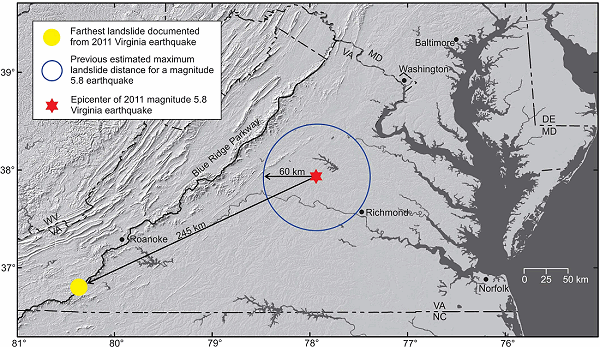
The two researchers found fresh rockfalls four times as far away as their model predicted for a magnitude-5.8 event. Rockfalls occurred in an area 20 times as large as expected. Jibson talked about their results this week at the Geological Society of America's annual meeting in Charlotte, and a paper about it will appear in the Seismological Society of America Bulletin next month.

US Geological Survey image

Scientifically, this result made sense in two ways. First, it's already well known that earthquakes are felt much more widely in the cold, hard crust east of the Rockies. Jibson and Harp's rockfall evidence matches the human evidence—in fact, human reports of the Virginia quake show that it was felt by more Americans than any previous earthquake.

US Geological Survey image

Second, the rockfall limit did not form a circle on the map, but an ellipse elongated along the Appalachian Mountains. That is, the regional geology, not just the basic structure of the Earth's crust, affected the pattern of shaking. Those two new pieces of knowledge will help in reassessing historical earthquakes as well as preparing for future ones in different places.

Slowly but surely, Americans are joining Californians in becoming earthquake-aware. The broken Washington Monument, damaged in the 2011 Virginia quake, is a peerless consciousness raiser. The growing participation in ShakeOut programs across the country is helping, too. Earthquake resistance can be engineered into our buildings and infrastructure, but landslides will never change. Speaking of which, California has its own special hazard of earthquakes related to landslides: valley fever. Jibson documented an outbreak of this disease, caused by a soil-dwelling fungus, after the 1994 Northridge earthquake. Face masks might be a good addition to your earthquake kit.

lower waypoint
next waypoint