upper waypoint

Caldor Fire Nearly 50% Contained, As Crews Continue Battling 'Troublesome' Spots

Save ArticleSave Article
Failed to save article

Please try again

A firefighter sprays down hot spots while battling the Caldor Fire on Aug. 31, 2021 in Meyers. (Justin Sullivan/Getty Images)

Find the latest on evacuation orders and warnings, including a map from the El Dorado County Sheriff's Office, as well as current shelter information for evacuees. Follow Cal Fire AEU on Twitter for up-to-date information. This post, originally published on Aug. 27, was continually updated through Sept. 7. 

Updated 11 a.m. Tuesday

Despite rising temperatures and low humidity, fire crews made steady progress in an ongoing quest to subdue the massive Caldor Fire, with almost 50% of the voracious blaze contained as of Tuesday morning.

"Which means we don't expect any movement of the fire outside those containment lines," said Cal Fire Operations Section Chief Tim Ernst, proudly pointing to the solid black containment lines ringing most of the southern and southwestern sections of the perimeter, nearly up the Highway 50 corridor to Kyburz. "As a matter of fact, yesterday we didn't have any significant runs of the fire that pushed any of those containment lines, nor did we have any significant spots. So that's a great accomplishment."

A screenshot of Cal Fire Incident Commander Tim Ernst during Tuesday morning's Caldor Fire update, as he points to hard-fought black containment lines along the blaze's southern and southwestern flank. (Cal Fire via Facebook)

But even as communities in the South Lake Tahoe basin and other recently evacuated areas returned home this weekend, Ernst noted the blaze was far from quenched.

He said crews were still contending with "troublesome" areas in its northern and eastern reaches, including near Wrights Lake, northwest of Highway 50, where a tenacious offshoot of the blaze had entered Desolation Wilderness.

And while crews in the basin made incremental progress beefing up containment efforts near Heavenly Mountain Resort, staving off any major structural damage in the vicinity, the eastern flank of the blaze continued to push against the Highway 88 corridor, posing a lingering threat to the Kirkwood Mountain Resort community. Ernst, though, said crews had just done firing operations near homes in that area — referring to the tactic of intentionally burning brush and other fuels as a preventive measure — and were now
"seeing much better results there."

The fire, which first sparked on Aug. 14 near Grizzly Flats, has destroyed at least 776 homes and devoured more than 216,000 acres. Full containment of the blaze is expected by Sept. 27, Cal Fire said.

Explore a map of current Caldor Fire activity:

Clear here to view larger map (or if not loading on mobile)


Updated 6 p.m. Monday

Containment on the Caldor Fire improved over Labor Day weekend to 44% as fire officials let people return to South Lake Tahoe.

The repopulation of South Lake Tahoe began on Sunday afternoon after the evacuation order for the city of more than 20,000 people was downgraded to an evacuation warning.

This includes everything within the city limits, the area north of State Highway 50 between the Nevada state line and the Lake Tahoe airport, and all properties on both sides of Highway 89  from Emerald Bay north through Tahoma, among a few other spots in El Dorado County.

A map of the southern shore of Lake Tahoe. Tahoma, Fallen Leaf A, South Lake Tahoe, and Lower and Upper Kingsbury are in yellow.
While South Lake Tahoe has been downgraded to an evacuation warning, many other parts of El Dorado County remain under an evacuation order. On Sept. 5, Cal Fire AED published this map to show which areas remain under an evacuation order (violet) and which are now under an evacuation warning (yellow). (Cal Fire Amador-El Dorado Unit)

Over the weekend, fire crews made progress in containing the flames along the northwest and northeast sections of the perimeter, including the section closest to South Lake Tahoe.

Sponsored

"A lot of great work has gone on there," said Cal Fire Operations Section Chief Tim Ernst in a Monday morning community briefing.

But on the morning of Labor Day, fire officials also signaled that conditions on Monday are a lot drier, which could make the work of containing what is left of the Caldor Fire much more difficult.

"I cannot emphasize how dry things are across this fire today. The humidity was very, very poor recovery last night," said incident meteorologist Jim Dudley, who also added that the wind is blowing a lot more strongly than it did during the weekend.

With stronger winds comes a greater risk of embers flying out and widening the perimeter of the fire, Stephen Vollmer, fire analyst with Cal Fire, reminded fire crews Monday morning.

"We've got this thing, we're wrapping our arms around it. We're trying to take it down, but don't get complacent on it," he said. "Stay focused."

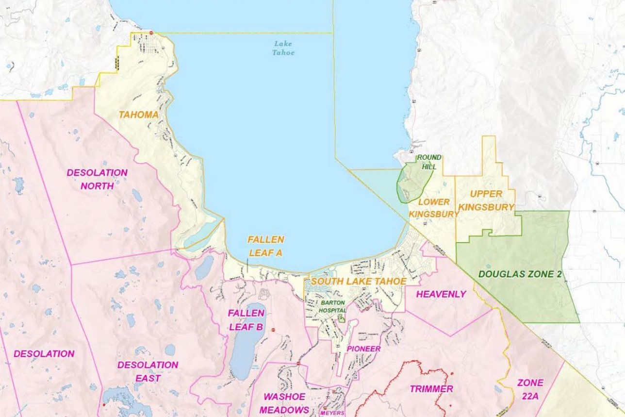
For now, Highway 50 has reopened from the Nevada border to the South Lake Tahoe city limits to allow residents back in.

"People are really excited to get back into town," said Mayor of South Lake Tahoe Tamara Wallace. She was quick to point out that the repopulation effort does not include all of El Dorado County and that there are many other communities still under an evacuation order.

"It's …  a testament to the firefighters and their amazing work that we are able to get back into our homes and all our homes are safe," said Wallace, who for the moment plans to hold off for a few days until she returns to her own home in the city.

"There's limited services," she explained, pointing to the fact that, as of Monday morning, only one grocery store in the entire city had reopened.

Both Wallace and Cal Fire recommend that residents who are allowed to return to their homes first stock up on groceries, gas and other essential supplies before making the trip back. This also goes for folks who don't live full-time in South Lake Tahoe but have a cabin or property in the area and want to check up on it.

Once a fire has burned through an area, many dangers remain: Damage to buildings can make them unstable; debris and downed trees can block roads; and downed utility lines pose serious electrical and other hazards. Fire officials also warn that the risk of flooding remains high for weeks and months after a wildfire, due to the amount of destroyed vegetation that once stabilized the soil.

Updated 10 a.m. Saturday

As of Saturday morning, Cal Fire AEU reported a continued decrease in fire behavior "thanks to a slight rise in humidity levels and decrease in temperatures." Ongoing inspections for damage continue, but Cal Fire said 75% of structures were assessed. The fire is still most active on the south side of Echo Lake.

The smoke outlook for the Tahoe area is expected to be between moderate to unhealthy throughout the day with some light winds predicted to provide some relief. The temporary closure of all national forests in California is still in effect.

Updated 5:30 p.m. Friday 

As fire crews manage the seemingly insurmountable feat of beating back the Caldor Fire from South Lake Tahoe, one question has been repeatedly aired by the public: When will people be allowed back?

The prospects are "looking good" for repopulating South Lake Tahoe, said U.S. Forest Service Operations Sections Chief Jake Cagle, but it depends on the weather and the efforts of hundreds of people — so officially, there's no answer yet.

Still, Cagle said, "we're getting close."

South Lake Tahoe Fire Chief Clive Savacool said he and his fellow firefighters have been evacuated from their homes as well, "so we can empathize with you."

Savacool thanked South Lake Tahoe citizens for pushing for more information, and said, "I wanted to assure you we're going to get you home as soon as we can, as soon as the fire is safe. ... It's also our position to be your voice."

The Caldor Fire has burned 212,907 acres as of Friday evening, and is 29% contained.

Repopulating areas that have been evacuated was on the minds of most fire officials at Friday evening's community meeting, as they downgraded various areas from evacuation orders — which mandate evacuations — to warnings, which merely caution them.

Areas downgraded Friday afternoon include:

  • South Sly Park: South of Starkes Grade Road, north of Sly Park Creek, east of Pleasant Valley Road up to and including the Diamond Garnet subdivision.
  • Grizzly Flats West: East of Highway E16, west of Steely Ridge Road, south of the North Fork of the Cosumnes River and north of the Middle Fork of the Cosumnes River.
  • Happy Valley: All properties accessed from Happy Valley Road.

Other fronts of the fire showed signs of fire crews finding success, including Christmas Valley, with fire officials saying "everything looks good" there, and Sierra Springs and the Lower Pines area both being downgraded to evacuation warnings, from orders.

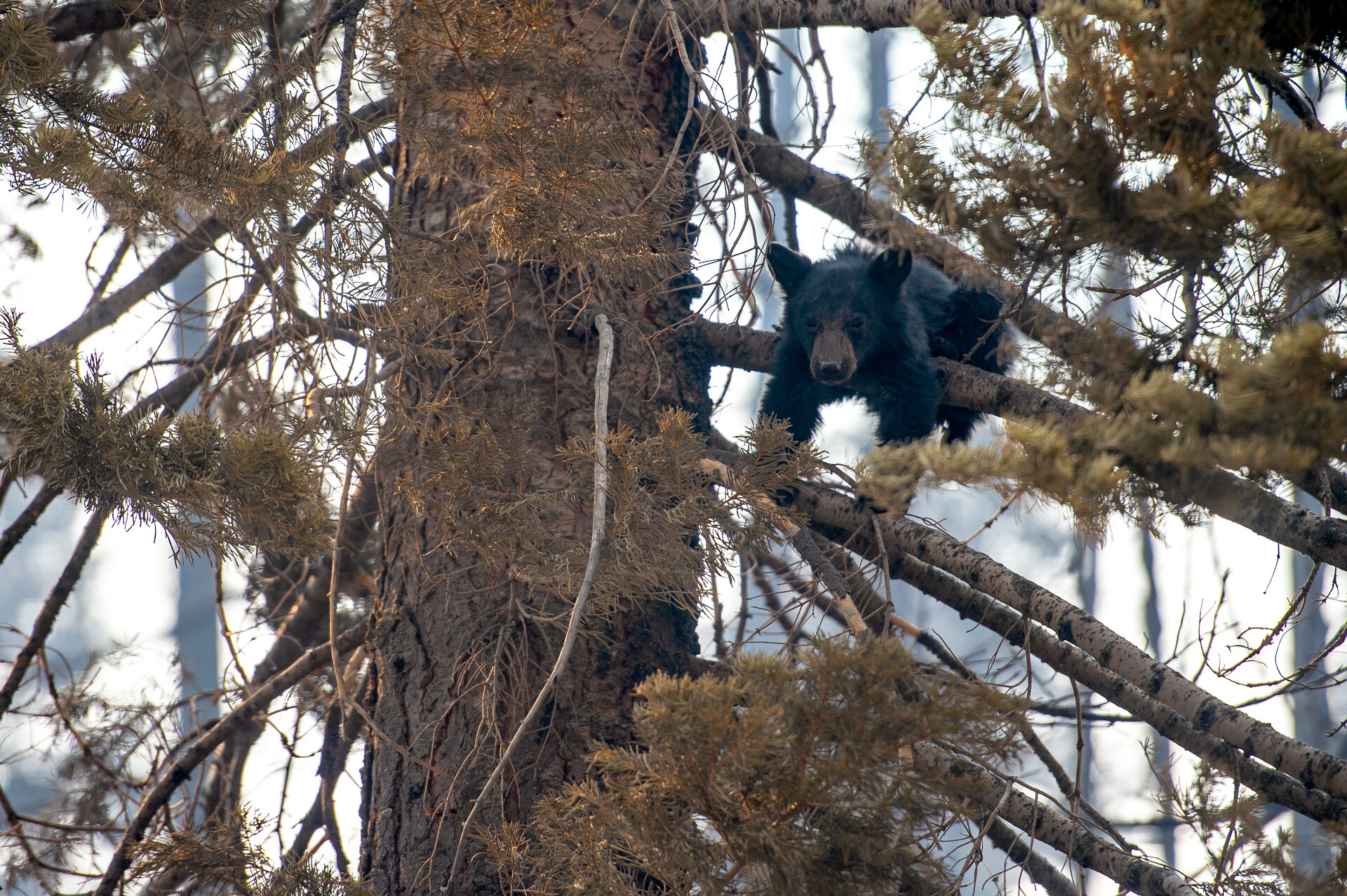
Savacool had one more thought to reassure South Lake Tahoe citizens: We're making sure the bears aren't rummaging around your homes.

"We've gotten a lot of calls and concerns about the bears in town," Savacool said Friday evening. He said law enforcement is "patrolling 24/7 to make sure your homes are safe, to scare off the bears, so your homes are protected."

Make sure to check for full and up-to-date evacuation orders and warnings with Cal Fire.

Updated 2 p.m. Friday 

The Caldor Fire has so far been successfully steered from South Lake Tahoe thanks to a break in weather conditions, defensive fire prevention and a continuous push from fire crews, officials said Friday.

Still, the fire has encroached on nearby areas, like Christmas Valley, and fire officials said the battle is far from over.

In a Friday afternoon community briefing, Anthony Scardina, deputy regional forester with the United States Forest Service, said a lot of the day's success came from defensive field treatments like forest thinning and prescribed burns.

"There were conditions where there were 150-foot flame lengths, and when they hit, those field treatments worked, bringing them down to 20-foot flame lengths," Scardina said.

"But we're still not out of the woods," he said. "We're having some success, but there's still a lot of fire on the landscape. And weather conditions can change pretty quickly, as you've seen."

Some evacuation orders were downgraded to evacuation warnings as of 2 p.m. Friday afternoon, including:

  • The area south of Pleasant Valley between Bucks Bar Road and Newtown Road
  • East of Bucks Bar Road
  • The areas of Gopher Hole Road and Moon-Shadow
  • The area just south of U.S. Highway 50, north of Starkes Grade Road
  • East of Snows Road
  • West of Fresh Pond

The successful field treatments that aided fire efforts this week were the result of 10 years of fire prevention, Scardina said, and that's work that needs to be ongoing.

"We have forest conditions that are overstocked. They're too dense, and you combine that with a series of years of drought, and combine that with some of the warming temperatures we've seen," he said, "with those three elements we have to continue working on them."

Updated 9 a.m. Friday 

Cal Fire expressed cautious optimism this morning, after another night of more favorable weather conditions allowed them to inch up containment on the Caldor Fire to 29%.

"I'll sum everything up with the incident with the words 'cautiously optimistic,'" Cal Fire Section Chief Tim Ernst said at the Friday morning briefing. "The humidities came in again last night, and fortunately we've had no significant fire runs through the entire shift yesterday. So we've definitely turned that corner."

Ernst credited the consistent hard work of fire crews for saving thousands of homes and countless acres of forest. More than 4,400 firefighters are currently on the ground and in the air fighting the blaze.

Since first erupting on Aug. 14, the massive blaze has destroyed 661 homes and devoured nearly 213,000 acres, while continuing to threaten some 32,000 other structures.

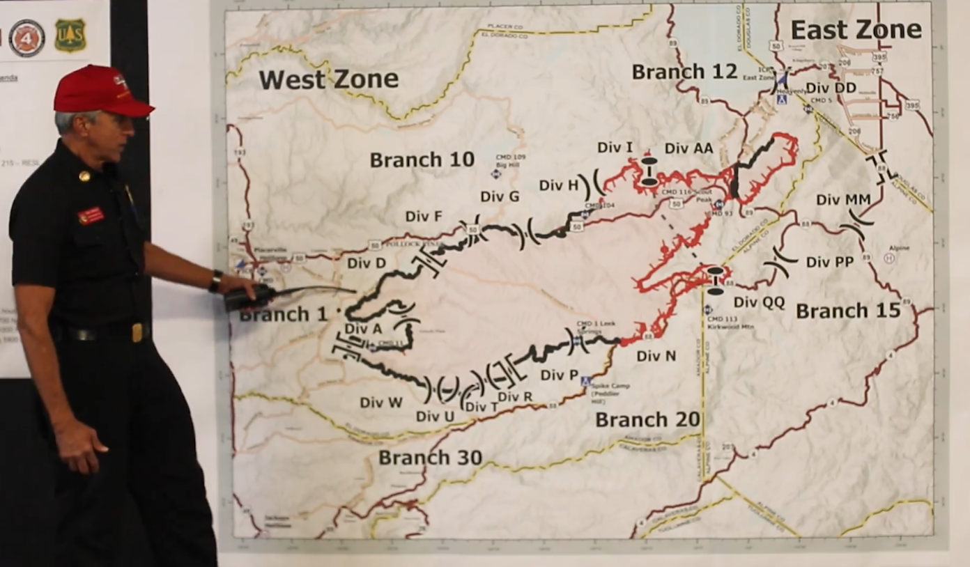
While overall conditions are still dry, firefighters are taking advantage of the marginally improved humidity and reduced winds to secure key areas, like those along the Highway 50 corridor and near the Heavenly Mountain Resort.

"We are going into a new phase in the weather," said incident meteorologist Jim Dudley. "We're going back to the inversion. We got the smoke."

Dudley said that while this weather will result in lighter winds, regular terrain-driven winds throughout the day will continue to be a challenge because of their unpredictability and tendency to move in "squirrely directions."

Firefighters are also working to improve containment lines near Meyers and South Lake Tahoe, where the blaze continues to be active. Northeast of the Pioneer Trail, hand crews and bulldozers are working to build lines that would usher the fire toward Cold Creek, where containment is more secure.

Across Highway 50, at Lower Echo Lake, firefighters worked through the night extinguishing hot spots and battling the fire directly to keep it from spreading to nearby cabins.

Christmas Valley, which sits just south of South Lake Tahoe, remains among the areas of greatest concern. The fire is still very active in the area, prompting firefighters last night to build control lines to coax it east toward Saxon Creek.

"We're not out of the woods, but we have not seen any growth there as well," Ernst said. Crews, he added, will continue to focus heavily on that area today in an effort to contain the fire's spread.

Another big priority Friday is securing areas near homes so officials can begin lifting evacuation orders and allowing residents to return. Nearly 48,000 people in the region still remain under evacuation orders.

While acknowledging the positive developments, officials urged residents not to get complacent.

"We've got this thing kind of lassoed. We just need to keep holding on to it with what we've got," said Stephen Vollmer, a fire analyst with Cal Fire. "So know that there's still a lot of hot material out there, know that there's a lot of unburned islands in the middle of this thing that could still threaten our line."

That's especially true, he said, along much of Highway 50, an area that remains hot and windy, where embers can still blow up to half a mile into unburned islands of brush and start new spot fires.

Paraphrasing from a World War II speech by Winston Churchill, U.S. Forest Service Supervisor Dean Gould said: "This isn't the end. It's not the beginning of the end, but it's the end of the beginning. So please keep that in mind."

Updated 6:30 p.m. Thursday 

Favorable weather conditions Thursday gave firefighters a slight advantage, as they worked to keep the Caldor Fire from moving into populated areas in the Tahoe basin and nearby communities.

The fire has already destroyed 649 homes, and some 32,000 more structures are still under threat.

Following three extremely gusty, dry red flag condition days that fueled the spread of the fire — which is now 27% contained — calmer winds throughout much of the massive fire area helped an army of more than 4,400 firefighters gain some ground.

Those conditions are expected to continue through Saturday and possibly even Sunday, giving weary crews a crucial window to make steady containment gains.

"Weather’s gotten better. We got good news on the weather front. The light winds will continue for about two to three days,” said incident meteorologist Jim Dudley during the Thursday evening briefing.

That decrease in winds means a decrease in fire activity, particularly the spot fires that have been largely responsible for spreading this blaze, added Stephen Vollmer, a fire analyst with Cal Fire. Although ignition rates will remain very high, he said embers were now being cast less than half a mile, down from over a mile just days ago.

"Which is great for the resources on the ground, so we can get in there and mop up all those hot spots," he said.

In a sign of improved conditions, officials on Thursday downgraded mandatory evacuation orders to warnings in the area of Omo Ranch, on the southwestern heel of the fire — where there is a growing segment of continuous containment line — and lifted evacuation warnings altogether in several nearby communities.

“What we did get today is a little bit of good news. The colors are starting to change," said John Davis, a Cal Fire liaison officer, pointing to the updated recent evacuation map. “Everyone's getting in here, doing the work necessary to put everybody back as soon as safely possible."

Firefighters on Thursday were also able to maintain control over a stubborn section of fire along Butte Creek and Sturdevant Ridge, north of Grizzly Flats.

"This continued to be probably one of our major challenges for the first two weeks of the incident," said Cal Fire Section Chief Tim Ernst. “By [containing it], we were able to save about 600 or 700 structures, over 10,000 additional acres in this area."

Heading up Highway 50 into the Tahoe basin, fire activity continued at Lower Echo Lake, where firefighters yesterday were ferried by boat to protect and prepare structures. Crews on Thursday worked along the edges of the blaze to steer it away from cabins.

Despite earlier concerns, the fire had not spread to the area of Upper Truckee Road, where crews worked to put in contingency line up to Fallen Leaf Lake, in case conditions change. "Right now there's not imminent threat or anticipation that it's going to get in there," said Cal Fire Operations Section Chief Jake Cagle.

While crews made overall progress on the fire Thursday, the northeastern edge of the blaze continued to menace communities in the Tahoe basin as it moved toward the Nevada state line.

That tongue of fire was still "bumping up" against the border of Heavenly Mountain Resort, Tahoe’s largest ski area, although the blaze was not spreading as fast as it has in recent days, Ernst said. He said crews there are continuing to shore up the northeast perimeter by putting in strong bulldozer lines and removing hazardous trees, in a thus-far successful effort to protect nearby housing developments.

There was some increased fire activity in the area on Thursday, with crews working the edge of the blaze and trying to push it toward the power line grid.

The resort, which is now being used as a staging area by firefighters, also brought out its big guns — snowmaking devices that were being used to hose down buildings.

Thick smoke continues to envelop South Lake Tahoe, which remains under a mandatory evacuation order and is all but deserted at a time when it would normally be swarming with tourists.

After casinos and stores closed on the Nevada side of Lake Tahoe on Wednesday morning, evacuees lined up outside the MontBleu Resort Casino & Spa in Stateline, waiting for a bus to take them to Reno.

Cagle also said crews had made good progress on the fire's northeastern flank in a bid to prevent it from crossing into Nevada.

The lower end of that same spur of the fire, roughly 3 miles south of South Lake Tahoe, also continued to threaten communities in Meyers and Christmas Valley. Firefighters there, aided by air tankers, hustled Thursday to keep the flames as high up on the eastern ridge as possible, and away from dense concentrations of homes. But Christmas Valley was looking good by day's end Thursday, Cagle said, noting that crews there were being "extremely aggressive."

Crews were also still struggling to gain control over the blaze near the Kirkwood ski resort area, to the south of the basin. Aircraft bombarded the area with water and retardant throughout day, as hand crews and bulldozers put in line to keep the blaze from coming down the ridge into the community.

Since first sparking on Aug. 14, the blaze has charred nearly 211,000 acres.

Updated 9 a.m. Thursday

The good news: Improved weather is expected to continue today.

"We lost the winds aloft. It's a good day today to not have gusty winds up on the ridges," said incident meteorologist Jim Dudley at a Thursday morning briefing. "What we are going to have today are terrain-driven winds," which occur as the sun heats the ground.

Still, those winds, he warned, tend to be "quite variable in direction," and given the ongoing dry conditions can still easily spark spot fires.

On the west side of the blaze, firefighters are working to secure the Highway 50 corridor and keep the fire from burning cabins near Wrights Lake on the edge of Desolation Wilderness, in hopes the granite fields there will block its advance.

"We've got a lot of resources heading up there to make sure we prevent any fire spread from heading back to the west," said Beale Monday, a U.S. Forest Service operations section chief.

In a positive development, crews overnight were able to use air support to drop water near the Kirkwood ski resort, holding back the blaze, which is hung up on a ridge just outside the area.

Officials on Thursday planned to fly in pumps to bring more water into the area to reinforce containment lines and protect homes.

Late Wednesday night, President Biden issued an emergency declaration for the Caldor Fire — following a request from Gov. Gavin Newsom — directing federal assistance to support state, local and tribal officials in battling the blaze. The order also authorizes the Department of Homeland Security and the Federal Emergency Management Agency (FEMA) to coordinate disaster relief efforts and provide assistance.

Although the fire has charred more than 210,000 acres, only five injuries — three firefighters and two civilians — have been reported so far, with no fatalities.

Fire managers on Wednesday also announced a major change in command structure, with the fire now divided into a western and eastern zone, each managed by separate teams.

Updated 8 p.m. Wednesday

Facing a third consecutive red flag warning day amid dry, blustery conditions, thousands of firefighters labored Wednesday to block the ravenous Caldor Fire from reaching two major ski resort areas near Lake Tahoe.

Crews doubled down on efforts to corral a large finger of the blaze that was rapidly spreading northeast toward Heavenly Mountain Resort and the Nevada state line, where it posed an immediate threat to South Lake Tahoe and neighboring communities.

"Heavy, heavy resource commitment. We've got folks from all over the country here pushed into this entire area," Beale Monday, a U.S. Forest Service operations section chief, said on Wednesday. "This is some very tough country. Very steep, very rugged. And it’s just not safe to try to put people right on the fire edge right now."

He said the fire was expected to spread further northeast, crossing into Nevada, and that crews with heavy equipment were doing prep work around the clock on sections of Highways 206, 207 and 88 to try to create “a catcher’s mitt as close to this as we possibly can."

"We're going to have a lot of equipment, a lot of people working on this periphery out here," Monday said.

The blaze also skirted across the north side of Christmas Valley, with crews scrambling to keep flames east of Pioneer Trail and away from homes. Monday said there has so far been no reported damage to homes in the area.

South of the Tahoe basin, crews hardened their defense of the Kirkwood ski area along Highway 88, where strong, erratic winds continued to fuel the blaze, spreading spot fires dangerously close to that community. As of Wednesday evening, the fire had not entered Kirkwood proper, Monday said.

And on the northwest side of the blaze, the fire on Wednesday continued moving aggressively up Wrights Lake Road off Highway 50 toward Desolation Wilderness. Aided by heavy air tankers dumping retardant, ground crews there moved quickly to connect control lines to the nearby granite fields in an effort to steer the blaze away from cabins and prevent it from spreading west.

"We're actively engaged way up high here into the wilderness, trying to make sure that we do not get any more fire spread to the west," he said.

Wind-fueled spot fires continue to be the biggest hurdle to control efforts, said Stephen Vollmer, a fire analyst with Cal Fire.

"They've been a problem since the very first day of this incident, and that's what's causing this fire to grow exponentially," he said. "So we're battling what we can battle and waiting for those winds to subside so that we can get in there and actively engage those fires."

On Wednesday, crews also toiled to stop an offshoot of fire along the Highway 50 corridor east of Pollock Pines, as bulldozers tried to build a contingency line on the north side of the highway.

"One of our biggest fears is that fire jumping across the highway," Monday said.

Despite the many challenges firefighters continued to face, much progress had been made in various sections of the massive fire area, including most of the southern flank, where the perimeter remained strong, he said.

Things were also generally looking under control in much of the southwestern section of the blaze, near where it first ignited more than two weeks ago, he added, although crews were still working to connect containment lines there, after a fierce spot fire erupted Tuesday on a ridge above Sly Park Road — setting a bulldozer on fire.

"We still have a lot of work to do in there," Monday said. "This has been a real troublesome spot for us over the last 14 to 15 days."

Firefighters, he said, were "trying to put the wet stuff on the hot stuff as much as we can," hoping to "call this line contained" in the next few days and then begin repopulating much of the area.

A black bear cub hangs over a tree branch near a burned structure in Phillips on Tues., Aug. 31, 2021. The Caldor Fire spread through the area on Monday evening. (Beth LaBerge/KQED)

As containment lines grew, officials on Wednesday downgraded an evacuation order to a warning in the area near North Camino and Pollock Pines north of Highway 50 and west of Sly Park Road, allowing residents there to return to their homes for the first time in about two weeks.

But some 53,000 residents in El Dorado County alone were still under evacuation orders Wednesday. Officials have not given a timeline for when those areas can be repopulated, noting the many steps necessary before lifting evacuation orders, including removing firefighting equipment, cutting down damaged trees, and getting critical infrastructure running.

But an expected positive turn in the weather in the coming days may help hasten those repopulation efforts.

“Finally some good news on the weather side here on this fire,” said incident meteorologist Jim Dudley, emphasizing that the region's red flag warning would finally be ending late Wednesday.

While dry conditions will continue into tomorrow, with high ignition rates, he said the strong, erratic winds that have so effectively fueled the fire in recent days are likely to subside.

"And getting into Friday, the winds get even lighter," he said. "So the issues and conditions that weather was causing, especially for the last couple of days, are going to be mitigated by much lighter winds across the fire."

Burning since Aug. 14, the Caldor Fire has charred nearly 208,000 acres and is now 23% contained. The blaze has destroyed almost 600 residences and continues to threaten more than 32,000 homes and other structures. Amazingly, only five injuries — three firefighters and two civilians — have been reported so far, with no fatalities.

Updated 9 a.m. Wednesday

After another long night of working to protect structures in the southern Tahoe basin from the sprawling Caldor Fire, firefighters face a challenging day again Wednesday as gusty winds and extremely dry conditions persist.

Fire crews dodged a bit of a bullet Tuesday as southwesterly winds didn't blow as hard as forecast, instead pushing the fire northeast — further into the Carson Range toward Nevada — instead of north toward South Lake Tahoe.

"We lucked out yesterday with some of the winds that didn't come up quite as hard as we expected," said Cal Fire Section Chief Tim Ernst in a Wednesday morning briefing. "We're fortunate the fire did not make as strong a push into Tahoe as it did the previous day."

Ernst said a thick layer of smoke that came in around midnight "put a damper on things and slowed a lot of growth," giving crews opportunities to make some progress, despite very low humidity and warm temperatures.

"We've got some great dozer line to protect structures here," Ernst said of efforts to keep the dangerous easternmost tongue of the fire from spreading into nearby communities, including South Lake Tahoe.

The fire is now burning just a few miles southwest of the Heavenly Mountain Resort, which on Tuesday began activating snowmaking equipment in an effort to slow the fire should it reach the area.

Fire crews Wednesday will also continue on protecting the Kirkwood area south of the Tahoe basin along Highway 88.

"One of our major concerns was the Kirkwood bowl area where the Kirkwood ski area is. The fire is currently hung up right on the ridge outside Kirkwood, so that's something we'll be looking at today as one of our priorities," Ernst said.

As to the active fire area further west of Kirkwood along Highway 88, Ernst said fire crews are continuing to work on buttoning it up and keeping it from spreading further south across the highway — but he said the area "won't show containment for a while."

Overnight, the fire also moved quickly up Wrights Lake Road, above Highway 50, spreading north toward a group of nearby cabins and Desolation Wilderness beyond that.

"This continues to be probably one of the biggest challenges of this last shift," said Ernst, adding that crews were putting in contingency lines and doing structure defense.

On a positive note, Ernst said things were "looking real good" in most of the southern and southwestern sections of the fire, where firefighters had made steady containment gains, including the area along Sly Park Road, south of Pollock Pines. Crews, though, were still fighting hard to clean up and secure one small area near Grizzly Flats, close to where the fire began more than two weeks — and where a bulldozer went up in flames yesterday. "We expect to probably see another 36 to 48 hours before we show full containment here," he said.

"The entire fire is still in a red flag warning," warned Cal Fire incident meteorologist Jim Dudley Wednesday morning. "The wind regime you saw yesterday will continue today. The speeds may be a little bit less than [Tuesday] ... but we'll still have swirling gusty winds."

The red flag warning is set to expire at 11 p.m. Wednesday — but fire behavior analyst Stephen Vollmer warned that extreme fire behavior is likely to continue for at least another week, and indicated that officials fully expect the fire to cross the California-Nevada state line. Mandatory evacuation orders have already been issued for several communities just across the state line.

In El Dorado County alone, more than 53,000 residents are currently under mandatory evacuation orders, with no timeline yet in place for repopulating those areas.

"We've talked about fire-weakened timber falling across roads, across escape routes. ... We've talked about long-distance spotting and high probability of ignition with extremely dry fuels," Vollmer said Wednesday morning. "All those things are still in play today. And they're still going to be in play for the next week or so until we get a severe change in the weather."

Updated 10 p.m. Tuesday

A sprawling army of firefighters worked furiously Tuesday to protect communities in and around the South Lake Tahoe area, as fierce alpine gusts continued fanning the flames of the fast-growing Caldor Fire.

Nearly 4,000 personnel kept fighting the ferocious blaze from all directions in an all-out scramble not so much to extinguish the flames, but merely to keep them from destroying houses and other structures.

"We can’t control it. We don’t have any tools out there to stop the fire," Erich Schwab, a Cal Fire operations section chief, told reporters during a Tuesday evening briefing, noting the exceptionally windy, dry conditions — expected to continue through Wednesday — that have stymied control efforts. "So we resort to herding the fire away from structures and away from people, so that’s what we’re actively doing."

That strategy has so far proved successful in protecting most buildings in the densely populated Tahoe basin and in many of the communities along the Highway 50 corridor heading up to Echo Summit.

Although the fire had already reached into Meyers Tuesday, the flames had yet to extend into neighboring South Lake Tahoe.

Schwab said crews were also still actively fighting the blaze in pockets of "unburned islands" along Highway 50 near Twin Bridges.

"There are literally fire engines from here all the way down into Tahoe," he said. "I did see some damage to structures. The fire burned through there extremely fast, extremely hot. And we did the best that we could. And we’re still in there."

Since sparking more than two weeks ago, the blaze has charred nearly 200,000 acres and destroyed nearly 500 homes, along with some 100 other structures, while continuing to threaten more than 33,000 more, officials said. It is now 18% contained.

Schwab also said crews had kept the head of the fire — which jumped Highway 89 Monday night — from reaching the Heavenly Mountain Resort area, and were now putting in bulldozer lines and waiting for fire activity to "settle down" before beginning their attack. That growth prompted a mandatory evacuation order for several communities just across the state line in Nevada — adding to the many thousands of people who have been forced to flee their homes in areas throughout the region, including the nearly 22,000 South Lake residents ordered to leave on Monday.

A new evacuation order was also issued late Tuesday for a small section of Alpine County along Highway 88, near Kirkwood, where the fire gained ground.

"[We'll] go back in and get it when the fire behaves and calms down on us," Schwab said.

The blaze, which on Monday jumped Highway 88, had not yet reached Kirkwood, he said, but a structure defense operation with 20 engines had been established there in preparation.

The fire on Tuesday also jumped the control line on Wrights Lake Road, Schwab added, and was making a run east toward Wrights Lake and Desolation Wilderness.

The undesirable trio of strong winds, low humidity and high temperatures continues to make the probability of ignition incredibly high, explained Cal Fire’s Stephen Vollmer, a fire behavior analyst. Those conditions enable active crown runs, where the fire jumps from treetop to treetop, sometimes casting embers more than a mile away.

"So that's what's propagating the spread of the fire right now," he said. "Those embers are landing in the very old, very dense fuels that are out there in the fire environment ... in an area that has not seen fire history all the way back before 1940."

A red flag warning will remain in place for the region through Wednesday night, amid ongoing windy gusts and low humidity, incident meteorologist Jim Dudley said.

"I think today is the worst of the weather days," he said. "Tomorrow’s going to be another bad weather day — I’ll be honest with you — but it’ll be the last one of those."

But Dudley said winds were expected to weaken considerably by Thursday.

"And that’s gonna make for a much better situation here on the fire footprint," he said. "So keep that in mind. We’ve got to get through tonight and tomorrow. Things look better come Thursday."

Although most of the southern and southwestern edges of the fire are now contained, officials said there is no timeline to repopulate most of those areas still under mandatory evacuation.

"Everybody is making every effort to get you back in your homes," said Sgt. Eric Palmberg with the El Dorado County Sheriff's Office. "When these people determine it is safe to get back into our homes, we will put that information out and we will get you back in there as soon as we can."

Updated 4 p.m. Tuesday

An army of firefighters faced an increasingly challenging fight against the Caldor Fire overnight, as the blaze's eastern flank continued to burn downslope from near Echo Summit into the Tahoe basin, with the fire establishing itself on both sides of Highway 89 south of Meyers — the third major roadway it has now jumped.

Pushed by strong winds, flames on the eastern side of Highway 89 have now begun burning into the mountains on the other side of the valley, south of South Lake Tahoe.

"We saw spotting distances of a half mile to a mile yesterday. The spots went all the way to the other side of the 89 and are working their way back up," said Tim Ernst, Cal Fire section chief, in a morning briefing Tuesday.

Crews in the Christmas Valley area, near Meyers, worked overnight to protect homes on the west side of 89, as the fire backed down the slope behind them. Amazingly, there did not appear to be any significant structure loss in the neighborhoods that the flames had reached into, according to ABC10 reporter Brandon Rittiman.

"I just want to show you how close the Caldor Fire came to getting some of these structures. You can see the blackened forest just right up into the backyards," Rittiman said in a Twitter video posted on Tuesday afternoon, which he filmed near the intersection of Highway 89 and Santa Claus Drive. "I don't see any structures lost down here, which is just incredible given the way-big flame lengths that we were seeing last night."

He added, "This took a lot of work from fire crews."

And in similarly positive news, a Cal Fire firefighter told KQED's Beth LaBerge that all structures at the Sierra at Tahoe ski resort — where the blaze had run through on Sunday night — were saved except for one vehicle maintenance building.

Firefighters are likely to face even more challenging conditions and very dangerous rates of fire spread Tuesday, as winds are expected to pick up significantly and a red flag warning remains in effect until 11 p.m. Wednesday.

"We have even more flow coming across the fire to cause more turbulent winds, [with] gusts to 45 mph, maybe 50 mph depending on where you are," said incident meteorologist Jim Dudley on Tuesday morning.

Stronger winds will be more pronounced at higher elevations, he said, with the general wind direction pushing the fire toward South Lake Tahoe to the northeast and further into the mountains to the east. But crews will likely have to contend with more chaotic winds on the valley floor.

"I can't emphasize [enough] the wind issues we're going to have up top," Dudley said. "That wind is going to channel through the canyons and drainages up there. The overall direction is going to want to take it off to the northeast and east, but when you're down on the terrain it's going to be all over the place."

Those winds mean the Caldor Fire will likely continue to grow at dangerous rates of spread — with crown fires torching large trees and throwing embers for long distances, especially in drainages that align with the southwesterly wind direction, said Stephen Vollmer, Cal Fire fire behavior analyst.

"Every day when those trees torch out we've got that long distance spotting. Today is not going to be any different," Vollmer said Tuesday morning. "We're going to see rates of spread go up to about 200 feet per minute, and the spotting distances go over a mile."

Extremely dry conditions also mean extremely high rates of ignition for spot fires created by those embers. "Ignition is about 90%," Vollmer said. "But it probably should be about 150%." Vollmer said long-distance spotting would likely continue for the next two days due to forecast winds.

"This fire is going to stand up and rip," said Cal Fire incident commander Jeff Ike on Tuesday morning, emphasizing the danger for fire crews and advising them to stay out of the fire's direct path. "Under no circumstances get in front of the head of this fire."

Thick smoke prevented air firefighting operations periodically last week. But since then, nearly two dozen helicopters and three air tankers dumped thousands of gallons of water and retardant on the fire, fire spokesperson Dominic Polito said Tuesday.

The city of South Lake Tahoe, usually bustling with summer tourists, was eerily empty Tuesday morning, the air thick with smoke from the approaching blaze. On Monday, thousands of residents jammed Highway 50 heading toward Nevada — one of the only exit routes — after being ordered by authorities to leave.

City officials said only a handful defied the order. But nearly everyone worried Tuesday about what the fire would do next.

“It just kind of sucks waiting. I mean, I know it’s close down that way,” said Russ Crupi, gesturing south from his home in the Heavenly Valley Estates mobile home park, which he and his wife manage. He had arranged sprinklers and tractors around the neighborhood.

“I’m worried about what’ll be here when people come back. People want to come back to their houses and that’s what I’m going to try to do,” he said.


José Mora, 37, a construction worker from South Lake Tahoe, waited until yesterday's evacuation order to leave town, jumping in his car with just a bag of clothes. He moved here as a young child from his native Jalisco, Mexico, where many of South Lake's Latino residents come from. The Latino community here, which has grown markedly in recent years, now accounts for more than 30% of the city's population.

But Mora, who on Tuesday was sheltering at the Carson City Community Center, said if the area is hit hard by the fire, he'll likely have to relocate in search of work.

"If it burns, it's going to be hard, a lot of years to recover, and it's not going to be the same," he said. "It's going to take years to be where we're at right now."

As of Tuesday morning, the Caldor Fire had burned over 191,607 acres, destroyed at least 669 structures, and was 16% contained. Just five injuries have so far been reported since the start of the blaze more than two weeks ago.

Updated 6 p.m. Monday

Fire crews continued battling the Caldor Fire's advancing eastern perimeter along the Highway 50 corridor near Echo Summit on Monday afternoon, after officials put the entirety of South Lake Tahoe under a mandatory evacuation order late Monday morning.

“It’s been a rough long day for the troops up there today. But they have been decently successful,” said Cody Bogan, a Cal Fire operations section chief, during an evening briefing. “Luckily the fuel’s kind of run out and it kind of slowed the fire progression down, up on that north piece.”

The fire was casting embers up to half a mile earlier Monday, according to fire officials, causing spot fires to ignite downslope into the Tahoe basin. The blaze, which has now charred more than 186,500 acres and is only 15% contained, continues to pose a serious threat to the basin amid a red flag warning due to higher winds and exceptionally dry conditions. That warning has been extended until 11 p.m. Wednesday.

Clearer air in the area allowed some aircraft to provide much-needed support from above on Monday, Bogan said, with firefighters on the ground continuing to chase spot fires.

Further south, along the fire's southeastern flank, crews were unable to keep the blaze from jumping Highway 88 for the first time, into Amador County. The fire jumped the highway approximately two miles west of Kirkwood, and was pushing eastward toward the resort area. Kirkwood was placed under mandatory evacuation orders on Sunday.

“The Highway 88 corridor got hit pretty hard today,” Bogan said, noting that bulldozers were digging line to try to cut it off and “get it tamed back” onto the north side of the road.

Among Monday's positive developments: Firefighters have been successful in protecting the town of Strawberry, which just days earlier was under imminent threat, Bogan said.

“Everything through Strawberry’s looking a lot better now. They’re continuing to mop up around structures and trying to secure things,” he said of the community that lies along Highway 50 on the western side of the pass, east of Twin Bridges. “As of right now, there’s been no structure loss in the Strawberry area that we are aware of.”

Bogan also called it “a very successful day” in the southwestern sections of the fire, near where it first ignited two weeks ago, with crews making steady containment gains. That progress prompted officials late Monday to downgrade evacuation orders to warnings in several nearby areas close to Omo Ranch Road, near the Amador/El Dorado County line.

Conditions, he added, were also “looking real good” heading northeast toward the Pollock Pines area, with “no real issues at all to report,” although evacuation orders there remained in effect.

Updated 3 p.m. Monday

All 22,000 South Lake Tahoe residents were ordered to evacuate late Monday morning as the Caldor Fire continued its rapid advance eastward, crossing Echo Summit and threatening to extend further into the Tahoe basin.

"It's something that's always in the back of your mind that you hope never happens," said South Lake Mayor Pro Tem Devin Middlebrook, who evacuated late Sunday night. "But here we are today, with this threat to our community. And it's something that we, as a city and as a community, have been preparing for, and hopefully that preparation pays off."

By early Monday afternoon, vehicles packed to the brim with bikes, camping gear and other personal belongings — some even towing boats — were backed up for miles in the thick, brown air along eastbound Highway 50 heading toward Nevada, the main evacuation route, as residents anxiously waited to escape the smoke-choked basin. One man broke out his violin and played a mournful melody as he ambled along the vast line of motionless cars.

"This is a systematic evacuation, one neighborhood at a time," South Lake Tahoe police Lt. Travis Cabral said on social media. "I am asking you as our community to please remain calm."

An evacuation order is defined as an immediate threat to life. Evacuation shelters are located at Truckee Veterans Hall and the Douglas County Community and Senior Center in Gardnerville, Nevada.

The orders come as the eastern edge of the Caldor Fire continues its rapid advance. On Sunday night, the blaze extended 8 1/2 miles up to the border of the Tahoe basin, incinerating cabins and other structures in the forest along Highway 50 between Twin Bridges and Echo Summit.

By Monday morning, the blaze had grown to more than 177,000 acres — a run of more than 20,000 acres over just one day — leaping over hard-fought containment lines cut with bulldozers, as crews battled the flames on multiple sides. The fire remained only 14% contained, down from 19% containment earlier this weekend, after rapid growth on the northeast and southern edges.

By midday Monday, the fire had breached several points along the ridge and begun its descent into the basin, reaching spots around Lower Echo Lake and parts of Desolation Wilderness.

"So there's fire in the basin," Cal Fire Chief Thom Porter reported solemnly at a Monday afternoon briefing.

"Caldor is a real tough one for us," he said, noting the steep challenges firefighters face controlling the northeastern edge's side of the massive blaze, which continues to churn through rugged, difficult-to-reach terrain. "It's been burning in heavy timber, just very, very difficult conditions."

Porter said last week's inversion layer in the atmosphere, which helped keep a lid on the fire, disappeared yesterday.

"When the air clears, it's like taking the lid off of your pot of boiling water — all of a sudden there's that plume of heat and steam that comes out. Same thing happens on a fire," he said. "Also sucks in oxygen from all directions, puts fire and spot fires in all directions. That's what happened yesterday."

Officials are still assessing last night’s damage in the El Dorado County communities the fire swept through, including the Sierra-at-Tahoe ski resort, where snowmaking equipment had been activated in the hopes of gaining some protection from the blaze. More than 600 structures have already been destroyed, and at least 20,000 more were threatened.

Weather conditions were expected to worsen throughout the day, with strong wind gusts and low humidity raising concerns of erratic fire behavior and prompting the National Weather Service to issue a red flag warning extending through Tuesday night.

Porter underscored the unprecedented ferocity of California fires this season , which is still just in its early stages.

"We haven't had fires burn from one side of the Sierras to the other. [But] we did with the Dixie, now we have with the Caldor. Two times in our history, and they're both happening this month," he said, urging residents to be prepared and evacuate as early as possible. "We need to be really cognizant that there is fire activity happening in California that we have never seen before."

Updated 10 p.m. Sunday
Evacuation orders and warnings hit South Lake Tahoe and additional areas in the Tahoe basin on Sunday night after a challenging weekend for crews battling the massive Caldor Fire.

Evacuation orders in El Dorado County were extended to include the community of Meyers and communities south of Meyers along Highway 89 to the Alpine County line. An evacuation warning is now in effect for the remainder of El Dorado County in the Tahoe basin, including all of South Lake Tahoe and communities along the southern shores of the lake north to the Placer County line.

Additional evacuation orders in Alpine County included the Kirkwood Mountain Resort and Caples Lake.

South Lake Tahoe's main medical facility, Barton Memorial Hospital, proactively evacuated 36 patients needing skilled nursing and 16 in acute care beds Sunday, sending them to regional facilities far from the fire, public information officer Mindi Befu said. The rest of the hospital was evacuating following Monday's expanded orders.

Fire officials sounded resigned in a community meeting Sunday evening, as new evacuation orders were issued across El Dorado and Alpine counties in the wake of "extreme rates" of fire spread, said Eric Schwab, Cal Fire's operation section chief.

Those evacuation orders include Meyers, just 7 miles south of South Lake Tahoe, which itself was issued an evacuation warning.

"A couple days ago I really felt we were turning the corner with it," Schwab told the community. But without adequate staffing and with changing weather conditions, firefighters found themselves playing defense over the weekend, fire officials said — not so much stopping the spread, as working to save structures from the fire.

Schwab said that in the last two weeks, the Caldor Fire's perimeter had advanced less than a half mile, but on Sunday the perimeter "moved about 2 1/2 miles on us with no sign it's slowing down."

In those conditions, Schwab said, fire crews moved to their No. 1 priority: evacuating people and preserving life. Much of their defense of structures was around Highway 50 and the Kirkwood Mountain Resort, with 25 strike teams of engines, 25 bulldozers and 25 hand crews set to defend nearby structures Sunday night.

"When the wind blows like this, our primary modes are one — hold onto what we have," Schwab said.

A favorable turn in weather Saturday afternoon allowed firefighters to make progress and increase containment of the fire to 19%, up from 12% the day before, said Capt. Stephen Horner, a Cal Fire spokesperson for the Caldor Fire.

But Sunday's effort was far more of a struggle, with crews having to carry hoses by hand through rough terrain. Triple-digit weather also lies ahead through Tuesday, leaving little optimism.

“Today’s been a rough day and there’s no bones about it," said Jeff Marsolais, forest supervisor for Eldorado National Forest. A few days ago, he thought crews could halt the Caldor Fire's eastern progress, but “today it let loose."

"Eleven days ago we had 240 people, and that was it to try to work and contain this fire," said Keith Wade, a Cal Fire captain and public information officer. "Now we're upwards of 3,500 personnel. … That means more help. And that means more containment lines getting down on the ground."

Updated 7 p.m. Saturday
Cal Fire has ordered evacuations across portions of El Dorado County, including near Echo Summit. Cal Fire also asked other communities near Echo Summit — like Christmas Valley near Highway 89 — to prepare for that possibility. Check Cal Fire's incident page for a full list of evacuation orders.

The massive blaze has raged across a vast expanse of steep, mountainous terrain southwest of Lake Tahoe and destroyed more than 470 structures since igniting on Aug. 14, even as the fire continued to advance northeast toward the much more populated Tahoe basin.

Some low humidity on Saturday afternoon increased fire activity, according to Cal Fire, with erratic winds casting embers up to half a mile from the fire.

"Today's been the hottest, driest day so far on the fire," said Jim Dudley, Cal Fire incident meteorologist, in a Saturday evening community meeting.

On Sunday night and Monday, wind will increase, Dudley said, prompting officials to call a red flag warning for the northern Sierra and the southern Cascades, which takes effect 11 a.m. Monday through Tuesday evening. Those conditions may mean more "rapid spread of fire," according to the National Weather Service.

Fire officials said they'll expect to see increased fire activity Sunday and Monday morning, since an inversion layer of air is expected to bottle up smoky air in the area and release it those mornings.

Visibility improved enough near Saturday evening to allow Cal Fire to bring in more air support, said Cal Fire Section Chief Cody Bogan.

Original post: Updated 8 p.m. Friday
As of Friday morning, much of the southwestern and western flanks of the sprawling Caldor Fire, along with its southern perimeter, had been largely contained, with no major growth reported, fire officials said. Cal Fire Operations Section Chief Erich Schwab echoed that sentiment about the southwestern portion of the blaze in an evening briefing, saying fire officials were "finally comfortable and confident that that's not going to move any further."

Schwab said technical burning operations on the northwestern edge of the fire — the portion closest to Placerville — resulted in some minor spot fires, which were difficult to fight in extremely limited visibility due to smoke. "We hope to get it boxed in," Schwab said, as a daylong smoke inversion had lifted and allowed an air attack.

The most active and dangerous portions of the Caldor Fire remain the eastern and northeastern sections currently burning toward the Lake Tahoe basin.

The most problematic flank of the blaze — the northeastern section, which has jumped Highway 50 between Kyburz and Strawberry — "got very active [Thursday] and jumped over our proposed control line and ran about 800 acres ... burning up to the 7,500 elevation line," Schwab said.

"Fuels are extremely critical up there," he added. "Fuels that normally wouldn't be available to burn actively are burning with extreme conditions."

That portion of the fire has also "completely torched" much of the area along Highway 50 between Kyburz and Strawberry, hurling fallen trees and other debris onto the roadway, said Cal Fire Section Chief Tim Ernst earlier on Friday.

"This road is extremely treacherous right now," Ernst added, while noting that firefighters have so far been able to protect all the structures in the area.

Nonetheless, Schwab sounded a note of optimism Friday evening regarding the blaze's eastern section south of Highway 50, calling it a "success story for today." Crews were able to establish multiple bulldozer containment lines east of where the fire is burning — that is, between the fire and the Tahoe basin — and Schwab was hopeful that planned overnight backfire operations would succeed in halting the blaze's eastern progress.

Answering a question about the likelihood of the blaze reaching the Tahoe basin, Schwab said, "We're doing everything that we can to ensure that it doesn't. ... That's why [the eastern branch of the fire south of Highway 50] is such a critical priority for us."

As for winds that could significantly drive the fire, Cal Fire incident meteorologist Jim Dudley said Friday evening that relatively light winds are forecast for the weekend, but that the situation could change Sunday.

"You'll probably be hearing terms like 'possibly a red flag might be coming out this weekend for strong winds for Monday,'" said Cal Fire incident met

KQED's Monica Lam contributed to this report.

Sponsored

lower waypoint
next waypoint
State Prisons Offset New Inmate Wage Hikes by Cutting Hours for Some WorkersCecil Williams, Legendary Pastor of Glide Church, Dies at 94Erik Aadahl on the Power of Sound in FilmFresno's Chinatown Neighborhood To See Big Changes From High Speed RailKQED Youth Takeover: How Can San Jose Schools Create Safer Campuses?How to Attend a Rally Safely in the Bay Area: Your Rights, Protections and the PoliceWill Less Homework Stress Make California Students Happier?Nurses Warn Patient Safety at Risk as AI Use Spreads in Health CareBill to Curb California Utilities’ Use of Customer Money Fails to PassSilicon Valley House Seat Race Gets a Recount