window.__IS_SSR__=true
window.__INITIAL_STATE__={
"attachmentsReducer": {
"audio_0": {
"type": "attachments",
"id": "audio_0",
"imgSizes": {
"kqedFullSize": {
"file": "https://ww2.kqed.org/news/wp-content/themes/KQED-unified/img/audio_bgs/background0.jpg"
}
}
},
"audio_1": {
"type": "attachments",
"id": "audio_1",
"imgSizes": {
"kqedFullSize": {
"file": "https://ww2.kqed.org/news/wp-content/themes/KQED-unified/img/audio_bgs/background1.jpg"
}
}
},
"audio_2": {
"type": "attachments",
"id": "audio_2",
"imgSizes": {
"kqedFullSize": {
"file": "https://ww2.kqed.org/news/wp-content/themes/KQED-unified/img/audio_bgs/background2.jpg"
}
}
},
"audio_3": {
"type": "attachments",
"id": "audio_3",
"imgSizes": {
"kqedFullSize": {
"file": "https://ww2.kqed.org/news/wp-content/themes/KQED-unified/img/audio_bgs/background3.jpg"
}
}
},
"audio_4": {
"type": "attachments",
"id": "audio_4",
"imgSizes": {
"kqedFullSize": {
"file": "https://ww2.kqed.org/news/wp-content/themes/KQED-unified/img/audio_bgs/background4.jpg"
}
}
},
"placeholder": {
"type": "attachments",
"id": "placeholder",
"imgSizes": {
"thumbnail": {
"file": "https://cdn.kqed.org/wp-content/uploads/2024/12/KQED-Default-Image-816638274-2000x1333-1-160x107.jpg",
"width": 160,
"height": 107,
"mimeType": "image/jpeg"
},
"medium": {
"file": "https://cdn.kqed.org/wp-content/uploads/2024/12/KQED-Default-Image-816638274-2000x1333-1-800x533.jpg",
"width": 800,
"height": 533,
"mimeType": "image/jpeg"
},
"medium_large": {
"file": "https://cdn.kqed.org/wp-content/uploads/2024/12/KQED-Default-Image-816638274-2000x1333-1-768x512.jpg",
"width": 768,
"height": 512,
"mimeType": "image/jpeg"
},
"large": {
"file": "https://cdn.kqed.org/wp-content/uploads/2024/12/KQED-Default-Image-816638274-2000x1333-1-1020x680.jpg",
"width": 1020,
"height": 680,
"mimeType": "image/jpeg"
},
"1536x1536": {
"file": "https://cdn.kqed.org/wp-content/uploads/2024/12/KQED-Default-Image-816638274-2000x1333-1-1536x1024.jpg",
"width": 1536,
"height": 1024,
"mimeType": "image/jpeg"
},
"fd-lrg": {
"file": "https://cdn.kqed.org/wp-content/uploads/2024/12/KQED-Default-Image-816638274-2000x1333-1-1536x1024.jpg",
"width": 1536,
"height": 1024,
"mimeType": "image/jpeg"
},
"fd-med": {
"file": "https://cdn.kqed.org/wp-content/uploads/2024/12/KQED-Default-Image-816638274-2000x1333-1-1020x680.jpg",
"width": 1020,
"height": 680,
"mimeType": "image/jpeg"
},
"fd-sm": {
"file": "https://cdn.kqed.org/wp-content/uploads/2024/12/KQED-Default-Image-816638274-2000x1333-1-800x533.jpg",
"width": 800,
"height": 533,
"mimeType": "image/jpeg"
},
"post-thumbnail": {
"file": "https://cdn.kqed.org/wp-content/uploads/2024/12/KQED-Default-Image-816638274-2000x1333-1-672x372.jpg",
"width": 672,
"height": 372,
"mimeType": "image/jpeg"
},
"twentyfourteen-full-width": {
"file": "https://cdn.kqed.org/wp-content/uploads/2024/12/KQED-Default-Image-816638274-2000x1333-1-1038x576.jpg",
"width": 1038,
"height": 576,
"mimeType": "image/jpeg"
},
"xxsmall": {
"file": "https://cdn.kqed.org/wp-content/uploads/2024/12/KQED-Default-Image-816638274-2000x1333-1-160x107.jpg",
"width": 160,
"height": 107,
"mimeType": "image/jpeg"
},
"xsmall": {
"file": "https://cdn.kqed.org/wp-content/uploads/2024/12/KQED-Default-Image-816638274-2000x1333-1-672x372.jpg",
"width": 672,
"height": 372,
"mimeType": "image/jpeg"
},
"small": {
"file": "https://cdn.kqed.org/wp-content/uploads/2024/12/KQED-Default-Image-816638274-2000x1333-1-672x372.jpg",
"width": 672,
"height": 372,
"mimeType": "image/jpeg"
},
"xlarge": {
"file": "https://cdn.kqed.org/wp-content/uploads/2024/12/KQED-Default-Image-816638274-2000x1333-1-1020x680.jpg",
"width": 1020,
"height": 680,
"mimeType": "image/jpeg"
},
"full-width": {
"file": "https://cdn.kqed.org/wp-content/uploads/2024/12/KQED-Default-Image-816638274-2000x1333-1-1920x1280.jpg",
"width": 1920,
"height": 1280,
"mimeType": "image/jpeg"
},
"guest-author-32": {
"file": "https://cdn.kqed.org/wp-content/uploads/2025/01/KQED-Default-Image-816638274-1333x1333-1-160x160.jpg",
"width": 32,
"height": 32,
"mimeType": "image/jpeg"
},
"guest-author-50": {
"file": "https://cdn.kqed.org/wp-content/uploads/2025/01/KQED-Default-Image-816638274-1333x1333-1-160x160.jpg",
"width": 50,
"height": 50,
"mimeType": "image/jpeg"
},
"guest-author-64": {
"file": "https://cdn.kqed.org/wp-content/uploads/2025/01/KQED-Default-Image-816638274-1333x1333-1-160x160.jpg",
"width": 64,
"height": 64,
"mimeType": "image/jpeg"
},
"guest-author-96": {
"file": "https://cdn.kqed.org/wp-content/uploads/2025/01/KQED-Default-Image-816638274-1333x1333-1-160x160.jpg",
"width": 96,
"height": 96,
"mimeType": "image/jpeg"
},
"guest-author-128": {
"file": "https://cdn.kqed.org/wp-content/uploads/2025/01/KQED-Default-Image-816638274-1333x1333-1-160x160.jpg",
"width": 128,
"height": 128,
"mimeType": "image/jpeg"
},
"detail": {
"file": "https://cdn.kqed.org/wp-content/uploads/2025/01/KQED-Default-Image-816638274-1333x1333-1-160x160.jpg",
"width": 160,
"height": 160,
"mimeType": "image/jpeg"
},
"kqedFullSize": {
"file": "https://cdn.kqed.org/wp-content/uploads/2024/12/KQED-Default-Image-816638274-2000x1333-1.jpg",
"width": 2000,
"height": 1333
}
}
},
"news_12087662": {
"type": "attachments",
"id": "news_12087662",
"meta": {
"index": "attachments_1716263798",
"site": "news",
"id": "12087662",
"found": true
},
"title": "061526Flooding_GH_001-KQED",
"publishDate": 1781558849,
"status": "inherit",
"parent": 0,
"modified": 1781559066,
"caption": "A puddle left behind by receding king tides reflects homes along Golden Hind Passage in Corte Madera on June 15, 2026. Corte Madera Mayor Rosa Thomas said more adaptation will be needed to prepare the city for an El Niño winter.\r\n",
"credit": "Gustavo Hernandez/KQED",
"altTag": null,
"description": null,
"imgSizes": {
"thumbnail": {
"file": "https://cdn.kqed.org/wp-content/uploads/sites/10/2026/06/061526Flooding_GH_001-KQED-160x107.jpg",
"width": 160,
"height": 107,
"mimeType": "image/jpeg"
},
"1536x1536": {
"file": "https://cdn.kqed.org/wp-content/uploads/sites/10/2026/06/061526Flooding_GH_001-KQED-1536x1024.jpg",
"width": 1536,
"height": 1024,
"mimeType": "image/jpeg"
},
"post-thumbnail": {
"file": "https://cdn.kqed.org/wp-content/uploads/sites/10/2026/06/061526Flooding_GH_001-KQED-672x372.jpg",
"width": 672,
"height": 372,
"mimeType": "image/jpeg"
},
"twentyfourteen-full-width": {
"file": "https://cdn.kqed.org/wp-content/uploads/sites/10/2026/06/061526Flooding_GH_001-KQED-1038x576.jpg",
"width": 1038,
"height": 576,
"mimeType": "image/jpeg"
},
"npr-cds-wide": {
"file": "https://cdn.kqed.org/wp-content/uploads/sites/10/2026/06/061526Flooding_GH_001-KQED-1200x675.jpg",
"width": 1200,
"height": 675,
"mimeType": "image/jpeg"
},
"npr-cds-square": {
"file": "https://cdn.kqed.org/wp-content/uploads/sites/10/2026/06/061526Flooding_GH_001-KQED-600x600.jpg",
"width": 600,
"height": 600,
"mimeType": "image/jpeg"
},
"kqedFullSize": {
"file": "https://cdn.kqed.org/wp-content/uploads/sites/10/2026/06/061526Flooding_GH_001-KQED.jpg",
"width": 2000,
"height": 1333
}
},
"isLoading": false,
"fetchFailed": false
},
"news_12087082": {
"type": "attachments",
"id": "news_12087082",
"meta": {
"index": "attachments_1716263798",
"site": "news",
"id": "12087082",
"found": true
},
"title": "People enjoy the water at Ocean Beach in San Francisco on June 10, 2026.",
"publishDate": 1781134708,
"status": "inherit",
"parent": 0,
"modified": 1781134787,
"caption": "People enjoy the water at Ocean Beach in San Francisco on June 10, 2026.",
"credit": "Tâm Vũ/KQED",
"altTag": null,
"description": null,
"imgSizes": {
"medium": {
"file": "https://cdn.kqed.org/wp-content/uploads/sites/10/2026/06/260610-RISKYWX00337_TV-KQED-2000x1333.jpg",
"width": 2000,
"height": 1333,
"mimeType": "image/jpeg"
},
"large": {
"file": "https://cdn.kqed.org/wp-content/uploads/sites/10/2026/06/260610-RISKYWX00337_TV-KQED-2000x1333.jpg",
"width": 2000,
"height": 1333,
"mimeType": "image/jpeg"
},
"thumbnail": {
"file": "https://cdn.kqed.org/wp-content/uploads/sites/10/2026/06/260610-RISKYWX00337_TV-KQED-160x107.jpg",
"width": 160,
"height": 107,
"mimeType": "image/jpeg"
},
"1536x1536": {
"file": "https://cdn.kqed.org/wp-content/uploads/sites/10/2026/06/260610-RISKYWX00337_TV-KQED-1536x1024.jpg",
"width": 1536,
"height": 1024,
"mimeType": "image/jpeg"
},
"2048x2048": {
"file": "https://cdn.kqed.org/wp-content/uploads/sites/10/2026/06/260610-RISKYWX00337_TV-KQED-2048x1365.jpg",
"width": 2048,
"height": 1365,
"mimeType": "image/jpeg"
},
"post-thumbnail": {
"file": "https://cdn.kqed.org/wp-content/uploads/sites/10/2026/06/260610-RISKYWX00337_TV-KQED-672x372.jpg",
"width": 672,
"height": 372,
"mimeType": "image/jpeg"
},
"twentyfourteen-full-width": {
"file": "https://cdn.kqed.org/wp-content/uploads/sites/10/2026/06/260610-RISKYWX00337_TV-KQED-1038x576.jpg",
"width": 1038,
"height": 576,
"mimeType": "image/jpeg"
},
"full-width": {
"file": "https://cdn.kqed.org/wp-content/uploads/sites/10/2026/06/260610-RISKYWX00337_TV-KQED-2000x1333.jpg",
"width": 2000,
"height": 1333,
"mimeType": "image/jpeg"
},
"npr-cds-wide": {
"file": "https://cdn.kqed.org/wp-content/uploads/sites/10/2026/06/260610-RISKYWX00337_TV-KQED-1200x675.jpg",
"width": 1200,
"height": 675,
"mimeType": "image/jpeg"
},
"npr-cds-square": {
"file": "https://cdn.kqed.org/wp-content/uploads/sites/10/2026/06/260610-RISKYWX00337_TV-KQED-600x600.jpg",
"width": 600,
"height": 600,
"mimeType": "image/jpeg"
},
"kqedFullSize": {
"file": "https://cdn.kqed.org/wp-content/uploads/sites/10/2026/06/260610-RISKYWX00337_TV-KQED.jpg",
"width": 2500,
"height": 1666
}
},
"isLoading": false,
"fetchFailed": false
},
"news_12057996": {
"type": "attachments",
"id": "news_12057996",
"meta": {
"index": "attachments_1716263798",
"site": "news",
"id": "12057996",
"found": true
},
"title": "Atmospheric river storm in Northern California",
"publishDate": 1759168970,
"status": "inherit",
"parent": 12057992,
"modified": 1781200630,
"caption": "A woman with an umbrella walks on a road during heavy rain in Guerneville, California, on Feb. 6, 2025, as an atmospheric river hits Northern California. ",
"credit": "Tayfun Coskun/Anadolu via Getty Images",
"altTag": null,
"description": null,
"imgSizes": {
"medium": {
"file": "https://cdn.kqed.org/wp-content/uploads/sites/10/2025/09/GettyImages-2197490970-2000x1333.jpg",
"width": 2000,
"height": 1333,
"mimeType": "image/jpeg"
},
"large": {
"file": "https://cdn.kqed.org/wp-content/uploads/sites/10/2025/09/GettyImages-2197490970-2000x1333.jpg",
"width": 2000,
"height": 1333,
"mimeType": "image/jpeg"
},
"thumbnail": {
"file": "https://cdn.kqed.org/wp-content/uploads/sites/10/2025/09/GettyImages-2197490970-160x107.jpg",
"width": 160,
"height": 107,
"mimeType": "image/jpeg"
},
"1536x1536": {
"file": "https://cdn.kqed.org/wp-content/uploads/sites/10/2025/09/GettyImages-2197490970-1536x1024.jpg",
"width": 1536,
"height": 1024,
"mimeType": "image/jpeg"
},
"2048x2048": {
"file": "https://cdn.kqed.org/wp-content/uploads/sites/10/2025/09/GettyImages-2197490970-2048x1365.jpg",
"width": 2048,
"height": 1365,
"mimeType": "image/jpeg"
},
"post-thumbnail": {
"file": "https://cdn.kqed.org/wp-content/uploads/sites/10/2025/09/GettyImages-2197490970-672x372.jpg",
"width": 672,
"height": 372,
"mimeType": "image/jpeg"
},
"twentyfourteen-full-width": {
"file": "https://cdn.kqed.org/wp-content/uploads/sites/10/2025/09/GettyImages-2197490970-1038x576.jpg",
"width": 1038,
"height": 576,
"mimeType": "image/jpeg"
},
"full-width": {
"file": "https://cdn.kqed.org/wp-content/uploads/sites/10/2025/09/GettyImages-2197490970-2000x1333.jpg",
"width": 2000,
"height": 1333,
"mimeType": "image/jpeg"
},
"kqedFullSize": {
"file": "https://cdn.kqed.org/wp-content/uploads/sites/10/2025/09/GettyImages-2197490970-scaled-e1759169024848.jpg",
"width": 2000,
"height": 1334
}
},
"isLoading": false,
"fetchFailed": false
},
"news_11974638": {
"type": "attachments",
"id": "news_11974638",
"meta": {
"index": "attachments_1716263798",
"site": "news",
"id": "11974638",
"found": true
},
"parent": 11936674,
"imgSizes": {
"twentyfourteen-full-width": {
"file": "https://cdn.kqed.org/wp-content/uploads/sites/10/2024/01/231218-RainFile-14-BL_qut-1038x576.jpg",
"width": 1038,
"mimeType": "image/jpeg",
"height": 576
},
"thumbnail": {
"file": "https://cdn.kqed.org/wp-content/uploads/sites/10/2024/01/231218-RainFile-14-BL_qut-160x107.jpg",
"width": 160,
"mimeType": "image/jpeg",
"height": 107
},
"post-thumbnail": {
"file": "https://cdn.kqed.org/wp-content/uploads/sites/10/2024/01/231218-RainFile-14-BL_qut-672x372.jpg",
"width": 672,
"mimeType": "image/jpeg",
"height": 372
},
"kqedFullSize": {
"file": "https://cdn.kqed.org/wp-content/uploads/sites/10/2024/01/231218-RainFile-14-BL_qut.jpg",
"width": 1920,
"height": 1280
},
"large": {
"file": "https://cdn.kqed.org/wp-content/uploads/sites/10/2024/01/231218-RainFile-14-BL_qut-1020x680.jpg",
"width": 1020,
"mimeType": "image/jpeg",
"height": 680
},
"1536x1536": {
"file": "https://cdn.kqed.org/wp-content/uploads/sites/10/2024/01/231218-RainFile-14-BL_qut-1536x1024.jpg",
"width": 1536,
"mimeType": "image/jpeg",
"height": 1024
},
"medium": {
"file": "https://cdn.kqed.org/wp-content/uploads/sites/10/2024/01/231218-RainFile-14-BL_qut-800x533.jpg",
"width": 800,
"mimeType": "image/jpeg",
"height": 533
}
},
"publishDate": 1706913206,
"modified": 1706913240,
"caption": "A person walks in the rain on Mission Street in San Francisco on Dec. 18, 2023.",
"description": null,
"title": "weather-forecast-rain-bay-area",
"credit": "Beth LaBerge/KQED",
"status": "inherit",
"altTag": null,
"isLoading": false,
"fetchFailed": false
},
"news_12051516": {
"type": "attachments",
"id": "news_12051516",
"meta": {
"index": "attachments_1716263798",
"site": "news",
"id": "12051516",
"found": true
},
"title": "US-SCIENCE-CLIMATE-ENVIRONMENT-NOAA",
"publishDate": 1754682601,
"status": "inherit",
"parent": 12051499,
"modified": 1754682672,
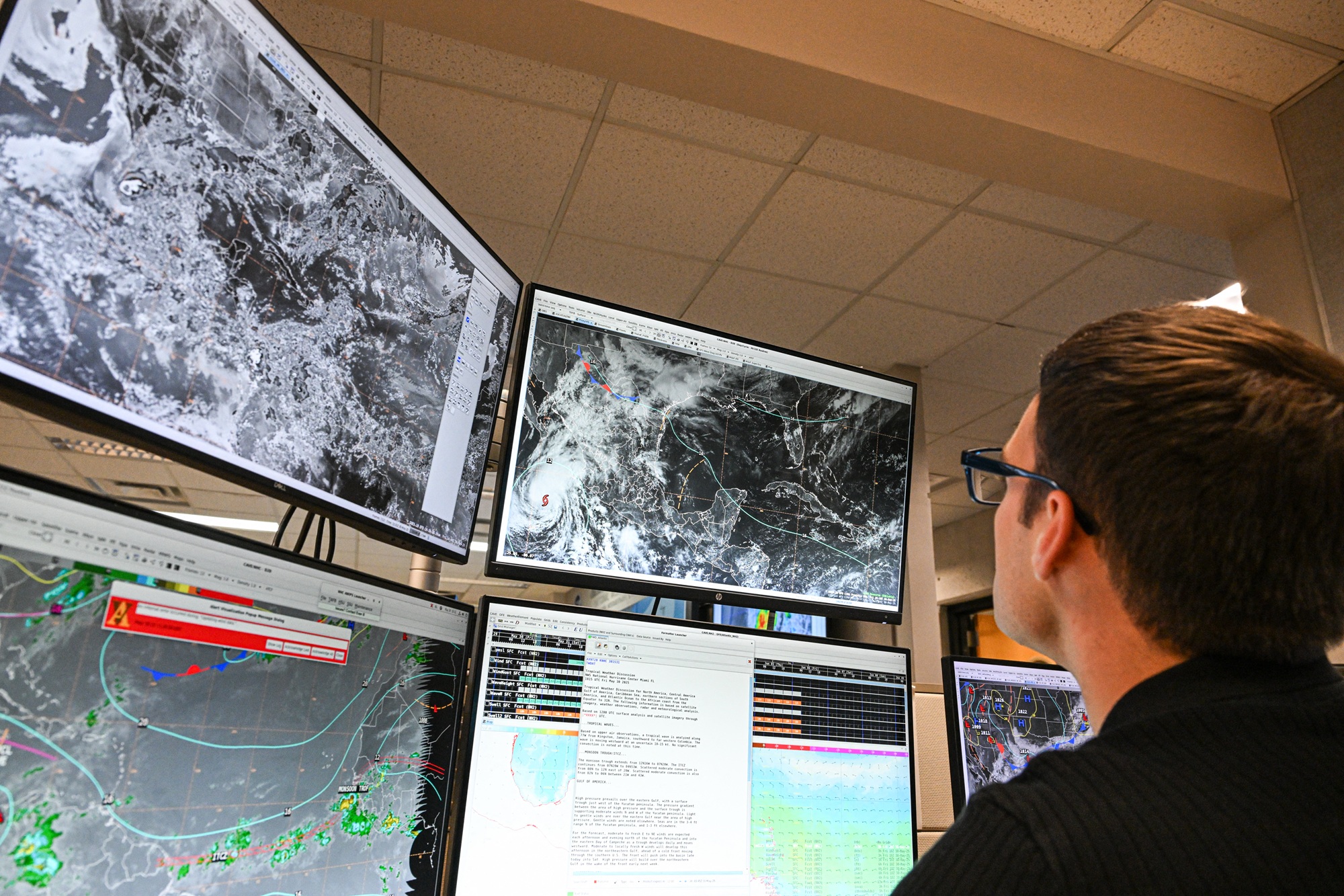
"caption": "A tropical analysis meteorologist works at his station at the National Oceanic and Atmospheric Administration's (NOAA) National Hurricane Center in Miami, Florida, on May 30, 2025. The Trump administration has fired hundreds of staff at NOAA and deleted government websites with data on the weather and climate. ",
"credit": "Chandan Khanna/AFP via Getty Images",
"altTag": null,
"description": null,
"imgSizes": {
"thumbnail": {
"file": "https://cdn.kqed.org/wp-content/uploads/sites/10/2025/08/MeteorologistsTrumpGetty-160x107.jpg",
"width": 160,
"height": 107,
"mimeType": "image/jpeg"
},
"1536x1536": {
"file": "https://cdn.kqed.org/wp-content/uploads/sites/10/2025/08/MeteorologistsTrumpGetty-1536x1024.jpg",
"width": 1536,
"height": 1024,
"mimeType": "image/jpeg"
},
"post-thumbnail": {
"file": "https://cdn.kqed.org/wp-content/uploads/sites/10/2025/08/MeteorologistsTrumpGetty-672x372.jpg",
"width": 672,
"height": 372,
"mimeType": "image/jpeg"
},
"twentyfourteen-full-width": {
"file": "https://cdn.kqed.org/wp-content/uploads/sites/10/2025/08/MeteorologistsTrumpGetty-1038x576.jpg",
"width": 1038,
"height": 576,
"mimeType": "image/jpeg"
},
"kqedFullSize": {
"file": "https://cdn.kqed.org/wp-content/uploads/sites/10/2025/08/MeteorologistsTrumpGetty.jpg",
"width": 2000,
"height": 1333
}
},
"isLoading": false,
"fetchFailed": false
},
"news_12042478": {
"type": "attachments",
"id": "news_12042478",
"meta": {
"index": "attachments_1716263798",
"site": "news",
"id": "12042478",
"found": true
},
"title": "GettyImages-861092546-1020x680",
"publishDate": 1748958165,
"status": "inherit",
"parent": 12042477,
"modified": 1748958202,
"caption": null,
"credit": "Metamorworks via iStock/Getty Images Plus",
"altTag": null,
"description": null,
"imgSizes": {
"medium": {
"file": "https://cdn.kqed.org/wp-content/uploads/sites/10/2025/06/GettyImages-861092546-1020x680-1-800x533.jpg",
"width": 800,
"height": 533,
"mimeType": "image/jpeg"
},
"thumbnail": {
"file": "https://cdn.kqed.org/wp-content/uploads/sites/10/2025/06/GettyImages-861092546-1020x680-1-160x107.jpg",
"width": 160,
"height": 107,
"mimeType": "image/jpeg"
},
"post-thumbnail": {
"file": "https://cdn.kqed.org/wp-content/uploads/sites/10/2025/06/GettyImages-861092546-1020x680-1-672x372.jpg",
"width": 672,
"height": 372,
"mimeType": "image/jpeg"
},
"twentyfourteen-full-width": {
"file": "https://cdn.kqed.org/wp-content/uploads/sites/10/2025/06/GettyImages-861092546-1020x680-1-1020x576.jpg",
"width": 1020,
"height": 576,
"mimeType": "image/jpeg"
},
"kqedFullSize": {
"file": "https://cdn.kqed.org/wp-content/uploads/sites/10/2025/06/GettyImages-861092546-1020x680-1.jpg",
"width": 1020,
"height": 680
}
},
"isLoading": false,
"fetchFailed": false
},
"news_12040711": {
"type": "attachments",
"id": "news_12040711",
"meta": {
"index": "attachments_1716263798",
"site": "news",
"id": "12040711",
"found": true
},
"title": "drought_1_140115_qed",
"publishDate": 1747530311,
"status": "inherit",
"parent": 12040710,
"modified": 1747530419,
"caption": "Fire warning signs in the Berkeley and Oakland Hills. The red flag warning for a large part of the Central Valley — including much of Solano County — starts Sunday morning and is set to expire Monday night.",
"credit": "Mark Andrew Boyer/KQED",
"altTag": null,
"description": null,
"imgSizes": {
"medium": {
"file": "https://cdn.kqed.org/wp-content/uploads/sites/10/2025/05/drought_1_140115_qed-800x533.jpg",
"width": 800,
"height": 533,
"mimeType": "image/jpeg"
},
"large": {
"file": "https://cdn.kqed.org/wp-content/uploads/sites/10/2025/05/drought_1_140115_qed-1020x680.jpg",
"width": 1020,
"height": 680,
"mimeType": "image/jpeg"
},
"thumbnail": {
"file": "https://cdn.kqed.org/wp-content/uploads/sites/10/2025/05/drought_1_140115_qed-160x107.jpg",
"width": 160,
"height": 107,
"mimeType": "image/jpeg"
},
"1536x1536": {
"file": "https://cdn.kqed.org/wp-content/uploads/sites/10/2025/05/drought_1_140115_qed-1536x1024.jpg",
"width": 1536,
"height": 1024,
"mimeType": "image/jpeg"
},
"post-thumbnail": {
"file": "https://cdn.kqed.org/wp-content/uploads/sites/10/2025/05/drought_1_140115_qed-672x372.jpg",
"width": 672,
"height": 372,
"mimeType": "image/jpeg"
},
"twentyfourteen-full-width": {
"file": "https://cdn.kqed.org/wp-content/uploads/sites/10/2025/05/drought_1_140115_qed-1038x576.jpg",
"width": 1038,
"height": 576,
"mimeType": "image/jpeg"
},
"full-width": {
"file": "https://cdn.kqed.org/wp-content/uploads/sites/10/2025/05/drought_1_140115_qed-1920x1280.jpg",
"width": 1920,
"height": 1280,
"mimeType": "image/jpeg"
},
"kqedFullSize": {
"file": "https://cdn.kqed.org/wp-content/uploads/sites/10/2025/05/drought_1_140115_qed.jpg",
"width": 1999,
"height": 1333
}
},
"isLoading": false,
"fetchFailed": false
},
"news_12032747": {
"type": "attachments",
"id": "news_12032747",
"meta": {
"index": "attachments_1716263798",
"site": "news",
"id": "12032747",
"found": true
},
"title": "heatwave",
"publishDate": 1742838898,
"status": "inherit",
"parent": 12032741,
"modified": 1742838936,
"caption": "Siblings enjoy the spray grounds at Prince Gateway Park in Santa Rosa as the temperature reached 100 degrees on July 11, 2024.",
"credit": "Gina Castro/KQED",
"altTag": null,
"description": null,
"imgSizes": {
"medium": {
"file": "https://cdn.kqed.org/wp-content/uploads/sites/10/2025/03/heatwave-800x546.jpg",
"width": 800,
"height": 546,
"mimeType": "image/jpeg"
},
"large": {
"file": "https://cdn.kqed.org/wp-content/uploads/sites/10/2025/03/heatwave-1020x696.jpg",
"width": 1020,
"height": 696,
"mimeType": "image/jpeg"
},
"thumbnail": {
"file": "https://cdn.kqed.org/wp-content/uploads/sites/10/2025/03/heatwave-160x109.jpg",
"width": 160,
"height": 109,
"mimeType": "image/jpeg"
},
"1536x1536": {
"file": "https://cdn.kqed.org/wp-content/uploads/sites/10/2025/03/heatwave-1536x1048.jpg",
"width": 1536,
"height": 1048,
"mimeType": "image/jpeg"
},
"post-thumbnail": {
"file": "https://cdn.kqed.org/wp-content/uploads/sites/10/2025/03/heatwave-672x372.jpg",
"width": 672,
"height": 372,
"mimeType": "image/jpeg"
},
"twentyfourteen-full-width": {
"file": "https://cdn.kqed.org/wp-content/uploads/sites/10/2025/03/heatwave-1038x576.jpg",
"width": 1038,
"height": 576,
"mimeType": "image/jpeg"
},
"full-width": {
"file": "https://cdn.kqed.org/wp-content/uploads/sites/10/2025/03/heatwave-1920x1309.jpg",
"width": 1920,
"height": 1309,
"mimeType": "image/jpeg"
},
"kqedFullSize": {
"file": "https://cdn.kqed.org/wp-content/uploads/sites/10/2025/03/heatwave.jpg",
"width": 2000,
"height": 1364
}
},
"isLoading": false,
"fetchFailed": false
},
"news_12029443": {
"type": "attachments",
"id": "news_12029443",
"meta": {
"index": "attachments_1716263798",
"site": "news",
"id": "12029443",
"found": true
},
"title": "20241122_NorcalStorm_GC-7_qed",
"publishDate": 1741024106,
"status": "inherit",
"parent": 12029441,
"modified": 1741024140,
"caption": "A car drives through a puddle on Piner Road in Santa Rosa during an atmospheric river storm affecting the Bay Area on Nov. 22, 2024. ",
"credit": "Gina Castro/KQED",
"altTag": null,
"description": null,
"imgSizes": {
"medium": {
"file": "https://cdn.kqed.org/wp-content/uploads/sites/10/2025/03/20241122_NorcalStorm_GC-7_qed-800x516.jpg",
"width": 800,
"height": 516,
"mimeType": "image/jpeg"
},
"large": {
"file": "https://cdn.kqed.org/wp-content/uploads/sites/10/2025/03/20241122_NorcalStorm_GC-7_qed-1020x658.jpg",
"width": 1020,
"height": 658,
"mimeType": "image/jpeg"
},
"thumbnail": {
"file": "https://cdn.kqed.org/wp-content/uploads/sites/10/2025/03/20241122_NorcalStorm_GC-7_qed-160x103.jpg",
"width": 160,
"height": 103,
"mimeType": "image/jpeg"
},
"1536x1536": {
"file": "https://cdn.kqed.org/wp-content/uploads/sites/10/2025/03/20241122_NorcalStorm_GC-7_qed-1536x991.jpg",
"width": 1536,
"height": 991,
"mimeType": "image/jpeg"
},
"post-thumbnail": {
"file": "https://cdn.kqed.org/wp-content/uploads/sites/10/2025/03/20241122_NorcalStorm_GC-7_qed-672x372.jpg",
"width": 672,
"height": 372,
"mimeType": "image/jpeg"
},
"twentyfourteen-full-width": {
"file": "https://cdn.kqed.org/wp-content/uploads/sites/10/2025/03/20241122_NorcalStorm_GC-7_qed-1038x576.jpg",
"width": 1038,
"height": 576,
"mimeType": "image/jpeg"
},
"full-width": {
"file": "https://cdn.kqed.org/wp-content/uploads/sites/10/2025/03/20241122_NorcalStorm_GC-7_qed-1920x1239.jpg",
"width": 1920,
"height": 1239,
"mimeType": "image/jpeg"
},
"kqedFullSize": {
"file": "https://cdn.kqed.org/wp-content/uploads/sites/10/2025/03/20241122_NorcalStorm_GC-7_qed.jpg",
"width": 2000,
"height": 1291
}
},
"isLoading": false,
"fetchFailed": false
},
"news_12029189": {
"type": "attachments",
"id": "news_12029189",
"meta": {
"index": "attachments_1716263798",
"site": "news",
"id": "12029189",
"found": true
},
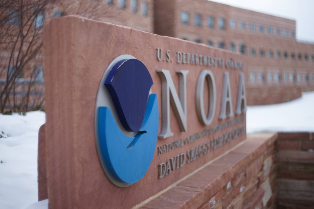
"title": "NOAA Earth System Research Laboratory",
"publishDate": 1740766106,
"status": "inherit",
"parent": 12029178,
"modified": 1740766133,
"caption": "National Oceanic & Atmospheric Administration Earth System Research Laboratory in Boulder, Colorado.",
"credit": "Byunghwan Lim/Getty Images",
"altTag": null,
"description": null,
"imgSizes": {
"medium": {
"file": "https://cdn.kqed.org/wp-content/uploads/sites/10/2025/02/NOAAGetty-800x533.jpg",
"width": 800,
"height": 533,
"mimeType": "image/jpeg"
},
"large": {
"file": "https://cdn.kqed.org/wp-content/uploads/sites/10/2025/02/NOAAGetty-1020x680.jpg",
"width": 1020,
"height": 680,
"mimeType": "image/jpeg"
},
"thumbnail": {
"file": "https://cdn.kqed.org/wp-content/uploads/sites/10/2025/02/NOAAGetty-160x107.jpg",
"width": 160,
"height": 107,
"mimeType": "image/jpeg"
},
"1536x1536": {
"file": "https://cdn.kqed.org/wp-content/uploads/sites/10/2025/02/NOAAGetty-1536x1024.jpg",
"width": 1536,
"height": 1024,
"mimeType": "image/jpeg"
},
"post-thumbnail": {
"file": "https://cdn.kqed.org/wp-content/uploads/sites/10/2025/02/NOAAGetty-672x372.jpg",
"width": 672,
"height": 372,
"mimeType": "image/jpeg"
},
"twentyfourteen-full-width": {
"file": "https://cdn.kqed.org/wp-content/uploads/sites/10/2025/02/NOAAGetty-1038x576.jpg",
"width": 1038,
"height": 576,
"mimeType": "image/jpeg"
},
"full-width": {
"file": "https://cdn.kqed.org/wp-content/uploads/sites/10/2025/02/NOAAGetty-1920x1280.jpg",
"width": 1920,
"height": 1280,
"mimeType": "image/jpeg"
},
"kqedFullSize": {
"file": "https://cdn.kqed.org/wp-content/uploads/sites/10/2025/02/NOAAGetty.jpg",
"width": 2000,
"height": 1333
}
},
"isLoading": false,
"fetchFailed": false
},
"news_12021263": {
"type": "attachments",
"id": "news_12021263",
"meta": {
"index": "attachments_1716263798",
"site": "news",
"id": "12021263",
"found": true
},
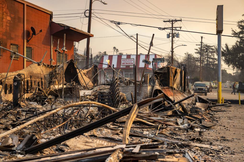
"title": "240109-CAWindStorm-043",
"publishDate": 1736462228,
"status": "inherit",
"parent": 12022146,
"modified": 1737075351,
"caption": "Buildings are destroyed along Fair Oaks Avenue in Altadena, California, after the Eaton Fire swept through the area northeast of Los Angeles, California, on Thursday, Jan. 9, 2025.",
"credit": "Beth LaBerge/KQED",
"altTag": null,
"description": null,
"imgSizes": {
"medium": {
"file": "https://cdn.kqed.org/wp-content/uploads/sites/10/2025/01/240109-CAWindStorm-043-800x533.jpg",
"width": 800,
"height": 533,
"mimeType": "image/jpeg"
},
"large": {
"file": "https://cdn.kqed.org/wp-content/uploads/sites/10/2025/01/240109-CAWindStorm-043-1020x680.jpg",
"width": 1020,
"height": 680,
"mimeType": "image/jpeg"
},
"thumbnail": {
"file": "https://cdn.kqed.org/wp-content/uploads/sites/10/2025/01/240109-CAWindStorm-043-160x107.jpg",
"width": 160,
"height": 107,
"mimeType": "image/jpeg"
},
"1536x1536": {
"file": "https://cdn.kqed.org/wp-content/uploads/sites/10/2025/01/240109-CAWindStorm-043-1536x1024.jpg",
"width": 1536,
"height": 1024,
"mimeType": "image/jpeg"
},
"post-thumbnail": {
"file": "https://cdn.kqed.org/wp-content/uploads/sites/10/2025/01/240109-CAWindStorm-043-672x372.jpg",
"width": 672,
"height": 372,
"mimeType": "image/jpeg"
},
"twentyfourteen-full-width": {
"file": "https://cdn.kqed.org/wp-content/uploads/sites/10/2025/01/240109-CAWindStorm-043-1038x576.jpg",
"width": 1038,
"height": 576,
"mimeType": "image/jpeg"
},
"full-width": {
"file": "https://cdn.kqed.org/wp-content/uploads/sites/10/2025/01/240109-CAWindStorm-043-1920x1280.jpg",
"width": 1920,
"height": 1280,
"mimeType": "image/jpeg"
},
"kqedFullSize": {
"file": "https://cdn.kqed.org/wp-content/uploads/sites/10/2025/01/240109-CAWindStorm-043.jpg",
"width": 2000,
"height": 1333
}
},
"isLoading": false,
"fetchFailed": false
}
},
"audioPlayerReducer": {
"postId": "stream_live",
"isPaused": true,
"isPlaying": false,
"pfsActive": false,
"pledgeModalIsOpen": true,
"playerDrawerIsOpen": false,
"liveAudioPlayStartedAt": 0,
"liveAudioPlayContext": ""
},
"authorsReducer": {
"kmizuguchi": {
"type": "authors",
"id": "11739",
"meta": {
"index": "authors_1716337520",
"id": "11739",
"found": true
},
"name": "Keith Mizuguchi",
"firstName": "Keith",
"lastName": "Mizuguchi",
"slug": "kmizuguchi",
"email": "kmizuguchi@kqed.org",
"display_author_email": false,
"staff_mastheads": [],
"title": "KQED Contributor",
"bio": null,
"avatar": "https://secure.gravatar.com/avatar/64d8a7de0723d4099b9fe4e915136103febcc20809abce228ee4415bcb237023?s=600&d=blank&r=g",
"twitter": null,
"bluesky": null,
"facebook": null,
"instagram": null,
"linkedin": null,
"sites": [
{
"site": "news",
"roles": [
"editor"
]
},
{
"site": "science",
"roles": [
"editor"
]
}
],
"headData": {
"title": "Keith Mizuguchi | KQED",
"description": "KQED Contributor",
"ogImgSrc": "https://secure.gravatar.com/avatar/64d8a7de0723d4099b9fe4e915136103febcc20809abce228ee4415bcb237023?s=600&d=blank&r=g",
"twImgSrc": "https://secure.gravatar.com/avatar/64d8a7de0723d4099b9fe4e915136103febcc20809abce228ee4415bcb237023?s=600&d=blank&r=g"
},
"isLoading": false,
"link": "/author/kmizuguchi"
},
"eromero": {
"type": "authors",
"id": "11746",
"meta": {
"index": "authors_1716337520",
"id": "11746",
"found": true
},
"name": "Ezra David Romero",
"firstName": "Ezra David",
"lastName": "Romero",
"slug": "eromero",
"email": "eromero@kqed.org",
"display_author_email": true,
"staff_mastheads": [
"news",
"science"
],
"title": "Climate Reporter",
"bio": "Ezra David Romero is a climate reporter for KQED News. He covers the absence and excess of water in the Bay Area — think sea level rise, flooding and drought. For nearly a decade he’s covered how warming temperatures are altering the lives of Californians. He’s reported on farmers worried their pistachio trees aren’t getting enough sleep, families desperate for water, scientists studying dying giant sequoias, and alongside firefighters containing wildfires. His work has appeared on local stations across California and nationally on public radio shows like Morning Edition, Here and Now, All Things Considered and Science Friday. ",
"avatar": "https://secure.gravatar.com/avatar/9c15bb8bab267e058708a9eeaeef16bf?s=600&d=blank&r=g",
"twitter": "ezraromero",
"bluesky": null,
"facebook": null,
"instagram": null,
"linkedin": null,
"sites": [
{
"site": "arts",
"roles": [
"editor"
]
},
{
"site": "news",
"roles": [
"editor"
]
},
{
"site": "science",
"roles": [
"editor"
]
},
{
"site": "liveblog",
"roles": [
"author"
]
}
],
"headData": {
"title": "Ezra David Romero | KQED",
"description": "Climate Reporter",
"ogImgSrc": "https://secure.gravatar.com/avatar/9c15bb8bab267e058708a9eeaeef16bf?s=600&d=blank&r=g",
"twImgSrc": "https://secure.gravatar.com/avatar/9c15bb8bab267e058708a9eeaeef16bf?s=600&d=blank&r=g"
},
"isLoading": false,
"link": "/author/eromero"
},
"jlara": {
"type": "authors",
"id": "11761",
"meta": {
"index": "authors_1716337520",
"id": "11761",
"found": true
},
"name": "Juan Carlos Lara",
"firstName": "Juan Carlos",
"lastName": "Lara",
"slug": "jlara",
"email": "jlara@kqed.org",
"display_author_email": false,
"staff_mastheads": [],
"title": "KQED Contributor",
"bio": null,
"avatar": "https://secure.gravatar.com/avatar/19e2052b9b05657c5ff2af2121846e9c?s=600&d=blank&r=g",
"twitter": null,
"facebook": null,
"instagram": null,
"linkedin": null,
"sites": [
{
"site": "arts",
"roles": [
"editor"
]
},
{
"site": "news",
"roles": [
"editor"
]
},
{
"site": "forum",
"roles": [
"editor"
]
},
{
"site": "liveblog",
"roles": [
"contributor"
]
}
],
"headData": {
"title": "Juan Carlos Lara | KQED",
"description": "KQED Contributor",
"ogImgSrc": "https://secure.gravatar.com/avatar/19e2052b9b05657c5ff2af2121846e9c?s=600&d=blank&r=g",
"twImgSrc": "https://secure.gravatar.com/avatar/19e2052b9b05657c5ff2af2121846e9c?s=600&d=blank&r=g"
},
"isLoading": false,
"link": "/author/jlara"
},
"adahlstromeckman": {
"type": "authors",
"id": "11785",
"meta": {
"index": "authors_1716337520",
"id": "11785",
"found": true
},
"name": "Azul Dahlstrom-Eckman",
"firstName": "Azul",
"lastName": "Dahlstrom-Eckman",
"slug": "adahlstromeckman",
"email": "adahlstrom-eckman@kqed.org",
"display_author_email": true,
"staff_mastheads": [],
"title": "Reporter",
"bio": "Azul is a reporter for KQED focusing on transportation and features. He joined KQED in 2021 as an alumna of KALW's Audio Academy radio journalism training program.",
"avatar": "https://secure.gravatar.com/avatar/9cb750298435add7815a777f55bf1f46845c1386bb8452555c60a7b820b5aba3?s=600&d=blank&r=g",
"twitter": "@zuliemann",
"bluesky": "@azul415.bsky.social",
"facebook": null,
"instagram": null,
"linkedin": null,
"sites": [
{
"site": "arts",
"roles": [
"editor"
]
},
{
"site": "news",
"roles": [
"editor"
]
},
{
"site": "science",
"roles": [
"editor"
]
},
{
"site": "liveblog",
"roles": [
"author"
]
}
],
"headData": {
"title": "Azul Dahlstrom-Eckman | KQED",
"description": "Reporter",
"ogImgSrc": "https://secure.gravatar.com/avatar/9cb750298435add7815a777f55bf1f46845c1386bb8452555c60a7b820b5aba3?s=600&d=blank&r=g",
"twImgSrc": "https://secure.gravatar.com/avatar/9cb750298435add7815a777f55bf1f46845c1386bb8452555c60a7b820b5aba3?s=600&d=blank&r=g"
},
"isLoading": false,
"link": "/author/adahlstromeckman"
},
"kdebenedetti": {
"type": "authors",
"id": "11913",
"meta": {
"index": "authors_1716337520",
"id": "11913",
"found": true
},
"name": "Katie DeBenedetti",
"firstName": "Katie",
"lastName": "DeBenedetti",
"slug": "kdebenedetti",
"email": "kdebenedetti@kqed.org",
"display_author_email": false,
"staff_mastheads": [
"news",
"science"
],
"title": "KQED Contributor",
"bio": "Katie DeBenedetti is a digital reporter covering daily news for the Express Desk. Prior to joining KQED as a culture reporting intern in January 2024, she covered education and city government for the Napa Valley Register.",
"avatar": "https://secure.gravatar.com/avatar/6e31073cb8f7e4214ab03f42771d0f45?s=600&d=blank&r=g",
"twitter": null,
"facebook": null,
"instagram": null,
"linkedin": null,
"sites": [
{
"site": "news",
"roles": [
"author"
]
},
{
"site": "science",
"roles": [
"author"
]
},
{
"site": "liveblog",
"roles": [
"author"
]
}
],
"headData": {
"title": "Katie DeBenedetti | KQED",
"description": "KQED Contributor",
"ogImgSrc": "https://secure.gravatar.com/avatar/6e31073cb8f7e4214ab03f42771d0f45?s=600&d=blank&r=g",
"twImgSrc": "https://secure.gravatar.com/avatar/6e31073cb8f7e4214ab03f42771d0f45?s=600&d=blank&r=g"
},
"isLoading": false,
"link": "/author/kdebenedetti"
}
},
"pagesReducer": {
"news_tag_national-weather-service": {
"type": "terms",
"id": "news_461",
"meta": {
"index": "terms_1716263798",
"site": "news",
"id": "461",
"score": 10.400392
},
"featImg": null,
"name": "National Weather Service",
"description": null,
"taxonomy": "tag",
"headData": {
"twImgId": null,
"twTitle": null,
"ogTitle": null,
"ogImgId": null,
"twDescription": null,
"description": null,
"title": "National Weather Service Archives | KQED News",
"ogDescription": null
},
"ttid": 470,
"slug": "national-weather-service",
"isLoading": false,
"title": "National Weather Service",
"pageMeta": {
"site": "news",
"WpPageTemplate": "page-topic-editorial",
"currentPage": 1
},
"blocks": [
{
"blockName": "kqed/post-list",
"attrs": {
"layout": "cardArticle2",
"query": "posts/news?tag=national-weather-service",
"seeMore": false,
"paginated": true,
"page": 1
}
},
{
"blockName": "kqed/ad"
}
]
}
},
"pfsSessionReducer": {},
"postsReducer": {
"stream_live": {
"type": "live",
"id": "stream_live",
"audioUrl": "https://streams.kqed.org/kqedradio",
"title": "Live Stream",
"excerpt": "Live Stream information currently unavailable.",
"link": "/radio",
"featImg": "",
"label": {
"name": "KQED Live",
"link": "/"
}
},
"stream_kqedNewscast": {
"type": "posts",
"id": "stream_kqedNewscast",
"audioUrl": "https://www.kqed.org/.stream/anon/radio/RDnews/newscast.mp3?_=1",
"title": "KQED Newscast",
"featImg": "",
"label": {
"name": "88.5 FM",
"link": "/"
}
},
"news_12087558": {
"type": "posts",
"id": "news_12087558",
"meta": {
"index": "posts_1716263798",
"site": "news",
"id": "12087558",
"score": null,
"sort": [
1781564820000
]
},
"guestAuthors": [],
"slug": "san-francisco-and-marin-face-flooding-amid-highest-summer-tide-on-record",
"title": "San Francisco and Marin Face Flooding Amid Highest Summer Tide on Record",
"publishDate": 1781564820,
"format": "standard",
"headTitle": "San Francisco and Marin Face Flooding Amid Highest Summer Tide on Record | KQED",
"labelTerm": {
"site": "news"
},
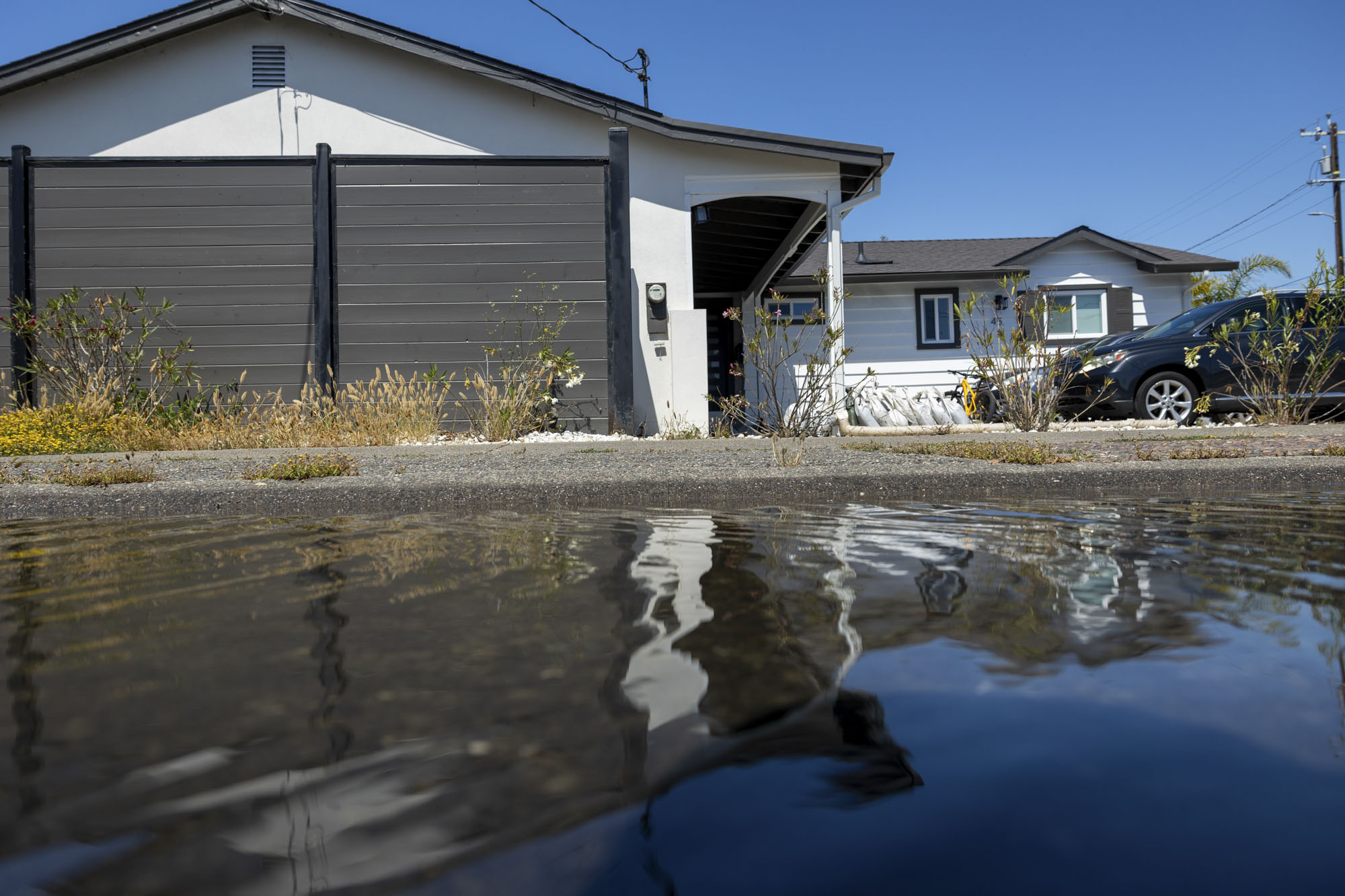
"content": "\u003cp>The \u003ca href=\"https://www.kqed.org/news/tag/bay-area\">Bay Area\u003c/a> saw its highest summer tides on record over the weekend, and more flooding and king tides are expected in low-lying coastal and bayshore areas through Thursday, according to the National Weather Service.\u003c/p>\n\u003cp>Water levels peaked at 1.97 feet above normal Sunday — breaking the Bay Area’s summer record, set the previous day. Tides are predicted to peak again overnight Monday at 2 feet above normal in Monterey County and 1.8 feet in San Francisco, according to the weather service.\u003c/p>\n\u003cp>The region should see slightly lower peaks just after midnight Wednesday and Thursday, as the astronomical tide recedes late this week. The weather service also warned of hazardous beach conditions, including sneaker waves and strong rip currents.\u003c/p>\n\u003cp>[ad fullwidth]\u003c/p>\n\u003cp>The weekend’s record-breaking tides caused some coastal flooding in Larkspur along Lucky Drive and Redwood Highway, as well as throughout Corte Madera’s Golden Hind Passage neighborhood.\u003c/p>\n\u003cp>Water also flooded the sidewalk and spilled into the street in San Francisco near Pier 14 on the Embarcadero, disrupting pedestrian and cyclist traffic.\u003c/p>\n\u003cp>Meteorologist Rachel Kennedy said the weather service is predicting some isolated road and parking lot closures, especially along the Marin County shoreline and coastal Sonoma County.\u003c/p>\n\u003cfigure id=\"attachment_12087663\" class=\"wp-caption aligncenter\" style=\"max-width: 2000px\">\u003cimg loading=\"lazy\" decoding=\"async\" class=\"size-full wp-image-12087663\" src=\"https://cdn.kqed.org/wp-content/uploads/sites/10/2026/06/061526Flooding_GH_002-KQED.jpg\" alt=\"\" width=\"2000\" height=\"1333\" srcset=\"https://cdn.kqed.org/wp-content/uploads/sites/10/2026/06/061526Flooding_GH_002-KQED.jpg 2000w, https://cdn.kqed.org/wp-content/uploads/sites/10/2026/06/061526Flooding_GH_002-KQED-160x107.jpg 160w, https://cdn.kqed.org/wp-content/uploads/sites/10/2026/06/061526Flooding_GH_002-KQED-1536x1024.jpg 1536w\" sizes=\"auto, (max-width: 2000px) 100vw, 2000px\">\u003cfigcaption class=\"wp-caption-text\">Jamie and her son, Rowan, stand outside their home beside road closure signs staged for potential flooding along Golden Hind Passage in Corte Madera on June 15, 2026. Residents in low-lying neighborhoods were advised to prepare for king tide flooding through June 16. \u003ccite>(Gustavo Hernandez/KQED)\u003c/cite>\u003c/figcaption>\u003c/figure>\n\u003cp>“If you’re driving in those areas, [make] sure that you have an alternate route ready to go in the event that your normal path is encountering some coastal flooding, or you’re going to park in a parking lot that’s now got some flooding going on in it,” she said.\u003c/p>\n\u003cp>Jaime Kelly, 48, who’s lived in the Golden Hind Passage neighborhood in Marin County for more than 20 years, said this weekend was the first time her home has flooded in the summer, without significant rainfall.\u003c/p>\n\u003cp>“It’s definitely gotten worse since we first moved in 2002,” she told KQED. “It would happen maybe once every few years, and it might come up over the sidewalk or something, but the last couple years, it’s come up higher and higher.”[aside postID=news_12069118 hero='https://cdn.kqed.org/wp-content/uploads/sites/10/2026/01/MarinCountyFloodingAP3.jpg']During January’s record-setting \u003ca href=\"https://www.kqed.org/news/12068644/marin-county-looked-like-a-lagoon-after-king-tides-heavy-rain\">king tides\u003c/a>, which peaked at 2.5 feet above normal after multiple particularly wet weeks, she said water seeped into her and her husband’s garage for the first time.\u003c/p>\n\u003cp>Residents are increasingly taking protective measures into their own hands. On Monday, nearby construction crews were busy raising the foundation of one of Kelly’s neighbor’s homes, and Kelly said she and her husband recently opted to install a new fence around their garden as a way to protect it from flooding.\u003c/p>\n\u003cp>The tides are driven by the phases of the moon, according to Kennedy, usually peaking around the new moon, which happened Sunday. Water levels have historically risen the highest in the winter months, but meteorologists said at the time that extreme tides could become more common as the climate changes.\u003c/p>\n\u003cp>The Bay Area’s water levels have risen nearly 2 millimeters per year on average over the past three decades, and the ocean and the bay could rise by about a foot by 2050 — and more than 6 feet by the end of the century.\u003c/p>\n\u003cp>Neighbors who live at slightly lower elevations, Kelly said, can sometimes be up to their knees in seawater in their garages.\u003c/p>\n\u003cp>John Breidenbaugh, who was visiting his daughter’s home in Golden Hind, said that her garage had upwards of seven inches of water in it during Sunday night’s peak tide. The house effectively became an island.\u003c/p>\n\u003cfigure id=\"attachment_12087668\" class=\"wp-caption aligncenter\" style=\"max-width: 2000px\">\u003cimg loading=\"lazy\" decoding=\"async\" class=\"size-full wp-image-12087668\" src=\"https://cdn.kqed.org/wp-content/uploads/sites/10/2026/06/061526Flooding_GH_011-KQED.jpg\" alt=\"\" width=\"2000\" height=\"1333\" srcset=\"https://cdn.kqed.org/wp-content/uploads/sites/10/2026/06/061526Flooding_GH_011-KQED.jpg 2000w, https://cdn.kqed.org/wp-content/uploads/sites/10/2026/06/061526Flooding_GH_011-KQED-160x107.jpg 160w, https://cdn.kqed.org/wp-content/uploads/sites/10/2026/06/061526Flooding_GH_011-KQED-1536x1024.jpg 1536w\" sizes=\"auto, (max-width: 2000px) 100vw, 2000px\">\u003cfigcaption class=\"wp-caption-text\">Plastic sheeting and sandbags are placed outside a home along Golden Hind Passage, as residents prepare for potential king tide flooding, in Corte Madera, on June 15, 2026. \u003ccite>(Gustavo Hernandez/KQED)\u003c/cite>\u003c/figcaption>\u003c/figure>\n\u003cp>“This lot is a bit below high sea level, unfortunately,” he told KQED. “They’ve lost some stuff because they weren’t as diligent as they should be, but they’re learning fast.”\u003c/p>\n\u003cp>Breidenbaugh was drying out the garage with a fan Monday and said the family was going to line it with some polyethylene plastic sheeting before the tides are expected to rise again overnight.\u003c/p>\n\u003cp>The family has learned to keep everything in the garage, from a baby stroller to the washer and dryer, off the floor. Seawater remained pooled along the curb of his daughter’s house late into the morning.\u003c/p>\n\u003cp>“It’ll flood again tonight, so we’ll be doing this again tomorrow,” he said.\u003c/p>\n\u003cfigure id=\"attachment_12087664\" class=\"wp-caption aligncenter\" style=\"max-width: 2000px\">\u003cimg loading=\"lazy\" decoding=\"async\" class=\"size-full wp-image-12087664\" src=\"https://cdn.kqed.org/wp-content/uploads/sites/10/2026/06/061526Flooding_GH_003-KQED.jpg\" alt=\"\" width=\"2000\" height=\"1333\" srcset=\"https://cdn.kqed.org/wp-content/uploads/sites/10/2026/06/061526Flooding_GH_003-KQED.jpg 2000w, https://cdn.kqed.org/wp-content/uploads/sites/10/2026/06/061526Flooding_GH_003-KQED-160x107.jpg 160w, https://cdn.kqed.org/wp-content/uploads/sites/10/2026/06/061526Flooding_GH_003-KQED-1536x1024.jpg 1536w\" sizes=\"auto, (max-width: 2000px) 100vw, 2000px\">\u003cfigcaption class=\"wp-caption-text\">A home along Golden Hind Passage is raised above its foundation in Corte Madera on June 15, 2026. Some homeowners are elevating structures as part of long-term efforts to adapt to recurring tidal flooding. \u003ccite>(Gustavo Hernandez/KQED)\u003c/cite>\u003c/figcaption>\u003c/figure>\n\u003cp>Longer term, he said the family was planning to install a sump — a basin dug in a basement that drains water — in the garage, and considering building up perimeter walls around the property.\u003c/p>\n\u003cp>“We’re helping them figure this property out and get it armored against the water,” he said. “We’ll figure it out. It might take a few years.”\u003c/p>\n\u003cp>Corte Madera Mayor Rosa Thomas said her office is also looking at solutions to protect the entire town. In January, sea water reached freeways, and spilled over levees, bike trails and into homes and businesses.\u003c/p>\n\u003cp>Thomas said they’re hoping to build berms, or raised mounts of earth and soil material that slope, to keep water out.\u003c/p>\n\u003cfigure id=\"attachment_12087666\" class=\"wp-caption aligncenter\" style=\"max-width: 2000px\">\u003cimg loading=\"lazy\" decoding=\"async\" class=\"size-full wp-image-12087666\" src=\"https://cdn.kqed.org/wp-content/uploads/sites/10/2026/06/061526Flooding_GH_008-KQED.jpg\" alt=\"\" width=\"2000\" height=\"1333\" srcset=\"https://cdn.kqed.org/wp-content/uploads/sites/10/2026/06/061526Flooding_GH_008-KQED.jpg 2000w, https://cdn.kqed.org/wp-content/uploads/sites/10/2026/06/061526Flooding_GH_008-KQED-160x107.jpg 160w, https://cdn.kqed.org/wp-content/uploads/sites/10/2026/06/061526Flooding_GH_008-KQED-1536x1024.jpg 1536w\" sizes=\"auto, (max-width: 2000px) 100vw, 2000px\">\u003cfigcaption class=\"wp-caption-text\">Rosa Thomas, mayor of Corte Madera, poses for a portrait in Corte Madera on June 15, 2026. \u003ccite>(Gustavo Hernandez/KQED)\u003c/cite>\u003c/figcaption>\u003c/figure>\n\u003cp>Corte Madera has a system of flood gates and pumps, Thomas said, but “when the tides are as high as they were back in January, there’s nowhere for the water to go.”\u003c/p>\n\u003cp>Corte Madera does have a FEMA-funded berm project in the pipeline, but Thomas said it’s been stalled under the Trump administration.\u003c/p>\n\u003cp>In the meantime, she said, they’re looking at building temporary, inflatable berms ahead of next winter, when California is expecting stormier, wetter weather thanks to what could be a strong El Niño season. The arrival of the weather pattern likely means more intense atmospheric rivers, major snow events in the Sierra Nevada, and larger waves, coastal flooding, and higher sea levels.\u003c/p>\n\u003cp>“The next big tidal flooding that we’re expecting is going to probably be around January [or] December of this year, so we were looking at how we can best be ready for that,” she said.\u003c/p>\n\u003cp>[ad floatright]\u003c/p>\n",
"blocks": [],
"excerpt": "Minor coastal flooding is expected along Bay Area shorelines and along the Pacific Coast, as water levels peak around 2 feet above normal. For some Marin County residents, it’s a forecast of a wetter future. ",
"status": "publish",
"parent": 0,
"modified": 1781632332,
"stats": {
"hasAudio": false,
"hasVideo": false,
"hasChartOrMap": false,
"iframeSrcs": [],
"hasGoogleForm": false,
"hasGallery": false,
"hasHearkenModule": false,
"hasPolis": false,
"paragraphCount": 28,
"wordCount": 1178
},
"headData": {
"title": "San Francisco and Marin Face Flooding Amid Highest Summer Tide on Record | KQED",
"description": "Minor coastal flooding is expected along Bay Area shorelines and along the Pacific Coast, as water levels peak around 2 feet above normal. For some Marin County residents, it’s a forecast of a wetter future. ",
"ogTitle": "",
"ogDescription": "",
"ogImgId": "",
"twTitle": "",
"twDescription": "",
"twImgId": "",
"schema": {
"@context": "https://schema.org",
"@type": "NewsArticle",
"headline": "San Francisco and Marin Face Flooding Amid Highest Summer Tide on Record",
"datePublished": "2026-06-15T16:07:00-07:00",
"dateModified": "2026-06-16T10:52:12-07:00",
"image": "https://cdn.kqed.org/wp-content/uploads/2020/02/KQED-OG-Image@1x.png",
"isAccessibleForFree": "True",
"publisher": {
"@type": "NewsMediaOrganization",
"@id": "https://www.kqed.org/#organization",
"name": "KQED",
"logo": "https://cdn.kqed.org/wp-content/uploads/2020/02/KQED-OG-Image@1x.png",
"url": "https://www.kqed.org",
"sameAs": [
"https://www.facebook.com/KQED",
"https://twitter.com/KQED",
"https://www.instagram.com/kqed/",
"https://www.tiktok.com/@kqedofficial",
"https://www.linkedin.com/company/kqed",
"https://www.youtube.com/channel/UCeC0IOo7i1P_61zVUWbJ4nw"
]
}
}
},
"primaryCategory": {
"termId": 34165,
"slug": "climate",
"name": "Climate"
},
"audioUrl": "https://traffic.omny.fm/d/clips/0af137ef-751e-4b19-a055-aaef00d2d578/ffca7e9f-6831-41c5-bcaf-aaef00f5a073/1cf37955-443e-4780-a3b2-b46b0123c602/audio.mp3",
"sticky": false,
"nprStoryId": "kqed-12087558",
"templateType": "standard",
"featuredImageType": "standard",
"excludeFromSiteSearch": "Include",
"articleAge": "0",
"path": "/news/12087558/san-francisco-and-marin-face-flooding-amid-highest-summer-tide-on-record",
"audioTrackLength": null,
"parsedContent": [
{
"type": "contentString",
"content": "\u003cdiv class=\"post-body\">\u003cp>\u003cp>The \u003ca href=\"https://www.kqed.org/news/tag/bay-area\">Bay Area\u003c/a> saw its highest summer tides on record over the weekend, and more flooding and king tides are expected in low-lying coastal and bayshore areas through Thursday, according to the National Weather Service.\u003c/p>\n\u003cp>Water levels peaked at 1.97 feet above normal Sunday — breaking the Bay Area’s summer record, set the previous day. Tides are predicted to peak again overnight Monday at 2 feet above normal in Monterey County and 1.8 feet in San Francisco, according to the weather service.\u003c/p>\n\u003cp>The region should see slightly lower peaks just after midnight Wednesday and Thursday, as the astronomical tide recedes late this week. The weather service also warned of hazardous beach conditions, including sneaker waves and strong rip currents.\u003c/p>\n\u003cp>\u003c/p>\u003c/div>",
"attributes": {
"named": {},
"numeric": []
}
},
{
"type": "component",
"content": "",
"name": "ad",
"attributes": {
"named": {
"label": "fullwidth"
},
"numeric": [
"fullwidth"
]
}
},
{
"type": "contentString",
"content": "\u003cdiv class=\"post-body\">\u003cp>\u003c/p>\n\u003cp>The weekend’s record-breaking tides caused some coastal flooding in Larkspur along Lucky Drive and Redwood Highway, as well as throughout Corte Madera’s Golden Hind Passage neighborhood.\u003c/p>\n\u003cp>Water also flooded the sidewalk and spilled into the street in San Francisco near Pier 14 on the Embarcadero, disrupting pedestrian and cyclist traffic.\u003c/p>\n\u003cp>Meteorologist Rachel Kennedy said the weather service is predicting some isolated road and parking lot closures, especially along the Marin County shoreline and coastal Sonoma County.\u003c/p>\n\u003cfigure id=\"attachment_12087663\" class=\"wp-caption aligncenter\" style=\"max-width: 2000px\">\u003cimg loading=\"lazy\" decoding=\"async\" class=\"size-full wp-image-12087663\" src=\"https://cdn.kqed.org/wp-content/uploads/sites/10/2026/06/061526Flooding_GH_002-KQED.jpg\" alt=\"\" width=\"2000\" height=\"1333\" srcset=\"https://cdn.kqed.org/wp-content/uploads/sites/10/2026/06/061526Flooding_GH_002-KQED.jpg 2000w, https://cdn.kqed.org/wp-content/uploads/sites/10/2026/06/061526Flooding_GH_002-KQED-160x107.jpg 160w, https://cdn.kqed.org/wp-content/uploads/sites/10/2026/06/061526Flooding_GH_002-KQED-1536x1024.jpg 1536w\" sizes=\"auto, (max-width: 2000px) 100vw, 2000px\">\u003cfigcaption class=\"wp-caption-text\">Jamie and her son, Rowan, stand outside their home beside road closure signs staged for potential flooding along Golden Hind Passage in Corte Madera on June 15, 2026. Residents in low-lying neighborhoods were advised to prepare for king tide flooding through June 16. \u003ccite>(Gustavo Hernandez/KQED)\u003c/cite>\u003c/figcaption>\u003c/figure>\n\u003cp>“If you’re driving in those areas, [make] sure that you have an alternate route ready to go in the event that your normal path is encountering some coastal flooding, or you’re going to park in a parking lot that’s now got some flooding going on in it,” she said.\u003c/p>\n\u003cp>Jaime Kelly, 48, who’s lived in the Golden Hind Passage neighborhood in Marin County for more than 20 years, said this weekend was the first time her home has flooded in the summer, without significant rainfall.\u003c/p>\n\u003cp>“It’s definitely gotten worse since we first moved in 2002,” she told KQED. “It would happen maybe once every few years, and it might come up over the sidewalk or something, but the last couple years, it’s come up higher and higher.”\u003c/p>\u003c/div>",
"attributes": {
"named": {},
"numeric": []
}
},
{
"type": "component",
"content": "",
"name": "aside",
"attributes": {
"named": {
"postid": "news_12069118",
"hero": "https://cdn.kqed.org/wp-content/uploads/sites/10/2026/01/MarinCountyFloodingAP3.jpg",
"label": ""
},
"numeric": []
}
},
{
"type": "contentString",
"content": "\u003cdiv class=\"post-body\">\u003cp>During January’s record-setting \u003ca href=\"https://www.kqed.org/news/12068644/marin-county-looked-like-a-lagoon-after-king-tides-heavy-rain\">king tides\u003c/a>, which peaked at 2.5 feet above normal after multiple particularly wet weeks, she said water seeped into her and her husband’s garage for the first time.\u003c/p>\n\u003cp>Residents are increasingly taking protective measures into their own hands. On Monday, nearby construction crews were busy raising the foundation of one of Kelly’s neighbor’s homes, and Kelly said she and her husband recently opted to install a new fence around their garden as a way to protect it from flooding.\u003c/p>\n\u003cp>The tides are driven by the phases of the moon, according to Kennedy, usually peaking around the new moon, which happened Sunday. Water levels have historically risen the highest in the winter months, but meteorologists said at the time that extreme tides could become more common as the climate changes.\u003c/p>\n\u003cp>The Bay Area’s water levels have risen nearly 2 millimeters per year on average over the past three decades, and the ocean and the bay could rise by about a foot by 2050 — and more than 6 feet by the end of the century.\u003c/p>\n\u003cp>Neighbors who live at slightly lower elevations, Kelly said, can sometimes be up to their knees in seawater in their garages.\u003c/p>\n\u003cp>John Breidenbaugh, who was visiting his daughter’s home in Golden Hind, said that her garage had upwards of seven inches of water in it during Sunday night’s peak tide. The house effectively became an island.\u003c/p>\n\u003cfigure id=\"attachment_12087668\" class=\"wp-caption aligncenter\" style=\"max-width: 2000px\">\u003cimg loading=\"lazy\" decoding=\"async\" class=\"size-full wp-image-12087668\" src=\"https://cdn.kqed.org/wp-content/uploads/sites/10/2026/06/061526Flooding_GH_011-KQED.jpg\" alt=\"\" width=\"2000\" height=\"1333\" srcset=\"https://cdn.kqed.org/wp-content/uploads/sites/10/2026/06/061526Flooding_GH_011-KQED.jpg 2000w, https://cdn.kqed.org/wp-content/uploads/sites/10/2026/06/061526Flooding_GH_011-KQED-160x107.jpg 160w, https://cdn.kqed.org/wp-content/uploads/sites/10/2026/06/061526Flooding_GH_011-KQED-1536x1024.jpg 1536w\" sizes=\"auto, (max-width: 2000px) 100vw, 2000px\">\u003cfigcaption class=\"wp-caption-text\">Plastic sheeting and sandbags are placed outside a home along Golden Hind Passage, as residents prepare for potential king tide flooding, in Corte Madera, on June 15, 2026. \u003ccite>(Gustavo Hernandez/KQED)\u003c/cite>\u003c/figcaption>\u003c/figure>\n\u003cp>“This lot is a bit below high sea level, unfortunately,” he told KQED. “They’ve lost some stuff because they weren’t as diligent as they should be, but they’re learning fast.”\u003c/p>\n\u003cp>Breidenbaugh was drying out the garage with a fan Monday and said the family was going to line it with some polyethylene plastic sheeting before the tides are expected to rise again overnight.\u003c/p>\n\u003cp>The family has learned to keep everything in the garage, from a baby stroller to the washer and dryer, off the floor. Seawater remained pooled along the curb of his daughter’s house late into the morning.\u003c/p>\n\u003cp>“It’ll flood again tonight, so we’ll be doing this again tomorrow,” he said.\u003c/p>\n\u003cfigure id=\"attachment_12087664\" class=\"wp-caption aligncenter\" style=\"max-width: 2000px\">\u003cimg loading=\"lazy\" decoding=\"async\" class=\"size-full wp-image-12087664\" src=\"https://cdn.kqed.org/wp-content/uploads/sites/10/2026/06/061526Flooding_GH_003-KQED.jpg\" alt=\"\" width=\"2000\" height=\"1333\" srcset=\"https://cdn.kqed.org/wp-content/uploads/sites/10/2026/06/061526Flooding_GH_003-KQED.jpg 2000w, https://cdn.kqed.org/wp-content/uploads/sites/10/2026/06/061526Flooding_GH_003-KQED-160x107.jpg 160w, https://cdn.kqed.org/wp-content/uploads/sites/10/2026/06/061526Flooding_GH_003-KQED-1536x1024.jpg 1536w\" sizes=\"auto, (max-width: 2000px) 100vw, 2000px\">\u003cfigcaption class=\"wp-caption-text\">A home along Golden Hind Passage is raised above its foundation in Corte Madera on June 15, 2026. Some homeowners are elevating structures as part of long-term efforts to adapt to recurring tidal flooding. \u003ccite>(Gustavo Hernandez/KQED)\u003c/cite>\u003c/figcaption>\u003c/figure>\n\u003cp>Longer term, he said the family was planning to install a sump — a basin dug in a basement that drains water — in the garage, and considering building up perimeter walls around the property.\u003c/p>\n\u003cp>“We’re helping them figure this property out and get it armored against the water,” he said. “We’ll figure it out. It might take a few years.”\u003c/p>\n\u003cp>Corte Madera Mayor Rosa Thomas said her office is also looking at solutions to protect the entire town. In January, sea water reached freeways, and spilled over levees, bike trails and into homes and businesses.\u003c/p>\n\u003cp>Thomas said they’re hoping to build berms, or raised mounts of earth and soil material that slope, to keep water out.\u003c/p>\n\u003cfigure id=\"attachment_12087666\" class=\"wp-caption aligncenter\" style=\"max-width: 2000px\">\u003cimg loading=\"lazy\" decoding=\"async\" class=\"size-full wp-image-12087666\" src=\"https://cdn.kqed.org/wp-content/uploads/sites/10/2026/06/061526Flooding_GH_008-KQED.jpg\" alt=\"\" width=\"2000\" height=\"1333\" srcset=\"https://cdn.kqed.org/wp-content/uploads/sites/10/2026/06/061526Flooding_GH_008-KQED.jpg 2000w, https://cdn.kqed.org/wp-content/uploads/sites/10/2026/06/061526Flooding_GH_008-KQED-160x107.jpg 160w, https://cdn.kqed.org/wp-content/uploads/sites/10/2026/06/061526Flooding_GH_008-KQED-1536x1024.jpg 1536w\" sizes=\"auto, (max-width: 2000px) 100vw, 2000px\">\u003cfigcaption class=\"wp-caption-text\">Rosa Thomas, mayor of Corte Madera, poses for a portrait in Corte Madera on June 15, 2026. \u003ccite>(Gustavo Hernandez/KQED)\u003c/cite>\u003c/figcaption>\u003c/figure>\n\u003cp>Corte Madera has a system of flood gates and pumps, Thomas said, but “when the tides are as high as they were back in January, there’s nowhere for the water to go.”\u003c/p>\n\u003cp>Corte Madera does have a FEMA-funded berm project in the pipeline, but Thomas said it’s been stalled under the Trump administration.\u003c/p>\n\u003cp>In the meantime, she said, they’re looking at building temporary, inflatable berms ahead of next winter, when California is expecting stormier, wetter weather thanks to what could be a strong El Niño season. The arrival of the weather pattern likely means more intense atmospheric rivers, major snow events in the Sierra Nevada, and larger waves, coastal flooding, and higher sea levels.\u003c/p>\n\u003cp>“The next big tidal flooding that we’re expecting is going to probably be around January [or] December of this year, so we were looking at how we can best be ready for that,” she said.\u003c/p>\n\u003cp>\u003c/p>\u003c/div>",
"attributes": {
"named": {},
"numeric": []
}
},
{
"type": "component",
"content": "",
"name": "ad",
"attributes": {
"named": {
"label": "floatright"
},
"numeric": [
"floatright"
]
}
},
{
"type": "contentString",
"content": "\u003cdiv class=\"post-body\">\u003cp>\u003c/p>\n\u003c/div>\u003c/p>",
"attributes": {
"named": {},
"numeric": []
}
}
],
"link": "/news/12087558/san-francisco-and-marin-face-flooding-amid-highest-summer-tide-on-record",
"authors": [
"11913",
"11785"
],
"categories": [
"news_34165",
"news_19906",
"news_8"
],
"tags": [
"news_1386",
"news_34945",
"news_19204",
"news_255",
"news_27626",
"news_28199",
"news_3431",
"news_3729",
"news_461",
"news_35836",
"news_38",
"news_3187",
"news_2181"
],
"featImg": "news_12087662",
"label": "news"
},
"news_12086933": {
"type": "posts",
"id": "news_12086933",
"meta": {
"index": "posts_1716263798",
"site": "news",
"id": "12086933",
"score": null,
"sort": [
1781135138000
]
},
"guestAuthors": [],
"slug": "bay-area-faces-a-weather-quadfecta-heat-fire-risk-flooding-and-powerful-waves",
"title": "Bay Area Faces a Weather ‘Quadfecta’: Heat, Fire Risk, Flooding and Powerful Waves",
"publishDate": 1781135138,
"format": "standard",
"headTitle": "Bay Area Faces a Weather ‘Quadfecta’: Heat, Fire Risk, Flooding and Powerful Waves | KQED",
"labelTerm": {
"site": "news"
},
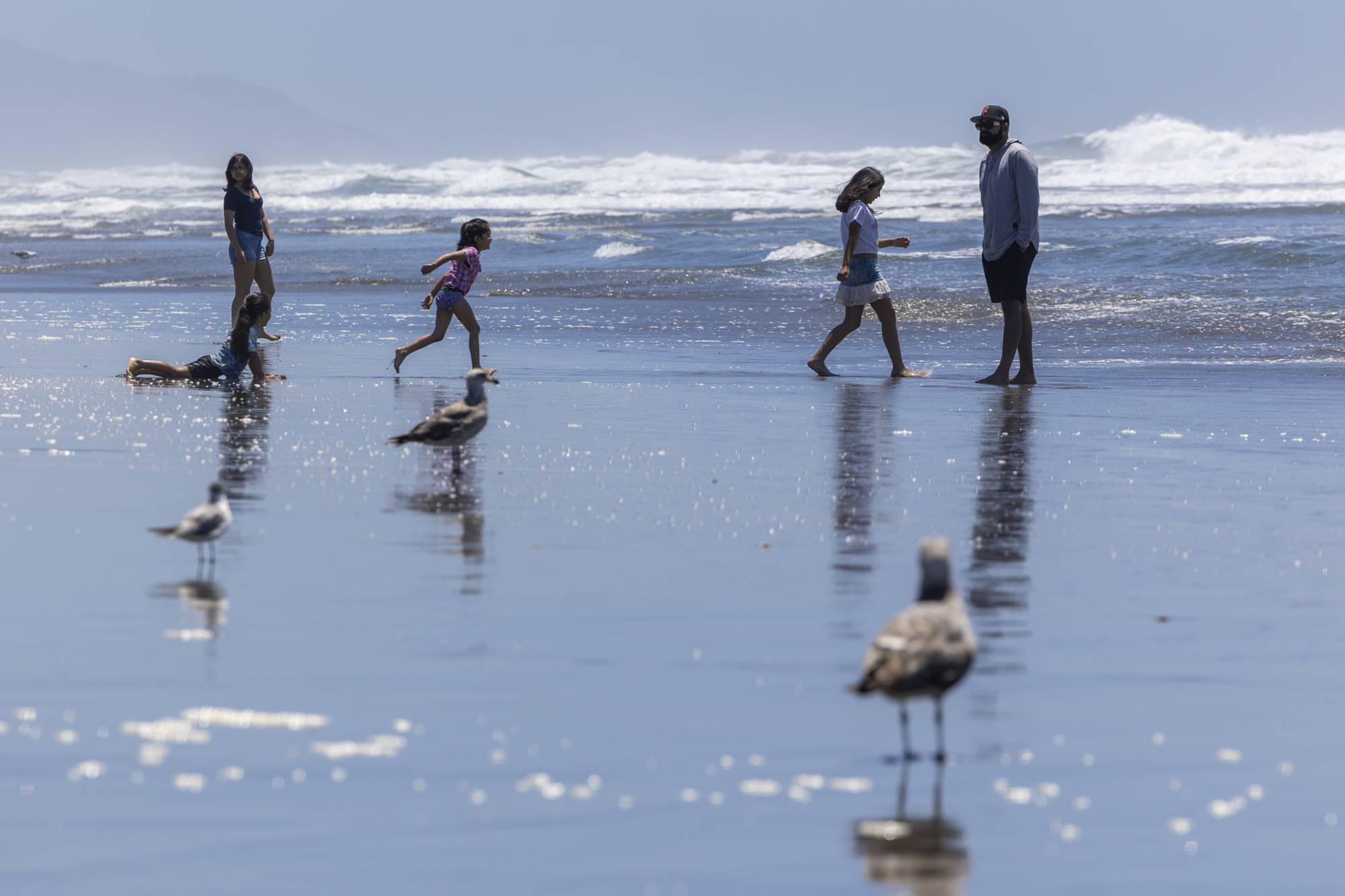
"content": "\u003cp>The \u003ca href=\"https://www.kqed.org/news/tag/bay-area\">Bay Area \u003c/a>is about to experience a quadfecta of \u003ca href=\"https://www.kqed.org/science/2001255/bay-area-warm-up-could-bring-100-degree-heat-and-high-wildfire-risk\">hot weather\u003c/a> and climate effects this week — high temperatures, fire danger, sneaker waves and high tides.\u003c/p>\n\u003cp>As a ridge of higher pressure builds over the region, Bay Area National Weather Service meteorologists forecast high heat to peak on Thursday.\u003c/p>\n\u003cp>“Thursday is going to be the hottest day and almost 15 to 25 degrees above normal for this time of year,” said Lamont Bain, a meteorologist with the weather service’s Bay Area office. “It’s going to certainly be pretty warm to downright hot for some people.”\u003c/p>\n\u003cp>[ad fullwidth]\u003c/p>\n\u003cp>On Wednesday, temperatures will range from the 80s to 90s in inland areas, with the warmest spots reaching the triple digits, including Concord, Napa and Sonoma. Forecasters expect the ridge to keep the marine layer at bay overnight.\u003c/p>\n\u003cp>By Thursday, meteorologists forecast temperatures to soar into the 90s or low 100s in inland valleys, including Santa Rosa and San José. The warmest spots — in rural Contra Costa County — could reach around 105 degrees. Temperatures across the Bay will range from the 80s to mid-90s.\u003c/p>\n\u003cfigure id=\"attachment_12087080\" class=\"wp-caption aligncenter\" style=\"max-width: 2500px\">\u003cimg loading=\"lazy\" decoding=\"async\" class=\"size-full wp-image-12087080\" src=\"https://cdn.kqed.org/wp-content/uploads/sites/10/2026/06/260610-RISKYWX00193_TV-KQED.jpg\" alt=\"\" width=\"2500\" height=\"1667\" srcset=\"https://cdn.kqed.org/wp-content/uploads/sites/10/2026/06/260610-RISKYWX00193_TV-KQED.jpg 2500w, https://cdn.kqed.org/wp-content/uploads/sites/10/2026/06/260610-RISKYWX00193_TV-KQED-2000x1334.jpg 2000w, https://cdn.kqed.org/wp-content/uploads/sites/10/2026/06/260610-RISKYWX00193_TV-KQED-160x107.jpg 160w, https://cdn.kqed.org/wp-content/uploads/sites/10/2026/06/260610-RISKYWX00193_TV-KQED-1536x1024.jpg 1536w, https://cdn.kqed.org/wp-content/uploads/sites/10/2026/06/260610-RISKYWX00193_TV-KQED-2048x1366.jpg 2048w\" sizes=\"auto, (max-width: 2500px) 100vw, 2500px\">\u003cfigcaption class=\"wp-caption-text\">People sunbathe at Ocean Beach in San Francisco on June 10, 2026. \u003ccite>(Tâm Vũ/KQED)\u003c/cite>\u003c/figcaption>\u003c/figure>\n\u003cp>Forecasters have also issued a heat advisory from noon to 11 p.m. Thursday for the North Bay, the Sonoma coastal range, the East Bay, the Santa Clara Valley and the San Francisco Bay shoreline.\u003c/p>\n\u003cp>The current forecast shows a slight cooling trend on Friday, though forecasters said they’ll continue to look out for “heat headlines,” particularly inland in the East Bay. Because of the short duration, Bain said forecasters aren’t calling it a heat wave.\u003c/p>\n\u003cp>“As of now, this week’s warmth is not going to be like the heat events that we had earlier this year, where we had multiple days of warmth; this will be maybe two days at most,” Bain said.[aside postID=science_2001267 hero='https://cdn.kqed.org/wp-content/uploads/sites/35/2026/06/260609-PACIFICAPIERUPDATE-10-BL-KQED.jpg']As for how long the heat will last, Bain said the marine layer could return by Sunday, pushing away the high pressure that is causing the heat.\u003c/p>\n\u003cp>Still, the “combination of the hot, dry, and windy conditions” has led the weather service to issue a red flag warning for the North and East Bay interior and mountain areas from 11 p.m. Wednesday through 9 a.m. Thursday. Fire weather conditions may also be prevalent in mountain areas in Santa Clara County.\u003c/p>\n\u003cp>Overnight, forecasters said to expect strong north-to-northeast winds of up to 45 mph in mountain areas; gusts of 60 mph or higher are possible at the highest elevations. The winds will help lower relative humidity, and “result in critical fire weather conditions where any fires that start could take hold and spread rapidly,” forecasters wrote in their daily \u003ca href=\"https://forecast.weather.gov/product.php?site=mtr&issuedby=MTR&product=AFD\">forecast discussion\u003c/a>.\u003c/p>\n\u003cp>The weather service also expects normal high astronomical tides with about a half a foot of surge. This will likely result in minor flooding in low-lying parts of the Bay Area on Wednesday evening. The hardest-hit areas could be in the North Bay, particularly \u003ca href=\"https://www.kqed.org/news/12069118/for-marin-county-last-weekends-floods-were-a-wake-up-call\">Marin County\u003c/a>. Forecasters expect the high tides to expand across the rest of the Bay Area on Thursday.\u003c/p>\n\u003cp>As a result, the weather service issued coastal flood advisories starting at 6 p.m. Wednesday for the North Bay, and at 7 p.m. Thursday for the rest of the San Francisco Bayshore.\u003c/p>\n\u003cp>Forecasters expect the San Francisco tidal gauge to read around 7 inches above normal at around 8 p.m. Wednesday, 1.2 feet above normal around 9 p.m. Thursday, and 1.5 feet above normal around 9:30 p.m. on Friday. Coastal flood advisories will likely remain in effect into the weekend as high tides persist.\u003c/p>\n\u003cfigure id=\"attachment_12087086\" class=\"wp-caption aligncenter\" style=\"max-width: 2500px\">\u003cimg loading=\"lazy\" decoding=\"async\" class=\"size-full wp-image-12087086\" src=\"https://cdn.kqed.org/wp-content/uploads/sites/10/2026/06/260610-RISKYWX00895_TV-KQED.jpg\" alt=\"\" width=\"2500\" height=\"1667\" srcset=\"https://cdn.kqed.org/wp-content/uploads/sites/10/2026/06/260610-RISKYWX00895_TV-KQED.jpg 2500w, https://cdn.kqed.org/wp-content/uploads/sites/10/2026/06/260610-RISKYWX00895_TV-KQED-2000x1334.jpg 2000w, https://cdn.kqed.org/wp-content/uploads/sites/10/2026/06/260610-RISKYWX00895_TV-KQED-160x107.jpg 160w, https://cdn.kqed.org/wp-content/uploads/sites/10/2026/06/260610-RISKYWX00895_TV-KQED-1536x1024.jpg 1536w, https://cdn.kqed.org/wp-content/uploads/sites/10/2026/06/260610-RISKYWX00895_TV-KQED-2048x1366.jpg 2048w\" sizes=\"auto, (max-width: 2500px) 100vw, 2500px\">\u003cfigcaption class=\"wp-caption-text\">Bently Ha (left) and Michael Matey (right) practice boxing at Ocean Beach in San Francisco on June 10, 2026. \u003ccite>(Tâm Vũ/KQED)\u003c/cite>\u003c/figcaption>\u003c/figure>\n\u003cp>And finally, meteorologists expect an increased risk of potentially dangerous sneaker waves and rip currents along southwest-facing beaches on the Pacific Coast this week. As a result, NWS has issued a beach hazards statement for the coast along the North Bay as well as San Mateo and Santa Cruz counties through 5 a.m. Thursday.\u003c/p>\n\u003cp>Sneaker waves can run up the beach farther than smaller waves and catch beachgoers by surprise and sweep them out into the water.\u003c/p>\n\u003cp>“People should care because, as the name implies, sneaker waves happen very suddenly,” Bain said. “Pay attention because sneaker waves aren’t always huge waves. Be smart and be aware.”\u003c/p>\n\u003cp>\u003c/p>\n",
"blocks": [],
"excerpt": "Triple-digit heat, wildfire danger, sneaker waves and high tides could make for a sunny — and risky — week for the Bay Area. ",
"status": "publish",
"parent": 0,
"modified": 1781135152,
"stats": {
"hasAudio": false,
"hasVideo": false,
"hasChartOrMap": false,
"iframeSrcs": [],
"hasGoogleForm": false,
"hasGallery": false,
"hasHearkenModule": false,
"hasPolis": false,
"paragraphCount": 18,
"wordCount": 800
},
"headData": {
"title": "Bay Area Faces a Weather ‘Quadfecta’: Heat, Fire Risk, Flooding and Powerful Waves | KQED",
"description": "Triple-digit heat, wildfire danger, sneaker waves and high tides could make for a sunny — and risky — week for the Bay Area. ",
"ogTitle": "",
"ogDescription": "",
"ogImgId": "",
"twTitle": "",
"twDescription": "",
"twImgId": "",
"schema": {
"@context": "https://schema.org",
"@type": "NewsArticle",
"headline": "Bay Area Faces a Weather ‘Quadfecta’: Heat, Fire Risk, Flooding and Powerful Waves",
"datePublished": "2026-06-10T16:45:38-07:00",
"dateModified": "2026-06-10T16:45:52-07:00",
"image": "https://cdn.kqed.org/wp-content/uploads/2020/02/KQED-OG-Image@1x.png",
"isAccessibleForFree": "True",
"publisher": {
"@type": "NewsMediaOrganization",
"@id": "https://www.kqed.org/#organization",
"name": "KQED",
"logo": "https://cdn.kqed.org/wp-content/uploads/2020/02/KQED-OG-Image@1x.png",
"url": "https://www.kqed.org",
"sameAs": [
"https://www.facebook.com/KQED",
"https://twitter.com/KQED",
"https://www.instagram.com/kqed/",
"https://www.tiktok.com/@kqedofficial",
"https://www.linkedin.com/company/kqed",
"https://www.youtube.com/channel/UCeC0IOo7i1P_61zVUWbJ4nw"
]
}
}
},
"primaryCategory": {
"termId": 34165,
"slug": "climate",
"name": "Climate"
},
"sticky": false,
"nprStoryId": "kqed-12086933",
"templateType": "standard",
"featuredImageType": "standard",
"excludeFromSiteSearch": "Include",
"articleAge": "0",
"path": "/news/12086933/bay-area-faces-a-weather-quadfecta-heat-fire-risk-flooding-and-powerful-waves",
"audioTrackLength": null,
"parsedContent": [
{
"type": "contentString",
"content": "\u003cdiv class=\"post-body\">\u003cp>\u003cp>The \u003ca href=\"https://www.kqed.org/news/tag/bay-area\">Bay Area \u003c/a>is about to experience a quadfecta of \u003ca href=\"https://www.kqed.org/science/2001255/bay-area-warm-up-could-bring-100-degree-heat-and-high-wildfire-risk\">hot weather\u003c/a> and climate effects this week — high temperatures, fire danger, sneaker waves and high tides.\u003c/p>\n\u003cp>As a ridge of higher pressure builds over the region, Bay Area National Weather Service meteorologists forecast high heat to peak on Thursday.\u003c/p>\n\u003cp>“Thursday is going to be the hottest day and almost 15 to 25 degrees above normal for this time of year,” said Lamont Bain, a meteorologist with the weather service’s Bay Area office. “It’s going to certainly be pretty warm to downright hot for some people.”\u003c/p>\n\u003cp>\u003c/p>\u003c/div>",
"attributes": {
"named": {},
"numeric": []
}
},
{
"type": "component",
"content": "",
"name": "ad",
"attributes": {
"named": {
"label": "fullwidth"
},
"numeric": [
"fullwidth"
]
}
},
{
"type": "contentString",
"content": "\u003cdiv class=\"post-body\">\u003cp>\u003c/p>\n\u003cp>On Wednesday, temperatures will range from the 80s to 90s in inland areas, with the warmest spots reaching the triple digits, including Concord, Napa and Sonoma. Forecasters expect the ridge to keep the marine layer at bay overnight.\u003c/p>\n\u003cp>By Thursday, meteorologists forecast temperatures to soar into the 90s or low 100s in inland valleys, including Santa Rosa and San José. The warmest spots — in rural Contra Costa County — could reach around 105 degrees. Temperatures across the Bay will range from the 80s to mid-90s.\u003c/p>\n\u003cfigure id=\"attachment_12087080\" class=\"wp-caption aligncenter\" style=\"max-width: 2500px\">\u003cimg loading=\"lazy\" decoding=\"async\" class=\"size-full wp-image-12087080\" src=\"https://cdn.kqed.org/wp-content/uploads/sites/10/2026/06/260610-RISKYWX00193_TV-KQED.jpg\" alt=\"\" width=\"2500\" height=\"1667\" srcset=\"https://cdn.kqed.org/wp-content/uploads/sites/10/2026/06/260610-RISKYWX00193_TV-KQED.jpg 2500w, https://cdn.kqed.org/wp-content/uploads/sites/10/2026/06/260610-RISKYWX00193_TV-KQED-2000x1334.jpg 2000w, https://cdn.kqed.org/wp-content/uploads/sites/10/2026/06/260610-RISKYWX00193_TV-KQED-160x107.jpg 160w, https://cdn.kqed.org/wp-content/uploads/sites/10/2026/06/260610-RISKYWX00193_TV-KQED-1536x1024.jpg 1536w, https://cdn.kqed.org/wp-content/uploads/sites/10/2026/06/260610-RISKYWX00193_TV-KQED-2048x1366.jpg 2048w\" sizes=\"auto, (max-width: 2500px) 100vw, 2500px\">\u003cfigcaption class=\"wp-caption-text\">People sunbathe at Ocean Beach in San Francisco on June 10, 2026. \u003ccite>(Tâm Vũ/KQED)\u003c/cite>\u003c/figcaption>\u003c/figure>\n\u003cp>Forecasters have also issued a heat advisory from noon to 11 p.m. Thursday for the North Bay, the Sonoma coastal range, the East Bay, the Santa Clara Valley and the San Francisco Bay shoreline.\u003c/p>\n\u003cp>The current forecast shows a slight cooling trend on Friday, though forecasters said they’ll continue to look out for “heat headlines,” particularly inland in the East Bay. Because of the short duration, Bain said forecasters aren’t calling it a heat wave.\u003c/p>\n\u003cp>“As of now, this week’s warmth is not going to be like the heat events that we had earlier this year, where we had multiple days of warmth; this will be maybe two days at most,” Bain said.\u003c/p>\u003c/div>",
"attributes": {
"named": {},
"numeric": []
}
},
{
"type": "component",
"content": "",
"name": "aside",
"attributes": {
"named": {
"postid": "science_2001267",
"hero": "https://cdn.kqed.org/wp-content/uploads/sites/35/2026/06/260609-PACIFICAPIERUPDATE-10-BL-KQED.jpg",
"label": ""
},
"numeric": []
}
},
{
"type": "contentString",
"content": "\u003cdiv class=\"post-body\">\u003cp>As for how long the heat will last, Bain said the marine layer could return by Sunday, pushing away the high pressure that is causing the heat.\u003c/p>\n\u003cp>Still, the “combination of the hot, dry, and windy conditions” has led the weather service to issue a red flag warning for the North and East Bay interior and mountain areas from 11 p.m. Wednesday through 9 a.m. Thursday. Fire weather conditions may also be prevalent in mountain areas in Santa Clara County.\u003c/p>\n\u003cp>Overnight, forecasters said to expect strong north-to-northeast winds of up to 45 mph in mountain areas; gusts of 60 mph or higher are possible at the highest elevations. The winds will help lower relative humidity, and “result in critical fire weather conditions where any fires that start could take hold and spread rapidly,” forecasters wrote in their daily \u003ca href=\"https://forecast.weather.gov/product.php?site=mtr&issuedby=MTR&product=AFD\">forecast discussion\u003c/a>.\u003c/p>\n\u003cp>The weather service also expects normal high astronomical tides with about a half a foot of surge. This will likely result in minor flooding in low-lying parts of the Bay Area on Wednesday evening. The hardest-hit areas could be in the North Bay, particularly \u003ca href=\"https://www.kqed.org/news/12069118/for-marin-county-last-weekends-floods-were-a-wake-up-call\">Marin County\u003c/a>. Forecasters expect the high tides to expand across the rest of the Bay Area on Thursday.\u003c/p>\n\u003cp>As a result, the weather service issued coastal flood advisories starting at 6 p.m. Wednesday for the North Bay, and at 7 p.m. Thursday for the rest of the San Francisco Bayshore.\u003c/p>\n\u003cp>Forecasters expect the San Francisco tidal gauge to read around 7 inches above normal at around 8 p.m. Wednesday, 1.2 feet above normal around 9 p.m. Thursday, and 1.5 feet above normal around 9:30 p.m. on Friday. Coastal flood advisories will likely remain in effect into the weekend as high tides persist.\u003c/p>\n\u003cfigure id=\"attachment_12087086\" class=\"wp-caption aligncenter\" style=\"max-width: 2500px\">\u003cimg loading=\"lazy\" decoding=\"async\" class=\"size-full wp-image-12087086\" src=\"https://cdn.kqed.org/wp-content/uploads/sites/10/2026/06/260610-RISKYWX00895_TV-KQED.jpg\" alt=\"\" width=\"2500\" height=\"1667\" srcset=\"https://cdn.kqed.org/wp-content/uploads/sites/10/2026/06/260610-RISKYWX00895_TV-KQED.jpg 2500w, https://cdn.kqed.org/wp-content/uploads/sites/10/2026/06/260610-RISKYWX00895_TV-KQED-2000x1334.jpg 2000w, https://cdn.kqed.org/wp-content/uploads/sites/10/2026/06/260610-RISKYWX00895_TV-KQED-160x107.jpg 160w, https://cdn.kqed.org/wp-content/uploads/sites/10/2026/06/260610-RISKYWX00895_TV-KQED-1536x1024.jpg 1536w, https://cdn.kqed.org/wp-content/uploads/sites/10/2026/06/260610-RISKYWX00895_TV-KQED-2048x1366.jpg 2048w\" sizes=\"auto, (max-width: 2500px) 100vw, 2500px\">\u003cfigcaption class=\"wp-caption-text\">Bently Ha (left) and Michael Matey (right) practice boxing at Ocean Beach in San Francisco on June 10, 2026. \u003ccite>(Tâm Vũ/KQED)\u003c/cite>\u003c/figcaption>\u003c/figure>\n\u003cp>And finally, meteorologists expect an increased risk of potentially dangerous sneaker waves and rip currents along southwest-facing beaches on the Pacific Coast this week. As a result, NWS has issued a beach hazards statement for the coast along the North Bay as well as San Mateo and Santa Cruz counties through 5 a.m. Thursday.\u003c/p>\n\u003cp>Sneaker waves can run up the beach farther than smaller waves and catch beachgoers by surprise and sweep them out into the water.\u003c/p>\n\u003cp>“People should care because, as the name implies, sneaker waves happen very suddenly,” Bain said. “Pay attention because sneaker waves aren’t always huge waves. Be smart and be aware.”\u003c/p>\n\u003cp>\u003c/p>\n\u003c/div>\u003c/p>",
"attributes": {
"named": {},
"numeric": []
}
}
],
"link": "/news/12086933/bay-area-faces-a-weather-quadfecta-heat-fire-risk-flooding-and-powerful-waves",
"authors": [
"11746"
],
"categories": [
"news_34165",
"news_28250",
"news_8"
],
"tags": [
"news_1386",
"news_34945",
"news_19204",
"news_255",
"news_27626",
"news_28199",
"news_2929",
"news_18578",
"news_34507",
"news_461",
"news_38",
"news_1861",
"news_3187",
"news_3"
],
"featImg": "news_12087082",
"label": "news"
},
"news_12057992": {
"type": "posts",
"id": "news_12057992",
"meta": {
"index": "posts_1716263798",
"site": "news",
"id": "12057992",
"score": null,
"sort": [
1759169083000
]
},
"guestAuthors": [],
"slug": "bay-area-storm-season-sneaks-in-with-sprinkles-and-a-chance-of-thunder",
"title": "Bay Area Storm Season Sneaks In With Sprinkles and a Chance of Thunder",
"publishDate": 1759169083,
"format": "standard",
"headTitle": "Bay Area Storm Season Sneaks In With Sprinkles and a Chance of Thunder | KQED",
"labelTerm": {
"site": "news"
},
"content": "\u003cp>Early-season storms will bring scattered showers and a slight chance of thunderstorms across the \u003ca href=\"https://www.kqed.org/news/tag/bay-area-weather\">Bay Area\u003c/a> starting Monday.\u003c/p>\n\u003cp>The first storm, driven by a low-pressure system off the Pacific Northwest, is expected to mainly affect the North Bay. As much as a quarter-inch of rain could fall in the northern portion of Sonoma County, said Joe Merchant, a meteorologist with the National Weather Service’s Bay Area office. The rest of the Bay Area could receive as much as a tenth of an inch of rain.\u003c/p>\n\u003cp>“The storm loses a little bit of a punch as it comes onshore,” Merchant said. “We’re not expecting much in the way of impacts as far as any flooding.”\u003c/p>\n\u003cp>[ad fullwidth]\u003c/p>\n\u003cp>After a break on Tuesday, a second cold front could bring more \u003ca href=\"https://www.kqed.org/news/12057407/weather-in-san-francisco-and-the-bay-area-takes-a-dramatic-turn-after-record-heat\">unsettled weather\u003c/a>, with rain forecast for Wednesday and Thursday. Merchant said the highest rainfall totals will once again be over the North Bay, with a 10% chance of thunderstorms.\u003c/p>\n\u003cp>“Wednesday’s storm still has a chance to sort of overachieve because it’s tapping into some moisture way out west,” he said.\u003c/p>\n\u003cp>After the storms break, rainfall totals for the week could be as high as an inch in the North Bay and about half as much for the rest of the region, Merchant said.\u003c/p>\n\u003cp>“By Thursday, most of the interesting weather will be behind us, but the details of the more subtle pattern become uncertain,” meteorologists wrote in the weather service’s daily forecast discussion. They said there “isn’t any real threat of more rain” and conditions will likely be cooler through Saturday.\u003c/p>\n\u003cp>After this week’s stormy weather, Merchant said long-term weather outlooks suggest warmer and near-normal weather in the coming weeks.\u003c/p>\n\u003cp>“After these fronts, we’re going to dry out and there’s not much on the horizon after that,” Merchant said. “That can obviously change very quickly.”\u003c/p>\n\u003cp>\u003c/p>\n",
"blocks": [],
"excerpt": "Early season storms will bring light rain to the Bay Area this week, mostly in the North Bay.\r\n\r\n",
"status": "publish",
"parent": 0,
"modified": 1759169917,
"stats": {
"hasAudio": false,
"hasVideo": false,
"hasChartOrMap": false,
"iframeSrcs": [],
"hasGoogleForm": false,
"hasGallery": false,
"hasHearkenModule": false,
"hasPolis": false,
"paragraphCount": 11,
"wordCount": 340
},
"headData": {
"title": "Bay Area Storm Season Sneaks In With Sprinkles and a Chance of Thunder | KQED",
"description": "Early season storms will bring light rain to the Bay Area this week, mostly in the North Bay.\r\n\r\n",
"ogTitle": "",
"ogDescription": "",
"ogImgId": "",
"twTitle": "",
"twDescription": "",
"twImgId": "",
"schema": {
"@context": "https://schema.org",
"@type": "NewsArticle",
"headline": "Bay Area Storm Season Sneaks In With Sprinkles and a Chance of Thunder",
"datePublished": "2025-09-29T11:04:43-07:00",
"dateModified": "2025-09-29T11:18:37-07:00",
"image": "https://cdn.kqed.org/wp-content/uploads/2020/02/KQED-OG-Image@1x.png",
"isAccessibleForFree": "True",
"publisher": {
"@type": "NewsMediaOrganization",
"@id": "https://www.kqed.org/#organization",
"name": "KQED",
"logo": "https://cdn.kqed.org/wp-content/uploads/2020/02/KQED-OG-Image@1x.png",
"url": "https://www.kqed.org",
"sameAs": [
"https://www.facebook.com/KQED",
"https://twitter.com/KQED",
"https://www.instagram.com/kqed/",
"https://www.tiktok.com/@kqedofficial",
"https://www.linkedin.com/company/kqed",
"https://www.youtube.com/channel/UCeC0IOo7i1P_61zVUWbJ4nw"
]
}
}
},
"primaryCategory": {
"termId": 34165,
"slug": "climate",
"name": "Climate"
},
"sticky": false,
"nprStoryId": "kqed-12057992",
"templateType": "standard",
"featuredImageType": "standard",
"excludeFromSiteSearch": "Include",
"articleAge": "0",
"path": "/news/12057992/bay-area-storm-season-sneaks-in-with-sprinkles-and-a-chance-of-thunder",
"audioTrackLength": null,
"parsedContent": [
{
"type": "contentString",
"content": "\u003cdiv class=\"post-body\">\u003cp>\u003cp>Early-season storms will bring scattered showers and a slight chance of thunderstorms across the \u003ca href=\"https://www.kqed.org/news/tag/bay-area-weather\">Bay Area\u003c/a> starting Monday.\u003c/p>\n\u003cp>The first storm, driven by a low-pressure system off the Pacific Northwest, is expected to mainly affect the North Bay. As much as a quarter-inch of rain could fall in the northern portion of Sonoma County, said Joe Merchant, a meteorologist with the National Weather Service’s Bay Area office. The rest of the Bay Area could receive as much as a tenth of an inch of rain.\u003c/p>\n\u003cp>“The storm loses a little bit of a punch as it comes onshore,” Merchant said. “We’re not expecting much in the way of impacts as far as any flooding.”\u003c/p>\n\u003cp>\u003c/p>\u003c/div>",
"attributes": {
"named": {},
"numeric": []
}
},
{
"type": "component",
"content": "",
"name": "ad",
"attributes": {
"named": {
"label": "fullwidth"
},
"numeric": [
"fullwidth"
]
}
},
{
"type": "contentString",
"content": "\u003cdiv class=\"post-body\">\u003cp>\u003c/p>\n\u003cp>After a break on Tuesday, a second cold front could bring more \u003ca href=\"https://www.kqed.org/news/12057407/weather-in-san-francisco-and-the-bay-area-takes-a-dramatic-turn-after-record-heat\">unsettled weather\u003c/a>, with rain forecast for Wednesday and Thursday. Merchant said the highest rainfall totals will once again be over the North Bay, with a 10% chance of thunderstorms.\u003c/p>\n\u003cp>“Wednesday’s storm still has a chance to sort of overachieve because it’s tapping into some moisture way out west,” he said.\u003c/p>\n\u003cp>After the storms break, rainfall totals for the week could be as high as an inch in the North Bay and about half as much for the rest of the region, Merchant said.\u003c/p>\n\u003cp>“By Thursday, most of the interesting weather will be behind us, but the details of the more subtle pattern become uncertain,” meteorologists wrote in the weather service’s daily forecast discussion. They said there “isn’t any real threat of more rain” and conditions will likely be cooler through Saturday.\u003c/p>\n\u003cp>After this week’s stormy weather, Merchant said long-term weather outlooks suggest warmer and near-normal weather in the coming weeks.\u003c/p>\n\u003cp>“After these fronts, we’re going to dry out and there’s not much on the horizon after that,” Merchant said. “That can obviously change very quickly.”\u003c/p>\n\u003cp>\u003c/p>\n\u003c/div>\u003c/p>",
"attributes": {
"named": {},
"numeric": []
}
}
],
"link": "/news/12057992/bay-area-storm-season-sneaks-in-with-sprinkles-and-a-chance-of-thunder",
"authors": [
"11746"
],
"categories": [
"news_31795",
"news_34165",
"news_19906",
"news_8"
],
"tags": [
"news_34945",
"news_19204",
"news_461",
"news_6615",
"news_5930",
"news_4981",
"news_3"
],
"featImg": "news_12057996",
"label": "news"
},
"news_12057407": {
"type": "posts",
"id": "news_12057407",
"meta": {
"index": "posts_1716263798",
"site": "news",
"id": "12057407",
"score": null,
"sort": [
1758737965000
]
},
"guestAuthors": [],
"slug": "weather-in-san-francisco-and-the-bay-area-takes-a-dramatic-turn-after-record-heat",
"title": "Weather in San Francisco and the Bay Area Takes a Dramatic Turn After Record Heat",
"publishDate": 1758737965,
"format": "standard",
"headTitle": "Weather in San Francisco and the Bay Area Takes a Dramatic Turn After Record Heat | KQED",
"labelTerm": {
"site": "news"
},
"content": "\u003cp>Yes, that is rain misting the \u003ca href=\"https://www.kqed.org/news/tag/bay-area-weather\">Bay Area\u003c/a> on Wednesday morning — and no, you didn’t imagine Tuesday’s record heat.\u003c/p>\n\u003cp>The region’s weather took a dramatic turn after one of the hottest days so far this year, with temperatures plummeting almost 20 degrees overnight and scattered showers in some areas.\u003c/p>\n\u003cp>The rapid change is due to an upper-level storm system moving north from the Central Coast after dropping up to an inch of rain on parts of Monterey and San Benito counties overnight, said Lamont Bain, a meteorologist in the National Weather Service’s Bay Area office.\u003c/p>\n\u003cp>[ad fullwidth]\u003c/p>\n\u003cp>Thanks to drier air, the Bay Area is expected to collect much lower rainfall totals, ranging from mere sprinkles to a few tenths of an inch, Bain said. The southern Peninsula and South Bay are likely to get the most rainfall.\u003c/p>\n\u003cp>Initially, meteorologists warned that low humidity across Northern California created significant chances for dry lightning that could spark wildfires, but Bain said that risk is now low.\u003c/p>\n\u003cp>“As you progress north from the Central Coast, [we] cannot rule out maybe an isolated rumble of thunder or two, but that threat is really under 10%,” he said. “Right now it does look like we’ll see sufficient amounts of precipitation that would sort of curtail that threat.” [aside postID=news_12053125 hero='https://cdn.kqed.org/wp-content/uploads/sites/10/2025/08/20240711_HeatFeatures-4_qed.jpg'] As well as lessening the threat of dry lightning, Bain said the light rain is helping lower the risk for wildfires as California gets into its usual peak season.\u003c/p>\n\u003cp>“We’ll still need a little bit more [rain] to shut things down completely, and it’s not looking like that’s going to do that just yet, but this we kind of consider more of a wildfire season-slowing type of thing,” he told KQED.\u003c/p>\n\u003cp>The Bay Area could get a few more days of showers early next week before it looks to enter a period of warmer-than-average temperatures at the start of October.\u003c/p>\n\u003cp>Bain said \u003ca href=\"https://www.kqed.org/science/1998073/after-weeks-of-chill-the-bay-area-finally-gets-its-summer-sizzle\">San Francisco’s notorious “second summer”\u003c/a> is still on the way, despite the early-season rain and an \u003ca href=\"https://www.kqed.org/science/1997911/cool-for-the-summer-bay-area-sweater-weather-could-linger-into-august\">especially chilly start\u003c/a>.\u003c/p>\n\u003cp>“We are seeing the potential for above normal warmth at least over the next two weeks, and actually the signal is pretty strong,” Bain said, though he cautioned the weather could vary greatly day to day.\u003c/p>\n\u003cp>When thick fog blankets the Pacific Ocean, temperatures can drop quickly, like they did on Wednesday. But when the marine layer clears this time of year, he said, “that can allow those temperatures to really skyrocket.”\u003c/p>\n\u003cp>\u003c/p>\n",
"blocks": [],
"excerpt": "After one of the hottest days of the year, temperatures plummeted almost 20 degrees overnight and scattered showers are coming to some areas.",
"status": "publish",
"parent": 0,
"modified": 1759858054,
"stats": {
"hasAudio": false,
"hasVideo": false,
"hasChartOrMap": false,
"iframeSrcs": [],
"hasGoogleForm": false,
"hasGallery": false,
"hasHearkenModule": false,
"hasPolis": false,
"paragraphCount": 13,
"wordCount": 460
},
"headData": {
"title": "Weather in San Francisco and the Bay Area Takes a Dramatic Turn After Record Heat | KQED",
"description": "After one of the hottest days of the year, temperatures plummeted almost 20 degrees overnight and scattered showers are coming to some areas.",
"ogTitle": "",
"ogDescription": "",
"ogImgId": "",
"twTitle": "",
"twDescription": "",
"twImgId": "",
"schema": {
"@context": "https://schema.org",
"@type": "NewsArticle",
"headline": "Weather in San Francisco and the Bay Area Takes a Dramatic Turn After Record Heat",
"datePublished": "2025-09-24T11:19:25-07:00",
"dateModified": "2025-10-07T10:27:34-07:00",
"image": "https://cdn.kqed.org/wp-content/uploads/2020/02/KQED-OG-Image@1x.png",
"isAccessibleForFree": "True",
"publisher": {
"@type": "NewsMediaOrganization",
"@id": "https://www.kqed.org/#organization",
"name": "KQED",
"logo": "https://cdn.kqed.org/wp-content/uploads/2020/02/KQED-OG-Image@1x.png",
"url": "https://www.kqed.org",
"sameAs": [
"https://www.facebook.com/KQED",
"https://twitter.com/KQED",
"https://www.instagram.com/kqed/",
"https://www.tiktok.com/@kqedofficial",
"https://www.linkedin.com/company/kqed",
"https://www.youtube.com/channel/UCeC0IOo7i1P_61zVUWbJ4nw"
]
}
}
},
"primaryCategory": {
"termId": 34165,
"slug": "climate",
"name": "Climate"
},
"sticky": false,
"nprStoryId": "kqed-12057407",
"templateType": "standard",
"featuredImageType": "standard",
"excludeFromSiteSearch": "Include",
"articleAge": "0",
"path": "/news/12057407/weather-in-san-francisco-and-the-bay-area-takes-a-dramatic-turn-after-record-heat",
"audioTrackLength": null,
"parsedContent": [
{
"type": "contentString",
"content": "\u003cdiv class=\"post-body\">\u003cp>\u003cp>Yes, that is rain misting the \u003ca href=\"https://www.kqed.org/news/tag/bay-area-weather\">Bay Area\u003c/a> on Wednesday morning — and no, you didn’t imagine Tuesday’s record heat.\u003c/p>\n\u003cp>The region’s weather took a dramatic turn after one of the hottest days so far this year, with temperatures plummeting almost 20 degrees overnight and scattered showers in some areas.\u003c/p>\n\u003cp>The rapid change is due to an upper-level storm system moving north from the Central Coast after dropping up to an inch of rain on parts of Monterey and San Benito counties overnight, said Lamont Bain, a meteorologist in the National Weather Service’s Bay Area office.\u003c/p>\n\u003cp>\u003c/p>\u003c/div>",
"attributes": {
"named": {},
"numeric": []
}
},
{
"type": "component",
"content": "",
"name": "ad",
"attributes": {
"named": {
"label": "fullwidth"
},
"numeric": [
"fullwidth"
]
}
},
{
"type": "contentString",
"content": "\u003cdiv class=\"post-body\">\u003cp>\u003c/p>\n\u003cp>Thanks to drier air, the Bay Area is expected to collect much lower rainfall totals, ranging from mere sprinkles to a few tenths of an inch, Bain said. The southern Peninsula and South Bay are likely to get the most rainfall.\u003c/p>\n\u003cp>Initially, meteorologists warned that low humidity across Northern California created significant chances for dry lightning that could spark wildfires, but Bain said that risk is now low.\u003c/p>\n\u003cp>“As you progress north from the Central Coast, [we] cannot rule out maybe an isolated rumble of thunder or two, but that threat is really under 10%,” he said. “Right now it does look like we’ll see sufficient amounts of precipitation that would sort of curtail that threat.” \u003c/p>\u003c/div>",
"attributes": {
"named": {},
"numeric": []
}
},
{
"type": "component",
"content": "",
"name": "aside",
"attributes": {
"named": {
"postid": "news_12053125",
"hero": "https://cdn.kqed.org/wp-content/uploads/sites/10/2025/08/20240711_HeatFeatures-4_qed.jpg",
"label": ""
},
"numeric": []
}
},
{
"type": "contentString",
"content": "\u003cdiv class=\"post-body\">\u003cp> As well as lessening the threat of dry lightning, Bain said the light rain is helping lower the risk for wildfires as California gets into its usual peak season.\u003c/p>\n\u003cp>“We’ll still need a little bit more [rain] to shut things down completely, and it’s not looking like that’s going to do that just yet, but this we kind of consider more of a wildfire season-slowing type of thing,” he told KQED.\u003c/p>\n\u003cp>The Bay Area could get a few more days of showers early next week before it looks to enter a period of warmer-than-average temperatures at the start of October.\u003c/p>\n\u003cp>Bain said \u003ca href=\"https://www.kqed.org/science/1998073/after-weeks-of-chill-the-bay-area-finally-gets-its-summer-sizzle\">San Francisco’s notorious “second summer”\u003c/a> is still on the way, despite the early-season rain and an \u003ca href=\"https://www.kqed.org/science/1997911/cool-for-the-summer-bay-area-sweater-weather-could-linger-into-august\">especially chilly start\u003c/a>.\u003c/p>\n\u003cp>“We are seeing the potential for above normal warmth at least over the next two weeks, and actually the signal is pretty strong,” Bain said, though he cautioned the weather could vary greatly day to day.\u003c/p>\n\u003cp>When thick fog blankets the Pacific Ocean, temperatures can drop quickly, like they did on Wednesday. But when the marine layer clears this time of year, he said, “that can allow those temperatures to really skyrocket.”\u003c/p>\n\u003cp>\u003c/p>\n\u003c/div>\u003c/p>",
"attributes": {
"named": {},
"numeric": []
}
}
],
"link": "/news/12057407/weather-in-san-francisco-and-the-bay-area-takes-a-dramatic-turn-after-record-heat",
"authors": [
"11913"
],
"categories": [
"news_31795",
"news_34165",
"news_19906",
"news_8"
],
"tags": [
"news_34945",
"news_19204",
"news_461",
"news_5930",
"news_21285",
"news_3"
],
"featImg": "news_11974638",
"label": "news"
},
"news_12051499": {
"type": "posts",
"id": "news_12051499",
"meta": {
"index": "posts_1716263798",
"site": "news",
"id": "12051499",
"score": null,
"sort": [
1754683041000
]
},
"guestAuthors": [],
"slug": "after-months-of-short-staffing-trump-cuts-bay-area-nws-could-hire-more-meteorologists",
"title": "After Months of Short-Staffing, Trump Cuts, Bay Area NWS Could Hire More Meteorologists",
"publishDate": 1754683041,
"format": "standard",
"headTitle": "After Months of Short-Staffing, Trump Cuts, Bay Area NWS Could Hire More Meteorologists | KQED",
"labelTerm": {
"site": "news"
},
"content": "\u003cp>The National Weather Service plans to fill two vacancies for \u003ca href=\"https://www.kqed.org/news/12029178/trumps-mass-layoffs-noaa-cut-into-bay-area-weather-service\">meteorologists\u003c/a> who forecast daily weather for the public and airspace above the Bay Area, after the agency lost more than 500 employees earlier this year during the Trump administration’s deep federal cuts.\u003c/p>\n\u003cp>The potential hirings aren’t totally official yet, but the federal government may post the jobs in the next week, according to Dalton Behringer, the Bay Area office’s union steward for the National Weather Service Employees Organization.\u003c/p>\n\u003cp>Once hired, they could help bolster weather reports for two offices that have operated for months with limited staff. The news comes as temperatures across the Bay Area are heating up, passengers are departing for summertime travels, and wildfire risk is growing.\u003c/p>\n\u003cp>[ad fullwidth]\u003c/p>\n\u003cp>The cuts earlier this year included at least three people at the National Weather Service’s Bay Area office in Monterey — a meteorologist, an administrative support assistant and a facilities technician. The three employees were relatively new to their jobs and received emails notifying them of their termination before their supervisors were aware.\u003c/p>\n\u003cp>Behringer said the administration has so far promised to restore one meteorologist position in Monterey, but noted the union has asked the administration to fill the administrative support position.\u003c/p>\n\u003cp>“The trend’s looking in the right direction,” Behringer said. “We certainly need more than one position per office with several vacancies, and we’re still doing mutual aid for some of our neighboring offices.”[aside postID=news_12050852 hero='https://cdn.kqed.org/wp-content/uploads/sites/10/2025/08/GiffordFireGetty1.jpg']For months, \u003ca href=\"https://www.kqed.org/news/12033338/bay-area-air-traffic-control-is-down-to-1-meteorologist-after-trumps-hiring-freeze\">a single full-time meteorologist\u003c/a>, with aid from other offices, has staffed the National Weather Service’s Fremont-based Center Weather Service Unit in Oakland after a forecaster there retired. The unit already had two vacant positions when President Donald Trump ordered a federal hiring freeze on Jan. 20.\u003c/p>\n\u003cp>The meteorologist works with air traffic controllers at a command center in Fremont. Their role is to provide real-time weather updates seven days a week, forecasting any turbulence from around 40,000 feet in the air down to the runway.\u003c/p>\n\u003cp>That meteorologist could soon have a second trained permanent colleague to relieve the stress of forecasting weather conditions in the Bay Area’s massive airspace.\u003c/p>\n\u003cp>“I can’t even tell you how much overtime he’s been working and then double shifts here and there,” Behringer said. “As the lone wolf, it is pretty daunting with the Bay Area air traffic. So, in morale alone, having a second set of eyes permanently will be huge.”\u003c/p>\n\u003cp>On top of the coming hires, Behringer said last month, the administration classified National Weather Service employees as necessary for public safety.\u003c/p>\n\u003cp>“That means that meteorologists will be exempt from all future hiring freezes, and we are exempt from any of the reduction-in-force policies that are still to come,” Behringer said.\u003c/p>\n\u003cp>\u003c/p>\n",
"blocks": [],
"excerpt": "Key staff are critically needed, Bay Area weather offices said, as fire risk and travel rise. ",
"status": "publish",
"parent": 0,
"modified": 1754684835,
"stats": {
"hasAudio": false,
"hasVideo": false,
"hasChartOrMap": false,
"iframeSrcs": [],
"hasGoogleForm": false,
"hasGallery": false,
"hasHearkenModule": false,
"hasPolis": false,
"paragraphCount": 13,
"wordCount": 500
},
"headData": {
"title": "After Months of Short-Staffing, Trump Cuts, Bay Area NWS Could Hire More Meteorologists | KQED",
"description": "Key staff are critically needed, Bay Area weather offices said, as fire risk and travel rise. ",
"ogTitle": "",
"ogDescription": "",
"ogImgId": "",
"twTitle": "",
"twDescription": "",
"twImgId": "",
"schema": {
"@context": "https://schema.org",
"@type": "NewsArticle",
"headline": "After Months of Short-Staffing, Trump Cuts, Bay Area NWS Could Hire More Meteorologists",
"datePublished": "2025-08-08T12:57:21-07:00",
"dateModified": "2025-08-08T13:27:15-07:00",
"image": "https://cdn.kqed.org/wp-content/uploads/2020/02/KQED-OG-Image@1x.png",
"isAccessibleForFree": "True",
"publisher": {
"@type": "NewsMediaOrganization",
"@id": "https://www.kqed.org/#organization",
"name": "KQED",
"logo": "https://cdn.kqed.org/wp-content/uploads/2020/02/KQED-OG-Image@1x.png",
"url": "https://www.kqed.org",
"sameAs": [
"https://www.facebook.com/KQED",
"https://twitter.com/KQED",
"https://www.instagram.com/kqed/",
"https://www.tiktok.com/@kqedofficial",
"https://www.linkedin.com/company/kqed",
"https://www.youtube.com/channel/UCeC0IOo7i1P_61zVUWbJ4nw"
]
}
}
},
"primaryCategory": {
"termId": 8,
"slug": "news",
"name": "News"
},
"sticky": false,
"nprStoryId": "kqed-12051499",
"templateType": "standard",
"featuredImageType": "standard",
"excludeFromSiteSearch": "Include",
"articleAge": "0",
"path": "/news/12051499/after-months-of-short-staffing-trump-cuts-bay-area-nws-could-hire-more-meteorologists",
"audioTrackLength": null,
"parsedContent": [
{
"type": "contentString",
"content": "\u003cdiv class=\"post-body\">\u003cp>\u003cp>The National Weather Service plans to fill two vacancies for \u003ca href=\"https://www.kqed.org/news/12029178/trumps-mass-layoffs-noaa-cut-into-bay-area-weather-service\">meteorologists\u003c/a> who forecast daily weather for the public and airspace above the Bay Area, after the agency lost more than 500 employees earlier this year during the Trump administration’s deep federal cuts.\u003c/p>\n\u003cp>The potential hirings aren’t totally official yet, but the federal government may post the jobs in the next week, according to Dalton Behringer, the Bay Area office’s union steward for the National Weather Service Employees Organization.\u003c/p>\n\u003cp>Once hired, they could help bolster weather reports for two offices that have operated for months with limited staff. The news comes as temperatures across the Bay Area are heating up, passengers are departing for summertime travels, and wildfire risk is growing.\u003c/p>\n\u003cp>\u003c/p>\u003c/div>",
"attributes": {
"named": {},
"numeric": []
}
},
{
"type": "component",
"content": "",
"name": "ad",
"attributes": {
"named": {
"label": "fullwidth"
},
"numeric": [
"fullwidth"
]
}
},
{
"type": "contentString",
"content": "\u003cdiv class=\"post-body\">\u003cp>\u003c/p>\n\u003cp>The cuts earlier this year included at least three people at the National Weather Service’s Bay Area office in Monterey — a meteorologist, an administrative support assistant and a facilities technician. The three employees were relatively new to their jobs and received emails notifying them of their termination before their supervisors were aware.\u003c/p>\n\u003cp>Behringer said the administration has so far promised to restore one meteorologist position in Monterey, but noted the union has asked the administration to fill the administrative support position.\u003c/p>\n\u003cp>“The trend’s looking in the right direction,” Behringer said. “We certainly need more than one position per office with several vacancies, and we’re still doing mutual aid for some of our neighboring offices.”\u003c/p>\u003c/div>",
"attributes": {
"named": {},
"numeric": []
}
},
{
"type": "component",
"content": "",
"name": "aside",
"attributes": {
"named": {
"postid": "news_12050852",
"hero": "https://cdn.kqed.org/wp-content/uploads/sites/10/2025/08/GiffordFireGetty1.jpg",
"label": ""
},
"numeric": []
}
},
{
"type": "contentString",
"content": "\u003cdiv class=\"post-body\">\u003cp>For months, \u003ca href=\"https://www.kqed.org/news/12033338/bay-area-air-traffic-control-is-down-to-1-meteorologist-after-trumps-hiring-freeze\">a single full-time meteorologist\u003c/a>, with aid from other offices, has staffed the National Weather Service’s Fremont-based Center Weather Service Unit in Oakland after a forecaster there retired. The unit already had two vacant positions when President Donald Trump ordered a federal hiring freeze on Jan. 20.\u003c/p>\n\u003cp>The meteorologist works with air traffic controllers at a command center in Fremont. Their role is to provide real-time weather updates seven days a week, forecasting any turbulence from around 40,000 feet in the air down to the runway.\u003c/p>\n\u003cp>That meteorologist could soon have a second trained permanent colleague to relieve the stress of forecasting weather conditions in the Bay Area’s massive airspace.\u003c/p>\n\u003cp>“I can’t even tell you how much overtime he’s been working and then double shifts here and there,” Behringer said. “As the lone wolf, it is pretty daunting with the Bay Area air traffic. So, in morale alone, having a second set of eyes permanently will be huge.”\u003c/p>\n\u003cp>On top of the coming hires, Behringer said last month, the administration classified National Weather Service employees as necessary for public safety.\u003c/p>\n\u003cp>“That means that meteorologists will be exempt from all future hiring freezes, and we are exempt from any of the reduction-in-force policies that are still to come,” Behringer said.\u003c/p>\n\u003cp>\u003c/p>\n\u003c/div>\u003c/p>",
"attributes": {
"named": {},
"numeric": []
}
}
],
"link": "/news/12051499/after-months-of-short-staffing-trump-cuts-bay-area-nws-could-hire-more-meteorologists",
"authors": [
"11746"
],
"categories": [
"news_31795",
"news_34165",
"news_28250",
"news_8",
"news_13",
"news_356"
],
"tags": [
"news_1386",
"news_18538",
"news_255",
"news_1323",
"news_34377",
"news_28199",
"news_3788",
"news_4084",
"news_461",
"news_17968",
"news_35018",
"news_3",
"news_4463"
],
"featImg": "news_12051516",
"label": "news"
},
"news_12042477": {
"type": "posts",
"id": "news_12042477",
"meta": {
"index": "posts_1716263798",
"site": "news",
"id": "12042477",
"score": null,
"sort": [
1748966957000
]
},
"guestAuthors": [],
"slug": "banks-asking-for-customers-voice-samples",
"title": "Banks Asking For Customer's Voice Samples",
"publishDate": 1748966957,
"format": "audio",
"headTitle": "Banks Asking For Customer’s Voice Samples | KQED",
"labelTerm": {},
"content": "\u003cp>\u003cb>Here are the morning’s top stories on Tuesday, June 3, 2025…\u003c/b>\u003c/p>\n\u003cul>\n\u003cli style=\"font-weight: 400\">\u003cspan style=\"font-weight: 400\">Many of us have become accustomed to giving up some personal data to access financial services accounts, like Social Security numbers and the places we were born. But \u003c/span>\u003ca href=\"https://www.kqed.org/news/11992707/why-does-my-bank-want-my-voice-to-login\">\u003cspan style=\"font-weight: 400\">a growing number of financial institutions\u003c/span>\u003c/a>\u003cspan style=\"font-weight: 400\"> are also asking for customers’ voice samples.\u003c/span>\u003c/li>\n\u003cli style=\"font-weight: 400\">\u003cspan style=\"font-weight: 400\">Bay Area members of Congress \u003c/span>\u003ca href=\"https://www.kqed.org/science/1997135/with-california-weather-service-offices-at-half-strength-lawmakers-want-cuts-reversed\">\u003cspan style=\"font-weight: 400\">are pushing the Trump administration\u003c/span>\u003c/a>\u003cspan style=\"font-weight: 400\"> to rehire National Weather Service workers it cut from its Sacramento and Hanford offices.\u003c/span>\u003c/li>\n\u003cli>Anyone entering a California prison could be subject to a canine search under a new policy that rolls out statewide this week. That’s according to \u003ca href=\"https://calmatters.org/justice/2025/06/california-prisons-canine-search/\">a department of corrections memo\u003c/a> obtained by our partner, CalMatters.\u003c/li>\n\u003c/ul>\n\u003ch2 class=\"routes-Site-routes-Post-Title-__Title__title\">\u003ca href=\"https://www.kqed.org/news/11992707/why-does-my-bank-want-my-voice-to-login\">\u003cstrong>Why Does My Bank Want My Voice to Login?\u003c/strong>\u003c/a>\u003c/h2>\n\u003cp>We’re all used to giving out a bit of personal data to get into our financial accounts: social security numbers, our birthdays and so on. However, a growing number of financial institutions are asking for a sample of our voices. Should we be concerned?\u003c/p>\n\u003cp>Voice authentication systems are a form of biometric authentication, similar to a fingerprint. It relies on voice recognition software, which verifies customer identities by detecting the unique patterns in a small speaking sample.\u003c/p>\n\u003cp>Banks have to try something new because our personal data is no longer so private, according to \u003ca href=\"https://www.idtheftcenter.org/key-staff-and-board-of-directors/\">James Lee\u003c/a>, Chief Operating Officer of the non-profit Identity Theft Resource Center outside of San Diego. “All of that data’s been compromised. Our Social Security numbers, our driver’s license numbers, where we live, our phone numbers, you know. …That’s all readily available,” Lee said. He and other cybersecurity experts \u003ca href=\"https://www.wsj.com/tech/cybersecurity/ai-is-helping-scammers-outsmart-youand-your-bank-23bbbced\">warn\u003c/a> that a readily available pool of personal data contributes to fraudulent logins and financial theft.\u003c/p>\n\u003ch2 class=\"routes-Site-routes-Post-Title-__Title__title\">\u003ca href=\"https://www.kqed.org/science/1997135/with-california-weather-service-offices-at-half-strength-lawmakers-want-cuts-reversed\">\u003cstrong>With California Weather Service Offices At ‘Half Strength,’ Lawmakers Want Cuts Reversed\u003c/strong>\u003c/a>\u003c/h2>\n\u003cp>Several members of the Bay Area’s congressional delegation are pressing the Trump administration to reverse \u003ca href=\"https://www.kqed.org/news/12029178/trumps-mass-layoffs-noaa-cut-into-bay-area-weather-service\">firings\u003c/a> at the \u003ca href=\"https://www.kqed.org/news/tag/national-weather-service\">National Weather Service\u003c/a> offices in Sacramento and Hanford that curtailed their 24-hour operations.\u003c/p>\n\u003cp>[ad fullwidth]\u003c/p>\n\u003cp>Eight Bay Area representatives were among 23 California Democrats who signed a \u003ca href=\"https://lofgren.house.gov/sites/evo-subsites/lofgren.house.gov/files/evo-media-document/california-delegation-letter-on-nws-cuts-5.30.25.pdf\">letter\u003c/a> criticizing the “\u003ca href=\"https://www.kqed.org/forum/2010101909033/trump-purge-hits-bay-area-federal-workers\">terminations, hiring freezes, and vacancies\u003c/a>” that led the weather service to reduce services at these forecast offices.\u003c/p>\n\u003cp>“These service reductions represent the beginning of a public safety crisis with potentially catastrophic consequences if the NWS is unable to retain the staff necessary to maintain around-the-clock weather monitoring in California,” the letter said. “Across the state’s airports, highways, farms, and reservoirs, accurate, reliable, and timely weather forecasting is critical for every Californian.”\u003c/p>\n\u003cp>Lawmakers addressed the letter to Commerce Secretary Howard Lutnick and Laura Grimm, acting administrator for the National Oceanic and Atmospheric Administration, which is housed in the Commerce Department. The letter urged them to halt any service reductions, reinstate terminated workers and lift the federal hiring freeze for NWS.\u003c/p>\n\u003ch2 class=\"entry-title \">\u003ca href=\"https://calmatters.org/justice/2025/06/california-prisons-canine-search/\">\u003cstrong>California Prisons Have A Narcotics Problem. Now, More People Will Face Canine Searches\u003c/strong>\u003c/a>\u003c/h2>\n\u003cp>Anyone entering a \u003ca href=\"https://calmatters.org/tag/prisons/\" target=\"_blank\" rel=\"noreferrer noopener\">California prison\u003c/a> — including visitors, staff and attorneys — will be subject to a canine search under a new policy rolling out today across the state.\u003c/p>\n\u003cp>CalMatters obtained a California Department of Corrections and Rehabilitation memo from March 10, announcing the statewide implementation of the policy. It said the canine searches are meant “to combat the introduction of illegal drugs and contraband into (prisons) and reduce the overall level of narcotics, contraband, and criminal activity within the incarcerated population, thereby enhancing the safety and security of all institutions,” the memo stated.\u003c/p>\n\u003cp>\u003c/p>\n\u003cp>Now, visitors and attorneys will not be permitted to visit an incarcerated person in a way that would allow for close contact if they refuse a search. In some cases, a refusal “may lead to exclusion from all (California Department of Corrections and Rehabilitation) institutions,” according to the memo.\u003c/p>\n\n",
"blocks": [],
"excerpt": "Cybersecurity experts warn that more available personal data can contribute to financial theft.",
"status": "publish",
"parent": 0,
"modified": 1748966957,
"stats": {
"hasAudio": false,
"hasVideo": false,
"hasChartOrMap": false,
"iframeSrcs": [],
"hasGoogleForm": false,
"hasGallery": false,
"hasHearkenModule": false,
"hasPolis": false,
"paragraphCount": 13,
"wordCount": 663
},
"headData": {
"title": "Banks Asking For Customer's Voice Samples | KQED",
"description": "Cybersecurity experts warn that more available personal data can contribute to financial theft.",
"ogTitle": "",
"ogDescription": "",
"ogImgId": "",
"twTitle": "",
"twDescription": "",
"twImgId": "",
"schema": {
"@context": "https://schema.org",
"@type": "NewsArticle",
"headline": "Banks Asking For Customer's Voice Samples",
"datePublished": "2025-06-03T09:09:17-07:00",
"dateModified": "2025-06-03T09:09:17-07:00",
"image": "https://cdn.kqed.org/wp-content/uploads/2020/02/KQED-OG-Image@1x.png",
"isAccessibleForFree": "True",
"publisher": {
"@type": "NewsMediaOrganization",
"@id": "https://www.kqed.org/#organization",
"name": "KQED",
"logo": "https://cdn.kqed.org/wp-content/uploads/2020/02/KQED-OG-Image@1x.png",
"url": "https://www.kqed.org",
"sameAs": [
"https://www.facebook.com/KQED",
"https://twitter.com/KQED",
"https://www.instagram.com/kqed/",
"https://www.tiktok.com/@kqedofficial",
"https://www.linkedin.com/company/kqed",
"https://www.youtube.com/channel/UCeC0IOo7i1P_61zVUWbJ4nw"
]
}
}
},
"source": "The California Report",
"sourceUrl": "https://www.kqed.org/news/tag/tcrarchive/",
"audioUrl": "https://www.podtrac.com/pts/redirect.mp3/chrt.fm/track/G6C7C3/traffic.megaphone.fm/KQINC4089304664.mp3?updated=1748959210",
"sticky": false,
"nprStoryId": "kqed-12042477",
"templateType": "standard",
"featuredImageType": "standard",
"excludeFromSiteSearch": "Include",
"articleAge": "0",
"path": "/news/12042477/banks-asking-for-customers-voice-samples",
"audioTrackLength": null,
"parsedContent": [
{
"type": "contentString",
"content": "\u003cdiv class=\"post-body\">\u003cp>\u003cp>\u003cb>Here are the morning’s top stories on Tuesday, June 3, 2025…\u003c/b>\u003c/p>\n\u003cul>\n\u003cli style=\"font-weight: 400\">\u003cspan style=\"font-weight: 400\">Many of us have become accustomed to giving up some personal data to access financial services accounts, like Social Security numbers and the places we were born. But \u003c/span>\u003ca href=\"https://www.kqed.org/news/11992707/why-does-my-bank-want-my-voice-to-login\">\u003cspan style=\"font-weight: 400\">a growing number of financial institutions\u003c/span>\u003c/a>\u003cspan style=\"font-weight: 400\"> are also asking for customers’ voice samples.\u003c/span>\u003c/li>\n\u003cli style=\"font-weight: 400\">\u003cspan style=\"font-weight: 400\">Bay Area members of Congress \u003c/span>\u003ca href=\"https://www.kqed.org/science/1997135/with-california-weather-service-offices-at-half-strength-lawmakers-want-cuts-reversed\">\u003cspan style=\"font-weight: 400\">are pushing the Trump administration\u003c/span>\u003c/a>\u003cspan style=\"font-weight: 400\"> to rehire National Weather Service workers it cut from its Sacramento and Hanford offices.\u003c/span>\u003c/li>\n\u003cli>Anyone entering a California prison could be subject to a canine search under a new policy that rolls out statewide this week. That’s according to \u003ca href=\"https://calmatters.org/justice/2025/06/california-prisons-canine-search/\">a department of corrections memo\u003c/a> obtained by our partner, CalMatters.\u003c/li>\n\u003c/ul>\n\u003ch2 class=\"routes-Site-routes-Post-Title-__Title__title\">\u003ca href=\"https://www.kqed.org/news/11992707/why-does-my-bank-want-my-voice-to-login\">\u003cstrong>Why Does My Bank Want My Voice to Login?\u003c/strong>\u003c/a>\u003c/h2>\n\u003cp>We’re all used to giving out a bit of personal data to get into our financial accounts: social security numbers, our birthdays and so on. However, a growing number of financial institutions are asking for a sample of our voices. Should we be concerned?\u003c/p>\n\u003cp>Voice authentication systems are a form of biometric authentication, similar to a fingerprint. It relies on voice recognition software, which verifies customer identities by detecting the unique patterns in a small speaking sample.\u003c/p>\n\u003cp>Banks have to try something new because our personal data is no longer so private, according to \u003ca href=\"https://www.idtheftcenter.org/key-staff-and-board-of-directors/\">James Lee\u003c/a>, Chief Operating Officer of the non-profit Identity Theft Resource Center outside of San Diego. “All of that data’s been compromised. Our Social Security numbers, our driver’s license numbers, where we live, our phone numbers, you know. …That’s all readily available,” Lee said. He and other cybersecurity experts \u003ca href=\"https://www.wsj.com/tech/cybersecurity/ai-is-helping-scammers-outsmart-youand-your-bank-23bbbced\">warn\u003c/a> that a readily available pool of personal data contributes to fraudulent logins and financial theft.\u003c/p>\n\u003ch2 class=\"routes-Site-routes-Post-Title-__Title__title\">\u003ca href=\"https://www.kqed.org/science/1997135/with-california-weather-service-offices-at-half-strength-lawmakers-want-cuts-reversed\">\u003cstrong>With California Weather Service Offices At ‘Half Strength,’ Lawmakers Want Cuts Reversed\u003c/strong>\u003c/a>\u003c/h2>\n\u003cp>Several members of the Bay Area’s congressional delegation are pressing the Trump administration to reverse \u003ca href=\"https://www.kqed.org/news/12029178/trumps-mass-layoffs-noaa-cut-into-bay-area-weather-service\">firings\u003c/a> at the \u003ca href=\"https://www.kqed.org/news/tag/national-weather-service\">National Weather Service\u003c/a> offices in Sacramento and Hanford that curtailed their 24-hour operations.\u003c/p>\n\u003cp>\u003c/p>\u003c/div>",
"attributes": {
"named": {},
"numeric": []
}
},
{
"type": "component",
"content": "",
"name": "ad",
"attributes": {
"named": {
"label": "fullwidth"
},
"numeric": [
"fullwidth"
]
}
},
{
"type": "contentString",
"content": "\u003cdiv class=\"post-body\">\u003cp>\u003c/p>\n\u003cp>Eight Bay Area representatives were among 23 California Democrats who signed a \u003ca href=\"https://lofgren.house.gov/sites/evo-subsites/lofgren.house.gov/files/evo-media-document/california-delegation-letter-on-nws-cuts-5.30.25.pdf\">letter\u003c/a> criticizing the “\u003ca href=\"https://www.kqed.org/forum/2010101909033/trump-purge-hits-bay-area-federal-workers\">terminations, hiring freezes, and vacancies\u003c/a>” that led the weather service to reduce services at these forecast offices.\u003c/p>\n\u003cp>“These service reductions represent the beginning of a public safety crisis with potentially catastrophic consequences if the NWS is unable to retain the staff necessary to maintain around-the-clock weather monitoring in California,” the letter said. “Across the state’s airports, highways, farms, and reservoirs, accurate, reliable, and timely weather forecasting is critical for every Californian.”\u003c/p>\n\u003cp>Lawmakers addressed the letter to Commerce Secretary Howard Lutnick and Laura Grimm, acting administrator for the National Oceanic and Atmospheric Administration, which is housed in the Commerce Department. The letter urged them to halt any service reductions, reinstate terminated workers and lift the federal hiring freeze for NWS.\u003c/p>\n\u003ch2 class=\"entry-title \">\u003ca href=\"https://calmatters.org/justice/2025/06/california-prisons-canine-search/\">\u003cstrong>California Prisons Have A Narcotics Problem. Now, More People Will Face Canine Searches\u003c/strong>\u003c/a>\u003c/h2>\n\u003cp>Anyone entering a \u003ca href=\"https://calmatters.org/tag/prisons/\" target=\"_blank\" rel=\"noreferrer noopener\">California prison\u003c/a> — including visitors, staff and attorneys — will be subject to a canine search under a new policy rolling out today across the state.\u003c/p>\n\u003cp>CalMatters obtained a California Department of Corrections and Rehabilitation memo from March 10, announcing the statewide implementation of the policy. It said the canine searches are meant “to combat the introduction of illegal drugs and contraband into (prisons) and reduce the overall level of narcotics, contraband, and criminal activity within the incarcerated population, thereby enhancing the safety and security of all institutions,” the memo stated.\u003c/p>\n\u003cp>\u003c/p>\n\u003cp>Now, visitors and attorneys will not be permitted to visit an incarcerated person in a way that would allow for close contact if they refuse a search. In some cases, a refusal “may lead to exclusion from all (California Department of Corrections and Rehabilitation) institutions,” according to the memo.\u003c/p>\n\n\u003c/div>\u003c/p>",
"attributes": {
"named": {},
"numeric": []
}
}
],
"link": "/news/12042477/banks-asking-for-customers-voice-samples",
"authors": [
"11739"
],
"programs": [
"news_72"
],
"categories": [
"news_33520",
"news_34018"
],
"tags": [
"news_69",
"news_461",
"news_35037",
"news_35510",
"news_21998",
"news_21268",
"news_35509"
],
"featImg": "news_12042478",
"label": "source_news_12042477"
},
"news_12040710": {
"type": "posts",
"id": "news_12040710",
"meta": {
"index": "posts_1716263798",
"site": "news",
"id": "12040710",
"score": null,
"sort": [
1747531018000
]
},
"guestAuthors": [],
"slug": "weather-officials-issue-red-flag-warning-for-portion-of-north-bay",
"title": "Weather Officials Issue Red Flag Warning for Portion of North Bay",
"publishDate": 1747531018,
"format": "standard",
"headTitle": "Weather Officials Issue Red Flag Warning for Portion of North Bay | KQED",
"labelTerm": {
"site": "news"
},
"content": "\u003cp>National Weather Service officials have \u003ca href=\"https://forecast.weather.gov/product.php?site=sto&issuedby=STO&product=AFD\">upgraded an alert on fire conditions\u003c/a> in a portion of the North Bay starting Sunday morning to a Red Flag Warning.\u003c/p>\n\u003cp>The change signals increased confidence from forecasters that the area — which covers a large swath of the Central Valley and much of Solano County — will see gusty winds and low humidity, weather conditions that increase the risk of fires.\u003c/p>\n\u003cp>[aside postID=news_12040528 hero='https://cdn.kqed.org/wp-content/uploads/sites/10/2025/05/240204-Storm-08-BL_qed-1020x680.jpg']\u003c/p>\n\u003cp>“We’re pretty confident that the red flag conditions are going to come to pass beginning 8 a.m. Sunday morning and continue through at least 8 p.m., Monday evening,” said Jeffery Wood, meteorologist for the National Weather Service’s Sacramento office.\u003c/p>\n\u003cp>The warning area spans from Modesto to Redding.\u003c/p>\n\u003cp>In high-terrain areas in the North Bay and the East Bay, the Weather Service also warned of an elevated risk of grass fires through the weekend into Monday.\u003c/p>\n\u003cp>Wood and the Weather Service said residents should follow key safety steps to minimize the risk of igniting a fire: avoid outdoor burns, properly dispose of cigarette butts instead of throwing them on the ground or in grass and drivers are encouraged to check under their cars for dragging objects whose sparks could cause a roadside fire.\u003c/p>\n\u003cp>“If you haven’t cleaned up areas around your house, if you’ve got dead grass clippings or leaves in the yard, it would be a good time to start cleaning those out,” Wood said. “Give your house a defensible position.”\u003c/p>\n\u003cp>[ad fullwidth]\u003c/p>\n\u003cp>\u003c/p>\n",
"blocks": [],
"excerpt": "The warning for a large part of the Central Valley — including much of Solano County — starts Sunday morning and is set to expire Monday night.",
"status": "publish",
"parent": 0,
"modified": 1747678689,
"stats": {
"hasAudio": false,
"hasVideo": false,
"hasChartOrMap": false,
"iframeSrcs": [],
"hasGoogleForm": false,
"hasGallery": false,
"hasHearkenModule": false,
"hasPolis": false,
"paragraphCount": 10,
"wordCount": 278
},
"headData": {
"title": "Weather Officials Issue Red Flag Warning for Portion of North Bay | KQED",
"description": "The warning for a large part of the Central Valley — including much of Solano County — starts Sunday morning and is set to expire Monday night.",
"ogTitle": "",
"ogDescription": "",
"ogImgId": "",
"twTitle": "",
"twDescription": "",
"twImgId": "",
"schema": {
"@context": "https://schema.org",
"@type": "NewsArticle",
"headline": "Weather Officials Issue Red Flag Warning for Portion of North Bay",
"datePublished": "2025-05-17T18:16:58-07:00",
"dateModified": "2025-05-19T11:18:09-07:00",
"image": "https://cdn.kqed.org/wp-content/uploads/2020/02/KQED-OG-Image@1x.png",
"isAccessibleForFree": "True",
"publisher": {
"@type": "NewsMediaOrganization",
"@id": "https://www.kqed.org/#organization",
"name": "KQED",
"logo": "https://cdn.kqed.org/wp-content/uploads/2020/02/KQED-OG-Image@1x.png",
"url": "https://www.kqed.org",
"sameAs": [
"https://www.facebook.com/KQED",
"https://twitter.com/KQED",
"https://www.instagram.com/kqed/",
"https://www.tiktok.com/@kqedofficial",
"https://www.linkedin.com/company/kqed",
"https://www.youtube.com/channel/UCeC0IOo7i1P_61zVUWbJ4nw"
]
}
}
},
"sticky": false,
"nprStoryId": "kqed-12040710",
"templateType": "standard",
"featuredImageType": "standard",
"excludeFromSiteSearch": "Include",
"articleAge": "0",
"path": "/news/12040710/weather-officials-issue-red-flag-warning-for-portion-of-north-bay",
"audioTrackLength": null,
"parsedContent": [
{
"type": "contentString",
"content": "\u003cdiv class=\"post-body\">\u003cp>\u003cp>National Weather Service officials have \u003ca href=\"https://forecast.weather.gov/product.php?site=sto&issuedby=STO&product=AFD\">upgraded an alert on fire conditions\u003c/a> in a portion of the North Bay starting Sunday morning to a Red Flag Warning.\u003c/p>\n\u003cp>The change signals increased confidence from forecasters that the area — which covers a large swath of the Central Valley and much of Solano County — will see gusty winds and low humidity, weather conditions that increase the risk of fires.\u003c/p>\n\u003cp>\u003c/p>\u003c/div>",
"attributes": {
"named": {},
"numeric": []
}
},
{
"type": "component",
"content": "",
"name": "aside",
"attributes": {
"named": {
"postid": "news_12040528",
"hero": "https://cdn.kqed.org/wp-content/uploads/sites/10/2025/05/240204-Storm-08-BL_qed-1020x680.jpg",
"label": ""
},
"numeric": []
}
},
{
"type": "contentString",
"content": "\u003cdiv class=\"post-body\">\u003cp>\u003c/p>\n\u003cp>“We’re pretty confident that the red flag conditions are going to come to pass beginning 8 a.m. Sunday morning and continue through at least 8 p.m., Monday evening,” said Jeffery Wood, meteorologist for the National Weather Service’s Sacramento office.\u003c/p>\n\u003cp>The warning area spans from Modesto to Redding.\u003c/p>\n\u003cp>In high-terrain areas in the North Bay and the East Bay, the Weather Service also warned of an elevated risk of grass fires through the weekend into Monday.\u003c/p>\n\u003cp>Wood and the Weather Service said residents should follow key safety steps to minimize the risk of igniting a fire: avoid outdoor burns, properly dispose of cigarette butts instead of throwing them on the ground or in grass and drivers are encouraged to check under their cars for dragging objects whose sparks could cause a roadside fire.\u003c/p>\n\u003cp>“If you haven’t cleaned up areas around your house, if you’ve got dead grass clippings or leaves in the yard, it would be a good time to start cleaning those out,” Wood said. “Give your house a defensible position.”\u003c/p>\n\u003cp>\u003c/p>\u003c/div>",
"attributes": {
"named": {},
"numeric": []
}
},
{
"type": "component",
"content": "",
"name": "ad",
"attributes": {
"named": {
"label": "fullwidth"
},
"numeric": [
"fullwidth"
]
}
},
{
"type": "contentString",
"content": "\u003cdiv class=\"post-body\">\u003cp>\u003c/p>\n\u003cp>\u003c/p>\n\u003c/div>\u003c/p>",
"attributes": {
"named": {},
"numeric": []
}
}
],
"link": "/news/12040710/weather-officials-issue-red-flag-warning-for-portion-of-north-bay",
"authors": [
"11761"
],
"categories": [
"news_34165",
"news_19906",
"news_8",
"news_356"
],
"tags": [
"news_34945",
"news_461",
"news_29698"
],
"featImg": "news_12040711",
"label": "news"
},
"news_12033538": {
"type": "posts",
"id": "news_12033538",
"meta": {
"index": "posts_1716263798",
"site": "news",
"id": "12033538",
"score": null,
"sort": [
1743188112000
]
},
"guestAuthors": [],
"slug": "trio-of-storms-line-up-to-hit-bay-area-but-will-they-bring-heavy-rain",
"title": "Trio of Storms Line Up to Hit Bay Area. But Will They Bring Heavy Rain?",
"publishDate": 1743188112,
"format": "standard",
"headTitle": "Trio of Storms Line Up to Hit Bay Area. But Will They Bring Heavy Rain? | KQED",
"labelTerm": {
"site": "news"
},
"content": "\u003cp>\u003cem>Updated 12:40 p.m. Friday\u003c/em>\u003c/p>\n\u003cp>The Bay Area and Sierra Nevada could be in for several days of rain and mountain snow starting this weekend, but \u003ca href=\"https://www.kqed.org/news/12033338/bay-area-air-traffic-control-is-down-to-1-meteorologist-after-trumps-hiring-freeze\">meteorologists\u003c/a> said forecast models disagree on the intensity of the largest storm.\u003c/p>\n\u003cp>After two storms pass over the region from Saturday into Monday, there are at least three possibilities for a third system expected to settle over Northern California: no rain at all, light rain throughout the workweek, or intense rainfall from a building \u003ca href=\"https://www.kqed.org/science/1935067/rivers-in-the-sky-what-you-need-to-know-about-atmospheric-river-storms\">atmospheric river\u003c/a>, which can dump precipitation like a firehose.\u003c/p>\n\u003cp>“We are seeing a signal that we could have some significant rain next week,” said Dial Hoang, a meteorologist with the weather service’s Bay Area office. “However, it is still very uncertain at this point.”\u003c/p>\n\u003cp>[ad fullwidth]\u003c/p>\n\u003cp>Hoang said part of what’s unknown is where the system building out of the Gulf of Alaska could park over California. While atmospheric rivers have \u003ca href=\"https://www.kqed.org/news/12026874/bay-area-heavy-rain-flooding-landslides-thousands-without-power\">inundated the region in recent history\u003c/a>, the effects aren’t unilateral.\u003c/p>\n\u003cp>At this point, it’s too early to tell where the storm will make landfall. There is a chance for “the perfect conditions for very significant rainfall” in the Bay Area, but the heaviest rain could also veer more to the north or south, Hoang said.\u003c/p>\n\u003cfigure id=\"attachment_12020173\" class=\"wp-caption aligncenter\" style=\"max-width: 2000px\">\u003ca href=\"https://cdn.kqed.org/wp-content/uploads/sites/10/2025/01/NS1_9754.jpg\">\u003cimg loading=\"lazy\" decoding=\"async\" class=\"size-full wp-image-12020173\" src=\"https://cdn.kqed.org/wp-content/uploads/sites/10/2025/01/NS1_9754.jpg\" alt=\"\" width=\"2000\" height=\"1213\" srcset=\"https://cdn.kqed.org/wp-content/uploads/sites/10/2025/01/NS1_9754.jpg 2000w, https://cdn.kqed.org/wp-content/uploads/sites/10/2025/01/NS1_9754-800x485.jpg 800w, https://cdn.kqed.org/wp-content/uploads/sites/10/2025/01/NS1_9754-1020x619.jpg 1020w, https://cdn.kqed.org/wp-content/uploads/sites/10/2025/01/NS1_9754-160x97.jpg 160w, https://cdn.kqed.org/wp-content/uploads/sites/10/2025/01/NS1_9754-1536x932.jpg 1536w, https://cdn.kqed.org/wp-content/uploads/sites/10/2025/01/NS1_9754-1920x1164.jpg 1920w\" sizes=\"auto, (max-width: 2000px) 100vw, 2000px\">\u003c/a>\u003cfigcaption class=\"wp-caption-text\">California Department of Water Resources staff members conduct the first media snow survey of the 2025 season at Phillips Station in the Sierra Nevada in El Dorado County, Jan. 2, 2025. \u003ccite>(Courtesy Nick Shockey/California Department of Water Resources)\u003c/cite>\u003c/figcaption>\u003c/figure>\n\u003cp>There’s also the potential for minor urban flooding. With all scenarios still on the table, Hoang said people living in low-lying areas should prepare for the worst if the storm comes in on the stronger side.\u003c/p>\n\u003cp>Forecasters expect steady light rain on Sunday, totalling about a tenth of an inch. As much as a foot of snow could fall across the height of the Sierra — a promising sign for \u003ca href=\"https://www.kqed.org/news/12029075/california-snowpack-rebounds-amid-a-wobbly-winter-with-more-storms-on-the-way\">the state’s snowpack\u003c/a>, which sits at \u003ca href=\"https://cdec.water.ca.gov/snowapp/sweq.action\">90% of normal\u003c/a> for this time of year.\u003c/p>\n\u003cp>The state’s monthly snowpack survey took place Friday, four days earlier than normal, because of the potential atmospheric river next week.\u003c/p>\n\u003cp>[aside postID=news_12033338 hero='https://cdn.kqed.org/wp-content/uploads/sites/10/2025/03/GettyImages-1243270396-1-1020x680.jpg']\u003c/p>\n\u003cp>Andy Reising, manager of snow surveys and water supply forecasting for the state Department of Water Resources, said this is the third year in a row that snowpack conditions at the start of April are near or above average for this time of year. Farmers and cities across the state rely on this frozen reservoir for water supplies as the snowpack melts in spring and summer.\u003c/p>\n\u003cp>“Our hope is that we’ll get a little bit more before this season ends,” Reising said. “While it’s positive news today, we know that our luck could run out, and we could fall into a drought anytime.”\u003c/p>\n\u003cp>With little to no break in rain, forecasters said Monday’s cold front is expected to bring heavier rainfall over a shorter period, according to the Bay Area office’s \u003ca href=\"https://forecast.weather.gov/product.php?site=mtr&issuedby=MTR&product=AFD\">daily forecast discussion\u003c/a>. Across the Sierra Nevada, there’s a “40 to 70% chance of at least seeing a foot of snow or more above 4,500 feet,” said Idamis Del Valle-Shoemaker, a meteorologist with the weather service’s Sacramento office.\u003c/p>\n\u003cp>Amanda Young, a meteorologist with the weather service’s Reno office, suggests winter sports enthusiasts head up the mountain on Saturday before the trio of storms begin.\u003c/p>\n\u003cp>“Sunday should be fine in the morning hours, at least in terms of travel if you’re coming off the mountain trying to get back down to your residence,” Young said.\u003c/p>\n\u003cp>The first two storms could drop as much as 16 inches of snow. Young said it’s too early to forecast potential snow accumulation for the third storm starting Tuesday.\u003c/p>\n\u003cp>“One model suggests the system is trending a little bit colder with a lot more snow potential,” Young said. “There’s really a lot of uncertainty with the system coming up midweek. This is one of those wait-and-see situations.”\u003c/p>\n\u003cp>\u003c/p>\n",
"blocks": [],
"excerpt": "The Bay Area and Sierra Nevada face an uncertain week of weather, with forecasts ranging from light showers to heavy rain and snow as the storm’s path remains unclear.",
"status": "publish",
"parent": 0,
"modified": 1743194438,
"stats": {
"hasAudio": false,
"hasVideo": false,
"hasChartOrMap": false,
"iframeSrcs": [],
"hasGoogleForm": false,
"hasGallery": false,
"hasHearkenModule": false,
"hasPolis": false,
"paragraphCount": 19,
"wordCount": 720
},
"headData": {
"title": "Trio of Storms Line Up to Hit Bay Area. But Will They Bring Heavy Rain? | KQED",
"description": "The Bay Area and Sierra Nevada face an uncertain week of weather, with forecasts ranging from light showers to heavy rain and snow as the storm’s path remains unclear.",
"ogTitle": "",
"ogDescription": "",
"ogImgId": "",
"twTitle": "",
"twDescription": "",
"twImgId": "",
"schema": {
"@context": "https://schema.org",
"@type": "NewsArticle",
"headline": "Trio of Storms Line Up to Hit Bay Area. But Will They Bring Heavy Rain?",
"datePublished": "2025-03-28T11:55:12-07:00",
"dateModified": "2025-03-28T13:40:38-07:00",
"image": "https://cdn.kqed.org/wp-content/uploads/2020/02/KQED-OG-Image@1x.png",
"isAccessibleForFree": "True",
"publisher": {
"@type": "NewsMediaOrganization",
"@id": "https://www.kqed.org/#organization",
"name": "KQED",
"logo": "https://cdn.kqed.org/wp-content/uploads/2020/02/KQED-OG-Image@1x.png",
"url": "https://www.kqed.org",
"sameAs": [
"https://www.facebook.com/KQED",
"https://twitter.com/KQED",
"https://www.instagram.com/kqed/",
"https://www.tiktok.com/@kqedofficial",
"https://www.linkedin.com/company/kqed",
"https://www.youtube.com/channel/UCeC0IOo7i1P_61zVUWbJ4nw"
]
}
}
},
"sticky": false,
"nprStoryId": "kqed-12033538",
"templateType": "standard",
"featuredImageType": "standard",
"excludeFromSiteSearch": "Include",
"articleAge": "0",
"path": "/news/12033538/trio-of-storms-line-up-to-hit-bay-area-but-will-they-bring-heavy-rain",
"audioTrackLength": null,
"parsedContent": [
{
"type": "contentString",
"content": "\u003cdiv class=\"post-body\">\u003cp>\u003cp>\u003cem>Updated 12:40 p.m. Friday\u003c/em>\u003c/p>\n\u003cp>The Bay Area and Sierra Nevada could be in for several days of rain and mountain snow starting this weekend, but \u003ca href=\"https://www.kqed.org/news/12033338/bay-area-air-traffic-control-is-down-to-1-meteorologist-after-trumps-hiring-freeze\">meteorologists\u003c/a> said forecast models disagree on the intensity of the largest storm.\u003c/p>\n\u003cp>After two storms pass over the region from Saturday into Monday, there are at least three possibilities for a third system expected to settle over Northern California: no rain at all, light rain throughout the workweek, or intense rainfall from a building \u003ca href=\"https://www.kqed.org/science/1935067/rivers-in-the-sky-what-you-need-to-know-about-atmospheric-river-storms\">atmospheric river\u003c/a>, which can dump precipitation like a firehose.\u003c/p>\n\u003cp>“We are seeing a signal that we could have some significant rain next week,” said Dial Hoang, a meteorologist with the weather service’s Bay Area office. “However, it is still very uncertain at this point.”\u003c/p>\n\u003cp>\u003c/p>\u003c/div>",
"attributes": {
"named": {},
"numeric": []
}
},
{
"type": "component",
"content": "",
"name": "ad",
"attributes": {
"named": {
"label": "fullwidth"
},
"numeric": [
"fullwidth"
]
}
},
{
"type": "contentString",
"content": "\u003cdiv class=\"post-body\">\u003cp>\u003c/p>\n\u003cp>Hoang said part of what’s unknown is where the system building out of the Gulf of Alaska could park over California. While atmospheric rivers have \u003ca href=\"https://www.kqed.org/news/12026874/bay-area-heavy-rain-flooding-landslides-thousands-without-power\">inundated the region in recent history\u003c/a>, the effects aren’t unilateral.\u003c/p>\n\u003cp>At this point, it’s too early to tell where the storm will make landfall. There is a chance for “the perfect conditions for very significant rainfall” in the Bay Area, but the heaviest rain could also veer more to the north or south, Hoang said.\u003c/p>\n\u003cfigure id=\"attachment_12020173\" class=\"wp-caption aligncenter\" style=\"max-width: 2000px\">\u003ca href=\"https://cdn.kqed.org/wp-content/uploads/sites/10/2025/01/NS1_9754.jpg\">\u003cimg loading=\"lazy\" decoding=\"async\" class=\"size-full wp-image-12020173\" src=\"https://cdn.kqed.org/wp-content/uploads/sites/10/2025/01/NS1_9754.jpg\" alt=\"\" width=\"2000\" height=\"1213\" srcset=\"https://cdn.kqed.org/wp-content/uploads/sites/10/2025/01/NS1_9754.jpg 2000w, https://cdn.kqed.org/wp-content/uploads/sites/10/2025/01/NS1_9754-800x485.jpg 800w, https://cdn.kqed.org/wp-content/uploads/sites/10/2025/01/NS1_9754-1020x619.jpg 1020w, https://cdn.kqed.org/wp-content/uploads/sites/10/2025/01/NS1_9754-160x97.jpg 160w, https://cdn.kqed.org/wp-content/uploads/sites/10/2025/01/NS1_9754-1536x932.jpg 1536w, https://cdn.kqed.org/wp-content/uploads/sites/10/2025/01/NS1_9754-1920x1164.jpg 1920w\" sizes=\"auto, (max-width: 2000px) 100vw, 2000px\">\u003c/a>\u003cfigcaption class=\"wp-caption-text\">California Department of Water Resources staff members conduct the first media snow survey of the 2025 season at Phillips Station in the Sierra Nevada in El Dorado County, Jan. 2, 2025. \u003ccite>(Courtesy Nick Shockey/California Department of Water Resources)\u003c/cite>\u003c/figcaption>\u003c/figure>\n\u003cp>There’s also the potential for minor urban flooding. With all scenarios still on the table, Hoang said people living in low-lying areas should prepare for the worst if the storm comes in on the stronger side.\u003c/p>\n\u003cp>Forecasters expect steady light rain on Sunday, totalling about a tenth of an inch. As much as a foot of snow could fall across the height of the Sierra — a promising sign for \u003ca href=\"https://www.kqed.org/news/12029075/california-snowpack-rebounds-amid-a-wobbly-winter-with-more-storms-on-the-way\">the state’s snowpack\u003c/a>, which sits at \u003ca href=\"https://cdec.water.ca.gov/snowapp/sweq.action\">90% of normal\u003c/a> for this time of year.\u003c/p>\n\u003cp>The state’s monthly snowpack survey took place Friday, four days earlier than normal, because of the potential atmospheric river next week.\u003c/p>\n\u003cp>\u003c/p>\u003c/div>",
"attributes": {
"named": {},
"numeric": []
}
},
{
"type": "component",
"content": "",
"name": "aside",
"attributes": {
"named": {
"postid": "news_12033338",
"hero": "https://cdn.kqed.org/wp-content/uploads/sites/10/2025/03/GettyImages-1243270396-1-1020x680.jpg",
"label": ""
},
"numeric": []
}
},
{
"type": "contentString",
"content": "\u003cdiv class=\"post-body\">\u003cp>\u003c/p>\n\u003cp>Andy Reising, manager of snow surveys and water supply forecasting for the state Department of Water Resources, said this is the third year in a row that snowpack conditions at the start of April are near or above average for this time of year. Farmers and cities across the state rely on this frozen reservoir for water supplies as the snowpack melts in spring and summer.\u003c/p>\n\u003cp>“Our hope is that we’ll get a little bit more before this season ends,” Reising said. “While it’s positive news today, we know that our luck could run out, and we could fall into a drought anytime.”\u003c/p>\n\u003cp>With little to no break in rain, forecasters said Monday’s cold front is expected to bring heavier rainfall over a shorter period, according to the Bay Area office’s \u003ca href=\"https://forecast.weather.gov/product.php?site=mtr&issuedby=MTR&product=AFD\">daily forecast discussion\u003c/a>. Across the Sierra Nevada, there’s a “40 to 70% chance of at least seeing a foot of snow or more above 4,500 feet,” said Idamis Del Valle-Shoemaker, a meteorologist with the weather service’s Sacramento office.\u003c/p>\n\u003cp>Amanda Young, a meteorologist with the weather service’s Reno office, suggests winter sports enthusiasts head up the mountain on Saturday before the trio of storms begin.\u003c/p>\n\u003cp>“Sunday should be fine in the morning hours, at least in terms of travel if you’re coming off the mountain trying to get back down to your residence,” Young said.\u003c/p>\n\u003cp>The first two storms could drop as much as 16 inches of snow. Young said it’s too early to forecast potential snow accumulation for the third storm starting Tuesday.\u003c/p>\n\u003cp>“One model suggests the system is trending a little bit colder with a lot more snow potential,” Young said. “There’s really a lot of uncertainty with the system coming up midweek. This is one of those wait-and-see situations.”\u003c/p>\n\u003cp>\u003c/p>\n\u003c/div>\u003c/p>",
"attributes": {
"named": {},
"numeric": []
}
}
],
"link": "/news/12033538/trio-of-storms-line-up-to-hit-bay-area-but-will-they-bring-heavy-rain",
"authors": [
"11746"
],
"categories": [
"news_31795",
"news_34165",
"news_8"
],
"tags": [
"news_34945",
"news_18538",
"news_27626",
"news_461",
"news_38",
"news_4747"
],
"featImg": "news_11974638",
"label": "news"
},
"news_12032741": {
"type": "posts",
"id": "news_12032741",
"meta": {
"index": "posts_1716263798",
"site": "news",
"id": "12032741",
"score": null,
"sort": [
1742839191000
]
},
"guestAuthors": [],
"slug": "enjoy-sun-bay-area-brief-spring-heat-wave-another-chance-rain",
"title": "Enjoy the Sun, Bay Area. After Brief Spring Heat Wave Comes Another Chance of Rain",
"publishDate": 1742839191,
"format": "standard",
"headTitle": "Enjoy the Sun, Bay Area. After Brief Spring Heat Wave Comes Another Chance of Rain | KQED",
"labelTerm": {
"site": "news"
},
"content": "\u003cp>In the Bay Area, it’s time to bring short sleeves and sandals out of storage — but don’t \u003ca href=\"https://www.kqed.org/news/12031151/cold-bay-area-storm-could-dust-mount-diablo-with-snow-drop-hail-some-parts\">put your raincoats away\u003c/a> just yet.\u003c/p>\n\u003cp>Some parts of the region could hit record-high daily temperatures on Monday and Tuesday during a brief spring heat wave, bringing highs in the 70s and low 80s to much of the Bay Area. The weather service has issued a minor heat warning for particularly sensitive populations.\u003c/p>\n\u003cp>Oakland is expected to push toward 80 degrees on Monday, handily beating its former record of 75 degrees for the calendar date. Other locales will rival records from the 1920s, but those long-standing highs are likely to stay in place, said Brayden Murdock, a meteorologist at the \u003ca href=\"https://www.kqed.org/news/tag/national-weather-service\">National Weather Service\u003c/a>’s Bay Area office.\u003c/p>\n\u003cp>[ad fullwidth]\u003c/p>\n\u003cp>If you blink, you could miss the summer-like weather. Mild temperatures and even chances for rain will return by the end of the workweek and span the rest of the forecast period, according to the weather service.\u003c/p>\n\u003cp>“As Wednesday comes through, a cold front starts to arrive, and we’re actually going to have some chances for a drizzle, maybe some light rain finally accumulating later into the day,” Murdock said. “Compared to seeing the 80s across the board for today and tomorrow for a good portion of the region? Yeah, Wednesday is going to feel quite different.”[aside postID=science_1992036 hero='https://cdn.kqed.org/wp-content/uploads/sites/35/2024/03/iStock-501441083-1020x680.jpg']It will be a good time to store up some sunshine since the yo-yoing weather patterns that indicate \u003ca href=\"https://www.kqed.org/news/12031578/bay-area-set-for-sunny-spring-weekend-first-another-chance-rain\">spring in the Bay Area\u003c/a> will be on full display this week.\u003c/p>\n\u003cp>“We kind of call this the ‘shoulder’ season where you start seeing that mix of more summer-like patterns versus more winter-like patterns,” Murdock said. “There’s a lot more uneven heating and cooling as you go into the spring months.”\u003c/p>\n\u003cp>After midweek, current forecasts show a return to average seasonal temperatures — mostly in the high 50s and low 60s — spanning at least until the end of the month. Some weather models also predict a significant storm system during the first few days of April.\u003c/p>\n\u003cp>Murdock said that the longer forecast is pretty uncertain, especially given the transitional time of year. But weather suited to shorts and sandals, at least, will only last a few days, so be sure to enjoy some time in the sun before winds and rain clouds whisk it away.\u003c/p>\n\u003cp>\u003c/p>\n",
"blocks": [],
"excerpt": "As summer-like weather sweeps across Northern California, some places could hit record-high daily temperatures on Monday and Tuesday before a cold front arrives.",
"status": "publish",
"parent": 0,
"modified": 1742840719,
"stats": {
"hasAudio": false,
"hasVideo": false,
"hasChartOrMap": false,
"iframeSrcs": [],
"hasGoogleForm": false,
"hasGallery": false,
"hasHearkenModule": false,
"hasPolis": false,
"paragraphCount": 10,
"wordCount": 432
},
"headData": {
"title": "Enjoy the Sun, Bay Area. After Brief Spring Heat Wave Comes Another Chance of Rain | KQED",
"description": "As summer-like weather sweeps across Northern California, some places could hit record-high daily temperatures on Monday and Tuesday before a cold front arrives.",
"ogTitle": "",
"ogDescription": "",
"ogImgId": "",
"twTitle": "",
"twDescription": "",
"twImgId": "",
"schema": {
"@context": "https://schema.org",
"@type": "NewsArticle",
"headline": "Enjoy the Sun, Bay Area. After Brief Spring Heat Wave Comes Another Chance of Rain",
"datePublished": "2025-03-24T10:59:51-07:00",
"dateModified": "2025-03-24T11:25:19-07:00",
"image": "https://cdn.kqed.org/wp-content/uploads/2020/02/KQED-OG-Image@1x.png",
"isAccessibleForFree": "True",
"publisher": {
"@type": "NewsMediaOrganization",
"@id": "https://www.kqed.org/#organization",
"name": "KQED",
"logo": "https://cdn.kqed.org/wp-content/uploads/2020/02/KQED-OG-Image@1x.png",
"url": "https://www.kqed.org",
"sameAs": [
"https://www.facebook.com/KQED",
"https://twitter.com/KQED",
"https://www.instagram.com/kqed/",
"https://www.tiktok.com/@kqedofficial",
"https://www.linkedin.com/company/kqed",
"https://www.youtube.com/channel/UCeC0IOo7i1P_61zVUWbJ4nw"
]
}
}
},
"sticky": false,
"nprStoryId": "kqed-12032741",
"templateType": "standard",
"featuredImageType": "standard",
"excludeFromSiteSearch": "Include",
"articleAge": "0",
"path": "/news/12032741/enjoy-sun-bay-area-brief-spring-heat-wave-another-chance-rain",
"audioTrackLength": null,
"parsedContent": [
{
"type": "contentString",
"content": "\u003cdiv class=\"post-body\">\u003cp>\u003cp>In the Bay Area, it’s time to bring short sleeves and sandals out of storage — but don’t \u003ca href=\"https://www.kqed.org/news/12031151/cold-bay-area-storm-could-dust-mount-diablo-with-snow-drop-hail-some-parts\">put your raincoats away\u003c/a> just yet.\u003c/p>\n\u003cp>Some parts of the region could hit record-high daily temperatures on Monday and Tuesday during a brief spring heat wave, bringing highs in the 70s and low 80s to much of the Bay Area. The weather service has issued a minor heat warning for particularly sensitive populations.\u003c/p>\n\u003cp>Oakland is expected to push toward 80 degrees on Monday, handily beating its former record of 75 degrees for the calendar date. Other locales will rival records from the 1920s, but those long-standing highs are likely to stay in place, said Brayden Murdock, a meteorologist at the \u003ca href=\"https://www.kqed.org/news/tag/national-weather-service\">National Weather Service\u003c/a>’s Bay Area office.\u003c/p>\n\u003cp>\u003c/p>\u003c/div>",
"attributes": {
"named": {},
"numeric": []
}
},
{
"type": "component",
"content": "",
"name": "ad",
"attributes": {
"named": {
"label": "fullwidth"
},
"numeric": [
"fullwidth"
]
}
},
{
"type": "contentString",
"content": "\u003cdiv class=\"post-body\">\u003cp>\u003c/p>\n\u003cp>If you blink, you could miss the summer-like weather. Mild temperatures and even chances for rain will return by the end of the workweek and span the rest of the forecast period, according to the weather service.\u003c/p>\n\u003cp>“As Wednesday comes through, a cold front starts to arrive, and we’re actually going to have some chances for a drizzle, maybe some light rain finally accumulating later into the day,” Murdock said. “Compared to seeing the 80s across the board for today and tomorrow for a good portion of the region? Yeah, Wednesday is going to feel quite different.”\u003c/p>\u003c/div>",
"attributes": {
"named": {},
"numeric": []
}
},
{
"type": "component",
"content": "",
"name": "aside",
"attributes": {
"named": {
"postid": "science_1992036",
"hero": "https://cdn.kqed.org/wp-content/uploads/sites/35/2024/03/iStock-501441083-1020x680.jpg",
"label": ""
},
"numeric": []
}
},
{
"type": "contentString",
"content": "\u003cdiv class=\"post-body\">\u003cp>It will be a good time to store up some sunshine since the yo-yoing weather patterns that indicate \u003ca href=\"https://www.kqed.org/news/12031578/bay-area-set-for-sunny-spring-weekend-first-another-chance-rain\">spring in the Bay Area\u003c/a> will be on full display this week.\u003c/p>\n\u003cp>“We kind of call this the ‘shoulder’ season where you start seeing that mix of more summer-like patterns versus more winter-like patterns,” Murdock said. “There’s a lot more uneven heating and cooling as you go into the spring months.”\u003c/p>\n\u003cp>After midweek, current forecasts show a return to average seasonal temperatures — mostly in the high 50s and low 60s — spanning at least until the end of the month. Some weather models also predict a significant storm system during the first few days of April.\u003c/p>\n\u003cp>Murdock said that the longer forecast is pretty uncertain, especially given the transitional time of year. But weather suited to shorts and sandals, at least, will only last a few days, so be sure to enjoy some time in the sun before winds and rain clouds whisk it away.\u003c/p>\n\u003cp>\u003c/p>\n\u003c/div>\u003c/p>",
"attributes": {
"named": {},
"numeric": []
}
}
],
"link": "/news/12032741/enjoy-sun-bay-area-brief-spring-heat-wave-another-chance-rain",
"authors": [
"11913"
],
"categories": [
"news_31795",
"news_34165",
"news_8"
],
"tags": [
"news_1386",
"news_34945",
"news_18538",
"news_19204",
"news_18352",
"news_2929",
"news_18578",
"news_461",
"news_34054",
"news_38"
],
"featImg": "news_12032747",
"label": "news"
},
"news_12029441": {
"type": "posts",
"id": "news_12029441",
"meta": {
"index": "posts_1716263798",
"site": "news",
"id": "12029441",
"score": null,
"sort": [
1741031722000
]
},
"guestAuthors": [],
"slug": "california-weather-colder-rainier-after-hint-spring",
"title": "California Weather to Get Colder and Rainier After a Hint of Spring",
"publishDate": 1741031722,
"format": "standard",
"headTitle": "California Weather to Get Colder and Rainier After a Hint of Spring | KQED",
"labelTerm": {
"site": "news"
},
"content": "\u003cp>The Bay Area’s sunny spring weather last week seems to have been a tease, with rain dotting the current forecast while meteorologists warn that the first half of the month at least looks dreary.\u003c/p>\n\u003cp>“It looks like we’re gonna be cold and wet,” said Dylan Flynn, a meteorologist at the \u003ca href=\"https://www.kqed.org/news/tag/national-weather-service\">National Weather Service\u003c/a>’s Bay Area office. “Colder than average and wetter than average, at least through the middle of the month.”\u003c/p>\n\u003cp>After some early morning rain on Monday, the rest of the day should be pretty dry across the Bay Area, with only slight chances of spotty showers in Monterey County. When the rain returns later in the week, it will be unusually focused on Southern California, dropping just about an inch across Northern California counties that bore the brunt of February’s winter weather.\u003c/p>\n\u003cp>[ad fullwidth]\u003c/p>\n\u003cp>The National Weather Service said there’s about a 50% chance the Bay Area will get light rain on Tuesday before the odds increase throughout Wednesday and into Thursday morning.\u003c/p>\n\u003cp>Most of the rainfall will occur south of San José, and the Santa Cruz Mountains and Monterey’s Santa Lucia Mountains could get about an inch of rainfall. Throughout the north and east Bay Area and San Francisco, just about a quarter to half an inch could fall.\u003c/p>\n\u003cfigure id=\"attachment_12015646\" class=\"wp-caption aligncenter\" style=\"max-width: 2000px\">\u003cimg loading=\"lazy\" decoding=\"async\" class=\"size-full wp-image-12015646\" src=\"https://cdn.kqed.org/wp-content/uploads/sites/10/2024/11/241122-StormHitsBayArea-37-BL.jpg\" alt=\"\" width=\"2000\" height=\"1333\" srcset=\"https://cdn.kqed.org/wp-content/uploads/sites/10/2024/11/241122-StormHitsBayArea-37-BL.jpg 2000w, https://cdn.kqed.org/wp-content/uploads/sites/10/2024/11/241122-StormHitsBayArea-37-BL-800x533.jpg 800w, https://cdn.kqed.org/wp-content/uploads/sites/10/2024/11/241122-StormHitsBayArea-37-BL-1020x680.jpg 1020w, https://cdn.kqed.org/wp-content/uploads/sites/10/2024/11/241122-StormHitsBayArea-37-BL-160x107.jpg 160w, https://cdn.kqed.org/wp-content/uploads/sites/10/2024/11/241122-StormHitsBayArea-37-BL-1536x1024.jpg 1536w, https://cdn.kqed.org/wp-content/uploads/sites/10/2024/11/241122-StormHitsBayArea-37-BL-1920x1280.jpg 1920w\" sizes=\"auto, (max-width: 2000px) 100vw, 2000px\">\u003cfigcaption class=\"wp-caption-text\">Water spills over the Highway 101 overpass in San Francisco on Nov. 22, 2024, during a storm bringing heavy rain and strong winds to the Bay Area. \u003ccite>(Beth LaBerge/KQED)\u003c/cite>\u003c/figcaption>\u003c/figure>\n\u003cp>Monitoring the rainfall in the Santa Cruz Mountains over the next few days could be more difficult than usual after the NWS’s radar on Mount Umunhum, just south of San José, \u003ca href=\"https://x.com/NWSBayArea/status/1895941600813203859\">went down\u003c/a> Saturday. It is one of 160 radars across the state that help meteorologists track rainfall by examining particles in raindrops and snow.\u003c/p>\n\u003cp>“Some of our components wore out, and we needed to order replacements, so as soon as the replacements come in, we’re sending our technicians up to get it repaired,” Flynn said. He said it’s not uncommon for the radars to need maintenance, especially since they are often on mountaintops and spin constantly.\u003c/p>\n\u003cp>“It’s unfortunate when we don’t have a replacement part on hand, and there’s rain also coming because that’s where we really rely on the radar to see through the clouds and what’s happening in the rain,” Flynn told KQED.\u003c/p>\n\u003cp>[aside postID=news_12029178 hero='https://cdn.kqed.org/wp-content/uploads/sites/10/2025/02/NOAAGetty-1020x680.jpg']\u003c/p>\n\u003cp>He said that the replacement part is expected to arrive in the next day or so and that NWS is working to have the radar repaired before the next round of rain begins Wednesday.\u003c/p>\n\u003cp>Flynn called the series of showers “beneficial rains” that won’t mirror \u003ca href=\"https://www.kqed.org/news/12026874/bay-area-heavy-rain-flooding-landslides-thousands-without-power\">February’s deluges\u003c/a> — less than half an inch of rainfall is predicted throughout most of the Bay Area, and the San Mateo and Santa Clara coasts are expected to top out at about one inch.\u003c/p>\n\u003cp>These are “amounts that are noticeable, measurable, might not be the most comfortable thing to go and walk your dog in, but it’s not a big flooding concern,” Flynn said. “It more helps fill up the reservoirs, it’s good as we get to the drier months ahead for the state.”\u003c/p>\n\u003cp>Unlike the atmospheric river-fueled storms that have dominated the Bay Area’s winter weather so far, this series will bring more evenly distributed rain throughout the state, with the low-pressure systems hanging in the Central Valley and reaching Southern California. The storms will also be considerably colder since there’s less moisture gathering in the air.\u003c/p>\n\u003cp>That means the Sierra Nevada can expect significant snowfall throughout the week after getting 6 to 12 inches around the mountains this past weekend.\u003c/p>\n\u003cp>“I would assume it’ll [be] pretty much on par with what we got over the weekend for each of these [systems],” Flynn said.\u003c/p>\n\u003cp>Friday and Saturday should be dry — though cold and windy — before rain returns Sunday, dropping up to an inch of rain across the Bay Area. Flynn said the National Weather Service is starting to see hints that a larger storm system could be gearing up to hit the region in the middle of next week.\u003c/p>\n\u003cp>“Enjoy the short periods of dry weather,” the NWS’s forecast discussion said Monday.\u003c/p>\n\u003cp>\u003c/p>\n",
"blocks": [],
"excerpt": "Rain is dotting the forecast for the Bay Area and other parts of the state, but monitoring it could be more difficult after a weather service radar went down.",
"status": "publish",
"parent": 0,
"modified": 1741033330,
"stats": {
"hasAudio": false,
"hasVideo": false,
"hasChartOrMap": false,
"iframeSrcs": [],
"hasGoogleForm": false,
"hasGallery": false,
"hasHearkenModule": false,
"hasPolis": false,
"paragraphCount": 19,
"wordCount": 773
},
"headData": {
"title": "California Weather to Get Colder and Rainier After a Hint of Spring | KQED",
"description": "Rain is dotting the forecast for the Bay Area and other parts of the state, but monitoring it could be more difficult after a weather service radar went down.",
"ogTitle": "",
"ogDescription": "",
"ogImgId": "",
"twTitle": "",
"twDescription": "",
"twImgId": "",
"schema": {
"@context": "https://schema.org",
"@type": "NewsArticle",
"headline": "California Weather to Get Colder and Rainier After a Hint of Spring",
"datePublished": "2025-03-03T11:55:22-08:00",
"dateModified": "2025-03-03T12:22:10-08:00",
"image": "https://cdn.kqed.org/wp-content/uploads/2020/02/KQED-OG-Image@1x.png",
"isAccessibleForFree": "True",
"publisher": {
"@type": "NewsMediaOrganization",
"@id": "https://www.kqed.org/#organization",
"name": "KQED",
"logo": "https://cdn.kqed.org/wp-content/uploads/2020/02/KQED-OG-Image@1x.png",
"url": "https://www.kqed.org",
"sameAs": [
"https://www.facebook.com/KQED",
"https://twitter.com/KQED",
"https://www.instagram.com/kqed/",
"https://www.tiktok.com/@kqedofficial",
"https://www.linkedin.com/company/kqed",
"https://www.youtube.com/channel/UCeC0IOo7i1P_61zVUWbJ4nw"
]
}
}
},
"sticky": false,
"nprStoryId": "kqed-12029441",
"templateType": "standard",
"featuredImageType": "standard",
"excludeFromSiteSearch": "Include",
"articleAge": "0",
"path": "/news/12029441/california-weather-colder-rainier-after-hint-spring",
"audioTrackLength": null,
"parsedContent": [
{
"type": "contentString",
"content": "\u003cdiv class=\"post-body\">\u003cp>\u003cp>The Bay Area’s sunny spring weather last week seems to have been a tease, with rain dotting the current forecast while meteorologists warn that the first half of the month at least looks dreary.\u003c/p>\n\u003cp>“It looks like we’re gonna be cold and wet,” said Dylan Flynn, a meteorologist at the \u003ca href=\"https://www.kqed.org/news/tag/national-weather-service\">National Weather Service\u003c/a>’s Bay Area office. “Colder than average and wetter than average, at least through the middle of the month.”\u003c/p>\n\u003cp>After some early morning rain on Monday, the rest of the day should be pretty dry across the Bay Area, with only slight chances of spotty showers in Monterey County. When the rain returns later in the week, it will be unusually focused on Southern California, dropping just about an inch across Northern California counties that bore the brunt of February’s winter weather.\u003c/p>\n\u003cp>\u003c/p>\u003c/div>",
"attributes": {
"named": {},
"numeric": []
}
},
{
"type": "component",
"content": "",
"name": "ad",
"attributes": {
"named": {
"label": "fullwidth"
},
"numeric": [
"fullwidth"
]
}
},
{
"type": "contentString",
"content": "\u003cdiv class=\"post-body\">\u003cp>\u003c/p>\n\u003cp>The National Weather Service said there’s about a 50% chance the Bay Area will get light rain on Tuesday before the odds increase throughout Wednesday and into Thursday morning.\u003c/p>\n\u003cp>Most of the rainfall will occur south of San José, and the Santa Cruz Mountains and Monterey’s Santa Lucia Mountains could get about an inch of rainfall. Throughout the north and east Bay Area and San Francisco, just about a quarter to half an inch could fall.\u003c/p>\n\u003cfigure id=\"attachment_12015646\" class=\"wp-caption aligncenter\" style=\"max-width: 2000px\">\u003cimg loading=\"lazy\" decoding=\"async\" class=\"size-full wp-image-12015646\" src=\"https://cdn.kqed.org/wp-content/uploads/sites/10/2024/11/241122-StormHitsBayArea-37-BL.jpg\" alt=\"\" width=\"2000\" height=\"1333\" srcset=\"https://cdn.kqed.org/wp-content/uploads/sites/10/2024/11/241122-StormHitsBayArea-37-BL.jpg 2000w, https://cdn.kqed.org/wp-content/uploads/sites/10/2024/11/241122-StormHitsBayArea-37-BL-800x533.jpg 800w, https://cdn.kqed.org/wp-content/uploads/sites/10/2024/11/241122-StormHitsBayArea-37-BL-1020x680.jpg 1020w, https://cdn.kqed.org/wp-content/uploads/sites/10/2024/11/241122-StormHitsBayArea-37-BL-160x107.jpg 160w, https://cdn.kqed.org/wp-content/uploads/sites/10/2024/11/241122-StormHitsBayArea-37-BL-1536x1024.jpg 1536w, https://cdn.kqed.org/wp-content/uploads/sites/10/2024/11/241122-StormHitsBayArea-37-BL-1920x1280.jpg 1920w\" sizes=\"auto, (max-width: 2000px) 100vw, 2000px\">\u003cfigcaption class=\"wp-caption-text\">Water spills over the Highway 101 overpass in San Francisco on Nov. 22, 2024, during a storm bringing heavy rain and strong winds to the Bay Area. \u003ccite>(Beth LaBerge/KQED)\u003c/cite>\u003c/figcaption>\u003c/figure>\n\u003cp>Monitoring the rainfall in the Santa Cruz Mountains over the next few days could be more difficult than usual after the NWS’s radar on Mount Umunhum, just south of San José, \u003ca href=\"https://x.com/NWSBayArea/status/1895941600813203859\">went down\u003c/a> Saturday. It is one of 160 radars across the state that help meteorologists track rainfall by examining particles in raindrops and snow.\u003c/p>\n\u003cp>“Some of our components wore out, and we needed to order replacements, so as soon as the replacements come in, we’re sending our technicians up to get it repaired,” Flynn said. He said it’s not uncommon for the radars to need maintenance, especially since they are often on mountaintops and spin constantly.\u003c/p>\n\u003cp>“It’s unfortunate when we don’t have a replacement part on hand, and there’s rain also coming because that’s where we really rely on the radar to see through the clouds and what’s happening in the rain,” Flynn told KQED.\u003c/p>\n\u003cp>\u003c/p>\u003c/div>",
"attributes": {
"named": {},
"numeric": []
}
},
{
"type": "component",
"content": "",
"name": "aside",
"attributes": {
"named": {
"postid": "news_12029178",
"hero": "https://cdn.kqed.org/wp-content/uploads/sites/10/2025/02/NOAAGetty-1020x680.jpg",
"label": ""
},
"numeric": []
}
},
{
"type": "contentString",
"content": "\u003cdiv class=\"post-body\">\u003cp>\u003c/p>\n\u003cp>He said that the replacement part is expected to arrive in the next day or so and that NWS is working to have the radar repaired before the next round of rain begins Wednesday.\u003c/p>\n\u003cp>Flynn called the series of showers “beneficial rains” that won’t mirror \u003ca href=\"https://www.kqed.org/news/12026874/bay-area-heavy-rain-flooding-landslides-thousands-without-power\">February’s deluges\u003c/a> — less than half an inch of rainfall is predicted throughout most of the Bay Area, and the San Mateo and Santa Clara coasts are expected to top out at about one inch.\u003c/p>\n\u003cp>These are “amounts that are noticeable, measurable, might not be the most comfortable thing to go and walk your dog in, but it’s not a big flooding concern,” Flynn said. “It more helps fill up the reservoirs, it’s good as we get to the drier months ahead for the state.”\u003c/p>\n\u003cp>Unlike the atmospheric river-fueled storms that have dominated the Bay Area’s winter weather so far, this series will bring more evenly distributed rain throughout the state, with the low-pressure systems hanging in the Central Valley and reaching Southern California. The storms will also be considerably colder since there’s less moisture gathering in the air.\u003c/p>\n\u003cp>That means the Sierra Nevada can expect significant snowfall throughout the week after getting 6 to 12 inches around the mountains this past weekend.\u003c/p>\n\u003cp>“I would assume it’ll [be] pretty much on par with what we got over the weekend for each of these [systems],” Flynn said.\u003c/p>\n\u003cp>Friday and Saturday should be dry — though cold and windy — before rain returns Sunday, dropping up to an inch of rain across the Bay Area. Flynn said the National Weather Service is starting to see hints that a larger storm system could be gearing up to hit the region in the middle of next week.\u003c/p>\n\u003cp>“Enjoy the short periods of dry weather,” the NWS’s forecast discussion said Monday.\u003c/p>\n\u003cp>\u003c/p>\n\u003c/div>\u003c/p>",
"attributes": {
"named": {},
"numeric": []
}
}
],
"link": "/news/12029441/california-weather-colder-rainier-after-hint-spring",
"authors": [
"11913"
],
"categories": [
"news_34165",
"news_28250",
"news_8"
],
"tags": [
"news_20061",
"news_1386",
"news_34945",
"news_19204",
"news_255",
"news_27626",
"news_28199",
"news_461",
"news_465",
"news_30125",
"news_18541",
"news_21285",
"news_3"
],
"featImg": "news_12029443",
"label": "news"
},
"news_12029178": {
"type": "posts",
"id": "news_12029178",
"meta": {
"index": "posts_1716263798",
"site": "news",
"id": "12029178",
"score": null,
"sort": [
1740766679000
]
},
"guestAuthors": [],
"slug": "trumps-mass-layoffs-noaa-cut-into-bay-area-weather-service",
"title": "Trump’s Mass Layoffs at NOAA Cut Into the Bay Area Weather Service",
"publishDate": 1740766679,
"format": "standard",
"headTitle": "Trump’s Mass Layoffs at NOAA Cut Into the Bay Area Weather Service | KQED",
"labelTerm": {
"site": "news"
},
"content": "\u003cp>\u003cem>Updated 12:20 p.m. Tuesday\u003c/em>\u003c/p>\n\u003cp>Hundreds of employees were believed to have been fired from the National Oceanic and Atmospheric Administration, one of the world’s preeminent climate research institutions, as part of the Trump administration’s latest \u003ca href=\"https://www.kqed.org/forum/2010101909033/trump-purge-hits-bay-area-federal-workers\">mass culling of the federal workforce\u003c/a>.\u003c/p>\n\u003cp>They include at least three people at the \u003ca href=\"https://www.kqed.org/news/tag/national-weather-service\">National Weather Service\u003c/a>’s Bay Area office — a meteorologist, an administrative support assistant and a facilities technician. The three employees were relatively new to their jobs and received emails notifying them of their termination before their supervisors were aware.\u003c/p>\n\u003cp>They were given until 5 p.m. Thursday before being locked out of their emails and accounts, according to Dalton Behringer, the Bay Area office’s union steward for the National Weather Service Employees Organization.\u003c/p>\n\u003cp>[ad fullwidth]\u003c/p>\n\u003cp>Across the country, around 800 probationary employees at NOAA were reportedly fired. The agency, which employs around 12,000 people, includes federal meteorologists who provide daily forecasts, issue \u003ca href=\"https://www.kqed.org/news/12022118/particularly-dangerous-situation-red-flag-warning-and-other-wildfire-terms-explained\">red flag warnings\u003c/a> for high fire danger, alert residents to \u003ca href=\"https://www.kqed.org/news/12026803/one-of-the-years-strongest-storms-is-about-to-hit-the-bay-area\">critical storm and weather threats\u003c/a>, and collect data on water, climate and river levels.\u003c/p>\n\u003cp>“This is very clearly not what you want to do if you want to remove the fat,” said Daniel Swain, a climate scientist with the University of California Agriculture and Natural Resources and UCLA. “This is what you would do if you want to purposefully kneecap a well-functioning public agency. It’s really impossible at this point to see it as anything other than that.”\u003c/p>\n\u003cp>Swain said the cuts would exacerbate staffing shortages and strain the weather service’s ability to provide critical information to the public.\u003c/p>\n\u003cp>[aside postID=news_12029016 hero='https://cdn.kqed.org/wp-content/uploads/sites/10/2024/11/005_KQED_StanfordGradUnion_05302023_qed-1020x680.jpg']\u003c/p>\n\u003cp>“It may mean that meteorologists are put in a really difficult position, where they’re trying their best, and they’re still not able to keep up,” he said. “They may still miss things. And that, first of all, will be a personally terrible feeling for those meteorologists who might miss a severe weather event, a tornado on the radar screen, or a flash flood warning.”\u003c/p>\n\u003cp>The Bay Area NWS office, which serves more than 8 million residents across 11 counties in the San Francisco and Monterey Bay regions, was already down one meteorologist, Behringer said. It will now operate with a staff of 22, with 20% of the remaining employees eligible for retirement.\u003c/p>\n\u003cp>Behringer, a meteorologist for the Bay Area office, spoke to KQED after hours in his union capacity.\u003c/p>\n\u003cp>The work of the fired employees “is going to get spread to those of us who are already overworked, and we’re understaffed,” he said.\u003c/p>\n\u003cp>Weather service offices from Eureka to Los Angeles may also have lost staff, Behringer said, but he could not confirm it.\u003c/p>\n\u003cfigure id=\"attachment_11647575\" class=\"wp-caption aligncenter\" style=\"max-width: 1920px\">\u003cimg loading=\"lazy\" decoding=\"async\" class=\"size-full wp-image-11647575\" src=\"https://cdn.kqed.org/wp-content/uploads/sites/10/2018/02/DK_Snow_Survey_8309_02_01_2018-e1517527035156.jpg\" alt=\"\" width=\"1920\" height=\"1280\">\u003cfigcaption class=\"wp-caption-text\">Warning Coordination Meteorologists with the National Weather Service and the General Forecaster National Weather Service help California’s chief of the Cooperative Snow Surveys Program with the second snow survey of the 2018 snow season at Phillips Station in the Sierra Nevada. \u003ccite>(Dale Kolke/California Department of Water Resources)\u003c/cite>\u003c/figcaption>\u003c/figure>\n\u003cp>The full impact of the layoffs will not be known for weeks. Behringer said weather service products such as those offered to schools and in multiple languages could disappear, and community engagement might be scaled back.\u003c/p>\n\u003cp>Some offices could be asked to expand their forecast areas to fill in gaps. The additional workload and loss of expertise could slow the dissemination of critical weather data.\u003c/p>\n\u003cp>“A big part of our work is aligned with emergency management so that we can work eye to eye with them,” Behringer said. “With reduced staffing levels, that hinders our ability to not only do outreach but also limits our ability to get in the field.\u003c/p>\n\u003cp>“If suddenly our office has to start covering areas we’re not as familiar with weather-wise, we could definitely see a degradation in our service,” he said.\u003c/p>\n\u003cp>The layoff emails stated that the employees were “not fit for continued employment because your ability, knowledge and/or skills do not fit the agency’s current needs,” Behringer said.[aside postID=news_12028300 hero='https://cdn.kqed.org/wp-content/uploads/sites/10/2025/02/PresidioSFGetty-1020x693.jpg']The cuts come after Howard Lutnick was sworn in as secretary of the Commerce Department, which oversees NOAA, last week.\u003c/p>\n\u003cp>Rep. Jared Huffman, a Democrat who represents communities from the Golden Gate Bridge to the Oregon border, called the firings a “betrayal of the American people, and it will not stand.”\u003c/p>\n\u003cp>“If we were looking for a point at which this crazy DOGE exercise really backfired into people’s lives, I think you’ve found it with NOAA and with many of these cuts,” said Huffman, the ranking member of the House Natural Resources Committee.\u003c/p>\n\u003cp>He took aim at the Department of Government Efficiency, the newly formed entity behind the Trump administration’s \u003ca href=\"https://www.kqed.org/news/12029015/us-judge-in-san-francisco-will-hear-union-request-to-halt-trump-mass-firings\">slashing of the federal workforce\u003c/a>, which is overseen by billionaire Tesla CEO Elon Musk.\u003c/p>\n\u003cp>“The tech bros at DOGE just have no concept of any of this,” said Huffman. “These layoffs will absolutely translate into direct impacts to people’s lives, to our economy, and to our way of life.”\u003c/p>\n\u003cp>He is particularly worried about how the loss of a meteorologist could affect local forecasting, especially during fire season.\u003c/p>\n\u003cp>“We’re going to head into fire season, for example, without the data and the science that we need to be safe,” he said.\u003c/p>\n\u003cp>Rep. Zoe Lofgren, a Democrat who represents communities in Monterey, San Benito, Santa Clara and Santa Cruz counties, told KQED she learned of the firings when her staff received a call from a NOAA employee who monitors tsunami threats.\u003c/p>\n\u003cp>“This is really heedless firing, and unfortunately, we don’t even know how many people have been fired,” said Lofgren, the ranking member of the House Science, Space and Technology Committee. “We need to know what’s coming at us so that we can prepare and have people safe to evacuate if they need to.”\u003c/p>\n\u003cp>Lofgren said she and other lawmakers plan to fight the firings and pursue litigation.\u003c/p>\n\u003cp>“This is not the way to run a government,” she said. “If they want to change the government, they should do it properly by going in, repealing the law if they don’t like it, and passing a new one.”\u003c/p>\n\u003cp>Behringer, the NWS Bay Area union steward, said he is reminded that he took the same oath as the president to defend the Constitution, which he takes seriously.\u003c/p>\n\u003cp>“We are sticking by that for now as long as we can, but as far as the union is concerned and what will happen with these appeals in the coming days or with pushing back against these illegal terminations, we will just have to wait and see,” he said.\u003c/p>\n\u003cp>\u003cem>March 4: This story was updated after the National Weather Service added that a third Bay Area employee was fired last week, after it had initially said two.\u003c/em>\u003c/p>\n\u003cp>[ad floatright]\u003c/p>\n",
"blocks": [],
"excerpt": "Hundreds of workers at the climate research agency are being fired, including at least three Bay Area weather service employees, raising concerns about NOAA’s ability to serve the public.",
"status": "publish",
"parent": 0,
"modified": 1741119860,
"stats": {
"hasAudio": false,
"hasVideo": false,
"hasChartOrMap": false,
"iframeSrcs": [],
"hasGoogleForm": false,
"hasGallery": false,
"hasHearkenModule": false,
"hasPolis": false,
"paragraphCount": 33,
"wordCount": 1219
},
"headData": {
"title": "Trump’s Mass Layoffs at NOAA Cut Into the Bay Area Weather Service | KQED",
"description": "Hundreds of workers at the climate research agency are being fired, including at least three Bay Area weather service employees, raising concerns about NOAA’s ability to serve the public.",
"ogTitle": "",
"ogDescription": "",
"ogImgId": "",
"twTitle": "",
"twDescription": "",
"twImgId": "",
"schema": {
"@context": "https://schema.org",
"@type": "NewsArticle",
"headline": "Trump’s Mass Layoffs at NOAA Cut Into the Bay Area Weather Service",
"datePublished": "2025-02-28T10:17:59-08:00",
"dateModified": "2025-03-04T12:24:20-08:00",
"image": "https://cdn.kqed.org/wp-content/uploads/2020/02/KQED-OG-Image@1x.png",
"isAccessibleForFree": "True",
"publisher": {
"@type": "NewsMediaOrganization",
"@id": "https://www.kqed.org/#organization",
"name": "KQED",
"logo": "https://cdn.kqed.org/wp-content/uploads/2020/02/KQED-OG-Image@1x.png",
"url": "https://www.kqed.org",
"sameAs": [
"https://www.facebook.com/KQED",
"https://twitter.com/KQED",
"https://www.instagram.com/kqed/",
"https://www.tiktok.com/@kqedofficial",
"https://www.linkedin.com/company/kqed",
"https://www.youtube.com/channel/UCeC0IOo7i1P_61zVUWbJ4nw"
]
}
}
},
"sticky": false,
"nprStoryId": "kqed-12029178",
"templateType": "standard",
"featuredImageType": "standard",
"excludeFromSiteSearch": "Include",
"articleAge": "0",
"path": "/news/12029178/trumps-mass-layoffs-noaa-cut-into-bay-area-weather-service",
"audioTrackLength": null,
"parsedContent": [
{
"type": "contentString",
"content": "\u003cdiv class=\"post-body\">\u003cp>\u003cp>\u003cem>Updated 12:20 p.m. Tuesday\u003c/em>\u003c/p>\n\u003cp>Hundreds of employees were believed to have been fired from the National Oceanic and Atmospheric Administration, one of the world’s preeminent climate research institutions, as part of the Trump administration’s latest \u003ca href=\"https://www.kqed.org/forum/2010101909033/trump-purge-hits-bay-area-federal-workers\">mass culling of the federal workforce\u003c/a>.\u003c/p>\n\u003cp>They include at least three people at the \u003ca href=\"https://www.kqed.org/news/tag/national-weather-service\">National Weather Service\u003c/a>’s Bay Area office — a meteorologist, an administrative support assistant and a facilities technician. The three employees were relatively new to their jobs and received emails notifying them of their termination before their supervisors were aware.\u003c/p>\n\u003cp>They were given until 5 p.m. Thursday before being locked out of their emails and accounts, according to Dalton Behringer, the Bay Area office’s union steward for the National Weather Service Employees Organization.\u003c/p>\n\u003cp>\u003c/p>\u003c/div>",
"attributes": {
"named": {},
"numeric": []
}
},
{
"type": "component",
"content": "",
"name": "ad",
"attributes": {
"named": {
"label": "fullwidth"
},
"numeric": [
"fullwidth"
]
}
},
{
"type": "contentString",
"content": "\u003cdiv class=\"post-body\">\u003cp>\u003c/p>\n\u003cp>Across the country, around 800 probationary employees at NOAA were reportedly fired. The agency, which employs around 12,000 people, includes federal meteorologists who provide daily forecasts, issue \u003ca href=\"https://www.kqed.org/news/12022118/particularly-dangerous-situation-red-flag-warning-and-other-wildfire-terms-explained\">red flag warnings\u003c/a> for high fire danger, alert residents to \u003ca href=\"https://www.kqed.org/news/12026803/one-of-the-years-strongest-storms-is-about-to-hit-the-bay-area\">critical storm and weather threats\u003c/a>, and collect data on water, climate and river levels.\u003c/p>\n\u003cp>“This is very clearly not what you want to do if you want to remove the fat,” said Daniel Swain, a climate scientist with the University of California Agriculture and Natural Resources and UCLA. “This is what you would do if you want to purposefully kneecap a well-functioning public agency. It’s really impossible at this point to see it as anything other than that.”\u003c/p>\n\u003cp>Swain said the cuts would exacerbate staffing shortages and strain the weather service’s ability to provide critical information to the public.\u003c/p>\n\u003cp>\u003c/p>\u003c/div>",
"attributes": {
"named": {},
"numeric": []
}
},
{
"type": "component",
"content": "",
"name": "aside",
"attributes": {
"named": {
"postid": "news_12029016",
"hero": "https://cdn.kqed.org/wp-content/uploads/sites/10/2024/11/005_KQED_StanfordGradUnion_05302023_qed-1020x680.jpg",
"label": ""
},
"numeric": []
}
},
{
"type": "contentString",
"content": "\u003cdiv class=\"post-body\">\u003cp>\u003c/p>\n\u003cp>“It may mean that meteorologists are put in a really difficult position, where they’re trying their best, and they’re still not able to keep up,” he said. “They may still miss things. And that, first of all, will be a personally terrible feeling for those meteorologists who might miss a severe weather event, a tornado on the radar screen, or a flash flood warning.”\u003c/p>\n\u003cp>The Bay Area NWS office, which serves more than 8 million residents across 11 counties in the San Francisco and Monterey Bay regions, was already down one meteorologist, Behringer said. It will now operate with a staff of 22, with 20% of the remaining employees eligible for retirement.\u003c/p>\n\u003cp>Behringer, a meteorologist for the Bay Area office, spoke to KQED after hours in his union capacity.\u003c/p>\n\u003cp>The work of the fired employees “is going to get spread to those of us who are already overworked, and we’re understaffed,” he said.\u003c/p>\n\u003cp>Weather service offices from Eureka to Los Angeles may also have lost staff, Behringer said, but he could not confirm it.\u003c/p>\n\u003cfigure id=\"attachment_11647575\" class=\"wp-caption aligncenter\" style=\"max-width: 1920px\">\u003cimg loading=\"lazy\" decoding=\"async\" class=\"size-full wp-image-11647575\" src=\"https://cdn.kqed.org/wp-content/uploads/sites/10/2018/02/DK_Snow_Survey_8309_02_01_2018-e1517527035156.jpg\" alt=\"\" width=\"1920\" height=\"1280\">\u003cfigcaption class=\"wp-caption-text\">Warning Coordination Meteorologists with the National Weather Service and the General Forecaster National Weather Service help California’s chief of the Cooperative Snow Surveys Program with the second snow survey of the 2018 snow season at Phillips Station in the Sierra Nevada. \u003ccite>(Dale Kolke/California Department of Water Resources)\u003c/cite>\u003c/figcaption>\u003c/figure>\n\u003cp>The full impact of the layoffs will not be known for weeks. Behringer said weather service products such as those offered to schools and in multiple languages could disappear, and community engagement might be scaled back.\u003c/p>\n\u003cp>Some offices could be asked to expand their forecast areas to fill in gaps. The additional workload and loss of expertise could slow the dissemination of critical weather data.\u003c/p>\n\u003cp>“A big part of our work is aligned with emergency management so that we can work eye to eye with them,” Behringer said. “With reduced staffing levels, that hinders our ability to not only do outreach but also limits our ability to get in the field.\u003c/p>\n\u003cp>“If suddenly our office has to start covering areas we’re not as familiar with weather-wise, we could definitely see a degradation in our service,” he said.\u003c/p>\n\u003cp>The layoff emails stated that the employees were “not fit for continued employment because your ability, knowledge and/or skills do not fit the agency’s current needs,” Behringer said.\u003c/p>\u003c/div>",
"attributes": {
"named": {},
"numeric": []
}
},
{
"type": "component",
"content": "",
"name": "aside",
"attributes": {
"named": {
"postid": "news_12028300",
"hero": "https://cdn.kqed.org/wp-content/uploads/sites/10/2025/02/PresidioSFGetty-1020x693.jpg",
"label": ""
},
"numeric": []
}
},
{
"type": "contentString",
"content": "\u003cdiv class=\"post-body\">\u003cp>The cuts come after Howard Lutnick was sworn in as secretary of the Commerce Department, which oversees NOAA, last week.\u003c/p>\n\u003cp>Rep. Jared Huffman, a Democrat who represents communities from the Golden Gate Bridge to the Oregon border, called the firings a “betrayal of the American people, and it will not stand.”\u003c/p>\n\u003cp>“If we were looking for a point at which this crazy DOGE exercise really backfired into people’s lives, I think you’ve found it with NOAA and with many of these cuts,” said Huffman, the ranking member of the House Natural Resources Committee.\u003c/p>\n\u003cp>He took aim at the Department of Government Efficiency, the newly formed entity behind the Trump administration’s \u003ca href=\"https://www.kqed.org/news/12029015/us-judge-in-san-francisco-will-hear-union-request-to-halt-trump-mass-firings\">slashing of the federal workforce\u003c/a>, which is overseen by billionaire Tesla CEO Elon Musk.\u003c/p>\n\u003cp>“The tech bros at DOGE just have no concept of any of this,” said Huffman. “These layoffs will absolutely translate into direct impacts to people’s lives, to our economy, and to our way of life.”\u003c/p>\n\u003cp>He is particularly worried about how the loss of a meteorologist could affect local forecasting, especially during fire season.\u003c/p>\n\u003cp>“We’re going to head into fire season, for example, without the data and the science that we need to be safe,” he said.\u003c/p>\n\u003cp>Rep. Zoe Lofgren, a Democrat who represents communities in Monterey, San Benito, Santa Clara and Santa Cruz counties, told KQED she learned of the firings when her staff received a call from a NOAA employee who monitors tsunami threats.\u003c/p>\n\u003cp>“This is really heedless firing, and unfortunately, we don’t even know how many people have been fired,” said Lofgren, the ranking member of the House Science, Space and Technology Committee. “We need to know what’s coming at us so that we can prepare and have people safe to evacuate if they need to.”\u003c/p>\n\u003cp>Lofgren said she and other lawmakers plan to fight the firings and pursue litigation.\u003c/p>\n\u003cp>“This is not the way to run a government,” she said. “If they want to change the government, they should do it properly by going in, repealing the law if they don’t like it, and passing a new one.”\u003c/p>\n\u003cp>Behringer, the NWS Bay Area union steward, said he is reminded that he took the same oath as the president to defend the Constitution, which he takes seriously.\u003c/p>\n\u003cp>“We are sticking by that for now as long as we can, but as far as the union is concerned and what will happen with these appeals in the coming days or with pushing back against these illegal terminations, we will just have to wait and see,” he said.\u003c/p>\n\u003cp>\u003cem>March 4: This story was updated after the National Weather Service added that a third Bay Area employee was fired last week, after it had initially said two.\u003c/em>\u003c/p>\n\u003cp>\u003c/p>\u003c/div>",
"attributes": {
"named": {},
"numeric": []
}
},
{
"type": "component",
"content": "",
"name": "ad",
"attributes": {
"named": {
"label": "floatright"
},
"numeric": [
"floatright"
]
}
},
{
"type": "contentString",
"content": "\u003cdiv class=\"post-body\">\u003cp>\u003c/p>\n\u003c/div>\u003c/p>",
"attributes": {
"named": {},
"numeric": []
}
}
],
"link": "/news/12029178/trumps-mass-layoffs-noaa-cut-into-bay-area-weather-service",
"authors": [
"11746"
],
"categories": [
"news_8",
"news_13",
"news_356"
],
"tags": [
"news_1386",
"news_19204",
"news_255",
"news_1323",
"news_27626",
"news_34377",
"news_461",
"news_19092",
"news_22531",
"news_17968"
],
"featImg": "news_12029189",
"label": "news"
},
"news_12021872": {
"type": "posts",
"id": "news_12021872",
"meta": {
"index": "posts_1716263798",
"site": "news",
"id": "12021872",
"score": null,
"sort": [
1736809782000
]
},
"guestAuthors": [],
"slug": "santa-ana-winds-turned-la-fires-into-monsters-theyre-back-prompting-dire-warnings",
"title": "Santa Ana Winds Turned LA Fires Into Monsters. They’re Back, Prompting Dire Warnings",
"publishDate": 1736809782,
"format": "standard",
"headTitle": "Santa Ana Winds Turned LA Fires Into Monsters. They’re Back, Prompting Dire Warnings | KQED",
"labelTerm": {
"site": "news"
},
"content": "\u003cp>The strong Santa Ana winds that whipped flames into \u003ca href=\"https://www.kqed.org/news/12021834/la-fire-death-toll-reaches-24-as-high-winds-forecasted-to-return\">deadly and destructive wildfires\u003c/a> last week are expected to again blow through Los Angeles this week, prompting dire warnings from forecasters and fire officials.\u003c/p>\n\u003cp>With no rain on the horizon, fuels will remain dry and firefighters \u003ca href=\"https://www.kqed.org/news/12021777/reporters-notebook\">battling the ongoing blazes\u003c/a> will get little reprieve.\u003c/p>\n\u003cp>The National Weather Service issued its most serious red flag warning from early Tuesday through midday Wednesday across large areas of Los Angeles and Ventura counties, an advisory reserved for the “extreme of the extreme fire weather scenarios.”\u003c/p>\n\u003cp>The agency has issued three other “particularly dangerous situation” warnings in the last three months. Each of them precipitated a significant wildfire, Gov. Gavin Newsom \u003ca href=\"https://x.com/GavinNewsom/status/1878648755374973145\">warned Sunday\u003c/a>, saying that fire crews will be pre-positioned around Southern California and emergency responders will be prepared.\u003c/p>\n\u003cp>“This setup is about as bad as it gets,” the National Weather Service \u003ca href=\"https://x.com/NWSLosAngeles/status/1878882840492044401\">posted on X\u003c/a>.\u003c/p>\n\u003cp>[ad fullwidth]\u003c/p>\n\u003cp>The PDS warning covers the western Santa Monica Mountains and Malibu, where the Palisades Fire has spread, along with the northern San Fernando Valley, parts of Ventura County, including the cities of Ventura and Simi Valley, and Interstate 5’s Grapevine corridor in the mountains between Los Angeles and Kern counties. A broader red flag warning is in place in much of both Los Angeles and Ventura counties and extends as far north as San Luis Obispo. Within all of the red flag zone, high fire risk persists through Wednesday night.\u003c/p>\n\u003cp>“Areas in the Red Flag Warning, especially during the [Particularly Dangerous Situation] time frame, will have a high risk for large fires with very rapid fire spread, extreme fire behavior, and long-range spotting,” according to the National Weather Service’s \u003ca href=\"https://forecast.weather.gov/product.php?site=lox&issuedby=LOX&product=AFD\">forecast discussion\u003c/a> on Monday morning.\u003c/p>\n\u003cp>Despite slightly lower wind speeds than last week, the wind event is expected to be long-lasting, according to UCLA climate scientist Daniel Swain.[aside postID=news_12021702 hero='https://cdn.kqed.org/wp-content/uploads/sites/10/2025/01/GettyImages-2192687291.jpg']\u003c/p>\n\u003cp>The “reduction in peak intensity will be partially offset by the long duration and also the cumulative fuel drying that has occurred over this now dayslong period of very low humidity and strong winds in many areas,” he wrote on his \u003ca href=\"https://weatherwest.com/\">Weather West blog\u003c/a> on Sunday.\u003c/p>\n\u003cp>The second bout of offshore winds moving through California from the Pacific Ocean is also especially dangerous because gusts could feed fire areas that have been extinguished and are gasping for air. If heat and embers from a fire remain, high winds could \u003ca href=\"https://apxdata.com/reflash-rekindle-understanding-the-phenomenon-in-firefighting/\">reflash\u003c/a> — or reignite — the blazes, especially if there isn’t water to cool the surrounding area or good ventilation to clear smoke.\u003c/p>\n\u003cp>Higher altitudes are at greater risk of winds matching last week’s speeds, while lower valley areas shouldn’t see any gusts near 100 mph like those that spurred the Eaton Fire into Altadena.\u003c/p>\n\u003cp>Much-hoped-for rain is not in the forecast for at least the next 10 days, and Swain said dry conditions could persist longer, pushing Southern California further into a record-dry year. The dry spell is also affecting Northern California, which was \u003ca href=\"https://www.kqed.org/news/12020521/winds-raise-extreme-fire-risk-in-southern-california-but-bay-area-is-spared-by-rain\">largely safe from the current wind events\u003c/a> because of a rainy November and December. However, dry conditions this month could begin to dry out portions of the region where humidity is persistently low.\u003c/p>\n\u003cp>\u003c/p>\n\u003cp>Over the next few days, the NWS is urging residents not to take any action that could start a fire, make sure they have multiple ways to receive emergency information and be prepared to evacuate.\u003c/p>\n\n",
"blocks": [],
"excerpt": "The National Weather Service issued its most serious red flag warning for parts of Los Angeles and Ventura counties this week as the fires still burn.",
"status": "publish",
"parent": 0,
"modified": 1736811260,
"stats": {
"hasAudio": false,
"hasVideo": false,
"hasChartOrMap": false,
"iframeSrcs": [],
"hasGoogleForm": false,
"hasGallery": false,
"hasHearkenModule": false,
"hasPolis": false,
"paragraphCount": 15,
"wordCount": 605
},
"headData": {
"title": "Santa Ana Winds Turned LA Fires Into Monsters. They’re Back, Prompting Dire Warnings | KQED",
"description": "The National Weather Service issued its most serious red flag warning for parts of Los Angeles and Ventura counties this week as the fires still burn.",
"ogTitle": "",
"ogDescription": "",
"ogImgId": "",
"twTitle": "",
"twDescription": "",
"twImgId": "",
"schema": {
"@context": "https://schema.org",
"@type": "NewsArticle",
"headline": "Santa Ana Winds Turned LA Fires Into Monsters. They’re Back, Prompting Dire Warnings",
"datePublished": "2025-01-13T15:09:42-08:00",
"dateModified": "2025-01-13T15:34:20-08:00",
"image": "https://cdn.kqed.org/wp-content/uploads/2020/02/KQED-OG-Image@1x.png",
"isAccessibleForFree": "True",
"publisher": {
"@type": "NewsMediaOrganization",
"@id": "https://www.kqed.org/#organization",
"name": "KQED",
"logo": "https://cdn.kqed.org/wp-content/uploads/2020/02/KQED-OG-Image@1x.png",
"url": "https://www.kqed.org",
"sameAs": [
"https://www.facebook.com/KQED",
"https://twitter.com/KQED",
"https://www.instagram.com/kqed/",
"https://www.tiktok.com/@kqedofficial",
"https://www.linkedin.com/company/kqed",
"https://www.youtube.com/channel/UCeC0IOo7i1P_61zVUWbJ4nw"
]
}
}
},
"sticky": false,
"nprStoryId": "kqed-12021872",
"excludeFromSiteSearch": "Include",
"articleAge": "0",
"path": "/news/12021872/santa-ana-winds-turned-la-fires-into-monsters-theyre-back-prompting-dire-warnings",
"audioTrackLength": null,
"parsedContent": [
{
"type": "contentString",
"content": "\u003cdiv class=\"post-body\">\u003cp>\u003cp>The strong Santa Ana winds that whipped flames into \u003ca href=\"https://www.kqed.org/news/12021834/la-fire-death-toll-reaches-24-as-high-winds-forecasted-to-return\">deadly and destructive wildfires\u003c/a> last week are expected to again blow through Los Angeles this week, prompting dire warnings from forecasters and fire officials.\u003c/p>\n\u003cp>With no rain on the horizon, fuels will remain dry and firefighters \u003ca href=\"https://www.kqed.org/news/12021777/reporters-notebook\">battling the ongoing blazes\u003c/a> will get little reprieve.\u003c/p>\n\u003cp>The National Weather Service issued its most serious red flag warning from early Tuesday through midday Wednesday across large areas of Los Angeles and Ventura counties, an advisory reserved for the “extreme of the extreme fire weather scenarios.”\u003c/p>\n\u003cp>The agency has issued three other “particularly dangerous situation” warnings in the last three months. Each of them precipitated a significant wildfire, Gov. Gavin Newsom \u003ca href=\"https://x.com/GavinNewsom/status/1878648755374973145\">warned Sunday\u003c/a>, saying that fire crews will be pre-positioned around Southern California and emergency responders will be prepared.\u003c/p>\n\u003cp>“This setup is about as bad as it gets,” the National Weather Service \u003ca href=\"https://x.com/NWSLosAngeles/status/1878882840492044401\">posted on X\u003c/a>.\u003c/p>\n\u003cp>\u003c/p>\u003c/div>",
"attributes": {
"named": {},
"numeric": []
}
},
{
"type": "component",
"content": "",
"name": "ad",
"attributes": {
"named": {
"label": "fullwidth"
},
"numeric": [
"fullwidth"
]
}
},
{
"type": "contentString",
"content": "\u003cdiv class=\"post-body\">\u003cp>\u003c/p>\n\u003cp>The PDS warning covers the western Santa Monica Mountains and Malibu, where the Palisades Fire has spread, along with the northern San Fernando Valley, parts of Ventura County, including the cities of Ventura and Simi Valley, and Interstate 5’s Grapevine corridor in the mountains between Los Angeles and Kern counties. A broader red flag warning is in place in much of both Los Angeles and Ventura counties and extends as far north as San Luis Obispo. Within all of the red flag zone, high fire risk persists through Wednesday night.\u003c/p>\n\u003cp>“Areas in the Red Flag Warning, especially during the [Particularly Dangerous Situation] time frame, will have a high risk for large fires with very rapid fire spread, extreme fire behavior, and long-range spotting,” according to the National Weather Service’s \u003ca href=\"https://forecast.weather.gov/product.php?site=lox&issuedby=LOX&product=AFD\">forecast discussion\u003c/a> on Monday morning.\u003c/p>\n\u003cp>Despite slightly lower wind speeds than last week, the wind event is expected to be long-lasting, according to UCLA climate scientist Daniel Swain.\u003c/p>\u003c/div>",
"attributes": {
"named": {},
"numeric": []
}
},
{
"type": "component",
"content": "",
"name": "aside",
"attributes": {
"named": {
"postid": "news_12021702",
"hero": "https://cdn.kqed.org/wp-content/uploads/sites/10/2025/01/GettyImages-2192687291.jpg",
"label": ""
},
"numeric": []
}
},
{
"type": "contentString",
"content": "\u003cdiv class=\"post-body\">\u003cp>\u003c/p>\n\u003cp>The “reduction in peak intensity will be partially offset by the long duration and also the cumulative fuel drying that has occurred over this now dayslong period of very low humidity and strong winds in many areas,” he wrote on his \u003ca href=\"https://weatherwest.com/\">Weather West blog\u003c/a> on Sunday.\u003c/p>\n\u003cp>The second bout of offshore winds moving through California from the Pacific Ocean is also especially dangerous because gusts could feed fire areas that have been extinguished and are gasping for air. If heat and embers from a fire remain, high winds could \u003ca href=\"https://apxdata.com/reflash-rekindle-understanding-the-phenomenon-in-firefighting/\">reflash\u003c/a> — or reignite — the blazes, especially if there isn’t water to cool the surrounding area or good ventilation to clear smoke.\u003c/p>\n\u003cp>Higher altitudes are at greater risk of winds matching last week’s speeds, while lower valley areas shouldn’t see any gusts near 100 mph like those that spurred the Eaton Fire into Altadena.\u003c/p>\n\u003cp>Much-hoped-for rain is not in the forecast for at least the next 10 days, and Swain said dry conditions could persist longer, pushing Southern California further into a record-dry year. The dry spell is also affecting Northern California, which was \u003ca href=\"https://www.kqed.org/news/12020521/winds-raise-extreme-fire-risk-in-southern-california-but-bay-area-is-spared-by-rain\">largely safe from the current wind events\u003c/a> because of a rainy November and December. However, dry conditions this month could begin to dry out portions of the region where humidity is persistently low.\u003c/p>\n\u003cp>\u003c/p>\n\u003cp>Over the next few days, the NWS is urging residents not to take any action that could start a fire, make sure they have multiple ways to receive emergency information and be prepared to evacuate.\u003c/p>\n\n\u003c/div>\u003c/p>",
"attributes": {
"named": {},
"numeric": []
}
}
],
"link": "/news/12021872/santa-ana-winds-turned-la-fires-into-monsters-theyre-back-prompting-dire-warnings",
"authors": [
"11913"
],
"categories": [
"news_31795",
"news_34165",
"news_8"
],
"tags": [
"news_18538",
"news_23064",
"news_19204",
"news_255",
"news_4",
"news_21238",
"news_461",
"news_881",
"news_18355",
"news_4463"
],
"featImg": "news_12021263",
"label": "news"
}
},
"podcastsReducer": {
"isFetching": false,
"fetchFailed": false,
"hasFetched": false,
"podcasts": {}
},
"radioProgramsReducer": {
"isFetching": false,
"fetchFailed": false,
"hasFetched": false,
"radioPrograms": {}
},
"programsReducer": {
"all-things-considered": {
"id": "all-things-considered",
"title": "All Things Considered",
"info": "Every weekday, \u003cem>All Things Considered\u003c/em> hosts Robert Siegel, Audie Cornish, Ari Shapiro, and Kelly McEvers present the program's trademark mix of news, interviews, commentaries, reviews, and offbeat features. Michel Martin hosts on the weekends.",
"airtime": "MON-FRI 1pm-2pm, 4:30pm-6:30pm\u003cbr />SAT-SUN 5pm-6pm",
"imageSrc": "https://cdn.kqed.org/wp-content/uploads/2024/04/All-Things-Considered-Podcast-Tile-360x360-1.jpg",
"officialWebsiteLink": "https://www.npr.org/programs/all-things-considered/",
"meta": {
"site": "news",
"source": "npr"
},
"link": "/radio/program/all-things-considered"
},
"american-suburb-podcast": {
"id": "american-suburb-podcast",
"title": "American Suburb: The Podcast",
"tagline": "The flip side of gentrification, told through one town",
"info": "Gentrification is changing cities across America, forcing people from neighborhoods they have long called home. Call them the displaced. Now those priced out of the Bay Area are looking for a better life in an unlikely place. American Suburb follows this migration to one California town along the Delta, 45 miles from San Francisco. But is this once sleepy suburb ready for them?",
"imageSrc": "https://cdn.kqed.org/wp-content/uploads/2024/04/American-Suburb-Podcast-Tile-703x703-1.jpg",
"officialWebsiteLink": "/news/series/american-suburb-podcast",
"meta": {
"site": "news",
"source": "kqed",
"order": 19
},
"link": "/news/series/american-suburb-podcast/",
"subscribe": {
"npr": "https://rpb3r.app.goo.gl/RBrW",
"apple": "https://itunes.apple.com/WebObjects/MZStore.woa/wa/viewPodcast?mt=2&id=1287748328",
"tuneIn": "https://tunein.com/radio/American-Suburb-p1086805/",
"rss": "https://ww2.kqed.org/news/series/american-suburb-podcast/feed/podcast",
"google": "https://podcasts.google.com/feed/aHR0cHM6Ly9mZWVkcy5tZWdhcGhvbmUuZm0vS1FJTkMzMDExODgxNjA5"
}
},
"baycurious": {
"id": "baycurious",
"title": "Bay Curious",
"tagline": "Exploring the Bay Area, one question at a time",
"info": "KQED’s new podcast, Bay Curious, gets to the bottom of the mysteries — both profound and peculiar — that give the Bay Area its unique identity. And we’ll do it with your help! You ask the questions. You decide what Bay Curious investigates. And you join us on the journey to find the answers.",
"imageSrc": "https://cdn.kqed.org/wp-content/uploads/2024/04/Bay-Curious-Podcast-Tile-703x703-1.jpg",
"imageAlt": "KQED Bay Curious",
"officialWebsiteLink": "/news/series/baycurious",
"meta": {
"site": "news",
"source": "kqed",
"order": 3
},
"link": "/podcasts/baycurious",
"subscribe": {
"apple": "https://podcasts.apple.com/us/podcast/bay-curious/id1172473406",
"npr": "https://www.npr.org/podcasts/500557090/bay-curious",
"rss": "https://ww2.kqed.org/news/category/bay-curious-podcast/feed/podcast",
"amazon": "https://music.amazon.com/podcasts/9a90d476-aa04-455d-9a4c-0871ed6216d4/bay-curious",
"stitcher": "https://www.stitcher.com/podcast/kqed/bay-curious",
"spotify": "https://open.spotify.com/show/6O76IdmhixfijmhTZLIJ8k"
}
},
"bbc-world-service": {
"id": "bbc-world-service",
"title": "BBC World Service",
"info": "The day's top stories from BBC News compiled twice daily in the week, once at weekends.",
"airtime": "MON-FRI 9pm-10pm, TUE-FRI 1am-2am",
"imageSrc": "https://cdn.kqed.org/wp-content/uploads/2024/04/BBC-World-Service-Podcast-Tile-360x360-1.jpg",
"officialWebsiteLink": "https://www.bbc.co.uk/sounds/play/live:bbc_world_service",
"meta": {
"site": "news",
"source": "BBC World Service"
},
"link": "/radio/program/bbc-world-service",
"subscribe": {
"apple": "https://itunes.apple.com/us/podcast/global-news-podcast/id135067274?mt=2",
"tuneIn": "https://tunein.com/radio/BBC-World-Service-p455581/",
"rss": "https://podcasts.files.bbci.co.uk/p02nq0gn.rss"
}
},
"californiareport": {
"id": "californiareport",
"title": "The California Report",
"tagline": "California, day by day",
"info": "KQED’s statewide radio news program providing daily coverage of issues, trends and public policy decisions.",
"imageSrc": "https://cdn.kqed.org/wp-content/uploads/2024/04/The-California-Report-Podcast-Tile-703x703-1.jpg",
"imageAlt": "KQED The California Report",
"officialWebsiteLink": "/californiareport",
"meta": {
"site": "news",
"source": "kqed",
"order": 8
},
"link": "/californiareport",
"subscribe": {
"apple": "https://podcasts.apple.com/us/podcast/kqeds-the-california-report/id79681292",
"amazon": "https://music.amazon.com/podcasts/26099305-72af-4542-9dde-ac1807fe36d5/kqed-s-the-california-report",
"npr": "https://www.npr.org/podcasts/432285393/the-california-report",
"stitcher": "https://www.stitcher.com/podcast/kqedfm-kqeds-the-california-report-podcast-8838",
"rss": "https://ww2.kqed.org/news/tag/tcram/feed/podcast"
}
},
"californiareportmagazine": {
"id": "californiareportmagazine",
"title": "The California Report Magazine",
"tagline": "Your state, your stories",
"info": "Every week, The California Report Magazine takes you on a road trip for the ears: to visit the places and meet the people who make California unique. The in-depth storytelling podcast from the California Report.",
"airtime": "FRI 4:30pm-5pm, 6:30pm-7pm, 11pm-11:30pm",
"imageSrc": "https://cdn.kqed.org/wp-content/uploads/2024/04/The-California-Report-Magazine-Podcast-Tile-703x703-1.jpg",
"imageAlt": "KQED The California Report Magazine",
"officialWebsiteLink": "/californiareportmagazine",
"meta": {
"site": "news",
"source": "kqed",
"order": 10
},
"link": "/californiareportmagazine",
"subscribe": {
"apple": "https://podcasts.apple.com/us/podcast/the-california-report-magazine/id1314750545",
"google": "https://podcasts.google.com/feed/aHR0cHM6Ly9mZWVkcy5tZWdhcGhvbmUuZm0vS1FJTkM3NjkwNjk1OTAz",
"npr": "https://www.npr.org/podcasts/564733126/the-california-report-magazine",
"stitcher": "https://www.stitcher.com/podcast/kqed/the-california-report-magazine",
"rss": "https://ww2.kqed.org/news/tag/tcrmag/feed/podcast"
}
},
"city-arts": {
"id": "city-arts",
"title": "City Arts & Lectures",
"info": "A one-hour radio program to hear celebrated writers, artists and thinkers address contemporary ideas and values, often discussing the creative process. Please note: tapes or transcripts are not available",
"imageSrc": "https://ww2.kqed.org/radio/wp-content/uploads/sites/50/2018/05/cityartsandlecture-300x300.jpg",
"officialWebsiteLink": "https://www.cityarts.net/",
"airtime": "SUN 1pm-2pm, TUE 10pm, WED 1am",
"meta": {
"site": "news",
"source": "City Arts & Lectures"
},
"link": "https://www.cityarts.net",
"subscribe": {
"tuneIn": "https://tunein.com/radio/City-Arts-and-Lectures-p692/",
"rss": "https://www.cityarts.net/feed/"
}
},
"closealltabs": {
"id": "closealltabs",
"title": "Close All Tabs",
"tagline": "Your irreverent guide to the trends redefining our world",
"info": "Close All Tabs breaks down how digital culture shapes our world through thoughtful insights and irreverent humor.",
"imageSrc": "https://cdn.kqed.org/wp-content/uploads/2025/02/CAT_2_Tile-scaled.jpg",
"imageAlt": "KQED Close All Tabs",
"officialWebsiteLink": "/podcasts/closealltabs",
"meta": {
"site": "news",
"source": "kqed",
"order": 1
},
"link": "/podcasts/closealltabs",
"subscribe": {
"apple": "https://podcasts.apple.com/us/podcast/close-all-tabs/id214663465",
"rss": "https://feeds.megaphone.fm/KQINC6993880386",
"amazon": "https://music.amazon.com/podcasts/92d9d4ac-67a3-4eed-b10a-fb45d45b1ef2/close-all-tabs",
"spotify": "https://open.spotify.com/show/6LAJFHnGK1pYXYzv6SIol6?si=deb0cae19813417c"
}
},
"code-switch-life-kit": {
"id": "code-switch-life-kit",
"title": "Code Switch / Life Kit",
"info": "\u003cem>Code Switch\u003c/em>, which listeners will hear in the first part of the hour, has fearless and much-needed conversations about race. Hosted by journalists of color, the show tackles the subject of race head-on, exploring how it impacts every part of society — from politics and pop culture to history, sports and more.\u003cbr />\u003cbr />\u003cem>Life Kit\u003c/em>, which will be in the second part of the hour, guides you through spaces and feelings no one prepares you for — from finances to mental health, from workplace microaggressions to imposter syndrome, from relationships to parenting. The show features experts with real world experience and shares their knowledge. Because everyone needs a little help being human.\u003cbr />\u003cbr />\u003ca href=\"https://www.npr.org/podcasts/510312/codeswitch\">\u003cem>Code Switch\u003c/em> offical site and podcast\u003c/a>\u003cbr />\u003ca href=\"https://www.npr.org/lifekit\">\u003cem>Life Kit\u003c/em> offical site and podcast\u003c/a>\u003cbr />",
"airtime": "SUN 9pm-10pm",
"imageSrc": "https://cdn.kqed.org/wp-content/uploads/2024/04/Code-Switch-Life-Kit-Podcast-Tile-360x360-1.jpg",
"meta": {
"site": "radio",
"source": "npr"
},
"link": "/radio/program/code-switch-life-kit",
"subscribe": {
"apple": "https://podcasts.apple.com/podcast/1112190608?mt=2&at=11l79Y&ct=nprdirectory",
"google": "https://podcasts.google.com/feed/aHR0cHM6Ly93d3cubnByLm9yZy9yc3MvcG9kY2FzdC5waHA_aWQ9NTEwMzEy",
"spotify": "https://open.spotify.com/show/3bExJ9JQpkwNhoHvaIIuyV",
"rss": "https://feeds.npr.org/510312/podcast.xml"
}
},
"commonwealth-club": {
"id": "commonwealth-club",
"title": "Commonwealth Club of California Podcast",
"info": "The Commonwealth Club of California is the nation's oldest and largest public affairs forum. As a non-partisan forum, The Club brings to the public airwaves diverse viewpoints on important topics. The Club's weekly radio broadcast - the oldest in the U.S., dating back to 1924 - is carried across the nation on public radio stations and is now podcasting. Our website archive features audio of our recent programs, as well as selected speeches from our long and distinguished history. This podcast feed is usually updated twice a week and is always un-edited.",
"airtime": "THU 10pm, FRI 1am",
"imageSrc": "https://cdn.kqed.org/wp-content/uploads/2024/04/Commonwealth-Club-Podcast-Tile-360x360-1.jpg",
"officialWebsiteLink": "https://www.commonwealthclub.org/podcasts",
"meta": {
"site": "news",
"source": "Commonwealth Club of California"
},
"link": "/radio/program/commonwealth-club",
"subscribe": {
"apple": "https://itunes.apple.com/us/podcast/commonwealth-club-of-california-podcast/id976334034?mt=2",
"google": "https://podcasts.google.com/feed/aHR0cDovL3d3dy5jb21tb253ZWFsdGhjbHViLm9yZy9hdWRpby9wb2RjYXN0L3dlZWtseS54bWw",
"tuneIn": "https://tunein.com/radio/Commonwealth-Club-of-California-p1060/"
}
},
"forum": {
"id": "forum",
"title": "Forum",
"tagline": "The conversation starts here",
"info": "KQED’s live call-in program discussing local, state, national and international issues, as well as in-depth interviews.",
"airtime": "MON-FRI 9am-11am, 10pm-11pm",
"imageSrc": "https://cdn.kqed.org/wp-content/uploads/2024/04/Forum-Podcast-Tile-703x703-1.jpg",
"imageAlt": "KQED Forum with Mina Kim and Alexis Madrigal",
"officialWebsiteLink": "/forum",
"meta": {
"site": "news",
"source": "kqed",
"order": 9
},
"link": "/forum",
"subscribe": {
"apple": "https://podcasts.apple.com/us/podcast/kqeds-forum/id73329719",
"google": "https://podcasts.google.com/feed/aHR0cHM6Ly9mZWVkcy5tZWdhcGhvbmUuZm0vS1FJTkM5NTU3MzgxNjMz",
"npr": "https://www.npr.org/podcasts/432307980/forum",
"stitcher": "https://www.stitcher.com/podcast/kqedfm-kqeds-forum-podcast",
"rss": "https://feeds.megaphone.fm/KQINC9557381633"
}
},
"freakonomics-radio": {
"id": "freakonomics-radio",
"title": "Freakonomics Radio",
"info": "Freakonomics Radio is a one-hour award-winning podcast and public-radio project hosted by Stephen Dubner, with co-author Steve Levitt as a regular guest. It is produced in partnership with WNYC.",
"imageSrc": "https://ww2.kqed.org/news/wp-content/uploads/sites/10/2018/05/freakonomicsRadio.png",
"officialWebsiteLink": "http://freakonomics.com/",
"airtime": "SUN 1am-2am, SAT 3pm-4pm",
"meta": {
"site": "radio",
"source": "WNYC"
},
"link": "/radio/program/freakonomics-radio",
"subscribe": {
"npr": "https://rpb3r.app.goo.gl/4s8b",
"apple": "https://itunes.apple.com/us/podcast/freakonomics-radio/id354668519",
"tuneIn": "https://tunein.com/podcasts/WNYC-Podcasts/Freakonomics-Radio-p272293/",
"rss": "https://feeds.feedburner.com/freakonomicsradio"
}
},
"fresh-air": {
"id": "fresh-air",
"title": "Fresh Air",
"info": "Hosted by Terry Gross, \u003cem>Fresh Air from WHYY\u003c/em> is the Peabody Award-winning weekday magazine of contemporary arts and issues. One of public radio's most popular programs, Fresh Air features intimate conversations with today's biggest luminaries.",
"airtime": "MON-FRI 7pm-8pm",
"imageSrc": "https://cdn.kqed.org/wp-content/uploads/2024/04/Fresh-Air-Podcast-Tile-360x360-1.jpg",
"officialWebsiteLink": "https://www.npr.org/programs/fresh-air/",
"meta": {
"site": "radio",
"source": "npr"
},
"link": "/radio/program/fresh-air",
"subscribe": {
"npr": "https://rpb3r.app.goo.gl/4s8b",
"apple": "https://itunes.apple.com/WebObjects/MZStore.woa/wa/viewPodcast?s=143441&mt=2&id=214089682&at=11l79Y&ct=nprdirectory",
"tuneIn": "https://tunein.com/radio/Fresh-Air-p17/",
"rss": "https://feeds.npr.org/381444908/podcast.xml"
}
},
"here-and-now": {
"id": "here-and-now",
"title": "Here & Now",
"info": "A live production of NPR and WBUR Boston, in collaboration with stations across the country, Here & Now reflects the fluid world of news as it's happening in the middle of the day, with timely, in-depth news, interviews and conversation. Hosted by Robin Young, Jeremy Hobson and Tonya Mosley.",
"airtime": "MON-THU 11am-12pm",
"imageSrc": "https://cdn.kqed.org/wp-content/uploads/2024/04/Here-And-Now-Podcast-Tile-360x360-1.jpg",
"officialWebsiteLink": "http://www.wbur.org/hereandnow",
"meta": {
"site": "news",
"source": "npr"
},
"link": "/radio/program/here-and-now",
"subsdcribe": {
"apple": "https://itunes.apple.com/WebObjects/MZStore.woa/wa/viewPodcast?mt=2&id=426698661",
"tuneIn": "https://tunein.com/radio/Here--Now-p211/",
"rss": "https://feeds.npr.org/510051/podcast.xml"
}
},
"hidden-brain": {
"id": "hidden-brain",
"title": "Hidden Brain",
"info": "Shankar Vedantam uses science and storytelling to reveal the unconscious patterns that drive human behavior, shape our choices and direct our relationships.",
"imageSrc": "https://ww2.kqed.org/radio/wp-content/uploads/sites/50/2018/05/hiddenbrain.jpg",
"officialWebsiteLink": "https://www.npr.org/series/423302056/hidden-brain",
"airtime": "SUN 7pm-8pm",
"meta": {
"site": "news",
"source": "NPR"
},
"link": "/radio/program/hidden-brain",
"subscribe": {
"apple": "https://itunes.apple.com/us/podcast/hidden-brain/id1028908750?mt=2",
"tuneIn": "https://tunein.com/podcasts/Science-Podcasts/Hidden-Brain-p787503/",
"rss": "https://feeds.npr.org/510308/podcast.xml"
}
},
"how-i-built-this": {
"id": "how-i-built-this",
"title": "How I Built This with Guy Raz",
"info": "Guy Raz dives into the stories behind some of the world's best known companies. How I Built This weaves a narrative journey about innovators, entrepreneurs and idealists—and the movements they built.",
"imageSrc": "https://ww2.kqed.org/news/wp-content/uploads/sites/10/2018/05/howIBuiltThis.png",
"officialWebsiteLink": "https://www.npr.org/podcasts/510313/how-i-built-this",
"airtime": "SUN 7:30pm-8pm",
"meta": {
"site": "news",
"source": "npr"
},
"link": "/radio/program/how-i-built-this",
"subscribe": {
"npr": "https://rpb3r.app.goo.gl/3zxy",
"apple": "https://itunes.apple.com/us/podcast/how-i-built-this-with-guy-raz/id1150510297?mt=2",
"tuneIn": "https://tunein.com/podcasts/Arts--Culture-Podcasts/How-I-Built-This-p910896/",
"rss": "https://feeds.npr.org/510313/podcast.xml"
}
},
"hyphenacion": {
"id": "hyphenacion",
"title": "Hyphenación",
"tagline": "Where conversation and cultura meet",
"info": "What kind of no sabo word is Hyphenación? For us, it’s about living within a hyphenation. Like being a third-gen Mexican-American from the Texas border now living that Bay Area Chicano life. Like Xorje! Each week we bring together a couple of hyphenated Latinos to talk all about personal life choices: family, careers, relationships, belonging … everything is on the table. ",
"imageSrc": "https://cdn.kqed.org/wp-content/uploads/2025/03/Hyphenacion_FinalAssets_PodcastTile.png",
"imageAlt": "KQED Hyphenación",
"officialWebsiteLink": "/podcasts/hyphenacion",
"meta": {
"site": "news",
"source": "kqed",
"order": 15
},
"link": "/podcasts/hyphenacion",
"subscribe": {
"apple": "https://podcasts.apple.com/us/podcast/hyphenaci%C3%B3n/id1191591838",
"spotify": "https://open.spotify.com/show/2p3Fifq96nw9BPcmFdIq0o?si=39209f7b25774f38",
"youtube": "https://www.youtube.com/c/kqedarts",
"amazon": "https://music.amazon.com/podcasts/6c3dd23c-93fb-4aab-97ba-1725fa6315f1/hyphenaci%C3%B3n",
"rss": "https://feeds.megaphone.fm/KQINC2275451163"
}
},
"jerrybrown": {
"id": "jerrybrown",
"title": "The Political Mind of Jerry Brown",
"tagline": "Lessons from a lifetime in politics",
"info": "The Political Mind of Jerry Brown brings listeners the wisdom of the former Governor, Mayor, and presidential candidate. Scott Shafer interviewed Brown for more than 40 hours, covering the former governor's life and half-century in the political game – and Brown has some lessons he'd like to share. ",
"imageSrc": "https://cdn.kqed.org/wp-content/uploads/2024/04/The-Political-Mind-of-Jerry-Brown-Podcast-Tile-703x703-1.jpg",
"imageAlt": "KQED The Political Mind of Jerry Brown",
"officialWebsiteLink": "/podcasts/jerrybrown",
"meta": {
"site": "news",
"source": "kqed",
"order": 18
},
"link": "/podcasts/jerrybrown",
"subscribe": {
"npr": "https://www.npr.org/podcasts/790253322/the-political-mind-of-jerry-brown",
"apple": "https://itunes.apple.com/us/podcast/id1492194549",
"rss": "https://ww2.kqed.org/news/series/jerrybrown/feed/podcast/",
"tuneIn": "http://tun.in/pjGcK",
"stitcher": "https://www.stitcher.com/podcast/kqed/the-political-mind-of-jerry-brown",
"spotify": "https://open.spotify.com/show/54C1dmuyFyKMFttY6X2j6r?si=K8SgRCoISNK6ZbjpXrX5-w",
"amazon": "https://music.amazon.com/podcasts/44420f75-3b0e-4301-ab3b-16da6b09e543/the-political-mind-of-jerry-brown"
}
},
"latino-usa": {
"id": "latino-usa",
"title": "Latino USA",
"airtime": "MON 1am-2am, SUN 6pm-7pm",
"info": "Latino USA, the radio journal of news and culture, is the only national, English-language radio program produced from a Latino perspective.",
"imageSrc": "https://ww2.kqed.org/radio/wp-content/uploads/sites/50/2018/04/latinoUsa.jpg",
"officialWebsiteLink": "http://latinousa.org/",
"meta": {
"site": "news",
"source": "npr"
},
"link": "/radio/program/latino-usa",
"subscribe": {
"npr": "https://rpb3r.app.goo.gl/xtTd",
"apple": "https://itunes.apple.com/WebObjects/MZStore.woa/wa/viewPodcast?s=143441&mt=2&id=79681317&at=11l79Y&ct=nprdirectory",
"tuneIn": "https://tunein.com/radio/Latino-USA-p621/",
"rss": "https://feeds.npr.org/510016/podcast.xml"
}
},
"marketplace": {
"id": "marketplace",
"title": "Marketplace",
"info": "Our flagship program, helmed by Kai Ryssdal, examines what the day in money delivered, through stories, conversations, newsworthy numbers and more. Updated Monday through Friday at about 3:30 p.m. PT.",
"airtime": "MON-FRI 4pm-4:30pm, MON-WED 6:30pm-7pm",
"imageSrc": "https://cdn.kqed.org/wp-content/uploads/2024/04/Marketplace-Podcast-Tile-360x360-1.jpg",
"officialWebsiteLink": "https://www.marketplace.org/",
"meta": {
"site": "news",
"source": "American Public Media"
},
"link": "/radio/program/marketplace",
"subscribe": {
"apple": "https://itunes.apple.com/WebObjects/MZStore.woa/wa/viewPodcast?s=143441&mt=2&id=201853034&at=11l79Y&ct=nprdirectory",
"tuneIn": "https://tunein.com/radio/APM-Marketplace-p88/",
"rss": "https://feeds.publicradio.org/public_feeds/marketplace-pm/rss/rss"
}
},
"masters-of-scale": {
"id": "masters-of-scale",
"title": "Masters of Scale",
"info": "Masters of Scale is an original podcast in which LinkedIn co-founder and Greylock Partner Reid Hoffman sets out to describe and prove theories that explain how great entrepreneurs take their companies from zero to a gazillion in ingenious fashion.",
"airtime": "Every other Wednesday June 12 through October 16 at 8pm (repeats Thursdays at 2am)",
"imageSrc": "https://cdn.kqed.org/wp-content/uploads/2024/04/Masters-of-Scale-Podcast-Tile-360x360-1.jpg",
"officialWebsiteLink": "https://mastersofscale.com/",
"meta": {
"site": "radio",
"source": "WaitWhat"
},
"link": "/radio/program/masters-of-scale",
"subscribe": {
"apple": "http://mastersofscale.app.link/",
"rss": "https://rss.art19.com/masters-of-scale"
}
},
"mindshift": {
"id": "mindshift",
"title": "MindShift",
"tagline": "A podcast about the future of learning and how we raise our kids",
"info": "The MindShift podcast explores the innovations in education that are shaping how kids learn. Hosts Ki Sung and Katrina Schwartz introduce listeners to educators, researchers, parents and students who are developing effective ways to improve how kids learn. We cover topics like how fed-up administrators are developing surprising tactics to deal with classroom disruptions; how listening to podcasts are helping kids develop reading skills; the consequences of overparenting; and why interdisciplinary learning can engage students on all ends of the traditional achievement spectrum. This podcast is part of the MindShift education site, a division of KQED News. KQED is an NPR/PBS member station based in San Francisco. You can also visit the MindShift website for episodes and supplemental blog posts or tweet us \u003ca href=\"https://twitter.com/MindShiftKQED\">@MindShiftKQED\u003c/a> or visit us at \u003ca href=\"/mindshift\">MindShift.KQED.org\u003c/a>",
"imageSrc": "https://cdn.kqed.org/wp-content/uploads/2024/04/Mindshift-Podcast-Tile-703x703-1.jpg",
"imageAlt": "KQED MindShift: How We Will Learn",
"officialWebsiteLink": "/mindshift/",
"meta": {
"site": "news",
"source": "kqed",
"order": 12
},
"link": "/podcasts/mindshift",
"subscribe": {
"apple": "https://podcasts.apple.com/us/podcast/mindshift-podcast/id1078765985",
"google": "https://podcasts.google.com/feed/aHR0cHM6Ly9mZWVkcy5tZWdhcGhvbmUuZm0vS1FJTkM1NzY0NjAwNDI5",
"npr": "https://www.npr.org/podcasts/464615685/mind-shift-podcast",
"stitcher": "https://www.stitcher.com/podcast/kqed/stories-teachers-share",
"spotify": "https://open.spotify.com/show/0MxSpNYZKNprFLCl7eEtyx"
}
},
"morning-edition": {
"id": "morning-edition",
"title": "Morning Edition",
"info": "\u003cem>Morning Edition\u003c/em> takes listeners around the country and the world with multi-faceted stories and commentaries every weekday. Hosts Steve Inskeep, David Greene and Rachel Martin bring you the latest breaking news and features to prepare you for the day.",
"airtime": "MON-FRI 3am-9am",
"imageSrc": "https://cdn.kqed.org/wp-content/uploads/2024/04/Morning-Edition-Podcast-Tile-360x360-1.jpg",
"officialWebsiteLink": "https://www.npr.org/programs/morning-edition/",
"meta": {
"site": "news",
"source": "npr"
},
"link": "/radio/program/morning-edition"
},
"onourwatch": {
"id": "onourwatch",
"title": "On Our Watch",
"tagline": "Deeply-reported investigative journalism",
"info": "For decades, the process for how police police themselves has been inconsistent – if not opaque. In some states, like California, these proceedings were completely hidden. After a new police transparency law unsealed scores of internal affairs files, our reporters set out to examine these cases and the shadow world of police discipline. On Our Watch brings listeners into the rooms where officers are questioned and witnesses are interrogated to find out who this system is really protecting. Is it the officers, or the public they've sworn to serve?",
"imageSrc": "https://cdn.kqed.org/wp-content/uploads/2024/04/On-Our-Watch-Podcast-Tile-703x703-1.jpg",
"imageAlt": "On Our Watch from NPR and KQED",
"officialWebsiteLink": "/podcasts/onourwatch",
"meta": {
"site": "news",
"source": "kqed",
"order": 11
},
"link": "/podcasts/onourwatch",
"subscribe": {
"apple": "https://podcasts.apple.com/podcast/id1567098962",
"google": "https://podcasts.google.com/feed/aHR0cHM6Ly9mZWVkcy5ucHIub3JnLzUxMDM2MC9wb2RjYXN0LnhtbD9zYz1nb29nbGVwb2RjYXN0cw",
"npr": "https://rpb3r.app.goo.gl/onourwatch",
"spotify": "https://open.spotify.com/show/0OLWoyizopu6tY1XiuX70x",
"tuneIn": "https://tunein.com/radio/On-Our-Watch-p1436229/",
"stitcher": "https://www.stitcher.com/show/on-our-watch",
"rss": "https://feeds.npr.org/510360/podcast.xml"
}
},
"on-the-media": {
"id": "on-the-media",
"title": "On The Media",
"info": "Our weekly podcast explores how the media 'sausage' is made, casts an incisive eye on fluctuations in the marketplace of ideas, and examines threats to the freedom of information and expression in America and abroad. For one hour a week, the show tries to lift the veil from the process of \"making media,\" especially news media, because it's through that lens that we see the world and the world sees us",
"airtime": "SUN 2pm-3pm, MON 12am-1am",
"imageSrc": "https://ww2.kqed.org/radio/wp-content/uploads/sites/50/2018/04/onTheMedia.png",
"officialWebsiteLink": "https://www.wnycstudios.org/shows/otm",
"meta": {
"site": "news",
"source": "wnyc"
},
"link": "/radio/program/on-the-media",
"subscribe": {
"apple": "https://itunes.apple.com/us/podcast/on-the-media/id73330715?mt=2",
"tuneIn": "https://tunein.com/radio/On-the-Media-p69/",
"rss": "http://feeds.wnyc.org/onthemedia"
}
},
"pbs-newshour": {
"id": "pbs-newshour",
"title": "PBS NewsHour",
"info": "Analysis, background reports and updates from the PBS NewsHour putting today's news in context.",
"airtime": "MON-FRI 3pm-4pm",
"imageSrc": "https://cdn.kqed.org/wp-content/uploads/2024/04/PBS-News-Hour-Podcast-Tile-360x360-1.jpg",
"officialWebsiteLink": "https://www.pbs.org/newshour/",
"meta": {
"site": "news",
"source": "pbs"
},
"link": "/radio/program/pbs-newshour",
"subscribe": {
"apple": "https://itunes.apple.com/us/podcast/pbs-newshour-full-show/id394432287?mt=2",
"tuneIn": "https://tunein.com/radio/PBS-NewsHour---Full-Show-p425698/",
"rss": "https://www.pbs.org/newshour/feeds/rss/podcasts/show"
}
},
"perspectives": {
"id": "perspectives",
"title": "Perspectives",
"tagline": "KQED's series of daily listener commentaries since 1991",
"info": "KQED's series of daily listener commentaries since 1991.",
"imageSrc": "https://cdn.kqed.org/wp-content/uploads/2025/01/Perspectives_Tile_Final.jpg",
"imageAlt": "KQED Perspectives",
"officialWebsiteLink": "/perspectives/",
"meta": {
"site": "radio",
"source": "kqed",
"order": 14
},
"link": "/perspectives",
"subscribe": {
"apple": "https://podcasts.apple.com/us/podcast/id73801135",
"npr": "https://www.npr.org/podcasts/432309616/perspectives",
"rss": "https://ww2.kqed.org/perspectives/category/perspectives/feed/",
"google": "https://podcasts.google.com/feed/aHR0cHM6Ly93dzIua3FlZC5vcmcvcGVyc3BlY3RpdmVzL2NhdGVnb3J5L3BlcnNwZWN0aXZlcy9mZWVkLw"
}
},
"planet-money": {
"id": "planet-money",
"title": "Planet Money",
"info": "The economy explained. Imagine you could call up a friend and say, Meet me at the bar and tell me what's going on with the economy. Now imagine that's actually a fun evening.",
"airtime": "SUN 3pm-4pm",
"imageSrc": "https://ww2.kqed.org/radio/wp-content/uploads/sites/50/2018/04/planetmoney.jpg",
"officialWebsiteLink": "https://www.npr.org/sections/money/",
"meta": {
"site": "news",
"source": "npr"
},
"link": "/radio/program/planet-money",
"subscribe": {
"npr": "https://rpb3r.app.goo.gl/M4f5",
"apple": "https://itunes.apple.com/us/podcast/planet-money/id290783428?mt=2",
"tuneIn": "https://tunein.com/podcasts/Business--Economics-Podcasts/Planet-Money-p164680/",
"rss": "https://feeds.npr.org/510289/podcast.xml"
}
},
"politicalbreakdown": {
"id": "politicalbreakdown",
"title": "Political Breakdown",
"tagline": "Politics from a personal perspective",
"info": "Political Breakdown is a new series that explores the political intersection of California and the nation. Each week hosts Scott Shafer and Marisa Lagos are joined with a new special guest to unpack politics -- with personality — and offer an insider’s glimpse at how politics happens.",
"airtime": "THU 6:30pm-7pm",
"imageSrc": "https://cdn.kqed.org/wp-content/uploads/2024/04/Political-Breakdown-2024-Podcast-Tile-703x703-1.jpg",
"imageAlt": "KQED Political Breakdown",
"officialWebsiteLink": "/podcasts/politicalbreakdown",
"meta": {
"site": "radio",
"source": "kqed",
"order": 5
},
"link": "/podcasts/politicalbreakdown",
"subscribe": {
"apple": "https://podcasts.apple.com/us/podcast/political-breakdown/id1327641087",
"amazon": "https://music.amazon.com/podcasts/e0c2d153-ad36-4c8d-901d-f1da6a724824/political-breakdown",
"npr": "https://www.npr.org/podcasts/572155894/political-breakdown",
"stitcher": "https://www.stitcher.com/podcast/kqed/political-breakdown",
"spotify": "https://open.spotify.com/show/07RVyIjIdk2WDuVehvBMoN",
"rss": "https://ww2.kqed.org/news/tag/political-breakdown/feed/podcast"
}
},
"possible": {
"id": "possible",
"title": "Possible",
"info": "Possible is hosted by entrepreneur Reid Hoffman and writer Aria Finger. Together in Possible, Hoffman and Finger lead enlightening discussions about building a brighter collective future. The show features interviews with visionary guests like Trevor Noah, Sam Altman and Janette Sadik-Khan. Possible paints an optimistic portrait of the world we can create through science, policy, business, art and our shared humanity. It asks: What if everything goes right for once? How can we get there? Each episode also includes a short fiction story generated by advanced AI GPT-4, serving as a thought-provoking springboard to speculate how humanity could leverage technology for good.",
"airtime": "SUN 2pm",
"imageSrc": "https://cdn.kqed.org/wp-content/uploads/2024/04/Possible-Podcast-Tile-360x360-1.jpg",
"officialWebsiteLink": "https://www.possible.fm/",
"meta": {
"site": "news",
"source": "Possible"
},
"link": "/radio/program/possible",
"subscribe": {
"apple": "https://podcasts.apple.com/us/podcast/possible/id1677184070",
"spotify": "https://open.spotify.com/show/730YpdUSNlMyPQwNnyjp4k"
}
},
"pri-the-world": {
"id": "pri-the-world",
"title": "PRI's The World: Latest Edition",
"info": "Each weekday, host Marco Werman and his team of producers bring you the world's most interesting stories in an hour of radio that reminds us just how small our planet really is.",
"airtime": "MON-FRI 2pm-3pm",
"imageSrc": "https://cdn.kqed.org/wp-content/uploads/2024/04/The-World-Podcast-Tile-360x360-1.jpg",
"officialWebsiteLink": "https://www.pri.org/programs/the-world",
"meta": {
"site": "news",
"source": "PRI"
},
"link": "/radio/program/pri-the-world",
"subscribe": {
"apple": "https://itunes.apple.com/us/podcast/pris-the-world-latest-edition/id278196007?mt=2",
"tuneIn": "https://tunein.com/podcasts/News--Politics-Podcasts/PRIs-The-World-p24/",
"rss": "http://feeds.feedburner.com/pri/theworld"
}
},
"radiolab": {
"id": "radiolab",
"title": "Radiolab",
"info": "A two-time Peabody Award-winner, Radiolab is an investigation told through sounds and stories, and centered around one big idea. In the Radiolab world, information sounds like music and science and culture collide. Hosted by Jad Abumrad and Robert Krulwich, the show is designed for listeners who demand skepticism, but appreciate wonder. WNYC Studios is the producer of other leading podcasts including Freakonomics Radio, Death, Sex & Money, On the Media and many more.",
"airtime": "SUN 12am-1am, SAT 2pm-3pm",
"imageSrc": "https://ww2.kqed.org/radio/wp-content/uploads/sites/50/2018/04/radiolab1400.png",
"officialWebsiteLink": "https://www.wnycstudios.org/shows/radiolab/",
"meta": {
"site": "science",
"source": "WNYC"
},
"link": "/radio/program/radiolab",
"subscribe": {
"apple": "https://itunes.apple.com/us/podcast/radiolab/id152249110?mt=2",
"tuneIn": "https://tunein.com/radio/RadioLab-p68032/",
"rss": "https://feeds.wnyc.org/radiolab"
}
},
"reveal": {
"id": "reveal",
"title": "Reveal",
"info": "Created by The Center for Investigative Reporting and PRX, Reveal is public radios first one-hour weekly radio show and podcast dedicated to investigative reporting. Credible, fact based and without a partisan agenda, Reveal combines the power and artistry of driveway moment storytelling with data-rich reporting on critically important issues. The result is stories that inform and inspire, arming our listeners with information to right injustices, hold the powerful accountable and improve lives.Reveal is hosted by Al Letson and showcases the award-winning work of CIR and newsrooms large and small across the nation. In a radio and podcast market crowded with choices, Reveal focuses on important and often surprising stories that illuminate the world for our listeners.",
"airtime": "SAT 4pm-5pm",
"imageSrc": "https://ww2.kqed.org/radio/wp-content/uploads/sites/50/2018/04/reveal300px.png",
"officialWebsiteLink": "https://www.revealnews.org/episodes/",
"meta": {
"site": "news",
"source": "npr"
},
"link": "/radio/program/reveal",
"subscribe": {
"apple": "https://itunes.apple.com/us/podcast/reveal/id886009669",
"tuneIn": "https://tunein.com/radio/Reveal-p679597/",
"rss": "http://feeds.revealradio.org/revealpodcast"
}
},
"rightnowish": {
"id": "rightnowish",
"title": "Rightnowish",
"tagline": "Art is where you find it",
"info": "Rightnowish digs into life in the Bay Area right now… ish. Journalist Pendarvis Harshaw takes us to galleries painted on the sides of liquor stores in West Oakland. We'll dance in warehouses in the Bayview, make smoothies with kids in South Berkeley, and listen to classical music in a 1984 Cutlass Supreme in Richmond. Every week, Pen talks to movers and shakers about how the Bay Area shapes what they create, and how they shape the place we call home.",
"imageSrc": "https://cdn.kqed.org/wp-content/uploads/2024/04/Rightnowish-Podcast-Tile-500x500-1.jpg",
"imageAlt": "KQED Rightnowish with Pendarvis Harshaw",
"officialWebsiteLink": "/podcasts/rightnowish",
"meta": {
"site": "arts",
"source": "kqed",
"order": 16
},
"link": "/podcasts/rightnowish",
"subscribe": {
"npr": "https://www.npr.org/podcasts/721590300/rightnowish",
"rss": "https://ww2.kqed.org/arts/programs/rightnowish/feed/podcast",
"apple": "https://podcasts.apple.com/us/podcast/rightnowish/id1482187648",
"stitcher": "https://www.stitcher.com/podcast/kqed/rightnowish",
"google": "https://podcasts.google.com/feed/aHR0cHM6Ly9mZWVkcy5tZWdhcGhvbmUuZm0vS1FJTkMxMjU5MTY3NDc4",
"spotify": "https://open.spotify.com/show/7kEJuafTzTVan7B78ttz1I"
}
},
"science-friday": {
"id": "science-friday",
"title": "Science Friday",
"info": "Science Friday is a weekly science talk show, broadcast live over public radio stations nationwide. Each week, the show focuses on science topics that are in the news and tries to bring an educated, balanced discussion to bear on the scientific issues at hand. Panels of expert guests join host Ira Flatow, a veteran science journalist, to discuss science and to take questions from listeners during the call-in portion of the program.",
"airtime": "FRI 11am-1pm",
"imageSrc": "https://cdn.kqed.org/wp-content/uploads/2024/04/Science-Friday-Podcast-Tile-360x360-1.jpg",
"officialWebsiteLink": "https://www.wnycstudios.org/shows/science-friday",
"meta": {
"site": "news",
"source": "npr"
},
"link": "/radio/program/science-friday",
"subscribe": {
"apple": "https://itunes.apple.com/WebObjects/MZStore.woa/wa/viewPodcast?s=143441&mt=2&id=73329284&at=11l79Y&ct=nprdirectory",
"tuneIn": "https://tunein.com/radio/Science-Friday-p394/",
"rss": "http://feeds.wnyc.org/science-friday"
}
},
"snap-judgment": {
"id": "snap-judgment",
"title": "Snap Judgment",
"tagline": "Real stories with killer beats",
"info": "The Snap Judgment radio show and podcast mixes real stories with killer beats to produce cinematic, dramatic radio. Snap's musical brand of storytelling dares listeners to see the world through the eyes of another. This is storytelling... with a BEAT!! Snap first aired on public radio stations nationwide in July 2010. Today, Snap Judgment airs on over 450 public radio stations and is brought to the airwaves by KQED & PRX.",
"airtime": "SAT 1pm-2pm, 9pm-10pm",
"imageSrc": "https://cdn.kqed.org/wp-content/uploads/2024/05/Snap-Judgment-Podcast-Tile-703x703-1.jpg",
"imageAlt": "KQED Snap Judgment",
"officialWebsiteLink": "https://snapjudgment.org",
"meta": {
"site": "arts",
"source": "kqed",
"order": 4
},
"link": "https://snapjudgment.org",
"subscribe": {
"apple": "https://podcasts.apple.com/us/podcast/snap-judgment/id283657561",
"npr": "https://www.npr.org/podcasts/449018144/snap-judgment",
"stitcher": "https://www.pandora.com/podcast/snap-judgment/PC:241?source=stitcher-sunset",
"spotify": "https://open.spotify.com/show/3Cct7ZWmxHNAtLgBTqjC5v",
"rss": "https://snap.feed.snapjudgment.org/"
}
},
"soldout": {
"id": "soldout",
"title": "SOLD OUT: Rethinking Housing in America",
"tagline": "A new future for housing",
"info": "Sold Out: Rethinking Housing in America",
"imageSrc": "https://cdn.kqed.org/wp-content/uploads/2024/04/Sold-Out-Podcast-Tile-703x703-1.jpg",
"imageAlt": "KQED Sold Out: Rethinking Housing in America",
"officialWebsiteLink": "/podcasts/soldout",
"meta": {
"site": "news",
"source": "kqed",
"order": 13
},
"link": "/podcasts/soldout",
"subscribe": {
"npr": "https://www.npr.org/podcasts/911586047/s-o-l-d-o-u-t-a-new-future-for-housing",
"apple": "https://podcasts.apple.com/us/podcast/introducing-sold-out-rethinking-housing-in-america/id1531354937",
"rss": "https://feeds.megaphone.fm/soldout",
"spotify": "https://open.spotify.com/show/38dTBSk2ISFoPiyYNoKn1X",
"stitcher": "https://www.stitcher.com/podcast/kqed/sold-out-rethinking-housing-in-america",
"tunein": "https://tunein.com/radio/SOLD-OUT-Rethinking-Housing-in-America-p1365871/"
}
},
"spooked": {
"id": "spooked",
"title": "Spooked",
"tagline": "True-life supernatural stories",
"info": "",
"imageSrc": "https://cdn.kqed.org/wp-content/uploads/2024/10/Spooked-Podcast-Tile-703x703-1.jpg",
"imageAlt": "KQED Spooked",
"officialWebsiteLink": "https://spookedpodcast.org/",
"meta": {
"site": "news",
"source": "kqed",
"order": 7
},
"link": "https://spookedpodcast.org/",
"subscribe": {
"apple": "https://podcasts.apple.com/us/podcast/spooked/id1279361017",
"npr": "https://www.npr.org/podcasts/549547848/snap-judgment-presents-spooked",
"spotify": "https://open.spotify.com/show/76571Rfl3m7PLJQZKQIGCT",
"rss": "https://feeds.simplecast.com/TBotaapn"
}
},
"tech-nation": {
"id": "tech-nation",
"title": "Tech Nation Radio Podcast",
"info": "Tech Nation is a weekly public radio program, hosted by Dr. Moira Gunn. Founded in 1993, it has grown from a simple interview show to a multi-faceted production, featuring conversations with noted technology and science leaders, and a weekly science and technology-related commentary.",
"airtime": "FRI 10pm",
"imageSrc": "https://cdn.kqed.org/wp-content/uploads/2024/04/Tech-Nation-Radio-Podcast-Tile-360x360-1.jpg",
"officialWebsiteLink": "http://technation.podomatic.com/",
"meta": {
"site": "science",
"source": "Tech Nation Media"
},
"link": "/radio/program/tech-nation",
"subscribe": {
"rss": "https://technation.podomatic.com/rss2.xml"
}
},
"ted-radio-hour": {
"id": "ted-radio-hour",
"title": "TED Radio Hour",
"info": "The TED Radio Hour is a journey through fascinating ideas, astonishing inventions, fresh approaches to old problems, and new ways to think and create.",
"airtime": "SUN 3pm-4pm, SAT 10pm-11pm",
"imageSrc": "https://ww2.kqed.org/radio/wp-content/uploads/sites/50/2018/04/tedRadioHour.jpg",
"officialWebsiteLink": "https://www.npr.org/programs/ted-radio-hour/?showDate=2018-06-22",
"meta": {
"site": "news",
"source": "npr"
},
"link": "/radio/program/ted-radio-hour",
"subscribe": {
"npr": "https://rpb3r.app.goo.gl/8vsS",
"apple": "https://itunes.apple.com/WebObjects/MZStore.woa/wa/viewPodcast?s=143441&mt=2&id=523121474&at=11l79Y&ct=nprdirectory",
"tuneIn": "https://tunein.com/radio/TED-Radio-Hour-p418021/",
"rss": "https://feeds.npr.org/510298/podcast.xml"
}
},
"thebay": {
"id": "thebay",
"title": "The Bay",
"tagline": "Local news to keep you rooted",
"info": "Host Devin Katayama walks you through the biggest story of the day with reporters and newsmakers.",
"imageSrc": "https://cdn.kqed.org/wp-content/uploads/2024/04/The-Bay-Podcast-Tile-703x703-1.jpg",
"imageAlt": "KQED The Bay",
"officialWebsiteLink": "/podcasts/thebay",
"meta": {
"site": "radio",
"source": "kqed",
"order": 2
},
"link": "/podcasts/thebay",
"subscribe": {
"apple": "https://podcasts.apple.com/us/podcast/the-bay/id1350043452",
"amazon": "https://music.amazon.com/podcasts/d800ea4c-7a2c-42f2-b861-edaf78a5db0b/the-bay",
"npr": "https://www.npr.org/podcasts/586725995/the-bay",
"stitcher": "https://www.stitcher.com/podcast/kqed/the-bay",
"spotify": "https://open.spotify.com/show/4BIKBKIujizLHlIlBNaAqQ",
"rss": "https://feeds.megaphone.fm/KQINC8259786327"
}
},
"thelatest": {
"id": "thelatest",
"title": "The Latest",
"tagline": "Trusted local news in real time",
"info": "",
"imageSrc": "https://cdn.kqed.org/wp-content/uploads/2025/05/The-Latest-2025-Podcast-Tile-703x703-1.jpg",
"imageAlt": "KQED The Latest",
"officialWebsiteLink": "/thelatest",
"meta": {
"site": "news",
"source": "kqed",
"order": 6
},
"link": "/thelatest",
"subscribe": {
"apple": "https://podcasts.apple.com/us/podcast/the-latest-from-kqed/id1197721799",
"npr": "https://www.npr.org/podcasts/1257949365/the-latest-from-k-q-e-d",
"spotify": "https://open.spotify.com/show/5KIIXMgM9GTi5AepwOYvIZ?si=bd3053fec7244dba",
"rss": "https://feeds.megaphone.fm/KQINC9137121918"
}
},
"theleap": {
"id": "theleap",
"title": "The Leap",
"tagline": "What if you closed your eyes, and jumped?",
"info": "Stories about people making dramatic, risky changes, told by award-winning public radio reporter Judy Campbell.",
"imageSrc": "https://cdn.kqed.org/wp-content/uploads/2024/04/The-Leap-Podcast-Tile-703x703-1.jpg",
"imageAlt": "KQED The Leap",
"officialWebsiteLink": "/podcasts/theleap",
"meta": {
"site": "news",
"source": "kqed",
"order": 17
},
"link": "/podcasts/theleap",
"subscribe": {
"apple": "https://podcasts.apple.com/us/podcast/the-leap/id1046668171",
"npr": "https://www.npr.org/podcasts/447248267/the-leap",
"stitcher": "https://www.stitcher.com/podcast/kqed/the-leap",
"spotify": "https://open.spotify.com/show/3sSlVHHzU0ytLwuGs1SD1U",
"rss": "https://ww2.kqed.org/news/programs/the-leap/feed/podcast"
}
},
"the-moth-radio-hour": {
"id": "the-moth-radio-hour",
"title": "The Moth Radio Hour",
"info": "Since its launch in 1997, The Moth has presented thousands of true stories, told live and without notes, to standing-room-only crowds worldwide. Moth storytellers stand alone, under a spotlight, with only a microphone and a roomful of strangers. The storyteller and the audience embark on a high-wire act of shared experience which is both terrifying and exhilarating. Since 2008, The Moth podcast has featured many of our favorite stories told live on Moth stages around the country. For information on all of our programs and live events, visit themoth.org.",
"airtime": "SAT 8pm-9pm and SUN 11am-12pm",
"imageSrc": "https://ww2.kqed.org/radio/wp-content/uploads/sites/50/2018/04/theMoth.jpg",
"officialWebsiteLink": "https://themoth.org/",
"meta": {
"site": "arts",
"source": "prx"
},
"link": "/radio/program/the-moth-radio-hour",
"subscribe": {
"apple": "https://itunes.apple.com/us/podcast/the-moth-podcast/id275699983?mt=2",
"tuneIn": "https://tunein.com/radio/The-Moth-p273888/",
"rss": "http://feeds.themoth.org/themothpodcast"
}
},
"the-new-yorker-radio-hour": {
"id": "the-new-yorker-radio-hour",
"title": "The New Yorker Radio Hour",
"info": "The New Yorker Radio Hour is a weekly program presented by the magazine's editor, David Remnick, and produced by WNYC Studios and The New Yorker. Each episode features a diverse mix of interviews, profiles, storytelling, and an occasional burst of humor inspired by the magazine, and shaped by its writers, artists, and editors. This isn't a radio version of a magazine, but something all its own, reflecting the rich possibilities of audio storytelling and conversation. Theme music for the show was composed and performed by Merrill Garbus of tUnE-YArDs.",
"airtime": "SAT 10am-11am",
"imageSrc": "https://cdn.kqed.org/wp-content/uploads/2024/04/The-New-Yorker-Podcast-Tile-360x360-1.jpg",
"officialWebsiteLink": "https://www.wnycstudios.org/shows/tnyradiohour",
"meta": {
"site": "arts",
"source": "WNYC"
},
"link": "/radio/program/the-new-yorker-radio-hour",
"subscribe": {
"apple": "https://itunes.apple.com/us/podcast/id1050430296",
"tuneIn": "https://tunein.com/podcasts/WNYC-Podcasts/New-Yorker-Radio-Hour-p803804/",
"rss": "https://feeds.feedburner.com/newyorkerradiohour"
}
},
"the-sam-sanders-show": {
"id": "the-sam-sanders-show",
"title": "The Sam Sanders Show",
"info": "One of public radio's most dynamic voices, Sam Sanders helped launch The NPR Politics Podcast and hosted NPR's hit show It's Been A Minute. Now, the award-winning host returns with something brand new, The Sam Sanders Show. Every week, Sam Sanders and friends dig into the culture that shapes our lives: what's driving the biggest trends, how artists really think, and even the memes you can't stop scrolling past. Sam is beloved for his way of unpacking the world and bringing you up close to fresh currents and engaging conversations. The Sam Sanders Show is smart, funny and always a good time.",
"airtime": "FRI 12-1pm AND SAT 11am-12pm",
"imageSrc": "https://cdn.kqed.org/wp-content/uploads/2025/11/The-Sam-Sanders-Show-Podcast-Tile-400x400-1.jpg",
"officialWebsiteLink": "https://www.kcrw.com/shows/the-sam-sanders-show/latest",
"meta": {
"site": "arts",
"source": "KCRW"
},
"link": "https://www.kcrw.com/shows/the-sam-sanders-show/latest",
"subscribe": {
"rss": "https://feed.cdnstream1.com/zjb/feed/download/ac/28/59/ac28594c-e1d0-4231-8728-61865cdc80e8.xml"
}
},
"the-splendid-table": {
"id": "the-splendid-table",
"title": "The Splendid Table",
"info": "\u003cem>The Splendid Table\u003c/em> hosts our nation's conversations about cooking, sustainability and food culture.",
"imageSrc": "https://cdn.kqed.org/wp-content/uploads/2024/04/The-Splendid-Table-Podcast-Tile-360x360-1.jpg",
"officialWebsiteLink": "https://www.splendidtable.org/",
"airtime": "SUN 10-11 pm",
"meta": {
"site": "radio",
"source": "npr"
},
"link": "/radio/program/the-splendid-table"
},
"this-american-life": {
"id": "this-american-life",
"title": "This American Life",
"info": "This American Life is a weekly public radio show, heard by 2.2 million people on more than 500 stations. Another 2.5 million people download the weekly podcast. It is hosted by Ira Glass, produced in collaboration with Chicago Public Media, delivered to stations by PRX The Public Radio Exchange, and has won all of the major broadcasting awards.",
"airtime": "SAT 12pm-1pm, 7pm-8pm",
"imageSrc": "https://ww2.kqed.org/radio/wp-content/uploads/sites/50/2018/04/thisAmericanLife.png",
"officialWebsiteLink": "https://www.thisamericanlife.org/",
"meta": {
"site": "news",
"source": "wbez"
},
"link": "/radio/program/this-american-life",
"subscribe": {
"apple": "https://itunes.apple.com/WebObjects/MZStore.woa/wa/viewPodcast?s=143441&mt=2&id=201671138&at=11l79Y&ct=nprdirectory",
"rss": "https://www.thisamericanlife.org/podcast/rss.xml"
}
},
"tinydeskradio": {
"id": "tinydeskradio",
"title": "Tiny Desk Radio",
"info": "We're bringing the best of Tiny Desk to the airwaves, only on public radio.",
"airtime": "SUN 8pm and SAT 9pm",
"imageSrc": "https://cdn.kqed.org/wp-content/uploads/2025/04/300x300-For-Member-Station-Logo-Tiny-Desk-Radio-@2x.png",
"officialWebsiteLink": "https://www.npr.org/series/g-s1-52030/tiny-desk-radio",
"meta": {
"site": "news",
"source": "npr"
},
"link": "/radio/program/tinydeskradio",
"subscribe": {
"rss": "https://feeds.npr.org/g-s1-52030/rss.xml"
}
},
"wait-wait-dont-tell-me": {
"id": "wait-wait-dont-tell-me",
"title": "Wait Wait... Don't Tell Me!",
"info": "Peter Sagal and Bill Kurtis host the weekly NPR News quiz show alongside some of the best and brightest news and entertainment personalities.",
"airtime": "SUN 10am-11am, SAT 11am-12pm, SAT 6pm-7pm",
"imageSrc": "https://cdn.kqed.org/wp-content/uploads/2024/04/Wait-Wait-Podcast-Tile-300x300-1.jpg",
"officialWebsiteLink": "https://www.npr.org/programs/wait-wait-dont-tell-me/",
"meta": {
"site": "news",
"source": "npr"
},
"link": "/radio/program/wait-wait-dont-tell-me",
"subscribe": {
"npr": "https://rpb3r.app.goo.gl/Xogv",
"apple": "https://itunes.apple.com/WebObjects/MZStore.woa/wa/viewPodcast?s=143441&mt=2&id=121493804&at=11l79Y&ct=nprdirectory",
"tuneIn": "https://tunein.com/radio/Wait-Wait-Dont-Tell-Me-p46/",
"rss": "https://feeds.npr.org/344098539/podcast.xml"
}
},
"weekend-edition-saturday": {
"id": "weekend-edition-saturday",
"title": "Weekend Edition Saturday",
"info": "Weekend Edition Saturday wraps up the week's news and offers a mix of analysis and features on a wide range of topics, including arts, sports, entertainment, and human interest stories. The two-hour program is hosted by NPR's Peabody Award-winning Scott Simon.",
"airtime": "SAT 5am-10am",
"imageSrc": "https://cdn.kqed.org/wp-content/uploads/2024/04/Weekend-Edition-Podcast-Tile-360x360-1.jpg",
"officialWebsiteLink": "https://www.npr.org/programs/weekend-edition-saturday/",
"meta": {
"site": "news",
"source": "npr"
},
"link": "/radio/program/weekend-edition-saturday"
},
"weekend-edition-sunday": {
"id": "weekend-edition-sunday",
"title": "Weekend Edition Sunday",
"info": "Weekend Edition Sunday features interviews with newsmakers, artists, scientists, politicians, musicians, writers, theologians and historians. The program has covered news events from Nelson Mandela's 1990 release from a South African prison to the capture of Saddam Hussein.",
"airtime": "SUN 5am-10am",
"imageSrc": "https://cdn.kqed.org/wp-content/uploads/2024/04/Weekend-Edition-Podcast-Tile-360x360-1.jpg",
"officialWebsiteLink": "https://www.npr.org/programs/weekend-edition-sunday/",
"meta": {
"site": "news",
"source": "npr"
},
"link": "/radio/program/weekend-edition-sunday"
}
},
"racesReducer": {},
"racesGenElectionReducer": {},
"racesGenElection2026Reducer": {},
"radioSchedulesReducer": {},
"listsReducer": {
"posts/news?tag=national-weather-service": {
"isFetching": false,
"latestQuery": {
"from": 0,
"size": 12
},
"vitalsOnly": false,
"totalRequested": 12,
"isLoading": false,
"isLoadingMore": true,
"total": {
"value": 45,
"relation": "eq"
},
"items": [
"news_12087558",
"news_12086933",
"news_12057992",
"news_12057407",
"news_12051499",
"news_12042477",
"news_12040710",
"news_12033538",
"news_12032741",
"news_12029441",
"news_12029178",
"news_12021872"
],
"complete": true
}
},
"recallGuideReducer": {
"intros": {},
"policy": {},
"candidates": {}
},
"savedArticleReducer": {
"articles": [],
"status": {}
},
"newslettersReducer": {
"isFetching": false,
"fetchFailed": false,
"hasFetched": false,
"newsletters": {},
"isSubscribing": false,
"isUnsubscribing": false,
"subscribedNewsletters": {}
},
"termsReducer": {
"about": {
"name": "About",
"type": "terms",
"id": "about",
"slug": "about",
"link": "/about",
"taxonomy": "site"
},
"arts": {
"name": "Arts & Culture",
"grouping": [
"arts",
"pop",
"trulyca"
],
"description": "KQED Arts provides daily in-depth coverage of the Bay Area's music, art, film, performing arts, literature and arts news, as well as cultural commentary and criticism.",
"type": "terms",
"id": "arts",
"slug": "arts",
"link": "/arts",
"taxonomy": "site"
},
"artschool": {
"name": "Art School",
"parent": "arts",
"type": "terms",
"id": "artschool",
"slug": "artschool",
"link": "/artschool",
"taxonomy": "site"
},
"bayareabites": {
"name": "KQED food",
"grouping": [
"food",
"bayareabites",
"checkplease"
],
"parent": "food",
"type": "terms",
"id": "bayareabites",
"slug": "bayareabites",
"link": "/food",
"taxonomy": "site"
},
"bayareahiphop": {
"name": "Bay Area Hiphop",
"type": "terms",
"id": "bayareahiphop",
"slug": "bayareahiphop",
"link": "/bayareahiphop",
"taxonomy": "site"
},
"campaign21": {
"name": "Campaign 21",
"type": "terms",
"id": "campaign21",
"slug": "campaign21",
"link": "/campaign21",
"taxonomy": "site"
},
"careers": {
"name": "Careers",
"type": "terms",
"id": "careers",
"slug": "careers",
"link": "/careers",
"taxonomy": "site"
},
"checkplease": {
"name": "KQED food",
"grouping": [
"food",
"bayareabites",
"checkplease"
],
"parent": "food",
"type": "terms",
"id": "checkplease",
"slug": "checkplease",
"link": "/food",
"taxonomy": "site"
},
"education": {
"name": "Education",
"grouping": [
"education"
],
"type": "terms",
"id": "education",
"slug": "education",
"link": "/education",
"taxonomy": "site"
},
"elections": {
"name": "Elections",
"type": "terms",
"id": "elections",
"slug": "elections",
"link": "/elections",
"taxonomy": "site"
},
"events": {
"name": "Events",
"type": "terms",
"id": "events",
"slug": "events",
"link": "/events",
"taxonomy": "site"
},
"event": {
"name": "Event",
"alias": "events",
"type": "terms",
"id": "event",
"slug": "event",
"link": "/event",
"taxonomy": "site"
},
"filmschoolshorts": {
"name": "Film School Shorts",
"type": "terms",
"id": "filmschoolshorts",
"slug": "filmschoolshorts",
"link": "/filmschoolshorts",
"taxonomy": "site"
},
"food": {
"name": "KQED food",
"grouping": [
"food",
"bayareabites",
"checkplease"
],
"type": "terms",
"id": "food",
"slug": "food",
"link": "/food",
"taxonomy": "site"
},
"forum": {
"name": "Forum",
"relatedContentQuery": "posts/forum?",
"parent": "news",
"type": "terms",
"id": "forum",
"slug": "forum",
"link": "/forum",
"taxonomy": "site"
},
"futureofyou": {
"name": "Future of You",
"grouping": [
"science",
"futureofyou"
],
"parent": "science",
"type": "terms",
"id": "futureofyou",
"slug": "futureofyou",
"link": "/futureofyou",
"taxonomy": "site"
},
"jpepinheart": {
"name": "KQED food",
"relatedContentQuery": "posts/food,bayareabites,checkplease",
"parent": "food",
"type": "terms",
"id": "jpepinheart",
"slug": "jpepinheart",
"link": "/food",
"taxonomy": "site"
},
"liveblog": {
"name": "Live Blog",
"type": "terms",
"id": "liveblog",
"slug": "liveblog",
"link": "/liveblog",
"taxonomy": "site"
},
"livetv": {
"name": "Live TV",
"parent": "tv",
"type": "terms",
"id": "livetv",
"slug": "livetv",
"link": "/livetv",
"taxonomy": "site"
},
"lowdown": {
"name": "The Lowdown",
"relatedContentQuery": "posts/lowdown?",
"parent": "news",
"type": "terms",
"id": "lowdown",
"slug": "lowdown",
"link": "/lowdown",
"taxonomy": "site"
},
"mindshift": {
"name": "Mindshift",
"parent": "news",
"description": "MindShift explores the future of education by highlighting the innovative – and sometimes counterintuitive – ways educators and parents are helping all children succeed.",
"type": "terms",
"id": "mindshift",
"slug": "mindshift",
"link": "/mindshift",
"taxonomy": "site"
},
"news": {
"name": "News",
"grouping": [
"news",
"forum"
],
"type": "terms",
"id": "news",
"slug": "news",
"link": "/news",
"taxonomy": "site"
},
"newsletters": {
"name": "newsletters",
"type": "terms",
"id": "newsletters",
"slug": "newsletters",
"link": "/newsletters",
"taxonomy": "site"
},
"perspectives": {
"name": "Perspectives",
"parent": "radio",
"type": "terms",
"id": "perspectives",
"slug": "perspectives",
"link": "/perspectives",
"taxonomy": "site"
},
"podcasts": {
"name": "Podcasts",
"type": "terms",
"id": "podcasts",
"slug": "podcasts",
"link": "/podcasts",
"taxonomy": "site"
},
"pop": {
"name": "Pop",
"parent": "arts",
"type": "terms",
"id": "pop",
"slug": "pop",
"link": "/pop",
"taxonomy": "site"
},
"pressroom": {
"name": "Pressroom",
"type": "terms",
"id": "pressroom",
"slug": "pressroom",
"link": "/pressroom",
"taxonomy": "site"
},
"quest": {
"name": "Quest",
"parent": "science",
"type": "terms",
"id": "quest",
"slug": "quest",
"link": "/quest",
"taxonomy": "site"
},
"radio": {
"name": "Radio",
"grouping": [
"forum",
"perspectives"
],
"description": "Listen to KQED Public Radio – home of Forum and The California Report – on 88.5 FM in San Francisco, 89.3 FM in Sacramento, 88.3 FM in Santa Rosa and 88.1 FM in Martinez.",
"type": "terms",
"id": "radio",
"slug": "radio",
"link": "/radio",
"taxonomy": "site"
},
"root": {
"name": "KQED",
"image": "https://ww2.kqed.org/app/uploads/2020/02/KQED-OG-Image@1x.png",
"imageWidth": 1200,
"imageHeight": 630,
"headData": {
"title": "KQED | News, Radio, Podcasts, TV | Public Media for Northern California",
"description": "KQED provides public radio, television, and independent reporting on issues that matter to the Bay Area. We’re the NPR and PBS member station for Northern California."
},
"type": "terms",
"id": "root",
"slug": "root",
"link": "/root",
"taxonomy": "site"
},
"science": {
"name": "Science",
"grouping": [
"science",
"futureofyou"
],
"description": "KQED Science brings you award-winning science and environment coverage from the Bay Area and beyond.",
"type": "terms",
"id": "science",
"slug": "science",
"link": "/science",
"taxonomy": "site"
},
"stateofhealth": {
"name": "State of Health",
"parent": "science",
"type": "terms",
"id": "stateofhealth",
"slug": "stateofhealth",
"link": "/stateofhealth",
"taxonomy": "site"
},
"support": {
"name": "Support",
"type": "terms",
"id": "support",
"slug": "support",
"link": "/support",
"taxonomy": "site"
},
"thedolist": {
"name": "The Do List",
"parent": "arts",
"type": "terms",
"id": "thedolist",
"slug": "thedolist",
"link": "/thedolist",
"taxonomy": "site"
},
"trulyca": {
"name": "Truly CA",
"grouping": [
"arts",
"pop",
"trulyca"
],
"parent": "arts",
"type": "terms",
"id": "trulyca",
"slug": "trulyca",
"link": "/trulyca",
"taxonomy": "site"
},
"tv": {
"name": "TV",
"type": "terms",
"id": "tv",
"slug": "tv",
"link": "/tv",
"taxonomy": "site"
},
"voterguide": {
"name": "Voter Guide",
"parent": "elections",
"alias": "elections",
"type": "terms",
"id": "voterguide",
"slug": "voterguide",
"link": "/voterguide",
"taxonomy": "site"
},
"guiaelectoral": {
"name": "Guia Electoral",
"parent": "elections",
"alias": "elections",
"type": "terms",
"id": "guiaelectoral",
"slug": "guiaelectoral",
"link": "/guiaelectoral",
"taxonomy": "site"
},
"news_tag_national-weather-service": {
"isLoading": true
},
"news_461": {
"type": "terms",
"id": "news_461",
"meta": {
"index": "terms_1716263798",
"site": "news",
"id": "461",
"found": true
},
"relationships": {},
"featImg": null,
"name": "National Weather Service",
"description": null,
"taxonomy": "tag",
"headData": {
"twImgId": null,
"twTitle": null,
"ogTitle": null,
"ogImgId": null,
"twDescription": null,
"description": null,
"title": "National Weather Service Archives | KQED News",
"ogDescription": null
},
"ttid": 470,
"slug": "national-weather-service",
"isLoading": false,
"link": "/news/tag/national-weather-service"
},
"source_news_12042477": {
"type": "terms",
"id": "source_news_12042477",
"meta": {
"override": true
},
"name": "The California Report",
"link": "https://www.kqed.org/news/tag/tcrarchive/",
"isLoading": false
},
"news_34165": {
"type": "terms",
"id": "news_34165",
"meta": {
"index": "terms_1716263798",
"site": "news",
"id": "34165",
"found": true
},
"relationships": {},
"name": "Climate",
"slug": "climate",
"taxonomy": "category",
"description": null,
"featImg": null,
"headData": {
"title": "Climate Archives | KQED News",
"description": null,
"ogTitle": null,
"ogDescription": null,
"ogImgId": null,
"twTitle": null,
"twDescription": null,
"twImgId": null
},
"ttid": 34182,
"isLoading": false,
"link": "/news/category/climate"
},
"news_19906": {
"type": "terms",
"id": "news_19906",
"meta": {
"index": "terms_1716263798",
"site": "news",
"id": "19906",
"found": true
},
"relationships": {},
"featImg": null,
"name": "Environment",
"description": null,
"taxonomy": "category",
"headData": {
"twImgId": null,
"twTitle": null,
"ogTitle": null,
"ogImgId": null,
"twDescription": null,
"description": null,
"title": "Environment Archives | KQED News",
"ogDescription": null
},
"ttid": 19923,
"slug": "environment",
"isLoading": false,
"link": "/news/category/environment"
},
"news_8": {
"type": "terms",
"id": "news_8",
"meta": {
"index": "terms_1716263798",
"site": "news",
"id": "8",
"found": true
},
"relationships": {},
"featImg": null,
"name": "News",
"description": null,
"taxonomy": "category",
"headData": {
"twImgId": null,
"twTitle": null,
"ogTitle": null,
"ogImgId": null,
"twDescription": null,
"description": null,
"title": "News Archives | KQED News",
"ogDescription": null
},
"ttid": 8,
"slug": "news",
"isLoading": false,
"link": "/news/category/news"
},
"news_1386": {
"type": "terms",
"id": "news_1386",
"meta": {
"index": "terms_1716263798",
"site": "news",
"id": "1386",
"found": true
},
"relationships": {},
"featImg": null,
"name": "Bay Area",
"description": null,
"taxonomy": "tag",
"headData": {
"twImgId": null,
"twTitle": null,
"ogTitle": null,
"ogImgId": null,
"twDescription": null,
"description": null,
"title": "Bay Area Archives | KQED News",
"ogDescription": null
},
"ttid": 1398,
"slug": "bay-area",
"isLoading": false,
"link": "/news/tag/bay-area"
},
"news_34945": {
"type": "terms",
"id": "news_34945",
"meta": {
"index": "terms_1716263798",
"site": "news",
"id": "34945",
"found": true
},
"relationships": {},
"name": "bay area weather",
"slug": "bay-area-weather",
"taxonomy": "tag",
"description": null,
"featImg": null,
"headData": {
"title": "bay area weather | KQED News",
"description": null,
"ogTitle": null,
"ogDescription": null,
"ogImgId": null,
"twTitle": null,
"twDescription": null,
"twImgId": null
},
"ttid": 34962,
"isLoading": false,
"link": "/news/tag/bay-area-weather"
},
"news_19204": {
"type": "terms",
"id": "news_19204",
"meta": {
"index": "terms_1716263798",
"site": "news",
"id": "19204",
"found": true
},
"relationships": {},
"featImg": null,
"name": "climate",
"description": null,
"taxonomy": "tag",
"headData": {
"twImgId": null,
"twTitle": null,
"ogTitle": null,
"ogImgId": null,
"twDescription": null,
"description": null,
"title": "climate Archives | KQED News",
"ogDescription": null
},
"ttid": 19221,
"slug": "climate",
"isLoading": false,
"link": "/news/tag/climate"
},
"news_255": {
"type": "terms",
"id": "news_255",
"meta": {
"index": "terms_1716263798",
"site": "news",
"id": "255",
"found": true
},
"relationships": {},
"featImg": null,
"name": "climate change",
"description": null,
"taxonomy": "tag",
"headData": {
"twImgId": null,
"twTitle": null,
"ogTitle": null,
"ogImgId": null,
"twDescription": null,
"description": null,
"title": "climate change Archives | KQED News",
"ogDescription": null
},
"ttid": 263,
"slug": "climate-change",
"isLoading": false,
"link": "/news/tag/climate-change"
},
"news_27626": {
"type": "terms",
"id": "news_27626",
"meta": {
"index": "terms_1716263798",
"site": "news",
"id": "27626",
"found": true
},
"relationships": {},
"featImg": null,
"name": "featured-news",
"description": null,
"taxonomy": "tag",
"headData": {
"twImgId": null,
"twTitle": null,
"ogTitle": null,
"ogImgId": null,
"twDescription": null,
"description": null,
"title": "featured-news Archives | KQED News",
"ogDescription": null
},
"ttid": 27643,
"slug": "featured-news",
"isLoading": false,
"link": "/news/tag/featured-news"
},
"news_28199": {
"type": "terms",
"id": "news_28199",
"meta": {
"index": "terms_1716263798",
"site": "news",
"id": "28199",
"found": true
},
"relationships": {},
"featImg": null,
"name": "featured-science",
"description": null,
"taxonomy": "tag",
"headData": {
"twImgId": null,
"twTitle": null,
"ogTitle": null,
"ogImgId": null,
"twDescription": null,
"description": null,
"title": "featured-science Archives | KQED News",
"ogDescription": null
},
"ttid": 28216,
"slug": "featured-science",
"isLoading": false,
"link": "/news/tag/featured-science"
},
"news_3431": {
"type": "terms",
"id": "news_3431",
"meta": {
"index": "terms_1716263798",
"site": "news",
"id": "3431",
"found": true
},
"relationships": {},
"name": "Flooding",
"slug": "flooding",
"taxonomy": "tag",
"description": null,
"featImg": null,
"headData": {
"title": "Flooding | KQED News",
"description": null,
"ogTitle": null,
"ogDescription": null,
"ogImgId": null,
"twTitle": null,
"twDescription": null,
"twImgId": null
},
"ttid": 3449,
"isLoading": false,
"link": "/news/tag/flooding"
},
"news_3729": {
"type": "terms",
"id": "news_3729",
"meta": {
"index": "terms_1716263798",
"site": "news",
"id": "3729",
"found": true
},
"relationships": {},
"featImg": null,
"name": "Marin County",
"description": null,
"taxonomy": "tag",
"headData": {
"twImgId": null,
"twTitle": null,
"ogTitle": null,
"ogImgId": null,
"twDescription": null,
"description": null,
"title": "Marin County Archives | KQED News",
"ogDescription": null
},
"ttid": 3747,
"slug": "marin-county",
"isLoading": false,
"link": "/news/tag/marin-county"
},
"news_35836": {
"type": "terms",
"id": "news_35836",
"meta": {
"index": "terms_1716263798",
"site": "news",
"id": "35836",
"found": true
},
"relationships": {},
"name": "safety",
"slug": "safety",
"taxonomy": "tag",
"description": null,
"featImg": null,
"headData": {
"title": "safety | KQED News",
"description": null,
"ogTitle": null,
"ogDescription": null,
"ogImgId": null,
"twTitle": null,
"twDescription": null,
"twImgId": null
},
"ttid": 35853,
"isLoading": false,
"link": "/news/tag/safety"
},
"news_38": {
"type": "terms",
"id": "news_38",
"meta": {
"index": "terms_1716263798",
"site": "news",
"id": "38",
"found": true
},
"relationships": {},
"featImg": null,
"name": "San Francisco",
"description": null,
"taxonomy": "tag",
"headData": {
"twImgId": null,
"twTitle": null,
"ogTitle": null,
"ogImgId": null,
"twDescription": null,
"description": null,
"title": "San Francisco Archives | KQED News",
"ogDescription": null
},
"ttid": 58,
"slug": "san-francisco",
"isLoading": false,
"link": "/news/tag/san-francisco"
},
"news_3187": {
"type": "terms",
"id": "news_3187",
"meta": {
"index": "terms_1716263798",
"site": "news",
"id": "3187",
"found": true
},
"relationships": {},
"featImg": null,
"name": "science",
"description": null,
"taxonomy": "tag",
"headData": {
"twImgId": null,
"twTitle": null,
"ogTitle": null,
"ogImgId": null,
"twDescription": null,
"description": null,
"title": "science Archives | KQED News",
"ogDescription": null
},
"ttid": 3205,
"slug": "science-2",
"isLoading": false,
"link": "/news/tag/science-2"
},
"news_2181": {
"type": "terms",
"id": "news_2181",
"meta": {
"index": "terms_1716263798",
"site": "news",
"id": "2181",
"found": true
},
"relationships": {},
"featImg": null,
"name": "sea-level rise",
"description": null,
"taxonomy": "tag",
"headData": {
"twImgId": null,
"twTitle": null,
"ogTitle": null,
"ogImgId": null,
"twDescription": null,
"description": null,
"title": "sea-level rise Archives | KQED News",
"ogDescription": null
},
"ttid": 2196,
"slug": "sea-level-rise",
"isLoading": false,
"link": "/news/tag/sea-level-rise"
},
"news_33738": {
"type": "terms",
"id": "news_33738",
"meta": {
"index": "terms_1716263798",
"site": "news",
"id": "33738",
"found": true
},
"relationships": {},
"featImg": null,
"name": "California",
"description": null,
"taxonomy": "interest",
"headData": {
"twImgId": null,
"twTitle": null,
"ogTitle": null,
"ogImgId": null,
"twDescription": null,
"description": null,
"title": "California Archives | KQED News",
"ogDescription": null
},
"ttid": 33755,
"slug": "california",
"isLoading": false,
"link": "/news/interest/california"
},
"news_33743": {
"type": "terms",
"id": "news_33743",
"meta": {
"index": "terms_1716263798",
"site": "news",
"id": "33743",
"found": true
},
"relationships": {},
"featImg": null,
"name": "North Bay",
"description": null,
"taxonomy": "interest",
"headData": {
"twImgId": null,
"twTitle": null,
"ogTitle": null,
"ogImgId": null,
"twDescription": null,
"description": null,
"title": "North Bay Archives | KQED News",
"ogDescription": null
},
"ttid": 33760,
"slug": "north-bay",
"isLoading": false,
"link": "/news/interest/north-bay"
},
"news_28250": {
"type": "terms",
"id": "news_28250",
"meta": {
"index": "terms_1716263798",
"site": "news",
"id": "28250",
"found": true
},
"relationships": {},
"featImg": null,
"name": "Local",
"description": null,
"taxonomy": "category",
"headData": {
"twImgId": null,
"twTitle": null,
"ogTitle": null,
"ogImgId": null,
"twDescription": null,
"description": null,
"title": "Local Archives | KQED News",
"ogDescription": null
},
"ttid": 28267,
"slug": "local",
"isLoading": false,
"link": "/news/category/local"
},
"news_2929": {
"type": "terms",
"id": "news_2929",
"meta": {
"index": "terms_1716263798",
"site": "news",
"id": "2929",
"found": true
},
"relationships": {},
"featImg": null,
"name": "heat",
"description": null,
"taxonomy": "tag",
"headData": {
"twImgId": null,
"twTitle": null,
"ogTitle": null,
"ogImgId": null,
"twDescription": null,
"description": null,
"title": "heat Archives | KQED News",
"ogDescription": null
},
"ttid": 2947,
"slug": "heat",
"isLoading": false,
"link": "/news/tag/heat"
},
"news_18578": {
"type": "terms",
"id": "news_18578",
"meta": {
"index": "terms_1716263798",
"site": "news",
"id": "18578",
"found": true
},
"relationships": {},
"featImg": null,
"name": "heat wave",
"description": null,
"taxonomy": "tag",
"headData": {
"twImgId": null,
"twTitle": null,
"ogTitle": null,
"ogImgId": null,
"twDescription": null,
"description": null,
"title": "heat wave Archives | KQED News",
"ogDescription": null
},
"ttid": 18595,
"slug": "heat-wave",
"isLoading": false,
"link": "/news/tag/heat-wave"
},
"news_34507": {
"type": "terms",
"id": "news_34507",
"meta": {
"index": "terms_1716263798",
"site": "news",
"id": "34507",
"found": true
},
"relationships": {},
"name": "hot weather",
"slug": "hot-weather",
"taxonomy": "tag",
"description": null,
"featImg": null,
"headData": {
"title": "hot weather | KQED News",
"description": null,
"ogTitle": null,
"ogDescription": null,
"ogImgId": null,
"twTitle": null,
"twDescription": null,
"twImgId": null
},
"ttid": 34524,
"isLoading": false,
"link": "/news/tag/hot-weather"
},
"news_1861": {
"type": "terms",
"id": "news_1861",
"meta": {
"index": "terms_1716263798",
"site": "news",
"id": "1861",
"found": true
},
"relationships": {},
"featImg": null,
"name": "San Francisco Bay",
"description": null,
"taxonomy": "tag",
"headData": {
"twImgId": null,
"twTitle": null,
"ogTitle": null,
"ogImgId": null,
"twDescription": null,
"description": null,
"title": "San Francisco Bay Archives | KQED News",
"ogDescription": null
},
"ttid": 1876,
"slug": "san-francisco-bay",
"isLoading": false,
"link": "/news/tag/san-francisco-bay"
},
"news_3": {
"type": "terms",
"id": "news_3",
"meta": {
"index": "terms_1716263798",
"site": "news",
"id": "3",
"found": true
},
"relationships": {},
"featImg": null,
"name": "weather",
"description": null,
"taxonomy": "tag",
"headData": {
"twImgId": null,
"twTitle": null,
"ogTitle": null,
"ogImgId": null,
"twDescription": null,
"description": null,
"title": "weather Archives | KQED News",
"ogDescription": null
},
"ttid": 3,
"slug": "weather",
"isLoading": false,
"link": "/news/tag/weather"
},
"news_33750": {
"type": "terms",
"id": "news_33750",
"meta": {
"index": "terms_1716263798",
"site": "news",
"id": "33750",
"found": true
},
"relationships": {},
"featImg": null,
"name": "Climate",
"description": null,
"taxonomy": "interest",
"headData": {
"twImgId": null,
"twTitle": null,
"ogTitle": null,
"ogImgId": null,
"twDescription": null,
"description": null,
"title": "Climate Archives | KQED News",
"ogDescription": null
},
"ttid": 33767,
"slug": "climate",
"isLoading": false,
"link": "/news/interest/climate"
},
"news_33733": {
"type": "terms",
"id": "news_33733",
"meta": {
"index": "terms_1716263798",
"site": "news",
"id": "33733",
"found": true
},
"relationships": {},
"featImg": null,
"name": "News",
"description": null,
"taxonomy": "interest",
"headData": {
"twImgId": null,
"twTitle": null,
"ogTitle": null,
"ogImgId": null,
"twDescription": null,
"description": null,
"title": "News Archives | KQED News",
"ogDescription": null
},
"ttid": 33750,
"slug": "news",
"isLoading": false,
"link": "/news/interest/news"
},
"news_31795": {
"type": "terms",
"id": "news_31795",
"meta": {
"index": "terms_1716263798",
"site": "news",
"id": "31795",
"found": true
},
"relationships": {},
"featImg": null,
"name": "California",
"description": null,
"taxonomy": "category",
"headData": {
"twImgId": null,
"twTitle": null,
"ogTitle": null,
"ogImgId": null,
"twDescription": null,
"description": null,
"title": "California Archives | KQED News",
"ogDescription": null
},
"ttid": 31812,
"slug": "california",
"isLoading": false,
"link": "/news/category/california"
},
"news_6615": {
"type": "terms",
"id": "news_6615",
"meta": {
"index": "terms_1716263798",
"site": "news",
"id": "6615",
"found": true
},
"relationships": {},
"featImg": null,
"name": "North Bay",
"description": null,
"taxonomy": "tag",
"headData": {
"twImgId": null,
"twTitle": null,
"ogTitle": null,
"ogImgId": null,
"twDescription": null,
"description": null,
"title": "North Bay Archives | KQED News",
"ogDescription": null
},
"ttid": 6639,
"slug": "north-bay",
"isLoading": false,
"link": "/news/tag/north-bay"
},
"news_5930": {
"type": "terms",
"id": "news_5930",
"meta": {
"index": "terms_1716263798",
"site": "news",
"id": "5930",
"found": true
},
"relationships": {},
"featImg": null,
"name": "Northern California",
"description": null,
"taxonomy": "tag",
"headData": {
"twImgId": null,
"twTitle": null,
"ogTitle": null,
"ogImgId": null,
"twDescription": null,
"description": null,
"title": "Northern California Archives | KQED News",
"ogDescription": null
},
"ttid": 5954,
"slug": "northern-california",
"isLoading": false,
"link": "/news/tag/northern-california"
},
"news_4981": {
"type": "terms",
"id": "news_4981",
"meta": {
"index": "terms_1716263798",
"site": "news",
"id": "4981",
"found": true
},
"relationships": {},
"featImg": null,
"name": "Sonoma County",
"description": null,
"taxonomy": "tag",
"headData": {
"twImgId": null,
"twTitle": null,
"ogTitle": null,
"ogImgId": null,
"twDescription": null,
"description": null,
"title": "Sonoma County Archives | KQED News",
"ogDescription": null
},
"ttid": 5000,
"slug": "sonoma-county",
"isLoading": false,
"link": "/news/tag/sonoma-county"
},
"news_21285": {
"type": "terms",
"id": "news_21285",
"meta": {
"index": "terms_1716263798",
"site": "news",
"id": "21285",
"found": true
},
"relationships": {},
"featImg": null,
"name": "South Bay",
"description": null,
"taxonomy": "tag",
"headData": {
"twImgId": null,
"twTitle": null,
"ogTitle": null,
"ogImgId": null,
"twDescription": null,
"description": null,
"title": "South Bay Archives | KQED News",
"ogDescription": null
},
"ttid": 21302,
"slug": "south-bay",
"isLoading": false,
"link": "/news/tag/south-bay"
},
"news_13": {
"type": "terms",
"id": "news_13",
"meta": {
"index": "terms_1716263798",
"site": "news",
"id": "13",
"found": true
},
"relationships": {},
"name": "Politics",
"slug": "politics",
"taxonomy": "category",
"description": null,
"featImg": null,
"headData": {
"title": "Politics | KQED News",
"description": null,
"ogTitle": null,
"ogDescription": null,
"ogImgId": null,
"twTitle": null,
"twDescription": null,
"twImgId": null
},
"ttid": 13,
"isLoading": false,
"link": "/news/category/politics"
},
"news_356": {
"type": "terms",
"id": "news_356",
"meta": {
"index": "terms_1716263798",
"site": "news",
"id": "356",
"found": true
},
"relationships": {},
"featImg": null,
"name": "Science",
"description": null,
"taxonomy": "category",
"headData": {
"twImgId": null,
"twTitle": null,
"ogTitle": null,
"ogImgId": null,
"twDescription": null,
"description": null,
"title": "Science Archives | KQED News",
"ogDescription": null
},
"ttid": 364,
"slug": "science",
"isLoading": false,
"link": "/news/category/science"
},
"news_18538": {
"type": "terms",
"id": "news_18538",
"meta": {
"index": "terms_1716263798",
"site": "news",
"id": "18538",
"found": true
},
"relationships": {},
"featImg": null,
"name": "California",
"description": null,
"taxonomy": "tag",
"headData": {
"twImgId": null,
"twTitle": null,
"ogTitle": null,
"ogImgId": null,
"twDescription": null,
"description": null,
"title": "California Archives | KQED News",
"ogDescription": null
},
"ttid": 31,
"slug": "california",
"isLoading": false,
"link": "/news/tag/california"
},
"news_1323": {
"type": "terms",
"id": "news_1323",
"meta": {
"index": "terms_1716263798",
"site": "news",
"id": "1323",
"found": true
},
"relationships": {},
"featImg": null,
"name": "Donald Trump",
"description": null,
"taxonomy": "tag",
"headData": {
"twImgId": null,
"twTitle": null,
"ogTitle": null,
"ogImgId": null,
"twDescription": null,
"description": null,
"title": "Donald Trump Archives | KQED News",
"ogDescription": null
},
"ttid": 1335,
"slug": "donald-trump",
"isLoading": false,
"link": "/news/tag/donald-trump"
},
"news_34377": {
"type": "terms",
"id": "news_34377",
"meta": {
"index": "terms_1716263798",
"site": "news",
"id": "34377",
"found": true
},
"relationships": {},
"name": "featured-politics",
"slug": "featured-politics",
"taxonomy": "tag",
"description": null,
"featImg": null,
"headData": {
"title": "featured-politics Archives | KQED News",
"description": null,
"ogTitle": null,
"ogDescription": null,
"ogImgId": null,
"twTitle": null,
"twDescription": null,
"twImgId": null
},
"ttid": 34394,
"isLoading": false,
"link": "/news/tag/featured-politics"
},
"news_3788": {
"type": "terms",
"id": "news_3788",
"meta": {
"index": "terms_1716263798",
"site": "news",
"id": "3788",
"found": true
},
"relationships": {},
"featImg": null,
"name": "Monterey",
"description": null,
"taxonomy": "tag",
"headData": {
"twImgId": null,
"twTitle": null,
"ogTitle": null,
"ogImgId": null,
"twDescription": null,
"description": null,
"title": "Monterey Archives | KQED News",
"ogDescription": null
},
"ttid": 3806,
"slug": "monterey",
"isLoading": false,
"link": "/news/tag/monterey"
},
"news_4084": {
"type": "terms",
"id": "news_4084",
"meta": {
"index": "terms_1716263798",
"site": "news",
"id": "4084",
"found": true
},
"relationships": {},
"featImg": null,
"name": "Monterey County",
"description": null,
"taxonomy": "tag",
"headData": {
"twImgId": null,
"twTitle": null,
"ogTitle": null,
"ogImgId": null,
"twDescription": null,
"description": null,
"title": "Monterey County Archives | KQED News",
"ogDescription": null
},
"ttid": 4103,
"slug": "monterey-county",
"isLoading": false,
"link": "/news/tag/monterey-county"
},
"news_17968": {
"type": "terms",
"id": "news_17968",
"meta": {
"index": "terms_1716263798",
"site": "news",
"id": "17968",
"found": true
},
"relationships": {},
"name": "Politics",
"slug": "politics",
"taxonomy": "tag",
"description": null,
"featImg": null,
"headData": {
"title": "Politics | KQED News",
"description": null,
"ogTitle": null,
"ogDescription": null,
"ogImgId": null,
"twTitle": null,
"twDescription": null,
"twImgId": null
},
"ttid": 18002,
"isLoading": false,
"link": "/news/tag/politics"
},
"news_35018": {
"type": "terms",
"id": "news_35018",
"meta": {
"index": "terms_1716263798",
"site": "news",
"id": "35018",
"found": true
},
"relationships": {},
"name": "storm forecast",
"slug": "storm-forecast",
"taxonomy": "tag",
"description": null,
"featImg": null,
"headData": {
"title": "storm forecast | KQED News",
"description": null,
"ogTitle": null,
"ogDescription": null,
"ogImgId": null,
"twTitle": null,
"twDescription": null,
"twImgId": null
},
"ttid": 35035,
"isLoading": false,
"link": "/news/tag/storm-forecast"
},
"news_4463": {
"type": "terms",
"id": "news_4463",
"meta": {
"index": "terms_1716263798",
"site": "news",
"id": "4463",
"found": true
},
"relationships": {},
"featImg": null,
"name": "wildfires",
"description": null,
"taxonomy": "tag",
"headData": {
"twImgId": null,
"twTitle": null,
"ogTitle": null,
"ogImgId": null,
"twDescription": null,
"description": null,
"title": "wildfires Archives | KQED News",
"ogDescription": null
},
"ttid": 4482,
"slug": "wildfires",
"isLoading": false,
"link": "/news/tag/wildfires"
},
"news_33734": {
"type": "terms",
"id": "news_33734",
"meta": {
"index": "terms_1716263798",
"site": "news",
"id": "33734",
"found": true
},
"relationships": {},
"featImg": null,
"name": "Local Politics",
"description": null,
"taxonomy": "interest",
"headData": {
"twImgId": null,
"twTitle": null,
"ogTitle": null,
"ogImgId": null,
"twDescription": null,
"description": null,
"title": "Local Politics Archives | KQED News",
"ogDescription": null
},
"ttid": 33751,
"slug": "local-politics",
"isLoading": false,
"link": "/news/interest/local-politics"
},
"news_72": {
"type": "terms",
"id": "news_72",
"meta": {
"index": "terms_1716263798",
"site": "news",
"id": "72",
"found": true
},
"relationships": {},
"featImg": "https://ww2.kqed.org/app/uploads/sites/10/2014/10/TCR-2-Logo-Web-Banners-03.png",
"name": "The California Report",
"description": null,
"taxonomy": "program",
"headData": {
"twImgId": null,
"twTitle": null,
"ogTitle": null,
"ogImgId": null,
"twDescription": null,
"description": null,
"title": "The California Report Archives | KQED News",
"ogDescription": null
},
"ttid": 6969,
"slug": "the-california-report",
"isLoading": false,
"link": "/news/program/the-california-report"
},
"news_33520": {
"type": "terms",
"id": "news_33520",
"meta": {
"index": "terms_1716263798",
"site": "news",
"id": "33520",
"found": true
},
"relationships": {},
"featImg": null,
"name": "Podcast",
"description": null,
"taxonomy": "category",
"headData": {
"twImgId": null,
"twTitle": null,
"ogTitle": null,
"ogImgId": null,
"twDescription": null,
"description": null,
"title": "Podcast Archives | KQED News",
"ogDescription": null
},
"ttid": 33537,
"slug": "podcast",
"isLoading": false,
"link": "/news/category/podcast"
},
"news_34018": {
"type": "terms",
"id": "news_34018",
"meta": {
"index": "terms_1716263798",
"site": "news",
"id": "34018",
"found": true
},
"relationships": {},
"featImg": null,
"name": "tcr",
"description": null,
"taxonomy": "category",
"headData": {
"twImgId": null,
"twTitle": null,
"ogTitle": null,
"ogImgId": null,
"twDescription": null,
"description": null,
"title": "tcr Archives | KQED News",
"ogDescription": null
},
"ttid": 34035,
"slug": "tcr",
"isLoading": false,
"link": "/news/category/tcr"
},
"news_69": {
"type": "terms",
"id": "news_69",
"meta": {
"index": "terms_1716263798",
"site": "news",
"id": "69",
"found": true
},
"relationships": {},
"name": "Banks",
"slug": "banks",
"taxonomy": "tag",
"description": null,
"featImg": null,
"headData": {
"title": "Banks | KQED News",
"description": null,
"ogTitle": null,
"ogDescription": null,
"ogImgId": null,
"twTitle": null,
"twDescription": null,
"twImgId": null
},
"ttid": 70,
"isLoading": false,
"link": "/news/tag/banks"
},
"news_35037": {
"type": "terms",
"id": "news_35037",
"meta": {
"index": "terms_1716263798",
"site": "news",
"id": "35037",
"found": true
},
"relationships": {},
"name": "prison",
"slug": "prison",
"taxonomy": "tag",
"description": null,
"featImg": null,
"headData": {
"title": "prison | KQED News",
"description": null,
"ogTitle": null,
"ogDescription": null,
"ogImgId": null,
"twTitle": null,
"twDescription": null,
"twImgId": null
},
"ttid": 35054,
"isLoading": false,
"link": "/news/tag/prison"
},
"news_35510": {
"type": "terms",
"id": "news_35510",
"meta": {
"index": "terms_1716263798",
"site": "news",
"id": "35510",
"found": true
},
"relationships": {},
"name": "searches",
"slug": "searches",
"taxonomy": "tag",
"description": null,
"featImg": null,
"headData": {
"title": "searches | KQED News",
"description": null,
"ogTitle": null,
"ogDescription": null,
"ogImgId": null,
"twTitle": null,
"twDescription": null,
"twImgId": null
},
"ttid": 35527,
"isLoading": false,
"link": "/news/tag/searches"
},
"news_21998": {
"type": "terms",
"id": "news_21998",
"meta": {
"index": "terms_1716263798",
"site": "news",
"id": "21998",
"found": true
},
"relationships": {},
"featImg": null,
"name": "TCRAM",
"description": null,
"taxonomy": "tag",
"headData": {
"twImgId": null,
"twTitle": null,
"ogTitle": null,
"ogImgId": null,
"twDescription": null,
"description": null,
"title": "TCRAM Archives | KQED News",
"ogDescription": null
},
"ttid": 22015,
"slug": "tcram",
"isLoading": false,
"link": "/news/tag/tcram"
},
"news_21268": {
"type": "terms",
"id": "news_21268",
"meta": {
"index": "terms_1716263798",
"site": "news",
"id": "21268",
"found": true
},
"relationships": {},
"featImg": null,
"name": "tcrarchive",
"description": null,
"taxonomy": "tag",
"headData": {
"twImgId": null,
"twTitle": null,
"ogTitle": null,
"ogImgId": null,
"twDescription": null,
"description": null,
"title": "tcrarchive Archives | KQED News",
"ogDescription": null
},
"ttid": 21285,
"slug": "tcrarchive",
"isLoading": false,
"link": "/news/tag/tcrarchive"
},
"news_35509": {
"type": "terms",
"id": "news_35509",
"meta": {
"index": "terms_1716263798",
"site": "news",
"id": "35509",
"found": true
},
"relationships": {},
"name": "voice samples",
"slug": "voice-samples",
"taxonomy": "tag",
"description": null,
"featImg": null,
"headData": {
"title": "voice samples | KQED News",
"description": null,
"ogTitle": null,
"ogDescription": null,
"ogImgId": null,
"twTitle": null,
"twDescription": null,
"twImgId": null
},
"ttid": 35526,
"isLoading": false,
"link": "/news/tag/voice-samples"
},
"news_29698": {
"type": "terms",
"id": "news_29698",
"meta": {
"index": "terms_1716263798",
"site": "news",
"id": "29698",
"found": true
},
"relationships": {},
"featImg": null,
"name": "wildfire safety",
"description": null,
"taxonomy": "tag",
"headData": {
"twImgId": null,
"twTitle": null,
"ogTitle": null,
"ogImgId": null,
"twDescription": null,
"description": null,
"title": "wildfire safety Archives | KQED News",
"ogDescription": null
},
"ttid": 29715,
"slug": "wildfire-safety",
"isLoading": false,
"link": "/news/tag/wildfire-safety"
},
"news_33737": {
"type": "terms",
"id": "news_33737",
"meta": {
"index": "terms_1716263798",
"site": "news",
"id": "33737",
"found": true
},
"relationships": {},
"featImg": null,
"name": "Science",
"description": null,
"taxonomy": "interest",
"headData": {
"twImgId": null,
"twTitle": null,
"ogTitle": null,
"ogImgId": null,
"twDescription": null,
"description": null,
"title": "Science Archives | KQED News",
"ogDescription": null
},
"ttid": 33754,
"slug": "science",
"isLoading": false,
"link": "/news/interest/science"
},
"news_4747": {
"type": "terms",
"id": "news_4747",
"meta": {
"index": "terms_1716263798",
"site": "news",
"id": "4747",
"found": true
},
"relationships": {},
"featImg": null,
"name": "Sierra Nevada",
"description": null,
"taxonomy": "tag",
"headData": {
"twImgId": null,
"twTitle": null,
"ogTitle": null,
"ogImgId": null,
"twDescription": null,
"description": null,
"title": "Sierra Nevada Archives | KQED News",
"ogDescription": null
},
"ttid": 4766,
"slug": "sierra-nevada",
"isLoading": false,
"link": "/news/tag/sierra-nevada"
},
"news_18352": {
"type": "terms",
"id": "news_18352",
"meta": {
"index": "terms_1716263798",
"site": "news",
"id": "18352",
"found": true
},
"relationships": {},
"featImg": null,
"name": "East Bay",
"description": null,
"taxonomy": "tag",
"headData": {
"twImgId": null,
"twTitle": null,
"ogTitle": null,
"ogImgId": null,
"twDescription": null,
"description": null,
"title": "East Bay Archives | KQED News",
"ogDescription": null
},
"ttid": 18386,
"slug": "east-bay",
"isLoading": false,
"link": "/news/tag/east-bay"
},
"news_34054": {
"type": "terms",
"id": "news_34054",
"meta": {
"index": "terms_1716263798",
"site": "news",
"id": "34054",
"found": true
},
"relationships": {},
"featImg": null,
"name": "oakland",
"description": null,
"taxonomy": "tag",
"headData": {
"twImgId": null,
"twTitle": null,
"ogTitle": null,
"ogImgId": null,
"twDescription": null,
"description": null,
"title": "oakland Archives | KQED News",
"ogDescription": null
},
"ttid": 34071,
"slug": "oakland",
"isLoading": false,
"link": "/news/tag/oakland"
},
"news_20061": {
"type": "terms",
"id": "news_20061",
"meta": {
"index": "terms_1716263798",
"site": "news",
"id": "20061",
"found": true
},
"relationships": {},
"featImg": null,
"name": "Atmospheric River",
"description": null,
"taxonomy": "tag",
"headData": {
"twImgId": null,
"twTitle": null,
"ogTitle": null,
"ogImgId": null,
"twDescription": null,
"description": null,
"title": "Atmospheric River Archives | KQED News",
"ogDescription": null
},
"ttid": 20078,
"slug": "atmospheric-river",
"isLoading": false,
"link": "/news/tag/atmospheric-river"
},
"news_465": {
"type": "terms",
"id": "news_465",
"meta": {
"index": "terms_1716263798",
"site": "news",
"id": "465",
"found": true
},
"relationships": {},
"featImg": null,
"name": "rain",
"description": null,
"taxonomy": "tag",
"headData": {
"twImgId": null,
"twTitle": null,
"ogTitle": null,
"ogImgId": null,
"twDescription": null,
"description": null,
"title": "rain Archives | KQED News",
"ogDescription": null
},
"ttid": 474,
"slug": "rain",
"isLoading": false,
"link": "/news/tag/rain"
},
"news_30125": {
"type": "terms",
"id": "news_30125",
"meta": {
"index": "terms_1716263798",
"site": "news",
"id": "30125",
"found": true
},
"relationships": {},
"featImg": null,
"name": "rain storm",
"description": null,
"taxonomy": "tag",
"headData": {
"twImgId": null,
"twTitle": null,
"ogTitle": null,
"ogImgId": null,
"twDescription": null,
"description": null,
"title": "rain storm Archives | KQED News",
"ogDescription": null
},
"ttid": 30142,
"slug": "rain-storm",
"isLoading": false,
"link": "/news/tag/rain-storm"
},
"news_18541": {
"type": "terms",
"id": "news_18541",
"meta": {
"index": "terms_1716263798",
"site": "news",
"id": "18541",
"found": true
},
"relationships": {},
"featImg": null,
"name": "San Jose",
"description": null,
"taxonomy": "tag",
"headData": {
"twImgId": null,
"twTitle": null,
"ogTitle": null,
"ogImgId": null,
"twDescription": null,
"description": null,
"title": "San Jose Archives | KQED News",
"ogDescription": null
},
"ttid": 91,
"slug": "san-jose",
"isLoading": false,
"link": "/news/tag/san-jose"
},
"news_19092": {
"type": "terms",
"id": "news_19092",
"meta": {
"index": "terms_1716263798",
"site": "news",
"id": "19092",
"found": true
},
"relationships": {},
"featImg": null,
"name": "NOAA",
"description": null,
"taxonomy": "tag",
"headData": {
"twImgId": null,
"twTitle": null,
"ogTitle": null,
"ogImgId": null,
"twDescription": null,
"description": null,
"title": "NOAA Archives | KQED News",
"ogDescription": null
},
"ttid": 19109,
"slug": "noaa",
"isLoading": false,
"link": "/news/tag/noaa"
},
"news_22531": {
"type": "terms",
"id": "news_22531",
"meta": {
"index": "terms_1716263798",
"site": "news",
"id": "22531",
"found": true
},
"relationships": {},
"featImg": null,
"name": "oceans",
"description": null,
"taxonomy": "tag",
"headData": {
"twImgId": null,
"twTitle": null,
"ogTitle": null,
"ogImgId": null,
"twDescription": null,
"description": null,
"title": "oceans Archives | KQED News",
"ogDescription": null
},
"ttid": 22548,
"slug": "oceans",
"isLoading": false,
"link": "/news/tag/oceans"
},
"news_23064": {
"type": "terms",
"id": "news_23064",
"meta": {
"index": "terms_1716263798",
"site": "news",
"id": "23064",
"found": true
},
"relationships": {},
"featImg": null,
"name": "California weather",
"description": null,
"taxonomy": "tag",
"headData": {
"twImgId": null,
"twTitle": null,
"ogTitle": null,
"ogImgId": null,
"twDescription": null,
"description": null,
"title": "California weather Archives | KQED News",
"ogDescription": null
},
"ttid": 23081,
"slug": "california-weather",
"isLoading": false,
"link": "/news/tag/california-weather"
},
"news_4": {
"type": "terms",
"id": "news_4",
"meta": {
"index": "terms_1716263798",
"site": "news",
"id": "4",
"found": true
},
"relationships": {},
"featImg": null,
"name": "los angeles",
"description": null,
"taxonomy": "tag",
"headData": {
"twImgId": null,
"twTitle": null,
"ogTitle": null,
"ogImgId": null,
"twDescription": null,
"description": null,
"title": "los angeles Archives | KQED News",
"ogDescription": null
},
"ttid": 4,
"slug": "los-angeles",
"isLoading": false,
"link": "/news/tag/los-angeles"
},
"news_21238": {
"type": "terms",
"id": "news_21238",
"meta": {
"index": "terms_1716263798",
"site": "news",
"id": "21238",
"found": true
},
"relationships": {},
"featImg": null,
"name": "Los Angeles County",
"description": null,
"taxonomy": "tag",
"headData": {
"twImgId": null,
"twTitle": null,
"ogTitle": null,
"ogImgId": null,
"twDescription": null,
"description": null,
"title": "Los Angeles County Archives | KQED News",
"ogDescription": null
},
"ttid": 21255,
"slug": "los-angeles-county",
"isLoading": false,
"link": "/news/tag/los-angeles-county"
},
"news_881": {
"type": "terms",
"id": "news_881",
"meta": {
"index": "terms_1716263798",
"site": "news",
"id": "881",
"found": true
},
"relationships": {},
"featImg": null,
"name": "Natural Disasters",
"description": null,
"taxonomy": "tag",
"headData": {
"twImgId": null,
"twTitle": null,
"ogTitle": null,
"ogImgId": null,
"twDescription": null,
"description": null,
"title": "Natural Disasters Archives | KQED News",
"ogDescription": null
},
"ttid": 891,
"slug": "natural-disasters",
"isLoading": false,
"link": "/news/tag/natural-disasters"
},
"news_18355": {
"type": "terms",
"id": "news_18355",
"meta": {
"index": "terms_1716263798",
"site": "news",
"id": "18355",
"found": true
},
"relationships": {},
"featImg": null,
"name": "Southern California",
"description": null,
"taxonomy": "tag",
"headData": {
"twImgId": null,
"twTitle": null,
"ogTitle": null,
"ogImgId": null,
"twDescription": null,
"description": null,
"title": "Southern California Archives | KQED News",
"ogDescription": null
},
"ttid": 18389,
"slug": "southern-california",
"isLoading": false,
"link": "/news/tag/southern-california"
}
},
"userPermissionsReducer": {
"wpLoggedIn": false
},
"eventsReducer": {},
"fssReducer": {},
"tvDailyScheduleReducer": {},
"tvWeeklyScheduleReducer": {},
"tvPrimetimeScheduleReducer": {},
"tvMonthlyScheduleReducer": {},
"userAccountReducer": {
"user": {
"email": null,
"emailStatus": "EMAIL_UNVALIDATED",
"loggedStatus": "LOGGED_OUT",
"loggingChecked": false,
"articles": [],
"firstName": null,
"lastName": null,
"phoneNumber": null,
"fetchingMembership": false,
"membershipError": false,
"memberships": [
{
"id": null,
"startDate": null,
"firstName": null,
"lastName": null,
"familyNumber": null,
"memberNumber": null,
"memberSince": null,
"expirationDate": null,
"pfsEligible": false,
"isSustaining": false,
"membershipLevel": "Prospect",
"membershipStatus": "Non Member",
"lastGiftDate": null,
"renewalDate": null,
"lastDonationAmount": null
}
]
},
"authModal": {
"isOpen": false,
"view": "LANDING_VIEW"
},
"error": null
},
"youthMediaReducer": {},
"checkPleaseReducer": {
"filterData": {
"region": {
"key": "Restaurant Region",
"filters": [
"Any Region"
]
},
"cuisine": {
"key": "Restaurant Cuisine",
"filters": [
"Any Cuisine"
]
}
},
"restaurantDataById": {},
"restaurantIdsSorted": [],
"error": null
},
"userAgentReducer": {
"userAgent": "Mozilla/5.0 AppleWebKit/537.36 (KHTML, like Gecko; compatible; ClaudeBot/1.0; +claudebot@anthropic.com)",
"isBot": true
}
}