National Weather Service forecasters said two back-to-back storms this week will wet the state and push out the ridge of high pressure that created the recent heat wave.
That period broke the all-time March high-temperature records at every major Bay Area climate station, and saw Lake Tahoe also get its warmest March day on record.
“It’s not like we barely beat the records, either — we really shattered the records,” said Dylan Flynn, a meteorologist with the weather service’s Bay Area office.
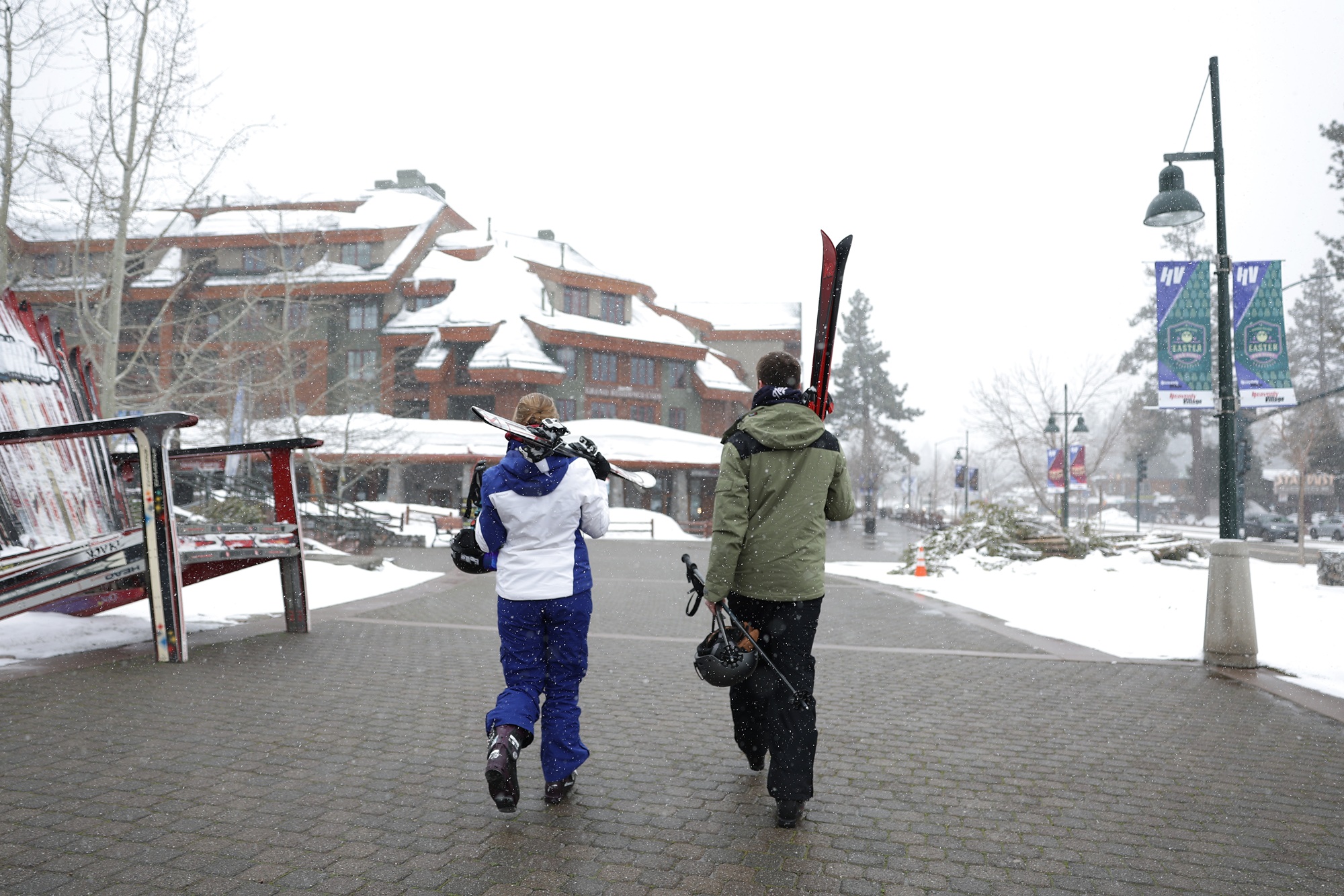
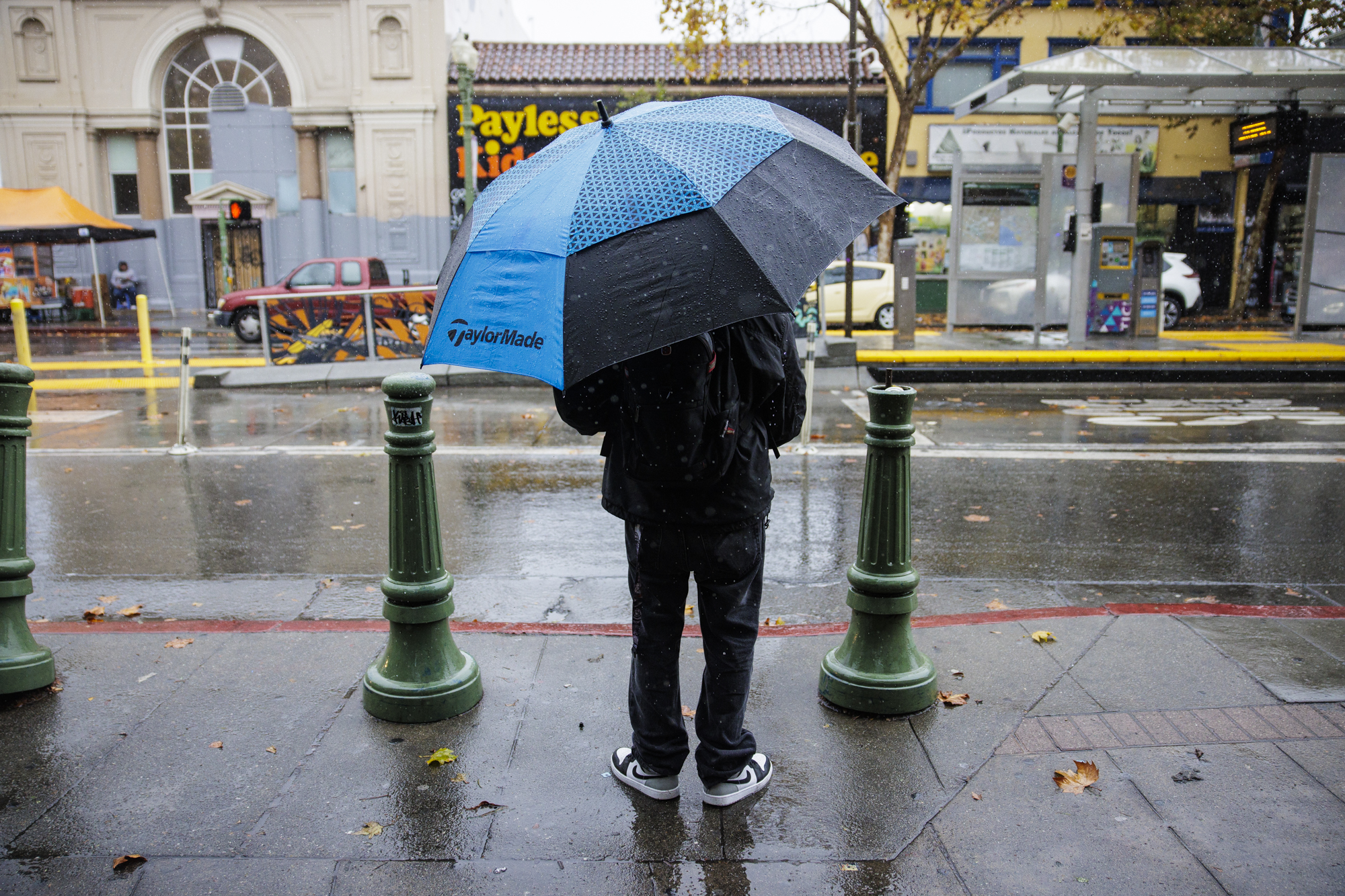
A person waits to cross the street in the Fruitvale neighborhood of Oakland on Nov. 13, 2025. (Martin do Nascimento/KQED)
But for the resorts that remain open, it ain’t over yet. With rain and snow in the forecast this week, incoming cooler weather could give diehard skiers one last chance to hit fresh powder this spring.
“You can never count on winter to be done in the High Sierra,” said Carly Mangan, spokesperson for Vail Resorts in Tahoe.
Keep reading for what we know about this week’s weather change, and what anyone contemplating heading to the Sierra for one last ride should know.
What’s the weather forecast for the Bay Area this week?
Flynn said the Bay Area cooldown will begin Monday, with a first storm from the tropics that could bring a chance of “novelty drops” of rain across the region through Tuesday.
But the second storm, a cold system dipping down from the Pacific Northwest on Wednesday and Thursday, is the region’s “best chance for rain,” Flynn said.
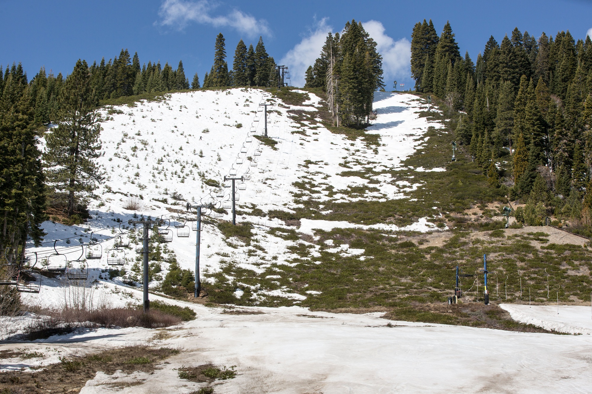
The ski area at Homewood has closed due to poor snow conditions as viewed on April 14, 2021, in Homewood, California. (George Rose/Getty Images)
As much as a quarter inch of rain could fall across the Bay Area, which Flynn said is important owing to the fact that it’s been “one of the driest Marches on record, too.”
“In fact, in San Francisco, it’s the driest March in over 100 years,” he noted.
After this week’s rain, what can we expect in the Bay for early April?
The cooldown is only temporary, Flynn said. This weekend, as a new ridge of high pressure builds over the region, temperatures will spike back into the 80s in inland areas and into the 70s along the coast.
“Unfortunately, after the next three days, the sun comes back out, and it gets hot again,” Flynn said.
Flynn expects temperatures to continue to be warm into early next week, but said “there’s a lot of uncertainty” over what the weather will be like after Monday.
“What I can say is after this cool stretch, we go right back above normal temperatures,” Flynn said.
What kind of snow will Tahoe see this week?
By the end of Thursday, this week’s storms could drop as much as a foot or more of snow on the height of the Sierra Nevada, said Gigi Giralte, a meteorologist with the NWS’s Reno office.
The new snow is a big deal for the state’s dwindling snowpack, which as of Monday sat at a meager 18% of the April 1 average. But Giralte warned that the snow may have trouble sticking to the ground because of the recent warmth and lack of snow.
After the storms end, Giralte expects the snowpack to “be about the same, because we’re not getting feet and feet of snow” this week.
“We would need a much more significant storm to greatly impact the snowpack that we currently have,” she said.
Since temperatures are forecast to warm up after Thursday into the low 60s in the Tahoe area, Giralte said anyone heading up to the area should still “definitely expect spring skiing” conditions.
People traveling to the region can expect minor snow impacts, “but it’s still going to be a switch-up from the warm and dry weather we’ve been experiencing for most of March,” said Kate Forrest, a meteorologist with the weather service’s Sacramento office.
What do Tahoe ski resorts expect, and is it worth it to go up from the Bay this weekend?
But some Tahoe ski areas are still open — and are embracing this April storm.
That includes the three Vail-owned resorts in Tahoe: Kirkwood, Heavenly and Northstar. Spokesperson Mangan said they’re hoping for significant snowfall this week — up to 18 inches according to Monday’s projections — especially at Kirkwood.
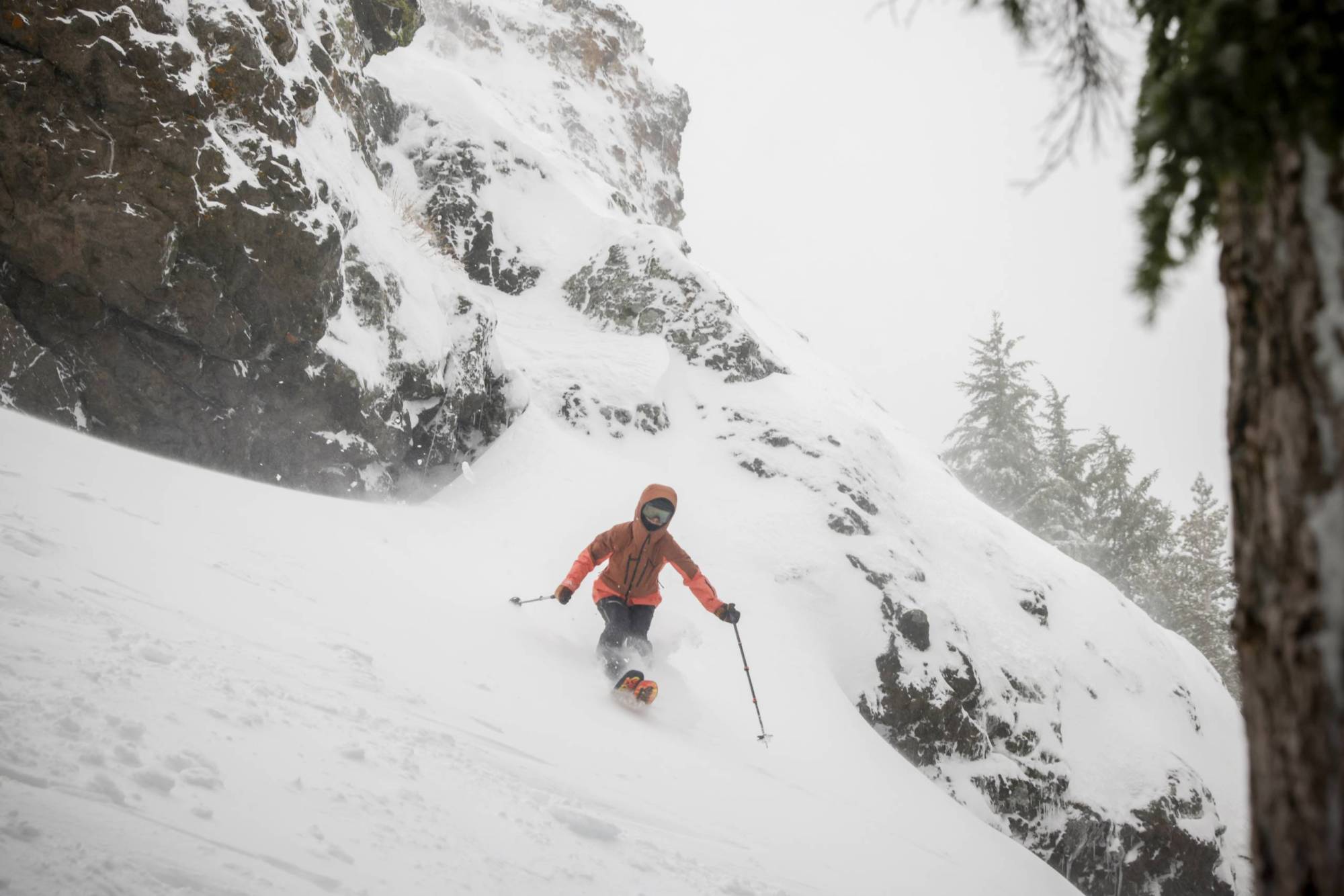
Professional skier Molly Armanino lands Dan’s Cliff at Kirkwood Ski Resort in Kirkwood, California, on Jan. 3, 2026. (Brontë Wittpenn/San Francisco Chronicle via Getty Images)
“Kirkwood does kind of seem like right now in the eye of the storm,” Mangan said on Monday.
Palisades Tahoe’s Olympic Valley side is also still open. OpenSnow forecaster Bryan Allegretto wrote on the Palisades Tahoe blog that the resort is expecting snow to start early Tuesday morning and to last through Thursday. But he said it’s still unclear whether the heaviest snowfall will head north or south.
Related Article
At present, Allegretto predicts high temperatures in the 30s up on the mountain, with ridgetop winds up to 50 miles per hour to start — increasing to up to 100 miles per hour overnight on Wednesday, which could affect lift operations on Wednesday or Thursday. Allegretto expects up to 16 inches of snow at the Palisades’ highest elevations.
Perhaps more importantly, Mangan said, are the cold temperatures the region is expecting overnight this week, which could not only help slow snowmelt and assist resort operations in grooming more terrain, but also produce loose, soft “corn” snow, which is a springtime Tahoe staple.
“Any of that is just going to help immensely at this time in the season for us to get through to our closing days,” she said. “We’ll take anything we can get.”
While Northstar is slated to close after Sunday, Heavenly and Kirkwood are aiming for an April 19 closing date, Mangan said. And while she doesn’t expect this storm to open a bunch of new terrain in the mountains, this week’s storm could help keep the season alive until then, she said.
What should skiers and snowboarders know about conditions right now?
The sun may return this weekend, Allegretto said, bringing highs in the 60s at the village in Olympic Valley and in the 40s up top at Palisades.
But “given that we are seeing low coverage across different areas on all of our resorts in the Tahoe region,” Mangan warned that anyone skiing this weekend should “be aware of the potential for unmarked hazards hidden just below the snow,” concealed by the injection of fresh powder. She advised skiing with caution and within one’s ability level.
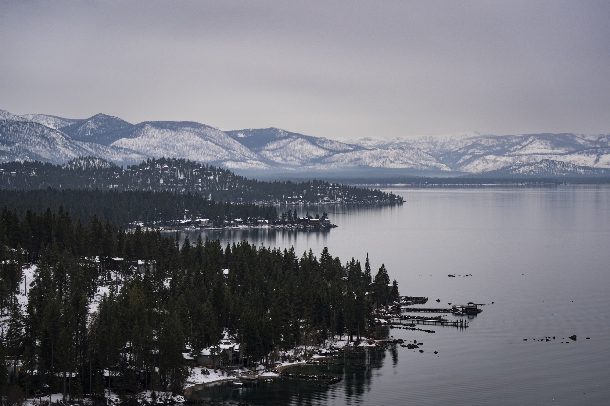
Snow and trees along Lake Tahoe on Dec. 31, 2025, in Glenbrook, Nevada. Lake Tahoe is the largest alpine lake in North America, straddling the border between California and Nevada. (Al Drago/Getty Images)
While Heavenly and Northstar’s lower mountains are closed, they benefit from gondolas to bring skiers to the upper mountains, terrain which Mangan said is “ holding up really well.”
Kirkwood, meanwhile, has a higher base level, so it’s still open from top to bottom with 60% of terrain open — but nonetheless, “it’s melting out fast,” Mangan said.
So if you want to get “that one last hurrah” for the season, you may be able to get it this weekend, she said.
“Everybody loves a little April powder,” Mangan said.
Beyond this week, is there any more snow in the long-range forecast?
The simple answer is not really, Giralte said — but it has “snowed in May before, so it’s not out of the question.”
The Climate Prediction Center’s 8-to-14-day outlook shows California and most of Nevada will likely experience above-normal temperatures and below-average precipitation for around the first two weeks of April.
“In the long range, we don’t really see some snow coming as high pressure sets back and lingers,” Giralte said, “which will help bring those temperatures back up and dry us out again, like we saw last week.”
lower waypointnext waypoint
Player sponsored by
window.__IS_SSR__=true
window.__INITIAL_STATE__={
"attachmentsReducer": {
"audio_0": {
"type": "attachments",
"id": "audio_0",
"imgSizes": {
"kqedFullSize": {
"file": "https://ww2.kqed.org/news/wp-content/themes/KQED-unified/img/audio_bgs/background0.jpg"
}
}
},
"audio_1": {
"type": "attachments",
"id": "audio_1",
"imgSizes": {
"kqedFullSize": {
"file": "https://ww2.kqed.org/news/wp-content/themes/KQED-unified/img/audio_bgs/background1.jpg"
}
}
},
"audio_2": {
"type": "attachments",
"id": "audio_2",
"imgSizes": {
"kqedFullSize": {
"file": "https://ww2.kqed.org/news/wp-content/themes/KQED-unified/img/audio_bgs/background2.jpg"
}
}
},
"audio_3": {
"type": "attachments",
"id": "audio_3",
"imgSizes": {
"kqedFullSize": {
"file": "https://ww2.kqed.org/news/wp-content/themes/KQED-unified/img/audio_bgs/background3.jpg"
}
}
},
"audio_4": {
"type": "attachments",
"id": "audio_4",
"imgSizes": {
"kqedFullSize": {
"file": "https://ww2.kqed.org/news/wp-content/themes/KQED-unified/img/audio_bgs/background4.jpg"
}
}
},
"placeholder": {
"type": "attachments",
"id": "placeholder",
"imgSizes": {
"thumbnail": {
"file": "https://cdn.kqed.org/wp-content/uploads/2024/12/KQED-Default-Image-816638274-2000x1333-1-160x107.jpg",
"width": 160,
"height": 107,
"mimeType": "image/jpeg"
},
"medium": {
"file": "https://cdn.kqed.org/wp-content/uploads/2024/12/KQED-Default-Image-816638274-2000x1333-1-800x533.jpg",
"width": 800,
"height": 533,
"mimeType": "image/jpeg"
},
"medium_large": {
"file": "https://cdn.kqed.org/wp-content/uploads/2024/12/KQED-Default-Image-816638274-2000x1333-1-768x512.jpg",
"width": 768,
"height": 512,
"mimeType": "image/jpeg"
},
"large": {
"file": "https://cdn.kqed.org/wp-content/uploads/2024/12/KQED-Default-Image-816638274-2000x1333-1-1020x680.jpg",
"width": 1020,
"height": 680,
"mimeType": "image/jpeg"
},
"1536x1536": {
"file": "https://cdn.kqed.org/wp-content/uploads/2024/12/KQED-Default-Image-816638274-2000x1333-1-1536x1024.jpg",
"width": 1536,
"height": 1024,
"mimeType": "image/jpeg"
},
"fd-lrg": {
"file": "https://cdn.kqed.org/wp-content/uploads/2024/12/KQED-Default-Image-816638274-2000x1333-1-1536x1024.jpg",
"width": 1536,
"height": 1024,
"mimeType": "image/jpeg"
},
"fd-med": {
"file": "https://cdn.kqed.org/wp-content/uploads/2024/12/KQED-Default-Image-816638274-2000x1333-1-1020x680.jpg",
"width": 1020,
"height": 680,
"mimeType": "image/jpeg"
},
"fd-sm": {
"file": "https://cdn.kqed.org/wp-content/uploads/2024/12/KQED-Default-Image-816638274-2000x1333-1-800x533.jpg",
"width": 800,
"height": 533,
"mimeType": "image/jpeg"
},
"post-thumbnail": {
"file": "https://cdn.kqed.org/wp-content/uploads/2024/12/KQED-Default-Image-816638274-2000x1333-1-672x372.jpg",
"width": 672,
"height": 372,
"mimeType": "image/jpeg"
},
"twentyfourteen-full-width": {
"file": "https://cdn.kqed.org/wp-content/uploads/2024/12/KQED-Default-Image-816638274-2000x1333-1-1038x576.jpg",
"width": 1038,
"height": 576,
"mimeType": "image/jpeg"
},
"xxsmall": {
"file": "https://cdn.kqed.org/wp-content/uploads/2024/12/KQED-Default-Image-816638274-2000x1333-1-160x107.jpg",
"width": 160,
"height": 107,
"mimeType": "image/jpeg"
},
"xsmall": {
"file": "https://cdn.kqed.org/wp-content/uploads/2024/12/KQED-Default-Image-816638274-2000x1333-1-672x372.jpg",
"width": 672,
"height": 372,
"mimeType": "image/jpeg"
},
"small": {
"file": "https://cdn.kqed.org/wp-content/uploads/2024/12/KQED-Default-Image-816638274-2000x1333-1-672x372.jpg",
"width": 672,
"height": 372,
"mimeType": "image/jpeg"
},
"xlarge": {
"file": "https://cdn.kqed.org/wp-content/uploads/2024/12/KQED-Default-Image-816638274-2000x1333-1-1020x680.jpg",
"width": 1020,
"height": 680,
"mimeType": "image/jpeg"
},
"full-width": {
"file": "https://cdn.kqed.org/wp-content/uploads/2024/12/KQED-Default-Image-816638274-2000x1333-1-1920x1280.jpg",
"width": 1920,
"height": 1280,
"mimeType": "image/jpeg"
},
"guest-author-32": {
"file": "https://cdn.kqed.org/wp-content/uploads/2025/01/KQED-Default-Image-816638274-1333x1333-1-160x160.jpg",
"width": 32,
"height": 32,
"mimeType": "image/jpeg"
},
"guest-author-50": {
"file": "https://cdn.kqed.org/wp-content/uploads/2025/01/KQED-Default-Image-816638274-1333x1333-1-160x160.jpg",
"width": 50,
"height": 50,
"mimeType": "image/jpeg"
},
"guest-author-64": {
"file": "https://cdn.kqed.org/wp-content/uploads/2025/01/KQED-Default-Image-816638274-1333x1333-1-160x160.jpg",
"width": 64,
"height": 64,
"mimeType": "image/jpeg"
},
"guest-author-96": {
"file": "https://cdn.kqed.org/wp-content/uploads/2025/01/KQED-Default-Image-816638274-1333x1333-1-160x160.jpg",
"width": 96,
"height": 96,
"mimeType": "image/jpeg"
},
"guest-author-128": {
"file": "https://cdn.kqed.org/wp-content/uploads/2025/01/KQED-Default-Image-816638274-1333x1333-1-160x160.jpg",
"width": 128,
"height": 128,
"mimeType": "image/jpeg"
},
"detail": {
"file": "https://cdn.kqed.org/wp-content/uploads/2025/01/KQED-Default-Image-816638274-1333x1333-1-160x160.jpg",
"width": 160,
"height": 160,
"mimeType": "image/jpeg"
},
"kqedFullSize": {
"file": "https://cdn.kqed.org/wp-content/uploads/2024/12/KQED-Default-Image-816638274-2000x1333-1.jpg",
"width": 2000,
"height": 1333
}
}
},
"news_12078062": {
"type": "attachments",
"id": "news_12078062",
"meta": {
"index": "attachments_1716263798",
"site": "news",
"id": "12078062",
"found": true
},
"title": "Lake Tahoe Area Readies For More Snow As Another Storm Moves Over California",
"publishDate": 1774902695,
"status": "inherit",
"parent": 12078060,
"modified": 1774902730,
"caption": "People carry skis as they walk toward a resort on March 21, 2023, in South Lake Tahoe, California. ",
"credit": "Justin Sullivan/Getty Images",
"altTag": null,
"description": null,
"imgSizes": {
"thumbnail": {
"file": "https://cdn.kqed.org/wp-content/uploads/sites/10/2026/03/TahoeGetty1-160x107.jpg",
"width": 160,
"height": 107,
"mimeType": "image/jpeg"
},
"1536x1536": {
"file": "https://cdn.kqed.org/wp-content/uploads/sites/10/2026/03/TahoeGetty1-1536x1024.jpg",
"width": 1536,
"height": 1024,
"mimeType": "image/jpeg"
},
"post-thumbnail": {
"file": "https://cdn.kqed.org/wp-content/uploads/sites/10/2026/03/TahoeGetty1-672x372.jpg",
"width": 672,
"height": 372,
"mimeType": "image/jpeg"
},
"twentyfourteen-full-width": {
"file": "https://cdn.kqed.org/wp-content/uploads/sites/10/2026/03/TahoeGetty1-1038x576.jpg",
"width": 1038,
"height": 576,
"mimeType": "image/jpeg"
},
"npr-cds-wide": {
"file": "https://cdn.kqed.org/wp-content/uploads/sites/10/2026/03/TahoeGetty1-1200x675.jpg",
"width": 1200,
"height": 675,
"mimeType": "image/jpeg"
},
"npr-cds-square": {
"file": "https://cdn.kqed.org/wp-content/uploads/sites/10/2026/03/TahoeGetty1-600x600.jpg",
"width": 600,
"height": 600,
"mimeType": "image/jpeg"
},
"kqedFullSize": {
"file": "https://cdn.kqed.org/wp-content/uploads/sites/10/2026/03/TahoeGetty1.jpg",
"width": 2000,
"height": 1333
}
},
"isLoading": false,
"fetchFailed": false
}
},
"audioPlayerReducer": {
"postId": "stream_live",
"isPaused": true,
"isPlaying": false,
"pfsActive": false,
"pledgeModalIsOpen": true,
"playerDrawerIsOpen": false,
"liveAudioPlayStartedAt": 0,
"liveAudioPlayContext": ""
},
"authorsReducer": {
"eromero": {
"type": "authors",
"id": "11746",
"meta": {
"index": "authors_1716337520",
"id": "11746",
"found": true
},
"name": "Ezra David Romero",
"firstName": "Ezra David",
"lastName": "Romero",
"slug": "eromero",
"email": "eromero@kqed.org",
"display_author_email": true,
"staff_mastheads": [
"news",
"science"
],
"title": "Climate Reporter",
"bio": "Ezra David Romero is a climate reporter for KQED News. He covers the absence and excess of water in the Bay Area — think sea level rise, flooding and drought. For nearly a decade he’s covered how warming temperatures are altering the lives of Californians. He’s reported on farmers worried their pistachio trees aren’t getting enough sleep, families desperate for water, scientists studying dying giant sequoias, and alongside firefighters containing wildfires. His work has appeared on local stations across California and nationally on public radio shows like Morning Edition, Here and Now, All Things Considered and Science Friday. ",
"avatar": "https://secure.gravatar.com/avatar/9c15bb8bab267e058708a9eeaeef16bf?s=600&d=blank&r=g",
"twitter": "ezraromero",
"bluesky": null,
"facebook": null,
"instagram": null,
"linkedin": null,
"sites": [
{
"site": "arts",
"roles": [
"editor"
]
},
{
"site": "news",
"roles": [
"editor"
]
},
{
"site": "science",
"roles": [
"editor"
]
},
{
"site": "liveblog",
"roles": [
"author"
]
}
],
"headData": {
"title": "Ezra David Romero | KQED",
"description": "Climate Reporter",
"ogImgSrc": "https://secure.gravatar.com/avatar/9c15bb8bab267e058708a9eeaeef16bf?s=600&d=blank&r=g",
"twImgSrc": "https://secure.gravatar.com/avatar/9c15bb8bab267e058708a9eeaeef16bf?s=600&d=blank&r=g"
},
"isLoading": false,
"link": "/author/eromero"
},
"sarahwright": {
"type": "authors",
"id": "11956",
"meta": {
"index": "authors_1716337520",
"id": "11956",
"found": true
},
"name": "Sarah Wright",
"firstName": "Sarah",
"lastName": "Wright",
"slug": "sarahwright",
"email": "swright@kqed.org",
"display_author_email": true,
"staff_mastheads": [],
"title": "Outdoors Engagement Reporter",
"bio": "Sarah Wright is KQED's Outdoors Engagement Reporter. Originally from Lake Tahoe, she completed a thru-hike of the Pacific Crest Trail in 2019 and was a U.S. Fulbright Program grantee to Argentina in 2023. Her journalism has appeared in The Guardian, The San Francisco Standard, The Palo Alto Weekly and the Half Moon Bay Review.",
"avatar": "https://secure.gravatar.com/avatar/c161a3d6441865cba25e6db4fa561099ad665799e9432e34da2b84d7e371524c?s=600&d=blank&r=g",
"twitter": null,
"bluesky": null,
"facebook": null,
"instagram": null,
"linkedin": null,
"sites": [
{
"site": "arts",
"roles": [
"editor"
]
},
{
"site": "news",
"roles": [
"editor"
]
},
{
"site": "science",
"roles": [
"contributor",
"author"
]
},
{
"site": "forum",
"roles": [
"editor"
]
}
],
"headData": {
"title": "Sarah Wright | KQED",
"description": "Outdoors Engagement Reporter",
"ogImgSrc": "https://secure.gravatar.com/avatar/c161a3d6441865cba25e6db4fa561099ad665799e9432e34da2b84d7e371524c?s=600&d=blank&r=g",
"twImgSrc": "https://secure.gravatar.com/avatar/c161a3d6441865cba25e6db4fa561099ad665799e9432e34da2b84d7e371524c?s=600&d=blank&r=g"
},
"isLoading": false,
"link": "/author/sarahwright"
}
},
"pagesReducer": {},
"pfsSessionReducer": {},
"postsReducer": {
"stream_live": {
"type": "live",
"id": "stream_live",
"audioUrl": "https://streams.kqed.org/kqedradio",
"title": "Live Stream",
"excerpt": "Live Stream information currently unavailable.",
"link": "/radio",
"featImg": "",
"label": {
"name": "KQED Live",
"link": "/"
}
},
"stream_kqedNewscast": {
"type": "posts",
"id": "stream_kqedNewscast",
"audioUrl": "https://www.kqed.org/.stream/anon/radio/RDnews/newscast.mp3?_=1",
"title": "KQED Newscast",
"featImg": "",
"label": {
"name": "88.5 FM",
"link": "/"
}
},
"news_12078060": {
"type": "posts",
"id": "news_12078060",
"meta": {
"index": "posts_1716263798",
"site": "news",
"id": "12078060",
"found": true
},
"articlePosition": 0,
"guestAuthors": [],
"slug": "bay-area-weather-forecast-rain-snow-storms-tahoe-this-week-conditions-resorts-open",
"title": "Cold Weather Is Back in the Bay Area and Tahoe. Here’s What the Storms Could Bring",
"publishDate": 1774904300,
"format": "standard",
"headTitle": "Cold Weather Is Back in the Bay Area and Tahoe. Here’s What the Storms Could Bring | KQED",
"labelTerm": {
"site": "news"
},
"content": "\u003cp>The early-season \u003ca href=\"https://www.kqed.org/science/2000445/yikes-bay-area-heat-lingers-sierra-nevada-snowpack-melting-fast\">summer-time temperatures\u003c/a> that baked the Bay Area and \u003ca href=\"https://www.kqed.org/science/2000372/snow-eater-heat-wave-behind-big-sierra-melt-is-a-look-at-our-climate-future\">rapidly melted the Sierra Nevada snowpack\u003c/a> are coming to an end this week — but only for a couple of days.\u003c/p>\n\u003cp>National Weather Service forecasters said two back-to-back storms this week will wet the state and push out the ridge of high pressure that created the recent heat wave.\u003c/p>\n\u003cp>That period broke the all-time March high-temperature records at every major Bay Area climate station, and saw Lake Tahoe also get its warmest March day on record.\u003c/p>\n\u003cp>[ad fullwidth]\u003c/p>\n\u003cp>“It’s not like we barely beat the records, either — we really shattered the records,” said Dylan Flynn, a meteorologist with the weather service’s Bay Area office.\u003c/p>\n\u003cp>This two-week run of warm temperatures caused Bay Area residents to \u003ca href=\"https://www.kqed.org/news/12076391/best-beaches-near-san-francisco-bay-area-weather-heat-wave-how-to-check-tides-wind\">flock to local beaches\u003c/a> or travel to the Sierra for the chance to ski in shorts. However, the exceptionally hot and dry March spelled the \u003ca href=\"https://www.kqed.org/news/12077367/tahoe-ski-resorts-closing-dates-2026-heavenly-palisades-homewood-closed-weather-snow-forecast-storms\">end of the ski season for many Tahoe resorts, w\u003c/a>hich have since closed\u003ca href=\"https://www.kqed.org/news/12077367/tahoe-ski-resorts-closing-dates-2026-heavenly-palisades-homewood-closed-weather-snow-forecast-storms\">.\u003c/a>\u003c/p>\n\u003cfigure id=\"attachment_12063989\" class=\"wp-caption aligncenter\" style=\"max-width: 2000px\">\u003cimg loading=\"lazy\" decoding=\"async\" class=\"size-full wp-image-12063989\" src=\"https://cdn.kqed.org/wp-content/uploads/sites/10/2025/11/251113-RAIN-FILE-MD-04-KQED.jpg\" alt=\"\" width=\"2000\" height=\"1334\" srcset=\"https://cdn.kqed.org/wp-content/uploads/sites/10/2025/11/251113-RAIN-FILE-MD-04-KQED.jpg 2000w, https://cdn.kqed.org/wp-content/uploads/sites/10/2025/11/251113-RAIN-FILE-MD-04-KQED-160x107.jpg 160w, https://cdn.kqed.org/wp-content/uploads/sites/10/2025/11/251113-RAIN-FILE-MD-04-KQED-1536x1025.jpg 1536w\" sizes=\"auto, (max-width: 2000px) 100vw, 2000px\">\u003cfigcaption class=\"wp-caption-text\">A person waits to cross the street in the Fruitvale neighborhood of Oakland on Nov. 13, 2025. \u003ccite>(Martin do Nascimento/KQED)\u003c/cite>\u003c/figcaption>\u003c/figure>\n\u003cp>But for the resorts that remain open, it ain’t over yet. With rain and snow in the forecast this week, incoming cooler weather could give diehard skiers one last chance to hit fresh powder this spring.\u003c/p>\n\u003cp>“You can never count on winter to be done in the High Sierra,” said Carly Mangan, spokesperson for Vail Resorts in Tahoe.\u003c/p>\n\u003cp>Keep reading for what we know about this week’s weather change, and what anyone contemplating heading to the Sierra for one last ride should know.\u003c/p>\n\u003ch2>What’s the weather forecast for the Bay Area this week?\u003c/h2>\n\u003cp>Flynn said the Bay Area cooldown will begin Monday, with a first storm from the tropics that could bring a chance of “novelty drops” of rain across the region through Tuesday.\u003c/p>\n\u003cp>But the second storm, a cold system dipping down from the Pacific Northwest on Wednesday and Thursday, is the region’s “best chance for rain,” Flynn said.\u003c/p>\n\u003cfigure id=\"attachment_12077403\" class=\"wp-caption aligncenter\" style=\"max-width: 2000px\">\u003cimg loading=\"lazy\" decoding=\"async\" class=\"size-full wp-image-12077403\" src=\"https://cdn.kqed.org/wp-content/uploads/sites/10/2026/03/TahoeSnowGetty.jpg\" alt=\"\" width=\"2000\" height=\"1333\" srcset=\"https://cdn.kqed.org/wp-content/uploads/sites/10/2026/03/TahoeSnowGetty.jpg 2000w, https://cdn.kqed.org/wp-content/uploads/sites/10/2026/03/TahoeSnowGetty-160x107.jpg 160w, https://cdn.kqed.org/wp-content/uploads/sites/10/2026/03/TahoeSnowGetty-1536x1024.jpg 1536w\" sizes=\"auto, (max-width: 2000px) 100vw, 2000px\">\u003cfigcaption class=\"wp-caption-text\">The ski area at Homewood has closed due to poor snow conditions as viewed on April 14, 2021, in Homewood, California. \u003ccite>(George Rose/Getty Images)\u003c/cite>\u003c/figcaption>\u003c/figure>\n\u003cp>As much as a quarter inch of rain could fall across the Bay Area, which Flynn said is important owing to the fact that it’s been “one of the driest Marches on record, too.”\u003c/p>\n\u003cp>“In fact, in San Francisco, it’s the driest March in over 100 years,” he noted.\u003c/p>\n\u003cp>Flynn said most of the rain will be “focused south of the Golden Gate Bridge” across the Peninsula, the East Bay and the Central Coast. \u003ca href=\"https://forecast.weather.gov/product.php?format=ci&glossary=1&issuedby=mtr&product=afd&site=mtr&version=1\">Read the full forecast from the NWS’s Bay Area office. \u003c/a>\u003c/p>\n\u003ch2>After this week’s rain, what can we expect in the Bay for early April?\u003c/h2>\n\u003cp>The cooldown is only temporary, Flynn said. This weekend, as a new ridge of high pressure builds over the region, temperatures will spike back into the 80s in inland areas and into the 70s along the coast.\u003c/p>\n\u003cp>“Unfortunately, after the next three days, the sun comes back out, and it gets hot again,” Flynn said.\u003c/p>\n\u003cp>Flynn expects temperatures to continue to be warm into early next week, but said “there’s a lot of uncertainty” over what the weather will be like after Monday.\u003c/p>\n\u003cp>“What I can say is after this cool stretch, we go right back above normal temperatures,” Flynn said.\u003c/p>\n\u003ch2>What kind of snow will Tahoe see this week?\u003c/h2>\n\u003cp>By the end of Thursday, this week’s storms could drop as much as a foot or more of snow on the height of the Sierra Nevada, said Gigi Giralte, a meteorologist with the NWS’s Reno office.\u003c/p>\n\u003cp>The new snow is a big deal for the state’s dwindling snowpack, which as of Monday sat at a meager \u003ca href=\"https://snow.water.ca.gov/\">18% of the April 1\u003c/a> average. But Giralte warned that the snow may have trouble sticking to the ground because of the recent warmth and lack of snow.\u003c/p>\n\u003cp>https://twitter.com/NWSSacramento/status/2038685187270169013\u003c/p>\n\u003cp>After the storms end, Giralte expects the snowpack to “be about the same, because we’re not getting feet and feet of snow” this week.\u003c/p>\n\u003cp>“We would need a much more significant storm to greatly impact the snowpack that we currently have,” she said.\u003c/p>\n\u003cp>Since temperatures are forecast to warm up after Thursday into the low 60s in the Tahoe area, Giralte said anyone heading up to the area should still “definitely expect spring skiing” conditions.\u003c/p>\n\u003cp>People traveling to the region can expect \u003ca href=\"https://x.com/NWSSacramento/status/2038685187270169013/photo/2\">minor snow impacts\u003c/a>, “but it’s still going to be a switch-up from the warm and dry weather we’ve been experiencing for most of March,” said Kate Forrest, a meteorologist with the weather service’s Sacramento office.\u003c/p>\n\u003ch2>What do Tahoe ski resorts expect, and is it worth it to go up from the Bay this weekend?\u003c/h2>\n\u003cp>For many Tahoe resorts whose lifts have already \u003ca href=\"https://www.kqed.org/news/12077367/tahoe-ski-resorts-closing-dates-2026-heavenly-palisades-homewood-closed-weather-snow-forecast-storms\">stopped spinning for the season\u003c/a>, this storm is too little, too late.\u003c/p>\n\u003cp>But some Tahoe ski areas are still open — and are embracing this April storm.\u003c/p>\n\u003cp>That includes the three Vail-owned resorts in Tahoe: Kirkwood, Heavenly and Northstar. Spokesperson Mangan said they’re hoping for significant snowfall this week — up to 18 inches according to Monday’s projections — especially at Kirkwood.\u003c/p>\n\u003cfigure id=\"attachment_12071091\" class=\"wp-caption aligncenter\" style=\"max-width: 2000px\">\u003cimg loading=\"lazy\" decoding=\"async\" class=\"wp-image-12071091 size-full\" src=\"https://cdn.kqed.org/wp-content/uploads/sites/10/2026/01/GettyImages-2253947921-scaled-e1769466571155.jpg\" alt=\"\" width=\"2000\" height=\"1334\">\u003cfigcaption class=\"wp-caption-text\">Professional skier Molly Armanino lands Dan’s Cliff at Kirkwood Ski Resort in Kirkwood, California, on Jan. 3, 2026. \u003ccite>(Brontë Wittpenn/San Francisco Chronicle via Getty Images)\u003c/cite>\u003c/figcaption>\u003c/figure>\n\u003cp>“Kirkwood does kind of seem like right now in the eye of the storm,” Mangan said on Monday.\u003c/p>\n\u003cp>Palisades Tahoe’s Olympic Valley side is also still open. OpenSnow forecaster Bryan Allegretto \u003ca href=\"https://blog.palisadestahoe.com/weather/rain-snow-with-mountain-accumulations/\">wrote on the Palisades Tahoe blog\u003c/a> that the resort is expecting snow to start early Tuesday morning and to last through Thursday. But he said it’s still unclear whether the heaviest snowfall will head north or south.[aside postID=news_12075796 hero='https://cdn.kqed.org/wp-content/uploads/sites/10/2026/03/GettyImages-1262723899.jpg']At present, Allegretto predicts high temperatures in the 30s up on the mountain, with ridgetop winds up to 50 miles per hour to start — increasing to up to 100 miles per hour overnight on Wednesday, which could affect lift operations on Wednesday or Thursday. Allegretto expects up to 16 inches of snow at the Palisades’ highest elevations.\u003c/p>\n\u003cp>Perhaps more importantly, Mangan said, are the cold temperatures the region is expecting overnight this week, which could not only help slow snowmelt and assist resort operations in grooming more terrain, but also produce loose, soft “corn” snow, which is a springtime Tahoe staple.\u003c/p>\n\u003cp>“Any of that is just going to help immensely at this time in the season for us to get through to our closing days,” she said. “We’ll take anything we can get.”\u003c/p>\n\u003cp>While Northstar is slated to close after Sunday, Heavenly and Kirkwood are aiming for an April 19 closing date, Mangan said. And while she doesn’t expect this storm to open a bunch of new terrain in the mountains, this week’s storm could help keep the season alive until then, she said.\u003c/p>\n\u003ch2>What should skiers and snowboarders know about conditions right now?\u003c/h2>\n\u003cp>The sun may return this weekend, Allegretto said, bringing highs in the 60s at the village in Olympic Valley and in the 40s up top at Palisades.\u003c/p>\n\u003cp>But “given that we are seeing low coverage across different areas on all of our resorts in the Tahoe region,” Mangan warned that anyone skiing this weekend should “be aware of the potential for \u003ca href=\"https://www.reddit.com/r/kirkwood/comments/1s7u04a/psa_for_anyone_coming_next_weekend/?share_id=YCA72Zd-_0_IkERkwh3_a&utm_content=1&utm_medium=ios_app&utm_name=ioscss&utm_source=share&utm_term=1\">unmarked hazards\u003c/a> hidden just below the snow,” concealed by the injection of fresh powder. She advised skiing with caution and within one’s ability level.\u003c/p>\n\u003cfigure id=\"attachment_12077406\" class=\"wp-caption aligncenter\" style=\"max-width: 2000px\">\u003cimg loading=\"lazy\" decoding=\"async\" class=\"wp-image-12077406 size-full\" src=\"https://cdn.kqed.org/wp-content/uploads/sites/10/2026/03/TahoeGetty.jpg\" alt=\"\" width=\"2000\" height=\"1333\" srcset=\"https://cdn.kqed.org/wp-content/uploads/sites/10/2026/03/TahoeGetty.jpg 2000w, https://cdn.kqed.org/wp-content/uploads/sites/10/2026/03/TahoeGetty-160x107.jpg 160w, https://cdn.kqed.org/wp-content/uploads/sites/10/2026/03/TahoeGetty-1536x1024.jpg 1536w\" sizes=\"auto, (max-width: 2000px) 100vw, 2000px\">\u003cfigcaption class=\"wp-caption-text\">Snow and trees along Lake Tahoe on Dec. 31, 2025, in Glenbrook, Nevada. Lake Tahoe is the largest alpine lake in North America, straddling the border between California and Nevada. \u003ccite>(Al Drago/Getty Images)\u003c/cite>\u003c/figcaption>\u003c/figure>\n\u003cp>While Heavenly and Northstar’s lower mountains are closed, they benefit from gondolas to bring skiers to the upper mountains, terrain which Mangan said is “ holding up really well.”\u003c/p>\n\u003cp>Kirkwood, meanwhile, has a higher base level, so it’s still open from top to bottom with 60% of terrain open — but nonetheless, “it’s melting out fast,” Mangan said.\u003c/p>\n\u003cp>So if you want to get “that one last hurrah” for the season, you may be able to get it this weekend, she said.\u003c/p>\n\u003cp>“Everybody loves a little April powder,” Mangan said.\u003c/p>\n\u003ch2>Beyond this week, is there any more snow in the long-range forecast?\u003c/h2>\n\u003cp>The simple answer is not really, Giralte said — but it has “snowed in May before, so it’s not out of the question.”\u003c/p>\n\u003cp>The Climate Prediction Center’s \u003ca href=\"https://www.cpc.ncep.noaa.gov/products/predictions/814day/\">8-to-14-day outlook\u003c/a> shows California and most of Nevada will likely experience above-normal temperatures and below-average precipitation for around the first two weeks of April.\u003c/p>\n\u003cp>“In the long range, we don’t really see some snow coming as high pressure sets back and lingers,” Giralte said, “which will help bring those temperatures back up and dry us out again, like we saw last week.”\u003c/p>\n\u003cp>[ad floatright]\u003c/p>\n",
"blocks": [],
"excerpt": "Incoming rain and snow could salvage Bay Area residents' final ski trip to Tahoe. Here’s what to know if you’re heading to the slopes.",
"status": "publish",
"parent": 0,
"modified": 1774908215,
"stats": {
"hasAudio": false,
"hasVideo": false,
"hasChartOrMap": false,
"iframeSrcs": [],
"hasGoogleForm": false,
"hasGallery": false,
"hasHearkenModule": false,
"hasPolis": false,
"paragraphCount": 42,
"wordCount": 1620
},
"headData": {
"title": "Cold Weather Is Back in the Bay Area and Tahoe. Here’s What the Storms Could Bring | KQED",
"description": "Incoming rain and snow could salvage Bay Area residents' final ski trip to Tahoe. Here’s what to know if you’re heading to the slopes.",
"ogTitle": "",
"ogDescription": "",
"ogImgId": "",
"twTitle": "",
"twDescription": "",
"twImgId": "",
"schema": {
"@context": "https://schema.org",
"@type": "NewsArticle",
"headline": "Cold Weather Is Back in the Bay Area and Tahoe. Here’s What the Storms Could Bring",
"datePublished": "2026-03-30T13:58:20-07:00",
"dateModified": "2026-03-30T15:03:35-07:00",
"image": "https://cdn.kqed.org/wp-content/uploads/2020/02/KQED-OG-Image@1x.png",
"isAccessibleForFree": "True",
"publisher": {
"@type": "NewsMediaOrganization",
"@id": "https://www.kqed.org/#organization",
"name": "KQED",
"logo": "https://cdn.kqed.org/wp-content/uploads/2020/02/KQED-OG-Image@1x.png",
"url": "https://www.kqed.org",
"sameAs": [
"https://www.facebook.com/KQED",
"https://twitter.com/KQED",
"https://www.instagram.com/kqed/",
"https://www.tiktok.com/@kqedofficial",
"https://www.linkedin.com/company/kqed",
"https://www.youtube.com/channel/UCeC0IOo7i1P_61zVUWbJ4nw"
]
},
"author": {
"@type": "Person",
"name": "Ezra David Romero",
"jobTitle": "Climate Reporter",
"url": "https://www.kqed.org/author/eromero"
}
},
"authorsData": [],
"tagData": []
},
"primaryCategory": {
"termId": 34168,
"slug": "guides-and-explainers",
"name": "Guides and Explainers"
},
"sticky": false,
"nprStoryId": "kqed-12078060",
"templateType": "standard",
"featuredImageType": "standard",
"excludeFromSiteSearch": "Include",
"articleAge": "0",
"path": "/news/12078060/bay-area-weather-forecast-rain-snow-storms-tahoe-this-week-conditions-resorts-open",
"audioTrackLength": null,
"parsedContent": [
{
"type": "contentString",
"content": "\u003cdiv class=\"post-body\">\u003cp>\u003cp>The early-season \u003ca href=\"https://www.kqed.org/science/2000445/yikes-bay-area-heat-lingers-sierra-nevada-snowpack-melting-fast\">summer-time temperatures\u003c/a> that baked the Bay Area and \u003ca href=\"https://www.kqed.org/science/2000372/snow-eater-heat-wave-behind-big-sierra-melt-is-a-look-at-our-climate-future\">rapidly melted the Sierra Nevada snowpack\u003c/a> are coming to an end this week — but only for a couple of days.\u003c/p>\n\u003cp>National Weather Service forecasters said two back-to-back storms this week will wet the state and push out the ridge of high pressure that created the recent heat wave.\u003c/p>\n\u003cp>That period broke the all-time March high-temperature records at every major Bay Area climate station, and saw Lake Tahoe also get its warmest March day on record.\u003c/p>\n\u003cp>\u003c/p>\u003c/div>",
"attributes": {
"named": {},
"numeric": []
}
},
{
"type": "component",
"content": "",
"name": "ad",
"attributes": {
"named": {
"label": "fullwidth"
},
"numeric": [
"fullwidth"
]
}
},
{
"type": "contentString",
"content": "\u003cdiv class=\"post-body\">\u003cp>\u003c/p>\n\u003cp>“It’s not like we barely beat the records, either — we really shattered the records,” said Dylan Flynn, a meteorologist with the weather service’s Bay Area office.\u003c/p>\n\u003cp>This two-week run of warm temperatures caused Bay Area residents to \u003ca href=\"https://www.kqed.org/news/12076391/best-beaches-near-san-francisco-bay-area-weather-heat-wave-how-to-check-tides-wind\">flock to local beaches\u003c/a> or travel to the Sierra for the chance to ski in shorts. However, the exceptionally hot and dry March spelled the \u003ca href=\"https://www.kqed.org/news/12077367/tahoe-ski-resorts-closing-dates-2026-heavenly-palisades-homewood-closed-weather-snow-forecast-storms\">end of the ski season for many Tahoe resorts, w\u003c/a>hich have since closed\u003ca href=\"https://www.kqed.org/news/12077367/tahoe-ski-resorts-closing-dates-2026-heavenly-palisades-homewood-closed-weather-snow-forecast-storms\">.\u003c/a>\u003c/p>\n\u003cfigure id=\"attachment_12063989\" class=\"wp-caption aligncenter\" style=\"max-width: 2000px\">\u003cimg loading=\"lazy\" decoding=\"async\" class=\"size-full wp-image-12063989\" src=\"https://cdn.kqed.org/wp-content/uploads/sites/10/2025/11/251113-RAIN-FILE-MD-04-KQED.jpg\" alt=\"\" width=\"2000\" height=\"1334\" srcset=\"https://cdn.kqed.org/wp-content/uploads/sites/10/2025/11/251113-RAIN-FILE-MD-04-KQED.jpg 2000w, https://cdn.kqed.org/wp-content/uploads/sites/10/2025/11/251113-RAIN-FILE-MD-04-KQED-160x107.jpg 160w, https://cdn.kqed.org/wp-content/uploads/sites/10/2025/11/251113-RAIN-FILE-MD-04-KQED-1536x1025.jpg 1536w\" sizes=\"auto, (max-width: 2000px) 100vw, 2000px\">\u003cfigcaption class=\"wp-caption-text\">A person waits to cross the street in the Fruitvale neighborhood of Oakland on Nov. 13, 2025. \u003ccite>(Martin do Nascimento/KQED)\u003c/cite>\u003c/figcaption>\u003c/figure>\n\u003cp>But for the resorts that remain open, it ain’t over yet. With rain and snow in the forecast this week, incoming cooler weather could give diehard skiers one last chance to hit fresh powder this spring.\u003c/p>\n\u003cp>“You can never count on winter to be done in the High Sierra,” said Carly Mangan, spokesperson for Vail Resorts in Tahoe.\u003c/p>\n\u003cp>Keep reading for what we know about this week’s weather change, and what anyone contemplating heading to the Sierra for one last ride should know.\u003c/p>\n\u003ch2>What’s the weather forecast for the Bay Area this week?\u003c/h2>\n\u003cp>Flynn said the Bay Area cooldown will begin Monday, with a first storm from the tropics that could bring a chance of “novelty drops” of rain across the region through Tuesday.\u003c/p>\n\u003cp>But the second storm, a cold system dipping down from the Pacific Northwest on Wednesday and Thursday, is the region’s “best chance for rain,” Flynn said.\u003c/p>\n\u003cfigure id=\"attachment_12077403\" class=\"wp-caption aligncenter\" style=\"max-width: 2000px\">\u003cimg loading=\"lazy\" decoding=\"async\" class=\"size-full wp-image-12077403\" src=\"https://cdn.kqed.org/wp-content/uploads/sites/10/2026/03/TahoeSnowGetty.jpg\" alt=\"\" width=\"2000\" height=\"1333\" srcset=\"https://cdn.kqed.org/wp-content/uploads/sites/10/2026/03/TahoeSnowGetty.jpg 2000w, https://cdn.kqed.org/wp-content/uploads/sites/10/2026/03/TahoeSnowGetty-160x107.jpg 160w, https://cdn.kqed.org/wp-content/uploads/sites/10/2026/03/TahoeSnowGetty-1536x1024.jpg 1536w\" sizes=\"auto, (max-width: 2000px) 100vw, 2000px\">\u003cfigcaption class=\"wp-caption-text\">The ski area at Homewood has closed due to poor snow conditions as viewed on April 14, 2021, in Homewood, California. \u003ccite>(George Rose/Getty Images)\u003c/cite>\u003c/figcaption>\u003c/figure>\n\u003cp>As much as a quarter inch of rain could fall across the Bay Area, which Flynn said is important owing to the fact that it’s been “one of the driest Marches on record, too.”\u003c/p>\n\u003cp>“In fact, in San Francisco, it’s the driest March in over 100 years,” he noted.\u003c/p>\n\u003cp>Flynn said most of the rain will be “focused south of the Golden Gate Bridge” across the Peninsula, the East Bay and the Central Coast. \u003ca href=\"https://forecast.weather.gov/product.php?format=ci&glossary=1&issuedby=mtr&product=afd&site=mtr&version=1\">Read the full forecast from the NWS’s Bay Area office. \u003c/a>\u003c/p>\n\u003ch2>After this week’s rain, what can we expect in the Bay for early April?\u003c/h2>\n\u003cp>The cooldown is only temporary, Flynn said. This weekend, as a new ridge of high pressure builds over the region, temperatures will spike back into the 80s in inland areas and into the 70s along the coast.\u003c/p>\n\u003cp>“Unfortunately, after the next three days, the sun comes back out, and it gets hot again,” Flynn said.\u003c/p>\n\u003cp>Flynn expects temperatures to continue to be warm into early next week, but said “there’s a lot of uncertainty” over what the weather will be like after Monday.\u003c/p>\n\u003cp>“What I can say is after this cool stretch, we go right back above normal temperatures,” Flynn said.\u003c/p>\n\u003ch2>What kind of snow will Tahoe see this week?\u003c/h2>\n\u003cp>By the end of Thursday, this week’s storms could drop as much as a foot or more of snow on the height of the Sierra Nevada, said Gigi Giralte, a meteorologist with the NWS’s Reno office.\u003c/p>\n\u003cp>The new snow is a big deal for the state’s dwindling snowpack, which as of Monday sat at a meager \u003ca href=\"https://snow.water.ca.gov/\">18% of the April 1\u003c/a> average. But Giralte warned that the snow may have trouble sticking to the ground because of the recent warmth and lack of snow.\u003c/p>\u003c/p>\u003c/div>",
"attributes": {
"named": {},
"numeric": []
}
},
{
"type": "component",
"content": "",
"name": "singleTwitterStatus",
"attributes": {
"named": {
"id": "2038685187270169013"
},
"numeric": []
}
},
{
"type": "contentString",
"content": "\u003cdiv class=\"post-body\">\u003cp>\n\u003cp>After the storms end, Giralte expects the snowpack to “be about the same, because we’re not getting feet and feet of snow” this week.\u003c/p>\n\u003cp>“We would need a much more significant storm to greatly impact the snowpack that we currently have,” she said.\u003c/p>\n\u003cp>Since temperatures are forecast to warm up after Thursday into the low 60s in the Tahoe area, Giralte said anyone heading up to the area should still “definitely expect spring skiing” conditions.\u003c/p>\n\u003cp>People traveling to the region can expect \u003ca href=\"https://x.com/NWSSacramento/status/2038685187270169013/photo/2\">minor snow impacts\u003c/a>, “but it’s still going to be a switch-up from the warm and dry weather we’ve been experiencing for most of March,” said Kate Forrest, a meteorologist with the weather service’s Sacramento office.\u003c/p>\n\u003ch2>What do Tahoe ski resorts expect, and is it worth it to go up from the Bay this weekend?\u003c/h2>\n\u003cp>For many Tahoe resorts whose lifts have already \u003ca href=\"https://www.kqed.org/news/12077367/tahoe-ski-resorts-closing-dates-2026-heavenly-palisades-homewood-closed-weather-snow-forecast-storms\">stopped spinning for the season\u003c/a>, this storm is too little, too late.\u003c/p>\n\u003cp>But some Tahoe ski areas are still open — and are embracing this April storm.\u003c/p>\n\u003cp>That includes the three Vail-owned resorts in Tahoe: Kirkwood, Heavenly and Northstar. Spokesperson Mangan said they’re hoping for significant snowfall this week — up to 18 inches according to Monday’s projections — especially at Kirkwood.\u003c/p>\n\u003cfigure id=\"attachment_12071091\" class=\"wp-caption aligncenter\" style=\"max-width: 2000px\">\u003cimg loading=\"lazy\" decoding=\"async\" class=\"wp-image-12071091 size-full\" src=\"https://cdn.kqed.org/wp-content/uploads/sites/10/2026/01/GettyImages-2253947921-scaled-e1769466571155.jpg\" alt=\"\" width=\"2000\" height=\"1334\">\u003cfigcaption class=\"wp-caption-text\">Professional skier Molly Armanino lands Dan’s Cliff at Kirkwood Ski Resort in Kirkwood, California, on Jan. 3, 2026. \u003ccite>(Brontë Wittpenn/San Francisco Chronicle via Getty Images)\u003c/cite>\u003c/figcaption>\u003c/figure>\n\u003cp>“Kirkwood does kind of seem like right now in the eye of the storm,” Mangan said on Monday.\u003c/p>\n\u003cp>Palisades Tahoe’s Olympic Valley side is also still open. OpenSnow forecaster Bryan Allegretto \u003ca href=\"https://blog.palisadestahoe.com/weather/rain-snow-with-mountain-accumulations/\">wrote on the Palisades Tahoe blog\u003c/a> that the resort is expecting snow to start early Tuesday morning and to last through Thursday. But he said it’s still unclear whether the heaviest snowfall will head north or south.\u003c/p>\u003c/div>",
"attributes": {
"named": {},
"numeric": []
}
},
{
"type": "component",
"content": "",
"name": "aside",
"attributes": {
"named": {
"postid": "news_12075796",
"hero": "https://cdn.kqed.org/wp-content/uploads/sites/10/2026/03/GettyImages-1262723899.jpg",
"label": ""
},
"numeric": []
}
},
{
"type": "contentString",
"content": "\u003cdiv class=\"post-body\">\u003cp>At present, Allegretto predicts high temperatures in the 30s up on the mountain, with ridgetop winds up to 50 miles per hour to start — increasing to up to 100 miles per hour overnight on Wednesday, which could affect lift operations on Wednesday or Thursday. Allegretto expects up to 16 inches of snow at the Palisades’ highest elevations.\u003c/p>\n\u003cp>Perhaps more importantly, Mangan said, are the cold temperatures the region is expecting overnight this week, which could not only help slow snowmelt and assist resort operations in grooming more terrain, but also produce loose, soft “corn” snow, which is a springtime Tahoe staple.\u003c/p>\n\u003cp>“Any of that is just going to help immensely at this time in the season for us to get through to our closing days,” she said. “We’ll take anything we can get.”\u003c/p>\n\u003cp>While Northstar is slated to close after Sunday, Heavenly and Kirkwood are aiming for an April 19 closing date, Mangan said. And while she doesn’t expect this storm to open a bunch of new terrain in the mountains, this week’s storm could help keep the season alive until then, she said.\u003c/p>\n\u003ch2>What should skiers and snowboarders know about conditions right now?\u003c/h2>\n\u003cp>The sun may return this weekend, Allegretto said, bringing highs in the 60s at the village in Olympic Valley and in the 40s up top at Palisades.\u003c/p>\n\u003cp>But “given that we are seeing low coverage across different areas on all of our resorts in the Tahoe region,” Mangan warned that anyone skiing this weekend should “be aware of the potential for \u003ca href=\"https://www.reddit.com/r/kirkwood/comments/1s7u04a/psa_for_anyone_coming_next_weekend/?share_id=YCA72Zd-_0_IkERkwh3_a&utm_content=1&utm_medium=ios_app&utm_name=ioscss&utm_source=share&utm_term=1\">unmarked hazards\u003c/a> hidden just below the snow,” concealed by the injection of fresh powder. She advised skiing with caution and within one’s ability level.\u003c/p>\n\u003cfigure id=\"attachment_12077406\" class=\"wp-caption aligncenter\" style=\"max-width: 2000px\">\u003cimg loading=\"lazy\" decoding=\"async\" class=\"wp-image-12077406 size-full\" src=\"https://cdn.kqed.org/wp-content/uploads/sites/10/2026/03/TahoeGetty.jpg\" alt=\"\" width=\"2000\" height=\"1333\" srcset=\"https://cdn.kqed.org/wp-content/uploads/sites/10/2026/03/TahoeGetty.jpg 2000w, https://cdn.kqed.org/wp-content/uploads/sites/10/2026/03/TahoeGetty-160x107.jpg 160w, https://cdn.kqed.org/wp-content/uploads/sites/10/2026/03/TahoeGetty-1536x1024.jpg 1536w\" sizes=\"auto, (max-width: 2000px) 100vw, 2000px\">\u003cfigcaption class=\"wp-caption-text\">Snow and trees along Lake Tahoe on Dec. 31, 2025, in Glenbrook, Nevada. Lake Tahoe is the largest alpine lake in North America, straddling the border between California and Nevada. \u003ccite>(Al Drago/Getty Images)\u003c/cite>\u003c/figcaption>\u003c/figure>\n\u003cp>While Heavenly and Northstar’s lower mountains are closed, they benefit from gondolas to bring skiers to the upper mountains, terrain which Mangan said is “ holding up really well.”\u003c/p>\n\u003cp>Kirkwood, meanwhile, has a higher base level, so it’s still open from top to bottom with 60% of terrain open — but nonetheless, “it’s melting out fast,” Mangan said.\u003c/p>\n\u003cp>So if you want to get “that one last hurrah” for the season, you may be able to get it this weekend, she said.\u003c/p>\n\u003cp>“Everybody loves a little April powder,” Mangan said.\u003c/p>\n\u003ch2>Beyond this week, is there any more snow in the long-range forecast?\u003c/h2>\n\u003cp>The simple answer is not really, Giralte said — but it has “snowed in May before, so it’s not out of the question.”\u003c/p>\n\u003cp>The Climate Prediction Center’s \u003ca href=\"https://www.cpc.ncep.noaa.gov/products/predictions/814day/\">8-to-14-day outlook\u003c/a> shows California and most of Nevada will likely experience above-normal temperatures and below-average precipitation for around the first two weeks of April.\u003c/p>\n\u003cp>“In the long range, we don’t really see some snow coming as high pressure sets back and lingers,” Giralte said, “which will help bring those temperatures back up and dry us out again, like we saw last week.”\u003c/p>\n\u003cp>\u003c/p>\u003c/div>",
"attributes": {
"named": {},
"numeric": []
}
},
{
"type": "component",
"content": "",
"name": "ad",
"attributes": {
"named": {
"label": "floatright"
},
"numeric": [
"floatright"
]
}
},
{
"type": "contentString",
"content": "\u003cdiv class=\"post-body\">\u003cp>\u003c/p>\n\u003c/div>\u003c/p>",
"attributes": {
"named": {},
"numeric": []
}
}
],
"link": "/news/12078060/bay-area-weather-forecast-rain-snow-storms-tahoe-this-week-conditions-resorts-open",
"authors": [
"11746",
"11956"
],
"categories": [
"news_31795",
"news_34165",
"news_34168",
"news_28250"
],
"tags": [
"news_32707",
"news_18538",
"news_23064",
"news_19204",
"news_35888",
"news_28199",
"news_1430",
"news_3187",
"news_466",
"news_25259",
"news_29871",
"news_35737",
"news_3"
],
"featImg": "news_12078062",
"label": "news",
"isLoading": false,
"hasAllInfo": true
}
},
"podcastsReducer": {
"isFetching": false,
"fetchFailed": false,
"hasFetched": false,
"podcasts": {}
},
"radioProgramsReducer": {
"isFetching": false,
"fetchFailed": false,
"hasFetched": false,
"radioPrograms": {}
},
"programsReducer": {
"all-things-considered": {
"id": "all-things-considered",
"title": "All Things Considered",
"info": "Every weekday, \u003cem>All Things Considered\u003c/em> hosts Robert Siegel, Audie Cornish, Ari Shapiro, and Kelly McEvers present the program's trademark mix of news, interviews, commentaries, reviews, and offbeat features. Michel Martin hosts on the weekends.",
"airtime": "MON-FRI 1pm-2pm, 4:30pm-6:30pm\u003cbr />SAT-SUN 5pm-6pm",
"imageSrc": "https://cdn.kqed.org/wp-content/uploads/2024/04/All-Things-Considered-Podcast-Tile-360x360-1.jpg",
"officialWebsiteLink": "https://www.npr.org/programs/all-things-considered/",
"meta": {
"site": "news",
"source": "npr"
},
"link": "/radio/program/all-things-considered"
},
"american-suburb-podcast": {
"id": "american-suburb-podcast",
"title": "American Suburb: The Podcast",
"tagline": "The flip side of gentrification, told through one town",
"info": "Gentrification is changing cities across America, forcing people from neighborhoods they have long called home. Call them the displaced. Now those priced out of the Bay Area are looking for a better life in an unlikely place. American Suburb follows this migration to one California town along the Delta, 45 miles from San Francisco. But is this once sleepy suburb ready for them?",
"imageSrc": "https://cdn.kqed.org/wp-content/uploads/2024/04/American-Suburb-Podcast-Tile-703x703-1.jpg",
"officialWebsiteLink": "/news/series/american-suburb-podcast",
"meta": {
"site": "news",
"source": "kqed",
"order": 19
},
"link": "/news/series/american-suburb-podcast/",
"subscribe": {
"npr": "https://rpb3r.app.goo.gl/RBrW",
"apple": "https://itunes.apple.com/WebObjects/MZStore.woa/wa/viewPodcast?mt=2&id=1287748328",
"tuneIn": "https://tunein.com/radio/American-Suburb-p1086805/",
"rss": "https://ww2.kqed.org/news/series/american-suburb-podcast/feed/podcast",
"google": "https://podcasts.google.com/feed/aHR0cHM6Ly9mZWVkcy5tZWdhcGhvbmUuZm0vS1FJTkMzMDExODgxNjA5"
}
},
"baycurious": {
"id": "baycurious",
"title": "Bay Curious",
"tagline": "Exploring the Bay Area, one question at a time",
"info": "KQED’s new podcast, Bay Curious, gets to the bottom of the mysteries — both profound and peculiar — that give the Bay Area its unique identity. And we’ll do it with your help! You ask the questions. You decide what Bay Curious investigates. And you join us on the journey to find the answers.",
"imageSrc": "https://cdn.kqed.org/wp-content/uploads/2024/04/Bay-Curious-Podcast-Tile-703x703-1.jpg",
"imageAlt": "KQED Bay Curious",
"officialWebsiteLink": "/news/series/baycurious",
"meta": {
"site": "news",
"source": "kqed",
"order": 3
},
"link": "/podcasts/baycurious",
"subscribe": {
"apple": "https://podcasts.apple.com/us/podcast/bay-curious/id1172473406",
"npr": "https://www.npr.org/podcasts/500557090/bay-curious",
"rss": "https://ww2.kqed.org/news/category/bay-curious-podcast/feed/podcast",
"amazon": "https://music.amazon.com/podcasts/9a90d476-aa04-455d-9a4c-0871ed6216d4/bay-curious",
"stitcher": "https://www.stitcher.com/podcast/kqed/bay-curious",
"spotify": "https://open.spotify.com/show/6O76IdmhixfijmhTZLIJ8k"
}
},
"bbc-world-service": {
"id": "bbc-world-service",
"title": "BBC World Service",
"info": "The day's top stories from BBC News compiled twice daily in the week, once at weekends.",
"airtime": "MON-FRI 9pm-10pm, TUE-FRI 1am-2am",
"imageSrc": "https://cdn.kqed.org/wp-content/uploads/2024/04/BBC-World-Service-Podcast-Tile-360x360-1.jpg",
"officialWebsiteLink": "https://www.bbc.co.uk/sounds/play/live:bbc_world_service",
"meta": {
"site": "news",
"source": "BBC World Service"
},
"link": "/radio/program/bbc-world-service",
"subscribe": {
"apple": "https://itunes.apple.com/us/podcast/global-news-podcast/id135067274?mt=2",
"tuneIn": "https://tunein.com/radio/BBC-World-Service-p455581/",
"rss": "https://podcasts.files.bbci.co.uk/p02nq0gn.rss"
}
},
"californiareport": {
"id": "californiareport",
"title": "The California Report",
"tagline": "California, day by day",
"info": "KQED’s statewide radio news program providing daily coverage of issues, trends and public policy decisions.",
"imageSrc": "https://cdn.kqed.org/wp-content/uploads/2024/04/The-California-Report-Podcast-Tile-703x703-1.jpg",
"imageAlt": "KQED The California Report",
"officialWebsiteLink": "/californiareport",
"meta": {
"site": "news",
"source": "kqed",
"order": 8
},
"link": "/californiareport",
"subscribe": {
"apple": "https://podcasts.apple.com/us/podcast/kqeds-the-california-report/id79681292",
"amazon": "https://music.amazon.com/podcasts/26099305-72af-4542-9dde-ac1807fe36d5/kqed-s-the-california-report",
"npr": "https://www.npr.org/podcasts/432285393/the-california-report",
"stitcher": "https://www.stitcher.com/podcast/kqedfm-kqeds-the-california-report-podcast-8838",
"rss": "https://ww2.kqed.org/news/tag/tcram/feed/podcast"
}
},
"californiareportmagazine": {
"id": "californiareportmagazine",
"title": "The California Report Magazine",
"tagline": "Your state, your stories",
"info": "Every week, The California Report Magazine takes you on a road trip for the ears: to visit the places and meet the people who make California unique. The in-depth storytelling podcast from the California Report.",
"airtime": "FRI 4:30pm-5pm, 6:30pm-7pm, 11pm-11:30pm",
"imageSrc": "https://cdn.kqed.org/wp-content/uploads/2024/04/The-California-Report-Magazine-Podcast-Tile-703x703-1.jpg",
"imageAlt": "KQED The California Report Magazine",
"officialWebsiteLink": "/californiareportmagazine",
"meta": {
"site": "news",
"source": "kqed",
"order": 10
},
"link": "/californiareportmagazine",
"subscribe": {
"apple": "https://podcasts.apple.com/us/podcast/the-california-report-magazine/id1314750545",
"google": "https://podcasts.google.com/feed/aHR0cHM6Ly9mZWVkcy5tZWdhcGhvbmUuZm0vS1FJTkM3NjkwNjk1OTAz",
"npr": "https://www.npr.org/podcasts/564733126/the-california-report-magazine",
"stitcher": "https://www.stitcher.com/podcast/kqed/the-california-report-magazine",
"rss": "https://ww2.kqed.org/news/tag/tcrmag/feed/podcast"
}
},
"city-arts": {
"id": "city-arts",
"title": "City Arts & Lectures",
"info": "A one-hour radio program to hear celebrated writers, artists and thinkers address contemporary ideas and values, often discussing the creative process. Please note: tapes or transcripts are not available",
"imageSrc": "https://ww2.kqed.org/radio/wp-content/uploads/sites/50/2018/05/cityartsandlecture-300x300.jpg",
"officialWebsiteLink": "https://www.cityarts.net/",
"airtime": "SUN 1pm-2pm, TUE 10pm, WED 1am",
"meta": {
"site": "news",
"source": "City Arts & Lectures"
},
"link": "https://www.cityarts.net",
"subscribe": {
"tuneIn": "https://tunein.com/radio/City-Arts-and-Lectures-p692/",
"rss": "https://www.cityarts.net/feed/"
}
},
"closealltabs": {
"id": "closealltabs",
"title": "Close All Tabs",
"tagline": "Your irreverent guide to the trends redefining our world",
"info": "Close All Tabs breaks down how digital culture shapes our world through thoughtful insights and irreverent humor.",
"imageSrc": "https://cdn.kqed.org/wp-content/uploads/2025/02/CAT_2_Tile-scaled.jpg",
"imageAlt": "KQED Close All Tabs",
"officialWebsiteLink": "/podcasts/closealltabs",
"meta": {
"site": "news",
"source": "kqed",
"order": 1
},
"link": "/podcasts/closealltabs",
"subscribe": {
"apple": "https://podcasts.apple.com/us/podcast/close-all-tabs/id214663465",
"rss": "https://feeds.megaphone.fm/KQINC6993880386",
"amazon": "https://music.amazon.com/podcasts/92d9d4ac-67a3-4eed-b10a-fb45d45b1ef2/close-all-tabs",
"spotify": "https://open.spotify.com/show/6LAJFHnGK1pYXYzv6SIol6?si=deb0cae19813417c"
}
},
"code-switch-life-kit": {
"id": "code-switch-life-kit",
"title": "Code Switch / Life Kit",
"info": "\u003cem>Code Switch\u003c/em>, which listeners will hear in the first part of the hour, has fearless and much-needed conversations about race. Hosted by journalists of color, the show tackles the subject of race head-on, exploring how it impacts every part of society — from politics and pop culture to history, sports and more.\u003cbr />\u003cbr />\u003cem>Life Kit\u003c/em>, which will be in the second part of the hour, guides you through spaces and feelings no one prepares you for — from finances to mental health, from workplace microaggressions to imposter syndrome, from relationships to parenting. The show features experts with real world experience and shares their knowledge. Because everyone needs a little help being human.\u003cbr />\u003cbr />\u003ca href=\"https://www.npr.org/podcasts/510312/codeswitch\">\u003cem>Code Switch\u003c/em> offical site and podcast\u003c/a>\u003cbr />\u003ca href=\"https://www.npr.org/lifekit\">\u003cem>Life Kit\u003c/em> offical site and podcast\u003c/a>\u003cbr />",
"airtime": "SUN 9pm-10pm",
"imageSrc": "https://cdn.kqed.org/wp-content/uploads/2024/04/Code-Switch-Life-Kit-Podcast-Tile-360x360-1.jpg",
"meta": {
"site": "radio",
"source": "npr"
},
"link": "/radio/program/code-switch-life-kit",
"subscribe": {
"apple": "https://podcasts.apple.com/podcast/1112190608?mt=2&at=11l79Y&ct=nprdirectory",
"google": "https://podcasts.google.com/feed/aHR0cHM6Ly93d3cubnByLm9yZy9yc3MvcG9kY2FzdC5waHA_aWQ9NTEwMzEy",
"spotify": "https://open.spotify.com/show/3bExJ9JQpkwNhoHvaIIuyV",
"rss": "https://feeds.npr.org/510312/podcast.xml"
}
},
"commonwealth-club": {
"id": "commonwealth-club",
"title": "Commonwealth Club of California Podcast",
"info": "The Commonwealth Club of California is the nation's oldest and largest public affairs forum. As a non-partisan forum, The Club brings to the public airwaves diverse viewpoints on important topics. The Club's weekly radio broadcast - the oldest in the U.S., dating back to 1924 - is carried across the nation on public radio stations and is now podcasting. Our website archive features audio of our recent programs, as well as selected speeches from our long and distinguished history. This podcast feed is usually updated twice a week and is always un-edited.",
"airtime": "THU 10pm, FRI 1am",
"imageSrc": "https://cdn.kqed.org/wp-content/uploads/2024/04/Commonwealth-Club-Podcast-Tile-360x360-1.jpg",
"officialWebsiteLink": "https://www.commonwealthclub.org/podcasts",
"meta": {
"site": "news",
"source": "Commonwealth Club of California"
},
"link": "/radio/program/commonwealth-club",
"subscribe": {
"apple": "https://itunes.apple.com/us/podcast/commonwealth-club-of-california-podcast/id976334034?mt=2",
"google": "https://podcasts.google.com/feed/aHR0cDovL3d3dy5jb21tb253ZWFsdGhjbHViLm9yZy9hdWRpby9wb2RjYXN0L3dlZWtseS54bWw",
"tuneIn": "https://tunein.com/radio/Commonwealth-Club-of-California-p1060/"
}
},
"forum": {
"id": "forum",
"title": "Forum",
"tagline": "The conversation starts here",
"info": "KQED’s live call-in program discussing local, state, national and international issues, as well as in-depth interviews.",
"airtime": "MON-FRI 9am-11am, 10pm-11pm",
"imageSrc": "https://cdn.kqed.org/wp-content/uploads/2024/04/Forum-Podcast-Tile-703x703-1.jpg",
"imageAlt": "KQED Forum with Mina Kim and Alexis Madrigal",
"officialWebsiteLink": "/forum",
"meta": {
"site": "news",
"source": "kqed",
"order": 9
},
"link": "/forum",
"subscribe": {
"apple": "https://podcasts.apple.com/us/podcast/kqeds-forum/id73329719",
"google": "https://podcasts.google.com/feed/aHR0cHM6Ly9mZWVkcy5tZWdhcGhvbmUuZm0vS1FJTkM5NTU3MzgxNjMz",
"npr": "https://www.npr.org/podcasts/432307980/forum",
"stitcher": "https://www.stitcher.com/podcast/kqedfm-kqeds-forum-podcast",
"rss": "https://feeds.megaphone.fm/KQINC9557381633"
}
},
"freakonomics-radio": {
"id": "freakonomics-radio",
"title": "Freakonomics Radio",
"info": "Freakonomics Radio is a one-hour award-winning podcast and public-radio project hosted by Stephen Dubner, with co-author Steve Levitt as a regular guest. It is produced in partnership with WNYC.",
"imageSrc": "https://ww2.kqed.org/news/wp-content/uploads/sites/10/2018/05/freakonomicsRadio.png",
"officialWebsiteLink": "http://freakonomics.com/",
"airtime": "SUN 1am-2am, SAT 3pm-4pm",
"meta": {
"site": "radio",
"source": "WNYC"
},
"link": "/radio/program/freakonomics-radio",
"subscribe": {
"npr": "https://rpb3r.app.goo.gl/4s8b",
"apple": "https://itunes.apple.com/us/podcast/freakonomics-radio/id354668519",
"tuneIn": "https://tunein.com/podcasts/WNYC-Podcasts/Freakonomics-Radio-p272293/",
"rss": "https://feeds.feedburner.com/freakonomicsradio"
}
},
"fresh-air": {
"id": "fresh-air",
"title": "Fresh Air",
"info": "Hosted by Terry Gross, \u003cem>Fresh Air from WHYY\u003c/em> is the Peabody Award-winning weekday magazine of contemporary arts and issues. One of public radio's most popular programs, Fresh Air features intimate conversations with today's biggest luminaries.",
"airtime": "MON-FRI 7pm-8pm",
"imageSrc": "https://cdn.kqed.org/wp-content/uploads/2024/04/Fresh-Air-Podcast-Tile-360x360-1.jpg",
"officialWebsiteLink": "https://www.npr.org/programs/fresh-air/",
"meta": {
"site": "radio",
"source": "npr"
},
"link": "/radio/program/fresh-air",
"subscribe": {
"npr": "https://rpb3r.app.goo.gl/4s8b",
"apple": "https://itunes.apple.com/WebObjects/MZStore.woa/wa/viewPodcast?s=143441&mt=2&id=214089682&at=11l79Y&ct=nprdirectory",
"tuneIn": "https://tunein.com/radio/Fresh-Air-p17/",
"rss": "https://feeds.npr.org/381444908/podcast.xml"
}
},
"here-and-now": {
"id": "here-and-now",
"title": "Here & Now",
"info": "A live production of NPR and WBUR Boston, in collaboration with stations across the country, Here & Now reflects the fluid world of news as it's happening in the middle of the day, with timely, in-depth news, interviews and conversation. Hosted by Robin Young, Jeremy Hobson and Tonya Mosley.",
"airtime": "MON-THU 11am-12pm",
"imageSrc": "https://cdn.kqed.org/wp-content/uploads/2024/04/Here-And-Now-Podcast-Tile-360x360-1.jpg",
"officialWebsiteLink": "http://www.wbur.org/hereandnow",
"meta": {
"site": "news",
"source": "npr"
},
"link": "/radio/program/here-and-now",
"subsdcribe": {
"apple": "https://itunes.apple.com/WebObjects/MZStore.woa/wa/viewPodcast?mt=2&id=426698661",
"tuneIn": "https://tunein.com/radio/Here--Now-p211/",
"rss": "https://feeds.npr.org/510051/podcast.xml"
}
},
"hidden-brain": {
"id": "hidden-brain",
"title": "Hidden Brain",
"info": "Shankar Vedantam uses science and storytelling to reveal the unconscious patterns that drive human behavior, shape our choices and direct our relationships.",
"imageSrc": "https://ww2.kqed.org/radio/wp-content/uploads/sites/50/2018/05/hiddenbrain.jpg",
"officialWebsiteLink": "https://www.npr.org/series/423302056/hidden-brain",
"airtime": "SUN 7pm-8pm",
"meta": {
"site": "news",
"source": "NPR"
},
"link": "/radio/program/hidden-brain",
"subscribe": {
"apple": "https://itunes.apple.com/us/podcast/hidden-brain/id1028908750?mt=2",
"tuneIn": "https://tunein.com/podcasts/Science-Podcasts/Hidden-Brain-p787503/",
"rss": "https://feeds.npr.org/510308/podcast.xml"
}
},
"how-i-built-this": {
"id": "how-i-built-this",
"title": "How I Built This with Guy Raz",
"info": "Guy Raz dives into the stories behind some of the world's best known companies. How I Built This weaves a narrative journey about innovators, entrepreneurs and idealists—and the movements they built.",
"imageSrc": "https://ww2.kqed.org/news/wp-content/uploads/sites/10/2018/05/howIBuiltThis.png",
"officialWebsiteLink": "https://www.npr.org/podcasts/510313/how-i-built-this",
"airtime": "SUN 7:30pm-8pm",
"meta": {
"site": "news",
"source": "npr"
},
"link": "/radio/program/how-i-built-this",
"subscribe": {
"npr": "https://rpb3r.app.goo.gl/3zxy",
"apple": "https://itunes.apple.com/us/podcast/how-i-built-this-with-guy-raz/id1150510297?mt=2",
"tuneIn": "https://tunein.com/podcasts/Arts--Culture-Podcasts/How-I-Built-This-p910896/",
"rss": "https://feeds.npr.org/510313/podcast.xml"
}
},
"hyphenacion": {
"id": "hyphenacion",
"title": "Hyphenación",
"tagline": "Where conversation and cultura meet",
"info": "What kind of no sabo word is Hyphenación? For us, it’s about living within a hyphenation. Like being a third-gen Mexican-American from the Texas border now living that Bay Area Chicano life. Like Xorje! Each week we bring together a couple of hyphenated Latinos to talk all about personal life choices: family, careers, relationships, belonging … everything is on the table. ",
"imageSrc": "https://cdn.kqed.org/wp-content/uploads/2025/03/Hyphenacion_FinalAssets_PodcastTile.png",
"imageAlt": "KQED Hyphenación",
"officialWebsiteLink": "/podcasts/hyphenacion",
"meta": {
"site": "news",
"source": "kqed",
"order": 15
},
"link": "/podcasts/hyphenacion",
"subscribe": {
"apple": "https://podcasts.apple.com/us/podcast/hyphenaci%C3%B3n/id1191591838",
"spotify": "https://open.spotify.com/show/2p3Fifq96nw9BPcmFdIq0o?si=39209f7b25774f38",
"youtube": "https://www.youtube.com/c/kqedarts",
"amazon": "https://music.amazon.com/podcasts/6c3dd23c-93fb-4aab-97ba-1725fa6315f1/hyphenaci%C3%B3n",
"rss": "https://feeds.megaphone.fm/KQINC2275451163"
}
},
"jerrybrown": {
"id": "jerrybrown",
"title": "The Political Mind of Jerry Brown",
"tagline": "Lessons from a lifetime in politics",
"info": "The Political Mind of Jerry Brown brings listeners the wisdom of the former Governor, Mayor, and presidential candidate. Scott Shafer interviewed Brown for more than 40 hours, covering the former governor's life and half-century in the political game – and Brown has some lessons he'd like to share. ",
"imageSrc": "https://cdn.kqed.org/wp-content/uploads/2024/04/The-Political-Mind-of-Jerry-Brown-Podcast-Tile-703x703-1.jpg",
"imageAlt": "KQED The Political Mind of Jerry Brown",
"officialWebsiteLink": "/podcasts/jerrybrown",
"meta": {
"site": "news",
"source": "kqed",
"order": 18
},
"link": "/podcasts/jerrybrown",
"subscribe": {
"npr": "https://www.npr.org/podcasts/790253322/the-political-mind-of-jerry-brown",
"apple": "https://itunes.apple.com/us/podcast/id1492194549",
"rss": "https://ww2.kqed.org/news/series/jerrybrown/feed/podcast/",
"tuneIn": "http://tun.in/pjGcK",
"stitcher": "https://www.stitcher.com/podcast/kqed/the-political-mind-of-jerry-brown",
"spotify": "https://open.spotify.com/show/54C1dmuyFyKMFttY6X2j6r?si=K8SgRCoISNK6ZbjpXrX5-w",
"amazon": "https://music.amazon.com/podcasts/44420f75-3b0e-4301-ab3b-16da6b09e543/the-political-mind-of-jerry-brown"
}
},
"latino-usa": {
"id": "latino-usa",
"title": "Latino USA",
"airtime": "MON 1am-2am, SUN 6pm-7pm",
"info": "Latino USA, the radio journal of news and culture, is the only national, English-language radio program produced from a Latino perspective.",
"imageSrc": "https://ww2.kqed.org/radio/wp-content/uploads/sites/50/2018/04/latinoUsa.jpg",
"officialWebsiteLink": "http://latinousa.org/",
"meta": {
"site": "news",
"source": "npr"
},
"link": "/radio/program/latino-usa",
"subscribe": {
"npr": "https://rpb3r.app.goo.gl/xtTd",
"apple": "https://itunes.apple.com/WebObjects/MZStore.woa/wa/viewPodcast?s=143441&mt=2&id=79681317&at=11l79Y&ct=nprdirectory",
"tuneIn": "https://tunein.com/radio/Latino-USA-p621/",
"rss": "https://feeds.npr.org/510016/podcast.xml"
}
},
"marketplace": {
"id": "marketplace",
"title": "Marketplace",
"info": "Our flagship program, helmed by Kai Ryssdal, examines what the day in money delivered, through stories, conversations, newsworthy numbers and more. Updated Monday through Friday at about 3:30 p.m. PT.",
"airtime": "MON-FRI 4pm-4:30pm, MON-WED 6:30pm-7pm",
"imageSrc": "https://cdn.kqed.org/wp-content/uploads/2024/04/Marketplace-Podcast-Tile-360x360-1.jpg",
"officialWebsiteLink": "https://www.marketplace.org/",
"meta": {
"site": "news",
"source": "American Public Media"
},
"link": "/radio/program/marketplace",
"subscribe": {
"apple": "https://itunes.apple.com/WebObjects/MZStore.woa/wa/viewPodcast?s=143441&mt=2&id=201853034&at=11l79Y&ct=nprdirectory",
"tuneIn": "https://tunein.com/radio/APM-Marketplace-p88/",
"rss": "https://feeds.publicradio.org/public_feeds/marketplace-pm/rss/rss"
}
},
"masters-of-scale": {
"id": "masters-of-scale",
"title": "Masters of Scale",
"info": "Masters of Scale is an original podcast in which LinkedIn co-founder and Greylock Partner Reid Hoffman sets out to describe and prove theories that explain how great entrepreneurs take their companies from zero to a gazillion in ingenious fashion.",
"airtime": "Every other Wednesday June 12 through October 16 at 8pm (repeats Thursdays at 2am)",
"imageSrc": "https://cdn.kqed.org/wp-content/uploads/2024/04/Masters-of-Scale-Podcast-Tile-360x360-1.jpg",
"officialWebsiteLink": "https://mastersofscale.com/",
"meta": {
"site": "radio",
"source": "WaitWhat"
},
"link": "/radio/program/masters-of-scale",
"subscribe": {
"apple": "http://mastersofscale.app.link/",
"rss": "https://rss.art19.com/masters-of-scale"
}
},
"mindshift": {
"id": "mindshift",
"title": "MindShift",
"tagline": "A podcast about the future of learning and how we raise our kids",
"info": "The MindShift podcast explores the innovations in education that are shaping how kids learn. Hosts Ki Sung and Katrina Schwartz introduce listeners to educators, researchers, parents and students who are developing effective ways to improve how kids learn. We cover topics like how fed-up administrators are developing surprising tactics to deal with classroom disruptions; how listening to podcasts are helping kids develop reading skills; the consequences of overparenting; and why interdisciplinary learning can engage students on all ends of the traditional achievement spectrum. This podcast is part of the MindShift education site, a division of KQED News. KQED is an NPR/PBS member station based in San Francisco. You can also visit the MindShift website for episodes and supplemental blog posts or tweet us \u003ca href=\"https://twitter.com/MindShiftKQED\">@MindShiftKQED\u003c/a> or visit us at \u003ca href=\"/mindshift\">MindShift.KQED.org\u003c/a>",
"imageSrc": "https://cdn.kqed.org/wp-content/uploads/2024/04/Mindshift-Podcast-Tile-703x703-1.jpg",
"imageAlt": "KQED MindShift: How We Will Learn",
"officialWebsiteLink": "/mindshift/",
"meta": {
"site": "news",
"source": "kqed",
"order": 12
},
"link": "/podcasts/mindshift",
"subscribe": {
"apple": "https://podcasts.apple.com/us/podcast/mindshift-podcast/id1078765985",
"google": "https://podcasts.google.com/feed/aHR0cHM6Ly9mZWVkcy5tZWdhcGhvbmUuZm0vS1FJTkM1NzY0NjAwNDI5",
"npr": "https://www.npr.org/podcasts/464615685/mind-shift-podcast",
"stitcher": "https://www.stitcher.com/podcast/kqed/stories-teachers-share",
"spotify": "https://open.spotify.com/show/0MxSpNYZKNprFLCl7eEtyx"
}
},
"morning-edition": {
"id": "morning-edition",
"title": "Morning Edition",
"info": "\u003cem>Morning Edition\u003c/em> takes listeners around the country and the world with multi-faceted stories and commentaries every weekday. Hosts Steve Inskeep, David Greene and Rachel Martin bring you the latest breaking news and features to prepare you for the day.",
"airtime": "MON-FRI 3am-9am",
"imageSrc": "https://cdn.kqed.org/wp-content/uploads/2024/04/Morning-Edition-Podcast-Tile-360x360-1.jpg",
"officialWebsiteLink": "https://www.npr.org/programs/morning-edition/",
"meta": {
"site": "news",
"source": "npr"
},
"link": "/radio/program/morning-edition"
},
"onourwatch": {
"id": "onourwatch",
"title": "On Our Watch",
"tagline": "Deeply-reported investigative journalism",
"info": "For decades, the process for how police police themselves has been inconsistent – if not opaque. In some states, like California, these proceedings were completely hidden. After a new police transparency law unsealed scores of internal affairs files, our reporters set out to examine these cases and the shadow world of police discipline. On Our Watch brings listeners into the rooms where officers are questioned and witnesses are interrogated to find out who this system is really protecting. Is it the officers, or the public they've sworn to serve?",
"imageSrc": "https://cdn.kqed.org/wp-content/uploads/2024/04/On-Our-Watch-Podcast-Tile-703x703-1.jpg",
"imageAlt": "On Our Watch from NPR and KQED",
"officialWebsiteLink": "/podcasts/onourwatch",
"meta": {
"site": "news",
"source": "kqed",
"order": 11
},
"link": "/podcasts/onourwatch",
"subscribe": {
"apple": "https://podcasts.apple.com/podcast/id1567098962",
"google": "https://podcasts.google.com/feed/aHR0cHM6Ly9mZWVkcy5ucHIub3JnLzUxMDM2MC9wb2RjYXN0LnhtbD9zYz1nb29nbGVwb2RjYXN0cw",
"npr": "https://rpb3r.app.goo.gl/onourwatch",
"spotify": "https://open.spotify.com/show/0OLWoyizopu6tY1XiuX70x",
"tuneIn": "https://tunein.com/radio/On-Our-Watch-p1436229/",
"stitcher": "https://www.stitcher.com/show/on-our-watch",
"rss": "https://feeds.npr.org/510360/podcast.xml"
}
},
"on-the-media": {
"id": "on-the-media",
"title": "On The Media",
"info": "Our weekly podcast explores how the media 'sausage' is made, casts an incisive eye on fluctuations in the marketplace of ideas, and examines threats to the freedom of information and expression in America and abroad. For one hour a week, the show tries to lift the veil from the process of \"making media,\" especially news media, because it's through that lens that we see the world and the world sees us",
"airtime": "SUN 2pm-3pm, MON 12am-1am",
"imageSrc": "https://ww2.kqed.org/radio/wp-content/uploads/sites/50/2018/04/onTheMedia.png",
"officialWebsiteLink": "https://www.wnycstudios.org/shows/otm",
"meta": {
"site": "news",
"source": "wnyc"
},
"link": "/radio/program/on-the-media",
"subscribe": {
"apple": "https://itunes.apple.com/us/podcast/on-the-media/id73330715?mt=2",
"tuneIn": "https://tunein.com/radio/On-the-Media-p69/",
"rss": "http://feeds.wnyc.org/onthemedia"
}
},
"pbs-newshour": {
"id": "pbs-newshour",
"title": "PBS NewsHour",
"info": "Analysis, background reports and updates from the PBS NewsHour putting today's news in context.",
"airtime": "MON-FRI 3pm-4pm",
"imageSrc": "https://cdn.kqed.org/wp-content/uploads/2024/04/PBS-News-Hour-Podcast-Tile-360x360-1.jpg",
"officialWebsiteLink": "https://www.pbs.org/newshour/",
"meta": {
"site": "news",
"source": "pbs"
},
"link": "/radio/program/pbs-newshour",
"subscribe": {
"apple": "https://itunes.apple.com/us/podcast/pbs-newshour-full-show/id394432287?mt=2",
"tuneIn": "https://tunein.com/radio/PBS-NewsHour---Full-Show-p425698/",
"rss": "https://www.pbs.org/newshour/feeds/rss/podcasts/show"
}
},
"perspectives": {
"id": "perspectives",
"title": "Perspectives",
"tagline": "KQED's series of daily listener commentaries since 1991",
"info": "KQED's series of daily listener commentaries since 1991.",
"imageSrc": "https://cdn.kqed.org/wp-content/uploads/2025/01/Perspectives_Tile_Final.jpg",
"imageAlt": "KQED Perspectives",
"officialWebsiteLink": "/perspectives/",
"meta": {
"site": "radio",
"source": "kqed",
"order": 14
},
"link": "/perspectives",
"subscribe": {
"apple": "https://podcasts.apple.com/us/podcast/id73801135",
"npr": "https://www.npr.org/podcasts/432309616/perspectives",
"rss": "https://ww2.kqed.org/perspectives/category/perspectives/feed/",
"google": "https://podcasts.google.com/feed/aHR0cHM6Ly93dzIua3FlZC5vcmcvcGVyc3BlY3RpdmVzL2NhdGVnb3J5L3BlcnNwZWN0aXZlcy9mZWVkLw"
}
},
"planet-money": {
"id": "planet-money",
"title": "Planet Money",
"info": "The economy explained. Imagine you could call up a friend and say, Meet me at the bar and tell me what's going on with the economy. Now imagine that's actually a fun evening.",
"airtime": "SUN 3pm-4pm",
"imageSrc": "https://ww2.kqed.org/radio/wp-content/uploads/sites/50/2018/04/planetmoney.jpg",
"officialWebsiteLink": "https://www.npr.org/sections/money/",
"meta": {
"site": "news",
"source": "npr"
},
"link": "/radio/program/planet-money",
"subscribe": {
"npr": "https://rpb3r.app.goo.gl/M4f5",
"apple": "https://itunes.apple.com/us/podcast/planet-money/id290783428?mt=2",
"tuneIn": "https://tunein.com/podcasts/Business--Economics-Podcasts/Planet-Money-p164680/",
"rss": "https://feeds.npr.org/510289/podcast.xml"
}
},
"politicalbreakdown": {
"id": "politicalbreakdown",
"title": "Political Breakdown",
"tagline": "Politics from a personal perspective",
"info": "Political Breakdown is a new series that explores the political intersection of California and the nation. Each week hosts Scott Shafer and Marisa Lagos are joined with a new special guest to unpack politics -- with personality — and offer an insider’s glimpse at how politics happens.",
"airtime": "THU 6:30pm-7pm",
"imageSrc": "https://cdn.kqed.org/wp-content/uploads/2024/04/Political-Breakdown-2024-Podcast-Tile-703x703-1.jpg",
"imageAlt": "KQED Political Breakdown",
"officialWebsiteLink": "/podcasts/politicalbreakdown",
"meta": {
"site": "radio",
"source": "kqed",
"order": 5
},
"link": "/podcasts/politicalbreakdown",
"subscribe": {
"apple": "https://podcasts.apple.com/us/podcast/political-breakdown/id1327641087",
"amazon": "https://music.amazon.com/podcasts/e0c2d153-ad36-4c8d-901d-f1da6a724824/political-breakdown",
"npr": "https://www.npr.org/podcasts/572155894/political-breakdown",
"stitcher": "https://www.stitcher.com/podcast/kqed/political-breakdown",
"spotify": "https://open.spotify.com/show/07RVyIjIdk2WDuVehvBMoN",
"rss": "https://ww2.kqed.org/news/tag/political-breakdown/feed/podcast"
}
},
"possible": {
"id": "possible",
"title": "Possible",
"info": "Possible is hosted by entrepreneur Reid Hoffman and writer Aria Finger. Together in Possible, Hoffman and Finger lead enlightening discussions about building a brighter collective future. The show features interviews with visionary guests like Trevor Noah, Sam Altman and Janette Sadik-Khan. Possible paints an optimistic portrait of the world we can create through science, policy, business, art and our shared humanity. It asks: What if everything goes right for once? How can we get there? Each episode also includes a short fiction story generated by advanced AI GPT-4, serving as a thought-provoking springboard to speculate how humanity could leverage technology for good.",
"airtime": "SUN 2pm",
"imageSrc": "https://cdn.kqed.org/wp-content/uploads/2024/04/Possible-Podcast-Tile-360x360-1.jpg",
"officialWebsiteLink": "https://www.possible.fm/",
"meta": {
"site": "news",
"source": "Possible"
},
"link": "/radio/program/possible",
"subscribe": {
"apple": "https://podcasts.apple.com/us/podcast/possible/id1677184070",
"spotify": "https://open.spotify.com/show/730YpdUSNlMyPQwNnyjp4k"
}
},
"pri-the-world": {
"id": "pri-the-world",
"title": "PRI's The World: Latest Edition",
"info": "Each weekday, host Marco Werman and his team of producers bring you the world's most interesting stories in an hour of radio that reminds us just how small our planet really is.",
"airtime": "MON-FRI 2pm-3pm",
"imageSrc": "https://cdn.kqed.org/wp-content/uploads/2024/04/The-World-Podcast-Tile-360x360-1.jpg",
"officialWebsiteLink": "https://www.pri.org/programs/the-world",
"meta": {
"site": "news",
"source": "PRI"
},
"link": "/radio/program/pri-the-world",
"subscribe": {
"apple": "https://itunes.apple.com/us/podcast/pris-the-world-latest-edition/id278196007?mt=2",
"tuneIn": "https://tunein.com/podcasts/News--Politics-Podcasts/PRIs-The-World-p24/",
"rss": "http://feeds.feedburner.com/pri/theworld"
}
},
"radiolab": {
"id": "radiolab",
"title": "Radiolab",
"info": "A two-time Peabody Award-winner, Radiolab is an investigation told through sounds and stories, and centered around one big idea. In the Radiolab world, information sounds like music and science and culture collide. Hosted by Jad Abumrad and Robert Krulwich, the show is designed for listeners who demand skepticism, but appreciate wonder. WNYC Studios is the producer of other leading podcasts including Freakonomics Radio, Death, Sex & Money, On the Media and many more.",
"airtime": "SUN 12am-1am, SAT 2pm-3pm",
"imageSrc": "https://ww2.kqed.org/radio/wp-content/uploads/sites/50/2018/04/radiolab1400.png",
"officialWebsiteLink": "https://www.wnycstudios.org/shows/radiolab/",
"meta": {
"site": "science",
"source": "WNYC"
},
"link": "/radio/program/radiolab",
"subscribe": {
"apple": "https://itunes.apple.com/us/podcast/radiolab/id152249110?mt=2",
"tuneIn": "https://tunein.com/radio/RadioLab-p68032/",
"rss": "https://feeds.wnyc.org/radiolab"
}
},
"reveal": {
"id": "reveal",
"title": "Reveal",
"info": "Created by The Center for Investigative Reporting and PRX, Reveal is public radios first one-hour weekly radio show and podcast dedicated to investigative reporting. Credible, fact based and without a partisan agenda, Reveal combines the power and artistry of driveway moment storytelling with data-rich reporting on critically important issues. The result is stories that inform and inspire, arming our listeners with information to right injustices, hold the powerful accountable and improve lives.Reveal is hosted by Al Letson and showcases the award-winning work of CIR and newsrooms large and small across the nation. In a radio and podcast market crowded with choices, Reveal focuses on important and often surprising stories that illuminate the world for our listeners.",
"airtime": "SAT 4pm-5pm",
"imageSrc": "https://ww2.kqed.org/radio/wp-content/uploads/sites/50/2018/04/reveal300px.png",
"officialWebsiteLink": "https://www.revealnews.org/episodes/",
"meta": {
"site": "news",
"source": "npr"
},
"link": "/radio/program/reveal",
"subscribe": {
"apple": "https://itunes.apple.com/us/podcast/reveal/id886009669",
"tuneIn": "https://tunein.com/radio/Reveal-p679597/",
"rss": "http://feeds.revealradio.org/revealpodcast"
}
},
"rightnowish": {
"id": "rightnowish",
"title": "Rightnowish",
"tagline": "Art is where you find it",
"info": "Rightnowish digs into life in the Bay Area right now… ish. Journalist Pendarvis Harshaw takes us to galleries painted on the sides of liquor stores in West Oakland. We'll dance in warehouses in the Bayview, make smoothies with kids in South Berkeley, and listen to classical music in a 1984 Cutlass Supreme in Richmond. Every week, Pen talks to movers and shakers about how the Bay Area shapes what they create, and how they shape the place we call home.",
"imageSrc": "https://cdn.kqed.org/wp-content/uploads/2024/04/Rightnowish-Podcast-Tile-500x500-1.jpg",
"imageAlt": "KQED Rightnowish with Pendarvis Harshaw",
"officialWebsiteLink": "/podcasts/rightnowish",
"meta": {
"site": "arts",
"source": "kqed",
"order": 16
},
"link": "/podcasts/rightnowish",
"subscribe": {
"npr": "https://www.npr.org/podcasts/721590300/rightnowish",
"rss": "https://ww2.kqed.org/arts/programs/rightnowish/feed/podcast",
"apple": "https://podcasts.apple.com/us/podcast/rightnowish/id1482187648",
"stitcher": "https://www.stitcher.com/podcast/kqed/rightnowish",
"google": "https://podcasts.google.com/feed/aHR0cHM6Ly9mZWVkcy5tZWdhcGhvbmUuZm0vS1FJTkMxMjU5MTY3NDc4",
"spotify": "https://open.spotify.com/show/7kEJuafTzTVan7B78ttz1I"
}
},
"science-friday": {
"id": "science-friday",
"title": "Science Friday",
"info": "Science Friday is a weekly science talk show, broadcast live over public radio stations nationwide. Each week, the show focuses on science topics that are in the news and tries to bring an educated, balanced discussion to bear on the scientific issues at hand. Panels of expert guests join host Ira Flatow, a veteran science journalist, to discuss science and to take questions from listeners during the call-in portion of the program.",
"airtime": "FRI 11am-1pm",
"imageSrc": "https://cdn.kqed.org/wp-content/uploads/2024/04/Science-Friday-Podcast-Tile-360x360-1.jpg",
"officialWebsiteLink": "https://www.wnycstudios.org/shows/science-friday",
"meta": {
"site": "news",
"source": "npr"
},
"link": "/radio/program/science-friday",
"subscribe": {
"apple": "https://itunes.apple.com/WebObjects/MZStore.woa/wa/viewPodcast?s=143441&mt=2&id=73329284&at=11l79Y&ct=nprdirectory",
"tuneIn": "https://tunein.com/radio/Science-Friday-p394/",
"rss": "http://feeds.wnyc.org/science-friday"
}
},
"snap-judgment": {
"id": "snap-judgment",
"title": "Snap Judgment",
"tagline": "Real stories with killer beats",
"info": "The Snap Judgment radio show and podcast mixes real stories with killer beats to produce cinematic, dramatic radio. Snap's musical brand of storytelling dares listeners to see the world through the eyes of another. This is storytelling... with a BEAT!! Snap first aired on public radio stations nationwide in July 2010. Today, Snap Judgment airs on over 450 public radio stations and is brought to the airwaves by KQED & PRX.",
"airtime": "SAT 1pm-2pm, 9pm-10pm",
"imageSrc": "https://cdn.kqed.org/wp-content/uploads/2024/05/Snap-Judgment-Podcast-Tile-703x703-1.jpg",
"imageAlt": "KQED Snap Judgment",
"officialWebsiteLink": "https://snapjudgment.org",
"meta": {
"site": "arts",
"source": "kqed",
"order": 4
},
"link": "https://snapjudgment.org",
"subscribe": {
"apple": "https://podcasts.apple.com/us/podcast/snap-judgment/id283657561",
"npr": "https://www.npr.org/podcasts/449018144/snap-judgment",
"stitcher": "https://www.pandora.com/podcast/snap-judgment/PC:241?source=stitcher-sunset",
"spotify": "https://open.spotify.com/show/3Cct7ZWmxHNAtLgBTqjC5v",
"rss": "https://snap.feed.snapjudgment.org/"
}
},
"soldout": {
"id": "soldout",
"title": "SOLD OUT: Rethinking Housing in America",
"tagline": "A new future for housing",
"info": "Sold Out: Rethinking Housing in America",
"imageSrc": "https://cdn.kqed.org/wp-content/uploads/2024/04/Sold-Out-Podcast-Tile-703x703-1.jpg",
"imageAlt": "KQED Sold Out: Rethinking Housing in America",
"officialWebsiteLink": "/podcasts/soldout",
"meta": {
"site": "news",
"source": "kqed",
"order": 13
},
"link": "/podcasts/soldout",
"subscribe": {
"npr": "https://www.npr.org/podcasts/911586047/s-o-l-d-o-u-t-a-new-future-for-housing",
"apple": "https://podcasts.apple.com/us/podcast/introducing-sold-out-rethinking-housing-in-america/id1531354937",
"rss": "https://feeds.megaphone.fm/soldout",
"spotify": "https://open.spotify.com/show/38dTBSk2ISFoPiyYNoKn1X",
"stitcher": "https://www.stitcher.com/podcast/kqed/sold-out-rethinking-housing-in-america",
"tunein": "https://tunein.com/radio/SOLD-OUT-Rethinking-Housing-in-America-p1365871/"
}
},
"spooked": {
"id": "spooked",
"title": "Spooked",
"tagline": "True-life supernatural stories",
"info": "",
"imageSrc": "https://cdn.kqed.org/wp-content/uploads/2024/10/Spooked-Podcast-Tile-703x703-1.jpg",
"imageAlt": "KQED Spooked",
"officialWebsiteLink": "https://spookedpodcast.org/",
"meta": {
"site": "news",
"source": "kqed",
"order": 7
},
"link": "https://spookedpodcast.org/",
"subscribe": {
"apple": "https://podcasts.apple.com/us/podcast/spooked/id1279361017",
"npr": "https://www.npr.org/podcasts/549547848/snap-judgment-presents-spooked",
"spotify": "https://open.spotify.com/show/76571Rfl3m7PLJQZKQIGCT",
"rss": "https://feeds.simplecast.com/TBotaapn"
}
},
"tech-nation": {
"id": "tech-nation",
"title": "Tech Nation Radio Podcast",
"info": "Tech Nation is a weekly public radio program, hosted by Dr. Moira Gunn. Founded in 1993, it has grown from a simple interview show to a multi-faceted production, featuring conversations with noted technology and science leaders, and a weekly science and technology-related commentary.",
"airtime": "FRI 10pm",
"imageSrc": "https://cdn.kqed.org/wp-content/uploads/2024/04/Tech-Nation-Radio-Podcast-Tile-360x360-1.jpg",
"officialWebsiteLink": "http://technation.podomatic.com/",
"meta": {
"site": "science",
"source": "Tech Nation Media"
},
"link": "/radio/program/tech-nation",
"subscribe": {
"rss": "https://technation.podomatic.com/rss2.xml"
}
},
"ted-radio-hour": {
"id": "ted-radio-hour",
"title": "TED Radio Hour",
"info": "The TED Radio Hour is a journey through fascinating ideas, astonishing inventions, fresh approaches to old problems, and new ways to think and create.",
"airtime": "SUN 3pm-4pm, SAT 10pm-11pm",
"imageSrc": "https://ww2.kqed.org/radio/wp-content/uploads/sites/50/2018/04/tedRadioHour.jpg",
"officialWebsiteLink": "https://www.npr.org/programs/ted-radio-hour/?showDate=2018-06-22",
"meta": {
"site": "news",
"source": "npr"
},
"link": "/radio/program/ted-radio-hour",
"subscribe": {
"npr": "https://rpb3r.app.goo.gl/8vsS",
"apple": "https://itunes.apple.com/WebObjects/MZStore.woa/wa/viewPodcast?s=143441&mt=2&id=523121474&at=11l79Y&ct=nprdirectory",
"tuneIn": "https://tunein.com/radio/TED-Radio-Hour-p418021/",
"rss": "https://feeds.npr.org/510298/podcast.xml"
}
},
"thebay": {
"id": "thebay",
"title": "The Bay",
"tagline": "Local news to keep you rooted",
"info": "Host Devin Katayama walks you through the biggest story of the day with reporters and newsmakers.",
"imageSrc": "https://cdn.kqed.org/wp-content/uploads/2024/04/The-Bay-Podcast-Tile-703x703-1.jpg",
"imageAlt": "KQED The Bay",
"officialWebsiteLink": "/podcasts/thebay",
"meta": {
"site": "radio",
"source": "kqed",
"order": 2
},
"link": "/podcasts/thebay",
"subscribe": {
"apple": "https://podcasts.apple.com/us/podcast/the-bay/id1350043452",
"amazon": "https://music.amazon.com/podcasts/d800ea4c-7a2c-42f2-b861-edaf78a5db0b/the-bay",
"npr": "https://www.npr.org/podcasts/586725995/the-bay",
"stitcher": "https://www.stitcher.com/podcast/kqed/the-bay",
"spotify": "https://open.spotify.com/show/4BIKBKIujizLHlIlBNaAqQ",
"rss": "https://feeds.megaphone.fm/KQINC8259786327"
}
},
"thelatest": {
"id": "thelatest",
"title": "The Latest",
"tagline": "Trusted local news in real time",
"info": "",
"imageSrc": "https://cdn.kqed.org/wp-content/uploads/2025/05/The-Latest-2025-Podcast-Tile-703x703-1.jpg",
"imageAlt": "KQED The Latest",
"officialWebsiteLink": "/thelatest",
"meta": {
"site": "news",
"source": "kqed",
"order": 6
},
"link": "/thelatest",
"subscribe": {
"apple": "https://podcasts.apple.com/us/podcast/the-latest-from-kqed/id1197721799",
"npr": "https://www.npr.org/podcasts/1257949365/the-latest-from-k-q-e-d",
"spotify": "https://open.spotify.com/show/5KIIXMgM9GTi5AepwOYvIZ?si=bd3053fec7244dba",
"rss": "https://feeds.megaphone.fm/KQINC9137121918"
}
},
"theleap": {
"id": "theleap",
"title": "The Leap",
"tagline": "What if you closed your eyes, and jumped?",
"info": "Stories about people making dramatic, risky changes, told by award-winning public radio reporter Judy Campbell.",
"imageSrc": "https://cdn.kqed.org/wp-content/uploads/2024/04/The-Leap-Podcast-Tile-703x703-1.jpg",
"imageAlt": "KQED The Leap",
"officialWebsiteLink": "/podcasts/theleap",
"meta": {
"site": "news",
"source": "kqed",
"order": 17
},
"link": "/podcasts/theleap",
"subscribe": {
"apple": "https://podcasts.apple.com/us/podcast/the-leap/id1046668171",
"npr": "https://www.npr.org/podcasts/447248267/the-leap",
"stitcher": "https://www.stitcher.com/podcast/kqed/the-leap",
"spotify": "https://open.spotify.com/show/3sSlVHHzU0ytLwuGs1SD1U",
"rss": "https://ww2.kqed.org/news/programs/the-leap/feed/podcast"
}
},
"the-moth-radio-hour": {
"id": "the-moth-radio-hour",
"title": "The Moth Radio Hour",
"info": "Since its launch in 1997, The Moth has presented thousands of true stories, told live and without notes, to standing-room-only crowds worldwide. Moth storytellers stand alone, under a spotlight, with only a microphone and a roomful of strangers. The storyteller and the audience embark on a high-wire act of shared experience which is both terrifying and exhilarating. Since 2008, The Moth podcast has featured many of our favorite stories told live on Moth stages around the country. For information on all of our programs and live events, visit themoth.org.",
"airtime": "SAT 8pm-9pm and SUN 11am-12pm",
"imageSrc": "https://ww2.kqed.org/radio/wp-content/uploads/sites/50/2018/04/theMoth.jpg",
"officialWebsiteLink": "https://themoth.org/",
"meta": {
"site": "arts",
"source": "prx"
},
"link": "/radio/program/the-moth-radio-hour",
"subscribe": {
"apple": "https://itunes.apple.com/us/podcast/the-moth-podcast/id275699983?mt=2",
"tuneIn": "https://tunein.com/radio/The-Moth-p273888/",
"rss": "http://feeds.themoth.org/themothpodcast"
}
},
"the-new-yorker-radio-hour": {
"id": "the-new-yorker-radio-hour",
"title": "The New Yorker Radio Hour",
"info": "The New Yorker Radio Hour is a weekly program presented by the magazine's editor, David Remnick, and produced by WNYC Studios and The New Yorker. Each episode features a diverse mix of interviews, profiles, storytelling, and an occasional burst of humor inspired by the magazine, and shaped by its writers, artists, and editors. This isn't a radio version of a magazine, but something all its own, reflecting the rich possibilities of audio storytelling and conversation. Theme music for the show was composed and performed by Merrill Garbus of tUnE-YArDs.",
"airtime": "SAT 10am-11am",
"imageSrc": "https://cdn.kqed.org/wp-content/uploads/2024/04/The-New-Yorker-Podcast-Tile-360x360-1.jpg",
"officialWebsiteLink": "https://www.wnycstudios.org/shows/tnyradiohour",
"meta": {
"site": "arts",
"source": "WNYC"
},
"link": "/radio/program/the-new-yorker-radio-hour",
"subscribe": {
"apple": "https://itunes.apple.com/us/podcast/id1050430296",
"tuneIn": "https://tunein.com/podcasts/WNYC-Podcasts/New-Yorker-Radio-Hour-p803804/",
"rss": "https://feeds.feedburner.com/newyorkerradiohour"
}
},
"the-sam-sanders-show": {
"id": "the-sam-sanders-show",
"title": "The Sam Sanders Show",
"info": "One of public radio's most dynamic voices, Sam Sanders helped launch The NPR Politics Podcast and hosted NPR's hit show It's Been A Minute. Now, the award-winning host returns with something brand new, The Sam Sanders Show. Every week, Sam Sanders and friends dig into the culture that shapes our lives: what's driving the biggest trends, how artists really think, and even the memes you can't stop scrolling past. Sam is beloved for his way of unpacking the world and bringing you up close to fresh currents and engaging conversations. The Sam Sanders Show is smart, funny and always a good time.",
"airtime": "FRI 12-1pm AND SAT 11am-12pm",
"imageSrc": "https://cdn.kqed.org/wp-content/uploads/2025/11/The-Sam-Sanders-Show-Podcast-Tile-400x400-1.jpg",
"officialWebsiteLink": "https://www.kcrw.com/shows/the-sam-sanders-show/latest",
"meta": {
"site": "arts",
"source": "KCRW"
},
"link": "https://www.kcrw.com/shows/the-sam-sanders-show/latest",
"subscribe": {
"rss": "https://feed.cdnstream1.com/zjb/feed/download/ac/28/59/ac28594c-e1d0-4231-8728-61865cdc80e8.xml"
}
},
"the-splendid-table": {
"id": "the-splendid-table",
"title": "The Splendid Table",
"info": "\u003cem>The Splendid Table\u003c/em> hosts our nation's conversations about cooking, sustainability and food culture.",
"imageSrc": "https://cdn.kqed.org/wp-content/uploads/2024/04/The-Splendid-Table-Podcast-Tile-360x360-1.jpg",
"officialWebsiteLink": "https://www.splendidtable.org/",
"airtime": "SUN 10-11 pm",
"meta": {
"site": "radio",
"source": "npr"
},
"link": "/radio/program/the-splendid-table"
},
"this-american-life": {
"id": "this-american-life",
"title": "This American Life",
"info": "This American Life is a weekly public radio show, heard by 2.2 million people on more than 500 stations. Another 2.5 million people download the weekly podcast. It is hosted by Ira Glass, produced in collaboration with Chicago Public Media, delivered to stations by PRX The Public Radio Exchange, and has won all of the major broadcasting awards.",
"airtime": "SAT 12pm-1pm, 7pm-8pm",
"imageSrc": "https://ww2.kqed.org/radio/wp-content/uploads/sites/50/2018/04/thisAmericanLife.png",
"officialWebsiteLink": "https://www.thisamericanlife.org/",
"meta": {
"site": "news",
"source": "wbez"
},
"link": "/radio/program/this-american-life",
"subscribe": {
"apple": "https://itunes.apple.com/WebObjects/MZStore.woa/wa/viewPodcast?s=143441&mt=2&id=201671138&at=11l79Y&ct=nprdirectory",
"rss": "https://www.thisamericanlife.org/podcast/rss.xml"
}
},
"tinydeskradio": {
"id": "tinydeskradio",
"title": "Tiny Desk Radio",
"info": "We're bringing the best of Tiny Desk to the airwaves, only on public radio.",
"airtime": "SUN 8pm and SAT 9pm",
"imageSrc": "https://cdn.kqed.org/wp-content/uploads/2025/04/300x300-For-Member-Station-Logo-Tiny-Desk-Radio-@2x.png",
"officialWebsiteLink": "https://www.npr.org/series/g-s1-52030/tiny-desk-radio",
"meta": {
"site": "news",
"source": "npr"
},
"link": "/radio/program/tinydeskradio",
"subscribe": {
"rss": "https://feeds.npr.org/g-s1-52030/rss.xml"
}
},
"wait-wait-dont-tell-me": {
"id": "wait-wait-dont-tell-me",
"title": "Wait Wait... Don't Tell Me!",
"info": "Peter Sagal and Bill Kurtis host the weekly NPR News quiz show alongside some of the best and brightest news and entertainment personalities.",
"airtime": "SUN 10am-11am, SAT 11am-12pm, SAT 6pm-7pm",
"imageSrc": "https://cdn.kqed.org/wp-content/uploads/2024/04/Wait-Wait-Podcast-Tile-300x300-1.jpg",
"officialWebsiteLink": "https://www.npr.org/programs/wait-wait-dont-tell-me/",
"meta": {
"site": "news",
"source": "npr"
},
"link": "/radio/program/wait-wait-dont-tell-me",
"subscribe": {
"npr": "https://rpb3r.app.goo.gl/Xogv",
"apple": "https://itunes.apple.com/WebObjects/MZStore.woa/wa/viewPodcast?s=143441&mt=2&id=121493804&at=11l79Y&ct=nprdirectory",
"tuneIn": "https://tunein.com/radio/Wait-Wait-Dont-Tell-Me-p46/",
"rss": "https://feeds.npr.org/344098539/podcast.xml"
}
},
"weekend-edition-saturday": {
"id": "weekend-edition-saturday",
"title": "Weekend Edition Saturday",
"info": "Weekend Edition Saturday wraps up the week's news and offers a mix of analysis and features on a wide range of topics, including arts, sports, entertainment, and human interest stories. The two-hour program is hosted by NPR's Peabody Award-winning Scott Simon.",
"airtime": "SAT 5am-10am",
"imageSrc": "https://cdn.kqed.org/wp-content/uploads/2024/04/Weekend-Edition-Podcast-Tile-360x360-1.jpg",
"officialWebsiteLink": "https://www.npr.org/programs/weekend-edition-saturday/",
"meta": {
"site": "news",
"source": "npr"
},
"link": "/radio/program/weekend-edition-saturday"
},
"weekend-edition-sunday": {
"id": "weekend-edition-sunday",
"title": "Weekend Edition Sunday",
"info": "Weekend Edition Sunday features interviews with newsmakers, artists, scientists, politicians, musicians, writers, theologians and historians. The program has covered news events from Nelson Mandela's 1990 release from a South African prison to the capture of Saddam Hussein.",
"airtime": "SUN 5am-10am",
"imageSrc": "https://cdn.kqed.org/wp-content/uploads/2024/04/Weekend-Edition-Podcast-Tile-360x360-1.jpg",
"officialWebsiteLink": "https://www.npr.org/programs/weekend-edition-sunday/",
"meta": {
"site": "news",
"source": "npr"
},
"link": "/radio/program/weekend-edition-sunday"
}
},
"racesReducer": {},
"racesGenElectionReducer": {},
"racesGenElection2026Reducer": {},
"radioSchedulesReducer": {},
"listsReducer": {},
"recallGuideReducer": {
"intros": {},
"policy": {},
"candidates": {}
},
"savedArticleReducer": {
"articles": [],
"status": {}
},
"newslettersReducer": {
"isFetching": false,
"fetchFailed": false,
"hasFetched": false,
"newsletters": {},
"isSubscribing": false,
"isUnsubscribing": false,
"subscribedNewsletters": {}
},
"termsReducer": {
"about": {
"name": "About",
"type": "terms",
"id": "about",
"slug": "about",
"link": "/about",
"taxonomy": "site"
},
"arts": {
"name": "Arts & Culture",
"grouping": [
"arts",
"pop",
"trulyca"
],
"description": "KQED Arts provides daily in-depth coverage of the Bay Area's music, art, film, performing arts, literature and arts news, as well as cultural commentary and criticism.",
"type": "terms",
"id": "arts",
"slug": "arts",
"link": "/arts",
"taxonomy": "site"
},
"artschool": {
"name": "Art School",
"parent": "arts",
"type": "terms",
"id": "artschool",
"slug": "artschool",
"link": "/artschool",
"taxonomy": "site"
},
"bayareabites": {
"name": "KQED food",
"grouping": [
"food",
"bayareabites",
"checkplease"
],
"parent": "food",
"type": "terms",
"id": "bayareabites",
"slug": "bayareabites",
"link": "/food",
"taxonomy": "site"
},
"bayareahiphop": {
"name": "Bay Area Hiphop",
"type": "terms",
"id": "bayareahiphop",
"slug": "bayareahiphop",
"link": "/bayareahiphop",
"taxonomy": "site"
},
"campaign21": {
"name": "Campaign 21",
"type": "terms",
"id": "campaign21",
"slug": "campaign21",
"link": "/campaign21",
"taxonomy": "site"
},
"careers": {
"name": "Careers",
"type": "terms",
"id": "careers",
"slug": "careers",
"link": "/careers",
"taxonomy": "site"
},
"checkplease": {
"name": "KQED food",
"grouping": [
"food",
"bayareabites",
"checkplease"
],
"parent": "food",
"type": "terms",
"id": "checkplease",
"slug": "checkplease",
"link": "/food",
"taxonomy": "site"
},
"education": {
"name": "Education",
"grouping": [
"education"
],
"type": "terms",
"id": "education",
"slug": "education",
"link": "/education",
"taxonomy": "site"
},
"elections": {
"name": "Elections",
"type": "terms",
"id": "elections",
"slug": "elections",
"link": "/elections",
"taxonomy": "site"
},
"events": {
"name": "Events",
"type": "terms",
"id": "events",
"slug": "events",
"link": "/events",
"taxonomy": "site"
},
"event": {
"name": "Event",
"alias": "events",
"type": "terms",
"id": "event",
"slug": "event",
"link": "/event",
"taxonomy": "site"
},
"filmschoolshorts": {
"name": "Film School Shorts",
"type": "terms",
"id": "filmschoolshorts",
"slug": "filmschoolshorts",
"link": "/filmschoolshorts",
"taxonomy": "site"
},
"food": {
"name": "KQED food",
"grouping": [
"food",
"bayareabites",
"checkplease"
],
"type": "terms",
"id": "food",
"slug": "food",
"link": "/food",
"taxonomy": "site"
},
"forum": {
"name": "Forum",
"relatedContentQuery": "posts/forum?",
"parent": "news",
"type": "terms",
"id": "forum",
"slug": "forum",
"link": "/forum",
"taxonomy": "site"
},
"futureofyou": {
"name": "Future of You",
"grouping": [
"science",
"futureofyou"
],
"parent": "science",
"type": "terms",
"id": "futureofyou",
"slug": "futureofyou",
"link": "/futureofyou",
"taxonomy": "site"
},
"jpepinheart": {
"name": "KQED food",
"relatedContentQuery": "posts/food,bayareabites,checkplease",
"parent": "food",
"type": "terms",
"id": "jpepinheart",
"slug": "jpepinheart",
"link": "/food",
"taxonomy": "site"
},
"liveblog": {
"name": "Live Blog",
"type": "terms",
"id": "liveblog",
"slug": "liveblog",
"link": "/liveblog",
"taxonomy": "site"
},
"livetv": {
"name": "Live TV",
"parent": "tv",
"type": "terms",
"id": "livetv",
"slug": "livetv",
"link": "/livetv",
"taxonomy": "site"
},
"lowdown": {
"name": "The Lowdown",
"relatedContentQuery": "posts/lowdown?",
"parent": "news",
"type": "terms",
"id": "lowdown",
"slug": "lowdown",
"link": "/lowdown",
"taxonomy": "site"
},
"mindshift": {
"name": "Mindshift",
"parent": "news",
"description": "MindShift explores the future of education by highlighting the innovative – and sometimes counterintuitive – ways educators and parents are helping all children succeed.",
"type": "terms",
"id": "mindshift",
"slug": "mindshift",
"link": "/mindshift",
"taxonomy": "site"
},
"news": {
"name": "News",
"grouping": [
"news",
"forum"
],
"type": "terms",
"id": "news",
"slug": "news",
"link": "/news",
"taxonomy": "site"
},
"newsletters": {
"name": "newsletters",
"type": "terms",
"id": "newsletters",
"slug": "newsletters",
"link": "/newsletters",
"taxonomy": "site"
},
"perspectives": {
"name": "Perspectives",
"parent": "radio",
"type": "terms",
"id": "perspectives",
"slug": "perspectives",
"link": "/perspectives",
"taxonomy": "site"
},
"podcasts": {
"name": "Podcasts",
"type": "terms",
"id": "podcasts",
"slug": "podcasts",
"link": "/podcasts",
"taxonomy": "site"
},
"pop": {
"name": "Pop",
"parent": "arts",
"type": "terms",
"id": "pop",
"slug": "pop",
"link": "/pop",
"taxonomy": "site"
},
"pressroom": {
"name": "Pressroom",
"type": "terms",
"id": "pressroom",
"slug": "pressroom",
"link": "/pressroom",
"taxonomy": "site"
},
"quest": {
"name": "Quest",
"parent": "science",
"type": "terms",
"id": "quest",
"slug": "quest",
"link": "/quest",
"taxonomy": "site"
},
"radio": {
"name": "Radio",
"grouping": [
"forum",
"perspectives"
],
"description": "Listen to KQED Public Radio – home of Forum and The California Report – on 88.5 FM in San Francisco, 89.3 FM in Sacramento, 88.3 FM in Santa Rosa and 88.1 FM in Martinez.",
"type": "terms",
"id": "radio",
"slug": "radio",
"link": "/radio",
"taxonomy": "site"
},
"root": {
"name": "KQED",
"image": "https://ww2.kqed.org/app/uploads/2020/02/KQED-OG-Image@1x.png",
"imageWidth": 1200,
"imageHeight": 630,
"headData": {
"title": "KQED | News, Radio, Podcasts, TV | Public Media for Northern California",
"description": "KQED provides public radio, television, and independent reporting on issues that matter to the Bay Area. We’re the NPR and PBS member station for Northern California."
},
"type": "terms",
"id": "root",
"slug": "root",
"link": "/root",
"taxonomy": "site"
},
"science": {
"name": "Science",
"grouping": [
"science",
"futureofyou"
],
"description": "KQED Science brings you award-winning science and environment coverage from the Bay Area and beyond.",
"type": "terms",
"id": "science",
"slug": "science",
"link": "/science",
"taxonomy": "site"
},
"stateofhealth": {
"name": "State of Health",
"parent": "science",
"type": "terms",
"id": "stateofhealth",
"slug": "stateofhealth",
"link": "/stateofhealth",
"taxonomy": "site"
},
"support": {
"name": "Support",
"type": "terms",
"id": "support",
"slug": "support",
"link": "/support",
"taxonomy": "site"
},
"thedolist": {
"name": "The Do List",
"parent": "arts",
"type": "terms",
"id": "thedolist",
"slug": "thedolist",
"link": "/thedolist",
"taxonomy": "site"
},
"trulyca": {
"name": "Truly CA",
"grouping": [
"arts",
"pop",
"trulyca"
],
"parent": "arts",
"type": "terms",
"id": "trulyca",
"slug": "trulyca",
"link": "/trulyca",
"taxonomy": "site"
},
"tv": {
"name": "TV",
"type": "terms",
"id": "tv",
"slug": "tv",
"link": "/tv",
"taxonomy": "site"
},
"voterguide": {
"name": "Voter Guide",
"parent": "elections",
"alias": "elections",
"type": "terms",
"id": "voterguide",
"slug": "voterguide",
"link": "/voterguide",
"taxonomy": "site"
},
"guiaelectoral": {
"name": "Guia Electoral",
"parent": "elections",
"alias": "elections",
"type": "terms",
"id": "guiaelectoral",
"slug": "guiaelectoral",
"link": "/guiaelectoral",
"taxonomy": "site"
},
"news_31795": {
"type": "terms",
"id": "news_31795",
"meta": {
"index": "terms_1716263798",
"site": "news",
"id": "31795",
"found": true
},
"relationships": {},
"featImg": null,
"name": "California",
"description": null,
"taxonomy": "category",
"headData": {
"twImgId": null,
"twTitle": null,
"ogTitle": null,
"ogImgId": null,
"twDescription": null,
"description": null,
"title": "California Archives | KQED News",
"ogDescription": null
},
"ttid": 31812,
"slug": "california",
"isLoading": false,
"link": "/news/category/california"
},
"news_34165": {
"type": "terms",
"id": "news_34165",
"meta": {
"index": "terms_1716263798",
"site": "news",
"id": "34165",
"found": true
},
"relationships": {},
"name": "Climate",
"slug": "climate",
"taxonomy": "category",
"description": null,
"featImg": null,
"headData": {
"title": "Climate Archives | KQED News",
"description": null,
"ogTitle": null,
"ogDescription": null,
"ogImgId": null,
"twTitle": null,
"twDescription": null,
"twImgId": null
},
"ttid": 34182,
"isLoading": false,
"link": "/news/category/climate"
},
"news_34168": {
"type": "terms",
"id": "news_34168",
"meta": {
"index": "terms_1716263798",
"site": "news",
"id": "34168",
"found": true
},
"relationships": {},
"name": "Guides and Explainers",
"slug": "guides-and-explainers",
"taxonomy": "category",
"description": null,
"featImg": null,
"headData": {
"title": "Guides and Explainers Archives | KQED News",
"description": null,
"ogTitle": null,
"ogDescription": null,
"ogImgId": null,
"twTitle": null,
"twDescription": null,
"twImgId": null
},
"ttid": 34185,
"isLoading": false,
"link": "/news/category/guides-and-explainers"
},
"news_28250": {
"type": "terms",
"id": "news_28250",
"meta": {
"index": "terms_1716263798",
"site": "news",
"id": "28250",
"found": true
},
"relationships": {},
"featImg": null,
"name": "Local",
"description": null,
"taxonomy": "category",
"headData": {
"twImgId": null,
"twTitle": null,
"ogTitle": null,
"ogImgId": null,
"twDescription": null,
"description": null,
"title": "Local Archives | KQED News",
"ogDescription": null
},
"ttid": 28267,
"slug": "local",
"isLoading": false,
"link": "/news/category/local"
},
"news_32707": {
"type": "terms",
"id": "news_32707",
"meta": {
"index": "terms_1716263798",
"site": "news",
"id": "32707",
"found": true
},
"relationships": {},
"featImg": null,
"name": "audience-news",
"description": null,
"taxonomy": "tag",
"headData": {
"twImgId": null,
"twTitle": null,
"ogTitle": null,
"ogImgId": null,
"twDescription": null,
"description": null,
"title": "audience-news Archives | KQED News",
"ogDescription": null
},
"ttid": 32724,
"slug": "audience-news",
"isLoading": false,
"link": "/news/tag/audience-news"
},
"news_18538": {
"type": "terms",
"id": "news_18538",
"meta": {
"index": "terms_1716263798",
"site": "news",
"id": "18538",
"found": true
},
"relationships": {},
"featImg": null,
"name": "California",
"description": null,
"taxonomy": "tag",
"headData": {
"twImgId": null,
"twTitle": null,
"ogTitle": null,
"ogImgId": null,
"twDescription": null,
"description": null,
"title": "California Archives | KQED News",
"ogDescription": null
},
"ttid": 31,
"slug": "california",
"isLoading": false,
"link": "/news/tag/california"
},
"news_23064": {
"type": "terms",
"id": "news_23064",
"meta": {
"index": "terms_1716263798",
"site": "news",
"id": "23064",
"found": true
},
"relationships": {},
"featImg": null,
"name": "California weather",
"description": null,
"taxonomy": "tag",
"headData": {
"twImgId": null,
"twTitle": null,
"ogTitle": null,
"ogImgId": null,
"twDescription": null,
"description": null,
"title": "California weather Archives | KQED News",
"ogDescription": null
},
"ttid": 23081,
"slug": "california-weather",
"isLoading": false,
"link": "/news/tag/california-weather"
},
"news_19204": {
"type": "terms",
"id": "news_19204",
"meta": {
"index": "terms_1716263798",
"site": "news",
"id": "19204",
"found": true
},
"relationships": {},
"featImg": null,
"name": "climate",
"description": null,
"taxonomy": "tag",
"headData": {
"twImgId": null,
"twTitle": null,
"ogTitle": null,
"ogImgId": null,
"twDescription": null,
"description": null,
"title": "climate Archives | KQED News",
"ogDescription": null
},
"ttid": 19221,
"slug": "climate",
"isLoading": false,
"link": "/news/tag/climate"
},
"news_35888": {
"type": "terms",
"id": "news_35888",
"meta": {
"index": "terms_1716263798",
"site": "news",
"id": "35888",
"found": true
},
"relationships": {},
"name": "featured-audience-news",
"slug": "featured-audience-news",
"taxonomy": "tag",
"description": null,
"featImg": null,
"headData": {
"title": "featured-audience-news | KQED News",
"description": null,
"ogTitle": null,
"ogDescription": null,
"ogImgId": null,
"twTitle": null,
"twDescription": null,
"twImgId": null
},
"ttid": 35905,
"isLoading": false,
"link": "/news/tag/featured-audience-news"
},
"news_28199": {
"type": "terms",
"id": "news_28199",
"meta": {
"index": "terms_1716263798",
"site": "news",
"id": "28199",
"found": true
},
"relationships": {},
"featImg": null,
"name": "featured-science",
"description": null,
"taxonomy": "tag",
"headData": {
"twImgId": null,
"twTitle": null,
"ogTitle": null,
"ogImgId": null,
"twDescription": null,
"description": null,
"title": "featured-science Archives | KQED News",
"ogDescription": null
},
"ttid": 28216,
"slug": "featured-science",
"isLoading": false,
"link": "/news/tag/featured-science"
},
"news_1430": {
"type": "terms",
"id": "news_1430",
"meta": {
"index": "terms_1716263798",
"site": "news",
"id": "1430",
"found": true
},
"relationships": {},
"featImg": null,
"name": "Lake Tahoe",
"description": null,
"taxonomy": "tag",
"headData": {
"twImgId": null,
"twTitle": null,
"ogTitle": null,
"ogImgId": null,
"twDescription": null,
"description": null,
"title": "Lake Tahoe Archives | KQED News",
"ogDescription": null
},
"ttid": 1442,
"slug": "lake-tahoe",
"isLoading": false,
"link": "/news/tag/lake-tahoe"
},
"news_3187": {
"type": "terms",
"id": "news_3187",
"meta": {
"index": "terms_1716263798",
"site": "news",
"id": "3187",
"found": true
},
"relationships": {},
"featImg": null,
"name": "science",
"description": null,
"taxonomy": "tag",
"headData": {
"twImgId": null,
"twTitle": null,
"ogTitle": null,
"ogImgId": null,
"twDescription": null,
"description": null,
"title": "science Archives | KQED News",
"ogDescription": null
},
"ttid": 3205,
"slug": "science-2",
"isLoading": false,
"link": "/news/tag/science-2"
},
"news_466": {
"type": "terms",
"id": "news_466",
"meta": {
"index": "terms_1716263798",
"site": "news",
"id": "466",
"found": true
},
"relationships": {},
"featImg": null,
"name": "snow",
"description": null,
"taxonomy": "tag",
"headData": {
"twImgId": null,
"twTitle": null,
"ogTitle": null,
"ogImgId": null,
"twDescription": null,
"description": null,
"title": "snow Archives | KQED News",
"ogDescription": null
},
"ttid": 475,
"slug": "snow",
"isLoading": false,
"link": "/news/tag/snow"
},
"news_25259": {
"type": "terms",
"id": "news_25259",
"meta": {
"index": "terms_1716263798",
"site": "news",
"id": "25259",
"found": true
},
"relationships": {},
"featImg": null,
"name": "South Lake Tahoe",
"description": null,
"taxonomy": "tag",
"headData": {
"twImgId": null,
"twTitle": null,
"ogTitle": null,
"ogImgId": null,
"twDescription": null,
"description": null,
"title": "South Lake Tahoe Archives | KQED News",
"ogDescription": null
},
"ttid": 25276,
"slug": "south-lake-tahoe",
"isLoading": false,
"link": "/news/tag/south-lake-tahoe"
},
"news_29871": {
"type": "terms",
"id": "news_29871",
"meta": {
"index": "terms_1716263798",
"site": "news",
"id": "29871",
"found": true
},
"relationships": {},
"featImg": null,
"name": "tahoe",
"description": null,
"taxonomy": "tag",
"headData": {
"twImgId": null,
"twTitle": null,
"ogTitle": null,
"ogImgId": null,
"twDescription": null,
"description": null,
"title": "tahoe Archives | KQED News",
"ogDescription": null
},
"ttid": 29888,
"slug": "tahoe",
"isLoading": false,
"link": "/news/tag/tahoe"
},
"news_35737": {
"type": "terms",
"id": "news_35737",
"meta": {
"index": "terms_1716263798",
"site": "news",
"id": "35737",
"found": true
},
"relationships": {},
"name": "Tahoe Summit",
"slug": "tahoe-summit",
"taxonomy": "tag",
"description": null,
"featImg": null,
"headData": {
"title": "Tahoe Summit | KQED News",
"description": null,
"ogTitle": null,
"ogDescription": null,
"ogImgId": null,
"twTitle": null,
"twDescription": null,
"twImgId": null
},
"ttid": 35754,
"isLoading": false,
"link": "/news/tag/tahoe-summit"
},
"news_3": {
"type": "terms",
"id": "news_3",
"meta": {
"index": "terms_1716263798",
"site": "news",
"id": "3",
"found": true
},
"relationships": {},
"featImg": null,
"name": "weather",
"description": null,
"taxonomy": "tag",
"headData": {
"twImgId": null,
"twTitle": null,
"ogTitle": null,
"ogImgId": null,
"twDescription": null,
"description": null,
"title": "weather Archives | KQED News",
"ogDescription": null
},
"ttid": 3,
"slug": "weather",
"isLoading": false,
"link": "/news/tag/weather"
},
"news_33738": {
"type": "terms",
"id": "news_33738",
"meta": {
"index": "terms_1716263798",
"site": "news",
"id": "33738",
"found": true
},
"relationships": {},
"featImg": null,
"name": "California",
"description": null,
"taxonomy": "interest",
"headData": {
"twImgId": null,
"twTitle": null,
"ogTitle": null,
"ogImgId": null,
"twDescription": null,
"description": null,
"title": "California Archives | KQED News",
"ogDescription": null
},
"ttid": 33755,
"slug": "california",
"isLoading": false,
"link": "/news/interest/california"
},
"news_33750": {
"type": "terms",
"id": "news_33750",
"meta": {
"index": "terms_1716263798",
"site": "news",
"id": "33750",
"found": true
},
"relationships": {},
"featImg": null,
"name": "Climate",
"description": null,
"taxonomy": "interest",
"headData": {
"twImgId": null,
"twTitle": null,
"ogTitle": null,
"ogImgId": null,
"twDescription": null,
"description": null,
"title": "Climate Archives | KQED News",
"ogDescription": null
},
"ttid": 33767,
"slug": "climate",
"isLoading": false,
"link": "/news/interest/climate"
},
"news_33733": {
"type": "terms",
"id": "news_33733",
"meta": {
"index": "terms_1716263798",
"site": "news",
"id": "33733",
"found": true
},
"relationships": {},
"featImg": null,
"name": "News",
"description": null,
"taxonomy": "interest",
"headData": {
"twImgId": null,
"twTitle": null,
"ogTitle": null,
"ogImgId": null,
"twDescription": null,
"description": null,
"title": "News Archives | KQED News",
"ogDescription": null
},
"ttid": 33750,
"slug": "news",
"isLoading": false,
"link": "/news/interest/news"
}
},
"userPermissionsReducer": {
"wpLoggedIn": false
},
"eventsReducer": {},
"fssReducer": {},
"tvDailyScheduleReducer": {},
"tvWeeklyScheduleReducer": {},
"tvPrimetimeScheduleReducer": {},
"tvMonthlyScheduleReducer": {},
"userAccountReducer": {
"user": {
"email": null,
"emailStatus": "EMAIL_UNVALIDATED",
"loggedStatus": "LOGGED_OUT",
"loggingChecked": false,
"articles": [],
"firstName": null,
"lastName": null,
"phoneNumber": null,
"fetchingMembership": false,
"membershipError": false,
"memberships": [
{
"id": null,
"startDate": null,
"firstName": null,
"lastName": null,
"familyNumber": null,
"memberNumber": null,
"memberSince": null,
"expirationDate": null,
"pfsEligible": false,
"isSustaining": false,
"membershipLevel": "Prospect",
"membershipStatus": "Non Member",
"lastGiftDate": null,
"renewalDate": null,
"lastDonationAmount": null
}
]
},
"authModal": {
"isOpen": false,
"view": "LANDING_VIEW"
},
"error": null
},
"youthMediaReducer": {},
"checkPleaseReducer": {
"filterData": {
"region": {
"key": "Restaurant Region",
"filters": [
"Any Region"
]
},
"cuisine": {
"key": "Restaurant Cuisine",
"filters": [
"Any Cuisine"
]
}
},
"restaurantDataById": {},
"restaurantIdsSorted": [],
"error": null
},
"userAgentReducer": {
"userAgent": "Mozilla/5.0 AppleWebKit/537.36 (KHTML, like Gecko; compatible; ClaudeBot/1.0; +claudebot@anthropic.com)",
"isBot": true
}
}