Public lands make up around half of the land in the state of California. That includes around 15 million acres of Bureau of Land Management lands that themselves comprise around 15% of the state, but “these BLM lands have been under threat to land sale, to private developers and land barons, since their inception in 1946,” said Josh Jackson, author of The Enduring Wild: A Journey into California’s Public Lands. For Jackson, this recent effort to sell this land “wasn’t a great surprise.”
“We don’t have the Eiffel Tower, we don’t have the Great Barrier Reef or the Great Wall of China, but what we have in America, and what makes us so unique, is our public land system across the West that we’ve set aside,” said Jackson. “It’s one of the unique things that we get to experience here in the States.”
KQED Forum spoke to Jackson about the history of public lands, the crucial role they play in California conservation, why they’re under threat and how you can get out and discover them for yourself.
This interview has been edited for brevity and clarity.
Thankfully, thanks to a really robust group of people around the West, that land sale was kind of taken out of the reconciliation package, only to be added later by Mike Lee, Senator of Utah.
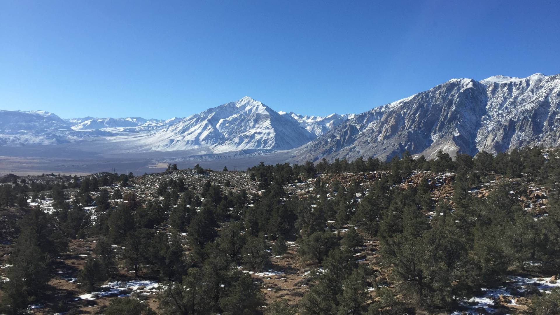
Most of the BLM land is in the Western 11 states and in Alaska. We have 245 million acres across those states. It’s mostly desert, a lot of sea of sagebrush in places like Nevada and Eastern California. You’ve got red rock country in Utah, but then you have these really isolated pockets of BLM lands, for example, in the northwest in California’s King Range in the Lost Coast area, which is old-growth forest of Douglas fir and redwoods.
The Eastern Sierra Nevada near Mammoth Lakes. (Kirk Siegler/NPR)
These 245 million acres: historians often refer to them as the “leftover lands.” They weren’t picked up during the Homestead Act. They weren’t bought by railroads or developers or land barons. The other federal land management agencies did not even pick them up. … As I started diving into the history of these landscapes, I started thinking of them as the scrappy underdogs of our public lands. These places that not many people know about or understand, or even visit.
And Aldo Leopold, one of the great writers and thinkers and ecologists of the 20th century, wrote, “American conservation is, I fear, still concerned for the most part with showpieces. We have not yet learned to think in terms of small cogs and wheels.”
I started to think of these BLM lands as the small cogs and wheels of present-day conservation.
What purpose do BLM and other public lands serve today?
These landscapes that maybe don’t have that same blast of scenic beauty that the national parks have, they serve as really important ecological places for different flora and fauna. These are landscapes that are on the edges of national parks and national forest and provide these really amazing wildlife corridors that are really important. So even if you look out on these places that look like an empty landscape, these are places that wildlife roam.
Related Article
The Carrizo Plain is the last largest intact native grassland we have in California. The Sacramento and San Joaquin valleys that run through the heart of the state used to be these really diverse, vibrant grasslands. Between agriculture and private ownership, these lands have been turned into a different thing. But we have this last vestige of grassland in the 250,000-acre Carrizo Plain National Monument. It’s only three hours outside of Los Angeles, and it’s this really wonderful place.
This is where a lot of endangered species live, and there’s a lake that, when it fills up after a lot of rain, becomes an important flyover stop for migrating birds. And it’s really important to Indigenous history: Some of the most elaborate rock art in the world is found in the Carrizo Plain at a place called Painted Rock.
The superbloom is one of those things that draws a lot of people. But to a place like the Carrizo Plain, it’s important that people get out there and see these BLM lands.
What’s the case for making some BLM land private?
The BLM is already authorized to sell small plots of land, and if you’re near one of those or you think that it would be better off, and the BLM could sell it off, that’s an option. They don’t need any Congressional act to be passed.
In 1998, the Southern Nevada Public Land Management Act allowed for the sale of BLM lands around Las Vegas to be turned into housing and development. But a lot of those lands weren’t just sold off. They were also traded for other private lands, like in more ecologically sensitive areas.
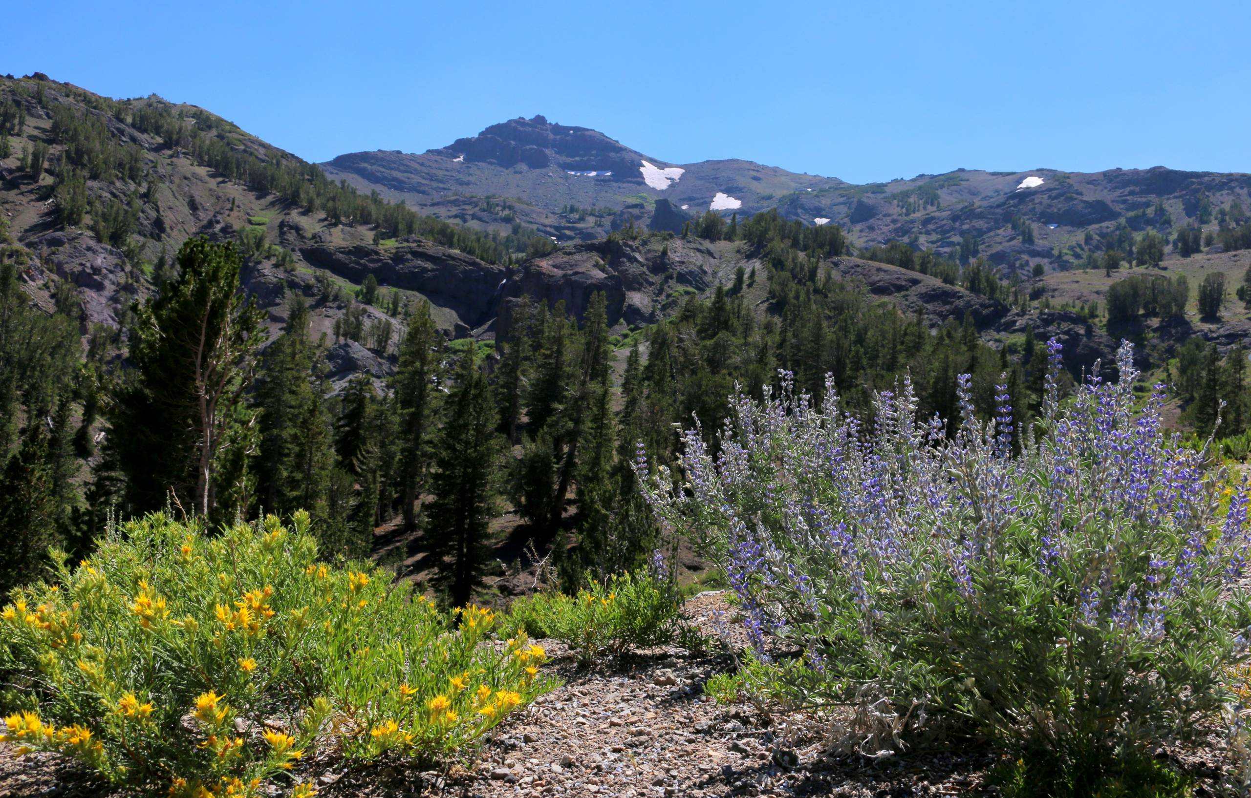
At 9,600 feet, Sonora Pass features sweeping views of the Sierra Nevada Mountain Range, including waterfalls, wildflowers and high alpine lakes. (Courtesy of Amanda Carlson/Mono County Tourism)
But even in those places, 85% of the sales went directly back to the state of Nevada for conservation and for new parks around Las Vegas, and they were traded off for lands up in the northwest of Nevada, near Lake Tahoe, that were important habitats or on the edge of conservation areas. That took ten years to hammer out all the details, with lots of compromise involved from both sides of the aisle.
I think it’s an important lesson that really good bipartisan laws take a lot of time and compromise to develop, and the opposite was happening in the last couple of months, where these giant land sales were thrown in without a lot of support from either side of the aisle. Let alone all of the constituents that represent these places.
How can you enjoy BLM land?
On BLM land in California, we have 60-plus campgrounds that are all no-reservation. The fees are typically free to about $10 a night. Those are the easiest places to access BLM land, as are places like national monuments. But you’re often on your own trying to figure out where these places are, how to access them and what road conditions are like.
I would typically build an itinerary before I even left, which was really important to understand, not just the landscape I was going to, in the flora and fauna [and] Indigenous history that existed there, but also how to get there safely.
I would always call the local BLM field office. They were so incredibly helpful because they could give you up-to-date road conditions. And then I used an app called onX Off-Road that allowed me to download offline maps before I went to a landscape, so I never was lost, even if I didn’t have cell reception.
window.__IS_SSR__=true
window.__INITIAL_STATE__={
"attachmentsReducer": {
"audio_0": {
"type": "attachments",
"id": "audio_0",
"imgSizes": {
"kqedFullSize": {
"file": "https://ww2.kqed.org/news/wp-content/themes/KQED-unified/img/audio_bgs/background0.jpg"
}
}
},
"audio_1": {
"type": "attachments",
"id": "audio_1",
"imgSizes": {
"kqedFullSize": {
"file": "https://ww2.kqed.org/news/wp-content/themes/KQED-unified/img/audio_bgs/background1.jpg"
}
}
},
"audio_2": {
"type": "attachments",
"id": "audio_2",
"imgSizes": {
"kqedFullSize": {
"file": "https://ww2.kqed.org/news/wp-content/themes/KQED-unified/img/audio_bgs/background2.jpg"
}
}
},
"audio_3": {
"type": "attachments",
"id": "audio_3",
"imgSizes": {
"kqedFullSize": {
"file": "https://ww2.kqed.org/news/wp-content/themes/KQED-unified/img/audio_bgs/background3.jpg"
}
}
},
"audio_4": {
"type": "attachments",
"id": "audio_4",
"imgSizes": {
"kqedFullSize": {
"file": "https://ww2.kqed.org/news/wp-content/themes/KQED-unified/img/audio_bgs/background4.jpg"
}
}
},
"placeholder": {
"type": "attachments",
"id": "placeholder",
"imgSizes": {
"thumbnail": {
"file": "https://cdn.kqed.org/wp-content/uploads/2024/12/KQED-Default-Image-816638274-2000x1333-1-160x107.jpg",
"width": 160,
"height": 107,
"mimeType": "image/jpeg"
},
"medium": {
"file": "https://cdn.kqed.org/wp-content/uploads/2024/12/KQED-Default-Image-816638274-2000x1333-1-800x533.jpg",
"width": 800,
"height": 533,
"mimeType": "image/jpeg"
},
"medium_large": {
"file": "https://cdn.kqed.org/wp-content/uploads/2024/12/KQED-Default-Image-816638274-2000x1333-1-768x512.jpg",
"width": 768,
"height": 512,
"mimeType": "image/jpeg"
},
"large": {
"file": "https://cdn.kqed.org/wp-content/uploads/2024/12/KQED-Default-Image-816638274-2000x1333-1-1020x680.jpg",
"width": 1020,
"height": 680,
"mimeType": "image/jpeg"
},
"1536x1536": {
"file": "https://cdn.kqed.org/wp-content/uploads/2024/12/KQED-Default-Image-816638274-2000x1333-1-1536x1024.jpg",
"width": 1536,
"height": 1024,
"mimeType": "image/jpeg"
},
"fd-lrg": {
"file": "https://cdn.kqed.org/wp-content/uploads/2024/12/KQED-Default-Image-816638274-2000x1333-1-1536x1024.jpg",
"width": 1536,
"height": 1024,
"mimeType": "image/jpeg"
},
"fd-med": {
"file": "https://cdn.kqed.org/wp-content/uploads/2024/12/KQED-Default-Image-816638274-2000x1333-1-1020x680.jpg",
"width": 1020,
"height": 680,
"mimeType": "image/jpeg"
},
"fd-sm": {
"file": "https://cdn.kqed.org/wp-content/uploads/2024/12/KQED-Default-Image-816638274-2000x1333-1-800x533.jpg",
"width": 800,
"height": 533,
"mimeType": "image/jpeg"
},
"post-thumbnail": {
"file": "https://cdn.kqed.org/wp-content/uploads/2024/12/KQED-Default-Image-816638274-2000x1333-1-672x372.jpg",
"width": 672,
"height": 372,
"mimeType": "image/jpeg"
},
"twentyfourteen-full-width": {
"file": "https://cdn.kqed.org/wp-content/uploads/2024/12/KQED-Default-Image-816638274-2000x1333-1-1038x576.jpg",
"width": 1038,
"height": 576,
"mimeType": "image/jpeg"
},
"xxsmall": {
"file": "https://cdn.kqed.org/wp-content/uploads/2024/12/KQED-Default-Image-816638274-2000x1333-1-160x107.jpg",
"width": 160,
"height": 107,
"mimeType": "image/jpeg"
},
"xsmall": {
"file": "https://cdn.kqed.org/wp-content/uploads/2024/12/KQED-Default-Image-816638274-2000x1333-1-672x372.jpg",
"width": 672,
"height": 372,
"mimeType": "image/jpeg"
},
"small": {
"file": "https://cdn.kqed.org/wp-content/uploads/2024/12/KQED-Default-Image-816638274-2000x1333-1-672x372.jpg",
"width": 672,
"height": 372,
"mimeType": "image/jpeg"
},
"xlarge": {
"file": "https://cdn.kqed.org/wp-content/uploads/2024/12/KQED-Default-Image-816638274-2000x1333-1-1020x680.jpg",
"width": 1020,
"height": 680,
"mimeType": "image/jpeg"
},
"full-width": {
"file": "https://cdn.kqed.org/wp-content/uploads/2024/12/KQED-Default-Image-816638274-2000x1333-1-1920x1280.jpg",
"width": 1920,
"height": 1280,
"mimeType": "image/jpeg"
},
"guest-author-32": {
"file": "https://cdn.kqed.org/wp-content/uploads/2025/01/KQED-Default-Image-816638274-1333x1333-1-160x160.jpg",
"width": 32,
"height": 32,
"mimeType": "image/jpeg"
},
"guest-author-50": {
"file": "https://cdn.kqed.org/wp-content/uploads/2025/01/KQED-Default-Image-816638274-1333x1333-1-160x160.jpg",
"width": 50,
"height": 50,
"mimeType": "image/jpeg"
},
"guest-author-64": {
"file": "https://cdn.kqed.org/wp-content/uploads/2025/01/KQED-Default-Image-816638274-1333x1333-1-160x160.jpg",
"width": 64,
"height": 64,
"mimeType": "image/jpeg"
},
"guest-author-96": {
"file": "https://cdn.kqed.org/wp-content/uploads/2025/01/KQED-Default-Image-816638274-1333x1333-1-160x160.jpg",
"width": 96,
"height": 96,
"mimeType": "image/jpeg"
},
"guest-author-128": {
"file": "https://cdn.kqed.org/wp-content/uploads/2025/01/KQED-Default-Image-816638274-1333x1333-1-160x160.jpg",
"width": 128,
"height": 128,
"mimeType": "image/jpeg"
},
"detail": {
"file": "https://cdn.kqed.org/wp-content/uploads/2025/01/KQED-Default-Image-816638274-1333x1333-1-160x160.jpg",
"width": 160,
"height": 160,
"mimeType": "image/jpeg"
},
"kqedFullSize": {
"file": "https://cdn.kqed.org/wp-content/uploads/2024/12/KQED-Default-Image-816638274-2000x1333-1.jpg",
"width": 2000,
"height": 1333
}
}
},
"news_12049632": {
"type": "attachments",
"id": "news_12049632",
"meta": {
"index": "attachments_1716263798",
"site": "news",
"id": "12049632",
"found": true
},
"title": "07032019_sonomacoaststatepark_qed",
"publishDate": 1753390231,
"status": "inherit",
"parent": 12049616,
"modified": 1753390255,
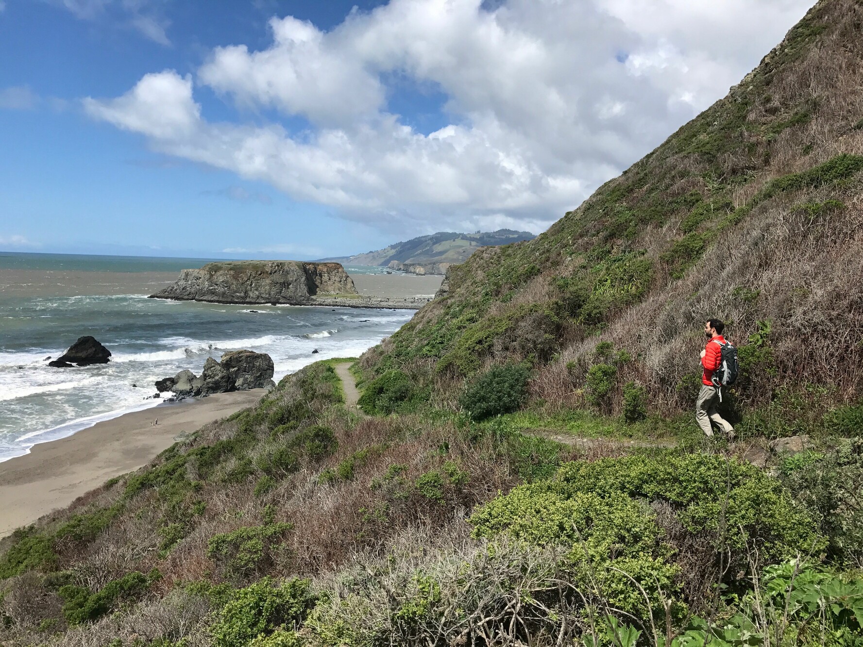
"caption": "A hiker in Sonoma Coast State Park in March 2018.",
"credit": "Miranda Leitsinger/KQED",
"altTag": null,
"description": null,
"imgSizes": {
"thumbnail": {
"file": "https://cdn.kqed.org/wp-content/uploads/sites/10/2025/07/07032019_sonomacoaststatepark_qed-160x120.jpg",
"width": 160,
"height": 120,
"mimeType": "image/jpeg"
},
"1536x1536": {
"file": "https://cdn.kqed.org/wp-content/uploads/sites/10/2025/07/07032019_sonomacoaststatepark_qed-1536x1152.jpg",
"width": 1536,
"height": 1152,
"mimeType": "image/jpeg"
},
"post-thumbnail": {
"file": "https://cdn.kqed.org/wp-content/uploads/sites/10/2025/07/07032019_sonomacoaststatepark_qed-672x372.jpg",
"width": 672,
"height": 372,
"mimeType": "image/jpeg"
},
"twentyfourteen-full-width": {
"file": "https://cdn.kqed.org/wp-content/uploads/sites/10/2025/07/07032019_sonomacoaststatepark_qed-1038x576.jpg",
"width": 1038,
"height": 576,
"mimeType": "image/jpeg"
},
"kqedFullSize": {
"file": "https://cdn.kqed.org/wp-content/uploads/sites/10/2025/07/07032019_sonomacoaststatepark_qed.jpg",
"width": 1777,
"height": 1333
}
},
"isLoading": false,
"fetchFailed": false
}
},
"audioPlayerReducer": {
"postId": "stream_live",
"isPaused": true,
"isPlaying": false,
"pfsActive": false,
"pledgeModalIsOpen": true,
"playerDrawerIsOpen": false,
"liveAudioPlayStartedAt": 0,
"liveAudioPlayContext": ""
},
"authorsReducer": {
"amadrigal": {
"type": "authors",
"id": "11757",
"meta": {
"index": "authors_1716337520",
"id": "11757",
"found": true
},
"name": "Alexis Madrigal",
"firstName": "Alexis",
"lastName": "Madrigal",
"slug": "amadrigal",
"email": "amadrigal@kqed.org",
"display_author_email": true,
"staff_mastheads": [],
"title": "Co-Host Forum",
"bio": "Alexis Madrigal is the co-host of Forum. He is also a contributing writer at \u003cem>The Atlantic \u003c/em>and the co-founder of the COVID Tracking Project. He's the creator of the podcast, \u003cem>Containers\u003c/em>, and has been a staff writer at \u003cem>Wired. \u003c/em>He was a visiting scholar at UC Berkeley's Information School, and is working on a book about Oakland and the Bay Area's revolutionary ideas.",
"avatar": "https://secure.gravatar.com/avatar/200d13dd6cebef55bf04327dec901b3d?s=600&d=blank&r=g",
"twitter": "alexismadrigal",
"bluesky": null,
"facebook": null,
"instagram": null,
"linkedin": null,
"sites": [
{
"site": "arts",
"roles": [
"editor"
]
},
{
"site": "news",
"roles": [
"editor"
]
},
{
"site": "forum",
"roles": [
"editor"
]
}
],
"headData": {
"title": "Alexis Madrigal | KQED",
"description": "Co-Host Forum",
"ogImgSrc": "https://secure.gravatar.com/avatar/200d13dd6cebef55bf04327dec901b3d?s=600&d=blank&r=g",
"twImgSrc": "https://secure.gravatar.com/avatar/200d13dd6cebef55bf04327dec901b3d?s=600&d=blank&r=g"
},
"isLoading": false,
"link": "/author/amadrigal"
},
"sarahwright": {
"type": "authors",
"id": "11956",
"meta": {
"index": "authors_1716337520",
"id": "11956",
"found": true
},
"name": "Sarah Wright",
"firstName": "Sarah",
"lastName": "Wright",
"slug": "sarahwright",
"email": "swright@kqed.org",
"display_author_email": true,
"staff_mastheads": [],
"title": "Outdoors Engagement Reporter",
"bio": "Sarah Wright is KQED's Outdoors Engagement Reporter. Originally from Lake Tahoe, she completed a thru-hike of the Pacific Crest Trail in 2019 and was a U.S. Fulbright Program grantee to Argentina in 2023. Her journalism has appeared in The Guardian, The San Francisco Standard, The Palo Alto Weekly and the Half Moon Bay Review.",
"avatar": "https://secure.gravatar.com/avatar/c161a3d6441865cba25e6db4fa561099ad665799e9432e34da2b84d7e371524c?s=600&d=blank&r=g",
"twitter": null,
"bluesky": null,
"facebook": null,
"instagram": null,
"linkedin": null,
"sites": [
{
"site": "arts",
"roles": [
"editor"
]
},
{
"site": "news",
"roles": [
"editor"
]
},
{
"site": "science",
"roles": [
"contributor",
"author"
]
},
{
"site": "forum",
"roles": [
"editor"
]
}
],
"headData": {
"title": "Sarah Wright | KQED",
"description": "Outdoors Engagement Reporter",
"ogImgSrc": "https://secure.gravatar.com/avatar/c161a3d6441865cba25e6db4fa561099ad665799e9432e34da2b84d7e371524c?s=600&d=blank&r=g",
"twImgSrc": "https://secure.gravatar.com/avatar/c161a3d6441865cba25e6db4fa561099ad665799e9432e34da2b84d7e371524c?s=600&d=blank&r=g"
},
"isLoading": false,
"link": "/author/sarahwright"
}
},
"pagesReducer": {},
"pfsSessionReducer": {},
"postsReducer": {
"stream_live": {
"type": "live",
"id": "stream_live",
"audioUrl": "https://streams.kqed.org/kqedradio",
"title": "Live Stream",
"excerpt": "Live Stream information currently unavailable.",
"link": "/radio",
"featImg": "",
"label": {
"name": "KQED Live",
"link": "/"
}
},
"stream_kqedNewscast": {
"type": "posts",
"id": "stream_kqedNewscast",
"audioUrl": "https://www.kqed.org/.stream/anon/radio/RDnews/newscast.mp3?_=1",
"title": "KQED Newscast",
"featImg": "",
"label": {
"name": "88.5 FM",
"link": "/"
}
},
"news_12049616": {
"type": "posts",
"id": "news_12049616",
"meta": {
"index": "posts_1716263798",
"site": "news",
"id": "12049616",
"found": true
},
"articlePosition": 0,
"guestAuthors": [],
"slug": "public-lands-blm-california-united-states-hiking-camping-under-threat-josh-jackson-enduring-wild",
"title": "‘Get Out There and See’: As America’s Public Lands Come Under Threat, Here’s Why They’re Worth Saving",
"publishDate": 1753441244,
"format": "standard",
"headTitle": "‘Get Out There and See’: As America’s Public Lands Come Under Threat, Here’s Why They’re Worth Saving | KQED",
"labelTerm": {
"term": 18537,
"site": "news"
},
"content": "\u003cp>Earlier this summer, \u003ca href=\"https://www.kqed.org/news/12046147/incredibly-short-sighted-land-conservation-groups-rally-against-gop-proposal-to-sell-off-public-lands-like-tahoe\">Republicans in Congress proposed a massive selloff of public lands\u003c/a> across the United States, arguing that these lands would be better off in private hands to be used for housing or other economically driven uses like mining or drilling.\u003c/p>\n\u003cp>The pushback to the proposal from the public, joined by outdoors and land conservation advocacy groups, was swift and loud. But while the proposal was \u003ca href=\"https://thehill.com/policy/energy-environment/5375473-senate-removes-provision-that-would-sell-off-public-lands-from-megabill/\">ultimately scrapped from this year’s so-called “Big Beautiful Bill” budget\u003c/a>, the idea of selling off public lands remains alive and well in lawmakers’ minds, most notably Sen. Mike Lee of Utah, \u003ca href=\"https://x.com/SenMikeLee/status/1939132778605388207\">who promised to bring the proposal back in the future.\u003c/a>\u003c/p>\n\u003cp>Public lands make up around half of the land in the state of California. That includes around \u003ca href=\"https://www.blm.gov/about/what-we-manage/california\">15 million acres of Bureau of Land Management lands\u003c/a> that themselves comprise around 15% of the state, but “these BLM lands have been under threat to land sale, to private developers and land barons, \u003ca href=\"https://www.blm.gov/about/history/history-by-region/california\">since their inception in 1946,\u003c/a>” said Josh Jackson, author of \u003cem>The Enduring Wild: A Journey into California’s Public Lands\u003c/em>. For Jackson, this recent effort to sell this land “wasn’t a great surprise.”\u003c/p>\n\u003cp>[ad fullwidth]\u003c/p>\n\u003cp>“We don’t have the Eiffel Tower, we don’t have the Great Barrier Reef or the Great Wall of China, but what we have in America, and what makes us so unique, is our public land system across the West that we’ve set aside,” said Jackson. “It’s one of the unique things that we get to experience here in the States.”\u003c/p>\n\u003cp>\u003ca href=\"https://www.kqed.org/forum/2010101910647/the-threat-to-california-public-lands\">KQED Forum spoke to Jackson \u003c/a>about the history of public lands, the crucial role they play in California conservation, why they’re under threat and how you can get out and discover them for yourself.\u003c/p>\n\u003cp>\u003cem>This interview has been edited for brevity and clarity.\u003c/em>\u003c/p>\n\u003cul>\n\u003cli>\u003cstrong>Jump straight to: \u003ca href=\"#HowyoucanmakethemostofBLMlandnearyouwithcampingandhiking\">How you can make the most of BLM land near you with camping and hiking?\u003c/a>\u003c/strong>\u003c/li>\n\u003c/ul>\n\u003ch2>How did this latest Republican effort to sell public lands come about?\u003c/h2>\n\u003cp>\u003cstrong>Josh Jackson: \u003c/strong>It came at the last minute in the first reconciliation package from the House of Natural Resources to \u003ca href=\"https://stateline.org/2025/06/04/long-thwarted-efforts-to-sell-public-lands-see-new-life-under-trump/\">sell off roughly half a million acres of BLM land\u003c/a> in Nevada and Utah.\u003c/p>\n\u003cp>Thankfully, thanks to a really robust group of people around the West, that land sale was kind of taken out of the reconciliation package, only to be added later by Mike Lee, Senator of Utah.\u003c/p>\n\u003cp>That proposal was much more dire: \u003ca href=\"https://www.google.com/search?q=1.5+million+acress+sell+off&rlz=1C1GCCA_enUS1161US1161&oq=1.5+million+acress+sell+off&gs_lcrp=EgZjaHJvbWUyBggAEEUYOTIICAEQABgWGB4yDQgCEAAYhgMYgAQYigUyDQgDEAAYhgMYgAQYigUyCggEEAAYgAQYogQyCggFEAAYogQYiQUyCggGEAAYogQYiQUyCggHEAAYgAQYogQyCggIEAAYgAQYogTSAQg1NjE0ajBqNKgCALACAA&sourceid=chrome&ie=UTF-8&safe=active&ssui=on\">up to 1.5 million acres of BLM land to be sold off across the West\u003c/a>. And then, also thanks to bipartisan support against these land sales, which was \u003ca href=\"https://www.latimes.com/environment/story/2025-06-24/public-lands-sell-off-halted-mike-lee\">taken out of the reconciliation package as well.\u003c/a>\u003c/p>\n\u003ch2>What’s the history of public lands in the U.S.?\u003c/h2>\n\u003cp>\u003cstrong>Josh Jackson\u003c/strong>: Behind every story of the places I was going was a heartbreaking story of loss. Through genocide at times and lopsided deals with the government and a number of other factors,\u003ca href=\"https://www.loc.gov/classroom-materials/immigration/native-american/removing-native-americans-from-their-land/\"> these Indigenous peoples who lived and engaged with these landscapes were booted off.\u003c/a>\u003c/p>\n\u003cp>Most of the BLM land is in the Western 11 states and in Alaska. We have \u003ca href=\"https://www.blm.gov/about/what-we-manage\">245 million acres\u003c/a> across those states. It’s mostly desert, a lot of sea of sagebrush in places like Nevada and Eastern California. You’ve got red rock country in Utah, but then you have these really isolated pockets of BLM lands, for example, in the northwest in California’s King Range in the Lost Coast area, which is old-growth forest of Douglas fir and redwoods.\u003c/p>\n\u003cfigure id=\"attachment_11716102\" class=\"wp-caption aligncenter\" style=\"max-width: 1920px\">\u003cimg loading=\"lazy\" decoding=\"async\" class=\"size-full wp-image-11716102\" src=\"https://cdn.kqed.org/wp-content/uploads/sites/10/2019/01/img_7376_wide-e848890206768711978760ed1053bb57e3f367b7-e1546701706131.jpg\" alt=\"\" width=\"1920\" height=\"1080\" srcset=\"https://cdn.kqed.org/wp-content/uploads/sites/10/2019/01/img_7376_wide-e848890206768711978760ed1053bb57e3f367b7-e1546701706131.jpg 1920w, https://cdn.kqed.org/wp-content/uploads/sites/10/2019/01/img_7376_wide-e848890206768711978760ed1053bb57e3f367b7-e1546701706131-160x90.jpg 160w, https://cdn.kqed.org/wp-content/uploads/sites/10/2019/01/img_7376_wide-e848890206768711978760ed1053bb57e3f367b7-e1546701706131-800x450.jpg 800w, https://cdn.kqed.org/wp-content/uploads/sites/10/2019/01/img_7376_wide-e848890206768711978760ed1053bb57e3f367b7-e1546701706131-1020x574.jpg 1020w, https://cdn.kqed.org/wp-content/uploads/sites/10/2019/01/img_7376_wide-e848890206768711978760ed1053bb57e3f367b7-e1546701706131-1200x675.jpg 1200w\" sizes=\"auto, (max-width: 1920px) 100vw, 1920px\">\u003cfigcaption class=\"wp-caption-text\">The Eastern Sierra Nevada near Mammoth Lakes. \u003ccite>(Kirk Siegler/NPR)\u003c/cite>\u003c/figcaption>\u003c/figure>\n\u003cp>These 245 million acres: historians often \u003ca href=\"https://www.blm.gov/about/history#:~:text=Our%20Heritage%2C%20Our%20Future,%2C%20historical%2C%20and%20cultural%20resources.\">refer to them as the “leftover lands.”\u003c/a> They weren’t picked up during \u003ca href=\"https://www.nps.gov/home/learn/historyculture/abouthomesteadactlaw.htm\">the Homestead Act\u003c/a>. They weren’t bought by railroads or developers or land barons. The other federal land management agencies did not even pick them up. … As I started diving into the history of these landscapes, I started thinking of them as the scrappy underdogs of our public lands. These places that not many people know about or understand, or even visit.\u003c/p>\n\u003cp>And \u003ca href=\"https://www.aldoleopold.org/about/aldo-leopold\">Aldo Leopold\u003c/a>, one of the great writers and thinkers and ecologists of the 20th century, wrote, “American conservation is, I fear, still concerned for the most part with showpieces. We have not yet learned to think in terms of small cogs and wheels.”\u003c/p>\n\u003cp>I started to think of these BLM lands as the small cogs and wheels of present-day conservation.\u003c/p>\n\u003ch2>What purpose do BLM and other public lands serve today?\u003c/h2>\n\u003cp>These landscapes that maybe don’t have that same blast of scenic beauty that the national parks have, they serve as really important ecological places for different flora and fauna. These are landscapes that are on the edges of national parks and national forest and provide these really amazing wildlife corridors that are really important. So even if you look out on these places that look like an empty landscape, these are places that wildlife roam.[aside postID=news_12049405 hero='https://cdn.kqed.org/wp-content/uploads/sites/10/2025/07/Muir-Woods-Exhibit-1.png']\u003ca href=\"https://www.blm.gov/programs/national-conservation-lands/california/carrizo-plain-national-monument\">The Carrizo Plain\u003c/a> is the last largest intact native grassland we have in California. The Sacramento and San Joaquin valleys that run through the heart of the state used to be these really diverse, vibrant grasslands. Between agriculture and private ownership, these lands have been turned into a different thing. But we have this last vestige of grassland in the 250,000-acre Carrizo Plain National Monument. It’s only three hours outside of Los Angeles, and it’s this really wonderful place.\u003c/p>\n\u003cp>This is where a lot of endangered species live, and there’s a lake that, when it fills up after a lot of rain, becomes an important flyover stop for migrating birds. And it’s really important to Indigenous history: Some of the most elaborate rock art in the world is found in the Carrizo Plain at a place called \u003ca href=\"https://www.blm.gov/visit/painted-rock\">Painted Rock\u003c/a>.\u003c/p>\n\u003cp>Because of agriculture and private land ownership, we’ve boxed in these species that rely on the Carrizo Plain. Luckily, in 2001, \u003ca href=\"https://clintonwhitehouse5.archives.gov/library/hot_releases/January_17_2001_13.html\">it was protected as a national monument under the Clinton administration\u003c/a>.\u003c/p>\n\u003cp>\u003ca href=\"https://theodorepayne.org/learn/wildflower-hotline/\">The superbloom\u003c/a> is one of those things that \u003ca href=\"https://www.kqed.org/science/1996323/where-to-see-wildflowers-near-you-in-the-bay-area\">draws a lot of people\u003c/a>. But to a place like the Carrizo Plain, it’s important that people get out there and see these BLM lands.\u003c/p>\n\u003ch2>What’s the case for making some BLM land private?\u003c/h2>\n\u003cp>The BLM is already authorized to sell small plots of land, and if you’re near one of those or you think that it would be better off, and the BLM could sell it off, that’s an option. They don’t need any Congressional act to be passed.\u003c/p>\n\u003cp>In 1998, the \u003ca href=\"https://www.blm.gov/programs/lands-and-realty/regional-information/nevada/snplma\">Southern Nevada Public Land Management Act\u003c/a> allowed for the sale of BLM lands around Las Vegas to be turned into housing and development. But a lot of those lands weren’t just sold off. They were also traded for other private lands, like in more ecologically sensitive areas.\u003c/p>\n\u003cfigure id=\"attachment_12047193\" class=\"wp-caption aligncenter\" style=\"max-width: 2560px\">\u003cimg loading=\"lazy\" decoding=\"async\" class=\"size-full wp-image-12047193\" src=\"https://cdn.kqed.org/wp-content/uploads/sites/10/2025/07/Sonora-Pass-3-1-scaled.jpg\" alt=\"\" width=\"2560\" height=\"1634\" srcset=\"https://cdn.kqed.org/wp-content/uploads/sites/10/2025/07/Sonora-Pass-3-1-scaled.jpg 2560w, https://cdn.kqed.org/wp-content/uploads/sites/10/2025/07/Sonora-Pass-3-1-2000x1276.jpg 2000w, https://cdn.kqed.org/wp-content/uploads/sites/10/2025/07/Sonora-Pass-3-1-160x102.jpg 160w, https://cdn.kqed.org/wp-content/uploads/sites/10/2025/07/Sonora-Pass-3-1-1536x980.jpg 1536w, https://cdn.kqed.org/wp-content/uploads/sites/10/2025/07/Sonora-Pass-3-1-2048x1307.jpg 2048w\" sizes=\"auto, (max-width: 2560px) 100vw, 2560px\">\u003cfigcaption class=\"wp-caption-text\">At 9,600 feet, Sonora Pass features sweeping views of the Sierra Nevada Mountain Range, including waterfalls, wildflowers and high alpine lakes. \u003ccite>(Courtesy of Amanda Carlson/Mono County Tourism)\u003c/cite>\u003c/figcaption>\u003c/figure>\n\u003cp>But even in those places, \u003ca href=\"https://www.leg.state.nv.us/App/InterimCommittee/REL/Document/23817?rewrote=1\">85% of the sales went directly back to the state of Nevada for conservation\u003c/a> and for new parks around Las Vegas, and they were traded off for lands up in the northwest of Nevada, near Lake Tahoe, that were important habitats or on the edge of conservation areas. That took ten years to hammer out all the details, with lots of compromise involved from both sides of the aisle.\u003c/p>\n\u003cp>I think it’s an important lesson that really good bipartisan laws take a lot of time and compromise to develop, and the opposite was happening in the last couple of months, where these giant land sales were thrown in without a lot of support from either side of the aisle. Let alone all of the constituents that represent these places.\u003c/p>\n\u003ch2>\u003ca id=\"HowyoucanmakethemostofBLMlandnearyouwithcampingandhiking\">\u003c/a>How can you enjoy BLM land?\u003c/h2>\n\u003cp>On BLM land in California, \u003ca href=\"https://www.blm.gov/blog/2025-06-26/blm-public-lands-know-you-go\">we have 60-plus campgrounds\u003c/a> that are all no-reservation. \u003ca href=\"https://www.blm.gov/programs/recreation/camping\">The fees are typically free to about $10 a night\u003c/a>. Those are the easiest places to access BLM land, as are places like national monuments. But you’re often on your own trying to figure out where these places are, how to access them and what road conditions are like.\u003c/p>\n\u003cp>I would typically build an itinerary before I even left, which was really important to understand, not just the landscape I was going to, in the flora and fauna [and] Indigenous history that existed there, but also how to get there safely.\u003c/p>\n\u003cp>I would always \u003ca href=\"https://www.blm.gov/office/california-state-office\">call the local BLM field office\u003c/a>. They were so incredibly helpful because they could give you up-to-date road conditions. And then I used an app called \u003ca href=\"https://www.onxmaps.com/offroad/app\">onX Off-Road \u003c/a>that allowed me to download offline maps before I went to a landscape, so I never was lost, even if I didn’t have cell reception.\u003c/p>\n\u003cp>It’s kind of an amazing part of being out in the West. If you have the right toolkit, lots of water, sunscreen, a tent and a sleeping bag, \u003ca href=\"https://www.kqed.org/news/11920867/how-to-find-free-camping-in-californias-national-forests\">you can pull over and camp on BLM land almost anywhere. \u003c/a>\u003c/p>\n\u003cp>[ad floatright]\u003c/p>\n",
"blocks": [],
"excerpt": "One author gives his perspective after touring remote public lands across California. ",
"status": "publish",
"parent": 0,
"modified": 1753393027,
"stats": {
"hasAudio": false,
"hasVideo": false,
"hasChartOrMap": false,
"iframeSrcs": [],
"hasGoogleForm": false,
"hasGallery": false,
"hasHearkenModule": false,
"hasPolis": false,
"paragraphCount": 28,
"wordCount": 1593
},
"headData": {
"title": "‘Get Out There and See’: As America’s Public Lands Come Under Threat, Here’s Why They’re Worth Saving | KQED",
"description": "One author gives his perspective after touring remote public lands across California. ",
"ogTitle": "",
"ogDescription": "",
"ogImgId": "",
"twTitle": "",
"twDescription": "",
"twImgId": "",
"schema": {
"@context": "https://schema.org",
"@type": "NewsArticle",
"headline": "‘Get Out There and See’: As America’s Public Lands Come Under Threat, Here’s Why They’re Worth Saving",
"datePublished": "2025-07-25T04:00:44-07:00",
"dateModified": "2025-07-24T14:37:07-07:00",
"image": "https://cdn.kqed.org/wp-content/uploads/2020/02/KQED-OG-Image@1x.png",
"isAccessibleForFree": "True",
"publisher": {
"@type": "NewsMediaOrganization",
"@id": "https://www.kqed.org/#organization",
"name": "KQED",
"logo": "https://cdn.kqed.org/wp-content/uploads/2020/02/KQED-OG-Image@1x.png",
"url": "https://www.kqed.org",
"sameAs": [
"https://www.facebook.com/KQED",
"https://twitter.com/KQED",
"https://www.instagram.com/kqed/",
"https://www.tiktok.com/@kqedofficial",
"https://www.linkedin.com/company/kqed",
"https://www.youtube.com/channel/UCeC0IOo7i1P_61zVUWbJ4nw"
]
},
"author": {
"@type": "Person",
"name": "Alexis Madrigal",
"jobTitle": "Co-Host Forum",
"url": "https://www.kqed.org/author/amadrigal"
}
},
"authorsData": [],
"tagData": []
},
"primaryCategory": {
"termId": 8,
"slug": "news",
"name": "News"
},
"sticky": false,
"templateType": "standard",
"featuredImageType": "standard",
"excludeFromSiteSearch": "Include",
"articleAge": "0",
"path": "/news/12049616/public-lands-blm-california-united-states-hiking-camping-under-threat-josh-jackson-enduring-wild",
"audioTrackLength": null,
"parsedContent": [
{
"type": "contentString",
"content": "\u003cdiv class=\"post-body\">\u003cp>\u003cp>Earlier this summer, \u003ca href=\"https://www.kqed.org/news/12046147/incredibly-short-sighted-land-conservation-groups-rally-against-gop-proposal-to-sell-off-public-lands-like-tahoe\">Republicans in Congress proposed a massive selloff of public lands\u003c/a> across the United States, arguing that these lands would be better off in private hands to be used for housing or other economically driven uses like mining or drilling.\u003c/p>\n\u003cp>The pushback to the proposal from the public, joined by outdoors and land conservation advocacy groups, was swift and loud. But while the proposal was \u003ca href=\"https://thehill.com/policy/energy-environment/5375473-senate-removes-provision-that-would-sell-off-public-lands-from-megabill/\">ultimately scrapped from this year’s so-called “Big Beautiful Bill” budget\u003c/a>, the idea of selling off public lands remains alive and well in lawmakers’ minds, most notably Sen. Mike Lee of Utah, \u003ca href=\"https://x.com/SenMikeLee/status/1939132778605388207\">who promised to bring the proposal back in the future.\u003c/a>\u003c/p>\n\u003cp>Public lands make up around half of the land in the state of California. That includes around \u003ca href=\"https://www.blm.gov/about/what-we-manage/california\">15 million acres of Bureau of Land Management lands\u003c/a> that themselves comprise around 15% of the state, but “these BLM lands have been under threat to land sale, to private developers and land barons, \u003ca href=\"https://www.blm.gov/about/history/history-by-region/california\">since their inception in 1946,\u003c/a>” said Josh Jackson, author of \u003cem>The Enduring Wild: A Journey into California’s Public Lands\u003c/em>. For Jackson, this recent effort to sell this land “wasn’t a great surprise.”\u003c/p>\n\u003cp>\u003c/p>\u003c/div>",
"attributes": {
"named": {},
"numeric": []
}
},
{
"type": "component",
"content": "",
"name": "ad",
"attributes": {
"named": {
"label": "fullwidth"
},
"numeric": [
"fullwidth"
]
}
},
{
"type": "contentString",
"content": "\u003cdiv class=\"post-body\">\u003cp>\u003c/p>\n\u003cp>“We don’t have the Eiffel Tower, we don’t have the Great Barrier Reef or the Great Wall of China, but what we have in America, and what makes us so unique, is our public land system across the West that we’ve set aside,” said Jackson. “It’s one of the unique things that we get to experience here in the States.”\u003c/p>\n\u003cp>\u003ca href=\"https://www.kqed.org/forum/2010101910647/the-threat-to-california-public-lands\">KQED Forum spoke to Jackson \u003c/a>about the history of public lands, the crucial role they play in California conservation, why they’re under threat and how you can get out and discover them for yourself.\u003c/p>\n\u003cp>\u003cem>This interview has been edited for brevity and clarity.\u003c/em>\u003c/p>\n\u003cul>\n\u003cli>\u003cstrong>Jump straight to: \u003ca href=\"#HowyoucanmakethemostofBLMlandnearyouwithcampingandhiking\">How you can make the most of BLM land near you with camping and hiking?\u003c/a>\u003c/strong>\u003c/li>\n\u003c/ul>\n\u003ch2>How did this latest Republican effort to sell public lands come about?\u003c/h2>\n\u003cp>\u003cstrong>Josh Jackson: \u003c/strong>It came at the last minute in the first reconciliation package from the House of Natural Resources to \u003ca href=\"https://stateline.org/2025/06/04/long-thwarted-efforts-to-sell-public-lands-see-new-life-under-trump/\">sell off roughly half a million acres of BLM land\u003c/a> in Nevada and Utah.\u003c/p>\n\u003cp>Thankfully, thanks to a really robust group of people around the West, that land sale was kind of taken out of the reconciliation package, only to be added later by Mike Lee, Senator of Utah.\u003c/p>\n\u003cp>That proposal was much more dire: \u003ca href=\"https://www.google.com/search?q=1.5+million+acress+sell+off&rlz=1C1GCCA_enUS1161US1161&oq=1.5+million+acress+sell+off&gs_lcrp=EgZjaHJvbWUyBggAEEUYOTIICAEQABgWGB4yDQgCEAAYhgMYgAQYigUyDQgDEAAYhgMYgAQYigUyCggEEAAYgAQYogQyCggFEAAYogQYiQUyCggGEAAYogQYiQUyCggHEAAYgAQYogQyCggIEAAYgAQYogTSAQg1NjE0ajBqNKgCALACAA&sourceid=chrome&ie=UTF-8&safe=active&ssui=on\">up to 1.5 million acres of BLM land to be sold off across the West\u003c/a>. And then, also thanks to bipartisan support against these land sales, which was \u003ca href=\"https://www.latimes.com/environment/story/2025-06-24/public-lands-sell-off-halted-mike-lee\">taken out of the reconciliation package as well.\u003c/a>\u003c/p>\n\u003ch2>What’s the history of public lands in the U.S.?\u003c/h2>\n\u003cp>\u003cstrong>Josh Jackson\u003c/strong>: Behind every story of the places I was going was a heartbreaking story of loss. Through genocide at times and lopsided deals with the government and a number of other factors,\u003ca href=\"https://www.loc.gov/classroom-materials/immigration/native-american/removing-native-americans-from-their-land/\"> these Indigenous peoples who lived and engaged with these landscapes were booted off.\u003c/a>\u003c/p>\n\u003cp>Most of the BLM land is in the Western 11 states and in Alaska. We have \u003ca href=\"https://www.blm.gov/about/what-we-manage\">245 million acres\u003c/a> across those states. It’s mostly desert, a lot of sea of sagebrush in places like Nevada and Eastern California. You’ve got red rock country in Utah, but then you have these really isolated pockets of BLM lands, for example, in the northwest in California’s King Range in the Lost Coast area, which is old-growth forest of Douglas fir and redwoods.\u003c/p>\n\u003cfigure id=\"attachment_11716102\" class=\"wp-caption aligncenter\" style=\"max-width: 1920px\">\u003cimg loading=\"lazy\" decoding=\"async\" class=\"size-full wp-image-11716102\" src=\"https://cdn.kqed.org/wp-content/uploads/sites/10/2019/01/img_7376_wide-e848890206768711978760ed1053bb57e3f367b7-e1546701706131.jpg\" alt=\"\" width=\"1920\" height=\"1080\" srcset=\"https://cdn.kqed.org/wp-content/uploads/sites/10/2019/01/img_7376_wide-e848890206768711978760ed1053bb57e3f367b7-e1546701706131.jpg 1920w, https://cdn.kqed.org/wp-content/uploads/sites/10/2019/01/img_7376_wide-e848890206768711978760ed1053bb57e3f367b7-e1546701706131-160x90.jpg 160w, https://cdn.kqed.org/wp-content/uploads/sites/10/2019/01/img_7376_wide-e848890206768711978760ed1053bb57e3f367b7-e1546701706131-800x450.jpg 800w, https://cdn.kqed.org/wp-content/uploads/sites/10/2019/01/img_7376_wide-e848890206768711978760ed1053bb57e3f367b7-e1546701706131-1020x574.jpg 1020w, https://cdn.kqed.org/wp-content/uploads/sites/10/2019/01/img_7376_wide-e848890206768711978760ed1053bb57e3f367b7-e1546701706131-1200x675.jpg 1200w\" sizes=\"auto, (max-width: 1920px) 100vw, 1920px\">\u003cfigcaption class=\"wp-caption-text\">The Eastern Sierra Nevada near Mammoth Lakes. \u003ccite>(Kirk Siegler/NPR)\u003c/cite>\u003c/figcaption>\u003c/figure>\n\u003cp>These 245 million acres: historians often \u003ca href=\"https://www.blm.gov/about/history#:~:text=Our%20Heritage%2C%20Our%20Future,%2C%20historical%2C%20and%20cultural%20resources.\">refer to them as the “leftover lands.”\u003c/a> They weren’t picked up during \u003ca href=\"https://www.nps.gov/home/learn/historyculture/abouthomesteadactlaw.htm\">the Homestead Act\u003c/a>. They weren’t bought by railroads or developers or land barons. The other federal land management agencies did not even pick them up. … As I started diving into the history of these landscapes, I started thinking of them as the scrappy underdogs of our public lands. These places that not many people know about or understand, or even visit.\u003c/p>\n\u003cp>And \u003ca href=\"https://www.aldoleopold.org/about/aldo-leopold\">Aldo Leopold\u003c/a>, one of the great writers and thinkers and ecologists of the 20th century, wrote, “American conservation is, I fear, still concerned for the most part with showpieces. We have not yet learned to think in terms of small cogs and wheels.”\u003c/p>\n\u003cp>I started to think of these BLM lands as the small cogs and wheels of present-day conservation.\u003c/p>\n\u003ch2>What purpose do BLM and other public lands serve today?\u003c/h2>\n\u003cp>These landscapes that maybe don’t have that same blast of scenic beauty that the national parks have, they serve as really important ecological places for different flora and fauna. These are landscapes that are on the edges of national parks and national forest and provide these really amazing wildlife corridors that are really important. So even if you look out on these places that look like an empty landscape, these are places that wildlife roam.\u003c/p>\u003c/div>",
"attributes": {
"named": {},
"numeric": []
}
},
{
"type": "component",
"content": "",
"name": "aside",
"attributes": {
"named": {
"postid": "news_12049405",
"hero": "https://cdn.kqed.org/wp-content/uploads/sites/10/2025/07/Muir-Woods-Exhibit-1.png",
"label": ""
},
"numeric": []
}
},
{
"type": "contentString",
"content": "\u003cdiv class=\"post-body\">\u003cp>\u003ca href=\"https://www.blm.gov/programs/national-conservation-lands/california/carrizo-plain-national-monument\">The Carrizo Plain\u003c/a> is the last largest intact native grassland we have in California. The Sacramento and San Joaquin valleys that run through the heart of the state used to be these really diverse, vibrant grasslands. Between agriculture and private ownership, these lands have been turned into a different thing. But we have this last vestige of grassland in the 250,000-acre Carrizo Plain National Monument. It’s only three hours outside of Los Angeles, and it’s this really wonderful place.\u003c/p>\n\u003cp>This is where a lot of endangered species live, and there’s a lake that, when it fills up after a lot of rain, becomes an important flyover stop for migrating birds. And it’s really important to Indigenous history: Some of the most elaborate rock art in the world is found in the Carrizo Plain at a place called \u003ca href=\"https://www.blm.gov/visit/painted-rock\">Painted Rock\u003c/a>.\u003c/p>\n\u003cp>Because of agriculture and private land ownership, we’ve boxed in these species that rely on the Carrizo Plain. Luckily, in 2001, \u003ca href=\"https://clintonwhitehouse5.archives.gov/library/hot_releases/January_17_2001_13.html\">it was protected as a national monument under the Clinton administration\u003c/a>.\u003c/p>\n\u003cp>\u003ca href=\"https://theodorepayne.org/learn/wildflower-hotline/\">The superbloom\u003c/a> is one of those things that \u003ca href=\"https://www.kqed.org/science/1996323/where-to-see-wildflowers-near-you-in-the-bay-area\">draws a lot of people\u003c/a>. But to a place like the Carrizo Plain, it’s important that people get out there and see these BLM lands.\u003c/p>\n\u003ch2>What’s the case for making some BLM land private?\u003c/h2>\n\u003cp>The BLM is already authorized to sell small plots of land, and if you’re near one of those or you think that it would be better off, and the BLM could sell it off, that’s an option. They don’t need any Congressional act to be passed.\u003c/p>\n\u003cp>In 1998, the \u003ca href=\"https://www.blm.gov/programs/lands-and-realty/regional-information/nevada/snplma\">Southern Nevada Public Land Management Act\u003c/a> allowed for the sale of BLM lands around Las Vegas to be turned into housing and development. But a lot of those lands weren’t just sold off. They were also traded for other private lands, like in more ecologically sensitive areas.\u003c/p>\n\u003cfigure id=\"attachment_12047193\" class=\"wp-caption aligncenter\" style=\"max-width: 2560px\">\u003cimg loading=\"lazy\" decoding=\"async\" class=\"size-full wp-image-12047193\" src=\"https://cdn.kqed.org/wp-content/uploads/sites/10/2025/07/Sonora-Pass-3-1-scaled.jpg\" alt=\"\" width=\"2560\" height=\"1634\" srcset=\"https://cdn.kqed.org/wp-content/uploads/sites/10/2025/07/Sonora-Pass-3-1-scaled.jpg 2560w, https://cdn.kqed.org/wp-content/uploads/sites/10/2025/07/Sonora-Pass-3-1-2000x1276.jpg 2000w, https://cdn.kqed.org/wp-content/uploads/sites/10/2025/07/Sonora-Pass-3-1-160x102.jpg 160w, https://cdn.kqed.org/wp-content/uploads/sites/10/2025/07/Sonora-Pass-3-1-1536x980.jpg 1536w, https://cdn.kqed.org/wp-content/uploads/sites/10/2025/07/Sonora-Pass-3-1-2048x1307.jpg 2048w\" sizes=\"auto, (max-width: 2560px) 100vw, 2560px\">\u003cfigcaption class=\"wp-caption-text\">At 9,600 feet, Sonora Pass features sweeping views of the Sierra Nevada Mountain Range, including waterfalls, wildflowers and high alpine lakes. \u003ccite>(Courtesy of Amanda Carlson/Mono County Tourism)\u003c/cite>\u003c/figcaption>\u003c/figure>\n\u003cp>But even in those places, \u003ca href=\"https://www.leg.state.nv.us/App/InterimCommittee/REL/Document/23817?rewrote=1\">85% of the sales went directly back to the state of Nevada for conservation\u003c/a> and for new parks around Las Vegas, and they were traded off for lands up in the northwest of Nevada, near Lake Tahoe, that were important habitats or on the edge of conservation areas. That took ten years to hammer out all the details, with lots of compromise involved from both sides of the aisle.\u003c/p>\n\u003cp>I think it’s an important lesson that really good bipartisan laws take a lot of time and compromise to develop, and the opposite was happening in the last couple of months, where these giant land sales were thrown in without a lot of support from either side of the aisle. Let alone all of the constituents that represent these places.\u003c/p>\n\u003ch2>\u003ca id=\"HowyoucanmakethemostofBLMlandnearyouwithcampingandhiking\">\u003c/a>How can you enjoy BLM land?\u003c/h2>\n\u003cp>On BLM land in California, \u003ca href=\"https://www.blm.gov/blog/2025-06-26/blm-public-lands-know-you-go\">we have 60-plus campgrounds\u003c/a> that are all no-reservation. \u003ca href=\"https://www.blm.gov/programs/recreation/camping\">The fees are typically free to about $10 a night\u003c/a>. Those are the easiest places to access BLM land, as are places like national monuments. But you’re often on your own trying to figure out where these places are, how to access them and what road conditions are like.\u003c/p>\n\u003cp>I would typically build an itinerary before I even left, which was really important to understand, not just the landscape I was going to, in the flora and fauna [and] Indigenous history that existed there, but also how to get there safely.\u003c/p>\n\u003cp>I would always \u003ca href=\"https://www.blm.gov/office/california-state-office\">call the local BLM field office\u003c/a>. They were so incredibly helpful because they could give you up-to-date road conditions. And then I used an app called \u003ca href=\"https://www.onxmaps.com/offroad/app\">onX Off-Road \u003c/a>that allowed me to download offline maps before I went to a landscape, so I never was lost, even if I didn’t have cell reception.\u003c/p>\n\u003cp>It’s kind of an amazing part of being out in the West. If you have the right toolkit, lots of water, sunscreen, a tent and a sleeping bag, \u003ca href=\"https://www.kqed.org/news/11920867/how-to-find-free-camping-in-californias-national-forests\">you can pull over and camp on BLM land almost anywhere. \u003c/a>\u003c/p>\n\u003cp>\u003c/p>\u003c/div>",
"attributes": {
"named": {},
"numeric": []
}
},
{
"type": "component",
"content": "",
"name": "ad",
"attributes": {
"named": {
"label": "floatright"
},
"numeric": [
"floatright"
]
}
},
{
"type": "contentString",
"content": "\u003cdiv class=\"post-body\">\u003cp>\u003c/p>\n\u003c/div>\u003c/p>",
"attributes": {
"named": {},
"numeric": []
}
}
],
"link": "/news/12049616/public-lands-blm-california-united-states-hiking-camping-under-threat-josh-jackson-enduring-wild",
"authors": [
"11956",
"11757"
],
"programs": [
"news_18537"
],
"categories": [
"news_31795",
"news_34168",
"news_8",
"news_13"
],
"tags": [
"news_32707",
"news_21256",
"news_18538",
"news_24345",
"news_1323",
"news_27626",
"news_29828",
"news_17925",
"news_1430",
"news_21950",
"news_3034",
"news_17968",
"news_35145",
"news_4747",
"news_1419"
],
"featImg": "news_12049632",
"label": "news_18537",
"isLoading": false,
"hasAllInfo": true
}
},
"podcastsReducer": {
"isFetching": false,
"fetchFailed": false,
"hasFetched": false,
"podcasts": {}
},
"radioProgramsReducer": {
"isFetching": false,
"fetchFailed": false,
"hasFetched": false,
"radioPrograms": {}
},
"programsReducer": {
"all-things-considered": {
"id": "all-things-considered",
"title": "All Things Considered",
"info": "Every weekday, \u003cem>All Things Considered\u003c/em> hosts Robert Siegel, Audie Cornish, Ari Shapiro, and Kelly McEvers present the program's trademark mix of news, interviews, commentaries, reviews, and offbeat features. Michel Martin hosts on the weekends.",
"airtime": "MON-FRI 1pm-2pm, 4:30pm-6:30pm\u003cbr />SAT-SUN 5pm-6pm",
"imageSrc": "https://cdn.kqed.org/wp-content/uploads/2024/04/All-Things-Considered-Podcast-Tile-360x360-1.jpg",
"officialWebsiteLink": "https://www.npr.org/programs/all-things-considered/",
"meta": {
"site": "news",
"source": "npr"
},
"link": "/radio/program/all-things-considered"
},
"american-suburb-podcast": {
"id": "american-suburb-podcast",
"title": "American Suburb: The Podcast",
"tagline": "The flip side of gentrification, told through one town",
"info": "Gentrification is changing cities across America, forcing people from neighborhoods they have long called home. Call them the displaced. Now those priced out of the Bay Area are looking for a better life in an unlikely place. American Suburb follows this migration to one California town along the Delta, 45 miles from San Francisco. But is this once sleepy suburb ready for them?",
"imageSrc": "https://cdn.kqed.org/wp-content/uploads/2024/04/American-Suburb-Podcast-Tile-703x703-1.jpg",
"officialWebsiteLink": "/news/series/american-suburb-podcast",
"meta": {
"site": "news",
"source": "kqed",
"order": 19
},
"link": "/news/series/american-suburb-podcast/",
"subscribe": {
"npr": "https://rpb3r.app.goo.gl/RBrW",
"apple": "https://itunes.apple.com/WebObjects/MZStore.woa/wa/viewPodcast?mt=2&id=1287748328",
"tuneIn": "https://tunein.com/radio/American-Suburb-p1086805/",
"rss": "https://ww2.kqed.org/news/series/american-suburb-podcast/feed/podcast",
"google": "https://podcasts.google.com/feed/aHR0cHM6Ly9mZWVkcy5tZWdhcGhvbmUuZm0vS1FJTkMzMDExODgxNjA5"
}
},
"baycurious": {
"id": "baycurious",
"title": "Bay Curious",
"tagline": "Exploring the Bay Area, one question at a time",
"info": "KQED’s new podcast, Bay Curious, gets to the bottom of the mysteries — both profound and peculiar — that give the Bay Area its unique identity. And we’ll do it with your help! You ask the questions. You decide what Bay Curious investigates. And you join us on the journey to find the answers.",
"imageSrc": "https://cdn.kqed.org/wp-content/uploads/2024/04/Bay-Curious-Podcast-Tile-703x703-1.jpg",
"imageAlt": "KQED Bay Curious",
"officialWebsiteLink": "/news/series/baycurious",
"meta": {
"site": "news",
"source": "kqed",
"order": 3
},
"link": "/podcasts/baycurious",
"subscribe": {
"apple": "https://podcasts.apple.com/us/podcast/bay-curious/id1172473406",
"npr": "https://www.npr.org/podcasts/500557090/bay-curious",
"rss": "https://ww2.kqed.org/news/category/bay-curious-podcast/feed/podcast",
"amazon": "https://music.amazon.com/podcasts/9a90d476-aa04-455d-9a4c-0871ed6216d4/bay-curious",
"stitcher": "https://www.stitcher.com/podcast/kqed/bay-curious",
"spotify": "https://open.spotify.com/show/6O76IdmhixfijmhTZLIJ8k"
}
},
"bbc-world-service": {
"id": "bbc-world-service",
"title": "BBC World Service",
"info": "The day's top stories from BBC News compiled twice daily in the week, once at weekends.",
"airtime": "MON-FRI 9pm-10pm, TUE-FRI 1am-2am",
"imageSrc": "https://cdn.kqed.org/wp-content/uploads/2024/04/BBC-World-Service-Podcast-Tile-360x360-1.jpg",
"officialWebsiteLink": "https://www.bbc.co.uk/sounds/play/live:bbc_world_service",
"meta": {
"site": "news",
"source": "BBC World Service"
},
"link": "/radio/program/bbc-world-service",
"subscribe": {
"apple": "https://itunes.apple.com/us/podcast/global-news-podcast/id135067274?mt=2",
"tuneIn": "https://tunein.com/radio/BBC-World-Service-p455581/",
"rss": "https://podcasts.files.bbci.co.uk/p02nq0gn.rss"
}
},
"californiareport": {
"id": "californiareport",
"title": "The California Report",
"tagline": "California, day by day",
"info": "KQED’s statewide radio news program providing daily coverage of issues, trends and public policy decisions.",
"imageSrc": "https://cdn.kqed.org/wp-content/uploads/2024/04/The-California-Report-Podcast-Tile-703x703-1.jpg",
"imageAlt": "KQED The California Report",
"officialWebsiteLink": "/californiareport",
"meta": {
"site": "news",
"source": "kqed",
"order": 8
},
"link": "/californiareport",
"subscribe": {
"apple": "https://podcasts.apple.com/us/podcast/kqeds-the-california-report/id79681292",
"amazon": "https://music.amazon.com/podcasts/26099305-72af-4542-9dde-ac1807fe36d5/kqed-s-the-california-report",
"npr": "https://www.npr.org/podcasts/432285393/the-california-report",
"stitcher": "https://www.stitcher.com/podcast/kqedfm-kqeds-the-california-report-podcast-8838",
"rss": "https://ww2.kqed.org/news/tag/tcram/feed/podcast"
}
},
"californiareportmagazine": {
"id": "californiareportmagazine",
"title": "The California Report Magazine",
"tagline": "Your state, your stories",
"info": "Every week, The California Report Magazine takes you on a road trip for the ears: to visit the places and meet the people who make California unique. The in-depth storytelling podcast from the California Report.",
"airtime": "FRI 4:30pm-5pm, 6:30pm-7pm, 11pm-11:30pm",
"imageSrc": "https://cdn.kqed.org/wp-content/uploads/2024/04/The-California-Report-Magazine-Podcast-Tile-703x703-1.jpg",
"imageAlt": "KQED The California Report Magazine",
"officialWebsiteLink": "/californiareportmagazine",
"meta": {
"site": "news",
"source": "kqed",
"order": 10
},
"link": "/californiareportmagazine",
"subscribe": {
"apple": "https://podcasts.apple.com/us/podcast/the-california-report-magazine/id1314750545",
"google": "https://podcasts.google.com/feed/aHR0cHM6Ly9mZWVkcy5tZWdhcGhvbmUuZm0vS1FJTkM3NjkwNjk1OTAz",
"npr": "https://www.npr.org/podcasts/564733126/the-california-report-magazine",
"stitcher": "https://www.stitcher.com/podcast/kqed/the-california-report-magazine",
"rss": "https://ww2.kqed.org/news/tag/tcrmag/feed/podcast"
}
},
"city-arts": {
"id": "city-arts",
"title": "City Arts & Lectures",
"info": "A one-hour radio program to hear celebrated writers, artists and thinkers address contemporary ideas and values, often discussing the creative process. Please note: tapes or transcripts are not available",
"imageSrc": "https://ww2.kqed.org/radio/wp-content/uploads/sites/50/2018/05/cityartsandlecture-300x300.jpg",
"officialWebsiteLink": "https://www.cityarts.net/",
"airtime": "SUN 1pm-2pm, TUE 10pm, WED 1am",
"meta": {
"site": "news",
"source": "City Arts & Lectures"
},
"link": "https://www.cityarts.net",
"subscribe": {
"tuneIn": "https://tunein.com/radio/City-Arts-and-Lectures-p692/",
"rss": "https://www.cityarts.net/feed/"
}
},
"closealltabs": {
"id": "closealltabs",
"title": "Close All Tabs",
"tagline": "Your irreverent guide to the trends redefining our world",
"info": "Close All Tabs breaks down how digital culture shapes our world through thoughtful insights and irreverent humor.",
"imageSrc": "https://cdn.kqed.org/wp-content/uploads/2025/02/CAT_2_Tile-scaled.jpg",
"imageAlt": "KQED Close All Tabs",
"officialWebsiteLink": "/podcasts/closealltabs",
"meta": {
"site": "news",
"source": "kqed",
"order": 1
},
"link": "/podcasts/closealltabs",
"subscribe": {
"apple": "https://podcasts.apple.com/us/podcast/close-all-tabs/id214663465",
"rss": "https://feeds.megaphone.fm/KQINC6993880386",
"amazon": "https://music.amazon.com/podcasts/92d9d4ac-67a3-4eed-b10a-fb45d45b1ef2/close-all-tabs",
"spotify": "https://open.spotify.com/show/6LAJFHnGK1pYXYzv6SIol6?si=deb0cae19813417c"
}
},
"code-switch-life-kit": {
"id": "code-switch-life-kit",
"title": "Code Switch / Life Kit",
"info": "\u003cem>Code Switch\u003c/em>, which listeners will hear in the first part of the hour, has fearless and much-needed conversations about race. Hosted by journalists of color, the show tackles the subject of race head-on, exploring how it impacts every part of society — from politics and pop culture to history, sports and more.\u003cbr />\u003cbr />\u003cem>Life Kit\u003c/em>, which will be in the second part of the hour, guides you through spaces and feelings no one prepares you for — from finances to mental health, from workplace microaggressions to imposter syndrome, from relationships to parenting. The show features experts with real world experience and shares their knowledge. Because everyone needs a little help being human.\u003cbr />\u003cbr />\u003ca href=\"https://www.npr.org/podcasts/510312/codeswitch\">\u003cem>Code Switch\u003c/em> offical site and podcast\u003c/a>\u003cbr />\u003ca href=\"https://www.npr.org/lifekit\">\u003cem>Life Kit\u003c/em> offical site and podcast\u003c/a>\u003cbr />",
"airtime": "SUN 9pm-10pm",
"imageSrc": "https://cdn.kqed.org/wp-content/uploads/2024/04/Code-Switch-Life-Kit-Podcast-Tile-360x360-1.jpg",
"meta": {
"site": "radio",
"source": "npr"
},
"link": "/radio/program/code-switch-life-kit",
"subscribe": {
"apple": "https://podcasts.apple.com/podcast/1112190608?mt=2&at=11l79Y&ct=nprdirectory",
"google": "https://podcasts.google.com/feed/aHR0cHM6Ly93d3cubnByLm9yZy9yc3MvcG9kY2FzdC5waHA_aWQ9NTEwMzEy",
"spotify": "https://open.spotify.com/show/3bExJ9JQpkwNhoHvaIIuyV",
"rss": "https://feeds.npr.org/510312/podcast.xml"
}
},
"commonwealth-club": {
"id": "commonwealth-club",
"title": "Commonwealth Club of California Podcast",
"info": "The Commonwealth Club of California is the nation's oldest and largest public affairs forum. As a non-partisan forum, The Club brings to the public airwaves diverse viewpoints on important topics. The Club's weekly radio broadcast - the oldest in the U.S., dating back to 1924 - is carried across the nation on public radio stations and is now podcasting. Our website archive features audio of our recent programs, as well as selected speeches from our long and distinguished history. This podcast feed is usually updated twice a week and is always un-edited.",
"airtime": "THU 10pm, FRI 1am",
"imageSrc": "https://cdn.kqed.org/wp-content/uploads/2024/04/Commonwealth-Club-Podcast-Tile-360x360-1.jpg",
"officialWebsiteLink": "https://www.commonwealthclub.org/podcasts",
"meta": {
"site": "news",
"source": "Commonwealth Club of California"
},
"link": "/radio/program/commonwealth-club",
"subscribe": {
"apple": "https://itunes.apple.com/us/podcast/commonwealth-club-of-california-podcast/id976334034?mt=2",
"google": "https://podcasts.google.com/feed/aHR0cDovL3d3dy5jb21tb253ZWFsdGhjbHViLm9yZy9hdWRpby9wb2RjYXN0L3dlZWtseS54bWw",
"tuneIn": "https://tunein.com/radio/Commonwealth-Club-of-California-p1060/"
}
},
"forum": {
"id": "forum",
"title": "Forum",
"tagline": "The conversation starts here",
"info": "KQED’s live call-in program discussing local, state, national and international issues, as well as in-depth interviews.",
"airtime": "MON-FRI 9am-11am, 10pm-11pm",
"imageSrc": "https://cdn.kqed.org/wp-content/uploads/2024/04/Forum-Podcast-Tile-703x703-1.jpg",
"imageAlt": "KQED Forum with Mina Kim and Alexis Madrigal",
"officialWebsiteLink": "/forum",
"meta": {
"site": "news",
"source": "kqed",
"order": 9
},
"link": "/forum",
"subscribe": {
"apple": "https://podcasts.apple.com/us/podcast/kqeds-forum/id73329719",
"google": "https://podcasts.google.com/feed/aHR0cHM6Ly9mZWVkcy5tZWdhcGhvbmUuZm0vS1FJTkM5NTU3MzgxNjMz",
"npr": "https://www.npr.org/podcasts/432307980/forum",
"stitcher": "https://www.stitcher.com/podcast/kqedfm-kqeds-forum-podcast",
"rss": "https://feeds.megaphone.fm/KQINC9557381633"
}
},
"freakonomics-radio": {
"id": "freakonomics-radio",
"title": "Freakonomics Radio",
"info": "Freakonomics Radio is a one-hour award-winning podcast and public-radio project hosted by Stephen Dubner, with co-author Steve Levitt as a regular guest. It is produced in partnership with WNYC.",
"imageSrc": "https://ww2.kqed.org/news/wp-content/uploads/sites/10/2018/05/freakonomicsRadio.png",
"officialWebsiteLink": "http://freakonomics.com/",
"airtime": "SUN 1am-2am, SAT 3pm-4pm",
"meta": {
"site": "radio",
"source": "WNYC"
},
"link": "/radio/program/freakonomics-radio",
"subscribe": {
"npr": "https://rpb3r.app.goo.gl/4s8b",
"apple": "https://itunes.apple.com/us/podcast/freakonomics-radio/id354668519",
"tuneIn": "https://tunein.com/podcasts/WNYC-Podcasts/Freakonomics-Radio-p272293/",
"rss": "https://feeds.feedburner.com/freakonomicsradio"
}
},
"fresh-air": {
"id": "fresh-air",
"title": "Fresh Air",
"info": "Hosted by Terry Gross, \u003cem>Fresh Air from WHYY\u003c/em> is the Peabody Award-winning weekday magazine of contemporary arts and issues. One of public radio's most popular programs, Fresh Air features intimate conversations with today's biggest luminaries.",
"airtime": "MON-FRI 7pm-8pm",
"imageSrc": "https://cdn.kqed.org/wp-content/uploads/2024/04/Fresh-Air-Podcast-Tile-360x360-1.jpg",
"officialWebsiteLink": "https://www.npr.org/programs/fresh-air/",
"meta": {
"site": "radio",
"source": "npr"
},
"link": "/radio/program/fresh-air",
"subscribe": {
"npr": "https://rpb3r.app.goo.gl/4s8b",
"apple": "https://itunes.apple.com/WebObjects/MZStore.woa/wa/viewPodcast?s=143441&mt=2&id=214089682&at=11l79Y&ct=nprdirectory",
"tuneIn": "https://tunein.com/radio/Fresh-Air-p17/",
"rss": "https://feeds.npr.org/381444908/podcast.xml"
}
},
"here-and-now": {
"id": "here-and-now",
"title": "Here & Now",
"info": "A live production of NPR and WBUR Boston, in collaboration with stations across the country, Here & Now reflects the fluid world of news as it's happening in the middle of the day, with timely, in-depth news, interviews and conversation. Hosted by Robin Young, Jeremy Hobson and Tonya Mosley.",
"airtime": "MON-THU 11am-12pm",
"imageSrc": "https://cdn.kqed.org/wp-content/uploads/2024/04/Here-And-Now-Podcast-Tile-360x360-1.jpg",
"officialWebsiteLink": "http://www.wbur.org/hereandnow",
"meta": {
"site": "news",
"source": "npr"
},
"link": "/radio/program/here-and-now",
"subsdcribe": {
"apple": "https://itunes.apple.com/WebObjects/MZStore.woa/wa/viewPodcast?mt=2&id=426698661",
"tuneIn": "https://tunein.com/radio/Here--Now-p211/",
"rss": "https://feeds.npr.org/510051/podcast.xml"
}
},
"hidden-brain": {
"id": "hidden-brain",
"title": "Hidden Brain",
"info": "Shankar Vedantam uses science and storytelling to reveal the unconscious patterns that drive human behavior, shape our choices and direct our relationships.",
"imageSrc": "https://ww2.kqed.org/radio/wp-content/uploads/sites/50/2018/05/hiddenbrain.jpg",
"officialWebsiteLink": "https://www.npr.org/series/423302056/hidden-brain",
"airtime": "SUN 7pm-8pm",
"meta": {
"site": "news",
"source": "NPR"
},
"link": "/radio/program/hidden-brain",
"subscribe": {
"apple": "https://itunes.apple.com/us/podcast/hidden-brain/id1028908750?mt=2",
"tuneIn": "https://tunein.com/podcasts/Science-Podcasts/Hidden-Brain-p787503/",
"rss": "https://feeds.npr.org/510308/podcast.xml"
}
},
"how-i-built-this": {
"id": "how-i-built-this",
"title": "How I Built This with Guy Raz",
"info": "Guy Raz dives into the stories behind some of the world's best known companies. How I Built This weaves a narrative journey about innovators, entrepreneurs and idealists—and the movements they built.",
"imageSrc": "https://ww2.kqed.org/news/wp-content/uploads/sites/10/2018/05/howIBuiltThis.png",
"officialWebsiteLink": "https://www.npr.org/podcasts/510313/how-i-built-this",
"airtime": "SUN 7:30pm-8pm",
"meta": {
"site": "news",
"source": "npr"
},
"link": "/radio/program/how-i-built-this",
"subscribe": {
"npr": "https://rpb3r.app.goo.gl/3zxy",
"apple": "https://itunes.apple.com/us/podcast/how-i-built-this-with-guy-raz/id1150510297?mt=2",
"tuneIn": "https://tunein.com/podcasts/Arts--Culture-Podcasts/How-I-Built-This-p910896/",
"rss": "https://feeds.npr.org/510313/podcast.xml"
}
},
"hyphenacion": {
"id": "hyphenacion",
"title": "Hyphenación",
"tagline": "Where conversation and cultura meet",
"info": "What kind of no sabo word is Hyphenación? For us, it’s about living within a hyphenation. Like being a third-gen Mexican-American from the Texas border now living that Bay Area Chicano life. Like Xorje! Each week we bring together a couple of hyphenated Latinos to talk all about personal life choices: family, careers, relationships, belonging … everything is on the table. ",
"imageSrc": "https://cdn.kqed.org/wp-content/uploads/2025/03/Hyphenacion_FinalAssets_PodcastTile.png",
"imageAlt": "KQED Hyphenación",
"officialWebsiteLink": "/podcasts/hyphenacion",
"meta": {
"site": "news",
"source": "kqed",
"order": 15
},
"link": "/podcasts/hyphenacion",
"subscribe": {
"apple": "https://podcasts.apple.com/us/podcast/hyphenaci%C3%B3n/id1191591838",
"spotify": "https://open.spotify.com/show/2p3Fifq96nw9BPcmFdIq0o?si=39209f7b25774f38",
"youtube": "https://www.youtube.com/c/kqedarts",
"amazon": "https://music.amazon.com/podcasts/6c3dd23c-93fb-4aab-97ba-1725fa6315f1/hyphenaci%C3%B3n",
"rss": "https://feeds.megaphone.fm/KQINC2275451163"
}
},
"jerrybrown": {
"id": "jerrybrown",
"title": "The Political Mind of Jerry Brown",
"tagline": "Lessons from a lifetime in politics",
"info": "The Political Mind of Jerry Brown brings listeners the wisdom of the former Governor, Mayor, and presidential candidate. Scott Shafer interviewed Brown for more than 40 hours, covering the former governor's life and half-century in the political game – and Brown has some lessons he'd like to share. ",
"imageSrc": "https://cdn.kqed.org/wp-content/uploads/2024/04/The-Political-Mind-of-Jerry-Brown-Podcast-Tile-703x703-1.jpg",
"imageAlt": "KQED The Political Mind of Jerry Brown",
"officialWebsiteLink": "/podcasts/jerrybrown",
"meta": {
"site": "news",
"source": "kqed",
"order": 18
},
"link": "/podcasts/jerrybrown",
"subscribe": {
"npr": "https://www.npr.org/podcasts/790253322/the-political-mind-of-jerry-brown",
"apple": "https://itunes.apple.com/us/podcast/id1492194549",
"rss": "https://ww2.kqed.org/news/series/jerrybrown/feed/podcast/",
"tuneIn": "http://tun.in/pjGcK",
"stitcher": "https://www.stitcher.com/podcast/kqed/the-political-mind-of-jerry-brown",
"spotify": "https://open.spotify.com/show/54C1dmuyFyKMFttY6X2j6r?si=K8SgRCoISNK6ZbjpXrX5-w",
"amazon": "https://music.amazon.com/podcasts/44420f75-3b0e-4301-ab3b-16da6b09e543/the-political-mind-of-jerry-brown"
}
},
"latino-usa": {
"id": "latino-usa",
"title": "Latino USA",
"airtime": "MON 1am-2am, SUN 6pm-7pm",
"info": "Latino USA, the radio journal of news and culture, is the only national, English-language radio program produced from a Latino perspective.",
"imageSrc": "https://ww2.kqed.org/radio/wp-content/uploads/sites/50/2018/04/latinoUsa.jpg",
"officialWebsiteLink": "http://latinousa.org/",
"meta": {
"site": "news",
"source": "npr"
},
"link": "/radio/program/latino-usa",
"subscribe": {
"npr": "https://rpb3r.app.goo.gl/xtTd",
"apple": "https://itunes.apple.com/WebObjects/MZStore.woa/wa/viewPodcast?s=143441&mt=2&id=79681317&at=11l79Y&ct=nprdirectory",
"tuneIn": "https://tunein.com/radio/Latino-USA-p621/",
"rss": "https://feeds.npr.org/510016/podcast.xml"
}
},
"marketplace": {
"id": "marketplace",
"title": "Marketplace",
"info": "Our flagship program, helmed by Kai Ryssdal, examines what the day in money delivered, through stories, conversations, newsworthy numbers and more. Updated Monday through Friday at about 3:30 p.m. PT.",
"airtime": "MON-FRI 4pm-4:30pm, MON-WED 6:30pm-7pm",
"imageSrc": "https://cdn.kqed.org/wp-content/uploads/2024/04/Marketplace-Podcast-Tile-360x360-1.jpg",
"officialWebsiteLink": "https://www.marketplace.org/",
"meta": {
"site": "news",
"source": "American Public Media"
},
"link": "/radio/program/marketplace",
"subscribe": {
"apple": "https://itunes.apple.com/WebObjects/MZStore.woa/wa/viewPodcast?s=143441&mt=2&id=201853034&at=11l79Y&ct=nprdirectory",
"tuneIn": "https://tunein.com/radio/APM-Marketplace-p88/",
"rss": "https://feeds.publicradio.org/public_feeds/marketplace-pm/rss/rss"
}
},
"masters-of-scale": {
"id": "masters-of-scale",
"title": "Masters of Scale",
"info": "Masters of Scale is an original podcast in which LinkedIn co-founder and Greylock Partner Reid Hoffman sets out to describe and prove theories that explain how great entrepreneurs take their companies from zero to a gazillion in ingenious fashion.",
"airtime": "Every other Wednesday June 12 through October 16 at 8pm (repeats Thursdays at 2am)",
"imageSrc": "https://cdn.kqed.org/wp-content/uploads/2024/04/Masters-of-Scale-Podcast-Tile-360x360-1.jpg",
"officialWebsiteLink": "https://mastersofscale.com/",
"meta": {
"site": "radio",
"source": "WaitWhat"
},
"link": "/radio/program/masters-of-scale",
"subscribe": {
"apple": "http://mastersofscale.app.link/",
"rss": "https://rss.art19.com/masters-of-scale"
}
},
"mindshift": {
"id": "mindshift",
"title": "MindShift",
"tagline": "A podcast about the future of learning and how we raise our kids",
"info": "The MindShift podcast explores the innovations in education that are shaping how kids learn. Hosts Ki Sung and Katrina Schwartz introduce listeners to educators, researchers, parents and students who are developing effective ways to improve how kids learn. We cover topics like how fed-up administrators are developing surprising tactics to deal with classroom disruptions; how listening to podcasts are helping kids develop reading skills; the consequences of overparenting; and why interdisciplinary learning can engage students on all ends of the traditional achievement spectrum. This podcast is part of the MindShift education site, a division of KQED News. KQED is an NPR/PBS member station based in San Francisco. You can also visit the MindShift website for episodes and supplemental blog posts or tweet us \u003ca href=\"https://twitter.com/MindShiftKQED\">@MindShiftKQED\u003c/a> or visit us at \u003ca href=\"/mindshift\">MindShift.KQED.org\u003c/a>",
"imageSrc": "https://cdn.kqed.org/wp-content/uploads/2024/04/Mindshift-Podcast-Tile-703x703-1.jpg",
"imageAlt": "KQED MindShift: How We Will Learn",
"officialWebsiteLink": "/mindshift/",
"meta": {
"site": "news",
"source": "kqed",
"order": 12
},
"link": "/podcasts/mindshift",
"subscribe": {
"apple": "https://podcasts.apple.com/us/podcast/mindshift-podcast/id1078765985",
"google": "https://podcasts.google.com/feed/aHR0cHM6Ly9mZWVkcy5tZWdhcGhvbmUuZm0vS1FJTkM1NzY0NjAwNDI5",
"npr": "https://www.npr.org/podcasts/464615685/mind-shift-podcast",
"stitcher": "https://www.stitcher.com/podcast/kqed/stories-teachers-share",
"spotify": "https://open.spotify.com/show/0MxSpNYZKNprFLCl7eEtyx"
}
},
"morning-edition": {
"id": "morning-edition",
"title": "Morning Edition",
"info": "\u003cem>Morning Edition\u003c/em> takes listeners around the country and the world with multi-faceted stories and commentaries every weekday. Hosts Steve Inskeep, David Greene and Rachel Martin bring you the latest breaking news and features to prepare you for the day.",
"airtime": "MON-FRI 3am-9am",
"imageSrc": "https://cdn.kqed.org/wp-content/uploads/2024/04/Morning-Edition-Podcast-Tile-360x360-1.jpg",
"officialWebsiteLink": "https://www.npr.org/programs/morning-edition/",
"meta": {
"site": "news",
"source": "npr"
},
"link": "/radio/program/morning-edition"
},
"onourwatch": {
"id": "onourwatch",
"title": "On Our Watch",
"tagline": "Deeply-reported investigative journalism",
"info": "For decades, the process for how police police themselves has been inconsistent – if not opaque. In some states, like California, these proceedings were completely hidden. After a new police transparency law unsealed scores of internal affairs files, our reporters set out to examine these cases and the shadow world of police discipline. On Our Watch brings listeners into the rooms where officers are questioned and witnesses are interrogated to find out who this system is really protecting. Is it the officers, or the public they've sworn to serve?",
"imageSrc": "https://cdn.kqed.org/wp-content/uploads/2024/04/On-Our-Watch-Podcast-Tile-703x703-1.jpg",
"imageAlt": "On Our Watch from NPR and KQED",
"officialWebsiteLink": "/podcasts/onourwatch",
"meta": {
"site": "news",
"source": "kqed",
"order": 11
},
"link": "/podcasts/onourwatch",
"subscribe": {
"apple": "https://podcasts.apple.com/podcast/id1567098962",
"google": "https://podcasts.google.com/feed/aHR0cHM6Ly9mZWVkcy5ucHIub3JnLzUxMDM2MC9wb2RjYXN0LnhtbD9zYz1nb29nbGVwb2RjYXN0cw",
"npr": "https://rpb3r.app.goo.gl/onourwatch",
"spotify": "https://open.spotify.com/show/0OLWoyizopu6tY1XiuX70x",
"tuneIn": "https://tunein.com/radio/On-Our-Watch-p1436229/",
"stitcher": "https://www.stitcher.com/show/on-our-watch",
"rss": "https://feeds.npr.org/510360/podcast.xml"
}
},
"on-the-media": {
"id": "on-the-media",
"title": "On The Media",
"info": "Our weekly podcast explores how the media 'sausage' is made, casts an incisive eye on fluctuations in the marketplace of ideas, and examines threats to the freedom of information and expression in America and abroad. For one hour a week, the show tries to lift the veil from the process of \"making media,\" especially news media, because it's through that lens that we see the world and the world sees us",
"airtime": "SUN 2pm-3pm, MON 12am-1am",
"imageSrc": "https://ww2.kqed.org/radio/wp-content/uploads/sites/50/2018/04/onTheMedia.png",
"officialWebsiteLink": "https://www.wnycstudios.org/shows/otm",
"meta": {
"site": "news",
"source": "wnyc"
},
"link": "/radio/program/on-the-media",
"subscribe": {
"apple": "https://itunes.apple.com/us/podcast/on-the-media/id73330715?mt=2",
"tuneIn": "https://tunein.com/radio/On-the-Media-p69/",
"rss": "http://feeds.wnyc.org/onthemedia"
}
},
"pbs-newshour": {
"id": "pbs-newshour",
"title": "PBS NewsHour",
"info": "Analysis, background reports and updates from the PBS NewsHour putting today's news in context.",
"airtime": "MON-FRI 3pm-4pm",
"imageSrc": "https://cdn.kqed.org/wp-content/uploads/2024/04/PBS-News-Hour-Podcast-Tile-360x360-1.jpg",
"officialWebsiteLink": "https://www.pbs.org/newshour/",
"meta": {
"site": "news",
"source": "pbs"
},
"link": "/radio/program/pbs-newshour",
"subscribe": {
"apple": "https://itunes.apple.com/us/podcast/pbs-newshour-full-show/id394432287?mt=2",
"tuneIn": "https://tunein.com/radio/PBS-NewsHour---Full-Show-p425698/",
"rss": "https://www.pbs.org/newshour/feeds/rss/podcasts/show"
}
},
"perspectives": {
"id": "perspectives",
"title": "Perspectives",
"tagline": "KQED's series of daily listener commentaries since 1991",
"info": "KQED's series of daily listener commentaries since 1991.",
"imageSrc": "https://cdn.kqed.org/wp-content/uploads/2025/01/Perspectives_Tile_Final.jpg",
"imageAlt": "KQED Perspectives",
"officialWebsiteLink": "/perspectives/",
"meta": {
"site": "radio",
"source": "kqed",
"order": 14
},
"link": "/perspectives",
"subscribe": {
"apple": "https://podcasts.apple.com/us/podcast/id73801135",
"npr": "https://www.npr.org/podcasts/432309616/perspectives",
"rss": "https://ww2.kqed.org/perspectives/category/perspectives/feed/",
"google": "https://podcasts.google.com/feed/aHR0cHM6Ly93dzIua3FlZC5vcmcvcGVyc3BlY3RpdmVzL2NhdGVnb3J5L3BlcnNwZWN0aXZlcy9mZWVkLw"
}
},
"planet-money": {
"id": "planet-money",
"title": "Planet Money",
"info": "The economy explained. Imagine you could call up a friend and say, Meet me at the bar and tell me what's going on with the economy. Now imagine that's actually a fun evening.",
"airtime": "SUN 3pm-4pm",
"imageSrc": "https://ww2.kqed.org/radio/wp-content/uploads/sites/50/2018/04/planetmoney.jpg",
"officialWebsiteLink": "https://www.npr.org/sections/money/",
"meta": {
"site": "news",
"source": "npr"
},
"link": "/radio/program/planet-money",
"subscribe": {
"npr": "https://rpb3r.app.goo.gl/M4f5",
"apple": "https://itunes.apple.com/us/podcast/planet-money/id290783428?mt=2",
"tuneIn": "https://tunein.com/podcasts/Business--Economics-Podcasts/Planet-Money-p164680/",
"rss": "https://feeds.npr.org/510289/podcast.xml"
}
},
"politicalbreakdown": {
"id": "politicalbreakdown",
"title": "Political Breakdown",
"tagline": "Politics from a personal perspective",
"info": "Political Breakdown is a new series that explores the political intersection of California and the nation. Each week hosts Scott Shafer and Marisa Lagos are joined with a new special guest to unpack politics -- with personality — and offer an insider’s glimpse at how politics happens.",
"airtime": "THU 6:30pm-7pm",
"imageSrc": "https://cdn.kqed.org/wp-content/uploads/2024/04/Political-Breakdown-2024-Podcast-Tile-703x703-1.jpg",
"imageAlt": "KQED Political Breakdown",
"officialWebsiteLink": "/podcasts/politicalbreakdown",
"meta": {
"site": "radio",
"source": "kqed",
"order": 5
},
"link": "/podcasts/politicalbreakdown",
"subscribe": {
"apple": "https://podcasts.apple.com/us/podcast/political-breakdown/id1327641087",
"amazon": "https://music.amazon.com/podcasts/e0c2d153-ad36-4c8d-901d-f1da6a724824/political-breakdown",
"npr": "https://www.npr.org/podcasts/572155894/political-breakdown",
"stitcher": "https://www.stitcher.com/podcast/kqed/political-breakdown",
"spotify": "https://open.spotify.com/show/07RVyIjIdk2WDuVehvBMoN",
"rss": "https://ww2.kqed.org/news/tag/political-breakdown/feed/podcast"
}
},
"possible": {
"id": "possible",
"title": "Possible",
"info": "Possible is hosted by entrepreneur Reid Hoffman and writer Aria Finger. Together in Possible, Hoffman and Finger lead enlightening discussions about building a brighter collective future. The show features interviews with visionary guests like Trevor Noah, Sam Altman and Janette Sadik-Khan. Possible paints an optimistic portrait of the world we can create through science, policy, business, art and our shared humanity. It asks: What if everything goes right for once? How can we get there? Each episode also includes a short fiction story generated by advanced AI GPT-4, serving as a thought-provoking springboard to speculate how humanity could leverage technology for good.",
"airtime": "SUN 2pm",
"imageSrc": "https://cdn.kqed.org/wp-content/uploads/2024/04/Possible-Podcast-Tile-360x360-1.jpg",
"officialWebsiteLink": "https://www.possible.fm/",
"meta": {
"site": "news",
"source": "Possible"
},
"link": "/radio/program/possible",
"subscribe": {
"apple": "https://podcasts.apple.com/us/podcast/possible/id1677184070",
"spotify": "https://open.spotify.com/show/730YpdUSNlMyPQwNnyjp4k"
}
},
"pri-the-world": {
"id": "pri-the-world",
"title": "PRI's The World: Latest Edition",
"info": "Each weekday, host Marco Werman and his team of producers bring you the world's most interesting stories in an hour of radio that reminds us just how small our planet really is.",
"airtime": "MON-FRI 2pm-3pm",
"imageSrc": "https://cdn.kqed.org/wp-content/uploads/2024/04/The-World-Podcast-Tile-360x360-1.jpg",
"officialWebsiteLink": "https://www.pri.org/programs/the-world",
"meta": {
"site": "news",
"source": "PRI"
},
"link": "/radio/program/pri-the-world",
"subscribe": {
"apple": "https://itunes.apple.com/us/podcast/pris-the-world-latest-edition/id278196007?mt=2",
"tuneIn": "https://tunein.com/podcasts/News--Politics-Podcasts/PRIs-The-World-p24/",
"rss": "http://feeds.feedburner.com/pri/theworld"
}
},
"radiolab": {
"id": "radiolab",
"title": "Radiolab",
"info": "A two-time Peabody Award-winner, Radiolab is an investigation told through sounds and stories, and centered around one big idea. In the Radiolab world, information sounds like music and science and culture collide. Hosted by Jad Abumrad and Robert Krulwich, the show is designed for listeners who demand skepticism, but appreciate wonder. WNYC Studios is the producer of other leading podcasts including Freakonomics Radio, Death, Sex & Money, On the Media and many more.",
"airtime": "SUN 12am-1am, SAT 2pm-3pm",
"imageSrc": "https://ww2.kqed.org/radio/wp-content/uploads/sites/50/2018/04/radiolab1400.png",
"officialWebsiteLink": "https://www.wnycstudios.org/shows/radiolab/",
"meta": {
"site": "science",
"source": "WNYC"
},
"link": "/radio/program/radiolab",
"subscribe": {
"apple": "https://itunes.apple.com/us/podcast/radiolab/id152249110?mt=2",
"tuneIn": "https://tunein.com/radio/RadioLab-p68032/",
"rss": "https://feeds.wnyc.org/radiolab"
}
},
"reveal": {
"id": "reveal",
"title": "Reveal",
"info": "Created by The Center for Investigative Reporting and PRX, Reveal is public radios first one-hour weekly radio show and podcast dedicated to investigative reporting. Credible, fact based and without a partisan agenda, Reveal combines the power and artistry of driveway moment storytelling with data-rich reporting on critically important issues. The result is stories that inform and inspire, arming our listeners with information to right injustices, hold the powerful accountable and improve lives.Reveal is hosted by Al Letson and showcases the award-winning work of CIR and newsrooms large and small across the nation. In a radio and podcast market crowded with choices, Reveal focuses on important and often surprising stories that illuminate the world for our listeners.",
"airtime": "SAT 4pm-5pm",
"imageSrc": "https://ww2.kqed.org/radio/wp-content/uploads/sites/50/2018/04/reveal300px.png",
"officialWebsiteLink": "https://www.revealnews.org/episodes/",
"meta": {
"site": "news",
"source": "npr"
},
"link": "/radio/program/reveal",
"subscribe": {
"apple": "https://itunes.apple.com/us/podcast/reveal/id886009669",
"tuneIn": "https://tunein.com/radio/Reveal-p679597/",
"rss": "http://feeds.revealradio.org/revealpodcast"
}
},
"rightnowish": {
"id": "rightnowish",
"title": "Rightnowish",
"tagline": "Art is where you find it",
"info": "Rightnowish digs into life in the Bay Area right now… ish. Journalist Pendarvis Harshaw takes us to galleries painted on the sides of liquor stores in West Oakland. We'll dance in warehouses in the Bayview, make smoothies with kids in South Berkeley, and listen to classical music in a 1984 Cutlass Supreme in Richmond. Every week, Pen talks to movers and shakers about how the Bay Area shapes what they create, and how they shape the place we call home.",
"imageSrc": "https://cdn.kqed.org/wp-content/uploads/2024/04/Rightnowish-Podcast-Tile-500x500-1.jpg",
"imageAlt": "KQED Rightnowish with Pendarvis Harshaw",
"officialWebsiteLink": "/podcasts/rightnowish",
"meta": {
"site": "arts",
"source": "kqed",
"order": 16
},
"link": "/podcasts/rightnowish",
"subscribe": {
"npr": "https://www.npr.org/podcasts/721590300/rightnowish",
"rss": "https://ww2.kqed.org/arts/programs/rightnowish/feed/podcast",
"apple": "https://podcasts.apple.com/us/podcast/rightnowish/id1482187648",
"stitcher": "https://www.stitcher.com/podcast/kqed/rightnowish",
"google": "https://podcasts.google.com/feed/aHR0cHM6Ly9mZWVkcy5tZWdhcGhvbmUuZm0vS1FJTkMxMjU5MTY3NDc4",
"spotify": "https://open.spotify.com/show/7kEJuafTzTVan7B78ttz1I"
}
},
"science-friday": {
"id": "science-friday",
"title": "Science Friday",
"info": "Science Friday is a weekly science talk show, broadcast live over public radio stations nationwide. Each week, the show focuses on science topics that are in the news and tries to bring an educated, balanced discussion to bear on the scientific issues at hand. Panels of expert guests join host Ira Flatow, a veteran science journalist, to discuss science and to take questions from listeners during the call-in portion of the program.",
"airtime": "FRI 11am-1pm",
"imageSrc": "https://cdn.kqed.org/wp-content/uploads/2024/04/Science-Friday-Podcast-Tile-360x360-1.jpg",
"officialWebsiteLink": "https://www.wnycstudios.org/shows/science-friday",
"meta": {
"site": "news",
"source": "npr"
},
"link": "/radio/program/science-friday",
"subscribe": {
"apple": "https://itunes.apple.com/WebObjects/MZStore.woa/wa/viewPodcast?s=143441&mt=2&id=73329284&at=11l79Y&ct=nprdirectory",
"tuneIn": "https://tunein.com/radio/Science-Friday-p394/",
"rss": "http://feeds.wnyc.org/science-friday"
}
},
"snap-judgment": {
"id": "snap-judgment",
"title": "Snap Judgment",
"tagline": "Real stories with killer beats",
"info": "The Snap Judgment radio show and podcast mixes real stories with killer beats to produce cinematic, dramatic radio. Snap's musical brand of storytelling dares listeners to see the world through the eyes of another. This is storytelling... with a BEAT!! Snap first aired on public radio stations nationwide in July 2010. Today, Snap Judgment airs on over 450 public radio stations and is brought to the airwaves by KQED & PRX.",
"airtime": "SAT 1pm-2pm, 9pm-10pm",
"imageSrc": "https://cdn.kqed.org/wp-content/uploads/2024/05/Snap-Judgment-Podcast-Tile-703x703-1.jpg",
"imageAlt": "KQED Snap Judgment",
"officialWebsiteLink": "https://snapjudgment.org",
"meta": {
"site": "arts",
"source": "kqed",
"order": 4
},
"link": "https://snapjudgment.org",
"subscribe": {
"apple": "https://podcasts.apple.com/us/podcast/snap-judgment/id283657561",
"npr": "https://www.npr.org/podcasts/449018144/snap-judgment",
"stitcher": "https://www.pandora.com/podcast/snap-judgment/PC:241?source=stitcher-sunset",
"spotify": "https://open.spotify.com/show/3Cct7ZWmxHNAtLgBTqjC5v",
"rss": "https://snap.feed.snapjudgment.org/"
}
},
"soldout": {
"id": "soldout",
"title": "SOLD OUT: Rethinking Housing in America",
"tagline": "A new future for housing",
"info": "Sold Out: Rethinking Housing in America",
"imageSrc": "https://cdn.kqed.org/wp-content/uploads/2024/04/Sold-Out-Podcast-Tile-703x703-1.jpg",
"imageAlt": "KQED Sold Out: Rethinking Housing in America",
"officialWebsiteLink": "/podcasts/soldout",
"meta": {
"site": "news",
"source": "kqed",
"order": 13
},
"link": "/podcasts/soldout",
"subscribe": {
"npr": "https://www.npr.org/podcasts/911586047/s-o-l-d-o-u-t-a-new-future-for-housing",
"apple": "https://podcasts.apple.com/us/podcast/introducing-sold-out-rethinking-housing-in-america/id1531354937",
"rss": "https://feeds.megaphone.fm/soldout",
"spotify": "https://open.spotify.com/show/38dTBSk2ISFoPiyYNoKn1X",
"stitcher": "https://www.stitcher.com/podcast/kqed/sold-out-rethinking-housing-in-america",
"tunein": "https://tunein.com/radio/SOLD-OUT-Rethinking-Housing-in-America-p1365871/"
}
},
"spooked": {
"id": "spooked",
"title": "Spooked",
"tagline": "True-life supernatural stories",
"info": "",
"imageSrc": "https://cdn.kqed.org/wp-content/uploads/2024/10/Spooked-Podcast-Tile-703x703-1.jpg",
"imageAlt": "KQED Spooked",
"officialWebsiteLink": "https://spookedpodcast.org/",
"meta": {
"site": "news",
"source": "kqed",
"order": 7
},
"link": "https://spookedpodcast.org/",
"subscribe": {
"apple": "https://podcasts.apple.com/us/podcast/spooked/id1279361017",
"npr": "https://www.npr.org/podcasts/549547848/snap-judgment-presents-spooked",
"spotify": "https://open.spotify.com/show/76571Rfl3m7PLJQZKQIGCT",
"rss": "https://feeds.simplecast.com/TBotaapn"
}
},
"tech-nation": {
"id": "tech-nation",
"title": "Tech Nation Radio Podcast",
"info": "Tech Nation is a weekly public radio program, hosted by Dr. Moira Gunn. Founded in 1993, it has grown from a simple interview show to a multi-faceted production, featuring conversations with noted technology and science leaders, and a weekly science and technology-related commentary.",
"airtime": "FRI 10pm",
"imageSrc": "https://cdn.kqed.org/wp-content/uploads/2024/04/Tech-Nation-Radio-Podcast-Tile-360x360-1.jpg",
"officialWebsiteLink": "http://technation.podomatic.com/",
"meta": {
"site": "science",
"source": "Tech Nation Media"
},
"link": "/radio/program/tech-nation",
"subscribe": {
"rss": "https://technation.podomatic.com/rss2.xml"
}
},
"ted-radio-hour": {
"id": "ted-radio-hour",
"title": "TED Radio Hour",
"info": "The TED Radio Hour is a journey through fascinating ideas, astonishing inventions, fresh approaches to old problems, and new ways to think and create.",
"airtime": "SUN 3pm-4pm, SAT 10pm-11pm",
"imageSrc": "https://ww2.kqed.org/radio/wp-content/uploads/sites/50/2018/04/tedRadioHour.jpg",
"officialWebsiteLink": "https://www.npr.org/programs/ted-radio-hour/?showDate=2018-06-22",
"meta": {
"site": "news",
"source": "npr"
},
"link": "/radio/program/ted-radio-hour",
"subscribe": {
"npr": "https://rpb3r.app.goo.gl/8vsS",
"apple": "https://itunes.apple.com/WebObjects/MZStore.woa/wa/viewPodcast?s=143441&mt=2&id=523121474&at=11l79Y&ct=nprdirectory",
"tuneIn": "https://tunein.com/radio/TED-Radio-Hour-p418021/",
"rss": "https://feeds.npr.org/510298/podcast.xml"
}
},
"thebay": {
"id": "thebay",
"title": "The Bay",
"tagline": "Local news to keep you rooted",
"info": "Host Devin Katayama walks you through the biggest story of the day with reporters and newsmakers.",
"imageSrc": "https://cdn.kqed.org/wp-content/uploads/2024/04/The-Bay-Podcast-Tile-703x703-1.jpg",
"imageAlt": "KQED The Bay",
"officialWebsiteLink": "/podcasts/thebay",
"meta": {
"site": "radio",
"source": "kqed",
"order": 2
},
"link": "/podcasts/thebay",
"subscribe": {
"apple": "https://podcasts.apple.com/us/podcast/the-bay/id1350043452",
"amazon": "https://music.amazon.com/podcasts/d800ea4c-7a2c-42f2-b861-edaf78a5db0b/the-bay",
"npr": "https://www.npr.org/podcasts/586725995/the-bay",
"stitcher": "https://www.stitcher.com/podcast/kqed/the-bay",
"spotify": "https://open.spotify.com/show/4BIKBKIujizLHlIlBNaAqQ",
"rss": "https://feeds.megaphone.fm/KQINC8259786327"
}
},
"thelatest": {
"id": "thelatest",
"title": "The Latest",
"tagline": "Trusted local news in real time",
"info": "",
"imageSrc": "https://cdn.kqed.org/wp-content/uploads/2025/05/The-Latest-2025-Podcast-Tile-703x703-1.jpg",
"imageAlt": "KQED The Latest",
"officialWebsiteLink": "/thelatest",
"meta": {
"site": "news",
"source": "kqed",
"order": 6
},
"link": "/thelatest",
"subscribe": {
"apple": "https://podcasts.apple.com/us/podcast/the-latest-from-kqed/id1197721799",
"npr": "https://www.npr.org/podcasts/1257949365/the-latest-from-k-q-e-d",
"spotify": "https://open.spotify.com/show/5KIIXMgM9GTi5AepwOYvIZ?si=bd3053fec7244dba",
"rss": "https://feeds.megaphone.fm/KQINC9137121918"
}
},
"theleap": {
"id": "theleap",
"title": "The Leap",
"tagline": "What if you closed your eyes, and jumped?",
"info": "Stories about people making dramatic, risky changes, told by award-winning public radio reporter Judy Campbell.",
"imageSrc": "https://cdn.kqed.org/wp-content/uploads/2024/04/The-Leap-Podcast-Tile-703x703-1.jpg",
"imageAlt": "KQED The Leap",
"officialWebsiteLink": "/podcasts/theleap",
"meta": {
"site": "news",
"source": "kqed",
"order": 17
},
"link": "/podcasts/theleap",
"subscribe": {
"apple": "https://podcasts.apple.com/us/podcast/the-leap/id1046668171",
"npr": "https://www.npr.org/podcasts/447248267/the-leap",
"stitcher": "https://www.stitcher.com/podcast/kqed/the-leap",
"spotify": "https://open.spotify.com/show/3sSlVHHzU0ytLwuGs1SD1U",
"rss": "https://ww2.kqed.org/news/programs/the-leap/feed/podcast"
}
},
"the-moth-radio-hour": {
"id": "the-moth-radio-hour",
"title": "The Moth Radio Hour",
"info": "Since its launch in 1997, The Moth has presented thousands of true stories, told live and without notes, to standing-room-only crowds worldwide. Moth storytellers stand alone, under a spotlight, with only a microphone and a roomful of strangers. The storyteller and the audience embark on a high-wire act of shared experience which is both terrifying and exhilarating. Since 2008, The Moth podcast has featured many of our favorite stories told live on Moth stages around the country. For information on all of our programs and live events, visit themoth.org.",
"airtime": "SAT 8pm-9pm and SUN 11am-12pm",
"imageSrc": "https://ww2.kqed.org/radio/wp-content/uploads/sites/50/2018/04/theMoth.jpg",
"officialWebsiteLink": "https://themoth.org/",
"meta": {
"site": "arts",
"source": "prx"
},
"link": "/radio/program/the-moth-radio-hour",
"subscribe": {
"apple": "https://itunes.apple.com/us/podcast/the-moth-podcast/id275699983?mt=2",
"tuneIn": "https://tunein.com/radio/The-Moth-p273888/",
"rss": "http://feeds.themoth.org/themothpodcast"
}
},
"the-new-yorker-radio-hour": {
"id": "the-new-yorker-radio-hour",
"title": "The New Yorker Radio Hour",
"info": "The New Yorker Radio Hour is a weekly program presented by the magazine's editor, David Remnick, and produced by WNYC Studios and The New Yorker. Each episode features a diverse mix of interviews, profiles, storytelling, and an occasional burst of humor inspired by the magazine, and shaped by its writers, artists, and editors. This isn't a radio version of a magazine, but something all its own, reflecting the rich possibilities of audio storytelling and conversation. Theme music for the show was composed and performed by Merrill Garbus of tUnE-YArDs.",
"airtime": "SAT 10am-11am",
"imageSrc": "https://cdn.kqed.org/wp-content/uploads/2024/04/The-New-Yorker-Podcast-Tile-360x360-1.jpg",
"officialWebsiteLink": "https://www.wnycstudios.org/shows/tnyradiohour",
"meta": {
"site": "arts",
"source": "WNYC"
},
"link": "/radio/program/the-new-yorker-radio-hour",
"subscribe": {
"apple": "https://itunes.apple.com/us/podcast/id1050430296",
"tuneIn": "https://tunein.com/podcasts/WNYC-Podcasts/New-Yorker-Radio-Hour-p803804/",
"rss": "https://feeds.feedburner.com/newyorkerradiohour"
}
},
"the-sam-sanders-show": {
"id": "the-sam-sanders-show",
"title": "The Sam Sanders Show",
"info": "One of public radio's most dynamic voices, Sam Sanders helped launch The NPR Politics Podcast and hosted NPR's hit show It's Been A Minute. Now, the award-winning host returns with something brand new, The Sam Sanders Show. Every week, Sam Sanders and friends dig into the culture that shapes our lives: what's driving the biggest trends, how artists really think, and even the memes you can't stop scrolling past. Sam is beloved for his way of unpacking the world and bringing you up close to fresh currents and engaging conversations. The Sam Sanders Show is smart, funny and always a good time.",
"airtime": "FRI 12-1pm AND SAT 11am-12pm",
"imageSrc": "https://cdn.kqed.org/wp-content/uploads/2025/11/The-Sam-Sanders-Show-Podcast-Tile-400x400-1.jpg",
"officialWebsiteLink": "https://www.kcrw.com/shows/the-sam-sanders-show/latest",
"meta": {
"site": "arts",
"source": "KCRW"
},
"link": "https://www.kcrw.com/shows/the-sam-sanders-show/latest",
"subscribe": {
"rss": "https://feed.cdnstream1.com/zjb/feed/download/ac/28/59/ac28594c-e1d0-4231-8728-61865cdc80e8.xml"
}
},
"the-splendid-table": {
"id": "the-splendid-table",
"title": "The Splendid Table",
"info": "\u003cem>The Splendid Table\u003c/em> hosts our nation's conversations about cooking, sustainability and food culture.",
"imageSrc": "https://cdn.kqed.org/wp-content/uploads/2024/04/The-Splendid-Table-Podcast-Tile-360x360-1.jpg",
"officialWebsiteLink": "https://www.splendidtable.org/",
"airtime": "SUN 10-11 pm",
"meta": {
"site": "radio",
"source": "npr"
},
"link": "/radio/program/the-splendid-table"
},
"this-american-life": {
"id": "this-american-life",
"title": "This American Life",
"info": "This American Life is a weekly public radio show, heard by 2.2 million people on more than 500 stations. Another 2.5 million people download the weekly podcast. It is hosted by Ira Glass, produced in collaboration with Chicago Public Media, delivered to stations by PRX The Public Radio Exchange, and has won all of the major broadcasting awards.",
"airtime": "SAT 12pm-1pm, 7pm-8pm",
"imageSrc": "https://ww2.kqed.org/radio/wp-content/uploads/sites/50/2018/04/thisAmericanLife.png",
"officialWebsiteLink": "https://www.thisamericanlife.org/",
"meta": {
"site": "news",
"source": "wbez"
},
"link": "/radio/program/this-american-life",
"subscribe": {
"apple": "https://itunes.apple.com/WebObjects/MZStore.woa/wa/viewPodcast?s=143441&mt=2&id=201671138&at=11l79Y&ct=nprdirectory",
"rss": "https://www.thisamericanlife.org/podcast/rss.xml"
}
},
"tinydeskradio": {
"id": "tinydeskradio",
"title": "Tiny Desk Radio",
"info": "We're bringing the best of Tiny Desk to the airwaves, only on public radio.",
"airtime": "SUN 8pm and SAT 9pm",
"imageSrc": "https://cdn.kqed.org/wp-content/uploads/2025/04/300x300-For-Member-Station-Logo-Tiny-Desk-Radio-@2x.png",
"officialWebsiteLink": "https://www.npr.org/series/g-s1-52030/tiny-desk-radio",
"meta": {
"site": "news",
"source": "npr"
},
"link": "/radio/program/tinydeskradio",
"subscribe": {
"rss": "https://feeds.npr.org/g-s1-52030/rss.xml"
}
},
"wait-wait-dont-tell-me": {
"id": "wait-wait-dont-tell-me",
"title": "Wait Wait... Don't Tell Me!",
"info": "Peter Sagal and Bill Kurtis host the weekly NPR News quiz show alongside some of the best and brightest news and entertainment personalities.",
"airtime": "SUN 10am-11am, SAT 11am-12pm, SAT 6pm-7pm",
"imageSrc": "https://cdn.kqed.org/wp-content/uploads/2024/04/Wait-Wait-Podcast-Tile-300x300-1.jpg",
"officialWebsiteLink": "https://www.npr.org/programs/wait-wait-dont-tell-me/",
"meta": {
"site": "news",
"source": "npr"
},
"link": "/radio/program/wait-wait-dont-tell-me",
"subscribe": {
"npr": "https://rpb3r.app.goo.gl/Xogv",
"apple": "https://itunes.apple.com/WebObjects/MZStore.woa/wa/viewPodcast?s=143441&mt=2&id=121493804&at=11l79Y&ct=nprdirectory",
"tuneIn": "https://tunein.com/radio/Wait-Wait-Dont-Tell-Me-p46/",
"rss": "https://feeds.npr.org/344098539/podcast.xml"
}
},
"weekend-edition-saturday": {
"id": "weekend-edition-saturday",
"title": "Weekend Edition Saturday",
"info": "Weekend Edition Saturday wraps up the week's news and offers a mix of analysis and features on a wide range of topics, including arts, sports, entertainment, and human interest stories. The two-hour program is hosted by NPR's Peabody Award-winning Scott Simon.",
"airtime": "SAT 5am-10am",
"imageSrc": "https://cdn.kqed.org/wp-content/uploads/2024/04/Weekend-Edition-Podcast-Tile-360x360-1.jpg",
"officialWebsiteLink": "https://www.npr.org/programs/weekend-edition-saturday/",
"meta": {
"site": "news",
"source": "npr"
},
"link": "/radio/program/weekend-edition-saturday"
},
"weekend-edition-sunday": {
"id": "weekend-edition-sunday",
"title": "Weekend Edition Sunday",
"info": "Weekend Edition Sunday features interviews with newsmakers, artists, scientists, politicians, musicians, writers, theologians and historians. The program has covered news events from Nelson Mandela's 1990 release from a South African prison to the capture of Saddam Hussein.",
"airtime": "SUN 5am-10am",
"imageSrc": "https://cdn.kqed.org/wp-content/uploads/2024/04/Weekend-Edition-Podcast-Tile-360x360-1.jpg",
"officialWebsiteLink": "https://www.npr.org/programs/weekend-edition-sunday/",
"meta": {
"site": "news",
"source": "npr"
},
"link": "/radio/program/weekend-edition-sunday"
}
},
"racesReducer": {},
"racesGenElectionReducer": {},
"racesGenElection2026Reducer": {},
"radioSchedulesReducer": {},
"listsReducer": {},
"recallGuideReducer": {
"intros": {},
"policy": {},
"candidates": {}
},
"savedArticleReducer": {
"articles": [],
"status": {}
},
"newslettersReducer": {
"isFetching": false,
"fetchFailed": false,
"hasFetched": false,
"newsletters": {},
"isSubscribing": false,
"isUnsubscribing": false,
"subscribedNewsletters": {}
},
"termsReducer": {
"about": {
"name": "About",
"type": "terms",
"id": "about",
"slug": "about",
"link": "/about",
"taxonomy": "site"
},
"arts": {
"name": "Arts & Culture",
"grouping": [
"arts",
"pop",
"trulyca"
],
"description": "KQED Arts provides daily in-depth coverage of the Bay Area's music, art, film, performing arts, literature and arts news, as well as cultural commentary and criticism.",
"type": "terms",
"id": "arts",
"slug": "arts",
"link": "/arts",
"taxonomy": "site"
},
"artschool": {
"name": "Art School",
"parent": "arts",
"type": "terms",
"id": "artschool",
"slug": "artschool",
"link": "/artschool",
"taxonomy": "site"
},
"bayareabites": {
"name": "KQED food",
"grouping": [
"food",
"bayareabites",
"checkplease"
],
"parent": "food",
"type": "terms",
"id": "bayareabites",
"slug": "bayareabites",
"link": "/food",
"taxonomy": "site"
},
"bayareahiphop": {
"name": "Bay Area Hiphop",
"type": "terms",
"id": "bayareahiphop",
"slug": "bayareahiphop",
"link": "/bayareahiphop",
"taxonomy": "site"
},
"campaign21": {
"name": "Campaign 21",
"type": "terms",
"id": "campaign21",
"slug": "campaign21",
"link": "/campaign21",
"taxonomy": "site"
},
"careers": {
"name": "Careers",
"type": "terms",
"id": "careers",
"slug": "careers",
"link": "/careers",
"taxonomy": "site"
},
"checkplease": {
"name": "KQED food",
"grouping": [
"food",
"bayareabites",
"checkplease"
],
"parent": "food",
"type": "terms",
"id": "checkplease",
"slug": "checkplease",
"link": "/food",
"taxonomy": "site"
},
"education": {
"name": "Education",
"grouping": [
"education"
],
"type": "terms",
"id": "education",
"slug": "education",
"link": "/education",
"taxonomy": "site"
},
"elections": {
"name": "Elections",
"type": "terms",
"id": "elections",
"slug": "elections",
"link": "/elections",
"taxonomy": "site"
},
"events": {
"name": "Events",
"type": "terms",
"id": "events",
"slug": "events",
"link": "/events",
"taxonomy": "site"
},
"event": {
"name": "Event",
"alias": "events",
"type": "terms",
"id": "event",
"slug": "event",
"link": "/event",
"taxonomy": "site"
},
"filmschoolshorts": {
"name": "Film School Shorts",
"type": "terms",
"id": "filmschoolshorts",
"slug": "filmschoolshorts",
"link": "/filmschoolshorts",
"taxonomy": "site"
},
"food": {
"name": "KQED food",
"grouping": [
"food",
"bayareabites",
"checkplease"
],
"type": "terms",
"id": "food",
"slug": "food",
"link": "/food",
"taxonomy": "site"
},
"forum": {
"name": "Forum",
"relatedContentQuery": "posts/forum?",
"parent": "news",
"type": "terms",
"id": "forum",
"slug": "forum",
"link": "/forum",
"taxonomy": "site"
},
"futureofyou": {
"name": "Future of You",
"grouping": [
"science",
"futureofyou"
],
"parent": "science",
"type": "terms",
"id": "futureofyou",
"slug": "futureofyou",
"link": "/futureofyou",
"taxonomy": "site"
},
"jpepinheart": {
"name": "KQED food",
"relatedContentQuery": "posts/food,bayareabites,checkplease",
"parent": "food",
"type": "terms",
"id": "jpepinheart",
"slug": "jpepinheart",
"link": "/food",
"taxonomy": "site"
},
"liveblog": {
"name": "Live Blog",
"type": "terms",
"id": "liveblog",
"slug": "liveblog",
"link": "/liveblog",
"taxonomy": "site"
},
"livetv": {
"name": "Live TV",
"parent": "tv",
"type": "terms",
"id": "livetv",
"slug": "livetv",
"link": "/livetv",
"taxonomy": "site"
},
"lowdown": {
"name": "The Lowdown",
"relatedContentQuery": "posts/lowdown?",
"parent": "news",
"type": "terms",
"id": "lowdown",
"slug": "lowdown",
"link": "/lowdown",
"taxonomy": "site"
},
"mindshift": {
"name": "Mindshift",
"parent": "news",
"description": "MindShift explores the future of education by highlighting the innovative – and sometimes counterintuitive – ways educators and parents are helping all children succeed.",
"type": "terms",
"id": "mindshift",
"slug": "mindshift",
"link": "/mindshift",
"taxonomy": "site"
},
"news": {
"name": "News",
"grouping": [
"news",
"forum"
],
"type": "terms",
"id": "news",
"slug": "news",
"link": "/news",
"taxonomy": "site"
},
"newsletters": {
"name": "newsletters",
"type": "terms",
"id": "newsletters",
"slug": "newsletters",
"link": "/newsletters",
"taxonomy": "site"
},
"perspectives": {
"name": "Perspectives",
"parent": "radio",
"type": "terms",
"id": "perspectives",
"slug": "perspectives",
"link": "/perspectives",
"taxonomy": "site"
},
"podcasts": {
"name": "Podcasts",
"type": "terms",
"id": "podcasts",
"slug": "podcasts",
"link": "/podcasts",
"taxonomy": "site"
},
"pop": {
"name": "Pop",
"parent": "arts",
"type": "terms",
"id": "pop",
"slug": "pop",
"link": "/pop",
"taxonomy": "site"
},
"pressroom": {
"name": "Pressroom",
"type": "terms",
"id": "pressroom",
"slug": "pressroom",
"link": "/pressroom",
"taxonomy": "site"
},
"quest": {
"name": "Quest",
"parent": "science",
"type": "terms",
"id": "quest",
"slug": "quest",
"link": "/quest",
"taxonomy": "site"
},
"radio": {
"name": "Radio",
"grouping": [
"forum",
"perspectives"
],
"description": "Listen to KQED Public Radio – home of Forum and The California Report – on 88.5 FM in San Francisco, 89.3 FM in Sacramento, 88.3 FM in Santa Rosa and 88.1 FM in Martinez.",
"type": "terms",
"id": "radio",
"slug": "radio",
"link": "/radio",
"taxonomy": "site"
},
"root": {
"name": "KQED",
"image": "https://ww2.kqed.org/app/uploads/2020/02/KQED-OG-Image@1x.png",
"imageWidth": 1200,
"imageHeight": 630,
"headData": {
"title": "KQED | News, Radio, Podcasts, TV | Public Media for Northern California",
"description": "KQED provides public radio, television, and independent reporting on issues that matter to the Bay Area. We’re the NPR and PBS member station for Northern California."
},
"type": "terms",
"id": "root",
"slug": "root",
"link": "/root",
"taxonomy": "site"
},
"science": {
"name": "Science",
"grouping": [
"science",
"futureofyou"
],
"description": "KQED Science brings you award-winning science and environment coverage from the Bay Area and beyond.",
"type": "terms",
"id": "science",
"slug": "science",
"link": "/science",
"taxonomy": "site"
},
"stateofhealth": {
"name": "State of Health",
"parent": "science",
"type": "terms",
"id": "stateofhealth",
"slug": "stateofhealth",
"link": "/stateofhealth",
"taxonomy": "site"
},
"support": {
"name": "Support",
"type": "terms",
"id": "support",
"slug": "support",
"link": "/support",
"taxonomy": "site"
},
"thedolist": {
"name": "The Do List",
"parent": "arts",
"type": "terms",
"id": "thedolist",
"slug": "thedolist",
"link": "/thedolist",
"taxonomy": "site"
},
"trulyca": {
"name": "Truly CA",
"grouping": [
"arts",
"pop",
"trulyca"
],
"parent": "arts",
"type": "terms",
"id": "trulyca",
"slug": "trulyca",
"link": "/trulyca",
"taxonomy": "site"
},
"tv": {
"name": "TV",
"type": "terms",
"id": "tv",
"slug": "tv",
"link": "/tv",
"taxonomy": "site"
},
"voterguide": {
"name": "Voter Guide",
"parent": "elections",
"alias": "elections",
"type": "terms",
"id": "voterguide",
"slug": "voterguide",
"link": "/voterguide",
"taxonomy": "site"
},
"guiaelectoral": {
"name": "Guia Electoral",
"parent": "elections",
"alias": "elections",
"type": "terms",
"id": "guiaelectoral",
"slug": "guiaelectoral",
"link": "/guiaelectoral",
"taxonomy": "site"
},
"news_18537": {
"type": "terms",
"id": "news_18537",
"meta": {
"index": "terms_1716263798",
"site": "news",
"id": "18537",
"found": true
},
"relationships": {},
"featImg": "https://ww2.kqed.org/app/uploads/sites/10/2014/10/Forum-Logo-Web-Banners-06.png",
"name": "Forum",
"description": null,
"taxonomy": "program",
"headData": {
"twImgId": null,
"twTitle": null,
"ogTitle": null,
"ogImgId": null,
"twDescription": null,
"description": null,
"title": "Forum Archives | KQED News",
"ogDescription": null
},
"ttid": 7076,
"slug": "forum",
"isLoading": false,
"link": "/news/program/forum"
},
"news_31795": {
"type": "terms",
"id": "news_31795",
"meta": {
"index": "terms_1716263798",
"site": "news",
"id": "31795",
"found": true
},
"relationships": {},
"featImg": null,
"name": "California",
"description": null,
"taxonomy": "category",
"headData": {
"twImgId": null,
"twTitle": null,
"ogTitle": null,
"ogImgId": null,
"twDescription": null,
"description": null,
"title": "California Archives | KQED News",
"ogDescription": null
},
"ttid": 31812,
"slug": "california",
"isLoading": false,
"link": "/news/category/california"
},
"news_34168": {
"type": "terms",
"id": "news_34168",
"meta": {
"index": "terms_1716263798",
"site": "news",
"id": "34168",
"found": true
},
"relationships": {},
"name": "Guides and Explainers",
"slug": "guides-and-explainers",
"taxonomy": "category",
"description": null,
"featImg": null,
"headData": {
"title": "Guides and Explainers Archives | KQED News",
"description": null,
"ogTitle": null,
"ogDescription": null,
"ogImgId": null,
"twTitle": null,
"twDescription": null,
"twImgId": null
},
"ttid": 34185,
"isLoading": false,
"link": "/news/category/guides-and-explainers"
},
"news_8": {
"type": "terms",
"id": "news_8",
"meta": {
"index": "terms_1716263798",
"site": "news",
"id": "8",
"found": true
},
"relationships": {},
"featImg": null,
"name": "News",
"description": null,
"taxonomy": "category",
"headData": {
"twImgId": null,
"twTitle": null,
"ogTitle": null,
"ogImgId": null,
"twDescription": null,
"description": null,
"title": "News Archives | KQED News",
"ogDescription": null
},
"ttid": 8,
"slug": "news",
"isLoading": false,
"link": "/news/category/news"
},
"news_13": {
"type": "terms",
"id": "news_13",
"meta": {
"index": "terms_1716263798",
"site": "news",
"id": "13",
"found": true
},
"relationships": {},
"name": "Politics",
"slug": "politics",
"taxonomy": "category",
"description": null,
"featImg": null,
"headData": {
"title": "Politics | KQED News",
"description": null,
"ogTitle": null,
"ogDescription": null,
"ogImgId": null,
"twTitle": null,
"twDescription": null,
"twImgId": null
},
"ttid": 13,
"isLoading": false,
"link": "/news/category/politics"
},
"news_32707": {
"type": "terms",
"id": "news_32707",
"meta": {
"index": "terms_1716263798",
"site": "news",
"id": "32707",
"found": true
},
"relationships": {},
"featImg": null,
"name": "audience-news",
"description": null,
"taxonomy": "tag",
"headData": {
"twImgId": null,
"twTitle": null,
"ogTitle": null,
"ogImgId": null,
"twDescription": null,
"description": null,
"title": "audience-news Archives | KQED News",
"ogDescription": null
},
"ttid": 32724,
"slug": "audience-news",
"isLoading": false,
"link": "/news/tag/audience-news"
},
"news_21256": {
"type": "terms",
"id": "news_21256",
"meta": {
"index": "terms_1716263798",
"site": "news",
"id": "21256",
"found": true
},
"relationships": {},
"featImg": null,
"name": "Bureau of Land Management",
"description": null,
"taxonomy": "tag",
"headData": {
"twImgId": null,
"twTitle": null,
"ogTitle": null,
"ogImgId": null,
"twDescription": null,
"description": null,
"title": "Bureau of Land Management Archives | KQED News",
"ogDescription": null
},
"ttid": 21273,
"slug": "bureau-of-land-management",
"isLoading": false,
"link": "/news/tag/bureau-of-land-management"
},
"news_18538": {
"type": "terms",
"id": "news_18538",
"meta": {
"index": "terms_1716263798",
"site": "news",
"id": "18538",
"found": true
},
"relationships": {},
"featImg": null,
"name": "California",
"description": null,
"taxonomy": "tag",
"headData": {
"twImgId": null,
"twTitle": null,
"ogTitle": null,
"ogImgId": null,
"twDescription": null,
"description": null,
"title": "California Archives | KQED News",
"ogDescription": null
},
"ttid": 31,
"slug": "california",
"isLoading": false,
"link": "/news/tag/california"
},
"news_24345": {
"type": "terms",
"id": "news_24345",
"meta": {
"index": "terms_1716263798",
"site": "news",
"id": "24345",
"found": true
},
"relationships": {},
"featImg": null,
"name": "California State Parks",
"description": null,
"taxonomy": "tag",
"headData": {
"twImgId": null,
"twTitle": null,
"ogTitle": null,
"ogImgId": null,
"twDescription": null,
"description": null,
"title": "California State Parks Archives | KQED News",
"ogDescription": null
},
"ttid": 24362,
"slug": "california-state-parks",
"isLoading": false,
"link": "/news/tag/california-state-parks"
},
"news_1323": {
"type": "terms",
"id": "news_1323",
"meta": {
"index": "terms_1716263798",
"site": "news",
"id": "1323",
"found": true
},
"relationships": {},
"featImg": null,
"name": "Donald Trump",
"description": null,
"taxonomy": "tag",
"headData": {
"twImgId": null,
"twTitle": null,
"ogTitle": null,
"ogImgId": null,
"twDescription": null,
"description": null,
"title": "Donald Trump Archives | KQED News",
"ogDescription": null
},
"ttid": 1335,
"slug": "donald-trump",
"isLoading": false,
"link": "/news/tag/donald-trump"
},
"news_27626": {
"type": "terms",
"id": "news_27626",
"meta": {
"index": "terms_1716263798",
"site": "news",
"id": "27626",
"found": true
},
"relationships": {},
"featImg": null,
"name": "featured-news",
"description": null,
"taxonomy": "tag",
"headData": {
"twImgId": null,
"twTitle": null,
"ogTitle": null,
"ogImgId": null,
"twDescription": null,
"description": null,
"title": "featured-news Archives | KQED News",
"ogDescription": null
},
"ttid": 27643,
"slug": "featured-news",
"isLoading": false,
"link": "/news/tag/featured-news"
},
"news_29828": {
"type": "terms",
"id": "news_29828",
"meta": {
"index": "terms_1716263798",
"site": "news",
"id": "29828",
"found": true
},
"relationships": {},
"featImg": null,
"name": "hikes",
"description": null,
"taxonomy": "tag",
"headData": {
"twImgId": null,
"twTitle": null,
"ogTitle": null,
"ogImgId": null,
"twDescription": null,
"description": null,
"title": "hikes Archives | KQED News",
"ogDescription": null
},
"ttid": 29845,
"slug": "hikes",
"isLoading": false,
"link": "/news/tag/hikes"
},
"news_17925": {
"type": "terms",
"id": "news_17925",
"meta": {
"index": "terms_1716263798",
"site": "news",
"id": "17925",
"found": true
},
"relationships": {},
"featImg": null,
"name": "hiking",
"description": null,
"taxonomy": "tag",
"headData": {
"twImgId": null,
"twTitle": null,
"ogTitle": null,
"ogImgId": null,
"twDescription": null,
"description": null,
"title": "hiking Archives | KQED News",
"ogDescription": null
},
"ttid": 17959,
"slug": "hiking",
"isLoading": false,
"link": "/news/tag/hiking"
},
"news_1430": {
"type": "terms",
"id": "news_1430",
"meta": {
"index": "terms_1716263798",
"site": "news",
"id": "1430",
"found": true
},
"relationships": {},
"featImg": null,
"name": "Lake Tahoe",
"description": null,
"taxonomy": "tag",
"headData": {
"twImgId": null,
"twTitle": null,
"ogTitle": null,
"ogImgId": null,
"twDescription": null,
"description": null,
"title": "Lake Tahoe Archives | KQED News",
"ogDescription": null
},
"ttid": 1442,
"slug": "lake-tahoe",
"isLoading": false,
"link": "/news/tag/lake-tahoe"
},
"news_21950": {
"type": "terms",
"id": "news_21950",
"meta": {
"index": "terms_1716263798",
"site": "news",
"id": "21950",
"found": true
},
"relationships": {},
"featImg": null,
"name": "nature",
"description": null,
"taxonomy": "tag",
"headData": {
"twImgId": null,
"twTitle": null,
"ogTitle": null,
"ogImgId": null,
"twDescription": null,
"description": null,
"title": "nature Archives | KQED News",
"ogDescription": null
},
"ttid": 21967,
"slug": "nature",
"isLoading": false,
"link": "/news/tag/nature"
},
"news_3034": {
"type": "terms",
"id": "news_3034",
"meta": {
"index": "terms_1716263798",
"site": "news",
"id": "3034",
"found": true
},
"relationships": {},
"featImg": null,
"name": "Nevada",
"description": null,
"taxonomy": "tag",
"headData": {
"twImgId": null,
"twTitle": null,
"ogTitle": null,
"ogImgId": null,
"twDescription": null,
"description": null,
"title": "Nevada Archives | KQED News",
"ogDescription": null
},
"ttid": 3052,
"slug": "nevada",
"isLoading": false,
"link": "/news/tag/nevada"
},
"news_17968": {
"type": "terms",
"id": "news_17968",
"meta": {
"index": "terms_1716263798",
"site": "news",
"id": "17968",
"found": true
},
"relationships": {},
"name": "Politics",
"slug": "politics",
"taxonomy": "tag",
"description": null,
"featImg": null,
"headData": {
"title": "Politics | KQED News",
"description": null,
"ogTitle": null,
"ogDescription": null,
"ogImgId": null,
"twTitle": null,
"twDescription": null,
"twImgId": null
},
"ttid": 18002,
"isLoading": false,
"link": "/news/tag/politics"
},
"news_35145": {
"type": "terms",
"id": "news_35145",
"meta": {
"index": "terms_1716263798",
"site": "news",
"id": "35145",
"found": true
},
"relationships": {},
"name": "public lands",
"slug": "public-lands",
"taxonomy": "tag",
"description": null,
"featImg": null,
"headData": {
"title": "public lands | KQED News",
"description": null,
"ogTitle": null,
"ogDescription": null,
"ogImgId": null,
"twTitle": null,
"twDescription": null,
"twImgId": null
},
"ttid": 35162,
"isLoading": false,
"link": "/news/tag/public-lands"
},
"news_4747": {
"type": "terms",
"id": "news_4747",
"meta": {
"index": "terms_1716263798",
"site": "news",
"id": "4747",
"found": true
},
"relationships": {},
"featImg": null,
"name": "Sierra Nevada",
"description": null,
"taxonomy": "tag",
"headData": {
"twImgId": null,
"twTitle": null,
"ogTitle": null,
"ogImgId": null,
"twDescription": null,
"description": null,
"title": "Sierra Nevada Archives | KQED News",
"ogDescription": null
},
"ttid": 4766,
"slug": "sierra-nevada",
"isLoading": false,
"link": "/news/tag/sierra-nevada"
},
"news_1419": {
"type": "terms",
"id": "news_1419",
"meta": {
"index": "terms_1716263798",
"site": "news",
"id": "1419",
"found": true
},
"relationships": {},
"featImg": null,
"name": "state parks",
"description": null,
"taxonomy": "tag",
"headData": {
"twImgId": null,
"twTitle": null,
"ogTitle": null,
"ogImgId": null,
"twDescription": null,
"description": null,
"title": "state parks Archives | KQED News",
"ogDescription": null
},
"ttid": 1431,
"slug": "state-parks",
"isLoading": false,
"link": "/news/tag/state-parks"
},
"news_33738": {
"type": "terms",
"id": "news_33738",
"meta": {
"index": "terms_1716263798",
"site": "news",
"id": "33738",
"found": true
},
"relationships": {},
"featImg": null,
"name": "California",
"description": null,
"taxonomy": "interest",
"headData": {
"twImgId": null,
"twTitle": null,
"ogTitle": null,
"ogImgId": null,
"twDescription": null,
"description": null,
"title": "California Archives | KQED News",
"ogDescription": null
},
"ttid": 33755,
"slug": "california",
"isLoading": false,
"link": "/news/interest/california"
},
"news_33734": {
"type": "terms",
"id": "news_33734",
"meta": {
"index": "terms_1716263798",
"site": "news",
"id": "33734",
"found": true
},
"relationships": {},
"featImg": null,
"name": "Local Politics",
"description": null,
"taxonomy": "interest",
"headData": {
"twImgId": null,
"twTitle": null,
"ogTitle": null,
"ogImgId": null,
"twDescription": null,
"description": null,
"title": "Local Politics Archives | KQED News",
"ogDescription": null
},
"ttid": 33751,
"slug": "local-politics",
"isLoading": false,
"link": "/news/interest/local-politics"
},
"news_33733": {
"type": "terms",
"id": "news_33733",
"meta": {
"index": "terms_1716263798",
"site": "news",
"id": "33733",
"found": true
},
"relationships": {},
"featImg": null,
"name": "News",
"description": null,
"taxonomy": "interest",
"headData": {
"twImgId": null,
"twTitle": null,
"ogTitle": null,
"ogImgId": null,
"twDescription": null,
"description": null,
"title": "News Archives | KQED News",
"ogDescription": null
},
"ttid": 33750,
"slug": "news",
"isLoading": false,
"link": "/news/interest/news"
}
},
"userPermissionsReducer": {
"wpLoggedIn": false
},
"eventsReducer": {},
"fssReducer": {},
"tvDailyScheduleReducer": {},
"tvWeeklyScheduleReducer": {},
"tvPrimetimeScheduleReducer": {},
"tvMonthlyScheduleReducer": {},
"userAccountReducer": {
"user": {
"email": null,
"emailStatus": "EMAIL_UNVALIDATED",
"loggedStatus": "LOGGED_OUT",
"loggingChecked": false,
"articles": [],
"firstName": null,
"lastName": null,
"phoneNumber": null,
"fetchingMembership": false,
"membershipError": false,
"memberships": [
{
"id": null,
"startDate": null,
"firstName": null,
"lastName": null,
"familyNumber": null,
"memberNumber": null,
"memberSince": null,
"expirationDate": null,
"pfsEligible": false,
"isSustaining": false,
"membershipLevel": "Prospect",
"membershipStatus": "Non Member",
"lastGiftDate": null,
"renewalDate": null,
"lastDonationAmount": null
}
]
},
"authModal": {
"isOpen": false,
"view": "LANDING_VIEW"
},
"error": null
},
"youthMediaReducer": {},
"checkPleaseReducer": {
"filterData": {
"region": {
"key": "Restaurant Region",
"filters": [
"Any Region"
]
},
"cuisine": {
"key": "Restaurant Cuisine",
"filters": [
"Any Cuisine"
]
}
},
"restaurantDataById": {},
"restaurantIdsSorted": [],
"error": null
},
"userAgentReducer": {
"userAgent": "Mozilla/5.0 AppleWebKit/537.36 (KHTML, like Gecko; compatible; ClaudeBot/1.0; +claudebot@anthropic.com)",
"isBot": true
}
}