Episode Transcript
This is a computer-generated transcript. While our team has reviewed it, there may be errors.
Katrina Schwartz: Francisco Alvarado likes to walk his Chihuahua, Little Bean, on the beach near Fort Funston, right on the border with Daly City.
Francisco Alvarado: He is 13 years old. Brown big ears and we’ve been going to the beach his entire life, but he loves it down there.
Katrina Schwartz: One day, they strolled along a beach that will look familiar to Northern Californians: dramatic bluffs covered in sand and succulents. But then, Francisco saw something unusual.
Francisco Alvarado: It’s a tunnel coming out of the hillside in the middle of the beach, kind of not close to anything.
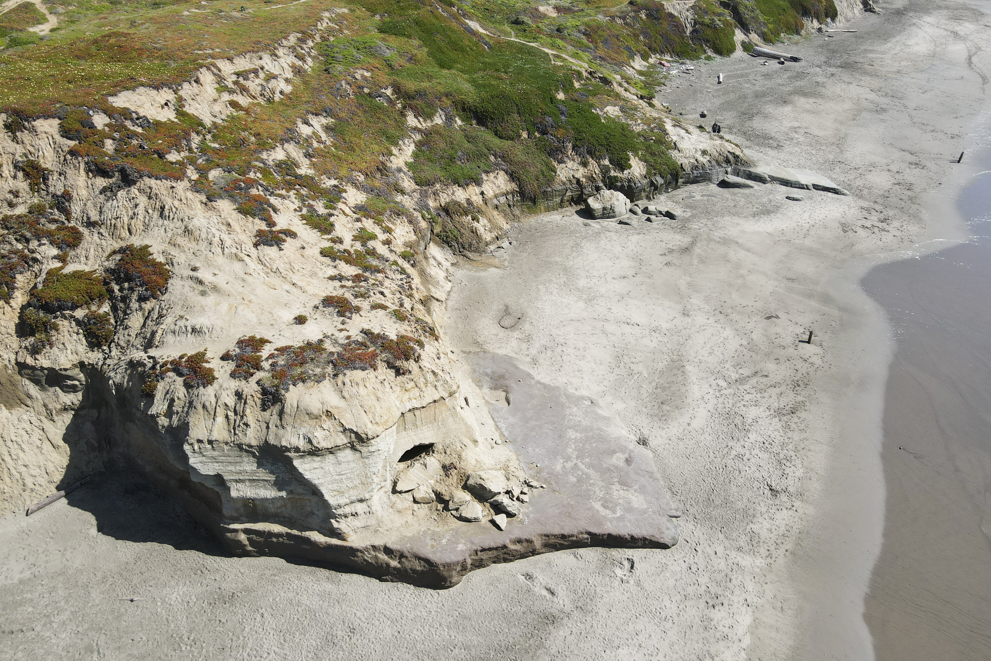
Katrina Schwartz: If you stand on the beach at low tide, with your back to the ocean, he says you’ll see this elevated cave-like thing in the middle of a cliff. Its floor is around head-height. He climbed up to get a better look inside. It was bigger than he thought, maybe 3-feet wide, and it’s roof is smooth and flat.
Francisco Alvarado: It’s just a very mysterious tunnel and I want to know what it was used for.
Katrina Schwartz: Since Francisco first saw this tunnel, his curiosity has consumed him. And he’s got some guesses about it.
Francisco Alvarado: And it has some, like, poles or maybe we used to be a platform on, on the beach. I think the tunnel is like an old train tunnel or something from way back in the day. My sister who was with me that day, she thinks it’s an old like a storm drain runoff or something.
Theme starts
Katrina Schwartz: So we’ve got some theories. Today on Bay Curious we’ll visit Phillip Burton Memorial Beach, as it’s technically called, to see if we can find clues that tell us more about this mysterious tunnel. I’m Katrina Schwartz, you’re listening to Bay Curious. Stay with us.
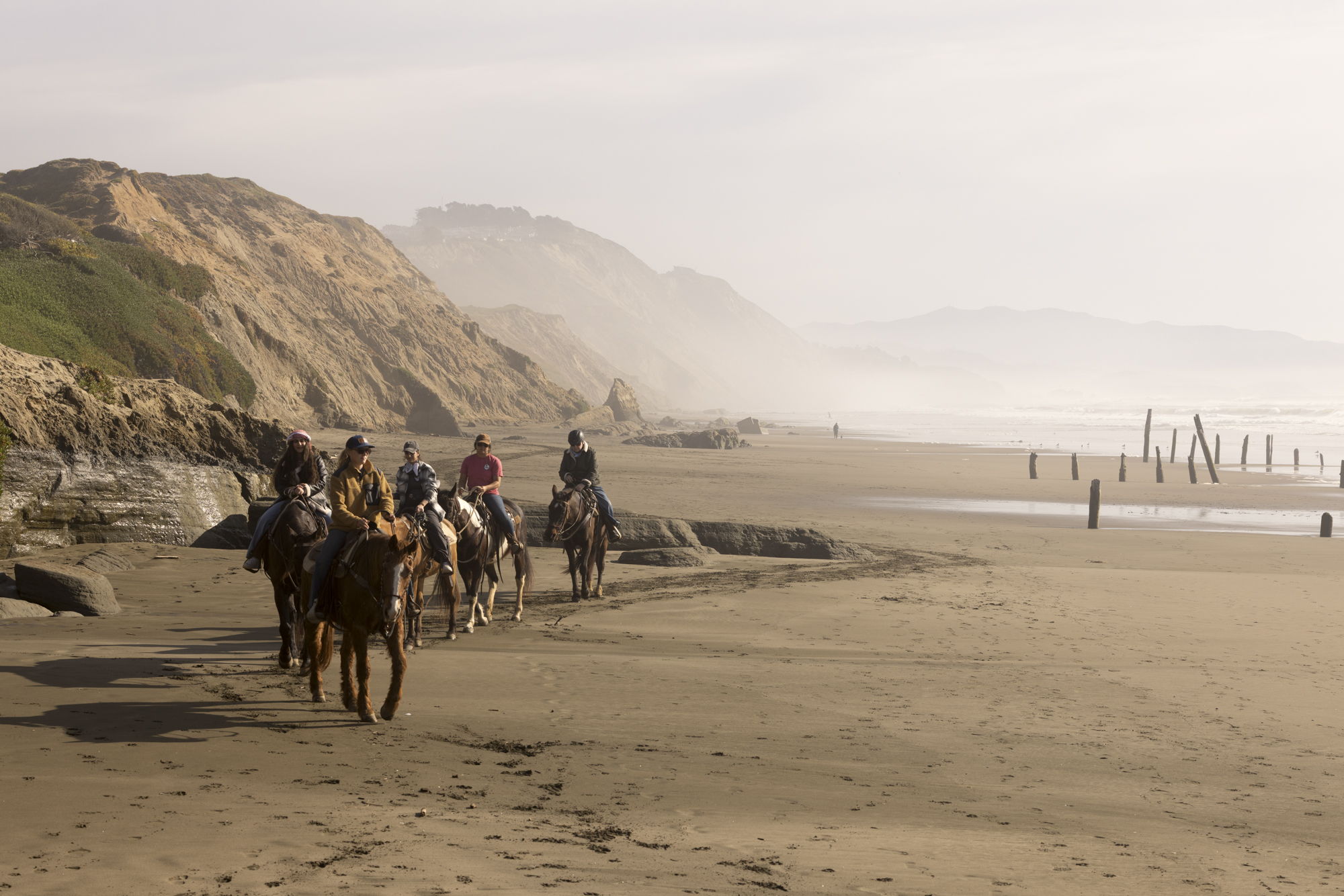
Katrina Schwartz: Today we’re on a mission to find out more about a large tunnel carved into a cliff on the beach between Fort Funston and Thornton Beach. (Sounds of the beach) To find some answers, I meet up with Katryn Wiese, a geology professor at College of San Mateo. We start at the large Fort Funston parking lot and pick our way down what looks to me like a huge sandy cliff.
Katryn Wiese: We’re walking down the massive landslide that is Fort Funston. So this, up at the top there, was the original surface of this cliff, and this whole area we’re walking down here was a big landslide.
Katrina Schwartz: There are logs hammered into the slope — almost like a ladder — to help hikers navigate the sliding sand.
Katryn Wiese: Basically this whole section of the coastline is very soft rock and it slides all the time.
Katrina Schwartz: Katryn tells me this beach can change dramatically depending on the season.
Katryn Wiese: So the sand piles up in the summer, and then throughout the winter, the heavier waves start excavating it.
Katrina Schwartz: That means there are hidden treasures here that can only be seen at certain times of the year.
Katryn Wiese: Back where we first came in at Fort Funston, there’s all these beautiful fossil-rich rocks right at the base of the cliff. But you only can see them in the spring. otherwise they’re covered with sand.
Katrina Schwartz: Look closely at the bottom of the cliff and you can see clam fossils dating back almost a million years, Katryn says.
But today, we’re on the hunt for a tunnel, not fossils. Neither Katryn nor I have seen this tunnel yet, so as we amble south down the beach we keep our eyes peeled for what Francisco described.
Katrina Schwartz (in tape): I wonder if this is it coming up
Katryn Wiese: Let’s take a look.
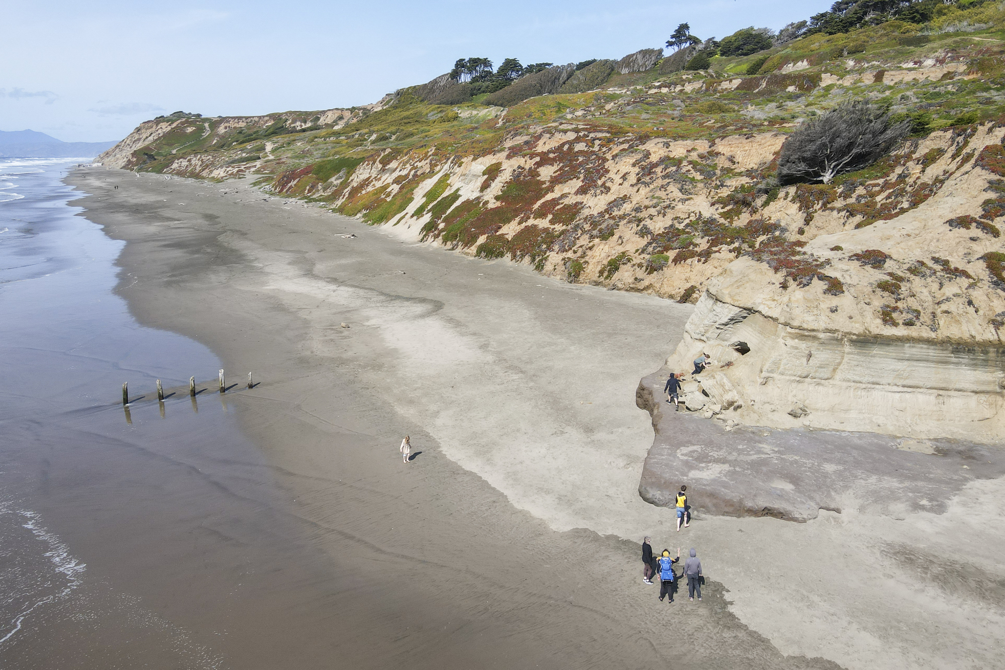
Katrina Schwartz: It’s definitely the right place. Francisco told us to look for two things: wood pilings sticking out of the nearby surf, and a cliff that juts farther into the Pacific than surrounding bluffs. Katryn and I walk over to get a closer look.
Katryn Wiese: When you touch it, what do you feel?
Katrina Schwartz (in tape): It’s pretty hard and it’s definitely very rough.
Katryn Wiese: What grain size would you associate with that?
Katrina Schwartz (in tape): Feels like sand to me.
Katryn Wiese: It’s very sandy, isn’t it? Yeah, so this is a sandstone.
Katrina Schwartz: Little sand particles brush off when we rub the stone.
Katryn Wiese: So whenever something sticks out on a coastline, away from everything else, it’s because it’s made of more resistant rock. So as the waves come in, they’re going to naturally excavate the softest stuff, leave the hardest stuff behind.
Katrina Schwartz: Katryn says with soft rock like this, any little divet in the surface of the bluff can quickly become larger as the waves crash against it.
Katryn Wiese: When the waves come in they’re going hit that same indentation. It’s going to funnel the water into that indentation. And it’s just going to get deeper and deeper and deeper.
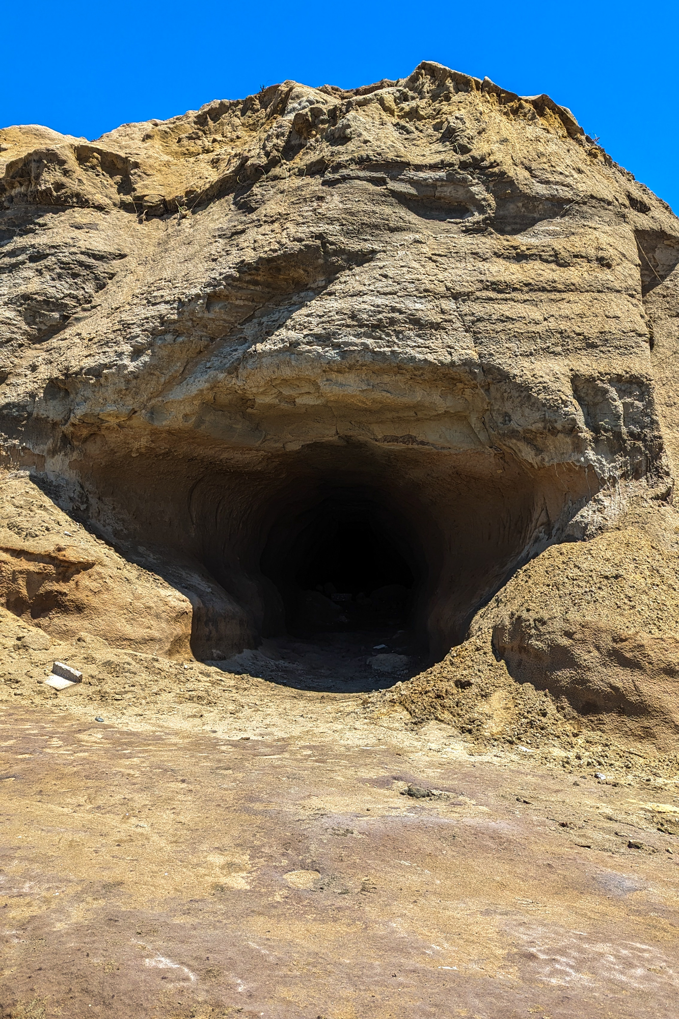
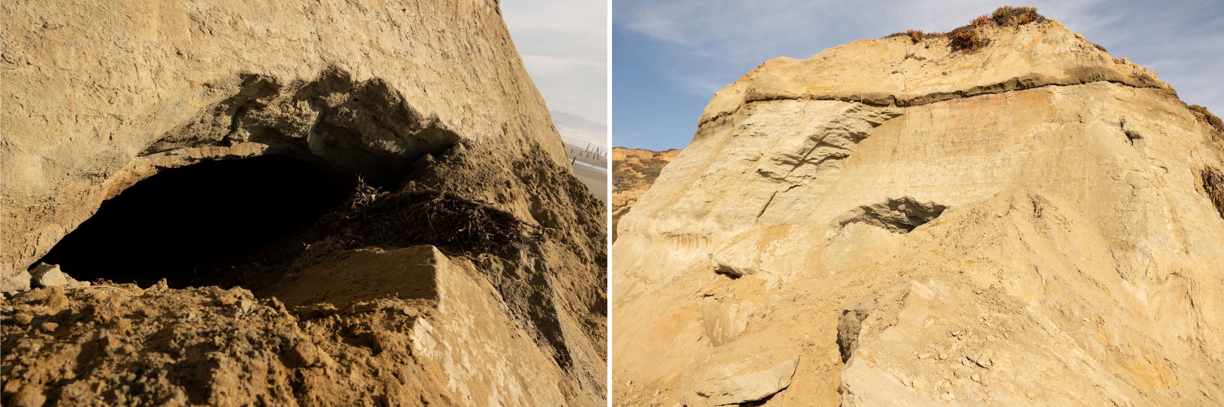
Katrina Schwartz: Looking up the cliff, we spot it! The mouth of the tunnel is barely visible about eight feet off the sand where we stand. When Francisco first saw it, the opening was much more obvious, but since then it looks like the mouth of the tunnel has collapsed, partially blocking the entrance.
Katryn Wiese: I’m going to go up and take a look.
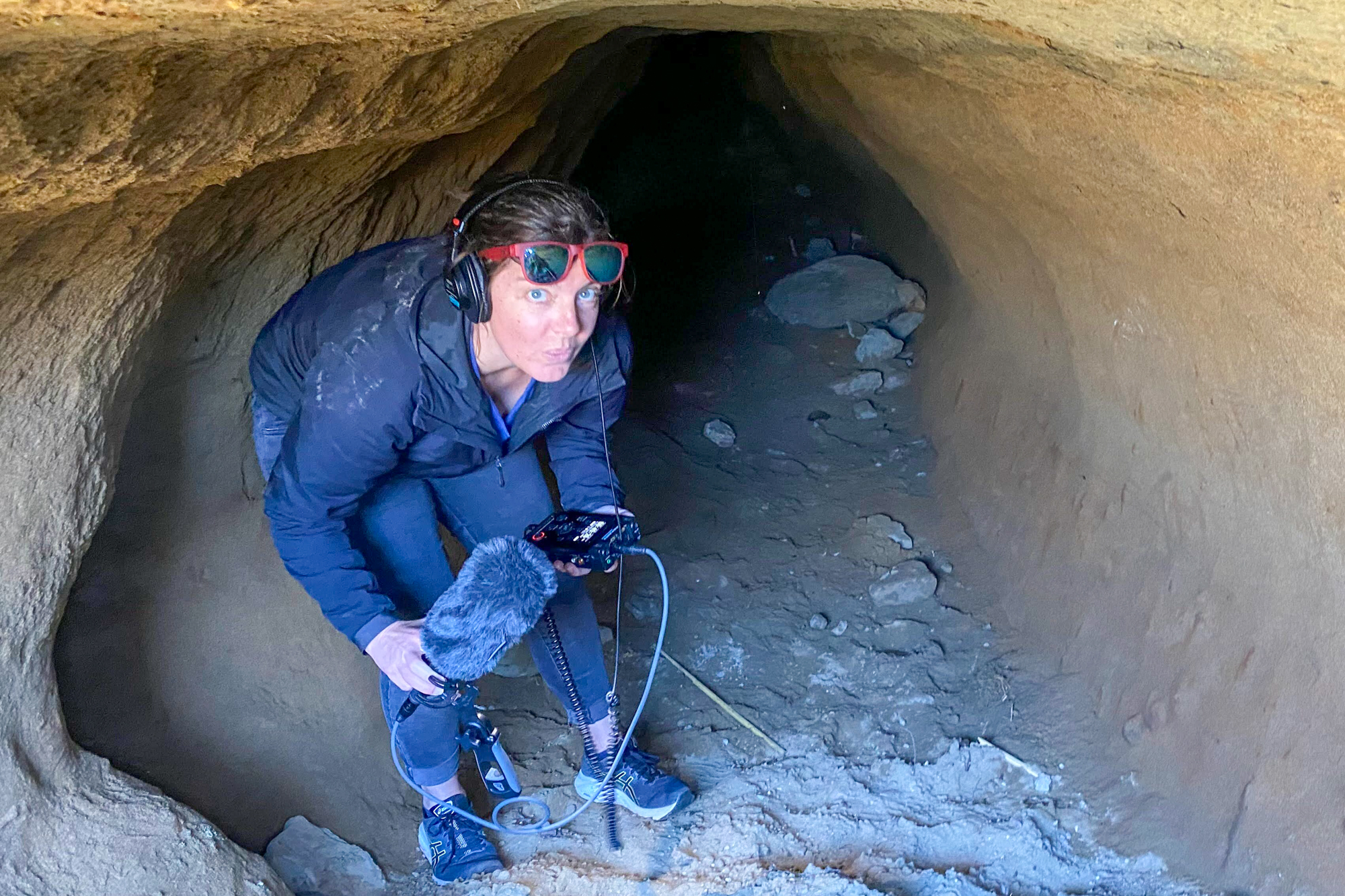
Katrina Schwartz: We climb up a rocky shelf that gets us close enough to peer in, over the sandy rubble. It really is big — large enough for me to stand up hunched over. And it’s deep. We debate whether it’s safe to go inside.
Katrina Schwartz (in tape): Well, and it certainly goes back, I mean, 12, 15 feet, from what we can even see. So, like, if you were 15 feet back and then it caved in, that would be really bad.
Katryn Wiese: It’s so tempting, though. And it’s not so much that I’m worried about the tunnel caving in. I’m worried about the collapse of the entrance. So this collapsed, we don’t know when, but it was recent.
Katrina Schwartz: Katryn admits to being let’s say wary of confined spaces.
Katryn Wiese: You need to get someone who’s braver than me, because I don’t want to go back in there.
Katrina Schwartz: But the allure of solving this mystery is just too much for me.
Katrina Schwartz (in tape): I’m going into this tunnel.
Katrina Schwartz: I hand Katryn my backpack and clutch my recorder as I climb over the cave-in and slide down several feet of sand into near darkness.
Katrina Schwartz (in tape): Ok, so I’m down in here. You can hear it’s a lot quieter.
Katrina Schwartz: It looks like someone has used a big ice cream scoop on the side of the tunnel near the entrance. The marks look similar to ones in a tunnel from the 1800s at Sutro Baths, so Katryn’s wondering if this tunnel really could be from back then.
Katrina Schwartz (in tape): I’m going to go a little further back and see.
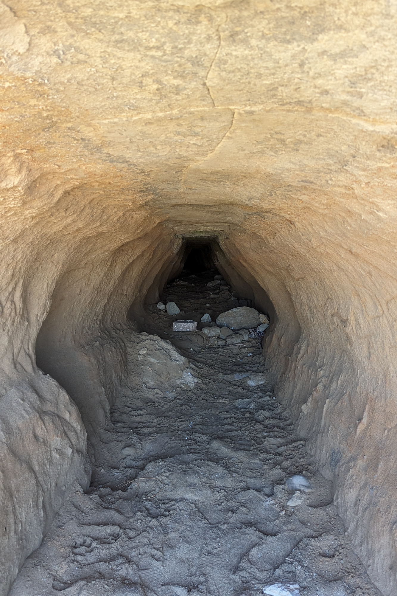
Katrina Schwartz: But further in, the sides of the tunnel are smooth, a strike against the 1800s theory.
Katrina Schwartz (in tape): It gets smaller and smaller. I think it only goes 20 or 30 feet back.
Katrina Schwartz: I also noticed that although the sides of the tunnel are round and smooth, the top is flat, so from the outside, the tunnel opening looks something like a trapezoid.
Katrina Schwartz (in tape): The top is a little flatter.
Katryn Wiese: I’m noticing that too.
Katrina Schwartz: By this time, I’d been in the tunnel for five or six minutes and to be honest, I got a little spooked. I figured the less time in there the better and made my way out.
Katryn Wiese: I’m glad you did it. It needed to be done. Nice one.
Katrina Schwartz: After examining the rock formation up close — and taking photos of me inside it — Katryn heads back to her computer. She wants to compare today’s shots with some photographs she’s taken of the same spot on the beach going back several years.
Later, I hopped on a call to talk about what she’d found.
Katryn Wiese: The tunnel was not there back in 2021.
Katrina Schwartz: So just four years ago, there was no tunnel.
Katryn Wiese: And it does appear a year ago in ’24. You know, somewhere around ’23, probably year ’22–’23 is when it started to get excavated.
Katrina Schwartz: That means it’s probably not an old tunnel from the 1800s. And there isn’t a lot of evidence for it being a drainage outlet either.
Katryn Wiese: But then when I saw how smooth the inside was, and of course, how I felt the rock is very, very soft, I realized that, well, the waves have actually been smoothing it out throughout this storm season. And of course if the waves have a hole and they can go in it, they’re gonna just start digging that hole deeper and deeper. That is a typical aspect of coastal erosion.
Katrina Schwartz: And in the winter, those waves are especially powerful, reaching all the way up to, and inside of, the tunnel.
From a photo she took in January of 2021, Katryn can even see where she thinks the first indentation started.
Katryn Wiese: There’s no tunnel yet, but there’s more rock on the top of it right here. But you can kind of see what looks like a little bit of an indentation.
Katrina Schwartz: But why is the roof so perfectly flat? The geologist has an explanation for that too. The cliff is composed of different layers of rock. The layer just above the cave is dense, but the ocean has scoured away with the rock below.
Katryn Wiese: So, it’s because it’s excavating this softer layer, which is between two harder layers. And it just so happens that’s not a thin layer, it’s about six or seven feet tall, so you get a large tunnel.
Katrina Schwartz: The marks at the opening of the tunnel that made Katryn originally think humans might have dug it — those ice cream scoops — likely are the work of curious people. But they probably didn’t dig the whole tunnel, they just widened the mouth. Their digging may have even caused the cave-in we saw.
Katryn Wiese: And it ends up being a natural answer, which is sort of what you would have guessed from the beginning, but it’s nice to have it confirmed.
Katrina Schwartz: I know, I was hoping this cave was some kind of secret rumrunners tunnel.
But the truth is more surprising in some ways. In a few more years this massive tunnel might no longer exist. As landslides shift the cliffs and strong waves buffet them, this beach is constantly changing.
So the next time Francisco brings his dog Little Bean to walk here, it could look completely different.
If listening to this story really made you want to see what this tunnel looks like for yourself, go check out our website … kqed.org/bay curious. We’ll put a link in our show notes too. We’ve got photos of what the tunnel looked like when Francisco saw it AND ones from after the cave in, when I was there. Honestly, it’s pretty cool.
Thanks to Francisco for asking this week’s question. It actually won a Bay Curious voting round. And we’ve got three new questions up on our website now, ready for you to go vote. Here are your options:
Question 1: The Nimitz House — an abandoned, but still-stunning 6,000 square foot mansion located literally under the Bay Bridge on Yerba Buena — is something even long-time San Francisco residents know nothing about. What’s the story of the mansion?
Question 2: What were the navigational trees in Oakland and how did they help sailors avoid Blossom Rock in the bay? And also, what’s the story of Blossom Rock being blown up?
Question 3: What the story with the “art” (read: eyesore) installation just west of the Ferry Building in San Francisco? It’s the large concrete structure with flowing, moldy mildew water (on Google maps it’s called the Vaillancourt Fountain).
Katrina Schwartz: Head over to kqed dot org slash bay curious to cast your vote. And, while you’re there, scroll down a little ways and sign up for our newsletter. We only send it once and month and in it we answer even more of your questions!
Francisco Alvarado: Bay Curious is made in San Francisco at member-supported KQED.
Katrina Schwartz: Our show is produced by Gabriela Glueck, Christopher Beale and me, Katrina Schwartz. With extra support from Conner, Vicky Chung, Mark Jones, Alana Walker, Maha Sanad, Katie Springer, Jen Chien, Holly Kernan and everyone at team KQED.
Some members of the KQED podcast team are represented by The Screen Actors Guild, American Federation of Television and Radio Artists. San Francisco Northern California Local.
Have a great week.