upper waypoint

PG&E Power Line May Have Sparked Dixie Fire, Near Where Its Equipment Started State's Deadliest Blaze

Save ArticleSave Article
Failed to save article

Please try again

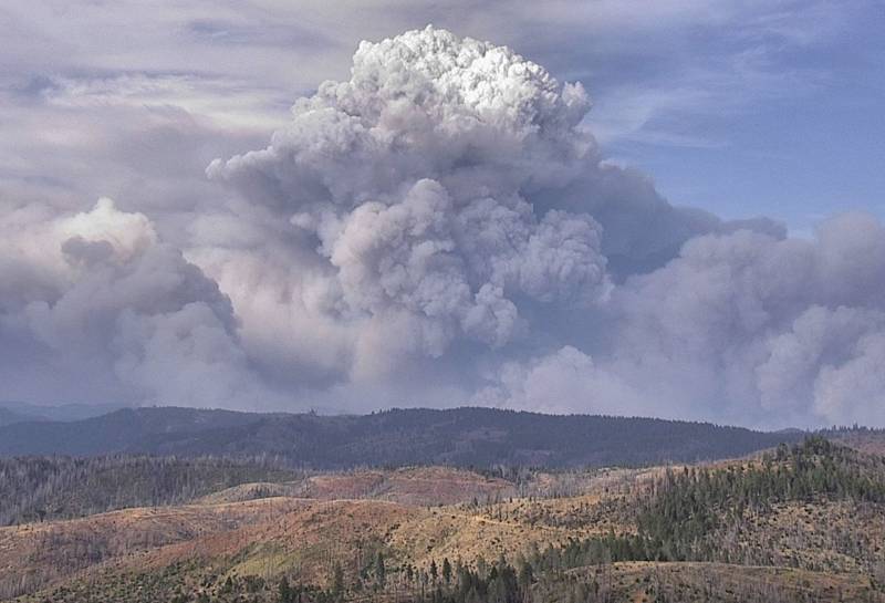
billowing pyrocumulus cloud
A wildfire-generated pyrocumulus cloud rises above the Dixie Fire in Butte and Plumas counties on Sunday, July 18, 2021.  (Courtesy PG&E)

PG&E said in a report filed with state utility regulators late Sunday night that Cal Fire is investigating the company's equipment as the possible cause of a wildland blaze that's burned nearly 50 square miles of forest land in Butte and Plumas counties.

The company says Cal Fire investigators collected parts of a power line and other possible evidence, including portions of a tree that came into contact with the line, from the location where the fire was first seen last Tuesday, July 13.

The Sunday night report and a separate PG&E statement said the company was disclosing the information "in an abundance of caution" and is cooperating with Cal Fire's investigation. Cal Fire confirmed it's investigating but declined further comment.

The Dixie Fire started in the Feather River Canyon just 5 miles upstream from the spot where a PG&E transmission line touched off the 2018 Camp Fire, the deadliest and most destructive wildfire in California's recorded history.

In its electrical incident report to the California Public Utilities Commission, PG&E described a 10-hour series of events that began 7 a.m. on July 13 with a power outage at its Cresta hydropower dam on the Feather River.

Sponsored

The company says a field worker — referred to in the report as a troubleman — was dispatched to the area, along Highway 70 about 30 miles northeast of Oroville, to investigate. The company's report does not say when the worker was dispatched.

"The responding PG&E troubleman observed from a distance what he thought was a blown fuse" on a power line. But getting to the line – a lower-voltage distribution line strung across wooden poles — proved difficult.

The only access to the spot, along a rugged dirt track called Storrie Road, was by way of another backcountry route called Camp Creek Road. PG&E says its worker drove along that road until he reached an out-of-service bridge and was forced to walk the rest of the way to the location of the possible blown fuse.

When he finally reached that spot it was 4:40 p.m., the company says — nearly 10 hours after the first indication of trouble in the area. In addition to finding that two of three fuses at the location had blown, the company report says, the worker discovered a "healthy green tree leaning into [a power line], which was still intact and suspended on the poles. He also observed a fire on the ground near the base of the tree."

After removing the still-intact fuse, the worker alerted a supervisor, who then called 911. But by then, Cal Fire already knew about the blaze.

Related Coverage

Just after 5 p.m., a passing Sutter County fire crew alerted Cal Fire dispatchers to a small blaze burning "near the power lines" on the other side of the river.

The crew leader estimated the size of the fire at 40 feet by 40 feet. Cal Fire air tankers and helicopters responded within an hour in hopes of dropping enough water and retardant on the blaze to limit its spread until ground crews could arrive.

But getting access to the fire scene also proved daunting for those ground forces, which initially included half a dozen fire engines, two hand crews, a bulldozer and three water tenders.

A Cal Fire engine and a bus carrying a 20-member hand crew made their way up Camp Creek Road only to find the impassable bridge. The hand crew arrived at the disabled bridge after 8 p.m., nearly three hours after it was dispatched, and still faced a hike of at least a mile to get to the fire.

Fire commanders decided to hold off on sending reinforcements up Camp Creek Road. Instead, just before 9 p.m., they dispatched engines and water tenders to a remote road called 300 U Line that a single Cal Fire engine had scouted and found to have access to the fire scene from the slope above. Getting to the U Line site, however, required a drive of about 20 miles from a staging location on Highway 70 — much of it on a series of steep, twisting dirt roads.

One final factor limited Cal Fire's early response to the blaze: Shortly before 8 p.m., air operations were halted when a private drone was spotted over the fire.

Still, Cal Fire issued a statement at 8:45 p.m. that sounded an optimistic note about containing the fire.

"Air resources were able to ... hold the fire to approximately 1 to 2 acres," the statement said. "Air tankers dropped at least 7,000 gallons of retardant, while [a] helicopter was able to consistently take and drop water from the Feather River, which was right below the fire. Ground resources were able to hike into the fire and will begin to construct line around the fire and hold the fire at its current size."

Monday morning, Cal Fire reported the Dixie Fire has burned more than 30,000 acres and is 15% contained.

The blaze spread rapidly on Sunday, jumping the Feather River and growing to about 19,000 acres before sunset. The rapid spread of the fire prompted mandatory evacuation orders in several Butte and Plumas county communities north and east of the blaze, including along the river and near Bucks Lake.
lower waypoint
next waypoint
Why California Environmentalists Are Divided Over Plan to Change Power Utility RatesWhy Renaming Oakland's Airport Is a Big DealAllegations of Prosecutorial Bias Spark Review of Death Penalty Convictions in Alameda CountyCecil Williams, Legendary Pastor of Glide Church, Dies at 94Bay Area Indians Brace for India’s Pivotal 2024 Election: Here’s What to KnowSF Democratic Party’s Support of Unlimited Housing Could Pressure Mayoral Candidates‘Sweeps Kill’: Bay Area Homeless Advocates Weigh in on Pivotal US Supreme Court CaseNurses Warn Patient Safety at Risk as AI Use Spreads in Health CareCalifornia’s Future Educators Divided on How to Teach ReadingWhen Rivers Caught Fire: A Brief History of Earth Day