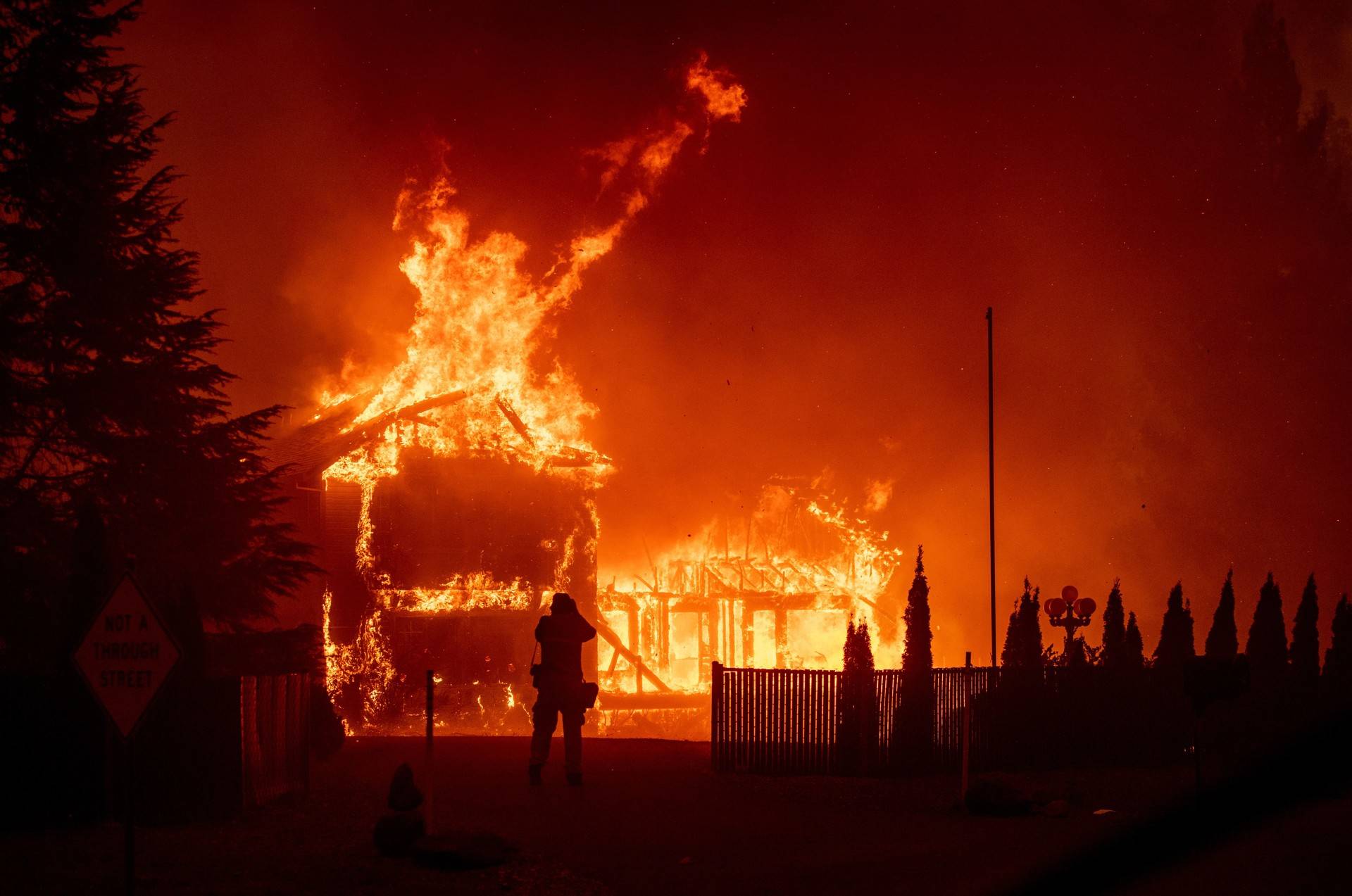
A home burns during the Camp Fire in Paradise, California. (JOSH EDELSON/AFP/Getty Images)
Associated Press
California Towns at Risk From Fires Often Have Few Ways Out
About 350,000 Californians live in areas that have both the highest wildfire risk designation, and either the same number or fewer exit routes per person as Paradise.
Megan Diskin Ventura County Star; Evan Wyloge Palm Springs Desert Sun
Californians got a deadly wake-up call when more than 27,000 Paradise residents trying to escape the Camp Fire got caught in a nightmare traffic jam. The November 2018 catastrophe illuminated the grim reality that road systems throughout the state are not designed to handle a sudden evacuation.
Now a new USA TODAY Network-California analysis reveals the extent to which a fundamental problem in Paradise — too few escape lanes for too many people in vehicles — applies to other cities and neighborhoods at great risk of wildfire across the state.
What Happened in Paradise
About 350,000 Californians live in areas that have both the highest wildfire risk designation, and either the same number or fewer exit routes per person as Paradise. From the mountains, lakes and forests of Northern California to the San Diego suburbs, some residents in the most fire-prone areas have far fewer evacuation routes than the vast majority of the state.
The ratio of people to exit routes doesn’t account for all the complexities of an actual evacuation, experts say, but it does serve as a shorthand for evaluating evacuation efficacy.
In the Gold Rush town of Sonora, about 3½ hours southeast of Paradise, Karl Rodefer worries as the next dry season approaches.
“If that happens here, we’re going to have the same kinds of issues,” said Rodefer, a Tuolumne County supervisor. “There’s a lot of anxiety in the foothills now because of the Camp Fire.”
Both Sonora and Paradise are isolated communities with few roads leading into and out of town.
In Los Angeles County, an area already known for gridlock, the city of Glendale straddles the Verdugo Mountains with neighborhoods, schools and hiking trails carved into its base. The city’s 2008 emergency plan identified them as potential brush fire zones.
The roads can be narrow and some communities have only one way in and out. The plan notes that these conditions could make evacuation and emergency response difficult, but years of construction and development have made any kind of road widening “physically impossible” in those areas, city spokesman Dan Bell said.
The city’s police and fire agencies have conducted outreach in these communities and are strict about defensible space around homes. There’s also a new targeted alert system.
“I think the only concern is people not evacuating when we ask them to evacuate,” he said.
Plus, Bell said, the area hasn’t seen a major wildfire in some time.
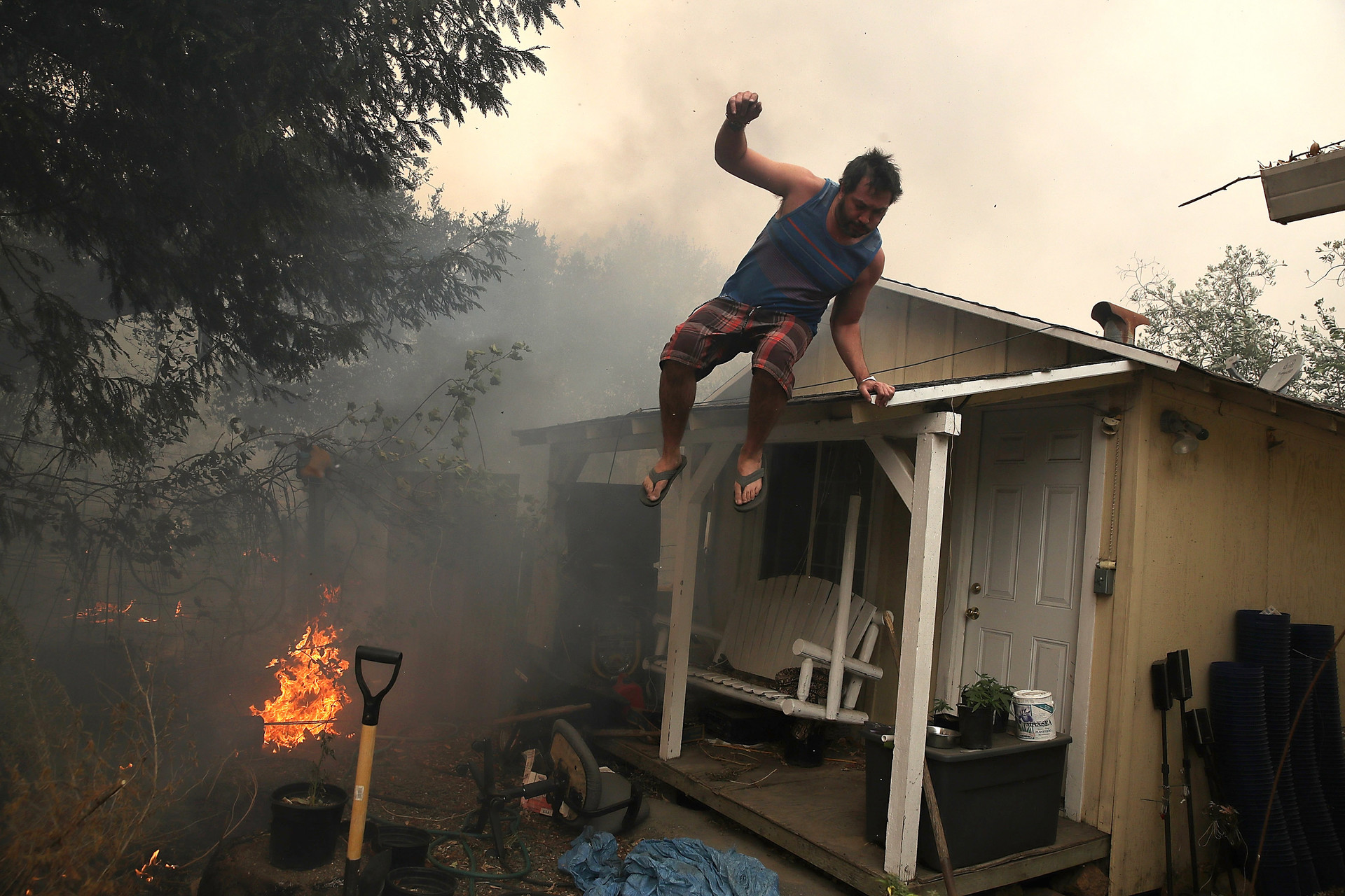
A resident rushes to save his home as an out-of-control wildfire moves through Glen Ellen. (Justin Sullivan/Getty Images)
But it’s the big one that worries Glendale resident James Ward, 62. For 32 years he’s lived in Chevy Chase Canyon, a community of 1,600 homes in a cleft of the San Rafael Hills, which the city has also identified as a potential brush fire zone.
There are only two-lane roads that run through the canyon, with a single access point for many streets and only a few main arteries that let people out. But some neighbors don’t know all the ways out, Ward said.
“If 80% or 60% of the people thought the only way was Chevy Chase (Drive) and all the emergency vehicles were coming up, yes that’s gonna be an issue,” Ward said.
Evacuation routes came up at an annual community meeting in March with the police and fire departments because residents saw the tragedy in Paradise and had the same fears, Ward said. The co-president of the Chevy Chase Estates Association said the public safety officials acknowledged their fears, but “their message was: Be aware of your surroundings and if we ask you to leave, leave.”
California officially adopted fire code standards for roads in the 1990s, although they had been used in some areas for decades before that. They set rules for things like grades, road surfaces, passing areas, signage on dead-ends and “critical” secondary access to any subdivision, said Daniel Berlant, assistant deputy director with Cal Fire’s Office of the State Fire Marshal.
But most of the road systems that California communities like Glendale rely on were built before the widespread use of the standards.
There are also building codes that regulate room capacity and emergency exits, said wildfire evacuations expert Tom Cova. The same consideration should be applied to road infrastructure in communities, he said.
“We’re gonna see a lot of bad things happen, I think … before we do something for communities that we did for buildings,” said Cova, director of the University of Utah’s Center for Natural and Technological Hazards.
Still, Cova and other experts see road capacity as just one element of a healthy evacuation system. Timely evacuation orders, residents’ willingness to obey them, traffic pinch points at intersections beyond the community and many other factors can also be a matter of life and death.
And road capacities can be sufficient, Cova said, if evacuations are gradual or limited. It’s when everyone tries to leave at once that escape routes are quickly overwhelmed.
‘There Were Just So Many People’
Malibu transplant Kassidy Jones, 40, said that’s exactly what happened when he and his family fled their home in the city’s Corral Canyon neighborhood the morning of Nov. 9. As the Woolsey Fire bore down, they packed two cars full of belongings and drove south down the windy, two-lane road to scenic Pacific Coast Highway. At the bottom of the canyon, they found bumper-to-bumper traffic.
“I don’t think there’s really another way out, especially because the fire was coming down the mountain,” Jones said. “There were just so many people. PCH can’t handle it.”
Work brought the Texas native to Los Angeles, but he never liked the city much. That’s why he moved his family to the remote neighborhood where his backyard met the sprawling canyon and gave him a glimpse of the Pacific Ocean.
Now there he was, stuck in traffic. He couldn’t go north. The flames were coming from that direction — just like in previous fires. Plus, north of Jones, the canyon road eventually empties into a network of hiking trails.
At the bottom of the canyon, it took 20 minutes to even turn onto the highway, Jones said. He parked one of the vehicles along PCH and planned to leave it there, figuring the fire wouldn’t spread that far. There, Jones rejoined his wife and their children, ages 6 and 8.
The kids became restless as the family’s car crept along the highway for two hours to go just 2 miles. Finally, they stopped at a park to stretch their legs, go to the bathroom and have some snacks.
They watched as the towering smoke plume from the Woolsey Fire changed direction.
“Before it was flowing west, then it went south. Our neighborhood was on the eastern edge of where the fire went. Unfortunately, it got our house,” Jones said.
Where Drivers Could Overwhelm Evacuation Routes
For others like Jones, who choose to live in places prone to fire, whether in remote parts of rural California or in the “urban-wildland interface” that buffers California’s rugged wilderness and dense cities, a similar situation could await.
Near the top of the list is South Lake Tahoe. The town is relatively isolated, with only a few thoroughfares to facilitate emergency access for firefighting resources.
There, the number of people living in the “very high fire hazard safety zone” per roadway lanes out is almost three times the number for Paradise.
Drennan said that since Paradise burned, he hears the same question from people on a nearly daily basis: What are they going to do if a major fire breaks out? Evacuation plans fall primarily to police, he said, but his fire department is one of several agencies trying to plan for what feels like a looming threat. The fire department and other public safety agencies in the area are “on super high alert,” he said.
“The mindset here is: There’s no earthly way you’re moving the entire vacation population out of the basin all at once,” Drennan said. “If you have just one quirk, you’re going to end up with a lot of people stuck on the roads.”
The previous fire chief there wrote in a 2018 op-ed that it’s not a question of “if” but “when” a major fire will hit the area, and he pointed out the limited evacuation routes as a major concern.
Police, fire and city officials held a public meeting April 25, specifically to discuss fire preparedness and evacuation planning, partly in response to the anxiety many have expressed to him and others, Drennan said.
An aerial view at the edge of the Camp Fire one month later. (Adam Grossberg/KQED)
The analysis identified some places in California where fires have already combined with jammed roadways, killing drivers attempting to flee. Paradise and its neighbor, Magalia, were among the areas identified as a populous area with limited routes out, and 2018’s Camp Fire proved the point. There, city and county officials had planned on having motorists evacuate using five two-lane roads and one four-lane road leading out of town. But fire forced officials to close three of those routes, further clogging the remaining roads, Paradise Mayor Jody Jones said.
The Cedar Fire, which burned 273,000 acres across the hills of northeastern San Diego in 2003, claimed 10 people trying to flee the blaze in their cars. That fire lashed the densely populated Scripps Ranch area, which has a limited number of roadways that lead to less fire-prone areas.
Undeterred
Many Californians clearly understand the risks. They’ve lived through wildfire evacuations, or have watched others. But that’s not enough to pry them from the places they love.
Greg Meneshian, 53, is one. He’s rebuilding the Bell Canyon home destroyed last year by the Woolsey Fire. There’s only one access point in his neighborhood of 750.
Meneshian moved to the gated, equestrian-oriented community just west of the bustling San Fernando Valley about five years ago. The sense of community he felt the night he evacuated, he said, is just more reason for him and his two daughters, 10 and 12, to stay.
Looking northwest from his driveway on the night of Nov. 8 he could see flames in the canyon. He and his neighbors met on the street in front of his home trying to figure out what they should do, Meneshian said.
“They were looking to me for answers as if I lived through this before,” Meneshian said. But he was in disbelief.
He woke up the girls and told them to pack a bag for a week. The power had been flickering on and off, and Meneshian knew that meant it was time to go.
Unlike Jones, whose wife had gotten an evacuation alert, Meneshian left before anyone told him to.
It was dark and smoky with nothing but the pockets of fire visible in the canyon, Meneshian said. Vehicles raced down his hilly street.
“It was really a scramble for our lives,” Meneshian said.
He’d find out the next day his home was destroyed.
But the self-proclaimed “nostalgic guy” likes the sense of togetherness in Bell Canyon, where the closest store is 30 minutes away so sometimes borrowing from a neighbor is usually the better bet.
The limited escape routes, he thinks, are just something to be aware of: “It’s probably a deterrent for some people (moving) in,” he said. “But it shouldn’t be.”
‘You Have to Make These Investments’
Before Paradise burned, there were already signs of problems with evacuation routes during major wildfires, said Assemblywoman Laura Friedman, whose district includes Glendale.
The 2017 Tubbs Fire in Santa Rosa, which killed 22 people and destroyed more than 5,600 structures, raised alarms.
Related Article
Afterward, Friedman and her staff talked with academics about the lessons learned, and she introduced Assembly Bill 2911, which then-Gov. Jerry Brown signed into law in 2018. Among other things, AB 2911 requires that subdivisions with only one exit route, located in very high hazard zones for wildfire, undergo an assessment. The bill calls for developing safety recommendations.
State fire officials should begin the surveys around July 1, 2021, and continue every five years after.
Friedman’s bill is likely to have an impact back in her district. In Glendale’s 2008 emergency plan, bold, capitalized letters call attention to the Oakmont Woods and Whiting Woods communities and their single-access roads. Both are within the state’s very high hazard zone.
“Any city that has those conditions could benefit, and certainly it could be a legislative wake-up call to not only identify these areas but (to signal that) you have to make these investments to make the cities safer,” Friedman said.
Friedman hopes for more state funding for the assessments. She sees reason for optimism in Gov. Gavin Newsom’s declaration of a state of emergency ahead of the traditional wildfire season.
While there’s no unified approach to dealing with California’s wildfire evacuation problem, Friedman’s bill calling for assessments to begin two years from now is not the only potential improvement underway.
In March, Newsom fast-tracked 35 priority projects to remove years of dry, built-up vegetation and create fuel breaks for emergency routes. Those follow an effort by Caltrans since 2016 to remove dead and dying trees from state roadways.
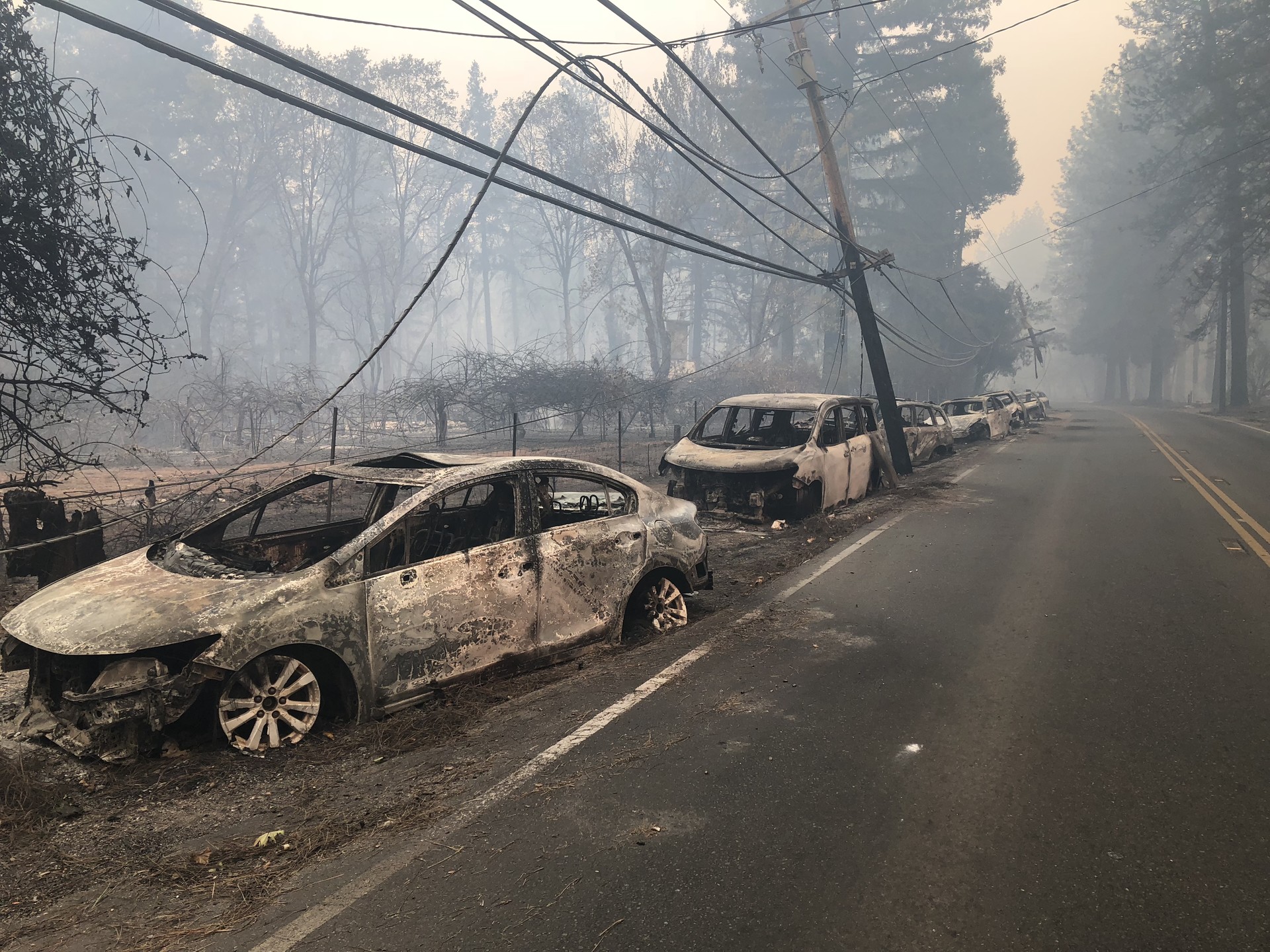
Cars abandoned on the side of the road during the evacuation of Paradise. (Sonja Hutson/KQED)
More Than Just Lanes
Cova, the wildfire evacuations expert, said 25 years ago he became preoccupied with the idea that road congestion was the problem. But through his research he also learned it’s more complicated.
The direction the roads let out is also important. In most fire-prone areas officials know what historically contributes to large wildfires, such as Santa Ana or Diablo winds, and can plan to build roads in a direction those gusts are unlikely to push the fire, Cova said.
During an emergency, Cova said traffic routing and control makes a big difference. That can be especially important at the points where evacuation routes hit other roads. The Malibu example, where so many roads empty onto PCH, is apt.
Related Article
The road issues are important because so many other human factors may decrease the amount of time people have to evacuate, he said.
“What really causes the problem is when you have too many people leaving in too little a time,” Cova said.
It can take officials a while to order evacuations. And residents often hesitate, contemplating whether they should leave, and then take time packing.
Back in Malibu, Jones’ wife got an evacuation alert on her phone at 6 a.m. Sheriff’s officials came around on a loudspeaker at 7 a.m. It was around 8 a.m. when Jones actually left.
To speed things up, Cova encourages residents to have a go bag with medications, important paperwork, photographs and other irreplaceable items. And they should have a plan to round up pets, since critical time can be lost chasing dogs and locating cats.
“Being prepared to leave at a moment’s notice is a good idea,” Cova said.
___
‘Destined to Burn’ is a collaborative story package by journalists from USA TODAY Network-California, McClatchy, Media News and The Associated Press.
Damon Arthur of the Redding Record Searchlight contributed to this report.
lower waypointnext waypoint
Player sponsored by
window.__IS_SSR__=true
window.__INITIAL_STATE__={
"attachmentsReducer": {
"audio_0": {
"type": "attachments",
"id": "audio_0",
"imgSizes": {
"kqedFullSize": {
"file": "https://ww2.kqed.org/news/wp-content/themes/KQED-unified/img/audio_bgs/background0.jpg"
}
}
},
"audio_1": {
"type": "attachments",
"id": "audio_1",
"imgSizes": {
"kqedFullSize": {
"file": "https://ww2.kqed.org/news/wp-content/themes/KQED-unified/img/audio_bgs/background1.jpg"
}
}
},
"audio_2": {
"type": "attachments",
"id": "audio_2",
"imgSizes": {
"kqedFullSize": {
"file": "https://ww2.kqed.org/news/wp-content/themes/KQED-unified/img/audio_bgs/background2.jpg"
}
}
},
"audio_3": {
"type": "attachments",
"id": "audio_3",
"imgSizes": {
"kqedFullSize": {
"file": "https://ww2.kqed.org/news/wp-content/themes/KQED-unified/img/audio_bgs/background3.jpg"
}
}
},
"audio_4": {
"type": "attachments",
"id": "audio_4",
"imgSizes": {
"kqedFullSize": {
"file": "https://ww2.kqed.org/news/wp-content/themes/KQED-unified/img/audio_bgs/background4.jpg"
}
}
},
"placeholder": {
"type": "attachments",
"id": "placeholder",
"imgSizes": {
"thumbnail": {
"file": "https://cdn.kqed.org/wp-content/uploads/2024/12/KQED-Default-Image-816638274-2000x1333-1-160x107.jpg",
"width": 160,
"height": 107,
"mimeType": "image/jpeg"
},
"medium": {
"file": "https://cdn.kqed.org/wp-content/uploads/2024/12/KQED-Default-Image-816638274-2000x1333-1-800x533.jpg",
"width": 800,
"height": 533,
"mimeType": "image/jpeg"
},
"medium_large": {
"file": "https://cdn.kqed.org/wp-content/uploads/2024/12/KQED-Default-Image-816638274-2000x1333-1-768x512.jpg",
"width": 768,
"height": 512,
"mimeType": "image/jpeg"
},
"large": {
"file": "https://cdn.kqed.org/wp-content/uploads/2024/12/KQED-Default-Image-816638274-2000x1333-1-1020x680.jpg",
"width": 1020,
"height": 680,
"mimeType": "image/jpeg"
},
"1536x1536": {
"file": "https://cdn.kqed.org/wp-content/uploads/2024/12/KQED-Default-Image-816638274-2000x1333-1-1536x1024.jpg",
"width": 1536,
"height": 1024,
"mimeType": "image/jpeg"
},
"fd-lrg": {
"file": "https://cdn.kqed.org/wp-content/uploads/2024/12/KQED-Default-Image-816638274-2000x1333-1-1536x1024.jpg",
"width": 1536,
"height": 1024,
"mimeType": "image/jpeg"
},
"fd-med": {
"file": "https://cdn.kqed.org/wp-content/uploads/2024/12/KQED-Default-Image-816638274-2000x1333-1-1020x680.jpg",
"width": 1020,
"height": 680,
"mimeType": "image/jpeg"
},
"fd-sm": {
"file": "https://cdn.kqed.org/wp-content/uploads/2024/12/KQED-Default-Image-816638274-2000x1333-1-800x533.jpg",
"width": 800,
"height": 533,
"mimeType": "image/jpeg"
},
"post-thumbnail": {
"file": "https://cdn.kqed.org/wp-content/uploads/2024/12/KQED-Default-Image-816638274-2000x1333-1-672x372.jpg",
"width": 672,
"height": 372,
"mimeType": "image/jpeg"
},
"twentyfourteen-full-width": {
"file": "https://cdn.kqed.org/wp-content/uploads/2024/12/KQED-Default-Image-816638274-2000x1333-1-1038x576.jpg",
"width": 1038,
"height": 576,
"mimeType": "image/jpeg"
},
"xxsmall": {
"file": "https://cdn.kqed.org/wp-content/uploads/2024/12/KQED-Default-Image-816638274-2000x1333-1-160x107.jpg",
"width": 160,
"height": 107,
"mimeType": "image/jpeg"
},
"xsmall": {
"file": "https://cdn.kqed.org/wp-content/uploads/2024/12/KQED-Default-Image-816638274-2000x1333-1-672x372.jpg",
"width": 672,
"height": 372,
"mimeType": "image/jpeg"
},
"small": {
"file": "https://cdn.kqed.org/wp-content/uploads/2024/12/KQED-Default-Image-816638274-2000x1333-1-672x372.jpg",
"width": 672,
"height": 372,
"mimeType": "image/jpeg"
},
"xlarge": {
"file": "https://cdn.kqed.org/wp-content/uploads/2024/12/KQED-Default-Image-816638274-2000x1333-1-1020x680.jpg",
"width": 1020,
"height": 680,
"mimeType": "image/jpeg"
},
"full-width": {
"file": "https://cdn.kqed.org/wp-content/uploads/2024/12/KQED-Default-Image-816638274-2000x1333-1-1920x1280.jpg",
"width": 1920,
"height": 1280,
"mimeType": "image/jpeg"
},
"guest-author-32": {
"file": "https://cdn.kqed.org/wp-content/uploads/2025/01/KQED-Default-Image-816638274-1333x1333-1-160x160.jpg",
"width": 32,
"height": 32,
"mimeType": "image/jpeg"
},
"guest-author-50": {
"file": "https://cdn.kqed.org/wp-content/uploads/2025/01/KQED-Default-Image-816638274-1333x1333-1-160x160.jpg",
"width": 50,
"height": 50,
"mimeType": "image/jpeg"
},
"guest-author-64": {
"file": "https://cdn.kqed.org/wp-content/uploads/2025/01/KQED-Default-Image-816638274-1333x1333-1-160x160.jpg",
"width": 64,
"height": 64,
"mimeType": "image/jpeg"
},
"guest-author-96": {
"file": "https://cdn.kqed.org/wp-content/uploads/2025/01/KQED-Default-Image-816638274-1333x1333-1-160x160.jpg",
"width": 96,
"height": 96,
"mimeType": "image/jpeg"
},
"guest-author-128": {
"file": "https://cdn.kqed.org/wp-content/uploads/2025/01/KQED-Default-Image-816638274-1333x1333-1-160x160.jpg",
"width": 128,
"height": 128,
"mimeType": "image/jpeg"
},
"detail": {
"file": "https://cdn.kqed.org/wp-content/uploads/2025/01/KQED-Default-Image-816638274-1333x1333-1-160x160.jpg",
"width": 160,
"height": 160,
"mimeType": "image/jpeg"
},
"kqedFullSize": {
"file": "https://cdn.kqed.org/wp-content/uploads/2024/12/KQED-Default-Image-816638274-2000x1333-1.jpg",
"width": 2000,
"height": 1333
}
}
},
"news_11743359": {
"type": "attachments",
"id": "news_11743359",
"meta": {
"index": "attachments_1716263798",
"site": "news",
"id": "11743359",
"found": true
},
"parent": 11743347,
"imgSizes": {
"twentyfourteen-full-width": {
"file": "https://ww2.kqed.org/app/uploads/sites/10/2019/04/RS33764_GettyImages-1059345696-qut-1-1038x576.jpg",
"width": 1038,
"mimeType": "image/jpeg",
"height": 576
},
"thumbnail": {
"file": "https://ww2.kqed.org/app/uploads/sites/10/2019/04/RS33764_GettyImages-1059345696-qut-1-160x106.jpg",
"width": 160,
"mimeType": "image/jpeg",
"height": 106
},
"post-thumbnail": {
"file": "https://ww2.kqed.org/app/uploads/sites/10/2019/04/RS33764_GettyImages-1059345696-qut-1-672x372.jpg",
"width": 672,
"mimeType": "image/jpeg",
"height": 372
},
"kqedFullSize": {
"file": "https://ww2.kqed.org/app/uploads/sites/10/2019/04/RS33764_GettyImages-1059345696-qut-1.jpg",
"width": 1920,
"height": 1273
},
"large": {
"file": "https://ww2.kqed.org/app/uploads/sites/10/2019/04/RS33764_GettyImages-1059345696-qut-1-1020x676.jpg",
"width": 1020,
"mimeType": "image/jpeg",
"height": 676
},
"complete_open_graph": {
"file": "https://ww2.kqed.org/app/uploads/sites/10/2019/04/RS33764_GettyImages-1059345696-qut-1-1200x796.jpg",
"width": 1200,
"mimeType": "image/jpeg",
"height": 796
},
"full-width": {
"file": "https://ww2.kqed.org/app/uploads/sites/10/2019/04/RS33764_GettyImages-1059345696-qut-1-1920x1273.jpg",
"width": 1920,
"mimeType": "image/jpeg",
"height": 1273
},
"medium": {
"file": "https://ww2.kqed.org/app/uploads/sites/10/2019/04/RS33764_GettyImages-1059345696-qut-1-800x530.jpg",
"width": 800,
"mimeType": "image/jpeg",
"height": 530
}
},
"publishDate": 1556402836,
"modified": 1556581418,
"caption": "A home burns during the Camp Fire in Paradise, California.",
"description": "A home burns during the Camp fire in Paradise.",
"title": "US-FIRE-WEATHER",
"credit": "JOSH EDELSON/AFP/Getty Images",
"status": "inherit",
"isLoading": false,
"fetchFailed": false
}
},
"audioPlayerReducer": {
"postId": "stream_live",
"isPaused": true,
"isPlaying": false,
"pfsActive": false,
"pledgeModalIsOpen": true,
"playerDrawerIsOpen": false,
"liveAudioPlayStartedAt": 0,
"liveAudioPlayContext": ""
},
"authorsReducer": {
"byline_news_11743347": {
"type": "authors",
"id": "byline_news_11743347",
"meta": {
"override": true
},
"slug": "byline_news_11743347",
"name": "Megan Diskin\u003cbr>\u003cstrong>Ventura County Star\u003c/strong>;\u003cbr>Evan Wyloge\u003cbr>\u003cstrong>Palm Springs Desert Sun\u003c/strong>",
"isLoading": false
}
},
"pagesReducer": {},
"pfsSessionReducer": {},
"postsReducer": {
"stream_live": {
"type": "live",
"id": "stream_live",
"audioUrl": "https://streams.kqed.org/kqedradio",
"title": "Live Stream",
"excerpt": "Live Stream information currently unavailable.",
"link": "/radio",
"featImg": "",
"label": {
"name": "KQED Live",
"link": "/"
}
},
"stream_kqedNewscast": {
"type": "posts",
"id": "stream_kqedNewscast",
"audioUrl": "https://www.kqed.org/.stream/anon/radio/RDnews/newscast.mp3?_=1",
"title": "KQED Newscast",
"featImg": "",
"label": {
"name": "88.5 FM",
"link": "/"
}
},
"news_11743347": {
"type": "posts",
"id": "news_11743347",
"meta": {
"index": "posts_1716263798",
"site": "news",
"id": "11743347",
"found": true
},
"articlePosition": 0,
"guestAuthors": [],
"slug": "california-towns-at-risk-from-fires-often-have-few-ways-out",
"title": "California Towns at Risk From Fires Often Have Few Ways Out",
"publishDate": 1556457966,
"format": "image",
"headTitle": "California Towns at Risk From Fires Often Have Few Ways Out | KQED",
"labelTerm": {},
"content": "\u003cp>Californians got a deadly wake-up call when more than 27,000 Paradise residents trying to escape \u003ca href=\"https://www.kqed.org/news/tag/camp-fire\" target=\"_blank\" rel=\"noopener\">the Camp Fire\u003c/a> got caught in a nightmare traffic jam. The November 2018 catastrophe illuminated the grim reality that road systems throughout the state are not designed to handle a sudden evacuation.\u003c/p>\n\u003cp>Now a new \u003ca href=\"https://www.kqed.org/news/11743364\" target=\"_blank\" rel=\"noopener\">USA TODAY Network-California analysis\u003c/a> reveals the extent to which a fundamental problem in Paradise — too few escape lanes for too many people in vehicles — applies to other cities and neighborhoods at great risk of wildfire across the state.\u003c/p>\n\u003cp>[aside postID=\"news_11711175,news_11706065\" label=\"What Happened in Paradise\"]\u003cbr>\nAbout 350,000 Californians live in areas that have both the highest wildfire risk designation, and either the same number or fewer exit routes per person as Paradise. From the mountains, lakes and forests of Northern California to the San Diego suburbs, some residents in the most fire-prone areas have far fewer evacuation routes than the vast majority of the state.\u003c/p>\n\u003cp>The ratio of people to exit routes doesn’t account for all the complexities of an actual evacuation, experts say, but it does serve as a shorthand for evaluating evacuation efficacy.\u003c/p>\n\u003cp>In the Gold Rush town of Sonora, about 3½ hours southeast of Paradise, Karl Rodefer worries as the next dry season approaches.\u003c/p>\n\u003cp>“If that happens here, we’re going to have the same kinds of issues,” said Rodefer, a Tuolumne County supervisor. “There’s a lot of anxiety in the foothills now because of the Camp Fire.”\u003c/p>\n\u003cp>[ad fullwidth]\u003c/p>\n\u003cp>Both Sonora and Paradise are isolated communities with few roads leading into and out of town.\u003c/p>\n\u003cp>In Los Angeles County, an area already known for gridlock, the city of Glendale straddles the Verdugo Mountains with neighborhoods, schools and hiking trails carved into its base. The city’s 2008 emergency plan identified them as potential brush fire zones.\u003c/p>\n\u003cp>The roads can be narrow and some communities have only one way in and out. The plan notes that these conditions could make evacuation and emergency response difficult, but years of construction and development have made any kind of road widening “physically impossible” in those areas, city spokesman Dan Bell said.\u003c/p>\n\u003cp>The city’s police and fire agencies have conducted outreach in these communities and are strict about defensible space around homes. There’s also a new targeted alert system.\u003c/p>\n\u003cp>“I think the only concern is people not evacuating when we ask them to evacuate,” he said.\u003c/p>\n\u003cp>Plus, Bell said, the area hasn’t seen a major wildfire in some time.\u003c/p>\n\u003cfigure id=\"attachment_11743360\" class=\"wp-caption aligncenter\" style=\"max-width: 1920px\">\u003ca href=\"https://ww2.kqed.org/news/wp-content/uploads/sites/10/2019/04/RS27223_GettyImages-859436442-qut.jpg\">\u003cimg loading=\"lazy\" decoding=\"async\" class=\"wp-image-11743360 size-full\" src=\"https://ww2.kqed.org/news/wp-content/uploads/sites/10/2019/04/RS27223_GettyImages-859436442-qut.jpg\" alt=\"\" width=\"1920\" height=\"1280\" srcset=\"https://cdn.kqed.org/wp-content/uploads/sites/10/2019/04/RS27223_GettyImages-859436442-qut.jpg 1920w, https://cdn.kqed.org/wp-content/uploads/sites/10/2019/04/RS27223_GettyImages-859436442-qut-160x107.jpg 160w, https://cdn.kqed.org/wp-content/uploads/sites/10/2019/04/RS27223_GettyImages-859436442-qut-800x533.jpg 800w, https://cdn.kqed.org/wp-content/uploads/sites/10/2019/04/RS27223_GettyImages-859436442-qut-1020x680.jpg 1020w, https://cdn.kqed.org/wp-content/uploads/sites/10/2019/04/RS27223_GettyImages-859436442-qut-1200x800.jpg 1200w\" sizes=\"(max-width: 1920px) 100vw, 1920px\">\u003c/a>\u003cfigcaption class=\"wp-caption-text\">A resident rushes to save his home as an out-of-control wildfire moves through Glen Ellen. \u003ccite>(Justin Sullivan/Getty Images)\u003c/cite>\u003c/figcaption>\u003c/figure>\n\u003cp>But it’s the big one that worries Glendale resident James Ward, 62. For 32 years he’s lived in Chevy Chase Canyon, a community of 1,600 homes in a cleft of the San Rafael Hills, which the city has also identified as a potential brush fire zone.\u003c/p>\n\u003cp>There are only two-lane roads that run through the canyon, with a single access point for many streets and only a few main arteries that let people out. But some neighbors don’t know all the ways out, Ward said.\u003c/p>\n\u003cp>“If 80% or 60% of the people thought the only way was Chevy Chase (Drive) and all the emergency vehicles were coming up, yes that’s gonna be an issue,” Ward said.\u003c/p>\n\u003cp>[pullquote align=\"left\" citation=\"Tom Cova, wildfire evacuations expert\"]“We’re gonna see a lot of bad things happen, I think … before we do something for communities.”[/pullquote]\u003ca href=\"https://apnews.com/4eb3806b4c5c448f985646d91ce03c20\" target=\"_blank\" rel=\"noopener\">Evacuation routes\u003c/a> came up at an annual community meeting in March with the police and fire departments because residents saw the tragedy in Paradise and had the same fears, Ward said. The co-president of the Chevy Chase Estates Association said the public safety officials acknowledged their fears, but “their message was: Be aware of your surroundings and if we ask you to leave, leave.”\u003c/p>\n\u003cp>California officially adopted fire code standards for roads in the 1990s, although they had been used in some areas for decades before that. They set rules for things like grades, road surfaces, passing areas, signage on dead-ends and “critical” secondary access to any subdivision, said Daniel Berlant, assistant deputy director with Cal Fire’s Office of the State Fire Marshal.\u003c/p>\n\u003cp>But most of the road systems that California communities like Glendale rely on were built before the widespread use of the standards.\u003c/p>\n\u003cp>There are also building codes that regulate room capacity and emergency exits, said wildfire evacuations expert Tom Cova. The same consideration should be applied to road infrastructure in communities, he said.\u003c/p>\n\u003cp>“We’re gonna see a lot of bad things happen, I think … before we do something for communities that we did for buildings,” said Cova, director of the University of Utah’s Center for Natural and Technological Hazards.\u003c/p>\n\u003cp>Still, Cova and other experts see road capacity as just one element of a healthy evacuation system. Timely evacuation orders, residents’ willingness to obey them, traffic pinch points at intersections beyond the community and many other factors can also be a matter of life and death.\u003c/p>\n\u003cp>And road capacities can be sufficient, Cova said, if evacuations are gradual or limited. It’s when everyone tries to leave at once that escape routes are quickly overwhelmed.\u003c/p>\n\u003ch2>‘There Were Just So Many People’\u003c/h2>\n\u003cp>Malibu transplant Kassidy Jones, 40, said that’s exactly what happened when he and his family fled their home in the city’s Corral Canyon neighborhood the morning of Nov. 9. As \u003ca href=\"https://www.kqed.org/news/tag/woolsey-fire\" target=\"_blank\" rel=\"noopener\">the Woolsey Fire\u003c/a> bore down, they packed two cars full of belongings and drove south down the windy, two-lane road to scenic Pacific Coast Highway. At the bottom of the canyon, they found bumper-to-bumper traffic.\u003c/p>\n\u003cp>“I don’t think there’s really another way out, especially because the fire was coming down the mountain,” Jones said. “There were just so many people. PCH can’t handle it.”\u003c/p>\n\u003cp>Work brought the Texas native to Los Angeles, but he never liked the city much. That’s why he moved his family to the remote neighborhood where his backyard met the sprawling canyon and gave him a glimpse of the Pacific Ocean.\u003c/p>\n\u003cp>Now there he was, stuck in traffic. He couldn’t go north. The flames were coming from that direction — just like in previous fires. Plus, north of Jones, the canyon road eventually empties into a network of hiking trails.\u003c/p>\n\u003cp>https://twitter.com/LASDHQ/status/1061073827021578240\u003c/p>\n\u003cp>At the bottom of the canyon, it took 20 minutes to even turn onto the highway, Jones said. He parked one of the vehicles along PCH and planned to leave it there, figuring the fire wouldn’t spread that far. There, Jones rejoined his wife and their children, ages 6 and 8.\u003c/p>\n\u003cp>The kids became restless as the family’s car crept along the highway for two hours to go just 2 miles. Finally, they stopped at a park to stretch their legs, go to the bathroom and have some snacks.\u003c/p>\n\u003cp>They watched as the towering smoke plume from the Woolsey Fire changed direction.\u003c/p>\n\u003cp>“Before it was flowing west, then it went south. Our neighborhood was on the eastern edge of where the fire went. Unfortunately, it got our house,” Jones said.\u003c/p>\n\u003ch2>Where Drivers Could Overwhelm Evacuation Routes\u003c/h2>\n\u003cp>For others like Jones, who choose to live in places prone to fire, whether in remote parts of rural California or in the “urban-wildland interface” that buffers California’s rugged wilderness and dense cities, a similar situation could await.\u003c/p>\n\u003cp>A \u003ca href=\"https://apnews.com/bba93f2197404969a0d4a3fa59f659ae\" target=\"_blank\" rel=\"noopener\">USA TODAY Network-California analysis of populations, fire risk zones and roadways\u003c/a> shows roughly one out of every 100 ZIP codes in California has a population-to-evacuation-route ratio that is near to or worse than that of Paradise and its neighbor, Magalia.\u003c/p>\n\u003cp>[pullquote align=\"left\" citation=\"Jim Drennan, South Lake Tahoe Fire Department Battalion Chief \"]“There’s no earthly way you’re moving the entire vacation population out of the basin all at once.”[/pullquote]Near the top of the list is South Lake Tahoe. The town is relatively isolated, with only a few thoroughfares to facilitate emergency access for firefighting resources.\u003c/p>\n\u003cp>There, the number of people living in the “very high fire hazard safety zone” per roadway lanes out is almost three times the number for Paradise.\u003c/p>\n\u003cp>Interim South Lake Tahoe Fire Department Battalion Chief Jim Drennan said he wasn’t surprised to find out his community is in \u003ca href=\"https://apnews.com/bf00185ed887421388358ed8145fe423\" target=\"_blank\" rel=\"noopener\">one of the most precarious fire evacuation locations in the state\u003c/a>, given the small number of roads in and out of the Tahoe Basin.\u003c/p>\n\u003cp>Drennan said that since Paradise burned, he hears the same question from people on a nearly daily basis: What are they going to do if a major fire breaks out? Evacuation plans fall primarily to police, he said, but his fire department is one of several agencies trying to plan for what feels like a looming threat. The fire department and other public safety agencies in the area are “on super high alert,” he said.\u003c/p>\n\u003cp>“The mindset here is: There’s no earthly way you’re moving the entire vacation population out of the basin all at once,” Drennan said. “If you have just one quirk, you’re going to end up with a lot of people stuck on the roads.”\u003c/p>\n\u003cp>The previous fire chief there wrote in a 2018 op-ed that it’s not a question of “if” but “when” a major fire will hit the area, and he pointed out the limited evacuation routes as a major concern.\u003c/p>\n\u003cp>Police, fire and city officials held a public meeting April 25, specifically to discuss fire preparedness and evacuation planning, partly in response to the anxiety many have expressed to him and others, Drennan said.\u003c/p>\n\u003cfigure id=\"attachment_11743357\" class=\"wp-caption aligncenter\" style=\"max-width: 1920px\">\u003ca href=\"https://ww2.kqed.org/news/wp-content/uploads/sites/10/2019/04/RS34317_Camp-Fire-aerials_1204-1-qut.jpg\">\u003cimg loading=\"lazy\" decoding=\"async\" class=\"size-full wp-image-11743357\" src=\"https://ww2.kqed.org/news/wp-content/uploads/sites/10/2019/04/RS34317_Camp-Fire-aerials_1204-1-qut.jpg\" alt=\"\" width=\"1920\" height=\"1280\" srcset=\"https://cdn.kqed.org/wp-content/uploads/sites/10/2019/04/RS34317_Camp-Fire-aerials_1204-1-qut.jpg 1920w, https://cdn.kqed.org/wp-content/uploads/sites/10/2019/04/RS34317_Camp-Fire-aerials_1204-1-qut-160x107.jpg 160w, https://cdn.kqed.org/wp-content/uploads/sites/10/2019/04/RS34317_Camp-Fire-aerials_1204-1-qut-800x533.jpg 800w, https://cdn.kqed.org/wp-content/uploads/sites/10/2019/04/RS34317_Camp-Fire-aerials_1204-1-qut-1020x680.jpg 1020w, https://cdn.kqed.org/wp-content/uploads/sites/10/2019/04/RS34317_Camp-Fire-aerials_1204-1-qut-1200x800.jpg 1200w\" sizes=\"(max-width: 1920px) 100vw, 1920px\">\u003c/a>\u003cfigcaption class=\"wp-caption-text\">An aerial view at the edge of the Camp Fire one month later. \u003ccite>(Adam Grossberg/KQED)\u003c/cite>\u003c/figcaption>\u003c/figure>\n\u003cp>The analysis identified some places in California where fires have already combined with jammed roadways, killing drivers attempting to flee. Paradise and its neighbor, Magalia, were among the areas identified as a populous area with limited routes out, and 2018’s Camp Fire proved the point. There, city and county officials had planned on having motorists evacuate using five two-lane roads and one four-lane road leading out of town. But fire forced officials to close three of those routes, further clogging the remaining roads, Paradise Mayor Jody Jones said.\u003c/p>\n\u003cp>The Cedar Fire, which burned 273,000 acres across the hills of northeastern San Diego in 2003, claimed 10 people trying to flee the blaze in their cars. That fire lashed the densely populated Scripps Ranch area, which has a limited number of roadways that lead to less fire-prone areas.\u003c/p>\n\u003ch2>Undeterred\u003c/h2>\n\u003cp>Many Californians clearly understand the risks. They’ve lived through wildfire evacuations, or have watched others. But that’s not enough to pry them from the places they love.\u003c/p>\n\u003cp>Greg Meneshian, 53, is one. He’s rebuilding the Bell Canyon home destroyed last year by the Woolsey Fire. There’s only one access point in his neighborhood of 750.\u003c/p>\n\u003cp>Meneshian moved to the gated, equestrian-oriented community just west of the bustling San Fernando Valley about five years ago. The sense of community he felt the night he evacuated, he said, is just more reason for him and his two daughters, 10 and 12, to stay.\u003c/p>\n\u003cp>Looking northwest from his driveway on the night of Nov. 8 he could see flames in the canyon. He and his neighbors met on the street in front of his home trying to figure out what they should do, Meneshian said.\u003c/p>\n\u003cp>“They were looking to me for answers as if I lived through this before,” Meneshian said. But he was in disbelief.\u003c/p>\n\u003cp>He woke up the girls and told them to pack a bag for a week. The power had been flickering on and off, and Meneshian knew that meant it was time to go.\u003c/p>\n\u003cp>Unlike Jones, whose wife had gotten an evacuation alert, Meneshian left before anyone told him to.\u003c/p>\n\u003cp>It was dark and smoky with nothing but the pockets of fire visible in the canyon, Meneshian said. Vehicles raced down his hilly street.\u003c/p>\n\u003cp>“It was really a scramble for our lives,” Meneshian said.\u003c/p>\n\u003cp>He’d find out the next day his home was destroyed.\u003c/p>\n\u003cp>But the self-proclaimed “nostalgic guy” likes the sense of togetherness in Bell Canyon, where the closest store is 30 minutes away so sometimes borrowing from a neighbor is usually the better bet.\u003c/p>\n\u003cp>The limited escape routes, he thinks, are just something to be aware of: “It’s probably a deterrent for some people (moving) in,” he said. “But it shouldn’t be.”\u003c/p>\n\u003ch2>‘You Have to Make These Investments’\u003c/h2>\n\u003cp>Before Paradise burned, there were already signs of problems with evacuation routes during major wildfires, said Assemblywoman Laura Friedman, whose district includes Glendale.\u003c/p>\n\u003cp>The 2017 \u003ca href=\"https://www.kqed.org/news/tag/tubbs-fire\" target=\"_blank\" rel=\"noopener\">Tubbs Fire\u003c/a> in Santa Rosa, which killed 22 people and destroyed more than 5,600 structures, raised alarms.\u003c/p>\n\u003cp>[aside postID=\"news_11654027\"]Afterward, Friedman and her staff talked with academics about the lessons learned, and she introduced Assembly Bill 2911, which then-Gov. Jerry Brown signed into law in 2018. Among other things, AB 2911 requires that subdivisions with only one exit route, located in very high hazard zones for wildfire, undergo an assessment. The bill calls for developing safety recommendations.\u003c/p>\n\u003cp>State fire officials should begin the surveys around July 1, 2021, and continue every five years after.\u003c/p>\n\u003cp>Friedman’s bill is likely to have an impact back in her district. In Glendale’s 2008 emergency plan, bold, capitalized letters call attention to the Oakmont Woods and Whiting Woods communities and their single-access roads. Both are within the state’s very high hazard zone.\u003c/p>\n\u003cp>“Any city that has those conditions could benefit, and certainly it could be a legislative wake-up call to not only identify these areas but (to signal that) you have to make these investments to make the cities safer,” Friedman said.\u003c/p>\n\u003cp>Friedman hopes for more state funding for the assessments. She sees reason for optimism in Gov. Gavin Newsom’s declaration of a state of emergency ahead of the traditional wildfire season.\u003c/p>\n\u003cp>While there’s no unified approach to dealing with California’s wildfire evacuation problem, Friedman’s bill calling for assessments to begin two years from now is not the only potential improvement underway.\u003c/p>\n\u003cp>In March, Newsom fast-tracked 35 priority projects to remove years of dry, built-up vegetation and create fuel breaks for emergency routes. Those follow an effort by Caltrans since 2016 to remove dead and dying trees from state roadways.\u003c/p>\n\u003cfigure id=\"attachment_11743358\" class=\"wp-caption aligncenter\" style=\"max-width: 1920px\">\u003ca href=\"https://ww2.kqed.org/news/wp-content/uploads/sites/10/2019/04/RS33843_Image-from-iOS-1-qut.jpg\">\u003cimg loading=\"lazy\" decoding=\"async\" class=\"size-full wp-image-11743358\" src=\"https://ww2.kqed.org/news/wp-content/uploads/sites/10/2019/04/RS33843_Image-from-iOS-1-qut.jpg\" alt=\"\" width=\"1920\" height=\"1440\" srcset=\"https://cdn.kqed.org/wp-content/uploads/sites/10/2019/04/RS33843_Image-from-iOS-1-qut.jpg 1920w, https://cdn.kqed.org/wp-content/uploads/sites/10/2019/04/RS33843_Image-from-iOS-1-qut-160x120.jpg 160w, https://cdn.kqed.org/wp-content/uploads/sites/10/2019/04/RS33843_Image-from-iOS-1-qut-800x600.jpg 800w, https://cdn.kqed.org/wp-content/uploads/sites/10/2019/04/RS33843_Image-from-iOS-1-qut-1020x765.jpg 1020w, https://cdn.kqed.org/wp-content/uploads/sites/10/2019/04/RS33843_Image-from-iOS-1-qut-1200x900.jpg 1200w\" sizes=\"(max-width: 1920px) 100vw, 1920px\">\u003c/a>\u003cfigcaption class=\"wp-caption-text\">Cars abandoned on the side of the road during the evacuation of Paradise. \u003ccite>(Sonja Hutson/KQED)\u003c/cite>\u003c/figcaption>\u003c/figure>\n\u003ch2>More Than Just Lanes\u003c/h2>\n\u003cp>Cova, the wildfire evacuations expert, said 25 years ago he became preoccupied with the idea that road congestion was the problem. But through his research he also learned it’s more complicated.\u003c/p>\n\u003cp>The direction the roads let out is also important. In most fire-prone areas officials know what historically contributes to large wildfires, such as Santa Ana or Diablo winds, and can plan to build roads in a direction those gusts are unlikely to push the fire, Cova said.\u003c/p>\n\u003cp>During an emergency, Cova said traffic routing and control makes a big difference. That can be especially important at the points where evacuation routes hit other roads. The Malibu example, where so many roads empty onto PCH, is apt.\u003c/p>\n\u003cp>[aside postID=\"news_11622223\"]The road issues are important because so many other human factors may decrease the amount of time people have to evacuate, he said.\u003c/p>\n\u003cp>“What really causes the problem is when you have too many people leaving in too little a time,” Cova said.\u003c/p>\n\u003cp>It can take officials a while to order evacuations. And residents often hesitate, contemplating whether they should leave, and then take time packing.\u003c/p>\n\u003cp>Back in Malibu, Jones’ wife got an evacuation alert on her phone at 6 a.m. Sheriff’s officials came around on a loudspeaker at 7 a.m. It was around 8 a.m. when Jones actually left.\u003c/p>\n\u003cp>To speed things up, Cova encourages residents to have a \u003ca href=\"https://www.kqed.org/news/11622223/heres-what-you-should-have-in-your-emergency-bag\" target=\"_blank\" rel=\"noopener\">go bag\u003c/a> with medications, important paperwork, photographs and other irreplaceable items. And they should have a plan to round up pets, since critical time can be lost chasing dogs and locating cats.\u003c/p>\n\u003cp>“Being prepared to leave at a moment’s notice is a good idea,” Cova said.\u003c/p>\n\u003cp>___\u003c/p>\n\u003cp>\u003cem>‘Destined to Burn’ is a collaborative story package by journalists from USA TODAY Network-California, McClatchy, Media News and The Associated Press.\u003c/em>\u003c/p>\n\u003cp>\u003cem>Damon Arthur of the Redding Record Searchlight contributed to this report.\u003c/em>\u003c/p>\n\u003cp>[ad floatright]\u003c/p>\n",
"blocks": [],
"excerpt": "About 350,000 Californians live in areas that have both the highest wildfire risk designation, and either the same number or fewer exit routes per person as Paradise.",
"status": "publish",
"parent": 0,
"modified": 1721120923,
"stats": {
"hasAudio": false,
"hasVideo": false,
"hasChartOrMap": false,
"iframeSrcs": [],
"hasGoogleForm": false,
"hasGallery": false,
"hasHearkenModule": false,
"hasPolis": false,
"paragraphCount": 76,
"wordCount": 2900
},
"headData": {
"title": "California Towns at Risk From Fires Often Have Few Ways Out | KQED",
"description": "About 350,000 Californians live in areas that have both the highest wildfire risk designation, and either the same number or fewer exit routes per person as Paradise.",
"ogTitle": "",
"ogDescription": "",
"ogImgId": "",
"twTitle": "",
"twDescription": "",
"twImgId": "",
"schema": {
"@context": "https://schema.org",
"@type": "NewsArticle",
"headline": "California Towns at Risk From Fires Often Have Few Ways Out",
"datePublished": "2019-04-28T06:26:06-07:00",
"dateModified": "2024-07-16T02:08:43-07:00",
"image": "https://ww2.kqed.org/app/uploads/sites/10/2019/04/RS33764_GettyImages-1059345696-qut-1-1020x676.jpg",
"isAccessibleForFree": "True",
"publisher": {
"@type": "NewsMediaOrganization",
"@id": "https://www.kqed.org/#organization",
"name": "KQED",
"logo": "https://cdn.kqed.org/wp-content/uploads/2020/02/KQED-OG-Image@1x.png",
"url": "https://www.kqed.org",
"sameAs": [
"https://www.facebook.com/KQED",
"https://twitter.com/KQED",
"https://www.instagram.com/kqed/",
"https://www.tiktok.com/@kqedofficial",
"https://www.linkedin.com/company/kqed",
"https://www.youtube.com/channel/UCeC0IOo7i1P_61zVUWbJ4nw"
]
}
},
"authorsData": [],
"tagData": []
},
"source": "Associated Press",
"sticky": false,
"nprByline": "Megan Diskin\u003cbr>\u003cstrong>Ventura County Star\u003c/strong>;\u003cbr>Evan Wyloge\u003cbr>\u003cstrong>Palm Springs Desert Sun\u003c/strong>",
"path": "/news/11743347/california-towns-at-risk-from-fires-often-have-few-ways-out",
"audioTrackLength": null,
"parsedContent": [
{
"type": "contentString",
"content": "\u003cdiv class=\"post-body\">\u003cp>\u003cp>Californians got a deadly wake-up call when more than 27,000 Paradise residents trying to escape \u003ca href=\"https://www.kqed.org/news/tag/camp-fire\" target=\"_blank\" rel=\"noopener\">the Camp Fire\u003c/a> got caught in a nightmare traffic jam. The November 2018 catastrophe illuminated the grim reality that road systems throughout the state are not designed to handle a sudden evacuation.\u003c/p>\n\u003cp>Now a new \u003ca href=\"https://www.kqed.org/news/11743364\" target=\"_blank\" rel=\"noopener\">USA TODAY Network-California analysis\u003c/a> reveals the extent to which a fundamental problem in Paradise — too few escape lanes for too many people in vehicles — applies to other cities and neighborhoods at great risk of wildfire across the state.\u003c/p>\n\u003cp>\u003c/p>\u003c/div>",
"attributes": {
"named": {},
"numeric": []
}
},
{
"type": "component",
"content": "",
"name": "aside",
"attributes": {
"named": {
"postid": "news_11711175,news_11706065",
"label": "What Happened in Paradise "
},
"numeric": []
}
},
{
"type": "contentString",
"content": "\u003cdiv class=\"post-body\">\u003cp>\u003cbr>\nAbout 350,000 Californians live in areas that have both the highest wildfire risk designation, and either the same number or fewer exit routes per person as Paradise. From the mountains, lakes and forests of Northern California to the San Diego suburbs, some residents in the most fire-prone areas have far fewer evacuation routes than the vast majority of the state.\u003c/p>\n\u003cp>The ratio of people to exit routes doesn’t account for all the complexities of an actual evacuation, experts say, but it does serve as a shorthand for evaluating evacuation efficacy.\u003c/p>\n\u003cp>In the Gold Rush town of Sonora, about 3½ hours southeast of Paradise, Karl Rodefer worries as the next dry season approaches.\u003c/p>\n\u003cp>“If that happens here, we’re going to have the same kinds of issues,” said Rodefer, a Tuolumne County supervisor. “There’s a lot of anxiety in the foothills now because of the Camp Fire.”\u003c/p>\n\u003cp>\u003c/p>\u003c/div>",
"attributes": {
"named": {},
"numeric": []
}
},
{
"type": "component",
"content": "",
"name": "ad",
"attributes": {
"named": {
"label": "fullwidth"
},
"numeric": [
"fullwidth"
]
}
},
{
"type": "contentString",
"content": "\u003cdiv class=\"post-body\">\u003cp>\u003c/p>\n\u003cp>Both Sonora and Paradise are isolated communities with few roads leading into and out of town.\u003c/p>\n\u003cp>In Los Angeles County, an area already known for gridlock, the city of Glendale straddles the Verdugo Mountains with neighborhoods, schools and hiking trails carved into its base. The city’s 2008 emergency plan identified them as potential brush fire zones.\u003c/p>\n\u003cp>The roads can be narrow and some communities have only one way in and out. The plan notes that these conditions could make evacuation and emergency response difficult, but years of construction and development have made any kind of road widening “physically impossible” in those areas, city spokesman Dan Bell said.\u003c/p>\n\u003cp>The city’s police and fire agencies have conducted outreach in these communities and are strict about defensible space around homes. There’s also a new targeted alert system.\u003c/p>\n\u003cp>“I think the only concern is people not evacuating when we ask them to evacuate,” he said.\u003c/p>\n\u003cp>Plus, Bell said, the area hasn’t seen a major wildfire in some time.\u003c/p>\n\u003cfigure id=\"attachment_11743360\" class=\"wp-caption aligncenter\" style=\"max-width: 1920px\">\u003ca href=\"https://ww2.kqed.org/news/wp-content/uploads/sites/10/2019/04/RS27223_GettyImages-859436442-qut.jpg\">\u003cimg loading=\"lazy\" decoding=\"async\" class=\"wp-image-11743360 size-full\" src=\"https://ww2.kqed.org/news/wp-content/uploads/sites/10/2019/04/RS27223_GettyImages-859436442-qut.jpg\" alt=\"\" width=\"1920\" height=\"1280\" srcset=\"https://cdn.kqed.org/wp-content/uploads/sites/10/2019/04/RS27223_GettyImages-859436442-qut.jpg 1920w, https://cdn.kqed.org/wp-content/uploads/sites/10/2019/04/RS27223_GettyImages-859436442-qut-160x107.jpg 160w, https://cdn.kqed.org/wp-content/uploads/sites/10/2019/04/RS27223_GettyImages-859436442-qut-800x533.jpg 800w, https://cdn.kqed.org/wp-content/uploads/sites/10/2019/04/RS27223_GettyImages-859436442-qut-1020x680.jpg 1020w, https://cdn.kqed.org/wp-content/uploads/sites/10/2019/04/RS27223_GettyImages-859436442-qut-1200x800.jpg 1200w\" sizes=\"(max-width: 1920px) 100vw, 1920px\">\u003c/a>\u003cfigcaption class=\"wp-caption-text\">A resident rushes to save his home as an out-of-control wildfire moves through Glen Ellen. \u003ccite>(Justin Sullivan/Getty Images)\u003c/cite>\u003c/figcaption>\u003c/figure>\n\u003cp>But it’s the big one that worries Glendale resident James Ward, 62. For 32 years he’s lived in Chevy Chase Canyon, a community of 1,600 homes in a cleft of the San Rafael Hills, which the city has also identified as a potential brush fire zone.\u003c/p>\n\u003cp>There are only two-lane roads that run through the canyon, with a single access point for many streets and only a few main arteries that let people out. But some neighbors don’t know all the ways out, Ward said.\u003c/p>\n\u003cp>“If 80% or 60% of the people thought the only way was Chevy Chase (Drive) and all the emergency vehicles were coming up, yes that’s gonna be an issue,” Ward said.\u003c/p>\n\u003cp>\u003c/p>\u003c/div>",
"attributes": {
"named": {},
"numeric": []
}
},
{
"type": "component",
"content": "“We’re gonna see a lot of bad things happen, I think … before we do something for communities.”",
"name": "pullquote",
"attributes": {
"named": {
"align": "left",
"citation": "Tom Cova, wildfire evacuations expert",
"label": ""
},
"numeric": []
}
},
{
"type": "contentString",
"content": "\u003cdiv class=\"post-body\">\u003cp>\u003ca href=\"https://apnews.com/4eb3806b4c5c448f985646d91ce03c20\" target=\"_blank\" rel=\"noopener\">Evacuation routes\u003c/a> came up at an annual community meeting in March with the police and fire departments because residents saw the tragedy in Paradise and had the same fears, Ward said. The co-president of the Chevy Chase Estates Association said the public safety officials acknowledged their fears, but “their message was: Be aware of your surroundings and if we ask you to leave, leave.”\u003c/p>\n\u003cp>California officially adopted fire code standards for roads in the 1990s, although they had been used in some areas for decades before that. They set rules for things like grades, road surfaces, passing areas, signage on dead-ends and “critical” secondary access to any subdivision, said Daniel Berlant, assistant deputy director with Cal Fire’s Office of the State Fire Marshal.\u003c/p>\n\u003cp>But most of the road systems that California communities like Glendale rely on were built before the widespread use of the standards.\u003c/p>\n\u003cp>There are also building codes that regulate room capacity and emergency exits, said wildfire evacuations expert Tom Cova. The same consideration should be applied to road infrastructure in communities, he said.\u003c/p>\n\u003cp>“We’re gonna see a lot of bad things happen, I think … before we do something for communities that we did for buildings,” said Cova, director of the University of Utah’s Center for Natural and Technological Hazards.\u003c/p>\n\u003cp>Still, Cova and other experts see road capacity as just one element of a healthy evacuation system. Timely evacuation orders, residents’ willingness to obey them, traffic pinch points at intersections beyond the community and many other factors can also be a matter of life and death.\u003c/p>\n\u003cp>And road capacities can be sufficient, Cova said, if evacuations are gradual or limited. It’s when everyone tries to leave at once that escape routes are quickly overwhelmed.\u003c/p>\n\u003ch2>‘There Were Just So Many People’\u003c/h2>\n\u003cp>Malibu transplant Kassidy Jones, 40, said that’s exactly what happened when he and his family fled their home in the city’s Corral Canyon neighborhood the morning of Nov. 9. As \u003ca href=\"https://www.kqed.org/news/tag/woolsey-fire\" target=\"_blank\" rel=\"noopener\">the Woolsey Fire\u003c/a> bore down, they packed two cars full of belongings and drove south down the windy, two-lane road to scenic Pacific Coast Highway. At the bottom of the canyon, they found bumper-to-bumper traffic.\u003c/p>\n\u003cp>“I don’t think there’s really another way out, especially because the fire was coming down the mountain,” Jones said. “There were just so many people. PCH can’t handle it.”\u003c/p>\n\u003cp>Work brought the Texas native to Los Angeles, but he never liked the city much. That’s why he moved his family to the remote neighborhood where his backyard met the sprawling canyon and gave him a glimpse of the Pacific Ocean.\u003c/p>\n\u003cp>Now there he was, stuck in traffic. He couldn’t go north. The flames were coming from that direction — just like in previous fires. Plus, north of Jones, the canyon road eventually empties into a network of hiking trails.\u003c/p>\u003c/p>\u003c/div>",
"attributes": {
"named": {},
"numeric": []
}
},
{
"type": "component",
"content": "",
"name": "singleTwitterStatus",
"attributes": {
"named": {
"id": "1061073827021578240"
},
"numeric": []
}
},
{
"type": "contentString",
"content": "\u003cdiv class=\"post-body\">\u003cp>\n\u003cp>At the bottom of the canyon, it took 20 minutes to even turn onto the highway, Jones said. He parked one of the vehicles along PCH and planned to leave it there, figuring the fire wouldn’t spread that far. There, Jones rejoined his wife and their children, ages 6 and 8.\u003c/p>\n\u003cp>The kids became restless as the family’s car crept along the highway for two hours to go just 2 miles. Finally, they stopped at a park to stretch their legs, go to the bathroom and have some snacks.\u003c/p>\n\u003cp>They watched as the towering smoke plume from the Woolsey Fire changed direction.\u003c/p>\n\u003cp>“Before it was flowing west, then it went south. Our neighborhood was on the eastern edge of where the fire went. Unfortunately, it got our house,” Jones said.\u003c/p>\n\u003ch2>Where Drivers Could Overwhelm Evacuation Routes\u003c/h2>\n\u003cp>For others like Jones, who choose to live in places prone to fire, whether in remote parts of rural California or in the “urban-wildland interface” that buffers California’s rugged wilderness and dense cities, a similar situation could await.\u003c/p>\n\u003cp>A \u003ca href=\"https://apnews.com/bba93f2197404969a0d4a3fa59f659ae\" target=\"_blank\" rel=\"noopener\">USA TODAY Network-California analysis of populations, fire risk zones and roadways\u003c/a> shows roughly one out of every 100 ZIP codes in California has a population-to-evacuation-route ratio that is near to or worse than that of Paradise and its neighbor, Magalia.\u003c/p>\n\u003cp>\u003c/p>\u003c/div>",
"attributes": {
"named": {},
"numeric": []
}
},
{
"type": "component",
"content": "“There’s no earthly way you’re moving the entire vacation population out of the basin all at once.”",
"name": "pullquote",
"attributes": {
"named": {
"align": "left",
"citation": "Jim Drennan, South Lake Tahoe Fire Department Battalion Chief ",
"label": ""
},
"numeric": []
}
},
{
"type": "contentString",
"content": "\u003cdiv class=\"post-body\">\u003cp>Near the top of the list is South Lake Tahoe. The town is relatively isolated, with only a few thoroughfares to facilitate emergency access for firefighting resources.\u003c/p>\n\u003cp>There, the number of people living in the “very high fire hazard safety zone” per roadway lanes out is almost three times the number for Paradise.\u003c/p>\n\u003cp>Interim South Lake Tahoe Fire Department Battalion Chief Jim Drennan said he wasn’t surprised to find out his community is in \u003ca href=\"https://apnews.com/bf00185ed887421388358ed8145fe423\" target=\"_blank\" rel=\"noopener\">one of the most precarious fire evacuation locations in the state\u003c/a>, given the small number of roads in and out of the Tahoe Basin.\u003c/p>\n\u003cp>Drennan said that since Paradise burned, he hears the same question from people on a nearly daily basis: What are they going to do if a major fire breaks out? Evacuation plans fall primarily to police, he said, but his fire department is one of several agencies trying to plan for what feels like a looming threat. The fire department and other public safety agencies in the area are “on super high alert,” he said.\u003c/p>\n\u003cp>“The mindset here is: There’s no earthly way you’re moving the entire vacation population out of the basin all at once,” Drennan said. “If you have just one quirk, you’re going to end up with a lot of people stuck on the roads.”\u003c/p>\n\u003cp>The previous fire chief there wrote in a 2018 op-ed that it’s not a question of “if” but “when” a major fire will hit the area, and he pointed out the limited evacuation routes as a major concern.\u003c/p>\n\u003cp>Police, fire and city officials held a public meeting April 25, specifically to discuss fire preparedness and evacuation planning, partly in response to the anxiety many have expressed to him and others, Drennan said.\u003c/p>\n\u003cfigure id=\"attachment_11743357\" class=\"wp-caption aligncenter\" style=\"max-width: 1920px\">\u003ca href=\"https://ww2.kqed.org/news/wp-content/uploads/sites/10/2019/04/RS34317_Camp-Fire-aerials_1204-1-qut.jpg\">\u003cimg loading=\"lazy\" decoding=\"async\" class=\"size-full wp-image-11743357\" src=\"https://ww2.kqed.org/news/wp-content/uploads/sites/10/2019/04/RS34317_Camp-Fire-aerials_1204-1-qut.jpg\" alt=\"\" width=\"1920\" height=\"1280\" srcset=\"https://cdn.kqed.org/wp-content/uploads/sites/10/2019/04/RS34317_Camp-Fire-aerials_1204-1-qut.jpg 1920w, https://cdn.kqed.org/wp-content/uploads/sites/10/2019/04/RS34317_Camp-Fire-aerials_1204-1-qut-160x107.jpg 160w, https://cdn.kqed.org/wp-content/uploads/sites/10/2019/04/RS34317_Camp-Fire-aerials_1204-1-qut-800x533.jpg 800w, https://cdn.kqed.org/wp-content/uploads/sites/10/2019/04/RS34317_Camp-Fire-aerials_1204-1-qut-1020x680.jpg 1020w, https://cdn.kqed.org/wp-content/uploads/sites/10/2019/04/RS34317_Camp-Fire-aerials_1204-1-qut-1200x800.jpg 1200w\" sizes=\"(max-width: 1920px) 100vw, 1920px\">\u003c/a>\u003cfigcaption class=\"wp-caption-text\">An aerial view at the edge of the Camp Fire one month later. \u003ccite>(Adam Grossberg/KQED)\u003c/cite>\u003c/figcaption>\u003c/figure>\n\u003cp>The analysis identified some places in California where fires have already combined with jammed roadways, killing drivers attempting to flee. Paradise and its neighbor, Magalia, were among the areas identified as a populous area with limited routes out, and 2018’s Camp Fire proved the point. There, city and county officials had planned on having motorists evacuate using five two-lane roads and one four-lane road leading out of town. But fire forced officials to close three of those routes, further clogging the remaining roads, Paradise Mayor Jody Jones said.\u003c/p>\n\u003cp>The Cedar Fire, which burned 273,000 acres across the hills of northeastern San Diego in 2003, claimed 10 people trying to flee the blaze in their cars. That fire lashed the densely populated Scripps Ranch area, which has a limited number of roadways that lead to less fire-prone areas.\u003c/p>\n\u003ch2>Undeterred\u003c/h2>\n\u003cp>Many Californians clearly understand the risks. They’ve lived through wildfire evacuations, or have watched others. But that’s not enough to pry them from the places they love.\u003c/p>\n\u003cp>Greg Meneshian, 53, is one. He’s rebuilding the Bell Canyon home destroyed last year by the Woolsey Fire. There’s only one access point in his neighborhood of 750.\u003c/p>\n\u003cp>Meneshian moved to the gated, equestrian-oriented community just west of the bustling San Fernando Valley about five years ago. The sense of community he felt the night he evacuated, he said, is just more reason for him and his two daughters, 10 and 12, to stay.\u003c/p>\n\u003cp>Looking northwest from his driveway on the night of Nov. 8 he could see flames in the canyon. He and his neighbors met on the street in front of his home trying to figure out what they should do, Meneshian said.\u003c/p>\n\u003cp>“They were looking to me for answers as if I lived through this before,” Meneshian said. But he was in disbelief.\u003c/p>\n\u003cp>He woke up the girls and told them to pack a bag for a week. The power had been flickering on and off, and Meneshian knew that meant it was time to go.\u003c/p>\n\u003cp>Unlike Jones, whose wife had gotten an evacuation alert, Meneshian left before anyone told him to.\u003c/p>\n\u003cp>It was dark and smoky with nothing but the pockets of fire visible in the canyon, Meneshian said. Vehicles raced down his hilly street.\u003c/p>\n\u003cp>“It was really a scramble for our lives,” Meneshian said.\u003c/p>\n\u003cp>He’d find out the next day his home was destroyed.\u003c/p>\n\u003cp>But the self-proclaimed “nostalgic guy” likes the sense of togetherness in Bell Canyon, where the closest store is 30 minutes away so sometimes borrowing from a neighbor is usually the better bet.\u003c/p>\n\u003cp>The limited escape routes, he thinks, are just something to be aware of: “It’s probably a deterrent for some people (moving) in,” he said. “But it shouldn’t be.”\u003c/p>\n\u003ch2>‘You Have to Make These Investments’\u003c/h2>\n\u003cp>Before Paradise burned, there were already signs of problems with evacuation routes during major wildfires, said Assemblywoman Laura Friedman, whose district includes Glendale.\u003c/p>\n\u003cp>The 2017 \u003ca href=\"https://www.kqed.org/news/tag/tubbs-fire\" target=\"_blank\" rel=\"noopener\">Tubbs Fire\u003c/a> in Santa Rosa, which killed 22 people and destroyed more than 5,600 structures, raised alarms.\u003c/p>\n\u003cp>\u003c/p>\u003c/div>",
"attributes": {
"named": {},
"numeric": []
}
},
{
"type": "component",
"content": "",
"name": "aside",
"attributes": {
"named": {
"postid": "news_11654027",
"label": ""
},
"numeric": []
}
},
{
"type": "contentString",
"content": "\u003cdiv class=\"post-body\">\u003cp>Afterward, Friedman and her staff talked with academics about the lessons learned, and she introduced Assembly Bill 2911, which then-Gov. Jerry Brown signed into law in 2018. Among other things, AB 2911 requires that subdivisions with only one exit route, located in very high hazard zones for wildfire, undergo an assessment. The bill calls for developing safety recommendations.\u003c/p>\n\u003cp>State fire officials should begin the surveys around July 1, 2021, and continue every five years after.\u003c/p>\n\u003cp>Friedman’s bill is likely to have an impact back in her district. In Glendale’s 2008 emergency plan, bold, capitalized letters call attention to the Oakmont Woods and Whiting Woods communities and their single-access roads. Both are within the state’s very high hazard zone.\u003c/p>\n\u003cp>“Any city that has those conditions could benefit, and certainly it could be a legislative wake-up call to not only identify these areas but (to signal that) you have to make these investments to make the cities safer,” Friedman said.\u003c/p>\n\u003cp>Friedman hopes for more state funding for the assessments. She sees reason for optimism in Gov. Gavin Newsom’s declaration of a state of emergency ahead of the traditional wildfire season.\u003c/p>\n\u003cp>While there’s no unified approach to dealing with California’s wildfire evacuation problem, Friedman’s bill calling for assessments to begin two years from now is not the only potential improvement underway.\u003c/p>\n\u003cp>In March, Newsom fast-tracked 35 priority projects to remove years of dry, built-up vegetation and create fuel breaks for emergency routes. Those follow an effort by Caltrans since 2016 to remove dead and dying trees from state roadways.\u003c/p>\n\u003cfigure id=\"attachment_11743358\" class=\"wp-caption aligncenter\" style=\"max-width: 1920px\">\u003ca href=\"https://ww2.kqed.org/news/wp-content/uploads/sites/10/2019/04/RS33843_Image-from-iOS-1-qut.jpg\">\u003cimg loading=\"lazy\" decoding=\"async\" class=\"size-full wp-image-11743358\" src=\"https://ww2.kqed.org/news/wp-content/uploads/sites/10/2019/04/RS33843_Image-from-iOS-1-qut.jpg\" alt=\"\" width=\"1920\" height=\"1440\" srcset=\"https://cdn.kqed.org/wp-content/uploads/sites/10/2019/04/RS33843_Image-from-iOS-1-qut.jpg 1920w, https://cdn.kqed.org/wp-content/uploads/sites/10/2019/04/RS33843_Image-from-iOS-1-qut-160x120.jpg 160w, https://cdn.kqed.org/wp-content/uploads/sites/10/2019/04/RS33843_Image-from-iOS-1-qut-800x600.jpg 800w, https://cdn.kqed.org/wp-content/uploads/sites/10/2019/04/RS33843_Image-from-iOS-1-qut-1020x765.jpg 1020w, https://cdn.kqed.org/wp-content/uploads/sites/10/2019/04/RS33843_Image-from-iOS-1-qut-1200x900.jpg 1200w\" sizes=\"(max-width: 1920px) 100vw, 1920px\">\u003c/a>\u003cfigcaption class=\"wp-caption-text\">Cars abandoned on the side of the road during the evacuation of Paradise. \u003ccite>(Sonja Hutson/KQED)\u003c/cite>\u003c/figcaption>\u003c/figure>\n\u003ch2>More Than Just Lanes\u003c/h2>\n\u003cp>Cova, the wildfire evacuations expert, said 25 years ago he became preoccupied with the idea that road congestion was the problem. But through his research he also learned it’s more complicated.\u003c/p>\n\u003cp>The direction the roads let out is also important. In most fire-prone areas officials know what historically contributes to large wildfires, such as Santa Ana or Diablo winds, and can plan to build roads in a direction those gusts are unlikely to push the fire, Cova said.\u003c/p>\n\u003cp>During an emergency, Cova said traffic routing and control makes a big difference. That can be especially important at the points where evacuation routes hit other roads. The Malibu example, where so many roads empty onto PCH, is apt.\u003c/p>\n\u003cp>\u003c/p>\u003c/div>",
"attributes": {
"named": {},
"numeric": []
}
},
{
"type": "component",
"content": "",
"name": "aside",
"attributes": {
"named": {
"postid": "news_11622223",
"label": ""
},
"numeric": []
}
},
{
"type": "contentString",
"content": "\u003cdiv class=\"post-body\">\u003cp>The road issues are important because so many other human factors may decrease the amount of time people have to evacuate, he said.\u003c/p>\n\u003cp>“What really causes the problem is when you have too many people leaving in too little a time,” Cova said.\u003c/p>\n\u003cp>It can take officials a while to order evacuations. And residents often hesitate, contemplating whether they should leave, and then take time packing.\u003c/p>\n\u003cp>Back in Malibu, Jones’ wife got an evacuation alert on her phone at 6 a.m. Sheriff’s officials came around on a loudspeaker at 7 a.m. It was around 8 a.m. when Jones actually left.\u003c/p>\n\u003cp>To speed things up, Cova encourages residents to have a \u003ca href=\"https://www.kqed.org/news/11622223/heres-what-you-should-have-in-your-emergency-bag\" target=\"_blank\" rel=\"noopener\">go bag\u003c/a> with medications, important paperwork, photographs and other irreplaceable items. And they should have a plan to round up pets, since critical time can be lost chasing dogs and locating cats.\u003c/p>\n\u003cp>“Being prepared to leave at a moment’s notice is a good idea,” Cova said.\u003c/p>\n\u003cp>___\u003c/p>\n\u003cp>\u003cem>‘Destined to Burn’ is a collaborative story package by journalists from USA TODAY Network-California, McClatchy, Media News and The Associated Press.\u003c/em>\u003c/p>\n\u003cp>\u003cem>Damon Arthur of the Redding Record Searchlight contributed to this report.\u003c/em>\u003c/p>\n\u003cp>\u003c/p>\u003c/div>",
"attributes": {
"named": {},
"numeric": []
}
},
{
"type": "component",
"content": "",
"name": "ad",
"attributes": {
"named": {
"label": "floatright"
},
"numeric": [
"floatright"
]
}
},
{
"type": "contentString",
"content": "\u003cdiv class=\"post-body\">\u003cp>\u003c/p>\n\u003c/div>\u003c/p>",
"attributes": {
"named": {},
"numeric": []
}
}
],
"link": "/news/11743347/california-towns-at-risk-from-fires-often-have-few-ways-out",
"authors": [
"byline_news_11743347"
],
"programs": [
"news_72"
],
"categories": [
"news_19906",
"news_8",
"news_1397"
],
"tags": [
"news_24483",
"news_25347",
"news_4463"
],
"featImg": "news_11743359",
"label": "source_news_11743347",
"isLoading": false,
"hasAllInfo": true
}
},
"podcastsReducer": {
"isFetching": false,
"fetchFailed": false,
"hasFetched": false,
"podcasts": {}
},
"radioProgramsReducer": {
"isFetching": false,
"fetchFailed": false,
"hasFetched": false,
"radioPrograms": {}
},
"programsReducer": {
"all-things-considered": {
"id": "all-things-considered",
"title": "All Things Considered",
"info": "Every weekday, \u003cem>All Things Considered\u003c/em> hosts Robert Siegel, Audie Cornish, Ari Shapiro, and Kelly McEvers present the program's trademark mix of news, interviews, commentaries, reviews, and offbeat features. Michel Martin hosts on the weekends.",
"airtime": "MON-FRI 1pm-2pm, 4:30pm-6:30pm\u003cbr />SAT-SUN 5pm-6pm",
"imageSrc": "https://cdn.kqed.org/wp-content/uploads/2024/04/All-Things-Considered-Podcast-Tile-360x360-1.jpg",
"officialWebsiteLink": "https://www.npr.org/programs/all-things-considered/",
"meta": {
"site": "news",
"source": "npr"
},
"link": "/radio/program/all-things-considered"
},
"american-suburb-podcast": {
"id": "american-suburb-podcast",
"title": "American Suburb: The Podcast",
"tagline": "The flip side of gentrification, told through one town",
"info": "Gentrification is changing cities across America, forcing people from neighborhoods they have long called home. Call them the displaced. Now those priced out of the Bay Area are looking for a better life in an unlikely place. American Suburb follows this migration to one California town along the Delta, 45 miles from San Francisco. But is this once sleepy suburb ready for them?",
"imageSrc": "https://cdn.kqed.org/wp-content/uploads/2024/04/American-Suburb-Podcast-Tile-703x703-1.jpg",
"officialWebsiteLink": "/news/series/american-suburb-podcast",
"meta": {
"site": "news",
"source": "kqed",
"order": 19
},
"link": "/news/series/american-suburb-podcast/",
"subscribe": {
"npr": "https://rpb3r.app.goo.gl/RBrW",
"apple": "https://itunes.apple.com/WebObjects/MZStore.woa/wa/viewPodcast?mt=2&id=1287748328",
"tuneIn": "https://tunein.com/radio/American-Suburb-p1086805/",
"rss": "https://ww2.kqed.org/news/series/american-suburb-podcast/feed/podcast",
"google": "https://podcasts.google.com/feed/aHR0cHM6Ly9mZWVkcy5tZWdhcGhvbmUuZm0vS1FJTkMzMDExODgxNjA5"
}
},
"baycurious": {
"id": "baycurious",
"title": "Bay Curious",
"tagline": "Exploring the Bay Area, one question at a time",
"info": "KQED’s new podcast, Bay Curious, gets to the bottom of the mysteries — both profound and peculiar — that give the Bay Area its unique identity. And we’ll do it with your help! You ask the questions. You decide what Bay Curious investigates. And you join us on the journey to find the answers.",
"imageSrc": "https://cdn.kqed.org/wp-content/uploads/2024/04/Bay-Curious-Podcast-Tile-703x703-1.jpg",
"imageAlt": "KQED Bay Curious",
"officialWebsiteLink": "/news/series/baycurious",
"meta": {
"site": "news",
"source": "kqed",
"order": 3
},
"link": "/podcasts/baycurious",
"subscribe": {
"apple": "https://podcasts.apple.com/us/podcast/bay-curious/id1172473406",
"npr": "https://www.npr.org/podcasts/500557090/bay-curious",
"rss": "https://ww2.kqed.org/news/category/bay-curious-podcast/feed/podcast",
"amazon": "https://music.amazon.com/podcasts/9a90d476-aa04-455d-9a4c-0871ed6216d4/bay-curious",
"stitcher": "https://www.stitcher.com/podcast/kqed/bay-curious",
"spotify": "https://open.spotify.com/show/6O76IdmhixfijmhTZLIJ8k"
}
},
"bbc-world-service": {
"id": "bbc-world-service",
"title": "BBC World Service",
"info": "The day's top stories from BBC News compiled twice daily in the week, once at weekends.",
"airtime": "MON-FRI 9pm-10pm, TUE-FRI 1am-2am",
"imageSrc": "https://cdn.kqed.org/wp-content/uploads/2024/04/BBC-World-Service-Podcast-Tile-360x360-1.jpg",
"officialWebsiteLink": "https://www.bbc.co.uk/sounds/play/live:bbc_world_service",
"meta": {
"site": "news",
"source": "BBC World Service"
},
"link": "/radio/program/bbc-world-service",
"subscribe": {
"apple": "https://itunes.apple.com/us/podcast/global-news-podcast/id135067274?mt=2",
"tuneIn": "https://tunein.com/radio/BBC-World-Service-p455581/",
"rss": "https://podcasts.files.bbci.co.uk/p02nq0gn.rss"
}
},
"californiareport": {
"id": "californiareport",
"title": "The California Report",
"tagline": "California, day by day",
"info": "KQED’s statewide radio news program providing daily coverage of issues, trends and public policy decisions.",
"imageSrc": "https://cdn.kqed.org/wp-content/uploads/2024/04/The-California-Report-Podcast-Tile-703x703-1.jpg",
"imageAlt": "KQED The California Report",
"officialWebsiteLink": "/californiareport",
"meta": {
"site": "news",
"source": "kqed",
"order": 8
},
"link": "/californiareport",
"subscribe": {
"apple": "https://podcasts.apple.com/us/podcast/kqeds-the-california-report/id79681292",
"amazon": "https://music.amazon.com/podcasts/26099305-72af-4542-9dde-ac1807fe36d5/kqed-s-the-california-report",
"npr": "https://www.npr.org/podcasts/432285393/the-california-report",
"stitcher": "https://www.stitcher.com/podcast/kqedfm-kqeds-the-california-report-podcast-8838",
"rss": "https://ww2.kqed.org/news/tag/tcram/feed/podcast"
}
},
"californiareportmagazine": {
"id": "californiareportmagazine",
"title": "The California Report Magazine",
"tagline": "Your state, your stories",
"info": "Every week, The California Report Magazine takes you on a road trip for the ears: to visit the places and meet the people who make California unique. The in-depth storytelling podcast from the California Report.",
"airtime": "FRI 4:30pm-5pm, 6:30pm-7pm, 11pm-11:30pm",
"imageSrc": "https://cdn.kqed.org/wp-content/uploads/2024/04/The-California-Report-Magazine-Podcast-Tile-703x703-1.jpg",
"imageAlt": "KQED The California Report Magazine",
"officialWebsiteLink": "/californiareportmagazine",
"meta": {
"site": "news",
"source": "kqed",
"order": 10
},
"link": "/californiareportmagazine",
"subscribe": {
"apple": "https://podcasts.apple.com/us/podcast/the-california-report-magazine/id1314750545",
"google": "https://podcasts.google.com/feed/aHR0cHM6Ly9mZWVkcy5tZWdhcGhvbmUuZm0vS1FJTkM3NjkwNjk1OTAz",
"npr": "https://www.npr.org/podcasts/564733126/the-california-report-magazine",
"stitcher": "https://www.stitcher.com/podcast/kqed/the-california-report-magazine",
"rss": "https://ww2.kqed.org/news/tag/tcrmag/feed/podcast"
}
},
"city-arts": {
"id": "city-arts",
"title": "City Arts & Lectures",
"info": "A one-hour radio program to hear celebrated writers, artists and thinkers address contemporary ideas and values, often discussing the creative process. Please note: tapes or transcripts are not available",
"imageSrc": "https://ww2.kqed.org/radio/wp-content/uploads/sites/50/2018/05/cityartsandlecture-300x300.jpg",
"officialWebsiteLink": "https://www.cityarts.net/",
"airtime": "SUN 1pm-2pm, TUE 10pm, WED 1am",
"meta": {
"site": "news",
"source": "City Arts & Lectures"
},
"link": "https://www.cityarts.net",
"subscribe": {
"tuneIn": "https://tunein.com/radio/City-Arts-and-Lectures-p692/",
"rss": "https://www.cityarts.net/feed/"
}
},
"closealltabs": {
"id": "closealltabs",
"title": "Close All Tabs",
"tagline": "Your irreverent guide to the trends redefining our world",
"info": "Close All Tabs breaks down how digital culture shapes our world through thoughtful insights and irreverent humor.",
"imageSrc": "https://cdn.kqed.org/wp-content/uploads/2025/02/CAT_2_Tile-scaled.jpg",
"imageAlt": "KQED Close All Tabs",
"officialWebsiteLink": "/podcasts/closealltabs",
"meta": {
"site": "news",
"source": "kqed",
"order": 1
},
"link": "/podcasts/closealltabs",
"subscribe": {
"apple": "https://podcasts.apple.com/us/podcast/close-all-tabs/id214663465",
"rss": "https://feeds.megaphone.fm/KQINC6993880386",
"amazon": "https://music.amazon.com/podcasts/92d9d4ac-67a3-4eed-b10a-fb45d45b1ef2/close-all-tabs",
"spotify": "https://open.spotify.com/show/6LAJFHnGK1pYXYzv6SIol6?si=deb0cae19813417c"
}
},
"code-switch-life-kit": {
"id": "code-switch-life-kit",
"title": "Code Switch / Life Kit",
"info": "\u003cem>Code Switch\u003c/em>, which listeners will hear in the first part of the hour, has fearless and much-needed conversations about race. Hosted by journalists of color, the show tackles the subject of race head-on, exploring how it impacts every part of society — from politics and pop culture to history, sports and more.\u003cbr />\u003cbr />\u003cem>Life Kit\u003c/em>, which will be in the second part of the hour, guides you through spaces and feelings no one prepares you for — from finances to mental health, from workplace microaggressions to imposter syndrome, from relationships to parenting. The show features experts with real world experience and shares their knowledge. Because everyone needs a little help being human.\u003cbr />\u003cbr />\u003ca href=\"https://www.npr.org/podcasts/510312/codeswitch\">\u003cem>Code Switch\u003c/em> offical site and podcast\u003c/a>\u003cbr />\u003ca href=\"https://www.npr.org/lifekit\">\u003cem>Life Kit\u003c/em> offical site and podcast\u003c/a>\u003cbr />",
"airtime": "SUN 9pm-10pm",
"imageSrc": "https://cdn.kqed.org/wp-content/uploads/2024/04/Code-Switch-Life-Kit-Podcast-Tile-360x360-1.jpg",
"meta": {
"site": "radio",
"source": "npr"
},
"link": "/radio/program/code-switch-life-kit",
"subscribe": {
"apple": "https://podcasts.apple.com/podcast/1112190608?mt=2&at=11l79Y&ct=nprdirectory",
"google": "https://podcasts.google.com/feed/aHR0cHM6Ly93d3cubnByLm9yZy9yc3MvcG9kY2FzdC5waHA_aWQ9NTEwMzEy",
"spotify": "https://open.spotify.com/show/3bExJ9JQpkwNhoHvaIIuyV",
"rss": "https://feeds.npr.org/510312/podcast.xml"
}
},
"commonwealth-club": {
"id": "commonwealth-club",
"title": "Commonwealth Club of California Podcast",
"info": "The Commonwealth Club of California is the nation's oldest and largest public affairs forum. As a non-partisan forum, The Club brings to the public airwaves diverse viewpoints on important topics. The Club's weekly radio broadcast - the oldest in the U.S., dating back to 1924 - is carried across the nation on public radio stations and is now podcasting. Our website archive features audio of our recent programs, as well as selected speeches from our long and distinguished history. This podcast feed is usually updated twice a week and is always un-edited.",
"airtime": "THU 10pm, FRI 1am",
"imageSrc": "https://cdn.kqed.org/wp-content/uploads/2024/04/Commonwealth-Club-Podcast-Tile-360x360-1.jpg",
"officialWebsiteLink": "https://www.commonwealthclub.org/podcasts",
"meta": {
"site": "news",
"source": "Commonwealth Club of California"
},
"link": "/radio/program/commonwealth-club",
"subscribe": {
"apple": "https://itunes.apple.com/us/podcast/commonwealth-club-of-california-podcast/id976334034?mt=2",
"google": "https://podcasts.google.com/feed/aHR0cDovL3d3dy5jb21tb253ZWFsdGhjbHViLm9yZy9hdWRpby9wb2RjYXN0L3dlZWtseS54bWw",
"tuneIn": "https://tunein.com/radio/Commonwealth-Club-of-California-p1060/"
}
},
"forum": {
"id": "forum",
"title": "Forum",
"tagline": "The conversation starts here",
"info": "KQED’s live call-in program discussing local, state, national and international issues, as well as in-depth interviews.",
"airtime": "MON-FRI 9am-11am, 10pm-11pm",
"imageSrc": "https://cdn.kqed.org/wp-content/uploads/2024/04/Forum-Podcast-Tile-703x703-1.jpg",
"imageAlt": "KQED Forum with Mina Kim and Alexis Madrigal",
"officialWebsiteLink": "/forum",
"meta": {
"site": "news",
"source": "kqed",
"order": 9
},
"link": "/forum",
"subscribe": {
"apple": "https://podcasts.apple.com/us/podcast/kqeds-forum/id73329719",
"google": "https://podcasts.google.com/feed/aHR0cHM6Ly9mZWVkcy5tZWdhcGhvbmUuZm0vS1FJTkM5NTU3MzgxNjMz",
"npr": "https://www.npr.org/podcasts/432307980/forum",
"stitcher": "https://www.stitcher.com/podcast/kqedfm-kqeds-forum-podcast",
"rss": "https://feeds.megaphone.fm/KQINC9557381633"
}
},
"freakonomics-radio": {
"id": "freakonomics-radio",
"title": "Freakonomics Radio",
"info": "Freakonomics Radio is a one-hour award-winning podcast and public-radio project hosted by Stephen Dubner, with co-author Steve Levitt as a regular guest. It is produced in partnership with WNYC.",
"imageSrc": "https://ww2.kqed.org/news/wp-content/uploads/sites/10/2018/05/freakonomicsRadio.png",
"officialWebsiteLink": "http://freakonomics.com/",
"airtime": "SUN 1am-2am, SAT 3pm-4pm",
"meta": {
"site": "radio",
"source": "WNYC"
},
"link": "/radio/program/freakonomics-radio",
"subscribe": {
"npr": "https://rpb3r.app.goo.gl/4s8b",
"apple": "https://itunes.apple.com/us/podcast/freakonomics-radio/id354668519",
"tuneIn": "https://tunein.com/podcasts/WNYC-Podcasts/Freakonomics-Radio-p272293/",
"rss": "https://feeds.feedburner.com/freakonomicsradio"
}
},
"fresh-air": {
"id": "fresh-air",
"title": "Fresh Air",
"info": "Hosted by Terry Gross, \u003cem>Fresh Air from WHYY\u003c/em> is the Peabody Award-winning weekday magazine of contemporary arts and issues. One of public radio's most popular programs, Fresh Air features intimate conversations with today's biggest luminaries.",
"airtime": "MON-FRI 7pm-8pm",
"imageSrc": "https://cdn.kqed.org/wp-content/uploads/2024/04/Fresh-Air-Podcast-Tile-360x360-1.jpg",
"officialWebsiteLink": "https://www.npr.org/programs/fresh-air/",
"meta": {
"site": "radio",
"source": "npr"
},
"link": "/radio/program/fresh-air",
"subscribe": {
"npr": "https://rpb3r.app.goo.gl/4s8b",
"apple": "https://itunes.apple.com/WebObjects/MZStore.woa/wa/viewPodcast?s=143441&mt=2&id=214089682&at=11l79Y&ct=nprdirectory",
"tuneIn": "https://tunein.com/radio/Fresh-Air-p17/",
"rss": "https://feeds.npr.org/381444908/podcast.xml"
}
},
"here-and-now": {
"id": "here-and-now",
"title": "Here & Now",
"info": "A live production of NPR and WBUR Boston, in collaboration with stations across the country, Here & Now reflects the fluid world of news as it's happening in the middle of the day, with timely, in-depth news, interviews and conversation. Hosted by Robin Young, Jeremy Hobson and Tonya Mosley.",
"airtime": "MON-THU 11am-12pm",
"imageSrc": "https://cdn.kqed.org/wp-content/uploads/2024/04/Here-And-Now-Podcast-Tile-360x360-1.jpg",
"officialWebsiteLink": "http://www.wbur.org/hereandnow",
"meta": {
"site": "news",
"source": "npr"
},
"link": "/radio/program/here-and-now",
"subsdcribe": {
"apple": "https://itunes.apple.com/WebObjects/MZStore.woa/wa/viewPodcast?mt=2&id=426698661",
"tuneIn": "https://tunein.com/radio/Here--Now-p211/",
"rss": "https://feeds.npr.org/510051/podcast.xml"
}
},
"hidden-brain": {
"id": "hidden-brain",
"title": "Hidden Brain",
"info": "Shankar Vedantam uses science and storytelling to reveal the unconscious patterns that drive human behavior, shape our choices and direct our relationships.",
"imageSrc": "https://ww2.kqed.org/radio/wp-content/uploads/sites/50/2018/05/hiddenbrain.jpg",
"officialWebsiteLink": "https://www.npr.org/series/423302056/hidden-brain",
"airtime": "SUN 7pm-8pm",
"meta": {
"site": "news",
"source": "NPR"
},
"link": "/radio/program/hidden-brain",
"subscribe": {
"apple": "https://itunes.apple.com/us/podcast/hidden-brain/id1028908750?mt=2",
"tuneIn": "https://tunein.com/podcasts/Science-Podcasts/Hidden-Brain-p787503/",
"rss": "https://feeds.npr.org/510308/podcast.xml"
}
},
"how-i-built-this": {
"id": "how-i-built-this",
"title": "How I Built This with Guy Raz",
"info": "Guy Raz dives into the stories behind some of the world's best known companies. How I Built This weaves a narrative journey about innovators, entrepreneurs and idealists—and the movements they built.",
"imageSrc": "https://ww2.kqed.org/news/wp-content/uploads/sites/10/2018/05/howIBuiltThis.png",
"officialWebsiteLink": "https://www.npr.org/podcasts/510313/how-i-built-this",
"airtime": "SUN 7:30pm-8pm",
"meta": {
"site": "news",
"source": "npr"
},
"link": "/radio/program/how-i-built-this",
"subscribe": {
"npr": "https://rpb3r.app.goo.gl/3zxy",
"apple": "https://itunes.apple.com/us/podcast/how-i-built-this-with-guy-raz/id1150510297?mt=2",
"tuneIn": "https://tunein.com/podcasts/Arts--Culture-Podcasts/How-I-Built-This-p910896/",
"rss": "https://feeds.npr.org/510313/podcast.xml"
}
},
"hyphenacion": {
"id": "hyphenacion",
"title": "Hyphenación",
"tagline": "Where conversation and cultura meet",
"info": "What kind of no sabo word is Hyphenación? For us, it’s about living within a hyphenation. Like being a third-gen Mexican-American from the Texas border now living that Bay Area Chicano life. Like Xorje! Each week we bring together a couple of hyphenated Latinos to talk all about personal life choices: family, careers, relationships, belonging … everything is on the table. ",
"imageSrc": "https://cdn.kqed.org/wp-content/uploads/2025/03/Hyphenacion_FinalAssets_PodcastTile.png",
"imageAlt": "KQED Hyphenación",
"officialWebsiteLink": "/podcasts/hyphenacion",
"meta": {
"site": "news",
"source": "kqed",
"order": 15
},
"link": "/podcasts/hyphenacion",
"subscribe": {
"apple": "https://podcasts.apple.com/us/podcast/hyphenaci%C3%B3n/id1191591838",
"spotify": "https://open.spotify.com/show/2p3Fifq96nw9BPcmFdIq0o?si=39209f7b25774f38",
"youtube": "https://www.youtube.com/c/kqedarts",
"amazon": "https://music.amazon.com/podcasts/6c3dd23c-93fb-4aab-97ba-1725fa6315f1/hyphenaci%C3%B3n",
"rss": "https://feeds.megaphone.fm/KQINC2275451163"
}
},
"jerrybrown": {
"id": "jerrybrown",
"title": "The Political Mind of Jerry Brown",
"tagline": "Lessons from a lifetime in politics",
"info": "The Political Mind of Jerry Brown brings listeners the wisdom of the former Governor, Mayor, and presidential candidate. Scott Shafer interviewed Brown for more than 40 hours, covering the former governor's life and half-century in the political game – and Brown has some lessons he'd like to share. ",
"imageSrc": "https://cdn.kqed.org/wp-content/uploads/2024/04/The-Political-Mind-of-Jerry-Brown-Podcast-Tile-703x703-1.jpg",
"imageAlt": "KQED The Political Mind of Jerry Brown",
"officialWebsiteLink": "/podcasts/jerrybrown",
"meta": {
"site": "news",
"source": "kqed",
"order": 18
},
"link": "/podcasts/jerrybrown",
"subscribe": {
"npr": "https://www.npr.org/podcasts/790253322/the-political-mind-of-jerry-brown",
"apple": "https://itunes.apple.com/us/podcast/id1492194549",
"rss": "https://ww2.kqed.org/news/series/jerrybrown/feed/podcast/",
"tuneIn": "http://tun.in/pjGcK",
"stitcher": "https://www.stitcher.com/podcast/kqed/the-political-mind-of-jerry-brown",
"spotify": "https://open.spotify.com/show/54C1dmuyFyKMFttY6X2j6r?si=K8SgRCoISNK6ZbjpXrX5-w",
"amazon": "https://music.amazon.com/podcasts/44420f75-3b0e-4301-ab3b-16da6b09e543/the-political-mind-of-jerry-brown"
}
},
"latino-usa": {
"id": "latino-usa",
"title": "Latino USA",
"airtime": "MON 1am-2am, SUN 6pm-7pm",
"info": "Latino USA, the radio journal of news and culture, is the only national, English-language radio program produced from a Latino perspective.",
"imageSrc": "https://ww2.kqed.org/radio/wp-content/uploads/sites/50/2018/04/latinoUsa.jpg",
"officialWebsiteLink": "http://latinousa.org/",
"meta": {
"site": "news",
"source": "npr"
},
"link": "/radio/program/latino-usa",
"subscribe": {
"npr": "https://rpb3r.app.goo.gl/xtTd",
"apple": "https://itunes.apple.com/WebObjects/MZStore.woa/wa/viewPodcast?s=143441&mt=2&id=79681317&at=11l79Y&ct=nprdirectory",
"tuneIn": "https://tunein.com/radio/Latino-USA-p621/",
"rss": "https://feeds.npr.org/510016/podcast.xml"
}
},
"marketplace": {
"id": "marketplace",
"title": "Marketplace",
"info": "Our flagship program, helmed by Kai Ryssdal, examines what the day in money delivered, through stories, conversations, newsworthy numbers and more. Updated Monday through Friday at about 3:30 p.m. PT.",
"airtime": "MON-FRI 4pm-4:30pm, MON-WED 6:30pm-7pm",
"imageSrc": "https://cdn.kqed.org/wp-content/uploads/2024/04/Marketplace-Podcast-Tile-360x360-1.jpg",
"officialWebsiteLink": "https://www.marketplace.org/",
"meta": {
"site": "news",
"source": "American Public Media"
},
"link": "/radio/program/marketplace",
"subscribe": {
"apple": "https://itunes.apple.com/WebObjects/MZStore.woa/wa/viewPodcast?s=143441&mt=2&id=201853034&at=11l79Y&ct=nprdirectory",
"tuneIn": "https://tunein.com/radio/APM-Marketplace-p88/",
"rss": "https://feeds.publicradio.org/public_feeds/marketplace-pm/rss/rss"
}
},
"masters-of-scale": {
"id": "masters-of-scale",
"title": "Masters of Scale",
"info": "Masters of Scale is an original podcast in which LinkedIn co-founder and Greylock Partner Reid Hoffman sets out to describe and prove theories that explain how great entrepreneurs take their companies from zero to a gazillion in ingenious fashion.",
"airtime": "Every other Wednesday June 12 through October 16 at 8pm (repeats Thursdays at 2am)",
"imageSrc": "https://cdn.kqed.org/wp-content/uploads/2024/04/Masters-of-Scale-Podcast-Tile-360x360-1.jpg",
"officialWebsiteLink": "https://mastersofscale.com/",
"meta": {
"site": "radio",
"source": "WaitWhat"
},
"link": "/radio/program/masters-of-scale",
"subscribe": {
"apple": "http://mastersofscale.app.link/",
"rss": "https://rss.art19.com/masters-of-scale"
}
},
"mindshift": {
"id": "mindshift",
"title": "MindShift",
"tagline": "A podcast about the future of learning and how we raise our kids",
"info": "The MindShift podcast explores the innovations in education that are shaping how kids learn. Hosts Ki Sung and Katrina Schwartz introduce listeners to educators, researchers, parents and students who are developing effective ways to improve how kids learn. We cover topics like how fed-up administrators are developing surprising tactics to deal with classroom disruptions; how listening to podcasts are helping kids develop reading skills; the consequences of overparenting; and why interdisciplinary learning can engage students on all ends of the traditional achievement spectrum. This podcast is part of the MindShift education site, a division of KQED News. KQED is an NPR/PBS member station based in San Francisco. You can also visit the MindShift website for episodes and supplemental blog posts or tweet us \u003ca href=\"https://twitter.com/MindShiftKQED\">@MindShiftKQED\u003c/a> or visit us at \u003ca href=\"/mindshift\">MindShift.KQED.org\u003c/a>",
"imageSrc": "https://cdn.kqed.org/wp-content/uploads/2024/04/Mindshift-Podcast-Tile-703x703-1.jpg",
"imageAlt": "KQED MindShift: How We Will Learn",
"officialWebsiteLink": "/mindshift/",
"meta": {
"site": "news",
"source": "kqed",
"order": 12
},
"link": "/podcasts/mindshift",
"subscribe": {
"apple": "https://podcasts.apple.com/us/podcast/mindshift-podcast/id1078765985",
"google": "https://podcasts.google.com/feed/aHR0cHM6Ly9mZWVkcy5tZWdhcGhvbmUuZm0vS1FJTkM1NzY0NjAwNDI5",
"npr": "https://www.npr.org/podcasts/464615685/mind-shift-podcast",
"stitcher": "https://www.stitcher.com/podcast/kqed/stories-teachers-share",
"spotify": "https://open.spotify.com/show/0MxSpNYZKNprFLCl7eEtyx"
}
},
"morning-edition": {
"id": "morning-edition",
"title": "Morning Edition",
"info": "\u003cem>Morning Edition\u003c/em> takes listeners around the country and the world with multi-faceted stories and commentaries every weekday. Hosts Steve Inskeep, David Greene and Rachel Martin bring you the latest breaking news and features to prepare you for the day.",
"airtime": "MON-FRI 3am-9am",
"imageSrc": "https://cdn.kqed.org/wp-content/uploads/2024/04/Morning-Edition-Podcast-Tile-360x360-1.jpg",
"officialWebsiteLink": "https://www.npr.org/programs/morning-edition/",
"meta": {
"site": "news",
"source": "npr"
},
"link": "/radio/program/morning-edition"
},
"onourwatch": {
"id": "onourwatch",
"title": "On Our Watch",
"tagline": "Deeply-reported investigative journalism",
"info": "For decades, the process for how police police themselves has been inconsistent – if not opaque. In some states, like California, these proceedings were completely hidden. After a new police transparency law unsealed scores of internal affairs files, our reporters set out to examine these cases and the shadow world of police discipline. On Our Watch brings listeners into the rooms where officers are questioned and witnesses are interrogated to find out who this system is really protecting. Is it the officers, or the public they've sworn to serve?",
"imageSrc": "https://cdn.kqed.org/wp-content/uploads/2024/04/On-Our-Watch-Podcast-Tile-703x703-1.jpg",
"imageAlt": "On Our Watch from NPR and KQED",
"officialWebsiteLink": "/podcasts/onourwatch",
"meta": {
"site": "news",
"source": "kqed",
"order": 11
},
"link": "/podcasts/onourwatch",
"subscribe": {
"apple": "https://podcasts.apple.com/podcast/id1567098962",
"google": "https://podcasts.google.com/feed/aHR0cHM6Ly9mZWVkcy5ucHIub3JnLzUxMDM2MC9wb2RjYXN0LnhtbD9zYz1nb29nbGVwb2RjYXN0cw",
"npr": "https://rpb3r.app.goo.gl/onourwatch",
"spotify": "https://open.spotify.com/show/0OLWoyizopu6tY1XiuX70x",
"tuneIn": "https://tunein.com/radio/On-Our-Watch-p1436229/",
"stitcher": "https://www.stitcher.com/show/on-our-watch",
"rss": "https://feeds.npr.org/510360/podcast.xml"
}
},
"on-the-media": {
"id": "on-the-media",
"title": "On The Media",
"info": "Our weekly podcast explores how the media 'sausage' is made, casts an incisive eye on fluctuations in the marketplace of ideas, and examines threats to the freedom of information and expression in America and abroad. For one hour a week, the show tries to lift the veil from the process of \"making media,\" especially news media, because it's through that lens that we see the world and the world sees us",
"airtime": "SUN 2pm-3pm, MON 12am-1am",
"imageSrc": "https://ww2.kqed.org/radio/wp-content/uploads/sites/50/2018/04/onTheMedia.png",
"officialWebsiteLink": "https://www.wnycstudios.org/shows/otm",
"meta": {
"site": "news",
"source": "wnyc"
},
"link": "/radio/program/on-the-media",
"subscribe": {
"apple": "https://itunes.apple.com/us/podcast/on-the-media/id73330715?mt=2",
"tuneIn": "https://tunein.com/radio/On-the-Media-p69/",
"rss": "http://feeds.wnyc.org/onthemedia"
}
},
"pbs-newshour": {
"id": "pbs-newshour",
"title": "PBS NewsHour",
"info": "Analysis, background reports and updates from the PBS NewsHour putting today's news in context.",
"airtime": "MON-FRI 3pm-4pm",
"imageSrc": "https://cdn.kqed.org/wp-content/uploads/2024/04/PBS-News-Hour-Podcast-Tile-360x360-1.jpg",
"officialWebsiteLink": "https://www.pbs.org/newshour/",
"meta": {
"site": "news",
"source": "pbs"
},
"link": "/radio/program/pbs-newshour",
"subscribe": {
"apple": "https://itunes.apple.com/us/podcast/pbs-newshour-full-show/id394432287?mt=2",
"tuneIn": "https://tunein.com/radio/PBS-NewsHour---Full-Show-p425698/",
"rss": "https://www.pbs.org/newshour/feeds/rss/podcasts/show"
}
},
"perspectives": {
"id": "perspectives",
"title": "Perspectives",
"tagline": "KQED's series of daily listener commentaries since 1991",
"info": "KQED's series of daily listener commentaries since 1991.",
"imageSrc": "https://cdn.kqed.org/wp-content/uploads/2025/01/Perspectives_Tile_Final.jpg",
"imageAlt": "KQED Perspectives",
"officialWebsiteLink": "/perspectives/",
"meta": {
"site": "radio",
"source": "kqed",
"order": 14
},
"link": "/perspectives",
"subscribe": {
"apple": "https://podcasts.apple.com/us/podcast/id73801135",
"npr": "https://www.npr.org/podcasts/432309616/perspectives",
"rss": "https://ww2.kqed.org/perspectives/category/perspectives/feed/",
"google": "https://podcasts.google.com/feed/aHR0cHM6Ly93dzIua3FlZC5vcmcvcGVyc3BlY3RpdmVzL2NhdGVnb3J5L3BlcnNwZWN0aXZlcy9mZWVkLw"
}
},
"planet-money": {
"id": "planet-money",
"title": "Planet Money",
"info": "The economy explained. Imagine you could call up a friend and say, Meet me at the bar and tell me what's going on with the economy. Now imagine that's actually a fun evening.",
"airtime": "SUN 3pm-4pm",
"imageSrc": "https://ww2.kqed.org/radio/wp-content/uploads/sites/50/2018/04/planetmoney.jpg",
"officialWebsiteLink": "https://www.npr.org/sections/money/",
"meta": {
"site": "news",
"source": "npr"
},
"link": "/radio/program/planet-money",
"subscribe": {
"npr": "https://rpb3r.app.goo.gl/M4f5",
"apple": "https://itunes.apple.com/us/podcast/planet-money/id290783428?mt=2",
"tuneIn": "https://tunein.com/podcasts/Business--Economics-Podcasts/Planet-Money-p164680/",
"rss": "https://feeds.npr.org/510289/podcast.xml"
}
},
"politicalbreakdown": {
"id": "politicalbreakdown",
"title": "Political Breakdown",
"tagline": "Politics from a personal perspective",
"info": "Political Breakdown is a new series that explores the political intersection of California and the nation. Each week hosts Scott Shafer and Marisa Lagos are joined with a new special guest to unpack politics -- with personality — and offer an insider’s glimpse at how politics happens.",
"airtime": "THU 6:30pm-7pm",
"imageSrc": "https://cdn.kqed.org/wp-content/uploads/2024/04/Political-Breakdown-2024-Podcast-Tile-703x703-1.jpg",
"imageAlt": "KQED Political Breakdown",
"officialWebsiteLink": "/podcasts/politicalbreakdown",
"meta": {
"site": "radio",
"source": "kqed",
"order": 5
},
"link": "/podcasts/politicalbreakdown",
"subscribe": {
"apple": "https://podcasts.apple.com/us/podcast/political-breakdown/id1327641087",
"amazon": "https://music.amazon.com/podcasts/e0c2d153-ad36-4c8d-901d-f1da6a724824/political-breakdown",
"npr": "https://www.npr.org/podcasts/572155894/political-breakdown",
"stitcher": "https://www.stitcher.com/podcast/kqed/political-breakdown",
"spotify": "https://open.spotify.com/show/07RVyIjIdk2WDuVehvBMoN",
"rss": "https://ww2.kqed.org/news/tag/political-breakdown/feed/podcast"
}
},
"possible": {
"id": "possible",
"title": "Possible",
"info": "Possible is hosted by entrepreneur Reid Hoffman and writer Aria Finger. Together in Possible, Hoffman and Finger lead enlightening discussions about building a brighter collective future. The show features interviews with visionary guests like Trevor Noah, Sam Altman and Janette Sadik-Khan. Possible paints an optimistic portrait of the world we can create through science, policy, business, art and our shared humanity. It asks: What if everything goes right for once? How can we get there? Each episode also includes a short fiction story generated by advanced AI GPT-4, serving as a thought-provoking springboard to speculate how humanity could leverage technology for good.",
"airtime": "SUN 2pm",
"imageSrc": "https://cdn.kqed.org/wp-content/uploads/2024/04/Possible-Podcast-Tile-360x360-1.jpg",
"officialWebsiteLink": "https://www.possible.fm/",
"meta": {
"site": "news",
"source": "Possible"
},
"link": "/radio/program/possible",
"subscribe": {
"apple": "https://podcasts.apple.com/us/podcast/possible/id1677184070",
"spotify": "https://open.spotify.com/show/730YpdUSNlMyPQwNnyjp4k"
}
},
"pri-the-world": {
"id": "pri-the-world",
"title": "PRI's The World: Latest Edition",
"info": "Each weekday, host Marco Werman and his team of producers bring you the world's most interesting stories in an hour of radio that reminds us just how small our planet really is.",
"airtime": "MON-FRI 2pm-3pm",
"imageSrc": "https://cdn.kqed.org/wp-content/uploads/2024/04/The-World-Podcast-Tile-360x360-1.jpg",
"officialWebsiteLink": "https://www.pri.org/programs/the-world",
"meta": {
"site": "news",
"source": "PRI"
},
"link": "/radio/program/pri-the-world",
"subscribe": {
"apple": "https://itunes.apple.com/us/podcast/pris-the-world-latest-edition/id278196007?mt=2",
"tuneIn": "https://tunein.com/podcasts/News--Politics-Podcasts/PRIs-The-World-p24/",
"rss": "http://feeds.feedburner.com/pri/theworld"
}
},
"radiolab": {
"id": "radiolab",
"title": "Radiolab",
"info": "A two-time Peabody Award-winner, Radiolab is an investigation told through sounds and stories, and centered around one big idea. In the Radiolab world, information sounds like music and science and culture collide. Hosted by Jad Abumrad and Robert Krulwich, the show is designed for listeners who demand skepticism, but appreciate wonder. WNYC Studios is the producer of other leading podcasts including Freakonomics Radio, Death, Sex & Money, On the Media and many more.",
"airtime": "SUN 12am-1am, SAT 2pm-3pm",
"imageSrc": "https://ww2.kqed.org/radio/wp-content/uploads/sites/50/2018/04/radiolab1400.png",
"officialWebsiteLink": "https://www.wnycstudios.org/shows/radiolab/",
"meta": {
"site": "science",
"source": "WNYC"
},
"link": "/radio/program/radiolab",
"subscribe": {
"apple": "https://itunes.apple.com/us/podcast/radiolab/id152249110?mt=2",
"tuneIn": "https://tunein.com/radio/RadioLab-p68032/",
"rss": "https://feeds.wnyc.org/radiolab"
}
},
"reveal": {
"id": "reveal",
"title": "Reveal",
"info": "Created by The Center for Investigative Reporting and PRX, Reveal is public radios first one-hour weekly radio show and podcast dedicated to investigative reporting. Credible, fact based and without a partisan agenda, Reveal combines the power and artistry of driveway moment storytelling with data-rich reporting on critically important issues. The result is stories that inform and inspire, arming our listeners with information to right injustices, hold the powerful accountable and improve lives.Reveal is hosted by Al Letson and showcases the award-winning work of CIR and newsrooms large and small across the nation. In a radio and podcast market crowded with choices, Reveal focuses on important and often surprising stories that illuminate the world for our listeners.",
"airtime": "SAT 4pm-5pm",
"imageSrc": "https://ww2.kqed.org/radio/wp-content/uploads/sites/50/2018/04/reveal300px.png",
"officialWebsiteLink": "https://www.revealnews.org/episodes/",
"meta": {
"site": "news",
"source": "npr"
},
"link": "/radio/program/reveal",
"subscribe": {
"apple": "https://itunes.apple.com/us/podcast/reveal/id886009669",
"tuneIn": "https://tunein.com/radio/Reveal-p679597/",
"rss": "http://feeds.revealradio.org/revealpodcast"
}
},
"rightnowish": {
"id": "rightnowish",
"title": "Rightnowish",
"tagline": "Art is where you find it",
"info": "Rightnowish digs into life in the Bay Area right now… ish. Journalist Pendarvis Harshaw takes us to galleries painted on the sides of liquor stores in West Oakland. We'll dance in warehouses in the Bayview, make smoothies with kids in South Berkeley, and listen to classical music in a 1984 Cutlass Supreme in Richmond. Every week, Pen talks to movers and shakers about how the Bay Area shapes what they create, and how they shape the place we call home.",
"imageSrc": "https://cdn.kqed.org/wp-content/uploads/2024/04/Rightnowish-Podcast-Tile-500x500-1.jpg",
"imageAlt": "KQED Rightnowish with Pendarvis Harshaw",
"officialWebsiteLink": "/podcasts/rightnowish",
"meta": {
"site": "arts",
"source": "kqed",
"order": 16
},
"link": "/podcasts/rightnowish",
"subscribe": {
"npr": "https://www.npr.org/podcasts/721590300/rightnowish",
"rss": "https://ww2.kqed.org/arts/programs/rightnowish/feed/podcast",
"apple": "https://podcasts.apple.com/us/podcast/rightnowish/id1482187648",
"stitcher": "https://www.stitcher.com/podcast/kqed/rightnowish",
"google": "https://podcasts.google.com/feed/aHR0cHM6Ly9mZWVkcy5tZWdhcGhvbmUuZm0vS1FJTkMxMjU5MTY3NDc4",
"spotify": "https://open.spotify.com/show/7kEJuafTzTVan7B78ttz1I"
}
},
"science-friday": {
"id": "science-friday",
"title": "Science Friday",
"info": "Science Friday is a weekly science talk show, broadcast live over public radio stations nationwide. Each week, the show focuses on science topics that are in the news and tries to bring an educated, balanced discussion to bear on the scientific issues at hand. Panels of expert guests join host Ira Flatow, a veteran science journalist, to discuss science and to take questions from listeners during the call-in portion of the program.",
"airtime": "FRI 11am-1pm",
"imageSrc": "https://cdn.kqed.org/wp-content/uploads/2024/04/Science-Friday-Podcast-Tile-360x360-1.jpg",
"officialWebsiteLink": "https://www.wnycstudios.org/shows/science-friday",
"meta": {
"site": "news",
"source": "npr"
},
"link": "/radio/program/science-friday",
"subscribe": {
"apple": "https://itunes.apple.com/WebObjects/MZStore.woa/wa/viewPodcast?s=143441&mt=2&id=73329284&at=11l79Y&ct=nprdirectory",
"tuneIn": "https://tunein.com/radio/Science-Friday-p394/",
"rss": "http://feeds.wnyc.org/science-friday"
}
},
"snap-judgment": {
"id": "snap-judgment",
"title": "Snap Judgment",
"tagline": "Real stories with killer beats",
"info": "The Snap Judgment radio show and podcast mixes real stories with killer beats to produce cinematic, dramatic radio. Snap's musical brand of storytelling dares listeners to see the world through the eyes of another. This is storytelling... with a BEAT!! Snap first aired on public radio stations nationwide in July 2010. Today, Snap Judgment airs on over 450 public radio stations and is brought to the airwaves by KQED & PRX.",
"airtime": "SAT 1pm-2pm, 9pm-10pm",
"imageSrc": "https://cdn.kqed.org/wp-content/uploads/2024/05/Snap-Judgment-Podcast-Tile-703x703-1.jpg",
"imageAlt": "KQED Snap Judgment",
"officialWebsiteLink": "https://snapjudgment.org",
"meta": {
"site": "arts",
"source": "kqed",
"order": 4
},
"link": "https://snapjudgment.org",
"subscribe": {
"apple": "https://podcasts.apple.com/us/podcast/snap-judgment/id283657561",
"npr": "https://www.npr.org/podcasts/449018144/snap-judgment",
"stitcher": "https://www.pandora.com/podcast/snap-judgment/PC:241?source=stitcher-sunset",
"spotify": "https://open.spotify.com/show/3Cct7ZWmxHNAtLgBTqjC5v",
"rss": "https://snap.feed.snapjudgment.org/"
}
},
"soldout": {
"id": "soldout",
"title": "SOLD OUT: Rethinking Housing in America",
"tagline": "A new future for housing",
"info": "Sold Out: Rethinking Housing in America",
"imageSrc": "https://cdn.kqed.org/wp-content/uploads/2024/04/Sold-Out-Podcast-Tile-703x703-1.jpg",
"imageAlt": "KQED Sold Out: Rethinking Housing in America",
"officialWebsiteLink": "/podcasts/soldout",
"meta": {
"site": "news",
"source": "kqed",
"order": 13
},
"link": "/podcasts/soldout",
"subscribe": {
"npr": "https://www.npr.org/podcasts/911586047/s-o-l-d-o-u-t-a-new-future-for-housing",
"apple": "https://podcasts.apple.com/us/podcast/introducing-sold-out-rethinking-housing-in-america/id1531354937",
"rss": "https://feeds.megaphone.fm/soldout",
"spotify": "https://open.spotify.com/show/38dTBSk2ISFoPiyYNoKn1X",
"stitcher": "https://www.stitcher.com/podcast/kqed/sold-out-rethinking-housing-in-america",
"tunein": "https://tunein.com/radio/SOLD-OUT-Rethinking-Housing-in-America-p1365871/"
}
},
"spooked": {
"id": "spooked",
"title": "Spooked",
"tagline": "True-life supernatural stories",
"info": "",
"imageSrc": "https://cdn.kqed.org/wp-content/uploads/2024/10/Spooked-Podcast-Tile-703x703-1.jpg",
"imageAlt": "KQED Spooked",
"officialWebsiteLink": "https://spookedpodcast.org/",
"meta": {
"site": "news",
"source": "kqed",
"order": 7
},
"link": "https://spookedpodcast.org/",
"subscribe": {
"apple": "https://podcasts.apple.com/us/podcast/spooked/id1279361017",
"npr": "https://www.npr.org/podcasts/549547848/snap-judgment-presents-spooked",
"spotify": "https://open.spotify.com/show/76571Rfl3m7PLJQZKQIGCT",
"rss": "https://feeds.simplecast.com/TBotaapn"
}
},
"tech-nation": {
"id": "tech-nation",
"title": "Tech Nation Radio Podcast",
"info": "Tech Nation is a weekly public radio program, hosted by Dr. Moira Gunn. Founded in 1993, it has grown from a simple interview show to a multi-faceted production, featuring conversations with noted technology and science leaders, and a weekly science and technology-related commentary.",
"airtime": "FRI 10pm",
"imageSrc": "https://cdn.kqed.org/wp-content/uploads/2024/04/Tech-Nation-Radio-Podcast-Tile-360x360-1.jpg",
"officialWebsiteLink": "http://technation.podomatic.com/",
"meta": {
"site": "science",
"source": "Tech Nation Media"
},
"link": "/radio/program/tech-nation",
"subscribe": {
"rss": "https://technation.podomatic.com/rss2.xml"
}
},
"ted-radio-hour": {
"id": "ted-radio-hour",
"title": "TED Radio Hour",
"info": "The TED Radio Hour is a journey through fascinating ideas, astonishing inventions, fresh approaches to old problems, and new ways to think and create.",
"airtime": "SUN 3pm-4pm, SAT 10pm-11pm",
"imageSrc": "https://ww2.kqed.org/radio/wp-content/uploads/sites/50/2018/04/tedRadioHour.jpg",
"officialWebsiteLink": "https://www.npr.org/programs/ted-radio-hour/?showDate=2018-06-22",
"meta": {
"site": "news",
"source": "npr"
},
"link": "/radio/program/ted-radio-hour",
"subscribe": {
"npr": "https://rpb3r.app.goo.gl/8vsS",
"apple": "https://itunes.apple.com/WebObjects/MZStore.woa/wa/viewPodcast?s=143441&mt=2&id=523121474&at=11l79Y&ct=nprdirectory",
"tuneIn": "https://tunein.com/radio/TED-Radio-Hour-p418021/",
"rss": "https://feeds.npr.org/510298/podcast.xml"
}
},
"thebay": {
"id": "thebay",
"title": "The Bay",
"tagline": "Local news to keep you rooted",
"info": "Host Devin Katayama walks you through the biggest story of the day with reporters and newsmakers.",
"imageSrc": "https://cdn.kqed.org/wp-content/uploads/2024/04/The-Bay-Podcast-Tile-703x703-1.jpg",
"imageAlt": "KQED The Bay",
"officialWebsiteLink": "/podcasts/thebay",
"meta": {
"site": "radio",
"source": "kqed",
"order": 2
},
"link": "/podcasts/thebay",
"subscribe": {
"apple": "https://podcasts.apple.com/us/podcast/the-bay/id1350043452",
"amazon": "https://music.amazon.com/podcasts/d800ea4c-7a2c-42f2-b861-edaf78a5db0b/the-bay",
"npr": "https://www.npr.org/podcasts/586725995/the-bay",
"stitcher": "https://www.stitcher.com/podcast/kqed/the-bay",
"spotify": "https://open.spotify.com/show/4BIKBKIujizLHlIlBNaAqQ",
"rss": "https://feeds.megaphone.fm/KQINC8259786327"
}
},
"thelatest": {
"id": "thelatest",
"title": "The Latest",
"tagline": "Trusted local news in real time",
"info": "",
"imageSrc": "https://cdn.kqed.org/wp-content/uploads/2025/05/The-Latest-2025-Podcast-Tile-703x703-1.jpg",
"imageAlt": "KQED The Latest",
"officialWebsiteLink": "/thelatest",
"meta": {
"site": "news",
"source": "kqed",
"order": 6
},
"link": "/thelatest",
"subscribe": {
"apple": "https://podcasts.apple.com/us/podcast/the-latest-from-kqed/id1197721799",
"npr": "https://www.npr.org/podcasts/1257949365/the-latest-from-k-q-e-d",
"spotify": "https://open.spotify.com/show/5KIIXMgM9GTi5AepwOYvIZ?si=bd3053fec7244dba",
"rss": "https://feeds.megaphone.fm/KQINC9137121918"
}
},
"theleap": {
"id": "theleap",
"title": "The Leap",
"tagline": "What if you closed your eyes, and jumped?",
"info": "Stories about people making dramatic, risky changes, told by award-winning public radio reporter Judy Campbell.",
"imageSrc": "https://cdn.kqed.org/wp-content/uploads/2024/04/The-Leap-Podcast-Tile-703x703-1.jpg",
"imageAlt": "KQED The Leap",
"officialWebsiteLink": "/podcasts/theleap",
"meta": {
"site": "news",
"source": "kqed",
"order": 17
},
"link": "/podcasts/theleap",
"subscribe": {
"apple": "https://podcasts.apple.com/us/podcast/the-leap/id1046668171",
"npr": "https://www.npr.org/podcasts/447248267/the-leap",
"stitcher": "https://www.stitcher.com/podcast/kqed/the-leap",
"spotify": "https://open.spotify.com/show/3sSlVHHzU0ytLwuGs1SD1U",
"rss": "https://ww2.kqed.org/news/programs/the-leap/feed/podcast"
}
},
"the-moth-radio-hour": {
"id": "the-moth-radio-hour",
"title": "The Moth Radio Hour",
"info": "Since its launch in 1997, The Moth has presented thousands of true stories, told live and without notes, to standing-room-only crowds worldwide. Moth storytellers stand alone, under a spotlight, with only a microphone and a roomful of strangers. The storyteller and the audience embark on a high-wire act of shared experience which is both terrifying and exhilarating. Since 2008, The Moth podcast has featured many of our favorite stories told live on Moth stages around the country. For information on all of our programs and live events, visit themoth.org.",
"airtime": "SAT 8pm-9pm and SUN 11am-12pm",
"imageSrc": "https://ww2.kqed.org/radio/wp-content/uploads/sites/50/2018/04/theMoth.jpg",
"officialWebsiteLink": "https://themoth.org/",
"meta": {
"site": "arts",
"source": "prx"
},
"link": "/radio/program/the-moth-radio-hour",
"subscribe": {
"apple": "https://itunes.apple.com/us/podcast/the-moth-podcast/id275699983?mt=2",
"tuneIn": "https://tunein.com/radio/The-Moth-p273888/",
"rss": "http://feeds.themoth.org/themothpodcast"
}
},
"the-new-yorker-radio-hour": {
"id": "the-new-yorker-radio-hour",
"title": "The New Yorker Radio Hour",
"info": "The New Yorker Radio Hour is a weekly program presented by the magazine's editor, David Remnick, and produced by WNYC Studios and The New Yorker. Each episode features a diverse mix of interviews, profiles, storytelling, and an occasional burst of humor inspired by the magazine, and shaped by its writers, artists, and editors. This isn't a radio version of a magazine, but something all its own, reflecting the rich possibilities of audio storytelling and conversation. Theme music for the show was composed and performed by Merrill Garbus of tUnE-YArDs.",
"airtime": "SAT 10am-11am",
"imageSrc": "https://cdn.kqed.org/wp-content/uploads/2024/04/The-New-Yorker-Podcast-Tile-360x360-1.jpg",
"officialWebsiteLink": "https://www.wnycstudios.org/shows/tnyradiohour",
"meta": {
"site": "arts",
"source": "WNYC"
},
"link": "/radio/program/the-new-yorker-radio-hour",
"subscribe": {
"apple": "https://itunes.apple.com/us/podcast/id1050430296",
"tuneIn": "https://tunein.com/podcasts/WNYC-Podcasts/New-Yorker-Radio-Hour-p803804/",
"rss": "https://feeds.feedburner.com/newyorkerradiohour"
}
},
"the-sam-sanders-show": {
"id": "the-sam-sanders-show",
"title": "The Sam Sanders Show",
"info": "One of public radio's most dynamic voices, Sam Sanders helped launch The NPR Politics Podcast and hosted NPR's hit show It's Been A Minute. Now, the award-winning host returns with something brand new, The Sam Sanders Show. Every week, Sam Sanders and friends dig into the culture that shapes our lives: what's driving the biggest trends, how artists really think, and even the memes you can't stop scrolling past. Sam is beloved for his way of unpacking the world and bringing you up close to fresh currents and engaging conversations. The Sam Sanders Show is smart, funny and always a good time.",
"airtime": "FRI 12-1pm AND SAT 11am-12pm",
"imageSrc": "https://cdn.kqed.org/wp-content/uploads/2025/11/The-Sam-Sanders-Show-Podcast-Tile-400x400-1.jpg",
"officialWebsiteLink": "https://www.kcrw.com/shows/the-sam-sanders-show/latest",
"meta": {
"site": "arts",
"source": "KCRW"
},
"link": "https://www.kcrw.com/shows/the-sam-sanders-show/latest",
"subscribe": {
"rss": "https://feed.cdnstream1.com/zjb/feed/download/ac/28/59/ac28594c-e1d0-4231-8728-61865cdc80e8.xml"
}
},
"the-splendid-table": {
"id": "the-splendid-table",
"title": "The Splendid Table",
"info": "\u003cem>The Splendid Table\u003c/em> hosts our nation's conversations about cooking, sustainability and food culture.",
"imageSrc": "https://cdn.kqed.org/wp-content/uploads/2024/04/The-Splendid-Table-Podcast-Tile-360x360-1.jpg",
"officialWebsiteLink": "https://www.splendidtable.org/",
"airtime": "SUN 10-11 pm",
"meta": {
"site": "radio",
"source": "npr"
},
"link": "/radio/program/the-splendid-table"
},
"this-american-life": {
"id": "this-american-life",
"title": "This American Life",
"info": "This American Life is a weekly public radio show, heard by 2.2 million people on more than 500 stations. Another 2.5 million people download the weekly podcast. It is hosted by Ira Glass, produced in collaboration with Chicago Public Media, delivered to stations by PRX The Public Radio Exchange, and has won all of the major broadcasting awards.",
"airtime": "SAT 12pm-1pm, 7pm-8pm",
"imageSrc": "https://ww2.kqed.org/radio/wp-content/uploads/sites/50/2018/04/thisAmericanLife.png",
"officialWebsiteLink": "https://www.thisamericanlife.org/",
"meta": {
"site": "news",
"source": "wbez"
},
"link": "/radio/program/this-american-life",
"subscribe": {
"apple": "https://itunes.apple.com/WebObjects/MZStore.woa/wa/viewPodcast?s=143441&mt=2&id=201671138&at=11l79Y&ct=nprdirectory",
"rss": "https://www.thisamericanlife.org/podcast/rss.xml"
}
},
"tinydeskradio": {
"id": "tinydeskradio",
"title": "Tiny Desk Radio",
"info": "We're bringing the best of Tiny Desk to the airwaves, only on public radio.",
"airtime": "SUN 8pm and SAT 9pm",
"imageSrc": "https://cdn.kqed.org/wp-content/uploads/2025/04/300x300-For-Member-Station-Logo-Tiny-Desk-Radio-@2x.png",
"officialWebsiteLink": "https://www.npr.org/series/g-s1-52030/tiny-desk-radio",
"meta": {
"site": "news",
"source": "npr"
},
"link": "/radio/program/tinydeskradio",
"subscribe": {
"rss": "https://feeds.npr.org/g-s1-52030/rss.xml"
}
},
"wait-wait-dont-tell-me": {
"id": "wait-wait-dont-tell-me",
"title": "Wait Wait... Don't Tell Me!",
"info": "Peter Sagal and Bill Kurtis host the weekly NPR News quiz show alongside some of the best and brightest news and entertainment personalities.",
"airtime": "SUN 10am-11am, SAT 11am-12pm, SAT 6pm-7pm",
"imageSrc": "https://cdn.kqed.org/wp-content/uploads/2024/04/Wait-Wait-Podcast-Tile-300x300-1.jpg",
"officialWebsiteLink": "https://www.npr.org/programs/wait-wait-dont-tell-me/",
"meta": {
"site": "news",
"source": "npr"
},
"link": "/radio/program/wait-wait-dont-tell-me",
"subscribe": {
"npr": "https://rpb3r.app.goo.gl/Xogv",
"apple": "https://itunes.apple.com/WebObjects/MZStore.woa/wa/viewPodcast?s=143441&mt=2&id=121493804&at=11l79Y&ct=nprdirectory",
"tuneIn": "https://tunein.com/radio/Wait-Wait-Dont-Tell-Me-p46/",
"rss": "https://feeds.npr.org/344098539/podcast.xml"
}
},
"weekend-edition-saturday": {
"id": "weekend-edition-saturday",
"title": "Weekend Edition Saturday",
"info": "Weekend Edition Saturday wraps up the week's news and offers a mix of analysis and features on a wide range of topics, including arts, sports, entertainment, and human interest stories. The two-hour program is hosted by NPR's Peabody Award-winning Scott Simon.",
"airtime": "SAT 5am-10am",
"imageSrc": "https://cdn.kqed.org/wp-content/uploads/2024/04/Weekend-Edition-Podcast-Tile-360x360-1.jpg",
"officialWebsiteLink": "https://www.npr.org/programs/weekend-edition-saturday/",
"meta": {
"site": "news",
"source": "npr"
},
"link": "/radio/program/weekend-edition-saturday"
},
"weekend-edition-sunday": {
"id": "weekend-edition-sunday",
"title": "Weekend Edition Sunday",
"info": "Weekend Edition Sunday features interviews with newsmakers, artists, scientists, politicians, musicians, writers, theologians and historians. The program has covered news events from Nelson Mandela's 1990 release from a South African prison to the capture of Saddam Hussein.",
"airtime": "SUN 5am-10am",
"imageSrc": "https://cdn.kqed.org/wp-content/uploads/2024/04/Weekend-Edition-Podcast-Tile-360x360-1.jpg",
"officialWebsiteLink": "https://www.npr.org/programs/weekend-edition-sunday/",
"meta": {
"site": "news",
"source": "npr"
},
"link": "/radio/program/weekend-edition-sunday"
}
},
"racesReducer": {},
"racesGenElectionReducer": {},
"racesGenElection2026Reducer": {},
"radioSchedulesReducer": {},
"listsReducer": {},
"recallGuideReducer": {
"intros": {},
"policy": {},
"candidates": {}
},
"savedArticleReducer": {
"articles": [],
"status": {}
},
"newslettersReducer": {
"isFetching": false,
"fetchFailed": false,
"hasFetched": false,
"newsletters": {},
"isSubscribing": false,
"isUnsubscribing": false,
"subscribedNewsletters": {}
},
"termsReducer": {
"about": {
"name": "About",
"type": "terms",
"id": "about",
"slug": "about",
"link": "/about",
"taxonomy": "site"
},
"arts": {
"name": "Arts & Culture",
"grouping": [
"arts",
"pop",
"trulyca"
],
"description": "KQED Arts provides daily in-depth coverage of the Bay Area's music, art, film, performing arts, literature and arts news, as well as cultural commentary and criticism.",
"type": "terms",
"id": "arts",
"slug": "arts",
"link": "/arts",
"taxonomy": "site"
},
"artschool": {
"name": "Art School",
"parent": "arts",
"type": "terms",
"id": "artschool",
"slug": "artschool",
"link": "/artschool",
"taxonomy": "site"
},
"bayareabites": {
"name": "KQED food",
"grouping": [
"food",
"bayareabites",
"checkplease"
],
"parent": "food",
"type": "terms",
"id": "bayareabites",
"slug": "bayareabites",
"link": "/food",
"taxonomy": "site"
},
"bayareahiphop": {
"name": "Bay Area Hiphop",
"type": "terms",
"id": "bayareahiphop",
"slug": "bayareahiphop",
"link": "/bayareahiphop",
"taxonomy": "site"
},
"campaign21": {
"name": "Campaign 21",
"type": "terms",
"id": "campaign21",
"slug": "campaign21",
"link": "/campaign21",
"taxonomy": "site"
},
"careers": {
"name": "Careers",
"type": "terms",
"id": "careers",
"slug": "careers",
"link": "/careers",
"taxonomy": "site"
},
"checkplease": {
"name": "KQED food",
"grouping": [
"food",
"bayareabites",
"checkplease"
],
"parent": "food",
"type": "terms",
"id": "checkplease",
"slug": "checkplease",
"link": "/food",
"taxonomy": "site"
},
"education": {
"name": "Education",
"grouping": [
"education"
],
"type": "terms",
"id": "education",
"slug": "education",
"link": "/education",
"taxonomy": "site"
},
"elections": {
"name": "Elections",
"type": "terms",
"id": "elections",
"slug": "elections",
"link": "/elections",
"taxonomy": "site"
},
"events": {
"name": "Events",
"type": "terms",
"id": "events",
"slug": "events",
"link": "/events",
"taxonomy": "site"
},
"event": {
"name": "Event",
"alias": "events",
"type": "terms",
"id": "event",
"slug": "event",
"link": "/event",
"taxonomy": "site"
},
"filmschoolshorts": {
"name": "Film School Shorts",
"type": "terms",
"id": "filmschoolshorts",
"slug": "filmschoolshorts",
"link": "/filmschoolshorts",
"taxonomy": "site"
},
"food": {
"name": "KQED food",
"grouping": [
"food",
"bayareabites",
"checkplease"
],
"type": "terms",
"id": "food",
"slug": "food",
"link": "/food",
"taxonomy": "site"
},
"forum": {
"name": "Forum",
"relatedContentQuery": "posts/forum?",
"parent": "news",
"type": "terms",
"id": "forum",
"slug": "forum",
"link": "/forum",
"taxonomy": "site"
},
"futureofyou": {
"name": "Future of You",
"grouping": [
"science",
"futureofyou"
],
"parent": "science",
"type": "terms",
"id": "futureofyou",
"slug": "futureofyou",
"link": "/futureofyou",
"taxonomy": "site"
},
"jpepinheart": {
"name": "KQED food",
"relatedContentQuery": "posts/food,bayareabites,checkplease",
"parent": "food",
"type": "terms",
"id": "jpepinheart",
"slug": "jpepinheart",
"link": "/food",
"taxonomy": "site"
},
"liveblog": {
"name": "Live Blog",
"type": "terms",
"id": "liveblog",
"slug": "liveblog",
"link": "/liveblog",
"taxonomy": "site"
},
"livetv": {
"name": "Live TV",
"parent": "tv",
"type": "terms",
"id": "livetv",
"slug": "livetv",
"link": "/livetv",
"taxonomy": "site"
},
"lowdown": {
"name": "The Lowdown",
"relatedContentQuery": "posts/lowdown?",
"parent": "news",
"type": "terms",
"id": "lowdown",
"slug": "lowdown",
"link": "/lowdown",
"taxonomy": "site"
},
"mindshift": {
"name": "Mindshift",
"parent": "news",
"description": "MindShift explores the future of education by highlighting the innovative – and sometimes counterintuitive – ways educators and parents are helping all children succeed.",
"type": "terms",
"id": "mindshift",
"slug": "mindshift",
"link": "/mindshift",
"taxonomy": "site"
},
"news": {
"name": "News",
"grouping": [
"news",
"forum"
],
"type": "terms",
"id": "news",
"slug": "news",
"link": "/news",
"taxonomy": "site"
},
"newsletters": {
"name": "newsletters",
"type": "terms",
"id": "newsletters",
"slug": "newsletters",
"link": "/newsletters",
"taxonomy": "site"
},
"perspectives": {
"name": "Perspectives",
"parent": "radio",
"type": "terms",
"id": "perspectives",
"slug": "perspectives",
"link": "/perspectives",
"taxonomy": "site"
},
"podcasts": {
"name": "Podcasts",
"type": "terms",
"id": "podcasts",
"slug": "podcasts",
"link": "/podcasts",
"taxonomy": "site"
},
"pop": {
"name": "Pop",
"parent": "arts",
"type": "terms",
"id": "pop",
"slug": "pop",
"link": "/pop",
"taxonomy": "site"
},
"pressroom": {
"name": "Pressroom",
"type": "terms",
"id": "pressroom",
"slug": "pressroom",
"link": "/pressroom",
"taxonomy": "site"
},
"quest": {
"name": "Quest",
"parent": "science",
"type": "terms",
"id": "quest",
"slug": "quest",
"link": "/quest",
"taxonomy": "site"
},
"radio": {
"name": "Radio",
"grouping": [
"forum",
"perspectives"
],
"description": "Listen to KQED Public Radio – home of Forum and The California Report – on 88.5 FM in San Francisco, 89.3 FM in Sacramento, 88.3 FM in Santa Rosa and 88.1 FM in Martinez.",
"type": "terms",
"id": "radio",
"slug": "radio",
"link": "/radio",
"taxonomy": "site"
},
"root": {
"name": "KQED",
"image": "https://ww2.kqed.org/app/uploads/2020/02/KQED-OG-Image@1x.png",
"imageWidth": 1200,
"imageHeight": 630,
"headData": {
"title": "KQED | News, Radio, Podcasts, TV | Public Media for Northern California",
"description": "KQED provides public radio, television, and independent reporting on issues that matter to the Bay Area. We’re the NPR and PBS member station for Northern California."
},
"type": "terms",
"id": "root",
"slug": "root",
"link": "/root",
"taxonomy": "site"
},
"science": {
"name": "Science",
"grouping": [
"science",
"futureofyou"
],
"description": "KQED Science brings you award-winning science and environment coverage from the Bay Area and beyond.",
"type": "terms",
"id": "science",
"slug": "science",
"link": "/science",
"taxonomy": "site"
},
"stateofhealth": {
"name": "State of Health",
"parent": "science",
"type": "terms",
"id": "stateofhealth",
"slug": "stateofhealth",
"link": "/stateofhealth",
"taxonomy": "site"
},
"support": {
"name": "Support",
"type": "terms",
"id": "support",
"slug": "support",
"link": "/support",
"taxonomy": "site"
},
"thedolist": {
"name": "The Do List",
"parent": "arts",
"type": "terms",
"id": "thedolist",
"slug": "thedolist",
"link": "/thedolist",
"taxonomy": "site"
},
"trulyca": {
"name": "Truly CA",
"grouping": [
"arts",
"pop",
"trulyca"
],
"parent": "arts",
"type": "terms",
"id": "trulyca",
"slug": "trulyca",
"link": "/trulyca",
"taxonomy": "site"
},
"tv": {
"name": "TV",
"type": "terms",
"id": "tv",
"slug": "tv",
"link": "/tv",
"taxonomy": "site"
},
"voterguide": {
"name": "Voter Guide",
"parent": "elections",
"alias": "elections",
"type": "terms",
"id": "voterguide",
"slug": "voterguide",
"link": "/voterguide",
"taxonomy": "site"
},
"guiaelectoral": {
"name": "Guia Electoral",
"parent": "elections",
"alias": "elections",
"type": "terms",
"id": "guiaelectoral",
"slug": "guiaelectoral",
"link": "/guiaelectoral",
"taxonomy": "site"
},
"source_news_11743347": {
"type": "terms",
"id": "source_news_11743347",
"meta": {
"override": true
},
"name": "Associated Press",
"isLoading": false
},
"news_72": {
"type": "terms",
"id": "news_72",
"meta": {
"index": "terms_1716263798",
"site": "news",
"id": "72",
"found": true
},
"relationships": {},
"featImg": "https://ww2.kqed.org/app/uploads/sites/10/2014/10/TCR-2-Logo-Web-Banners-03.png",
"name": "The California Report",
"description": null,
"taxonomy": "program",
"headData": {
"twImgId": null,
"twTitle": null,
"ogTitle": null,
"ogImgId": null,
"twDescription": null,
"description": null,
"title": "The California Report Archives | KQED News",
"ogDescription": null
},
"ttid": 6969,
"slug": "the-california-report",
"isLoading": false,
"link": "/news/program/the-california-report"
},
"news_19906": {
"type": "terms",
"id": "news_19906",
"meta": {
"index": "terms_1716263798",
"site": "news",
"id": "19906",
"found": true
},
"relationships": {},
"featImg": null,
"name": "Environment",
"description": null,
"taxonomy": "category",
"headData": {
"twImgId": null,
"twTitle": null,
"ogTitle": null,
"ogImgId": null,
"twDescription": null,
"description": null,
"title": "Environment Archives | KQED News",
"ogDescription": null
},
"ttid": 19923,
"slug": "environment",
"isLoading": false,
"link": "/news/category/environment"
},
"news_8": {
"type": "terms",
"id": "news_8",
"meta": {
"index": "terms_1716263798",
"site": "news",
"id": "8",
"found": true
},
"relationships": {},
"featImg": null,
"name": "News",
"description": null,
"taxonomy": "category",
"headData": {
"twImgId": null,
"twTitle": null,
"ogTitle": null,
"ogImgId": null,
"twDescription": null,
"description": null,
"title": "News Archives | KQED News",
"ogDescription": null
},
"ttid": 8,
"slug": "news",
"isLoading": false,
"link": "/news/category/news"
},
"news_1397": {
"type": "terms",
"id": "news_1397",
"meta": {
"index": "terms_1716263798",
"site": "news",
"id": "1397",
"found": true
},
"relationships": {},
"featImg": null,
"name": "Transportation",
"description": null,
"taxonomy": "category",
"headData": {
"twImgId": null,
"twTitle": null,
"ogTitle": null,
"ogImgId": null,
"twDescription": null,
"description": null,
"title": "Transportation Archives | KQED News",
"ogDescription": null
},
"ttid": 1409,
"slug": "transportation",
"isLoading": false,
"link": "/news/category/transportation"
},
"news_24483": {
"type": "terms",
"id": "news_24483",
"meta": {
"index": "terms_1716263798",
"site": "news",
"id": "24483",
"found": true
},
"relationships": {},
"featImg": null,
"name": "Camp Fire",
"description": null,
"taxonomy": "tag",
"headData": {
"twImgId": null,
"twTitle": null,
"ogTitle": null,
"ogImgId": null,
"twDescription": null,
"description": null,
"title": "Camp Fire Archives | KQED News",
"ogDescription": null
},
"ttid": 24500,
"slug": "camp-fire",
"isLoading": false,
"link": "/news/tag/camp-fire"
},
"news_25347": {
"type": "terms",
"id": "news_25347",
"meta": {
"index": "terms_1716263798",
"site": "news",
"id": "25347",
"found": true
},
"relationships": {},
"featImg": null,
"name": "wildfire evacuation",
"description": null,
"taxonomy": "tag",
"headData": {
"twImgId": null,
"twTitle": null,
"ogTitle": null,
"ogImgId": null,
"twDescription": null,
"description": null,
"title": "wildfire evacuation Archives | KQED News",
"ogDescription": null
},
"ttid": 25364,
"slug": "wildfire-evacuation",
"isLoading": false,
"link": "/news/tag/wildfire-evacuation"
},
"news_4463": {
"type": "terms",
"id": "news_4463",
"meta": {
"index": "terms_1716263798",
"site": "news",
"id": "4463",
"found": true
},
"relationships": {},
"featImg": null,
"name": "wildfires",
"description": null,
"taxonomy": "tag",
"headData": {
"twImgId": null,
"twTitle": null,
"ogTitle": null,
"ogImgId": null,
"twDescription": null,
"description": null,
"title": "wildfires Archives | KQED News",
"ogDescription": null
},
"ttid": 4482,
"slug": "wildfires",
"isLoading": false,
"link": "/news/tag/wildfires"
}
},
"userPermissionsReducer": {
"wpLoggedIn": false
},
"eventsReducer": {},
"fssReducer": {},
"tvDailyScheduleReducer": {},
"tvWeeklyScheduleReducer": {},
"tvPrimetimeScheduleReducer": {},
"tvMonthlyScheduleReducer": {},
"userAccountReducer": {
"user": {
"email": null,
"emailStatus": "EMAIL_UNVALIDATED",
"loggedStatus": "LOGGED_OUT",
"loggingChecked": false,
"articles": [],
"firstName": null,
"lastName": null,
"phoneNumber": null,
"fetchingMembership": false,
"membershipError": false,
"memberships": [
{
"id": null,
"startDate": null,
"firstName": null,
"lastName": null,
"familyNumber": null,
"memberNumber": null,
"memberSince": null,
"expirationDate": null,
"pfsEligible": false,
"isSustaining": false,
"membershipLevel": "Prospect",
"membershipStatus": "Non Member",
"lastGiftDate": null,
"renewalDate": null,
"lastDonationAmount": null
}
]
},
"authModal": {
"isOpen": false,
"view": "LANDING_VIEW"
},
"error": null
},
"youthMediaReducer": {},
"checkPleaseReducer": {
"filterData": {
"region": {
"key": "Restaurant Region",
"filters": [
"Any Region"
]
},
"cuisine": {
"key": "Restaurant Cuisine",
"filters": [
"Any Cuisine"
]
}
},
"restaurantDataById": {},
"restaurantIdsSorted": [],
"error": null
},
"userAgentReducer": {
"userAgent": "Mozilla/5.0 AppleWebKit/537.36 (KHTML, like Gecko; compatible; ClaudeBot/1.0; +claudebot@anthropic.com)",
"isBot": true
}
}