upper waypoint
An aerial view of a flooded neighborhood on Feb. 28, 2019, in Guerneville. Justin Sullivan/Getty Images
An aerial view of a flooded neighborhood on Feb. 28, 2019, in Guerneville. (Justin Sullivan/Getty Images)

Russian River Recedes, Residents Allowed to Return

Russian River Recedes, Residents Allowed to Return

Save ArticleSave Article
Failed to save article

Please try again

Update, 1:50 p.m. Friday:

Authorities have reopened the roads into Guerneville and Monte Rio and the Sonoma County Sheriff's Office said in a statement it has lifted evacuation orders for about 3,500 people. Residents of the two towns are now starting to return home and work crews are beginning to clean up after the flooding from the Russian River.

However, the Sheriff's Office is urging residents to be careful because crews are still in the processing of clearing the roads of debris. Although the roads have been reopened to the general public as well, officials also requested that only those with businesses in the area enter right now. "If you do not have legitimate business in the flood areas, please do not go out there," said the statement.

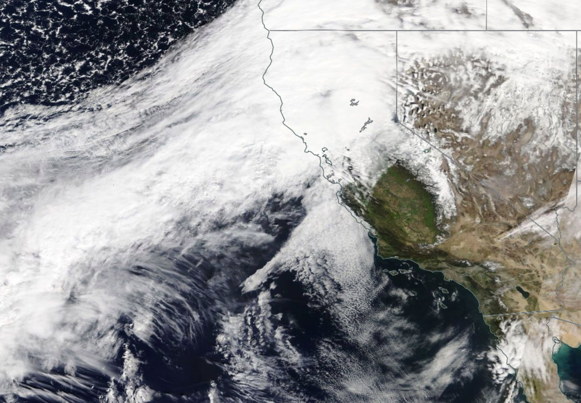
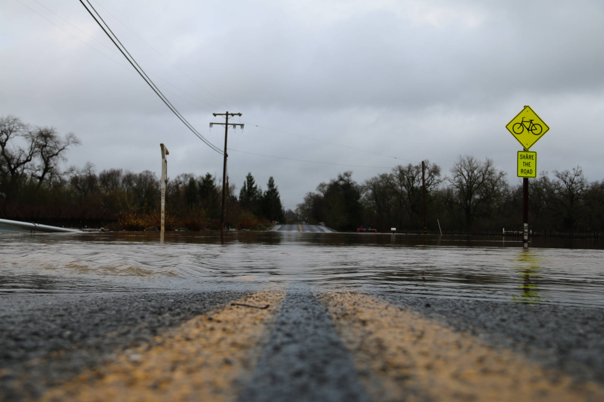
The river broke its banks Wednesday and reached a high of nearly 46 feet that night — the highest in more than 20 years — filling the stores and homes in downtown Guerneville with muddy water.

The Press Democrat spoke with Sonoma County Sheriff’s Sgt. Spencer Crum:

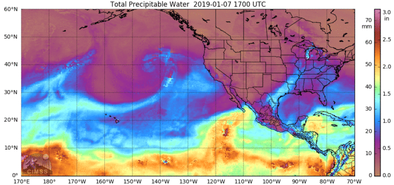
Among the organizations making inspections in the flooded areas along the Russian River include PG&E, the Sonoma County Department of Health Services and the county’s road maintenance team, Crum said. Each group will be on the look out of hazards caused by the atmospheric river that began on Monday, which include downed power lines and blocked roadways, he said.

Employees from Permit Sonoma will also enter the communities along the Russian River, when the roads become passable, to check flood-affected buildings, Sonoma County Supervisor Lynda Hopkins said.

Gov. Gavin Newsom on Thursday declared a state of emergency in Sonoma County, which Supervisor Hopkins welcomed.

"That was a critical step in allowing us to access additional resources that will help us to fund hopefully some of the major repairs," Hopkins said. "Unfortunately, in addition to the direct impacts to the flooding, we've had a number of road slides and anticipate extensive road damage to our rural road network."

Hopkins expected to survey the area Friday morning and help put together preliminary damage estimates to present to the state on Monday.

The Guerneville School District, Monte Rio School District, Montgomery School District and West Sonoma County Union High School District all remained closed Friday due to flooding, according to the Sonoma County Office of Education.

Update, 8:30 a.m. Thursday: The Russian River crested late Wednesday and has begun the long, slow process of receding. Residents, businesses and Sonoma County officials are bracing for the first view of what the flood left behind -- and for the big cleanup to come.

According to data from a U.S. Geological Survey gauge at Guerneville Bridge, the river hit 45.38 feet at 9 p.m. Wednesday and fluctuated within an inch or two of that level until midnight.

By 8 a.m. Thursday, the river had fallen to about 44 feet. It's expected to fall below flood stage about midnight Thursday.

Sonoma County emergency officials are asking those who remained in the flood zone to continue to shelter in place. Those who left homes along the river before the area was cut off will be allowed to return Friday or Saturday, officials said.

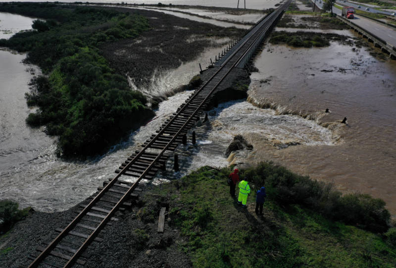
Both those who left and those who stayed face a big job: Assessing damage to communities along the river inundated by the flood and to roads and other infrastructure that took a beating from the prolonged intense rain earlier this week.

Images from Kent Porter, a photographer for the Santa Rosa Press Democrat who has been in Guerneville during the flooding, give some idea of the task facing the river towns.

In the meantime, communities across the county are still dealing with the effects of this week's storm, which dumped more than 21 inches of rain in the hills of western Sonoma County and huge amounts in the valleys as well:

  • Although water has retreated from many flooded roads, dozens of other remain closed, with some suffering major damage. See the county's road closure list.
  • More than a dozen school districts, many in the heart of the Russian River flood zone, canceled classes again Thursday. See county school closure list.
  • PG&E reports about 3,100 customers in western Sonoma County communities were without power early Thursday.

KQED's Danielle Venton contributed to this update.

Update, 2:55 p.m. Wednesday: The worst of the storm is over. But the worst of its impacts, with communities along the lower reaches of the Russian River cut off by still-rising floodwaters, may still be ahead.

The storm system that had been pumping a nonstop river of moisture into the North Bay moved south and east of the Bay Area early Wednesday, leaving showery weather behind across the Bay Area.

In Sonoma County, however, the Russian River continues to rise to a level predicted to be the highest since flooding on New Year's Day 1997.

The Russian River at Guerneville is on track to reach a crest of 45.6 feet Wednesday night-- 13.6 feet over flood stage and a level high enough to prompt mandatory evacuation orders for an estimated 4,000 residents along the waterway.

Daylight Wednesday morning showed a wide area of Sonoma County inundated by water rising in both the Russian River and creeks draining into it.

Much of Guerneville was awash:

Santa Rosa Press Democrat photographer Kent Porter, who stayed in Guerneville overnight, captured one rescue early Wednesday as the river rose:

Like Guerneville, the town of Monte Rio, a couple of miles downstream, was also cut off by flooded roads:

Other major storm impacts:

  • Sonoma County says dozens of roads have been closed by flooding. See list and interactive map.
  • PG&E reports about 4,400 North Bay customers without power -- and about 6,000 in all throughout the Bay Area in the wake of the storm.
  • More than 20 Sonoma County school districts, mostly along the Russian River, canceled classes Wednesday. See full list.

Update, 9:20 p.m. Tuesday: With the Russian River rising rapidly past flood stage, Sonoma County officials ordered mandatory evacuations for residents and businesses on a long stretch of the waterway from just below Cloverdale, through the Healdsburg and Guerneville areas, and all the way to the coastal community of Jenner.

The notice was issued as a rich stream of atmospheric moisture remained nearly stationary, pointing a steady stream of heavy precipitation into the North Bay counties. The deluge, which has continued with only brief breaks since early Monday, is expected to continue into early Wednesday morning.

"If you live in an evacuation area, we want you to leave now," Sonoma County Sheriff Mark Essick said at a 5:30 p.m. media briefing. "Please don't wait until 10 o'clock tomorrow night" — when the river is expected to crest 14 feet above flood stage at Guerneville — "please evacuate now."

The warning affects 25 communities in all, listed here.

The county has set up evacuation centers at the Sebastopol Center for the Arts and at the Sonoma County fairgrounds in Santa Rosa. Free shuttle buses began running from the Guerneville Veterans Memorial Building to the centers Tuesday afternoon.

The sheriff said 25 extra deputies and two boats were being deployed to the lower Russian River area to help people leave an area where many roads were already inundated by Tuesday afternoon.

Sheriff's Office spokeswoman Misti Harris said that despite Essick's plea, compliance with the evacuation order was "a mixed bag" Tuesday evening.

"We're getting mixed results from the public," Harris said. "Some people are flat-out refusing to leave."

The evacuation order was issued as the National Weather Service forecast the worst flooding along the river in a generation — exceeding a storm crest of 45 feet reached in 1997 but below catastrophic surges seen during February onslaughts in 1986 and 1995.

The service's California-Nevada River Forecast Center predicted the Russian River would exceed flood stage at Guerneville at 6 p.m. Tuesday and crest at 46.1 feet late Wednesday night before receding below flood level on Thursday night.

The flooding — which has closed dozens of roads across Sonoma County — is the result of the storm stalling and unleashing nearly nonstop downpours north of the Golden Gate.

That pummeling is expected to continue past midnight Tuesday before the storm shifts to the south and east. The National Weather Service's Weather Prediction Center, in College Park, Maryland, issued an advisory late Tuesday forecasting heavy rain across the entire region before the system passes. The center said rain rates as high as three-quarters of an inch per hour may occur in the Santa Cruz Mountains early Wednesday.

Daniel Swain, a climate scientist at UCLA, pointed to one factor above all for the soaking the North Bay has gotten from the second atmospheric river to come ashore in the North Bay this month.

"What's interesting about this one is that it's not an extreme atmospheric river from an intensity perspective," Swain said. "It's certainly wet, but if we had only a few hours of this in any one place it really wouldn't be any problem at all. But the main issue is that it's an atmospheric river of moderate intensity that's lasting for many, many hours in the same place, and the accumulation of water over that period is really quite substantial."

The rainiest locations in the Russian River watershed have received more than a foot of rain since the storm's onset early Monday, with the rain gauge at Venado, west of Healdsburg, recording a total of 16.16 inches through 7 p.m. Tuesday.

Similarly impressive amounts have been recorded throughout the area. Warm Springs Dam, on Dry Creek northwest of Healdsburg, has reported 7.94 inches during the storm. Santa Rosa has received 5.73 inches; Mount Veeder, west of the city of Napa, has recorded 10.12 inches; and Yountville, on the floor of the Napa Valley, has gotten 6.69 inches.

The heavy rainfall started rapid rises on the Napa River, which is forecast to reach flood stage at St. Helena and the city of Napa, though not to the potentially disastrous levels forecast for the Russian.

The river forecast center said the Napa would crest late tonight at St. Helena at about 3 feet above flood stage. In the city of Napa, the river is expected to reach its peak about dawn Wednesday.

The rising water led to some road closures across the Napa Valley on Tuesday, but even with the river exceeding flood levels, major damage is not anticipated.

"We have seen these river levels in Napa before and we generally know what to expect," said Rick Thomasser, flood control operations manager for Napa County.

The rainiest locations in the Russian River watershed have received more than a foot of rain since the storm's onset early Monday, with the rain gauge at Venado, west of Healdsburg, recording a total of 15.36 inches through 6 p.m. Tuesday.

Nine school districts in Sonoma County have canceled classes Wednesday due to the high water: Alexander Valley Union School District, Forestville Union School, Guerneville School District, Geyserville Unified School District, Harmony Union School District, Monte Rio School District, Montgomery Elementary School District, Oak Grove Union School District and El Molino High School and West County Charter Middle School, both in West Sonoma County Union High School District.

Update, 12:40 p.m. Tuesday: The deluge that has targeted Sonoma, Napa and Marin counties for more than a full day is now threatening to trigger a disaster along the lower reaches of the Russian River in western Sonoma County.

Sustained downpours have led to a sharp rise on the river, which is expected to begin inundating low-lying areas around Guerneville by early Tuesday evening. The river is forecast to crest at 45.9 feet — nearly 14 feet above flood stage — late Wednesday.

If that outlook from the California-Nevada River Forecast Center is accurate — and it's driven by the expectation of continued heavy rain north of the Golden Gate — much of Guerneville and the nearby communities of Rio Nido and Monte Rio will flood.

Sonoma County emergency officials issued an evacuation warning late Tuesday morning recommending those living near the river to evacuate. The county Sheriff's Office advised those who don't leave that they will be isolated as River Road — the main route into and out of the area — is expected to be flooded and impassable.

The county set up sandbag stations at the Forestville Fire Station, the Guerneville Safeway and at Main Street and Fir Road in Monte Rio.

The storm flooded roads across the North Bay — with Sonoma County reporting more than two dozen closures since midmorning Monday (see closure map).

People in the West Marin communities of Point Reyes Station and Inverness were advised to stay off the roads until floodwaters recede from local highways. The Bolinas-Stinson Union School District canceled classes at its two schools due to roads closed by flooding and downed trees.

The deluge was causing problems for sewer systems in the North Bay. One area of concern is the Sonoma Valley County Sanitation District, which experienced sewage overflow problems after heavy rains in January.

"Our crews were out all night responding to issues from the rain," said Ann DuBay of the Sonoma County Water Agency, which runs the sanitation district. "It’s unbelievable how much water we're seeing."

The district reported late Tuesday morning it was contending with four ongoing wastewater overflows, with a total of about 159,000 gallons of sewage and stormwater released.

In Marin, the Ross Valley Sanitation District said it had contingency plans in place as the storm challenged its system's capacity.

"This evening’s cloudbursts could push our ability to keep the wastewater in the sewers, and our crews are showing signs of fatigue," said Steve Moore, the district's general manager.

The Napa River is also expected to flood late Tuesday into Wednesday — though not to the disastrous extent predicted for the Russian River. Moderate flooding is forecast for areas along the river from St. Helena to the city of Napa.

The forecast flooding on the North Bay rivers is the result of an atmospheric river-fed storm that has remained focused on a narrow area of the North Bay counties since early Monday.

That rich flow of moisture-laden air, coupled with a slow-moving cold front draped across the coast just to the north, has resulted in spectacular rainfall totals in the Russian River drainage.

The heaviest rainfall total in the current storm: 11.03 inches, recorded through 10 a.m. Tuesday at the northern Sonoma County rain gauge in Venado, west of Healdsburg.

Other notable totals include Mount Veeder, west of Napa, 7.83; Olema, 5.47; Kentfield, 4.93; Mount Tamalpais, 4.68; and Santa Rosa, 3.97.

More modest amounts fell to the south, including Richmond, 1.50; Vollmer Peak (Berkeley Hills), 1.32; San Francisco, .40; and Oakland, .34. Most Peninsula and East Bay locations have gotten just a few hundredths of an inch of rain from the storm. A rain gauge near Boulder Creek in the Santa Cruz Mountains — a dependably soggy spot — has gotten a scant .63 of an inch since the storm began. San Jose International Airport had recorded zero rainfall as of 10 a.m.

Gusty winds accompanying the storm have led to power outages around the region, with PG&E saying early Tuesday it was working to restore electricity to about 12,000 customers. The biggest outage, by far, was for a stretch of the San Mateo County coast outside the heavy rain zone, where the lights were out for about 9,400 customers.

Forecasters and weather models suggest that will change by Wednesday morning as the approaching cold front finally moves through the region and rainfall — heavy at times — is more evenly distributed. Showery weather is expected to continue into Thursday before a brief break on Friday. More rain is expected over the weekend.

Update 5:50 p.m. Monday: Rain has returned to the Bay Area — or part of it anyway, as our latest atmospheric river-fed storm pours most of its abundant supply of moisture on the North Bay.

The heaviest rainfall total in the current storm: 4.08 inches, recorded through 5 p.m. at the northern Sonoma County rain gauge in Venado, west of Healdsburg. Rainfall amounts fall off dramatically to the south, and include Mount Veeder, west of the Napa Valley, 1.50; Santa Rosa, 1.08; San Rafael (Marin Civic Center), .91; Mount Tamalpais, .78; Vollmer Peak (Berkeley Hills), .29; Richmond, .18; San Francisco, .11; and Oakland, .05.

Virtually no rain had been recorded by midafternoon Monday in bayside and valley locations south of a line from Daly City to Livermore, except for a few hundredths of an inch recorded at several stations in the Santa Cruz Mountains.

The National Weather Service says that through late Monday, heavy rainfall will be confined almost exclusively to the North Bay before moving slowly south early Tuesday.

The copious rainfall in Sonoma, Marin and Napa counties is forecast to cause a new round of flooding on the lower reaches of the Russian River. The normally sluggish stream is expected to reach flood stage at Guerneville before dawn Wednesday and to crest Wednesday evening at about 6.5 feet above flood stage.

The Napa River, too, is expected to overflow early Wednesday, reaching 2 feet above flood stage and inundating areas adjacent to the river on the northern and southern ends of the city.

Original post (last updated 8:40 a.m. Monday):

Yet another winter storm fed by an atmospheric river is expected to bring 9 inches of rain or more to the wettest locations of the North Bay, triggering another round of flooding on the lower reaches of the Russian River.

The Sierra Nevada, which has already received an epic snowfall this season, could see another 10 feet at the highest elevations and 5 to 7 feet at pass levels by Thursday.

With the storm crawling south along the coast, the National Weather Service issued flood watches for most of the Bay Area. Those include a flash flood watch for the central Bay Area and South Bay through late Tuesday night and a flood watch for Sonoma, Napa and Marin counties.

"The next few days are going to be rather hectic up in the North Bay," said National Weather Service meteorologist Steve Anderson. He says the rain will start in the North Bay Monday morning, with heavy rains showing up by the evening commute and continuing overnight into Tuesday.

The California Nevada River Forecast Center says the Russian River will go above flood levels at Guerneville on Wednesday morning, before hitting its peak about 5 feet above flood stage late Wednesday evening. The Napa River on the north side of the city of Napa is predicted to top flood levels by just over a foot before dawn on Wednesday.

Both rivers flooded during storms earlier this month, leading to school closures. With the soil already saturated from those earlier storms, this week's deluge could also flood creeks and smaller rivers throughout the region.

Officials in Napa and Marin counties say they are monitoring the storm. A Marin spokesman said the county will consider increasing staff for both public works and fire departments around midday on Monday based on updated forecast information. The county will also be monitoring the levees around Highway 37 — which breached during the last wave of storms — and the levels of Corte Madera Creek.

An aerial view of a levee that was breached during a storm on Feb. 14, 2019, in Novato, California. (Justin Sullivan/Getty Images)

Anderson said the rest of the Bay Area will also likely see some heavy rains, with 2 to 3 inches forecast for the central Bay Area and up to an inch in the South Bay. He said winds will also surge during the storm, starting Monday night and peaking on Tuesday between 30 and 40 mph.

"We expect more trees to come down during those winds," Anderson said. A PG&E spokeswoman said the storm "could cause trees and other debris to bring down power lines, damage equipment and interrupt electric service."

Storm to Add Even More Snow to State's Snowpack

Satellite view of the Sierra Nevada and western Nevada from Yosemite National Park, at lower left, to Walker Lake, at the top of the images toward the right. The 'before' image was taken Feb. 16, 2018; the 'after' image on Feb. 11, 2019. (Planet)

The storm is also expected to bring several inches of rain to the Sacramento Valley and 5 to 7 feet of snow to pass levels in the Sierra Nevada, according to National Weather Service meteorologist Cory Mueller.

"It's going to be a pretty impactful storm system," Mueller said. "We're also going to see some flooding concerns." He said both creeks and rivers are expected to rise with the potential for street flooding.

Like the Bay Area, heavy precipitation is expected to start Monday night and continue through Wednesday morning, "but snow will continue in the mountains, and mountain travel will continue to be quite terrible into Thursday," Mueller said.

Mueller said snow is expected starting at 5,500 feet, and rain at lower elevations could melt some of the snow that fell there during earlier storms. The additional snow at high elevations should add onto a snowpack that is currently 127 percent of average in the northern Sierra and 152 percent in the central Sierra, according to Mueller.

"The main takeaway is our snowpack is well above average," he said.

Sponsored

KQED's Ted Goldberg and Marisol Medina contributed to this post.

Sponsored

lower waypoint
next waypoint
California Law Letting Property Owners Split Lots to Build New Homes Is 'Unconstitutional,' Judge RulesAlameda: The Island That Almost Wasn’tJust Days Left to Apply for California Program That Helps Pay for Your First HouseIn Fresno’s Chinatown, High-Speed Rail Sparks Hope and Debate Within ResidentsFresno's Chinatown Neighborhood To See Big Changes From High Speed RailRainn Wilson from ‘The Office’ on Why We Need a Spiritual RevolutionIs California Headed For Another Tax Revolt?Will Less Homework Stress Make California Students Happier?NPR's Sarah McCammon on Leaving the Evangelical ChurchUC Regent John Pérez on the Gaza Protests Roiling College Campuses