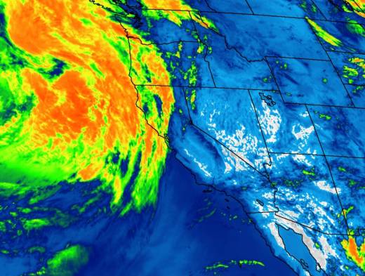
Update, 10:35 a.m. As advertised by human forecasters and their numerical weather models, this morning's rain has been heaviest north of the Golden Gate, with mostly light -- very light -- totals to the south and east.
Here are 28 locations in the greater Bay Area (and slightly beyond) and their rainfall totals through 10 a.m.:
| Location | Rain amount |
|---|---|
| Mount Tamalpais Middle Peak | 0.58 |
| Dillon Beach (Marin County) | 0.40 |
| Venado (Sonoma County) | 0.40 |
| Olema Valley | 0.39 |
| Point Reyes | 0.25 |
| St. Helena | 0.24 |
| Santa Rosa-Charles Schulz Airport | 0.22 |
| Sacramento International Airport | 0.22 |
| Angwin (Napa County) | 0.20 |
| Napa Airport | 0.20 |
| Mill Valley | 0.19 |
| Mount Veeder | 0.19 |
| Point Reyes Station | 0.19 |
| Barnaby (West Marin) | 0.17 |
| Kentfield | 0.11 |
| Novato Library | 0.08 |
| San Francisco | 0.05 |
| Vacaville | 0.05 |
| Vollmer Peak (Berkeley Hills) | 0.05 |
| Half Moon Bay | 0.03 |
| Lake Berryessa | 0.03 |
| Oakland Int'l Airport | 0.02 |
| San Rafael | 0.02 |
| Briones | 0.01 |
| Orinda Fire Station | 0.01 |
| Rodeo | 0.01 |
| SFO Int'l Airport | 0.01 |
| Concord | 0.01 |
Original post: The Bay Area is in for a semi-unusual weather event beginning early Thursday: June rain.
We say semi-unusual, or perhaps quasi-atypical, because while rain in June is a relatively infrequent occurrence in most of California -- with no precipitation recorded in 53 of the 167 Junes in the San Francisco weather record -- it is not at all unheard of.
It last rained in June all the way back in 2015, when San Francisco got .01 of an inch on the 1st of the month and .11 on the 10th. The last June you might call rainy was in 2011, when the city recorded 2.02 inches, including .99 on June 4 and .81 on June 28.

We'll get back to the historical record after taking a look into the immediate future.

