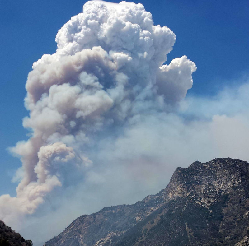
The Rough Fire, burning in and near Kings Canyon National Park, has prompted new evacuations. (Fresno County Sheriff's Office)
Update, 4:45 p.m., Friday, Sept. 11:
Fresno health officials are alerting county residents to limit all outdoor activities as the Rough Fire rains ash on Fresno.
Fresno County's department of public health reports a 411 percent increase in emergency room visits over the past 72 hours due to respiratory issues and a 90 percent increase in visits due to cough.
Update, 11 a.m., Friday, Sept. 11: Smoke from the Rough Fire is affecting Fresno residents, reports KQED Central Valley Bureau Chief Sasha Khokha, who lives in the city.
"People are joking about how it feels like they're smoking a pack an hour," she said. "It was raining ash this morning when I took my kids to school, and it got into the car, and my kid said, 'I can't breath, we have to get out of here.' It's very palpable; it feels like a curtain of smog that’s trapped us. The sky is bizarrely yellowish-gray."
Khokha said the head pediatric nurse at Children's Hospital told her there's been a 25 percent spike in kids coming in for respiratory problems, and that even children with healthy lungs were coming in with a hacking cough and burning eyes. Fresno Unified School District has been routinely cancelling outdoor activity.
"You should do everything possible to get inside," Jaime Holt, a spokeswoman for the San Joaquin Valley Air Pollution Control District, told Khokha. Holt said the air quality was "probably some of the worst" the district had seen all year.
The fire has so far spared lives and homes. But it has exposed one of the obscured effects that four years of record drought has unleashed here: dangerous drops in air quality that exacerbate public health problems in this region and threaten to choke the quality of life.
“With the fire, even with my inhaler, I’m still wheezing,” Antoinette Wyer, 48, an asthmatic who has lived her whole life here, said at a health clinic on Wednesday. She has kept her 3-year-old grandson inside this week, while a 4-year-old grandson has stayed home from school.
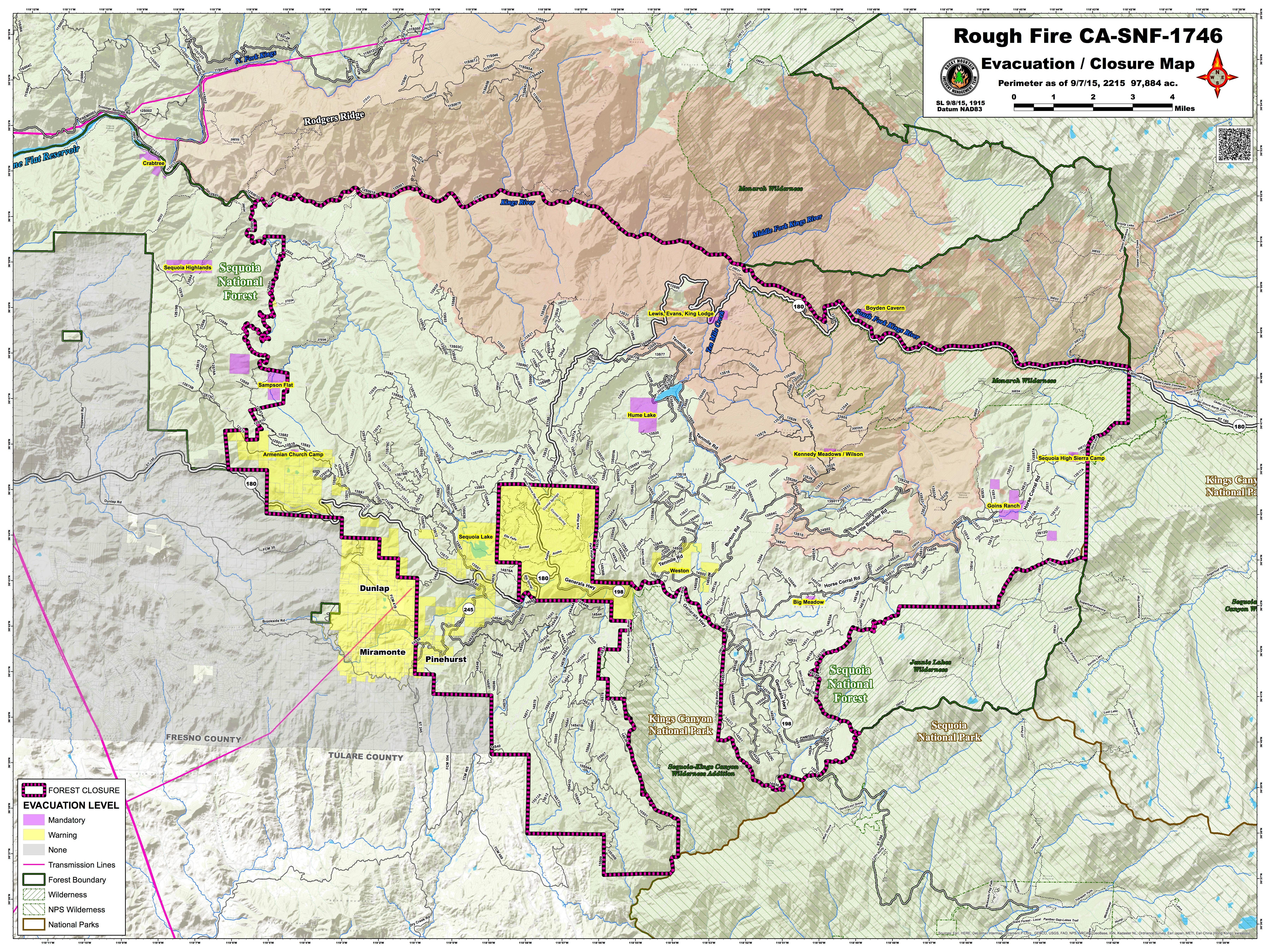
An evacuation warning has been implemented on the following area within Fresno County:
All private lands adjacent to Highway 180 between the Highway 180/Dunlap Road junction east to the 42000 block of Highway 180.
A mandatory evacuation has been implemented on the following area within Fresno County:
All private lands adjacent to Millwood Road beginning at the 40000 block of Millwood Road east to the Millwood Road/Todd Eymann Road junction; then adjacent to Todd Eymann Road southeast to the Todd Eymann Road/Highway 245 junction; then adjacent to Highway 245 northeast to the Highway 245/Highway 180 junction.
The Fresno Bee reported Thursday that the Rough Fire is now bearing down on the famous giant sequoia trees in Kings Canyon National Park and Sequoia National Forest. Those include the Boole Tree, located in Converse Basin, which the National Forest Service says is known as the sixth largest tree in the world.
From the Bee:
Rough fire public information officer Andy Isolano said the Converse Basin, home to a grove of around 60 giant sequoia trees, is now in the active fire area. It’s hard for the nearly 2,200 firefighters to know exactly where the flames are at all times, Isolano said, so they rely on maps provided each morning after planes fly overhead each night. The fire is expected to spread to the basin within 24 hours, but weather and other factors could alter its course.
But Isolano downplayed the threat. "The forest has probably burned like this in the last 500 years, and they’re still standing," he said.
Update, 12:40 p.m. Thursday, Sept. 10: More Rough Fire evacuation orders this morning. The National Park Service has issued an evacuation order that went into effect at 6 a.m. for "park visitors, park employees, concessions staff, and residents of Wilsonia, in the Grant Grove area of Kings Canyon National Park. The National Park Service is working with the Sheriff's Departments of both Fresno County and Tulare County to provide the evacuation notifications."
Sequoia Canyon Kings Park said such an order is issued when potential or actual threat to civilian life within one to two hours exists, or when an "incident commander deems it necessary to protect civilians."
In addition, park officials have closed the Grant Grove area.
All access to Highway 180 is closed east of Dunlap Road. Dunlap Road itself is currently open. The Generals Highway (sometimes referred to as Highway 198) is closed at the Red Fir Gate (which is west of Wuksachi Village). Sequoia National Park remains open and visitors can still use the Ash Mountain Entrance Station. Vehicles longer than 22 feet (including trailers) are not advised between Potwisha and Giant Forest Museum.
The Red Cross has opened a shelter at the Sanger Community Center, at 730 Recreation Drive, in Sanger.
Here is video of yesterday's community meeting, held by an official of the Rocky Mountain Incident Management team. The meeting begins five minutes into the stream.
One official at the meeting said, "This fire is doing things to us that with the best available science we have at our disposal, some of the things it's done, based on a math calculation, has been less than a 2 percent probability of an event occurring. And that has become an everyday occurrence at this point."
The size of the fire now stands at more than 110,000 acres. Containment is 29 percent. Here is the latest map of the fire's progression, to Sept. 8.
And here is today's Air Quality Status and Forecast from the San Joaquin Valley Air Pollution Control District. Air quality today is rated as "unhealthy for sensitive groups," from San Joaquin County south to Kern County.
Update, 12:20 p.m. Wednesday, Sept. 9: The Fresno County Sheriff's Office has ordered residents of three rural communities near the southwestern front of the Rough Fire to be ready to evacuate immediately as the fire continues to spread.
Map showing evacuation orders and warnings in effect near the perimeter of the Rough Fire in Fresno County. (Click for full size image.) (U.S. Forest Service)
The new evacuation warnings were issued late Tuesday for areas on both sides of Highway 180 just east of Kings Canyon National Park, including the Hye Armenian Church Camp and the hamlets of Dunlap, Miramonte and Pine Grove. Separately, national park officials advised park employees and visitors in Kings Canyon's Grant Grove area to be ready to evacuate.
The U.S. Forest Service says that as of Wednesday morning, the fire has consumed 103,244 acres -- 161 square miles, or more than triple the area of San Francisco.
Smoke from the fire has drifted west into the San Joaquin Valley, triggering air quality warnings for millions of residents in eight counties. Air is rated as unhealthy for sensitive groups -- people with respiratory or cardiac disease -- in the cities of Fresno, Bakersfield, Hanford, Visalia and Merced.
The poor air quality, along with a forecast high temperature of 105, prompted the Fresno Unified School District to cancel PE classes and recess for the second day in a row. Outdoor athletic activities, like team practices, have been canceled or moved indoors. The neighboring Clovis school district also canceled outdoor activities.
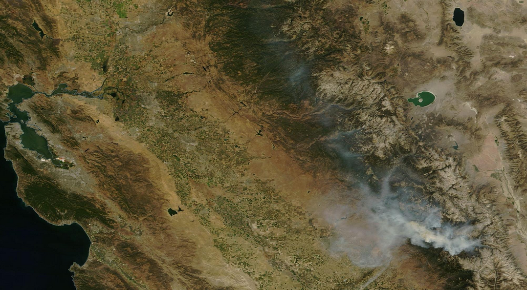
Update, 9:35 a.m. Tuesday, Sept. 8: The Rough Fire, a blaze that is likely to continue burning until the (desperately hoped for) first storms of the wet season, is continuing to spread and has forced new evacuations near Highway 180 east of Fresno and west of Kings Canyon National Park.
NASA satellite view showing smoke from the Rough Fire spreading north and west over the Sierra Nevada and San Joaquin Valley. (Click for larger image.) (NASA Worldview)
As of Tuesday morning, the fire has burned 97,884 acres -- almost exactly 153 square miles, or double the area of Oakland. Federal fire managers report the blaze, which started with a lightning strike at the end of July, is 31 percent contained.
The new evacuation area is on the southwestern front of the fire, north of Highway 180 nearly all the way up to the Kings River -- about 6 miles as the crow flies. It's a very sparsely settled area with several Sierra National Forest campgrounds along the Kings and nearby creeks.
Smoke from the fire, which had been largely trapped in the deep river canyons near its source, has been dispersing north and west through the Sierra Nevada and San Joaquin Valley. The valley's air pollution control district says particulate levels are unhealthy for sensitive groups -- people suffering from heart disease or respiratory conditions, including asthma.
About 1,900 personnel have been assigned to combat the Rough Fire. Managers reported one injury over the weekend -- a member of a hotshot crew who suffered burns while monitoring a control line in a remote area. He was evacuated "conscious and in good spirits," and is said to be in stable condition.
Update, 9:05 a.m. Monday, Sept. 7: Due to smoke, equipment and extra individuals in the area, fire officials are urging caution in driving around the area of the Rough Fire, burning along the King River east of Fresno and west of Kings Canyon National Park. The fire is the largest active blaze in the state and the biggest of 2015.
"Please drive with your headlights on, put cell phones in a location where they will not distract you, and drive slower than normal, " a fire update from InciWeb says.
The fire now stands at 95,183 acres, the vast majority of those in the Sierra National Forest and Sequoia National Forest. Containment is now 31 percent. The fire, which was started by lightning on July 31, has been burning for well over a month.
Update, 9:20 a.m. Tuesday, Sept. 1: Briefly: The U.S. Forest Service reports the Rough Fire has now grown to 77,287 acres -- nearly 120 square miles, equivalent to two-thirds the area of the city of San Jose -- and remains 25 percent contained.
One big issue for firefighting: Relatively calm, cool and humid weather has dampened fire activity but has also meant that smoke is settling into river canyons and valleys near Kings Canyon National Park. That's led to very poor air quality and made visibility bad enough that it's limiting flights by helicopters used to drop water on the blaze.
Update, 11 a.m, Monday, Aug. 31: Fire managers reported Monday that the Rough Fire, burning along the King River east of Fresno and just west of Kings Canyon National Park, is now 72,300 acres and 25 percent contained. The main spread of the fire is now east through the Monarch Wilderness and northeast up the Middle Fork of the Kings into a remote area called Little Tehipite Valley. Crews are undertaking structure defense measures in the national park's Cedar Grove area, though the fire is still 5 to 7 miles away from the lodge and other facilities there.
The fire's current acreage makes it California's biggest fire so far in 2015 -- ahead of the now-contained Rocky Fire in Lake County and the River Complex Fire in Trinity County. The Rocky Fire burned just over 69,000 acres; the River Complex has burned just under 69,000 acres and is 45 percent contained.
The Rough and River Complex fires were among dozens of blazes sparked by lightning at the end of July and the beginning of August. The Rocky Fire began July 29 a faulty gas hot-water heater started a building on fire just outside the town of Lower Lake; that blaze ignited nearby vegetation and triggered a conflagration that eventually burned 43 homes and 56 outbuildings.
Update, 9:15 a.m. Monday, Aug. 24: The teams managing the battle against the Rough Fire, east of Fresno along the Kings River, reported significant progress Monday morning:
Area and containment: 49,440 acres, or about 77 square miles, and 17 percent contained. The fire's growth slowed markedly over the weekend, with less than 3,000 additional acres burned since Friday after exponential growth last week. Containment stood at just 3 percent Saturday.
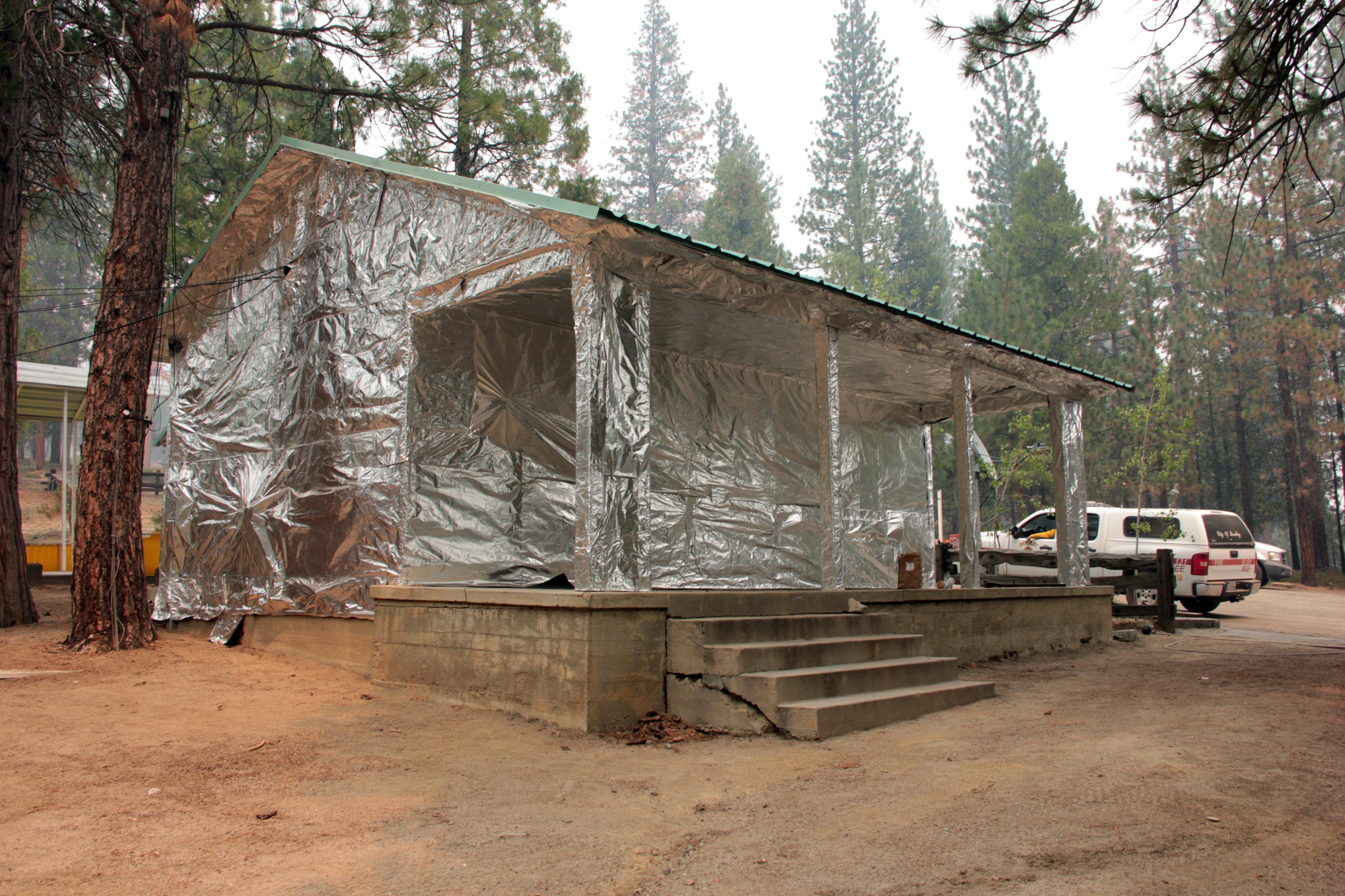
Hume Lake update: Fire managers say that aggressive firefighting tactics around the Hume Lake camp community "have reduced the threat to commercial and residential structures" in the area. The Hume Lake fire blog says that Sunday passed without an immediate threat from the fire, but notes the threat continues for several other facilities in the area.
National park impact: Parts of King Canyon National Park that officials closed because of the fire will begin to reopen Monday. See the official advisory for details.
A building at the Hume Lake camp, wrapped to resist ignition as the Rough Fire advanced through the adjacent forest. (Inciweb)
Update, 11:50 a.m. Sunday, Aug. 23: Developments on the Rough Fire, burning east of Fresno along Kings River and into Kings Canyon National Park:
Acreage: The fire now stands at 47,396 acres, or about 74 square miles. That's equivalent to roughly two-thirds the area of Fresno, a city of about half a million, or to nearly the entire area of Oakland, population 400,000-plus. The fire, which broke out in early August and grew slowly until last weekend, has doubled in size in the past three or four days and is 7 percent contained. In their Sunday morning update, though, fire managers said the blaze grew very little on Saturday, permitting crews to make some progress in containing it.
National Forest Service map of the Rough Fire perimeter, Aug. 22, 2015. Click for larger image. (Inciweb)
Damage: Kings Canyon Lodge, a well-known inn along Highway 180, the route to the national park, has burned down. The Fresno Bee reports: "Holes in the ground near the lodge were still smoking as of 5:30 p.m. Friday. Abandoned yellow fire hoses surrounded the wreckage – many of them melted at various portions. Firefighters back-burning on Highway 180 said they had no idea the lodged had burned down. The lodge had remained open until Cedar Grove evacuations on Monday."
National park impact: Some sections of Kings Canyon National Park are temporarily closed, and the air is smoky in much of the area. See the current advisory.
Saving a camp: The Hume Lake Christian Camps, a popular religious retreat for youth and adults, was evacuated earlier this week and has been turned into a base for firefighters. Crews using backfires and aided by air tankers have managed so far to keep the blaze, which has reached the lake's eastern end, from getting to the camp. The camp organization is publishing a detailed blog on the fight to save the facility.
Update, 2:55 p.m., Tuesday, Aug. 18: Fire managers report the Rough Fire, burning in the Sierra near the route from Fresno to Kings Canyon National Park, has continued to grow. The current acreage estimate: 23,600, or about 37 square miles. The biggest growth in the fire in the past 24 hours has been to drainages on the northwest side of the blaze.
Original post and radio story (Monday, Aug. 17): Steep, rough terrain was making it hard for firefighters to get a handle Monday on a growing fire raging in and around Kings Canyon National Park, east of Fresno.
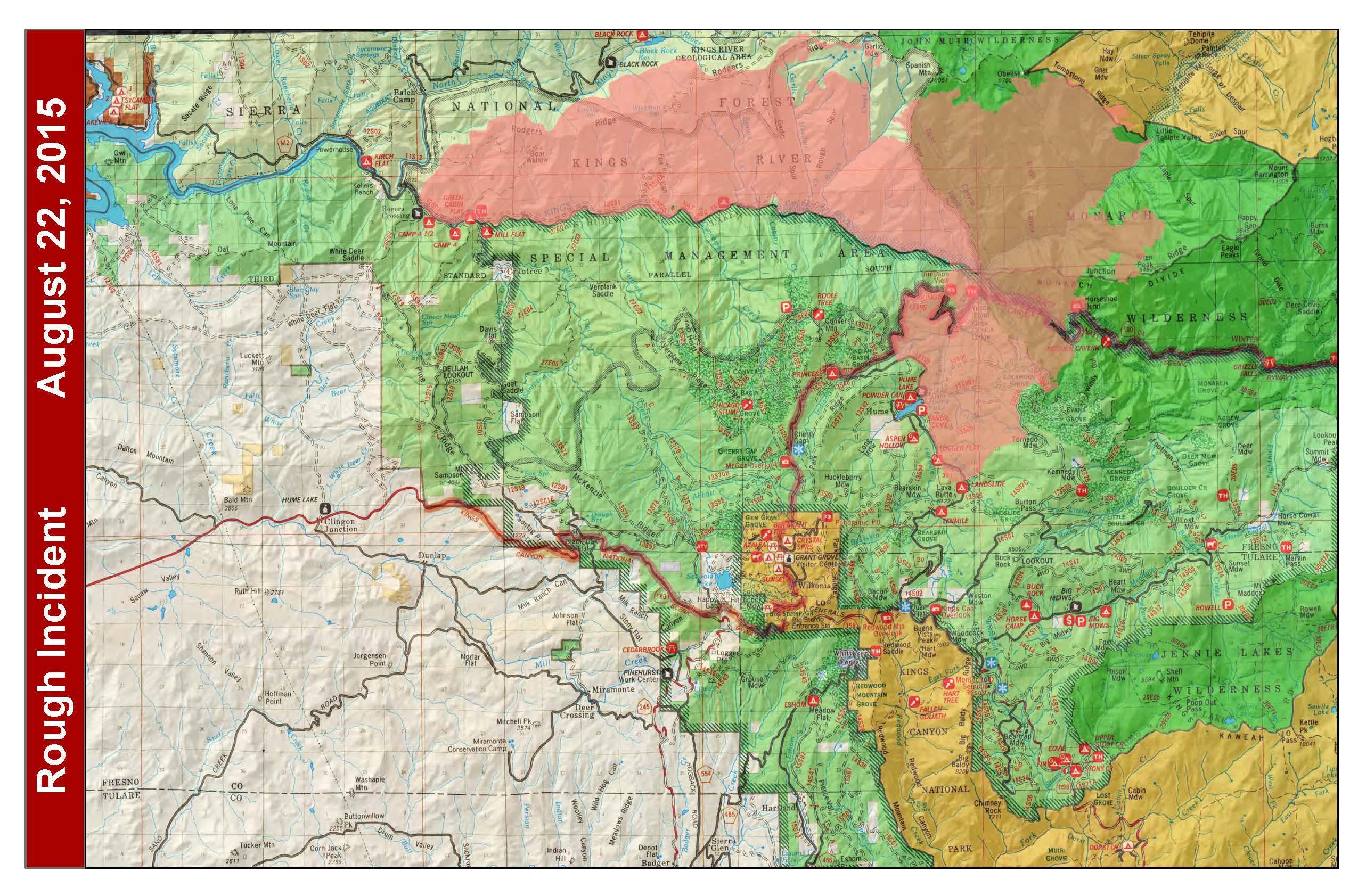
Map showing progression of the Rough Fire, burning in the Sierra east of Fresno, since it began as a small lightning-sparked fire in early August. Click for larger image. (Inciweb)
KQED’s Sasha Khokha reports the Rough Fire has burned more than 20,000 acres and is still zero percent contained.
Lightning sparked the fire more than two weeks ago, but it took a turn with this weekend’s hot weather.
The fire isn’t threatening any buildings. But officials have shut down the only road into the Cedar Grove area of the park, which meant closing campgrounds and a lodge there.
Smoke from the fire is affecting air quality near some popular giant Sequoia groves and mountain lakes.
The Rough Fire grew to more than 20,000 acres on Aug. 17. (U.S. Forest Service)
"This is actually one of the deepest canyons in North America," Mike Theune, fire information officer with Sequoia & Kings Canyon National Parks, told Khokha. "You’re talking sheer cliff walls. You’re talking slopes that anything rolling on it is going to keep on rolling.
"Being so steep and rugged makes firefighting really tough. This is a very, very challenging fire," he said.
Another challenge, reports Khokha: Because it’s a wilderness area, firefighters have to be light on the land and not use flame retardant that will impact the sensitive watershed.
The fire is currently the fifth largest of more than a dozen wildfires reported across California.
The Fresno Bee reports a mandatory evacuation was ordered in Cedar Grove and "320 campsites, a 20-room lodge and restaurant, campground store, and a pack station were closed."
Fire officials said a strong high pressure system was expected to bring warmer, drier conditions, along with light winds.
lower waypointnext waypoint
Player sponsored by
window.__IS_SSR__=true
window.__INITIAL_STATE__={
"attachmentsReducer": {
"audio_0": {
"type": "attachments",
"id": "audio_0",
"imgSizes": {
"kqedFullSize": {
"file": "https://ww2.kqed.org/news/wp-content/themes/KQED-unified/img/audio_bgs/background0.jpg"
}
}
},
"audio_1": {
"type": "attachments",
"id": "audio_1",
"imgSizes": {
"kqedFullSize": {
"file": "https://ww2.kqed.org/news/wp-content/themes/KQED-unified/img/audio_bgs/background1.jpg"
}
}
},
"audio_2": {
"type": "attachments",
"id": "audio_2",
"imgSizes": {
"kqedFullSize": {
"file": "https://ww2.kqed.org/news/wp-content/themes/KQED-unified/img/audio_bgs/background2.jpg"
}
}
},
"audio_3": {
"type": "attachments",
"id": "audio_3",
"imgSizes": {
"kqedFullSize": {
"file": "https://ww2.kqed.org/news/wp-content/themes/KQED-unified/img/audio_bgs/background3.jpg"
}
}
},
"audio_4": {
"type": "attachments",
"id": "audio_4",
"imgSizes": {
"kqedFullSize": {
"file": "https://ww2.kqed.org/news/wp-content/themes/KQED-unified/img/audio_bgs/background4.jpg"
}
}
},
"placeholder": {
"type": "attachments",
"id": "placeholder",
"imgSizes": {
"thumbnail": {
"file": "https://cdn.kqed.org/wp-content/uploads/2024/12/KQED-Default-Image-816638274-2000x1333-1-160x107.jpg",
"width": 160,
"height": 107,
"mimeType": "image/jpeg"
},
"medium": {
"file": "https://cdn.kqed.org/wp-content/uploads/2024/12/KQED-Default-Image-816638274-2000x1333-1-800x533.jpg",
"width": 800,
"height": 533,
"mimeType": "image/jpeg"
},
"medium_large": {
"file": "https://cdn.kqed.org/wp-content/uploads/2024/12/KQED-Default-Image-816638274-2000x1333-1-768x512.jpg",
"width": 768,
"height": 512,
"mimeType": "image/jpeg"
},
"large": {
"file": "https://cdn.kqed.org/wp-content/uploads/2024/12/KQED-Default-Image-816638274-2000x1333-1-1020x680.jpg",
"width": 1020,
"height": 680,
"mimeType": "image/jpeg"
},
"1536x1536": {
"file": "https://cdn.kqed.org/wp-content/uploads/2024/12/KQED-Default-Image-816638274-2000x1333-1-1536x1024.jpg",
"width": 1536,
"height": 1024,
"mimeType": "image/jpeg"
},
"fd-lrg": {
"file": "https://cdn.kqed.org/wp-content/uploads/2024/12/KQED-Default-Image-816638274-2000x1333-1-1536x1024.jpg",
"width": 1536,
"height": 1024,
"mimeType": "image/jpeg"
},
"fd-med": {
"file": "https://cdn.kqed.org/wp-content/uploads/2024/12/KQED-Default-Image-816638274-2000x1333-1-1020x680.jpg",
"width": 1020,
"height": 680,
"mimeType": "image/jpeg"
},
"fd-sm": {
"file": "https://cdn.kqed.org/wp-content/uploads/2024/12/KQED-Default-Image-816638274-2000x1333-1-800x533.jpg",
"width": 800,
"height": 533,
"mimeType": "image/jpeg"
},
"post-thumbnail": {
"file": "https://cdn.kqed.org/wp-content/uploads/2024/12/KQED-Default-Image-816638274-2000x1333-1-672x372.jpg",
"width": 672,
"height": 372,
"mimeType": "image/jpeg"
},
"twentyfourteen-full-width": {
"file": "https://cdn.kqed.org/wp-content/uploads/2024/12/KQED-Default-Image-816638274-2000x1333-1-1038x576.jpg",
"width": 1038,
"height": 576,
"mimeType": "image/jpeg"
},
"xxsmall": {
"file": "https://cdn.kqed.org/wp-content/uploads/2024/12/KQED-Default-Image-816638274-2000x1333-1-160x107.jpg",
"width": 160,
"height": 107,
"mimeType": "image/jpeg"
},
"xsmall": {
"file": "https://cdn.kqed.org/wp-content/uploads/2024/12/KQED-Default-Image-816638274-2000x1333-1-672x372.jpg",
"width": 672,
"height": 372,
"mimeType": "image/jpeg"
},
"small": {
"file": "https://cdn.kqed.org/wp-content/uploads/2024/12/KQED-Default-Image-816638274-2000x1333-1-672x372.jpg",
"width": 672,
"height": 372,
"mimeType": "image/jpeg"
},
"xlarge": {
"file": "https://cdn.kqed.org/wp-content/uploads/2024/12/KQED-Default-Image-816638274-2000x1333-1-1020x680.jpg",
"width": 1020,
"height": 680,
"mimeType": "image/jpeg"
},
"full-width": {
"file": "https://cdn.kqed.org/wp-content/uploads/2024/12/KQED-Default-Image-816638274-2000x1333-1-1920x1280.jpg",
"width": 1920,
"height": 1280,
"mimeType": "image/jpeg"
},
"guest-author-32": {
"file": "https://cdn.kqed.org/wp-content/uploads/2025/01/KQED-Default-Image-816638274-1333x1333-1-160x160.jpg",
"width": 32,
"height": 32,
"mimeType": "image/jpeg"
},
"guest-author-50": {
"file": "https://cdn.kqed.org/wp-content/uploads/2025/01/KQED-Default-Image-816638274-1333x1333-1-160x160.jpg",
"width": 50,
"height": 50,
"mimeType": "image/jpeg"
},
"guest-author-64": {
"file": "https://cdn.kqed.org/wp-content/uploads/2025/01/KQED-Default-Image-816638274-1333x1333-1-160x160.jpg",
"width": 64,
"height": 64,
"mimeType": "image/jpeg"
},
"guest-author-96": {
"file": "https://cdn.kqed.org/wp-content/uploads/2025/01/KQED-Default-Image-816638274-1333x1333-1-160x160.jpg",
"width": 96,
"height": 96,
"mimeType": "image/jpeg"
},
"guest-author-128": {
"file": "https://cdn.kqed.org/wp-content/uploads/2025/01/KQED-Default-Image-816638274-1333x1333-1-160x160.jpg",
"width": 128,
"height": 128,
"mimeType": "image/jpeg"
},
"detail": {
"file": "https://cdn.kqed.org/wp-content/uploads/2025/01/KQED-Default-Image-816638274-1333x1333-1-160x160.jpg",
"width": 160,
"height": 160,
"mimeType": "image/jpeg"
},
"kqedFullSize": {
"file": "https://cdn.kqed.org/wp-content/uploads/2024/12/KQED-Default-Image-816638274-2000x1333-1.jpg",
"width": 2000,
"height": 1333
}
}
},
"news_10674822": {
"type": "attachments",
"id": "news_10674822",
"meta": {
"index": "attachments_1716263798",
"site": "news",
"id": "10674822",
"found": true
},
"parent": 10647267,
"imgSizes": {
"jmtc-small-thumb": {
"file": "https://ww2.kqed.org/app/uploads/sites/10/2015/09/roughfire150909-280x150.png",
"width": 280,
"mimeType": "image/png",
"height": 150
},
"thumbnail": {
"file": "https://ww2.kqed.org/app/uploads/sites/10/2015/09/roughfire150909-400x228.png",
"width": 400,
"mimeType": "image/png",
"height": 228
},
"post-thumbnail": {
"file": "https://ww2.kqed.org/app/uploads/sites/10/2015/09/roughfire150909-672x372.png",
"width": 672,
"mimeType": "image/png",
"height": 372
},
"kqedFullSize": {
"file": "https://ww2.kqed.org/app/uploads/sites/10/2015/09/roughfire150909.png",
"width": 951,
"height": 542
},
"guest-author-96": {
"file": "https://ww2.kqed.org/app/uploads/sites/10/2015/09/roughfire150909-96x96.png",
"width": 96,
"mimeType": "image/png",
"height": 96
},
"medium": {
"file": "https://ww2.kqed.org/app/uploads/sites/10/2015/09/roughfire150909-800x456.png",
"width": 800,
"mimeType": "image/png",
"height": 456
},
"guest-author-64": {
"file": "https://ww2.kqed.org/app/uploads/sites/10/2015/09/roughfire150909-64x64.png",
"width": 64,
"mimeType": "image/png",
"height": 64
},
"detail": {
"file": "https://ww2.kqed.org/app/uploads/sites/10/2015/09/roughfire150909-75x75.png",
"width": 75,
"mimeType": "image/png",
"height": 75
},
"guest-author-32": {
"file": "https://ww2.kqed.org/app/uploads/sites/10/2015/09/roughfire150909-32x32.png",
"width": 32,
"mimeType": "image/png",
"height": 32
},
"guest-author-128": {
"file": "https://ww2.kqed.org/app/uploads/sites/10/2015/09/roughfire150909-128x128.png",
"width": 128,
"mimeType": "image/png",
"height": 128
}
},
"publishDate": 1441827137,
"modified": 1441827237,
"caption": "The Rough Fire, burning in and near Kings Canyon National Park, has prompted new evacuations. ",
"description": null,
"title": "Rough Fire",
"credit": "Fresno County Sheriff's Office",
"status": "inherit",
"isLoading": false,
"fetchFailed": false
}
},
"audioPlayerReducer": {
"postId": "stream_live",
"isPaused": true,
"isPlaying": false,
"pfsActive": false,
"pledgeModalIsOpen": true,
"playerDrawerIsOpen": false,
"liveAudioPlayStartedAt": 0,
"liveAudioPlayContext": ""
},
"authorsReducer": {
"kqed": {
"type": "authors",
"id": "236",
"meta": {
"index": "authors_1716337520",
"id": "236",
"found": true
},
"name": "KQED News Staff",
"firstName": "KQED News Staff",
"lastName": null,
"slug": "kqed",
"email": "faq@kqed.org",
"display_author_email": false,
"staff_mastheads": [],
"title": null,
"bio": null,
"avatar": "https://secure.gravatar.com/avatar/ef0e801a68c4c54afa9180db14084167?s=600&d=blank&r=g",
"twitter": null,
"facebook": null,
"instagram": null,
"linkedin": null,
"sites": [
{
"site": "arts",
"roles": [
"contributor"
]
},
{
"site": "news",
"roles": [
"editor"
]
},
{
"site": "futureofyou",
"roles": [
"author"
]
}
],
"headData": {
"title": "KQED News Staff | KQED",
"description": null,
"ogImgSrc": "https://secure.gravatar.com/avatar/ef0e801a68c4c54afa9180db14084167?s=600&d=blank&r=g",
"twImgSrc": "https://secure.gravatar.com/avatar/ef0e801a68c4c54afa9180db14084167?s=600&d=blank&r=g"
},
"isLoading": false,
"link": "/author/kqed"
}
},
"pagesReducer": {},
"pfsSessionReducer": {},
"postsReducer": {
"stream_live": {
"type": "live",
"id": "stream_live",
"audioUrl": "https://streams.kqed.org/kqedradio",
"title": "Live Stream",
"excerpt": "Live Stream information currently unavailable.",
"link": "/radio",
"featImg": "",
"label": {
"name": "KQED Live",
"link": "/"
}
},
"stream_kqedNewscast": {
"type": "posts",
"id": "stream_kqedNewscast",
"audioUrl": "https://www.kqed.org/.stream/anon/radio/RDnews/newscast.mp3?_=1",
"title": "KQED Newscast",
"featImg": "",
"label": {
"name": "88.5 FM",
"link": "/"
}
},
"news_10647267": {
"type": "posts",
"id": "news_10647267",
"meta": {
"index": "posts_1716263798",
"site": "news",
"id": "10647267",
"found": true
},
"articlePosition": 0,
"parent": 0,
"labelTerm": {
"site": "news",
"term": 72
},
"blocks": [],
"publishDate": 1441988408,
"format": "standard",
"disqusTitle": "Rough Fire Update: Raining Ash in Fresno",
"title": "Rough Fire Update: Raining Ash in Fresno",
"headTitle": "The California Report | KQED News",
"content": "\u003cp>\u003cstrong>Update, 4:45 p.m., Friday, Sept. 11:\u003c/strong> \u003c/p>\n\u003cp>Fresno health officials are alerting county residents to limit all outdoor activities as the Rough Fire rains ash on Fresno.\u003c/p>\n\u003cp>Fresno County's department of public health reports a 411 percent increase in emergency room visits over the past 72 hours due to respiratory issues and a 90 percent increase in visits due to cough.\u003c/p>\n\u003cp>Read more from \u003ca href=\"http://ww2.kqed.org/stateofhealth/2015/09/11/in-fresno-unprecedented-increase-in-er-visits-due-to-rough-fire/\" target=\"_blank\">KQED's State of Health blog\u003c/a>.\u003c/p>\n\u003cp>\u003cstrong>Update, 11 a.m., Friday, Sept. 11:\u003c/strong> Smoke from the Rough Fire is affecting Fresno residents, reports KQED Central Valley Bureau Chief Sasha Khokha, who lives in the city.\u003c/p>\n\u003cp>[ad fullwidth]\u003c/p>\n\u003cp>\"People are joking about how it feels like they're smoking a pack an hour,\" she said. \"It was raining ash this morning when I took my kids to school, and it got into the car, and my kid said, 'I can't breath, we have to get out of here.' It's very palpable; it feels like a curtain of smog that’s trapped us. The sky is bizarrely yellowish-gray.\"\u003c/p>\n\u003cp>Khokha said the head pediatric nurse at Children's Hospital told her there's been a 25 percent spike in kids coming in for respiratory problems, and that even children with healthy lungs were coming in with a hacking cough and burning eyes. Fresno Unified School District has been routinely cancelling outdoor activity.\u003c/p>\n\u003cp>\"You should do everything possible to get inside,\" Jaime Holt, a spokeswoman for the San Joaquin Valley Air Pollution Control District, told Khokha. Holt said the air quality was \"probably some of the worst\" the district had seen all year.\u003c/p>\n\u003cp>The New York Times on Thursday wrote a \u003ca href=\"http://www.nytimes.com/2015/09/10/us/fires-in-west-leave-residents-gasping-on-the-soot-left-behind.html?_r=0\" target=\"_blank\">report on the San Joaquin Valley's more-miserable-than-normal air quality.\u003c/a>\u003c/p>\n\u003cblockquote>\u003cp>The fire has so far spared lives and homes. But it has exposed one of the obscured effects that four years of record drought has unleashed here: dangerous drops in air quality that exacerbate public health problems in this region and threaten to choke the quality of life.\u003c/p>\n\u003cp>“With the fire, even with my inhaler, I’m still wheezing,” Antoinette Wyer, 48, an asthmatic who has lived her whole life here, said at a health clinic on Wednesday. She has kept her 3-year-old grandson inside this week, while a 4-year-old grandson has stayed home from school.\u003c/p>\u003c/blockquote>\n\u003cp>\u003cstrong>Update, 9:33 a.m. Friday, Sept. 11:\u003c/strong> \u003ca href=\"http://inciweb.nwcg.gov/incident/article/29604\" target=\"_blank\">Here is this morning's Rough Fire update\u003c/a>. New evacuation orders, for Friday, Sept. 11, went into effect at 6 a.m.\u003c/p>\n\u003cp>From InciWeb:\u003c/p>\n\u003cblockquote>\u003cp>An evacuation warning has been implemented on the following area within Fresno County:\u003c/p>\n\u003cp>All private lands adjacent to Highway 180 between the Highway 180/Dunlap Road junction east to the 42000 block of Highway 180.\u003c/p>\n\u003cp>A mandatory evacuation has been implemented on the following area within Fresno County:\u003c/p>\n\u003cp>All private lands adjacent to Millwood Road beginning at the 40000 block of Millwood Road east to the Millwood Road/Todd Eymann Road junction; then adjacent to Todd Eymann Road southeast to the Todd Eymann Road/Highway 245 junction; then adjacent to Highway 245 northeast to the Highway 245/Highway 180 junction.\u003c/p>\u003c/blockquote>\n\u003cp>The \u003ca href=\"http://www.fresnobee.com/news/local/article34826922.html\" target=\"_blank\">Fresno Bee\u003c/a> reported Thursday that the Rough Fire is now bearing down on the famous giant sequoia trees in Kings Canyon National Park and Sequoia National Forest. Those include the \u003ca href=\"http://www.fs.fed.us/r5/sequoia/gsnm/gsnm-boole-tree.html\" target=\"_blank\">Boole Tree\u003c/a>, located in Converse Basin, which the National Forest Service says is known as the sixth largest tree in the world.\u003c/p>\n\u003cp>From the Bee:\u003c/p>\n\u003cblockquote>\u003cp>Rough fire public information officer Andy Isolano said the Converse Basin, home to a grove of around 60 giant sequoia trees, is now in the active fire area. It’s hard for the nearly 2,200 firefighters to know exactly where the flames are at all times, Isolano said, so they rely on maps provided each morning after planes fly overhead each night. The fire is expected to spread to the basin within 24 hours, but weather and other factors could alter its course.\u003c/p>\u003c/blockquote>\n\u003cp>But Isolano downplayed the threat. \"The forest has probably burned like this in the last 500 years, and they’re still standing,\" he said.\u003c/p>\n\u003cp>\u003ca href=\"http://inciweb.nwcg.gov/incident/article/29604\" target=\"_blank\">Here is this morning's update\u003c/a> on the fire.\u003c/p>\n\u003cp>\u003cstrong>Update, 12:40 p.m. Thursday, Sept. 10:\u003c/strong> More \u003ca href=\"http://inciweb.nwcg.gov/incident/4456/\" target=\"_blank\">Rough Fire\u003c/a> evacuation orders this morning. The National Park Service has issued an \u003ca href=\"http://inciweb.nwcg.gov/incident/article/4456/29555/\" target=\"_blank\">evacuation order \u003c/a>that went into effect at 6 a.m. for \"park visitors, park employees, concessions staff, and residents of Wilsonia, in the Grant Grove area of Kings Canyon National Park. The National Park Service is working with the Sheriff's Departments of both Fresno County and Tulare County to provide the evacuation notifications.\"\u003c/p>\n\u003cp>Sequoia Canyon Kings Park said such an order is issued when potential or actual threat to civilian life within one to two hours exists, or when an \"incident commander deems it necessary to protect civilians.\"\u003c/p>\n\u003cp>In addition, park officials have closed the Grant Grove area.\u003c/p>\n\u003cp>All access to Highway 180 is closed east of Dunlap Road. Dunlap Road itself is currently open. The Generals Highway (sometimes referred to as Highway 198) is closed at the Red Fir Gate (which is west of Wuksachi Village). Sequoia National Park remains open and visitors can still use the Ash Mountain Entrance Station. Vehicles longer than 22 feet (including trailers) are not advised between Potwisha and Giant Forest Museum.\u003c/p>\n\u003cp>The Red Cross has opened a shelter at the Sanger Community Center, at 730 Recreation Drive, in Sanger.\u003c/p>\n\u003cp>Here is \u003ca href=\"http://www.ustream.tv/recorded/72862043\" target=\"_blank\">video\u003c/a> of yesterday's community meeting, held by an official of the Rocky Mountain Incident Management team. The meeting begins five minutes into the stream.\u003c/p>\n\u003cp>\u003c!-- iframe plugin v.4.3 wordpress.org/plugins/iframe/ -->\u003cbr>\n\u003ciframe width=\"480\" height=\"270\" src=\"http://www.ustream.tv/embed/recorded/72862043?html5ui\" scrolling=\"no\" frameborder=\"0\" style=\"border: 0 none transparent;\" class=\"iframe-class\">\u003c/iframe>\u003c/p>\n\u003cp>One official at the meeting said, \"This fire is doing things to us that with the best available science we have at our disposal, some of the things it's done, based on a math calculation, has been less than a 2 percent probability of an event occurring. And that has become an everyday occurrence at this point.\"\u003c/p>\n\u003cp>The size of the fire now stands at more than 110,000 acres. Containment is 29 percent. Here is the \u003ca href=\"http://inciweb.nwcg.gov/incident/map/4456/1/49860/\" target=\"_blank\">latest map of the fire's progression\u003c/a>, to Sept. 8.\u003c/p>\n\u003cp>And here is today's \u003ca href=\"http://www.valleyair.org/aqinfo/forecast.htm\" target=\"_blank\">Air Quality Status and Forecast\u003c/a> from the San Joaquin Valley Air Pollution Control District. Air quality today is rated as \"unhealthy for sensitive groups,\" from San Joaquin County south to Kern County.\u003c/p>\n\u003cp>\u003cstrong>Update, 12:20 p.m. Wednesday, Sept. 9:\u003c/strong> The Fresno County Sheriff's Office has ordered residents of three rural communities near the southwestern front of the \u003ca href=\"http://inciweb.nwcg.gov/incident/4456/\" target=\"_blank\">Rough Fire\u003c/a> to be ready to evacuate immediately as the fire continues to spread.\u003c/p>\n\u003cfigure id=\"attachment_10674755\" class=\"wp-caption alignright\" style=\"max-width: 400px\">\u003ca href=\"http://ww2.kqed.org/news/wp-content/uploads/sites/10/2015/09/roughfireevacuationmap.jpeg\">\u003cimg class=\"size-thumbnail wp-image-10674755\" src=\"http://ww2.kqed.org/news/wp-content/uploads/sites/10/2015/09/roughfireevacuationmap-400x300.jpeg\" alt=\"Map showing evacuation orders and warnings in effect near the perimeter of the Rough Fire in Fresno County. (Click for full size image.)\" width=\"400\" height=\"300\" srcset=\"https://ww2.kqed.org/app/uploads/sites/10/2015/09/roughfireevacuationmap-400x300.jpeg 400w, https://ww2.kqed.org/app/uploads/sites/10/2015/09/roughfireevacuationmap-800x600.jpeg 800w, https://ww2.kqed.org/app/uploads/sites/10/2015/09/roughfireevacuationmap-1440x1080.jpeg 1440w, https://ww2.kqed.org/app/uploads/sites/10/2015/09/roughfireevacuationmap-1920x1440.jpeg 1920w, https://ww2.kqed.org/app/uploads/sites/10/2015/09/roughfireevacuationmap-1180x885.jpeg 1180w, https://ww2.kqed.org/app/uploads/sites/10/2015/09/roughfireevacuationmap-960x720.jpeg 960w\" sizes=\"(max-width: 400px) 100vw, 400px\">\u003c/a>\u003cfigcaption class=\"wp-caption-text\">Map showing evacuation orders and warnings in effect near the perimeter of the Rough Fire in Fresno County. (Click for full size image.) \u003ccite>(U.S. Forest Service)\u003c/cite>\u003c/figcaption>\u003c/figure>\n\u003cp>The new evacuation warnings were issued late Tuesday for areas on both sides of Highway 180 just east of Kings Canyon National Park, including the Hye Armenian Church Camp and the hamlets of Dunlap, Miramonte and Pine Grove. Separately, national park officials \u003ca href=\"http://www.nps.gov/seki/learn/news/evacuation-warning-issued-for-the-grant-grove-area-of-kings-canyon-national-park.htm\" target=\"_blank\">advised park employees and visitors\u003c/a> in Kings Canyon's Grant Grove area to be ready to evacuate.\u003c/p>\n\u003cp>The U.S. Forest Service says that as of Wednesday morning, the fire has consumed 103,244 acres -- 161 square miles, or more than triple the area of San Francisco.\u003c/p>\n\u003cp>Smoke from the fire has drifted west into the San Joaquin Valley, triggering \u003ca href=\"http://www.fresnobee.com/news/local/article34340490.html\" target=\"_blank\">air quality warnings\u003c/a> for millions of residents in eight counties. Air \u003ca href=\"http://airnow.gov/index.cfm?action=airnow.local_state&stateid=5&mapcenter=0&tabs=0\" target=\"_blank\">is rated as unhealthy for sensitive groups\u003c/a> -- people with respiratory or cardiac disease -- in the cities of Fresno, Bakersfield, Hanford, Visalia and Merced.\u003c/p>\n\u003cp>The poor air quality, along with a forecast high temperature of 105, prompted the Fresno Unified School District to cancel PE classes and recess for the second day in a row. Outdoor athletic activities, like team practices, have been canceled or moved indoors. The neighboring Clovis school district also canceled outdoor activities.\u003c/p>\n\u003cp>\u003cstrong>Update, 9:35 a.m. Tuesday, Sept. 8:\u003c/strong> The R\u003ca href=\"http://inciweb.nwcg.gov/incident/4456/\" target=\"_blank\">ough Fire\u003c/a>, a blaze that is likely to continue burning until the (desperately hoped for) first storms of the wet season, is continuing to spread and has forced \u003ca href=\"http://inciweb.nwcg.gov/incident/article/4456/29382/\" target=\"_blank\">new evacuations\u003c/a> near Highway 180 east of Fresno and west of Kings Canyon National Park.\u003c/p>\n\u003cfigure id=\"attachment_10673430\" class=\"wp-caption alignright\" style=\"max-width: 400px\">\u003ca href=\"http://ww2.kqed.org/news/wp-content/uploads/sites/10/2015/09/roughfire2150907.png\">\u003cimg class=\"size-thumbnail wp-image-10673430\" src=\"http://ww2.kqed.org/news/wp-content/uploads/sites/10/2015/09/roughfire2150907-400x220.png\" alt=\"NASA satellite view showing smoke from the Rough Fire spreading north and west over the Sierra Nevada and San Joaquin Valley. (Click for larger image.)\" width=\"400\" height=\"220\" srcset=\"https://ww2.kqed.org/app/uploads/sites/10/2015/09/roughfire2150907-400x220.png 400w, https://ww2.kqed.org/app/uploads/sites/10/2015/09/roughfire2150907-800x441.png 800w, https://ww2.kqed.org/app/uploads/sites/10/2015/09/roughfire2150907-960x529.png 960w, https://ww2.kqed.org/app/uploads/sites/10/2015/09/roughfire2150907-672x372.png 672w, https://ww2.kqed.org/app/uploads/sites/10/2015/09/roughfire2150907.png 1078w\" sizes=\"(max-width: 400px) 100vw, 400px\">\u003c/a>\u003cfigcaption class=\"wp-caption-text\">NASA satellite view showing smoke from the Rough Fire spreading north and west over the Sierra Nevada and San Joaquin Valley. (Click for larger image.) \u003ccite>(NASA Worldview)\u003c/cite>\u003c/figcaption>\u003c/figure>\n\u003cp>As of Tuesday morning, the fire has burned 97,884 acres -- almost exactly 153 square miles, or double the area of Oakland. Federal fire managers report the blaze, which started with a lightning strike at the end of July, is 31 percent contained.\u003c/p>\n\u003cp>The new evacuation area is on the southwestern front of the fire, north of Highway 180 nearly all the way up to the Kings River -- about 6 miles as the crow flies. It's a very sparsely settled area with several Sierra National Forest campgrounds along the Kings and nearby creeks.\u003c/p>\n\u003cp>Smoke from the fire, which had been largely trapped in the deep river canyons near its source, has been dispersing north and west through the Sierra Nevada and San Joaquin Valley. The valley's air pollution control district says \u003ca href=\"http://www.valleyair.org/aqinfo/forecast.htm\" target=\"_blank\">particulate levels are unhealthy\u003c/a> for sensitive groups -- people suffering from heart disease or respiratory conditions, including asthma.\u003c/p>\n\u003cp>About 1,900 personnel have been assigned to combat the Rough Fire. Managers reported one injury over the weekend -- a member of a hotshot crew who suffered burns while monitoring a control line in a remote area. He was evacuated \"conscious and in good spirits,\" and is said to be in stable condition.\u003c/p>\n\u003cp>\u003cstrong>Update, 9:05 a.m. Monday, Sept. 7: \u003c/strong>Due to smoke, equipment and extra individuals in the area, fire officials are urging caution in driving around the \u003ca href=\"http://inciweb.nwcg.gov/incident/4456/\" target=\"_blank\">area of the Rough Fire\u003c/a>, burning along the King River east of Fresno and west of Kings Canyon National Park. The fire is the largest active blaze in the state and the biggest of 2015.\u003c/p>\n\u003cp>\"Please drive with your headlights on, put cell phones in a location where they will not distract you, and drive slower than normal, \" a \u003ca href=\"http://inciweb.nwcg.gov/photos/CASNF/2015-08-05-1720-Rough-Fire/related_files/pict20150807-104313-0.pdf\" target=\"_blank\">fire update\u003c/a> from InciWeb says.\u003c/p>\n\u003cp>The fire now stands at 95,183 acres, the vast majority of those in the Sierra National Forest and Sequoia National Forest. Containment is now 31 percent. The fire, which was started by lightning on July 31, has been burning for well over a month.\u003c/p>\n\u003cp>\u003cstrong>Update, 9:20 a.m. Tuesday, Sept. 1:\u003c/strong> Briefly: The U.S. Forest Service reports the Rough Fire has now grown to 77,287 acres -- nearly 120 square miles, equivalent to two-thirds the area of the city of San Jose -- and remains 25 percent contained.\u003c/p>\n\u003cp>One big issue for firefighting: Relatively calm, cool and humid weather has dampened fire activity but has also meant that smoke is settling into river canyons and valleys near Kings Canyon National Park. That's led to very poor air quality and made visibility bad enough that it's limiting flights by helicopters used to drop water on the blaze.\u003c/p>\n\u003cp>\u003cstrong>Update, 11 a.m, Monday, Aug. 31:\u003c/strong> Fire managers reported Monday that the \u003ca href=\"http://inciweb.nwcg.gov/incident/4456/\" target=\"_blank\">Rough Fire\u003c/a>, burning along the King River east of Fresno and just west of Kings Canyon National Park, is now 72,300 acres and 25 percent contained. The main spread of the fire is now east through the Monarch Wilderness and northeast up the Middle Fork of the Kings into a remote area called Little Tehipite Valley. Crews are undertaking structure defense measures in the national park's Cedar Grove area, though the fire is still 5 to 7 miles away from the lodge and other facilities there.\u003c/p>\n\u003cp>The fire's current acreage makes it California's biggest fire so far in 2015 -- ahead of the now-contained \u003ca href=\"http://ww2.kqed.org/news/2015/08/01/pictures-of-rocky-fire-lake-county\" target=\"_blank\">Rocky Fire\u003c/a> in Lake County and the River Complex Fire in Trinity County. The Rocky Fire burned just over 69,000 acres; the River Complex has burned just under 69,000 acres and is 45 percent contained.\u003c/p>\n\u003cp>The Rough and River Complex fires were among dozens of blazes sparked by lightning at the end of July and the beginning of August. The Rocky Fire began July 29 a faulty gas hot-water heater started a building on fire just outside the town of Lower Lake; that blaze ignited nearby vegetation and triggered a conflagration that eventually burned 43 homes and 56 outbuildings.\u003c/p>\n\u003cp>\u003cstrong>Update, 9:15 a.m. Monday, Aug. 24: \u003c/strong> The teams managing the battle against the Rough Fire, east of Fresno along the Kings River, \u003ca href=\"http://inciweb.nwcg.gov/photos/CASNF/2015-08-05-1720-Rough-Fire/related_files/pict20150724-101242-0.pdf\" target=\"_blank\">reported significant progress\u003c/a> Monday morning:\u003c/p>\n\u003cul>\n\u003cli>\u003cstrong>Area and containment:\u003c/strong> 49,440 acres, or about 77 square miles, and 17 percent contained. The fire's growth slowed markedly over the weekend, with less than 3,000 additional acres burned since Friday after exponential growth last week. Containment stood at just 3 percent Saturday.\u003c/li>\n\u003cli>\u003cstrong>Hume Lake update:\u003c/strong> Fire managers say that aggressive firefighting tactics around the Hume Lake camp community \"have reduced the threat to commercial and residential structures\" in the area. The \u003ca href=\"http://humelake.tumblr.com/\" target=\"_blank\">Hume Lake fire blog\u003c/a> says that Sunday passed without an immediate threat from the fire, but notes the threat continues for several other facilities in the area.\u003c/li>\n\u003cli>\u003cstrong>National park impact:\u003c/strong> Parts of King Canyon National Park that officials closed because of the fire will begin to reopen Monday. See \u003ca href=\"http://www.nps.gov/seki/learn/news/reopening-of-grant-grove-and-wilsonia-areas-of-kings-canyon-national-park.htm\" target=\"_blank\">the official advisory\u003c/a> for details.\u003c/li>\n\u003c/ul>\n\u003cfigure id=\"attachment_10655133\" class=\"wp-caption alignright\" style=\"max-width: 400px\">\u003ca href=\"http://ww2.kqed.org/news/wp-content/uploads/sites/10/2015/08/humelake.jpeg\">\u003cimg class=\"size-thumbnail wp-image-10655133\" src=\"http://ww2.kqed.org/news/wp-content/uploads/sites/10/2015/08/humelake-400x267.jpeg\" alt=\"A building at the Hume Lake camp, wrapped to resist ignition as the Rough Fire advanced through the adjacent forest. \" width=\"400\" height=\"267\" srcset=\"https://ww2.kqed.org/app/uploads/sites/10/2015/08/humelake-400x267.jpeg 400w, https://ww2.kqed.org/app/uploads/sites/10/2015/08/humelake-800x533.jpeg 800w, https://ww2.kqed.org/app/uploads/sites/10/2015/08/humelake-1440x960.jpeg 1440w, https://ww2.kqed.org/app/uploads/sites/10/2015/08/humelake-1920x1280.jpeg 1920w, https://ww2.kqed.org/app/uploads/sites/10/2015/08/humelake-1180x787.jpeg 1180w, https://ww2.kqed.org/app/uploads/sites/10/2015/08/humelake-960x640.jpeg 960w\" sizes=\"(max-width: 400px) 100vw, 400px\">\u003c/a>\u003cfigcaption class=\"wp-caption-text\">A building at the Hume Lake camp, wrapped to resist ignition as the Rough Fire advanced through the adjacent forest. \u003ccite>(Inciweb)\u003c/cite>\u003c/figcaption>\u003c/figure>\n\u003cp>\u003cstrong>Update, 11:50 a.m. Sunday, Aug. 23:\u003c/strong> Developments on the \u003ca href=\"http://inciweb.nwcg.gov/incident/4456/\" target=\"_blank\">Rough Fire\u003c/a>, burning east of Fresno along Kings River and into Kings Canyon National Park:\u003c/p>\n\u003cul>\n\u003cul>\n\u003cli>\u003cstrong>Acreage:\u003c/strong> The fire now stands at 47,396 acres, or about 74 square miles. That's equivalent to roughly two-thirds the area of Fresno, a city of about half a million, or to nearly the entire area of Oakland, population 400,000-plus. The fire, which broke out in early August and grew slowly until last weekend, has doubled in size in the past three or four days and is 7 percent contained. In their Sunday morning update, though, fire managers said the blaze grew very little on Saturday, permitting crews to make some progress in containing it.\u003c/li>\n\u003c/ul>\n\u003c/ul>\n\u003cfigure id=\"attachment_10653368\" class=\"wp-caption alignright\" style=\"max-width: 400px\">\u003ca href=\"http://ww2.kqed.org/news/wp-content/uploads/sites/10/2015/08/roughfiremap150822.jpeg\">\u003cimg class=\"size-thumbnail wp-image-10653368\" src=\"http://ww2.kqed.org/news/wp-content/uploads/sites/10/2015/08/roughfiremap150822-400x264.jpeg\" alt=\"National Forest Service map of the Rough Fire perimeter, Aug. 22, 2015. Click for larger image. \" width=\"400\" height=\"264\" srcset=\"https://ww2.kqed.org/app/uploads/sites/10/2015/08/roughfiremap150822-400x264.jpeg 400w, https://ww2.kqed.org/app/uploads/sites/10/2015/08/roughfiremap150822-800x528.jpeg 800w, https://ww2.kqed.org/app/uploads/sites/10/2015/08/roughfiremap150822-1440x950.jpeg 1440w, https://ww2.kqed.org/app/uploads/sites/10/2015/08/roughfiremap150822-1920x1267.jpeg 1920w, https://ww2.kqed.org/app/uploads/sites/10/2015/08/roughfiremap150822-1180x779.jpeg 1180w, https://ww2.kqed.org/app/uploads/sites/10/2015/08/roughfiremap150822-960x634.jpeg 960w\" sizes=\"(max-width: 400px) 100vw, 400px\">\u003c/a>\u003cfigcaption class=\"wp-caption-text\">National Forest Service map of the Rough Fire perimeter, Aug. 22, 2015. Click for larger image. \u003ccite>(Inciweb)\u003c/cite>\u003c/figcaption>\u003c/figure>\n\u003cul>\n\u003cli>\u003cstrong>Damage:\u003c/strong> Kings Canyon Lodge, a well-known inn along Highway 180, the route to the national park, has burned down. The \u003ca href=\"http://www.fresnobee.com/news/local/article31737783.html\" target=\"_blank\">Fresno Bee reports\u003c/a>: \"Holes in the ground near the lodge were still smoking as of 5:30 p.m. Friday. Abandoned yellow fire hoses surrounded the wreckage – many of them melted at various portions. Firefighters back-burning on Highway 180 said they had no idea the lodged had burned down. The lodge had remained open until Cedar Grove evacuations on Monday.\"\u003c/li>\n\u003cli>National park impact: Some sections of Kings Canyon National Park are temporarily closed, and the air is smoky in much of the area. See \u003ca href=\"http://www.nps.gov/seki/learn/news/temporary-closure-of-grant-grove-area-in-kings-canyon-national-park.htm\" target=\"_blank\">the current advisory\u003c/a>.\u003c/li>\n\u003cli>\u003cstrong>Saving a camp:\u003c/strong> The Hume Lake Christian Camps, a popular religious retreat for youth and adults, was evacuated earlier this week and has been turned into a base for firefighters. Crews using backfires and aided by air tankers have managed so far to keep the blaze, which has reached the lake's eastern end, from getting to the camp. The camp organization is publishing \u003ca href=\"http://humelake.tumblr.com\" target=\"_blank\">a detailed blog\u003c/a> on the fight to save the facility.\u003c/li>\n\u003c/ul>\n\u003cp>\u003cstrong>Update, 2:55 p.m., Tuesday, Aug. 18:\u003c/strong> Fire managers report the Rough Fire, burning in the Sierra near the route from Fresno to Kings Canyon National Park, has continued to grow. The current acreage estimate: 23,600, or about 37 square miles. The biggest growth in the fire in the past 24 hours has been to drainages on the northwest side of the blaze.\u003c/p>\n\u003cp>\u003cstrong>Original post and radio story (Monday, Aug. 17):\u003c/strong> Steep, rough terrain was making it hard for firefighters to get a handle Monday on a growing fire raging in and around Kings Canyon National Park, east of Fresno.\u003c/p>\n\u003cfigure id=\"attachment_10648668\" class=\"wp-caption alignright\" style=\"max-width: 400px\">\u003ca href=\"http://ww2.kqed.org/news/wp-content/uploads/sites/10/2015/08/roughfiremap150818.jpeg\">\u003cimg class=\"size-thumbnail wp-image-10648668\" src=\"http://ww2.kqed.org/news/wp-content/uploads/sites/10/2015/08/roughfiremap150818-400x267.jpeg\" alt=\"Map showing progression of the Rough Fire, burning in the Sierra east of Fresno, since it began as a small lightning-sparked fire in early August. Click for larger image. \" width=\"400\" height=\"267\" srcset=\"https://ww2.kqed.org/app/uploads/sites/10/2015/08/roughfiremap150818-400x267.jpeg 400w, https://ww2.kqed.org/app/uploads/sites/10/2015/08/roughfiremap150818-800x533.jpeg 800w, https://ww2.kqed.org/app/uploads/sites/10/2015/08/roughfiremap150818-1440x960.jpeg 1440w, https://ww2.kqed.org/app/uploads/sites/10/2015/08/roughfiremap150818-1920x1280.jpeg 1920w, https://ww2.kqed.org/app/uploads/sites/10/2015/08/roughfiremap150818-1180x787.jpeg 1180w, https://ww2.kqed.org/app/uploads/sites/10/2015/08/roughfiremap150818-960x640.jpeg 960w\" sizes=\"(max-width: 400px) 100vw, 400px\">\u003c/a>\u003cfigcaption class=\"wp-caption-text\">Map showing progression of the Rough Fire, burning in the Sierra east of Fresno, since it began as a small lightning-sparked fire in early August. Click for larger image. \u003ccite>(Inciweb)\u003c/cite>\u003c/figcaption>\u003c/figure>\n\u003cp>KQED’s Sasha Khokha reports the \u003ca href=\"http://inciweb.nwcg.gov/incident/4456/\">Rough Fire\u003c/a> has burned more than 20,000 acres and is still zero percent contained.\u003c/p>\n\u003cp>Lightning sparked the fire more than two weeks ago, but it took a turn with this weekend’s hot weather.\u003c/p>\n\u003cp>The fire isn’t threatening any buildings. But officials have shut down the only road into the Cedar Grove area of the park, which meant closing campgrounds and a lodge there.\u003c/p>\n\u003cp>Smoke from the fire is affecting air quality near some popular giant Sequoia groves and mountain lakes.\u003c/p>\n\u003cfigure id=\"attachment_10648430\" class=\"wp-caption alignright\" style=\"max-width: 800px\">\u003cimg class=\"wp-image-10648430 size-medium\" src=\"http://ww2.kqed.org/news/wp-content/uploads/sites/10/2015/08/RoughFire-800x791.jpg\" alt=\"The Rough Fire grew to more than 20,000 acres on Aug. 17..\" width=\"800\" height=\"791\" srcset=\"https://ww2.kqed.org/app/uploads/sites/10/2015/08/RoughFire-800x791.jpg 800w, https://ww2.kqed.org/app/uploads/sites/10/2015/08/RoughFire-400x395.jpg 400w, https://ww2.kqed.org/app/uploads/sites/10/2015/08/RoughFire-1440x1424.jpg 1440w, https://ww2.kqed.org/app/uploads/sites/10/2015/08/RoughFire.jpg 1920w, https://ww2.kqed.org/app/uploads/sites/10/2015/08/RoughFire-1180x1166.jpg 1180w, https://ww2.kqed.org/app/uploads/sites/10/2015/08/RoughFire-960x949.jpg 960w, https://ww2.kqed.org/app/uploads/sites/10/2015/08/RoughFire-32x32.jpg 32w, https://ww2.kqed.org/app/uploads/sites/10/2015/08/RoughFire-64x64.jpg 64w, https://ww2.kqed.org/app/uploads/sites/10/2015/08/RoughFire-96x96.jpg 96w, https://ww2.kqed.org/app/uploads/sites/10/2015/08/RoughFire-128x128.jpg 128w, https://ww2.kqed.org/app/uploads/sites/10/2015/08/RoughFire-75x75.jpg 75w\" sizes=\"(max-width: 800px) 100vw, 800px\">\u003cfigcaption class=\"wp-caption-text\">The Rough Fire grew to more than 20,000 acres on Aug. 17. \u003ccite>(U.S. Forest Service)\u003c/cite>\u003c/figcaption>\u003c/figure>\n\u003cp>\"This is actually one of the deepest canyons in North America,\" Mike Theune, fire information officer with Sequoia & Kings Canyon National Parks, told Khokha. \"You’re talking sheer cliff walls. You’re talking slopes that anything rolling on it is going to keep on rolling.\u003c/p>\n\u003cp>\"Being so steep and rugged makes firefighting really tough. This is a very, very challenging fire,\" he said.\u003c/p>\n\u003cp>Another challenge, reports Khokha: Because it’s a wilderness area, firefighters have to be light on the land and not use flame retardant that will impact the sensitive watershed.\u003c/p>\n\u003cp>[soundcloud url=\"https://api.soundcloud.com/tracks/219812830\" params=\"color=ff5500&auto_play=false&hide_related=false&show_comments=true&show_user=true&show_reposts=false\" width=\"100%\" height=\"166\" iframe=\"true\" /]\u003c/p>\n\u003cp>The fire is currently the fifth largest of more than a dozen wildfires reported across California.\u003c/p>\n\u003cp>The \u003ca href=\"http://www.fresnobee.com/news/local/article31308059.html\">Fresno Bee reports\u003c/a> a mandatory evacuation was ordered in Cedar Grove and \"320 campsites, a 20-room lodge and restaurant, campground store, and a pack station were closed.\"\u003c/p>\n\u003cp>[ad floatright]\u003c/p>\n\u003cp>Fire officials said a strong high pressure system was expected to bring warmer, drier conditions, along with light winds.\u003c/p>\n\n",
"disqusIdentifier": "10647267 http://ww2.kqed.org/news/?p=10647267",
"disqusUrl": "https://ww2.kqed.org/news/2015/09/11/campgrounds-closed-as-fast-moving-sierra-fire-burns-20000-acres/",
"stats": {
"hasVideo": false,
"hasChartOrMap": false,
"hasAudio": false,
"hasPolis": false,
"wordCount": 3016,
"hasGoogleForm": false,
"hasGallery": false,
"hasHearkenModule": false,
"iframeSrcs": [],
"paragraphCount": 67
},
"modified": 1442015569,
"excerpt": "Fire burning in rugged country at the edge of Kings Canyon National Park is the state's biggest in 2015.",
"headData": {
"twImgId": "",
"twTitle": "",
"ogTitle": "",
"ogImgId": "",
"twDescription": "",
"description": "Fire burning in rugged country at the edge of Kings Canyon National Park is the state's biggest in 2015.",
"title": "Rough Fire Update: Raining Ash in Fresno | KQED",
"ogDescription": "",
"schema": {
"@context": "https://schema.org",
"@type": "NewsArticle",
"headline": "Rough Fire Update: Raining Ash in Fresno",
"datePublished": "2015-09-11T09:20:08-07:00",
"dateModified": "2015-09-11T16:52:49-07:00",
"image": "https://cdn.kqed.org/wp-content/uploads/2020/02/KQED-OG-Image@1x.png",
"isAccessibleForFree": "True",
"publisher": {
"@type": "NewsMediaOrganization",
"@id": "https://www.kqed.org/#organization",
"name": "KQED",
"logo": "https://cdn.kqed.org/wp-content/uploads/2020/02/KQED-OG-Image@1x.png",
"url": "https://www.kqed.org",
"sameAs": [
"https://www.facebook.com/KQED",
"https://twitter.com/KQED",
"https://www.instagram.com/kqed/",
"https://www.tiktok.com/@kqedofficial",
"https://www.linkedin.com/company/kqed",
"https://www.youtube.com/channel/UCeC0IOo7i1P_61zVUWbJ4nw"
]
},
"author": {
"@type": "Person",
"name": "KQED News Staff",
"jobTitle": "Journalist",
"url": "https://www.kqed.org/author/kqed"
}
},
"authorsData": [],
"tagData": []
},
"guestAuthors": [],
"slug": "campgrounds-closed-as-fast-moving-sierra-fire-burns-20000-acres",
"status": "publish",
"customPermalink": "2015/x08/18/campgrounds-closed-as-fast-moving-sierra-fire-burns-20000-acres/",
"path": "/news/10647267/campgrounds-closed-as-fast-moving-sierra-fire-burns-20000-acres",
"audioTrackLength": null,
"parsedContent": [
{
"type": "contentString",
"content": "\u003cdiv class=\"post-body\">\u003cp>\u003cp>\u003cstrong>Update, 4:45 p.m., Friday, Sept. 11:\u003c/strong> \u003c/p>\n\u003cp>Fresno health officials are alerting county residents to limit all outdoor activities as the Rough Fire rains ash on Fresno.\u003c/p>\n\u003cp>Fresno County's department of public health reports a 411 percent increase in emergency room visits over the past 72 hours due to respiratory issues and a 90 percent increase in visits due to cough.\u003c/p>\n\u003cp>Read more from \u003ca href=\"http://ww2.kqed.org/stateofhealth/2015/09/11/in-fresno-unprecedented-increase-in-er-visits-due-to-rough-fire/\" target=\"_blank\">KQED's State of Health blog\u003c/a>.\u003c/p>\n\u003cp>\u003cstrong>Update, 11 a.m., Friday, Sept. 11:\u003c/strong> Smoke from the Rough Fire is affecting Fresno residents, reports KQED Central Valley Bureau Chief Sasha Khokha, who lives in the city.\u003c/p>\n\u003cp>\u003c/p>\u003c/div>",
"attributes": {
"named": {},
"numeric": []
}
},
{
"type": "component",
"content": "",
"name": "ad",
"attributes": {
"named": {
"label": "fullwidth"
},
"numeric": [
"fullwidth"
]
}
},
{
"type": "contentString",
"content": "\u003cdiv class=\"post-body\">\u003cp>\u003c/p>\n\u003cp>\"People are joking about how it feels like they're smoking a pack an hour,\" she said. \"It was raining ash this morning when I took my kids to school, and it got into the car, and my kid said, 'I can't breath, we have to get out of here.' It's very palpable; it feels like a curtain of smog that’s trapped us. The sky is bizarrely yellowish-gray.\"\u003c/p>\n\u003cp>Khokha said the head pediatric nurse at Children's Hospital told her there's been a 25 percent spike in kids coming in for respiratory problems, and that even children with healthy lungs were coming in with a hacking cough and burning eyes. Fresno Unified School District has been routinely cancelling outdoor activity.\u003c/p>\n\u003cp>\"You should do everything possible to get inside,\" Jaime Holt, a spokeswoman for the San Joaquin Valley Air Pollution Control District, told Khokha. Holt said the air quality was \"probably some of the worst\" the district had seen all year.\u003c/p>\n\u003cp>The New York Times on Thursday wrote a \u003ca href=\"http://www.nytimes.com/2015/09/10/us/fires-in-west-leave-residents-gasping-on-the-soot-left-behind.html?_r=0\" target=\"_blank\">report on the San Joaquin Valley's more-miserable-than-normal air quality.\u003c/a>\u003c/p>\n\u003cblockquote>\u003cp>The fire has so far spared lives and homes. But it has exposed one of the obscured effects that four years of record drought has unleashed here: dangerous drops in air quality that exacerbate public health problems in this region and threaten to choke the quality of life.\u003c/p>\n\u003cp>“With the fire, even with my inhaler, I’m still wheezing,” Antoinette Wyer, 48, an asthmatic who has lived her whole life here, said at a health clinic on Wednesday. She has kept her 3-year-old grandson inside this week, while a 4-year-old grandson has stayed home from school.\u003c/p>\u003c/blockquote>\n\u003cp>\u003cstrong>Update, 9:33 a.m. Friday, Sept. 11:\u003c/strong> \u003ca href=\"http://inciweb.nwcg.gov/incident/article/29604\" target=\"_blank\">Here is this morning's Rough Fire update\u003c/a>. New evacuation orders, for Friday, Sept. 11, went into effect at 6 a.m.\u003c/p>\n\u003cp>From InciWeb:\u003c/p>\n\u003cblockquote>\u003cp>An evacuation warning has been implemented on the following area within Fresno County:\u003c/p>\n\u003cp>All private lands adjacent to Highway 180 between the Highway 180/Dunlap Road junction east to the 42000 block of Highway 180.\u003c/p>\n\u003cp>A mandatory evacuation has been implemented on the following area within Fresno County:\u003c/p>\n\u003cp>All private lands adjacent to Millwood Road beginning at the 40000 block of Millwood Road east to the Millwood Road/Todd Eymann Road junction; then adjacent to Todd Eymann Road southeast to the Todd Eymann Road/Highway 245 junction; then adjacent to Highway 245 northeast to the Highway 245/Highway 180 junction.\u003c/p>\u003c/blockquote>\n\u003cp>The \u003ca href=\"http://www.fresnobee.com/news/local/article34826922.html\" target=\"_blank\">Fresno Bee\u003c/a> reported Thursday that the Rough Fire is now bearing down on the famous giant sequoia trees in Kings Canyon National Park and Sequoia National Forest. Those include the \u003ca href=\"http://www.fs.fed.us/r5/sequoia/gsnm/gsnm-boole-tree.html\" target=\"_blank\">Boole Tree\u003c/a>, located in Converse Basin, which the National Forest Service says is known as the sixth largest tree in the world.\u003c/p>\n\u003cp>From the Bee:\u003c/p>\n\u003cblockquote>\u003cp>Rough fire public information officer Andy Isolano said the Converse Basin, home to a grove of around 60 giant sequoia trees, is now in the active fire area. It’s hard for the nearly 2,200 firefighters to know exactly where the flames are at all times, Isolano said, so they rely on maps provided each morning after planes fly overhead each night. The fire is expected to spread to the basin within 24 hours, but weather and other factors could alter its course.\u003c/p>\u003c/blockquote>\n\u003cp>But Isolano downplayed the threat. \"The forest has probably burned like this in the last 500 years, and they’re still standing,\" he said.\u003c/p>\n\u003cp>\u003ca href=\"http://inciweb.nwcg.gov/incident/article/29604\" target=\"_blank\">Here is this morning's update\u003c/a> on the fire.\u003c/p>\n\u003cp>\u003cstrong>Update, 12:40 p.m. Thursday, Sept. 10:\u003c/strong> More \u003ca href=\"http://inciweb.nwcg.gov/incident/4456/\" target=\"_blank\">Rough Fire\u003c/a> evacuation orders this morning. The National Park Service has issued an \u003ca href=\"http://inciweb.nwcg.gov/incident/article/4456/29555/\" target=\"_blank\">evacuation order \u003c/a>that went into effect at 6 a.m. for \"park visitors, park employees, concessions staff, and residents of Wilsonia, in the Grant Grove area of Kings Canyon National Park. The National Park Service is working with the Sheriff's Departments of both Fresno County and Tulare County to provide the evacuation notifications.\"\u003c/p>\n\u003cp>Sequoia Canyon Kings Park said such an order is issued when potential or actual threat to civilian life within one to two hours exists, or when an \"incident commander deems it necessary to protect civilians.\"\u003c/p>\n\u003cp>In addition, park officials have closed the Grant Grove area.\u003c/p>\n\u003cp>All access to Highway 180 is closed east of Dunlap Road. Dunlap Road itself is currently open. The Generals Highway (sometimes referred to as Highway 198) is closed at the Red Fir Gate (which is west of Wuksachi Village). Sequoia National Park remains open and visitors can still use the Ash Mountain Entrance Station. Vehicles longer than 22 feet (including trailers) are not advised between Potwisha and Giant Forest Museum.\u003c/p>\n\u003cp>The Red Cross has opened a shelter at the Sanger Community Center, at 730 Recreation Drive, in Sanger.\u003c/p>\n\u003cp>Here is \u003ca href=\"http://www.ustream.tv/recorded/72862043\" target=\"_blank\">video\u003c/a> of yesterday's community meeting, held by an official of the Rocky Mountain Incident Management team. The meeting begins five minutes into the stream.\u003c/p>\n\u003cp>\u003c!-- iframe plugin v.4.3 wordpress.org/plugins/iframe/ -->\u003cbr>\n\u003ciframe width=\"480\" height=\"270\" src=\"http://www.ustream.tv/embed/recorded/72862043?html5ui\" scrolling=\"no\" frameborder=\"0\" style=\"border: 0 none transparent;\" class=\"iframe-class\">\u003c/iframe>\u003c/p>\n\u003cp>One official at the meeting said, \"This fire is doing things to us that with the best available science we have at our disposal, some of the things it's done, based on a math calculation, has been less than a 2 percent probability of an event occurring. And that has become an everyday occurrence at this point.\"\u003c/p>\n\u003cp>The size of the fire now stands at more than 110,000 acres. Containment is 29 percent. Here is the \u003ca href=\"http://inciweb.nwcg.gov/incident/map/4456/1/49860/\" target=\"_blank\">latest map of the fire's progression\u003c/a>, to Sept. 8.\u003c/p>\n\u003cp>And here is today's \u003ca href=\"http://www.valleyair.org/aqinfo/forecast.htm\" target=\"_blank\">Air Quality Status and Forecast\u003c/a> from the San Joaquin Valley Air Pollution Control District. Air quality today is rated as \"unhealthy for sensitive groups,\" from San Joaquin County south to Kern County.\u003c/p>\n\u003cp>\u003cstrong>Update, 12:20 p.m. Wednesday, Sept. 9:\u003c/strong> The Fresno County Sheriff's Office has ordered residents of three rural communities near the southwestern front of the \u003ca href=\"http://inciweb.nwcg.gov/incident/4456/\" target=\"_blank\">Rough Fire\u003c/a> to be ready to evacuate immediately as the fire continues to spread.\u003c/p>\n\u003cfigure id=\"attachment_10674755\" class=\"wp-caption alignright\" style=\"max-width: 400px\">\u003ca href=\"http://ww2.kqed.org/news/wp-content/uploads/sites/10/2015/09/roughfireevacuationmap.jpeg\">\u003cimg class=\"size-thumbnail wp-image-10674755\" src=\"http://ww2.kqed.org/news/wp-content/uploads/sites/10/2015/09/roughfireevacuationmap-400x300.jpeg\" alt=\"Map showing evacuation orders and warnings in effect near the perimeter of the Rough Fire in Fresno County. (Click for full size image.)\" width=\"400\" height=\"300\" srcset=\"https://ww2.kqed.org/app/uploads/sites/10/2015/09/roughfireevacuationmap-400x300.jpeg 400w, https://ww2.kqed.org/app/uploads/sites/10/2015/09/roughfireevacuationmap-800x600.jpeg 800w, https://ww2.kqed.org/app/uploads/sites/10/2015/09/roughfireevacuationmap-1440x1080.jpeg 1440w, https://ww2.kqed.org/app/uploads/sites/10/2015/09/roughfireevacuationmap-1920x1440.jpeg 1920w, https://ww2.kqed.org/app/uploads/sites/10/2015/09/roughfireevacuationmap-1180x885.jpeg 1180w, https://ww2.kqed.org/app/uploads/sites/10/2015/09/roughfireevacuationmap-960x720.jpeg 960w\" sizes=\"(max-width: 400px) 100vw, 400px\">\u003c/a>\u003cfigcaption class=\"wp-caption-text\">Map showing evacuation orders and warnings in effect near the perimeter of the Rough Fire in Fresno County. (Click for full size image.) \u003ccite>(U.S. Forest Service)\u003c/cite>\u003c/figcaption>\u003c/figure>\n\u003cp>The new evacuation warnings were issued late Tuesday for areas on both sides of Highway 180 just east of Kings Canyon National Park, including the Hye Armenian Church Camp and the hamlets of Dunlap, Miramonte and Pine Grove. Separately, national park officials \u003ca href=\"http://www.nps.gov/seki/learn/news/evacuation-warning-issued-for-the-grant-grove-area-of-kings-canyon-national-park.htm\" target=\"_blank\">advised park employees and visitors\u003c/a> in Kings Canyon's Grant Grove area to be ready to evacuate.\u003c/p>\n\u003cp>The U.S. Forest Service says that as of Wednesday morning, the fire has consumed 103,244 acres -- 161 square miles, or more than triple the area of San Francisco.\u003c/p>\n\u003cp>Smoke from the fire has drifted west into the San Joaquin Valley, triggering \u003ca href=\"http://www.fresnobee.com/news/local/article34340490.html\" target=\"_blank\">air quality warnings\u003c/a> for millions of residents in eight counties. Air \u003ca href=\"http://airnow.gov/index.cfm?action=airnow.local_state&stateid=5&mapcenter=0&tabs=0\" target=\"_blank\">is rated as unhealthy for sensitive groups\u003c/a> -- people with respiratory or cardiac disease -- in the cities of Fresno, Bakersfield, Hanford, Visalia and Merced.\u003c/p>\n\u003cp>The poor air quality, along with a forecast high temperature of 105, prompted the Fresno Unified School District to cancel PE classes and recess for the second day in a row. Outdoor athletic activities, like team practices, have been canceled or moved indoors. The neighboring Clovis school district also canceled outdoor activities.\u003c/p>\n\u003cp>\u003cstrong>Update, 9:35 a.m. Tuesday, Sept. 8:\u003c/strong> The R\u003ca href=\"http://inciweb.nwcg.gov/incident/4456/\" target=\"_blank\">ough Fire\u003c/a>, a blaze that is likely to continue burning until the (desperately hoped for) first storms of the wet season, is continuing to spread and has forced \u003ca href=\"http://inciweb.nwcg.gov/incident/article/4456/29382/\" target=\"_blank\">new evacuations\u003c/a> near Highway 180 east of Fresno and west of Kings Canyon National Park.\u003c/p>\n\u003cfigure id=\"attachment_10673430\" class=\"wp-caption alignright\" style=\"max-width: 400px\">\u003ca href=\"http://ww2.kqed.org/news/wp-content/uploads/sites/10/2015/09/roughfire2150907.png\">\u003cimg class=\"size-thumbnail wp-image-10673430\" src=\"http://ww2.kqed.org/news/wp-content/uploads/sites/10/2015/09/roughfire2150907-400x220.png\" alt=\"NASA satellite view showing smoke from the Rough Fire spreading north and west over the Sierra Nevada and San Joaquin Valley. (Click for larger image.)\" width=\"400\" height=\"220\" srcset=\"https://ww2.kqed.org/app/uploads/sites/10/2015/09/roughfire2150907-400x220.png 400w, https://ww2.kqed.org/app/uploads/sites/10/2015/09/roughfire2150907-800x441.png 800w, https://ww2.kqed.org/app/uploads/sites/10/2015/09/roughfire2150907-960x529.png 960w, https://ww2.kqed.org/app/uploads/sites/10/2015/09/roughfire2150907-672x372.png 672w, https://ww2.kqed.org/app/uploads/sites/10/2015/09/roughfire2150907.png 1078w\" sizes=\"(max-width: 400px) 100vw, 400px\">\u003c/a>\u003cfigcaption class=\"wp-caption-text\">NASA satellite view showing smoke from the Rough Fire spreading north and west over the Sierra Nevada and San Joaquin Valley. (Click for larger image.) \u003ccite>(NASA Worldview)\u003c/cite>\u003c/figcaption>\u003c/figure>\n\u003cp>As of Tuesday morning, the fire has burned 97,884 acres -- almost exactly 153 square miles, or double the area of Oakland. Federal fire managers report the blaze, which started with a lightning strike at the end of July, is 31 percent contained.\u003c/p>\n\u003cp>The new evacuation area is on the southwestern front of the fire, north of Highway 180 nearly all the way up to the Kings River -- about 6 miles as the crow flies. It's a very sparsely settled area with several Sierra National Forest campgrounds along the Kings and nearby creeks.\u003c/p>\n\u003cp>Smoke from the fire, which had been largely trapped in the deep river canyons near its source, has been dispersing north and west through the Sierra Nevada and San Joaquin Valley. The valley's air pollution control district says \u003ca href=\"http://www.valleyair.org/aqinfo/forecast.htm\" target=\"_blank\">particulate levels are unhealthy\u003c/a> for sensitive groups -- people suffering from heart disease or respiratory conditions, including asthma.\u003c/p>\n\u003cp>About 1,900 personnel have been assigned to combat the Rough Fire. Managers reported one injury over the weekend -- a member of a hotshot crew who suffered burns while monitoring a control line in a remote area. He was evacuated \"conscious and in good spirits,\" and is said to be in stable condition.\u003c/p>\n\u003cp>\u003cstrong>Update, 9:05 a.m. Monday, Sept. 7: \u003c/strong>Due to smoke, equipment and extra individuals in the area, fire officials are urging caution in driving around the \u003ca href=\"http://inciweb.nwcg.gov/incident/4456/\" target=\"_blank\">area of the Rough Fire\u003c/a>, burning along the King River east of Fresno and west of Kings Canyon National Park. The fire is the largest active blaze in the state and the biggest of 2015.\u003c/p>\n\u003cp>\"Please drive with your headlights on, put cell phones in a location where they will not distract you, and drive slower than normal, \" a \u003ca href=\"http://inciweb.nwcg.gov/photos/CASNF/2015-08-05-1720-Rough-Fire/related_files/pict20150807-104313-0.pdf\" target=\"_blank\">fire update\u003c/a> from InciWeb says.\u003c/p>\n\u003cp>The fire now stands at 95,183 acres, the vast majority of those in the Sierra National Forest and Sequoia National Forest. Containment is now 31 percent. The fire, which was started by lightning on July 31, has been burning for well over a month.\u003c/p>\n\u003cp>\u003cstrong>Update, 9:20 a.m. Tuesday, Sept. 1:\u003c/strong> Briefly: The U.S. Forest Service reports the Rough Fire has now grown to 77,287 acres -- nearly 120 square miles, equivalent to two-thirds the area of the city of San Jose -- and remains 25 percent contained.\u003c/p>\n\u003cp>One big issue for firefighting: Relatively calm, cool and humid weather has dampened fire activity but has also meant that smoke is settling into river canyons and valleys near Kings Canyon National Park. That's led to very poor air quality and made visibility bad enough that it's limiting flights by helicopters used to drop water on the blaze.\u003c/p>\n\u003cp>\u003cstrong>Update, 11 a.m, Monday, Aug. 31:\u003c/strong> Fire managers reported Monday that the \u003ca href=\"http://inciweb.nwcg.gov/incident/4456/\" target=\"_blank\">Rough Fire\u003c/a>, burning along the King River east of Fresno and just west of Kings Canyon National Park, is now 72,300 acres and 25 percent contained. The main spread of the fire is now east through the Monarch Wilderness and northeast up the Middle Fork of the Kings into a remote area called Little Tehipite Valley. Crews are undertaking structure defense measures in the national park's Cedar Grove area, though the fire is still 5 to 7 miles away from the lodge and other facilities there.\u003c/p>\n\u003cp>The fire's current acreage makes it California's biggest fire so far in 2015 -- ahead of the now-contained \u003ca href=\"http://ww2.kqed.org/news/2015/08/01/pictures-of-rocky-fire-lake-county\" target=\"_blank\">Rocky Fire\u003c/a> in Lake County and the River Complex Fire in Trinity County. The Rocky Fire burned just over 69,000 acres; the River Complex has burned just under 69,000 acres and is 45 percent contained.\u003c/p>\n\u003cp>The Rough and River Complex fires were among dozens of blazes sparked by lightning at the end of July and the beginning of August. The Rocky Fire began July 29 a faulty gas hot-water heater started a building on fire just outside the town of Lower Lake; that blaze ignited nearby vegetation and triggered a conflagration that eventually burned 43 homes and 56 outbuildings.\u003c/p>\n\u003cp>\u003cstrong>Update, 9:15 a.m. Monday, Aug. 24: \u003c/strong> The teams managing the battle against the Rough Fire, east of Fresno along the Kings River, \u003ca href=\"http://inciweb.nwcg.gov/photos/CASNF/2015-08-05-1720-Rough-Fire/related_files/pict20150724-101242-0.pdf\" target=\"_blank\">reported significant progress\u003c/a> Monday morning:\u003c/p>\n\u003cul>\n\u003cli>\u003cstrong>Area and containment:\u003c/strong> 49,440 acres, or about 77 square miles, and 17 percent contained. The fire's growth slowed markedly over the weekend, with less than 3,000 additional acres burned since Friday after exponential growth last week. Containment stood at just 3 percent Saturday.\u003c/li>\n\u003cli>\u003cstrong>Hume Lake update:\u003c/strong> Fire managers say that aggressive firefighting tactics around the Hume Lake camp community \"have reduced the threat to commercial and residential structures\" in the area. The \u003ca href=\"http://humelake.tumblr.com/\" target=\"_blank\">Hume Lake fire blog\u003c/a> says that Sunday passed without an immediate threat from the fire, but notes the threat continues for several other facilities in the area.\u003c/li>\n\u003cli>\u003cstrong>National park impact:\u003c/strong> Parts of King Canyon National Park that officials closed because of the fire will begin to reopen Monday. See \u003ca href=\"http://www.nps.gov/seki/learn/news/reopening-of-grant-grove-and-wilsonia-areas-of-kings-canyon-national-park.htm\" target=\"_blank\">the official advisory\u003c/a> for details.\u003c/li>\n\u003c/ul>\n\u003cfigure id=\"attachment_10655133\" class=\"wp-caption alignright\" style=\"max-width: 400px\">\u003ca href=\"http://ww2.kqed.org/news/wp-content/uploads/sites/10/2015/08/humelake.jpeg\">\u003cimg class=\"size-thumbnail wp-image-10655133\" src=\"http://ww2.kqed.org/news/wp-content/uploads/sites/10/2015/08/humelake-400x267.jpeg\" alt=\"A building at the Hume Lake camp, wrapped to resist ignition as the Rough Fire advanced through the adjacent forest. \" width=\"400\" height=\"267\" srcset=\"https://ww2.kqed.org/app/uploads/sites/10/2015/08/humelake-400x267.jpeg 400w, https://ww2.kqed.org/app/uploads/sites/10/2015/08/humelake-800x533.jpeg 800w, https://ww2.kqed.org/app/uploads/sites/10/2015/08/humelake-1440x960.jpeg 1440w, https://ww2.kqed.org/app/uploads/sites/10/2015/08/humelake-1920x1280.jpeg 1920w, https://ww2.kqed.org/app/uploads/sites/10/2015/08/humelake-1180x787.jpeg 1180w, https://ww2.kqed.org/app/uploads/sites/10/2015/08/humelake-960x640.jpeg 960w\" sizes=\"(max-width: 400px) 100vw, 400px\">\u003c/a>\u003cfigcaption class=\"wp-caption-text\">A building at the Hume Lake camp, wrapped to resist ignition as the Rough Fire advanced through the adjacent forest. \u003ccite>(Inciweb)\u003c/cite>\u003c/figcaption>\u003c/figure>\n\u003cp>\u003cstrong>Update, 11:50 a.m. Sunday, Aug. 23:\u003c/strong> Developments on the \u003ca href=\"http://inciweb.nwcg.gov/incident/4456/\" target=\"_blank\">Rough Fire\u003c/a>, burning east of Fresno along Kings River and into Kings Canyon National Park:\u003c/p>\n\u003cul>\n\u003cul>\n\u003cli>\u003cstrong>Acreage:\u003c/strong> The fire now stands at 47,396 acres, or about 74 square miles. That's equivalent to roughly two-thirds the area of Fresno, a city of about half a million, or to nearly the entire area of Oakland, population 400,000-plus. The fire, which broke out in early August and grew slowly until last weekend, has doubled in size in the past three or four days and is 7 percent contained. In their Sunday morning update, though, fire managers said the blaze grew very little on Saturday, permitting crews to make some progress in containing it.\u003c/li>\n\u003c/ul>\n\u003c/ul>\n\u003cfigure id=\"attachment_10653368\" class=\"wp-caption alignright\" style=\"max-width: 400px\">\u003ca href=\"http://ww2.kqed.org/news/wp-content/uploads/sites/10/2015/08/roughfiremap150822.jpeg\">\u003cimg class=\"size-thumbnail wp-image-10653368\" src=\"http://ww2.kqed.org/news/wp-content/uploads/sites/10/2015/08/roughfiremap150822-400x264.jpeg\" alt=\"National Forest Service map of the Rough Fire perimeter, Aug. 22, 2015. Click for larger image. \" width=\"400\" height=\"264\" srcset=\"https://ww2.kqed.org/app/uploads/sites/10/2015/08/roughfiremap150822-400x264.jpeg 400w, https://ww2.kqed.org/app/uploads/sites/10/2015/08/roughfiremap150822-800x528.jpeg 800w, https://ww2.kqed.org/app/uploads/sites/10/2015/08/roughfiremap150822-1440x950.jpeg 1440w, https://ww2.kqed.org/app/uploads/sites/10/2015/08/roughfiremap150822-1920x1267.jpeg 1920w, https://ww2.kqed.org/app/uploads/sites/10/2015/08/roughfiremap150822-1180x779.jpeg 1180w, https://ww2.kqed.org/app/uploads/sites/10/2015/08/roughfiremap150822-960x634.jpeg 960w\" sizes=\"(max-width: 400px) 100vw, 400px\">\u003c/a>\u003cfigcaption class=\"wp-caption-text\">National Forest Service map of the Rough Fire perimeter, Aug. 22, 2015. Click for larger image. \u003ccite>(Inciweb)\u003c/cite>\u003c/figcaption>\u003c/figure>\n\u003cul>\n\u003cli>\u003cstrong>Damage:\u003c/strong> Kings Canyon Lodge, a well-known inn along Highway 180, the route to the national park, has burned down. The \u003ca href=\"http://www.fresnobee.com/news/local/article31737783.html\" target=\"_blank\">Fresno Bee reports\u003c/a>: \"Holes in the ground near the lodge were still smoking as of 5:30 p.m. Friday. Abandoned yellow fire hoses surrounded the wreckage – many of them melted at various portions. Firefighters back-burning on Highway 180 said they had no idea the lodged had burned down. The lodge had remained open until Cedar Grove evacuations on Monday.\"\u003c/li>\n\u003cli>National park impact: Some sections of Kings Canyon National Park are temporarily closed, and the air is smoky in much of the area. See \u003ca href=\"http://www.nps.gov/seki/learn/news/temporary-closure-of-grant-grove-area-in-kings-canyon-national-park.htm\" target=\"_blank\">the current advisory\u003c/a>.\u003c/li>\n\u003cli>\u003cstrong>Saving a camp:\u003c/strong> The Hume Lake Christian Camps, a popular religious retreat for youth and adults, was evacuated earlier this week and has been turned into a base for firefighters. Crews using backfires and aided by air tankers have managed so far to keep the blaze, which has reached the lake's eastern end, from getting to the camp. The camp organization is publishing \u003ca href=\"http://humelake.tumblr.com\" target=\"_blank\">a detailed blog\u003c/a> on the fight to save the facility.\u003c/li>\n\u003c/ul>\n\u003cp>\u003cstrong>Update, 2:55 p.m., Tuesday, Aug. 18:\u003c/strong> Fire managers report the Rough Fire, burning in the Sierra near the route from Fresno to Kings Canyon National Park, has continued to grow. The current acreage estimate: 23,600, or about 37 square miles. The biggest growth in the fire in the past 24 hours has been to drainages on the northwest side of the blaze.\u003c/p>\n\u003cp>\u003cstrong>Original post and radio story (Monday, Aug. 17):\u003c/strong> Steep, rough terrain was making it hard for firefighters to get a handle Monday on a growing fire raging in and around Kings Canyon National Park, east of Fresno.\u003c/p>\n\u003cfigure id=\"attachment_10648668\" class=\"wp-caption alignright\" style=\"max-width: 400px\">\u003ca href=\"http://ww2.kqed.org/news/wp-content/uploads/sites/10/2015/08/roughfiremap150818.jpeg\">\u003cimg class=\"size-thumbnail wp-image-10648668\" src=\"http://ww2.kqed.org/news/wp-content/uploads/sites/10/2015/08/roughfiremap150818-400x267.jpeg\" alt=\"Map showing progression of the Rough Fire, burning in the Sierra east of Fresno, since it began as a small lightning-sparked fire in early August. Click for larger image. \" width=\"400\" height=\"267\" srcset=\"https://ww2.kqed.org/app/uploads/sites/10/2015/08/roughfiremap150818-400x267.jpeg 400w, https://ww2.kqed.org/app/uploads/sites/10/2015/08/roughfiremap150818-800x533.jpeg 800w, https://ww2.kqed.org/app/uploads/sites/10/2015/08/roughfiremap150818-1440x960.jpeg 1440w, https://ww2.kqed.org/app/uploads/sites/10/2015/08/roughfiremap150818-1920x1280.jpeg 1920w, https://ww2.kqed.org/app/uploads/sites/10/2015/08/roughfiremap150818-1180x787.jpeg 1180w, https://ww2.kqed.org/app/uploads/sites/10/2015/08/roughfiremap150818-960x640.jpeg 960w\" sizes=\"(max-width: 400px) 100vw, 400px\">\u003c/a>\u003cfigcaption class=\"wp-caption-text\">Map showing progression of the Rough Fire, burning in the Sierra east of Fresno, since it began as a small lightning-sparked fire in early August. Click for larger image. \u003ccite>(Inciweb)\u003c/cite>\u003c/figcaption>\u003c/figure>\n\u003cp>KQED’s Sasha Khokha reports the \u003ca href=\"http://inciweb.nwcg.gov/incident/4456/\">Rough Fire\u003c/a> has burned more than 20,000 acres and is still zero percent contained.\u003c/p>\n\u003cp>Lightning sparked the fire more than two weeks ago, but it took a turn with this weekend’s hot weather.\u003c/p>\n\u003cp>The fire isn’t threatening any buildings. But officials have shut down the only road into the Cedar Grove area of the park, which meant closing campgrounds and a lodge there.\u003c/p>\n\u003cp>Smoke from the fire is affecting air quality near some popular giant Sequoia groves and mountain lakes.\u003c/p>\n\u003cfigure id=\"attachment_10648430\" class=\"wp-caption alignright\" style=\"max-width: 800px\">\u003cimg class=\"wp-image-10648430 size-medium\" src=\"http://ww2.kqed.org/news/wp-content/uploads/sites/10/2015/08/RoughFire-800x791.jpg\" alt=\"The Rough Fire grew to more than 20,000 acres on Aug. 17..\" width=\"800\" height=\"791\" srcset=\"https://ww2.kqed.org/app/uploads/sites/10/2015/08/RoughFire-800x791.jpg 800w, https://ww2.kqed.org/app/uploads/sites/10/2015/08/RoughFire-400x395.jpg 400w, https://ww2.kqed.org/app/uploads/sites/10/2015/08/RoughFire-1440x1424.jpg 1440w, https://ww2.kqed.org/app/uploads/sites/10/2015/08/RoughFire.jpg 1920w, https://ww2.kqed.org/app/uploads/sites/10/2015/08/RoughFire-1180x1166.jpg 1180w, https://ww2.kqed.org/app/uploads/sites/10/2015/08/RoughFire-960x949.jpg 960w, https://ww2.kqed.org/app/uploads/sites/10/2015/08/RoughFire-32x32.jpg 32w, https://ww2.kqed.org/app/uploads/sites/10/2015/08/RoughFire-64x64.jpg 64w, https://ww2.kqed.org/app/uploads/sites/10/2015/08/RoughFire-96x96.jpg 96w, https://ww2.kqed.org/app/uploads/sites/10/2015/08/RoughFire-128x128.jpg 128w, https://ww2.kqed.org/app/uploads/sites/10/2015/08/RoughFire-75x75.jpg 75w\" sizes=\"(max-width: 800px) 100vw, 800px\">\u003cfigcaption class=\"wp-caption-text\">The Rough Fire grew to more than 20,000 acres on Aug. 17. \u003ccite>(U.S. Forest Service)\u003c/cite>\u003c/figcaption>\u003c/figure>\n\u003cp>\"This is actually one of the deepest canyons in North America,\" Mike Theune, fire information officer with Sequoia & Kings Canyon National Parks, told Khokha. \"You’re talking sheer cliff walls. You’re talking slopes that anything rolling on it is going to keep on rolling.\u003c/p>\n\u003cp>\"Being so steep and rugged makes firefighting really tough. This is a very, very challenging fire,\" he said.\u003c/p>\n\u003cp>Another challenge, reports Khokha: Because it’s a wilderness area, firefighters have to be light on the land and not use flame retardant that will impact the sensitive watershed.\u003c/p>\n\u003cp>\u003c/p>\u003cp>\u003cdiv class='utils-parseShortcode-shortcodes-__shortcodes__shortcodeWrapper'>\n \u003ciframe width='100%' height='166'\n scrolling='no' frameborder='no'\n src='https://w.soundcloud.com/player/?url=https://api.soundcloud.com/tracks/219812830&visual=true&color=ff5500&auto_play=false&hide_related=false&show_comments=true&show_user=true&show_reposts=false'\n title='https://api.soundcloud.com/tracks/219812830'>\n \u003c/iframe>\n \u003c/div>\u003c/p>\u003cp>\u003c/p>\n\u003cp>The fire is currently the fifth largest of more than a dozen wildfires reported across California.\u003c/p>\n\u003cp>The \u003ca href=\"http://www.fresnobee.com/news/local/article31308059.html\">Fresno Bee reports\u003c/a> a mandatory evacuation was ordered in Cedar Grove and \"320 campsites, a 20-room lodge and restaurant, campground store, and a pack station were closed.\"\u003c/p>\n\u003cp>\u003c/p>\u003c/div>",
"attributes": {
"named": {},
"numeric": []
}
},
{
"type": "component",
"content": "",
"name": "ad",
"attributes": {
"named": {
"label": "floatright"
},
"numeric": [
"floatright"
]
}
},
{
"type": "contentString",
"content": "\u003cdiv class=\"post-body\">\u003cp>\u003c/p>\n\u003cp>Fire officials said a strong high pressure system was expected to bring warmer, drier conditions, along with light winds.\u003c/p>\n\n\u003c/div>\u003c/p>",
"attributes": {
"named": {},
"numeric": []
}
}
],
"link": "/news/10647267/campgrounds-closed-as-fast-moving-sierra-fire-burns-20000-acres",
"authors": [
"236"
],
"programs": [
"news_6944",
"news_72"
],
"categories": [
"news_19906",
"news_8"
],
"tags": [
"news_4462",
"news_18474",
"news_18473",
"news_17286",
"news_17041"
],
"featImg": "news_10674822",
"label": "news_72",
"isLoading": false,
"hasAllInfo": true
}
},
"podcastsReducer": {
"isFetching": false,
"fetchFailed": false,
"hasFetched": false,
"podcasts": {}
},
"radioProgramsReducer": {
"isFetching": false,
"fetchFailed": false,
"hasFetched": false,
"radioPrograms": {}
},
"programsReducer": {
"all-things-considered": {
"id": "all-things-considered",
"title": "All Things Considered",
"info": "Every weekday, \u003cem>All Things Considered\u003c/em> hosts Robert Siegel, Audie Cornish, Ari Shapiro, and Kelly McEvers present the program's trademark mix of news, interviews, commentaries, reviews, and offbeat features. Michel Martin hosts on the weekends.",
"airtime": "MON-FRI 1pm-2pm, 4:30pm-6:30pm\u003cbr />SAT-SUN 5pm-6pm",
"imageSrc": "https://cdn.kqed.org/wp-content/uploads/2024/04/All-Things-Considered-Podcast-Tile-360x360-1.jpg",
"officialWebsiteLink": "https://www.npr.org/programs/all-things-considered/",
"meta": {
"site": "news",
"source": "npr"
},
"link": "/radio/program/all-things-considered"
},
"american-suburb-podcast": {
"id": "american-suburb-podcast",
"title": "American Suburb: The Podcast",
"tagline": "The flip side of gentrification, told through one town",
"info": "Gentrification is changing cities across America, forcing people from neighborhoods they have long called home. Call them the displaced. Now those priced out of the Bay Area are looking for a better life in an unlikely place. American Suburb follows this migration to one California town along the Delta, 45 miles from San Francisco. But is this once sleepy suburb ready for them?",
"imageSrc": "https://cdn.kqed.org/wp-content/uploads/2024/04/American-Suburb-Podcast-Tile-703x703-1.jpg",
"officialWebsiteLink": "/news/series/american-suburb-podcast",
"meta": {
"site": "news",
"source": "kqed",
"order": 19
},
"link": "/news/series/american-suburb-podcast/",
"subscribe": {
"npr": "https://rpb3r.app.goo.gl/RBrW",
"apple": "https://itunes.apple.com/WebObjects/MZStore.woa/wa/viewPodcast?mt=2&id=1287748328",
"tuneIn": "https://tunein.com/radio/American-Suburb-p1086805/",
"rss": "https://ww2.kqed.org/news/series/american-suburb-podcast/feed/podcast",
"google": "https://podcasts.google.com/feed/aHR0cHM6Ly9mZWVkcy5tZWdhcGhvbmUuZm0vS1FJTkMzMDExODgxNjA5"
}
},
"baycurious": {
"id": "baycurious",
"title": "Bay Curious",
"tagline": "Exploring the Bay Area, one question at a time",
"info": "KQED’s new podcast, Bay Curious, gets to the bottom of the mysteries — both profound and peculiar — that give the Bay Area its unique identity. And we’ll do it with your help! You ask the questions. You decide what Bay Curious investigates. And you join us on the journey to find the answers.",
"imageSrc": "https://cdn.kqed.org/wp-content/uploads/2024/04/Bay-Curious-Podcast-Tile-703x703-1.jpg",
"imageAlt": "KQED Bay Curious",
"officialWebsiteLink": "/news/series/baycurious",
"meta": {
"site": "news",
"source": "kqed",
"order": 3
},
"link": "/podcasts/baycurious",
"subscribe": {
"apple": "https://podcasts.apple.com/us/podcast/bay-curious/id1172473406",
"npr": "https://www.npr.org/podcasts/500557090/bay-curious",
"rss": "https://ww2.kqed.org/news/category/bay-curious-podcast/feed/podcast",
"amazon": "https://music.amazon.com/podcasts/9a90d476-aa04-455d-9a4c-0871ed6216d4/bay-curious",
"stitcher": "https://www.stitcher.com/podcast/kqed/bay-curious",
"spotify": "https://open.spotify.com/show/6O76IdmhixfijmhTZLIJ8k"
}
},
"bbc-world-service": {
"id": "bbc-world-service",
"title": "BBC World Service",
"info": "The day's top stories from BBC News compiled twice daily in the week, once at weekends.",
"airtime": "MON-FRI 9pm-10pm, TUE-FRI 1am-2am",
"imageSrc": "https://cdn.kqed.org/wp-content/uploads/2024/04/BBC-World-Service-Podcast-Tile-360x360-1.jpg",
"officialWebsiteLink": "https://www.bbc.co.uk/sounds/play/live:bbc_world_service",
"meta": {
"site": "news",
"source": "BBC World Service"
},
"link": "/radio/program/bbc-world-service",
"subscribe": {
"apple": "https://itunes.apple.com/us/podcast/global-news-podcast/id135067274?mt=2",
"tuneIn": "https://tunein.com/radio/BBC-World-Service-p455581/",
"rss": "https://podcasts.files.bbci.co.uk/p02nq0gn.rss"
}
},
"californiareport": {
"id": "californiareport",
"title": "The California Report",
"tagline": "California, day by day",
"info": "KQED’s statewide radio news program providing daily coverage of issues, trends and public policy decisions.",
"imageSrc": "https://cdn.kqed.org/wp-content/uploads/2024/04/The-California-Report-Podcast-Tile-703x703-1.jpg",
"imageAlt": "KQED The California Report",
"officialWebsiteLink": "/californiareport",
"meta": {
"site": "news",
"source": "kqed",
"order": 8
},
"link": "/californiareport",
"subscribe": {
"apple": "https://podcasts.apple.com/us/podcast/kqeds-the-california-report/id79681292",
"amazon": "https://music.amazon.com/podcasts/26099305-72af-4542-9dde-ac1807fe36d5/kqed-s-the-california-report",
"npr": "https://www.npr.org/podcasts/432285393/the-california-report",
"stitcher": "https://www.stitcher.com/podcast/kqedfm-kqeds-the-california-report-podcast-8838",
"rss": "https://ww2.kqed.org/news/tag/tcram/feed/podcast"
}
},
"californiareportmagazine": {
"id": "californiareportmagazine",
"title": "The California Report Magazine",
"tagline": "Your state, your stories",
"info": "Every week, The California Report Magazine takes you on a road trip for the ears: to visit the places and meet the people who make California unique. The in-depth storytelling podcast from the California Report.",
"airtime": "FRI 4:30pm-5pm, 6:30pm-7pm, 11pm-11:30pm",
"imageSrc": "https://cdn.kqed.org/wp-content/uploads/2024/04/The-California-Report-Magazine-Podcast-Tile-703x703-1.jpg",
"imageAlt": "KQED The California Report Magazine",
"officialWebsiteLink": "/californiareportmagazine",
"meta": {
"site": "news",
"source": "kqed",
"order": 10
},
"link": "/californiareportmagazine",
"subscribe": {
"apple": "https://podcasts.apple.com/us/podcast/the-california-report-magazine/id1314750545",
"google": "https://podcasts.google.com/feed/aHR0cHM6Ly9mZWVkcy5tZWdhcGhvbmUuZm0vS1FJTkM3NjkwNjk1OTAz",
"npr": "https://www.npr.org/podcasts/564733126/the-california-report-magazine",
"stitcher": "https://www.stitcher.com/podcast/kqed/the-california-report-magazine",
"rss": "https://ww2.kqed.org/news/tag/tcrmag/feed/podcast"
}
},
"city-arts": {
"id": "city-arts",
"title": "City Arts & Lectures",
"info": "A one-hour radio program to hear celebrated writers, artists and thinkers address contemporary ideas and values, often discussing the creative process. Please note: tapes or transcripts are not available",
"imageSrc": "https://ww2.kqed.org/radio/wp-content/uploads/sites/50/2018/05/cityartsandlecture-300x300.jpg",
"officialWebsiteLink": "https://www.cityarts.net/",
"airtime": "SUN 1pm-2pm, TUE 10pm, WED 1am",
"meta": {
"site": "news",
"source": "City Arts & Lectures"
},
"link": "https://www.cityarts.net",
"subscribe": {
"tuneIn": "https://tunein.com/radio/City-Arts-and-Lectures-p692/",
"rss": "https://www.cityarts.net/feed/"
}
},
"closealltabs": {
"id": "closealltabs",
"title": "Close All Tabs",
"tagline": "Your irreverent guide to the trends redefining our world",
"info": "Close All Tabs breaks down how digital culture shapes our world through thoughtful insights and irreverent humor.",
"imageSrc": "https://cdn.kqed.org/wp-content/uploads/2025/02/CAT_2_Tile-scaled.jpg",
"imageAlt": "KQED Close All Tabs",
"officialWebsiteLink": "/podcasts/closealltabs",
"meta": {
"site": "news",
"source": "kqed",
"order": 1
},
"link": "/podcasts/closealltabs",
"subscribe": {
"apple": "https://podcasts.apple.com/us/podcast/close-all-tabs/id214663465",
"rss": "https://feeds.megaphone.fm/KQINC6993880386",
"amazon": "https://music.amazon.com/podcasts/92d9d4ac-67a3-4eed-b10a-fb45d45b1ef2/close-all-tabs",
"spotify": "https://open.spotify.com/show/6LAJFHnGK1pYXYzv6SIol6?si=deb0cae19813417c"
}
},
"code-switch-life-kit": {
"id": "code-switch-life-kit",
"title": "Code Switch / Life Kit",
"info": "\u003cem>Code Switch\u003c/em>, which listeners will hear in the first part of the hour, has fearless and much-needed conversations about race. Hosted by journalists of color, the show tackles the subject of race head-on, exploring how it impacts every part of society — from politics and pop culture to history, sports and more.\u003cbr />\u003cbr />\u003cem>Life Kit\u003c/em>, which will be in the second part of the hour, guides you through spaces and feelings no one prepares you for — from finances to mental health, from workplace microaggressions to imposter syndrome, from relationships to parenting. The show features experts with real world experience and shares their knowledge. Because everyone needs a little help being human.\u003cbr />\u003cbr />\u003ca href=\"https://www.npr.org/podcasts/510312/codeswitch\">\u003cem>Code Switch\u003c/em> offical site and podcast\u003c/a>\u003cbr />\u003ca href=\"https://www.npr.org/lifekit\">\u003cem>Life Kit\u003c/em> offical site and podcast\u003c/a>\u003cbr />",
"airtime": "SUN 9pm-10pm",
"imageSrc": "https://cdn.kqed.org/wp-content/uploads/2024/04/Code-Switch-Life-Kit-Podcast-Tile-360x360-1.jpg",
"meta": {
"site": "radio",
"source": "npr"
},
"link": "/radio/program/code-switch-life-kit",
"subscribe": {
"apple": "https://podcasts.apple.com/podcast/1112190608?mt=2&at=11l79Y&ct=nprdirectory",
"google": "https://podcasts.google.com/feed/aHR0cHM6Ly93d3cubnByLm9yZy9yc3MvcG9kY2FzdC5waHA_aWQ9NTEwMzEy",
"spotify": "https://open.spotify.com/show/3bExJ9JQpkwNhoHvaIIuyV",
"rss": "https://feeds.npr.org/510312/podcast.xml"
}
},
"commonwealth-club": {
"id": "commonwealth-club",
"title": "Commonwealth Club of California Podcast",
"info": "The Commonwealth Club of California is the nation's oldest and largest public affairs forum. As a non-partisan forum, The Club brings to the public airwaves diverse viewpoints on important topics. The Club's weekly radio broadcast - the oldest in the U.S., dating back to 1924 - is carried across the nation on public radio stations and is now podcasting. Our website archive features audio of our recent programs, as well as selected speeches from our long and distinguished history. This podcast feed is usually updated twice a week and is always un-edited.",
"airtime": "THU 10pm, FRI 1am",
"imageSrc": "https://cdn.kqed.org/wp-content/uploads/2024/04/Commonwealth-Club-Podcast-Tile-360x360-1.jpg",
"officialWebsiteLink": "https://www.commonwealthclub.org/podcasts",
"meta": {
"site": "news",
"source": "Commonwealth Club of California"
},
"link": "/radio/program/commonwealth-club",
"subscribe": {
"apple": "https://itunes.apple.com/us/podcast/commonwealth-club-of-california-podcast/id976334034?mt=2",
"google": "https://podcasts.google.com/feed/aHR0cDovL3d3dy5jb21tb253ZWFsdGhjbHViLm9yZy9hdWRpby9wb2RjYXN0L3dlZWtseS54bWw",
"tuneIn": "https://tunein.com/radio/Commonwealth-Club-of-California-p1060/"
}
},
"forum": {
"id": "forum",
"title": "Forum",
"tagline": "The conversation starts here",
"info": "KQED’s live call-in program discussing local, state, national and international issues, as well as in-depth interviews.",
"airtime": "MON-FRI 9am-11am, 10pm-11pm",
"imageSrc": "https://cdn.kqed.org/wp-content/uploads/2024/04/Forum-Podcast-Tile-703x703-1.jpg",
"imageAlt": "KQED Forum with Mina Kim and Alexis Madrigal",
"officialWebsiteLink": "/forum",
"meta": {
"site": "news",
"source": "kqed",
"order": 9
},
"link": "/forum",
"subscribe": {
"apple": "https://podcasts.apple.com/us/podcast/kqeds-forum/id73329719",
"google": "https://podcasts.google.com/feed/aHR0cHM6Ly9mZWVkcy5tZWdhcGhvbmUuZm0vS1FJTkM5NTU3MzgxNjMz",
"npr": "https://www.npr.org/podcasts/432307980/forum",
"stitcher": "https://www.stitcher.com/podcast/kqedfm-kqeds-forum-podcast",
"rss": "https://feeds.megaphone.fm/KQINC9557381633"
}
},
"freakonomics-radio": {
"id": "freakonomics-radio",
"title": "Freakonomics Radio",
"info": "Freakonomics Radio is a one-hour award-winning podcast and public-radio project hosted by Stephen Dubner, with co-author Steve Levitt as a regular guest. It is produced in partnership with WNYC.",
"imageSrc": "https://ww2.kqed.org/news/wp-content/uploads/sites/10/2018/05/freakonomicsRadio.png",
"officialWebsiteLink": "http://freakonomics.com/",
"airtime": "SUN 1am-2am, SAT 3pm-4pm",
"meta": {
"site": "radio",
"source": "WNYC"
},
"link": "/radio/program/freakonomics-radio",
"subscribe": {
"npr": "https://rpb3r.app.goo.gl/4s8b",
"apple": "https://itunes.apple.com/us/podcast/freakonomics-radio/id354668519",
"tuneIn": "https://tunein.com/podcasts/WNYC-Podcasts/Freakonomics-Radio-p272293/",
"rss": "https://feeds.feedburner.com/freakonomicsradio"
}
},
"fresh-air": {
"id": "fresh-air",
"title": "Fresh Air",
"info": "Hosted by Terry Gross, \u003cem>Fresh Air from WHYY\u003c/em> is the Peabody Award-winning weekday magazine of contemporary arts and issues. One of public radio's most popular programs, Fresh Air features intimate conversations with today's biggest luminaries.",
"airtime": "MON-FRI 7pm-8pm",
"imageSrc": "https://cdn.kqed.org/wp-content/uploads/2024/04/Fresh-Air-Podcast-Tile-360x360-1.jpg",
"officialWebsiteLink": "https://www.npr.org/programs/fresh-air/",
"meta": {
"site": "radio",
"source": "npr"
},
"link": "/radio/program/fresh-air",
"subscribe": {
"npr": "https://rpb3r.app.goo.gl/4s8b",
"apple": "https://itunes.apple.com/WebObjects/MZStore.woa/wa/viewPodcast?s=143441&mt=2&id=214089682&at=11l79Y&ct=nprdirectory",
"tuneIn": "https://tunein.com/radio/Fresh-Air-p17/",
"rss": "https://feeds.npr.org/381444908/podcast.xml"
}
},
"here-and-now": {
"id": "here-and-now",
"title": "Here & Now",
"info": "A live production of NPR and WBUR Boston, in collaboration with stations across the country, Here & Now reflects the fluid world of news as it's happening in the middle of the day, with timely, in-depth news, interviews and conversation. Hosted by Robin Young, Jeremy Hobson and Tonya Mosley.",
"airtime": "MON-THU 11am-12pm",
"imageSrc": "https://cdn.kqed.org/wp-content/uploads/2024/04/Here-And-Now-Podcast-Tile-360x360-1.jpg",
"officialWebsiteLink": "http://www.wbur.org/hereandnow",
"meta": {
"site": "news",
"source": "npr"
},
"link": "/radio/program/here-and-now",
"subsdcribe": {
"apple": "https://itunes.apple.com/WebObjects/MZStore.woa/wa/viewPodcast?mt=2&id=426698661",
"tuneIn": "https://tunein.com/radio/Here--Now-p211/",
"rss": "https://feeds.npr.org/510051/podcast.xml"
}
},
"hidden-brain": {
"id": "hidden-brain",
"title": "Hidden Brain",
"info": "Shankar Vedantam uses science and storytelling to reveal the unconscious patterns that drive human behavior, shape our choices and direct our relationships.",
"imageSrc": "https://ww2.kqed.org/radio/wp-content/uploads/sites/50/2018/05/hiddenbrain.jpg",
"officialWebsiteLink": "https://www.npr.org/series/423302056/hidden-brain",
"airtime": "SUN 7pm-8pm",
"meta": {
"site": "news",
"source": "NPR"
},
"link": "/radio/program/hidden-brain",
"subscribe": {
"apple": "https://itunes.apple.com/us/podcast/hidden-brain/id1028908750?mt=2",
"tuneIn": "https://tunein.com/podcasts/Science-Podcasts/Hidden-Brain-p787503/",
"rss": "https://feeds.npr.org/510308/podcast.xml"
}
},
"how-i-built-this": {
"id": "how-i-built-this",
"title": "How I Built This with Guy Raz",
"info": "Guy Raz dives into the stories behind some of the world's best known companies. How I Built This weaves a narrative journey about innovators, entrepreneurs and idealists—and the movements they built.",
"imageSrc": "https://ww2.kqed.org/news/wp-content/uploads/sites/10/2018/05/howIBuiltThis.png",
"officialWebsiteLink": "https://www.npr.org/podcasts/510313/how-i-built-this",
"airtime": "SUN 7:30pm-8pm",
"meta": {
"site": "news",
"source": "npr"
},
"link": "/radio/program/how-i-built-this",
"subscribe": {
"npr": "https://rpb3r.app.goo.gl/3zxy",
"apple": "https://itunes.apple.com/us/podcast/how-i-built-this-with-guy-raz/id1150510297?mt=2",
"tuneIn": "https://tunein.com/podcasts/Arts--Culture-Podcasts/How-I-Built-This-p910896/",
"rss": "https://feeds.npr.org/510313/podcast.xml"
}
},
"hyphenacion": {
"id": "hyphenacion",
"title": "Hyphenación",
"tagline": "Where conversation and cultura meet",
"info": "What kind of no sabo word is Hyphenación? For us, it’s about living within a hyphenation. Like being a third-gen Mexican-American from the Texas border now living that Bay Area Chicano life. Like Xorje! Each week we bring together a couple of hyphenated Latinos to talk all about personal life choices: family, careers, relationships, belonging … everything is on the table. ",
"imageSrc": "https://cdn.kqed.org/wp-content/uploads/2025/03/Hyphenacion_FinalAssets_PodcastTile.png",
"imageAlt": "KQED Hyphenación",
"officialWebsiteLink": "/podcasts/hyphenacion",
"meta": {
"site": "news",
"source": "kqed",
"order": 15
},
"link": "/podcasts/hyphenacion",
"subscribe": {
"apple": "https://podcasts.apple.com/us/podcast/hyphenaci%C3%B3n/id1191591838",
"spotify": "https://open.spotify.com/show/2p3Fifq96nw9BPcmFdIq0o?si=39209f7b25774f38",
"youtube": "https://www.youtube.com/c/kqedarts",
"amazon": "https://music.amazon.com/podcasts/6c3dd23c-93fb-4aab-97ba-1725fa6315f1/hyphenaci%C3%B3n",
"rss": "https://feeds.megaphone.fm/KQINC2275451163"
}
},
"jerrybrown": {
"id": "jerrybrown",
"title": "The Political Mind of Jerry Brown",
"tagline": "Lessons from a lifetime in politics",
"info": "The Political Mind of Jerry Brown brings listeners the wisdom of the former Governor, Mayor, and presidential candidate. Scott Shafer interviewed Brown for more than 40 hours, covering the former governor's life and half-century in the political game – and Brown has some lessons he'd like to share. ",
"imageSrc": "https://cdn.kqed.org/wp-content/uploads/2024/04/The-Political-Mind-of-Jerry-Brown-Podcast-Tile-703x703-1.jpg",
"imageAlt": "KQED The Political Mind of Jerry Brown",
"officialWebsiteLink": "/podcasts/jerrybrown",
"meta": {
"site": "news",
"source": "kqed",
"order": 18
},
"link": "/podcasts/jerrybrown",
"subscribe": {
"npr": "https://www.npr.org/podcasts/790253322/the-political-mind-of-jerry-brown",
"apple": "https://itunes.apple.com/us/podcast/id1492194549",
"rss": "https://ww2.kqed.org/news/series/jerrybrown/feed/podcast/",
"tuneIn": "http://tun.in/pjGcK",
"stitcher": "https://www.stitcher.com/podcast/kqed/the-political-mind-of-jerry-brown",
"spotify": "https://open.spotify.com/show/54C1dmuyFyKMFttY6X2j6r?si=K8SgRCoISNK6ZbjpXrX5-w",
"amazon": "https://music.amazon.com/podcasts/44420f75-3b0e-4301-ab3b-16da6b09e543/the-political-mind-of-jerry-brown"
}
},
"latino-usa": {
"id": "latino-usa",
"title": "Latino USA",
"airtime": "MON 1am-2am, SUN 6pm-7pm",
"info": "Latino USA, the radio journal of news and culture, is the only national, English-language radio program produced from a Latino perspective.",
"imageSrc": "https://ww2.kqed.org/radio/wp-content/uploads/sites/50/2018/04/latinoUsa.jpg",
"officialWebsiteLink": "http://latinousa.org/",
"meta": {
"site": "news",
"source": "npr"
},
"link": "/radio/program/latino-usa",
"subscribe": {
"npr": "https://rpb3r.app.goo.gl/xtTd",
"apple": "https://itunes.apple.com/WebObjects/MZStore.woa/wa/viewPodcast?s=143441&mt=2&id=79681317&at=11l79Y&ct=nprdirectory",
"tuneIn": "https://tunein.com/radio/Latino-USA-p621/",
"rss": "https://feeds.npr.org/510016/podcast.xml"
}
},
"marketplace": {
"id": "marketplace",
"title": "Marketplace",
"info": "Our flagship program, helmed by Kai Ryssdal, examines what the day in money delivered, through stories, conversations, newsworthy numbers and more. Updated Monday through Friday at about 3:30 p.m. PT.",
"airtime": "MON-FRI 4pm-4:30pm, MON-WED 6:30pm-7pm",
"imageSrc": "https://cdn.kqed.org/wp-content/uploads/2024/04/Marketplace-Podcast-Tile-360x360-1.jpg",
"officialWebsiteLink": "https://www.marketplace.org/",
"meta": {
"site": "news",
"source": "American Public Media"
},
"link": "/radio/program/marketplace",
"subscribe": {
"apple": "https://itunes.apple.com/WebObjects/MZStore.woa/wa/viewPodcast?s=143441&mt=2&id=201853034&at=11l79Y&ct=nprdirectory",
"tuneIn": "https://tunein.com/radio/APM-Marketplace-p88/",
"rss": "https://feeds.publicradio.org/public_feeds/marketplace-pm/rss/rss"
}
},
"masters-of-scale": {
"id": "masters-of-scale",
"title": "Masters of Scale",
"info": "Masters of Scale is an original podcast in which LinkedIn co-founder and Greylock Partner Reid Hoffman sets out to describe and prove theories that explain how great entrepreneurs take their companies from zero to a gazillion in ingenious fashion.",
"airtime": "Every other Wednesday June 12 through October 16 at 8pm (repeats Thursdays at 2am)",
"imageSrc": "https://cdn.kqed.org/wp-content/uploads/2024/04/Masters-of-Scale-Podcast-Tile-360x360-1.jpg",
"officialWebsiteLink": "https://mastersofscale.com/",
"meta": {
"site": "radio",
"source": "WaitWhat"
},
"link": "/radio/program/masters-of-scale",
"subscribe": {
"apple": "http://mastersofscale.app.link/",
"rss": "https://rss.art19.com/masters-of-scale"
}
},
"mindshift": {
"id": "mindshift",
"title": "MindShift",
"tagline": "A podcast about the future of learning and how we raise our kids",
"info": "The MindShift podcast explores the innovations in education that are shaping how kids learn. Hosts Ki Sung and Katrina Schwartz introduce listeners to educators, researchers, parents and students who are developing effective ways to improve how kids learn. We cover topics like how fed-up administrators are developing surprising tactics to deal with classroom disruptions; how listening to podcasts are helping kids develop reading skills; the consequences of overparenting; and why interdisciplinary learning can engage students on all ends of the traditional achievement spectrum. This podcast is part of the MindShift education site, a division of KQED News. KQED is an NPR/PBS member station based in San Francisco. You can also visit the MindShift website for episodes and supplemental blog posts or tweet us \u003ca href=\"https://twitter.com/MindShiftKQED\">@MindShiftKQED\u003c/a> or visit us at \u003ca href=\"/mindshift\">MindShift.KQED.org\u003c/a>",
"imageSrc": "https://cdn.kqed.org/wp-content/uploads/2024/04/Mindshift-Podcast-Tile-703x703-1.jpg",
"imageAlt": "KQED MindShift: How We Will Learn",
"officialWebsiteLink": "/mindshift/",
"meta": {
"site": "news",
"source": "kqed",
"order": 12
},
"link": "/podcasts/mindshift",
"subscribe": {
"apple": "https://podcasts.apple.com/us/podcast/mindshift-podcast/id1078765985",
"google": "https://podcasts.google.com/feed/aHR0cHM6Ly9mZWVkcy5tZWdhcGhvbmUuZm0vS1FJTkM1NzY0NjAwNDI5",
"npr": "https://www.npr.org/podcasts/464615685/mind-shift-podcast",
"stitcher": "https://www.stitcher.com/podcast/kqed/stories-teachers-share",
"spotify": "https://open.spotify.com/show/0MxSpNYZKNprFLCl7eEtyx"
}
},
"morning-edition": {
"id": "morning-edition",
"title": "Morning Edition",
"info": "\u003cem>Morning Edition\u003c/em> takes listeners around the country and the world with multi-faceted stories and commentaries every weekday. Hosts Steve Inskeep, David Greene and Rachel Martin bring you the latest breaking news and features to prepare you for the day.",
"airtime": "MON-FRI 3am-9am",
"imageSrc": "https://cdn.kqed.org/wp-content/uploads/2024/04/Morning-Edition-Podcast-Tile-360x360-1.jpg",
"officialWebsiteLink": "https://www.npr.org/programs/morning-edition/",
"meta": {
"site": "news",
"source": "npr"
},
"link": "/radio/program/morning-edition"
},
"onourwatch": {
"id": "onourwatch",
"title": "On Our Watch",
"tagline": "Deeply-reported investigative journalism",
"info": "For decades, the process for how police police themselves has been inconsistent – if not opaque. In some states, like California, these proceedings were completely hidden. After a new police transparency law unsealed scores of internal affairs files, our reporters set out to examine these cases and the shadow world of police discipline. On Our Watch brings listeners into the rooms where officers are questioned and witnesses are interrogated to find out who this system is really protecting. Is it the officers, or the public they've sworn to serve?",
"imageSrc": "https://cdn.kqed.org/wp-content/uploads/2024/04/On-Our-Watch-Podcast-Tile-703x703-1.jpg",
"imageAlt": "On Our Watch from NPR and KQED",
"officialWebsiteLink": "/podcasts/onourwatch",
"meta": {
"site": "news",
"source": "kqed",
"order": 11
},
"link": "/podcasts/onourwatch",
"subscribe": {
"apple": "https://podcasts.apple.com/podcast/id1567098962",
"google": "https://podcasts.google.com/feed/aHR0cHM6Ly9mZWVkcy5ucHIub3JnLzUxMDM2MC9wb2RjYXN0LnhtbD9zYz1nb29nbGVwb2RjYXN0cw",
"npr": "https://rpb3r.app.goo.gl/onourwatch",
"spotify": "https://open.spotify.com/show/0OLWoyizopu6tY1XiuX70x",
"tuneIn": "https://tunein.com/radio/On-Our-Watch-p1436229/",
"stitcher": "https://www.stitcher.com/show/on-our-watch",
"rss": "https://feeds.npr.org/510360/podcast.xml"
}
},
"on-the-media": {
"id": "on-the-media",
"title": "On The Media",
"info": "Our weekly podcast explores how the media 'sausage' is made, casts an incisive eye on fluctuations in the marketplace of ideas, and examines threats to the freedom of information and expression in America and abroad. For one hour a week, the show tries to lift the veil from the process of \"making media,\" especially news media, because it's through that lens that we see the world and the world sees us",
"airtime": "SUN 2pm-3pm, MON 12am-1am",
"imageSrc": "https://ww2.kqed.org/radio/wp-content/uploads/sites/50/2018/04/onTheMedia.png",
"officialWebsiteLink": "https://www.wnycstudios.org/shows/otm",
"meta": {
"site": "news",
"source": "wnyc"
},
"link": "/radio/program/on-the-media",
"subscribe": {
"apple": "https://itunes.apple.com/us/podcast/on-the-media/id73330715?mt=2",
"tuneIn": "https://tunein.com/radio/On-the-Media-p69/",
"rss": "http://feeds.wnyc.org/onthemedia"
}
},
"pbs-newshour": {
"id": "pbs-newshour",
"title": "PBS NewsHour",
"info": "Analysis, background reports and updates from the PBS NewsHour putting today's news in context.",
"airtime": "MON-FRI 3pm-4pm",
"imageSrc": "https://cdn.kqed.org/wp-content/uploads/2024/04/PBS-News-Hour-Podcast-Tile-360x360-1.jpg",
"officialWebsiteLink": "https://www.pbs.org/newshour/",
"meta": {
"site": "news",
"source": "pbs"
},
"link": "/radio/program/pbs-newshour",
"subscribe": {
"apple": "https://itunes.apple.com/us/podcast/pbs-newshour-full-show/id394432287?mt=2",
"tuneIn": "https://tunein.com/radio/PBS-NewsHour---Full-Show-p425698/",
"rss": "https://www.pbs.org/newshour/feeds/rss/podcasts/show"
}
},
"perspectives": {
"id": "perspectives",
"title": "Perspectives",
"tagline": "KQED's series of daily listener commentaries since 1991",
"info": "KQED's series of daily listener commentaries since 1991.",
"imageSrc": "https://cdn.kqed.org/wp-content/uploads/2025/01/Perspectives_Tile_Final.jpg",
"imageAlt": "KQED Perspectives",
"officialWebsiteLink": "/perspectives/",
"meta": {
"site": "radio",
"source": "kqed",
"order": 14
},
"link": "/perspectives",
"subscribe": {
"apple": "https://podcasts.apple.com/us/podcast/id73801135",
"npr": "https://www.npr.org/podcasts/432309616/perspectives",
"rss": "https://ww2.kqed.org/perspectives/category/perspectives/feed/",
"google": "https://podcasts.google.com/feed/aHR0cHM6Ly93dzIua3FlZC5vcmcvcGVyc3BlY3RpdmVzL2NhdGVnb3J5L3BlcnNwZWN0aXZlcy9mZWVkLw"
}
},
"planet-money": {
"id": "planet-money",
"title": "Planet Money",
"info": "The economy explained. Imagine you could call up a friend and say, Meet me at the bar and tell me what's going on with the economy. Now imagine that's actually a fun evening.",
"airtime": "SUN 3pm-4pm",
"imageSrc": "https://ww2.kqed.org/radio/wp-content/uploads/sites/50/2018/04/planetmoney.jpg",
"officialWebsiteLink": "https://www.npr.org/sections/money/",
"meta": {
"site": "news",
"source": "npr"
},
"link": "/radio/program/planet-money",
"subscribe": {
"npr": "https://rpb3r.app.goo.gl/M4f5",
"apple": "https://itunes.apple.com/us/podcast/planet-money/id290783428?mt=2",
"tuneIn": "https://tunein.com/podcasts/Business--Economics-Podcasts/Planet-Money-p164680/",
"rss": "https://feeds.npr.org/510289/podcast.xml"
}
},
"politicalbreakdown": {
"id": "politicalbreakdown",
"title": "Political Breakdown",
"tagline": "Politics from a personal perspective",
"info": "Political Breakdown is a new series that explores the political intersection of California and the nation. Each week hosts Scott Shafer and Marisa Lagos are joined with a new special guest to unpack politics -- with personality — and offer an insider’s glimpse at how politics happens.",
"airtime": "THU 6:30pm-7pm",
"imageSrc": "https://cdn.kqed.org/wp-content/uploads/2024/04/Political-Breakdown-2024-Podcast-Tile-703x703-1.jpg",
"imageAlt": "KQED Political Breakdown",
"officialWebsiteLink": "/podcasts/politicalbreakdown",
"meta": {
"site": "radio",
"source": "kqed",
"order": 5
},
"link": "/podcasts/politicalbreakdown",
"subscribe": {
"apple": "https://podcasts.apple.com/us/podcast/political-breakdown/id1327641087",
"amazon": "https://music.amazon.com/podcasts/e0c2d153-ad36-4c8d-901d-f1da6a724824/political-breakdown",
"npr": "https://www.npr.org/podcasts/572155894/political-breakdown",
"stitcher": "https://www.stitcher.com/podcast/kqed/political-breakdown",
"spotify": "https://open.spotify.com/show/07RVyIjIdk2WDuVehvBMoN",
"rss": "https://ww2.kqed.org/news/tag/political-breakdown/feed/podcast"
}
},
"possible": {
"id": "possible",
"title": "Possible",
"info": "Possible is hosted by entrepreneur Reid Hoffman and writer Aria Finger. Together in Possible, Hoffman and Finger lead enlightening discussions about building a brighter collective future. The show features interviews with visionary guests like Trevor Noah, Sam Altman and Janette Sadik-Khan. Possible paints an optimistic portrait of the world we can create through science, policy, business, art and our shared humanity. It asks: What if everything goes right for once? How can we get there? Each episode also includes a short fiction story generated by advanced AI GPT-4, serving as a thought-provoking springboard to speculate how humanity could leverage technology for good.",
"airtime": "SUN 2pm",
"imageSrc": "https://cdn.kqed.org/wp-content/uploads/2024/04/Possible-Podcast-Tile-360x360-1.jpg",
"officialWebsiteLink": "https://www.possible.fm/",
"meta": {
"site": "news",
"source": "Possible"
},
"link": "/radio/program/possible",
"subscribe": {
"apple": "https://podcasts.apple.com/us/podcast/possible/id1677184070",
"spotify": "https://open.spotify.com/show/730YpdUSNlMyPQwNnyjp4k"
}
},
"pri-the-world": {
"id": "pri-the-world",
"title": "PRI's The World: Latest Edition",
"info": "Each weekday, host Marco Werman and his team of producers bring you the world's most interesting stories in an hour of radio that reminds us just how small our planet really is.",
"airtime": "MON-FRI 2pm-3pm",
"imageSrc": "https://cdn.kqed.org/wp-content/uploads/2024/04/The-World-Podcast-Tile-360x360-1.jpg",
"officialWebsiteLink": "https://www.pri.org/programs/the-world",
"meta": {
"site": "news",
"source": "PRI"
},
"link": "/radio/program/pri-the-world",
"subscribe": {
"apple": "https://itunes.apple.com/us/podcast/pris-the-world-latest-edition/id278196007?mt=2",
"tuneIn": "https://tunein.com/podcasts/News--Politics-Podcasts/PRIs-The-World-p24/",
"rss": "http://feeds.feedburner.com/pri/theworld"
}
},
"radiolab": {
"id": "radiolab",
"title": "Radiolab",
"info": "A two-time Peabody Award-winner, Radiolab is an investigation told through sounds and stories, and centered around one big idea. In the Radiolab world, information sounds like music and science and culture collide. Hosted by Jad Abumrad and Robert Krulwich, the show is designed for listeners who demand skepticism, but appreciate wonder. WNYC Studios is the producer of other leading podcasts including Freakonomics Radio, Death, Sex & Money, On the Media and many more.",
"airtime": "SUN 12am-1am, SAT 2pm-3pm",
"imageSrc": "https://ww2.kqed.org/radio/wp-content/uploads/sites/50/2018/04/radiolab1400.png",
"officialWebsiteLink": "https://www.wnycstudios.org/shows/radiolab/",
"meta": {
"site": "science",
"source": "WNYC"
},
"link": "/radio/program/radiolab",
"subscribe": {
"apple": "https://itunes.apple.com/us/podcast/radiolab/id152249110?mt=2",
"tuneIn": "https://tunein.com/radio/RadioLab-p68032/",
"rss": "https://feeds.wnyc.org/radiolab"
}
},
"reveal": {
"id": "reveal",
"title": "Reveal",
"info": "Created by The Center for Investigative Reporting and PRX, Reveal is public radios first one-hour weekly radio show and podcast dedicated to investigative reporting. Credible, fact based and without a partisan agenda, Reveal combines the power and artistry of driveway moment storytelling with data-rich reporting on critically important issues. The result is stories that inform and inspire, arming our listeners with information to right injustices, hold the powerful accountable and improve lives.Reveal is hosted by Al Letson and showcases the award-winning work of CIR and newsrooms large and small across the nation. In a radio and podcast market crowded with choices, Reveal focuses on important and often surprising stories that illuminate the world for our listeners.",
"airtime": "SAT 4pm-5pm",
"imageSrc": "https://ww2.kqed.org/radio/wp-content/uploads/sites/50/2018/04/reveal300px.png",
"officialWebsiteLink": "https://www.revealnews.org/episodes/",
"meta": {
"site": "news",
"source": "npr"
},
"link": "/radio/program/reveal",
"subscribe": {
"apple": "https://itunes.apple.com/us/podcast/reveal/id886009669",
"tuneIn": "https://tunein.com/radio/Reveal-p679597/",
"rss": "http://feeds.revealradio.org/revealpodcast"
}
},
"rightnowish": {
"id": "rightnowish",
"title": "Rightnowish",
"tagline": "Art is where you find it",
"info": "Rightnowish digs into life in the Bay Area right now… ish. Journalist Pendarvis Harshaw takes us to galleries painted on the sides of liquor stores in West Oakland. We'll dance in warehouses in the Bayview, make smoothies with kids in South Berkeley, and listen to classical music in a 1984 Cutlass Supreme in Richmond. Every week, Pen talks to movers and shakers about how the Bay Area shapes what they create, and how they shape the place we call home.",
"imageSrc": "https://cdn.kqed.org/wp-content/uploads/2024/04/Rightnowish-Podcast-Tile-500x500-1.jpg",
"imageAlt": "KQED Rightnowish with Pendarvis Harshaw",
"officialWebsiteLink": "/podcasts/rightnowish",
"meta": {
"site": "arts",
"source": "kqed",
"order": 16
},
"link": "/podcasts/rightnowish",
"subscribe": {
"npr": "https://www.npr.org/podcasts/721590300/rightnowish",
"rss": "https://ww2.kqed.org/arts/programs/rightnowish/feed/podcast",
"apple": "https://podcasts.apple.com/us/podcast/rightnowish/id1482187648",
"stitcher": "https://www.stitcher.com/podcast/kqed/rightnowish",
"google": "https://podcasts.google.com/feed/aHR0cHM6Ly9mZWVkcy5tZWdhcGhvbmUuZm0vS1FJTkMxMjU5MTY3NDc4",
"spotify": "https://open.spotify.com/show/7kEJuafTzTVan7B78ttz1I"
}
},
"science-friday": {
"id": "science-friday",
"title": "Science Friday",
"info": "Science Friday is a weekly science talk show, broadcast live over public radio stations nationwide. Each week, the show focuses on science topics that are in the news and tries to bring an educated, balanced discussion to bear on the scientific issues at hand. Panels of expert guests join host Ira Flatow, a veteran science journalist, to discuss science and to take questions from listeners during the call-in portion of the program.",
"airtime": "FRI 11am-1pm",
"imageSrc": "https://cdn.kqed.org/wp-content/uploads/2024/04/Science-Friday-Podcast-Tile-360x360-1.jpg",
"officialWebsiteLink": "https://www.wnycstudios.org/shows/science-friday",
"meta": {
"site": "news",
"source": "npr"
},
"link": "/radio/program/science-friday",
"subscribe": {
"apple": "https://itunes.apple.com/WebObjects/MZStore.woa/wa/viewPodcast?s=143441&mt=2&id=73329284&at=11l79Y&ct=nprdirectory",
"tuneIn": "https://tunein.com/radio/Science-Friday-p394/",
"rss": "http://feeds.wnyc.org/science-friday"
}
},
"snap-judgment": {
"id": "snap-judgment",
"title": "Snap Judgment",
"tagline": "Real stories with killer beats",
"info": "The Snap Judgment radio show and podcast mixes real stories with killer beats to produce cinematic, dramatic radio. Snap's musical brand of storytelling dares listeners to see the world through the eyes of another. This is storytelling... with a BEAT!! Snap first aired on public radio stations nationwide in July 2010. Today, Snap Judgment airs on over 450 public radio stations and is brought to the airwaves by KQED & PRX.",
"airtime": "SAT 1pm-2pm, 9pm-10pm",
"imageSrc": "https://cdn.kqed.org/wp-content/uploads/2024/05/Snap-Judgment-Podcast-Tile-703x703-1.jpg",
"imageAlt": "KQED Snap Judgment",
"officialWebsiteLink": "https://snapjudgment.org",
"meta": {
"site": "arts",
"source": "kqed",
"order": 4
},
"link": "https://snapjudgment.org",
"subscribe": {
"apple": "https://podcasts.apple.com/us/podcast/snap-judgment/id283657561",
"npr": "https://www.npr.org/podcasts/449018144/snap-judgment",
"stitcher": "https://www.pandora.com/podcast/snap-judgment/PC:241?source=stitcher-sunset",
"spotify": "https://open.spotify.com/show/3Cct7ZWmxHNAtLgBTqjC5v",
"rss": "https://snap.feed.snapjudgment.org/"
}
},
"soldout": {
"id": "soldout",
"title": "SOLD OUT: Rethinking Housing in America",
"tagline": "A new future for housing",
"info": "Sold Out: Rethinking Housing in America",
"imageSrc": "https://cdn.kqed.org/wp-content/uploads/2024/04/Sold-Out-Podcast-Tile-703x703-1.jpg",
"imageAlt": "KQED Sold Out: Rethinking Housing in America",
"officialWebsiteLink": "/podcasts/soldout",
"meta": {
"site": "news",
"source": "kqed",
"order": 13
},
"link": "/podcasts/soldout",
"subscribe": {
"npr": "https://www.npr.org/podcasts/911586047/s-o-l-d-o-u-t-a-new-future-for-housing",
"apple": "https://podcasts.apple.com/us/podcast/introducing-sold-out-rethinking-housing-in-america/id1531354937",
"rss": "https://feeds.megaphone.fm/soldout",
"spotify": "https://open.spotify.com/show/38dTBSk2ISFoPiyYNoKn1X",
"stitcher": "https://www.stitcher.com/podcast/kqed/sold-out-rethinking-housing-in-america",
"tunein": "https://tunein.com/radio/SOLD-OUT-Rethinking-Housing-in-America-p1365871/"
}
},
"spooked": {
"id": "spooked",
"title": "Spooked",
"tagline": "True-life supernatural stories",
"info": "",
"imageSrc": "https://cdn.kqed.org/wp-content/uploads/2024/10/Spooked-Podcast-Tile-703x703-1.jpg",
"imageAlt": "KQED Spooked",
"officialWebsiteLink": "https://spookedpodcast.org/",
"meta": {
"site": "news",
"source": "kqed",
"order": 7
},
"link": "https://spookedpodcast.org/",
"subscribe": {
"apple": "https://podcasts.apple.com/us/podcast/spooked/id1279361017",
"npr": "https://www.npr.org/podcasts/549547848/snap-judgment-presents-spooked",
"spotify": "https://open.spotify.com/show/76571Rfl3m7PLJQZKQIGCT",
"rss": "https://feeds.simplecast.com/TBotaapn"
}
},
"tech-nation": {
"id": "tech-nation",
"title": "Tech Nation Radio Podcast",
"info": "Tech Nation is a weekly public radio program, hosted by Dr. Moira Gunn. Founded in 1993, it has grown from a simple interview show to a multi-faceted production, featuring conversations with noted technology and science leaders, and a weekly science and technology-related commentary.",
"airtime": "FRI 10pm",
"imageSrc": "https://cdn.kqed.org/wp-content/uploads/2024/04/Tech-Nation-Radio-Podcast-Tile-360x360-1.jpg",
"officialWebsiteLink": "http://technation.podomatic.com/",
"meta": {
"site": "science",
"source": "Tech Nation Media"
},
"link": "/radio/program/tech-nation",
"subscribe": {
"rss": "https://technation.podomatic.com/rss2.xml"
}
},
"ted-radio-hour": {
"id": "ted-radio-hour",
"title": "TED Radio Hour",
"info": "The TED Radio Hour is a journey through fascinating ideas, astonishing inventions, fresh approaches to old problems, and new ways to think and create.",
"airtime": "SUN 3pm-4pm, SAT 10pm-11pm",
"imageSrc": "https://ww2.kqed.org/radio/wp-content/uploads/sites/50/2018/04/tedRadioHour.jpg",
"officialWebsiteLink": "https://www.npr.org/programs/ted-radio-hour/?showDate=2018-06-22",
"meta": {
"site": "news",
"source": "npr"
},
"link": "/radio/program/ted-radio-hour",
"subscribe": {
"npr": "https://rpb3r.app.goo.gl/8vsS",
"apple": "https://itunes.apple.com/WebObjects/MZStore.woa/wa/viewPodcast?s=143441&mt=2&id=523121474&at=11l79Y&ct=nprdirectory",
"tuneIn": "https://tunein.com/radio/TED-Radio-Hour-p418021/",
"rss": "https://feeds.npr.org/510298/podcast.xml"
}
},
"thebay": {
"id": "thebay",
"title": "The Bay",
"tagline": "Local news to keep you rooted",
"info": "Host Devin Katayama walks you through the biggest story of the day with reporters and newsmakers.",
"imageSrc": "https://cdn.kqed.org/wp-content/uploads/2024/04/The-Bay-Podcast-Tile-703x703-1.jpg",
"imageAlt": "KQED The Bay",
"officialWebsiteLink": "/podcasts/thebay",
"meta": {
"site": "radio",
"source": "kqed",
"order": 2
},
"link": "/podcasts/thebay",
"subscribe": {
"apple": "https://podcasts.apple.com/us/podcast/the-bay/id1350043452",
"amazon": "https://music.amazon.com/podcasts/d800ea4c-7a2c-42f2-b861-edaf78a5db0b/the-bay",
"npr": "https://www.npr.org/podcasts/586725995/the-bay",
"stitcher": "https://www.stitcher.com/podcast/kqed/the-bay",
"spotify": "https://open.spotify.com/show/4BIKBKIujizLHlIlBNaAqQ",
"rss": "https://feeds.megaphone.fm/KQINC8259786327"
}
},
"thelatest": {
"id": "thelatest",
"title": "The Latest",
"tagline": "Trusted local news in real time",
"info": "",
"imageSrc": "https://cdn.kqed.org/wp-content/uploads/2025/05/The-Latest-2025-Podcast-Tile-703x703-1.jpg",
"imageAlt": "KQED The Latest",
"officialWebsiteLink": "/thelatest",
"meta": {
"site": "news",
"source": "kqed",
"order": 6
},
"link": "/thelatest",
"subscribe": {
"apple": "https://podcasts.apple.com/us/podcast/the-latest-from-kqed/id1197721799",
"npr": "https://www.npr.org/podcasts/1257949365/the-latest-from-k-q-e-d",
"spotify": "https://open.spotify.com/show/5KIIXMgM9GTi5AepwOYvIZ?si=bd3053fec7244dba",
"rss": "https://feeds.megaphone.fm/KQINC9137121918"
}
},
"theleap": {
"id": "theleap",
"title": "The Leap",
"tagline": "What if you closed your eyes, and jumped?",
"info": "Stories about people making dramatic, risky changes, told by award-winning public radio reporter Judy Campbell.",
"imageSrc": "https://cdn.kqed.org/wp-content/uploads/2024/04/The-Leap-Podcast-Tile-703x703-1.jpg",
"imageAlt": "KQED The Leap",
"officialWebsiteLink": "/podcasts/theleap",
"meta": {
"site": "news",
"source": "kqed",
"order": 17
},
"link": "/podcasts/theleap",
"subscribe": {
"apple": "https://podcasts.apple.com/us/podcast/the-leap/id1046668171",
"npr": "https://www.npr.org/podcasts/447248267/the-leap",
"stitcher": "https://www.stitcher.com/podcast/kqed/the-leap",
"spotify": "https://open.spotify.com/show/3sSlVHHzU0ytLwuGs1SD1U",
"rss": "https://ww2.kqed.org/news/programs/the-leap/feed/podcast"
}
},
"the-moth-radio-hour": {
"id": "the-moth-radio-hour",
"title": "The Moth Radio Hour",
"info": "Since its launch in 1997, The Moth has presented thousands of true stories, told live and without notes, to standing-room-only crowds worldwide. Moth storytellers stand alone, under a spotlight, with only a microphone and a roomful of strangers. The storyteller and the audience embark on a high-wire act of shared experience which is both terrifying and exhilarating. Since 2008, The Moth podcast has featured many of our favorite stories told live on Moth stages around the country. For information on all of our programs and live events, visit themoth.org.",
"airtime": "SAT 8pm-9pm and SUN 11am-12pm",
"imageSrc": "https://ww2.kqed.org/radio/wp-content/uploads/sites/50/2018/04/theMoth.jpg",
"officialWebsiteLink": "https://themoth.org/",
"meta": {
"site": "arts",
"source": "prx"
},
"link": "/radio/program/the-moth-radio-hour",
"subscribe": {
"apple": "https://itunes.apple.com/us/podcast/the-moth-podcast/id275699983?mt=2",
"tuneIn": "https://tunein.com/radio/The-Moth-p273888/",
"rss": "http://feeds.themoth.org/themothpodcast"
}
},
"the-new-yorker-radio-hour": {
"id": "the-new-yorker-radio-hour",
"title": "The New Yorker Radio Hour",
"info": "The New Yorker Radio Hour is a weekly program presented by the magazine's editor, David Remnick, and produced by WNYC Studios and The New Yorker. Each episode features a diverse mix of interviews, profiles, storytelling, and an occasional burst of humor inspired by the magazine, and shaped by its writers, artists, and editors. This isn't a radio version of a magazine, but something all its own, reflecting the rich possibilities of audio storytelling and conversation. Theme music for the show was composed and performed by Merrill Garbus of tUnE-YArDs.",
"airtime": "SAT 10am-11am",
"imageSrc": "https://cdn.kqed.org/wp-content/uploads/2024/04/The-New-Yorker-Podcast-Tile-360x360-1.jpg",
"officialWebsiteLink": "https://www.wnycstudios.org/shows/tnyradiohour",
"meta": {
"site": "arts",
"source": "WNYC"
},
"link": "/radio/program/the-new-yorker-radio-hour",
"subscribe": {
"apple": "https://itunes.apple.com/us/podcast/id1050430296",
"tuneIn": "https://tunein.com/podcasts/WNYC-Podcasts/New-Yorker-Radio-Hour-p803804/",
"rss": "https://feeds.feedburner.com/newyorkerradiohour"
}
},
"the-sam-sanders-show": {
"id": "the-sam-sanders-show",
"title": "The Sam Sanders Show",
"info": "One of public radio's most dynamic voices, Sam Sanders helped launch The NPR Politics Podcast and hosted NPR's hit show It's Been A Minute. Now, the award-winning host returns with something brand new, The Sam Sanders Show. Every week, Sam Sanders and friends dig into the culture that shapes our lives: what's driving the biggest trends, how artists really think, and even the memes you can't stop scrolling past. Sam is beloved for his way of unpacking the world and bringing you up close to fresh currents and engaging conversations. The Sam Sanders Show is smart, funny and always a good time.",
"airtime": "FRI 12-1pm AND SAT 11am-12pm",
"imageSrc": "https://cdn.kqed.org/wp-content/uploads/2025/11/The-Sam-Sanders-Show-Podcast-Tile-400x400-1.jpg",
"officialWebsiteLink": "https://www.kcrw.com/shows/the-sam-sanders-show/latest",
"meta": {
"site": "arts",
"source": "KCRW"
},
"link": "https://www.kcrw.com/shows/the-sam-sanders-show/latest",
"subscribe": {
"rss": "https://feed.cdnstream1.com/zjb/feed/download/ac/28/59/ac28594c-e1d0-4231-8728-61865cdc80e8.xml"
}
},
"the-splendid-table": {
"id": "the-splendid-table",
"title": "The Splendid Table",
"info": "\u003cem>The Splendid Table\u003c/em> hosts our nation's conversations about cooking, sustainability and food culture.",
"imageSrc": "https://cdn.kqed.org/wp-content/uploads/2024/04/The-Splendid-Table-Podcast-Tile-360x360-1.jpg",
"officialWebsiteLink": "https://www.splendidtable.org/",
"airtime": "SUN 10-11 pm",
"meta": {
"site": "radio",
"source": "npr"
},
"link": "/radio/program/the-splendid-table"
},
"this-american-life": {
"id": "this-american-life",
"title": "This American Life",
"info": "This American Life is a weekly public radio show, heard by 2.2 million people on more than 500 stations. Another 2.5 million people download the weekly podcast. It is hosted by Ira Glass, produced in collaboration with Chicago Public Media, delivered to stations by PRX The Public Radio Exchange, and has won all of the major broadcasting awards.",
"airtime": "SAT 12pm-1pm, 7pm-8pm",
"imageSrc": "https://ww2.kqed.org/radio/wp-content/uploads/sites/50/2018/04/thisAmericanLife.png",
"officialWebsiteLink": "https://www.thisamericanlife.org/",
"meta": {
"site": "news",
"source": "wbez"
},
"link": "/radio/program/this-american-life",
"subscribe": {
"apple": "https://itunes.apple.com/WebObjects/MZStore.woa/wa/viewPodcast?s=143441&mt=2&id=201671138&at=11l79Y&ct=nprdirectory",
"rss": "https://www.thisamericanlife.org/podcast/rss.xml"
}
},
"tinydeskradio": {
"id": "tinydeskradio",
"title": "Tiny Desk Radio",
"info": "We're bringing the best of Tiny Desk to the airwaves, only on public radio.",
"airtime": "SUN 8pm and SAT 9pm",
"imageSrc": "https://cdn.kqed.org/wp-content/uploads/2025/04/300x300-For-Member-Station-Logo-Tiny-Desk-Radio-@2x.png",
"officialWebsiteLink": "https://www.npr.org/series/g-s1-52030/tiny-desk-radio",
"meta": {
"site": "news",
"source": "npr"
},
"link": "/radio/program/tinydeskradio",
"subscribe": {
"rss": "https://feeds.npr.org/g-s1-52030/rss.xml"
}
},
"wait-wait-dont-tell-me": {
"id": "wait-wait-dont-tell-me",
"title": "Wait Wait... Don't Tell Me!",
"info": "Peter Sagal and Bill Kurtis host the weekly NPR News quiz show alongside some of the best and brightest news and entertainment personalities.",
"airtime": "SUN 10am-11am, SAT 11am-12pm, SAT 6pm-7pm",
"imageSrc": "https://cdn.kqed.org/wp-content/uploads/2024/04/Wait-Wait-Podcast-Tile-300x300-1.jpg",
"officialWebsiteLink": "https://www.npr.org/programs/wait-wait-dont-tell-me/",
"meta": {
"site": "news",
"source": "npr"
},
"link": "/radio/program/wait-wait-dont-tell-me",
"subscribe": {
"npr": "https://rpb3r.app.goo.gl/Xogv",
"apple": "https://itunes.apple.com/WebObjects/MZStore.woa/wa/viewPodcast?s=143441&mt=2&id=121493804&at=11l79Y&ct=nprdirectory",
"tuneIn": "https://tunein.com/radio/Wait-Wait-Dont-Tell-Me-p46/",
"rss": "https://feeds.npr.org/344098539/podcast.xml"
}
},
"weekend-edition-saturday": {
"id": "weekend-edition-saturday",
"title": "Weekend Edition Saturday",
"info": "Weekend Edition Saturday wraps up the week's news and offers a mix of analysis and features on a wide range of topics, including arts, sports, entertainment, and human interest stories. The two-hour program is hosted by NPR's Peabody Award-winning Scott Simon.",
"airtime": "SAT 5am-10am",
"imageSrc": "https://cdn.kqed.org/wp-content/uploads/2024/04/Weekend-Edition-Podcast-Tile-360x360-1.jpg",
"officialWebsiteLink": "https://www.npr.org/programs/weekend-edition-saturday/",
"meta": {
"site": "news",
"source": "npr"
},
"link": "/radio/program/weekend-edition-saturday"
},
"weekend-edition-sunday": {
"id": "weekend-edition-sunday",
"title": "Weekend Edition Sunday",
"info": "Weekend Edition Sunday features interviews with newsmakers, artists, scientists, politicians, musicians, writers, theologians and historians. The program has covered news events from Nelson Mandela's 1990 release from a South African prison to the capture of Saddam Hussein.",
"airtime": "SUN 5am-10am",
"imageSrc": "https://cdn.kqed.org/wp-content/uploads/2024/04/Weekend-Edition-Podcast-Tile-360x360-1.jpg",
"officialWebsiteLink": "https://www.npr.org/programs/weekend-edition-sunday/",
"meta": {
"site": "news",
"source": "npr"
},
"link": "/radio/program/weekend-edition-sunday"
}
},
"racesReducer": {},
"racesGenElectionReducer": {},
"racesGenElection2026Reducer": {},
"radioSchedulesReducer": {},
"listsReducer": {},
"recallGuideReducer": {
"intros": {},
"policy": {},
"candidates": {}
},
"savedArticleReducer": {
"articles": [],
"status": {}
},
"newslettersReducer": {
"isFetching": false,
"fetchFailed": false,
"hasFetched": false,
"newsletters": {},
"isSubscribing": false,
"isUnsubscribing": false,
"subscribedNewsletters": {}
},
"termsReducer": {
"about": {
"name": "About",
"type": "terms",
"id": "about",
"slug": "about",
"link": "/about",
"taxonomy": "site"
},
"arts": {
"name": "Arts & Culture",
"grouping": [
"arts",
"pop",
"trulyca"
],
"description": "KQED Arts provides daily in-depth coverage of the Bay Area's music, art, film, performing arts, literature and arts news, as well as cultural commentary and criticism.",
"type": "terms",
"id": "arts",
"slug": "arts",
"link": "/arts",
"taxonomy": "site"
},
"artschool": {
"name": "Art School",
"parent": "arts",
"type": "terms",
"id": "artschool",
"slug": "artschool",
"link": "/artschool",
"taxonomy": "site"
},
"bayareabites": {
"name": "KQED food",
"grouping": [
"food",
"bayareabites",
"checkplease"
],
"parent": "food",
"type": "terms",
"id": "bayareabites",
"slug": "bayareabites",
"link": "/food",
"taxonomy": "site"
},
"bayareahiphop": {
"name": "Bay Area Hiphop",
"type": "terms",
"id": "bayareahiphop",
"slug": "bayareahiphop",
"link": "/bayareahiphop",
"taxonomy": "site"
},
"campaign21": {
"name": "Campaign 21",
"type": "terms",
"id": "campaign21",
"slug": "campaign21",
"link": "/campaign21",
"taxonomy": "site"
},
"careers": {
"name": "Careers",
"type": "terms",
"id": "careers",
"slug": "careers",
"link": "/careers",
"taxonomy": "site"
},
"checkplease": {
"name": "KQED food",
"grouping": [
"food",
"bayareabites",
"checkplease"
],
"parent": "food",
"type": "terms",
"id": "checkplease",
"slug": "checkplease",
"link": "/food",
"taxonomy": "site"
},
"education": {
"name": "Education",
"grouping": [
"education"
],
"type": "terms",
"id": "education",
"slug": "education",
"link": "/education",
"taxonomy": "site"
},
"elections": {
"name": "Elections",
"type": "terms",
"id": "elections",
"slug": "elections",
"link": "/elections",
"taxonomy": "site"
},
"events": {
"name": "Events",
"type": "terms",
"id": "events",
"slug": "events",
"link": "/events",
"taxonomy": "site"
},
"event": {
"name": "Event",
"alias": "events",
"type": "terms",
"id": "event",
"slug": "event",
"link": "/event",
"taxonomy": "site"
},
"filmschoolshorts": {
"name": "Film School Shorts",
"type": "terms",
"id": "filmschoolshorts",
"slug": "filmschoolshorts",
"link": "/filmschoolshorts",
"taxonomy": "site"
},
"food": {
"name": "KQED food",
"grouping": [
"food",
"bayareabites",
"checkplease"
],
"type": "terms",
"id": "food",
"slug": "food",
"link": "/food",
"taxonomy": "site"
},
"forum": {
"name": "Forum",
"relatedContentQuery": "posts/forum?",
"parent": "news",
"type": "terms",
"id": "forum",
"slug": "forum",
"link": "/forum",
"taxonomy": "site"
},
"futureofyou": {
"name": "Future of You",
"grouping": [
"science",
"futureofyou"
],
"parent": "science",
"type": "terms",
"id": "futureofyou",
"slug": "futureofyou",
"link": "/futureofyou",
"taxonomy": "site"
},
"jpepinheart": {
"name": "KQED food",
"relatedContentQuery": "posts/food,bayareabites,checkplease",
"parent": "food",
"type": "terms",
"id": "jpepinheart",
"slug": "jpepinheart",
"link": "/food",
"taxonomy": "site"
},
"liveblog": {
"name": "Live Blog",
"type": "terms",
"id": "liveblog",
"slug": "liveblog",
"link": "/liveblog",
"taxonomy": "site"
},
"livetv": {
"name": "Live TV",
"parent": "tv",
"type": "terms",
"id": "livetv",
"slug": "livetv",
"link": "/livetv",
"taxonomy": "site"
},
"lowdown": {
"name": "The Lowdown",
"relatedContentQuery": "posts/lowdown?",
"parent": "news",
"type": "terms",
"id": "lowdown",
"slug": "lowdown",
"link": "/lowdown",
"taxonomy": "site"
},
"mindshift": {
"name": "Mindshift",
"parent": "news",
"description": "MindShift explores the future of education by highlighting the innovative – and sometimes counterintuitive – ways educators and parents are helping all children succeed.",
"type": "terms",
"id": "mindshift",
"slug": "mindshift",
"link": "/mindshift",
"taxonomy": "site"
},
"news": {
"name": "News",
"grouping": [
"news",
"forum"
],
"type": "terms",
"id": "news",
"slug": "news",
"link": "/news",
"taxonomy": "site"
},
"newsletters": {
"name": "newsletters",
"type": "terms",
"id": "newsletters",
"slug": "newsletters",
"link": "/newsletters",
"taxonomy": "site"
},
"perspectives": {
"name": "Perspectives",
"parent": "radio",
"type": "terms",
"id": "perspectives",
"slug": "perspectives",
"link": "/perspectives",
"taxonomy": "site"
},
"podcasts": {
"name": "Podcasts",
"type": "terms",
"id": "podcasts",
"slug": "podcasts",
"link": "/podcasts",
"taxonomy": "site"
},
"pop": {
"name": "Pop",
"parent": "arts",
"type": "terms",
"id": "pop",
"slug": "pop",
"link": "/pop",
"taxonomy": "site"
},
"pressroom": {
"name": "Pressroom",
"type": "terms",
"id": "pressroom",
"slug": "pressroom",
"link": "/pressroom",
"taxonomy": "site"
},
"quest": {
"name": "Quest",
"parent": "science",
"type": "terms",
"id": "quest",
"slug": "quest",
"link": "/quest",
"taxonomy": "site"
},
"radio": {
"name": "Radio",
"grouping": [
"forum",
"perspectives"
],
"description": "Listen to KQED Public Radio – home of Forum and The California Report – on 88.5 FM in San Francisco, 89.3 FM in Sacramento, 88.3 FM in Santa Rosa and 88.1 FM in Martinez.",
"type": "terms",
"id": "radio",
"slug": "radio",
"link": "/radio",
"taxonomy": "site"
},
"root": {
"name": "KQED",
"image": "https://ww2.kqed.org/app/uploads/2020/02/KQED-OG-Image@1x.png",
"imageWidth": 1200,
"imageHeight": 630,
"headData": {
"title": "KQED | News, Radio, Podcasts, TV | Public Media for Northern California",
"description": "KQED provides public radio, television, and independent reporting on issues that matter to the Bay Area. We’re the NPR and PBS member station for Northern California."
},
"type": "terms",
"id": "root",
"slug": "root",
"link": "/root",
"taxonomy": "site"
},
"science": {
"name": "Science",
"grouping": [
"science",
"futureofyou"
],
"description": "KQED Science brings you award-winning science and environment coverage from the Bay Area and beyond.",
"type": "terms",
"id": "science",
"slug": "science",
"link": "/science",
"taxonomy": "site"
},
"stateofhealth": {
"name": "State of Health",
"parent": "science",
"type": "terms",
"id": "stateofhealth",
"slug": "stateofhealth",
"link": "/stateofhealth",
"taxonomy": "site"
},
"support": {
"name": "Support",
"type": "terms",
"id": "support",
"slug": "support",
"link": "/support",
"taxonomy": "site"
},
"thedolist": {
"name": "The Do List",
"parent": "arts",
"type": "terms",
"id": "thedolist",
"slug": "thedolist",
"link": "/thedolist",
"taxonomy": "site"
},
"trulyca": {
"name": "Truly CA",
"grouping": [
"arts",
"pop",
"trulyca"
],
"parent": "arts",
"type": "terms",
"id": "trulyca",
"slug": "trulyca",
"link": "/trulyca",
"taxonomy": "site"
},
"tv": {
"name": "TV",
"type": "terms",
"id": "tv",
"slug": "tv",
"link": "/tv",
"taxonomy": "site"
},
"voterguide": {
"name": "Voter Guide",
"parent": "elections",
"alias": "elections",
"type": "terms",
"id": "voterguide",
"slug": "voterguide",
"link": "/voterguide",
"taxonomy": "site"
},
"guiaelectoral": {
"name": "Guia Electoral",
"parent": "elections",
"alias": "elections",
"type": "terms",
"id": "guiaelectoral",
"slug": "guiaelectoral",
"link": "/guiaelectoral",
"taxonomy": "site"
},
"news_6944": {
"type": "terms",
"id": "news_6944",
"meta": {
"index": "terms_1716263798",
"site": "news",
"id": "6944",
"found": true
},
"relationships": {},
"featImg": "https://ww2.kqed.org/app/uploads/sites/10/2014/10/News-Fix-Logo-Web-Banners-04.png",
"name": "News Fix",
"description": null,
"taxonomy": "program",
"headData": {
"twImgId": null,
"twTitle": null,
"ogTitle": null,
"ogImgId": null,
"twDescription": null,
"description": "The News Fix is a daily news podcast from KQED that breaks down the latest headlines and provides in-depth analysis of the stories that matter to the Bay Area.",
"title": "News Fix - Daily Dose of Bay Area News | KQED",
"ogDescription": null
},
"ttid": 6968,
"slug": "news-fix",
"isLoading": false,
"link": "/news/program/news-fix"
},
"news_72": {
"type": "terms",
"id": "news_72",
"meta": {
"index": "terms_1716263798",
"site": "news",
"id": "72",
"found": true
},
"relationships": {},
"featImg": "https://ww2.kqed.org/app/uploads/sites/10/2014/10/TCR-2-Logo-Web-Banners-03.png",
"name": "The California Report",
"description": null,
"taxonomy": "program",
"headData": {
"twImgId": null,
"twTitle": null,
"ogTitle": null,
"ogImgId": null,
"twDescription": null,
"description": null,
"title": "The California Report Archives | KQED News",
"ogDescription": null
},
"ttid": 6969,
"slug": "the-california-report",
"isLoading": false,
"link": "/news/program/the-california-report"
},
"news_19906": {
"type": "terms",
"id": "news_19906",
"meta": {
"index": "terms_1716263798",
"site": "news",
"id": "19906",
"found": true
},
"relationships": {},
"featImg": null,
"name": "Environment",
"description": null,
"taxonomy": "category",
"headData": {
"twImgId": null,
"twTitle": null,
"ogTitle": null,
"ogImgId": null,
"twDescription": null,
"description": null,
"title": "Environment Archives | KQED News",
"ogDescription": null
},
"ttid": 19923,
"slug": "environment",
"isLoading": false,
"link": "/news/category/environment"
},
"news_8": {
"type": "terms",
"id": "news_8",
"meta": {
"index": "terms_1716263798",
"site": "news",
"id": "8",
"found": true
},
"relationships": {},
"featImg": null,
"name": "News",
"description": null,
"taxonomy": "category",
"headData": {
"twImgId": null,
"twTitle": null,
"ogTitle": null,
"ogImgId": null,
"twDescription": null,
"description": null,
"title": "News Archives | KQED News",
"ogDescription": null
},
"ttid": 8,
"slug": "news",
"isLoading": false,
"link": "/news/category/news"
},
"news_4462": {
"type": "terms",
"id": "news_4462",
"meta": {
"index": "terms_1716263798",
"site": "news",
"id": "4462",
"found": true
},
"relationships": {},
"featImg": null,
"name": "fires",
"description": null,
"taxonomy": "tag",
"headData": {
"twImgId": null,
"twTitle": null,
"ogTitle": null,
"ogImgId": null,
"twDescription": null,
"description": null,
"title": "fires Archives | KQED News",
"ogDescription": null
},
"ttid": 4481,
"slug": "fires",
"isLoading": false,
"link": "/news/tag/fires"
},
"news_18474": {
"type": "terms",
"id": "news_18474",
"meta": {
"index": "terms_1716263798",
"site": "news",
"id": "18474",
"found": true
},
"relationships": {},
"name": "Kings Canyon",
"slug": "kings-canyon",
"taxonomy": "tag",
"description": null,
"featImg": null,
"headData": {
"title": "Kings Canyon | KQED News",
"description": null,
"ogTitle": null,
"ogDescription": null,
"ogImgId": null,
"twTitle": null,
"twDescription": null,
"twImgId": null,
"metaRobotsNoIndex": "noindex"
},
"ttid": 18508,
"isLoading": false,
"link": "/news/tag/kings-canyon"
},
"news_18473": {
"type": "terms",
"id": "news_18473",
"meta": {
"index": "terms_1716263798",
"site": "news",
"id": "18473",
"found": true
},
"relationships": {},
"name": "Rough Fire",
"slug": "rough-fire",
"taxonomy": "tag",
"description": null,
"featImg": null,
"headData": {
"title": "Rough Fire | KQED News",
"description": null,
"ogTitle": null,
"ogDescription": null,
"ogImgId": null,
"twTitle": null,
"twDescription": null,
"twImgId": null,
"metaRobotsNoIndex": "noindex"
},
"ttid": 18507,
"isLoading": false,
"link": "/news/tag/rough-fire"
},
"news_17286": {
"type": "terms",
"id": "news_17286",
"meta": {
"index": "terms_1716263798",
"site": "news",
"id": "17286",
"found": true
},
"relationships": {},
"featImg": null,
"name": "tcr",
"description": null,
"taxonomy": "tag",
"headData": {
"twImgId": null,
"twTitle": null,
"ogTitle": null,
"ogImgId": null,
"twDescription": null,
"description": null,
"title": "tcr Archives | KQED News",
"ogDescription": null
},
"ttid": 17318,
"slug": "tcr",
"isLoading": false,
"link": "/news/tag/tcr"
},
"news_17041": {
"type": "terms",
"id": "news_17041",
"meta": {
"index": "terms_1716263798",
"site": "news",
"id": "17041",
"found": true
},
"relationships": {},
"featImg": null,
"name": "the-california-report-featured",
"description": null,
"taxonomy": "tag",
"headData": {
"twImgId": null,
"twTitle": null,
"ogTitle": null,
"ogImgId": null,
"twDescription": null,
"description": null,
"title": "the-california-report-featured Archives | KQED News",
"ogDescription": null
},
"ttid": 17067,
"slug": "the-california-report-featured",
"isLoading": false,
"link": "/news/tag/the-california-report-featured"
}
},
"userPermissionsReducer": {
"wpLoggedIn": false
},
"eventsReducer": {},
"fssReducer": {},
"tvDailyScheduleReducer": {},
"tvWeeklyScheduleReducer": {},
"tvPrimetimeScheduleReducer": {},
"tvMonthlyScheduleReducer": {},
"userAccountReducer": {
"user": {
"email": null,
"emailStatus": "EMAIL_UNVALIDATED",
"loggedStatus": "LOGGED_OUT",
"loggingChecked": false,
"articles": [],
"firstName": null,
"lastName": null,
"phoneNumber": null,
"fetchingMembership": false,
"membershipError": false,
"memberships": [
{
"id": null,
"startDate": null,
"firstName": null,
"lastName": null,
"familyNumber": null,
"memberNumber": null,
"memberSince": null,
"expirationDate": null,
"pfsEligible": false,
"isSustaining": false,
"membershipLevel": "Prospect",
"membershipStatus": "Non Member",
"lastGiftDate": null,
"renewalDate": null,
"lastDonationAmount": null
}
]
},
"authModal": {
"isOpen": false,
"view": "LANDING_VIEW"
},
"error": null
},
"youthMediaReducer": {},
"checkPleaseReducer": {
"filterData": {
"region": {
"key": "Restaurant Region",
"filters": [
"Any Region"
]
},
"cuisine": {
"key": "Restaurant Cuisine",
"filters": [
"Any Cuisine"
]
}
},
"restaurantDataById": {},
"restaurantIdsSorted": [],
"error": null
},
"userAgentReducer": {
"userAgent": "Mozilla/5.0 AppleWebKit/537.36 (KHTML, like Gecko; compatible; ClaudeBot/1.0; +claudebot@anthropic.com)",
"isBot": true
}
}