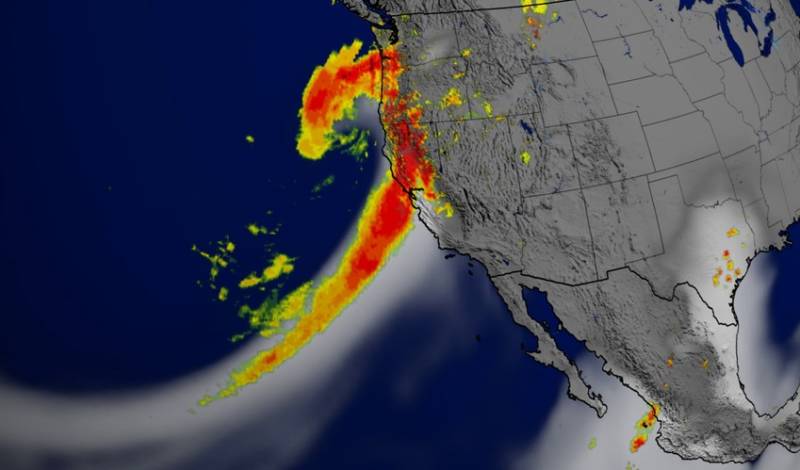
The new center focuses largely on understanding and predicting atmospheric rivers. A few weeks ago, it received a $3 million allocation in the new state budget to take this work further. Water Deeply recently spoke with Ralph about this program.
Water Deeply: What’s the idea behind this research program?
Marty Ralph: The idea behind the program emerged when I moved from NOAA to the Scripps Institution of Oceanography. I set out to create a center of excellence on storms that are important to the Western U.S. And we’ve created this Center for Western Weather and Water Extremes, CW3E. What we’re doing is bringing a focus to meteorological science and applications that are really focused on Western U.S. issues, and we’re starting with atmospheric rivers in California as the key player.
Water Deeply: Why is this so important to California?
Ralph: The really fundamental idea is that California has unique information needs to support its decision-making on water, whether it’s for flood control or water supply. The type of weather that is key to those decisions is these atmospheric river type storms. These provide about 30–50 percent of the state’s water supply each year, in Northern California especially. And that happens in just a handful of days – maybe 10 days on average – each storm being on the order of one day long. They produce the lion’s share of the water supply, and really the variability on the annual water supply really hinges on the number of atmospheric river events, rather than how strong they are.
An analysis showed 85 percent of the variability from year to year in annual precipitation in the Sacramento River basin was due to variations in the top 5 percent wettest days of the year. Those top 5 percent wettest days are mostly atmospheric river events. So there’s a seasonal role. There’s also a hazard, too. Somewhere between 80 and 90 percent of the major river flood events happen as a result of landfalling atmospheric rivers.
Water Deeply: How will this new $3 million in funding from the state of California be useful?
Ralph: It will help us establish a weather prediction model that’s tailored to the atmospheric river problem and the extreme precipitation that’s associated with it. For example, national models, like those used by the National Weather Service and the like, they have to serve the nation 24-7, 365 days a year. A single model that does really well at, say, hurricanes or thunderstorms may not do so well at atmospheric rivers. Similarly, a national model that really did the atmospheric river problem well may not do so well on those other problems.
This is how meteorology is evolving. There’s no one perfect prediction model and we are establishing what we call West-WRF, the Western Weather Research and Forecasting model. It is a very versatile model, and we are tailoring it to the western U.S. and, in particular, California precipitation events, so we can predict those as best as possible.
We’re also developing tools for diagnosing atmospheric river conditions as they are occurring, and helping show what the prediction of them looks like. So in other words, we’re doing a bit for atmospheric rivers in California what meteorology has done for hurricanes elsewhere in the country – developing specialized tools that really represent that phenomenon and the uncertainty and predictability of it so we can help inform people who are making decisions based on forecasts, whether they are emergency managers or water managers.
Water Deeply: How far along is this new forecasting tool?
Ralph: We have some prototypes running right now on our website. In the summer it’s not very exciting, because there’s not a hell of a lot going on. We used them in winter to try them out in real time, then used the summer to diagnose how they did and try to improve on them. We’ve got a running start. We’ve had some seed funding and gotten things rolling a little bit from that.
Water Deeply: What are your goals for the forecasting model?
Ralph: The goal is for it to have long-term capability to support the region. One of the key applications we’re supporting is called forecast-informed reservoir operations (FIRO). We have a collaboration going on with the Sonoma County Water Agency, at Lake Mendocino on the Russian River, which provides water to 600,000 people, the wine grape industry and to help recover endangered fish populations. They do a lot of water management. The U.S. Army Corps of Engineers is the other operator of that dam for flood control.
We have a steering committee that’s looking at assessing the viability of using atmospheric river forecasts to help operate Lake Mendocino. It’s a several-year effort. We’ve just gotten a work plan completed for a five-year program to look at the viability of using this method. It has the potential to increase water supply available for the state.
Use of FIRO in reservoir operations is relatively tough to do given that, when dams were built, it wasn’t really allowable. This atmospheric river program will help us ensure those tools are available, with the best skill possible, to support FIRO. And that we can explore its potential for use on other reservoirs.
Water Deeply: When will you have a working atmospheric river model ready to use in regular weather forecasting?
Ralph: In a way, it’s already doing that. It’s being used in ensemble predictions– in which we use many different forecast models joined together and we get an average answer. We’re contributing our West-WRF model to that approach. So it’s actually happening in a small way already.
But our goal is to have it be also available to produce its own forecast, without the ensemble, and be valuable in its own right. Our initial estimations are that it performed pretty well relative to other national models last winter. And now we’re just in the process of starting to refine it. That’s a tough science problem to do it right. It takes quite a lot of effort and time and people.
Water Deeply: How does the El Niño (ENSO) condition influence atmospheric rivers?
Ralph: ENSO modulates the position and structure of the Pacific storm track, which in turn affects the preferred locations of the atmospheric river events.
In cases where ENSO also creates a warm coastal sea surface temperature anomaly, that extra warmth can cause added evaporation and heating of atmospheric rivers as they cross over that warm water, thereby enhancing the potential for precipitation upon landfall.
Water Deeply: Does your atmospheric river forecast model take into account the ENSO condition? If so, how is that integrated?
Ralph: ENSO conditions are accounted for through their influence on sea surface temperatures, which are part of the boundary conditions used in weather forecast models, including our version focused on atmospheric rivers.
Water Deeply: A couple of years ago, you set up a network of ground-based sensors in the American River watershed to track atmospheric rivers as they came onshore. What’s the status of that sensor network now?
Ralph: The ground-based networks have expanded across California, including a roughly 100-station network spread across the state. Those include four different sensor types. There are also extra new observations on the Russian River watershed.
And last winter I led the first-ever operational atmospheric riverairborne reconnaissance effort. It learned from our past research efforts and made use of two Air Force C-130 aircraft normally deployed for hurricane recon for the eastern part of the nation.
Water Deeply: Do atmospheric rivers affect states other than California? And does your research and modeling include atmospheric river forecasting in those states?
Ralph: Atmospheric rivers do affect other states, especially the West Coast states, but also the next set of states inland (Ariz., Nev., Utah, Idaho, Mont., Colo.).
There is also emerging recognition that atmospheric rivers can be key sources of extreme precipitation in the Eastern U.S. Although other phenomena, such as landfalling hurricanes and big thunderstorm systems, are also important there.

