upper waypoint

California's Big Summer Wildfires Keep Sending Up Dangerous Fire-Triggered Thunderstorms

Save ArticleSave Article
Failed to save article

Please try again

A pyrocumulonimbus cloud rises over a fire in eastern Washington on Aug. 9, 2019 (David Peterson/NASA Earth Observatory )

The photo of the Dixie Fire captured by Cal Fire’s Santa Clara unit last month is composed like a Renaissance religious painting. Rocks frame the subject — in this case, a towering smoke plume — pine trees point to the sky, while small human figures stand in awe. But the cloud is a product of an earthly inferno, not heaven sent.

The pyrocumulus cloud rose above the Dixie Fire on the afternoon of July 19, nearly growing into pyrocumulonimbus — a wildfire-driven thunderhead. Meteorologists call these massive smoke columns “pyroCbs” for short (pronounced “pie-roh-cee-bee”).


Scientists are seeing more of them around the world, as fires burn bigger, fiercer and more frequently.

Sponsored

This week, the Dixie fire erupted again with high heat, low humidity, and blustery conditions. The fire ran parallel to a canyon that served as a chimney, stoking the fire and sending up an enormous columns of smoke, the Associated Press reported.

These pyro clouds present a danger to firefighters and have the potential to spread flames faster.

Julia Ruthford is an incident meteorologist with the National Weather Service. She was assigned to the Dixie Fire last month, entrusted with tracking weather around the fire to spot the potential for dangerous smoke columns and communicate the potential risk to fire officials and crews. She described seeing the July 19 event coming — in the forecast, on radar, satellite imagery, on fire alert cameras, and towering above her right outside the incident command center — as the column of smoke climbed higher and higher into the sky all afternoon.

“It was very sudden that it reached that tipping point,” she said. “It was right about up to 30,000 feet, with the potential to grow quite a bit taller with ice clouds on top.”

Hot air, smoke, and ash from fires like this one cool as they rise into the atmosphere. Water vapor condenses into liquid, which forms a cloud and creates precipitation. Because of the fire, it’s too hot for the rain to reach the ground. But the downward rush of air sends flames outward in all directions, ripping through forests and endangering firefighters.

August 5, 2021. (NOAA GOES-West.)

“Think of it as a giant chimney sitting over that fire,” said David Peterson, a scientist at the Naval Research Laboratory in Monterey. The smoke is funneled up into a massive thundercloud that can reach above the cruising altitude of jet aircraft.

This summer, ever since a heat wave baked the West in late June, North America has seen “a nearly continuous wave of pyroCb activity,” Peterson said, at least one per week, including an “outbreak” of 10 separate pyro clouds in Canada on June 30.

Massive pyrocumulonimbus clouds grew on the Bootleg Fire in Southern Oregon every afternoon for a week, and the Tamarack fire in Northern California created them, too. “The cloud actually takes on a life of its own,” said Neil Lareau, professor of atmospheric science at the University of Nevada-Reno.

Smoke columns this large create their own weather and present two different dangers: cloud-to-ground lightning that can ignite new fires and downdrafts that can shift the wind so quickly that fire crews on the ground can’t get out of the way fast enough.

“You get downdrafts, a strong outflow that can cause really sudden wind shifts.” Ruthford said. “If crews are working near the fire, they’re used to in-drafts into the fire. And that can all of a sudden reverse to the opposite direction — a sudden, rapid change and then [the downdraft] blows the fire in a completely different direction.”

The field of research looking at this type of fire behavior is new. But meteorologists say wildfires are producing more of them in recent years.

“The more fire on the landscape, the longer the fire season, the more opportunities you have for extreme fire behavior and things like pyroCbs,” Peterson said.

The conditions have to be right to produce these particularly explosive plumes — moist air with a fire that’s hot and dry enough to support very active behavior. They’re especially likely with monsoonal fronts. Like the one that blew through on July 19 and several times since, adding moisture and destabilizing the upper atmosphere.

“It’s really this kind of Goldilocks thing,” Lareau said.

‘That Afternoon, It Looked Like All of The Elements Lined Up’

When Ruthford is assigned to a fire, she works in a trailer at the incident command headquarters where she monitors multiple screens, working with other specialists to anticipate dangerous fire behavior. She communicates with the top firefighter brass on the incident. There’s a lot of back-and-forth discussion between her and the other fire officials as the cloud grows.

“That afternoon, it looked like all of the elements lined up,” she said.

On July 19, monsoonal moisture was blowing on the Dixie Fire, prompting an early warning from Ruthford during the daily firefighter briefing.

The conditions were ripe for a thundercloud to grow and collapse, creating lightning and howling winds. When the weather conditions shifted dangerously, she warned firefighters over the radio, an emergency step that can hinder the firefight by pulling crews off the fireline.

She sent out two warnings over the radio that day, for two separate pyro clouds, on two different parts of the fire.

“Firefighters are savvy to this and sometimes even ahead of the science, just through their anecdotal experience,” Lareau said. “They know that to watch out for that kind of situation because it can lead to all these potentially erratic and extreme fire behaviors.”

Scientists are learning too, sending weather balloons up into these giant clouds. The equipment is often never seen again, after sending readings to researchers on the ground. They also fly research aircrafts straight through the dark, gray columns. One research group flew NASA’s DC-8 over a wildfire in western Washington in 2019. The specialized radar, lidar, and sensors on the flying laboratories revealed an extreme environment: winds inside the fire clouds blowing as strong as 130 miles per hour, rivaling the strongest thunderstorms on Earth.

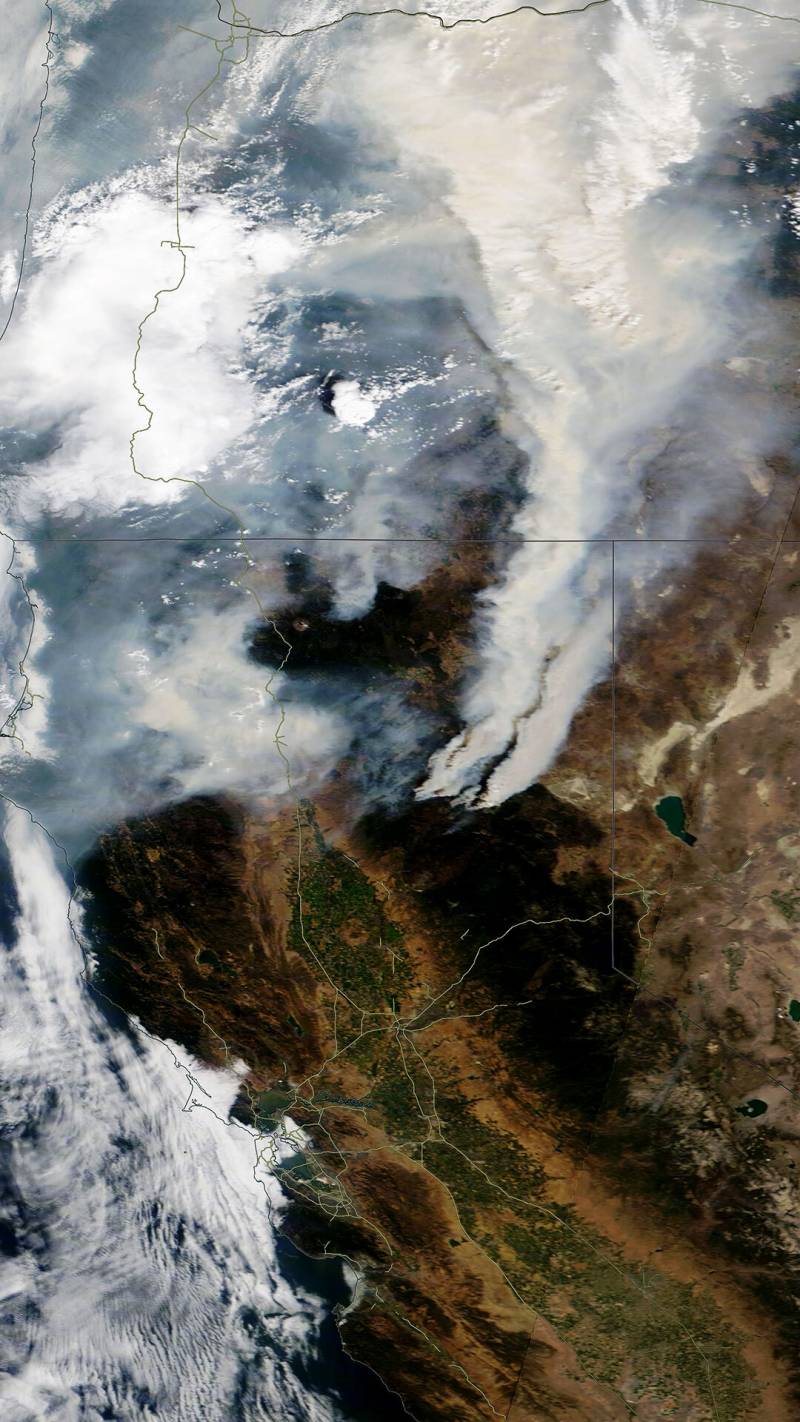
“Once fires get to the point where they’re producing their own weather, that’s when we get all these feedbacks and a vicious cycle between what the fire is doing and what it’s forcing the atmosphere to do. And then what the atmosphere is making the fire do. That can lead to these kind of explosive growth phases in the fire,” Lareau said.

‘We’re Witnessing Emergent Trends Right Now’

Warming temperatures are roasting forests, drying out soil and vegetation and priming them to burn. If climate change means the future will have more fire, Lareau says there will be more pyro clouds rising above California fires.

“We’re witnessing emergent trends right now, in fire severity, fire size, in these extremes of fire weather,” he said. “My basic prediction would just be more, more of that in the years to come.”

Peterson, the Navy researcher, studies the impact of pyrocumulonimbus clouds on the global atmospheric composition.

“There will be a smoke plume left over, usually up at the level of the jetstream winds. When you push smoke up high, it can be transported long distances rapidly,” he said. “Sometimes these fires are so intense that they penetrate into the next level of the atmosphere above the weather, the stratosphere. An aerosol plume at that level tends to stay there.

“Over the past four, five years, we have definitely seen some of the largest known pyroCb outbreaks across the globe,” Peterson said.

The task now is to predict them better, especially the atmospheric conditions that create that characteristic uplift around a fire. Scientists are also trying to model and forecast the movements of aerosol particles around the globe.

“What we do know is that these plumes can rival volcanic plumes in terms of their size and magnitude. But the chemistry is different — it’s smoke, not volcanic material,” he said. “Just imagine this blob of smoke sitting at like 60,000 feet. The smoke is an aerosol particle that will absorb solar radiation and heat the layer that it’s in, which can affect the stratospheric weather.”

Sponsored

The way to study this is to gather more direct measurements usually from planes equipped with specialized radar.

lower waypoint
next waypoint
Homeowners Insurance Market Stretched Even Thinner as 2 More Companies Leave CaliforniaSame-Sex Couples Face Higher Climate Change Risks, New UCLA Study ShowsHoping for a 2024 'Super Bloom'? Where to See Wildflowers in the Bay AreaWatch Ferns Get FreakyWhere to See Cherry Blossoms in the Bay Area This SpringEver Wake Up Frozen in the Middle of the Night, With a Shadowy Figure in the Room?Blue Jellyfish-Like Creatures Ride California Waves: A Climate Change Indicator?Everything You Never Wanted to Know About Snail SexHere's When and How to See the Green Comet Everyone's Talking AboutSchizophrenia: What It's Like to Hear Voices