Where Colma Creek was once lush and green, decades of development have forced it into a concrete channel. One way to adapt to sea level rise could open the creek back up again and make it accessible. (Molly Peterson/KQED)
Cities along San Francisco Bay have traditionally defended themselves against the menacing ocean with walls, levees, and pumps. But as seas rise, structures that keep water away may not be able to defend against an uncertain future. So urban and landscape designers are looking for alternatives.
Near Colma Creek, in South San Francisco, new ideas imagine embracing the bay, allowing water to move onto land, and allowing people to move on to water. If sea level rise reveals the vulnerabilities in our traditional relationship with water, it’s also opening the door to a new kind of thinking about the permeable relationships between water, land, and people.
A Creek Controlled by Concrete
Colma Creek trickles to life among ferns and green grass in the saddle of San Bruno Mountain, and rolls through industrial flatlands to San Francisco Bay. The mountain’s foothills once tumbled almost directly into the waters of the bay, but decades of landfill and urban development have pushed the mountain and the shoreline apart.
Now, creek waters flow in a concrete channel past boxy warehouses and industrial parks. I hop a short chain link fence with Ariel Cherbowsky-Corkidi, program director for San Bruno MountainWatch. We crouch in the nook of a low bridge on a windy evening.
“Colma Creek had a really, really big salt marsh at its mouth that spread a pretty good ways inland,” Cherbowsky-Corkidi says.
Not anymore. We can smell tidewater, salty and fresh; so can shorebirds standing on dry patches of the creekbed. But the creek itself is locked in gray, 20 feet below us. A for-hire LimeBike rusts morosely in the shallow ripples. Cherbowsky-Corkidi says people have separated themselves from this creek.
“We want to not be in contact with it, you know,” he says, “putting it behind fences and no trespassing signs. We’re kind of breaking that positive connection between people and water.”
To solve the problems of sea level rise in South City, experts say that positive connection must be restored.
“We can create walls that protect against hundred-year storms, yeah,” says Richard Mullane, a landscape architect with the international firm Hassell. “But then for 99 years and 50 weeks, do we really want to be three or four meters away from the shoreline? We don’t.”
Use Land to Control Water
As part of the Rockefeller Foundation’s Resilient by Design competition, Mullane’s Hassell Plus team set up a temporary office in a former bank in South San Francisco. Inside, Mullane grew native plants — the kind that would thrive along a rebuilt shoreline — and shared ideas for reconnecting the downtown core to the waterfront.
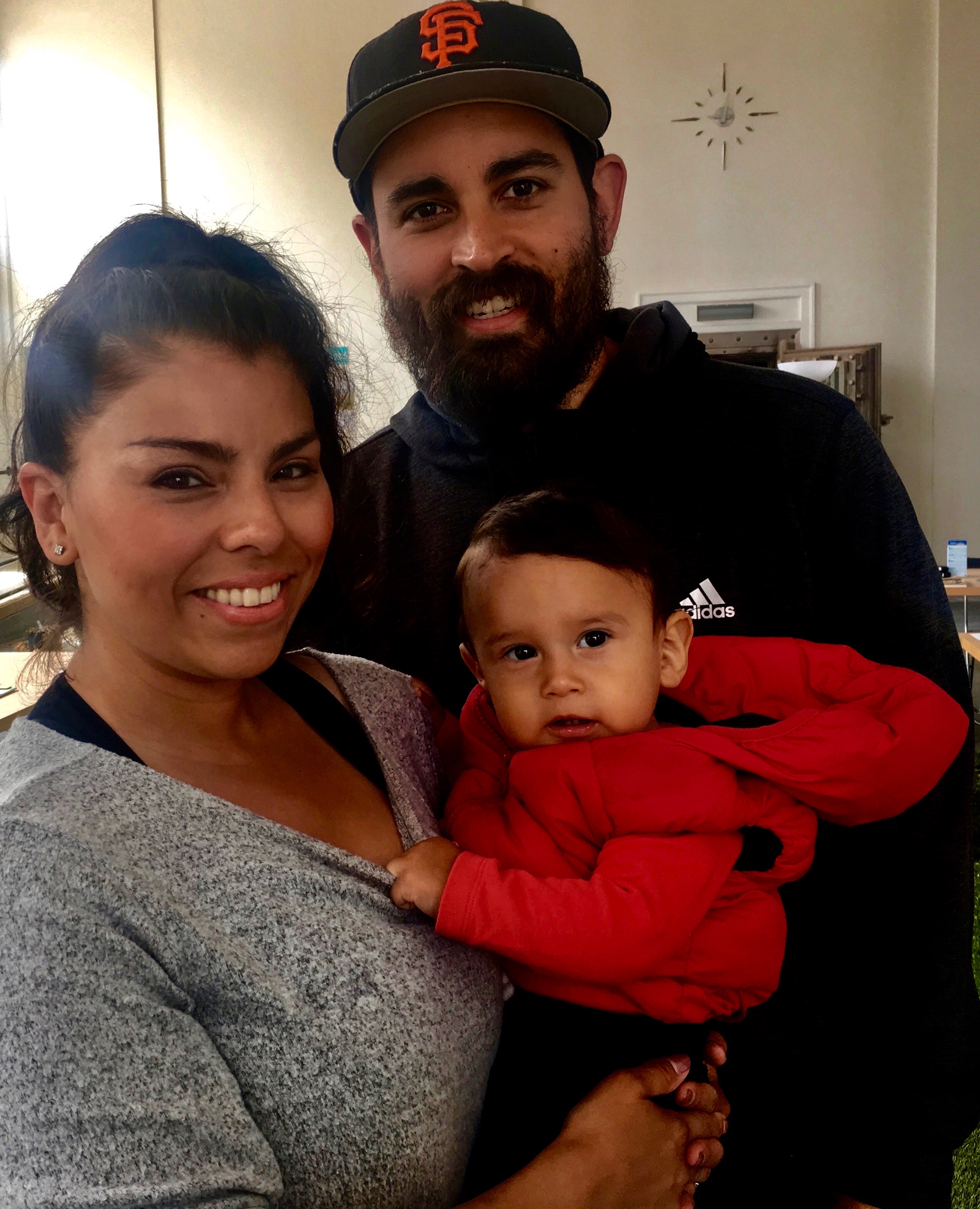
On a Saturday in April, the Casillas family wandered in: Brisa, her husband Danny, and their one-year-old son Cruz. As they study a massive wall map, 30-feet by 20-feet, Mullane shows them where the bay will rise, and Brisa realizes their home and their jobs will be awash in blue within a few decades.
Brisa and Danny Casillas, and their son Cruz, live in flood-prone San Mateo County but never thought about rising seas before. (Molly Peterson/KQED)
“What can we do?” says Brisa Casillas. “We live here and we have two other daughters, too. It is a concern.”
Danny Casillas says he didn’trealize flooding had anything to do with rising seas. “I guess I never thought about it like that,” he says. But he does remember one incident of high water, fifteen years ago.
“It was flooded down going to the freeway so I couldn’t get to school in San Mateo,” he says. “Yeah, I remember it was a nightmare, just cars all lined up on the street.”
Mullane tells Casillas that those high waters were a warning. More often now, extreme rainstorms and big tides will collide and fill the channelized Colma Creek, spilling floodwaters into the streets.
In a proposal the Hassel Plus team presented publicly in May, they argue the solution is less concrete and more green.
“We need to slow down water,” Mullane says.” “It’s the first principle.”
What would slow the water down is a wide, soft creek bottom that can absorb wave energy. Plus plenty of trees and native plants to sop up excess water. Then Mullane suggests expanding parkland surrounding the creek.
“Once we slow down that water,” he says, “we need to have space for it whilst we wait for rising tides to reduce.”
That space could look like a soccer field: grassy, flat, perhaps with sloping sides to contain the water. If you build a park in lowlands, it’s okay if it floods. That shows people how to share land with water, Mullane says. “We have to plan for extreme events and we have to plan for daily life.”
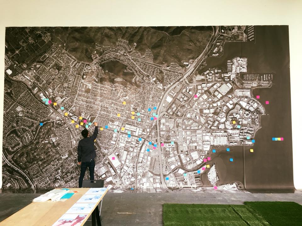
Resilient South City invited people to mark places on the aerial map that they love or want to see changed, or that had flooded in the past. (Hassell)
Redeveloping open space into a soccer field would not only expand recreational opportunities at the shoreline, but also diversify them. The narrow concrete Bay Trail is useful for walking or riding a bike, both solitary, small-group activities. Soccer, the Australian Mullane points out, is a pastime that attracts crowds, and is popular with a diverse population. What that means is that one Hassell Plus-proposed soccer field could both re-engineer water flow and re-engineer the way people see the shoreline.
Mullane and the Hassell Plus team’s proposal for Colma Creek isn’t much more than an idea yet. The Resilient by Design Competition seeded conversations and ideas in 9 communities around the bay, but won’t fund entire projects.
Embrace the Bay With Softer Landscapes
The argument that rebuilding a soft landscape can help the region cope with sea level rise has already found favor with Bay Area voters. Two years ago, across 9 counties, 69% of them approved Measure AA, a 20-year effort to bring marshes back.
“[Tidelands and marshes] are remarkable things both for the ecosystem and for flood protection,” says Pine, who also chairs the San Francisco Bay Restoration Authority. The authority eventually will hand out $500 million for potential projects, raised from Measure AA’s $12 annual parcel tax.
In the first round of funding twenty-two sites applied for support; the restoration authority will jump-start just nine of them.
Pine says this serves to underline the urgency of preparing for higher water. “If we don’t get it started, many of the opportunities will be lost because of the rising Bay,” he says. “There’s a big gap between the need and the funds.”
Adaptations to rising seas that focus on green or natural infrastructure may cost less than walls, pumps and levees, which demand mechanical maintenance and more frequent upgrades. But even regional projects can cost tens of millions of dollars, and need approval from multiple local, state and federal agencies.
Still, around Colma Creek, “It’s one of the few creeks in the county where we actually have a revenue stream to make some changes,” Pine says. San Mateo County created a flood control zone there in 1964.
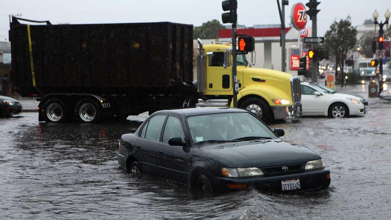
South City flooding at Grand Avenue and Airport Boulevard in December 2014. (Resilient South City)
Colma Creek isn’t unique in its historic separation of land and water. Neither is the starved shoreline of South San Francisco. Eighty percent of historic marshes around the bay are gone.
This area is one small corner of a San Francisco Bay that people have dramatically transformed over time. “It was a pristine bay,” says San Mateo County Supervisor Dave Pine. “Then we spent 100 years filling it in and considering wetlands waste and thought about carving the top of San Bruno Mountain off and putting it into the bay and we had dumps up and down the San Mateo County Bayshore.”
Through its widening, through the eras of meatpacking plants, and dumps, and industrial sites, land along the shoreline has reflected South San Francisco’s relationship to water, even just by distance from it. Now local leaders and designers say that sea level rise is making closeness to water inevitable: they’re suggesting we learn to embrace the water we once pushed away.
lower waypointnext waypoint
Player sponsored by
window.__IS_SSR__=true
window.__INITIAL_STATE__={
"attachmentsReducer": {
"audio_0": {
"type": "attachments",
"id": "audio_0",
"imgSizes": {
"kqedFullSize": {
"file": "https://ww2.kqed.org/news/wp-content/themes/KQED-unified/img/audio_bgs/background0.jpg"
}
}
},
"audio_1": {
"type": "attachments",
"id": "audio_1",
"imgSizes": {
"kqedFullSize": {
"file": "https://ww2.kqed.org/news/wp-content/themes/KQED-unified/img/audio_bgs/background1.jpg"
}
}
},
"audio_2": {
"type": "attachments",
"id": "audio_2",
"imgSizes": {
"kqedFullSize": {
"file": "https://ww2.kqed.org/news/wp-content/themes/KQED-unified/img/audio_bgs/background2.jpg"
}
}
},
"audio_3": {
"type": "attachments",
"id": "audio_3",
"imgSizes": {
"kqedFullSize": {
"file": "https://ww2.kqed.org/news/wp-content/themes/KQED-unified/img/audio_bgs/background3.jpg"
}
}
},
"audio_4": {
"type": "attachments",
"id": "audio_4",
"imgSizes": {
"kqedFullSize": {
"file": "https://ww2.kqed.org/news/wp-content/themes/KQED-unified/img/audio_bgs/background4.jpg"
}
}
},
"placeholder": {
"type": "attachments",
"id": "placeholder",
"imgSizes": {
"thumbnail": {
"file": "https://cdn.kqed.org/wp-content/uploads/2024/12/KQED-Default-Image-816638274-2000x1333-1-160x107.jpg",
"width": 160,
"height": 107,
"mimeType": "image/jpeg"
},
"medium": {
"file": "https://cdn.kqed.org/wp-content/uploads/2024/12/KQED-Default-Image-816638274-2000x1333-1-800x533.jpg",
"width": 800,
"height": 533,
"mimeType": "image/jpeg"
},
"medium_large": {
"file": "https://cdn.kqed.org/wp-content/uploads/2024/12/KQED-Default-Image-816638274-2000x1333-1-768x512.jpg",
"width": 768,
"height": 512,
"mimeType": "image/jpeg"
},
"large": {
"file": "https://cdn.kqed.org/wp-content/uploads/2024/12/KQED-Default-Image-816638274-2000x1333-1-1020x680.jpg",
"width": 1020,
"height": 680,
"mimeType": "image/jpeg"
},
"1536x1536": {
"file": "https://cdn.kqed.org/wp-content/uploads/2024/12/KQED-Default-Image-816638274-2000x1333-1-1536x1024.jpg",
"width": 1536,
"height": 1024,
"mimeType": "image/jpeg"
},
"fd-lrg": {
"file": "https://cdn.kqed.org/wp-content/uploads/2024/12/KQED-Default-Image-816638274-2000x1333-1-1536x1024.jpg",
"width": 1536,
"height": 1024,
"mimeType": "image/jpeg"
},
"fd-med": {
"file": "https://cdn.kqed.org/wp-content/uploads/2024/12/KQED-Default-Image-816638274-2000x1333-1-1020x680.jpg",
"width": 1020,
"height": 680,
"mimeType": "image/jpeg"
},
"fd-sm": {
"file": "https://cdn.kqed.org/wp-content/uploads/2024/12/KQED-Default-Image-816638274-2000x1333-1-800x533.jpg",
"width": 800,
"height": 533,
"mimeType": "image/jpeg"
},
"post-thumbnail": {
"file": "https://cdn.kqed.org/wp-content/uploads/2024/12/KQED-Default-Image-816638274-2000x1333-1-672x372.jpg",
"width": 672,
"height": 372,
"mimeType": "image/jpeg"
},
"twentyfourteen-full-width": {
"file": "https://cdn.kqed.org/wp-content/uploads/2024/12/KQED-Default-Image-816638274-2000x1333-1-1038x576.jpg",
"width": 1038,
"height": 576,
"mimeType": "image/jpeg"
},
"xxsmall": {
"file": "https://cdn.kqed.org/wp-content/uploads/2024/12/KQED-Default-Image-816638274-2000x1333-1-160x107.jpg",
"width": 160,
"height": 107,
"mimeType": "image/jpeg"
},
"xsmall": {
"file": "https://cdn.kqed.org/wp-content/uploads/2024/12/KQED-Default-Image-816638274-2000x1333-1-672x372.jpg",
"width": 672,
"height": 372,
"mimeType": "image/jpeg"
},
"small": {
"file": "https://cdn.kqed.org/wp-content/uploads/2024/12/KQED-Default-Image-816638274-2000x1333-1-672x372.jpg",
"width": 672,
"height": 372,
"mimeType": "image/jpeg"
},
"xlarge": {
"file": "https://cdn.kqed.org/wp-content/uploads/2024/12/KQED-Default-Image-816638274-2000x1333-1-1020x680.jpg",
"width": 1020,
"height": 680,
"mimeType": "image/jpeg"
},
"full-width": {
"file": "https://cdn.kqed.org/wp-content/uploads/2024/12/KQED-Default-Image-816638274-2000x1333-1-1920x1280.jpg",
"width": 1920,
"height": 1280,
"mimeType": "image/jpeg"
},
"guest-author-32": {
"file": "https://cdn.kqed.org/wp-content/uploads/2025/01/KQED-Default-Image-816638274-1333x1333-1-160x160.jpg",
"width": 32,
"height": 32,
"mimeType": "image/jpeg"
},
"guest-author-50": {
"file": "https://cdn.kqed.org/wp-content/uploads/2025/01/KQED-Default-Image-816638274-1333x1333-1-160x160.jpg",
"width": 50,
"height": 50,
"mimeType": "image/jpeg"
},
"guest-author-64": {
"file": "https://cdn.kqed.org/wp-content/uploads/2025/01/KQED-Default-Image-816638274-1333x1333-1-160x160.jpg",
"width": 64,
"height": 64,
"mimeType": "image/jpeg"
},
"guest-author-96": {
"file": "https://cdn.kqed.org/wp-content/uploads/2025/01/KQED-Default-Image-816638274-1333x1333-1-160x160.jpg",
"width": 96,
"height": 96,
"mimeType": "image/jpeg"
},
"guest-author-128": {
"file": "https://cdn.kqed.org/wp-content/uploads/2025/01/KQED-Default-Image-816638274-1333x1333-1-160x160.jpg",
"width": 128,
"height": 128,
"mimeType": "image/jpeg"
},
"detail": {
"file": "https://cdn.kqed.org/wp-content/uploads/2025/01/KQED-Default-Image-816638274-1333x1333-1-160x160.jpg",
"width": 160,
"height": 160,
"mimeType": "image/jpeg"
},
"kqedFullSize": {
"file": "https://cdn.kqed.org/wp-content/uploads/2024/12/KQED-Default-Image-816638274-2000x1333-1.jpg",
"width": 2000,
"height": 1333
}
}
},
"science_1926493": {
"type": "attachments",
"id": "science_1926493",
"meta": {
"index": "attachments_1716263798",
"site": "science",
"id": "1926493",
"found": true
},
"parent": 1926410,
"imgSizes": {
"small": {
"file": "https://ww2.kqed.org/app/uploads/sites/35/2018/06/RS31588_IMG_4664-520x390.jpg",
"width": 520,
"mimeType": "image/jpeg",
"height": 390
},
"twentyfourteen-full-width": {
"file": "https://ww2.kqed.org/app/uploads/sites/35/2018/06/RS31588_IMG_4664-1038x576.jpg",
"width": 1038,
"mimeType": "image/jpeg",
"height": 576
},
"thumbnail": {
"file": "https://ww2.kqed.org/app/uploads/sites/35/2018/06/RS31588_IMG_4664-160x120.jpg",
"width": 160,
"mimeType": "image/jpeg",
"height": 120
},
"fd-sm": {
"file": "https://ww2.kqed.org/app/uploads/sites/35/2018/06/RS31588_IMG_4664-960x720.jpg",
"width": 960,
"mimeType": "image/jpeg",
"height": 720
},
"post-thumbnail": {
"file": "https://ww2.kqed.org/app/uploads/sites/35/2018/06/RS31588_IMG_4664-672x372.jpg",
"width": 672,
"mimeType": "image/jpeg",
"height": 372
},
"xsmall": {
"file": "https://ww2.kqed.org/app/uploads/sites/35/2018/06/RS31588_IMG_4664-375x281.jpg",
"width": 375,
"mimeType": "image/jpeg",
"height": 281
},
"kqedFullSize": {
"file": "https://ww2.kqed.org/app/uploads/sites/35/2018/06/RS31588_IMG_4664.jpg",
"width": 4032,
"height": 3024
},
"large": {
"file": "https://ww2.kqed.org/app/uploads/sites/35/2018/06/RS31588_IMG_4664-1020x765.jpg",
"width": 1020,
"mimeType": "image/jpeg",
"height": 765
},
"xlarge": {
"file": "https://ww2.kqed.org/app/uploads/sites/35/2018/06/RS31588_IMG_4664-1180x885.jpg",
"width": 1180,
"mimeType": "image/jpeg",
"height": 885
},
"complete_open_graph": {
"file": "https://ww2.kqed.org/app/uploads/sites/35/2018/06/RS31588_IMG_4664-1200x900.jpg",
"width": 1200,
"mimeType": "image/jpeg",
"height": 900
},
"guest-author-50": {
"file": "https://ww2.kqed.org/app/uploads/sites/35/2018/06/RS31588_IMG_4664-50x50.jpg",
"width": 50,
"mimeType": "image/jpeg",
"height": 50
},
"guest-author-96": {
"file": "https://ww2.kqed.org/app/uploads/sites/35/2018/06/RS31588_IMG_4664-96x96.jpg",
"width": 96,
"mimeType": "image/jpeg",
"height": 96
},
"medium": {
"file": "https://ww2.kqed.org/app/uploads/sites/35/2018/06/RS31588_IMG_4664-800x600.jpg",
"width": 800,
"mimeType": "image/jpeg",
"height": 600
},
"guest-author-64": {
"file": "https://ww2.kqed.org/app/uploads/sites/35/2018/06/RS31588_IMG_4664-64x64.jpg",
"width": 64,
"mimeType": "image/jpeg",
"height": 64
},
"guest-author-32": {
"file": "https://ww2.kqed.org/app/uploads/sites/35/2018/06/RS31588_IMG_4664-32x32.jpg",
"width": 32,
"mimeType": "image/jpeg",
"height": 32
},
"fd-lrg": {
"file": "https://ww2.kqed.org/app/uploads/sites/35/2018/06/RS31588_IMG_4664-1920x1440.jpg",
"width": 1920,
"mimeType": "image/jpeg",
"height": 1440
},
"fd-med": {
"file": "https://ww2.kqed.org/app/uploads/sites/35/2018/06/RS31588_IMG_4664-1180x885.jpg",
"width": 1180,
"mimeType": "image/jpeg",
"height": 885
},
"full-width": {
"file": "https://ww2.kqed.org/app/uploads/sites/35/2018/06/RS31588_IMG_4664-1920x1440.jpg",
"width": 1920,
"mimeType": "image/jpeg",
"height": 1440
},
"detail": {
"file": "https://ww2.kqed.org/app/uploads/sites/35/2018/06/RS31588_IMG_4664-150x150.jpg",
"width": 150,
"mimeType": "image/jpeg",
"height": 150
},
"medium_large": {
"file": "https://ww2.kqed.org/app/uploads/sites/35/2018/06/RS31588_IMG_4664-768x576.jpg",
"width": 768,
"mimeType": "image/jpeg",
"height": 576
},
"guest-author-128": {
"file": "https://ww2.kqed.org/app/uploads/sites/35/2018/06/RS31588_IMG_4664-128x128.jpg",
"width": 128,
"mimeType": "image/jpeg",
"height": 128
},
"xxsmall": {
"file": "https://ww2.kqed.org/app/uploads/sites/35/2018/06/RS31588_IMG_4664-240x180.jpg",
"width": 240,
"mimeType": "image/jpeg",
"height": 180
}
},
"publishDate": 1530049113,
"modified": 1530049934,
"caption": "Where Colma Creek was once lush and green, decades of development have forced it into a concrete channel. One way to adapt to sea level rise could open the creek back up again and make it accessible.",
"description": null,
"title": "Colma Creek",
"credit": "Molly Peterson/KQED",
"status": "inherit",
"isLoading": false,
"fetchFailed": false
}
},
"audioPlayerReducer": {
"postId": "stream_live",
"isPaused": true,
"isPlaying": false,
"pfsActive": false,
"pledgeModalIsOpen": true,
"playerDrawerIsOpen": false,
"liveAudioPlayStartedAt": 0,
"liveAudioPlayContext": ""
},
"authorsReducer": {
"mpeterson": {
"type": "authors",
"id": "11223",
"meta": {
"index": "authors_1716337520",
"id": "11223",
"found": true
},
"name": "Molly Peterson",
"firstName": "Molly",
"lastName": "Peterson",
"slug": "mpeterson",
"email": "mpeterson@kqed.org",
"display_author_email": false,
"staff_mastheads": [],
"title": null,
"bio": "Molly Peterson reports for KQED science and news on climate change, catastrophe and risk. Previously she was environment correspondent at Southern California Public Radio. Her work has also appeared at The New York Times, The Guardian, on NPR, at High Country News, on Code Switch, and other national outlets. She has been honored with awards from Public Radio News Directors Incorporated, Investigative Reporters and Editors, the Society for Professional Journalists, the Los Angeles Press Club, and RTNDA Edward R. Murrow awards, among others.",
"avatar": "https://secure.gravatar.com/avatar/7908e2807131f776cc8165c649530b05?s=600&d=blank&r=g",
"twitter": "Mollydacious",
"facebook": null,
"instagram": "https://www.instagram.com/radiomolly/",
"linkedin": null,
"sites": [
{
"site": "news",
"roles": [
"subscriber"
]
},
{
"site": "futureofyou",
"roles": [
"editor"
]
},
{
"site": "science",
"roles": [
"editor"
]
}
],
"headData": {
"title": "Molly Peterson | KQED",
"description": null,
"ogImgSrc": "https://secure.gravatar.com/avatar/7908e2807131f776cc8165c649530b05?s=600&d=blank&r=g",
"twImgSrc": "https://secure.gravatar.com/avatar/7908e2807131f776cc8165c649530b05?s=600&d=blank&r=g"
},
"isLoading": false,
"link": "/author/mpeterson"
}
},
"pagesReducer": {},
"pfsSessionReducer": {},
"postsReducer": {
"stream_live": {
"type": "live",
"id": "stream_live",
"audioUrl": "https://streams.kqed.org/kqedradio",
"title": "Live Stream",
"excerpt": "Live Stream information currently unavailable.",
"link": "/radio",
"featImg": "",
"label": {
"name": "KQED Live",
"link": "/"
}
},
"stream_kqedNewscast": {
"type": "posts",
"id": "stream_kqedNewscast",
"audioUrl": "https://www.kqed.org/.stream/anon/radio/RDnews/newscast.mp3?_=1",
"title": "KQED Newscast",
"featImg": "",
"label": {
"name": "88.5 FM",
"link": "/"
}
},
"science_1926410": {
"type": "posts",
"id": "science_1926410",
"meta": {
"index": "posts_1716263798",
"site": "science",
"id": "1926410",
"found": true
},
"articlePosition": 0,
"parent": 0,
"labelTerm": {
"site": "science"
},
"blocks": [],
"publishDate": 1530169260,
"format": "standard",
"title": "Nature Does Flood Control Better Than Concrete: One Idea in South San Francisco",
"headTitle": "Nature Does Flood Control Better Than Concrete: One Idea in South San Francisco | KQED",
"content": "\u003cp>\u003cspan style=\"font-size: 4.6875em;float: left;line-height: 0.733em;padding: 0.05em 0.1em 0 0;font-family: times, serif, georgia\">C\u003c/span>ities along San Francisco Bay have traditionally defended themselves against the menacing ocean with walls, levees, and pumps. But as seas rise, structures that keep water away may not be able to defend against an uncertain future. So urban and landscape designers are looking for alternatives.\u003c/p>\n\u003caside class=\"pullquote alignright\">‘We need to slow down water. It’s the first principle.’\u003ccite>Richard Mullane, Hassell\u003c/cite>\u003c/aside>\n\u003cp>Near Colma Creek, in South San Francisco, new ideas imagine embracing the bay, allowing water to move onto land, and allowing people to move on to water. If sea level rise reveals the vulnerabilities in our traditional relationship with water, it’s also opening the door to a new kind of thinking about the permeable relationships between water, land, and people.\u003c/p>\n\u003cp>\u003cstrong>A Creek Controlled by Concrete\u003c/strong>\u003c/p>\n\u003cp>\u003cspan style=\"font-size: 4.6875em;float: left;line-height: 0.733em;padding: 0.05em 0.1em 0 0;font-family: times, serif, georgia\">C\u003c/span>olma Creek trickles to life among ferns and green grass in the saddle of San Bruno Mountain, and rolls through industrial flatlands to San Francisco Bay. The mountain’s foothills once tumbled almost directly into the waters of the bay, but decades of landfill and urban development have pushed the mountain and the shoreline apart.\u003c/p>\n\u003cp>Now, creek waters flow in a concrete channel past boxy warehouses and industrial parks. I hop a short chain link fence with Ariel Cherbowsky-Corkidi, program director for \u003ca href=\"http://www.mountainwatch.org/\">San Bruno MountainWatch\u003c/a>. We crouch in the nook of a low bridge on a windy evening.\u003c/p>\n\u003cp>[ad fullwidth]\u003c/p>\n\u003cp>“Colma Creek had a really, really big salt marsh at its mouth that spread a pretty good ways inland,” Cherbowsky-Corkidi says.\u003c/p>\n\u003cp>Not anymore. We can smell tidewater, salty and fresh; so can shorebirds standing on dry patches of the creekbed. But the creek itself is locked in gray, 20 feet below us. A for-hire LimeBike rusts morosely in the shallow ripples. Cherbowsky-Corkidi says people have separated themselves from this creek.\u003c/p>\n\u003cp>[emailsignup newslettername='science' align='right']“We want to not be in contact with it, you know,” he says, “putting it behind fences and no trespassing signs. We’re kind of breaking that positive connection between people and water.”\u003c/p>\n\u003cp>To solve the problems of sea level rise in South City, experts say that positive connection must be restored.\u003c/p>\n\u003cp>“We can create walls that protect against hundred-year storms, yeah,” says Richard Mullane, a landscape architect with the international firm Hassell. “But then for 99 years and 50 weeks, do we really want to be three or four meters away from the shoreline? We don’t.”\u003c/p>\n\u003cp>\u003cb>Use Land to Control Water\u003c/b>\u003c/p>\n\u003cp>\u003cspan style=\"font-size: 4.6875em;float: left;line-height: 0.733em;padding: 0.05em 0.1em 0 0;font-family: times, serif, georgia\">A\u003c/span>s part of the Rockefeller Foundation’s Resilient by Design competition, Mullane’s \u003ca href=\"http://www.resilientbayarea.org/hassell/\">Hassell Plus team\u003c/a> set up a temporary office in a former bank in South San Francisco. Inside, Mullane grew native plants — the kind that would thrive along a rebuilt shoreline — and shared ideas for reconnecting the downtown core to the waterfront.\u003c/p>\n\u003cp>On a Saturday in April, the Casillas family wandered in: Brisa, her husband Danny, and their one-year-old son Cruz. As they study a massive wall map, 30-feet by 20-feet, Mullane shows them where the bay will rise, and Brisa realizes their home and their jobs will be awash in blue within a few decades.\u003c/p>\n\u003cfigure id=\"attachment_1926614\" class=\"wp-caption alignright\" style=\"max-width: 2358px\">\u003ca href=\"https://ww2.kqed.org/science/wp-content/uploads/sites/35/2018/06/RS31587_IMG_5630.jpg\">\u003cimg loading=\"lazy\" decoding=\"async\" class=\"size-full wp-image-1926614\" src=\"https://ww2.kqed.org/science/wp-content/uploads/sites/35/2018/06/RS31587_IMG_5630.jpg\" alt=\"\" width=\"2358\" height=\"2909\" srcset=\"https://cdn.kqed.org/wp-content/uploads/sites/35/2018/06/RS31587_IMG_5630.jpg 2358w, https://cdn.kqed.org/wp-content/uploads/sites/35/2018/06/RS31587_IMG_5630-160x197.jpg 160w, https://cdn.kqed.org/wp-content/uploads/sites/35/2018/06/RS31587_IMG_5630-800x987.jpg 800w, https://cdn.kqed.org/wp-content/uploads/sites/35/2018/06/RS31587_IMG_5630-768x947.jpg 768w, https://cdn.kqed.org/wp-content/uploads/sites/35/2018/06/RS31587_IMG_5630-1020x1258.jpg 1020w, https://cdn.kqed.org/wp-content/uploads/sites/35/2018/06/RS31587_IMG_5630-973x1200.jpg 973w, https://cdn.kqed.org/wp-content/uploads/sites/35/2018/06/RS31587_IMG_5630-1920x2369.jpg 1920w, https://cdn.kqed.org/wp-content/uploads/sites/35/2018/06/RS31587_IMG_5630-1180x1456.jpg 1180w, https://cdn.kqed.org/wp-content/uploads/sites/35/2018/06/RS31587_IMG_5630-960x1184.jpg 960w, https://cdn.kqed.org/wp-content/uploads/sites/35/2018/06/RS31587_IMG_5630-240x296.jpg 240w, https://cdn.kqed.org/wp-content/uploads/sites/35/2018/06/RS31587_IMG_5630-375x463.jpg 375w, https://cdn.kqed.org/wp-content/uploads/sites/35/2018/06/RS31587_IMG_5630-520x642.jpg 520w\" sizes=\"(max-width: 2358px) 100vw, 2358px\">\u003c/a>\u003cfigcaption class=\"wp-caption-text\">Brisa and Danny Casillas, and their son Cruz, live in flood-prone San Mateo County but never thought about rising seas before. \u003ccite>(Molly Peterson/KQED)\u003c/cite>\u003c/figcaption>\u003c/figure>\n\u003cp>“What can we do?” says Brisa Casillas. “We live here and we have two other daughters, too. It is a concern.”\u003c/p>\n\u003cp>Danny Casillas says he didn’trealize flooding had anything to do with rising seas. “I guess I never thought about it like that,” he says. But he does remember one incident of high water, fifteen years ago.\u003c/p>\n\u003cp>“It was flooded down going to the freeway so I couldn’t get to school in San Mateo,” he says. “Yeah, I remember it was a nightmare, just cars all lined up on the street.”\u003c/p>\n\u003cp>Mullane tells Casillas that those high waters were a warning. More often now, extreme rainstorms and big tides will collide and fill the channelized Colma Creek, spilling floodwaters into the streets.\u003c/p>\n\u003cp>In \u003ca href=\"http://www.resilientbayarea.org/south-san-francisco/\">a proposa\u003c/a>l the Hassel Plus team \u003ca href=\"https://www.youtube.com/watch?v=nu-bSPOJxtI\">presented\u003c/a> publicly in May, they argue the solution is less concrete and more green.\u003c/p>\n\u003cp>“We need to slow down water,” Mullane says.” “It’s the first principle.”\u003c/p>\n\u003cp>What would slow the water down is a wide, soft creek bottom that can absorb wave energy. Plus plenty of trees and native plants to sop up excess water. Then Mullane suggests expanding parkland surrounding the creek.\u003c/p>\n\u003cp>“Once we slow down that water,” he says, “we need to have space for it whilst we wait for rising tides to reduce.”\u003c/p>\n\u003cp>That space could look like a soccer field: grassy, flat, perhaps with sloping sides to contain the water. If you build a park in lowlands, it’s okay if it floods. That shows people how to share land with water, Mullane says. “We have to plan for extreme events and we have to plan for daily life.”\u003c/p>\n\u003cfigure id=\"attachment_1926618\" class=\"wp-caption aligncenter\" style=\"max-width: 960px\">\u003ca href=\"https://ww2.kqed.org/science/wp-content/uploads/sites/35/2018/06/28870558_2017992898455355_1986297197578158080_n.jpg\">\u003cimg loading=\"lazy\" decoding=\"async\" class=\"size-full wp-image-1926618\" src=\"https://ww2.kqed.org/science/wp-content/uploads/sites/35/2018/06/28870558_2017992898455355_1986297197578158080_n.jpg\" alt=\"\" width=\"960\" height=\"720\" srcset=\"https://cdn.kqed.org/wp-content/uploads/sites/35/2018/06/28870558_2017992898455355_1986297197578158080_n.jpg 960w, https://cdn.kqed.org/wp-content/uploads/sites/35/2018/06/28870558_2017992898455355_1986297197578158080_n-160x120.jpg 160w, https://cdn.kqed.org/wp-content/uploads/sites/35/2018/06/28870558_2017992898455355_1986297197578158080_n-800x600.jpg 800w, https://cdn.kqed.org/wp-content/uploads/sites/35/2018/06/28870558_2017992898455355_1986297197578158080_n-768x576.jpg 768w, https://cdn.kqed.org/wp-content/uploads/sites/35/2018/06/28870558_2017992898455355_1986297197578158080_n-240x180.jpg 240w, https://cdn.kqed.org/wp-content/uploads/sites/35/2018/06/28870558_2017992898455355_1986297197578158080_n-375x281.jpg 375w, https://cdn.kqed.org/wp-content/uploads/sites/35/2018/06/28870558_2017992898455355_1986297197578158080_n-520x390.jpg 520w\" sizes=\"(max-width: 960px) 100vw, 960px\">\u003c/a>\u003cfigcaption class=\"wp-caption-text\">Resilient South City invited people to mark places on the aerial map that they love or want to see changed, or that had flooded in the past. \u003ccite>(Hassell)\u003c/cite>\u003c/figcaption>\u003c/figure>\n\u003cp>Redeveloping open space into a soccer field would not only expand recreational opportunities at the shoreline, but also diversify them. The narrow concrete Bay Trail is useful for walking or riding a bike, both solitary, small-group activities. Soccer, the Australian Mullane points out, is a pastime that attracts crowds, and is popular with a diverse population. What that means is that one Hassell Plus-proposed soccer field could both re-engineer water flow and re-engineer the way people see the shoreline.\u003c/p>\n\u003cp>Mullane and the Hassell Plus team’s proposal for Colma Creek isn’t much more than an idea yet. The Resilient by Design Competition seeded conversations and ideas in 9 communities around the bay, but won’t fund entire projects.\u003c/p>\n\u003cp>\u003cstrong>Embrace the Bay With Softer Landscapes\u003c/strong>\u003c/p>\n\u003cp>\u003cspan style=\"font-size: 4.6875em;float: left;line-height: 0.733em;padding: 0.05em 0.1em 0 0;font-family: times, serif, georgia\">T\u003c/span>he argument that rebuilding a soft landscape can help the region cope with sea level rise has already found favor with Bay Area voters. Two years ago, across 9 counties, 69% of them approved \u003ca href=\"https://www.yesonaaforthebay.com/about\">Measure AA\u003c/a>, a 20-year effort to bring marshes back.\u003c/p>\n\u003caside class=\"pullquote alignright\">‘It was a pristine bay. Then we spent 100 years filling it in and considering wetlands waste.’\u003ccite>Dave Pine,\u003cbr>\nSan Mateo County\u003c/cite>\u003c/aside>\n\u003cp>“[Tidelands and marshes] are remarkable things both for the ecosystem and for flood protection,” says Pine, who also chairs the San Francisco Bay Restoration Authority. The authority eventually will hand out $500 million for potential projects, raised from Measure AA’s $12 annual parcel tax.\u003c/p>\n\u003cp>In the first round of funding twenty-two sites applied for support; the restoration authority \u003ca href=\"http://sfbayrestore.org/\">will jump-start\u003c/a> just nine of them.\u003c/p>\n\u003cp>Pine says this serves to underline the urgency of preparing for higher water. “If we don’t get it started, many of the opportunities will be lost because of the rising Bay,” he says. “There’s a big gap between the need and the funds.”\u003c/p>\n\u003cp>Adaptations to rising seas that focus on green or natural infrastructure may cost less than walls, pumps and levees, which demand mechanical maintenance and more frequent upgrades. But even regional projects can cost tens of millions of dollars, and need approval from multiple local, state and federal agencies.\u003c/p>\n\u003cp>Still, around Colma Creek, “It’s one of the few creeks in the county where we actually have a revenue stream to make some changes,” Pine says. San Mateo County created a flood control zone there in 1964.\u003c/p>\n\u003cfigure id=\"attachment_1926622\" class=\"wp-caption aligncenter\" style=\"max-width: 1280px\">\u003ca href=\"https://ww2.kqed.org/science/wp-content/uploads/sites/35/2018/06/28783653_2017527131835265_1731173713539235840_o.jpg\">\u003cimg loading=\"lazy\" decoding=\"async\" class=\"size-full wp-image-1926622\" src=\"https://ww2.kqed.org/science/wp-content/uploads/sites/35/2018/06/28783653_2017527131835265_1731173713539235840_o.jpg\" alt=\"\" width=\"1280\" height=\"720\" srcset=\"https://cdn.kqed.org/wp-content/uploads/sites/35/2018/06/28783653_2017527131835265_1731173713539235840_o.jpg 1280w, https://cdn.kqed.org/wp-content/uploads/sites/35/2018/06/28783653_2017527131835265_1731173713539235840_o-160x90.jpg 160w, https://cdn.kqed.org/wp-content/uploads/sites/35/2018/06/28783653_2017527131835265_1731173713539235840_o-800x450.jpg 800w, https://cdn.kqed.org/wp-content/uploads/sites/35/2018/06/28783653_2017527131835265_1731173713539235840_o-768x432.jpg 768w, https://cdn.kqed.org/wp-content/uploads/sites/35/2018/06/28783653_2017527131835265_1731173713539235840_o-1020x574.jpg 1020w, https://cdn.kqed.org/wp-content/uploads/sites/35/2018/06/28783653_2017527131835265_1731173713539235840_o-1200x675.jpg 1200w, https://cdn.kqed.org/wp-content/uploads/sites/35/2018/06/28783653_2017527131835265_1731173713539235840_o-1180x664.jpg 1180w, https://cdn.kqed.org/wp-content/uploads/sites/35/2018/06/28783653_2017527131835265_1731173713539235840_o-960x540.jpg 960w, https://cdn.kqed.org/wp-content/uploads/sites/35/2018/06/28783653_2017527131835265_1731173713539235840_o-240x135.jpg 240w, https://cdn.kqed.org/wp-content/uploads/sites/35/2018/06/28783653_2017527131835265_1731173713539235840_o-375x211.jpg 375w, https://cdn.kqed.org/wp-content/uploads/sites/35/2018/06/28783653_2017527131835265_1731173713539235840_o-520x293.jpg 520w\" sizes=\"(max-width: 1280px) 100vw, 1280px\">\u003c/a>\u003cfigcaption class=\"wp-caption-text\">South City flooding at Grand Avenue and Airport Boulevard in December 2014. \u003ccite>(Resilient South City)\u003c/cite>\u003c/figcaption>\u003c/figure>\n\u003cp>Colma Creek isn’t unique in its historic separation of land and water. Neither is the starved shoreline of South San Francisco. Eighty percent of historic marshes around the bay are gone.\u003c/p>\n\u003cp>This area is one small corner of a San Francisco Bay that people have dramatically transformed over time. “It was a pristine bay,” says San Mateo County Supervisor Dave Pine. “Then we spent 100 years filling it in and considering wetlands waste and thought about carving the top of San Bruno Mountain off and putting it into the bay and we had dumps up and down the San Mateo County Bayshore.”\u003c/p>\n\u003cp>[ad floatright]\u003c/p>\n\u003cp>Through its widening, through the eras of meatpacking plants, and dumps, and industrial sites, land along the shoreline has reflected South San Francisco’s relationship to water, even just by distance from it. Now local leaders and designers say that sea level rise is making closeness to water inevitable: they’re suggesting we learn to embrace the water we once pushed away.\u003c/p>\n\n",
"stats": {
"hasVideo": false,
"hasChartOrMap": false,
"hasAudio": false,
"hasPolis": false,
"wordCount": 1494,
"hasGoogleForm": false,
"hasGallery": false,
"hasHearkenModule": false,
"iframeSrcs": [],
"paragraphCount": 36
},
"modified": 1704927753,
"excerpt": "Near Colma Creek, new ideas imagine embracing the bay waters as the sea level rises, allowing water to move onto land, and people to move onto water.\r\n\r\n",
"headData": {
"twImgId": "",
"twTitle": "",
"ogTitle": "",
"ogImgId": "",
"twDescription": "",
"description": "Near Colma Creek, new ideas imagine embracing the bay waters as the sea level rises, allowing water to move onto land, and people to move onto water.\r\n\r\n",
"title": "Nature Does Flood Control Better Than Concrete: One Idea in South San Francisco | KQED",
"ogDescription": "",
"schema": {
"@context": "https://schema.org",
"@type": "Article",
"headline": "Nature Does Flood Control Better Than Concrete: One Idea in South San Francisco",
"datePublished": "2018-06-28T00:01:00-07:00",
"dateModified": "2024-01-10T15:02:33-08:00",
"image": "https://ww2.kqed.org/app/uploads/sites/35/2018/06/RS31588_IMG_4664-1020x765.jpg",
"author": {
"@type": "Person",
"name": "Molly Peterson",
"jobTitle": "Journalist",
"url": "https://www.kqed.org/author/mpeterson"
}
},
"authorsData": [],
"tagData": []
},
"guestAuthors": [],
"slug": "nature-does-flood-control-better-than-concrete-one-idea-in-south-san-francisco",
"status": "publish",
"sticky": false,
"path": "/science/1926410/nature-does-flood-control-better-than-concrete-one-idea-in-south-san-francisco",
"audioTrackLength": null,
"parsedContent": [
{
"type": "contentString",
"content": "\u003cdiv class=\"post-body\">\u003cp>\u003cp>\u003cspan style=\"font-size: 4.6875em;float: left;line-height: 0.733em;padding: 0.05em 0.1em 0 0;font-family: times, serif, georgia\">C\u003c/span>ities along San Francisco Bay have traditionally defended themselves against the menacing ocean with walls, levees, and pumps. But as seas rise, structures that keep water away may not be able to defend against an uncertain future. So urban and landscape designers are looking for alternatives.\u003c/p>\n\u003caside class=\"pullquote alignright\">‘We need to slow down water. It’s the first principle.’\u003ccite>Richard Mullane, Hassell\u003c/cite>\u003c/aside>\n\u003cp>Near Colma Creek, in South San Francisco, new ideas imagine embracing the bay, allowing water to move onto land, and allowing people to move on to water. If sea level rise reveals the vulnerabilities in our traditional relationship with water, it’s also opening the door to a new kind of thinking about the permeable relationships between water, land, and people.\u003c/p>\n\u003cp>\u003cstrong>A Creek Controlled by Concrete\u003c/strong>\u003c/p>\n\u003cp>\u003cspan style=\"font-size: 4.6875em;float: left;line-height: 0.733em;padding: 0.05em 0.1em 0 0;font-family: times, serif, georgia\">C\u003c/span>olma Creek trickles to life among ferns and green grass in the saddle of San Bruno Mountain, and rolls through industrial flatlands to San Francisco Bay. The mountain’s foothills once tumbled almost directly into the waters of the bay, but decades of landfill and urban development have pushed the mountain and the shoreline apart.\u003c/p>\n\u003cp>Now, creek waters flow in a concrete channel past boxy warehouses and industrial parks. I hop a short chain link fence with Ariel Cherbowsky-Corkidi, program director for \u003ca href=\"http://www.mountainwatch.org/\">San Bruno MountainWatch\u003c/a>. We crouch in the nook of a low bridge on a windy evening.\u003c/p>\n\u003cp>\u003c/p>\u003c/div>",
"attributes": {
"named": {},
"numeric": []
}
},
{
"type": "component",
"content": "",
"name": "ad",
"attributes": {
"named": {
"label": "fullwidth"
},
"numeric": [
"fullwidth"
]
}
},
{
"type": "contentString",
"content": "\u003cdiv class=\"post-body\">\u003cp>\u003c/p>\n\u003cp>“Colma Creek had a really, really big salt marsh at its mouth that spread a pretty good ways inland,” Cherbowsky-Corkidi says.\u003c/p>\n\u003cp>Not anymore. We can smell tidewater, salty and fresh; so can shorebirds standing on dry patches of the creekbed. But the creek itself is locked in gray, 20 feet below us. A for-hire LimeBike rusts morosely in the shallow ripples. Cherbowsky-Corkidi says people have separated themselves from this creek.\u003c/p>\n\u003cp>\u003c/p>\u003c/div>",
"attributes": {
"named": {},
"numeric": []
}
},
{
"type": "component",
"content": "",
"name": "emailsignup",
"attributes": {
"named": {
"newslettername": "science",
"align": "right",
"label": ""
},
"numeric": []
}
},
{
"type": "contentString",
"content": "\u003cdiv class=\"post-body\">\u003cp>“We want to not be in contact with it, you know,” he says, “putting it behind fences and no trespassing signs. We’re kind of breaking that positive connection between people and water.”\u003c/p>\n\u003cp>To solve the problems of sea level rise in South City, experts say that positive connection must be restored.\u003c/p>\n\u003cp>“We can create walls that protect against hundred-year storms, yeah,” says Richard Mullane, a landscape architect with the international firm Hassell. “But then for 99 years and 50 weeks, do we really want to be three or four meters away from the shoreline? We don’t.”\u003c/p>\n\u003cp>\u003cb>Use Land to Control Water\u003c/b>\u003c/p>\n\u003cp>\u003cspan style=\"font-size: 4.6875em;float: left;line-height: 0.733em;padding: 0.05em 0.1em 0 0;font-family: times, serif, georgia\">A\u003c/span>s part of the Rockefeller Foundation’s Resilient by Design competition, Mullane’s \u003ca href=\"http://www.resilientbayarea.org/hassell/\">Hassell Plus team\u003c/a> set up a temporary office in a former bank in South San Francisco. Inside, Mullane grew native plants — the kind that would thrive along a rebuilt shoreline — and shared ideas for reconnecting the downtown core to the waterfront.\u003c/p>\n\u003cp>On a Saturday in April, the Casillas family wandered in: Brisa, her husband Danny, and their one-year-old son Cruz. As they study a massive wall map, 30-feet by 20-feet, Mullane shows them where the bay will rise, and Brisa realizes their home and their jobs will be awash in blue within a few decades.\u003c/p>\n\u003cfigure id=\"attachment_1926614\" class=\"wp-caption alignright\" style=\"max-width: 2358px\">\u003ca href=\"https://ww2.kqed.org/science/wp-content/uploads/sites/35/2018/06/RS31587_IMG_5630.jpg\">\u003cimg loading=\"lazy\" decoding=\"async\" class=\"size-full wp-image-1926614\" src=\"https://ww2.kqed.org/science/wp-content/uploads/sites/35/2018/06/RS31587_IMG_5630.jpg\" alt=\"\" width=\"2358\" height=\"2909\" srcset=\"https://cdn.kqed.org/wp-content/uploads/sites/35/2018/06/RS31587_IMG_5630.jpg 2358w, https://cdn.kqed.org/wp-content/uploads/sites/35/2018/06/RS31587_IMG_5630-160x197.jpg 160w, https://cdn.kqed.org/wp-content/uploads/sites/35/2018/06/RS31587_IMG_5630-800x987.jpg 800w, https://cdn.kqed.org/wp-content/uploads/sites/35/2018/06/RS31587_IMG_5630-768x947.jpg 768w, https://cdn.kqed.org/wp-content/uploads/sites/35/2018/06/RS31587_IMG_5630-1020x1258.jpg 1020w, https://cdn.kqed.org/wp-content/uploads/sites/35/2018/06/RS31587_IMG_5630-973x1200.jpg 973w, https://cdn.kqed.org/wp-content/uploads/sites/35/2018/06/RS31587_IMG_5630-1920x2369.jpg 1920w, https://cdn.kqed.org/wp-content/uploads/sites/35/2018/06/RS31587_IMG_5630-1180x1456.jpg 1180w, https://cdn.kqed.org/wp-content/uploads/sites/35/2018/06/RS31587_IMG_5630-960x1184.jpg 960w, https://cdn.kqed.org/wp-content/uploads/sites/35/2018/06/RS31587_IMG_5630-240x296.jpg 240w, https://cdn.kqed.org/wp-content/uploads/sites/35/2018/06/RS31587_IMG_5630-375x463.jpg 375w, https://cdn.kqed.org/wp-content/uploads/sites/35/2018/06/RS31587_IMG_5630-520x642.jpg 520w\" sizes=\"(max-width: 2358px) 100vw, 2358px\">\u003c/a>\u003cfigcaption class=\"wp-caption-text\">Brisa and Danny Casillas, and their son Cruz, live in flood-prone San Mateo County but never thought about rising seas before. \u003ccite>(Molly Peterson/KQED)\u003c/cite>\u003c/figcaption>\u003c/figure>\n\u003cp>“What can we do?” says Brisa Casillas. “We live here and we have two other daughters, too. It is a concern.”\u003c/p>\n\u003cp>Danny Casillas says he didn’trealize flooding had anything to do with rising seas. “I guess I never thought about it like that,” he says. But he does remember one incident of high water, fifteen years ago.\u003c/p>\n\u003cp>“It was flooded down going to the freeway so I couldn’t get to school in San Mateo,” he says. “Yeah, I remember it was a nightmare, just cars all lined up on the street.”\u003c/p>\n\u003cp>Mullane tells Casillas that those high waters were a warning. More often now, extreme rainstorms and big tides will collide and fill the channelized Colma Creek, spilling floodwaters into the streets.\u003c/p>\n\u003cp>In \u003ca href=\"http://www.resilientbayarea.org/south-san-francisco/\">a proposa\u003c/a>l the Hassel Plus team \u003ca href=\"https://www.youtube.com/watch?v=nu-bSPOJxtI\">presented\u003c/a> publicly in May, they argue the solution is less concrete and more green.\u003c/p>\n\u003cp>“We need to slow down water,” Mullane says.” “It’s the first principle.”\u003c/p>\n\u003cp>What would slow the water down is a wide, soft creek bottom that can absorb wave energy. Plus plenty of trees and native plants to sop up excess water. Then Mullane suggests expanding parkland surrounding the creek.\u003c/p>\n\u003cp>“Once we slow down that water,” he says, “we need to have space for it whilst we wait for rising tides to reduce.”\u003c/p>\n\u003cp>That space could look like a soccer field: grassy, flat, perhaps with sloping sides to contain the water. If you build a park in lowlands, it’s okay if it floods. That shows people how to share land with water, Mullane says. “We have to plan for extreme events and we have to plan for daily life.”\u003c/p>\n\u003cfigure id=\"attachment_1926618\" class=\"wp-caption aligncenter\" style=\"max-width: 960px\">\u003ca href=\"https://ww2.kqed.org/science/wp-content/uploads/sites/35/2018/06/28870558_2017992898455355_1986297197578158080_n.jpg\">\u003cimg loading=\"lazy\" decoding=\"async\" class=\"size-full wp-image-1926618\" src=\"https://ww2.kqed.org/science/wp-content/uploads/sites/35/2018/06/28870558_2017992898455355_1986297197578158080_n.jpg\" alt=\"\" width=\"960\" height=\"720\" srcset=\"https://cdn.kqed.org/wp-content/uploads/sites/35/2018/06/28870558_2017992898455355_1986297197578158080_n.jpg 960w, https://cdn.kqed.org/wp-content/uploads/sites/35/2018/06/28870558_2017992898455355_1986297197578158080_n-160x120.jpg 160w, https://cdn.kqed.org/wp-content/uploads/sites/35/2018/06/28870558_2017992898455355_1986297197578158080_n-800x600.jpg 800w, https://cdn.kqed.org/wp-content/uploads/sites/35/2018/06/28870558_2017992898455355_1986297197578158080_n-768x576.jpg 768w, https://cdn.kqed.org/wp-content/uploads/sites/35/2018/06/28870558_2017992898455355_1986297197578158080_n-240x180.jpg 240w, https://cdn.kqed.org/wp-content/uploads/sites/35/2018/06/28870558_2017992898455355_1986297197578158080_n-375x281.jpg 375w, https://cdn.kqed.org/wp-content/uploads/sites/35/2018/06/28870558_2017992898455355_1986297197578158080_n-520x390.jpg 520w\" sizes=\"(max-width: 960px) 100vw, 960px\">\u003c/a>\u003cfigcaption class=\"wp-caption-text\">Resilient South City invited people to mark places on the aerial map that they love or want to see changed, or that had flooded in the past. \u003ccite>(Hassell)\u003c/cite>\u003c/figcaption>\u003c/figure>\n\u003cp>Redeveloping open space into a soccer field would not only expand recreational opportunities at the shoreline, but also diversify them. The narrow concrete Bay Trail is useful for walking or riding a bike, both solitary, small-group activities. Soccer, the Australian Mullane points out, is a pastime that attracts crowds, and is popular with a diverse population. What that means is that one Hassell Plus-proposed soccer field could both re-engineer water flow and re-engineer the way people see the shoreline.\u003c/p>\n\u003cp>Mullane and the Hassell Plus team’s proposal for Colma Creek isn’t much more than an idea yet. The Resilient by Design Competition seeded conversations and ideas in 9 communities around the bay, but won’t fund entire projects.\u003c/p>\n\u003cp>\u003cstrong>Embrace the Bay With Softer Landscapes\u003c/strong>\u003c/p>\n\u003cp>\u003cspan style=\"font-size: 4.6875em;float: left;line-height: 0.733em;padding: 0.05em 0.1em 0 0;font-family: times, serif, georgia\">T\u003c/span>he argument that rebuilding a soft landscape can help the region cope with sea level rise has already found favor with Bay Area voters. Two years ago, across 9 counties, 69% of them approved \u003ca href=\"https://www.yesonaaforthebay.com/about\">Measure AA\u003c/a>, a 20-year effort to bring marshes back.\u003c/p>\n\u003caside class=\"pullquote alignright\">‘It was a pristine bay. Then we spent 100 years filling it in and considering wetlands waste.’\u003ccite>Dave Pine,\u003cbr>\nSan Mateo County\u003c/cite>\u003c/aside>\n\u003cp>“[Tidelands and marshes] are remarkable things both for the ecosystem and for flood protection,” says Pine, who also chairs the San Francisco Bay Restoration Authority. The authority eventually will hand out $500 million for potential projects, raised from Measure AA’s $12 annual parcel tax.\u003c/p>\n\u003cp>In the first round of funding twenty-two sites applied for support; the restoration authority \u003ca href=\"http://sfbayrestore.org/\">will jump-start\u003c/a> just nine of them.\u003c/p>\n\u003cp>Pine says this serves to underline the urgency of preparing for higher water. “If we don’t get it started, many of the opportunities will be lost because of the rising Bay,” he says. “There’s a big gap between the need and the funds.”\u003c/p>\n\u003cp>Adaptations to rising seas that focus on green or natural infrastructure may cost less than walls, pumps and levees, which demand mechanical maintenance and more frequent upgrades. But even regional projects can cost tens of millions of dollars, and need approval from multiple local, state and federal agencies.\u003c/p>\n\u003cp>Still, around Colma Creek, “It’s one of the few creeks in the county where we actually have a revenue stream to make some changes,” Pine says. San Mateo County created a flood control zone there in 1964.\u003c/p>\n\u003cfigure id=\"attachment_1926622\" class=\"wp-caption aligncenter\" style=\"max-width: 1280px\">\u003ca href=\"https://ww2.kqed.org/science/wp-content/uploads/sites/35/2018/06/28783653_2017527131835265_1731173713539235840_o.jpg\">\u003cimg loading=\"lazy\" decoding=\"async\" class=\"size-full wp-image-1926622\" src=\"https://ww2.kqed.org/science/wp-content/uploads/sites/35/2018/06/28783653_2017527131835265_1731173713539235840_o.jpg\" alt=\"\" width=\"1280\" height=\"720\" srcset=\"https://cdn.kqed.org/wp-content/uploads/sites/35/2018/06/28783653_2017527131835265_1731173713539235840_o.jpg 1280w, https://cdn.kqed.org/wp-content/uploads/sites/35/2018/06/28783653_2017527131835265_1731173713539235840_o-160x90.jpg 160w, https://cdn.kqed.org/wp-content/uploads/sites/35/2018/06/28783653_2017527131835265_1731173713539235840_o-800x450.jpg 800w, https://cdn.kqed.org/wp-content/uploads/sites/35/2018/06/28783653_2017527131835265_1731173713539235840_o-768x432.jpg 768w, https://cdn.kqed.org/wp-content/uploads/sites/35/2018/06/28783653_2017527131835265_1731173713539235840_o-1020x574.jpg 1020w, https://cdn.kqed.org/wp-content/uploads/sites/35/2018/06/28783653_2017527131835265_1731173713539235840_o-1200x675.jpg 1200w, https://cdn.kqed.org/wp-content/uploads/sites/35/2018/06/28783653_2017527131835265_1731173713539235840_o-1180x664.jpg 1180w, https://cdn.kqed.org/wp-content/uploads/sites/35/2018/06/28783653_2017527131835265_1731173713539235840_o-960x540.jpg 960w, https://cdn.kqed.org/wp-content/uploads/sites/35/2018/06/28783653_2017527131835265_1731173713539235840_o-240x135.jpg 240w, https://cdn.kqed.org/wp-content/uploads/sites/35/2018/06/28783653_2017527131835265_1731173713539235840_o-375x211.jpg 375w, https://cdn.kqed.org/wp-content/uploads/sites/35/2018/06/28783653_2017527131835265_1731173713539235840_o-520x293.jpg 520w\" sizes=\"(max-width: 1280px) 100vw, 1280px\">\u003c/a>\u003cfigcaption class=\"wp-caption-text\">South City flooding at Grand Avenue and Airport Boulevard in December 2014. \u003ccite>(Resilient South City)\u003c/cite>\u003c/figcaption>\u003c/figure>\n\u003cp>Colma Creek isn’t unique in its historic separation of land and water. Neither is the starved shoreline of South San Francisco. Eighty percent of historic marshes around the bay are gone.\u003c/p>\n\u003cp>This area is one small corner of a San Francisco Bay that people have dramatically transformed over time. “It was a pristine bay,” says San Mateo County Supervisor Dave Pine. “Then we spent 100 years filling it in and considering wetlands waste and thought about carving the top of San Bruno Mountain off and putting it into the bay and we had dumps up and down the San Mateo County Bayshore.”\u003c/p>\n\u003cp>\u003c/p>\u003c/div>",
"attributes": {
"named": {},
"numeric": []
}
},
{
"type": "component",
"content": "",
"name": "ad",
"attributes": {
"named": {
"label": "floatright"
},
"numeric": [
"floatright"
]
}
},
{
"type": "contentString",
"content": "\u003cdiv class=\"post-body\">\u003cp>\u003c/p>\n\u003cp>Through its widening, through the eras of meatpacking plants, and dumps, and industrial sites, land along the shoreline has reflected South San Francisco’s relationship to water, even just by distance from it. Now local leaders and designers say that sea level rise is making closeness to water inevitable: they’re suggesting we learn to embrace the water we once pushed away.\u003c/p>\n\n\u003c/div>\u003c/p>",
"attributes": {
"named": {},
"numeric": []
}
}
],
"link": "/science/1926410/nature-does-flood-control-better-than-concrete-one-idea-in-south-san-francisco",
"authors": [
"11223"
],
"categories": [
"science_31",
"science_89",
"science_35",
"science_2873",
"science_43",
"science_98"
],
"tags": [
"science_194",
"science_206"
],
"featImg": "science_1926493",
"label": "science",
"isLoading": false,
"hasAllInfo": true
}
},
"podcastsReducer": {
"isFetching": false,
"fetchFailed": false,
"hasFetched": false,
"podcasts": {}
},
"radioProgramsReducer": {
"isFetching": false,
"fetchFailed": false,
"hasFetched": false,
"radioPrograms": {}
},
"programsReducer": {
"all-things-considered": {
"id": "all-things-considered",
"title": "All Things Considered",
"info": "Every weekday, \u003cem>All Things Considered\u003c/em> hosts Robert Siegel, Audie Cornish, Ari Shapiro, and Kelly McEvers present the program's trademark mix of news, interviews, commentaries, reviews, and offbeat features. Michel Martin hosts on the weekends.",
"airtime": "MON-FRI 1pm-2pm, 4:30pm-6:30pm\u003cbr />SAT-SUN 5pm-6pm",
"imageSrc": "https://cdn.kqed.org/wp-content/uploads/2024/04/All-Things-Considered-Podcast-Tile-360x360-1.jpg",
"officialWebsiteLink": "https://www.npr.org/programs/all-things-considered/",
"meta": {
"site": "news",
"source": "npr"
},
"link": "/radio/program/all-things-considered"
},
"american-suburb-podcast": {
"id": "american-suburb-podcast",
"title": "American Suburb: The Podcast",
"tagline": "The flip side of gentrification, told through one town",
"info": "Gentrification is changing cities across America, forcing people from neighborhoods they have long called home. Call them the displaced. Now those priced out of the Bay Area are looking for a better life in an unlikely place. American Suburb follows this migration to one California town along the Delta, 45 miles from San Francisco. But is this once sleepy suburb ready for them?",
"imageSrc": "https://cdn.kqed.org/wp-content/uploads/2024/04/American-Suburb-Podcast-Tile-703x703-1.jpg",
"officialWebsiteLink": "/news/series/american-suburb-podcast",
"meta": {
"site": "news",
"source": "kqed",
"order": 19
},
"link": "/news/series/american-suburb-podcast/",
"subscribe": {
"npr": "https://rpb3r.app.goo.gl/RBrW",
"apple": "https://itunes.apple.com/WebObjects/MZStore.woa/wa/viewPodcast?mt=2&id=1287748328",
"tuneIn": "https://tunein.com/radio/American-Suburb-p1086805/",
"rss": "https://ww2.kqed.org/news/series/american-suburb-podcast/feed/podcast",
"google": "https://podcasts.google.com/feed/aHR0cHM6Ly9mZWVkcy5tZWdhcGhvbmUuZm0vS1FJTkMzMDExODgxNjA5"
}
},
"baycurious": {
"id": "baycurious",
"title": "Bay Curious",
"tagline": "Exploring the Bay Area, one question at a time",
"info": "KQED’s new podcast, Bay Curious, gets to the bottom of the mysteries — both profound and peculiar — that give the Bay Area its unique identity. And we’ll do it with your help! You ask the questions. You decide what Bay Curious investigates. And you join us on the journey to find the answers.",
"imageSrc": "https://cdn.kqed.org/wp-content/uploads/2024/04/Bay-Curious-Podcast-Tile-703x703-1.jpg",
"imageAlt": "KQED Bay Curious",
"officialWebsiteLink": "/news/series/baycurious",
"meta": {
"site": "news",
"source": "kqed",
"order": 3
},
"link": "/podcasts/baycurious",
"subscribe": {
"apple": "https://podcasts.apple.com/us/podcast/bay-curious/id1172473406",
"npr": "https://www.npr.org/podcasts/500557090/bay-curious",
"rss": "https://ww2.kqed.org/news/category/bay-curious-podcast/feed/podcast",
"amazon": "https://music.amazon.com/podcasts/9a90d476-aa04-455d-9a4c-0871ed6216d4/bay-curious",
"stitcher": "https://www.stitcher.com/podcast/kqed/bay-curious",
"spotify": "https://open.spotify.com/show/6O76IdmhixfijmhTZLIJ8k"
}
},
"bbc-world-service": {
"id": "bbc-world-service",
"title": "BBC World Service",
"info": "The day's top stories from BBC News compiled twice daily in the week, once at weekends.",
"airtime": "MON-FRI 9pm-10pm, TUE-FRI 1am-2am",
"imageSrc": "https://cdn.kqed.org/wp-content/uploads/2024/04/BBC-World-Service-Podcast-Tile-360x360-1.jpg",
"officialWebsiteLink": "https://www.bbc.co.uk/sounds/play/live:bbc_world_service",
"meta": {
"site": "news",
"source": "BBC World Service"
},
"link": "/radio/program/bbc-world-service",
"subscribe": {
"apple": "https://itunes.apple.com/us/podcast/global-news-podcast/id135067274?mt=2",
"tuneIn": "https://tunein.com/radio/BBC-World-Service-p455581/",
"rss": "https://podcasts.files.bbci.co.uk/p02nq0gn.rss"
}
},
"californiareport": {
"id": "californiareport",
"title": "The California Report",
"tagline": "California, day by day",
"info": "KQED’s statewide radio news program providing daily coverage of issues, trends and public policy decisions.",
"imageSrc": "https://cdn.kqed.org/wp-content/uploads/2024/04/The-California-Report-Podcast-Tile-703x703-1.jpg",
"imageAlt": "KQED The California Report",
"officialWebsiteLink": "/californiareport",
"meta": {
"site": "news",
"source": "kqed",
"order": 8
},
"link": "/californiareport",
"subscribe": {
"apple": "https://podcasts.apple.com/us/podcast/kqeds-the-california-report/id79681292",
"amazon": "https://music.amazon.com/podcasts/26099305-72af-4542-9dde-ac1807fe36d5/kqed-s-the-california-report",
"npr": "https://www.npr.org/podcasts/432285393/the-california-report",
"stitcher": "https://www.stitcher.com/podcast/kqedfm-kqeds-the-california-report-podcast-8838",
"rss": "https://ww2.kqed.org/news/tag/tcram/feed/podcast"
}
},
"californiareportmagazine": {
"id": "californiareportmagazine",
"title": "The California Report Magazine",
"tagline": "Your state, your stories",
"info": "Every week, The California Report Magazine takes you on a road trip for the ears: to visit the places and meet the people who make California unique. The in-depth storytelling podcast from the California Report.",
"airtime": "FRI 4:30pm-5pm, 6:30pm-7pm, 11pm-11:30pm",
"imageSrc": "https://cdn.kqed.org/wp-content/uploads/2024/04/The-California-Report-Magazine-Podcast-Tile-703x703-1.jpg",
"imageAlt": "KQED The California Report Magazine",
"officialWebsiteLink": "/californiareportmagazine",
"meta": {
"site": "news",
"source": "kqed",
"order": 10
},
"link": "/californiareportmagazine",
"subscribe": {
"apple": "https://podcasts.apple.com/us/podcast/the-california-report-magazine/id1314750545",
"google": "https://podcasts.google.com/feed/aHR0cHM6Ly9mZWVkcy5tZWdhcGhvbmUuZm0vS1FJTkM3NjkwNjk1OTAz",
"npr": "https://www.npr.org/podcasts/564733126/the-california-report-magazine",
"stitcher": "https://www.stitcher.com/podcast/kqed/the-california-report-magazine",
"rss": "https://ww2.kqed.org/news/tag/tcrmag/feed/podcast"
}
},
"city-arts": {
"id": "city-arts",
"title": "City Arts & Lectures",
"info": "A one-hour radio program to hear celebrated writers, artists and thinkers address contemporary ideas and values, often discussing the creative process. Please note: tapes or transcripts are not available",
"imageSrc": "https://ww2.kqed.org/radio/wp-content/uploads/sites/50/2018/05/cityartsandlecture-300x300.jpg",
"officialWebsiteLink": "https://www.cityarts.net/",
"airtime": "SUN 1pm-2pm, TUE 10pm, WED 1am",
"meta": {
"site": "news",
"source": "City Arts & Lectures"
},
"link": "https://www.cityarts.net",
"subscribe": {
"tuneIn": "https://tunein.com/radio/City-Arts-and-Lectures-p692/",
"rss": "https://www.cityarts.net/feed/"
}
},
"closealltabs": {
"id": "closealltabs",
"title": "Close All Tabs",
"tagline": "Your irreverent guide to the trends redefining our world",
"info": "Close All Tabs breaks down how digital culture shapes our world through thoughtful insights and irreverent humor.",
"imageSrc": "https://cdn.kqed.org/wp-content/uploads/2025/02/CAT_2_Tile-scaled.jpg",
"imageAlt": "KQED Close All Tabs",
"officialWebsiteLink": "/podcasts/closealltabs",
"meta": {
"site": "news",
"source": "kqed",
"order": 1
},
"link": "/podcasts/closealltabs",
"subscribe": {
"apple": "https://podcasts.apple.com/us/podcast/close-all-tabs/id214663465",
"rss": "https://feeds.megaphone.fm/KQINC6993880386",
"amazon": "https://music.amazon.com/podcasts/92d9d4ac-67a3-4eed-b10a-fb45d45b1ef2/close-all-tabs",
"spotify": "https://open.spotify.com/show/6LAJFHnGK1pYXYzv6SIol6?si=deb0cae19813417c"
}
},
"code-switch-life-kit": {
"id": "code-switch-life-kit",
"title": "Code Switch / Life Kit",
"info": "\u003cem>Code Switch\u003c/em>, which listeners will hear in the first part of the hour, has fearless and much-needed conversations about race. Hosted by journalists of color, the show tackles the subject of race head-on, exploring how it impacts every part of society — from politics and pop culture to history, sports and more.\u003cbr />\u003cbr />\u003cem>Life Kit\u003c/em>, which will be in the second part of the hour, guides you through spaces and feelings no one prepares you for — from finances to mental health, from workplace microaggressions to imposter syndrome, from relationships to parenting. The show features experts with real world experience and shares their knowledge. Because everyone needs a little help being human.\u003cbr />\u003cbr />\u003ca href=\"https://www.npr.org/podcasts/510312/codeswitch\">\u003cem>Code Switch\u003c/em> offical site and podcast\u003c/a>\u003cbr />\u003ca href=\"https://www.npr.org/lifekit\">\u003cem>Life Kit\u003c/em> offical site and podcast\u003c/a>\u003cbr />",
"airtime": "SUN 9pm-10pm",
"imageSrc": "https://cdn.kqed.org/wp-content/uploads/2024/04/Code-Switch-Life-Kit-Podcast-Tile-360x360-1.jpg",
"meta": {
"site": "radio",
"source": "npr"
},
"link": "/radio/program/code-switch-life-kit",
"subscribe": {
"apple": "https://podcasts.apple.com/podcast/1112190608?mt=2&at=11l79Y&ct=nprdirectory",
"google": "https://podcasts.google.com/feed/aHR0cHM6Ly93d3cubnByLm9yZy9yc3MvcG9kY2FzdC5waHA_aWQ9NTEwMzEy",
"spotify": "https://open.spotify.com/show/3bExJ9JQpkwNhoHvaIIuyV",
"rss": "https://feeds.npr.org/510312/podcast.xml"
}
},
"commonwealth-club": {
"id": "commonwealth-club",
"title": "Commonwealth Club of California Podcast",
"info": "The Commonwealth Club of California is the nation's oldest and largest public affairs forum. As a non-partisan forum, The Club brings to the public airwaves diverse viewpoints on important topics. The Club's weekly radio broadcast - the oldest in the U.S., dating back to 1924 - is carried across the nation on public radio stations and is now podcasting. Our website archive features audio of our recent programs, as well as selected speeches from our long and distinguished history. This podcast feed is usually updated twice a week and is always un-edited.",
"airtime": "THU 10pm, FRI 1am",
"imageSrc": "https://cdn.kqed.org/wp-content/uploads/2024/04/Commonwealth-Club-Podcast-Tile-360x360-1.jpg",
"officialWebsiteLink": "https://www.commonwealthclub.org/podcasts",
"meta": {
"site": "news",
"source": "Commonwealth Club of California"
},
"link": "/radio/program/commonwealth-club",
"subscribe": {
"apple": "https://itunes.apple.com/us/podcast/commonwealth-club-of-california-podcast/id976334034?mt=2",
"google": "https://podcasts.google.com/feed/aHR0cDovL3d3dy5jb21tb253ZWFsdGhjbHViLm9yZy9hdWRpby9wb2RjYXN0L3dlZWtseS54bWw",
"tuneIn": "https://tunein.com/radio/Commonwealth-Club-of-California-p1060/"
}
},
"forum": {
"id": "forum",
"title": "Forum",
"tagline": "The conversation starts here",
"info": "KQED’s live call-in program discussing local, state, national and international issues, as well as in-depth interviews.",
"airtime": "MON-FRI 9am-11am, 10pm-11pm",
"imageSrc": "https://cdn.kqed.org/wp-content/uploads/2024/04/Forum-Podcast-Tile-703x703-1.jpg",
"imageAlt": "KQED Forum with Mina Kim and Alexis Madrigal",
"officialWebsiteLink": "/forum",
"meta": {
"site": "news",
"source": "kqed",
"order": 9
},
"link": "/forum",
"subscribe": {
"apple": "https://podcasts.apple.com/us/podcast/kqeds-forum/id73329719",
"google": "https://podcasts.google.com/feed/aHR0cHM6Ly9mZWVkcy5tZWdhcGhvbmUuZm0vS1FJTkM5NTU3MzgxNjMz",
"npr": "https://www.npr.org/podcasts/432307980/forum",
"stitcher": "https://www.stitcher.com/podcast/kqedfm-kqeds-forum-podcast",
"rss": "https://feeds.megaphone.fm/KQINC9557381633"
}
},
"freakonomics-radio": {
"id": "freakonomics-radio",
"title": "Freakonomics Radio",
"info": "Freakonomics Radio is a one-hour award-winning podcast and public-radio project hosted by Stephen Dubner, with co-author Steve Levitt as a regular guest. It is produced in partnership with WNYC.",
"imageSrc": "https://ww2.kqed.org/news/wp-content/uploads/sites/10/2018/05/freakonomicsRadio.png",
"officialWebsiteLink": "http://freakonomics.com/",
"airtime": "SUN 1am-2am, SAT 3pm-4pm",
"meta": {
"site": "radio",
"source": "WNYC"
},
"link": "/radio/program/freakonomics-radio",
"subscribe": {
"npr": "https://rpb3r.app.goo.gl/4s8b",
"apple": "https://itunes.apple.com/us/podcast/freakonomics-radio/id354668519",
"tuneIn": "https://tunein.com/podcasts/WNYC-Podcasts/Freakonomics-Radio-p272293/",
"rss": "https://feeds.feedburner.com/freakonomicsradio"
}
},
"fresh-air": {
"id": "fresh-air",
"title": "Fresh Air",
"info": "Hosted by Terry Gross, \u003cem>Fresh Air from WHYY\u003c/em> is the Peabody Award-winning weekday magazine of contemporary arts and issues. One of public radio's most popular programs, Fresh Air features intimate conversations with today's biggest luminaries.",
"airtime": "MON-FRI 7pm-8pm",
"imageSrc": "https://cdn.kqed.org/wp-content/uploads/2024/04/Fresh-Air-Podcast-Tile-360x360-1.jpg",
"officialWebsiteLink": "https://www.npr.org/programs/fresh-air/",
"meta": {
"site": "radio",
"source": "npr"
},
"link": "/radio/program/fresh-air",
"subscribe": {
"npr": "https://rpb3r.app.goo.gl/4s8b",
"apple": "https://itunes.apple.com/WebObjects/MZStore.woa/wa/viewPodcast?s=143441&mt=2&id=214089682&at=11l79Y&ct=nprdirectory",
"tuneIn": "https://tunein.com/radio/Fresh-Air-p17/",
"rss": "https://feeds.npr.org/381444908/podcast.xml"
}
},
"here-and-now": {
"id": "here-and-now",
"title": "Here & Now",
"info": "A live production of NPR and WBUR Boston, in collaboration with stations across the country, Here & Now reflects the fluid world of news as it's happening in the middle of the day, with timely, in-depth news, interviews and conversation. Hosted by Robin Young, Jeremy Hobson and Tonya Mosley.",
"airtime": "MON-THU 11am-12pm",
"imageSrc": "https://cdn.kqed.org/wp-content/uploads/2024/04/Here-And-Now-Podcast-Tile-360x360-1.jpg",
"officialWebsiteLink": "http://www.wbur.org/hereandnow",
"meta": {
"site": "news",
"source": "npr"
},
"link": "/radio/program/here-and-now",
"subsdcribe": {
"apple": "https://itunes.apple.com/WebObjects/MZStore.woa/wa/viewPodcast?mt=2&id=426698661",
"tuneIn": "https://tunein.com/radio/Here--Now-p211/",
"rss": "https://feeds.npr.org/510051/podcast.xml"
}
},
"hidden-brain": {
"id": "hidden-brain",
"title": "Hidden Brain",
"info": "Shankar Vedantam uses science and storytelling to reveal the unconscious patterns that drive human behavior, shape our choices and direct our relationships.",
"imageSrc": "https://ww2.kqed.org/radio/wp-content/uploads/sites/50/2018/05/hiddenbrain.jpg",
"officialWebsiteLink": "https://www.npr.org/series/423302056/hidden-brain",
"airtime": "SUN 7pm-8pm",
"meta": {
"site": "news",
"source": "NPR"
},
"link": "/radio/program/hidden-brain",
"subscribe": {
"apple": "https://itunes.apple.com/us/podcast/hidden-brain/id1028908750?mt=2",
"tuneIn": "https://tunein.com/podcasts/Science-Podcasts/Hidden-Brain-p787503/",
"rss": "https://feeds.npr.org/510308/podcast.xml"
}
},
"how-i-built-this": {
"id": "how-i-built-this",
"title": "How I Built This with Guy Raz",
"info": "Guy Raz dives into the stories behind some of the world's best known companies. How I Built This weaves a narrative journey about innovators, entrepreneurs and idealists—and the movements they built.",
"imageSrc": "https://ww2.kqed.org/news/wp-content/uploads/sites/10/2018/05/howIBuiltThis.png",
"officialWebsiteLink": "https://www.npr.org/podcasts/510313/how-i-built-this",
"airtime": "SUN 7:30pm-8pm",
"meta": {
"site": "news",
"source": "npr"
},
"link": "/radio/program/how-i-built-this",
"subscribe": {
"npr": "https://rpb3r.app.goo.gl/3zxy",
"apple": "https://itunes.apple.com/us/podcast/how-i-built-this-with-guy-raz/id1150510297?mt=2",
"tuneIn": "https://tunein.com/podcasts/Arts--Culture-Podcasts/How-I-Built-This-p910896/",
"rss": "https://feeds.npr.org/510313/podcast.xml"
}
},
"hyphenacion": {
"id": "hyphenacion",
"title": "Hyphenación",
"tagline": "Where conversation and cultura meet",
"info": "What kind of no sabo word is Hyphenación? For us, it’s about living within a hyphenation. Like being a third-gen Mexican-American from the Texas border now living that Bay Area Chicano life. Like Xorje! Each week we bring together a couple of hyphenated Latinos to talk all about personal life choices: family, careers, relationships, belonging … everything is on the table. ",
"imageSrc": "https://cdn.kqed.org/wp-content/uploads/2025/03/Hyphenacion_FinalAssets_PodcastTile.png",
"imageAlt": "KQED Hyphenación",
"officialWebsiteLink": "/podcasts/hyphenacion",
"meta": {
"site": "news",
"source": "kqed",
"order": 15
},
"link": "/podcasts/hyphenacion",
"subscribe": {
"apple": "https://podcasts.apple.com/us/podcast/hyphenaci%C3%B3n/id1191591838",
"spotify": "https://open.spotify.com/show/2p3Fifq96nw9BPcmFdIq0o?si=39209f7b25774f38",
"youtube": "https://www.youtube.com/c/kqedarts",
"amazon": "https://music.amazon.com/podcasts/6c3dd23c-93fb-4aab-97ba-1725fa6315f1/hyphenaci%C3%B3n",
"rss": "https://feeds.megaphone.fm/KQINC2275451163"
}
},
"jerrybrown": {
"id": "jerrybrown",
"title": "The Political Mind of Jerry Brown",
"tagline": "Lessons from a lifetime in politics",
"info": "The Political Mind of Jerry Brown brings listeners the wisdom of the former Governor, Mayor, and presidential candidate. Scott Shafer interviewed Brown for more than 40 hours, covering the former governor's life and half-century in the political game – and Brown has some lessons he'd like to share. ",
"imageSrc": "https://cdn.kqed.org/wp-content/uploads/2024/04/The-Political-Mind-of-Jerry-Brown-Podcast-Tile-703x703-1.jpg",
"imageAlt": "KQED The Political Mind of Jerry Brown",
"officialWebsiteLink": "/podcasts/jerrybrown",
"meta": {
"site": "news",
"source": "kqed",
"order": 18
},
"link": "/podcasts/jerrybrown",
"subscribe": {
"npr": "https://www.npr.org/podcasts/790253322/the-political-mind-of-jerry-brown",
"apple": "https://itunes.apple.com/us/podcast/id1492194549",
"rss": "https://ww2.kqed.org/news/series/jerrybrown/feed/podcast/",
"tuneIn": "http://tun.in/pjGcK",
"stitcher": "https://www.stitcher.com/podcast/kqed/the-political-mind-of-jerry-brown",
"spotify": "https://open.spotify.com/show/54C1dmuyFyKMFttY6X2j6r?si=K8SgRCoISNK6ZbjpXrX5-w",
"amazon": "https://music.amazon.com/podcasts/44420f75-3b0e-4301-ab3b-16da6b09e543/the-political-mind-of-jerry-brown"
}
},
"latino-usa": {
"id": "latino-usa",
"title": "Latino USA",
"airtime": "MON 1am-2am, SUN 6pm-7pm",
"info": "Latino USA, the radio journal of news and culture, is the only national, English-language radio program produced from a Latino perspective.",
"imageSrc": "https://ww2.kqed.org/radio/wp-content/uploads/sites/50/2018/04/latinoUsa.jpg",
"officialWebsiteLink": "http://latinousa.org/",
"meta": {
"site": "news",
"source": "npr"
},
"link": "/radio/program/latino-usa",
"subscribe": {
"npr": "https://rpb3r.app.goo.gl/xtTd",
"apple": "https://itunes.apple.com/WebObjects/MZStore.woa/wa/viewPodcast?s=143441&mt=2&id=79681317&at=11l79Y&ct=nprdirectory",
"tuneIn": "https://tunein.com/radio/Latino-USA-p621/",
"rss": "https://feeds.npr.org/510016/podcast.xml"
}
},
"marketplace": {
"id": "marketplace",
"title": "Marketplace",
"info": "Our flagship program, helmed by Kai Ryssdal, examines what the day in money delivered, through stories, conversations, newsworthy numbers and more. Updated Monday through Friday at about 3:30 p.m. PT.",
"airtime": "MON-FRI 4pm-4:30pm, MON-WED 6:30pm-7pm",
"imageSrc": "https://cdn.kqed.org/wp-content/uploads/2024/04/Marketplace-Podcast-Tile-360x360-1.jpg",
"officialWebsiteLink": "https://www.marketplace.org/",
"meta": {
"site": "news",
"source": "American Public Media"
},
"link": "/radio/program/marketplace",
"subscribe": {
"apple": "https://itunes.apple.com/WebObjects/MZStore.woa/wa/viewPodcast?s=143441&mt=2&id=201853034&at=11l79Y&ct=nprdirectory",
"tuneIn": "https://tunein.com/radio/APM-Marketplace-p88/",
"rss": "https://feeds.publicradio.org/public_feeds/marketplace-pm/rss/rss"
}
},
"masters-of-scale": {
"id": "masters-of-scale",
"title": "Masters of Scale",
"info": "Masters of Scale is an original podcast in which LinkedIn co-founder and Greylock Partner Reid Hoffman sets out to describe and prove theories that explain how great entrepreneurs take their companies from zero to a gazillion in ingenious fashion.",
"airtime": "Every other Wednesday June 12 through October 16 at 8pm (repeats Thursdays at 2am)",
"imageSrc": "https://cdn.kqed.org/wp-content/uploads/2024/04/Masters-of-Scale-Podcast-Tile-360x360-1.jpg",
"officialWebsiteLink": "https://mastersofscale.com/",
"meta": {
"site": "radio",
"source": "WaitWhat"
},
"link": "/radio/program/masters-of-scale",
"subscribe": {
"apple": "http://mastersofscale.app.link/",
"rss": "https://rss.art19.com/masters-of-scale"
}
},
"mindshift": {
"id": "mindshift",
"title": "MindShift",
"tagline": "A podcast about the future of learning and how we raise our kids",
"info": "The MindShift podcast explores the innovations in education that are shaping how kids learn. Hosts Ki Sung and Katrina Schwartz introduce listeners to educators, researchers, parents and students who are developing effective ways to improve how kids learn. We cover topics like how fed-up administrators are developing surprising tactics to deal with classroom disruptions; how listening to podcasts are helping kids develop reading skills; the consequences of overparenting; and why interdisciplinary learning can engage students on all ends of the traditional achievement spectrum. This podcast is part of the MindShift education site, a division of KQED News. KQED is an NPR/PBS member station based in San Francisco. You can also visit the MindShift website for episodes and supplemental blog posts or tweet us \u003ca href=\"https://twitter.com/MindShiftKQED\">@MindShiftKQED\u003c/a> or visit us at \u003ca href=\"/mindshift\">MindShift.KQED.org\u003c/a>",
"imageSrc": "https://cdn.kqed.org/wp-content/uploads/2024/04/Mindshift-Podcast-Tile-703x703-1.jpg",
"imageAlt": "KQED MindShift: How We Will Learn",
"officialWebsiteLink": "/mindshift/",
"meta": {
"site": "news",
"source": "kqed",
"order": 12
},
"link": "/podcasts/mindshift",
"subscribe": {
"apple": "https://podcasts.apple.com/us/podcast/mindshift-podcast/id1078765985",
"google": "https://podcasts.google.com/feed/aHR0cHM6Ly9mZWVkcy5tZWdhcGhvbmUuZm0vS1FJTkM1NzY0NjAwNDI5",
"npr": "https://www.npr.org/podcasts/464615685/mind-shift-podcast",
"stitcher": "https://www.stitcher.com/podcast/kqed/stories-teachers-share",
"spotify": "https://open.spotify.com/show/0MxSpNYZKNprFLCl7eEtyx"
}
},
"morning-edition": {
"id": "morning-edition",
"title": "Morning Edition",
"info": "\u003cem>Morning Edition\u003c/em> takes listeners around the country and the world with multi-faceted stories and commentaries every weekday. Hosts Steve Inskeep, David Greene and Rachel Martin bring you the latest breaking news and features to prepare you for the day.",
"airtime": "MON-FRI 3am-9am",
"imageSrc": "https://cdn.kqed.org/wp-content/uploads/2024/04/Morning-Edition-Podcast-Tile-360x360-1.jpg",
"officialWebsiteLink": "https://www.npr.org/programs/morning-edition/",
"meta": {
"site": "news",
"source": "npr"
},
"link": "/radio/program/morning-edition"
},
"onourwatch": {
"id": "onourwatch",
"title": "On Our Watch",
"tagline": "Deeply-reported investigative journalism",
"info": "For decades, the process for how police police themselves has been inconsistent – if not opaque. In some states, like California, these proceedings were completely hidden. After a new police transparency law unsealed scores of internal affairs files, our reporters set out to examine these cases and the shadow world of police discipline. On Our Watch brings listeners into the rooms where officers are questioned and witnesses are interrogated to find out who this system is really protecting. Is it the officers, or the public they've sworn to serve?",
"imageSrc": "https://cdn.kqed.org/wp-content/uploads/2024/04/On-Our-Watch-Podcast-Tile-703x703-1.jpg",
"imageAlt": "On Our Watch from NPR and KQED",
"officialWebsiteLink": "/podcasts/onourwatch",
"meta": {
"site": "news",
"source": "kqed",
"order": 11
},
"link": "/podcasts/onourwatch",
"subscribe": {
"apple": "https://podcasts.apple.com/podcast/id1567098962",
"google": "https://podcasts.google.com/feed/aHR0cHM6Ly9mZWVkcy5ucHIub3JnLzUxMDM2MC9wb2RjYXN0LnhtbD9zYz1nb29nbGVwb2RjYXN0cw",
"npr": "https://rpb3r.app.goo.gl/onourwatch",
"spotify": "https://open.spotify.com/show/0OLWoyizopu6tY1XiuX70x",
"tuneIn": "https://tunein.com/radio/On-Our-Watch-p1436229/",
"stitcher": "https://www.stitcher.com/show/on-our-watch",
"rss": "https://feeds.npr.org/510360/podcast.xml"
}
},
"on-the-media": {
"id": "on-the-media",
"title": "On The Media",
"info": "Our weekly podcast explores how the media 'sausage' is made, casts an incisive eye on fluctuations in the marketplace of ideas, and examines threats to the freedom of information and expression in America and abroad. For one hour a week, the show tries to lift the veil from the process of \"making media,\" especially news media, because it's through that lens that we see the world and the world sees us",
"airtime": "SUN 2pm-3pm, MON 12am-1am",
"imageSrc": "https://ww2.kqed.org/radio/wp-content/uploads/sites/50/2018/04/onTheMedia.png",
"officialWebsiteLink": "https://www.wnycstudios.org/shows/otm",
"meta": {
"site": "news",
"source": "wnyc"
},
"link": "/radio/program/on-the-media",
"subscribe": {
"apple": "https://itunes.apple.com/us/podcast/on-the-media/id73330715?mt=2",
"tuneIn": "https://tunein.com/radio/On-the-Media-p69/",
"rss": "http://feeds.wnyc.org/onthemedia"
}
},
"pbs-newshour": {
"id": "pbs-newshour",
"title": "PBS NewsHour",
"info": "Analysis, background reports and updates from the PBS NewsHour putting today's news in context.",
"airtime": "MON-FRI 3pm-4pm",
"imageSrc": "https://cdn.kqed.org/wp-content/uploads/2024/04/PBS-News-Hour-Podcast-Tile-360x360-1.jpg",
"officialWebsiteLink": "https://www.pbs.org/newshour/",
"meta": {
"site": "news",
"source": "pbs"
},
"link": "/radio/program/pbs-newshour",
"subscribe": {
"apple": "https://itunes.apple.com/us/podcast/pbs-newshour-full-show/id394432287?mt=2",
"tuneIn": "https://tunein.com/radio/PBS-NewsHour---Full-Show-p425698/",
"rss": "https://www.pbs.org/newshour/feeds/rss/podcasts/show"
}
},
"perspectives": {
"id": "perspectives",
"title": "Perspectives",
"tagline": "KQED's series of daily listener commentaries since 1991",
"info": "KQED's series of daily listener commentaries since 1991.",
"imageSrc": "https://cdn.kqed.org/wp-content/uploads/2025/01/Perspectives_Tile_Final.jpg",
"imageAlt": "KQED Perspectives",
"officialWebsiteLink": "/perspectives/",
"meta": {
"site": "radio",
"source": "kqed",
"order": 14
},
"link": "/perspectives",
"subscribe": {
"apple": "https://podcasts.apple.com/us/podcast/id73801135",
"npr": "https://www.npr.org/podcasts/432309616/perspectives",
"rss": "https://ww2.kqed.org/perspectives/category/perspectives/feed/",
"google": "https://podcasts.google.com/feed/aHR0cHM6Ly93dzIua3FlZC5vcmcvcGVyc3BlY3RpdmVzL2NhdGVnb3J5L3BlcnNwZWN0aXZlcy9mZWVkLw"
}
},
"planet-money": {
"id": "planet-money",
"title": "Planet Money",
"info": "The economy explained. Imagine you could call up a friend and say, Meet me at the bar and tell me what's going on with the economy. Now imagine that's actually a fun evening.",
"airtime": "SUN 3pm-4pm",
"imageSrc": "https://ww2.kqed.org/radio/wp-content/uploads/sites/50/2018/04/planetmoney.jpg",
"officialWebsiteLink": "https://www.npr.org/sections/money/",
"meta": {
"site": "news",
"source": "npr"
},
"link": "/radio/program/planet-money",
"subscribe": {
"npr": "https://rpb3r.app.goo.gl/M4f5",
"apple": "https://itunes.apple.com/us/podcast/planet-money/id290783428?mt=2",
"tuneIn": "https://tunein.com/podcasts/Business--Economics-Podcasts/Planet-Money-p164680/",
"rss": "https://feeds.npr.org/510289/podcast.xml"
}
},
"politicalbreakdown": {
"id": "politicalbreakdown",
"title": "Political Breakdown",
"tagline": "Politics from a personal perspective",
"info": "Political Breakdown is a new series that explores the political intersection of California and the nation. Each week hosts Scott Shafer and Marisa Lagos are joined with a new special guest to unpack politics -- with personality — and offer an insider’s glimpse at how politics happens.",
"airtime": "THU 6:30pm-7pm",
"imageSrc": "https://cdn.kqed.org/wp-content/uploads/2024/04/Political-Breakdown-2024-Podcast-Tile-703x703-1.jpg",
"imageAlt": "KQED Political Breakdown",
"officialWebsiteLink": "/podcasts/politicalbreakdown",
"meta": {
"site": "radio",
"source": "kqed",
"order": 5
},
"link": "/podcasts/politicalbreakdown",
"subscribe": {
"apple": "https://podcasts.apple.com/us/podcast/political-breakdown/id1327641087",
"amazon": "https://music.amazon.com/podcasts/e0c2d153-ad36-4c8d-901d-f1da6a724824/political-breakdown",
"npr": "https://www.npr.org/podcasts/572155894/political-breakdown",
"stitcher": "https://www.stitcher.com/podcast/kqed/political-breakdown",
"spotify": "https://open.spotify.com/show/07RVyIjIdk2WDuVehvBMoN",
"rss": "https://ww2.kqed.org/news/tag/political-breakdown/feed/podcast"
}
},
"possible": {
"id": "possible",
"title": "Possible",
"info": "Possible is hosted by entrepreneur Reid Hoffman and writer Aria Finger. Together in Possible, Hoffman and Finger lead enlightening discussions about building a brighter collective future. The show features interviews with visionary guests like Trevor Noah, Sam Altman and Janette Sadik-Khan. Possible paints an optimistic portrait of the world we can create through science, policy, business, art and our shared humanity. It asks: What if everything goes right for once? How can we get there? Each episode also includes a short fiction story generated by advanced AI GPT-4, serving as a thought-provoking springboard to speculate how humanity could leverage technology for good.",
"airtime": "SUN 2pm",
"imageSrc": "https://cdn.kqed.org/wp-content/uploads/2024/04/Possible-Podcast-Tile-360x360-1.jpg",
"officialWebsiteLink": "https://www.possible.fm/",
"meta": {
"site": "news",
"source": "Possible"
},
"link": "/radio/program/possible",
"subscribe": {
"apple": "https://podcasts.apple.com/us/podcast/possible/id1677184070",
"spotify": "https://open.spotify.com/show/730YpdUSNlMyPQwNnyjp4k"
}
},
"pri-the-world": {
"id": "pri-the-world",
"title": "PRI's The World: Latest Edition",
"info": "Each weekday, host Marco Werman and his team of producers bring you the world's most interesting stories in an hour of radio that reminds us just how small our planet really is.",
"airtime": "MON-FRI 2pm-3pm",
"imageSrc": "https://cdn.kqed.org/wp-content/uploads/2024/04/The-World-Podcast-Tile-360x360-1.jpg",
"officialWebsiteLink": "https://www.pri.org/programs/the-world",
"meta": {
"site": "news",
"source": "PRI"
},
"link": "/radio/program/pri-the-world",
"subscribe": {
"apple": "https://itunes.apple.com/us/podcast/pris-the-world-latest-edition/id278196007?mt=2",
"tuneIn": "https://tunein.com/podcasts/News--Politics-Podcasts/PRIs-The-World-p24/",
"rss": "http://feeds.feedburner.com/pri/theworld"
}
},
"radiolab": {
"id": "radiolab",
"title": "Radiolab",
"info": "A two-time Peabody Award-winner, Radiolab is an investigation told through sounds and stories, and centered around one big idea. In the Radiolab world, information sounds like music and science and culture collide. Hosted by Jad Abumrad and Robert Krulwich, the show is designed for listeners who demand skepticism, but appreciate wonder. WNYC Studios is the producer of other leading podcasts including Freakonomics Radio, Death, Sex & Money, On the Media and many more.",
"airtime": "SUN 12am-1am, SAT 2pm-3pm",
"imageSrc": "https://ww2.kqed.org/radio/wp-content/uploads/sites/50/2018/04/radiolab1400.png",
"officialWebsiteLink": "https://www.wnycstudios.org/shows/radiolab/",
"meta": {
"site": "science",
"source": "WNYC"
},
"link": "/radio/program/radiolab",
"subscribe": {
"apple": "https://itunes.apple.com/us/podcast/radiolab/id152249110?mt=2",
"tuneIn": "https://tunein.com/radio/RadioLab-p68032/",
"rss": "https://feeds.wnyc.org/radiolab"
}
},
"reveal": {
"id": "reveal",
"title": "Reveal",
"info": "Created by The Center for Investigative Reporting and PRX, Reveal is public radios first one-hour weekly radio show and podcast dedicated to investigative reporting. Credible, fact based and without a partisan agenda, Reveal combines the power and artistry of driveway moment storytelling with data-rich reporting on critically important issues. The result is stories that inform and inspire, arming our listeners with information to right injustices, hold the powerful accountable and improve lives.Reveal is hosted by Al Letson and showcases the award-winning work of CIR and newsrooms large and small across the nation. In a radio and podcast market crowded with choices, Reveal focuses on important and often surprising stories that illuminate the world for our listeners.",
"airtime": "SAT 4pm-5pm",
"imageSrc": "https://ww2.kqed.org/radio/wp-content/uploads/sites/50/2018/04/reveal300px.png",
"officialWebsiteLink": "https://www.revealnews.org/episodes/",
"meta": {
"site": "news",
"source": "npr"
},
"link": "/radio/program/reveal",
"subscribe": {
"apple": "https://itunes.apple.com/us/podcast/reveal/id886009669",
"tuneIn": "https://tunein.com/radio/Reveal-p679597/",
"rss": "http://feeds.revealradio.org/revealpodcast"
}
},
"rightnowish": {
"id": "rightnowish",
"title": "Rightnowish",
"tagline": "Art is where you find it",
"info": "Rightnowish digs into life in the Bay Area right now… ish. Journalist Pendarvis Harshaw takes us to galleries painted on the sides of liquor stores in West Oakland. We'll dance in warehouses in the Bayview, make smoothies with kids in South Berkeley, and listen to classical music in a 1984 Cutlass Supreme in Richmond. Every week, Pen talks to movers and shakers about how the Bay Area shapes what they create, and how they shape the place we call home.",
"imageSrc": "https://cdn.kqed.org/wp-content/uploads/2024/04/Rightnowish-Podcast-Tile-500x500-1.jpg",
"imageAlt": "KQED Rightnowish with Pendarvis Harshaw",
"officialWebsiteLink": "/podcasts/rightnowish",
"meta": {
"site": "arts",
"source": "kqed",
"order": 16
},
"link": "/podcasts/rightnowish",
"subscribe": {
"npr": "https://www.npr.org/podcasts/721590300/rightnowish",
"rss": "https://ww2.kqed.org/arts/programs/rightnowish/feed/podcast",
"apple": "https://podcasts.apple.com/us/podcast/rightnowish/id1482187648",
"stitcher": "https://www.stitcher.com/podcast/kqed/rightnowish",
"google": "https://podcasts.google.com/feed/aHR0cHM6Ly9mZWVkcy5tZWdhcGhvbmUuZm0vS1FJTkMxMjU5MTY3NDc4",
"spotify": "https://open.spotify.com/show/7kEJuafTzTVan7B78ttz1I"
}
},
"science-friday": {
"id": "science-friday",
"title": "Science Friday",
"info": "Science Friday is a weekly science talk show, broadcast live over public radio stations nationwide. Each week, the show focuses on science topics that are in the news and tries to bring an educated, balanced discussion to bear on the scientific issues at hand. Panels of expert guests join host Ira Flatow, a veteran science journalist, to discuss science and to take questions from listeners during the call-in portion of the program.",
"airtime": "FRI 11am-1pm",
"imageSrc": "https://cdn.kqed.org/wp-content/uploads/2024/04/Science-Friday-Podcast-Tile-360x360-1.jpg",
"officialWebsiteLink": "https://www.wnycstudios.org/shows/science-friday",
"meta": {
"site": "news",
"source": "npr"
},
"link": "/radio/program/science-friday",
"subscribe": {
"apple": "https://itunes.apple.com/WebObjects/MZStore.woa/wa/viewPodcast?s=143441&mt=2&id=73329284&at=11l79Y&ct=nprdirectory",
"tuneIn": "https://tunein.com/radio/Science-Friday-p394/",
"rss": "http://feeds.wnyc.org/science-friday"
}
},
"snap-judgment": {
"id": "snap-judgment",
"title": "Snap Judgment",
"tagline": "Real stories with killer beats",
"info": "The Snap Judgment radio show and podcast mixes real stories with killer beats to produce cinematic, dramatic radio. Snap's musical brand of storytelling dares listeners to see the world through the eyes of another. This is storytelling... with a BEAT!! Snap first aired on public radio stations nationwide in July 2010. Today, Snap Judgment airs on over 450 public radio stations and is brought to the airwaves by KQED & PRX.",
"airtime": "SAT 1pm-2pm, 9pm-10pm",
"imageSrc": "https://cdn.kqed.org/wp-content/uploads/2024/05/Snap-Judgment-Podcast-Tile-703x703-1.jpg",
"imageAlt": "KQED Snap Judgment",
"officialWebsiteLink": "https://snapjudgment.org",
"meta": {
"site": "arts",
"source": "kqed",
"order": 4
},
"link": "https://snapjudgment.org",
"subscribe": {
"apple": "https://podcasts.apple.com/us/podcast/snap-judgment/id283657561",
"npr": "https://www.npr.org/podcasts/449018144/snap-judgment",
"stitcher": "https://www.pandora.com/podcast/snap-judgment/PC:241?source=stitcher-sunset",
"spotify": "https://open.spotify.com/show/3Cct7ZWmxHNAtLgBTqjC5v",
"rss": "https://snap.feed.snapjudgment.org/"
}
},
"soldout": {
"id": "soldout",
"title": "SOLD OUT: Rethinking Housing in America",
"tagline": "A new future for housing",
"info": "Sold Out: Rethinking Housing in America",
"imageSrc": "https://cdn.kqed.org/wp-content/uploads/2024/04/Sold-Out-Podcast-Tile-703x703-1.jpg",
"imageAlt": "KQED Sold Out: Rethinking Housing in America",
"officialWebsiteLink": "/podcasts/soldout",
"meta": {
"site": "news",
"source": "kqed",
"order": 13
},
"link": "/podcasts/soldout",
"subscribe": {
"npr": "https://www.npr.org/podcasts/911586047/s-o-l-d-o-u-t-a-new-future-for-housing",
"apple": "https://podcasts.apple.com/us/podcast/introducing-sold-out-rethinking-housing-in-america/id1531354937",
"rss": "https://feeds.megaphone.fm/soldout",
"spotify": "https://open.spotify.com/show/38dTBSk2ISFoPiyYNoKn1X",
"stitcher": "https://www.stitcher.com/podcast/kqed/sold-out-rethinking-housing-in-america",
"tunein": "https://tunein.com/radio/SOLD-OUT-Rethinking-Housing-in-America-p1365871/"
}
},
"spooked": {
"id": "spooked",
"title": "Spooked",
"tagline": "True-life supernatural stories",
"info": "",
"imageSrc": "https://cdn.kqed.org/wp-content/uploads/2024/10/Spooked-Podcast-Tile-703x703-1.jpg",
"imageAlt": "KQED Spooked",
"officialWebsiteLink": "https://spookedpodcast.org/",
"meta": {
"site": "news",
"source": "kqed",
"order": 7
},
"link": "https://spookedpodcast.org/",
"subscribe": {
"apple": "https://podcasts.apple.com/us/podcast/spooked/id1279361017",
"npr": "https://www.npr.org/podcasts/549547848/snap-judgment-presents-spooked",
"spotify": "https://open.spotify.com/show/76571Rfl3m7PLJQZKQIGCT",
"rss": "https://feeds.simplecast.com/TBotaapn"
}
},
"tech-nation": {
"id": "tech-nation",
"title": "Tech Nation Radio Podcast",
"info": "Tech Nation is a weekly public radio program, hosted by Dr. Moira Gunn. Founded in 1993, it has grown from a simple interview show to a multi-faceted production, featuring conversations with noted technology and science leaders, and a weekly science and technology-related commentary.",
"airtime": "FRI 10pm",
"imageSrc": "https://cdn.kqed.org/wp-content/uploads/2024/04/Tech-Nation-Radio-Podcast-Tile-360x360-1.jpg",
"officialWebsiteLink": "http://technation.podomatic.com/",
"meta": {
"site": "science",
"source": "Tech Nation Media"
},
"link": "/radio/program/tech-nation",
"subscribe": {
"rss": "https://technation.podomatic.com/rss2.xml"
}
},
"ted-radio-hour": {
"id": "ted-radio-hour",
"title": "TED Radio Hour",
"info": "The TED Radio Hour is a journey through fascinating ideas, astonishing inventions, fresh approaches to old problems, and new ways to think and create.",
"airtime": "SUN 3pm-4pm, SAT 10pm-11pm",
"imageSrc": "https://ww2.kqed.org/radio/wp-content/uploads/sites/50/2018/04/tedRadioHour.jpg",
"officialWebsiteLink": "https://www.npr.org/programs/ted-radio-hour/?showDate=2018-06-22",
"meta": {
"site": "news",
"source": "npr"
},
"link": "/radio/program/ted-radio-hour",
"subscribe": {
"npr": "https://rpb3r.app.goo.gl/8vsS",
"apple": "https://itunes.apple.com/WebObjects/MZStore.woa/wa/viewPodcast?s=143441&mt=2&id=523121474&at=11l79Y&ct=nprdirectory",
"tuneIn": "https://tunein.com/radio/TED-Radio-Hour-p418021/",
"rss": "https://feeds.npr.org/510298/podcast.xml"
}
},
"thebay": {
"id": "thebay",
"title": "The Bay",
"tagline": "Local news to keep you rooted",
"info": "Host Devin Katayama walks you through the biggest story of the day with reporters and newsmakers.",
"imageSrc": "https://cdn.kqed.org/wp-content/uploads/2024/04/The-Bay-Podcast-Tile-703x703-1.jpg",
"imageAlt": "KQED The Bay",
"officialWebsiteLink": "/podcasts/thebay",
"meta": {
"site": "radio",
"source": "kqed",
"order": 2
},
"link": "/podcasts/thebay",
"subscribe": {
"apple": "https://podcasts.apple.com/us/podcast/the-bay/id1350043452",
"amazon": "https://music.amazon.com/podcasts/d800ea4c-7a2c-42f2-b861-edaf78a5db0b/the-bay",
"npr": "https://www.npr.org/podcasts/586725995/the-bay",
"stitcher": "https://www.stitcher.com/podcast/kqed/the-bay",
"spotify": "https://open.spotify.com/show/4BIKBKIujizLHlIlBNaAqQ",
"rss": "https://feeds.megaphone.fm/KQINC8259786327"
}
},
"thelatest": {
"id": "thelatest",
"title": "The Latest",
"tagline": "Trusted local news in real time",
"info": "",
"imageSrc": "https://cdn.kqed.org/wp-content/uploads/2025/05/The-Latest-2025-Podcast-Tile-703x703-1.jpg",
"imageAlt": "KQED The Latest",
"officialWebsiteLink": "/thelatest",
"meta": {
"site": "news",
"source": "kqed",
"order": 6
},
"link": "/thelatest",
"subscribe": {
"apple": "https://podcasts.apple.com/us/podcast/the-latest-from-kqed/id1197721799",
"npr": "https://www.npr.org/podcasts/1257949365/the-latest-from-k-q-e-d",
"spotify": "https://open.spotify.com/show/5KIIXMgM9GTi5AepwOYvIZ?si=bd3053fec7244dba",
"rss": "https://feeds.megaphone.fm/KQINC9137121918"
}
},
"theleap": {
"id": "theleap",
"title": "The Leap",
"tagline": "What if you closed your eyes, and jumped?",
"info": "Stories about people making dramatic, risky changes, told by award-winning public radio reporter Judy Campbell.",
"imageSrc": "https://cdn.kqed.org/wp-content/uploads/2024/04/The-Leap-Podcast-Tile-703x703-1.jpg",
"imageAlt": "KQED The Leap",
"officialWebsiteLink": "/podcasts/theleap",
"meta": {
"site": "news",
"source": "kqed",
"order": 17
},
"link": "/podcasts/theleap",
"subscribe": {
"apple": "https://podcasts.apple.com/us/podcast/the-leap/id1046668171",
"npr": "https://www.npr.org/podcasts/447248267/the-leap",
"stitcher": "https://www.stitcher.com/podcast/kqed/the-leap",
"spotify": "https://open.spotify.com/show/3sSlVHHzU0ytLwuGs1SD1U",
"rss": "https://ww2.kqed.org/news/programs/the-leap/feed/podcast"
}
},
"the-moth-radio-hour": {
"id": "the-moth-radio-hour",
"title": "The Moth Radio Hour",
"info": "Since its launch in 1997, The Moth has presented thousands of true stories, told live and without notes, to standing-room-only crowds worldwide. Moth storytellers stand alone, under a spotlight, with only a microphone and a roomful of strangers. The storyteller and the audience embark on a high-wire act of shared experience which is both terrifying and exhilarating. Since 2008, The Moth podcast has featured many of our favorite stories told live on Moth stages around the country. For information on all of our programs and live events, visit themoth.org.",
"airtime": "SAT 8pm-9pm and SUN 11am-12pm",
"imageSrc": "https://ww2.kqed.org/radio/wp-content/uploads/sites/50/2018/04/theMoth.jpg",
"officialWebsiteLink": "https://themoth.org/",
"meta": {
"site": "arts",
"source": "prx"
},
"link": "/radio/program/the-moth-radio-hour",
"subscribe": {
"apple": "https://itunes.apple.com/us/podcast/the-moth-podcast/id275699983?mt=2",
"tuneIn": "https://tunein.com/radio/The-Moth-p273888/",
"rss": "http://feeds.themoth.org/themothpodcast"
}
},
"the-new-yorker-radio-hour": {
"id": "the-new-yorker-radio-hour",
"title": "The New Yorker Radio Hour",
"info": "The New Yorker Radio Hour is a weekly program presented by the magazine's editor, David Remnick, and produced by WNYC Studios and The New Yorker. Each episode features a diverse mix of interviews, profiles, storytelling, and an occasional burst of humor inspired by the magazine, and shaped by its writers, artists, and editors. This isn't a radio version of a magazine, but something all its own, reflecting the rich possibilities of audio storytelling and conversation. Theme music for the show was composed and performed by Merrill Garbus of tUnE-YArDs.",
"airtime": "SAT 10am-11am",
"imageSrc": "https://cdn.kqed.org/wp-content/uploads/2024/04/The-New-Yorker-Podcast-Tile-360x360-1.jpg",
"officialWebsiteLink": "https://www.wnycstudios.org/shows/tnyradiohour",
"meta": {
"site": "arts",
"source": "WNYC"
},
"link": "/radio/program/the-new-yorker-radio-hour",
"subscribe": {
"apple": "https://itunes.apple.com/us/podcast/id1050430296",
"tuneIn": "https://tunein.com/podcasts/WNYC-Podcasts/New-Yorker-Radio-Hour-p803804/",
"rss": "https://feeds.feedburner.com/newyorkerradiohour"
}
},
"the-sam-sanders-show": {
"id": "the-sam-sanders-show",
"title": "The Sam Sanders Show",
"info": "One of public radio's most dynamic voices, Sam Sanders helped launch The NPR Politics Podcast and hosted NPR's hit show It's Been A Minute. Now, the award-winning host returns with something brand new, The Sam Sanders Show. Every week, Sam Sanders and friends dig into the culture that shapes our lives: what's driving the biggest trends, how artists really think, and even the memes you can't stop scrolling past. Sam is beloved for his way of unpacking the world and bringing you up close to fresh currents and engaging conversations. The Sam Sanders Show is smart, funny and always a good time.",
"airtime": "FRI 12-1pm AND SAT 11am-12pm",
"imageSrc": "https://cdn.kqed.org/wp-content/uploads/2025/11/The-Sam-Sanders-Show-Podcast-Tile-400x400-1.jpg",
"officialWebsiteLink": "https://www.kcrw.com/shows/the-sam-sanders-show/latest",
"meta": {
"site": "arts",
"source": "KCRW"
},
"link": "https://www.kcrw.com/shows/the-sam-sanders-show/latest",
"subscribe": {
"rss": "https://feed.cdnstream1.com/zjb/feed/download/ac/28/59/ac28594c-e1d0-4231-8728-61865cdc80e8.xml"
}
},
"the-splendid-table": {
"id": "the-splendid-table",
"title": "The Splendid Table",
"info": "\u003cem>The Splendid Table\u003c/em> hosts our nation's conversations about cooking, sustainability and food culture.",
"imageSrc": "https://cdn.kqed.org/wp-content/uploads/2024/04/The-Splendid-Table-Podcast-Tile-360x360-1.jpg",
"officialWebsiteLink": "https://www.splendidtable.org/",
"airtime": "SUN 10-11 pm",
"meta": {
"site": "radio",
"source": "npr"
},
"link": "/radio/program/the-splendid-table"
},
"this-american-life": {
"id": "this-american-life",
"title": "This American Life",
"info": "This American Life is a weekly public radio show, heard by 2.2 million people on more than 500 stations. Another 2.5 million people download the weekly podcast. It is hosted by Ira Glass, produced in collaboration with Chicago Public Media, delivered to stations by PRX The Public Radio Exchange, and has won all of the major broadcasting awards.",
"airtime": "SAT 12pm-1pm, 7pm-8pm",
"imageSrc": "https://ww2.kqed.org/radio/wp-content/uploads/sites/50/2018/04/thisAmericanLife.png",
"officialWebsiteLink": "https://www.thisamericanlife.org/",
"meta": {
"site": "news",
"source": "wbez"
},
"link": "/radio/program/this-american-life",
"subscribe": {
"apple": "https://itunes.apple.com/WebObjects/MZStore.woa/wa/viewPodcast?s=143441&mt=2&id=201671138&at=11l79Y&ct=nprdirectory",
"rss": "https://www.thisamericanlife.org/podcast/rss.xml"
}
},
"tinydeskradio": {
"id": "tinydeskradio",
"title": "Tiny Desk Radio",
"info": "We're bringing the best of Tiny Desk to the airwaves, only on public radio.",
"airtime": "SUN 8pm and SAT 9pm",
"imageSrc": "https://cdn.kqed.org/wp-content/uploads/2025/04/300x300-For-Member-Station-Logo-Tiny-Desk-Radio-@2x.png",
"officialWebsiteLink": "https://www.npr.org/series/g-s1-52030/tiny-desk-radio",
"meta": {
"site": "news",
"source": "npr"
},
"link": "/radio/program/tinydeskradio",
"subscribe": {
"rss": "https://feeds.npr.org/g-s1-52030/rss.xml"
}
},
"wait-wait-dont-tell-me": {
"id": "wait-wait-dont-tell-me",
"title": "Wait Wait... Don't Tell Me!",
"info": "Peter Sagal and Bill Kurtis host the weekly NPR News quiz show alongside some of the best and brightest news and entertainment personalities.",
"airtime": "SUN 10am-11am, SAT 11am-12pm, SAT 6pm-7pm",
"imageSrc": "https://cdn.kqed.org/wp-content/uploads/2024/04/Wait-Wait-Podcast-Tile-300x300-1.jpg",
"officialWebsiteLink": "https://www.npr.org/programs/wait-wait-dont-tell-me/",
"meta": {
"site": "news",
"source": "npr"
},
"link": "/radio/program/wait-wait-dont-tell-me",
"subscribe": {
"npr": "https://rpb3r.app.goo.gl/Xogv",
"apple": "https://itunes.apple.com/WebObjects/MZStore.woa/wa/viewPodcast?s=143441&mt=2&id=121493804&at=11l79Y&ct=nprdirectory",
"tuneIn": "https://tunein.com/radio/Wait-Wait-Dont-Tell-Me-p46/",
"rss": "https://feeds.npr.org/344098539/podcast.xml"
}
},
"weekend-edition-saturday": {
"id": "weekend-edition-saturday",
"title": "Weekend Edition Saturday",
"info": "Weekend Edition Saturday wraps up the week's news and offers a mix of analysis and features on a wide range of topics, including arts, sports, entertainment, and human interest stories. The two-hour program is hosted by NPR's Peabody Award-winning Scott Simon.",
"airtime": "SAT 5am-10am",
"imageSrc": "https://cdn.kqed.org/wp-content/uploads/2024/04/Weekend-Edition-Podcast-Tile-360x360-1.jpg",
"officialWebsiteLink": "https://www.npr.org/programs/weekend-edition-saturday/",
"meta": {
"site": "news",
"source": "npr"
},
"link": "/radio/program/weekend-edition-saturday"
},
"weekend-edition-sunday": {
"id": "weekend-edition-sunday",
"title": "Weekend Edition Sunday",
"info": "Weekend Edition Sunday features interviews with newsmakers, artists, scientists, politicians, musicians, writers, theologians and historians. The program has covered news events from Nelson Mandela's 1990 release from a South African prison to the capture of Saddam Hussein.",
"airtime": "SUN 5am-10am",
"imageSrc": "https://cdn.kqed.org/wp-content/uploads/2024/04/Weekend-Edition-Podcast-Tile-360x360-1.jpg",
"officialWebsiteLink": "https://www.npr.org/programs/weekend-edition-sunday/",
"meta": {
"site": "news",
"source": "npr"
},
"link": "/radio/program/weekend-edition-sunday"
}
},
"racesReducer": {},
"racesGenElectionReducer": {},
"racesGenElection2026Reducer": {},
"radioSchedulesReducer": {},
"listsReducer": {},
"recallGuideReducer": {
"intros": {},
"policy": {},
"candidates": {}
},
"savedArticleReducer": {
"articles": [],
"status": {}
},
"newslettersReducer": {
"isFetching": false,
"fetchFailed": false,
"hasFetched": false,
"newsletters": {},
"isSubscribing": false,
"isUnsubscribing": false,
"subscribedNewsletters": {}
},
"termsReducer": {
"about": {
"name": "About",
"type": "terms",
"id": "about",
"slug": "about",
"link": "/about",
"taxonomy": "site"
},
"arts": {
"name": "Arts & Culture",
"grouping": [
"arts",
"pop",
"trulyca"
],
"description": "KQED Arts provides daily in-depth coverage of the Bay Area's music, art, film, performing arts, literature and arts news, as well as cultural commentary and criticism.",
"type": "terms",
"id": "arts",
"slug": "arts",
"link": "/arts",
"taxonomy": "site"
},
"artschool": {
"name": "Art School",
"parent": "arts",
"type": "terms",
"id": "artschool",
"slug": "artschool",
"link": "/artschool",
"taxonomy": "site"
},
"bayareabites": {
"name": "KQED food",
"grouping": [
"food",
"bayareabites",
"checkplease"
],
"parent": "food",
"type": "terms",
"id": "bayareabites",
"slug": "bayareabites",
"link": "/food",
"taxonomy": "site"
},
"bayareahiphop": {
"name": "Bay Area Hiphop",
"type": "terms",
"id": "bayareahiphop",
"slug": "bayareahiphop",
"link": "/bayareahiphop",
"taxonomy": "site"
},
"campaign21": {
"name": "Campaign 21",
"type": "terms",
"id": "campaign21",
"slug": "campaign21",
"link": "/campaign21",
"taxonomy": "site"
},
"careers": {
"name": "Careers",
"type": "terms",
"id": "careers",
"slug": "careers",
"link": "/careers",
"taxonomy": "site"
},
"checkplease": {
"name": "KQED food",
"grouping": [
"food",
"bayareabites",
"checkplease"
],
"parent": "food",
"type": "terms",
"id": "checkplease",
"slug": "checkplease",
"link": "/food",
"taxonomy": "site"
},
"education": {
"name": "Education",
"grouping": [
"education"
],
"type": "terms",
"id": "education",
"slug": "education",
"link": "/education",
"taxonomy": "site"
},
"elections": {
"name": "Elections",
"type": "terms",
"id": "elections",
"slug": "elections",
"link": "/elections",
"taxonomy": "site"
},
"events": {
"name": "Events",
"type": "terms",
"id": "events",
"slug": "events",
"link": "/events",
"taxonomy": "site"
},
"event": {
"name": "Event",
"alias": "events",
"type": "terms",
"id": "event",
"slug": "event",
"link": "/event",
"taxonomy": "site"
},
"filmschoolshorts": {
"name": "Film School Shorts",
"type": "terms",
"id": "filmschoolshorts",
"slug": "filmschoolshorts",
"link": "/filmschoolshorts",
"taxonomy": "site"
},
"food": {
"name": "KQED food",
"grouping": [
"food",
"bayareabites",
"checkplease"
],
"type": "terms",
"id": "food",
"slug": "food",
"link": "/food",
"taxonomy": "site"
},
"forum": {
"name": "Forum",
"relatedContentQuery": "posts/forum?",
"parent": "news",
"type": "terms",
"id": "forum",
"slug": "forum",
"link": "/forum",
"taxonomy": "site"
},
"futureofyou": {
"name": "Future of You",
"grouping": [
"science",
"futureofyou"
],
"parent": "science",
"type": "terms",
"id": "futureofyou",
"slug": "futureofyou",
"link": "/futureofyou",
"taxonomy": "site"
},
"jpepinheart": {
"name": "KQED food",
"relatedContentQuery": "posts/food,bayareabites,checkplease",
"parent": "food",
"type": "terms",
"id": "jpepinheart",
"slug": "jpepinheart",
"link": "/food",
"taxonomy": "site"
},
"liveblog": {
"name": "Live Blog",
"type": "terms",
"id": "liveblog",
"slug": "liveblog",
"link": "/liveblog",
"taxonomy": "site"
},
"livetv": {
"name": "Live TV",
"parent": "tv",
"type": "terms",
"id": "livetv",
"slug": "livetv",
"link": "/livetv",
"taxonomy": "site"
},
"lowdown": {
"name": "The Lowdown",
"relatedContentQuery": "posts/lowdown?",
"parent": "news",
"type": "terms",
"id": "lowdown",
"slug": "lowdown",
"link": "/lowdown",
"taxonomy": "site"
},
"mindshift": {
"name": "Mindshift",
"parent": "news",
"description": "MindShift explores the future of education by highlighting the innovative – and sometimes counterintuitive – ways educators and parents are helping all children succeed.",
"type": "terms",
"id": "mindshift",
"slug": "mindshift",
"link": "/mindshift",
"taxonomy": "site"
},
"news": {
"name": "News",
"grouping": [
"news",
"forum"
],
"type": "terms",
"id": "news",
"slug": "news",
"link": "/news",
"taxonomy": "site"
},
"newsletters": {
"name": "newsletters",
"type": "terms",
"id": "newsletters",
"slug": "newsletters",
"link": "/newsletters",
"taxonomy": "site"
},
"perspectives": {
"name": "Perspectives",
"parent": "radio",
"type": "terms",
"id": "perspectives",
"slug": "perspectives",
"link": "/perspectives",
"taxonomy": "site"
},
"podcasts": {
"name": "Podcasts",
"type": "terms",
"id": "podcasts",
"slug": "podcasts",
"link": "/podcasts",
"taxonomy": "site"
},
"pop": {
"name": "Pop",
"parent": "arts",
"type": "terms",
"id": "pop",
"slug": "pop",
"link": "/pop",
"taxonomy": "site"
},
"pressroom": {
"name": "Pressroom",
"type": "terms",
"id": "pressroom",
"slug": "pressroom",
"link": "/pressroom",
"taxonomy": "site"
},
"quest": {
"name": "Quest",
"parent": "science",
"type": "terms",
"id": "quest",
"slug": "quest",
"link": "/quest",
"taxonomy": "site"
},
"radio": {
"name": "Radio",
"grouping": [
"forum",
"perspectives"
],
"description": "Listen to KQED Public Radio – home of Forum and The California Report – on 88.5 FM in San Francisco, 89.3 FM in Sacramento, 88.3 FM in Santa Rosa and 88.1 FM in Martinez.",
"type": "terms",
"id": "radio",
"slug": "radio",
"link": "/radio",
"taxonomy": "site"
},
"root": {
"name": "KQED",
"image": "https://ww2.kqed.org/app/uploads/2020/02/KQED-OG-Image@1x.png",
"imageWidth": 1200,
"imageHeight": 630,
"headData": {
"title": "KQED | News, Radio, Podcasts, TV | Public Media for Northern California",
"description": "KQED provides public radio, television, and independent reporting on issues that matter to the Bay Area. We’re the NPR and PBS member station for Northern California."
},
"type": "terms",
"id": "root",
"slug": "root",
"link": "/root",
"taxonomy": "site"
},
"science": {
"name": "Science",
"grouping": [
"science",
"futureofyou"
],
"description": "KQED Science brings you award-winning science and environment coverage from the Bay Area and beyond.",
"type": "terms",
"id": "science",
"slug": "science",
"link": "/science",
"taxonomy": "site"
},
"stateofhealth": {
"name": "State of Health",
"parent": "science",
"type": "terms",
"id": "stateofhealth",
"slug": "stateofhealth",
"link": "/stateofhealth",
"taxonomy": "site"
},
"support": {
"name": "Support",
"type": "terms",
"id": "support",
"slug": "support",
"link": "/support",
"taxonomy": "site"
},
"thedolist": {
"name": "The Do List",
"parent": "arts",
"type": "terms",
"id": "thedolist",
"slug": "thedolist",
"link": "/thedolist",
"taxonomy": "site"
},
"trulyca": {
"name": "Truly CA",
"grouping": [
"arts",
"pop",
"trulyca"
],
"parent": "arts",
"type": "terms",
"id": "trulyca",
"slug": "trulyca",
"link": "/trulyca",
"taxonomy": "site"
},
"tv": {
"name": "TV",
"type": "terms",
"id": "tv",
"slug": "tv",
"link": "/tv",
"taxonomy": "site"
},
"voterguide": {
"name": "Voter Guide",
"parent": "elections",
"alias": "elections",
"type": "terms",
"id": "voterguide",
"slug": "voterguide",
"link": "/voterguide",
"taxonomy": "site"
},
"guiaelectoral": {
"name": "Guia Electoral",
"parent": "elections",
"alias": "elections",
"type": "terms",
"id": "guiaelectoral",
"slug": "guiaelectoral",
"link": "/guiaelectoral",
"taxonomy": "site"
},
"science_31": {
"type": "terms",
"id": "science_31",
"meta": {
"index": "terms_1716263798",
"site": "science",
"id": "31",
"found": true
},
"relationships": {},
"featImg": null,
"name": "Climate",
"description": null,
"taxonomy": "category",
"headData": {
"twImgId": null,
"twTitle": null,
"ogTitle": null,
"ogImgId": null,
"twDescription": null,
"description": null,
"title": "Climate Archives | KQED Science",
"ogDescription": null
},
"ttid": 33,
"slug": "climate",
"isLoading": false,
"link": "/science/category/climate"
},
"science_89": {
"type": "terms",
"id": "science_89",
"meta": {
"index": "terms_1716263798",
"site": "science",
"id": "89",
"found": true
},
"relationships": {},
"featImg": null,
"name": "Engineering",
"description": null,
"taxonomy": "category",
"headData": {
"twImgId": null,
"twTitle": null,
"ogTitle": null,
"ogImgId": null,
"twDescription": null,
"description": null,
"title": "Engineering Archives | KQED Science",
"ogDescription": null
},
"ttid": 92,
"slug": "engineering",
"isLoading": false,
"link": "/science/category/engineering"
},
"science_35": {
"type": "terms",
"id": "science_35",
"meta": {
"index": "terms_1716263798",
"site": "science",
"id": "35",
"found": true
},
"relationships": {},
"featImg": null,
"name": "Environment",
"description": null,
"taxonomy": "category",
"headData": {
"twImgId": null,
"twTitle": null,
"ogTitle": null,
"ogImgId": null,
"twDescription": null,
"description": null,
"title": "Environment Archives | KQED Science",
"ogDescription": null
},
"ttid": 37,
"slug": "environment",
"isLoading": false,
"link": "/science/category/environment"
},
"science_2873": {
"type": "terms",
"id": "science_2873",
"meta": {
"index": "terms_1716263798",
"site": "science",
"id": "2873",
"found": true
},
"relationships": {},
"featImg": null,
"name": "Oceans",
"description": null,
"taxonomy": "category",
"headData": {
"twImgId": null,
"twTitle": null,
"ogTitle": null,
"ogImgId": null,
"twDescription": null,
"description": null,
"title": "Oceans Archives | KQED Science",
"ogDescription": null
},
"ttid": 2873,
"slug": "oceans",
"isLoading": false,
"link": "/science/category/oceans"
},
"science_43": {
"type": "terms",
"id": "science_43",
"meta": {
"index": "terms_1716263798",
"site": "science",
"id": "43",
"found": true
},
"relationships": {},
"featImg": null,
"name": "Radio",
"description": null,
"taxonomy": "category",
"headData": {
"twImgId": null,
"twTitle": null,
"ogTitle": null,
"ogImgId": null,
"twDescription": null,
"description": null,
"title": "Radio Archives | KQED Science",
"ogDescription": null
},
"ttid": 45,
"slug": "radio",
"isLoading": false,
"link": "/science/category/radio"
},
"science_98": {
"type": "terms",
"id": "science_98",
"meta": {
"index": "terms_1716263798",
"site": "science",
"id": "98",
"found": true
},
"relationships": {},
"featImg": null,
"name": "Water",
"description": null,
"taxonomy": "category",
"headData": {
"twImgId": null,
"twTitle": null,
"ogTitle": null,
"ogImgId": null,
"twDescription": null,
"description": null,
"title": "Water Archives | KQED Science",
"ogDescription": null
},
"ttid": 102,
"slug": "water",
"isLoading": false,
"link": "/science/category/water"
},
"science_194": {
"type": "terms",
"id": "science_194",
"meta": {
"index": "terms_1716263798",
"site": "science",
"id": "194",
"found": true
},
"relationships": {},
"featImg": null,
"name": "climate change",
"description": null,
"taxonomy": "tag",
"headData": {
"twImgId": null,
"twTitle": null,
"ogTitle": null,
"ogImgId": null,
"twDescription": null,
"description": null,
"title": "climate change Archives | KQED Science",
"ogDescription": null
},
"ttid": 198,
"slug": "climate-change",
"isLoading": false,
"link": "/science/tag/climate-change"
},
"science_206": {
"type": "terms",
"id": "science_206",
"meta": {
"index": "terms_1716263798",
"site": "science",
"id": "206",
"found": true
},
"relationships": {},
"featImg": null,
"name": "sea level rise",
"description": null,
"taxonomy": "tag",
"headData": {
"twImgId": null,
"twTitle": null,
"ogTitle": null,
"ogImgId": null,
"twDescription": null,
"description": null,
"title": "sea level rise Archives | KQED Science",
"ogDescription": null
},
"ttid": 210,
"slug": "sea-level-rise",
"isLoading": false,
"link": "/science/tag/sea-level-rise"
}
},
"userPermissionsReducer": {
"wpLoggedIn": false
},
"eventsReducer": {},
"fssReducer": {},
"tvDailyScheduleReducer": {},
"tvWeeklyScheduleReducer": {},
"tvPrimetimeScheduleReducer": {},
"tvMonthlyScheduleReducer": {},
"userAccountReducer": {
"user": {
"email": null,
"emailStatus": "EMAIL_UNVALIDATED",
"loggedStatus": "LOGGED_OUT",
"loggingChecked": false,
"articles": [],
"firstName": null,
"lastName": null,
"phoneNumber": null,
"fetchingMembership": false,
"membershipError": false,
"memberships": [
{
"id": null,
"startDate": null,
"firstName": null,
"lastName": null,
"familyNumber": null,
"memberNumber": null,
"memberSince": null,
"expirationDate": null,
"pfsEligible": false,
"isSustaining": false,
"membershipLevel": "Prospect",
"membershipStatus": "Non Member",
"lastGiftDate": null,
"renewalDate": null,
"lastDonationAmount": null
}
]
},
"authModal": {
"isOpen": false,
"view": "LANDING_VIEW"
},
"error": null
},
"youthMediaReducer": {},
"checkPleaseReducer": {
"filterData": {
"region": {
"key": "Restaurant Region",
"filters": [
"Any Region"
]
},
"cuisine": {
"key": "Restaurant Cuisine",
"filters": [
"Any Cuisine"
]
}
},
"restaurantDataById": {},
"restaurantIdsSorted": [],
"error": null
},
"userAgentReducer": {
"userAgent": "Mozilla/5.0 AppleWebKit/537.36 (KHTML, like Gecko; compatible; ClaudeBot/1.0; +claudebot@anthropic.com)",
"isBot": true
}
}