Measure P: Foster City Overwhelmingly Votes for $90 Million Tax to Defend Against Rising Seas
In one of the first major tests of a community's willingness to tax itself to gird against climate change, the measure passed by roughly 80-20 percent.
Foster City Manager Jeff Moneda says it's not just homes that are threatened by flooding from rising seas and extreme storms. It's also critical systems, including electricity and water. (Molly Peterson/KQED)
UPDATE: Voters overwhelmingly approved Foster City Measure P by a roughly 80-20 margin, in one of the first major tests of a community’s willingness to tax itself to gird against climate change impacts.
The only thing between Foster City and the salty San Francisco Bay is an earthen wall, eight miles long, fronted with crushed up concrete and riprap to defend against the sea.
On one level, the San Mateo County suburb’s voters face a straightforward choice about this levee on the June 5 ballot: whether to tax themselves to raise it, or run a higher risk of flooding.
But amid new reports of sinking land and rising seas, Foster City’s Measure P also offers the Bay Area’s first example for what one bayfront community is willing to do against the threat of climate-induced flooding.
“Foster City is the canary in the coal mine for the Bay Area,” says UC Berkeley environmental engineering professor Mark Stacey, who has studied sea level rise in the bay. “They’re facing an immediate decision on what to do with their shorelines.”
Foster City’s Risk of Flooding
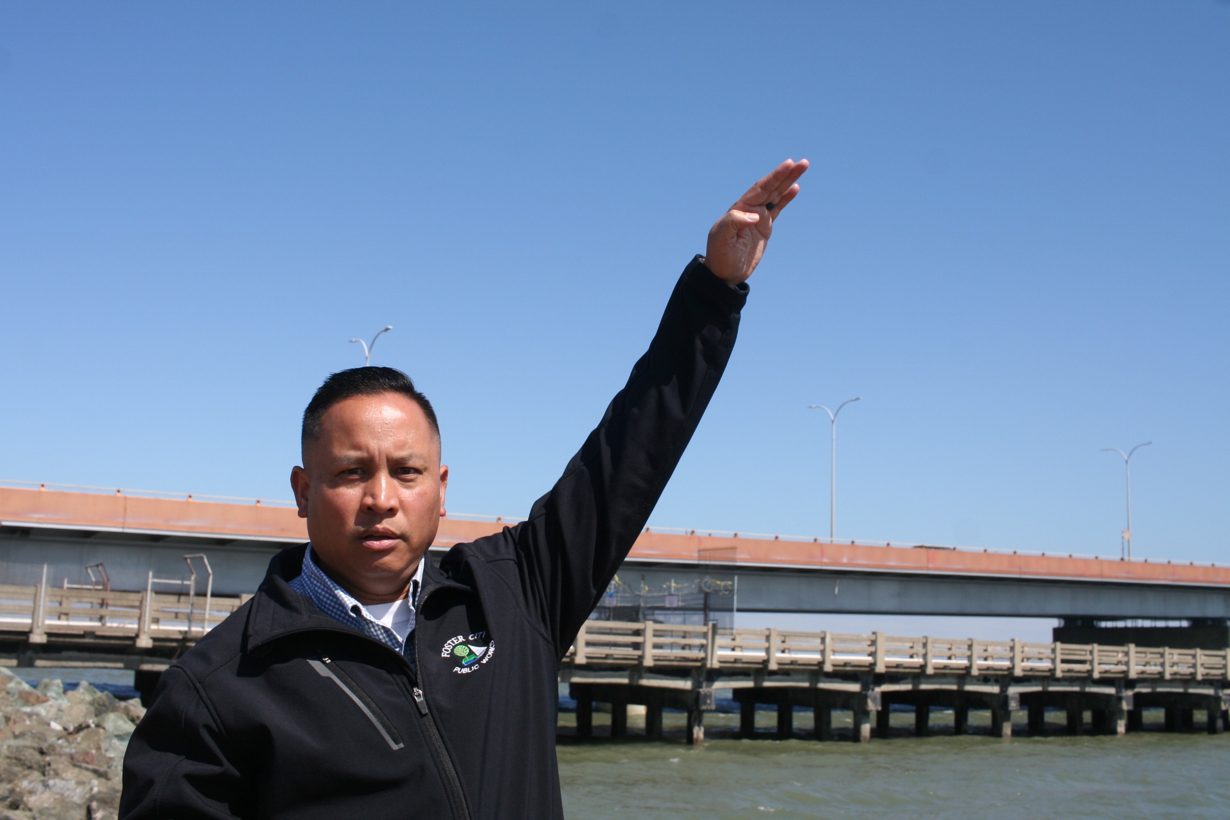
City Manager Jeff Moneda stands atop Foster City’s levee — it’s 13 feet above sea level — and looks down across Beach Park Boulevard at homes with a bayfront view, some worth millions of dollars.
“They would receive the direct impact first if levees were to be breached,” Moneda says. Behind them, he says all of Foster City is “pretty much” at sea level: once water got in, it would stay on low land.
Riprap and earth stand between San Francisco Bay and Foster City. (Molly Peterson/KQED)
Like other vulnerable places, Foster City has always possessed a mechanical and engineered defense against water; here, a man-made lagoon, connected to the bay, is its central component. When storms are on the way, the public works department lowers the lagoon to ready it for more water, and pumps what’s collected out to the bay. But Moneda says changing conditions would test the system by which the city manages water.
“If sea level were to rise to where the levee is breached,” he says, “the pumps could definitely not keep up.”
Risk to private property isn’t the only reason city leaders are seeking support for Measure P. Moneda points to Foster City’s water and emergency systems, also right here at sea level: they could flood too.
“Flushing their toilets, drinking water, ability to take a shower. All of those would be compromised. And then electricity of course,” Moneda says. “The essentials to function on a day-to-day basis would definitely be affected.”
That’s a concern for the Federal Emergency Management Agency. The agency has been remapping the region to assess the true risk of flood, in part because of climate change. Four years ago, FEMA notified Foster City leaders that the odds of water surging over this levee in a storm are too high, and this levee is far too low.
Unless the city has a solution underway by fall, FEMA intends to declare the area a flood hazard zone. Homeowners with federally-backed mortgages or risk-averse lenders would have to buy flood insurance. Some fear that with a flood hazard disclosure, property values could drop.
Beyond that, raising the levee to meet FEMA requirements draws the attention of the Bay Conservation Development Commission, which has authority over the first hundred feet inland for all four hundred miles of bay shoreline. The BCDC requires consideration of sea level rise in proposed developments; Foster City did that by hiring consultants, who recommended planning for 2 feet of sea level rise within 32 years.
So the city proposes to sink steel reinforcements in bay mud to raise the levee up to 8 feet higher, to meet FEMA’s flood requirements, and BCDC’s development guidance.
Measure P would authorize Foster City to purchase $90 million in bonds, and pay for them with a special tax of about $40 per $100,000 in property valuation. If you bought a house there today at the market average, you’d be looking at another $560 a year in taxes. The city contrasts that with the cost of flood insurance inside a special hazard zone; Moneda says officials called local insurance agents and priced that at $3,000 a year or more.
City Manager Jeff Moneda shows how high the city’s new levee needs to be to cope with sea level rise. Foster City voters will decide whether to raise the bayfront levee up to 8 feet higher, at a cost of $90 million. (Molly Peterson/KQED)
“The levee improvement is the only option,” says Moneda.
What One City’s Wall Means to Another
Even one “hardened” piece of shore changes how waves and tides move throughout the bay, says UC Berkeley’s Mark Stacey. Seawalls and levees fortified with riprap reflect wave energy back into the bay and keep water from spreading inland. That raises water levels everywhere. As seas rise, Stacey says more walls along one part of the bay could promote more flooding in another.
One levee in Foster City is small scale. “But if San Mateo acts next in this way and Redwood Shores acts after that,” Stacey says, “And if each of these communities are individually and incrementally pursuing this path, that’s when you start to see the regional impacts.”
Other cities along the southern edge of San Francisco Bay are watching what happens with Measure P: some, because they share an interest in funding pumps and walls, and others, nervously.
In a comment letter about the proposal to raise the Foster City levee, Alameda County’s Flood Control District has argued that “[i]mpacts from the Foster City levee modifications may or may not be small, but the cumulative impacts of Foster City’s Project combined with other future shoreline projects around the San Francisco Bay will exacerbate these effects on others.”
Alameda officials and other critics of the proposal also question whether one city should lead policy on climate change, when a regional, national, or even international response may be more effective.
They include former city leaders and the son of Foster City’s namesake, T. Jack Foster, Jr., himself one of the original developers.
Is This Necessary, or an Overreaction?
When the Fosters arrived, this land was Brewer Island, named for the farmer who levied off marshlands around 1900 to create hay for cattle, while nearby, salt dried in flats for the Leslie Salt company.
The Fosters bought 3000 acres of land, dried it out, and dumped another 18 million cubic yards of sand and fill on top of it. Now 89, T. Jack Foster, Jr., doesn’t accept the conclusion that sea level rise is happening fast. And he says in development, they planned for some land to sink.
“Well, after 50 years, if I’m asked what I would do different, I’d say not one single thing,” Foster, Junior, says. “I’m so proud of the way everything’s turned out.”
He says FEMA’s wrong, and that Foster City is safe.
“The aesthetic damage it does, you can put up with a certain amount of that if you get some benefit otherwise,” he says, about a higher levee. “But I don’t see any benefit at this time.”
With a home on Foster’s lagoon, longtime resident Bob Cushman also opposes Measure P.
“I think Jack Foster was a genius when he designed [this place],” he says.
The lagoon curves behind his home in the Admirals neighborhood: glassy, dyed blue-green. Cushman’s back deck view is man-made, and he loves it. In the 1990s, he and his wife worked hard to get it.
“After church every Sunday we drove through this neighborhood for two years,” Cushman says. “And we finally saw a stake in the front yard there: for sale by owner. We stopped and bought the house. We were so lucky.”
Cushman’s got several objections to Measure P. For one thing, he says, Foster City is sitting on tens of millions of dollars, money already in city coffers that could contribute to the cost of higher levees.
For another, he points out that the city’s made it through high water before, and he credits the engineered defense offered by the levee, the pumps, and the lagoon for that.
And while he does think climate change merits some response by Foster City, he wonders if up to eight feet of additional levee is an overreaction.
“This is a big jump,” Cushman says. “So maybe it’s just too big a leap for the public to swallow. We’ll find out.”
lower waypointnext waypoint
Player sponsored by
window.__IS_SSR__=true
window.__INITIAL_STATE__={
"attachmentsReducer": {
"audio_0": {
"type": "attachments",
"id": "audio_0",
"imgSizes": {
"kqedFullSize": {
"file": "https://ww2.kqed.org/news/wp-content/themes/KQED-unified/img/audio_bgs/background0.jpg"
}
}
},
"audio_1": {
"type": "attachments",
"id": "audio_1",
"imgSizes": {
"kqedFullSize": {
"file": "https://ww2.kqed.org/news/wp-content/themes/KQED-unified/img/audio_bgs/background1.jpg"
}
}
},
"audio_2": {
"type": "attachments",
"id": "audio_2",
"imgSizes": {
"kqedFullSize": {
"file": "https://ww2.kqed.org/news/wp-content/themes/KQED-unified/img/audio_bgs/background2.jpg"
}
}
},
"audio_3": {
"type": "attachments",
"id": "audio_3",
"imgSizes": {
"kqedFullSize": {
"file": "https://ww2.kqed.org/news/wp-content/themes/KQED-unified/img/audio_bgs/background3.jpg"
}
}
},
"audio_4": {
"type": "attachments",
"id": "audio_4",
"imgSizes": {
"kqedFullSize": {
"file": "https://ww2.kqed.org/news/wp-content/themes/KQED-unified/img/audio_bgs/background4.jpg"
}
}
},
"placeholder": {
"type": "attachments",
"id": "placeholder",
"imgSizes": {
"thumbnail": {
"file": "https://cdn.kqed.org/wp-content/uploads/2024/12/KQED-Default-Image-816638274-2000x1333-1-160x107.jpg",
"width": 160,
"height": 107,
"mimeType": "image/jpeg"
},
"medium": {
"file": "https://cdn.kqed.org/wp-content/uploads/2024/12/KQED-Default-Image-816638274-2000x1333-1-800x533.jpg",
"width": 800,
"height": 533,
"mimeType": "image/jpeg"
},
"medium_large": {
"file": "https://cdn.kqed.org/wp-content/uploads/2024/12/KQED-Default-Image-816638274-2000x1333-1-768x512.jpg",
"width": 768,
"height": 512,
"mimeType": "image/jpeg"
},
"large": {
"file": "https://cdn.kqed.org/wp-content/uploads/2024/12/KQED-Default-Image-816638274-2000x1333-1-1020x680.jpg",
"width": 1020,
"height": 680,
"mimeType": "image/jpeg"
},
"1536x1536": {
"file": "https://cdn.kqed.org/wp-content/uploads/2024/12/KQED-Default-Image-816638274-2000x1333-1-1536x1024.jpg",
"width": 1536,
"height": 1024,
"mimeType": "image/jpeg"
},
"fd-lrg": {
"file": "https://cdn.kqed.org/wp-content/uploads/2024/12/KQED-Default-Image-816638274-2000x1333-1-1536x1024.jpg",
"width": 1536,
"height": 1024,
"mimeType": "image/jpeg"
},
"fd-med": {
"file": "https://cdn.kqed.org/wp-content/uploads/2024/12/KQED-Default-Image-816638274-2000x1333-1-1020x680.jpg",
"width": 1020,
"height": 680,
"mimeType": "image/jpeg"
},
"fd-sm": {
"file": "https://cdn.kqed.org/wp-content/uploads/2024/12/KQED-Default-Image-816638274-2000x1333-1-800x533.jpg",
"width": 800,
"height": 533,
"mimeType": "image/jpeg"
},
"post-thumbnail": {
"file": "https://cdn.kqed.org/wp-content/uploads/2024/12/KQED-Default-Image-816638274-2000x1333-1-672x372.jpg",
"width": 672,
"height": 372,
"mimeType": "image/jpeg"
},
"twentyfourteen-full-width": {
"file": "https://cdn.kqed.org/wp-content/uploads/2024/12/KQED-Default-Image-816638274-2000x1333-1-1038x576.jpg",
"width": 1038,
"height": 576,
"mimeType": "image/jpeg"
},
"xxsmall": {
"file": "https://cdn.kqed.org/wp-content/uploads/2024/12/KQED-Default-Image-816638274-2000x1333-1-160x107.jpg",
"width": 160,
"height": 107,
"mimeType": "image/jpeg"
},
"xsmall": {
"file": "https://cdn.kqed.org/wp-content/uploads/2024/12/KQED-Default-Image-816638274-2000x1333-1-672x372.jpg",
"width": 672,
"height": 372,
"mimeType": "image/jpeg"
},
"small": {
"file": "https://cdn.kqed.org/wp-content/uploads/2024/12/KQED-Default-Image-816638274-2000x1333-1-672x372.jpg",
"width": 672,
"height": 372,
"mimeType": "image/jpeg"
},
"xlarge": {
"file": "https://cdn.kqed.org/wp-content/uploads/2024/12/KQED-Default-Image-816638274-2000x1333-1-1020x680.jpg",
"width": 1020,
"height": 680,
"mimeType": "image/jpeg"
},
"full-width": {
"file": "https://cdn.kqed.org/wp-content/uploads/2024/12/KQED-Default-Image-816638274-2000x1333-1-1920x1280.jpg",
"width": 1920,
"height": 1280,
"mimeType": "image/jpeg"
},
"guest-author-32": {
"file": "https://cdn.kqed.org/wp-content/uploads/2025/01/KQED-Default-Image-816638274-1333x1333-1-160x160.jpg",
"width": 32,
"height": 32,
"mimeType": "image/jpeg"
},
"guest-author-50": {
"file": "https://cdn.kqed.org/wp-content/uploads/2025/01/KQED-Default-Image-816638274-1333x1333-1-160x160.jpg",
"width": 50,
"height": 50,
"mimeType": "image/jpeg"
},
"guest-author-64": {
"file": "https://cdn.kqed.org/wp-content/uploads/2025/01/KQED-Default-Image-816638274-1333x1333-1-160x160.jpg",
"width": 64,
"height": 64,
"mimeType": "image/jpeg"
},
"guest-author-96": {
"file": "https://cdn.kqed.org/wp-content/uploads/2025/01/KQED-Default-Image-816638274-1333x1333-1-160x160.jpg",
"width": 96,
"height": 96,
"mimeType": "image/jpeg"
},
"guest-author-128": {
"file": "https://cdn.kqed.org/wp-content/uploads/2025/01/KQED-Default-Image-816638274-1333x1333-1-160x160.jpg",
"width": 128,
"height": 128,
"mimeType": "image/jpeg"
},
"detail": {
"file": "https://cdn.kqed.org/wp-content/uploads/2025/01/KQED-Default-Image-816638274-1333x1333-1-160x160.jpg",
"width": 160,
"height": 160,
"mimeType": "image/jpeg"
},
"kqedFullSize": {
"file": "https://cdn.kqed.org/wp-content/uploads/2024/12/KQED-Default-Image-816638274-2000x1333-1.jpg",
"width": 2000,
"height": 1333
}
}
},
"science_1924586": {
"type": "attachments",
"id": "science_1924586",
"meta": {
"index": "attachments_1716263798",
"site": "science",
"id": "1924586",
"found": true
},
"parent": 1924576,
"imgSizes": {
"small": {
"file": "https://ww2.kqed.org/app/uploads/sites/35/2018/05/RS31120_IMG_6447-520x347.jpeg",
"width": 520,
"mimeType": "image/jpeg",
"height": 347
},
"twentyfourteen-full-width": {
"file": "https://ww2.kqed.org/app/uploads/sites/35/2018/05/RS31120_IMG_6447-1038x576.jpeg",
"width": 1038,
"mimeType": "image/jpeg",
"height": 576
},
"thumbnail": {
"file": "https://ww2.kqed.org/app/uploads/sites/35/2018/05/RS31120_IMG_6447-160x107.jpeg",
"width": 160,
"mimeType": "image/jpeg",
"height": 107
},
"fd-sm": {
"file": "https://ww2.kqed.org/app/uploads/sites/35/2018/05/RS31120_IMG_6447-960x640.jpeg",
"width": 960,
"mimeType": "image/jpeg",
"height": 640
},
"post-thumbnail": {
"file": "https://ww2.kqed.org/app/uploads/sites/35/2018/05/RS31120_IMG_6447-672x372.jpeg",
"width": 672,
"mimeType": "image/jpeg",
"height": 372
},
"xsmall": {
"file": "https://ww2.kqed.org/app/uploads/sites/35/2018/05/RS31120_IMG_6447-375x250.jpeg",
"width": 375,
"mimeType": "image/jpeg",
"height": 250
},
"kqedFullSize": {
"file": "https://ww2.kqed.org/app/uploads/sites/35/2018/05/RS31120_IMG_6447.jpeg",
"width": 2496,
"height": 1664
},
"large": {
"file": "https://ww2.kqed.org/app/uploads/sites/35/2018/05/RS31120_IMG_6447-1020x680.jpeg",
"width": 1020,
"mimeType": "image/jpeg",
"height": 680
},
"xlarge": {
"file": "https://ww2.kqed.org/app/uploads/sites/35/2018/05/RS31120_IMG_6447-1180x787.jpeg",
"width": 1180,
"mimeType": "image/jpeg",
"height": 787
},
"complete_open_graph": {
"file": "https://ww2.kqed.org/app/uploads/sites/35/2018/05/RS31120_IMG_6447-1200x800.jpeg",
"width": 1200,
"mimeType": "image/jpeg",
"height": 800
},
"guest-author-50": {
"file": "https://ww2.kqed.org/app/uploads/sites/35/2018/05/RS31120_IMG_6447-50x50.jpeg",
"width": 50,
"mimeType": "image/jpeg",
"height": 50
},
"guest-author-96": {
"file": "https://ww2.kqed.org/app/uploads/sites/35/2018/05/RS31120_IMG_6447-96x96.jpeg",
"width": 96,
"mimeType": "image/jpeg",
"height": 96
},
"medium": {
"file": "https://ww2.kqed.org/app/uploads/sites/35/2018/05/RS31120_IMG_6447-800x533.jpeg",
"width": 800,
"mimeType": "image/jpeg",
"height": 533
},
"guest-author-64": {
"file": "https://ww2.kqed.org/app/uploads/sites/35/2018/05/RS31120_IMG_6447-64x64.jpeg",
"width": 64,
"mimeType": "image/jpeg",
"height": 64
},
"guest-author-32": {
"file": "https://ww2.kqed.org/app/uploads/sites/35/2018/05/RS31120_IMG_6447-32x32.jpeg",
"width": 32,
"mimeType": "image/jpeg",
"height": 32
},
"fd-lrg": {
"file": "https://ww2.kqed.org/app/uploads/sites/35/2018/05/RS31120_IMG_6447-1920x1280.jpeg",
"width": 1920,
"mimeType": "image/jpeg",
"height": 1280
},
"fd-med": {
"file": "https://ww2.kqed.org/app/uploads/sites/35/2018/05/RS31120_IMG_6447-1180x787.jpeg",
"width": 1180,
"mimeType": "image/jpeg",
"height": 787
},
"full-width": {
"file": "https://ww2.kqed.org/app/uploads/sites/35/2018/05/RS31120_IMG_6447-1920x1280.jpeg",
"width": 1920,
"mimeType": "image/jpeg",
"height": 1280
},
"detail": {
"file": "https://ww2.kqed.org/app/uploads/sites/35/2018/05/RS31120_IMG_6447-150x150.jpeg",
"width": 150,
"mimeType": "image/jpeg",
"height": 150
},
"medium_large": {
"file": "https://ww2.kqed.org/app/uploads/sites/35/2018/05/RS31120_IMG_6447-768x512.jpeg",
"width": 768,
"mimeType": "image/jpeg",
"height": 512
},
"guest-author-128": {
"file": "https://ww2.kqed.org/app/uploads/sites/35/2018/05/RS31120_IMG_6447-128x128.jpeg",
"width": 128,
"mimeType": "image/jpeg",
"height": 128
},
"xxsmall": {
"file": "https://ww2.kqed.org/app/uploads/sites/35/2018/05/RS31120_IMG_6447-240x160.jpeg",
"width": 240,
"mimeType": "image/jpeg",
"height": 160
}
},
"publishDate": 1527558750,
"modified": 1527627259,
"caption": "Foster City Manager Jeff Moneda says it's not just homes that are threatened by flooding from rising seas and extreme storms. It's also critical systems, including electricity and water.",
"description": null,
"title": "RS31120_IMG_6447",
"credit": "Molly Peterson/KQED",
"status": "inherit",
"isLoading": false,
"fetchFailed": false
}
},
"audioPlayerReducer": {
"postId": "stream_live",
"isPaused": true,
"isPlaying": false,
"pfsActive": false,
"pledgeModalIsOpen": true,
"playerDrawerIsOpen": false,
"liveAudioPlayStartedAt": 0,
"liveAudioPlayContext": ""
},
"authorsReducer": {
"mpeterson": {
"type": "authors",
"id": "11223",
"meta": {
"index": "authors_1716337520",
"id": "11223",
"found": true
},
"name": "Molly Peterson",
"firstName": "Molly",
"lastName": "Peterson",
"slug": "mpeterson",
"email": "mpeterson@kqed.org",
"display_author_email": false,
"staff_mastheads": [],
"title": null,
"bio": "Molly Peterson reports for KQED science and news on climate change, catastrophe and risk. Previously she was environment correspondent at Southern California Public Radio. Her work has also appeared at The New York Times, The Guardian, on NPR, at High Country News, on Code Switch, and other national outlets. She has been honored with awards from Public Radio News Directors Incorporated, Investigative Reporters and Editors, the Society for Professional Journalists, the Los Angeles Press Club, and RTNDA Edward R. Murrow awards, among others.",
"avatar": "https://secure.gravatar.com/avatar/7908e2807131f776cc8165c649530b05?s=600&d=blank&r=g",
"twitter": "Mollydacious",
"facebook": null,
"instagram": "https://www.instagram.com/radiomolly/",
"linkedin": null,
"sites": [
{
"site": "news",
"roles": [
"subscriber"
]
},
{
"site": "futureofyou",
"roles": [
"editor"
]
},
{
"site": "science",
"roles": [
"editor"
]
}
],
"headData": {
"title": "Molly Peterson | KQED",
"description": null,
"ogImgSrc": "https://secure.gravatar.com/avatar/7908e2807131f776cc8165c649530b05?s=600&d=blank&r=g",
"twImgSrc": "https://secure.gravatar.com/avatar/7908e2807131f776cc8165c649530b05?s=600&d=blank&r=g"
},
"isLoading": false,
"link": "/author/mpeterson"
}
},
"pagesReducer": {},
"pfsSessionReducer": {},
"postsReducer": {
"stream_live": {
"type": "live",
"id": "stream_live",
"audioUrl": "https://streams.kqed.org/kqedradio",
"title": "Live Stream",
"excerpt": "Live Stream information currently unavailable.",
"link": "/radio",
"featImg": "",
"label": {
"name": "KQED Live",
"link": "/"
}
},
"stream_kqedNewscast": {
"type": "posts",
"id": "stream_kqedNewscast",
"audioUrl": "https://www.kqed.org/.stream/anon/radio/RDnews/newscast.mp3?_=1",
"title": "KQED Newscast",
"featImg": "",
"label": {
"name": "88.5 FM",
"link": "/"
}
},
"science_1924576": {
"type": "posts",
"id": "science_1924576",
"meta": {
"index": "posts_1716263798",
"site": "science",
"id": "1924576",
"found": true
},
"articlePosition": 0,
"parent": 0,
"labelTerm": {
"site": "science"
},
"blocks": [],
"publishDate": 1528303047,
"format": "standard",
"title": "Measure P: Foster City Overwhelmingly Votes for $90 Million Tax to Defend Against Rising Seas",
"headTitle": "Measure P: Foster City Overwhelmingly Votes for $90 Million Tax to Defend Against Rising Seas | KQED",
"content": "\u003cp>\u003cem>UPDATE: Voters overwhelmingly approved Foster City Measure P by a roughly 80-20 margin, in one of the first major tests of a community’s willingness to tax itself to gird against climate change impacts.\u003c/em>\u003c/p>\n\u003cp>The only thing between Foster City and the salty San Francisco Bay is an earthen wall, eight miles long, fronted with crushed up concrete and riprap to defend against the sea.\u003c/p>\n\u003caside class=\"pullquote alignright\">‘Foster City is the canary in the coal mine for the Bay Area.’\u003ccite>Mark Stacey, UC Berkeley\u003c/cite>\u003c/aside>\n\u003cp>On one level, the San Mateo County suburb’s voters face a straightforward choice about this levee on the June 5 ballot: whether to tax themselves to raise it, or run a higher risk of flooding.\u003c/p>\n\u003cp>But amid \u003ca href=\"https://www.kqed.org/science/1920819/treasure-island-is-sinking-as-seas-are-rising-and-so-are-other-bay-area-cities\">new reports of sinking land\u003c/a> and rising seas, Foster City’s Measure P also offers the Bay Area’s first example for what one bayfront community is willing to do against the threat of climate-induced flooding.\u003c/p>\n\u003cp>“Foster City is the canary in the coal mine for the Bay Area,” says UC Berkeley environmental engineering professor Mark Stacey, \u003ca href=\"https://vcresearch.berkeley.edu/faculty/mark-stacey\">who has studied sea level rise in the bay\u003c/a>. “They’re facing an immediate decision on what to do with their shorelines.”\u003c/p>\n\u003cp>[ad fullwidth]\u003c/p>\n\u003cp>\u003cstrong>Foster City’s Risk of Flooding\u003c/strong>\u003c/p>\n\u003cp>City Manager Jeff Moneda stands atop Foster City’s levee — it’s 13 feet above sea level — and looks down across Beach Park Boulevard at homes with a bayfront view, some worth millions of dollars.\u003c/p>\n\u003cp>“They would receive the direct impact first if levees were to be breached,” Moneda says. Behind them, he says all of Foster City is “pretty much” at sea level: once water got in, it would stay on low land.\u003c/p>\n\u003cfigure id=\"attachment_1924708\" class=\"wp-caption aligncenter\" style=\"max-width: 2496px\">\u003ca href=\"https://ww2.kqed.org/science/wp-content/uploads/sites/35/2018/05/RS31123_IMG_6463-1.jpg\">\u003cimg loading=\"lazy\" decoding=\"async\" class=\"size-full wp-image-1924708\" src=\"https://ww2.kqed.org/science/wp-content/uploads/sites/35/2018/05/RS31123_IMG_6463-1.jpg\" alt=\"\" width=\"2496\" height=\"1664\" srcset=\"https://cdn.kqed.org/wp-content/uploads/sites/35/2018/05/RS31123_IMG_6463-1.jpg 2496w, https://cdn.kqed.org/wp-content/uploads/sites/35/2018/05/RS31123_IMG_6463-1-160x107.jpg 160w, https://cdn.kqed.org/wp-content/uploads/sites/35/2018/05/RS31123_IMG_6463-1-800x533.jpg 800w, https://cdn.kqed.org/wp-content/uploads/sites/35/2018/05/RS31123_IMG_6463-1-768x512.jpg 768w, https://cdn.kqed.org/wp-content/uploads/sites/35/2018/05/RS31123_IMG_6463-1-1020x680.jpg 1020w, https://cdn.kqed.org/wp-content/uploads/sites/35/2018/05/RS31123_IMG_6463-1-1200x800.jpg 1200w, https://cdn.kqed.org/wp-content/uploads/sites/35/2018/05/RS31123_IMG_6463-1-1920x1280.jpg 1920w, https://cdn.kqed.org/wp-content/uploads/sites/35/2018/05/RS31123_IMG_6463-1-1180x787.jpg 1180w, https://cdn.kqed.org/wp-content/uploads/sites/35/2018/05/RS31123_IMG_6463-1-960x640.jpg 960w, https://cdn.kqed.org/wp-content/uploads/sites/35/2018/05/RS31123_IMG_6463-1-240x160.jpg 240w, https://cdn.kqed.org/wp-content/uploads/sites/35/2018/05/RS31123_IMG_6463-1-375x250.jpg 375w, https://cdn.kqed.org/wp-content/uploads/sites/35/2018/05/RS31123_IMG_6463-1-520x347.jpg 520w\" sizes=\"(max-width: 2496px) 100vw, 2496px\">\u003c/a>\u003cfigcaption class=\"wp-caption-text\">Riprap and earth stand between San Francisco Bay and Foster City. \u003ccite>(Molly Peterson/KQED)\u003c/cite>\u003c/figcaption>\u003c/figure>\n\u003cp>Like other vulnerable places, Foster City has always possessed a mechanical and engineered defense against water; here, a man-made lagoon, connected to the bay, is its central component. When storms are on the way, the public works department lowers the lagoon to ready it for more water, and pumps what’s collected out to the bay. But Moneda says changing conditions would test the system by which the city manages water.\u003c/p>\n\u003cp>“If sea level were to rise to where the levee is breached,” he says, “the pumps could definitely not keep up.”\u003c/p>\n\u003cp>Risk to private property isn’t the only reason city leaders are seeking support for Measure P. Moneda points to Foster City’s water and emergency systems, also right here at sea level: they could flood too.\u003c/p>\n\u003cp>[contextly_sidebar id=”gznrjQjhtM0anBFX9T1jHEA7c1fklU7M”]“Flushing their toilets, drinking water, ability to take a shower. All of those would be compromised. And then electricity of course,” Moneda says. “The essentials to function on a day-to-day basis would definitely be affected.”\u003c/p>\n\u003cp>That’s a concern for the Federal Emergency Management Agency. The agency has been remapping the region to assess the true risk of flood, in part because of climate change. Four years ago, FEMA notified Foster City leaders that the odds of water surging over this levee in a storm are too high, and this levee is far too low.\u003c/p>\n\u003cp>Unless the city has a solution underway by fall, FEMA intends to declare the area a flood hazard zone. Homeowners with federally-backed mortgages or risk-averse lenders would have to buy flood insurance. Some fear that with a flood hazard disclosure, property values could drop.\u003c/p>\n\u003caside class=\"pullquote alignleft\">‘The essentials to function on a day-to-day basis would definitely be affected.’\u003ccite>Jeff Moneda, City Manager, Foster City\u003c/cite>\u003c/aside>\n\u003cp>Beyond that, raising the levee to meet FEMA requirements draws the attention of the Bay Conservation Development Commission, which has authority over the first hundred feet inland for all four hundred miles of bay shoreline. The BCDC requires consideration of sea level rise in proposed developments; Foster City did that by hiring consultants, who recommended planning for 2 feet of sea level rise within 32 years.\u003c/p>\n\u003cp>So the city proposes to sink steel reinforcements in bay mud to raise the levee up to 8 feet higher, to meet FEMA’s flood requirements, and BCDC’s development guidance.\u003c/p>\n\u003cp>Measure P would authorize Foster City to purchase $90 million in bonds, and pay for them with a special tax of about $40 per $100,000 in property valuation. If you bought a house there today at the market average, you’d be looking at another $560 a year in taxes. The city contrasts that with the cost of flood insurance inside a special hazard zone; Moneda says officials called local insurance agents and priced that at $3,000 a year or more.\u003c/p>\n\u003cfigure id=\"attachment_1924585\" class=\"wp-caption alignright\" style=\"max-width: 2496px\">\u003ca href=\"https://ww2.kqed.org/science/wp-content/uploads/sites/35/2018/05/RS31118_IMG_6418.jpeg\">\u003cimg loading=\"lazy\" decoding=\"async\" class=\"size-full wp-image-1924585\" src=\"https://ww2.kqed.org/science/wp-content/uploads/sites/35/2018/05/RS31118_IMG_6418.jpeg\" alt=\"City Manager Jeff Moneda, standing on a levee.\" width=\"2496\" height=\"1664\" srcset=\"https://cdn.kqed.org/wp-content/uploads/sites/35/2018/05/RS31118_IMG_6418.jpeg 2496w, https://cdn.kqed.org/wp-content/uploads/sites/35/2018/05/RS31118_IMG_6418-160x107.jpeg 160w, https://cdn.kqed.org/wp-content/uploads/sites/35/2018/05/RS31118_IMG_6418-800x533.jpeg 800w, https://cdn.kqed.org/wp-content/uploads/sites/35/2018/05/RS31118_IMG_6418-768x512.jpeg 768w, https://cdn.kqed.org/wp-content/uploads/sites/35/2018/05/RS31118_IMG_6418-1020x680.jpeg 1020w, https://cdn.kqed.org/wp-content/uploads/sites/35/2018/05/RS31118_IMG_6418-1200x800.jpeg 1200w, https://cdn.kqed.org/wp-content/uploads/sites/35/2018/05/RS31118_IMG_6418-1920x1280.jpeg 1920w, https://cdn.kqed.org/wp-content/uploads/sites/35/2018/05/RS31118_IMG_6418-1180x787.jpeg 1180w, https://cdn.kqed.org/wp-content/uploads/sites/35/2018/05/RS31118_IMG_6418-960x640.jpeg 960w, https://cdn.kqed.org/wp-content/uploads/sites/35/2018/05/RS31118_IMG_6418-240x160.jpeg 240w, https://cdn.kqed.org/wp-content/uploads/sites/35/2018/05/RS31118_IMG_6418-375x250.jpeg 375w, https://cdn.kqed.org/wp-content/uploads/sites/35/2018/05/RS31118_IMG_6418-520x347.jpeg 520w\" sizes=\"(max-width: 2496px) 100vw, 2496px\">\u003c/a>\u003cfigcaption class=\"wp-caption-text\">City Manager Jeff Moneda shows how high the city’s new levee needs to be to cope with sea level rise. Foster City voters will decide whether to raise the bayfront levee up to 8 feet higher, at a cost of $90 million. \u003ccite>(Molly Peterson/KQED)\u003c/cite>\u003c/figcaption>\u003c/figure>\n\u003cp>“The levee improvement is the only option,” says Moneda.\u003c/p>\n\u003cp>\u003cstrong>What One City’s Wall Means to Another\u003c/strong>\u003c/p>\n\u003cp>Even one “hardened” piece of shore changes how waves and tides move throughout the bay, says UC Berkeley’s Mark Stacey. Seawalls and levees fortified with riprap reflect wave energy back into the bay and keep water from spreading inland. That raises water levels everywhere. As seas rise, Stacey says more walls along one part of the bay could promote more flooding in another.\u003c/p>\n\u003cp>One levee in Foster City is small scale. “But if San Mateo acts next in this way and Redwood Shores acts after that,” Stacey says, “And if each of these communities are individually and incrementally pursuing this path, that’s when you start to see the regional impacts.”\u003c/p>\n\u003cp>Other cities along the southern edge of San Francisco Bay are watching what happens with Measure P: some, because they share an interest in funding pumps and walls, and others, nervously.\u003c/p>\n\u003caside class=\"pullquote alignleft\">‘This is a big jump. So maybe it’s just too big a leap for the public to swallow. We’ll find out.’\u003ccite>Bob Cushman, Foster City resident\u003c/cite>\u003c/aside>\n\u003cp>In a comment letter about the proposal to raise the Foster City levee, Alameda County’s Flood Control District \u003ca href=\"https://www.fostercity.org/sites/default/files/fileattachments/community_development/page/4961/fc-levee-rtc_final.pdf\">has argued that\u003c/a> “[i]mpacts from the Foster City levee modifications may or may not be small, but the cumulative impacts of Foster City’s Project combined with other future shoreline projects around the San Francisco Bay will exacerbate these effects on others.”\u003c/p>\n\u003cp>Alameda officials and other critics of the proposal also question whether one city should lead policy on climate change, when a regional, national, or even international response may be more effective.\u003c/p>\n\u003cp>They include former city leaders and the son of Foster City’s namesake, \u003ca href=\"http://www.samceda.org/san-mateo-county-economic-development/samceda-board/t-jack-foster-jr\">T. Jack Foster, Jr.\u003c/a>, himself one of the original developers.\u003c/p>\n\u003cp>\u003cstrong>Is This Necessary, or an Overreaction?\u003c/strong>\u003c/p>\n\u003cp>When the Fosters \u003ca href=\"https://www.xlibris.com/bookstore/bookdetail.aspx?bookid=SKU-0118054049\">arrived\u003c/a>, this land was Brewer Island, named for the farmer who levied off marshlands around 1900 to create hay for cattle, while nearby, salt dried in flats for the Leslie Salt company.\u003c/p>\n\u003cp>The Fosters bought 3000 acres of land, dried it out, and dumped another 18 million cubic yards of sand and fill on top of it. Now 89, T. Jack Foster, Jr., doesn’t accept the conclusion that sea level rise is happening fast. And he says in development, they planned for some land to sink.\u003c/p>\n\u003cp>“Well, after 50 years, if I’m asked what I would do different, I’d say not one single thing,” Foster, Junior, says. “I’m so proud of the way everything’s turned out.”\u003c/p>\n\u003cp>He says FEMA’s wrong, and that Foster City is safe.\u003c/p>\n\u003cp>“The aesthetic damage it does, you can put up with a certain amount of that if you get some benefit otherwise,” he says, about a higher levee. “But I don’t see any benefit at this time.”\u003c/p>\n\u003cp>With a home on Foster’s lagoon, longtime resident Bob Cushman also opposes Measure P.\u003c/p>\n\u003cp>“I think Jack Foster was a genius when he designed [this place],” he says.\u003c/p>\n\u003cp>The lagoon curves behind his home in the Admirals neighborhood: glassy, dyed blue-green. Cushman’s back deck view is man-made, and he loves it. In the 1990s, he and his wife worked hard to get it.\u003c/p>\n\u003cp>“After church every Sunday we drove through this neighborhood for two years,” Cushman says. “And we finally saw a stake in the front yard there: for sale by owner. We stopped and bought the house. We were so lucky.”\u003c/p>\n\u003cp>Cushman’s got several objections to Measure P. For one thing, he says, Foster City is sitting on tens of millions of dollars, money already in city coffers that could contribute to the cost of higher levees.\u003c/p>\n\u003cp>For another, he points out that the city’s made it through high water before, and he credits the engineered defense offered by the levee, the pumps, and the lagoon for that.\u003c/p>\n\u003cp>And while he does think climate change merits some response by Foster City, he wonders if up to eight feet of additional levee is an overreaction.\u003c/p>\n\u003cp>“This is a big jump,” Cushman says. “So maybe it’s just too big a leap for the public to swallow. We’ll find out.”\u003c/p>\n\u003cp> \u003c/p>\n\u003cp>[ad floatright]\u003c/p>\n\u003cp> \u003c/p>\n\n",
"stats": {
"hasVideo": false,
"hasChartOrMap": false,
"hasAudio": false,
"hasPolis": false,
"wordCount": 1622,
"hasGoogleForm": false,
"hasGallery": false,
"hasHearkenModule": false,
"iframeSrcs": [],
"paragraphCount": 41
},
"modified": 1704927842,
"excerpt": "In one of the first major tests of a community's willingness to tax itself to gird against climate change, the measure passed by roughly 80-20 percent.",
"headData": {
"twImgId": "",
"twTitle": "",
"ogTitle": "",
"ogImgId": "",
"twDescription": "",
"description": "In one of the first major tests of a community's willingness to tax itself to gird against climate change, the measure passed by roughly 80-20 percent.",
"title": "Measure P: Foster City Overwhelmingly Votes for $90 Million Tax to Defend Against Rising Seas | KQED",
"ogDescription": "",
"schema": {
"@context": "https://schema.org",
"@type": "Article",
"headline": "Measure P: Foster City Overwhelmingly Votes for $90 Million Tax to Defend Against Rising Seas",
"datePublished": "2018-06-06T09:37:27-07:00",
"dateModified": "2024-01-10T15:04:02-08:00",
"image": "https://ww2.kqed.org/app/uploads/sites/35/2018/05/RS31120_IMG_6447-1020x680.jpeg",
"author": {
"@type": "Person",
"name": "Molly Peterson",
"jobTitle": "Journalist",
"url": "https://www.kqed.org/author/mpeterson"
}
},
"authorsData": [],
"tagData": []
},
"guestAuthors": [],
"slug": "measure-p-foster-citys-90-million-tax-to-defend-against-rising-seas",
"status": "publish",
"sticky": false,
"path": "/science/1924576/measure-p-foster-citys-90-million-tax-to-defend-against-rising-seas",
"audioTrackLength": null,
"parsedContent": [
{
"type": "contentString",
"content": "\u003cdiv class=\"post-body\">\u003cp>\u003cp>\u003cem>UPDATE: Voters overwhelmingly approved Foster City Measure P by a roughly 80-20 margin, in one of the first major tests of a community’s willingness to tax itself to gird against climate change impacts.\u003c/em>\u003c/p>\n\u003cp>The only thing between Foster City and the salty San Francisco Bay is an earthen wall, eight miles long, fronted with crushed up concrete and riprap to defend against the sea.\u003c/p>\n\u003caside class=\"pullquote alignright\">‘Foster City is the canary in the coal mine for the Bay Area.’\u003ccite>Mark Stacey, UC Berkeley\u003c/cite>\u003c/aside>\n\u003cp>On one level, the San Mateo County suburb’s voters face a straightforward choice about this levee on the June 5 ballot: whether to tax themselves to raise it, or run a higher risk of flooding.\u003c/p>\n\u003cp>But amid \u003ca href=\"https://www.kqed.org/science/1920819/treasure-island-is-sinking-as-seas-are-rising-and-so-are-other-bay-area-cities\">new reports of sinking land\u003c/a> and rising seas, Foster City’s Measure P also offers the Bay Area’s first example for what one bayfront community is willing to do against the threat of climate-induced flooding.\u003c/p>\n\u003cp>“Foster City is the canary in the coal mine for the Bay Area,” says UC Berkeley environmental engineering professor Mark Stacey, \u003ca href=\"https://vcresearch.berkeley.edu/faculty/mark-stacey\">who has studied sea level rise in the bay\u003c/a>. “They’re facing an immediate decision on what to do with their shorelines.”\u003c/p>\n\u003cp>\u003c/p>\u003c/div>",
"attributes": {
"named": {},
"numeric": []
}
},
{
"type": "component",
"content": "",
"name": "ad",
"attributes": {
"named": {
"label": "fullwidth"
},
"numeric": [
"fullwidth"
]
}
},
{
"type": "contentString",
"content": "\u003cdiv class=\"post-body\">\u003cp>\u003c/p>\n\u003cp>\u003cstrong>Foster City’s Risk of Flooding\u003c/strong>\u003c/p>\n\u003cp>City Manager Jeff Moneda stands atop Foster City’s levee — it’s 13 feet above sea level — and looks down across Beach Park Boulevard at homes with a bayfront view, some worth millions of dollars.\u003c/p>\n\u003cp>“They would receive the direct impact first if levees were to be breached,” Moneda says. Behind them, he says all of Foster City is “pretty much” at sea level: once water got in, it would stay on low land.\u003c/p>\n\u003cfigure id=\"attachment_1924708\" class=\"wp-caption aligncenter\" style=\"max-width: 2496px\">\u003ca href=\"https://ww2.kqed.org/science/wp-content/uploads/sites/35/2018/05/RS31123_IMG_6463-1.jpg\">\u003cimg loading=\"lazy\" decoding=\"async\" class=\"size-full wp-image-1924708\" src=\"https://ww2.kqed.org/science/wp-content/uploads/sites/35/2018/05/RS31123_IMG_6463-1.jpg\" alt=\"\" width=\"2496\" height=\"1664\" srcset=\"https://cdn.kqed.org/wp-content/uploads/sites/35/2018/05/RS31123_IMG_6463-1.jpg 2496w, https://cdn.kqed.org/wp-content/uploads/sites/35/2018/05/RS31123_IMG_6463-1-160x107.jpg 160w, https://cdn.kqed.org/wp-content/uploads/sites/35/2018/05/RS31123_IMG_6463-1-800x533.jpg 800w, https://cdn.kqed.org/wp-content/uploads/sites/35/2018/05/RS31123_IMG_6463-1-768x512.jpg 768w, https://cdn.kqed.org/wp-content/uploads/sites/35/2018/05/RS31123_IMG_6463-1-1020x680.jpg 1020w, https://cdn.kqed.org/wp-content/uploads/sites/35/2018/05/RS31123_IMG_6463-1-1200x800.jpg 1200w, https://cdn.kqed.org/wp-content/uploads/sites/35/2018/05/RS31123_IMG_6463-1-1920x1280.jpg 1920w, https://cdn.kqed.org/wp-content/uploads/sites/35/2018/05/RS31123_IMG_6463-1-1180x787.jpg 1180w, https://cdn.kqed.org/wp-content/uploads/sites/35/2018/05/RS31123_IMG_6463-1-960x640.jpg 960w, https://cdn.kqed.org/wp-content/uploads/sites/35/2018/05/RS31123_IMG_6463-1-240x160.jpg 240w, https://cdn.kqed.org/wp-content/uploads/sites/35/2018/05/RS31123_IMG_6463-1-375x250.jpg 375w, https://cdn.kqed.org/wp-content/uploads/sites/35/2018/05/RS31123_IMG_6463-1-520x347.jpg 520w\" sizes=\"(max-width: 2496px) 100vw, 2496px\">\u003c/a>\u003cfigcaption class=\"wp-caption-text\">Riprap and earth stand between San Francisco Bay and Foster City. \u003ccite>(Molly Peterson/KQED)\u003c/cite>\u003c/figcaption>\u003c/figure>\n\u003cp>Like other vulnerable places, Foster City has always possessed a mechanical and engineered defense against water; here, a man-made lagoon, connected to the bay, is its central component. When storms are on the way, the public works department lowers the lagoon to ready it for more water, and pumps what’s collected out to the bay. But Moneda says changing conditions would test the system by which the city manages water.\u003c/p>\n\u003cp>“If sea level were to rise to where the levee is breached,” he says, “the pumps could definitely not keep up.”\u003c/p>\n\u003cp>Risk to private property isn’t the only reason city leaders are seeking support for Measure P. Moneda points to Foster City’s water and emergency systems, also right here at sea level: they could flood too.\u003c/p>\n\u003cp>\u003c/p>\u003cp>\u003c/p>\u003cp>“Flushing their toilets, drinking water, ability to take a shower. All of those would be compromised. And then electricity of course,” Moneda says. “The essentials to function on a day-to-day basis would definitely be affected.”\u003c/p>\n\u003cp>That’s a concern for the Federal Emergency Management Agency. The agency has been remapping the region to assess the true risk of flood, in part because of climate change. Four years ago, FEMA notified Foster City leaders that the odds of water surging over this levee in a storm are too high, and this levee is far too low.\u003c/p>\n\u003cp>Unless the city has a solution underway by fall, FEMA intends to declare the area a flood hazard zone. Homeowners with federally-backed mortgages or risk-averse lenders would have to buy flood insurance. Some fear that with a flood hazard disclosure, property values could drop.\u003c/p>\n\u003caside class=\"pullquote alignleft\">‘The essentials to function on a day-to-day basis would definitely be affected.’\u003ccite>Jeff Moneda, City Manager, Foster City\u003c/cite>\u003c/aside>\n\u003cp>Beyond that, raising the levee to meet FEMA requirements draws the attention of the Bay Conservation Development Commission, which has authority over the first hundred feet inland for all four hundred miles of bay shoreline. The BCDC requires consideration of sea level rise in proposed developments; Foster City did that by hiring consultants, who recommended planning for 2 feet of sea level rise within 32 years.\u003c/p>\n\u003cp>So the city proposes to sink steel reinforcements in bay mud to raise the levee up to 8 feet higher, to meet FEMA’s flood requirements, and BCDC’s development guidance.\u003c/p>\n\u003cp>Measure P would authorize Foster City to purchase $90 million in bonds, and pay for them with a special tax of about $40 per $100,000 in property valuation. If you bought a house there today at the market average, you’d be looking at another $560 a year in taxes. The city contrasts that with the cost of flood insurance inside a special hazard zone; Moneda says officials called local insurance agents and priced that at $3,000 a year or more.\u003c/p>\n\u003cfigure id=\"attachment_1924585\" class=\"wp-caption alignright\" style=\"max-width: 2496px\">\u003ca href=\"https://ww2.kqed.org/science/wp-content/uploads/sites/35/2018/05/RS31118_IMG_6418.jpeg\">\u003cimg loading=\"lazy\" decoding=\"async\" class=\"size-full wp-image-1924585\" src=\"https://ww2.kqed.org/science/wp-content/uploads/sites/35/2018/05/RS31118_IMG_6418.jpeg\" alt=\"City Manager Jeff Moneda, standing on a levee.\" width=\"2496\" height=\"1664\" srcset=\"https://cdn.kqed.org/wp-content/uploads/sites/35/2018/05/RS31118_IMG_6418.jpeg 2496w, https://cdn.kqed.org/wp-content/uploads/sites/35/2018/05/RS31118_IMG_6418-160x107.jpeg 160w, https://cdn.kqed.org/wp-content/uploads/sites/35/2018/05/RS31118_IMG_6418-800x533.jpeg 800w, https://cdn.kqed.org/wp-content/uploads/sites/35/2018/05/RS31118_IMG_6418-768x512.jpeg 768w, https://cdn.kqed.org/wp-content/uploads/sites/35/2018/05/RS31118_IMG_6418-1020x680.jpeg 1020w, https://cdn.kqed.org/wp-content/uploads/sites/35/2018/05/RS31118_IMG_6418-1200x800.jpeg 1200w, https://cdn.kqed.org/wp-content/uploads/sites/35/2018/05/RS31118_IMG_6418-1920x1280.jpeg 1920w, https://cdn.kqed.org/wp-content/uploads/sites/35/2018/05/RS31118_IMG_6418-1180x787.jpeg 1180w, https://cdn.kqed.org/wp-content/uploads/sites/35/2018/05/RS31118_IMG_6418-960x640.jpeg 960w, https://cdn.kqed.org/wp-content/uploads/sites/35/2018/05/RS31118_IMG_6418-240x160.jpeg 240w, https://cdn.kqed.org/wp-content/uploads/sites/35/2018/05/RS31118_IMG_6418-375x250.jpeg 375w, https://cdn.kqed.org/wp-content/uploads/sites/35/2018/05/RS31118_IMG_6418-520x347.jpeg 520w\" sizes=\"(max-width: 2496px) 100vw, 2496px\">\u003c/a>\u003cfigcaption class=\"wp-caption-text\">City Manager Jeff Moneda shows how high the city’s new levee needs to be to cope with sea level rise. Foster City voters will decide whether to raise the bayfront levee up to 8 feet higher, at a cost of $90 million. \u003ccite>(Molly Peterson/KQED)\u003c/cite>\u003c/figcaption>\u003c/figure>\n\u003cp>“The levee improvement is the only option,” says Moneda.\u003c/p>\n\u003cp>\u003cstrong>What One City’s Wall Means to Another\u003c/strong>\u003c/p>\n\u003cp>Even one “hardened” piece of shore changes how waves and tides move throughout the bay, says UC Berkeley’s Mark Stacey. Seawalls and levees fortified with riprap reflect wave energy back into the bay and keep water from spreading inland. That raises water levels everywhere. As seas rise, Stacey says more walls along one part of the bay could promote more flooding in another.\u003c/p>\n\u003cp>One levee in Foster City is small scale. “But if San Mateo acts next in this way and Redwood Shores acts after that,” Stacey says, “And if each of these communities are individually and incrementally pursuing this path, that’s when you start to see the regional impacts.”\u003c/p>\n\u003cp>Other cities along the southern edge of San Francisco Bay are watching what happens with Measure P: some, because they share an interest in funding pumps and walls, and others, nervously.\u003c/p>\n\u003caside class=\"pullquote alignleft\">‘This is a big jump. So maybe it’s just too big a leap for the public to swallow. We’ll find out.’\u003ccite>Bob Cushman, Foster City resident\u003c/cite>\u003c/aside>\n\u003cp>In a comment letter about the proposal to raise the Foster City levee, Alameda County’s Flood Control District \u003ca href=\"https://www.fostercity.org/sites/default/files/fileattachments/community_development/page/4961/fc-levee-rtc_final.pdf\">has argued that\u003c/a> “[i]mpacts from the Foster City levee modifications may or may not be small, but the cumulative impacts of Foster City’s Project combined with other future shoreline projects around the San Francisco Bay will exacerbate these effects on others.”\u003c/p>\n\u003cp>Alameda officials and other critics of the proposal also question whether one city should lead policy on climate change, when a regional, national, or even international response may be more effective.\u003c/p>\n\u003cp>They include former city leaders and the son of Foster City’s namesake, \u003ca href=\"http://www.samceda.org/san-mateo-county-economic-development/samceda-board/t-jack-foster-jr\">T. Jack Foster, Jr.\u003c/a>, himself one of the original developers.\u003c/p>\n\u003cp>\u003cstrong>Is This Necessary, or an Overreaction?\u003c/strong>\u003c/p>\n\u003cp>When the Fosters \u003ca href=\"https://www.xlibris.com/bookstore/bookdetail.aspx?bookid=SKU-0118054049\">arrived\u003c/a>, this land was Brewer Island, named for the farmer who levied off marshlands around 1900 to create hay for cattle, while nearby, salt dried in flats for the Leslie Salt company.\u003c/p>\n\u003cp>The Fosters bought 3000 acres of land, dried it out, and dumped another 18 million cubic yards of sand and fill on top of it. Now 89, T. Jack Foster, Jr., doesn’t accept the conclusion that sea level rise is happening fast. And he says in development, they planned for some land to sink.\u003c/p>\n\u003cp>“Well, after 50 years, if I’m asked what I would do different, I’d say not one single thing,” Foster, Junior, says. “I’m so proud of the way everything’s turned out.”\u003c/p>\n\u003cp>He says FEMA’s wrong, and that Foster City is safe.\u003c/p>\n\u003cp>“The aesthetic damage it does, you can put up with a certain amount of that if you get some benefit otherwise,” he says, about a higher levee. “But I don’t see any benefit at this time.”\u003c/p>\n\u003cp>With a home on Foster’s lagoon, longtime resident Bob Cushman also opposes Measure P.\u003c/p>\n\u003cp>“I think Jack Foster was a genius when he designed [this place],” he says.\u003c/p>\n\u003cp>The lagoon curves behind his home in the Admirals neighborhood: glassy, dyed blue-green. Cushman’s back deck view is man-made, and he loves it. In the 1990s, he and his wife worked hard to get it.\u003c/p>\n\u003cp>“After church every Sunday we drove through this neighborhood for two years,” Cushman says. “And we finally saw a stake in the front yard there: for sale by owner. We stopped and bought the house. We were so lucky.”\u003c/p>\n\u003cp>Cushman’s got several objections to Measure P. For one thing, he says, Foster City is sitting on tens of millions of dollars, money already in city coffers that could contribute to the cost of higher levees.\u003c/p>\n\u003cp>For another, he points out that the city’s made it through high water before, and he credits the engineered defense offered by the levee, the pumps, and the lagoon for that.\u003c/p>\n\u003cp>And while he does think climate change merits some response by Foster City, he wonders if up to eight feet of additional levee is an overreaction.\u003c/p>\n\u003cp>“This is a big jump,” Cushman says. “So maybe it’s just too big a leap for the public to swallow. We’ll find out.”\u003c/p>\n\u003cp> \u003c/p>\n\u003cp>\u003c/p>\u003c/div>",
"attributes": {
"named": {},
"numeric": []
}
},
{
"type": "component",
"content": "",
"name": "ad",
"attributes": {
"named": {
"label": "floatright"
},
"numeric": [
"floatright"
]
}
},
{
"type": "contentString",
"content": "\u003cdiv class=\"post-body\">\u003cp>\u003c/p>\n\u003cp> \u003c/p>\n\n\u003c/div>\u003c/p>",
"attributes": {
"named": {},
"numeric": []
}
}
],
"link": "/science/1924576/measure-p-foster-citys-90-million-tax-to-defend-against-rising-seas",
"authors": [
"11223"
],
"categories": [
"science_46",
"science_31",
"science_89",
"science_35",
"science_40",
"science_2873",
"science_98"
],
"tags": [
"science_194",
"science_206"
],
"featImg": "science_1924586",
"label": "science",
"isLoading": false,
"hasAllInfo": true
}
},
"podcastsReducer": {
"isFetching": false,
"fetchFailed": false,
"hasFetched": false,
"podcasts": {}
},
"radioProgramsReducer": {
"isFetching": false,
"fetchFailed": false,
"hasFetched": false,
"radioPrograms": {}
},
"programsReducer": {
"all-things-considered": {
"id": "all-things-considered",
"title": "All Things Considered",
"info": "Every weekday, \u003cem>All Things Considered\u003c/em> hosts Robert Siegel, Audie Cornish, Ari Shapiro, and Kelly McEvers present the program's trademark mix of news, interviews, commentaries, reviews, and offbeat features. Michel Martin hosts on the weekends.",
"airtime": "MON-FRI 1pm-2pm, 4:30pm-6:30pm\u003cbr />SAT-SUN 5pm-6pm",
"imageSrc": "https://cdn.kqed.org/wp-content/uploads/2024/04/All-Things-Considered-Podcast-Tile-360x360-1.jpg",
"officialWebsiteLink": "https://www.npr.org/programs/all-things-considered/",
"meta": {
"site": "news",
"source": "npr"
},
"link": "/radio/program/all-things-considered"
},
"american-suburb-podcast": {
"id": "american-suburb-podcast",
"title": "American Suburb: The Podcast",
"tagline": "The flip side of gentrification, told through one town",
"info": "Gentrification is changing cities across America, forcing people from neighborhoods they have long called home. Call them the displaced. Now those priced out of the Bay Area are looking for a better life in an unlikely place. American Suburb follows this migration to one California town along the Delta, 45 miles from San Francisco. But is this once sleepy suburb ready for them?",
"imageSrc": "https://cdn.kqed.org/wp-content/uploads/2024/04/American-Suburb-Podcast-Tile-703x703-1.jpg",
"officialWebsiteLink": "/news/series/american-suburb-podcast",
"meta": {
"site": "news",
"source": "kqed",
"order": 19
},
"link": "/news/series/american-suburb-podcast/",
"subscribe": {
"npr": "https://rpb3r.app.goo.gl/RBrW",
"apple": "https://itunes.apple.com/WebObjects/MZStore.woa/wa/viewPodcast?mt=2&id=1287748328",
"tuneIn": "https://tunein.com/radio/American-Suburb-p1086805/",
"rss": "https://ww2.kqed.org/news/series/american-suburb-podcast/feed/podcast",
"google": "https://podcasts.google.com/feed/aHR0cHM6Ly9mZWVkcy5tZWdhcGhvbmUuZm0vS1FJTkMzMDExODgxNjA5"
}
},
"baycurious": {
"id": "baycurious",
"title": "Bay Curious",
"tagline": "Exploring the Bay Area, one question at a time",
"info": "KQED’s new podcast, Bay Curious, gets to the bottom of the mysteries — both profound and peculiar — that give the Bay Area its unique identity. And we’ll do it with your help! You ask the questions. You decide what Bay Curious investigates. And you join us on the journey to find the answers.",
"imageSrc": "https://cdn.kqed.org/wp-content/uploads/2024/04/Bay-Curious-Podcast-Tile-703x703-1.jpg",
"imageAlt": "KQED Bay Curious",
"officialWebsiteLink": "/news/series/baycurious",
"meta": {
"site": "news",
"source": "kqed",
"order": 3
},
"link": "/podcasts/baycurious",
"subscribe": {
"apple": "https://podcasts.apple.com/us/podcast/bay-curious/id1172473406",
"npr": "https://www.npr.org/podcasts/500557090/bay-curious",
"rss": "https://ww2.kqed.org/news/category/bay-curious-podcast/feed/podcast",
"amazon": "https://music.amazon.com/podcasts/9a90d476-aa04-455d-9a4c-0871ed6216d4/bay-curious",
"stitcher": "https://www.stitcher.com/podcast/kqed/bay-curious",
"spotify": "https://open.spotify.com/show/6O76IdmhixfijmhTZLIJ8k"
}
},
"bbc-world-service": {
"id": "bbc-world-service",
"title": "BBC World Service",
"info": "The day's top stories from BBC News compiled twice daily in the week, once at weekends.",
"airtime": "MON-FRI 9pm-10pm, TUE-FRI 1am-2am",
"imageSrc": "https://cdn.kqed.org/wp-content/uploads/2024/04/BBC-World-Service-Podcast-Tile-360x360-1.jpg",
"officialWebsiteLink": "https://www.bbc.co.uk/sounds/play/live:bbc_world_service",
"meta": {
"site": "news",
"source": "BBC World Service"
},
"link": "/radio/program/bbc-world-service",
"subscribe": {
"apple": "https://itunes.apple.com/us/podcast/global-news-podcast/id135067274?mt=2",
"tuneIn": "https://tunein.com/radio/BBC-World-Service-p455581/",
"rss": "https://podcasts.files.bbci.co.uk/p02nq0gn.rss"
}
},
"californiareport": {
"id": "californiareport",
"title": "The California Report",
"tagline": "California, day by day",
"info": "KQED’s statewide radio news program providing daily coverage of issues, trends and public policy decisions.",
"imageSrc": "https://cdn.kqed.org/wp-content/uploads/2024/04/The-California-Report-Podcast-Tile-703x703-1.jpg",
"imageAlt": "KQED The California Report",
"officialWebsiteLink": "/californiareport",
"meta": {
"site": "news",
"source": "kqed",
"order": 8
},
"link": "/californiareport",
"subscribe": {
"apple": "https://podcasts.apple.com/us/podcast/kqeds-the-california-report/id79681292",
"amazon": "https://music.amazon.com/podcasts/26099305-72af-4542-9dde-ac1807fe36d5/kqed-s-the-california-report",
"npr": "https://www.npr.org/podcasts/432285393/the-california-report",
"stitcher": "https://www.stitcher.com/podcast/kqedfm-kqeds-the-california-report-podcast-8838",
"rss": "https://ww2.kqed.org/news/tag/tcram/feed/podcast"
}
},
"californiareportmagazine": {
"id": "californiareportmagazine",
"title": "The California Report Magazine",
"tagline": "Your state, your stories",
"info": "Every week, The California Report Magazine takes you on a road trip for the ears: to visit the places and meet the people who make California unique. The in-depth storytelling podcast from the California Report.",
"airtime": "FRI 4:30pm-5pm, 6:30pm-7pm, 11pm-11:30pm",
"imageSrc": "https://cdn.kqed.org/wp-content/uploads/2024/04/The-California-Report-Magazine-Podcast-Tile-703x703-1.jpg",
"imageAlt": "KQED The California Report Magazine",
"officialWebsiteLink": "/californiareportmagazine",
"meta": {
"site": "news",
"source": "kqed",
"order": 10
},
"link": "/californiareportmagazine",
"subscribe": {
"apple": "https://podcasts.apple.com/us/podcast/the-california-report-magazine/id1314750545",
"google": "https://podcasts.google.com/feed/aHR0cHM6Ly9mZWVkcy5tZWdhcGhvbmUuZm0vS1FJTkM3NjkwNjk1OTAz",
"npr": "https://www.npr.org/podcasts/564733126/the-california-report-magazine",
"stitcher": "https://www.stitcher.com/podcast/kqed/the-california-report-magazine",
"rss": "https://ww2.kqed.org/news/tag/tcrmag/feed/podcast"
}
},
"city-arts": {
"id": "city-arts",
"title": "City Arts & Lectures",
"info": "A one-hour radio program to hear celebrated writers, artists and thinkers address contemporary ideas and values, often discussing the creative process. Please note: tapes or transcripts are not available",
"imageSrc": "https://ww2.kqed.org/radio/wp-content/uploads/sites/50/2018/05/cityartsandlecture-300x300.jpg",
"officialWebsiteLink": "https://www.cityarts.net/",
"airtime": "SUN 1pm-2pm, TUE 10pm, WED 1am",
"meta": {
"site": "news",
"source": "City Arts & Lectures"
},
"link": "https://www.cityarts.net",
"subscribe": {
"tuneIn": "https://tunein.com/radio/City-Arts-and-Lectures-p692/",
"rss": "https://www.cityarts.net/feed/"
}
},
"closealltabs": {
"id": "closealltabs",
"title": "Close All Tabs",
"tagline": "Your irreverent guide to the trends redefining our world",
"info": "Close All Tabs breaks down how digital culture shapes our world through thoughtful insights and irreverent humor.",
"imageSrc": "https://cdn.kqed.org/wp-content/uploads/2025/02/CAT_2_Tile-scaled.jpg",
"imageAlt": "KQED Close All Tabs",
"officialWebsiteLink": "/podcasts/closealltabs",
"meta": {
"site": "news",
"source": "kqed",
"order": 1
},
"link": "/podcasts/closealltabs",
"subscribe": {
"apple": "https://podcasts.apple.com/us/podcast/close-all-tabs/id214663465",
"rss": "https://feeds.megaphone.fm/KQINC6993880386",
"amazon": "https://music.amazon.com/podcasts/92d9d4ac-67a3-4eed-b10a-fb45d45b1ef2/close-all-tabs",
"spotify": "https://open.spotify.com/show/6LAJFHnGK1pYXYzv6SIol6?si=deb0cae19813417c"
}
},
"code-switch-life-kit": {
"id": "code-switch-life-kit",
"title": "Code Switch / Life Kit",
"info": "\u003cem>Code Switch\u003c/em>, which listeners will hear in the first part of the hour, has fearless and much-needed conversations about race. Hosted by journalists of color, the show tackles the subject of race head-on, exploring how it impacts every part of society — from politics and pop culture to history, sports and more.\u003cbr />\u003cbr />\u003cem>Life Kit\u003c/em>, which will be in the second part of the hour, guides you through spaces and feelings no one prepares you for — from finances to mental health, from workplace microaggressions to imposter syndrome, from relationships to parenting. The show features experts with real world experience and shares their knowledge. Because everyone needs a little help being human.\u003cbr />\u003cbr />\u003ca href=\"https://www.npr.org/podcasts/510312/codeswitch\">\u003cem>Code Switch\u003c/em> offical site and podcast\u003c/a>\u003cbr />\u003ca href=\"https://www.npr.org/lifekit\">\u003cem>Life Kit\u003c/em> offical site and podcast\u003c/a>\u003cbr />",
"airtime": "SUN 9pm-10pm",
"imageSrc": "https://cdn.kqed.org/wp-content/uploads/2024/04/Code-Switch-Life-Kit-Podcast-Tile-360x360-1.jpg",
"meta": {
"site": "radio",
"source": "npr"
},
"link": "/radio/program/code-switch-life-kit",
"subscribe": {
"apple": "https://podcasts.apple.com/podcast/1112190608?mt=2&at=11l79Y&ct=nprdirectory",
"google": "https://podcasts.google.com/feed/aHR0cHM6Ly93d3cubnByLm9yZy9yc3MvcG9kY2FzdC5waHA_aWQ9NTEwMzEy",
"spotify": "https://open.spotify.com/show/3bExJ9JQpkwNhoHvaIIuyV",
"rss": "https://feeds.npr.org/510312/podcast.xml"
}
},
"commonwealth-club": {
"id": "commonwealth-club",
"title": "Commonwealth Club of California Podcast",
"info": "The Commonwealth Club of California is the nation's oldest and largest public affairs forum. As a non-partisan forum, The Club brings to the public airwaves diverse viewpoints on important topics. The Club's weekly radio broadcast - the oldest in the U.S., dating back to 1924 - is carried across the nation on public radio stations and is now podcasting. Our website archive features audio of our recent programs, as well as selected speeches from our long and distinguished history. This podcast feed is usually updated twice a week and is always un-edited.",
"airtime": "THU 10pm, FRI 1am",
"imageSrc": "https://cdn.kqed.org/wp-content/uploads/2024/04/Commonwealth-Club-Podcast-Tile-360x360-1.jpg",
"officialWebsiteLink": "https://www.commonwealthclub.org/podcasts",
"meta": {
"site": "news",
"source": "Commonwealth Club of California"
},
"link": "/radio/program/commonwealth-club",
"subscribe": {
"apple": "https://itunes.apple.com/us/podcast/commonwealth-club-of-california-podcast/id976334034?mt=2",
"google": "https://podcasts.google.com/feed/aHR0cDovL3d3dy5jb21tb253ZWFsdGhjbHViLm9yZy9hdWRpby9wb2RjYXN0L3dlZWtseS54bWw",
"tuneIn": "https://tunein.com/radio/Commonwealth-Club-of-California-p1060/"
}
},
"forum": {
"id": "forum",
"title": "Forum",
"tagline": "The conversation starts here",
"info": "KQED’s live call-in program discussing local, state, national and international issues, as well as in-depth interviews.",
"airtime": "MON-FRI 9am-11am, 10pm-11pm",
"imageSrc": "https://cdn.kqed.org/wp-content/uploads/2024/04/Forum-Podcast-Tile-703x703-1.jpg",
"imageAlt": "KQED Forum with Mina Kim and Alexis Madrigal",
"officialWebsiteLink": "/forum",
"meta": {
"site": "news",
"source": "kqed",
"order": 9
},
"link": "/forum",
"subscribe": {
"apple": "https://podcasts.apple.com/us/podcast/kqeds-forum/id73329719",
"google": "https://podcasts.google.com/feed/aHR0cHM6Ly9mZWVkcy5tZWdhcGhvbmUuZm0vS1FJTkM5NTU3MzgxNjMz",
"npr": "https://www.npr.org/podcasts/432307980/forum",
"stitcher": "https://www.stitcher.com/podcast/kqedfm-kqeds-forum-podcast",
"rss": "https://feeds.megaphone.fm/KQINC9557381633"
}
},
"freakonomics-radio": {
"id": "freakonomics-radio",
"title": "Freakonomics Radio",
"info": "Freakonomics Radio is a one-hour award-winning podcast and public-radio project hosted by Stephen Dubner, with co-author Steve Levitt as a regular guest. It is produced in partnership with WNYC.",
"imageSrc": "https://ww2.kqed.org/news/wp-content/uploads/sites/10/2018/05/freakonomicsRadio.png",
"officialWebsiteLink": "http://freakonomics.com/",
"airtime": "SUN 1am-2am, SAT 3pm-4pm",
"meta": {
"site": "radio",
"source": "WNYC"
},
"link": "/radio/program/freakonomics-radio",
"subscribe": {
"npr": "https://rpb3r.app.goo.gl/4s8b",
"apple": "https://itunes.apple.com/us/podcast/freakonomics-radio/id354668519",
"tuneIn": "https://tunein.com/podcasts/WNYC-Podcasts/Freakonomics-Radio-p272293/",
"rss": "https://feeds.feedburner.com/freakonomicsradio"
}
},
"fresh-air": {
"id": "fresh-air",
"title": "Fresh Air",
"info": "Hosted by Terry Gross, \u003cem>Fresh Air from WHYY\u003c/em> is the Peabody Award-winning weekday magazine of contemporary arts and issues. One of public radio's most popular programs, Fresh Air features intimate conversations with today's biggest luminaries.",
"airtime": "MON-FRI 7pm-8pm",
"imageSrc": "https://cdn.kqed.org/wp-content/uploads/2024/04/Fresh-Air-Podcast-Tile-360x360-1.jpg",
"officialWebsiteLink": "https://www.npr.org/programs/fresh-air/",
"meta": {
"site": "radio",
"source": "npr"
},
"link": "/radio/program/fresh-air",
"subscribe": {
"npr": "https://rpb3r.app.goo.gl/4s8b",
"apple": "https://itunes.apple.com/WebObjects/MZStore.woa/wa/viewPodcast?s=143441&mt=2&id=214089682&at=11l79Y&ct=nprdirectory",
"tuneIn": "https://tunein.com/radio/Fresh-Air-p17/",
"rss": "https://feeds.npr.org/381444908/podcast.xml"
}
},
"here-and-now": {
"id": "here-and-now",
"title": "Here & Now",
"info": "A live production of NPR and WBUR Boston, in collaboration with stations across the country, Here & Now reflects the fluid world of news as it's happening in the middle of the day, with timely, in-depth news, interviews and conversation. Hosted by Robin Young, Jeremy Hobson and Tonya Mosley.",
"airtime": "MON-THU 11am-12pm",
"imageSrc": "https://cdn.kqed.org/wp-content/uploads/2024/04/Here-And-Now-Podcast-Tile-360x360-1.jpg",
"officialWebsiteLink": "http://www.wbur.org/hereandnow",
"meta": {
"site": "news",
"source": "npr"
},
"link": "/radio/program/here-and-now",
"subsdcribe": {
"apple": "https://itunes.apple.com/WebObjects/MZStore.woa/wa/viewPodcast?mt=2&id=426698661",
"tuneIn": "https://tunein.com/radio/Here--Now-p211/",
"rss": "https://feeds.npr.org/510051/podcast.xml"
}
},
"hidden-brain": {
"id": "hidden-brain",
"title": "Hidden Brain",
"info": "Shankar Vedantam uses science and storytelling to reveal the unconscious patterns that drive human behavior, shape our choices and direct our relationships.",
"imageSrc": "https://ww2.kqed.org/radio/wp-content/uploads/sites/50/2018/05/hiddenbrain.jpg",
"officialWebsiteLink": "https://www.npr.org/series/423302056/hidden-brain",
"airtime": "SUN 7pm-8pm",
"meta": {
"site": "news",
"source": "NPR"
},
"link": "/radio/program/hidden-brain",
"subscribe": {
"apple": "https://itunes.apple.com/us/podcast/hidden-brain/id1028908750?mt=2",
"tuneIn": "https://tunein.com/podcasts/Science-Podcasts/Hidden-Brain-p787503/",
"rss": "https://feeds.npr.org/510308/podcast.xml"
}
},
"how-i-built-this": {
"id": "how-i-built-this",
"title": "How I Built This with Guy Raz",
"info": "Guy Raz dives into the stories behind some of the world's best known companies. How I Built This weaves a narrative journey about innovators, entrepreneurs and idealists—and the movements they built.",
"imageSrc": "https://ww2.kqed.org/news/wp-content/uploads/sites/10/2018/05/howIBuiltThis.png",
"officialWebsiteLink": "https://www.npr.org/podcasts/510313/how-i-built-this",
"airtime": "SUN 7:30pm-8pm",
"meta": {
"site": "news",
"source": "npr"
},
"link": "/radio/program/how-i-built-this",
"subscribe": {
"npr": "https://rpb3r.app.goo.gl/3zxy",
"apple": "https://itunes.apple.com/us/podcast/how-i-built-this-with-guy-raz/id1150510297?mt=2",
"tuneIn": "https://tunein.com/podcasts/Arts--Culture-Podcasts/How-I-Built-This-p910896/",
"rss": "https://feeds.npr.org/510313/podcast.xml"
}
},
"hyphenacion": {
"id": "hyphenacion",
"title": "Hyphenación",
"tagline": "Where conversation and cultura meet",
"info": "What kind of no sabo word is Hyphenación? For us, it’s about living within a hyphenation. Like being a third-gen Mexican-American from the Texas border now living that Bay Area Chicano life. Like Xorje! Each week we bring together a couple of hyphenated Latinos to talk all about personal life choices: family, careers, relationships, belonging … everything is on the table. ",
"imageSrc": "https://cdn.kqed.org/wp-content/uploads/2025/03/Hyphenacion_FinalAssets_PodcastTile.png",
"imageAlt": "KQED Hyphenación",
"officialWebsiteLink": "/podcasts/hyphenacion",
"meta": {
"site": "news",
"source": "kqed",
"order": 15
},
"link": "/podcasts/hyphenacion",
"subscribe": {
"apple": "https://podcasts.apple.com/us/podcast/hyphenaci%C3%B3n/id1191591838",
"spotify": "https://open.spotify.com/show/2p3Fifq96nw9BPcmFdIq0o?si=39209f7b25774f38",
"youtube": "https://www.youtube.com/c/kqedarts",
"amazon": "https://music.amazon.com/podcasts/6c3dd23c-93fb-4aab-97ba-1725fa6315f1/hyphenaci%C3%B3n",
"rss": "https://feeds.megaphone.fm/KQINC2275451163"
}
},
"jerrybrown": {
"id": "jerrybrown",
"title": "The Political Mind of Jerry Brown",
"tagline": "Lessons from a lifetime in politics",
"info": "The Political Mind of Jerry Brown brings listeners the wisdom of the former Governor, Mayor, and presidential candidate. Scott Shafer interviewed Brown for more than 40 hours, covering the former governor's life and half-century in the political game – and Brown has some lessons he'd like to share. ",
"imageSrc": "https://cdn.kqed.org/wp-content/uploads/2024/04/The-Political-Mind-of-Jerry-Brown-Podcast-Tile-703x703-1.jpg",
"imageAlt": "KQED The Political Mind of Jerry Brown",
"officialWebsiteLink": "/podcasts/jerrybrown",
"meta": {
"site": "news",
"source": "kqed",
"order": 18
},
"link": "/podcasts/jerrybrown",
"subscribe": {
"npr": "https://www.npr.org/podcasts/790253322/the-political-mind-of-jerry-brown",
"apple": "https://itunes.apple.com/us/podcast/id1492194549",
"rss": "https://ww2.kqed.org/news/series/jerrybrown/feed/podcast/",
"tuneIn": "http://tun.in/pjGcK",
"stitcher": "https://www.stitcher.com/podcast/kqed/the-political-mind-of-jerry-brown",
"spotify": "https://open.spotify.com/show/54C1dmuyFyKMFttY6X2j6r?si=K8SgRCoISNK6ZbjpXrX5-w",
"amazon": "https://music.amazon.com/podcasts/44420f75-3b0e-4301-ab3b-16da6b09e543/the-political-mind-of-jerry-brown"
}
},
"latino-usa": {
"id": "latino-usa",
"title": "Latino USA",
"airtime": "MON 1am-2am, SUN 6pm-7pm",
"info": "Latino USA, the radio journal of news and culture, is the only national, English-language radio program produced from a Latino perspective.",
"imageSrc": "https://ww2.kqed.org/radio/wp-content/uploads/sites/50/2018/04/latinoUsa.jpg",
"officialWebsiteLink": "http://latinousa.org/",
"meta": {
"site": "news",
"source": "npr"
},
"link": "/radio/program/latino-usa",
"subscribe": {
"npr": "https://rpb3r.app.goo.gl/xtTd",
"apple": "https://itunes.apple.com/WebObjects/MZStore.woa/wa/viewPodcast?s=143441&mt=2&id=79681317&at=11l79Y&ct=nprdirectory",
"tuneIn": "https://tunein.com/radio/Latino-USA-p621/",
"rss": "https://feeds.npr.org/510016/podcast.xml"
}
},
"marketplace": {
"id": "marketplace",
"title": "Marketplace",
"info": "Our flagship program, helmed by Kai Ryssdal, examines what the day in money delivered, through stories, conversations, newsworthy numbers and more. Updated Monday through Friday at about 3:30 p.m. PT.",
"airtime": "MON-FRI 4pm-4:30pm, MON-WED 6:30pm-7pm",
"imageSrc": "https://cdn.kqed.org/wp-content/uploads/2024/04/Marketplace-Podcast-Tile-360x360-1.jpg",
"officialWebsiteLink": "https://www.marketplace.org/",
"meta": {
"site": "news",
"source": "American Public Media"
},
"link": "/radio/program/marketplace",
"subscribe": {
"apple": "https://itunes.apple.com/WebObjects/MZStore.woa/wa/viewPodcast?s=143441&mt=2&id=201853034&at=11l79Y&ct=nprdirectory",
"tuneIn": "https://tunein.com/radio/APM-Marketplace-p88/",
"rss": "https://feeds.publicradio.org/public_feeds/marketplace-pm/rss/rss"
}
},
"masters-of-scale": {
"id": "masters-of-scale",
"title": "Masters of Scale",
"info": "Masters of Scale is an original podcast in which LinkedIn co-founder and Greylock Partner Reid Hoffman sets out to describe and prove theories that explain how great entrepreneurs take their companies from zero to a gazillion in ingenious fashion.",
"airtime": "Every other Wednesday June 12 through October 16 at 8pm (repeats Thursdays at 2am)",
"imageSrc": "https://cdn.kqed.org/wp-content/uploads/2024/04/Masters-of-Scale-Podcast-Tile-360x360-1.jpg",
"officialWebsiteLink": "https://mastersofscale.com/",
"meta": {
"site": "radio",
"source": "WaitWhat"
},
"link": "/radio/program/masters-of-scale",
"subscribe": {
"apple": "http://mastersofscale.app.link/",
"rss": "https://rss.art19.com/masters-of-scale"
}
},
"mindshift": {
"id": "mindshift",
"title": "MindShift",
"tagline": "A podcast about the future of learning and how we raise our kids",
"info": "The MindShift podcast explores the innovations in education that are shaping how kids learn. Hosts Ki Sung and Katrina Schwartz introduce listeners to educators, researchers, parents and students who are developing effective ways to improve how kids learn. We cover topics like how fed-up administrators are developing surprising tactics to deal with classroom disruptions; how listening to podcasts are helping kids develop reading skills; the consequences of overparenting; and why interdisciplinary learning can engage students on all ends of the traditional achievement spectrum. This podcast is part of the MindShift education site, a division of KQED News. KQED is an NPR/PBS member station based in San Francisco. You can also visit the MindShift website for episodes and supplemental blog posts or tweet us \u003ca href=\"https://twitter.com/MindShiftKQED\">@MindShiftKQED\u003c/a> or visit us at \u003ca href=\"/mindshift\">MindShift.KQED.org\u003c/a>",
"imageSrc": "https://cdn.kqed.org/wp-content/uploads/2024/04/Mindshift-Podcast-Tile-703x703-1.jpg",
"imageAlt": "KQED MindShift: How We Will Learn",
"officialWebsiteLink": "/mindshift/",
"meta": {
"site": "news",
"source": "kqed",
"order": 12
},
"link": "/podcasts/mindshift",
"subscribe": {
"apple": "https://podcasts.apple.com/us/podcast/mindshift-podcast/id1078765985",
"google": "https://podcasts.google.com/feed/aHR0cHM6Ly9mZWVkcy5tZWdhcGhvbmUuZm0vS1FJTkM1NzY0NjAwNDI5",
"npr": "https://www.npr.org/podcasts/464615685/mind-shift-podcast",
"stitcher": "https://www.stitcher.com/podcast/kqed/stories-teachers-share",
"spotify": "https://open.spotify.com/show/0MxSpNYZKNprFLCl7eEtyx"
}
},
"morning-edition": {
"id": "morning-edition",
"title": "Morning Edition",
"info": "\u003cem>Morning Edition\u003c/em> takes listeners around the country and the world with multi-faceted stories and commentaries every weekday. Hosts Steve Inskeep, David Greene and Rachel Martin bring you the latest breaking news and features to prepare you for the day.",
"airtime": "MON-FRI 3am-9am",
"imageSrc": "https://cdn.kqed.org/wp-content/uploads/2024/04/Morning-Edition-Podcast-Tile-360x360-1.jpg",
"officialWebsiteLink": "https://www.npr.org/programs/morning-edition/",
"meta": {
"site": "news",
"source": "npr"
},
"link": "/radio/program/morning-edition"
},
"onourwatch": {
"id": "onourwatch",
"title": "On Our Watch",
"tagline": "Deeply-reported investigative journalism",
"info": "For decades, the process for how police police themselves has been inconsistent – if not opaque. In some states, like California, these proceedings were completely hidden. After a new police transparency law unsealed scores of internal affairs files, our reporters set out to examine these cases and the shadow world of police discipline. On Our Watch brings listeners into the rooms where officers are questioned and witnesses are interrogated to find out who this system is really protecting. Is it the officers, or the public they've sworn to serve?",
"imageSrc": "https://cdn.kqed.org/wp-content/uploads/2024/04/On-Our-Watch-Podcast-Tile-703x703-1.jpg",
"imageAlt": "On Our Watch from NPR and KQED",
"officialWebsiteLink": "/podcasts/onourwatch",
"meta": {
"site": "news",
"source": "kqed",
"order": 11
},
"link": "/podcasts/onourwatch",
"subscribe": {
"apple": "https://podcasts.apple.com/podcast/id1567098962",
"google": "https://podcasts.google.com/feed/aHR0cHM6Ly9mZWVkcy5ucHIub3JnLzUxMDM2MC9wb2RjYXN0LnhtbD9zYz1nb29nbGVwb2RjYXN0cw",
"npr": "https://rpb3r.app.goo.gl/onourwatch",
"spotify": "https://open.spotify.com/show/0OLWoyizopu6tY1XiuX70x",
"tuneIn": "https://tunein.com/radio/On-Our-Watch-p1436229/",
"stitcher": "https://www.stitcher.com/show/on-our-watch",
"rss": "https://feeds.npr.org/510360/podcast.xml"
}
},
"on-the-media": {
"id": "on-the-media",
"title": "On The Media",
"info": "Our weekly podcast explores how the media 'sausage' is made, casts an incisive eye on fluctuations in the marketplace of ideas, and examines threats to the freedom of information and expression in America and abroad. For one hour a week, the show tries to lift the veil from the process of \"making media,\" especially news media, because it's through that lens that we see the world and the world sees us",
"airtime": "SUN 2pm-3pm, MON 12am-1am",
"imageSrc": "https://ww2.kqed.org/radio/wp-content/uploads/sites/50/2018/04/onTheMedia.png",
"officialWebsiteLink": "https://www.wnycstudios.org/shows/otm",
"meta": {
"site": "news",
"source": "wnyc"
},
"link": "/radio/program/on-the-media",
"subscribe": {
"apple": "https://itunes.apple.com/us/podcast/on-the-media/id73330715?mt=2",
"tuneIn": "https://tunein.com/radio/On-the-Media-p69/",
"rss": "http://feeds.wnyc.org/onthemedia"
}
},
"pbs-newshour": {
"id": "pbs-newshour",
"title": "PBS NewsHour",
"info": "Analysis, background reports and updates from the PBS NewsHour putting today's news in context.",
"airtime": "MON-FRI 3pm-4pm",
"imageSrc": "https://cdn.kqed.org/wp-content/uploads/2024/04/PBS-News-Hour-Podcast-Tile-360x360-1.jpg",
"officialWebsiteLink": "https://www.pbs.org/newshour/",
"meta": {
"site": "news",
"source": "pbs"
},
"link": "/radio/program/pbs-newshour",
"subscribe": {
"apple": "https://itunes.apple.com/us/podcast/pbs-newshour-full-show/id394432287?mt=2",
"tuneIn": "https://tunein.com/radio/PBS-NewsHour---Full-Show-p425698/",
"rss": "https://www.pbs.org/newshour/feeds/rss/podcasts/show"
}
},
"perspectives": {
"id": "perspectives",
"title": "Perspectives",
"tagline": "KQED's series of daily listener commentaries since 1991",
"info": "KQED's series of daily listener commentaries since 1991.",
"imageSrc": "https://cdn.kqed.org/wp-content/uploads/2025/01/Perspectives_Tile_Final.jpg",
"imageAlt": "KQED Perspectives",
"officialWebsiteLink": "/perspectives/",
"meta": {
"site": "radio",
"source": "kqed",
"order": 14
},
"link": "/perspectives",
"subscribe": {
"apple": "https://podcasts.apple.com/us/podcast/id73801135",
"npr": "https://www.npr.org/podcasts/432309616/perspectives",
"rss": "https://ww2.kqed.org/perspectives/category/perspectives/feed/",
"google": "https://podcasts.google.com/feed/aHR0cHM6Ly93dzIua3FlZC5vcmcvcGVyc3BlY3RpdmVzL2NhdGVnb3J5L3BlcnNwZWN0aXZlcy9mZWVkLw"
}
},
"planet-money": {
"id": "planet-money",
"title": "Planet Money",
"info": "The economy explained. Imagine you could call up a friend and say, Meet me at the bar and tell me what's going on with the economy. Now imagine that's actually a fun evening.",
"airtime": "SUN 3pm-4pm",
"imageSrc": "https://ww2.kqed.org/radio/wp-content/uploads/sites/50/2018/04/planetmoney.jpg",
"officialWebsiteLink": "https://www.npr.org/sections/money/",
"meta": {
"site": "news",
"source": "npr"
},
"link": "/radio/program/planet-money",
"subscribe": {
"npr": "https://rpb3r.app.goo.gl/M4f5",
"apple": "https://itunes.apple.com/us/podcast/planet-money/id290783428?mt=2",
"tuneIn": "https://tunein.com/podcasts/Business--Economics-Podcasts/Planet-Money-p164680/",
"rss": "https://feeds.npr.org/510289/podcast.xml"
}
},
"politicalbreakdown": {
"id": "politicalbreakdown",
"title": "Political Breakdown",
"tagline": "Politics from a personal perspective",
"info": "Political Breakdown is a new series that explores the political intersection of California and the nation. Each week hosts Scott Shafer and Marisa Lagos are joined with a new special guest to unpack politics -- with personality — and offer an insider’s glimpse at how politics happens.",
"airtime": "THU 6:30pm-7pm",
"imageSrc": "https://cdn.kqed.org/wp-content/uploads/2024/04/Political-Breakdown-2024-Podcast-Tile-703x703-1.jpg",
"imageAlt": "KQED Political Breakdown",
"officialWebsiteLink": "/podcasts/politicalbreakdown",
"meta": {
"site": "radio",
"source": "kqed",
"order": 5
},
"link": "/podcasts/politicalbreakdown",
"subscribe": {
"apple": "https://podcasts.apple.com/us/podcast/political-breakdown/id1327641087",
"amazon": "https://music.amazon.com/podcasts/e0c2d153-ad36-4c8d-901d-f1da6a724824/political-breakdown",
"npr": "https://www.npr.org/podcasts/572155894/political-breakdown",
"stitcher": "https://www.stitcher.com/podcast/kqed/political-breakdown",
"spotify": "https://open.spotify.com/show/07RVyIjIdk2WDuVehvBMoN",
"rss": "https://ww2.kqed.org/news/tag/political-breakdown/feed/podcast"
}
},
"possible": {
"id": "possible",
"title": "Possible",
"info": "Possible is hosted by entrepreneur Reid Hoffman and writer Aria Finger. Together in Possible, Hoffman and Finger lead enlightening discussions about building a brighter collective future. The show features interviews with visionary guests like Trevor Noah, Sam Altman and Janette Sadik-Khan. Possible paints an optimistic portrait of the world we can create through science, policy, business, art and our shared humanity. It asks: What if everything goes right for once? How can we get there? Each episode also includes a short fiction story generated by advanced AI GPT-4, serving as a thought-provoking springboard to speculate how humanity could leverage technology for good.",
"airtime": "SUN 2pm",
"imageSrc": "https://cdn.kqed.org/wp-content/uploads/2024/04/Possible-Podcast-Tile-360x360-1.jpg",
"officialWebsiteLink": "https://www.possible.fm/",
"meta": {
"site": "news",
"source": "Possible"
},
"link": "/radio/program/possible",
"subscribe": {
"apple": "https://podcasts.apple.com/us/podcast/possible/id1677184070",
"spotify": "https://open.spotify.com/show/730YpdUSNlMyPQwNnyjp4k"
}
},
"pri-the-world": {
"id": "pri-the-world",
"title": "PRI's The World: Latest Edition",
"info": "Each weekday, host Marco Werman and his team of producers bring you the world's most interesting stories in an hour of radio that reminds us just how small our planet really is.",
"airtime": "MON-FRI 2pm-3pm",
"imageSrc": "https://cdn.kqed.org/wp-content/uploads/2024/04/The-World-Podcast-Tile-360x360-1.jpg",
"officialWebsiteLink": "https://www.pri.org/programs/the-world",
"meta": {
"site": "news",
"source": "PRI"
},
"link": "/radio/program/pri-the-world",
"subscribe": {
"apple": "https://itunes.apple.com/us/podcast/pris-the-world-latest-edition/id278196007?mt=2",
"tuneIn": "https://tunein.com/podcasts/News--Politics-Podcasts/PRIs-The-World-p24/",
"rss": "http://feeds.feedburner.com/pri/theworld"
}
},
"radiolab": {
"id": "radiolab",
"title": "Radiolab",
"info": "A two-time Peabody Award-winner, Radiolab is an investigation told through sounds and stories, and centered around one big idea. In the Radiolab world, information sounds like music and science and culture collide. Hosted by Jad Abumrad and Robert Krulwich, the show is designed for listeners who demand skepticism, but appreciate wonder. WNYC Studios is the producer of other leading podcasts including Freakonomics Radio, Death, Sex & Money, On the Media and many more.",
"airtime": "SUN 12am-1am, SAT 2pm-3pm",
"imageSrc": "https://ww2.kqed.org/radio/wp-content/uploads/sites/50/2018/04/radiolab1400.png",
"officialWebsiteLink": "https://www.wnycstudios.org/shows/radiolab/",
"meta": {
"site": "science",
"source": "WNYC"
},
"link": "/radio/program/radiolab",
"subscribe": {
"apple": "https://itunes.apple.com/us/podcast/radiolab/id152249110?mt=2",
"tuneIn": "https://tunein.com/radio/RadioLab-p68032/",
"rss": "https://feeds.wnyc.org/radiolab"
}
},
"reveal": {
"id": "reveal",
"title": "Reveal",
"info": "Created by The Center for Investigative Reporting and PRX, Reveal is public radios first one-hour weekly radio show and podcast dedicated to investigative reporting. Credible, fact based and without a partisan agenda, Reveal combines the power and artistry of driveway moment storytelling with data-rich reporting on critically important issues. The result is stories that inform and inspire, arming our listeners with information to right injustices, hold the powerful accountable and improve lives.Reveal is hosted by Al Letson and showcases the award-winning work of CIR and newsrooms large and small across the nation. In a radio and podcast market crowded with choices, Reveal focuses on important and often surprising stories that illuminate the world for our listeners.",
"airtime": "SAT 4pm-5pm",
"imageSrc": "https://ww2.kqed.org/radio/wp-content/uploads/sites/50/2018/04/reveal300px.png",
"officialWebsiteLink": "https://www.revealnews.org/episodes/",
"meta": {
"site": "news",
"source": "npr"
},
"link": "/radio/program/reveal",
"subscribe": {
"apple": "https://itunes.apple.com/us/podcast/reveal/id886009669",
"tuneIn": "https://tunein.com/radio/Reveal-p679597/",
"rss": "http://feeds.revealradio.org/revealpodcast"
}
},
"rightnowish": {
"id": "rightnowish",
"title": "Rightnowish",
"tagline": "Art is where you find it",
"info": "Rightnowish digs into life in the Bay Area right now… ish. Journalist Pendarvis Harshaw takes us to galleries painted on the sides of liquor stores in West Oakland. We'll dance in warehouses in the Bayview, make smoothies with kids in South Berkeley, and listen to classical music in a 1984 Cutlass Supreme in Richmond. Every week, Pen talks to movers and shakers about how the Bay Area shapes what they create, and how they shape the place we call home.",
"imageSrc": "https://cdn.kqed.org/wp-content/uploads/2024/04/Rightnowish-Podcast-Tile-500x500-1.jpg",
"imageAlt": "KQED Rightnowish with Pendarvis Harshaw",
"officialWebsiteLink": "/podcasts/rightnowish",
"meta": {
"site": "arts",
"source": "kqed",
"order": 16
},
"link": "/podcasts/rightnowish",
"subscribe": {
"npr": "https://www.npr.org/podcasts/721590300/rightnowish",
"rss": "https://ww2.kqed.org/arts/programs/rightnowish/feed/podcast",
"apple": "https://podcasts.apple.com/us/podcast/rightnowish/id1482187648",
"stitcher": "https://www.stitcher.com/podcast/kqed/rightnowish",
"google": "https://podcasts.google.com/feed/aHR0cHM6Ly9mZWVkcy5tZWdhcGhvbmUuZm0vS1FJTkMxMjU5MTY3NDc4",
"spotify": "https://open.spotify.com/show/7kEJuafTzTVan7B78ttz1I"
}
},
"science-friday": {
"id": "science-friday",
"title": "Science Friday",
"info": "Science Friday is a weekly science talk show, broadcast live over public radio stations nationwide. Each week, the show focuses on science topics that are in the news and tries to bring an educated, balanced discussion to bear on the scientific issues at hand. Panels of expert guests join host Ira Flatow, a veteran science journalist, to discuss science and to take questions from listeners during the call-in portion of the program.",
"airtime": "FRI 11am-1pm",
"imageSrc": "https://cdn.kqed.org/wp-content/uploads/2024/04/Science-Friday-Podcast-Tile-360x360-1.jpg",
"officialWebsiteLink": "https://www.wnycstudios.org/shows/science-friday",
"meta": {
"site": "news",
"source": "npr"
},
"link": "/radio/program/science-friday",
"subscribe": {
"apple": "https://itunes.apple.com/WebObjects/MZStore.woa/wa/viewPodcast?s=143441&mt=2&id=73329284&at=11l79Y&ct=nprdirectory",
"tuneIn": "https://tunein.com/radio/Science-Friday-p394/",
"rss": "http://feeds.wnyc.org/science-friday"
}
},
"snap-judgment": {
"id": "snap-judgment",
"title": "Snap Judgment",
"tagline": "Real stories with killer beats",
"info": "The Snap Judgment radio show and podcast mixes real stories with killer beats to produce cinematic, dramatic radio. Snap's musical brand of storytelling dares listeners to see the world through the eyes of another. This is storytelling... with a BEAT!! Snap first aired on public radio stations nationwide in July 2010. Today, Snap Judgment airs on over 450 public radio stations and is brought to the airwaves by KQED & PRX.",
"airtime": "SAT 1pm-2pm, 9pm-10pm",
"imageSrc": "https://cdn.kqed.org/wp-content/uploads/2024/05/Snap-Judgment-Podcast-Tile-703x703-1.jpg",
"imageAlt": "KQED Snap Judgment",
"officialWebsiteLink": "https://snapjudgment.org",
"meta": {
"site": "arts",
"source": "kqed",
"order": 4
},
"link": "https://snapjudgment.org",
"subscribe": {
"apple": "https://podcasts.apple.com/us/podcast/snap-judgment/id283657561",
"npr": "https://www.npr.org/podcasts/449018144/snap-judgment",
"stitcher": "https://www.pandora.com/podcast/snap-judgment/PC:241?source=stitcher-sunset",
"spotify": "https://open.spotify.com/show/3Cct7ZWmxHNAtLgBTqjC5v",
"rss": "https://snap.feed.snapjudgment.org/"
}
},
"soldout": {
"id": "soldout",
"title": "SOLD OUT: Rethinking Housing in America",
"tagline": "A new future for housing",
"info": "Sold Out: Rethinking Housing in America",
"imageSrc": "https://cdn.kqed.org/wp-content/uploads/2024/04/Sold-Out-Podcast-Tile-703x703-1.jpg",
"imageAlt": "KQED Sold Out: Rethinking Housing in America",
"officialWebsiteLink": "/podcasts/soldout",
"meta": {
"site": "news",
"source": "kqed",
"order": 13
},
"link": "/podcasts/soldout",
"subscribe": {
"npr": "https://www.npr.org/podcasts/911586047/s-o-l-d-o-u-t-a-new-future-for-housing",
"apple": "https://podcasts.apple.com/us/podcast/introducing-sold-out-rethinking-housing-in-america/id1531354937",
"rss": "https://feeds.megaphone.fm/soldout",
"spotify": "https://open.spotify.com/show/38dTBSk2ISFoPiyYNoKn1X",
"stitcher": "https://www.stitcher.com/podcast/kqed/sold-out-rethinking-housing-in-america",
"tunein": "https://tunein.com/radio/SOLD-OUT-Rethinking-Housing-in-America-p1365871/"
}
},
"spooked": {
"id": "spooked",
"title": "Spooked",
"tagline": "True-life supernatural stories",
"info": "",
"imageSrc": "https://cdn.kqed.org/wp-content/uploads/2024/10/Spooked-Podcast-Tile-703x703-1.jpg",
"imageAlt": "KQED Spooked",
"officialWebsiteLink": "https://spookedpodcast.org/",
"meta": {
"site": "news",
"source": "kqed",
"order": 7
},
"link": "https://spookedpodcast.org/",
"subscribe": {
"apple": "https://podcasts.apple.com/us/podcast/spooked/id1279361017",
"npr": "https://www.npr.org/podcasts/549547848/snap-judgment-presents-spooked",
"spotify": "https://open.spotify.com/show/76571Rfl3m7PLJQZKQIGCT",
"rss": "https://feeds.simplecast.com/TBotaapn"
}
},
"tech-nation": {
"id": "tech-nation",
"title": "Tech Nation Radio Podcast",
"info": "Tech Nation is a weekly public radio program, hosted by Dr. Moira Gunn. Founded in 1993, it has grown from a simple interview show to a multi-faceted production, featuring conversations with noted technology and science leaders, and a weekly science and technology-related commentary.",
"airtime": "FRI 10pm",
"imageSrc": "https://cdn.kqed.org/wp-content/uploads/2024/04/Tech-Nation-Radio-Podcast-Tile-360x360-1.jpg",
"officialWebsiteLink": "http://technation.podomatic.com/",
"meta": {
"site": "science",
"source": "Tech Nation Media"
},
"link": "/radio/program/tech-nation",
"subscribe": {
"rss": "https://technation.podomatic.com/rss2.xml"
}
},
"ted-radio-hour": {
"id": "ted-radio-hour",
"title": "TED Radio Hour",
"info": "The TED Radio Hour is a journey through fascinating ideas, astonishing inventions, fresh approaches to old problems, and new ways to think and create.",
"airtime": "SUN 3pm-4pm, SAT 10pm-11pm",
"imageSrc": "https://ww2.kqed.org/radio/wp-content/uploads/sites/50/2018/04/tedRadioHour.jpg",
"officialWebsiteLink": "https://www.npr.org/programs/ted-radio-hour/?showDate=2018-06-22",
"meta": {
"site": "news",
"source": "npr"
},
"link": "/radio/program/ted-radio-hour",
"subscribe": {
"npr": "https://rpb3r.app.goo.gl/8vsS",
"apple": "https://itunes.apple.com/WebObjects/MZStore.woa/wa/viewPodcast?s=143441&mt=2&id=523121474&at=11l79Y&ct=nprdirectory",
"tuneIn": "https://tunein.com/radio/TED-Radio-Hour-p418021/",
"rss": "https://feeds.npr.org/510298/podcast.xml"
}
},
"thebay": {
"id": "thebay",
"title": "The Bay",
"tagline": "Local news to keep you rooted",
"info": "Host Devin Katayama walks you through the biggest story of the day with reporters and newsmakers.",
"imageSrc": "https://cdn.kqed.org/wp-content/uploads/2024/04/The-Bay-Podcast-Tile-703x703-1.jpg",
"imageAlt": "KQED The Bay",
"officialWebsiteLink": "/podcasts/thebay",
"meta": {
"site": "radio",
"source": "kqed",
"order": 2
},
"link": "/podcasts/thebay",
"subscribe": {
"apple": "https://podcasts.apple.com/us/podcast/the-bay/id1350043452",
"amazon": "https://music.amazon.com/podcasts/d800ea4c-7a2c-42f2-b861-edaf78a5db0b/the-bay",
"npr": "https://www.npr.org/podcasts/586725995/the-bay",
"stitcher": "https://www.stitcher.com/podcast/kqed/the-bay",
"spotify": "https://open.spotify.com/show/4BIKBKIujizLHlIlBNaAqQ",
"rss": "https://feeds.megaphone.fm/KQINC8259786327"
}
},
"thelatest": {
"id": "thelatest",
"title": "The Latest",
"tagline": "Trusted local news in real time",
"info": "",
"imageSrc": "https://cdn.kqed.org/wp-content/uploads/2025/05/The-Latest-2025-Podcast-Tile-703x703-1.jpg",
"imageAlt": "KQED The Latest",
"officialWebsiteLink": "/thelatest",
"meta": {
"site": "news",
"source": "kqed",
"order": 6
},
"link": "/thelatest",
"subscribe": {
"apple": "https://podcasts.apple.com/us/podcast/the-latest-from-kqed/id1197721799",
"npr": "https://www.npr.org/podcasts/1257949365/the-latest-from-k-q-e-d",
"spotify": "https://open.spotify.com/show/5KIIXMgM9GTi5AepwOYvIZ?si=bd3053fec7244dba",
"rss": "https://feeds.megaphone.fm/KQINC9137121918"
}
},
"theleap": {
"id": "theleap",
"title": "The Leap",
"tagline": "What if you closed your eyes, and jumped?",
"info": "Stories about people making dramatic, risky changes, told by award-winning public radio reporter Judy Campbell.",
"imageSrc": "https://cdn.kqed.org/wp-content/uploads/2024/04/The-Leap-Podcast-Tile-703x703-1.jpg",
"imageAlt": "KQED The Leap",
"officialWebsiteLink": "/podcasts/theleap",
"meta": {
"site": "news",
"source": "kqed",
"order": 17
},
"link": "/podcasts/theleap",
"subscribe": {
"apple": "https://podcasts.apple.com/us/podcast/the-leap/id1046668171",
"npr": "https://www.npr.org/podcasts/447248267/the-leap",
"stitcher": "https://www.stitcher.com/podcast/kqed/the-leap",
"spotify": "https://open.spotify.com/show/3sSlVHHzU0ytLwuGs1SD1U",
"rss": "https://ww2.kqed.org/news/programs/the-leap/feed/podcast"
}
},
"the-moth-radio-hour": {
"id": "the-moth-radio-hour",
"title": "The Moth Radio Hour",
"info": "Since its launch in 1997, The Moth has presented thousands of true stories, told live and without notes, to standing-room-only crowds worldwide. Moth storytellers stand alone, under a spotlight, with only a microphone and a roomful of strangers. The storyteller and the audience embark on a high-wire act of shared experience which is both terrifying and exhilarating. Since 2008, The Moth podcast has featured many of our favorite stories told live on Moth stages around the country. For information on all of our programs and live events, visit themoth.org.",
"airtime": "SAT 8pm-9pm and SUN 11am-12pm",
"imageSrc": "https://ww2.kqed.org/radio/wp-content/uploads/sites/50/2018/04/theMoth.jpg",
"officialWebsiteLink": "https://themoth.org/",
"meta": {
"site": "arts",
"source": "prx"
},
"link": "/radio/program/the-moth-radio-hour",
"subscribe": {
"apple": "https://itunes.apple.com/us/podcast/the-moth-podcast/id275699983?mt=2",
"tuneIn": "https://tunein.com/radio/The-Moth-p273888/",
"rss": "http://feeds.themoth.org/themothpodcast"
}
},
"the-new-yorker-radio-hour": {
"id": "the-new-yorker-radio-hour",
"title": "The New Yorker Radio Hour",
"info": "The New Yorker Radio Hour is a weekly program presented by the magazine's editor, David Remnick, and produced by WNYC Studios and The New Yorker. Each episode features a diverse mix of interviews, profiles, storytelling, and an occasional burst of humor inspired by the magazine, and shaped by its writers, artists, and editors. This isn't a radio version of a magazine, but something all its own, reflecting the rich possibilities of audio storytelling and conversation. Theme music for the show was composed and performed by Merrill Garbus of tUnE-YArDs.",
"airtime": "SAT 10am-11am",
"imageSrc": "https://cdn.kqed.org/wp-content/uploads/2024/04/The-New-Yorker-Podcast-Tile-360x360-1.jpg",
"officialWebsiteLink": "https://www.wnycstudios.org/shows/tnyradiohour",
"meta": {
"site": "arts",
"source": "WNYC"
},
"link": "/radio/program/the-new-yorker-radio-hour",
"subscribe": {
"apple": "https://itunes.apple.com/us/podcast/id1050430296",
"tuneIn": "https://tunein.com/podcasts/WNYC-Podcasts/New-Yorker-Radio-Hour-p803804/",
"rss": "https://feeds.feedburner.com/newyorkerradiohour"
}
},
"the-sam-sanders-show": {
"id": "the-sam-sanders-show",
"title": "The Sam Sanders Show",
"info": "One of public radio's most dynamic voices, Sam Sanders helped launch The NPR Politics Podcast and hosted NPR's hit show It's Been A Minute. Now, the award-winning host returns with something brand new, The Sam Sanders Show. Every week, Sam Sanders and friends dig into the culture that shapes our lives: what's driving the biggest trends, how artists really think, and even the memes you can't stop scrolling past. Sam is beloved for his way of unpacking the world and bringing you up close to fresh currents and engaging conversations. The Sam Sanders Show is smart, funny and always a good time.",
"airtime": "FRI 12-1pm AND SAT 11am-12pm",
"imageSrc": "https://cdn.kqed.org/wp-content/uploads/2025/11/The-Sam-Sanders-Show-Podcast-Tile-400x400-1.jpg",
"officialWebsiteLink": "https://www.kcrw.com/shows/the-sam-sanders-show/latest",
"meta": {
"site": "arts",
"source": "KCRW"
},
"link": "https://www.kcrw.com/shows/the-sam-sanders-show/latest",
"subscribe": {
"rss": "https://feed.cdnstream1.com/zjb/feed/download/ac/28/59/ac28594c-e1d0-4231-8728-61865cdc80e8.xml"
}
},
"the-splendid-table": {
"id": "the-splendid-table",
"title": "The Splendid Table",
"info": "\u003cem>The Splendid Table\u003c/em> hosts our nation's conversations about cooking, sustainability and food culture.",
"imageSrc": "https://cdn.kqed.org/wp-content/uploads/2024/04/The-Splendid-Table-Podcast-Tile-360x360-1.jpg",
"officialWebsiteLink": "https://www.splendidtable.org/",
"airtime": "SUN 10-11 pm",
"meta": {
"site": "radio",
"source": "npr"
},
"link": "/radio/program/the-splendid-table"
},
"this-american-life": {
"id": "this-american-life",
"title": "This American Life",
"info": "This American Life is a weekly public radio show, heard by 2.2 million people on more than 500 stations. Another 2.5 million people download the weekly podcast. It is hosted by Ira Glass, produced in collaboration with Chicago Public Media, delivered to stations by PRX The Public Radio Exchange, and has won all of the major broadcasting awards.",
"airtime": "SAT 12pm-1pm, 7pm-8pm",
"imageSrc": "https://ww2.kqed.org/radio/wp-content/uploads/sites/50/2018/04/thisAmericanLife.png",
"officialWebsiteLink": "https://www.thisamericanlife.org/",
"meta": {
"site": "news",
"source": "wbez"
},
"link": "/radio/program/this-american-life",
"subscribe": {
"apple": "https://itunes.apple.com/WebObjects/MZStore.woa/wa/viewPodcast?s=143441&mt=2&id=201671138&at=11l79Y&ct=nprdirectory",
"rss": "https://www.thisamericanlife.org/podcast/rss.xml"
}
},
"tinydeskradio": {
"id": "tinydeskradio",
"title": "Tiny Desk Radio",
"info": "We're bringing the best of Tiny Desk to the airwaves, only on public radio.",
"airtime": "SUN 8pm and SAT 9pm",
"imageSrc": "https://cdn.kqed.org/wp-content/uploads/2025/04/300x300-For-Member-Station-Logo-Tiny-Desk-Radio-@2x.png",
"officialWebsiteLink": "https://www.npr.org/series/g-s1-52030/tiny-desk-radio",
"meta": {
"site": "news",
"source": "npr"
},
"link": "/radio/program/tinydeskradio",
"subscribe": {
"rss": "https://feeds.npr.org/g-s1-52030/rss.xml"
}
},
"wait-wait-dont-tell-me": {
"id": "wait-wait-dont-tell-me",
"title": "Wait Wait... Don't Tell Me!",
"info": "Peter Sagal and Bill Kurtis host the weekly NPR News quiz show alongside some of the best and brightest news and entertainment personalities.",
"airtime": "SUN 10am-11am, SAT 11am-12pm, SAT 6pm-7pm",
"imageSrc": "https://cdn.kqed.org/wp-content/uploads/2024/04/Wait-Wait-Podcast-Tile-300x300-1.jpg",
"officialWebsiteLink": "https://www.npr.org/programs/wait-wait-dont-tell-me/",
"meta": {
"site": "news",
"source": "npr"
},
"link": "/radio/program/wait-wait-dont-tell-me",
"subscribe": {
"npr": "https://rpb3r.app.goo.gl/Xogv",
"apple": "https://itunes.apple.com/WebObjects/MZStore.woa/wa/viewPodcast?s=143441&mt=2&id=121493804&at=11l79Y&ct=nprdirectory",
"tuneIn": "https://tunein.com/radio/Wait-Wait-Dont-Tell-Me-p46/",
"rss": "https://feeds.npr.org/344098539/podcast.xml"
}
},
"weekend-edition-saturday": {
"id": "weekend-edition-saturday",
"title": "Weekend Edition Saturday",
"info": "Weekend Edition Saturday wraps up the week's news and offers a mix of analysis and features on a wide range of topics, including arts, sports, entertainment, and human interest stories. The two-hour program is hosted by NPR's Peabody Award-winning Scott Simon.",
"airtime": "SAT 5am-10am",
"imageSrc": "https://cdn.kqed.org/wp-content/uploads/2024/04/Weekend-Edition-Podcast-Tile-360x360-1.jpg",
"officialWebsiteLink": "https://www.npr.org/programs/weekend-edition-saturday/",
"meta": {
"site": "news",
"source": "npr"
},
"link": "/radio/program/weekend-edition-saturday"
},
"weekend-edition-sunday": {
"id": "weekend-edition-sunday",
"title": "Weekend Edition Sunday",
"info": "Weekend Edition Sunday features interviews with newsmakers, artists, scientists, politicians, musicians, writers, theologians and historians. The program has covered news events from Nelson Mandela's 1990 release from a South African prison to the capture of Saddam Hussein.",
"airtime": "SUN 5am-10am",
"imageSrc": "https://cdn.kqed.org/wp-content/uploads/2024/04/Weekend-Edition-Podcast-Tile-360x360-1.jpg",
"officialWebsiteLink": "https://www.npr.org/programs/weekend-edition-sunday/",
"meta": {
"site": "news",
"source": "npr"
},
"link": "/radio/program/weekend-edition-sunday"
}
},
"racesReducer": {},
"racesGenElectionReducer": {},
"racesGenElection2026Reducer": {},
"radioSchedulesReducer": {},
"listsReducer": {},
"recallGuideReducer": {
"intros": {},
"policy": {},
"candidates": {}
},
"savedArticleReducer": {
"articles": [],
"status": {}
},
"newslettersReducer": {
"isFetching": false,
"fetchFailed": false,
"hasFetched": false,
"newsletters": {},
"isSubscribing": false,
"isUnsubscribing": false,
"subscribedNewsletters": {}
},
"termsReducer": {
"about": {
"name": "About",
"type": "terms",
"id": "about",
"slug": "about",
"link": "/about",
"taxonomy": "site"
},
"arts": {
"name": "Arts & Culture",
"grouping": [
"arts",
"pop",
"trulyca"
],
"description": "KQED Arts provides daily in-depth coverage of the Bay Area's music, art, film, performing arts, literature and arts news, as well as cultural commentary and criticism.",
"type": "terms",
"id": "arts",
"slug": "arts",
"link": "/arts",
"taxonomy": "site"
},
"artschool": {
"name": "Art School",
"parent": "arts",
"type": "terms",
"id": "artschool",
"slug": "artschool",
"link": "/artschool",
"taxonomy": "site"
},
"bayareabites": {
"name": "KQED food",
"grouping": [
"food",
"bayareabites",
"checkplease"
],
"parent": "food",
"type": "terms",
"id": "bayareabites",
"slug": "bayareabites",
"link": "/food",
"taxonomy": "site"
},
"bayareahiphop": {
"name": "Bay Area Hiphop",
"type": "terms",
"id": "bayareahiphop",
"slug": "bayareahiphop",
"link": "/bayareahiphop",
"taxonomy": "site"
},
"campaign21": {
"name": "Campaign 21",
"type": "terms",
"id": "campaign21",
"slug": "campaign21",
"link": "/campaign21",
"taxonomy": "site"
},
"careers": {
"name": "Careers",
"type": "terms",
"id": "careers",
"slug": "careers",
"link": "/careers",
"taxonomy": "site"
},
"checkplease": {
"name": "KQED food",
"grouping": [
"food",
"bayareabites",
"checkplease"
],
"parent": "food",
"type": "terms",
"id": "checkplease",
"slug": "checkplease",
"link": "/food",
"taxonomy": "site"
},
"education": {
"name": "Education",
"grouping": [
"education"
],
"type": "terms",
"id": "education",
"slug": "education",
"link": "/education",
"taxonomy": "site"
},
"elections": {
"name": "Elections",
"type": "terms",
"id": "elections",
"slug": "elections",
"link": "/elections",
"taxonomy": "site"
},
"events": {
"name": "Events",
"type": "terms",
"id": "events",
"slug": "events",
"link": "/events",
"taxonomy": "site"
},
"event": {
"name": "Event",
"alias": "events",
"type": "terms",
"id": "event",
"slug": "event",
"link": "/event",
"taxonomy": "site"
},
"filmschoolshorts": {
"name": "Film School Shorts",
"type": "terms",
"id": "filmschoolshorts",
"slug": "filmschoolshorts",
"link": "/filmschoolshorts",
"taxonomy": "site"
},
"food": {
"name": "KQED food",
"grouping": [
"food",
"bayareabites",
"checkplease"
],
"type": "terms",
"id": "food",
"slug": "food",
"link": "/food",
"taxonomy": "site"
},
"forum": {
"name": "Forum",
"relatedContentQuery": "posts/forum?",
"parent": "news",
"type": "terms",
"id": "forum",
"slug": "forum",
"link": "/forum",
"taxonomy": "site"
},
"futureofyou": {
"name": "Future of You",
"grouping": [
"science",
"futureofyou"
],
"parent": "science",
"type": "terms",
"id": "futureofyou",
"slug": "futureofyou",
"link": "/futureofyou",
"taxonomy": "site"
},
"jpepinheart": {
"name": "KQED food",
"relatedContentQuery": "posts/food,bayareabites,checkplease",
"parent": "food",
"type": "terms",
"id": "jpepinheart",
"slug": "jpepinheart",
"link": "/food",
"taxonomy": "site"
},
"liveblog": {
"name": "Live Blog",
"type": "terms",
"id": "liveblog",
"slug": "liveblog",
"link": "/liveblog",
"taxonomy": "site"
},
"livetv": {
"name": "Live TV",
"parent": "tv",
"type": "terms",
"id": "livetv",
"slug": "livetv",
"link": "/livetv",
"taxonomy": "site"
},
"lowdown": {
"name": "The Lowdown",
"relatedContentQuery": "posts/lowdown?",
"parent": "news",
"type": "terms",
"id": "lowdown",
"slug": "lowdown",
"link": "/lowdown",
"taxonomy": "site"
},
"mindshift": {
"name": "Mindshift",
"parent": "news",
"description": "MindShift explores the future of education by highlighting the innovative – and sometimes counterintuitive – ways educators and parents are helping all children succeed.",
"type": "terms",
"id": "mindshift",
"slug": "mindshift",
"link": "/mindshift",
"taxonomy": "site"
},
"news": {
"name": "News",
"grouping": [
"news",
"forum"
],
"type": "terms",
"id": "news",
"slug": "news",
"link": "/news",
"taxonomy": "site"
},
"newsletters": {
"name": "newsletters",
"type": "terms",
"id": "newsletters",
"slug": "newsletters",
"link": "/newsletters",
"taxonomy": "site"
},
"perspectives": {
"name": "Perspectives",
"parent": "radio",
"type": "terms",
"id": "perspectives",
"slug": "perspectives",
"link": "/perspectives",
"taxonomy": "site"
},
"podcasts": {
"name": "Podcasts",
"type": "terms",
"id": "podcasts",
"slug": "podcasts",
"link": "/podcasts",
"taxonomy": "site"
},
"pop": {
"name": "Pop",
"parent": "arts",
"type": "terms",
"id": "pop",
"slug": "pop",
"link": "/pop",
"taxonomy": "site"
},
"pressroom": {
"name": "Pressroom",
"type": "terms",
"id": "pressroom",
"slug": "pressroom",
"link": "/pressroom",
"taxonomy": "site"
},
"quest": {
"name": "Quest",
"parent": "science",
"type": "terms",
"id": "quest",
"slug": "quest",
"link": "/quest",
"taxonomy": "site"
},
"radio": {
"name": "Radio",
"grouping": [
"forum",
"perspectives"
],
"description": "Listen to KQED Public Radio – home of Forum and The California Report – on 88.5 FM in San Francisco, 89.3 FM in Sacramento, 88.3 FM in Santa Rosa and 88.1 FM in Martinez.",
"type": "terms",
"id": "radio",
"slug": "radio",
"link": "/radio",
"taxonomy": "site"
},
"root": {
"name": "KQED",
"image": "https://ww2.kqed.org/app/uploads/2020/02/KQED-OG-Image@1x.png",
"imageWidth": 1200,
"imageHeight": 630,
"headData": {
"title": "KQED | News, Radio, Podcasts, TV | Public Media for Northern California",
"description": "KQED provides public radio, television, and independent reporting on issues that matter to the Bay Area. We’re the NPR and PBS member station for Northern California."
},
"type": "terms",
"id": "root",
"slug": "root",
"link": "/root",
"taxonomy": "site"
},
"science": {
"name": "Science",
"grouping": [
"science",
"futureofyou"
],
"description": "KQED Science brings you award-winning science and environment coverage from the Bay Area and beyond.",
"type": "terms",
"id": "science",
"slug": "science",
"link": "/science",
"taxonomy": "site"
},
"stateofhealth": {
"name": "State of Health",
"parent": "science",
"type": "terms",
"id": "stateofhealth",
"slug": "stateofhealth",
"link": "/stateofhealth",
"taxonomy": "site"
},
"support": {
"name": "Support",
"type": "terms",
"id": "support",
"slug": "support",
"link": "/support",
"taxonomy": "site"
},
"thedolist": {
"name": "The Do List",
"parent": "arts",
"type": "terms",
"id": "thedolist",
"slug": "thedolist",
"link": "/thedolist",
"taxonomy": "site"
},
"trulyca": {
"name": "Truly CA",
"grouping": [
"arts",
"pop",
"trulyca"
],
"parent": "arts",
"type": "terms",
"id": "trulyca",
"slug": "trulyca",
"link": "/trulyca",
"taxonomy": "site"
},
"tv": {
"name": "TV",
"type": "terms",
"id": "tv",
"slug": "tv",
"link": "/tv",
"taxonomy": "site"
},
"voterguide": {
"name": "Voter Guide",
"parent": "elections",
"alias": "elections",
"type": "terms",
"id": "voterguide",
"slug": "voterguide",
"link": "/voterguide",
"taxonomy": "site"
},
"guiaelectoral": {
"name": "Guia Electoral",
"parent": "elections",
"alias": "elections",
"type": "terms",
"id": "guiaelectoral",
"slug": "guiaelectoral",
"link": "/guiaelectoral",
"taxonomy": "site"
},
"science_46": {
"type": "terms",
"id": "science_46",
"meta": {
"index": "terms_1716263798",
"site": "science",
"id": "46",
"found": true
},
"relationships": {},
"featImg": null,
"name": "Audio",
"description": null,
"taxonomy": "category",
"headData": {
"twImgId": null,
"twTitle": null,
"ogTitle": null,
"ogImgId": null,
"twDescription": null,
"description": null,
"title": "Audio Archives | KQED Science",
"ogDescription": null
},
"ttid": 48,
"slug": "audio",
"isLoading": false,
"link": "/science/category/audio"
},
"science_31": {
"type": "terms",
"id": "science_31",
"meta": {
"index": "terms_1716263798",
"site": "science",
"id": "31",
"found": true
},
"relationships": {},
"featImg": null,
"name": "Climate",
"description": null,
"taxonomy": "category",
"headData": {
"twImgId": null,
"twTitle": null,
"ogTitle": null,
"ogImgId": null,
"twDescription": null,
"description": null,
"title": "Climate Archives | KQED Science",
"ogDescription": null
},
"ttid": 33,
"slug": "climate",
"isLoading": false,
"link": "/science/category/climate"
},
"science_89": {
"type": "terms",
"id": "science_89",
"meta": {
"index": "terms_1716263798",
"site": "science",
"id": "89",
"found": true
},
"relationships": {},
"featImg": null,
"name": "Engineering",
"description": null,
"taxonomy": "category",
"headData": {
"twImgId": null,
"twTitle": null,
"ogTitle": null,
"ogImgId": null,
"twDescription": null,
"description": null,
"title": "Engineering Archives | KQED Science",
"ogDescription": null
},
"ttid": 92,
"slug": "engineering",
"isLoading": false,
"link": "/science/category/engineering"
},
"science_35": {
"type": "terms",
"id": "science_35",
"meta": {
"index": "terms_1716263798",
"site": "science",
"id": "35",
"found": true
},
"relationships": {},
"featImg": null,
"name": "Environment",
"description": null,
"taxonomy": "category",
"headData": {
"twImgId": null,
"twTitle": null,
"ogTitle": null,
"ogImgId": null,
"twDescription": null,
"description": null,
"title": "Environment Archives | KQED Science",
"ogDescription": null
},
"ttid": 37,
"slug": "environment",
"isLoading": false,
"link": "/science/category/environment"
},
"science_40": {
"type": "terms",
"id": "science_40",
"meta": {
"index": "terms_1716263798",
"site": "science",
"id": "40",
"found": true
},
"relationships": {},
"featImg": null,
"name": "News",
"description": null,
"taxonomy": "category",
"headData": {
"twImgId": null,
"twTitle": null,
"ogTitle": null,
"ogImgId": null,
"twDescription": null,
"description": null,
"title": "News Archives | KQED Science",
"ogDescription": null
},
"ttid": 42,
"slug": "news",
"isLoading": false,
"link": "/science/category/news"
},
"science_2873": {
"type": "terms",
"id": "science_2873",
"meta": {
"index": "terms_1716263798",
"site": "science",
"id": "2873",
"found": true
},
"relationships": {},
"featImg": null,
"name": "Oceans",
"description": null,
"taxonomy": "category",
"headData": {
"twImgId": null,
"twTitle": null,
"ogTitle": null,
"ogImgId": null,
"twDescription": null,
"description": null,
"title": "Oceans Archives | KQED Science",
"ogDescription": null
},
"ttid": 2873,
"slug": "oceans",
"isLoading": false,
"link": "/science/category/oceans"
},
"science_98": {
"type": "terms",
"id": "science_98",
"meta": {
"index": "terms_1716263798",
"site": "science",
"id": "98",
"found": true
},
"relationships": {},
"featImg": null,
"name": "Water",
"description": null,
"taxonomy": "category",
"headData": {
"twImgId": null,
"twTitle": null,
"ogTitle": null,
"ogImgId": null,
"twDescription": null,
"description": null,
"title": "Water Archives | KQED Science",
"ogDescription": null
},
"ttid": 102,
"slug": "water",
"isLoading": false,
"link": "/science/category/water"
},
"science_194": {
"type": "terms",
"id": "science_194",
"meta": {
"index": "terms_1716263798",
"site": "science",
"id": "194",
"found": true
},
"relationships": {},
"featImg": null,
"name": "climate change",
"description": null,
"taxonomy": "tag",
"headData": {
"twImgId": null,
"twTitle": null,
"ogTitle": null,
"ogImgId": null,
"twDescription": null,
"description": null,
"title": "climate change Archives | KQED Science",
"ogDescription": null
},
"ttid": 198,
"slug": "climate-change",
"isLoading": false,
"link": "/science/tag/climate-change"
},
"science_206": {
"type": "terms",
"id": "science_206",
"meta": {
"index": "terms_1716263798",
"site": "science",
"id": "206",
"found": true
},
"relationships": {},
"featImg": null,
"name": "sea level rise",
"description": null,
"taxonomy": "tag",
"headData": {
"twImgId": null,
"twTitle": null,
"ogTitle": null,
"ogImgId": null,
"twDescription": null,
"description": null,
"title": "sea level rise Archives | KQED Science",
"ogDescription": null
},
"ttid": 210,
"slug": "sea-level-rise",
"isLoading": false,
"link": "/science/tag/sea-level-rise"
}
},
"userPermissionsReducer": {
"wpLoggedIn": false
},
"eventsReducer": {},
"fssReducer": {},
"tvDailyScheduleReducer": {},
"tvWeeklyScheduleReducer": {},
"tvPrimetimeScheduleReducer": {},
"tvMonthlyScheduleReducer": {},
"userAccountReducer": {
"user": {
"email": null,
"emailStatus": "EMAIL_UNVALIDATED",
"loggedStatus": "LOGGED_OUT",
"loggingChecked": false,
"articles": [],
"firstName": null,
"lastName": null,
"phoneNumber": null,
"fetchingMembership": false,
"membershipError": false,
"memberships": [
{
"id": null,
"startDate": null,
"firstName": null,
"lastName": null,
"familyNumber": null,
"memberNumber": null,
"memberSince": null,
"expirationDate": null,
"pfsEligible": false,
"isSustaining": false,
"membershipLevel": "Prospect",
"membershipStatus": "Non Member",
"lastGiftDate": null,
"renewalDate": null,
"lastDonationAmount": null
}
]
},
"authModal": {
"isOpen": false,
"view": "LANDING_VIEW"
},
"error": null
},
"youthMediaReducer": {},
"checkPleaseReducer": {
"filterData": {
"region": {
"key": "Restaurant Region",
"filters": [
"Any Region"
]
},
"cuisine": {
"key": "Restaurant Cuisine",
"filters": [
"Any Cuisine"
]
}
},
"restaurantDataById": {},
"restaurantIdsSorted": [],
"error": null
},
"userAgentReducer": {
"userAgent": "Mozilla/5.0 AppleWebKit/537.36 (KHTML, like Gecko; compatible; ClaudeBot/1.0; +claudebot@anthropic.com)",
"isBot": true
}
}