upper waypoint

California's Recurring Nightmare: Nearly Half the State is Back in Drought

Save ArticleSave Article
Failed to save article

Please try again

The tan and brown areas on the map indicate moderate-to-severe drought conditions. (National Drought Mitigation Center)

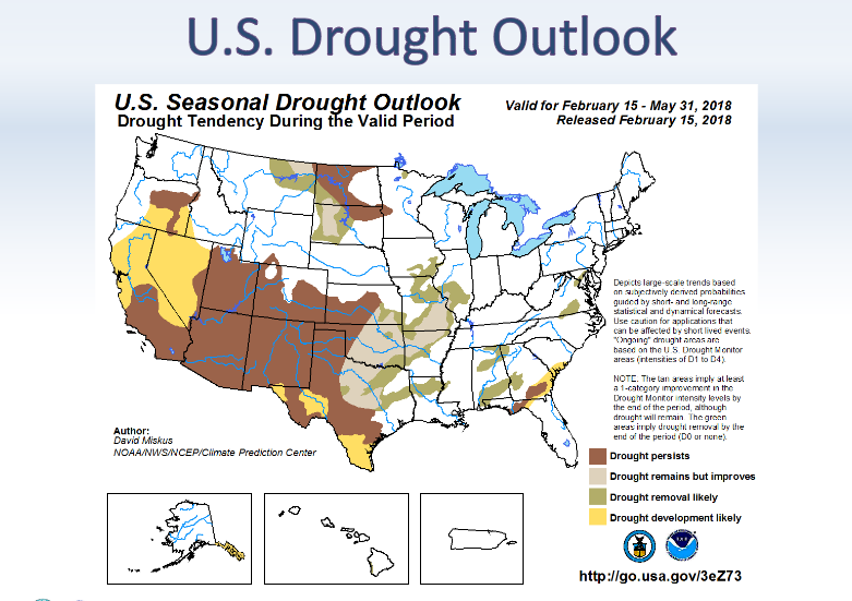
After an all-too-brief reprieve, the Golden State is once again starting to brown up — at least on government drought maps.

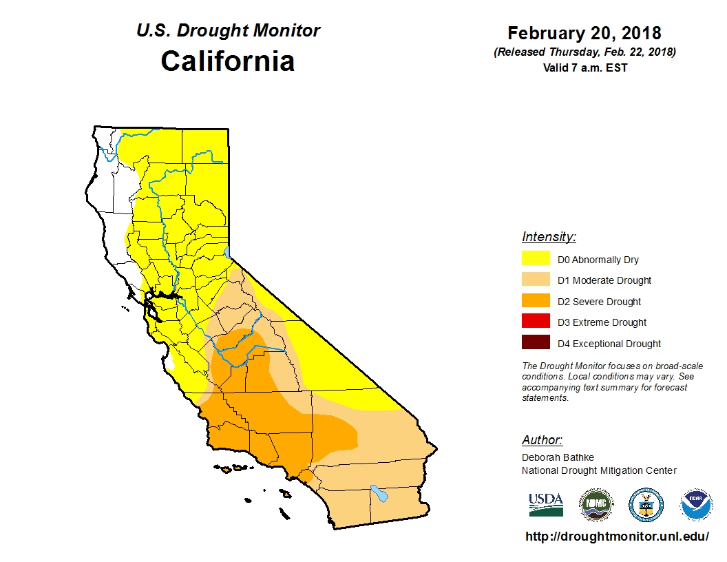
The U.S. Drought Monitor now has nearly 48 percent of the state categorized as being in at least “moderate drought.” More than 91 percent of the state is listed as at least “abnormally dry,” the precursor stage to drought.

US Drought Monitor map
Click image to enlarge. (Nat'l Drought Mitigation Center)

The term “drought,” is of course, highly subjective and has different meanings to different people. But the gradually returning shades of yellow and brown to the widely cited map are unnerving to many, with the state’s most punishing drought on record so fresh in California’s collective memory.

CNAP Probablities Map
By mid-February, a normal precipitation year was almost out of reach. (Western Regional Climate Ctr.)

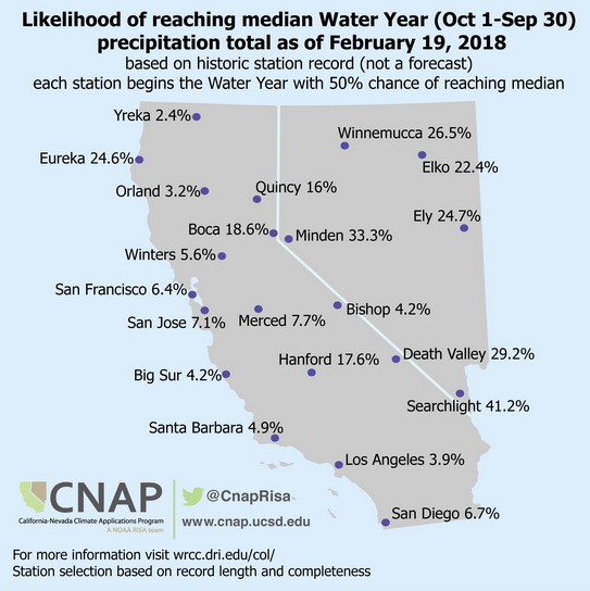
The stage is certainly being set for some sort of drought. This week as the State Water Resources Control Board considered permanent statewide restrictions on a list of wasteful water uses, members were told that, measured by a key collection of gauges in the northern Sierra Nevada, the December-through-February period has been California’s third driest on record (exceeded only by 1977 and 1991, when a “March Miracle” saved the wet season). In the central Sierra, this December through February was measured as the driest on record.

Those three months typically provide the state with half of its total annual precipitation.

Sponsored

At the same time, forecasters at the National Oceanic and Atmospheric Administration project dry conditions to “develop or persist” in California over the next three months.

NOAA 3-mo. Drought Outlook map
NOAA’s three-month outlook does not bode well for California precipitation. (NOAA)

The weekly Drought Monitor maps are compiled by a rotating stable of authors, in consultation with various government agencies, and they take into account more than 100 indicators. And while some have argued that they are given too much weight, John Leahigh, head of operations for California’s State Water Project, told the water board that an “ugly picture” is beginning to form of the state’s current water year.

With the notable exception of Lake Oroville, which engineers have kept at cautiously low levels after last year’s near spillway disaster, major reservoirs remain flush from last year’s precipitation. But Leahigh told regulators that expectations are “dramatically decreasing” for runoff from the state’s key watersheds to replenish water supplies this year.

lower waypoint
next waypoint
California’s New 1600-Acre State Park Set to Open This SummerBay Area Cities Push to Legally Validate Polyamorous FamiliesSame-Sex Couples Face Higher Climate Change Risks, New UCLA Study ShowsWhat Is the 'Green Flash' at Sunset — and How Can You See It?Homeowners Insurance Market Stretched Even Thinner as 2 More Companies Leave CaliforniaHoping for a 2024 'Super Bloom'? Where to See Wildflowers in the Bay AreaSchizophrenia: What It's Like to Hear VoicesThese Face Mites Really Grow on YouEver Wake Up Frozen in the Middle of the Night, With a Shadowy Figure in the Room?Everything You Never Wanted to Know About Snail Sex