upper waypoint
A neighborhood off Fountaingrove Parkway, northeast of Santa Rosa, California.  Overview News // DigitalGlobe 2017
A neighborhood off Fountaingrove Parkway, northeast of Santa Rosa, California.  (Overview News // DigitalGlobe 2017)

Before and After: Satellite Photos Show California Fire Damage

Before and After: Satellite Photos Show California Fire Damage

Save ArticleSave Article
Failed to save article

Please try again

By Thursday evening, Northern California’s wildfires had become the deadliest and most destructive in the state’s history. Taken all together, the fires raging from Napa to Mendocino to Nevada counties had killed 31 people, burned down 3,500 structures, and engulfed 170,000 acres in flames.

Firefighters have made progress toward containing some fires in the rural counties east of Sacramento, but multiple fires in the North Bay have been fueled by heavy winds this week and firefighters have barely begun to contain them. The cause of the fire is under investigation.

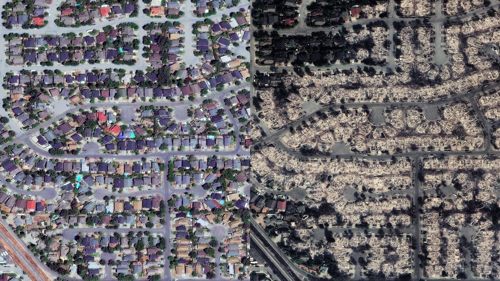
Satellite imagery from Colorado mapping company Digital Globe reveals the extent of the damage in several Santa Rosa neighborhoods.

Drag the white slider in the middle of each image from left to right to see a before-and-after comparison. These images show neighborhoods northeast of Santa Rosa, with “before” images captured during the summer and “after” images taken on Wednesday October 11, 2017.

The main street on the left in this first image is Fountaingrove Parkway:


The wiggly street on the right of this image is Crown Hill Drive:


This image shows Coffey Park, in the middle:

Sponsored

The upper main road in this image is Hopper Avenue; the neighborhood is directly west of Coffey Park:


This final image shows the golf course of Fountaingrove Golf and Athletic Club in a swath of green on the left:


Images by Overview News//DigitalGlobe 2017. Sliders by Teodros Hailye and Lindsey Hoshaw/KQED

lower waypoint
next waypoint
Bay Area Cities Push to Legally Validate Polyamorous FamiliesCalifornia’s New 1600-Acre State Park Set to Open This SummerWhat Is the 'Green Flash' at Sunset — and How Can You See It?Same-Sex Couples Face Higher Climate Change Risks, New UCLA Study ShowsCalifornia's Plans for Slowing Climate Change Through Nature-Based SolutionsHoping for a 2024 'Super Bloom'? Where to See Wildflowers in the Bay AreaHomeowners Insurance Market Stretched Even Thinner as 2 More Companies Leave CaliforniaEver Wake Up Frozen in the Middle of the Night, With a Shadowy Figure in the Room?Everything You Never Wanted to Know About Snail SexThese Face Mites Really Grow on You