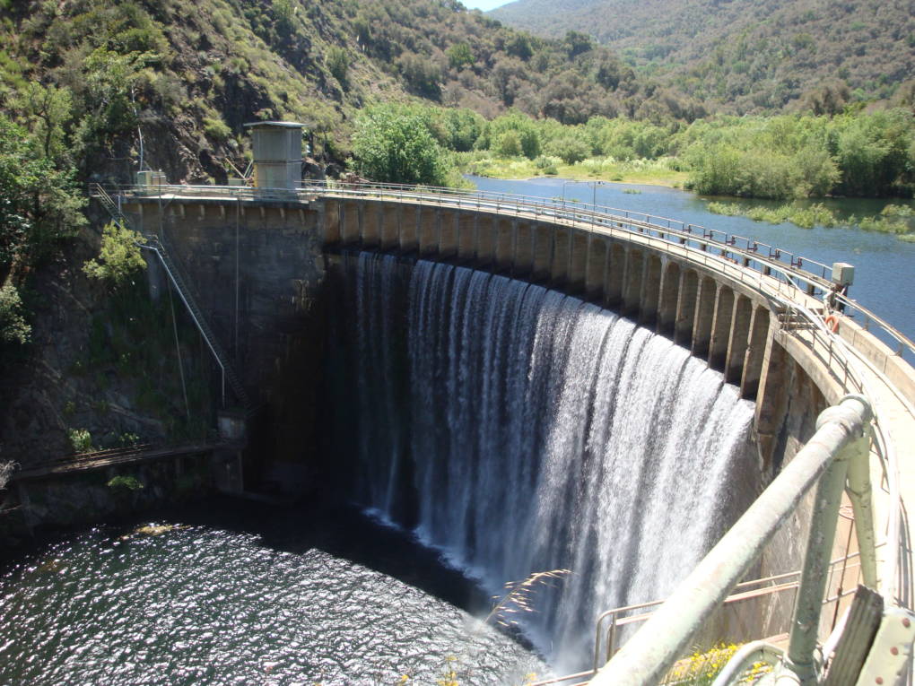
A swath of the Carmel River, upstream from the former San Clemente Dam site, surged with water on January 26, 2017. (Lindsey Hoshaw/KQED)
Tommy Williams—a fisheries biologist whose enthusiasm bubbles forth so swiftly, he’s often interrupting himself mid-sentence—is pacing on the banks of the Carmel River. “Amazing,” he says, snapping pictures of newly formed sandbanks and twigs wedged in between white alder, black cottonwood and willow trunks.
It’s not the trees or twigs that delight him. It’s the thundering flow of a river that has been dammed for the last 94 years—and the sediment (dirt and rocks) that are pushing everything downstream.
A view of the San Clemente Dam, before it was torn down in 2015. (California American Water)
“These trees have been growing in a place that haven’t had this kind of sediment flow here for 100 years,” says Williams, who works in the Santa Cruz office for NOAA Fisheries. “This is rocking their world right now.”
Williams doesn’t even mind that recent high flows have stripped out some of the tree tags he’d tied to branches along the river’s edge to mark fish survey spots. NOAA’s collaborating agency, the USGS, has also lost several rebar survey markers (which designate geological study areas) to the floods.
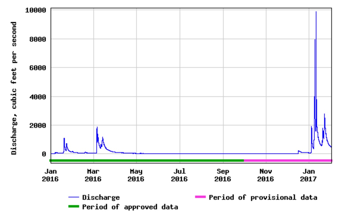
In fact, Carmel River flows in January were the highest they’ve been since 1998. That’s due to winter storms which soaked the Carmel Basin with 25 inches of rain since the first of the year.
At its peak, the river water was rushing by at about 75,000 gallons a second. That’s 4.5 million gallons every minute, roughly enough water to fill six Olympic-size swimming pools.
The water sent boulders and broken tree branches crashing onto a service road alongside the river. By mid-January, it became impassable.
Carmel River Flows
In January 2017, Carmel River flows were the highest they’ve been since 1998. (USGS)
“It’s kind of messy,” says Williams. “But messy is okay.”
Actually, “messy” is crucial. The roots of upturned trees capture gravel, which provides essential spawning ground for federally protected steelhead trout. The back eddies and side channels next to the unearthed trees give fish a place to hide from predators like kingfishers and garter snakes. Or rest, as they make their long trek up river to spawn.
Tearing Down a Relic, Restoring a River
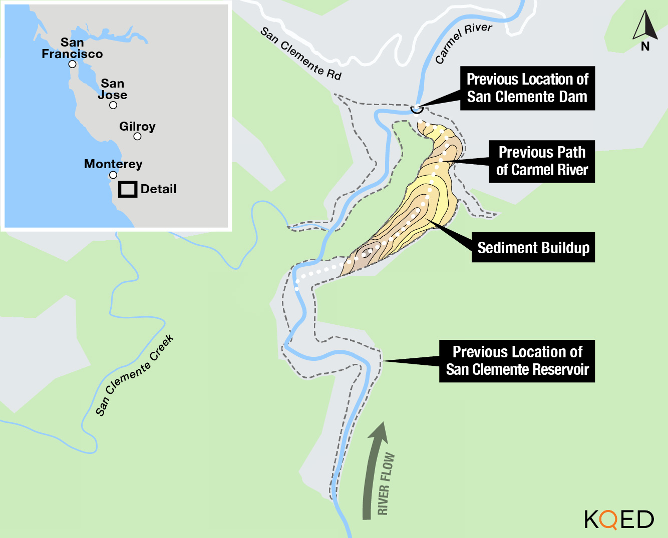
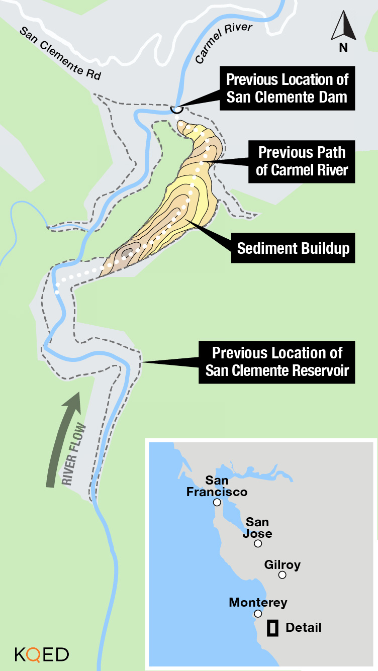
The river hasn’t been this messy since Woodrow Wilson was president. All that debris used to be trapped behind the San Clemente Dam, a concrete behemoth built in 1921 that became choked with silt and was eventually declared seismically unsafe in 1991. The dam crossed where the Carmel River and the San Clemente Creek naturally converged.
San Clemente Dam stopped supplying water to Monterey residents in 2002, when it was 90 percent full of silt and there was only a sliver of storage capacity left for water.
Cranes and bulldozers chipped away at it, demolishing the dam in 2015 after state and federal agencies decided it was too hazardous. If it were flooded or if an earthquake struck, up to 250,000 dump trucks worth of sediment could spew forth, suffocating anything living in the river.
The project involved a major river reroute—getting half a mile of the Carmel to flow into an adjacent stream: San Clemente Creek. This allowed engineers to stabilize the built-up sediment behind the dam and cover it with grass and tree saplings.
Trish Chapman, regional manager for the California State Coastal Conservancy, says the removal “seemed so much smarter than just slapping more concrete on a dam that no longer had any function.”
California American Water Company, the agency that owns the dam, could have retrofitted the structure for $49 million, which still would have presented problems as the dam weakened and aged. So for $84 million, the company tore it down.
Expanding Habitat for Steelhead to Spawn
Now the Carmel River is flowing freely again, carrying sediment downstream that was trapped behind the 106-foot wall for almost a century.
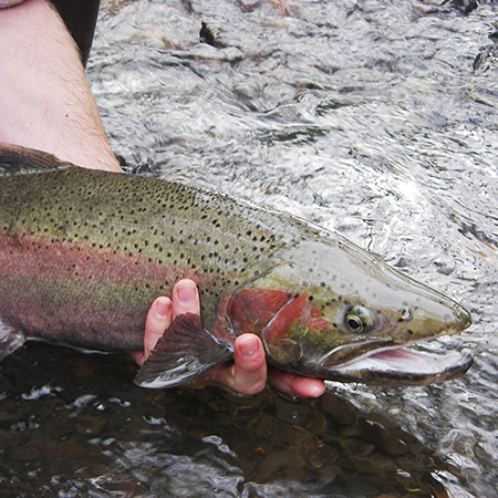
Steelhead trout live in the Carmel River. (The National Park Service)
“Did I ever think we’d see dams coming down? Not really,” says Williams. The biologist is also involved in the planned removal of four hydroelectric dams on the Klamath River.
“So it’s a pretty exciting time,” he adds.
Exciting and historic. The San Clemente deconstruction was the largest dam removal in state history.
Demolition of the dam opened 25 miles of upstream tributaries and creeks so that endangered steelhead can start to make their way up river to spawn.
The old dam impeded the fish’s migration to and from the ocean. There was a fish ladder, but it was the steepest fish ladder in western North America. Over time, the steelhead population dwindled from 1,350 in 1965 to 249 in 2013, the year the dam closed.
By 2016, the California State Coastal Conservancy was already seeing initial signs of recovery.
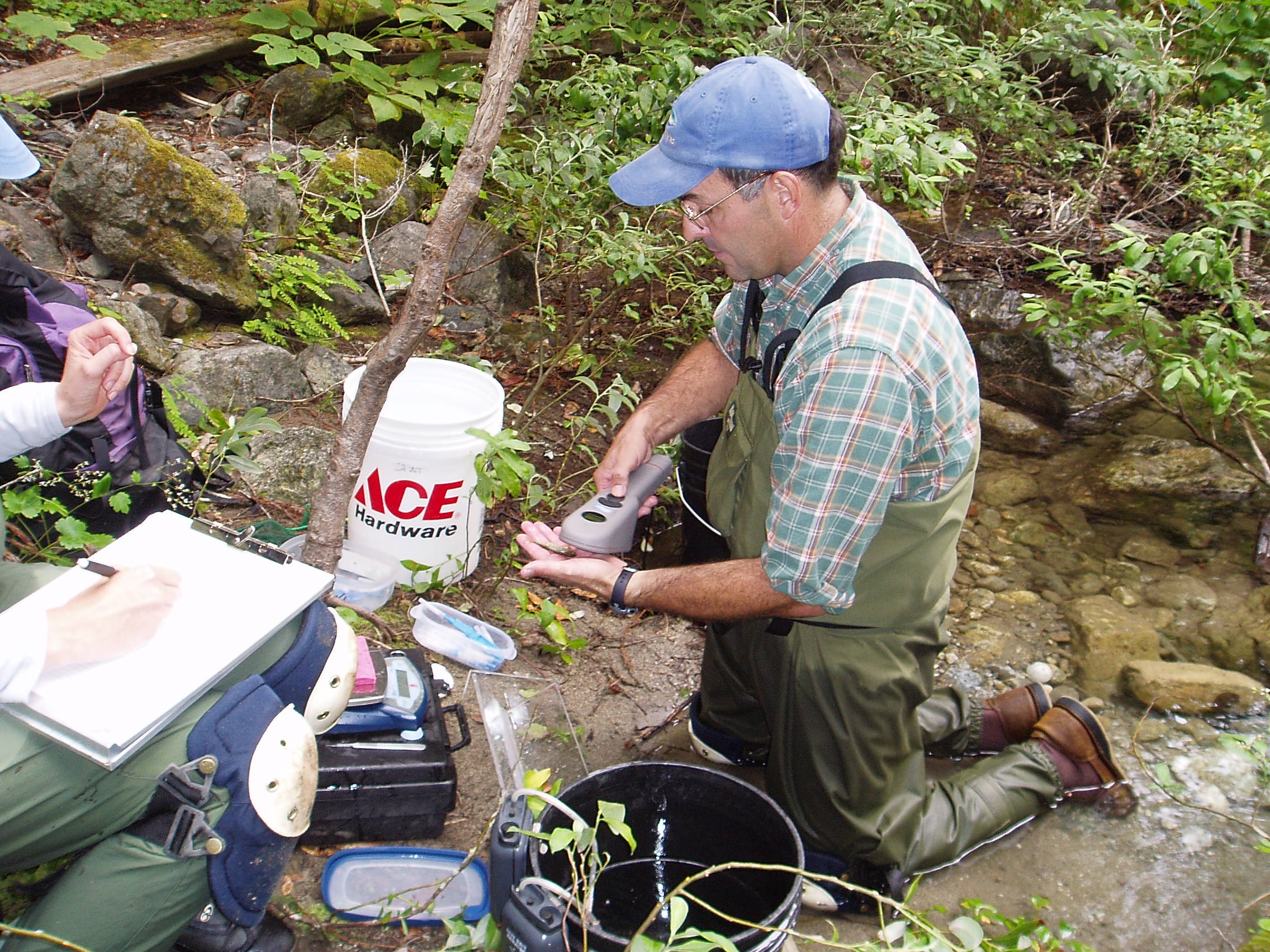
Fisheries biologist Tommy Williams scans a juvenile steelhead trout for a passive integrated transponder (PIT) tag. PIT tags uniquely identify each fish. (NOAA Fisheries)
Trish Chapman says fisheries biologists surveyed a “reach,” or section of the river they’d restored, and discovered steelhead nests above where the dam had been, evidence that the fish were making it past the old dam site.
“Finding out last year that fish had made it up above the reach that we worked on… that was pretty exciting,” says Chapman.
Williams says it will take years, maybe decades, before the biologists know whether the river has fully repaired itself and the fish are coming back.
“For me, extinction is not an option here,” says Williams. “We have to say, ‘what would we do to try to keep these fish around?'”
For now, that means allowing the river to run its course.
This summer, Williams and his team will return to tag and measure fish after the roaring rush of the river—fueled by winter rains—has finally slowed to a crawl.
lower waypointnext waypoint
Player sponsored by
window.__IS_SSR__=true
window.__INITIAL_STATE__={
"attachmentsReducer": {
"audio_0": {
"type": "attachments",
"id": "audio_0",
"imgSizes": {
"kqedFullSize": {
"file": "https://ww2.kqed.org/news/wp-content/themes/KQED-unified/img/audio_bgs/background0.jpg"
}
}
},
"audio_1": {
"type": "attachments",
"id": "audio_1",
"imgSizes": {
"kqedFullSize": {
"file": "https://ww2.kqed.org/news/wp-content/themes/KQED-unified/img/audio_bgs/background1.jpg"
}
}
},
"audio_2": {
"type": "attachments",
"id": "audio_2",
"imgSizes": {
"kqedFullSize": {
"file": "https://ww2.kqed.org/news/wp-content/themes/KQED-unified/img/audio_bgs/background2.jpg"
}
}
},
"audio_3": {
"type": "attachments",
"id": "audio_3",
"imgSizes": {
"kqedFullSize": {
"file": "https://ww2.kqed.org/news/wp-content/themes/KQED-unified/img/audio_bgs/background3.jpg"
}
}
},
"audio_4": {
"type": "attachments",
"id": "audio_4",
"imgSizes": {
"kqedFullSize": {
"file": "https://ww2.kqed.org/news/wp-content/themes/KQED-unified/img/audio_bgs/background4.jpg"
}
}
},
"placeholder": {
"type": "attachments",
"id": "placeholder",
"imgSizes": {
"thumbnail": {
"file": "https://cdn.kqed.org/wp-content/uploads/2024/12/KQED-Default-Image-816638274-2000x1333-1-160x107.jpg",
"width": 160,
"height": 107,
"mimeType": "image/jpeg"
},
"medium": {
"file": "https://cdn.kqed.org/wp-content/uploads/2024/12/KQED-Default-Image-816638274-2000x1333-1-800x533.jpg",
"width": 800,
"height": 533,
"mimeType": "image/jpeg"
},
"medium_large": {
"file": "https://cdn.kqed.org/wp-content/uploads/2024/12/KQED-Default-Image-816638274-2000x1333-1-768x512.jpg",
"width": 768,
"height": 512,
"mimeType": "image/jpeg"
},
"large": {
"file": "https://cdn.kqed.org/wp-content/uploads/2024/12/KQED-Default-Image-816638274-2000x1333-1-1020x680.jpg",
"width": 1020,
"height": 680,
"mimeType": "image/jpeg"
},
"1536x1536": {
"file": "https://cdn.kqed.org/wp-content/uploads/2024/12/KQED-Default-Image-816638274-2000x1333-1-1536x1024.jpg",
"width": 1536,
"height": 1024,
"mimeType": "image/jpeg"
},
"fd-lrg": {
"file": "https://cdn.kqed.org/wp-content/uploads/2024/12/KQED-Default-Image-816638274-2000x1333-1-1536x1024.jpg",
"width": 1536,
"height": 1024,
"mimeType": "image/jpeg"
},
"fd-med": {
"file": "https://cdn.kqed.org/wp-content/uploads/2024/12/KQED-Default-Image-816638274-2000x1333-1-1020x680.jpg",
"width": 1020,
"height": 680,
"mimeType": "image/jpeg"
},
"fd-sm": {
"file": "https://cdn.kqed.org/wp-content/uploads/2024/12/KQED-Default-Image-816638274-2000x1333-1-800x533.jpg",
"width": 800,
"height": 533,
"mimeType": "image/jpeg"
},
"post-thumbnail": {
"file": "https://cdn.kqed.org/wp-content/uploads/2024/12/KQED-Default-Image-816638274-2000x1333-1-672x372.jpg",
"width": 672,
"height": 372,
"mimeType": "image/jpeg"
},
"twentyfourteen-full-width": {
"file": "https://cdn.kqed.org/wp-content/uploads/2024/12/KQED-Default-Image-816638274-2000x1333-1-1038x576.jpg",
"width": 1038,
"height": 576,
"mimeType": "image/jpeg"
},
"xxsmall": {
"file": "https://cdn.kqed.org/wp-content/uploads/2024/12/KQED-Default-Image-816638274-2000x1333-1-160x107.jpg",
"width": 160,
"height": 107,
"mimeType": "image/jpeg"
},
"xsmall": {
"file": "https://cdn.kqed.org/wp-content/uploads/2024/12/KQED-Default-Image-816638274-2000x1333-1-672x372.jpg",
"width": 672,
"height": 372,
"mimeType": "image/jpeg"
},
"small": {
"file": "https://cdn.kqed.org/wp-content/uploads/2024/12/KQED-Default-Image-816638274-2000x1333-1-672x372.jpg",
"width": 672,
"height": 372,
"mimeType": "image/jpeg"
},
"xlarge": {
"file": "https://cdn.kqed.org/wp-content/uploads/2024/12/KQED-Default-Image-816638274-2000x1333-1-1020x680.jpg",
"width": 1020,
"height": 680,
"mimeType": "image/jpeg"
},
"full-width": {
"file": "https://cdn.kqed.org/wp-content/uploads/2024/12/KQED-Default-Image-816638274-2000x1333-1-1920x1280.jpg",
"width": 1920,
"height": 1280,
"mimeType": "image/jpeg"
},
"guest-author-32": {
"file": "https://cdn.kqed.org/wp-content/uploads/2025/01/KQED-Default-Image-816638274-1333x1333-1-160x160.jpg",
"width": 32,
"height": 32,
"mimeType": "image/jpeg"
},
"guest-author-50": {
"file": "https://cdn.kqed.org/wp-content/uploads/2025/01/KQED-Default-Image-816638274-1333x1333-1-160x160.jpg",
"width": 50,
"height": 50,
"mimeType": "image/jpeg"
},
"guest-author-64": {
"file": "https://cdn.kqed.org/wp-content/uploads/2025/01/KQED-Default-Image-816638274-1333x1333-1-160x160.jpg",
"width": 64,
"height": 64,
"mimeType": "image/jpeg"
},
"guest-author-96": {
"file": "https://cdn.kqed.org/wp-content/uploads/2025/01/KQED-Default-Image-816638274-1333x1333-1-160x160.jpg",
"width": 96,
"height": 96,
"mimeType": "image/jpeg"
},
"guest-author-128": {
"file": "https://cdn.kqed.org/wp-content/uploads/2025/01/KQED-Default-Image-816638274-1333x1333-1-160x160.jpg",
"width": 128,
"height": 128,
"mimeType": "image/jpeg"
},
"detail": {
"file": "https://cdn.kqed.org/wp-content/uploads/2025/01/KQED-Default-Image-816638274-1333x1333-1-160x160.jpg",
"width": 160,
"height": 160,
"mimeType": "image/jpeg"
},
"kqedFullSize": {
"file": "https://cdn.kqed.org/wp-content/uploads/2024/12/KQED-Default-Image-816638274-2000x1333-1.jpg",
"width": 2000,
"height": 1333
}
}
},
"science_1382175": {
"type": "attachments",
"id": "science_1382175",
"meta": {
"index": "attachments_1716263798",
"site": "science",
"id": "1382175",
"found": true
},
"parent": 1365412,
"imgSizes": {
"small": {
"file": "https://ww2.kqed.org/app/uploads/sites/35/2017/02/Carmel_River_featured_image-520x290.jpg",
"width": 520,
"mimeType": "image/jpeg",
"height": 290
},
"twentyfourteen-full-width": {
"file": "https://ww2.kqed.org/app/uploads/sites/35/2017/02/Carmel_River_featured_image-1038x576.jpg",
"width": 1038,
"mimeType": "image/jpeg",
"height": 576
},
"thumbnail": {
"file": "https://ww2.kqed.org/app/uploads/sites/35/2017/02/Carmel_River_featured_image-160x89.jpg",
"width": 160,
"mimeType": "image/jpeg",
"height": 89
},
"fd-sm": {
"file": "https://ww2.kqed.org/app/uploads/sites/35/2017/02/Carmel_River_featured_image-960x535.jpg",
"width": 960,
"mimeType": "image/jpeg",
"height": 535
},
"post-thumbnail": {
"file": "https://ww2.kqed.org/app/uploads/sites/35/2017/02/Carmel_River_featured_image-672x372.jpg",
"width": 672,
"mimeType": "image/jpeg",
"height": 372
},
"xsmall": {
"file": "https://ww2.kqed.org/app/uploads/sites/35/2017/02/Carmel_River_featured_image-375x209.jpg",
"width": 375,
"mimeType": "image/jpeg",
"height": 209
},
"kqedFullSize": {
"file": "https://ww2.kqed.org/app/uploads/sites/35/2017/02/Carmel_River_featured_image.jpg",
"width": 1724,
"height": 960
},
"large": {
"file": "https://ww2.kqed.org/app/uploads/sites/35/2017/02/Carmel_River_featured_image-1020x568.jpg",
"width": 1020,
"mimeType": "image/jpeg",
"height": 568
},
"xlarge": {
"file": "https://ww2.kqed.org/app/uploads/sites/35/2017/02/Carmel_River_featured_image-1180x657.jpg",
"width": 1180,
"mimeType": "image/jpeg",
"height": 657
},
"guest-author-50": {
"file": "https://ww2.kqed.org/app/uploads/sites/35/2017/02/Carmel_River_featured_image-50x50.jpg",
"width": 50,
"mimeType": "image/jpeg",
"height": 50
},
"guest-author-96": {
"file": "https://ww2.kqed.org/app/uploads/sites/35/2017/02/Carmel_River_featured_image-96x96.jpg",
"width": 96,
"mimeType": "image/jpeg",
"height": 96
},
"medium": {
"file": "https://ww2.kqed.org/app/uploads/sites/35/2017/02/Carmel_River_featured_image-800x445.jpg",
"width": 800,
"mimeType": "image/jpeg",
"height": 445
},
"guest-author-64": {
"file": "https://ww2.kqed.org/app/uploads/sites/35/2017/02/Carmel_River_featured_image-64x64.jpg",
"width": 64,
"mimeType": "image/jpeg",
"height": 64
},
"guest-author-32": {
"file": "https://ww2.kqed.org/app/uploads/sites/35/2017/02/Carmel_River_featured_image-32x32.jpg",
"width": 32,
"mimeType": "image/jpeg",
"height": 32
},
"fd-med": {
"file": "https://ww2.kqed.org/app/uploads/sites/35/2017/02/Carmel_River_featured_image-1180x657.jpg",
"width": 1180,
"mimeType": "image/jpeg",
"height": 657
},
"detail": {
"file": "https://ww2.kqed.org/app/uploads/sites/35/2017/02/Carmel_River_featured_image-150x150.jpg",
"width": 150,
"mimeType": "image/jpeg",
"height": 150
},
"medium_large": {
"file": "https://ww2.kqed.org/app/uploads/sites/35/2017/02/Carmel_River_featured_image-768x428.jpg",
"width": 768,
"mimeType": "image/jpeg",
"height": 428
},
"guest-author-128": {
"file": "https://ww2.kqed.org/app/uploads/sites/35/2017/02/Carmel_River_featured_image-128x128.jpg",
"width": 128,
"mimeType": "image/jpeg",
"height": 128
},
"xxsmall": {
"file": "https://ww2.kqed.org/app/uploads/sites/35/2017/02/Carmel_River_featured_image-240x134.jpg",
"width": 240,
"mimeType": "image/jpeg",
"height": 134
}
},
"publishDate": 1486361877,
"modified": 1486361899,
"caption": "A swath of the Carmel River, upstream from the former San Clemente Dam site, surged with water on January 26, 2017. ",
"description": null,
"title": "Carmel_River_featured_image",
"credit": "Lindsey Hoshaw/KQED",
"status": "inherit",
"isLoading": false,
"fetchFailed": false
}
},
"audioPlayerReducer": {
"postId": "stream_live",
"isPaused": true,
"isPlaying": false,
"pfsActive": false,
"pledgeModalIsOpen": true,
"playerDrawerIsOpen": false,
"liveAudioPlayStartedAt": 0,
"liveAudioPlayContext": ""
},
"authorsReducer": {
"lindseyhoshaw": {
"type": "authors",
"id": "5432",
"meta": {
"index": "authors_1716337520",
"id": "5432",
"found": true
},
"name": "Lindsey Hoshaw",
"firstName": "Lindsey",
"lastName": "Hoshaw",
"slug": "lindseyhoshaw",
"email": "lhoshaw@kqed.org",
"display_author_email": false,
"staff_mastheads": [],
"title": "KQED Contributor",
"bio": "Lindsey Hoshaw is a former interactive producer for KQED Science. Before joining KQED, Lindsey was a science correspondent for The New York Times, The Boston Globe, Forbes and Scientific American. On Twitter @lindseyhoshaw",
"avatar": "https://secure.gravatar.com/avatar/274b07694c998eaa8f26cfabaa941186?s=600&d=mm&r=g",
"twitter": "lindseyhoshaw",
"facebook": "lindsey.hoshaw.9",
"instagram": null,
"linkedin": null,
"sites": [
{
"site": "arts",
"roles": [
"author"
]
},
{
"site": "news",
"roles": [
"subscriber"
]
},
{
"site": "futureofyou",
"roles": [
"editor"
]
},
{
"site": "bayareabites",
"roles": [
"contributor"
]
},
{
"site": "stateofhealth",
"roles": [
"author"
]
},
{
"site": "science",
"roles": [
"edit_theme_options",
"subscriber"
]
},
{
"site": "quest",
"roles": [
"edit_post_subscriptions",
"edit_usergroups",
"unfiltered_html",
"unfiltered_upload",
"leadcoordinator",
"editor"
]
},
{
"site": "food",
"roles": []
}
],
"headData": {
"title": "Lindsey Hoshaw | KQED",
"description": "KQED Contributor",
"ogImgSrc": "https://secure.gravatar.com/avatar/274b07694c998eaa8f26cfabaa941186?s=600&d=mm&r=g",
"twImgSrc": "https://secure.gravatar.com/avatar/274b07694c998eaa8f26cfabaa941186?s=600&d=mm&r=g"
},
"isLoading": false,
"link": "/author/lindseyhoshaw"
}
},
"pagesReducer": {},
"pfsSessionReducer": {},
"postsReducer": {
"stream_live": {
"type": "live",
"id": "stream_live",
"audioUrl": "https://streams.kqed.org/kqedradio",
"title": "Live Stream",
"excerpt": "Live Stream information currently unavailable.",
"link": "/radio",
"featImg": "",
"label": {
"name": "KQED Live",
"link": "/"
}
},
"stream_kqedNewscast": {
"type": "posts",
"id": "stream_kqedNewscast",
"audioUrl": "https://www.kqed.org/.stream/anon/radio/RDnews/newscast.mp3?_=1",
"title": "KQED Newscast",
"featImg": "",
"label": {
"name": "88.5 FM",
"link": "/"
}
},
"science_1365412": {
"type": "posts",
"id": "science_1365412",
"meta": {
"index": "posts_1716263798",
"site": "science",
"id": "1365412",
"found": true
},
"articlePosition": 0,
"parent": 0,
"labelTerm": {
"site": "science"
},
"blocks": [],
"publishDate": 1486396844,
"format": "standard",
"title": "With Dam Gone, California River Comes Back to Life",
"headTitle": "With Dam Gone, California River Comes Back to Life | KQED",
"content": "\u003cp>\u003cspan style=\"font-size: 4.6875em;float: left;line-height: 0.733em;padding: 0.05em 0.1em 0 0;font-family: times, serif, georgia\">T\u003c/span>ommy Williams—a fisheries biologist whose enthusiasm bubbles forth so swiftly, he’s often interrupting himself mid-sentence—is pacing on the banks of the Carmel River. “Amazing,” he says, snapping pictures of newly formed sandbanks and twigs wedged in between white alder, black cottonwood and willow trunks.\u003c/p>\n\u003cp>It’s not the trees or twigs that delight him. It’s the thundering flow of a river that has been dammed for the last 94 years—and the sediment (dirt and rocks) that are pushing everything downstream.\u003c/p>\n\u003cfigure id=\"attachment_1371003\" class=\"wp-caption alignright\" style=\"max-width: 410px\">\u003cimg loading=\"lazy\" decoding=\"async\" class=\"wp-image-1371003 \" src=\"https://ww2.kqed.org/science/wp-content/uploads/sites/35/2017/02/San-Clemente-Dam_historic-1020x765.jpg\" alt=\"San Clemente Dam_historic\" width=\"410\" height=\"308\" srcset=\"https://cdn.kqed.org/wp-content/uploads/sites/35/2017/02/San-Clemente-Dam_historic-1020x765.jpg 1020w, https://cdn.kqed.org/wp-content/uploads/sites/35/2017/02/San-Clemente-Dam_historic-160x120.jpg 160w, https://cdn.kqed.org/wp-content/uploads/sites/35/2017/02/San-Clemente-Dam_historic-800x600.jpg 800w, https://cdn.kqed.org/wp-content/uploads/sites/35/2017/02/San-Clemente-Dam_historic-768x576.jpg 768w, https://cdn.kqed.org/wp-content/uploads/sites/35/2017/02/San-Clemente-Dam_historic-1920x1440.jpg 1920w, https://cdn.kqed.org/wp-content/uploads/sites/35/2017/02/San-Clemente-Dam_historic-1180x885.jpg 1180w, https://cdn.kqed.org/wp-content/uploads/sites/35/2017/02/San-Clemente-Dam_historic-960x720.jpg 960w, https://cdn.kqed.org/wp-content/uploads/sites/35/2017/02/San-Clemente-Dam_historic-240x180.jpg 240w, https://cdn.kqed.org/wp-content/uploads/sites/35/2017/02/San-Clemente-Dam_historic-375x281.jpg 375w, https://cdn.kqed.org/wp-content/uploads/sites/35/2017/02/San-Clemente-Dam_historic-520x390.jpg 520w\" sizes=\"(max-width: 410px) 100vw, 410px\">\u003cfigcaption class=\"wp-caption-text\">A view of the San Clemente Dam, before it was torn down in 2015. \u003ccite>(California American Water)\u003c/cite>\u003c/figcaption>\u003c/figure>\n\u003cp>“These trees have been growing in a place that haven’t had this kind of sediment flow here for 100 years,” says Williams, who works in the Santa Cruz office for \u003ca href=\"http://www.nmfs.noaa.gov/\" target=\"_blank\" rel=\"noopener\">NOAA Fisheries\u003c/a>. “This is rocking their world right now.”\u003c/p>\n\u003cp>Williams doesn’t even mind that recent high flows have stripped out some of the tree tags he’d tied to branches along the river’s edge to mark fish survey spots. NOAA’s collaborating agency, the \u003ca href=\"https://www.usgs.gov/\" target=\"_blank\" rel=\"noopener\">USGS\u003c/a>, has also lost several rebar survey markers (which designate geological study areas) to the floods.\u003c/p>\n\u003cp>In fact, Carmel River flows in January were the highest they’ve been since 1998. That’s due to winter storms which soaked the Carmel Basin with 25 inches of rain since the first of the year.\u003c/p>\n\u003cp>[ad fullwidth]\u003c/p>\n\u003cp>At its peak, the river water was rushing by at about 75,000 gallons a second. That’s 4.5 million gallons every minute, roughly enough water to fill six Olympic-size swimming pools.\u003c/p>\n\u003cp>The water sent boulders and broken tree branches crashing onto a service road alongside the river. By mid-January, it became impassable.\u003c/p>\n\u003ch4 style=\"text-align: center\">Carmel River Flows\u003c/h4>\n\u003cfigure id=\"attachment_1382063\" class=\"wp-caption aligncenter\" style=\"max-width: 1150px\">\u003cimg loading=\"lazy\" decoding=\"async\" class=\"size-full wp-image-1382063\" src=\"https://ww2.kqed.org/science/wp-content/uploads/sites/35/2017/02/USGS_graph_Carmel_River_Flows.jpg\" alt=\"In January 2017, Carmel River flows were the highest they’ve been since 1998.\" width=\"1150\" height=\"730\" srcset=\"https://cdn.kqed.org/wp-content/uploads/sites/35/2017/02/USGS_graph_Carmel_River_Flows.jpg 1150w, https://cdn.kqed.org/wp-content/uploads/sites/35/2017/02/USGS_graph_Carmel_River_Flows-160x102.jpg 160w, https://cdn.kqed.org/wp-content/uploads/sites/35/2017/02/USGS_graph_Carmel_River_Flows-800x508.jpg 800w, https://cdn.kqed.org/wp-content/uploads/sites/35/2017/02/USGS_graph_Carmel_River_Flows-768x488.jpg 768w, https://cdn.kqed.org/wp-content/uploads/sites/35/2017/02/USGS_graph_Carmel_River_Flows-1020x647.jpg 1020w, https://cdn.kqed.org/wp-content/uploads/sites/35/2017/02/USGS_graph_Carmel_River_Flows-960x609.jpg 960w, https://cdn.kqed.org/wp-content/uploads/sites/35/2017/02/USGS_graph_Carmel_River_Flows-240x152.jpg 240w, https://cdn.kqed.org/wp-content/uploads/sites/35/2017/02/USGS_graph_Carmel_River_Flows-375x238.jpg 375w, https://cdn.kqed.org/wp-content/uploads/sites/35/2017/02/USGS_graph_Carmel_River_Flows-520x330.jpg 520w\" sizes=\"(max-width: 1150px) 100vw, 1150px\">\u003cfigcaption class=\"wp-caption-text\">In January 2017, Carmel River flows were the highest they’ve been since 1998. \u003ccite>(USGS)\u003c/cite>\u003c/figcaption>\u003c/figure>\n\u003cp>“It’s kind of messy,” says Williams. “But messy is okay.”\u003c/p>\n\u003cp>Actually, “messy” is crucial. The roots of upturned trees capture gravel, which provides essential spawning ground for federally protected steelhead trout. The back eddies and side channels next to the unearthed trees give fish a place to hide from predators like kingfishers and garter snakes. Or rest, as they make their long trek up river to spawn.\u003c/p>\n\u003cp>\u003cstrong>Tearing Down a Relic, Restoring a River\u003c/strong>\u003c/p>\n\u003cp>The river hasn’t been this messy since Woodrow Wilson was president. All that debris used to be trapped behind the San Clemente Dam, a concrete behemoth built in 1921 that became choked with silt and was eventually declared seismically unsafe in 1991. The dam crossed where the Carmel River and the San Clemente Creek naturally converged.\u003c/p>\n\u003cp>San Clemente Dam stopped supplying water to Monterey residents in 2002, when it was 90 percent full of silt and there was only a sliver of storage capacity left for water.\u003c/p>\n\u003cp>Cranes and bulldozers chipped away at it, demolishing the dam in 2015 after state and federal agencies decided it was too hazardous. If it were flooded or if an earthquake struck, up to 250,000 dump trucks worth of sediment could spew forth, suffocating anything living in the river.\u003c/p>\n\u003cdiv class=\"sharedaddy show-for-medium-up\">\u003cimg loading=\"lazy\" decoding=\"async\" class=\"aligncenter size-full wp-image-1375780\" src=\"https://ww2.kqed.org/science/wp-content/uploads/sites/35/2017/02/Dam_desktop.jpg\" alt=\"Dam_desktop\" width=\"1334\" height=\"1075\" srcset=\"https://cdn.kqed.org/wp-content/uploads/sites/35/2017/02/Dam_desktop.jpg 1334w, https://cdn.kqed.org/wp-content/uploads/sites/35/2017/02/Dam_desktop-160x129.jpg 160w, https://cdn.kqed.org/wp-content/uploads/sites/35/2017/02/Dam_desktop-800x645.jpg 800w, https://cdn.kqed.org/wp-content/uploads/sites/35/2017/02/Dam_desktop-768x619.jpg 768w, https://cdn.kqed.org/wp-content/uploads/sites/35/2017/02/Dam_desktop-1020x822.jpg 1020w, https://cdn.kqed.org/wp-content/uploads/sites/35/2017/02/Dam_desktop-1180x951.jpg 1180w, https://cdn.kqed.org/wp-content/uploads/sites/35/2017/02/Dam_desktop-960x774.jpg 960w, https://cdn.kqed.org/wp-content/uploads/sites/35/2017/02/Dam_desktop-240x193.jpg 240w, https://cdn.kqed.org/wp-content/uploads/sites/35/2017/02/Dam_desktop-375x302.jpg 375w, https://cdn.kqed.org/wp-content/uploads/sites/35/2017/02/Dam_desktop-520x419.jpg 520w\" sizes=\"(max-width: 1334px) 100vw, 1334px\">\u003c/div>\n\u003cdiv class=\"show-for-small-only\">\u003cimg loading=\"lazy\" decoding=\"async\" class=\"aligncenter size-full wp-image-1375781\" src=\"https://ww2.kqed.org/science/wp-content/uploads/sites/35/2017/02/Dam_mobile.jpg\" alt=\"Dam_mobile\" width=\"752\" height=\"1335\" srcset=\"https://cdn.kqed.org/wp-content/uploads/sites/35/2017/02/Dam_mobile.jpg 752w, https://cdn.kqed.org/wp-content/uploads/sites/35/2017/02/Dam_mobile-160x284.jpg 160w, https://cdn.kqed.org/wp-content/uploads/sites/35/2017/02/Dam_mobile-240x426.jpg 240w, https://cdn.kqed.org/wp-content/uploads/sites/35/2017/02/Dam_mobile-375x666.jpg 375w, https://cdn.kqed.org/wp-content/uploads/sites/35/2017/02/Dam_mobile-520x923.jpg 520w\" sizes=\"(max-width: 752px) 100vw, 752px\">\u003c/div>\n\u003cp> \u003c/p>\n\u003cp>The project involved a major river reroute—getting half a mile of the Carmel to flow into an adjacent stream: San Clemente Creek. \u003cspan style=\"font-weight: 400\">This allowed engineers to stabilize the built-up sediment behind the dam and cover it with grass and tree saplings.\u003c/span>\u003c/p>\n\u003cp>Trish Chapman, regional manager for the \u003ca href=\"http://scc.ca.gov/\" target=\"_blank\" rel=\"noopener\">California State Coastal Conservancy\u003c/a>, says the removal “seemed so much smarter than just slapping more concrete on a dam that no longer had any function.”\u003c/p>\n\u003cp>\u003ca href=\"https://amwater.com/caaw/\" target=\"_blank\" rel=\"noopener\">California American Water Company\u003c/a>, the agency that owns the dam, could have retrofitted the structure for $49 million, which still would have presented problems as the dam weakened and aged. So for $84 million, the company tore it down.\u003c/p>\n\u003cp>\u003cstrong>Expanding Habitat for Steelhead to Spawn\u003c/strong>\u003c/p>\n\u003cp>Now the Carmel River is flowing freely again, carrying sediment downstream that was trapped behind the 106-foot wall for almost a century.\u003c/p>\n\u003cfigure id=\"attachment_1382193\" class=\"wp-caption alignleft\" style=\"max-width: 343px\">\u003cimg loading=\"lazy\" decoding=\"async\" class=\" wp-image-1382193\" src=\"https://ww2.kqed.org/science/wp-content/uploads/sites/35/2017/02/Steelhead_trout.jpg\" alt=\"Steelhead trout live in the Carmel River.\" width=\"343\" height=\"343\" srcset=\"https://cdn.kqed.org/wp-content/uploads/sites/35/2017/02/Steelhead_trout.jpg 450w, https://cdn.kqed.org/wp-content/uploads/sites/35/2017/02/Steelhead_trout-160x160.jpg 160w, https://cdn.kqed.org/wp-content/uploads/sites/35/2017/02/Steelhead_trout-240x240.jpg 240w, https://cdn.kqed.org/wp-content/uploads/sites/35/2017/02/Steelhead_trout-375x375.jpg 375w, https://cdn.kqed.org/wp-content/uploads/sites/35/2017/02/Steelhead_trout-32x32.jpg 32w, https://cdn.kqed.org/wp-content/uploads/sites/35/2017/02/Steelhead_trout-50x50.jpg 50w, https://cdn.kqed.org/wp-content/uploads/sites/35/2017/02/Steelhead_trout-64x64.jpg 64w, https://cdn.kqed.org/wp-content/uploads/sites/35/2017/02/Steelhead_trout-96x96.jpg 96w, https://cdn.kqed.org/wp-content/uploads/sites/35/2017/02/Steelhead_trout-128x128.jpg 128w, https://cdn.kqed.org/wp-content/uploads/sites/35/2017/02/Steelhead_trout-150x150.jpg 150w\" sizes=\"(max-width: 343px) 100vw, 343px\">\u003cfigcaption class=\"wp-caption-text\">Steelhead trout live in the Carmel River. \u003ccite>(The National Park Service)\u003c/cite>\u003c/figcaption>\u003c/figure>\n\u003cp>“Did I ever think we’d see dams coming down? Not really,” says Williams. The biologist is also involved in the \u003ca href=\"https://ww2.kqed.org/news/2016/10/24/removal-of-klamath-dams-would-be-largest-river-restoration-in-u-s-history/\" target=\"_blank\" rel=\"noopener\">planned removal of four hydroelectric dams\u003c/a> on the Klamath River.\u003c/p>\n\u003cp>“So it’s a pretty exciting time,” he adds.\u003c/p>\n\u003cp>Exciting and historic. The San Clemente deconstruction was the largest dam removal in state history.\u003c/p>\n\u003cp>Demolition of the dam opened 25 miles of upstream tributaries and creeks so that endangered steelhead can start to make their way up river to spawn.\u003c/p>\n\u003cp>The old dam impeded the fish’s migration to and from the ocean. There was a fish ladder, but it was the steepest fish ladder in western North America. Over time, the steelhead population dwindled from 1,350 in 1965 to 249 in 2013, the year the dam closed.\u003c/p>\n\u003cp>By 2016, the California State Coastal Conservancy was already seeing initial signs of recovery.\u003c/p>\n\u003cfigure id=\"attachment_1375543\" class=\"wp-caption alignright\" style=\"max-width: 2272px\">\u003cimg loading=\"lazy\" decoding=\"async\" class=\"size-full wp-image-1375543\" src=\"https://ww2.kqed.org/science/wp-content/uploads/sites/35/2017/02/Tommy-Williams_photo.jpg\" alt=\"Fisheries biologist Tommy Williams scans a juvenile steelhead trout for a passive integrated transponder (PIT) tag. PIT tags uniquely identify the fish and in mark-and-recapture studies, they allow scientists to estimate fish survival rates and population size.\" width=\"2272\" height=\"1704\" srcset=\"https://cdn.kqed.org/wp-content/uploads/sites/35/2017/02/Tommy-Williams_photo.jpg 2272w, https://cdn.kqed.org/wp-content/uploads/sites/35/2017/02/Tommy-Williams_photo-160x120.jpg 160w, https://cdn.kqed.org/wp-content/uploads/sites/35/2017/02/Tommy-Williams_photo-800x600.jpg 800w, https://cdn.kqed.org/wp-content/uploads/sites/35/2017/02/Tommy-Williams_photo-768x576.jpg 768w, https://cdn.kqed.org/wp-content/uploads/sites/35/2017/02/Tommy-Williams_photo-1020x765.jpg 1020w, https://cdn.kqed.org/wp-content/uploads/sites/35/2017/02/Tommy-Williams_photo-1920x1440.jpg 1920w, https://cdn.kqed.org/wp-content/uploads/sites/35/2017/02/Tommy-Williams_photo-1180x885.jpg 1180w, https://cdn.kqed.org/wp-content/uploads/sites/35/2017/02/Tommy-Williams_photo-960x720.jpg 960w, https://cdn.kqed.org/wp-content/uploads/sites/35/2017/02/Tommy-Williams_photo-240x180.jpg 240w, https://cdn.kqed.org/wp-content/uploads/sites/35/2017/02/Tommy-Williams_photo-375x281.jpg 375w, https://cdn.kqed.org/wp-content/uploads/sites/35/2017/02/Tommy-Williams_photo-520x390.jpg 520w\" sizes=\"(max-width: 2272px) 100vw, 2272px\">\u003cfigcaption class=\"wp-caption-text\">Fisheries biologist Tommy Williams scans a juvenile steelhead trout for a passive integrated transponder (PIT) tag. PIT tags uniquely identify each fish. \u003ccite>(NOAA Fisheries)\u003c/cite>\u003c/figcaption>\u003c/figure>\n\u003cp>Trish Chapman says fisheries biologists surveyed a “reach,” or section of the river they’d restored, and discovered steelhead nests above where the dam had been, evidence that the fish were making it past the old dam site.\u003c/p>\n\u003cp>“Finding out last year that fish had made it up above the reach that we worked on… that was pretty exciting,” says Chapman.\u003c/p>\n\u003cp>Williams says it will take years, maybe decades, before the biologists know whether the river has fully repaired itself and the fish are coming back.\u003c/p>\n\u003cp>“For me, extinction is not an option here,” says Williams. “We have to say, ‘what would we do to try to keep these fish around?'”\u003c/p>\n\u003cp>For now, that means allowing the river to run its course.\u003c/p>\n\u003cp>\u003c/p>\n\u003cp>This summer, Williams and his team will return to tag and measure fish after the roaring rush of the river—fueled by winter rains—has finally slowed to a crawl.\u003c/p>\n\n",
"stats": {
"hasVideo": false,
"hasChartOrMap": false,
"hasAudio": false,
"hasPolis": false,
"wordCount": 1105,
"hasGoogleForm": false,
"hasGallery": false,
"hasHearkenModule": false,
"iframeSrcs": [],
"paragraphCount": 32
},
"modified": 1704929113,
"excerpt": "After nearly 100 years, the Carmel River runs unobstructed again and set a record for high flow levels in January.\r\n",
"headData": {
"twImgId": "",
"twTitle": "",
"ogTitle": "",
"ogImgId": "",
"twDescription": "",
"description": "After nearly 100 years, the Carmel River runs unobstructed again and set a record for high flow levels in January.\r\n",
"title": "With Dam Gone, California River Comes Back to Life | KQED",
"ogDescription": "",
"schema": {
"@context": "https://schema.org",
"@type": "Article",
"headline": "With Dam Gone, California River Comes Back to Life",
"datePublished": "2017-02-06T08:00:44-08:00",
"dateModified": "2024-01-10T15:25:13-08:00",
"image": "https://ww2.kqed.org/app/uploads/sites/35/2017/02/Carmel_River_featured_image-1020x568.jpg",
"author": {
"@type": "Person",
"name": "Lindsey Hoshaw",
"jobTitle": "KQED Contributor",
"url": "https://www.kqed.org/author/lindseyhoshaw"
}
},
"authorsData": [],
"tagData": []
},
"guestAuthors": [],
"slug": "with-dam-gone-california-river-comes-back-to-life",
"status": "publish",
"sticky": false,
"path": "/science/1365412/with-dam-gone-california-river-comes-back-to-life",
"audioTrackLength": null,
"parsedContent": [
{
"type": "contentString",
"content": "\u003cdiv class=\"post-body\">\u003cp>\u003cp>\u003cspan style=\"font-size: 4.6875em;float: left;line-height: 0.733em;padding: 0.05em 0.1em 0 0;font-family: times, serif, georgia\">T\u003c/span>ommy Williams—a fisheries biologist whose enthusiasm bubbles forth so swiftly, he’s often interrupting himself mid-sentence—is pacing on the banks of the Carmel River. “Amazing,” he says, snapping pictures of newly formed sandbanks and twigs wedged in between white alder, black cottonwood and willow trunks.\u003c/p>\n\u003cp>It’s not the trees or twigs that delight him. It’s the thundering flow of a river that has been dammed for the last 94 years—and the sediment (dirt and rocks) that are pushing everything downstream.\u003c/p>\n\u003cfigure id=\"attachment_1371003\" class=\"wp-caption alignright\" style=\"max-width: 410px\">\u003cimg loading=\"lazy\" decoding=\"async\" class=\"wp-image-1371003 \" src=\"https://ww2.kqed.org/science/wp-content/uploads/sites/35/2017/02/San-Clemente-Dam_historic-1020x765.jpg\" alt=\"San Clemente Dam_historic\" width=\"410\" height=\"308\" srcset=\"https://cdn.kqed.org/wp-content/uploads/sites/35/2017/02/San-Clemente-Dam_historic-1020x765.jpg 1020w, https://cdn.kqed.org/wp-content/uploads/sites/35/2017/02/San-Clemente-Dam_historic-160x120.jpg 160w, https://cdn.kqed.org/wp-content/uploads/sites/35/2017/02/San-Clemente-Dam_historic-800x600.jpg 800w, https://cdn.kqed.org/wp-content/uploads/sites/35/2017/02/San-Clemente-Dam_historic-768x576.jpg 768w, https://cdn.kqed.org/wp-content/uploads/sites/35/2017/02/San-Clemente-Dam_historic-1920x1440.jpg 1920w, https://cdn.kqed.org/wp-content/uploads/sites/35/2017/02/San-Clemente-Dam_historic-1180x885.jpg 1180w, https://cdn.kqed.org/wp-content/uploads/sites/35/2017/02/San-Clemente-Dam_historic-960x720.jpg 960w, https://cdn.kqed.org/wp-content/uploads/sites/35/2017/02/San-Clemente-Dam_historic-240x180.jpg 240w, https://cdn.kqed.org/wp-content/uploads/sites/35/2017/02/San-Clemente-Dam_historic-375x281.jpg 375w, https://cdn.kqed.org/wp-content/uploads/sites/35/2017/02/San-Clemente-Dam_historic-520x390.jpg 520w\" sizes=\"(max-width: 410px) 100vw, 410px\">\u003cfigcaption class=\"wp-caption-text\">A view of the San Clemente Dam, before it was torn down in 2015. \u003ccite>(California American Water)\u003c/cite>\u003c/figcaption>\u003c/figure>\n\u003cp>“These trees have been growing in a place that haven’t had this kind of sediment flow here for 100 years,” says Williams, who works in the Santa Cruz office for \u003ca href=\"http://www.nmfs.noaa.gov/\" target=\"_blank\" rel=\"noopener\">NOAA Fisheries\u003c/a>. “This is rocking their world right now.”\u003c/p>\n\u003cp>Williams doesn’t even mind that recent high flows have stripped out some of the tree tags he’d tied to branches along the river’s edge to mark fish survey spots. NOAA’s collaborating agency, the \u003ca href=\"https://www.usgs.gov/\" target=\"_blank\" rel=\"noopener\">USGS\u003c/a>, has also lost several rebar survey markers (which designate geological study areas) to the floods.\u003c/p>\n\u003cp>In fact, Carmel River flows in January were the highest they’ve been since 1998. That’s due to winter storms which soaked the Carmel Basin with 25 inches of rain since the first of the year.\u003c/p>\n\u003cp>\u003c/p>\u003c/div>",
"attributes": {
"named": {},
"numeric": []
}
},
{
"type": "component",
"content": "",
"name": "ad",
"attributes": {
"named": {
"label": "fullwidth"
},
"numeric": [
"fullwidth"
]
}
},
{
"type": "contentString",
"content": "\u003cdiv class=\"post-body\">\u003cp>\u003c/p>\n\u003cp>At its peak, the river water was rushing by at about 75,000 gallons a second. That’s 4.5 million gallons every minute, roughly enough water to fill six Olympic-size swimming pools.\u003c/p>\n\u003cp>The water sent boulders and broken tree branches crashing onto a service road alongside the river. By mid-January, it became impassable.\u003c/p>\n\u003ch4 style=\"text-align: center\">Carmel River Flows\u003c/h4>\n\u003cfigure id=\"attachment_1382063\" class=\"wp-caption aligncenter\" style=\"max-width: 1150px\">\u003cimg loading=\"lazy\" decoding=\"async\" class=\"size-full wp-image-1382063\" src=\"https://ww2.kqed.org/science/wp-content/uploads/sites/35/2017/02/USGS_graph_Carmel_River_Flows.jpg\" alt=\"In January 2017, Carmel River flows were the highest they’ve been since 1998.\" width=\"1150\" height=\"730\" srcset=\"https://cdn.kqed.org/wp-content/uploads/sites/35/2017/02/USGS_graph_Carmel_River_Flows.jpg 1150w, https://cdn.kqed.org/wp-content/uploads/sites/35/2017/02/USGS_graph_Carmel_River_Flows-160x102.jpg 160w, https://cdn.kqed.org/wp-content/uploads/sites/35/2017/02/USGS_graph_Carmel_River_Flows-800x508.jpg 800w, https://cdn.kqed.org/wp-content/uploads/sites/35/2017/02/USGS_graph_Carmel_River_Flows-768x488.jpg 768w, https://cdn.kqed.org/wp-content/uploads/sites/35/2017/02/USGS_graph_Carmel_River_Flows-1020x647.jpg 1020w, https://cdn.kqed.org/wp-content/uploads/sites/35/2017/02/USGS_graph_Carmel_River_Flows-960x609.jpg 960w, https://cdn.kqed.org/wp-content/uploads/sites/35/2017/02/USGS_graph_Carmel_River_Flows-240x152.jpg 240w, https://cdn.kqed.org/wp-content/uploads/sites/35/2017/02/USGS_graph_Carmel_River_Flows-375x238.jpg 375w, https://cdn.kqed.org/wp-content/uploads/sites/35/2017/02/USGS_graph_Carmel_River_Flows-520x330.jpg 520w\" sizes=\"(max-width: 1150px) 100vw, 1150px\">\u003cfigcaption class=\"wp-caption-text\">In January 2017, Carmel River flows were the highest they’ve been since 1998. \u003ccite>(USGS)\u003c/cite>\u003c/figcaption>\u003c/figure>\n\u003cp>“It’s kind of messy,” says Williams. “But messy is okay.”\u003c/p>\n\u003cp>Actually, “messy” is crucial. The roots of upturned trees capture gravel, which provides essential spawning ground for federally protected steelhead trout. The back eddies and side channels next to the unearthed trees give fish a place to hide from predators like kingfishers and garter snakes. Or rest, as they make their long trek up river to spawn.\u003c/p>\n\u003cp>\u003cstrong>Tearing Down a Relic, Restoring a River\u003c/strong>\u003c/p>\n\u003cp>The river hasn’t been this messy since Woodrow Wilson was president. All that debris used to be trapped behind the San Clemente Dam, a concrete behemoth built in 1921 that became choked with silt and was eventually declared seismically unsafe in 1991. The dam crossed where the Carmel River and the San Clemente Creek naturally converged.\u003c/p>\n\u003cp>San Clemente Dam stopped supplying water to Monterey residents in 2002, when it was 90 percent full of silt and there was only a sliver of storage capacity left for water.\u003c/p>\n\u003cp>Cranes and bulldozers chipped away at it, demolishing the dam in 2015 after state and federal agencies decided it was too hazardous. If it were flooded or if an earthquake struck, up to 250,000 dump trucks worth of sediment could spew forth, suffocating anything living in the river.\u003c/p>\n\u003cdiv class=\"sharedaddy show-for-medium-up\">\u003cimg loading=\"lazy\" decoding=\"async\" class=\"aligncenter size-full wp-image-1375780\" src=\"https://ww2.kqed.org/science/wp-content/uploads/sites/35/2017/02/Dam_desktop.jpg\" alt=\"Dam_desktop\" width=\"1334\" height=\"1075\" srcset=\"https://cdn.kqed.org/wp-content/uploads/sites/35/2017/02/Dam_desktop.jpg 1334w, https://cdn.kqed.org/wp-content/uploads/sites/35/2017/02/Dam_desktop-160x129.jpg 160w, https://cdn.kqed.org/wp-content/uploads/sites/35/2017/02/Dam_desktop-800x645.jpg 800w, https://cdn.kqed.org/wp-content/uploads/sites/35/2017/02/Dam_desktop-768x619.jpg 768w, https://cdn.kqed.org/wp-content/uploads/sites/35/2017/02/Dam_desktop-1020x822.jpg 1020w, https://cdn.kqed.org/wp-content/uploads/sites/35/2017/02/Dam_desktop-1180x951.jpg 1180w, https://cdn.kqed.org/wp-content/uploads/sites/35/2017/02/Dam_desktop-960x774.jpg 960w, https://cdn.kqed.org/wp-content/uploads/sites/35/2017/02/Dam_desktop-240x193.jpg 240w, https://cdn.kqed.org/wp-content/uploads/sites/35/2017/02/Dam_desktop-375x302.jpg 375w, https://cdn.kqed.org/wp-content/uploads/sites/35/2017/02/Dam_desktop-520x419.jpg 520w\" sizes=\"(max-width: 1334px) 100vw, 1334px\">\u003c/div>\n\u003cdiv class=\"show-for-small-only\">\u003cimg loading=\"lazy\" decoding=\"async\" class=\"aligncenter size-full wp-image-1375781\" src=\"https://ww2.kqed.org/science/wp-content/uploads/sites/35/2017/02/Dam_mobile.jpg\" alt=\"Dam_mobile\" width=\"752\" height=\"1335\" srcset=\"https://cdn.kqed.org/wp-content/uploads/sites/35/2017/02/Dam_mobile.jpg 752w, https://cdn.kqed.org/wp-content/uploads/sites/35/2017/02/Dam_mobile-160x284.jpg 160w, https://cdn.kqed.org/wp-content/uploads/sites/35/2017/02/Dam_mobile-240x426.jpg 240w, https://cdn.kqed.org/wp-content/uploads/sites/35/2017/02/Dam_mobile-375x666.jpg 375w, https://cdn.kqed.org/wp-content/uploads/sites/35/2017/02/Dam_mobile-520x923.jpg 520w\" sizes=\"(max-width: 752px) 100vw, 752px\">\u003c/div>\n\u003cp> \u003c/p>\n\u003cp>The project involved a major river reroute—getting half a mile of the Carmel to flow into an adjacent stream: San Clemente Creek. \u003cspan style=\"font-weight: 400\">This allowed engineers to stabilize the built-up sediment behind the dam and cover it with grass and tree saplings.\u003c/span>\u003c/p>\n\u003cp>Trish Chapman, regional manager for the \u003ca href=\"http://scc.ca.gov/\" target=\"_blank\" rel=\"noopener\">California State Coastal Conservancy\u003c/a>, says the removal “seemed so much smarter than just slapping more concrete on a dam that no longer had any function.”\u003c/p>\n\u003cp>\u003ca href=\"https://amwater.com/caaw/\" target=\"_blank\" rel=\"noopener\">California American Water Company\u003c/a>, the agency that owns the dam, could have retrofitted the structure for $49 million, which still would have presented problems as the dam weakened and aged. So for $84 million, the company tore it down.\u003c/p>\n\u003cp>\u003cstrong>Expanding Habitat for Steelhead to Spawn\u003c/strong>\u003c/p>\n\u003cp>Now the Carmel River is flowing freely again, carrying sediment downstream that was trapped behind the 106-foot wall for almost a century.\u003c/p>\n\u003cfigure id=\"attachment_1382193\" class=\"wp-caption alignleft\" style=\"max-width: 343px\">\u003cimg loading=\"lazy\" decoding=\"async\" class=\" wp-image-1382193\" src=\"https://ww2.kqed.org/science/wp-content/uploads/sites/35/2017/02/Steelhead_trout.jpg\" alt=\"Steelhead trout live in the Carmel River.\" width=\"343\" height=\"343\" srcset=\"https://cdn.kqed.org/wp-content/uploads/sites/35/2017/02/Steelhead_trout.jpg 450w, https://cdn.kqed.org/wp-content/uploads/sites/35/2017/02/Steelhead_trout-160x160.jpg 160w, https://cdn.kqed.org/wp-content/uploads/sites/35/2017/02/Steelhead_trout-240x240.jpg 240w, https://cdn.kqed.org/wp-content/uploads/sites/35/2017/02/Steelhead_trout-375x375.jpg 375w, https://cdn.kqed.org/wp-content/uploads/sites/35/2017/02/Steelhead_trout-32x32.jpg 32w, https://cdn.kqed.org/wp-content/uploads/sites/35/2017/02/Steelhead_trout-50x50.jpg 50w, https://cdn.kqed.org/wp-content/uploads/sites/35/2017/02/Steelhead_trout-64x64.jpg 64w, https://cdn.kqed.org/wp-content/uploads/sites/35/2017/02/Steelhead_trout-96x96.jpg 96w, https://cdn.kqed.org/wp-content/uploads/sites/35/2017/02/Steelhead_trout-128x128.jpg 128w, https://cdn.kqed.org/wp-content/uploads/sites/35/2017/02/Steelhead_trout-150x150.jpg 150w\" sizes=\"(max-width: 343px) 100vw, 343px\">\u003cfigcaption class=\"wp-caption-text\">Steelhead trout live in the Carmel River. \u003ccite>(The National Park Service)\u003c/cite>\u003c/figcaption>\u003c/figure>\n\u003cp>“Did I ever think we’d see dams coming down? Not really,” says Williams. The biologist is also involved in the \u003ca href=\"https://ww2.kqed.org/news/2016/10/24/removal-of-klamath-dams-would-be-largest-river-restoration-in-u-s-history/\" target=\"_blank\" rel=\"noopener\">planned removal of four hydroelectric dams\u003c/a> on the Klamath River.\u003c/p>\n\u003cp>“So it’s a pretty exciting time,” he adds.\u003c/p>\n\u003cp>Exciting and historic. The San Clemente deconstruction was the largest dam removal in state history.\u003c/p>\n\u003cp>Demolition of the dam opened 25 miles of upstream tributaries and creeks so that endangered steelhead can start to make their way up river to spawn.\u003c/p>\n\u003cp>The old dam impeded the fish’s migration to and from the ocean. There was a fish ladder, but it was the steepest fish ladder in western North America. Over time, the steelhead population dwindled from 1,350 in 1965 to 249 in 2013, the year the dam closed.\u003c/p>\n\u003cp>By 2016, the California State Coastal Conservancy was already seeing initial signs of recovery.\u003c/p>\n\u003cfigure id=\"attachment_1375543\" class=\"wp-caption alignright\" style=\"max-width: 2272px\">\u003cimg loading=\"lazy\" decoding=\"async\" class=\"size-full wp-image-1375543\" src=\"https://ww2.kqed.org/science/wp-content/uploads/sites/35/2017/02/Tommy-Williams_photo.jpg\" alt=\"Fisheries biologist Tommy Williams scans a juvenile steelhead trout for a passive integrated transponder (PIT) tag. PIT tags uniquely identify the fish and in mark-and-recapture studies, they allow scientists to estimate fish survival rates and population size.\" width=\"2272\" height=\"1704\" srcset=\"https://cdn.kqed.org/wp-content/uploads/sites/35/2017/02/Tommy-Williams_photo.jpg 2272w, https://cdn.kqed.org/wp-content/uploads/sites/35/2017/02/Tommy-Williams_photo-160x120.jpg 160w, https://cdn.kqed.org/wp-content/uploads/sites/35/2017/02/Tommy-Williams_photo-800x600.jpg 800w, https://cdn.kqed.org/wp-content/uploads/sites/35/2017/02/Tommy-Williams_photo-768x576.jpg 768w, https://cdn.kqed.org/wp-content/uploads/sites/35/2017/02/Tommy-Williams_photo-1020x765.jpg 1020w, https://cdn.kqed.org/wp-content/uploads/sites/35/2017/02/Tommy-Williams_photo-1920x1440.jpg 1920w, https://cdn.kqed.org/wp-content/uploads/sites/35/2017/02/Tommy-Williams_photo-1180x885.jpg 1180w, https://cdn.kqed.org/wp-content/uploads/sites/35/2017/02/Tommy-Williams_photo-960x720.jpg 960w, https://cdn.kqed.org/wp-content/uploads/sites/35/2017/02/Tommy-Williams_photo-240x180.jpg 240w, https://cdn.kqed.org/wp-content/uploads/sites/35/2017/02/Tommy-Williams_photo-375x281.jpg 375w, https://cdn.kqed.org/wp-content/uploads/sites/35/2017/02/Tommy-Williams_photo-520x390.jpg 520w\" sizes=\"(max-width: 2272px) 100vw, 2272px\">\u003cfigcaption class=\"wp-caption-text\">Fisheries biologist Tommy Williams scans a juvenile steelhead trout for a passive integrated transponder (PIT) tag. PIT tags uniquely identify each fish. \u003ccite>(NOAA Fisheries)\u003c/cite>\u003c/figcaption>\u003c/figure>\n\u003cp>Trish Chapman says fisheries biologists surveyed a “reach,” or section of the river they’d restored, and discovered steelhead nests above where the dam had been, evidence that the fish were making it past the old dam site.\u003c/p>\n\u003cp>“Finding out last year that fish had made it up above the reach that we worked on… that was pretty exciting,” says Chapman.\u003c/p>\n\u003cp>Williams says it will take years, maybe decades, before the biologists know whether the river has fully repaired itself and the fish are coming back.\u003c/p>\n\u003cp>“For me, extinction is not an option here,” says Williams. “We have to say, ‘what would we do to try to keep these fish around?'”\u003c/p>\n\u003cp>For now, that means allowing the river to run its course.\u003c/p>\n\u003cp>\u003c/p>\n\u003cp>This summer, Williams and his team will return to tag and measure fish after the roaring rush of the river—fueled by winter rains—has finally slowed to a crawl.\u003c/p>\n\n\u003c/div>\u003c/p>",
"attributes": {
"named": {},
"numeric": []
}
}
],
"link": "/science/1365412/with-dam-gone-california-river-comes-back-to-life",
"authors": [
"5432"
],
"categories": [
"science_2874",
"science_89",
"science_35",
"science_40",
"science_98"
],
"tags": [
"science_5182",
"science_838"
],
"featImg": "science_1382175",
"label": "science",
"isLoading": false,
"hasAllInfo": true
}
},
"podcastsReducer": {
"isFetching": false,
"fetchFailed": false,
"hasFetched": false,
"podcasts": {}
},
"radioProgramsReducer": {
"isFetching": false,
"fetchFailed": false,
"hasFetched": false,
"radioPrograms": {}
},
"programsReducer": {
"all-things-considered": {
"id": "all-things-considered",
"title": "All Things Considered",
"info": "Every weekday, \u003cem>All Things Considered\u003c/em> hosts Robert Siegel, Audie Cornish, Ari Shapiro, and Kelly McEvers present the program's trademark mix of news, interviews, commentaries, reviews, and offbeat features. Michel Martin hosts on the weekends.",
"airtime": "MON-FRI 1pm-2pm, 4:30pm-6:30pm\u003cbr />SAT-SUN 5pm-6pm",
"imageSrc": "https://cdn.kqed.org/wp-content/uploads/2024/04/All-Things-Considered-Podcast-Tile-360x360-1.jpg",
"officialWebsiteLink": "https://www.npr.org/programs/all-things-considered/",
"meta": {
"site": "news",
"source": "npr"
},
"link": "/radio/program/all-things-considered"
},
"american-suburb-podcast": {
"id": "american-suburb-podcast",
"title": "American Suburb: The Podcast",
"tagline": "The flip side of gentrification, told through one town",
"info": "Gentrification is changing cities across America, forcing people from neighborhoods they have long called home. Call them the displaced. Now those priced out of the Bay Area are looking for a better life in an unlikely place. American Suburb follows this migration to one California town along the Delta, 45 miles from San Francisco. But is this once sleepy suburb ready for them?",
"imageSrc": "https://cdn.kqed.org/wp-content/uploads/2024/04/American-Suburb-Podcast-Tile-703x703-1.jpg",
"officialWebsiteLink": "/news/series/american-suburb-podcast",
"meta": {
"site": "news",
"source": "kqed",
"order": 19
},
"link": "/news/series/american-suburb-podcast/",
"subscribe": {
"npr": "https://rpb3r.app.goo.gl/RBrW",
"apple": "https://itunes.apple.com/WebObjects/MZStore.woa/wa/viewPodcast?mt=2&id=1287748328",
"tuneIn": "https://tunein.com/radio/American-Suburb-p1086805/",
"rss": "https://ww2.kqed.org/news/series/american-suburb-podcast/feed/podcast",
"google": "https://podcasts.google.com/feed/aHR0cHM6Ly9mZWVkcy5tZWdhcGhvbmUuZm0vS1FJTkMzMDExODgxNjA5"
}
},
"baycurious": {
"id": "baycurious",
"title": "Bay Curious",
"tagline": "Exploring the Bay Area, one question at a time",
"info": "KQED’s new podcast, Bay Curious, gets to the bottom of the mysteries — both profound and peculiar — that give the Bay Area its unique identity. And we’ll do it with your help! You ask the questions. You decide what Bay Curious investigates. And you join us on the journey to find the answers.",
"imageSrc": "https://cdn.kqed.org/wp-content/uploads/2024/04/Bay-Curious-Podcast-Tile-703x703-1.jpg",
"imageAlt": "KQED Bay Curious",
"officialWebsiteLink": "/news/series/baycurious",
"meta": {
"site": "news",
"source": "kqed",
"order": 3
},
"link": "/podcasts/baycurious",
"subscribe": {
"apple": "https://podcasts.apple.com/us/podcast/bay-curious/id1172473406",
"npr": "https://www.npr.org/podcasts/500557090/bay-curious",
"rss": "https://ww2.kqed.org/news/category/bay-curious-podcast/feed/podcast",
"amazon": "https://music.amazon.com/podcasts/9a90d476-aa04-455d-9a4c-0871ed6216d4/bay-curious",
"stitcher": "https://www.stitcher.com/podcast/kqed/bay-curious",
"spotify": "https://open.spotify.com/show/6O76IdmhixfijmhTZLIJ8k"
}
},
"bbc-world-service": {
"id": "bbc-world-service",
"title": "BBC World Service",
"info": "The day's top stories from BBC News compiled twice daily in the week, once at weekends.",
"airtime": "MON-FRI 9pm-10pm, TUE-FRI 1am-2am",
"imageSrc": "https://cdn.kqed.org/wp-content/uploads/2024/04/BBC-World-Service-Podcast-Tile-360x360-1.jpg",
"officialWebsiteLink": "https://www.bbc.co.uk/sounds/play/live:bbc_world_service",
"meta": {
"site": "news",
"source": "BBC World Service"
},
"link": "/radio/program/bbc-world-service",
"subscribe": {
"apple": "https://itunes.apple.com/us/podcast/global-news-podcast/id135067274?mt=2",
"tuneIn": "https://tunein.com/radio/BBC-World-Service-p455581/",
"rss": "https://podcasts.files.bbci.co.uk/p02nq0gn.rss"
}
},
"californiareport": {
"id": "californiareport",
"title": "The California Report",
"tagline": "California, day by day",
"info": "KQED’s statewide radio news program providing daily coverage of issues, trends and public policy decisions.",
"imageSrc": "https://cdn.kqed.org/wp-content/uploads/2024/04/The-California-Report-Podcast-Tile-703x703-1.jpg",
"imageAlt": "KQED The California Report",
"officialWebsiteLink": "/californiareport",
"meta": {
"site": "news",
"source": "kqed",
"order": 8
},
"link": "/californiareport",
"subscribe": {
"apple": "https://podcasts.apple.com/us/podcast/kqeds-the-california-report/id79681292",
"amazon": "https://music.amazon.com/podcasts/26099305-72af-4542-9dde-ac1807fe36d5/kqed-s-the-california-report",
"npr": "https://www.npr.org/podcasts/432285393/the-california-report",
"stitcher": "https://www.stitcher.com/podcast/kqedfm-kqeds-the-california-report-podcast-8838",
"rss": "https://ww2.kqed.org/news/tag/tcram/feed/podcast"
}
},
"californiareportmagazine": {
"id": "californiareportmagazine",
"title": "The California Report Magazine",
"tagline": "Your state, your stories",
"info": "Every week, The California Report Magazine takes you on a road trip for the ears: to visit the places and meet the people who make California unique. The in-depth storytelling podcast from the California Report.",
"airtime": "FRI 4:30pm-5pm, 6:30pm-7pm, 11pm-11:30pm",
"imageSrc": "https://cdn.kqed.org/wp-content/uploads/2024/04/The-California-Report-Magazine-Podcast-Tile-703x703-1.jpg",
"imageAlt": "KQED The California Report Magazine",
"officialWebsiteLink": "/californiareportmagazine",
"meta": {
"site": "news",
"source": "kqed",
"order": 10
},
"link": "/californiareportmagazine",
"subscribe": {
"apple": "https://podcasts.apple.com/us/podcast/the-california-report-magazine/id1314750545",
"google": "https://podcasts.google.com/feed/aHR0cHM6Ly9mZWVkcy5tZWdhcGhvbmUuZm0vS1FJTkM3NjkwNjk1OTAz",
"npr": "https://www.npr.org/podcasts/564733126/the-california-report-magazine",
"stitcher": "https://www.stitcher.com/podcast/kqed/the-california-report-magazine",
"rss": "https://ww2.kqed.org/news/tag/tcrmag/feed/podcast"
}
},
"city-arts": {
"id": "city-arts",
"title": "City Arts & Lectures",
"info": "A one-hour radio program to hear celebrated writers, artists and thinkers address contemporary ideas and values, often discussing the creative process. Please note: tapes or transcripts are not available",
"imageSrc": "https://ww2.kqed.org/radio/wp-content/uploads/sites/50/2018/05/cityartsandlecture-300x300.jpg",
"officialWebsiteLink": "https://www.cityarts.net/",
"airtime": "SUN 1pm-2pm, TUE 10pm, WED 1am",
"meta": {
"site": "news",
"source": "City Arts & Lectures"
},
"link": "https://www.cityarts.net",
"subscribe": {
"tuneIn": "https://tunein.com/radio/City-Arts-and-Lectures-p692/",
"rss": "https://www.cityarts.net/feed/"
}
},
"closealltabs": {
"id": "closealltabs",
"title": "Close All Tabs",
"tagline": "Your irreverent guide to the trends redefining our world",
"info": "Close All Tabs breaks down how digital culture shapes our world through thoughtful insights and irreverent humor.",
"imageSrc": "https://cdn.kqed.org/wp-content/uploads/2025/02/CAT_2_Tile-scaled.jpg",
"imageAlt": "KQED Close All Tabs",
"officialWebsiteLink": "/podcasts/closealltabs",
"meta": {
"site": "news",
"source": "kqed",
"order": 1
},
"link": "/podcasts/closealltabs",
"subscribe": {
"apple": "https://podcasts.apple.com/us/podcast/close-all-tabs/id214663465",
"rss": "https://feeds.megaphone.fm/KQINC6993880386",
"amazon": "https://music.amazon.com/podcasts/92d9d4ac-67a3-4eed-b10a-fb45d45b1ef2/close-all-tabs",
"spotify": "https://open.spotify.com/show/6LAJFHnGK1pYXYzv6SIol6?si=deb0cae19813417c"
}
},
"code-switch-life-kit": {
"id": "code-switch-life-kit",
"title": "Code Switch / Life Kit",
"info": "\u003cem>Code Switch\u003c/em>, which listeners will hear in the first part of the hour, has fearless and much-needed conversations about race. Hosted by journalists of color, the show tackles the subject of race head-on, exploring how it impacts every part of society — from politics and pop culture to history, sports and more.\u003cbr />\u003cbr />\u003cem>Life Kit\u003c/em>, which will be in the second part of the hour, guides you through spaces and feelings no one prepares you for — from finances to mental health, from workplace microaggressions to imposter syndrome, from relationships to parenting. The show features experts with real world experience and shares their knowledge. Because everyone needs a little help being human.\u003cbr />\u003cbr />\u003ca href=\"https://www.npr.org/podcasts/510312/codeswitch\">\u003cem>Code Switch\u003c/em> offical site and podcast\u003c/a>\u003cbr />\u003ca href=\"https://www.npr.org/lifekit\">\u003cem>Life Kit\u003c/em> offical site and podcast\u003c/a>\u003cbr />",
"airtime": "SUN 9pm-10pm",
"imageSrc": "https://cdn.kqed.org/wp-content/uploads/2024/04/Code-Switch-Life-Kit-Podcast-Tile-360x360-1.jpg",
"meta": {
"site": "radio",
"source": "npr"
},
"link": "/radio/program/code-switch-life-kit",
"subscribe": {
"apple": "https://podcasts.apple.com/podcast/1112190608?mt=2&at=11l79Y&ct=nprdirectory",
"google": "https://podcasts.google.com/feed/aHR0cHM6Ly93d3cubnByLm9yZy9yc3MvcG9kY2FzdC5waHA_aWQ9NTEwMzEy",
"spotify": "https://open.spotify.com/show/3bExJ9JQpkwNhoHvaIIuyV",
"rss": "https://feeds.npr.org/510312/podcast.xml"
}
},
"commonwealth-club": {
"id": "commonwealth-club",
"title": "Commonwealth Club of California Podcast",
"info": "The Commonwealth Club of California is the nation's oldest and largest public affairs forum. As a non-partisan forum, The Club brings to the public airwaves diverse viewpoints on important topics. The Club's weekly radio broadcast - the oldest in the U.S., dating back to 1924 - is carried across the nation on public radio stations and is now podcasting. Our website archive features audio of our recent programs, as well as selected speeches from our long and distinguished history. This podcast feed is usually updated twice a week and is always un-edited.",
"airtime": "THU 10pm, FRI 1am",
"imageSrc": "https://cdn.kqed.org/wp-content/uploads/2024/04/Commonwealth-Club-Podcast-Tile-360x360-1.jpg",
"officialWebsiteLink": "https://www.commonwealthclub.org/podcasts",
"meta": {
"site": "news",
"source": "Commonwealth Club of California"
},
"link": "/radio/program/commonwealth-club",
"subscribe": {
"apple": "https://itunes.apple.com/us/podcast/commonwealth-club-of-california-podcast/id976334034?mt=2",
"google": "https://podcasts.google.com/feed/aHR0cDovL3d3dy5jb21tb253ZWFsdGhjbHViLm9yZy9hdWRpby9wb2RjYXN0L3dlZWtseS54bWw",
"tuneIn": "https://tunein.com/radio/Commonwealth-Club-of-California-p1060/"
}
},
"forum": {
"id": "forum",
"title": "Forum",
"tagline": "The conversation starts here",
"info": "KQED’s live call-in program discussing local, state, national and international issues, as well as in-depth interviews.",
"airtime": "MON-FRI 9am-11am, 10pm-11pm",
"imageSrc": "https://cdn.kqed.org/wp-content/uploads/2024/04/Forum-Podcast-Tile-703x703-1.jpg",
"imageAlt": "KQED Forum with Mina Kim and Alexis Madrigal",
"officialWebsiteLink": "/forum",
"meta": {
"site": "news",
"source": "kqed",
"order": 9
},
"link": "/forum",
"subscribe": {
"apple": "https://podcasts.apple.com/us/podcast/kqeds-forum/id73329719",
"google": "https://podcasts.google.com/feed/aHR0cHM6Ly9mZWVkcy5tZWdhcGhvbmUuZm0vS1FJTkM5NTU3MzgxNjMz",
"npr": "https://www.npr.org/podcasts/432307980/forum",
"stitcher": "https://www.stitcher.com/podcast/kqedfm-kqeds-forum-podcast",
"rss": "https://feeds.megaphone.fm/KQINC9557381633"
}
},
"freakonomics-radio": {
"id": "freakonomics-radio",
"title": "Freakonomics Radio",
"info": "Freakonomics Radio is a one-hour award-winning podcast and public-radio project hosted by Stephen Dubner, with co-author Steve Levitt as a regular guest. It is produced in partnership with WNYC.",
"imageSrc": "https://ww2.kqed.org/news/wp-content/uploads/sites/10/2018/05/freakonomicsRadio.png",
"officialWebsiteLink": "http://freakonomics.com/",
"airtime": "SUN 1am-2am, SAT 3pm-4pm",
"meta": {
"site": "radio",
"source": "WNYC"
},
"link": "/radio/program/freakonomics-radio",
"subscribe": {
"npr": "https://rpb3r.app.goo.gl/4s8b",
"apple": "https://itunes.apple.com/us/podcast/freakonomics-radio/id354668519",
"tuneIn": "https://tunein.com/podcasts/WNYC-Podcasts/Freakonomics-Radio-p272293/",
"rss": "https://feeds.feedburner.com/freakonomicsradio"
}
},
"fresh-air": {
"id": "fresh-air",
"title": "Fresh Air",
"info": "Hosted by Terry Gross, \u003cem>Fresh Air from WHYY\u003c/em> is the Peabody Award-winning weekday magazine of contemporary arts and issues. One of public radio's most popular programs, Fresh Air features intimate conversations with today's biggest luminaries.",
"airtime": "MON-FRI 7pm-8pm",
"imageSrc": "https://cdn.kqed.org/wp-content/uploads/2024/04/Fresh-Air-Podcast-Tile-360x360-1.jpg",
"officialWebsiteLink": "https://www.npr.org/programs/fresh-air/",
"meta": {
"site": "radio",
"source": "npr"
},
"link": "/radio/program/fresh-air",
"subscribe": {
"npr": "https://rpb3r.app.goo.gl/4s8b",
"apple": "https://itunes.apple.com/WebObjects/MZStore.woa/wa/viewPodcast?s=143441&mt=2&id=214089682&at=11l79Y&ct=nprdirectory",
"tuneIn": "https://tunein.com/radio/Fresh-Air-p17/",
"rss": "https://feeds.npr.org/381444908/podcast.xml"
}
},
"here-and-now": {
"id": "here-and-now",
"title": "Here & Now",
"info": "A live production of NPR and WBUR Boston, in collaboration with stations across the country, Here & Now reflects the fluid world of news as it's happening in the middle of the day, with timely, in-depth news, interviews and conversation. Hosted by Robin Young, Jeremy Hobson and Tonya Mosley.",
"airtime": "MON-THU 11am-12pm",
"imageSrc": "https://cdn.kqed.org/wp-content/uploads/2024/04/Here-And-Now-Podcast-Tile-360x360-1.jpg",
"officialWebsiteLink": "http://www.wbur.org/hereandnow",
"meta": {
"site": "news",
"source": "npr"
},
"link": "/radio/program/here-and-now",
"subsdcribe": {
"apple": "https://itunes.apple.com/WebObjects/MZStore.woa/wa/viewPodcast?mt=2&id=426698661",
"tuneIn": "https://tunein.com/radio/Here--Now-p211/",
"rss": "https://feeds.npr.org/510051/podcast.xml"
}
},
"hidden-brain": {
"id": "hidden-brain",
"title": "Hidden Brain",
"info": "Shankar Vedantam uses science and storytelling to reveal the unconscious patterns that drive human behavior, shape our choices and direct our relationships.",
"imageSrc": "https://ww2.kqed.org/radio/wp-content/uploads/sites/50/2018/05/hiddenbrain.jpg",
"officialWebsiteLink": "https://www.npr.org/series/423302056/hidden-brain",
"airtime": "SUN 7pm-8pm",
"meta": {
"site": "news",
"source": "NPR"
},
"link": "/radio/program/hidden-brain",
"subscribe": {
"apple": "https://itunes.apple.com/us/podcast/hidden-brain/id1028908750?mt=2",
"tuneIn": "https://tunein.com/podcasts/Science-Podcasts/Hidden-Brain-p787503/",
"rss": "https://feeds.npr.org/510308/podcast.xml"
}
},
"how-i-built-this": {
"id": "how-i-built-this",
"title": "How I Built This with Guy Raz",
"info": "Guy Raz dives into the stories behind some of the world's best known companies. How I Built This weaves a narrative journey about innovators, entrepreneurs and idealists—and the movements they built.",
"imageSrc": "https://ww2.kqed.org/news/wp-content/uploads/sites/10/2018/05/howIBuiltThis.png",
"officialWebsiteLink": "https://www.npr.org/podcasts/510313/how-i-built-this",
"airtime": "SUN 7:30pm-8pm",
"meta": {
"site": "news",
"source": "npr"
},
"link": "/radio/program/how-i-built-this",
"subscribe": {
"npr": "https://rpb3r.app.goo.gl/3zxy",
"apple": "https://itunes.apple.com/us/podcast/how-i-built-this-with-guy-raz/id1150510297?mt=2",
"tuneIn": "https://tunein.com/podcasts/Arts--Culture-Podcasts/How-I-Built-This-p910896/",
"rss": "https://feeds.npr.org/510313/podcast.xml"
}
},
"hyphenacion": {
"id": "hyphenacion",
"title": "Hyphenación",
"tagline": "Where conversation and cultura meet",
"info": "What kind of no sabo word is Hyphenación? For us, it’s about living within a hyphenation. Like being a third-gen Mexican-American from the Texas border now living that Bay Area Chicano life. Like Xorje! Each week we bring together a couple of hyphenated Latinos to talk all about personal life choices: family, careers, relationships, belonging … everything is on the table. ",
"imageSrc": "https://cdn.kqed.org/wp-content/uploads/2025/03/Hyphenacion_FinalAssets_PodcastTile.png",
"imageAlt": "KQED Hyphenación",
"officialWebsiteLink": "/podcasts/hyphenacion",
"meta": {
"site": "news",
"source": "kqed",
"order": 15
},
"link": "/podcasts/hyphenacion",
"subscribe": {
"apple": "https://podcasts.apple.com/us/podcast/hyphenaci%C3%B3n/id1191591838",
"spotify": "https://open.spotify.com/show/2p3Fifq96nw9BPcmFdIq0o?si=39209f7b25774f38",
"youtube": "https://www.youtube.com/c/kqedarts",
"amazon": "https://music.amazon.com/podcasts/6c3dd23c-93fb-4aab-97ba-1725fa6315f1/hyphenaci%C3%B3n",
"rss": "https://feeds.megaphone.fm/KQINC2275451163"
}
},
"jerrybrown": {
"id": "jerrybrown",
"title": "The Political Mind of Jerry Brown",
"tagline": "Lessons from a lifetime in politics",
"info": "The Political Mind of Jerry Brown brings listeners the wisdom of the former Governor, Mayor, and presidential candidate. Scott Shafer interviewed Brown for more than 40 hours, covering the former governor's life and half-century in the political game – and Brown has some lessons he'd like to share. ",
"imageSrc": "https://cdn.kqed.org/wp-content/uploads/2024/04/The-Political-Mind-of-Jerry-Brown-Podcast-Tile-703x703-1.jpg",
"imageAlt": "KQED The Political Mind of Jerry Brown",
"officialWebsiteLink": "/podcasts/jerrybrown",
"meta": {
"site": "news",
"source": "kqed",
"order": 18
},
"link": "/podcasts/jerrybrown",
"subscribe": {
"npr": "https://www.npr.org/podcasts/790253322/the-political-mind-of-jerry-brown",
"apple": "https://itunes.apple.com/us/podcast/id1492194549",
"rss": "https://ww2.kqed.org/news/series/jerrybrown/feed/podcast/",
"tuneIn": "http://tun.in/pjGcK",
"stitcher": "https://www.stitcher.com/podcast/kqed/the-political-mind-of-jerry-brown",
"spotify": "https://open.spotify.com/show/54C1dmuyFyKMFttY6X2j6r?si=K8SgRCoISNK6ZbjpXrX5-w",
"amazon": "https://music.amazon.com/podcasts/44420f75-3b0e-4301-ab3b-16da6b09e543/the-political-mind-of-jerry-brown"
}
},
"latino-usa": {
"id": "latino-usa",
"title": "Latino USA",
"airtime": "MON 1am-2am, SUN 6pm-7pm",
"info": "Latino USA, the radio journal of news and culture, is the only national, English-language radio program produced from a Latino perspective.",
"imageSrc": "https://ww2.kqed.org/radio/wp-content/uploads/sites/50/2018/04/latinoUsa.jpg",
"officialWebsiteLink": "http://latinousa.org/",
"meta": {
"site": "news",
"source": "npr"
},
"link": "/radio/program/latino-usa",
"subscribe": {
"npr": "https://rpb3r.app.goo.gl/xtTd",
"apple": "https://itunes.apple.com/WebObjects/MZStore.woa/wa/viewPodcast?s=143441&mt=2&id=79681317&at=11l79Y&ct=nprdirectory",
"tuneIn": "https://tunein.com/radio/Latino-USA-p621/",
"rss": "https://feeds.npr.org/510016/podcast.xml"
}
},
"marketplace": {
"id": "marketplace",
"title": "Marketplace",
"info": "Our flagship program, helmed by Kai Ryssdal, examines what the day in money delivered, through stories, conversations, newsworthy numbers and more. Updated Monday through Friday at about 3:30 p.m. PT.",
"airtime": "MON-FRI 4pm-4:30pm, MON-WED 6:30pm-7pm",
"imageSrc": "https://cdn.kqed.org/wp-content/uploads/2024/04/Marketplace-Podcast-Tile-360x360-1.jpg",
"officialWebsiteLink": "https://www.marketplace.org/",
"meta": {
"site": "news",
"source": "American Public Media"
},
"link": "/radio/program/marketplace",
"subscribe": {
"apple": "https://itunes.apple.com/WebObjects/MZStore.woa/wa/viewPodcast?s=143441&mt=2&id=201853034&at=11l79Y&ct=nprdirectory",
"tuneIn": "https://tunein.com/radio/APM-Marketplace-p88/",
"rss": "https://feeds.publicradio.org/public_feeds/marketplace-pm/rss/rss"
}
},
"masters-of-scale": {
"id": "masters-of-scale",
"title": "Masters of Scale",
"info": "Masters of Scale is an original podcast in which LinkedIn co-founder and Greylock Partner Reid Hoffman sets out to describe and prove theories that explain how great entrepreneurs take their companies from zero to a gazillion in ingenious fashion.",
"airtime": "Every other Wednesday June 12 through October 16 at 8pm (repeats Thursdays at 2am)",
"imageSrc": "https://cdn.kqed.org/wp-content/uploads/2024/04/Masters-of-Scale-Podcast-Tile-360x360-1.jpg",
"officialWebsiteLink": "https://mastersofscale.com/",
"meta": {
"site": "radio",
"source": "WaitWhat"
},
"link": "/radio/program/masters-of-scale",
"subscribe": {
"apple": "http://mastersofscale.app.link/",
"rss": "https://rss.art19.com/masters-of-scale"
}
},
"mindshift": {
"id": "mindshift",
"title": "MindShift",
"tagline": "A podcast about the future of learning and how we raise our kids",
"info": "The MindShift podcast explores the innovations in education that are shaping how kids learn. Hosts Ki Sung and Katrina Schwartz introduce listeners to educators, researchers, parents and students who are developing effective ways to improve how kids learn. We cover topics like how fed-up administrators are developing surprising tactics to deal with classroom disruptions; how listening to podcasts are helping kids develop reading skills; the consequences of overparenting; and why interdisciplinary learning can engage students on all ends of the traditional achievement spectrum. This podcast is part of the MindShift education site, a division of KQED News. KQED is an NPR/PBS member station based in San Francisco. You can also visit the MindShift website for episodes and supplemental blog posts or tweet us \u003ca href=\"https://twitter.com/MindShiftKQED\">@MindShiftKQED\u003c/a> or visit us at \u003ca href=\"/mindshift\">MindShift.KQED.org\u003c/a>",
"imageSrc": "https://cdn.kqed.org/wp-content/uploads/2024/04/Mindshift-Podcast-Tile-703x703-1.jpg",
"imageAlt": "KQED MindShift: How We Will Learn",
"officialWebsiteLink": "/mindshift/",
"meta": {
"site": "news",
"source": "kqed",
"order": 12
},
"link": "/podcasts/mindshift",
"subscribe": {
"apple": "https://podcasts.apple.com/us/podcast/mindshift-podcast/id1078765985",
"google": "https://podcasts.google.com/feed/aHR0cHM6Ly9mZWVkcy5tZWdhcGhvbmUuZm0vS1FJTkM1NzY0NjAwNDI5",
"npr": "https://www.npr.org/podcasts/464615685/mind-shift-podcast",
"stitcher": "https://www.stitcher.com/podcast/kqed/stories-teachers-share",
"spotify": "https://open.spotify.com/show/0MxSpNYZKNprFLCl7eEtyx"
}
},
"morning-edition": {
"id": "morning-edition",
"title": "Morning Edition",
"info": "\u003cem>Morning Edition\u003c/em> takes listeners around the country and the world with multi-faceted stories and commentaries every weekday. Hosts Steve Inskeep, David Greene and Rachel Martin bring you the latest breaking news and features to prepare you for the day.",
"airtime": "MON-FRI 3am-9am",
"imageSrc": "https://cdn.kqed.org/wp-content/uploads/2024/04/Morning-Edition-Podcast-Tile-360x360-1.jpg",
"officialWebsiteLink": "https://www.npr.org/programs/morning-edition/",
"meta": {
"site": "news",
"source": "npr"
},
"link": "/radio/program/morning-edition"
},
"onourwatch": {
"id": "onourwatch",
"title": "On Our Watch",
"tagline": "Deeply-reported investigative journalism",
"info": "For decades, the process for how police police themselves has been inconsistent – if not opaque. In some states, like California, these proceedings were completely hidden. After a new police transparency law unsealed scores of internal affairs files, our reporters set out to examine these cases and the shadow world of police discipline. On Our Watch brings listeners into the rooms where officers are questioned and witnesses are interrogated to find out who this system is really protecting. Is it the officers, or the public they've sworn to serve?",
"imageSrc": "https://cdn.kqed.org/wp-content/uploads/2024/04/On-Our-Watch-Podcast-Tile-703x703-1.jpg",
"imageAlt": "On Our Watch from NPR and KQED",
"officialWebsiteLink": "/podcasts/onourwatch",
"meta": {
"site": "news",
"source": "kqed",
"order": 11
},
"link": "/podcasts/onourwatch",
"subscribe": {
"apple": "https://podcasts.apple.com/podcast/id1567098962",
"google": "https://podcasts.google.com/feed/aHR0cHM6Ly9mZWVkcy5ucHIub3JnLzUxMDM2MC9wb2RjYXN0LnhtbD9zYz1nb29nbGVwb2RjYXN0cw",
"npr": "https://rpb3r.app.goo.gl/onourwatch",
"spotify": "https://open.spotify.com/show/0OLWoyizopu6tY1XiuX70x",
"tuneIn": "https://tunein.com/radio/On-Our-Watch-p1436229/",
"stitcher": "https://www.stitcher.com/show/on-our-watch",
"rss": "https://feeds.npr.org/510360/podcast.xml"
}
},
"on-the-media": {
"id": "on-the-media",
"title": "On The Media",
"info": "Our weekly podcast explores how the media 'sausage' is made, casts an incisive eye on fluctuations in the marketplace of ideas, and examines threats to the freedom of information and expression in America and abroad. For one hour a week, the show tries to lift the veil from the process of \"making media,\" especially news media, because it's through that lens that we see the world and the world sees us",
"airtime": "SUN 2pm-3pm, MON 12am-1am",
"imageSrc": "https://ww2.kqed.org/radio/wp-content/uploads/sites/50/2018/04/onTheMedia.png",
"officialWebsiteLink": "https://www.wnycstudios.org/shows/otm",
"meta": {
"site": "news",
"source": "wnyc"
},
"link": "/radio/program/on-the-media",
"subscribe": {
"apple": "https://itunes.apple.com/us/podcast/on-the-media/id73330715?mt=2",
"tuneIn": "https://tunein.com/radio/On-the-Media-p69/",
"rss": "http://feeds.wnyc.org/onthemedia"
}
},
"pbs-newshour": {
"id": "pbs-newshour",
"title": "PBS NewsHour",
"info": "Analysis, background reports and updates from the PBS NewsHour putting today's news in context.",
"airtime": "MON-FRI 3pm-4pm",
"imageSrc": "https://cdn.kqed.org/wp-content/uploads/2024/04/PBS-News-Hour-Podcast-Tile-360x360-1.jpg",
"officialWebsiteLink": "https://www.pbs.org/newshour/",
"meta": {
"site": "news",
"source": "pbs"
},
"link": "/radio/program/pbs-newshour",
"subscribe": {
"apple": "https://itunes.apple.com/us/podcast/pbs-newshour-full-show/id394432287?mt=2",
"tuneIn": "https://tunein.com/radio/PBS-NewsHour---Full-Show-p425698/",
"rss": "https://www.pbs.org/newshour/feeds/rss/podcasts/show"
}
},
"perspectives": {
"id": "perspectives",
"title": "Perspectives",
"tagline": "KQED's series of daily listener commentaries since 1991",
"info": "KQED's series of daily listener commentaries since 1991.",
"imageSrc": "https://cdn.kqed.org/wp-content/uploads/2025/01/Perspectives_Tile_Final.jpg",
"imageAlt": "KQED Perspectives",
"officialWebsiteLink": "/perspectives/",
"meta": {
"site": "radio",
"source": "kqed",
"order": 14
},
"link": "/perspectives",
"subscribe": {
"apple": "https://podcasts.apple.com/us/podcast/id73801135",
"npr": "https://www.npr.org/podcasts/432309616/perspectives",
"rss": "https://ww2.kqed.org/perspectives/category/perspectives/feed/",
"google": "https://podcasts.google.com/feed/aHR0cHM6Ly93dzIua3FlZC5vcmcvcGVyc3BlY3RpdmVzL2NhdGVnb3J5L3BlcnNwZWN0aXZlcy9mZWVkLw"
}
},
"planet-money": {
"id": "planet-money",
"title": "Planet Money",
"info": "The economy explained. Imagine you could call up a friend and say, Meet me at the bar and tell me what's going on with the economy. Now imagine that's actually a fun evening.",
"airtime": "SUN 3pm-4pm",
"imageSrc": "https://ww2.kqed.org/radio/wp-content/uploads/sites/50/2018/04/planetmoney.jpg",
"officialWebsiteLink": "https://www.npr.org/sections/money/",
"meta": {
"site": "news",
"source": "npr"
},
"link": "/radio/program/planet-money",
"subscribe": {
"npr": "https://rpb3r.app.goo.gl/M4f5",
"apple": "https://itunes.apple.com/us/podcast/planet-money/id290783428?mt=2",
"tuneIn": "https://tunein.com/podcasts/Business--Economics-Podcasts/Planet-Money-p164680/",
"rss": "https://feeds.npr.org/510289/podcast.xml"
}
},
"politicalbreakdown": {
"id": "politicalbreakdown",
"title": "Political Breakdown",
"tagline": "Politics from a personal perspective",
"info": "Political Breakdown is a new series that explores the political intersection of California and the nation. Each week hosts Scott Shafer and Marisa Lagos are joined with a new special guest to unpack politics -- with personality — and offer an insider’s glimpse at how politics happens.",
"airtime": "THU 6:30pm-7pm",
"imageSrc": "https://cdn.kqed.org/wp-content/uploads/2024/04/Political-Breakdown-2024-Podcast-Tile-703x703-1.jpg",
"imageAlt": "KQED Political Breakdown",
"officialWebsiteLink": "/podcasts/politicalbreakdown",
"meta": {
"site": "radio",
"source": "kqed",
"order": 5
},
"link": "/podcasts/politicalbreakdown",
"subscribe": {
"apple": "https://podcasts.apple.com/us/podcast/political-breakdown/id1327641087",
"amazon": "https://music.amazon.com/podcasts/e0c2d153-ad36-4c8d-901d-f1da6a724824/political-breakdown",
"npr": "https://www.npr.org/podcasts/572155894/political-breakdown",
"stitcher": "https://www.stitcher.com/podcast/kqed/political-breakdown",
"spotify": "https://open.spotify.com/show/07RVyIjIdk2WDuVehvBMoN",
"rss": "https://ww2.kqed.org/news/tag/political-breakdown/feed/podcast"
}
},
"possible": {
"id": "possible",
"title": "Possible",
"info": "Possible is hosted by entrepreneur Reid Hoffman and writer Aria Finger. Together in Possible, Hoffman and Finger lead enlightening discussions about building a brighter collective future. The show features interviews with visionary guests like Trevor Noah, Sam Altman and Janette Sadik-Khan. Possible paints an optimistic portrait of the world we can create through science, policy, business, art and our shared humanity. It asks: What if everything goes right for once? How can we get there? Each episode also includes a short fiction story generated by advanced AI GPT-4, serving as a thought-provoking springboard to speculate how humanity could leverage technology for good.",
"airtime": "SUN 2pm",
"imageSrc": "https://cdn.kqed.org/wp-content/uploads/2024/04/Possible-Podcast-Tile-360x360-1.jpg",
"officialWebsiteLink": "https://www.possible.fm/",
"meta": {
"site": "news",
"source": "Possible"
},
"link": "/radio/program/possible",
"subscribe": {
"apple": "https://podcasts.apple.com/us/podcast/possible/id1677184070",
"spotify": "https://open.spotify.com/show/730YpdUSNlMyPQwNnyjp4k"
}
},
"pri-the-world": {
"id": "pri-the-world",
"title": "PRI's The World: Latest Edition",
"info": "Each weekday, host Marco Werman and his team of producers bring you the world's most interesting stories in an hour of radio that reminds us just how small our planet really is.",
"airtime": "MON-FRI 2pm-3pm",
"imageSrc": "https://cdn.kqed.org/wp-content/uploads/2024/04/The-World-Podcast-Tile-360x360-1.jpg",
"officialWebsiteLink": "https://www.pri.org/programs/the-world",
"meta": {
"site": "news",
"source": "PRI"
},
"link": "/radio/program/pri-the-world",
"subscribe": {
"apple": "https://itunes.apple.com/us/podcast/pris-the-world-latest-edition/id278196007?mt=2",
"tuneIn": "https://tunein.com/podcasts/News--Politics-Podcasts/PRIs-The-World-p24/",
"rss": "http://feeds.feedburner.com/pri/theworld"
}
},
"radiolab": {
"id": "radiolab",
"title": "Radiolab",
"info": "A two-time Peabody Award-winner, Radiolab is an investigation told through sounds and stories, and centered around one big idea. In the Radiolab world, information sounds like music and science and culture collide. Hosted by Jad Abumrad and Robert Krulwich, the show is designed for listeners who demand skepticism, but appreciate wonder. WNYC Studios is the producer of other leading podcasts including Freakonomics Radio, Death, Sex & Money, On the Media and many more.",
"airtime": "SUN 12am-1am, SAT 2pm-3pm",
"imageSrc": "https://ww2.kqed.org/radio/wp-content/uploads/sites/50/2018/04/radiolab1400.png",
"officialWebsiteLink": "https://www.wnycstudios.org/shows/radiolab/",
"meta": {
"site": "science",
"source": "WNYC"
},
"link": "/radio/program/radiolab",
"subscribe": {
"apple": "https://itunes.apple.com/us/podcast/radiolab/id152249110?mt=2",
"tuneIn": "https://tunein.com/radio/RadioLab-p68032/",
"rss": "https://feeds.wnyc.org/radiolab"
}
},
"reveal": {
"id": "reveal",
"title": "Reveal",
"info": "Created by The Center for Investigative Reporting and PRX, Reveal is public radios first one-hour weekly radio show and podcast dedicated to investigative reporting. Credible, fact based and without a partisan agenda, Reveal combines the power and artistry of driveway moment storytelling with data-rich reporting on critically important issues. The result is stories that inform and inspire, arming our listeners with information to right injustices, hold the powerful accountable and improve lives.Reveal is hosted by Al Letson and showcases the award-winning work of CIR and newsrooms large and small across the nation. In a radio and podcast market crowded with choices, Reveal focuses on important and often surprising stories that illuminate the world for our listeners.",
"airtime": "SAT 4pm-5pm",
"imageSrc": "https://ww2.kqed.org/radio/wp-content/uploads/sites/50/2018/04/reveal300px.png",
"officialWebsiteLink": "https://www.revealnews.org/episodes/",
"meta": {
"site": "news",
"source": "npr"
},
"link": "/radio/program/reveal",
"subscribe": {
"apple": "https://itunes.apple.com/us/podcast/reveal/id886009669",
"tuneIn": "https://tunein.com/radio/Reveal-p679597/",
"rss": "http://feeds.revealradio.org/revealpodcast"
}
},
"rightnowish": {
"id": "rightnowish",
"title": "Rightnowish",
"tagline": "Art is where you find it",
"info": "Rightnowish digs into life in the Bay Area right now… ish. Journalist Pendarvis Harshaw takes us to galleries painted on the sides of liquor stores in West Oakland. We'll dance in warehouses in the Bayview, make smoothies with kids in South Berkeley, and listen to classical music in a 1984 Cutlass Supreme in Richmond. Every week, Pen talks to movers and shakers about how the Bay Area shapes what they create, and how they shape the place we call home.",
"imageSrc": "https://cdn.kqed.org/wp-content/uploads/2024/04/Rightnowish-Podcast-Tile-500x500-1.jpg",
"imageAlt": "KQED Rightnowish with Pendarvis Harshaw",
"officialWebsiteLink": "/podcasts/rightnowish",
"meta": {
"site": "arts",
"source": "kqed",
"order": 16
},
"link": "/podcasts/rightnowish",
"subscribe": {
"npr": "https://www.npr.org/podcasts/721590300/rightnowish",
"rss": "https://ww2.kqed.org/arts/programs/rightnowish/feed/podcast",
"apple": "https://podcasts.apple.com/us/podcast/rightnowish/id1482187648",
"stitcher": "https://www.stitcher.com/podcast/kqed/rightnowish",
"google": "https://podcasts.google.com/feed/aHR0cHM6Ly9mZWVkcy5tZWdhcGhvbmUuZm0vS1FJTkMxMjU5MTY3NDc4",
"spotify": "https://open.spotify.com/show/7kEJuafTzTVan7B78ttz1I"
}
},
"science-friday": {
"id": "science-friday",
"title": "Science Friday",
"info": "Science Friday is a weekly science talk show, broadcast live over public radio stations nationwide. Each week, the show focuses on science topics that are in the news and tries to bring an educated, balanced discussion to bear on the scientific issues at hand. Panels of expert guests join host Ira Flatow, a veteran science journalist, to discuss science and to take questions from listeners during the call-in portion of the program.",
"airtime": "FRI 11am-1pm",
"imageSrc": "https://cdn.kqed.org/wp-content/uploads/2024/04/Science-Friday-Podcast-Tile-360x360-1.jpg",
"officialWebsiteLink": "https://www.wnycstudios.org/shows/science-friday",
"meta": {
"site": "news",
"source": "npr"
},
"link": "/radio/program/science-friday",
"subscribe": {
"apple": "https://itunes.apple.com/WebObjects/MZStore.woa/wa/viewPodcast?s=143441&mt=2&id=73329284&at=11l79Y&ct=nprdirectory",
"tuneIn": "https://tunein.com/radio/Science-Friday-p394/",
"rss": "http://feeds.wnyc.org/science-friday"
}
},
"snap-judgment": {
"id": "snap-judgment",
"title": "Snap Judgment",
"tagline": "Real stories with killer beats",
"info": "The Snap Judgment radio show and podcast mixes real stories with killer beats to produce cinematic, dramatic radio. Snap's musical brand of storytelling dares listeners to see the world through the eyes of another. This is storytelling... with a BEAT!! Snap first aired on public radio stations nationwide in July 2010. Today, Snap Judgment airs on over 450 public radio stations and is brought to the airwaves by KQED & PRX.",
"airtime": "SAT 1pm-2pm, 9pm-10pm",
"imageSrc": "https://cdn.kqed.org/wp-content/uploads/2024/05/Snap-Judgment-Podcast-Tile-703x703-1.jpg",
"imageAlt": "KQED Snap Judgment",
"officialWebsiteLink": "https://snapjudgment.org",
"meta": {
"site": "arts",
"source": "kqed",
"order": 4
},
"link": "https://snapjudgment.org",
"subscribe": {
"apple": "https://podcasts.apple.com/us/podcast/snap-judgment/id283657561",
"npr": "https://www.npr.org/podcasts/449018144/snap-judgment",
"stitcher": "https://www.pandora.com/podcast/snap-judgment/PC:241?source=stitcher-sunset",
"spotify": "https://open.spotify.com/show/3Cct7ZWmxHNAtLgBTqjC5v",
"rss": "https://snap.feed.snapjudgment.org/"
}
},
"soldout": {
"id": "soldout",
"title": "SOLD OUT: Rethinking Housing in America",
"tagline": "A new future for housing",
"info": "Sold Out: Rethinking Housing in America",
"imageSrc": "https://cdn.kqed.org/wp-content/uploads/2024/04/Sold-Out-Podcast-Tile-703x703-1.jpg",
"imageAlt": "KQED Sold Out: Rethinking Housing in America",
"officialWebsiteLink": "/podcasts/soldout",
"meta": {
"site": "news",
"source": "kqed",
"order": 13
},
"link": "/podcasts/soldout",
"subscribe": {
"npr": "https://www.npr.org/podcasts/911586047/s-o-l-d-o-u-t-a-new-future-for-housing",
"apple": "https://podcasts.apple.com/us/podcast/introducing-sold-out-rethinking-housing-in-america/id1531354937",
"rss": "https://feeds.megaphone.fm/soldout",
"spotify": "https://open.spotify.com/show/38dTBSk2ISFoPiyYNoKn1X",
"stitcher": "https://www.stitcher.com/podcast/kqed/sold-out-rethinking-housing-in-america",
"tunein": "https://tunein.com/radio/SOLD-OUT-Rethinking-Housing-in-America-p1365871/"
}
},
"spooked": {
"id": "spooked",
"title": "Spooked",
"tagline": "True-life supernatural stories",
"info": "",
"imageSrc": "https://cdn.kqed.org/wp-content/uploads/2024/10/Spooked-Podcast-Tile-703x703-1.jpg",
"imageAlt": "KQED Spooked",
"officialWebsiteLink": "https://spookedpodcast.org/",
"meta": {
"site": "news",
"source": "kqed",
"order": 7
},
"link": "https://spookedpodcast.org/",
"subscribe": {
"apple": "https://podcasts.apple.com/us/podcast/spooked/id1279361017",
"npr": "https://www.npr.org/podcasts/549547848/snap-judgment-presents-spooked",
"spotify": "https://open.spotify.com/show/76571Rfl3m7PLJQZKQIGCT",
"rss": "https://feeds.simplecast.com/TBotaapn"
}
},
"tech-nation": {
"id": "tech-nation",
"title": "Tech Nation Radio Podcast",
"info": "Tech Nation is a weekly public radio program, hosted by Dr. Moira Gunn. Founded in 1993, it has grown from a simple interview show to a multi-faceted production, featuring conversations with noted technology and science leaders, and a weekly science and technology-related commentary.",
"airtime": "FRI 10pm",
"imageSrc": "https://cdn.kqed.org/wp-content/uploads/2024/04/Tech-Nation-Radio-Podcast-Tile-360x360-1.jpg",
"officialWebsiteLink": "http://technation.podomatic.com/",
"meta": {
"site": "science",
"source": "Tech Nation Media"
},
"link": "/radio/program/tech-nation",
"subscribe": {
"rss": "https://technation.podomatic.com/rss2.xml"
}
},
"ted-radio-hour": {
"id": "ted-radio-hour",
"title": "TED Radio Hour",
"info": "The TED Radio Hour is a journey through fascinating ideas, astonishing inventions, fresh approaches to old problems, and new ways to think and create.",
"airtime": "SUN 3pm-4pm, SAT 10pm-11pm",
"imageSrc": "https://ww2.kqed.org/radio/wp-content/uploads/sites/50/2018/04/tedRadioHour.jpg",
"officialWebsiteLink": "https://www.npr.org/programs/ted-radio-hour/?showDate=2018-06-22",
"meta": {
"site": "news",
"source": "npr"
},
"link": "/radio/program/ted-radio-hour",
"subscribe": {
"npr": "https://rpb3r.app.goo.gl/8vsS",
"apple": "https://itunes.apple.com/WebObjects/MZStore.woa/wa/viewPodcast?s=143441&mt=2&id=523121474&at=11l79Y&ct=nprdirectory",
"tuneIn": "https://tunein.com/radio/TED-Radio-Hour-p418021/",
"rss": "https://feeds.npr.org/510298/podcast.xml"
}
},
"thebay": {
"id": "thebay",
"title": "The Bay",
"tagline": "Local news to keep you rooted",
"info": "Host Devin Katayama walks you through the biggest story of the day with reporters and newsmakers.",
"imageSrc": "https://cdn.kqed.org/wp-content/uploads/2024/04/The-Bay-Podcast-Tile-703x703-1.jpg",
"imageAlt": "KQED The Bay",
"officialWebsiteLink": "/podcasts/thebay",
"meta": {
"site": "radio",
"source": "kqed",
"order": 2
},
"link": "/podcasts/thebay",
"subscribe": {
"apple": "https://podcasts.apple.com/us/podcast/the-bay/id1350043452",
"amazon": "https://music.amazon.com/podcasts/d800ea4c-7a2c-42f2-b861-edaf78a5db0b/the-bay",
"npr": "https://www.npr.org/podcasts/586725995/the-bay",
"stitcher": "https://www.stitcher.com/podcast/kqed/the-bay",
"spotify": "https://open.spotify.com/show/4BIKBKIujizLHlIlBNaAqQ",
"rss": "https://feeds.megaphone.fm/KQINC8259786327"
}
},
"thelatest": {
"id": "thelatest",
"title": "The Latest",
"tagline": "Trusted local news in real time",
"info": "",
"imageSrc": "https://cdn.kqed.org/wp-content/uploads/2025/05/The-Latest-2025-Podcast-Tile-703x703-1.jpg",
"imageAlt": "KQED The Latest",
"officialWebsiteLink": "/thelatest",
"meta": {
"site": "news",
"source": "kqed",
"order": 6
},
"link": "/thelatest",
"subscribe": {
"apple": "https://podcasts.apple.com/us/podcast/the-latest-from-kqed/id1197721799",
"npr": "https://www.npr.org/podcasts/1257949365/the-latest-from-k-q-e-d",
"spotify": "https://open.spotify.com/show/5KIIXMgM9GTi5AepwOYvIZ?si=bd3053fec7244dba",
"rss": "https://feeds.megaphone.fm/KQINC9137121918"
}
},
"theleap": {
"id": "theleap",
"title": "The Leap",
"tagline": "What if you closed your eyes, and jumped?",
"info": "Stories about people making dramatic, risky changes, told by award-winning public radio reporter Judy Campbell.",
"imageSrc": "https://cdn.kqed.org/wp-content/uploads/2024/04/The-Leap-Podcast-Tile-703x703-1.jpg",
"imageAlt": "KQED The Leap",
"officialWebsiteLink": "/podcasts/theleap",
"meta": {
"site": "news",
"source": "kqed",
"order": 17
},
"link": "/podcasts/theleap",
"subscribe": {
"apple": "https://podcasts.apple.com/us/podcast/the-leap/id1046668171",
"npr": "https://www.npr.org/podcasts/447248267/the-leap",
"stitcher": "https://www.stitcher.com/podcast/kqed/the-leap",
"spotify": "https://open.spotify.com/show/3sSlVHHzU0ytLwuGs1SD1U",
"rss": "https://ww2.kqed.org/news/programs/the-leap/feed/podcast"
}
},
"the-moth-radio-hour": {
"id": "the-moth-radio-hour",
"title": "The Moth Radio Hour",
"info": "Since its launch in 1997, The Moth has presented thousands of true stories, told live and without notes, to standing-room-only crowds worldwide. Moth storytellers stand alone, under a spotlight, with only a microphone and a roomful of strangers. The storyteller and the audience embark on a high-wire act of shared experience which is both terrifying and exhilarating. Since 2008, The Moth podcast has featured many of our favorite stories told live on Moth stages around the country. For information on all of our programs and live events, visit themoth.org.",
"airtime": "SAT 8pm-9pm and SUN 11am-12pm",
"imageSrc": "https://ww2.kqed.org/radio/wp-content/uploads/sites/50/2018/04/theMoth.jpg",
"officialWebsiteLink": "https://themoth.org/",
"meta": {
"site": "arts",
"source": "prx"
},
"link": "/radio/program/the-moth-radio-hour",
"subscribe": {
"apple": "https://itunes.apple.com/us/podcast/the-moth-podcast/id275699983?mt=2",
"tuneIn": "https://tunein.com/radio/The-Moth-p273888/",
"rss": "http://feeds.themoth.org/themothpodcast"
}
},
"the-new-yorker-radio-hour": {
"id": "the-new-yorker-radio-hour",
"title": "The New Yorker Radio Hour",
"info": "The New Yorker Radio Hour is a weekly program presented by the magazine's editor, David Remnick, and produced by WNYC Studios and The New Yorker. Each episode features a diverse mix of interviews, profiles, storytelling, and an occasional burst of humor inspired by the magazine, and shaped by its writers, artists, and editors. This isn't a radio version of a magazine, but something all its own, reflecting the rich possibilities of audio storytelling and conversation. Theme music for the show was composed and performed by Merrill Garbus of tUnE-YArDs.",
"airtime": "SAT 10am-11am",
"imageSrc": "https://cdn.kqed.org/wp-content/uploads/2024/04/The-New-Yorker-Podcast-Tile-360x360-1.jpg",
"officialWebsiteLink": "https://www.wnycstudios.org/shows/tnyradiohour",
"meta": {
"site": "arts",
"source": "WNYC"
},
"link": "/radio/program/the-new-yorker-radio-hour",
"subscribe": {
"apple": "https://itunes.apple.com/us/podcast/id1050430296",
"tuneIn": "https://tunein.com/podcasts/WNYC-Podcasts/New-Yorker-Radio-Hour-p803804/",
"rss": "https://feeds.feedburner.com/newyorkerradiohour"
}
},
"the-sam-sanders-show": {
"id": "the-sam-sanders-show",
"title": "The Sam Sanders Show",
"info": "One of public radio's most dynamic voices, Sam Sanders helped launch The NPR Politics Podcast and hosted NPR's hit show It's Been A Minute. Now, the award-winning host returns with something brand new, The Sam Sanders Show. Every week, Sam Sanders and friends dig into the culture that shapes our lives: what's driving the biggest trends, how artists really think, and even the memes you can't stop scrolling past. Sam is beloved for his way of unpacking the world and bringing you up close to fresh currents and engaging conversations. The Sam Sanders Show is smart, funny and always a good time.",
"airtime": "FRI 12-1pm AND SAT 11am-12pm",
"imageSrc": "https://cdn.kqed.org/wp-content/uploads/2025/11/The-Sam-Sanders-Show-Podcast-Tile-400x400-1.jpg",
"officialWebsiteLink": "https://www.kcrw.com/shows/the-sam-sanders-show/latest",
"meta": {
"site": "arts",
"source": "KCRW"
},
"link": "https://www.kcrw.com/shows/the-sam-sanders-show/latest",
"subscribe": {
"rss": "https://feed.cdnstream1.com/zjb/feed/download/ac/28/59/ac28594c-e1d0-4231-8728-61865cdc80e8.xml"
}
},
"the-splendid-table": {
"id": "the-splendid-table",
"title": "The Splendid Table",
"info": "\u003cem>The Splendid Table\u003c/em> hosts our nation's conversations about cooking, sustainability and food culture.",
"imageSrc": "https://cdn.kqed.org/wp-content/uploads/2024/04/The-Splendid-Table-Podcast-Tile-360x360-1.jpg",
"officialWebsiteLink": "https://www.splendidtable.org/",
"airtime": "SUN 10-11 pm",
"meta": {
"site": "radio",
"source": "npr"
},
"link": "/radio/program/the-splendid-table"
},
"this-american-life": {
"id": "this-american-life",
"title": "This American Life",
"info": "This American Life is a weekly public radio show, heard by 2.2 million people on more than 500 stations. Another 2.5 million people download the weekly podcast. It is hosted by Ira Glass, produced in collaboration with Chicago Public Media, delivered to stations by PRX The Public Radio Exchange, and has won all of the major broadcasting awards.",
"airtime": "SAT 12pm-1pm, 7pm-8pm",
"imageSrc": "https://ww2.kqed.org/radio/wp-content/uploads/sites/50/2018/04/thisAmericanLife.png",
"officialWebsiteLink": "https://www.thisamericanlife.org/",
"meta": {
"site": "news",
"source": "wbez"
},
"link": "/radio/program/this-american-life",
"subscribe": {
"apple": "https://itunes.apple.com/WebObjects/MZStore.woa/wa/viewPodcast?s=143441&mt=2&id=201671138&at=11l79Y&ct=nprdirectory",
"rss": "https://www.thisamericanlife.org/podcast/rss.xml"
}
},
"tinydeskradio": {
"id": "tinydeskradio",
"title": "Tiny Desk Radio",
"info": "We're bringing the best of Tiny Desk to the airwaves, only on public radio.",
"airtime": "SUN 8pm and SAT 9pm",
"imageSrc": "https://cdn.kqed.org/wp-content/uploads/2025/04/300x300-For-Member-Station-Logo-Tiny-Desk-Radio-@2x.png",
"officialWebsiteLink": "https://www.npr.org/series/g-s1-52030/tiny-desk-radio",
"meta": {
"site": "news",
"source": "npr"
},
"link": "/radio/program/tinydeskradio",
"subscribe": {
"rss": "https://feeds.npr.org/g-s1-52030/rss.xml"
}
},
"wait-wait-dont-tell-me": {
"id": "wait-wait-dont-tell-me",
"title": "Wait Wait... Don't Tell Me!",
"info": "Peter Sagal and Bill Kurtis host the weekly NPR News quiz show alongside some of the best and brightest news and entertainment personalities.",
"airtime": "SUN 10am-11am, SAT 11am-12pm, SAT 6pm-7pm",
"imageSrc": "https://cdn.kqed.org/wp-content/uploads/2024/04/Wait-Wait-Podcast-Tile-300x300-1.jpg",
"officialWebsiteLink": "https://www.npr.org/programs/wait-wait-dont-tell-me/",
"meta": {
"site": "news",
"source": "npr"
},
"link": "/radio/program/wait-wait-dont-tell-me",
"subscribe": {
"npr": "https://rpb3r.app.goo.gl/Xogv",
"apple": "https://itunes.apple.com/WebObjects/MZStore.woa/wa/viewPodcast?s=143441&mt=2&id=121493804&at=11l79Y&ct=nprdirectory",
"tuneIn": "https://tunein.com/radio/Wait-Wait-Dont-Tell-Me-p46/",
"rss": "https://feeds.npr.org/344098539/podcast.xml"
}
},
"weekend-edition-saturday": {
"id": "weekend-edition-saturday",
"title": "Weekend Edition Saturday",
"info": "Weekend Edition Saturday wraps up the week's news and offers a mix of analysis and features on a wide range of topics, including arts, sports, entertainment, and human interest stories. The two-hour program is hosted by NPR's Peabody Award-winning Scott Simon.",
"airtime": "SAT 5am-10am",
"imageSrc": "https://cdn.kqed.org/wp-content/uploads/2024/04/Weekend-Edition-Podcast-Tile-360x360-1.jpg",
"officialWebsiteLink": "https://www.npr.org/programs/weekend-edition-saturday/",
"meta": {
"site": "news",
"source": "npr"
},
"link": "/radio/program/weekend-edition-saturday"
},
"weekend-edition-sunday": {
"id": "weekend-edition-sunday",
"title": "Weekend Edition Sunday",
"info": "Weekend Edition Sunday features interviews with newsmakers, artists, scientists, politicians, musicians, writers, theologians and historians. The program has covered news events from Nelson Mandela's 1990 release from a South African prison to the capture of Saddam Hussein.",
"airtime": "SUN 5am-10am",
"imageSrc": "https://cdn.kqed.org/wp-content/uploads/2024/04/Weekend-Edition-Podcast-Tile-360x360-1.jpg",
"officialWebsiteLink": "https://www.npr.org/programs/weekend-edition-sunday/",
"meta": {
"site": "news",
"source": "npr"
},
"link": "/radio/program/weekend-edition-sunday"
}
},
"racesReducer": {},
"racesGenElectionReducer": {},
"racesGenElection2026Reducer": {},
"radioSchedulesReducer": {},
"listsReducer": {},
"recallGuideReducer": {
"intros": {},
"policy": {},
"candidates": {}
},
"savedArticleReducer": {
"articles": [],
"status": {}
},
"newslettersReducer": {
"isFetching": false,
"fetchFailed": false,
"hasFetched": false,
"newsletters": {},
"isSubscribing": false,
"isUnsubscribing": false,
"subscribedNewsletters": {}
},
"termsReducer": {
"about": {
"name": "About",
"type": "terms",
"id": "about",
"slug": "about",
"link": "/about",
"taxonomy": "site"
},
"arts": {
"name": "Arts & Culture",
"grouping": [
"arts",
"pop",
"trulyca"
],
"description": "KQED Arts provides daily in-depth coverage of the Bay Area's music, art, film, performing arts, literature and arts news, as well as cultural commentary and criticism.",
"type": "terms",
"id": "arts",
"slug": "arts",
"link": "/arts",
"taxonomy": "site"
},
"artschool": {
"name": "Art School",
"parent": "arts",
"type": "terms",
"id": "artschool",
"slug": "artschool",
"link": "/artschool",
"taxonomy": "site"
},
"bayareabites": {
"name": "KQED food",
"grouping": [
"food",
"bayareabites",
"checkplease"
],
"parent": "food",
"type": "terms",
"id": "bayareabites",
"slug": "bayareabites",
"link": "/food",
"taxonomy": "site"
},
"bayareahiphop": {
"name": "Bay Area Hiphop",
"type": "terms",
"id": "bayareahiphop",
"slug": "bayareahiphop",
"link": "/bayareahiphop",
"taxonomy": "site"
},
"campaign21": {
"name": "Campaign 21",
"type": "terms",
"id": "campaign21",
"slug": "campaign21",
"link": "/campaign21",
"taxonomy": "site"
},
"careers": {
"name": "Careers",
"type": "terms",
"id": "careers",
"slug": "careers",
"link": "/careers",
"taxonomy": "site"
},
"checkplease": {
"name": "KQED food",
"grouping": [
"food",
"bayareabites",
"checkplease"
],
"parent": "food",
"type": "terms",
"id": "checkplease",
"slug": "checkplease",
"link": "/food",
"taxonomy": "site"
},
"education": {
"name": "Education",
"grouping": [
"education"
],
"type": "terms",
"id": "education",
"slug": "education",
"link": "/education",
"taxonomy": "site"
},
"elections": {
"name": "Elections",
"type": "terms",
"id": "elections",
"slug": "elections",
"link": "/elections",
"taxonomy": "site"
},
"events": {
"name": "Events",
"type": "terms",
"id": "events",
"slug": "events",
"link": "/events",
"taxonomy": "site"
},
"event": {
"name": "Event",
"alias": "events",
"type": "terms",
"id": "event",
"slug": "event",
"link": "/event",
"taxonomy": "site"
},
"filmschoolshorts": {
"name": "Film School Shorts",
"type": "terms",
"id": "filmschoolshorts",
"slug": "filmschoolshorts",
"link": "/filmschoolshorts",
"taxonomy": "site"
},
"food": {
"name": "KQED food",
"grouping": [
"food",
"bayareabites",
"checkplease"
],
"type": "terms",
"id": "food",
"slug": "food",
"link": "/food",
"taxonomy": "site"
},
"forum": {
"name": "Forum",
"relatedContentQuery": "posts/forum?",
"parent": "news",
"type": "terms",
"id": "forum",
"slug": "forum",
"link": "/forum",
"taxonomy": "site"
},
"futureofyou": {
"name": "Future of You",
"grouping": [
"science",
"futureofyou"
],
"parent": "science",
"type": "terms",
"id": "futureofyou",
"slug": "futureofyou",
"link": "/futureofyou",
"taxonomy": "site"
},
"jpepinheart": {
"name": "KQED food",
"relatedContentQuery": "posts/food,bayareabites,checkplease",
"parent": "food",
"type": "terms",
"id": "jpepinheart",
"slug": "jpepinheart",
"link": "/food",
"taxonomy": "site"
},
"liveblog": {
"name": "Live Blog",
"type": "terms",
"id": "liveblog",
"slug": "liveblog",
"link": "/liveblog",
"taxonomy": "site"
},
"livetv": {
"name": "Live TV",
"parent": "tv",
"type": "terms",
"id": "livetv",
"slug": "livetv",
"link": "/livetv",
"taxonomy": "site"
},
"lowdown": {
"name": "The Lowdown",
"relatedContentQuery": "posts/lowdown?",
"parent": "news",
"type": "terms",
"id": "lowdown",
"slug": "lowdown",
"link": "/lowdown",
"taxonomy": "site"
},
"mindshift": {
"name": "Mindshift",
"parent": "news",
"description": "MindShift explores the future of education by highlighting the innovative – and sometimes counterintuitive – ways educators and parents are helping all children succeed.",
"type": "terms",
"id": "mindshift",
"slug": "mindshift",
"link": "/mindshift",
"taxonomy": "site"
},
"news": {
"name": "News",
"grouping": [
"news",
"forum"
],
"type": "terms",
"id": "news",
"slug": "news",
"link": "/news",
"taxonomy": "site"
},
"newsletters": {
"name": "newsletters",
"type": "terms",
"id": "newsletters",
"slug": "newsletters",
"link": "/newsletters",
"taxonomy": "site"
},
"perspectives": {
"name": "Perspectives",
"parent": "radio",
"type": "terms",
"id": "perspectives",
"slug": "perspectives",
"link": "/perspectives",
"taxonomy": "site"
},
"podcasts": {
"name": "Podcasts",
"type": "terms",
"id": "podcasts",
"slug": "podcasts",
"link": "/podcasts",
"taxonomy": "site"
},
"pop": {
"name": "Pop",
"parent": "arts",
"type": "terms",
"id": "pop",
"slug": "pop",
"link": "/pop",
"taxonomy": "site"
},
"pressroom": {
"name": "Pressroom",
"type": "terms",
"id": "pressroom",
"slug": "pressroom",
"link": "/pressroom",
"taxonomy": "site"
},
"quest": {
"name": "Quest",
"parent": "science",
"type": "terms",
"id": "quest",
"slug": "quest",
"link": "/quest",
"taxonomy": "site"
},
"radio": {
"name": "Radio",
"grouping": [
"forum",
"perspectives"
],
"description": "Listen to KQED Public Radio – home of Forum and The California Report – on 88.5 FM in San Francisco, 89.3 FM in Sacramento, 88.3 FM in Santa Rosa and 88.1 FM in Martinez.",
"type": "terms",
"id": "radio",
"slug": "radio",
"link": "/radio",
"taxonomy": "site"
},
"root": {
"name": "KQED",
"image": "https://ww2.kqed.org/app/uploads/2020/02/KQED-OG-Image@1x.png",
"imageWidth": 1200,
"imageHeight": 630,
"headData": {
"title": "KQED | News, Radio, Podcasts, TV | Public Media for Northern California",
"description": "KQED provides public radio, television, and independent reporting on issues that matter to the Bay Area. We’re the NPR and PBS member station for Northern California."
},
"type": "terms",
"id": "root",
"slug": "root",
"link": "/root",
"taxonomy": "site"
},
"science": {
"name": "Science",
"grouping": [
"science",
"futureofyou"
],
"description": "KQED Science brings you award-winning science and environment coverage from the Bay Area and beyond.",
"type": "terms",
"id": "science",
"slug": "science",
"link": "/science",
"taxonomy": "site"
},
"stateofhealth": {
"name": "State of Health",
"parent": "science",
"type": "terms",
"id": "stateofhealth",
"slug": "stateofhealth",
"link": "/stateofhealth",
"taxonomy": "site"
},
"support": {
"name": "Support",
"type": "terms",
"id": "support",
"slug": "support",
"link": "/support",
"taxonomy": "site"
},
"thedolist": {
"name": "The Do List",
"parent": "arts",
"type": "terms",
"id": "thedolist",
"slug": "thedolist",
"link": "/thedolist",
"taxonomy": "site"
},
"trulyca": {
"name": "Truly CA",
"grouping": [
"arts",
"pop",
"trulyca"
],
"parent": "arts",
"type": "terms",
"id": "trulyca",
"slug": "trulyca",
"link": "/trulyca",
"taxonomy": "site"
},
"tv": {
"name": "TV",
"type": "terms",
"id": "tv",
"slug": "tv",
"link": "/tv",
"taxonomy": "site"
},
"voterguide": {
"name": "Voter Guide",
"parent": "elections",
"alias": "elections",
"type": "terms",
"id": "voterguide",
"slug": "voterguide",
"link": "/voterguide",
"taxonomy": "site"
},
"guiaelectoral": {
"name": "Guia Electoral",
"parent": "elections",
"alias": "elections",
"type": "terms",
"id": "guiaelectoral",
"slug": "guiaelectoral",
"link": "/guiaelectoral",
"taxonomy": "site"
},
"science_2874": {
"type": "terms",
"id": "science_2874",
"meta": {
"index": "terms_1716263798",
"site": "science",
"id": "2874",
"found": true
},
"relationships": {},
"featImg": null,
"name": "Animals",
"description": null,
"taxonomy": "category",
"headData": {
"twImgId": null,
"twTitle": null,
"ogTitle": null,
"ogImgId": null,
"twDescription": null,
"description": null,
"title": "Animals Archives | KQED Science",
"ogDescription": null
},
"ttid": 2874,
"slug": "animals",
"isLoading": false,
"link": "/science/category/animals"
},
"science_89": {
"type": "terms",
"id": "science_89",
"meta": {
"index": "terms_1716263798",
"site": "science",
"id": "89",
"found": true
},
"relationships": {},
"featImg": null,
"name": "Engineering",
"description": null,
"taxonomy": "category",
"headData": {
"twImgId": null,
"twTitle": null,
"ogTitle": null,
"ogImgId": null,
"twDescription": null,
"description": null,
"title": "Engineering Archives | KQED Science",
"ogDescription": null
},
"ttid": 92,
"slug": "engineering",
"isLoading": false,
"link": "/science/category/engineering"
},
"science_35": {
"type": "terms",
"id": "science_35",
"meta": {
"index": "terms_1716263798",
"site": "science",
"id": "35",
"found": true
},
"relationships": {},
"featImg": null,
"name": "Environment",
"description": null,
"taxonomy": "category",
"headData": {
"twImgId": null,
"twTitle": null,
"ogTitle": null,
"ogImgId": null,
"twDescription": null,
"description": null,
"title": "Environment Archives | KQED Science",
"ogDescription": null
},
"ttid": 37,
"slug": "environment",
"isLoading": false,
"link": "/science/category/environment"
},
"science_40": {
"type": "terms",
"id": "science_40",
"meta": {
"index": "terms_1716263798",
"site": "science",
"id": "40",
"found": true
},
"relationships": {},
"featImg": null,
"name": "News",
"description": null,
"taxonomy": "category",
"headData": {
"twImgId": null,
"twTitle": null,
"ogTitle": null,
"ogImgId": null,
"twDescription": null,
"description": null,
"title": "News Archives | KQED Science",
"ogDescription": null
},
"ttid": 42,
"slug": "news",
"isLoading": false,
"link": "/science/category/news"
},
"science_98": {
"type": "terms",
"id": "science_98",
"meta": {
"index": "terms_1716263798",
"site": "science",
"id": "98",
"found": true
},
"relationships": {},
"featImg": null,
"name": "Water",
"description": null,
"taxonomy": "category",
"headData": {
"twImgId": null,
"twTitle": null,
"ogTitle": null,
"ogImgId": null,
"twDescription": null,
"description": null,
"title": "Water Archives | KQED Science",
"ogDescription": null
},
"ttid": 102,
"slug": "water",
"isLoading": false,
"link": "/science/category/water"
},
"science_5182": {
"type": "terms",
"id": "science_5182",
"meta": {
"index": "terms_1716263798",
"site": "science",
"id": "5182",
"found": true
},
"relationships": {},
"featImg": null,
"name": "NOAA",
"description": null,
"taxonomy": "tag",
"headData": {
"twImgId": null,
"twTitle": null,
"ogTitle": null,
"ogImgId": null,
"twDescription": null,
"description": null,
"title": "NOAA Archives | KQED Science",
"ogDescription": null
},
"ttid": 5182,
"slug": "noaa",
"isLoading": false,
"link": "/science/tag/noaa"
},
"science_838": {
"type": "terms",
"id": "science_838",
"meta": {
"index": "terms_1716263798",
"site": "science",
"id": "838",
"found": true
},
"relationships": {},
"featImg": null,
"name": "USGS",
"description": null,
"taxonomy": "tag",
"headData": {
"twImgId": null,
"twTitle": null,
"ogTitle": null,
"ogImgId": null,
"twDescription": null,
"description": null,
"title": "USGS Archives | KQED Science",
"ogDescription": null
},
"ttid": 844,
"slug": "usgs-2",
"isLoading": false,
"link": "/science/tag/usgs-2"
}
},
"userPermissionsReducer": {
"wpLoggedIn": false
},
"eventsReducer": {},
"fssReducer": {},
"tvDailyScheduleReducer": {},
"tvWeeklyScheduleReducer": {},
"tvPrimetimeScheduleReducer": {},
"tvMonthlyScheduleReducer": {},
"userAccountReducer": {
"user": {
"email": null,
"emailStatus": "EMAIL_UNVALIDATED",
"loggedStatus": "LOGGED_OUT",
"loggingChecked": false,
"articles": [],
"firstName": null,
"lastName": null,
"phoneNumber": null,
"fetchingMembership": false,
"membershipError": false,
"memberships": [
{
"id": null,
"startDate": null,
"firstName": null,
"lastName": null,
"familyNumber": null,
"memberNumber": null,
"memberSince": null,
"expirationDate": null,
"pfsEligible": false,
"isSustaining": false,
"membershipLevel": "Prospect",
"membershipStatus": "Non Member",
"lastGiftDate": null,
"renewalDate": null,
"lastDonationAmount": null
}
]
},
"authModal": {
"isOpen": false,
"view": "LANDING_VIEW"
},
"error": null
},
"youthMediaReducer": {},
"checkPleaseReducer": {
"filterData": {
"region": {
"key": "Restaurant Region",
"filters": [
"Any Region"
]
},
"cuisine": {
"key": "Restaurant Cuisine",
"filters": [
"Any Cuisine"
]
}
},
"restaurantDataById": {},
"restaurantIdsSorted": [],
"error": null
},
"userAgentReducer": {
"userAgent": "Mozilla/5.0 AppleWebKit/537.36 (KHTML, like Gecko; compatible; ClaudeBot/1.0; +claudebot@anthropic.com)",
"isBot": true
}
}