The U.S. Geological Survey is seeking homes for around 30 new seismic sensors in the East Bay. The sensors help scientists better understand how earthquakes behave, and also contribute to the ongoing effort to establish stronger engineering standards for construction.
The new sensors will be deployed in August in homes and businesses in the Pleasanton/Dublin/San Ramon area for up to three years. The USGS has been operating a network of similar urban sensors in the East Bay since 1999. They are designed to detect and interpret signals from nearby seismic events and feed data to the USGS via the Internet. They utilize whatever local network is available via WiFi and a broadband connection to transmit data after a quake.
The placement of the clusters of sensors is meant to help answer specific research questions, including the spatial variability in ground motion throughout an area. Scientists hope to capture data from events as small as 2.0 on the Richter Scale. The hope is that this data will help predict ground motion in larger events.
These particular sensors are not designed to transmit to the USGS National Earthquake Information Center in real-time during an earthquake – other sensor networks do that work. Rather, data from these sensors is collected and stored on a local disk and retrieved by scientists during maintenance visits twice a year.
The distance between the sensor locations ‘tunes’ the array to detect particular seismic waves in a manner similar to the way radios detect different stations by changing the frequency of the signal receiver.
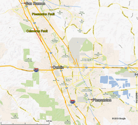
The specific research area for the new group of sensors in along the East Bay Hills on the west between San Ramon and Pleasanton to the hills on the east and northeast of San Ramon, Dublin, and Pleasanton, encompassing the San Ramon, Amador, and Livermore Valleys.