upper waypoint

When California Was an Island

Save ArticleSave Article
Failed to save article

Please try again

California as we like to think of it, despite knowing better. (Credit: Stanford University)

To some, it seems a mere technicality that California is attached to the rest of North America. It's not just a fantasy held by liberals keen to disengage from national politics, or by conservative pundits keen to dismiss our inexplicably robust performance in culture and business. The idea of California as separate, special, has been with us for centuries.

The misconception began in 1510, with a Spanish novel by Garci Rodríguez de Montalvo. He set imaginations afire with Las Sergas de Esplandián, an international bestseller in its day.

I tell you that on the right-hand side of the Indies there was an island called California, which was very close to the region of the Earthly Paradise. This island was inhabited by black women, and there were no males among them at all, for their life style was similar to that of the Amazons.

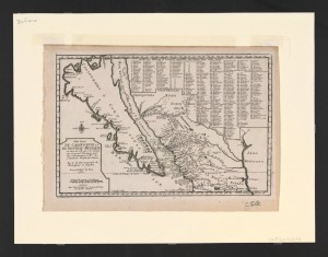
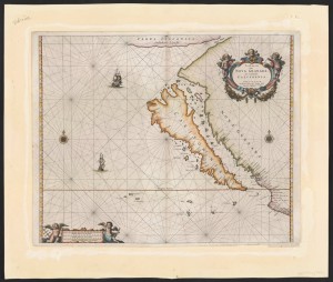
Montalvo's description was so compelling that Spanish explorers set off to find this earthly paradise, and insisted on the author's vision despite what they saw with their own eyes. Now at Stanford University, there’s a collection of about 800 maps from the 17th century that feature this curious coda in history.

The first map Glen McLaughlin bought, by Henrici Siele in 1666. (Credit: Stanford University)
The first map Glen McLaughlin bought, published by Henrici Siele in 1666. (Credit: Stanford University)

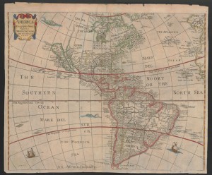
The guy who collected those maps is Glen McLaughlin. He became interested in maps about 42 years ago when, as Finance Director of Memorex Europe, he was sent to work in London. Poking around shops near Harrods, McLaughlin and his wife found a map that showed California as an island, “something I’d never seen before.”

Forty years later, the collection that chance discovery inspired came to Stanford's Branner Earth Sciences Library and Map Collections. McLaughlin's collection is believed to be the widest, broadest, deepest collection of its kind anywhere. It’s a fascinating survey of the human will to resist data that conflict with what we want to believe - or our loyalty to what we have come to believe, based on limited information.

Sponsored

The Spanish Conquistador Hernán Cortés de Monroy y Pizarro made an expedition to Cabo San Lucas on the tippy tip of Baja California in the mid-1500s. The explorers saw water separating California from the mainland, and they presumed that it must hold true all the way north to Oregon. Wouldn’t you?

If you start from the south, you can see how Spaniards might presume the Gulf of California was no gulf, but stretched on indefinitely. Or at least to Oregon. (Credit: Google)
You can imagine how Spaniards might presume the Gulf of California was no gulf, but stretched on indefinitely to the north. Or at least to Oregon. (Credit: Google Maps)

For that matter, mapmakers back in Europe presumed California must be HUGE compared with North America. “No one knew," McLaughlin mused. "They just made it up!”

So it went over the next two centuries.

In the early days, Spanish sailors resisted extensive maritime exploration of the West Coast. Prevailing winds blew ships away from the land, making it hard going. Also, the men had no interest in dallying about on the land. Baja California was desert, so the men presumed that was true north of San Diego, too.

“That was about as far as they wanted to go,” McLaughlin said. They had lost hope of spotting Amazonian women covered in gold jewelry. “Oh, I think sailors were very disappointed.” You would think the disappointment would lead the early explorers to question other presumptions, too. No.

In 1603, the Spanish government funded an expedition farther north. But even then, the sailors didn’t understand what they were looking at. For instance, they passed by San Francisco Bay, socked in with summer fog. Nobody saw massive rivers draining into the Pacific Ocean, which would suggest a substantial connection to a major land mass to the East. “They made it as far as Point Arena before turning back," McLaughlin said.

Undeniable proof of geographic reality would come from the East Side. Jesuit priests stationed in Baja California traveled as far north as what we know today as Tucson, and they couldn’t help but notice the southern tip of the Colorado River draining into the Gulf of California.

As time went on, Jesuit priests sent back increasingly detailed descriptions of the real (versus imaged) California, as this map from 1700 shows. (Credit: Stanford University)
As time went on, Jesuit priests sent back increasingly detailed descriptions of the real (versus imagined) California, as this map from 1700 shows. (Credit: Stanford University)

The Jesuits wrote back to the Vatican, but European mapmakers still clung to their romantic presumptions. McLaughlin said there was even one prominent London cartographer who insisted he had ship captains - in his office! - who swore they’d sailed completely around the island. (Wouldn’t you like to be a fly on the wall for that conversation?)

Finally, as the preponderance of evidence grew too great to ignore, Spain's King Ferdinand VI put an end to the debate with an official proclamation in 1747.

Julie Sweetkind-Singer, who heads the map collection, doesn’t think 250 years constitutes a remarkably long period of time for the Europeans to let go of their California Dream. She points out it took a long time back then for people to gather, record and disseminate information. “People were on horseback or they were walking. Or you’re in a canoe.”

You can see these maps depicting the fantasy island by traveling to Palo Alto, but in a few months you’ll be able to click on the maps from the comfort of your computer in San Diego or Seville. The Library is scanning many of its maps, having started with the McLaughlin collection.

Listen to Glenn McLaughlin describe his collection:

lower waypoint
next waypoint
California Preschools Wrestle to Comply With State’s Tightened Suspension RulesSan Francisco’s New Parking Rules Set to Displace RV Community Near SF StateA New Bay Area Clásico? SF's El Farolito and Oakland Roots Set to Battle in HaywardDemocrats Again Vote Down California Ban on Unhoused EncampmentsWhat the 99 Cents Only Stores Closure Means to CaliforniansCalifornia Legislators Take Aim at Construction Fees to Boost HousingJail Deaths Prompt Calls To Separate Coroner And Sheriff's Departments In Riverside CountyBay Area Diaspora Closely Watching India’s Upcoming ElectionSan José Police Department Sees Drop in Officer ComplaintsProtesters Shut Down I-880 Freeway in Oakland as Part of 'Economic Blockade' for Gaza