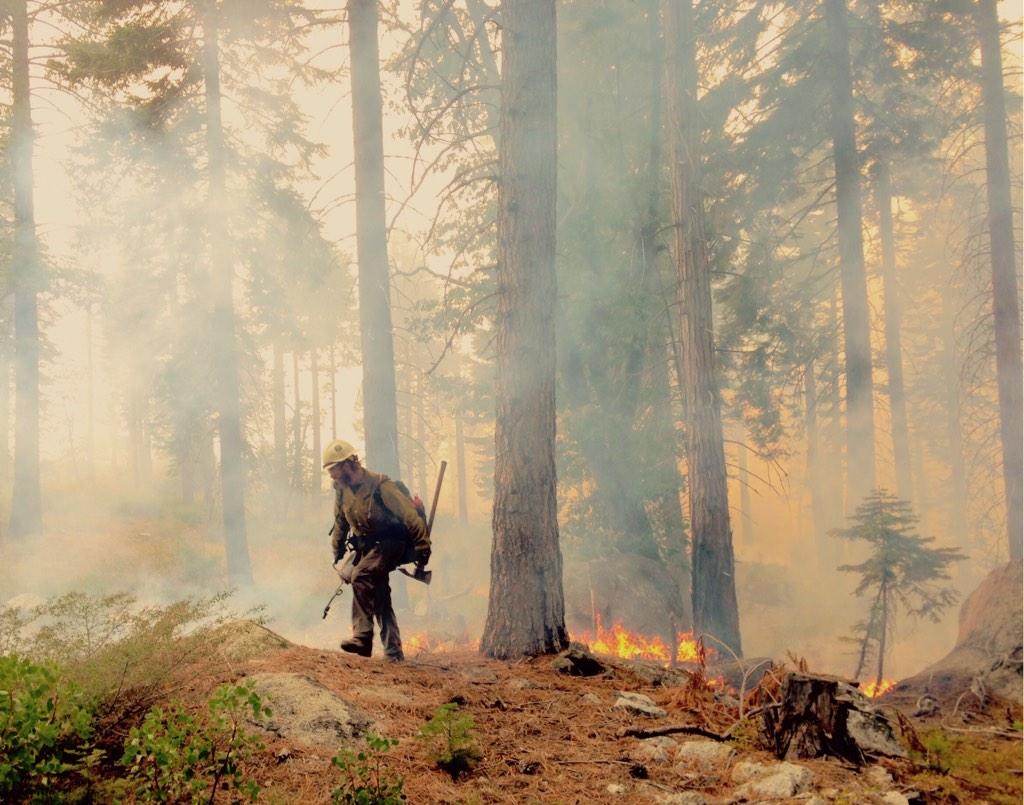
A member of the Lone Peak Hotshots, a Utah fire crew, patrols the line on the King Fire. (Lone Peak Hotshots via Twitter)
Update, 4:15 p.m. Monday (Sept. 29): Fire officials say that the King Fire will kick up a little this week as warm, dry weather returns to the Sierra Nevada. But as of Monday, they say they're confident that the fire in the forests west of Lake Tahoe has been pretty much stopped in its tracks by several days of rain. Here's the summary of the situation from the unified federal-state fire command:
After four days of precipitation with accumulations of 1 to 3 inches, fire spread has been halted, however heat remains in the heavier fuels and in the heavy duff sheltered from the rain under the dense timber canopy. As the weather turns warm and dry over the next several days, expect to see an increase in fire activity and smoke production; however spread potential is extremely low, due to the successful suppression efforts.
Allegedly the work of an arsonist, the King Fire has burned 97,000 acres -- about 150 square miles -- since starting Sept. 13.
To the north, federal fire managers have issued a final update on the Happy Camp Complex Fire, which has earned a footnote in California wildfire history. The blaze -- actually the combination of several fires that started Aug. 12 and burned together in the following weeks -- has burned nearly 133,000 acres (about 210 square miles) of timber in Siskiyou County south of the Klamath River. According to Cal Fire, that makes it the 16th-biggest California fire in area going back to 1932.
Update, 6:30 p.m. Thursday (Sept. 25) : Rain sounds like a great thing when you're facing the ravages of a wildfire. Right? But for those fighting the two biggest fires in California -- the Happy Camp Complex in Siskiyou County and the King Fire in El Dorado and Placer counties -- the state's first significant rain of the season was a little too much of a good thing.
The storm that moved slowly across the North Coast on Wednesday night, then over the central Sierra Nevada earlier Thursday, proved to be very wet, dumping more than 2 inches of rain over the Happy Camp blaze and less copious but still occasionally heavy rain on the King conflagration.
The result: Flash flood warnings were issued for the 210 square miles or so burned so far near Happy Camp in a blaze that started Aug. 12 and for the 145 square miles the King Fire has consumed since Sept. 13 in the Sierra forests west of Lake Tahoe. The heavy rain prompted fears of excessive runoff, debris flows and rock slides, especially on the steeper slopes seared by the fires. Those concerns led fire managers to pull crews off lines until the storm passed.
But the rains helped slow down the King Fire substantially, according to the latest event summary. "The observed fire activity was minimal with smoldering in interior pockets of the heavier fuels," it says.
Officially: As of Thursday evening, the King Fire is reported to have burned 95,347 acres and is 55 percent contained. The Happy Camp Fire is at 132,733 acres and 94 percent containment.
Update, 8:30 a.m. Wednesday: This morning, King Fire containment is at 38 percent, with about 93,000 acres burned. InciWeb reports that the fire "remained relatively active throughout the night due to the poor relative humidity recovery and wind." Potential remains for "extreme fire behavior if the winds, fuels, and topography come into alignment."
More from the Sacramento Bee, which reports community meetings will be held tonight at 7 p.m. at North Tahoe High School and Foresthill High School.
Update, 1:25 p.m. Tuesday: The good news on the King Fire, which has burned almost 90,000 acres of Sierra Nevada forests west of Lake Tahoe since it started Sept. 13: The force of nearly 7,500 fire personnel fighting the blaze, aided by several days of cool, damp weather, has achieved 35 percent containment.
The Sept. 22 footprint of the King Fire overlaid on a map of the Peninsula and South Bay. (Dan Brekke/KQED)
The bad news: Much warmer, drier and windier weather is sweeping across much of the northern Sierra, including the fire zone. The National Weather Service has issued a red-flag warning for the mountains from Yosemite clear up to the Oregon border. For El Dorado and Placer counties, where the fire is burning, the forecast calls for winds gusting up to 25 mph through Wednesday evening. After that, much of Northern California has a strong chance of rain.
For a second day in a row, the National Weather Service has issued a dense smoke advisory for the city, surrounding towns and the Tahoe Basin.
Some communities in the fire region have experienced extremely high levels of particulate pollution over the past several days. The reading for PM 2.5 -- fine particulates like those found in wood smoke -- was an astonishing 434 in parts of Placer County, northeast of Sacramento, on Tuesday morning. By comparison, the measure in most of the Bay Area was in the low 30s. In Auburn, air quality earlier Tuesday was classified as "hazardous" under the EPA's rating system.
Ann Hobbs, an air quality specialist with the Placer County Air Pollution Control District, said the worst of the pollution in Auburn had cleared by midday as winds shifted.
Update, 7:30 a.m. Monday: Cool, moist weather over the weekend, complete with occasional rain, has allowed the 5,500-person force fighting the King Fire to gain ground on the blaze burning across a large swath of the Sierra west of Lake Tahoe. The new acreage total for the King Fire released Monday: 87,592 acres, or 136 square miles, with about 18 percent containment.
Smoke from the fire will continue to have an impact over a wide area. The National Weather Service has issued dense-smoke advisories for Reno and the entire Tahoe basin. Concern about exposing students to poor air quality led several schools, including those in the towns of Colfax and Foresthill in Placer County, to cancel classes on Monday.
The fire has destroyed 10 homes and 22 "minor structures."
Update, 5:30 p.m. Saturday: No surprise: All the numbers have gotten bigger for the King Fire today. Fire officials say -- here, on Inciweb's King Fire page -- that the area covered by the blaze is now 81,000 acres (that's the number released this morning, so it's bigger now). About 4,900 personnel are assigned to fight the blaze -- the largest contingent assigned to a fire in California this year.
The fire is still rated as 10 percent contained, unchanged from Friday. Fire officials say the contained edge of the fire is along its southern flank, along U.S. 50 near the community of Pollock Pines, where it began a week ago.
The fire's biggest impact away from the burned area is the heavy smoke that's settled over much of the southern Sacramento Valley and the northern and central Sierra and foothills. The EPA's AirNow monitoring site shows air quality in the foothills near Auburn, northeast of Sacramento on Interstate 80, has ranged from very unhealthy to hazardous for most of Saturday. Air pollution in most of the Bay Area has been rated as "moderate" most of Saturday.
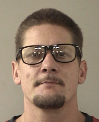
Update, 2:50 p.m. Friday: Wayne Allen Huntsman, the 37-year-old suspect in the King Fire that's swept through more than 76,000 acres of Sierra forest this week, entered a not guilty plea Friday to a charge that he deliberately set the blaze. Huntsman's next hearing on a single count of forest arson was set for late October. He continues to be held on $10 million bond.
That plea came as the first reports surfaced that homes have been destroyed in the fire. Sacramento's KCRA-Channel 3 reported Friday afternoon that the fire destroyed at least four homes north of U.S. 50, in an area called White Meadows about 6 miles from where the fire started.
Fire officials said Friday they were assessing structures in the area and wanted to contact property owners before confirming losses.
Huntsman's plea in El Dorado County Superior Court in Placerville was made as media reports emerge detailing the suspect's past and offering clues about the fire's origin near the community of Pollock Pines last weekend.
Sacramento's News10 reported Friday that police believe the arson suspect broke into a home in an apparent attempt to call 911 to report the fire. News10 says that account comes from a homeowner, Ralf Lorenz, whose front door was kicked in last Saturday:
Lorenz wasn't home at the time. He was working in the Bay Area when the King Fire broke out Saturday on the steep embankment behind his home. His first clue that something wasn't right was when he got a call from his home security company that afternoon.
"I didn't know if my house was still standing," Lorenz said. "I didn't know if it was pilfered."
Nothing was taken. But, Lorenz's front door was broken.
"The perpetrator kicked it in," Lorenz said. "He tried to call 911 to report the fire."
News10 said that law enforcement officials declined comment on Lorenz's story.
Several news sources reported on interviews with Huntsman's sister and former girlfriend, who both expressed incredulity that he's been accused with setting the fire.
"There's no way he would have ever done this intentionally," Tami Criswell of Salinas said in a telephone interview, one day after her brother, Wayne Allen Huntsman, was charged with felony arson....
… (She) said her brother loves the outdoors and is not someone who would want to destroy it.
"He had everything going for him," she said. "There's no reason he would ever do this." ...
... Huntsman has a criminal record that includes convictions for assault with a deadly weapon and grand theft in Santa Cruz County in 1997, public records show. None of his crimes relate to arson, and his sister said he cleaned up his act a long time ago.
"He had been in good standing with the law and the community," said Criswell. "He's always been part of my family and my kids. He's been helping take care of his elderly grandmother."
Criswell said Huntsman has enjoyed his life in the Sierra foothills, where he has friends and a few family members and where work has been steadier than in Santa Cruz.
She told Alexander the last time she spoke to Huntsman was Saturday, the same day the fire started.
One last update for now, by way of the Associated Press: Cal Fire says it set a record on Wednesday for the amount of retardant dropped on a wildfire in a single day:
Cal Fire spokeswoman Lynne Tolmachoff says air tankers on Wednesday poured 203,375 gallons of the red slurry on an explosive Northern California wildfire that has now burned through nearly 120 square miles of timber and vegetation.
As of Friday, Cal Fire and the U.S. Forest Service together had dumped 530,000 gallons on the El Dorado County blaze.
Tolmachoff says the fire is burning so fiercely it is running through the retardant lines because of the extreme drought conditions.
Update, 9:30 a.m. Friday: The force of more than 4,000 firefighters trying to corral the massive King Fire in El Dorado and Placer counties have gotten some help from a powerful ally -- the weather.
Fire managers report much cooler temperatures, along with humidity as high as 90 percent. That slowed the growth of the fire, which had raced north through the heavily forested terrain north of U.S. 50 on Wednesday, to a few thousand acres on Thursday. But the outlook may not be so good Friday: the return of dryer, warmer weather is expected to allow the fire to gain strength again today. So far, the King Fire has burned 76,376 acres and is 10 percent contained. That's about 120 square miles, roughly two-thirds the area of San Jose.
Investigators say the fire was deliberately set in steep terrain near the community of Pollock Pines last Saturday. The suspect in the case, identified Thursday as Wayne Allen Huntsman, 37, is scheduled to be arraigned in Placerville this afternoon on a single count of forest arson.
Update, 6:15 p.m. Thursday: As we posted earlier (see below) El Dorado County authorities announced the arrest of an arson suspect in the King Fire.
The fire has burned 73,000 acres and is 10 percent contained. That's about 115 square miles, or the equivalent of the San Francisco Peninsula from the Golden Gate down to Pacifica and Millbrae.
The fresh news that emerged this afternoon is that the fire's rapid spread through the heavily forested American River watershed north of U.S. 50 is threatening power infrastructure in the area.
The Placer County Water Agency, which serves communities from suburban Sacramento through the Sierra foothills and all the way to Lake Tahoe, said that the King Fire is now threatening its power generation facilities and PG&E transmission lines.
The mammoth King Fire spread rapidly into Placer County Wednesday night. ... The head of the fire has moved all the way to Placer County Water Agency’s Hell Hole Reservoir on the Rubicon River. It seriously threatens PCWA power generation and PG&E transmission facilities. The swath of fire in Placer County is 6 miles wide and fire officials report no containment after last night.
“We’re extremely concerned and we’re monitoring the situation very closely. We’ve moved all of our employees out of the danger zone, so now our number one concern is protecting PCWA’s Middle Fork American River Project hydroelectric generation facilities and PG&E’s transmission lines. The agency and PG&E are coordinating with the fire command and emergency services officials in El Dorado and Placer counties,” said PCWA General Manager David Breninger.
Firefighting officials said the fire made a run of more than 10 miles to the north between 4 p.m. Wednesday and 6 a.m. Thursday. And according to a report from Capital Public Radio's Bob Moffitt:
Mike Kaslin with the Cal Fire Amador County unit says the front of the fire is now about 14 miles west of Lake Tahoe.
"That area is fairly remote and we are sending resources up there to continue to flank it," says Kaslin. "But, the lion's share of our efforts are still going to be on the south end where the infrastructure -the homes and residences are."
Smoke from the fire is having a dramatic impact on air quality in communities to the east and north. From the Reno Gazette-Journal:
Heavy smoke ... has triggered a warning in Washoe County about the extremely poor air quality and prompted schools to cancel most athletic games and other outdoor events in the Reno area.
The Washoe County Health District said the air quality index reached the "very unhealthy" range at 4 p.m. Thursday. That's one step away from "hazardous."
Health officials say the "very unhealthy" air quality index reading of 221 means the general population may experience significant health effects. Its Reno's worst reading since 2008 when a string of Sierra fires pushed it to 211.
Officials earlier urged sensitive groups such as the elderly and people with respiratory conditions to remain indoors when the index climbed into the "unhealthy" range between 151 and 200.
Update, 3:20 p.m. Thursday: El Dorado County authorities have filed arson charges in the King Fire, which has raged across 71,000 acres of forest near the community of Pollock Pines since it started Saturday evening.
At a press conference Thursday morning in Camino, the county's district attorney announced that 37-year-old Wayne Allen Huntsman has been charged with a single court of arson of forest land. His arraignment is scheduled for Friday. Multiple media sources report he's being held on $10 million bail. We've embedded the district attorney's complaint against Huntsman below.
Monterey's KSBW reports that Huntsman is a resident of Aptos, near Santa Cruz. The charging document released Thursday shows four past felonies, including three 1997 convictions in Santa Cruz County. Those offenses include assault with a deadly weapon, grand theft and auto theft.
It was revealed at the news conference that the fire was set near Pollock Pines in very steep terrain. A Calfire investigator was the first to find the origin of the fire and begin the investigatory process that led to Huntsman’s arrest.
Pierson said that law enforcement had been in contact with the suspect in the days prior to his arrest in Placerville.
King Fire arson suspect Wayne Allen Huntsman in photo released by El Dorado County authorities.
Update, 10:35 a.m. Thursday: Cal Fire has scheduled an 11:30 a.m. press conference to announce the cause of the huge and rapidly spreading King Fire in El Dorado County. The 71,000-acre fire started Saturday evening and the origin has been under investigation.
The Mountain Democrat of Placerville is reporting that El Dorado County authorities arrested a suspect Wednesday night on a single count of arson on forest land, though it's not known for sure whether the suspect was picked up for starting the King Fire. The Mountain Democrat says the suspect, whom we'll refrain from naming for the time being, is being held on $10 million bail.
El Dorado County sheriff's Sgt. Jeff Leikauf said his is withholding comment until the Cal Fire press conference. We'll note that sheriff's officials, the El Dorado County district attorney and U.S. Forest Service officials are scheduled to attend the press conference in the town of Camino.
Update, 9:40 a.m. Thursday: YubaNet.com, based in Nevada City, has been providing some of the most comprehensive coverage of California fires all season long. YubaNet's page on the King Fire includes an excellent map -- embedded below this update -- that shows the rapid progress of the fire through El Dorado National Forest and, possibly, into Tahoe National Forest.
Original post: The major wildfire burning north of the Bay Area's main route to Lake Tahoe has exploded in size, with state and federal officials now saying the King Fire northeast of Placerville has covered nearly 71,000 acres.
Officials say the blaze is threatening 2,000 homes and 1,500 "minor structures" near the El Dorado County community of Pollock Pines, which is in a sort of transition zone from the Sierra Nevada foothills into thickly timbered mountain ridges and canyons in the American River watershed. So far, there's no word that the fire has burned homes or structures. About 3,600 personnel have been assigned to the fire, which is 5 percent contained.
According to the U.S. Forest Service and Cal Fire, most of the blaze's spread over the last day has been to the north and northwest, toward the communities of Swansboro and Volcanoville and Stumpy Meadows Reservoir.
For the second time since the blaze broke out over the weekend, U.S. 50 has been shut down to give firefighters full access to the fire zone. Details on the closure from the Sacramento Bee:
...Highway 50 is closed again in the Sierra Nevada as crews set backfires to stem the march of the King blaze that has charred a broad swath of timberland in El Dorado County.
The California Highway Patrol reports that [an 8-mile] stretch of the highway from Sly Park Road to Ice House Road closed again around midnight. Firefighters are busy setting backfires that they hope will burn into the main fire and provide a large burned buffer between flames and homes.
The closure will be re-evaluated later today.
“The fire is close to the roadway and they are trying to get crews in and out,” said CHP spokesman Officer Rich Wetzel.
Alternate routes for trans-Sierra travelers are Interstate 80 and Highway 88.
The rapid growth of the King Fire -- which apparently quadrupled in size from early Wednesday to early Thursday -- has been breathtaking.
The blaze started last Saturday evening on the outskirts of the community of Pollock Pines, about a dozen miles as the crow flies northeast of Placerville. That evening, it was reported to be 20 acres. Driven by hot, dry and occasionally windy weather and feeding on drought-parched forests, the fire has expanded rapidly since, covering 3,000 acres by Sunday evening, 8,600 by Monday night and 12,800 by Tuesday night and about 18,500 on Wednesday morning. After dark Wednesday, officials said the fire had grown to 28,000 acres, an estimate updated to 71,000 Thursday morning.
The current acreage total is equivalent to abut 110 square miles. How would that area look on a Bay Area map? It's roughly equal to the San Francisco Peninsula from the Golden Gate all the way down to Pacifica and Millbrae.
Fire officials say that weather conditions Thursday, though a bit cooler and moister than earlier in the week, could feed "extreme fire behavior" in the continue to push the fire north, east and west. Fire managers also report the southern flank of the fire, near Pollock Pines and along U.S. 50, is the most secure at this point.
window.__IS_SSR__=true
window.__INITIAL_STATE__={
"attachmentsReducer": {
"audio_0": {
"type": "attachments",
"id": "audio_0",
"imgSizes": {
"kqedFullSize": {
"file": "https://ww2.kqed.org/news/wp-content/themes/KQED-unified/img/audio_bgs/background0.jpg"
}
}
},
"audio_1": {
"type": "attachments",
"id": "audio_1",
"imgSizes": {
"kqedFullSize": {
"file": "https://ww2.kqed.org/news/wp-content/themes/KQED-unified/img/audio_bgs/background1.jpg"
}
}
},
"audio_2": {
"type": "attachments",
"id": "audio_2",
"imgSizes": {
"kqedFullSize": {
"file": "https://ww2.kqed.org/news/wp-content/themes/KQED-unified/img/audio_bgs/background2.jpg"
}
}
},
"audio_3": {
"type": "attachments",
"id": "audio_3",
"imgSizes": {
"kqedFullSize": {
"file": "https://ww2.kqed.org/news/wp-content/themes/KQED-unified/img/audio_bgs/background3.jpg"
}
}
},
"audio_4": {
"type": "attachments",
"id": "audio_4",
"imgSizes": {
"kqedFullSize": {
"file": "https://ww2.kqed.org/news/wp-content/themes/KQED-unified/img/audio_bgs/background4.jpg"
}
}
},
"placeholder": {
"type": "attachments",
"id": "placeholder",
"imgSizes": {
"thumbnail": {
"file": "https://cdn.kqed.org/wp-content/uploads/2024/12/KQED-Default-Image-816638274-2000x1333-1-160x107.jpg",
"width": 160,
"height": 107,
"mimeType": "image/jpeg"
},
"medium": {
"file": "https://cdn.kqed.org/wp-content/uploads/2024/12/KQED-Default-Image-816638274-2000x1333-1-800x533.jpg",
"width": 800,
"height": 533,
"mimeType": "image/jpeg"
},
"medium_large": {
"file": "https://cdn.kqed.org/wp-content/uploads/2024/12/KQED-Default-Image-816638274-2000x1333-1-768x512.jpg",
"width": 768,
"height": 512,
"mimeType": "image/jpeg"
},
"large": {
"file": "https://cdn.kqed.org/wp-content/uploads/2024/12/KQED-Default-Image-816638274-2000x1333-1-1020x680.jpg",
"width": 1020,
"height": 680,
"mimeType": "image/jpeg"
},
"1536x1536": {
"file": "https://cdn.kqed.org/wp-content/uploads/2024/12/KQED-Default-Image-816638274-2000x1333-1-1536x1024.jpg",
"width": 1536,
"height": 1024,
"mimeType": "image/jpeg"
},
"fd-lrg": {
"file": "https://cdn.kqed.org/wp-content/uploads/2024/12/KQED-Default-Image-816638274-2000x1333-1-1536x1024.jpg",
"width": 1536,
"height": 1024,
"mimeType": "image/jpeg"
},
"fd-med": {
"file": "https://cdn.kqed.org/wp-content/uploads/2024/12/KQED-Default-Image-816638274-2000x1333-1-1020x680.jpg",
"width": 1020,
"height": 680,
"mimeType": "image/jpeg"
},
"fd-sm": {
"file": "https://cdn.kqed.org/wp-content/uploads/2024/12/KQED-Default-Image-816638274-2000x1333-1-800x533.jpg",
"width": 800,
"height": 533,
"mimeType": "image/jpeg"
},
"post-thumbnail": {
"file": "https://cdn.kqed.org/wp-content/uploads/2024/12/KQED-Default-Image-816638274-2000x1333-1-672x372.jpg",
"width": 672,
"height": 372,
"mimeType": "image/jpeg"
},
"twentyfourteen-full-width": {
"file": "https://cdn.kqed.org/wp-content/uploads/2024/12/KQED-Default-Image-816638274-2000x1333-1-1038x576.jpg",
"width": 1038,
"height": 576,
"mimeType": "image/jpeg"
},
"xxsmall": {
"file": "https://cdn.kqed.org/wp-content/uploads/2024/12/KQED-Default-Image-816638274-2000x1333-1-160x107.jpg",
"width": 160,
"height": 107,
"mimeType": "image/jpeg"
},
"xsmall": {
"file": "https://cdn.kqed.org/wp-content/uploads/2024/12/KQED-Default-Image-816638274-2000x1333-1-672x372.jpg",
"width": 672,
"height": 372,
"mimeType": "image/jpeg"
},
"small": {
"file": "https://cdn.kqed.org/wp-content/uploads/2024/12/KQED-Default-Image-816638274-2000x1333-1-672x372.jpg",
"width": 672,
"height": 372,
"mimeType": "image/jpeg"
},
"xlarge": {
"file": "https://cdn.kqed.org/wp-content/uploads/2024/12/KQED-Default-Image-816638274-2000x1333-1-1020x680.jpg",
"width": 1020,
"height": 680,
"mimeType": "image/jpeg"
},
"full-width": {
"file": "https://cdn.kqed.org/wp-content/uploads/2024/12/KQED-Default-Image-816638274-2000x1333-1-1920x1280.jpg",
"width": 1920,
"height": 1280,
"mimeType": "image/jpeg"
},
"guest-author-32": {
"file": "https://cdn.kqed.org/wp-content/uploads/2025/01/KQED-Default-Image-816638274-1333x1333-1-160x160.jpg",
"width": 32,
"height": 32,
"mimeType": "image/jpeg"
},
"guest-author-50": {
"file": "https://cdn.kqed.org/wp-content/uploads/2025/01/KQED-Default-Image-816638274-1333x1333-1-160x160.jpg",
"width": 50,
"height": 50,
"mimeType": "image/jpeg"
},
"guest-author-64": {
"file": "https://cdn.kqed.org/wp-content/uploads/2025/01/KQED-Default-Image-816638274-1333x1333-1-160x160.jpg",
"width": 64,
"height": 64,
"mimeType": "image/jpeg"
},
"guest-author-96": {
"file": "https://cdn.kqed.org/wp-content/uploads/2025/01/KQED-Default-Image-816638274-1333x1333-1-160x160.jpg",
"width": 96,
"height": 96,
"mimeType": "image/jpeg"
},
"guest-author-128": {
"file": "https://cdn.kqed.org/wp-content/uploads/2025/01/KQED-Default-Image-816638274-1333x1333-1-160x160.jpg",
"width": 128,
"height": 128,
"mimeType": "image/jpeg"
},
"detail": {
"file": "https://cdn.kqed.org/wp-content/uploads/2025/01/KQED-Default-Image-816638274-1333x1333-1-160x160.jpg",
"width": 160,
"height": 160,
"mimeType": "image/jpeg"
},
"kqedFullSize": {
"file": "https://cdn.kqed.org/wp-content/uploads/2024/12/KQED-Default-Image-816638274-2000x1333-1.jpg",
"width": 2000,
"height": 1333
}
}
},
"news_148770": {
"type": "attachments",
"id": "news_148770",
"meta": {
"index": "attachments_1716263798",
"site": "news",
"id": "148770",
"found": true
},
"parent": 147957,
"imgSizes": {
"wide-featured-image": {
"file": "https://ww2.kqed.org/app/uploads/sites/10/2014/09/kingfirenasa-1-of-1-600x300.jpg",
"width": 600,
"mimeType": "image/jpeg",
"height": 300
},
"featured-page": {
"file": "https://ww2.kqed.org/app/uploads/sites/10/2014/09/kingfirenasa-1-of-1-315x145.jpg",
"width": 315,
"mimeType": "image/jpeg",
"height": 145
},
"thumbnail": {
"file": "https://ww2.kqed.org/app/uploads/sites/10/2014/09/kingfirenasa-1-of-1-300x300.jpg",
"width": 300,
"mimeType": "image/jpeg",
"height": 300
},
"kqedFullSize": {
"file": "https://ww2.kqed.org/app/uploads/sites/10/2014/09/kingfirenasa-1-of-1.jpg",
"width": 804,
"height": 562
},
"wide-featured-image-full": {
"file": "https://ww2.kqed.org/app/uploads/sites/10/2014/09/kingfirenasa-1-of-1-804x300.jpg",
"width": 804,
"mimeType": "image/jpeg",
"height": 300
},
"guest-author-96": {
"file": "https://ww2.kqed.org/app/uploads/sites/10/2014/09/kingfirenasa-1-of-1-96x96.jpg",
"width": 96,
"mimeType": "image/jpeg",
"height": 96
},
"medium": {
"file": "https://ww2.kqed.org/app/uploads/sites/10/2014/09/kingfirenasa-1-of-1-640x447.jpg",
"width": 640,
"mimeType": "image/jpeg",
"height": 447
},
"guest-author-64": {
"file": "https://ww2.kqed.org/app/uploads/sites/10/2014/09/kingfirenasa-1-of-1-64x64.jpg",
"width": 64,
"mimeType": "image/jpeg",
"height": 64
},
"guest-author-32": {
"file": "https://ww2.kqed.org/app/uploads/sites/10/2014/09/kingfirenasa-1-of-1-32x32.jpg",
"width": 32,
"mimeType": "image/jpeg",
"height": 32
},
"narrow-featured-image": {
"file": "https://ww2.kqed.org/app/uploads/sites/10/2014/09/kingfirenasa-1-of-1-400x300.jpg",
"width": 400,
"mimeType": "image/jpeg",
"height": 300
},
"narrow-featured-image-full": {
"file": "https://ww2.kqed.org/app/uploads/sites/10/2014/09/kingfirenasa-1-of-1-640x360.jpg",
"width": 640,
"mimeType": "image/jpeg",
"height": 360
},
"detail": {
"file": "https://ww2.kqed.org/app/uploads/sites/10/2014/09/kingfirenasa-1-of-1-75x75.jpg",
"width": 75,
"mimeType": "image/jpeg",
"height": 75
},
"guest-author-128": {
"file": "https://ww2.kqed.org/app/uploads/sites/10/2014/09/kingfirenasa-1-of-1-128x128.jpg",
"width": 128,
"mimeType": "image/jpeg",
"height": 128
}
},
"publishDate": 1411695113,
"modified": 1411695113,
"caption": "A NASA false-color image of the King Fire, burning in the Sierra west of Lake Tahoe. The red area to the west (left) of the lake is the area burned by the fire as of Sept. 19.",
"description": "A NASA false-color image of the King Fire, burning in the Sierra west of Lake Tahoe. The red area to the west (left) of the lake is the area burned by the fire as of Sept. 19.",
"title": "King Fire-NASA",
"credit": null,
"status": "inherit",
"isLoading": false,
"fetchFailed": false
}
},
"audioPlayerReducer": {
"postId": "stream_live",
"isPaused": true,
"isPlaying": false,
"pfsActive": false,
"pledgeModalIsOpen": true,
"playerDrawerIsOpen": false,
"liveAudioPlayStartedAt": 0,
"liveAudioPlayContext": ""
},
"authorsReducer": {
"danbrekke": {
"type": "authors",
"id": "222",
"meta": {
"index": "authors_1716337520",
"id": "222",
"found": true
},
"name": "Dan Brekke",
"firstName": "Dan",
"lastName": "Brekke",
"slug": "danbrekke",
"email": "dbrekke@kqed.org",
"display_author_email": true,
"staff_mastheads": [
"news",
"science"
],
"title": "KQED Editor and Reporter",
"bio": "Dan Brekke is a reporter and editor for KQED News, responsible for coverage of topics ranging from California water issues to the Bay Area's transportation challenges. In a newsroom career that began in Chicago in 1972, Dan has worked for \u003cem>The San Francisco Examiner,\u003c/em> Wired and TechTV and has been published in The New York Times, The New York Times Magazine, Business 2.0, Salon and elsewhere.\r\n\r\nSince joining KQED in 2007, Dan has reported, edited and produced both radio and online features and breaking news pieces. He has shared as both editor and reporter in four Society of Professional Journalists Norcal Excellence in Journalism awards and one Edward R. Murrow regional award. He was chosen for a spring 2017 residency at the Mesa Refuge to advance his research on California salmon.\r\n\r\nEmail Dan at: \u003ca href=\"mailto:dbrekke@kqed.org\">dbrekke@kqed.org\u003c/a>\r\n\r\n\u003cstrong>Twitter:\u003c/strong> \u003ca href=\"https://twitter.com/danbrekke\" rel=\"noopener noreferrer\">twitter.com/danbrekke\u003c/a>\r\n\u003cstrong>Facebook:\u003c/strong> \u003ca href=\"https://www.facebook.com/danbrekke\" rel=\"noopener noreferrer\">www.facebook.com/danbrekke\u003c/a>\r\n\u003cstrong>LinkedIn:\u003c/strong> \u003ca href=\"https://www.linkedin.com/in/danbrekke\" rel=\"noopener noreferrer\">www.linkedin.com/in/danbrekke\u003c/a>",
"avatar": "https://secure.gravatar.com/avatar/c8126230345efca3f7aa89b1a402be45?s=600&d=mm&r=g",
"twitter": "danbrekke",
"facebook": null,
"instagram": "https://www.instagram.com/dan.brekke/",
"linkedin": "https://www.linkedin.com/in/danbrekke/",
"sites": [
{
"site": "news",
"roles": [
"administrator",
"create_posts"
]
},
{
"site": "stateofhealth",
"roles": [
"editor"
]
},
{
"site": "science",
"roles": [
"editor"
]
},
{
"site": "quest",
"roles": [
"contributor"
]
},
{
"site": "food",
"roles": [
"contributor"
]
},
{
"site": "forum",
"roles": [
"contributor"
]
},
{
"site": "liveblog",
"roles": [
"editor"
]
}
],
"headData": {
"title": "Dan Brekke | KQED",
"description": "KQED Editor and Reporter",
"ogImgSrc": "https://secure.gravatar.com/avatar/c8126230345efca3f7aa89b1a402be45?s=600&d=mm&r=g",
"twImgSrc": "https://secure.gravatar.com/avatar/c8126230345efca3f7aa89b1a402be45?s=600&d=mm&r=g"
},
"isLoading": false,
"link": "/author/danbrekke"
}
},
"pagesReducer": {},
"pfsSessionReducer": {},
"postsReducer": {
"stream_live": {
"type": "live",
"id": "stream_live",
"audioUrl": "https://streams.kqed.org/kqedradio",
"title": "Live Stream",
"excerpt": "Live Stream information currently unavailable.",
"link": "/radio",
"featImg": "",
"label": {
"name": "KQED Live",
"link": "/"
}
},
"stream_kqedNewscast": {
"type": "posts",
"id": "stream_kqedNewscast",
"audioUrl": "https://www.kqed.org/.stream/anon/radio/RDnews/newscast.mp3?_=1",
"title": "KQED Newscast",
"featImg": "",
"label": {
"name": "88.5 FM",
"link": "/"
}
},
"news_147957": {
"type": "posts",
"id": "news_147957",
"meta": {
"index": "posts_1716263798",
"site": "news",
"id": "147957",
"found": true
},
"articlePosition": 0,
"parent": 0,
"labelTerm": {
"site": "news",
"term": 6944
},
"blocks": [],
"publishDate": 1412032504,
"format": "aside",
"disqusTitle": "King Fire Update: Rain Tames Blaze Even as Warm, Dry Weather Returns",
"title": "King Fire Update: Rain Tames Blaze Even as Warm, Dry Weather Returns",
"headTitle": "News Fix | KQED News",
"content": "\u003cfigure id=\"attachment_148997\" class=\"wp-caption aligncenter\" style=\"max-width: 640px\">\u003ca href=\"http://ww2.kqed.org/news/wp-content/uploads/sites/10/2014/09/kingfire-hotshots.jpg\">\u003cimg class=\"size-medium wp-image-148997\" src=\"http://ww2.kqed.org/news/wp-content/uploads/sites/10/2014/09/kingfire-hotshots-640x503.jpg\" alt=\"A member of the Lone Peak Hotshots, a Utah fire crew, patrols the line on the King Fire. (Lone Peak Hotshots via Twitter)\" width=\"640\" height=\"503\" srcset=\"https://ww2.kqed.org/app/uploads/sites/10/2014/09/kingfire-hotshots-640x503.jpg 640w, https://ww2.kqed.org/app/uploads/sites/10/2014/09/kingfire-hotshots.jpg 1024w\" sizes=\"(max-width: 640px) 100vw, 640px\">\u003c/a>\u003cfigcaption class=\"wp-caption-text\">A member of the Lone Peak Hotshots, a Utah fire crew, patrols the line on the King Fire. (\u003ca href=\"//twitter.com/LonePeakIHC\">Lone Peak Hotshots\u003c/a> via Twitter)\u003c/figcaption>\u003c/figure>\n\u003cp>\u003cstrong>Update, 4:15 p.m. Monday (Sept. 29): \u003c/strong>Fire officials say that the King Fire will kick up a little this week as warm, dry weather returns to the Sierra Nevada. But as of Monday, they say they're confident that the fire in the forests west of Lake Tahoe has been pretty much stopped in its tracks by several days of rain. Here's the summary of the situation from the unified federal-state fire command:\u003c/p>\n\u003cblockquote>\u003cp>After four days of precipitation with accumulations of 1 to 3 inches, fire spread has been halted, however heat remains in the heavier fuels and in the heavy duff sheltered from the rain under the dense timber canopy. As the weather turns warm and dry over the next several days, expect to see an increase in fire activity and smoke production; however spread potential is extremely low, due to the successful suppression efforts.\u003c/p>\u003c/blockquote>\n\u003cp>Allegedly the work of an arsonist, the King Fire has burned 97,000 acres -- about 150 square miles -- since starting Sept. 13.\u003c/p>\n\u003cp>To the north, federal fire managers have issued \u003ca href=\"http://inciweb.nwcg.gov/incident/4078/\" target=\"_blank\">a final update on the Happy Camp Complex Fire\u003c/a>, which has earned a footnote in California wildfire history. The blaze -- actually the combination of several fires that started Aug. 12 and burned together in the following weeks -- has burned nearly 133,000 acres (about 210 square miles) of timber in Siskiyou County south of the Klamath River. According to Cal Fire, that makes it \u003ca href=\"http://www.fire.ca.gov/communications/downloads/fact_sheets/20LACRES.pdf\" target=\"_blank\">the 16th-biggest California fire in area\u003c/a> going back to 1932.\u003c/p>\n\u003cp>\u003cstrong>Update, 6:30 p.m. Thursday (Sept. 25) :\u003c/strong> Rain sounds like a great thing when you're facing the ravages of a wildfire. Right? But for those fighting the two biggest fires in California -- the \u003ca href=\"http://inciweb.nwcg.gov/incident/4078/\" target=\"_blank\">Happy Camp Complex in Siskiyou County\u003c/a> and the \u003ca href=\"http://inciweb.nwcg.gov/incident/4108/\" target=\"_blank\">King Fire in El Dorado and Placer\u003c/a> counties -- the state's first significant rain of the season was a little too much of a good thing.\u003c/p>\n\u003cp>The storm that moved slowly across the North Coast on Wednesday night, then over the central Sierra Nevada earlier Thursday, proved to be very wet, dumping more than 2 inches of rain over the Happy Camp blaze and less copious but still occasionally heavy rain on the King conflagration.\u003c/p>\n\u003cp>[ad fullwidth]\u003c/p>\n\u003cp>The result: Flash flood warnings were issued for the 210 square miles or so burned so far near Happy Camp in a blaze that started Aug. 12 and for the 145 square miles the King Fire has consumed since Sept. 13 in the Sierra forests west of Lake Tahoe. The heavy rain prompted fears of excessive runoff, debris flows and rock slides, especially on the steeper slopes seared by the fires. Those concerns led fire managers to pull crews off lines until the storm passed.\u003c/p>\n\u003cp>But the rains helped slow down the King Fire substantially, according to the latest event summary. \"The observed fire activity was minimal with smoldering in interior pockets of the heavier fuels,\" it says.\u003c/p>\n\u003cp>Officially: As of Thursday evening, the King Fire is reported to have burned 95,347 acres and is 55 percent contained. The Happy Camp Fire is at 132,733 acres and 94 percent containment.\u003c/p>\n\u003cp>\u003cstrong>Update, 8:30 a.m. Wednesday: \u003c/strong>This morning, \u003ca href=\"http://inciweb.nwcg.gov/incident/4108/\" target=\"_blank\">King Fire\u003c/a> containment is at 38 percent, with about 93,000 acres burned. InciWeb reports that the fire \"remained relatively active throughout the night due to the poor relative humidity recovery and wind.\" Potential remains for \"extreme fire behavior if the winds, fuels, and topography come into alignment.\"\u003c/p>\n\u003cp>More from the \u003ca href=\"http://www.sacbee.com/2014/09/24/6732102/king-fire-burn-increases-3300.html\" target=\"_blank\">Sacramento Bee\u003c/a>, which reports community meetings will be held tonight at 7 p.m. at North Tahoe High School and Foresthill High School.\u003c/p>\n\u003cp>\u003cstrong>Update, 1:25 p.m. Tuesday: \u003c/strong>The good news on \u003ca href=\"http://inciweb.nwcg.gov/incident/4108/\" target=\"_blank\">the King Fire\u003c/a>, which has burned almost 90,000 acres of Sierra Nevada forests west of Lake Tahoe since it started Sept. 13: The force of nearly 7,500 fire personnel fighting the blaze, aided by several days of cool, damp weather, has achieved 35 percent containment.\u003c/p>\n\u003cfigure id=\"attachment_148394\" class=\"wp-caption alignright\" style=\"max-width: 252px\">\u003ca href=\"http://ww2.kqed.org/news/wp-content/uploads/sites/10/2014/09/kingfireoverlay.jpg\">\u003cimg class=\"size-full wp-image-148394\" src=\"http://ww2.kqed.org/news/wp-content/uploads/sites/10/2014/09/kingfireoverlay.jpg\" alt=\"The Sept. 22 footprint of the King Fire overlaid on a map of the Peninsula and South Bay. (Dan Brekke/KQED)\" width=\"252\" height=\"420\">\u003c/a>\u003cfigcaption class=\"wp-caption-text\">The Sept. 22 footprint of the King Fire overlaid on a map of the Peninsula and South Bay. (Dan Brekke/KQED)\u003c/figcaption>\u003c/figure>\n\u003cp>The bad news: Much warmer, drier and windier weather is sweeping across much of the northern Sierra, including the fire zone. The National Weather Service has issued a red-flag warning for the mountains from Yosemite clear up to the Oregon border. For El Dorado and Placer counties, where the fire is burning, \u003ca href=\"http://www.wrh.noaa.gov/firewx/?latitude=&longitude=&wfo=sto&interface=fwzones&click.x=553&click.y=382\" target=\"_blank\">the forecast calls for winds\u003c/a> gusting up to 25 mph through Wednesday evening. After that, much of Northern California has a strong chance of rain.\u003c/p>\n\u003cp>For a second day in a row, the National Weather Service has issued\u003ca href=\"http://forecast.weather.gov/showsigwx.php?warnzone=CAZ072&warncounty=CAC057&firewxzone=CAZ271&local_place1=6%20Miles%20NNW%20Devonshire%20CA&product1=Dense+Smoke+Advisory&lat=39.43421&lon=-120.11525#.VCHYWPldV8E\" target=\"_blank\"> a dense smoke advisory\u003c/a> for the city, surrounding towns and the Tahoe Basin.\u003c/p>\n\u003cp>Some communities in the fire region have experienced extremely high levels of particulate pollution over the past several days. The reading for PM 2.5 -- fine particulates like those found in wood smoke -- was an astonishing 434 in parts of Placer County, northeast of Sacramento, on Tuesday morning. By comparison, the measure in most of the Bay Area was in the low 30s. In Auburn, air quality earlier Tuesday was classified as \"hazardous\" under \u003ca href=\"http://airnow.gov/index.cfm?action=aqibasics.aqi\" target=\"_blank\">the EPA's rating system\u003c/a>.\u003c/p>\n\u003cp>Ann Hobbs, an air quality specialist with the Placer County Air Pollution Control District, said the worst of the pollution in Auburn had cleared by midday as winds shifted.\u003c/p>\n\u003cp>\u003cstrong>Update, 7:30 a.m. Monday:\u003c/strong> Cool, moist weather over the weekend, complete with occasional rain, has allowed the 5,500-person force fighting the King Fire to gain ground on the blaze burning across a large swath of the Sierra west of Lake Tahoe. The new acreage total for the King Fire released Monday: 87,592 acres, or 136 square miles, with about 18 percent containment.\u003c/p>\n\u003cp>The \u003ca href=\"http://www.wrh.noaa.gov/firewx/cafw/display_product.php?sid=sto&pil=fwf\" target=\"_blank\">National Weather Service fire weather forecast for the stat\u003c/a>e says that warm and drier weather is due Monday and Tuesday. Forecasts call for a chance of rainy and windy weather later in the week into next weekend.\u003c/p>\n\u003cp>Smoke from the fire will continue to have an impact over a wide area. The National Weather Service has issued \u003ca href=\"http://forecast.weather.gov/wwamap/wwatxtget.php?cwa=rev&wwa=dense%20smoke%20advisory\" target=\"_blank\">dense-smoke advisories\u003c/a> for Reno and the entire Tahoe basin. Concern about exposing students to poor air quality led several schools, including those in the towns of Colfax and Foresthill in Placer County, to cancel classes on Monday.\u003c/p>\n\u003cp>The fire has destroyed 10 homes and 22 \"minor structures.\"\u003c/p>\n\u003cp>\u003cstrong>Update, 5:30 p.m. Saturday:\u003c/strong> No surprise: All the numbers have gotten bigger for the King Fire today. Fire officials say -- \u003ca href=\"http://inciweb.nwcg.gov/incident/4108/\" target=\"_blank\">here, on Inciweb's King Fire page\u003c/a> -- that the area covered by the blaze is now 81,000 acres (that's the number released this morning, so it's bigger now). About 4,900 personnel are assigned to fight the blaze -- the largest contingent assigned to a fire in California this year.\u003c/p>\n\u003cp>The fire is still rated as 10 percent contained, unchanged from Friday. Fire officials say the contained edge of the fire is along its southern flank, along U.S. 50 near the community of Pollock Pines, where it began a week ago.\u003c/p>\n\u003cp>The fire's biggest impact away from the burned area is the heavy smoke that's settled over much of the southern Sacramento Valley and the northern and central Sierra and foothills. The EPA's AirNow monitoring site shows air quality in the foothills near \u003ca href=\"http://airnow.gov/index.cfm?action=airnow.local_city&mapcenter=1&cityid=272\" target=\"_blank\">Auburn\u003c/a>, northeast of Sacramento on Interstate 80, has ranged from very unhealthy to hazardous for most of Saturday. Air pollution in most of the Bay Area has been rated as \"moderate\" most of Saturday.\u003c/p>\n\u003cp>\u003cstrong>Update, 2:50 p.m. Friday:\u003c/strong> Wayne Allen Huntsman, the 37-year-old suspect in the King Fire that's swept through more than 76,000 acres of Sierra forest this week, entered a not guilty plea Friday to a charge that he deliberately set the blaze. Huntsman's next hearing on a single count of forest arson was set for late October. He continues to be held on $10 million bond.\u003c/p>\n\u003cp>That plea came as the first reports surfaced that homes have been destroyed in the fire. Sacramento's \u003ca href=\"http://www.kcra.com/news/local-news/news-sierra/crews-continue-fight-against-stillgrowing-king-fire/28148432\" target=\"_blank\">KCRA-Channel 3 reported Friday afternoon\u003c/a> that the fire destroyed at least four homes north of U.S. 50, in an area called White Meadows about 6 miles from where the fire started.\u003c/p>\n\u003cp>Fire officials said Friday they were assessing structures in the area and wanted to contact property owners before confirming losses.\u003c/p>\n\u003cp>Huntsman's plea in El Dorado County Superior Court in Placerville was made as media reports emerge detailing the suspect's past and offering clues about the fire's origin near the community of Pollock Pines last weekend.\u003c/p>\n\u003cp>\u003ca href=\"http://www.news10.net/story/news/local/auburn-grass-valley/2014/09/19/wayne-huntsman-king-fire-911/15873205/\" target=\"_blank\">Sacramento's News10 reported Friday\u003c/a> that police believe the arson suspect broke into a home in an apparent attempt to call 911 to report the fire. News10 says that account comes from a homeowner, Ralf Lorenz, whose front door was kicked in last Saturday:\u003c/p>\n\u003cblockquote>\u003cp>Lorenz wasn't home at the time. He was working in the Bay Area when the King Fire broke out Saturday on the steep embankment behind his home. His first clue that something wasn't right was when he got a call from his home security company that afternoon.\u003c/p>\n\u003cp>\"I didn't know if my house was still standing,\" Lorenz said. \"I didn't know if it was pilfered.\"\u003c/p>\n\u003cp>Nothing was taken. But, Lorenz's front door was broken.\u003c/p>\n\u003cp>\"The perpetrator kicked it in,\" Lorenz said. \"He tried to call 911 to report the fire.\"\u003c/p>\u003c/blockquote>\n\u003cp>News10 said that law enforcement officials declined comment on Lorenz's story.\u003c/p>\n\u003cp>Several news sources reported on interviews with Huntsman's sister and former girlfriend, who both expressed incredulity that he's been accused with setting the fire.\u003c/p>\n\u003cp>From \u003ca href=\"http://www.sfchronicle.com/science/article/Family-of-alleged-King-Fire-arsonist-shocked-5767241.php\" target=\"_blank\">the San Francisco Chronicle's Kurtis Alexander\u003c/a>:\u003c/p>\n\u003cblockquote>\u003cp>\"There's no way he would have ever done this intentionally,\" Tami Criswell of Salinas said in a telephone interview, one day after her brother, Wayne Allen Huntsman, was charged with felony arson....\u003c/p>\n\u003cp>… (She) said her brother loves the outdoors and is not someone who would want to destroy it.\u003c/p>\n\u003cp>\"He had everything going for him,\" she said. \"There's no reason he would ever do this.\" ...\u003c/p>\n\u003cp>... Huntsman has a criminal record that includes convictions for assault with a deadly weapon and grand theft in Santa Cruz County in 1997, public records show. None of his crimes relate to arson, and his sister said he cleaned up his act a long time ago.\u003c/p>\n\u003cp>\"He had been in good standing with the law and the community,\" said Criswell. \"He's always been part of my family and my kids. He's been helping take care of his elderly grandmother.\"\u003c/p>\n\u003cp>Criswell said Huntsman has enjoyed his life in the Sierra foothills, where he has friends and a few family members and where work has been steadier than in Santa Cruz.\u003c/p>\u003c/blockquote>\n\u003cp>She told Alexander the last time she spoke to Huntsman was Saturday, the same day the fire started.\u003c/p>\n\u003cp>One last update for now, by way of the Associated Press: Cal Fire says it set a record on Wednesday for the amount of retardant dropped on a wildfire in a single day:\u003c/p>\n\u003cblockquote>\u003cp>Cal Fire spokeswoman Lynne Tolmachoff says air tankers on Wednesday poured 203,375 gallons of the red slurry on an explosive Northern California wildfire that has now burned through nearly 120 square miles of timber and vegetation.\u003c/p>\n\u003cp>As of Friday, Cal Fire and the U.S. Forest Service together had dumped 530,000 gallons on the El Dorado County blaze.\u003c/p>\n\u003cp>Tolmachoff says the fire is burning so fiercely it is running through the retardant lines because of the extreme drought conditions.\u003c/p>\u003c/blockquote>\n\u003cp>\u003cstrong>Update, 9:30 a.m. Friday:\u003c/strong> The force of more than 4,000 firefighters trying to corral the massive King Fire in El Dorado and Placer counties have gotten some help from a powerful ally -- the weather.\u003c/p>\n\u003cp>Fire managers report much cooler temperatures, along with humidity as high as 90 percent. That slowed the growth of the fire, which had raced north through the heavily forested terrain north of U.S. 50 on Wednesday, to a few thousand acres on Thursday. But the outlook may not be so good Friday: the return of dryer, warmer weather is expected to allow the fire to gain strength again today. So far, \u003ca href=\"http://inciweb.nwcg.gov/incident/4108/\" target=\"_blank\">the King Fire\u003c/a> has burned 76,376 acres and is 10 percent contained. That's about 120 square miles, roughly two-thirds the area of San Jose.\u003c/p>\n\u003cp>Investigators say the fire was deliberately set in steep terrain near the community of Pollock Pines last Saturday. The suspect in the case, identified Thursday as Wayne Allen Huntsman, 37, is scheduled to be arraigned in Placerville this afternoon on a single count of forest arson.\u003c/p>\n\u003cp>\u003cstrong>Update, 6:15 p.m. Thursday:\u003c/strong> As we posted earlier (\u003ca href=\"#arsoncharges\">see below\u003c/a>) El Dorado County authorities announced the arrest of an arson suspect in the King Fire.\u003c/p>\n\u003cp>The fire \u003ca href=\"http://inciweb.nwcg.gov/incident/4108/\" target=\"_blank\">has burned 73,000 acres\u003c/a> and is 10 percent contained. That's about 115 square miles, or the equivalent of the San Francisco Peninsula from the Golden Gate down to Pacifica and Millbrae.\u003c/p>\n\u003cp>The fresh news that emerged this afternoon is that the fire's rapid spread through the heavily forested American River watershed north of U.S. 50 is threatening power infrastructure in the area.\u003c/p>\n\u003cp>The Placer County Water Agency, which serves communities from suburban Sacramento through the Sierra foothills and all the way to Lake Tahoe, said that the King Fire is now threatening its power generation facilities and PG&E transmission lines.\u003c/p>\n\u003cp>From \u003ca href=\"http://www.pcwa.net/files/docs/king/09-18-2014_King_Fire_Threatens_PCWA_Power_System.pdf\" target=\"_blank\">the agency's statement on the fire\u003c/a>:\u003c/p>\n\u003cblockquote>\u003cp>The mammoth King Fire spread rapidly into Placer County Wednesday night. ... The head of the fire has moved all the way to Placer County Water Agency’s Hell Hole Reservoir on the Rubicon River. It seriously threatens PCWA power generation and PG&E transmission facilities. The swath of fire in Placer County is 6 miles wide and fire officials report no containment after last night.\u003c/p>\n\u003cp>“We’re extremely concerned and we’re monitoring the situation very closely. We’ve moved all of our employees out of the danger zone, so now our number one concern is protecting PCWA’s Middle Fork American River Project hydroelectric generation facilities and PG&E’s transmission lines. The agency and PG&E are coordinating with the fire command and emergency services officials in El Dorado and Placer counties,” said PCWA General Manager David Breninger.\u003c/p>\u003c/blockquote>\n\u003cp>Firefighting officials said the fire made a run of more than 10 miles to the north between 4 p.m. Wednesday and 6 a.m. Thursday. And according to \u003ca href=\"http://www.capradio.org/articles/2014/09/18/king-fire-thursday-update-wildfires-prompt-governor-to-declare-state-of-emergency/\" target=\"_blank\">a report from Capital Public Radio's Bob Moffitt\u003c/a>:\u003c/p>\n\u003cblockquote>\u003cp>Mike Kaslin with the Cal Fire Amador County unit says the front of the fire is now about 14 miles west of Lake Tahoe.\u003c/p>\n\u003cp>\"That area is fairly remote and we are sending resources up there to continue to flank it,\" says Kaslin. \"But, the lion's share of our efforts are still going to be on the south end where the infrastructure -the homes and residences are.\"\u003c/p>\u003c/blockquote>\n\u003cp>Smoke from the fire is having a dramatic impact on air quality in communities to the east and north. \u003ca href=\"http://www.rgj.com/story/news/2014/09/16/smoke-clear-reno-friday/15748185/\" target=\"_blank\">From the Reno Gazette-Journal\u003c/a>:\u003c/p>\n\u003cblockquote>\u003cp>Heavy smoke ... has triggered a warning in Washoe County about the extremely poor air quality and prompted schools to cancel most athletic games and other outdoor events in the Reno area.\u003c/p>\n\u003cp>The Washoe County Health District said the air quality index reached the \"very unhealthy\" range at 4 p.m. Thursday. That's one step away from \"hazardous.\"\u003c/p>\n\u003cp>Health officials say the \"very unhealthy\" air quality index reading of 221 means the general population may experience significant health effects. Its Reno's worst reading since 2008 when a string of Sierra fires pushed it to 211.\u003c/p>\n\u003cp>Officials earlier urged sensitive groups such as the elderly and people with respiratory conditions to remain indoors when the index climbed into the \"unhealthy\" range between 151 and 200.\u003c/p>\u003c/blockquote>\n\u003cp>\u003cstrong>Update, 3:20 p.m. Thursday: \u003c/strong> El Dorado County authorities\u003ca id=\"arsoncharges\">\u003c/a> have filed arson charges in the King Fire, which has raged across 71,000 acres of forest near the community of Pollock Pines since it started Saturday evening.\u003c/p>\n\u003cp>At a press conference Thursday morning in Camino, the county's district attorney announced that 37-year-old Wayne Allen Huntsman has been charged with a single court of arson of forest land. His arraignment is scheduled for Friday. Multiple media sources report he's being held on $10 million bail. We've embedded the \u003ca href=\"#complaint\">district attorney's complaint\u003c/a> against Huntsman below.\u003c/p>\n\u003cp>\u003ca href=\"http://www.ksbw.com/news/central-california/santa-cruz/aptos-man-charged-with-intentionally-igniting-king-fire/28135656\" target=\"_blank\">Monterey's KSBW reports\u003c/a> that Huntsman is a resident of Aptos, near Santa Cruz. The charging document released Thursday shows four past felonies, including three 1997 convictions in Santa Cruz County. Those offenses include assault with a deadly weapon, grand theft and auto theft.\u003c/p>\n\u003cp>A little on the investigation \u003ca href=\"http://www.sacbee.com/2014/09/18/6717007/wayne-huntsman-king-fire.html\" target=\"_blank\">from the Sacramento Bee\u003c/a>:\u003c/p>\n\u003cblockquote>\u003cp>It was revealed at the news conference that the fire was set near Pollock Pines in very steep terrain. A Calfire investigator was the first to find the origin of the fire and begin the investigatory process that led to Huntsman’s arrest.\u003c/p>\n\u003cp>Pierson said that law enforcement had been in contact with the suspect in the days prior to his arrest in Placerville.\u003c/p>\u003c/blockquote>\n\u003cfigure id=\"attachment_148011\" class=\"wp-caption alignright\" style=\"max-width: 228px\">\u003ca href=\"http://ww2.kqed.org/news/wp-content/uploads/sites/10/2014/09/huntsman-mug-shot.jpg\">\u003cimg class=\"size-full wp-image-148011\" src=\"http://ww2.kqed.org/news/wp-content/uploads/sites/10/2014/09/huntsman-mug-shot.jpg\" alt=\"King Fire arson suspect Wayne Allen Huntsman in photo released by El Dorado County authorities. \" width=\"228\" height=\"280\">\u003c/a>\u003cfigcaption class=\"wp-caption-text\">King Fire arson suspect Wayne Allen Huntsman in photo released by El Dorado County authorities.\u003c/figcaption>\u003c/figure>\n\u003cp>\u003cstrong>Update, 10:35 a.m. Thursday:\u003c/strong> Cal Fire has scheduled an 11:30 a.m. press conference to announce the cause of the huge and rapidly spreading King Fire in El Dorado County. The 71,000-acre fire started Saturday evening and the origin has been under investigation.\u003c/p>\n\u003cp>\u003ca href=\"http://www.mtdemocrat.com/news/mandatory-king-fire-evacuations-include-swansboro-crystal-basin-and-wentworth-springs-road/\" target=\"_blank\">The Mountain Democrat of Placerville is reporting\u003c/a> that El Dorado County authorities arrested a suspect Wednesday night on a single count of arson on forest land, though it's not known for sure whether the suspect was picked up for starting the King Fire. The Mountain Democrat says the suspect, whom we'll refrain from naming for the time being, is being held on $10 million bail.\u003c/p>\n\u003cp>El Dorado County sheriff's Sgt. Jeff Leikauf said his is withholding comment until the Cal Fire press conference. We'll note that sheriff's officials, the El Dorado County district attorney and U.S. Forest Service officials are scheduled to attend the press conference in the town of Camino.\u003c/p>\n\u003cp>\u003cstrong>Update, 9:40 a.m. Thursday: \u003c/strong>YubaNet.com, based in Nevada City, has been providing some of the most comprehensive coverage of California fires all season long. \u003ca href=\"http://yubanet.com/nevada/King.php\" target=\"_blank\">YubaNet's page on the King Fire\u003c/a> includes an excellent map -- embedded below this update -- that shows the rapid progress of the fire through El Dorado National Forest and, possibly, into Tahoe National Forest.\u003c/p>\n\u003cp>[googlemaps https://mapsengine.google.com/maps/d/embed?mid=zdKyl7kg4VB4.kzoGHac5DqbE&w=640&h=480]\u003c/p>\n\u003cp>\u003cstrong>Original post:\u003c/strong> The major wildfire burning north of the Bay Area's main route to Lake Tahoe has exploded in size, with state and federal officials now saying the \u003ca href=\"http://inciweb.nwcg.gov/incident/article/4108/24483/\" target=\"_blank\">King Fire\u003c/a> northeast of Placerville has covered nearly 71,000 acres.\u003c/p>\n\u003cp>Officials say the blaze is threatening 2,000 homes and 1,500 \"minor structures\" near the El Dorado County community of Pollock Pines, which is in a sort of transition zone from the Sierra Nevada foothills into thickly timbered mountain ridges and canyons in the American River watershed. So far, there's no word that the fire has burned homes or structures. About 3,600 personnel have been assigned to the fire, which is 5 percent contained.\u003c/p>\n\u003cp>According to the U.S. Forest Service and Cal Fire, most of the blaze's spread over the last day has been to the north and northwest, toward the communities of Swansboro and Volcanoville and Stumpy Meadows Reservoir.\u003c/p>\n\u003cp>For the second time since the blaze broke out over the weekend, U.S. 50 has been shut down to give firefighters full access to the fire zone. \u003ca href=\"http://www.sacbee.com/2014/09/18/6717007/highway-50-closed-again-near-28000.html\" target=\"_blank\">Details on the closure from the Sacramento Bee\u003c/a>:\u003c/p>\n\u003cblockquote>\u003cp>...Highway 50 is closed again in the Sierra Nevada as crews set backfires to stem the march of the King blaze that has charred a broad swath of timberland in El Dorado County.\u003c/p>\n\u003cp>The California Highway Patrol reports that [an 8-mile] stretch of the highway from Sly Park Road to Ice House Road closed again around midnight. Firefighters are busy setting backfires that they hope will burn into the main fire and provide a large burned buffer between flames and homes.\u003c/p>\n\u003cp>The closure will be re-evaluated later today.\u003c/p>\n\u003cp>“The fire is close to the roadway and they are trying to get crews in and out,” said CHP spokesman Officer Rich Wetzel.\u003c/p>\n\u003cp>Alternate routes for trans-Sierra travelers are Interstate 80 and Highway 88.\u003c/p>\u003c/blockquote>\n\u003cp>The rapid growth of the King Fire -- which apparently quadrupled in size from early Wednesday to early Thursday -- has been breathtaking.\u003c/p>\n\u003cp>The blaze started last Saturday evening on the outskirts of the community of Pollock Pines, about a dozen miles as the crow flies northeast of Placerville. That evening, it was reported to be 20 acres. Driven by hot, dry and occasionally windy weather and feeding on drought-parched forests, the fire has expanded rapidly since, covering 3,000 acres by Sunday evening, 8,600 by Monday night and 12,800 by Tuesday night and about 18,500 on Wednesday morning. After dark Wednesday, officials said the fire had grown to 28,000 acres, an estimate updated to 71,000 Thursday morning.\u003c/p>\n\u003cp>The current acreage total is equivalent to abut 110 square miles. How would that area look on a Bay Area map? It's \u003cem>roughly\u003c/em> equal to the San Francisco Peninsula from the Golden Gate all the way down to Pacifica and Millbrae.\u003c/p>\n\u003cp>Fire officials say that weather conditions Thursday, though a bit cooler and moister than earlier in the week, could feed \"extreme fire behavior\" in the continue to push the fire north, east and west. Fire managers also report the southern flank of the fire, near Pollock Pines and along U.S. 50, is the most secure at this point.\u003c/p>\n\u003cp>\u003ca name=\"complaint\">\u003c/a>\u003c/p>\n\u003cp style=\"margin: 12px auto 6px auto;font-family: Helvetica,Arial,Sans-serif;font-style: normal;font-variant: normal;font-weight: normal;font-size: 14px;line-height: normal\">\u003ca style=\"text-decoration: underline\" title=\"View DA Announces Filing of Criminal Complaint Against Wayne Allen Huntsman on Scribd\" href=\"http://www.scribd.com/doc/240196194/DA-Announces-Filing-of-Criminal-Complaint-Against-Wayne-Allen-Huntsman\">DA Announces Filing of Criminal Complaint Against Wayne Allen Huntsman\u003c/a>\u003c/p>\n\u003cp>[ad floatright]\u003c/p>\n\u003cp>\u003ciframe id=\"doc_2308\" class=\"scribd_iframe_embed\" src=\"//www.scribd.com/embeds/240196194/content?start_page=1&view_mode=scroll&show_recommendations=true\" width=\"100%\" height=\"600\" frameborder=\"0\" scrolling=\"no\">\u003c/iframe>\u003c/p>\n\n",
"disqusIdentifier": "147957 http://ww2.kqed.org/news/?p=147957",
"disqusUrl": "https://ww2.kqed.org/news/2014/09/29/king-fire-in-el-dorado-county-explodes-in-size/",
"stats": {
"hasVideo": false,
"hasChartOrMap": true,
"hasAudio": false,
"hasPolis": false,
"wordCount": 3728,
"hasGoogleForm": false,
"hasGallery": false,
"hasHearkenModule": false,
"iframeSrcs": [
"https://mapsengine.google.com/maps/d/embed"
],
"paragraphCount": 92
},
"modified": 1412033945,
"excerpt": "Several days of rain on Sierra Nevada forests appear to have stopped dangerous fire in its tracks.",
"headData": {
"twImgId": "",
"twTitle": "",
"ogTitle": "",
"ogImgId": "",
"twDescription": "",
"description": "Several days of rain on Sierra Nevada forests appear to have stopped dangerous fire in its tracks.",
"title": "King Fire Update: Rain Tames Blaze Even as Warm, Dry Weather Returns | KQED",
"ogDescription": "",
"schema": {
"@context": "https://schema.org",
"@type": "NewsArticle",
"headline": "King Fire Update: Rain Tames Blaze Even as Warm, Dry Weather Returns",
"datePublished": "2014-09-29T16:15:04-07:00",
"dateModified": "2014-09-29T16:39:05-07:00",
"image": "https://cdn.kqed.org/wp-content/uploads/2020/02/KQED-OG-Image@1x.png",
"isAccessibleForFree": "True",
"publisher": {
"@type": "NewsMediaOrganization",
"@id": "https://www.kqed.org/#organization",
"name": "KQED",
"logo": "https://cdn.kqed.org/wp-content/uploads/2020/02/KQED-OG-Image@1x.png",
"url": "https://www.kqed.org",
"sameAs": [
"https://www.facebook.com/KQED",
"https://twitter.com/KQED",
"https://www.instagram.com/kqed/",
"https://www.tiktok.com/@kqedofficial",
"https://www.linkedin.com/company/kqed",
"https://www.youtube.com/channel/UCeC0IOo7i1P_61zVUWbJ4nw"
]
},
"author": {
"@type": "Person",
"name": "Dan Brekke",
"jobTitle": "KQED Editor and Reporter",
"url": "https://www.kqed.org/author/danbrekke"
}
},
"authorsData": [],
"tagData": []
},
"guestAuthors": [],
"slug": "king-fire-in-el-dorado-county-explodes-in-size",
"status": "publish",
"customPermalink": "2014/09/18/king-fire-update-pollock-pines-el-dorado-county/",
"path": "/news/147957/king-fire-in-el-dorado-county-explodes-in-size",
"audioTrackLength": null,
"parsedContent": [
{
"type": "contentString",
"content": "\u003cdiv class=\"post-body\">\u003cp>\u003cfigure id=\"attachment_148997\" class=\"wp-caption aligncenter\" style=\"max-width: 640px\">\u003ca href=\"http://ww2.kqed.org/news/wp-content/uploads/sites/10/2014/09/kingfire-hotshots.jpg\">\u003cimg class=\"size-medium wp-image-148997\" src=\"http://ww2.kqed.org/news/wp-content/uploads/sites/10/2014/09/kingfire-hotshots-640x503.jpg\" alt=\"A member of the Lone Peak Hotshots, a Utah fire crew, patrols the line on the King Fire. (Lone Peak Hotshots via Twitter)\" width=\"640\" height=\"503\" srcset=\"https://ww2.kqed.org/app/uploads/sites/10/2014/09/kingfire-hotshots-640x503.jpg 640w, https://ww2.kqed.org/app/uploads/sites/10/2014/09/kingfire-hotshots.jpg 1024w\" sizes=\"(max-width: 640px) 100vw, 640px\">\u003c/a>\u003cfigcaption class=\"wp-caption-text\">A member of the Lone Peak Hotshots, a Utah fire crew, patrols the line on the King Fire. (\u003ca href=\"//twitter.com/LonePeakIHC\">Lone Peak Hotshots\u003c/a> via Twitter)\u003c/figcaption>\u003c/figure>\n\u003cp>\u003cstrong>Update, 4:15 p.m. Monday (Sept. 29): \u003c/strong>Fire officials say that the King Fire will kick up a little this week as warm, dry weather returns to the Sierra Nevada. But as of Monday, they say they're confident that the fire in the forests west of Lake Tahoe has been pretty much stopped in its tracks by several days of rain. Here's the summary of the situation from the unified federal-state fire command:\u003c/p>\n\u003cblockquote>\u003cp>After four days of precipitation with accumulations of 1 to 3 inches, fire spread has been halted, however heat remains in the heavier fuels and in the heavy duff sheltered from the rain under the dense timber canopy. As the weather turns warm and dry over the next several days, expect to see an increase in fire activity and smoke production; however spread potential is extremely low, due to the successful suppression efforts.\u003c/p>\u003c/blockquote>\n\u003cp>Allegedly the work of an arsonist, the King Fire has burned 97,000 acres -- about 150 square miles -- since starting Sept. 13.\u003c/p>\n\u003cp>To the north, federal fire managers have issued \u003ca href=\"http://inciweb.nwcg.gov/incident/4078/\" target=\"_blank\">a final update on the Happy Camp Complex Fire\u003c/a>, which has earned a footnote in California wildfire history. The blaze -- actually the combination of several fires that started Aug. 12 and burned together in the following weeks -- has burned nearly 133,000 acres (about 210 square miles) of timber in Siskiyou County south of the Klamath River. According to Cal Fire, that makes it \u003ca href=\"http://www.fire.ca.gov/communications/downloads/fact_sheets/20LACRES.pdf\" target=\"_blank\">the 16th-biggest California fire in area\u003c/a> going back to 1932.\u003c/p>\n\u003cp>\u003cstrong>Update, 6:30 p.m. Thursday (Sept. 25) :\u003c/strong> Rain sounds like a great thing when you're facing the ravages of a wildfire. Right? But for those fighting the two biggest fires in California -- the \u003ca href=\"http://inciweb.nwcg.gov/incident/4078/\" target=\"_blank\">Happy Camp Complex in Siskiyou County\u003c/a> and the \u003ca href=\"http://inciweb.nwcg.gov/incident/4108/\" target=\"_blank\">King Fire in El Dorado and Placer\u003c/a> counties -- the state's first significant rain of the season was a little too much of a good thing.\u003c/p>\n\u003cp>The storm that moved slowly across the North Coast on Wednesday night, then over the central Sierra Nevada earlier Thursday, proved to be very wet, dumping more than 2 inches of rain over the Happy Camp blaze and less copious but still occasionally heavy rain on the King conflagration.\u003c/p>\n\u003cp>\u003c/p>\u003c/div>",
"attributes": {
"named": {},
"numeric": []
}
},
{
"type": "component",
"content": "",
"name": "ad",
"attributes": {
"named": {
"label": "fullwidth"
},
"numeric": [
"fullwidth"
]
}
},
{
"type": "contentString",
"content": "\u003cdiv class=\"post-body\">\u003cp>\u003c/p>\n\u003cp>The result: Flash flood warnings were issued for the 210 square miles or so burned so far near Happy Camp in a blaze that started Aug. 12 and for the 145 square miles the King Fire has consumed since Sept. 13 in the Sierra forests west of Lake Tahoe. The heavy rain prompted fears of excessive runoff, debris flows and rock slides, especially on the steeper slopes seared by the fires. Those concerns led fire managers to pull crews off lines until the storm passed.\u003c/p>\n\u003cp>But the rains helped slow down the King Fire substantially, according to the latest event summary. \"The observed fire activity was minimal with smoldering in interior pockets of the heavier fuels,\" it says.\u003c/p>\n\u003cp>Officially: As of Thursday evening, the King Fire is reported to have burned 95,347 acres and is 55 percent contained. The Happy Camp Fire is at 132,733 acres and 94 percent containment.\u003c/p>\n\u003cp>\u003cstrong>Update, 8:30 a.m. Wednesday: \u003c/strong>This morning, \u003ca href=\"http://inciweb.nwcg.gov/incident/4108/\" target=\"_blank\">King Fire\u003c/a> containment is at 38 percent, with about 93,000 acres burned. InciWeb reports that the fire \"remained relatively active throughout the night due to the poor relative humidity recovery and wind.\" Potential remains for \"extreme fire behavior if the winds, fuels, and topography come into alignment.\"\u003c/p>\n\u003cp>More from the \u003ca href=\"http://www.sacbee.com/2014/09/24/6732102/king-fire-burn-increases-3300.html\" target=\"_blank\">Sacramento Bee\u003c/a>, which reports community meetings will be held tonight at 7 p.m. at North Tahoe High School and Foresthill High School.\u003c/p>\n\u003cp>\u003cstrong>Update, 1:25 p.m. Tuesday: \u003c/strong>The good news on \u003ca href=\"http://inciweb.nwcg.gov/incident/4108/\" target=\"_blank\">the King Fire\u003c/a>, which has burned almost 90,000 acres of Sierra Nevada forests west of Lake Tahoe since it started Sept. 13: The force of nearly 7,500 fire personnel fighting the blaze, aided by several days of cool, damp weather, has achieved 35 percent containment.\u003c/p>\n\u003cfigure id=\"attachment_148394\" class=\"wp-caption alignright\" style=\"max-width: 252px\">\u003ca href=\"http://ww2.kqed.org/news/wp-content/uploads/sites/10/2014/09/kingfireoverlay.jpg\">\u003cimg class=\"size-full wp-image-148394\" src=\"http://ww2.kqed.org/news/wp-content/uploads/sites/10/2014/09/kingfireoverlay.jpg\" alt=\"The Sept. 22 footprint of the King Fire overlaid on a map of the Peninsula and South Bay. (Dan Brekke/KQED)\" width=\"252\" height=\"420\">\u003c/a>\u003cfigcaption class=\"wp-caption-text\">The Sept. 22 footprint of the King Fire overlaid on a map of the Peninsula and South Bay. (Dan Brekke/KQED)\u003c/figcaption>\u003c/figure>\n\u003cp>The bad news: Much warmer, drier and windier weather is sweeping across much of the northern Sierra, including the fire zone. The National Weather Service has issued a red-flag warning for the mountains from Yosemite clear up to the Oregon border. For El Dorado and Placer counties, where the fire is burning, \u003ca href=\"http://www.wrh.noaa.gov/firewx/?latitude=&longitude=&wfo=sto&interface=fwzones&click.x=553&click.y=382\" target=\"_blank\">the forecast calls for winds\u003c/a> gusting up to 25 mph through Wednesday evening. After that, much of Northern California has a strong chance of rain.\u003c/p>\n\u003cp>For a second day in a row, the National Weather Service has issued\u003ca href=\"http://forecast.weather.gov/showsigwx.php?warnzone=CAZ072&warncounty=CAC057&firewxzone=CAZ271&local_place1=6%20Miles%20NNW%20Devonshire%20CA&product1=Dense+Smoke+Advisory&lat=39.43421&lon=-120.11525#.VCHYWPldV8E\" target=\"_blank\"> a dense smoke advisory\u003c/a> for the city, surrounding towns and the Tahoe Basin.\u003c/p>\n\u003cp>Some communities in the fire region have experienced extremely high levels of particulate pollution over the past several days. The reading for PM 2.5 -- fine particulates like those found in wood smoke -- was an astonishing 434 in parts of Placer County, northeast of Sacramento, on Tuesday morning. By comparison, the measure in most of the Bay Area was in the low 30s. In Auburn, air quality earlier Tuesday was classified as \"hazardous\" under \u003ca href=\"http://airnow.gov/index.cfm?action=aqibasics.aqi\" target=\"_blank\">the EPA's rating system\u003c/a>.\u003c/p>\n\u003cp>Ann Hobbs, an air quality specialist with the Placer County Air Pollution Control District, said the worst of the pollution in Auburn had cleared by midday as winds shifted.\u003c/p>\n\u003cp>\u003cstrong>Update, 7:30 a.m. Monday:\u003c/strong> Cool, moist weather over the weekend, complete with occasional rain, has allowed the 5,500-person force fighting the King Fire to gain ground on the blaze burning across a large swath of the Sierra west of Lake Tahoe. The new acreage total for the King Fire released Monday: 87,592 acres, or 136 square miles, with about 18 percent containment.\u003c/p>\n\u003cp>The \u003ca href=\"http://www.wrh.noaa.gov/firewx/cafw/display_product.php?sid=sto&pil=fwf\" target=\"_blank\">National Weather Service fire weather forecast for the stat\u003c/a>e says that warm and drier weather is due Monday and Tuesday. Forecasts call for a chance of rainy and windy weather later in the week into next weekend.\u003c/p>\n\u003cp>Smoke from the fire will continue to have an impact over a wide area. The National Weather Service has issued \u003ca href=\"http://forecast.weather.gov/wwamap/wwatxtget.php?cwa=rev&wwa=dense%20smoke%20advisory\" target=\"_blank\">dense-smoke advisories\u003c/a> for Reno and the entire Tahoe basin. Concern about exposing students to poor air quality led several schools, including those in the towns of Colfax and Foresthill in Placer County, to cancel classes on Monday.\u003c/p>\n\u003cp>The fire has destroyed 10 homes and 22 \"minor structures.\"\u003c/p>\n\u003cp>\u003cstrong>Update, 5:30 p.m. Saturday:\u003c/strong> No surprise: All the numbers have gotten bigger for the King Fire today. Fire officials say -- \u003ca href=\"http://inciweb.nwcg.gov/incident/4108/\" target=\"_blank\">here, on Inciweb's King Fire page\u003c/a> -- that the area covered by the blaze is now 81,000 acres (that's the number released this morning, so it's bigger now). About 4,900 personnel are assigned to fight the blaze -- the largest contingent assigned to a fire in California this year.\u003c/p>\n\u003cp>The fire is still rated as 10 percent contained, unchanged from Friday. Fire officials say the contained edge of the fire is along its southern flank, along U.S. 50 near the community of Pollock Pines, where it began a week ago.\u003c/p>\n\u003cp>The fire's biggest impact away from the burned area is the heavy smoke that's settled over much of the southern Sacramento Valley and the northern and central Sierra and foothills. The EPA's AirNow monitoring site shows air quality in the foothills near \u003ca href=\"http://airnow.gov/index.cfm?action=airnow.local_city&mapcenter=1&cityid=272\" target=\"_blank\">Auburn\u003c/a>, northeast of Sacramento on Interstate 80, has ranged from very unhealthy to hazardous for most of Saturday. Air pollution in most of the Bay Area has been rated as \"moderate\" most of Saturday.\u003c/p>\n\u003cp>\u003cstrong>Update, 2:50 p.m. Friday:\u003c/strong> Wayne Allen Huntsman, the 37-year-old suspect in the King Fire that's swept through more than 76,000 acres of Sierra forest this week, entered a not guilty plea Friday to a charge that he deliberately set the blaze. Huntsman's next hearing on a single count of forest arson was set for late October. He continues to be held on $10 million bond.\u003c/p>\n\u003cp>That plea came as the first reports surfaced that homes have been destroyed in the fire. Sacramento's \u003ca href=\"http://www.kcra.com/news/local-news/news-sierra/crews-continue-fight-against-stillgrowing-king-fire/28148432\" target=\"_blank\">KCRA-Channel 3 reported Friday afternoon\u003c/a> that the fire destroyed at least four homes north of U.S. 50, in an area called White Meadows about 6 miles from where the fire started.\u003c/p>\n\u003cp>Fire officials said Friday they were assessing structures in the area and wanted to contact property owners before confirming losses.\u003c/p>\n\u003cp>Huntsman's plea in El Dorado County Superior Court in Placerville was made as media reports emerge detailing the suspect's past and offering clues about the fire's origin near the community of Pollock Pines last weekend.\u003c/p>\n\u003cp>\u003ca href=\"http://www.news10.net/story/news/local/auburn-grass-valley/2014/09/19/wayne-huntsman-king-fire-911/15873205/\" target=\"_blank\">Sacramento's News10 reported Friday\u003c/a> that police believe the arson suspect broke into a home in an apparent attempt to call 911 to report the fire. News10 says that account comes from a homeowner, Ralf Lorenz, whose front door was kicked in last Saturday:\u003c/p>\n\u003cblockquote>\u003cp>Lorenz wasn't home at the time. He was working in the Bay Area when the King Fire broke out Saturday on the steep embankment behind his home. His first clue that something wasn't right was when he got a call from his home security company that afternoon.\u003c/p>\n\u003cp>\"I didn't know if my house was still standing,\" Lorenz said. \"I didn't know if it was pilfered.\"\u003c/p>\n\u003cp>Nothing was taken. But, Lorenz's front door was broken.\u003c/p>\n\u003cp>\"The perpetrator kicked it in,\" Lorenz said. \"He tried to call 911 to report the fire.\"\u003c/p>\u003c/blockquote>\n\u003cp>News10 said that law enforcement officials declined comment on Lorenz's story.\u003c/p>\n\u003cp>Several news sources reported on interviews with Huntsman's sister and former girlfriend, who both expressed incredulity that he's been accused with setting the fire.\u003c/p>\n\u003cp>From \u003ca href=\"http://www.sfchronicle.com/science/article/Family-of-alleged-King-Fire-arsonist-shocked-5767241.php\" target=\"_blank\">the San Francisco Chronicle's Kurtis Alexander\u003c/a>:\u003c/p>\n\u003cblockquote>\u003cp>\"There's no way he would have ever done this intentionally,\" Tami Criswell of Salinas said in a telephone interview, one day after her brother, Wayne Allen Huntsman, was charged with felony arson....\u003c/p>\n\u003cp>… (She) said her brother loves the outdoors and is not someone who would want to destroy it.\u003c/p>\n\u003cp>\"He had everything going for him,\" she said. \"There's no reason he would ever do this.\" ...\u003c/p>\n\u003cp>... Huntsman has a criminal record that includes convictions for assault with a deadly weapon and grand theft in Santa Cruz County in 1997, public records show. None of his crimes relate to arson, and his sister said he cleaned up his act a long time ago.\u003c/p>\n\u003cp>\"He had been in good standing with the law and the community,\" said Criswell. \"He's always been part of my family and my kids. He's been helping take care of his elderly grandmother.\"\u003c/p>\n\u003cp>Criswell said Huntsman has enjoyed his life in the Sierra foothills, where he has friends and a few family members and where work has been steadier than in Santa Cruz.\u003c/p>\u003c/blockquote>\n\u003cp>She told Alexander the last time she spoke to Huntsman was Saturday, the same day the fire started.\u003c/p>\n\u003cp>One last update for now, by way of the Associated Press: Cal Fire says it set a record on Wednesday for the amount of retardant dropped on a wildfire in a single day:\u003c/p>\n\u003cblockquote>\u003cp>Cal Fire spokeswoman Lynne Tolmachoff says air tankers on Wednesday poured 203,375 gallons of the red slurry on an explosive Northern California wildfire that has now burned through nearly 120 square miles of timber and vegetation.\u003c/p>\n\u003cp>As of Friday, Cal Fire and the U.S. Forest Service together had dumped 530,000 gallons on the El Dorado County blaze.\u003c/p>\n\u003cp>Tolmachoff says the fire is burning so fiercely it is running through the retardant lines because of the extreme drought conditions.\u003c/p>\u003c/blockquote>\n\u003cp>\u003cstrong>Update, 9:30 a.m. Friday:\u003c/strong> The force of more than 4,000 firefighters trying to corral the massive King Fire in El Dorado and Placer counties have gotten some help from a powerful ally -- the weather.\u003c/p>\n\u003cp>Fire managers report much cooler temperatures, along with humidity as high as 90 percent. That slowed the growth of the fire, which had raced north through the heavily forested terrain north of U.S. 50 on Wednesday, to a few thousand acres on Thursday. But the outlook may not be so good Friday: the return of dryer, warmer weather is expected to allow the fire to gain strength again today. So far, \u003ca href=\"http://inciweb.nwcg.gov/incident/4108/\" target=\"_blank\">the King Fire\u003c/a> has burned 76,376 acres and is 10 percent contained. That's about 120 square miles, roughly two-thirds the area of San Jose.\u003c/p>\n\u003cp>Investigators say the fire was deliberately set in steep terrain near the community of Pollock Pines last Saturday. The suspect in the case, identified Thursday as Wayne Allen Huntsman, 37, is scheduled to be arraigned in Placerville this afternoon on a single count of forest arson.\u003c/p>\n\u003cp>\u003cstrong>Update, 6:15 p.m. Thursday:\u003c/strong> As we posted earlier (\u003ca href=\"#arsoncharges\">see below\u003c/a>) El Dorado County authorities announced the arrest of an arson suspect in the King Fire.\u003c/p>\n\u003cp>The fire \u003ca href=\"http://inciweb.nwcg.gov/incident/4108/\" target=\"_blank\">has burned 73,000 acres\u003c/a> and is 10 percent contained. That's about 115 square miles, or the equivalent of the San Francisco Peninsula from the Golden Gate down to Pacifica and Millbrae.\u003c/p>\n\u003cp>The fresh news that emerged this afternoon is that the fire's rapid spread through the heavily forested American River watershed north of U.S. 50 is threatening power infrastructure in the area.\u003c/p>\n\u003cp>The Placer County Water Agency, which serves communities from suburban Sacramento through the Sierra foothills and all the way to Lake Tahoe, said that the King Fire is now threatening its power generation facilities and PG&E transmission lines.\u003c/p>\n\u003cp>From \u003ca href=\"http://www.pcwa.net/files/docs/king/09-18-2014_King_Fire_Threatens_PCWA_Power_System.pdf\" target=\"_blank\">the agency's statement on the fire\u003c/a>:\u003c/p>\n\u003cblockquote>\u003cp>The mammoth King Fire spread rapidly into Placer County Wednesday night. ... The head of the fire has moved all the way to Placer County Water Agency’s Hell Hole Reservoir on the Rubicon River. It seriously threatens PCWA power generation and PG&E transmission facilities. The swath of fire in Placer County is 6 miles wide and fire officials report no containment after last night.\u003c/p>\n\u003cp>“We’re extremely concerned and we’re monitoring the situation very closely. We’ve moved all of our employees out of the danger zone, so now our number one concern is protecting PCWA’s Middle Fork American River Project hydroelectric generation facilities and PG&E’s transmission lines. The agency and PG&E are coordinating with the fire command and emergency services officials in El Dorado and Placer counties,” said PCWA General Manager David Breninger.\u003c/p>\u003c/blockquote>\n\u003cp>Firefighting officials said the fire made a run of more than 10 miles to the north between 4 p.m. Wednesday and 6 a.m. Thursday. And according to \u003ca href=\"http://www.capradio.org/articles/2014/09/18/king-fire-thursday-update-wildfires-prompt-governor-to-declare-state-of-emergency/\" target=\"_blank\">a report from Capital Public Radio's Bob Moffitt\u003c/a>:\u003c/p>\n\u003cblockquote>\u003cp>Mike Kaslin with the Cal Fire Amador County unit says the front of the fire is now about 14 miles west of Lake Tahoe.\u003c/p>\n\u003cp>\"That area is fairly remote and we are sending resources up there to continue to flank it,\" says Kaslin. \"But, the lion's share of our efforts are still going to be on the south end where the infrastructure -the homes and residences are.\"\u003c/p>\u003c/blockquote>\n\u003cp>Smoke from the fire is having a dramatic impact on air quality in communities to the east and north. \u003ca href=\"http://www.rgj.com/story/news/2014/09/16/smoke-clear-reno-friday/15748185/\" target=\"_blank\">From the Reno Gazette-Journal\u003c/a>:\u003c/p>\n\u003cblockquote>\u003cp>Heavy smoke ... has triggered a warning in Washoe County about the extremely poor air quality and prompted schools to cancel most athletic games and other outdoor events in the Reno area.\u003c/p>\n\u003cp>The Washoe County Health District said the air quality index reached the \"very unhealthy\" range at 4 p.m. Thursday. That's one step away from \"hazardous.\"\u003c/p>\n\u003cp>Health officials say the \"very unhealthy\" air quality index reading of 221 means the general population may experience significant health effects. Its Reno's worst reading since 2008 when a string of Sierra fires pushed it to 211.\u003c/p>\n\u003cp>Officials earlier urged sensitive groups such as the elderly and people with respiratory conditions to remain indoors when the index climbed into the \"unhealthy\" range between 151 and 200.\u003c/p>\u003c/blockquote>\n\u003cp>\u003cstrong>Update, 3:20 p.m. Thursday: \u003c/strong> El Dorado County authorities\u003ca id=\"arsoncharges\">\u003c/a> have filed arson charges in the King Fire, which has raged across 71,000 acres of forest near the community of Pollock Pines since it started Saturday evening.\u003c/p>\n\u003cp>At a press conference Thursday morning in Camino, the county's district attorney announced that 37-year-old Wayne Allen Huntsman has been charged with a single court of arson of forest land. His arraignment is scheduled for Friday. Multiple media sources report he's being held on $10 million bail. We've embedded the \u003ca href=\"#complaint\">district attorney's complaint\u003c/a> against Huntsman below.\u003c/p>\n\u003cp>\u003ca href=\"http://www.ksbw.com/news/central-california/santa-cruz/aptos-man-charged-with-intentionally-igniting-king-fire/28135656\" target=\"_blank\">Monterey's KSBW reports\u003c/a> that Huntsman is a resident of Aptos, near Santa Cruz. The charging document released Thursday shows four past felonies, including three 1997 convictions in Santa Cruz County. Those offenses include assault with a deadly weapon, grand theft and auto theft.\u003c/p>\n\u003cp>A little on the investigation \u003ca href=\"http://www.sacbee.com/2014/09/18/6717007/wayne-huntsman-king-fire.html\" target=\"_blank\">from the Sacramento Bee\u003c/a>:\u003c/p>\n\u003cblockquote>\u003cp>It was revealed at the news conference that the fire was set near Pollock Pines in very steep terrain. A Calfire investigator was the first to find the origin of the fire and begin the investigatory process that led to Huntsman’s arrest.\u003c/p>\n\u003cp>Pierson said that law enforcement had been in contact with the suspect in the days prior to his arrest in Placerville.\u003c/p>\u003c/blockquote>\n\u003cfigure id=\"attachment_148011\" class=\"wp-caption alignright\" style=\"max-width: 228px\">\u003ca href=\"http://ww2.kqed.org/news/wp-content/uploads/sites/10/2014/09/huntsman-mug-shot.jpg\">\u003cimg class=\"size-full wp-image-148011\" src=\"http://ww2.kqed.org/news/wp-content/uploads/sites/10/2014/09/huntsman-mug-shot.jpg\" alt=\"King Fire arson suspect Wayne Allen Huntsman in photo released by El Dorado County authorities. \" width=\"228\" height=\"280\">\u003c/a>\u003cfigcaption class=\"wp-caption-text\">King Fire arson suspect Wayne Allen Huntsman in photo released by El Dorado County authorities.\u003c/figcaption>\u003c/figure>\n\u003cp>\u003cstrong>Update, 10:35 a.m. Thursday:\u003c/strong> Cal Fire has scheduled an 11:30 a.m. press conference to announce the cause of the huge and rapidly spreading King Fire in El Dorado County. The 71,000-acre fire started Saturday evening and the origin has been under investigation.\u003c/p>\n\u003cp>\u003ca href=\"http://www.mtdemocrat.com/news/mandatory-king-fire-evacuations-include-swansboro-crystal-basin-and-wentworth-springs-road/\" target=\"_blank\">The Mountain Democrat of Placerville is reporting\u003c/a> that El Dorado County authorities arrested a suspect Wednesday night on a single count of arson on forest land, though it's not known for sure whether the suspect was picked up for starting the King Fire. The Mountain Democrat says the suspect, whom we'll refrain from naming for the time being, is being held on $10 million bail.\u003c/p>\n\u003cp>El Dorado County sheriff's Sgt. Jeff Leikauf said his is withholding comment until the Cal Fire press conference. We'll note that sheriff's officials, the El Dorado County district attorney and U.S. Forest Service officials are scheduled to attend the press conference in the town of Camino.\u003c/p>\n\u003cp>\u003cstrong>Update, 9:40 a.m. Thursday: \u003c/strong>YubaNet.com, based in Nevada City, has been providing some of the most comprehensive coverage of California fires all season long. \u003ca href=\"http://yubanet.com/nevada/King.php\" target=\"_blank\">YubaNet's page on the King Fire\u003c/a> includes an excellent map -- embedded below this update -- that shows the rapid progress of the fire through El Dorado National Forest and, possibly, into Tahoe National Forest.\u003c/p>\n\u003cp>\u003c/p>\u003cp>\u003ciframe\n src='https://mapsengine.google.com/maps/d/embed?mid=zdKyl7kg4VB4.kzoGHac5DqbE&w=640&h=480'\n title='https://mapsengine.google.com/maps/d/embed?mid=zdKyl7kg4VB4.kzoGHac5DqbE&w=640&h=480'\n width='640'\n height='480'\n scrolling='no'\n frameborder='no'>\u003c/iframe>\u003c/p>\u003cp>\u003c/p>\n\u003cp>\u003cstrong>Original post:\u003c/strong> The major wildfire burning north of the Bay Area's main route to Lake Tahoe has exploded in size, with state and federal officials now saying the \u003ca href=\"http://inciweb.nwcg.gov/incident/article/4108/24483/\" target=\"_blank\">King Fire\u003c/a> northeast of Placerville has covered nearly 71,000 acres.\u003c/p>\n\u003cp>Officials say the blaze is threatening 2,000 homes and 1,500 \"minor structures\" near the El Dorado County community of Pollock Pines, which is in a sort of transition zone from the Sierra Nevada foothills into thickly timbered mountain ridges and canyons in the American River watershed. So far, there's no word that the fire has burned homes or structures. About 3,600 personnel have been assigned to the fire, which is 5 percent contained.\u003c/p>\n\u003cp>According to the U.S. Forest Service and Cal Fire, most of the blaze's spread over the last day has been to the north and northwest, toward the communities of Swansboro and Volcanoville and Stumpy Meadows Reservoir.\u003c/p>\n\u003cp>For the second time since the blaze broke out over the weekend, U.S. 50 has been shut down to give firefighters full access to the fire zone. \u003ca href=\"http://www.sacbee.com/2014/09/18/6717007/highway-50-closed-again-near-28000.html\" target=\"_blank\">Details on the closure from the Sacramento Bee\u003c/a>:\u003c/p>\n\u003cblockquote>\u003cp>...Highway 50 is closed again in the Sierra Nevada as crews set backfires to stem the march of the King blaze that has charred a broad swath of timberland in El Dorado County.\u003c/p>\n\u003cp>The California Highway Patrol reports that [an 8-mile] stretch of the highway from Sly Park Road to Ice House Road closed again around midnight. Firefighters are busy setting backfires that they hope will burn into the main fire and provide a large burned buffer between flames and homes.\u003c/p>\n\u003cp>The closure will be re-evaluated later today.\u003c/p>\n\u003cp>“The fire is close to the roadway and they are trying to get crews in and out,” said CHP spokesman Officer Rich Wetzel.\u003c/p>\n\u003cp>Alternate routes for trans-Sierra travelers are Interstate 80 and Highway 88.\u003c/p>\u003c/blockquote>\n\u003cp>The rapid growth of the King Fire -- which apparently quadrupled in size from early Wednesday to early Thursday -- has been breathtaking.\u003c/p>\n\u003cp>The blaze started last Saturday evening on the outskirts of the community of Pollock Pines, about a dozen miles as the crow flies northeast of Placerville. That evening, it was reported to be 20 acres. Driven by hot, dry and occasionally windy weather and feeding on drought-parched forests, the fire has expanded rapidly since, covering 3,000 acres by Sunday evening, 8,600 by Monday night and 12,800 by Tuesday night and about 18,500 on Wednesday morning. After dark Wednesday, officials said the fire had grown to 28,000 acres, an estimate updated to 71,000 Thursday morning.\u003c/p>\n\u003cp>The current acreage total is equivalent to abut 110 square miles. How would that area look on a Bay Area map? It's \u003cem>roughly\u003c/em> equal to the San Francisco Peninsula from the Golden Gate all the way down to Pacifica and Millbrae.\u003c/p>\n\u003cp>Fire officials say that weather conditions Thursday, though a bit cooler and moister than earlier in the week, could feed \"extreme fire behavior\" in the continue to push the fire north, east and west. Fire managers also report the southern flank of the fire, near Pollock Pines and along U.S. 50, is the most secure at this point.\u003c/p>\n\u003cp>\u003ca name=\"complaint\">\u003c/a>\u003c/p>\n\u003cp style=\"margin: 12px auto 6px auto;font-family: Helvetica,Arial,Sans-serif;font-style: normal;font-variant: normal;font-weight: normal;font-size: 14px;line-height: normal\">\u003ca style=\"text-decoration: underline\" title=\"View DA Announces Filing of Criminal Complaint Against Wayne Allen Huntsman on Scribd\" href=\"http://www.scribd.com/doc/240196194/DA-Announces-Filing-of-Criminal-Complaint-Against-Wayne-Allen-Huntsman\">DA Announces Filing of Criminal Complaint Against Wayne Allen Huntsman\u003c/a>\u003c/p>\n\u003cp>\u003c/p>\u003c/div>",
"attributes": {
"named": {},
"numeric": []
}
},
{
"type": "component",
"content": "",
"name": "ad",
"attributes": {
"named": {
"label": "floatright"
},
"numeric": [
"floatright"
]
}
},
{
"type": "contentString",
"content": "\u003cdiv class=\"post-body\">\u003cp>\u003c/p>\n\u003cp>\u003ciframe id=\"doc_2308\" class=\"scribd_iframe_embed\" src=\"//www.scribd.com/embeds/240196194/content?start_page=1&view_mode=scroll&show_recommendations=true\" width=\"100%\" height=\"600\" frameborder=\"0\" scrolling=\"no\">\u003c/iframe>\u003c/p>\n\n\u003c/div>\u003c/p>",
"attributes": {
"named": {},
"numeric": []
}
}
],
"link": "/news/147957/king-fire-in-el-dorado-county-explodes-in-size",
"authors": [
"222"
],
"programs": [
"news_6944"
],
"categories": [
"news_19906",
"news_356"
],
"tags": [
"news_17601",
"news_16957",
"news_16958",
"news_4747",
"news_4463"
],
"featImg": "news_148770",
"label": "news_6944",
"isLoading": false,
"hasAllInfo": true
}
},
"podcastsReducer": {
"isFetching": false,
"fetchFailed": false,
"hasFetched": false,
"podcasts": {}
},
"radioProgramsReducer": {
"isFetching": false,
"fetchFailed": false,
"hasFetched": false,
"radioPrograms": {}
},
"programsReducer": {
"all-things-considered": {
"id": "all-things-considered",
"title": "All Things Considered",
"info": "Every weekday, \u003cem>All Things Considered\u003c/em> hosts Robert Siegel, Audie Cornish, Ari Shapiro, and Kelly McEvers present the program's trademark mix of news, interviews, commentaries, reviews, and offbeat features. Michel Martin hosts on the weekends.",
"airtime": "MON-FRI 1pm-2pm, 4:30pm-6:30pm\u003cbr />SAT-SUN 5pm-6pm",
"imageSrc": "https://cdn.kqed.org/wp-content/uploads/2024/04/All-Things-Considered-Podcast-Tile-360x360-1.jpg",
"officialWebsiteLink": "https://www.npr.org/programs/all-things-considered/",
"meta": {
"site": "news",
"source": "npr"
},
"link": "/radio/program/all-things-considered"
},
"american-suburb-podcast": {
"id": "american-suburb-podcast",
"title": "American Suburb: The Podcast",
"tagline": "The flip side of gentrification, told through one town",
"info": "Gentrification is changing cities across America, forcing people from neighborhoods they have long called home. Call them the displaced. Now those priced out of the Bay Area are looking for a better life in an unlikely place. American Suburb follows this migration to one California town along the Delta, 45 miles from San Francisco. But is this once sleepy suburb ready for them?",
"imageSrc": "https://cdn.kqed.org/wp-content/uploads/2024/04/American-Suburb-Podcast-Tile-703x703-1.jpg",
"officialWebsiteLink": "/news/series/american-suburb-podcast",
"meta": {
"site": "news",
"source": "kqed",
"order": 19
},
"link": "/news/series/american-suburb-podcast/",
"subscribe": {
"npr": "https://rpb3r.app.goo.gl/RBrW",
"apple": "https://itunes.apple.com/WebObjects/MZStore.woa/wa/viewPodcast?mt=2&id=1287748328",
"tuneIn": "https://tunein.com/radio/American-Suburb-p1086805/",
"rss": "https://ww2.kqed.org/news/series/american-suburb-podcast/feed/podcast",
"google": "https://podcasts.google.com/feed/aHR0cHM6Ly9mZWVkcy5tZWdhcGhvbmUuZm0vS1FJTkMzMDExODgxNjA5"
}
},
"baycurious": {
"id": "baycurious",
"title": "Bay Curious",
"tagline": "Exploring the Bay Area, one question at a time",
"info": "KQED’s new podcast, Bay Curious, gets to the bottom of the mysteries — both profound and peculiar — that give the Bay Area its unique identity. And we’ll do it with your help! You ask the questions. You decide what Bay Curious investigates. And you join us on the journey to find the answers.",
"imageSrc": "https://cdn.kqed.org/wp-content/uploads/2024/04/Bay-Curious-Podcast-Tile-703x703-1.jpg",
"imageAlt": "KQED Bay Curious",
"officialWebsiteLink": "/news/series/baycurious",
"meta": {
"site": "news",
"source": "kqed",
"order": 3
},
"link": "/podcasts/baycurious",
"subscribe": {
"apple": "https://podcasts.apple.com/us/podcast/bay-curious/id1172473406",
"npr": "https://www.npr.org/podcasts/500557090/bay-curious",
"rss": "https://ww2.kqed.org/news/category/bay-curious-podcast/feed/podcast",
"amazon": "https://music.amazon.com/podcasts/9a90d476-aa04-455d-9a4c-0871ed6216d4/bay-curious",
"stitcher": "https://www.stitcher.com/podcast/kqed/bay-curious",
"spotify": "https://open.spotify.com/show/6O76IdmhixfijmhTZLIJ8k"
}
},
"bbc-world-service": {
"id": "bbc-world-service",
"title": "BBC World Service",
"info": "The day's top stories from BBC News compiled twice daily in the week, once at weekends.",
"airtime": "MON-FRI 9pm-10pm, TUE-FRI 1am-2am",
"imageSrc": "https://cdn.kqed.org/wp-content/uploads/2024/04/BBC-World-Service-Podcast-Tile-360x360-1.jpg",
"officialWebsiteLink": "https://www.bbc.co.uk/sounds/play/live:bbc_world_service",
"meta": {
"site": "news",
"source": "BBC World Service"
},
"link": "/radio/program/bbc-world-service",
"subscribe": {
"apple": "https://itunes.apple.com/us/podcast/global-news-podcast/id135067274?mt=2",
"tuneIn": "https://tunein.com/radio/BBC-World-Service-p455581/",
"rss": "https://podcasts.files.bbci.co.uk/p02nq0gn.rss"
}
},
"californiareport": {
"id": "californiareport",
"title": "The California Report",
"tagline": "California, day by day",
"info": "KQED’s statewide radio news program providing daily coverage of issues, trends and public policy decisions.",
"imageSrc": "https://cdn.kqed.org/wp-content/uploads/2024/04/The-California-Report-Podcast-Tile-703x703-1.jpg",
"imageAlt": "KQED The California Report",
"officialWebsiteLink": "/californiareport",
"meta": {
"site": "news",
"source": "kqed",
"order": 8
},
"link": "/californiareport",
"subscribe": {
"apple": "https://podcasts.apple.com/us/podcast/kqeds-the-california-report/id79681292",
"amazon": "https://music.amazon.com/podcasts/26099305-72af-4542-9dde-ac1807fe36d5/kqed-s-the-california-report",
"npr": "https://www.npr.org/podcasts/432285393/the-california-report",
"stitcher": "https://www.stitcher.com/podcast/kqedfm-kqeds-the-california-report-podcast-8838",
"rss": "https://ww2.kqed.org/news/tag/tcram/feed/podcast"
}
},
"californiareportmagazine": {
"id": "californiareportmagazine",
"title": "The California Report Magazine",
"tagline": "Your state, your stories",
"info": "Every week, The California Report Magazine takes you on a road trip for the ears: to visit the places and meet the people who make California unique. The in-depth storytelling podcast from the California Report.",
"airtime": "FRI 4:30pm-5pm, 6:30pm-7pm, 11pm-11:30pm",
"imageSrc": "https://cdn.kqed.org/wp-content/uploads/2024/04/The-California-Report-Magazine-Podcast-Tile-703x703-1.jpg",
"imageAlt": "KQED The California Report Magazine",
"officialWebsiteLink": "/californiareportmagazine",
"meta": {
"site": "news",
"source": "kqed",
"order": 10
},
"link": "/californiareportmagazine",
"subscribe": {
"apple": "https://podcasts.apple.com/us/podcast/the-california-report-magazine/id1314750545",
"google": "https://podcasts.google.com/feed/aHR0cHM6Ly9mZWVkcy5tZWdhcGhvbmUuZm0vS1FJTkM3NjkwNjk1OTAz",
"npr": "https://www.npr.org/podcasts/564733126/the-california-report-magazine",
"stitcher": "https://www.stitcher.com/podcast/kqed/the-california-report-magazine",
"rss": "https://ww2.kqed.org/news/tag/tcrmag/feed/podcast"
}
},
"city-arts": {
"id": "city-arts",
"title": "City Arts & Lectures",
"info": "A one-hour radio program to hear celebrated writers, artists and thinkers address contemporary ideas and values, often discussing the creative process. Please note: tapes or transcripts are not available",
"imageSrc": "https://ww2.kqed.org/radio/wp-content/uploads/sites/50/2018/05/cityartsandlecture-300x300.jpg",
"officialWebsiteLink": "https://www.cityarts.net/",
"airtime": "SUN 1pm-2pm, TUE 10pm, WED 1am",
"meta": {
"site": "news",
"source": "City Arts & Lectures"
},
"link": "https://www.cityarts.net",
"subscribe": {
"tuneIn": "https://tunein.com/radio/City-Arts-and-Lectures-p692/",
"rss": "https://www.cityarts.net/feed/"
}
},
"closealltabs": {
"id": "closealltabs",
"title": "Close All Tabs",
"tagline": "Your irreverent guide to the trends redefining our world",
"info": "Close All Tabs breaks down how digital culture shapes our world through thoughtful insights and irreverent humor.",
"imageSrc": "https://cdn.kqed.org/wp-content/uploads/2025/02/CAT_2_Tile-scaled.jpg",
"imageAlt": "KQED Close All Tabs",
"officialWebsiteLink": "/podcasts/closealltabs",
"meta": {
"site": "news",
"source": "kqed",
"order": 1
},
"link": "/podcasts/closealltabs",
"subscribe": {
"apple": "https://podcasts.apple.com/us/podcast/close-all-tabs/id214663465",
"rss": "https://feeds.megaphone.fm/KQINC6993880386",
"amazon": "https://music.amazon.com/podcasts/92d9d4ac-67a3-4eed-b10a-fb45d45b1ef2/close-all-tabs",
"spotify": "https://open.spotify.com/show/6LAJFHnGK1pYXYzv6SIol6?si=deb0cae19813417c"
}
},
"code-switch-life-kit": {
"id": "code-switch-life-kit",
"title": "Code Switch / Life Kit",
"info": "\u003cem>Code Switch\u003c/em>, which listeners will hear in the first part of the hour, has fearless and much-needed conversations about race. Hosted by journalists of color, the show tackles the subject of race head-on, exploring how it impacts every part of society — from politics and pop culture to history, sports and more.\u003cbr />\u003cbr />\u003cem>Life Kit\u003c/em>, which will be in the second part of the hour, guides you through spaces and feelings no one prepares you for — from finances to mental health, from workplace microaggressions to imposter syndrome, from relationships to parenting. The show features experts with real world experience and shares their knowledge. Because everyone needs a little help being human.\u003cbr />\u003cbr />\u003ca href=\"https://www.npr.org/podcasts/510312/codeswitch\">\u003cem>Code Switch\u003c/em> offical site and podcast\u003c/a>\u003cbr />\u003ca href=\"https://www.npr.org/lifekit\">\u003cem>Life Kit\u003c/em> offical site and podcast\u003c/a>\u003cbr />",
"airtime": "SUN 9pm-10pm",
"imageSrc": "https://cdn.kqed.org/wp-content/uploads/2024/04/Code-Switch-Life-Kit-Podcast-Tile-360x360-1.jpg",
"meta": {
"site": "radio",
"source": "npr"
},
"link": "/radio/program/code-switch-life-kit",
"subscribe": {
"apple": "https://podcasts.apple.com/podcast/1112190608?mt=2&at=11l79Y&ct=nprdirectory",
"google": "https://podcasts.google.com/feed/aHR0cHM6Ly93d3cubnByLm9yZy9yc3MvcG9kY2FzdC5waHA_aWQ9NTEwMzEy",
"spotify": "https://open.spotify.com/show/3bExJ9JQpkwNhoHvaIIuyV",
"rss": "https://feeds.npr.org/510312/podcast.xml"
}
},
"commonwealth-club": {
"id": "commonwealth-club",
"title": "Commonwealth Club of California Podcast",
"info": "The Commonwealth Club of California is the nation's oldest and largest public affairs forum. As a non-partisan forum, The Club brings to the public airwaves diverse viewpoints on important topics. The Club's weekly radio broadcast - the oldest in the U.S., dating back to 1924 - is carried across the nation on public radio stations and is now podcasting. Our website archive features audio of our recent programs, as well as selected speeches from our long and distinguished history. This podcast feed is usually updated twice a week and is always un-edited.",
"airtime": "THU 10pm, FRI 1am",
"imageSrc": "https://cdn.kqed.org/wp-content/uploads/2024/04/Commonwealth-Club-Podcast-Tile-360x360-1.jpg",
"officialWebsiteLink": "https://www.commonwealthclub.org/podcasts",
"meta": {
"site": "news",
"source": "Commonwealth Club of California"
},
"link": "/radio/program/commonwealth-club",
"subscribe": {
"apple": "https://itunes.apple.com/us/podcast/commonwealth-club-of-california-podcast/id976334034?mt=2",
"google": "https://podcasts.google.com/feed/aHR0cDovL3d3dy5jb21tb253ZWFsdGhjbHViLm9yZy9hdWRpby9wb2RjYXN0L3dlZWtseS54bWw",
"tuneIn": "https://tunein.com/radio/Commonwealth-Club-of-California-p1060/"
}
},
"forum": {
"id": "forum",
"title": "Forum",
"tagline": "The conversation starts here",
"info": "KQED’s live call-in program discussing local, state, national and international issues, as well as in-depth interviews.",
"airtime": "MON-FRI 9am-11am, 10pm-11pm",
"imageSrc": "https://cdn.kqed.org/wp-content/uploads/2024/04/Forum-Podcast-Tile-703x703-1.jpg",
"imageAlt": "KQED Forum with Mina Kim and Alexis Madrigal",
"officialWebsiteLink": "/forum",
"meta": {
"site": "news",
"source": "kqed",
"order": 9
},
"link": "/forum",
"subscribe": {
"apple": "https://podcasts.apple.com/us/podcast/kqeds-forum/id73329719",
"google": "https://podcasts.google.com/feed/aHR0cHM6Ly9mZWVkcy5tZWdhcGhvbmUuZm0vS1FJTkM5NTU3MzgxNjMz",
"npr": "https://www.npr.org/podcasts/432307980/forum",
"stitcher": "https://www.stitcher.com/podcast/kqedfm-kqeds-forum-podcast",
"rss": "https://feeds.megaphone.fm/KQINC9557381633"
}
},
"freakonomics-radio": {
"id": "freakonomics-radio",
"title": "Freakonomics Radio",
"info": "Freakonomics Radio is a one-hour award-winning podcast and public-radio project hosted by Stephen Dubner, with co-author Steve Levitt as a regular guest. It is produced in partnership with WNYC.",
"imageSrc": "https://ww2.kqed.org/news/wp-content/uploads/sites/10/2018/05/freakonomicsRadio.png",
"officialWebsiteLink": "http://freakonomics.com/",
"airtime": "SUN 1am-2am, SAT 3pm-4pm",
"meta": {
"site": "radio",
"source": "WNYC"
},
"link": "/radio/program/freakonomics-radio",
"subscribe": {
"npr": "https://rpb3r.app.goo.gl/4s8b",
"apple": "https://itunes.apple.com/us/podcast/freakonomics-radio/id354668519",
"tuneIn": "https://tunein.com/podcasts/WNYC-Podcasts/Freakonomics-Radio-p272293/",
"rss": "https://feeds.feedburner.com/freakonomicsradio"
}
},
"fresh-air": {
"id": "fresh-air",
"title": "Fresh Air",
"info": "Hosted by Terry Gross, \u003cem>Fresh Air from WHYY\u003c/em> is the Peabody Award-winning weekday magazine of contemporary arts and issues. One of public radio's most popular programs, Fresh Air features intimate conversations with today's biggest luminaries.",
"airtime": "MON-FRI 7pm-8pm",
"imageSrc": "https://cdn.kqed.org/wp-content/uploads/2024/04/Fresh-Air-Podcast-Tile-360x360-1.jpg",
"officialWebsiteLink": "https://www.npr.org/programs/fresh-air/",
"meta": {
"site": "radio",
"source": "npr"
},
"link": "/radio/program/fresh-air",
"subscribe": {
"npr": "https://rpb3r.app.goo.gl/4s8b",
"apple": "https://itunes.apple.com/WebObjects/MZStore.woa/wa/viewPodcast?s=143441&mt=2&id=214089682&at=11l79Y&ct=nprdirectory",
"tuneIn": "https://tunein.com/radio/Fresh-Air-p17/",
"rss": "https://feeds.npr.org/381444908/podcast.xml"
}
},
"here-and-now": {
"id": "here-and-now",
"title": "Here & Now",
"info": "A live production of NPR and WBUR Boston, in collaboration with stations across the country, Here & Now reflects the fluid world of news as it's happening in the middle of the day, with timely, in-depth news, interviews and conversation. Hosted by Robin Young, Jeremy Hobson and Tonya Mosley.",
"airtime": "MON-THU 11am-12pm",
"imageSrc": "https://cdn.kqed.org/wp-content/uploads/2024/04/Here-And-Now-Podcast-Tile-360x360-1.jpg",
"officialWebsiteLink": "http://www.wbur.org/hereandnow",
"meta": {
"site": "news",
"source": "npr"
},
"link": "/radio/program/here-and-now",
"subsdcribe": {
"apple": "https://itunes.apple.com/WebObjects/MZStore.woa/wa/viewPodcast?mt=2&id=426698661",
"tuneIn": "https://tunein.com/radio/Here--Now-p211/",
"rss": "https://feeds.npr.org/510051/podcast.xml"
}
},
"hidden-brain": {
"id": "hidden-brain",
"title": "Hidden Brain",
"info": "Shankar Vedantam uses science and storytelling to reveal the unconscious patterns that drive human behavior, shape our choices and direct our relationships.",
"imageSrc": "https://ww2.kqed.org/radio/wp-content/uploads/sites/50/2018/05/hiddenbrain.jpg",
"officialWebsiteLink": "https://www.npr.org/series/423302056/hidden-brain",
"airtime": "SUN 7pm-8pm",
"meta": {
"site": "news",
"source": "NPR"
},
"link": "/radio/program/hidden-brain",
"subscribe": {
"apple": "https://itunes.apple.com/us/podcast/hidden-brain/id1028908750?mt=2",
"tuneIn": "https://tunein.com/podcasts/Science-Podcasts/Hidden-Brain-p787503/",
"rss": "https://feeds.npr.org/510308/podcast.xml"
}
},
"how-i-built-this": {
"id": "how-i-built-this",
"title": "How I Built This with Guy Raz",
"info": "Guy Raz dives into the stories behind some of the world's best known companies. How I Built This weaves a narrative journey about innovators, entrepreneurs and idealists—and the movements they built.",
"imageSrc": "https://ww2.kqed.org/news/wp-content/uploads/sites/10/2018/05/howIBuiltThis.png",
"officialWebsiteLink": "https://www.npr.org/podcasts/510313/how-i-built-this",
"airtime": "SUN 7:30pm-8pm",
"meta": {
"site": "news",
"source": "npr"
},
"link": "/radio/program/how-i-built-this",
"subscribe": {
"npr": "https://rpb3r.app.goo.gl/3zxy",
"apple": "https://itunes.apple.com/us/podcast/how-i-built-this-with-guy-raz/id1150510297?mt=2",
"tuneIn": "https://tunein.com/podcasts/Arts--Culture-Podcasts/How-I-Built-This-p910896/",
"rss": "https://feeds.npr.org/510313/podcast.xml"
}
},
"hyphenacion": {
"id": "hyphenacion",
"title": "Hyphenación",
"tagline": "Where conversation and cultura meet",
"info": "What kind of no sabo word is Hyphenación? For us, it’s about living within a hyphenation. Like being a third-gen Mexican-American from the Texas border now living that Bay Area Chicano life. Like Xorje! Each week we bring together a couple of hyphenated Latinos to talk all about personal life choices: family, careers, relationships, belonging … everything is on the table. ",
"imageSrc": "https://cdn.kqed.org/wp-content/uploads/2025/03/Hyphenacion_FinalAssets_PodcastTile.png",
"imageAlt": "KQED Hyphenación",
"officialWebsiteLink": "/podcasts/hyphenacion",
"meta": {
"site": "news",
"source": "kqed",
"order": 15
},
"link": "/podcasts/hyphenacion",
"subscribe": {
"apple": "https://podcasts.apple.com/us/podcast/hyphenaci%C3%B3n/id1191591838",
"spotify": "https://open.spotify.com/show/2p3Fifq96nw9BPcmFdIq0o?si=39209f7b25774f38",
"youtube": "https://www.youtube.com/c/kqedarts",
"amazon": "https://music.amazon.com/podcasts/6c3dd23c-93fb-4aab-97ba-1725fa6315f1/hyphenaci%C3%B3n",
"rss": "https://feeds.megaphone.fm/KQINC2275451163"
}
},
"jerrybrown": {
"id": "jerrybrown",
"title": "The Political Mind of Jerry Brown",
"tagline": "Lessons from a lifetime in politics",
"info": "The Political Mind of Jerry Brown brings listeners the wisdom of the former Governor, Mayor, and presidential candidate. Scott Shafer interviewed Brown for more than 40 hours, covering the former governor's life and half-century in the political game – and Brown has some lessons he'd like to share. ",
"imageSrc": "https://cdn.kqed.org/wp-content/uploads/2024/04/The-Political-Mind-of-Jerry-Brown-Podcast-Tile-703x703-1.jpg",
"imageAlt": "KQED The Political Mind of Jerry Brown",
"officialWebsiteLink": "/podcasts/jerrybrown",
"meta": {
"site": "news",
"source": "kqed",
"order": 18
},
"link": "/podcasts/jerrybrown",
"subscribe": {
"npr": "https://www.npr.org/podcasts/790253322/the-political-mind-of-jerry-brown",
"apple": "https://itunes.apple.com/us/podcast/id1492194549",
"rss": "https://ww2.kqed.org/news/series/jerrybrown/feed/podcast/",
"tuneIn": "http://tun.in/pjGcK",
"stitcher": "https://www.stitcher.com/podcast/kqed/the-political-mind-of-jerry-brown",
"spotify": "https://open.spotify.com/show/54C1dmuyFyKMFttY6X2j6r?si=K8SgRCoISNK6ZbjpXrX5-w",
"amazon": "https://music.amazon.com/podcasts/44420f75-3b0e-4301-ab3b-16da6b09e543/the-political-mind-of-jerry-brown"
}
},
"latino-usa": {
"id": "latino-usa",
"title": "Latino USA",
"airtime": "MON 1am-2am, SUN 6pm-7pm",
"info": "Latino USA, the radio journal of news and culture, is the only national, English-language radio program produced from a Latino perspective.",
"imageSrc": "https://ww2.kqed.org/radio/wp-content/uploads/sites/50/2018/04/latinoUsa.jpg",
"officialWebsiteLink": "http://latinousa.org/",
"meta": {
"site": "news",
"source": "npr"
},
"link": "/radio/program/latino-usa",
"subscribe": {
"npr": "https://rpb3r.app.goo.gl/xtTd",
"apple": "https://itunes.apple.com/WebObjects/MZStore.woa/wa/viewPodcast?s=143441&mt=2&id=79681317&at=11l79Y&ct=nprdirectory",
"tuneIn": "https://tunein.com/radio/Latino-USA-p621/",
"rss": "https://feeds.npr.org/510016/podcast.xml"
}
},
"marketplace": {
"id": "marketplace",
"title": "Marketplace",
"info": "Our flagship program, helmed by Kai Ryssdal, examines what the day in money delivered, through stories, conversations, newsworthy numbers and more. Updated Monday through Friday at about 3:30 p.m. PT.",
"airtime": "MON-FRI 4pm-4:30pm, MON-WED 6:30pm-7pm",
"imageSrc": "https://cdn.kqed.org/wp-content/uploads/2024/04/Marketplace-Podcast-Tile-360x360-1.jpg",
"officialWebsiteLink": "https://www.marketplace.org/",
"meta": {
"site": "news",
"source": "American Public Media"
},
"link": "/radio/program/marketplace",
"subscribe": {
"apple": "https://itunes.apple.com/WebObjects/MZStore.woa/wa/viewPodcast?s=143441&mt=2&id=201853034&at=11l79Y&ct=nprdirectory",
"tuneIn": "https://tunein.com/radio/APM-Marketplace-p88/",
"rss": "https://feeds.publicradio.org/public_feeds/marketplace-pm/rss/rss"
}
},
"masters-of-scale": {
"id": "masters-of-scale",
"title": "Masters of Scale",
"info": "Masters of Scale is an original podcast in which LinkedIn co-founder and Greylock Partner Reid Hoffman sets out to describe and prove theories that explain how great entrepreneurs take their companies from zero to a gazillion in ingenious fashion.",
"airtime": "Every other Wednesday June 12 through October 16 at 8pm (repeats Thursdays at 2am)",
"imageSrc": "https://cdn.kqed.org/wp-content/uploads/2024/04/Masters-of-Scale-Podcast-Tile-360x360-1.jpg",
"officialWebsiteLink": "https://mastersofscale.com/",
"meta": {
"site": "radio",
"source": "WaitWhat"
},
"link": "/radio/program/masters-of-scale",
"subscribe": {
"apple": "http://mastersofscale.app.link/",
"rss": "https://rss.art19.com/masters-of-scale"
}
},
"mindshift": {
"id": "mindshift",
"title": "MindShift",
"tagline": "A podcast about the future of learning and how we raise our kids",
"info": "The MindShift podcast explores the innovations in education that are shaping how kids learn. Hosts Ki Sung and Katrina Schwartz introduce listeners to educators, researchers, parents and students who are developing effective ways to improve how kids learn. We cover topics like how fed-up administrators are developing surprising tactics to deal with classroom disruptions; how listening to podcasts are helping kids develop reading skills; the consequences of overparenting; and why interdisciplinary learning can engage students on all ends of the traditional achievement spectrum. This podcast is part of the MindShift education site, a division of KQED News. KQED is an NPR/PBS member station based in San Francisco. You can also visit the MindShift website for episodes and supplemental blog posts or tweet us \u003ca href=\"https://twitter.com/MindShiftKQED\">@MindShiftKQED\u003c/a> or visit us at \u003ca href=\"/mindshift\">MindShift.KQED.org\u003c/a>",
"imageSrc": "https://cdn.kqed.org/wp-content/uploads/2024/04/Mindshift-Podcast-Tile-703x703-1.jpg",
"imageAlt": "KQED MindShift: How We Will Learn",
"officialWebsiteLink": "/mindshift/",
"meta": {
"site": "news",
"source": "kqed",
"order": 12
},
"link": "/podcasts/mindshift",
"subscribe": {
"apple": "https://podcasts.apple.com/us/podcast/mindshift-podcast/id1078765985",
"google": "https://podcasts.google.com/feed/aHR0cHM6Ly9mZWVkcy5tZWdhcGhvbmUuZm0vS1FJTkM1NzY0NjAwNDI5",
"npr": "https://www.npr.org/podcasts/464615685/mind-shift-podcast",
"stitcher": "https://www.stitcher.com/podcast/kqed/stories-teachers-share",
"spotify": "https://open.spotify.com/show/0MxSpNYZKNprFLCl7eEtyx"
}
},
"morning-edition": {
"id": "morning-edition",
"title": "Morning Edition",
"info": "\u003cem>Morning Edition\u003c/em> takes listeners around the country and the world with multi-faceted stories and commentaries every weekday. Hosts Steve Inskeep, David Greene and Rachel Martin bring you the latest breaking news and features to prepare you for the day.",
"airtime": "MON-FRI 3am-9am",
"imageSrc": "https://cdn.kqed.org/wp-content/uploads/2024/04/Morning-Edition-Podcast-Tile-360x360-1.jpg",
"officialWebsiteLink": "https://www.npr.org/programs/morning-edition/",
"meta": {
"site": "news",
"source": "npr"
},
"link": "/radio/program/morning-edition"
},
"onourwatch": {
"id": "onourwatch",
"title": "On Our Watch",
"tagline": "Deeply-reported investigative journalism",
"info": "For decades, the process for how police police themselves has been inconsistent – if not opaque. In some states, like California, these proceedings were completely hidden. After a new police transparency law unsealed scores of internal affairs files, our reporters set out to examine these cases and the shadow world of police discipline. On Our Watch brings listeners into the rooms where officers are questioned and witnesses are interrogated to find out who this system is really protecting. Is it the officers, or the public they've sworn to serve?",
"imageSrc": "https://cdn.kqed.org/wp-content/uploads/2024/04/On-Our-Watch-Podcast-Tile-703x703-1.jpg",
"imageAlt": "On Our Watch from NPR and KQED",
"officialWebsiteLink": "/podcasts/onourwatch",
"meta": {
"site": "news",
"source": "kqed",
"order": 11
},
"link": "/podcasts/onourwatch",
"subscribe": {
"apple": "https://podcasts.apple.com/podcast/id1567098962",
"google": "https://podcasts.google.com/feed/aHR0cHM6Ly9mZWVkcy5ucHIub3JnLzUxMDM2MC9wb2RjYXN0LnhtbD9zYz1nb29nbGVwb2RjYXN0cw",
"npr": "https://rpb3r.app.goo.gl/onourwatch",
"spotify": "https://open.spotify.com/show/0OLWoyizopu6tY1XiuX70x",
"tuneIn": "https://tunein.com/radio/On-Our-Watch-p1436229/",
"stitcher": "https://www.stitcher.com/show/on-our-watch",
"rss": "https://feeds.npr.org/510360/podcast.xml"
}
},
"on-the-media": {
"id": "on-the-media",
"title": "On The Media",
"info": "Our weekly podcast explores how the media 'sausage' is made, casts an incisive eye on fluctuations in the marketplace of ideas, and examines threats to the freedom of information and expression in America and abroad. For one hour a week, the show tries to lift the veil from the process of \"making media,\" especially news media, because it's through that lens that we see the world and the world sees us",
"airtime": "SUN 2pm-3pm, MON 12am-1am",
"imageSrc": "https://ww2.kqed.org/radio/wp-content/uploads/sites/50/2018/04/onTheMedia.png",
"officialWebsiteLink": "https://www.wnycstudios.org/shows/otm",
"meta": {
"site": "news",
"source": "wnyc"
},
"link": "/radio/program/on-the-media",
"subscribe": {
"apple": "https://itunes.apple.com/us/podcast/on-the-media/id73330715?mt=2",
"tuneIn": "https://tunein.com/radio/On-the-Media-p69/",
"rss": "http://feeds.wnyc.org/onthemedia"
}
},
"pbs-newshour": {
"id": "pbs-newshour",
"title": "PBS NewsHour",
"info": "Analysis, background reports and updates from the PBS NewsHour putting today's news in context.",
"airtime": "MON-FRI 3pm-4pm",
"imageSrc": "https://cdn.kqed.org/wp-content/uploads/2024/04/PBS-News-Hour-Podcast-Tile-360x360-1.jpg",
"officialWebsiteLink": "https://www.pbs.org/newshour/",
"meta": {
"site": "news",
"source": "pbs"
},
"link": "/radio/program/pbs-newshour",
"subscribe": {
"apple": "https://itunes.apple.com/us/podcast/pbs-newshour-full-show/id394432287?mt=2",
"tuneIn": "https://tunein.com/radio/PBS-NewsHour---Full-Show-p425698/",
"rss": "https://www.pbs.org/newshour/feeds/rss/podcasts/show"
}
},
"perspectives": {
"id": "perspectives",
"title": "Perspectives",
"tagline": "KQED's series of daily listener commentaries since 1991",
"info": "KQED's series of daily listener commentaries since 1991.",
"imageSrc": "https://cdn.kqed.org/wp-content/uploads/2025/01/Perspectives_Tile_Final.jpg",
"imageAlt": "KQED Perspectives",
"officialWebsiteLink": "/perspectives/",
"meta": {
"site": "radio",
"source": "kqed",
"order": 14
},
"link": "/perspectives",
"subscribe": {
"apple": "https://podcasts.apple.com/us/podcast/id73801135",
"npr": "https://www.npr.org/podcasts/432309616/perspectives",
"rss": "https://ww2.kqed.org/perspectives/category/perspectives/feed/",
"google": "https://podcasts.google.com/feed/aHR0cHM6Ly93dzIua3FlZC5vcmcvcGVyc3BlY3RpdmVzL2NhdGVnb3J5L3BlcnNwZWN0aXZlcy9mZWVkLw"
}
},
"planet-money": {
"id": "planet-money",
"title": "Planet Money",
"info": "The economy explained. Imagine you could call up a friend and say, Meet me at the bar and tell me what's going on with the economy. Now imagine that's actually a fun evening.",
"airtime": "SUN 3pm-4pm",
"imageSrc": "https://ww2.kqed.org/radio/wp-content/uploads/sites/50/2018/04/planetmoney.jpg",
"officialWebsiteLink": "https://www.npr.org/sections/money/",
"meta": {
"site": "news",
"source": "npr"
},
"link": "/radio/program/planet-money",
"subscribe": {
"npr": "https://rpb3r.app.goo.gl/M4f5",
"apple": "https://itunes.apple.com/us/podcast/planet-money/id290783428?mt=2",
"tuneIn": "https://tunein.com/podcasts/Business--Economics-Podcasts/Planet-Money-p164680/",
"rss": "https://feeds.npr.org/510289/podcast.xml"
}
},
"politicalbreakdown": {
"id": "politicalbreakdown",
"title": "Political Breakdown",
"tagline": "Politics from a personal perspective",
"info": "Political Breakdown is a new series that explores the political intersection of California and the nation. Each week hosts Scott Shafer and Marisa Lagos are joined with a new special guest to unpack politics -- with personality — and offer an insider’s glimpse at how politics happens.",
"airtime": "THU 6:30pm-7pm",
"imageSrc": "https://cdn.kqed.org/wp-content/uploads/2024/04/Political-Breakdown-2024-Podcast-Tile-703x703-1.jpg",
"imageAlt": "KQED Political Breakdown",
"officialWebsiteLink": "/podcasts/politicalbreakdown",
"meta": {
"site": "radio",
"source": "kqed",
"order": 5
},
"link": "/podcasts/politicalbreakdown",
"subscribe": {
"apple": "https://podcasts.apple.com/us/podcast/political-breakdown/id1327641087",
"amazon": "https://music.amazon.com/podcasts/e0c2d153-ad36-4c8d-901d-f1da6a724824/political-breakdown",
"npr": "https://www.npr.org/podcasts/572155894/political-breakdown",
"stitcher": "https://www.stitcher.com/podcast/kqed/political-breakdown",
"spotify": "https://open.spotify.com/show/07RVyIjIdk2WDuVehvBMoN",
"rss": "https://ww2.kqed.org/news/tag/political-breakdown/feed/podcast"
}
},
"possible": {
"id": "possible",
"title": "Possible",
"info": "Possible is hosted by entrepreneur Reid Hoffman and writer Aria Finger. Together in Possible, Hoffman and Finger lead enlightening discussions about building a brighter collective future. The show features interviews with visionary guests like Trevor Noah, Sam Altman and Janette Sadik-Khan. Possible paints an optimistic portrait of the world we can create through science, policy, business, art and our shared humanity. It asks: What if everything goes right for once? How can we get there? Each episode also includes a short fiction story generated by advanced AI GPT-4, serving as a thought-provoking springboard to speculate how humanity could leverage technology for good.",
"airtime": "SUN 2pm",
"imageSrc": "https://cdn.kqed.org/wp-content/uploads/2024/04/Possible-Podcast-Tile-360x360-1.jpg",
"officialWebsiteLink": "https://www.possible.fm/",
"meta": {
"site": "news",
"source": "Possible"
},
"link": "/radio/program/possible",
"subscribe": {
"apple": "https://podcasts.apple.com/us/podcast/possible/id1677184070",
"spotify": "https://open.spotify.com/show/730YpdUSNlMyPQwNnyjp4k"
}
},
"pri-the-world": {
"id": "pri-the-world",
"title": "PRI's The World: Latest Edition",
"info": "Each weekday, host Marco Werman and his team of producers bring you the world's most interesting stories in an hour of radio that reminds us just how small our planet really is.",
"airtime": "MON-FRI 2pm-3pm",
"imageSrc": "https://cdn.kqed.org/wp-content/uploads/2024/04/The-World-Podcast-Tile-360x360-1.jpg",
"officialWebsiteLink": "https://www.pri.org/programs/the-world",
"meta": {
"site": "news",
"source": "PRI"
},
"link": "/radio/program/pri-the-world",
"subscribe": {
"apple": "https://itunes.apple.com/us/podcast/pris-the-world-latest-edition/id278196007?mt=2",
"tuneIn": "https://tunein.com/podcasts/News--Politics-Podcasts/PRIs-The-World-p24/",
"rss": "http://feeds.feedburner.com/pri/theworld"
}
},
"radiolab": {
"id": "radiolab",
"title": "Radiolab",
"info": "A two-time Peabody Award-winner, Radiolab is an investigation told through sounds and stories, and centered around one big idea. In the Radiolab world, information sounds like music and science and culture collide. Hosted by Jad Abumrad and Robert Krulwich, the show is designed for listeners who demand skepticism, but appreciate wonder. WNYC Studios is the producer of other leading podcasts including Freakonomics Radio, Death, Sex & Money, On the Media and many more.",
"airtime": "SUN 12am-1am, SAT 2pm-3pm",
"imageSrc": "https://ww2.kqed.org/radio/wp-content/uploads/sites/50/2018/04/radiolab1400.png",
"officialWebsiteLink": "https://www.wnycstudios.org/shows/radiolab/",
"meta": {
"site": "science",
"source": "WNYC"
},
"link": "/radio/program/radiolab",
"subscribe": {
"apple": "https://itunes.apple.com/us/podcast/radiolab/id152249110?mt=2",
"tuneIn": "https://tunein.com/radio/RadioLab-p68032/",
"rss": "https://feeds.wnyc.org/radiolab"
}
},
"reveal": {
"id": "reveal",
"title": "Reveal",
"info": "Created by The Center for Investigative Reporting and PRX, Reveal is public radios first one-hour weekly radio show and podcast dedicated to investigative reporting. Credible, fact based and without a partisan agenda, Reveal combines the power and artistry of driveway moment storytelling with data-rich reporting on critically important issues. The result is stories that inform and inspire, arming our listeners with information to right injustices, hold the powerful accountable and improve lives.Reveal is hosted by Al Letson and showcases the award-winning work of CIR and newsrooms large and small across the nation. In a radio and podcast market crowded with choices, Reveal focuses on important and often surprising stories that illuminate the world for our listeners.",
"airtime": "SAT 4pm-5pm",
"imageSrc": "https://ww2.kqed.org/radio/wp-content/uploads/sites/50/2018/04/reveal300px.png",
"officialWebsiteLink": "https://www.revealnews.org/episodes/",
"meta": {
"site": "news",
"source": "npr"
},
"link": "/radio/program/reveal",
"subscribe": {
"apple": "https://itunes.apple.com/us/podcast/reveal/id886009669",
"tuneIn": "https://tunein.com/radio/Reveal-p679597/",
"rss": "http://feeds.revealradio.org/revealpodcast"
}
},
"rightnowish": {
"id": "rightnowish",
"title": "Rightnowish",
"tagline": "Art is where you find it",
"info": "Rightnowish digs into life in the Bay Area right now… ish. Journalist Pendarvis Harshaw takes us to galleries painted on the sides of liquor stores in West Oakland. We'll dance in warehouses in the Bayview, make smoothies with kids in South Berkeley, and listen to classical music in a 1984 Cutlass Supreme in Richmond. Every week, Pen talks to movers and shakers about how the Bay Area shapes what they create, and how they shape the place we call home.",
"imageSrc": "https://cdn.kqed.org/wp-content/uploads/2024/04/Rightnowish-Podcast-Tile-500x500-1.jpg",
"imageAlt": "KQED Rightnowish with Pendarvis Harshaw",
"officialWebsiteLink": "/podcasts/rightnowish",
"meta": {
"site": "arts",
"source": "kqed",
"order": 16
},
"link": "/podcasts/rightnowish",
"subscribe": {
"npr": "https://www.npr.org/podcasts/721590300/rightnowish",
"rss": "https://ww2.kqed.org/arts/programs/rightnowish/feed/podcast",
"apple": "https://podcasts.apple.com/us/podcast/rightnowish/id1482187648",
"stitcher": "https://www.stitcher.com/podcast/kqed/rightnowish",
"google": "https://podcasts.google.com/feed/aHR0cHM6Ly9mZWVkcy5tZWdhcGhvbmUuZm0vS1FJTkMxMjU5MTY3NDc4",
"spotify": "https://open.spotify.com/show/7kEJuafTzTVan7B78ttz1I"
}
},
"science-friday": {
"id": "science-friday",
"title": "Science Friday",
"info": "Science Friday is a weekly science talk show, broadcast live over public radio stations nationwide. Each week, the show focuses on science topics that are in the news and tries to bring an educated, balanced discussion to bear on the scientific issues at hand. Panels of expert guests join host Ira Flatow, a veteran science journalist, to discuss science and to take questions from listeners during the call-in portion of the program.",
"airtime": "FRI 11am-1pm",
"imageSrc": "https://cdn.kqed.org/wp-content/uploads/2024/04/Science-Friday-Podcast-Tile-360x360-1.jpg",
"officialWebsiteLink": "https://www.wnycstudios.org/shows/science-friday",
"meta": {
"site": "news",
"source": "npr"
},
"link": "/radio/program/science-friday",
"subscribe": {
"apple": "https://itunes.apple.com/WebObjects/MZStore.woa/wa/viewPodcast?s=143441&mt=2&id=73329284&at=11l79Y&ct=nprdirectory",
"tuneIn": "https://tunein.com/radio/Science-Friday-p394/",
"rss": "http://feeds.wnyc.org/science-friday"
}
},
"snap-judgment": {
"id": "snap-judgment",
"title": "Snap Judgment",
"tagline": "Real stories with killer beats",
"info": "The Snap Judgment radio show and podcast mixes real stories with killer beats to produce cinematic, dramatic radio. Snap's musical brand of storytelling dares listeners to see the world through the eyes of another. This is storytelling... with a BEAT!! Snap first aired on public radio stations nationwide in July 2010. Today, Snap Judgment airs on over 450 public radio stations and is brought to the airwaves by KQED & PRX.",
"airtime": "SAT 1pm-2pm, 9pm-10pm",
"imageSrc": "https://cdn.kqed.org/wp-content/uploads/2024/05/Snap-Judgment-Podcast-Tile-703x703-1.jpg",
"imageAlt": "KQED Snap Judgment",
"officialWebsiteLink": "https://snapjudgment.org",
"meta": {
"site": "arts",
"source": "kqed",
"order": 4
},
"link": "https://snapjudgment.org",
"subscribe": {
"apple": "https://podcasts.apple.com/us/podcast/snap-judgment/id283657561",
"npr": "https://www.npr.org/podcasts/449018144/snap-judgment",
"stitcher": "https://www.pandora.com/podcast/snap-judgment/PC:241?source=stitcher-sunset",
"spotify": "https://open.spotify.com/show/3Cct7ZWmxHNAtLgBTqjC5v",
"rss": "https://snap.feed.snapjudgment.org/"
}
},
"soldout": {
"id": "soldout",
"title": "SOLD OUT: Rethinking Housing in America",
"tagline": "A new future for housing",
"info": "Sold Out: Rethinking Housing in America",
"imageSrc": "https://cdn.kqed.org/wp-content/uploads/2024/04/Sold-Out-Podcast-Tile-703x703-1.jpg",
"imageAlt": "KQED Sold Out: Rethinking Housing in America",
"officialWebsiteLink": "/podcasts/soldout",
"meta": {
"site": "news",
"source": "kqed",
"order": 13
},
"link": "/podcasts/soldout",
"subscribe": {
"npr": "https://www.npr.org/podcasts/911586047/s-o-l-d-o-u-t-a-new-future-for-housing",
"apple": "https://podcasts.apple.com/us/podcast/introducing-sold-out-rethinking-housing-in-america/id1531354937",
"rss": "https://feeds.megaphone.fm/soldout",
"spotify": "https://open.spotify.com/show/38dTBSk2ISFoPiyYNoKn1X",
"stitcher": "https://www.stitcher.com/podcast/kqed/sold-out-rethinking-housing-in-america",
"tunein": "https://tunein.com/radio/SOLD-OUT-Rethinking-Housing-in-America-p1365871/"
}
},
"spooked": {
"id": "spooked",
"title": "Spooked",
"tagline": "True-life supernatural stories",
"info": "",
"imageSrc": "https://cdn.kqed.org/wp-content/uploads/2024/10/Spooked-Podcast-Tile-703x703-1.jpg",
"imageAlt": "KQED Spooked",
"officialWebsiteLink": "https://spookedpodcast.org/",
"meta": {
"site": "news",
"source": "kqed",
"order": 7
},
"link": "https://spookedpodcast.org/",
"subscribe": {
"apple": "https://podcasts.apple.com/us/podcast/spooked/id1279361017",
"npr": "https://www.npr.org/podcasts/549547848/snap-judgment-presents-spooked",
"spotify": "https://open.spotify.com/show/76571Rfl3m7PLJQZKQIGCT",
"rss": "https://feeds.simplecast.com/TBotaapn"
}
},
"tech-nation": {
"id": "tech-nation",
"title": "Tech Nation Radio Podcast",
"info": "Tech Nation is a weekly public radio program, hosted by Dr. Moira Gunn. Founded in 1993, it has grown from a simple interview show to a multi-faceted production, featuring conversations with noted technology and science leaders, and a weekly science and technology-related commentary.",
"airtime": "FRI 10pm",
"imageSrc": "https://cdn.kqed.org/wp-content/uploads/2024/04/Tech-Nation-Radio-Podcast-Tile-360x360-1.jpg",
"officialWebsiteLink": "http://technation.podomatic.com/",
"meta": {
"site": "science",
"source": "Tech Nation Media"
},
"link": "/radio/program/tech-nation",
"subscribe": {
"rss": "https://technation.podomatic.com/rss2.xml"
}
},
"ted-radio-hour": {
"id": "ted-radio-hour",
"title": "TED Radio Hour",
"info": "The TED Radio Hour is a journey through fascinating ideas, astonishing inventions, fresh approaches to old problems, and new ways to think and create.",
"airtime": "SUN 3pm-4pm, SAT 10pm-11pm",
"imageSrc": "https://ww2.kqed.org/radio/wp-content/uploads/sites/50/2018/04/tedRadioHour.jpg",
"officialWebsiteLink": "https://www.npr.org/programs/ted-radio-hour/?showDate=2018-06-22",
"meta": {
"site": "news",
"source": "npr"
},
"link": "/radio/program/ted-radio-hour",
"subscribe": {
"npr": "https://rpb3r.app.goo.gl/8vsS",
"apple": "https://itunes.apple.com/WebObjects/MZStore.woa/wa/viewPodcast?s=143441&mt=2&id=523121474&at=11l79Y&ct=nprdirectory",
"tuneIn": "https://tunein.com/radio/TED-Radio-Hour-p418021/",
"rss": "https://feeds.npr.org/510298/podcast.xml"
}
},
"thebay": {
"id": "thebay",
"title": "The Bay",
"tagline": "Local news to keep you rooted",
"info": "Host Devin Katayama walks you through the biggest story of the day with reporters and newsmakers.",
"imageSrc": "https://cdn.kqed.org/wp-content/uploads/2024/04/The-Bay-Podcast-Tile-703x703-1.jpg",
"imageAlt": "KQED The Bay",
"officialWebsiteLink": "/podcasts/thebay",
"meta": {
"site": "radio",
"source": "kqed",
"order": 2
},
"link": "/podcasts/thebay",
"subscribe": {
"apple": "https://podcasts.apple.com/us/podcast/the-bay/id1350043452",
"amazon": "https://music.amazon.com/podcasts/d800ea4c-7a2c-42f2-b861-edaf78a5db0b/the-bay",
"npr": "https://www.npr.org/podcasts/586725995/the-bay",
"stitcher": "https://www.stitcher.com/podcast/kqed/the-bay",
"spotify": "https://open.spotify.com/show/4BIKBKIujizLHlIlBNaAqQ",
"rss": "https://feeds.megaphone.fm/KQINC8259786327"
}
},
"thelatest": {
"id": "thelatest",
"title": "The Latest",
"tagline": "Trusted local news in real time",
"info": "",
"imageSrc": "https://cdn.kqed.org/wp-content/uploads/2025/05/The-Latest-2025-Podcast-Tile-703x703-1.jpg",
"imageAlt": "KQED The Latest",
"officialWebsiteLink": "/thelatest",
"meta": {
"site": "news",
"source": "kqed",
"order": 6
},
"link": "/thelatest",
"subscribe": {
"apple": "https://podcasts.apple.com/us/podcast/the-latest-from-kqed/id1197721799",
"npr": "https://www.npr.org/podcasts/1257949365/the-latest-from-k-q-e-d",
"spotify": "https://open.spotify.com/show/5KIIXMgM9GTi5AepwOYvIZ?si=bd3053fec7244dba",
"rss": "https://feeds.megaphone.fm/KQINC9137121918"
}
},
"theleap": {
"id": "theleap",
"title": "The Leap",
"tagline": "What if you closed your eyes, and jumped?",
"info": "Stories about people making dramatic, risky changes, told by award-winning public radio reporter Judy Campbell.",
"imageSrc": "https://cdn.kqed.org/wp-content/uploads/2024/04/The-Leap-Podcast-Tile-703x703-1.jpg",
"imageAlt": "KQED The Leap",
"officialWebsiteLink": "/podcasts/theleap",
"meta": {
"site": "news",
"source": "kqed",
"order": 17
},
"link": "/podcasts/theleap",
"subscribe": {
"apple": "https://podcasts.apple.com/us/podcast/the-leap/id1046668171",
"npr": "https://www.npr.org/podcasts/447248267/the-leap",
"stitcher": "https://www.stitcher.com/podcast/kqed/the-leap",
"spotify": "https://open.spotify.com/show/3sSlVHHzU0ytLwuGs1SD1U",
"rss": "https://ww2.kqed.org/news/programs/the-leap/feed/podcast"
}
},
"the-moth-radio-hour": {
"id": "the-moth-radio-hour",
"title": "The Moth Radio Hour",
"info": "Since its launch in 1997, The Moth has presented thousands of true stories, told live and without notes, to standing-room-only crowds worldwide. Moth storytellers stand alone, under a spotlight, with only a microphone and a roomful of strangers. The storyteller and the audience embark on a high-wire act of shared experience which is both terrifying and exhilarating. Since 2008, The Moth podcast has featured many of our favorite stories told live on Moth stages around the country. For information on all of our programs and live events, visit themoth.org.",
"airtime": "SAT 8pm-9pm and SUN 11am-12pm",
"imageSrc": "https://ww2.kqed.org/radio/wp-content/uploads/sites/50/2018/04/theMoth.jpg",
"officialWebsiteLink": "https://themoth.org/",
"meta": {
"site": "arts",
"source": "prx"
},
"link": "/radio/program/the-moth-radio-hour",
"subscribe": {
"apple": "https://itunes.apple.com/us/podcast/the-moth-podcast/id275699983?mt=2",
"tuneIn": "https://tunein.com/radio/The-Moth-p273888/",
"rss": "http://feeds.themoth.org/themothpodcast"
}
},
"the-new-yorker-radio-hour": {
"id": "the-new-yorker-radio-hour",
"title": "The New Yorker Radio Hour",
"info": "The New Yorker Radio Hour is a weekly program presented by the magazine's editor, David Remnick, and produced by WNYC Studios and The New Yorker. Each episode features a diverse mix of interviews, profiles, storytelling, and an occasional burst of humor inspired by the magazine, and shaped by its writers, artists, and editors. This isn't a radio version of a magazine, but something all its own, reflecting the rich possibilities of audio storytelling and conversation. Theme music for the show was composed and performed by Merrill Garbus of tUnE-YArDs.",
"airtime": "SAT 10am-11am",
"imageSrc": "https://cdn.kqed.org/wp-content/uploads/2024/04/The-New-Yorker-Podcast-Tile-360x360-1.jpg",
"officialWebsiteLink": "https://www.wnycstudios.org/shows/tnyradiohour",
"meta": {
"site": "arts",
"source": "WNYC"
},
"link": "/radio/program/the-new-yorker-radio-hour",
"subscribe": {
"apple": "https://itunes.apple.com/us/podcast/id1050430296",
"tuneIn": "https://tunein.com/podcasts/WNYC-Podcasts/New-Yorker-Radio-Hour-p803804/",
"rss": "https://feeds.feedburner.com/newyorkerradiohour"
}
},
"the-sam-sanders-show": {
"id": "the-sam-sanders-show",
"title": "The Sam Sanders Show",
"info": "One of public radio's most dynamic voices, Sam Sanders helped launch The NPR Politics Podcast and hosted NPR's hit show It's Been A Minute. Now, the award-winning host returns with something brand new, The Sam Sanders Show. Every week, Sam Sanders and friends dig into the culture that shapes our lives: what's driving the biggest trends, how artists really think, and even the memes you can't stop scrolling past. Sam is beloved for his way of unpacking the world and bringing you up close to fresh currents and engaging conversations. The Sam Sanders Show is smart, funny and always a good time.",
"airtime": "FRI 12-1pm AND SAT 11am-12pm",
"imageSrc": "https://cdn.kqed.org/wp-content/uploads/2025/11/The-Sam-Sanders-Show-Podcast-Tile-400x400-1.jpg",
"officialWebsiteLink": "https://www.kcrw.com/shows/the-sam-sanders-show/latest",
"meta": {
"site": "arts",
"source": "KCRW"
},
"link": "https://www.kcrw.com/shows/the-sam-sanders-show/latest",
"subscribe": {
"rss": "https://feed.cdnstream1.com/zjb/feed/download/ac/28/59/ac28594c-e1d0-4231-8728-61865cdc80e8.xml"
}
},
"the-splendid-table": {
"id": "the-splendid-table",
"title": "The Splendid Table",
"info": "\u003cem>The Splendid Table\u003c/em> hosts our nation's conversations about cooking, sustainability and food culture.",
"imageSrc": "https://cdn.kqed.org/wp-content/uploads/2024/04/The-Splendid-Table-Podcast-Tile-360x360-1.jpg",
"officialWebsiteLink": "https://www.splendidtable.org/",
"airtime": "SUN 10-11 pm",
"meta": {
"site": "radio",
"source": "npr"
},
"link": "/radio/program/the-splendid-table"
},
"this-american-life": {
"id": "this-american-life",
"title": "This American Life",
"info": "This American Life is a weekly public radio show, heard by 2.2 million people on more than 500 stations. Another 2.5 million people download the weekly podcast. It is hosted by Ira Glass, produced in collaboration with Chicago Public Media, delivered to stations by PRX The Public Radio Exchange, and has won all of the major broadcasting awards.",
"airtime": "SAT 12pm-1pm, 7pm-8pm",
"imageSrc": "https://ww2.kqed.org/radio/wp-content/uploads/sites/50/2018/04/thisAmericanLife.png",
"officialWebsiteLink": "https://www.thisamericanlife.org/",
"meta": {
"site": "news",
"source": "wbez"
},
"link": "/radio/program/this-american-life",
"subscribe": {
"apple": "https://itunes.apple.com/WebObjects/MZStore.woa/wa/viewPodcast?s=143441&mt=2&id=201671138&at=11l79Y&ct=nprdirectory",
"rss": "https://www.thisamericanlife.org/podcast/rss.xml"
}
},
"tinydeskradio": {
"id": "tinydeskradio",
"title": "Tiny Desk Radio",
"info": "We're bringing the best of Tiny Desk to the airwaves, only on public radio.",
"airtime": "SUN 8pm and SAT 9pm",
"imageSrc": "https://cdn.kqed.org/wp-content/uploads/2025/04/300x300-For-Member-Station-Logo-Tiny-Desk-Radio-@2x.png",
"officialWebsiteLink": "https://www.npr.org/series/g-s1-52030/tiny-desk-radio",
"meta": {
"site": "news",
"source": "npr"
},
"link": "/radio/program/tinydeskradio",
"subscribe": {
"rss": "https://feeds.npr.org/g-s1-52030/rss.xml"
}
},
"wait-wait-dont-tell-me": {
"id": "wait-wait-dont-tell-me",
"title": "Wait Wait... Don't Tell Me!",
"info": "Peter Sagal and Bill Kurtis host the weekly NPR News quiz show alongside some of the best and brightest news and entertainment personalities.",
"airtime": "SUN 10am-11am, SAT 11am-12pm, SAT 6pm-7pm",
"imageSrc": "https://cdn.kqed.org/wp-content/uploads/2024/04/Wait-Wait-Podcast-Tile-300x300-1.jpg",
"officialWebsiteLink": "https://www.npr.org/programs/wait-wait-dont-tell-me/",
"meta": {
"site": "news",
"source": "npr"
},
"link": "/radio/program/wait-wait-dont-tell-me",
"subscribe": {
"npr": "https://rpb3r.app.goo.gl/Xogv",
"apple": "https://itunes.apple.com/WebObjects/MZStore.woa/wa/viewPodcast?s=143441&mt=2&id=121493804&at=11l79Y&ct=nprdirectory",
"tuneIn": "https://tunein.com/radio/Wait-Wait-Dont-Tell-Me-p46/",
"rss": "https://feeds.npr.org/344098539/podcast.xml"
}
},
"weekend-edition-saturday": {
"id": "weekend-edition-saturday",
"title": "Weekend Edition Saturday",
"info": "Weekend Edition Saturday wraps up the week's news and offers a mix of analysis and features on a wide range of topics, including arts, sports, entertainment, and human interest stories. The two-hour program is hosted by NPR's Peabody Award-winning Scott Simon.",
"airtime": "SAT 5am-10am",
"imageSrc": "https://cdn.kqed.org/wp-content/uploads/2024/04/Weekend-Edition-Podcast-Tile-360x360-1.jpg",
"officialWebsiteLink": "https://www.npr.org/programs/weekend-edition-saturday/",
"meta": {
"site": "news",
"source": "npr"
},
"link": "/radio/program/weekend-edition-saturday"
},
"weekend-edition-sunday": {
"id": "weekend-edition-sunday",
"title": "Weekend Edition Sunday",
"info": "Weekend Edition Sunday features interviews with newsmakers, artists, scientists, politicians, musicians, writers, theologians and historians. The program has covered news events from Nelson Mandela's 1990 release from a South African prison to the capture of Saddam Hussein.",
"airtime": "SUN 5am-10am",
"imageSrc": "https://cdn.kqed.org/wp-content/uploads/2024/04/Weekend-Edition-Podcast-Tile-360x360-1.jpg",
"officialWebsiteLink": "https://www.npr.org/programs/weekend-edition-sunday/",
"meta": {
"site": "news",
"source": "npr"
},
"link": "/radio/program/weekend-edition-sunday"
}
},
"racesReducer": {},
"racesGenElectionReducer": {},
"racesGenElection2026Reducer": {},
"radioSchedulesReducer": {},
"listsReducer": {},
"recallGuideReducer": {
"intros": {},
"policy": {},
"candidates": {}
},
"savedArticleReducer": {
"articles": [],
"status": {}
},
"newslettersReducer": {
"isFetching": false,
"fetchFailed": false,
"hasFetched": false,
"newsletters": {},
"isSubscribing": false,
"isUnsubscribing": false,
"subscribedNewsletters": {}
},
"termsReducer": {
"about": {
"name": "About",
"type": "terms",
"id": "about",
"slug": "about",
"link": "/about",
"taxonomy": "site"
},
"arts": {
"name": "Arts & Culture",
"grouping": [
"arts",
"pop",
"trulyca"
],
"description": "KQED Arts provides daily in-depth coverage of the Bay Area's music, art, film, performing arts, literature and arts news, as well as cultural commentary and criticism.",
"type": "terms",
"id": "arts",
"slug": "arts",
"link": "/arts",
"taxonomy": "site"
},
"artschool": {
"name": "Art School",
"parent": "arts",
"type": "terms",
"id": "artschool",
"slug": "artschool",
"link": "/artschool",
"taxonomy": "site"
},
"bayareabites": {
"name": "KQED food",
"grouping": [
"food",
"bayareabites",
"checkplease"
],
"parent": "food",
"type": "terms",
"id": "bayareabites",
"slug": "bayareabites",
"link": "/food",
"taxonomy": "site"
},
"bayareahiphop": {
"name": "Bay Area Hiphop",
"type": "terms",
"id": "bayareahiphop",
"slug": "bayareahiphop",
"link": "/bayareahiphop",
"taxonomy": "site"
},
"campaign21": {
"name": "Campaign 21",
"type": "terms",
"id": "campaign21",
"slug": "campaign21",
"link": "/campaign21",
"taxonomy": "site"
},
"careers": {
"name": "Careers",
"type": "terms",
"id": "careers",
"slug": "careers",
"link": "/careers",
"taxonomy": "site"
},
"checkplease": {
"name": "KQED food",
"grouping": [
"food",
"bayareabites",
"checkplease"
],
"parent": "food",
"type": "terms",
"id": "checkplease",
"slug": "checkplease",
"link": "/food",
"taxonomy": "site"
},
"education": {
"name": "Education",
"grouping": [
"education"
],
"type": "terms",
"id": "education",
"slug": "education",
"link": "/education",
"taxonomy": "site"
},
"elections": {
"name": "Elections",
"type": "terms",
"id": "elections",
"slug": "elections",
"link": "/elections",
"taxonomy": "site"
},
"events": {
"name": "Events",
"type": "terms",
"id": "events",
"slug": "events",
"link": "/events",
"taxonomy": "site"
},
"event": {
"name": "Event",
"alias": "events",
"type": "terms",
"id": "event",
"slug": "event",
"link": "/event",
"taxonomy": "site"
},
"filmschoolshorts": {
"name": "Film School Shorts",
"type": "terms",
"id": "filmschoolshorts",
"slug": "filmschoolshorts",
"link": "/filmschoolshorts",
"taxonomy": "site"
},
"food": {
"name": "KQED food",
"grouping": [
"food",
"bayareabites",
"checkplease"
],
"type": "terms",
"id": "food",
"slug": "food",
"link": "/food",
"taxonomy": "site"
},
"forum": {
"name": "Forum",
"relatedContentQuery": "posts/forum?",
"parent": "news",
"type": "terms",
"id": "forum",
"slug": "forum",
"link": "/forum",
"taxonomy": "site"
},
"futureofyou": {
"name": "Future of You",
"grouping": [
"science",
"futureofyou"
],
"parent": "science",
"type": "terms",
"id": "futureofyou",
"slug": "futureofyou",
"link": "/futureofyou",
"taxonomy": "site"
},
"jpepinheart": {
"name": "KQED food",
"relatedContentQuery": "posts/food,bayareabites,checkplease",
"parent": "food",
"type": "terms",
"id": "jpepinheart",
"slug": "jpepinheart",
"link": "/food",
"taxonomy": "site"
},
"liveblog": {
"name": "Live Blog",
"type": "terms",
"id": "liveblog",
"slug": "liveblog",
"link": "/liveblog",
"taxonomy": "site"
},
"livetv": {
"name": "Live TV",
"parent": "tv",
"type": "terms",
"id": "livetv",
"slug": "livetv",
"link": "/livetv",
"taxonomy": "site"
},
"lowdown": {
"name": "The Lowdown",
"relatedContentQuery": "posts/lowdown?",
"parent": "news",
"type": "terms",
"id": "lowdown",
"slug": "lowdown",
"link": "/lowdown",
"taxonomy": "site"
},
"mindshift": {
"name": "Mindshift",
"parent": "news",
"description": "MindShift explores the future of education by highlighting the innovative – and sometimes counterintuitive – ways educators and parents are helping all children succeed.",
"type": "terms",
"id": "mindshift",
"slug": "mindshift",
"link": "/mindshift",
"taxonomy": "site"
},
"news": {
"name": "News",
"grouping": [
"news",
"forum"
],
"type": "terms",
"id": "news",
"slug": "news",
"link": "/news",
"taxonomy": "site"
},
"newsletters": {
"name": "newsletters",
"type": "terms",
"id": "newsletters",
"slug": "newsletters",
"link": "/newsletters",
"taxonomy": "site"
},
"perspectives": {
"name": "Perspectives",
"parent": "radio",
"type": "terms",
"id": "perspectives",
"slug": "perspectives",
"link": "/perspectives",
"taxonomy": "site"
},
"podcasts": {
"name": "Podcasts",
"type": "terms",
"id": "podcasts",
"slug": "podcasts",
"link": "/podcasts",
"taxonomy": "site"
},
"pop": {
"name": "Pop",
"parent": "arts",
"type": "terms",
"id": "pop",
"slug": "pop",
"link": "/pop",
"taxonomy": "site"
},
"pressroom": {
"name": "Pressroom",
"type": "terms",
"id": "pressroom",
"slug": "pressroom",
"link": "/pressroom",
"taxonomy": "site"
},
"quest": {
"name": "Quest",
"parent": "science",
"type": "terms",
"id": "quest",
"slug": "quest",
"link": "/quest",
"taxonomy": "site"
},
"radio": {
"name": "Radio",
"grouping": [
"forum",
"perspectives"
],
"description": "Listen to KQED Public Radio – home of Forum and The California Report – on 88.5 FM in San Francisco, 89.3 FM in Sacramento, 88.3 FM in Santa Rosa and 88.1 FM in Martinez.",
"type": "terms",
"id": "radio",
"slug": "radio",
"link": "/radio",
"taxonomy": "site"
},
"root": {
"name": "KQED",
"image": "https://ww2.kqed.org/app/uploads/2020/02/KQED-OG-Image@1x.png",
"imageWidth": 1200,
"imageHeight": 630,
"headData": {
"title": "KQED | News, Radio, Podcasts, TV | Public Media for Northern California",
"description": "KQED provides public radio, television, and independent reporting on issues that matter to the Bay Area. We’re the NPR and PBS member station for Northern California."
},
"type": "terms",
"id": "root",
"slug": "root",
"link": "/root",
"taxonomy": "site"
},
"science": {
"name": "Science",
"grouping": [
"science",
"futureofyou"
],
"description": "KQED Science brings you award-winning science and environment coverage from the Bay Area and beyond.",
"type": "terms",
"id": "science",
"slug": "science",
"link": "/science",
"taxonomy": "site"
},
"stateofhealth": {
"name": "State of Health",
"parent": "science",
"type": "terms",
"id": "stateofhealth",
"slug": "stateofhealth",
"link": "/stateofhealth",
"taxonomy": "site"
},
"support": {
"name": "Support",
"type": "terms",
"id": "support",
"slug": "support",
"link": "/support",
"taxonomy": "site"
},
"thedolist": {
"name": "The Do List",
"parent": "arts",
"type": "terms",
"id": "thedolist",
"slug": "thedolist",
"link": "/thedolist",
"taxonomy": "site"
},
"trulyca": {
"name": "Truly CA",
"grouping": [
"arts",
"pop",
"trulyca"
],
"parent": "arts",
"type": "terms",
"id": "trulyca",
"slug": "trulyca",
"link": "/trulyca",
"taxonomy": "site"
},
"tv": {
"name": "TV",
"type": "terms",
"id": "tv",
"slug": "tv",
"link": "/tv",
"taxonomy": "site"
},
"voterguide": {
"name": "Voter Guide",
"parent": "elections",
"alias": "elections",
"type": "terms",
"id": "voterguide",
"slug": "voterguide",
"link": "/voterguide",
"taxonomy": "site"
},
"guiaelectoral": {
"name": "Guia Electoral",
"parent": "elections",
"alias": "elections",
"type": "terms",
"id": "guiaelectoral",
"slug": "guiaelectoral",
"link": "/guiaelectoral",
"taxonomy": "site"
},
"news_6944": {
"type": "terms",
"id": "news_6944",
"meta": {
"index": "terms_1716263798",
"site": "news",
"id": "6944",
"found": true
},
"relationships": {},
"featImg": "https://ww2.kqed.org/app/uploads/sites/10/2014/10/News-Fix-Logo-Web-Banners-04.png",
"name": "News Fix",
"description": null,
"taxonomy": "program",
"headData": {
"twImgId": null,
"twTitle": null,
"ogTitle": null,
"ogImgId": null,
"twDescription": null,
"description": "The News Fix is a daily news podcast from KQED that breaks down the latest headlines and provides in-depth analysis of the stories that matter to the Bay Area.",
"title": "News Fix - Daily Dose of Bay Area News | KQED",
"ogDescription": null
},
"ttid": 6968,
"slug": "news-fix",
"isLoading": false,
"link": "/news/program/news-fix"
},
"news_19906": {
"type": "terms",
"id": "news_19906",
"meta": {
"index": "terms_1716263798",
"site": "news",
"id": "19906",
"found": true
},
"relationships": {},
"featImg": null,
"name": "Environment",
"description": null,
"taxonomy": "category",
"headData": {
"twImgId": null,
"twTitle": null,
"ogTitle": null,
"ogImgId": null,
"twDescription": null,
"description": null,
"title": "Environment Archives | KQED News",
"ogDescription": null
},
"ttid": 19923,
"slug": "environment",
"isLoading": false,
"link": "/news/category/environment"
},
"news_356": {
"type": "terms",
"id": "news_356",
"meta": {
"index": "terms_1716263798",
"site": "news",
"id": "356",
"found": true
},
"relationships": {},
"featImg": null,
"name": "Science",
"description": null,
"taxonomy": "category",
"headData": {
"twImgId": null,
"twTitle": null,
"ogTitle": null,
"ogImgId": null,
"twDescription": null,
"description": null,
"title": "Science Archives | KQED News",
"ogDescription": null
},
"ttid": 364,
"slug": "science",
"isLoading": false,
"link": "/news/category/science"
},
"news_17601": {
"type": "terms",
"id": "news_17601",
"meta": {
"index": "terms_1716263798",
"site": "news",
"id": "17601",
"found": true
},
"relationships": {},
"featImg": null,
"name": "Drought",
"description": null,
"taxonomy": "tag",
"headData": {
"twImgId": null,
"twTitle": null,
"ogTitle": null,
"ogImgId": null,
"twDescription": null,
"description": null,
"title": "Drought Archives | KQED News",
"ogDescription": null
},
"ttid": 17635,
"slug": "drought",
"isLoading": false,
"link": "/news/tag/drought"
},
"news_16957": {
"type": "terms",
"id": "news_16957",
"meta": {
"index": "terms_1716263798",
"site": "news",
"id": "16957",
"found": true
},
"relationships": {},
"featImg": null,
"name": "King Fire",
"description": null,
"taxonomy": "tag",
"headData": {
"twImgId": null,
"twTitle": null,
"ogTitle": null,
"ogImgId": null,
"twDescription": null,
"description": null,
"title": "King Fire Archives | KQED News",
"ogDescription": null
},
"ttid": 16982,
"slug": "king-fire",
"isLoading": false,
"link": "/news/tag/king-fire"
},
"news_16958": {
"type": "terms",
"id": "news_16958",
"meta": {
"index": "terms_1716263798",
"site": "news",
"id": "16958",
"found": true
},
"relationships": {},
"name": "Pollock Pines",
"slug": "pollock-pines",
"taxonomy": "tag",
"description": null,
"featImg": null,
"headData": {
"title": "Pollock Pines | KQED News",
"description": null,
"ogTitle": null,
"ogDescription": null,
"ogImgId": null,
"twTitle": null,
"twDescription": null,
"twImgId": null,
"metaRobotsNoIndex": "noindex"
},
"ttid": 16983,
"isLoading": false,
"link": "/news/tag/pollock-pines"
},
"news_4747": {
"type": "terms",
"id": "news_4747",
"meta": {
"index": "terms_1716263798",
"site": "news",
"id": "4747",
"found": true
},
"relationships": {},
"featImg": null,
"name": "Sierra Nevada",
"description": null,
"taxonomy": "tag",
"headData": {
"twImgId": null,
"twTitle": null,
"ogTitle": null,
"ogImgId": null,
"twDescription": null,
"description": null,
"title": "Sierra Nevada Archives | KQED News",
"ogDescription": null
},
"ttid": 4766,
"slug": "sierra-nevada",
"isLoading": false,
"link": "/news/tag/sierra-nevada"
},
"news_4463": {
"type": "terms",
"id": "news_4463",
"meta": {
"index": "terms_1716263798",
"site": "news",
"id": "4463",
"found": true
},
"relationships": {},
"featImg": null,
"name": "wildfires",
"description": null,
"taxonomy": "tag",
"headData": {
"twImgId": null,
"twTitle": null,
"ogTitle": null,
"ogImgId": null,
"twDescription": null,
"description": null,
"title": "wildfires Archives | KQED News",
"ogDescription": null
},
"ttid": 4482,
"slug": "wildfires",
"isLoading": false,
"link": "/news/tag/wildfires"
}
},
"userPermissionsReducer": {
"wpLoggedIn": false
},
"eventsReducer": {},
"fssReducer": {},
"tvDailyScheduleReducer": {},
"tvWeeklyScheduleReducer": {},
"tvPrimetimeScheduleReducer": {},
"tvMonthlyScheduleReducer": {},
"userAccountReducer": {
"user": {
"email": null,
"emailStatus": "EMAIL_UNVALIDATED",
"loggedStatus": "LOGGED_OUT",
"loggingChecked": false,
"articles": [],
"firstName": null,
"lastName": null,
"phoneNumber": null,
"fetchingMembership": false,
"membershipError": false,
"memberships": [
{
"id": null,
"startDate": null,
"firstName": null,
"lastName": null,
"familyNumber": null,
"memberNumber": null,
"memberSince": null,
"expirationDate": null,
"pfsEligible": false,
"isSustaining": false,
"membershipLevel": "Prospect",
"membershipStatus": "Non Member",
"lastGiftDate": null,
"renewalDate": null,
"lastDonationAmount": null
}
]
},
"authModal": {
"isOpen": false,
"view": "LANDING_VIEW"
},
"error": null
},
"youthMediaReducer": {},
"checkPleaseReducer": {
"filterData": {
"region": {
"key": "Restaurant Region",
"filters": [
"Any Region"
]
},
"cuisine": {
"key": "Restaurant Cuisine",
"filters": [
"Any Cuisine"
]
}
},
"restaurantDataById": {},
"restaurantIdsSorted": [],
"error": null
},
"userAgentReducer": {
"userAgent": "Mozilla/5.0 AppleWebKit/537.36 (KHTML, like Gecko; compatible; ClaudeBot/1.0; +claudebot@anthropic.com)",
"isBot": true
}
}