upper waypoint

Cal Fire Still Looking for Cause of Big Monticello Blaze

Save ArticleSave Article
Failed to save article

Please try again

A Cal Fire map showing the location of the Monticello Fire, between Lake Berryessa and the Yolo County town of Winters.

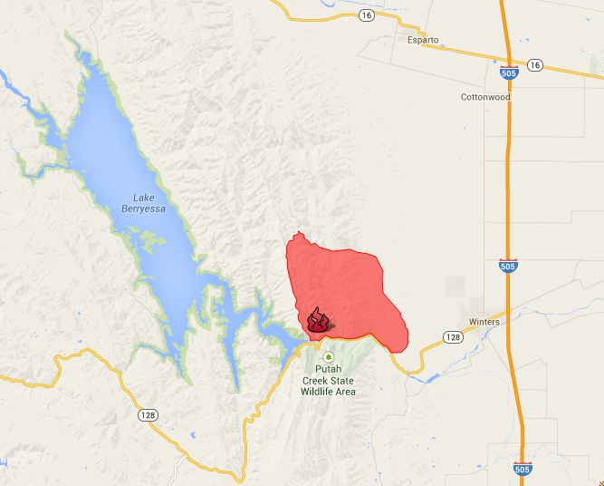
Update, 1 p.m. Friday: Cal Fire says it has achieved 95 percent containment on the 6,500-acre Monticello Fire, which broke out a week ago tonight near Highway 128, just southeast of Lake Berryessa. About 500 firefighters are still assigned to the fire, completing firelines and dousing hot spots within the blaze's perimeter.

The fire agency is asking the public for help in determining the cause of the fire, which at one point closed a stretch of Highway 128 and forced the evacuation of a subdivision west of the town of Winters.

From Sacramento's KFBK:

Cal Fire's Dennis Mathisen says [investigators are] looking at the area between the Canyon Creek Resort and Pleasant Valley Road near Highway 128.

"If anybody has any information or saw anything that evening of July 4, around 9:30 in the evening, we're asking them to call our arson tip line," Mathisen said.

Update, 11 a.m. Tuesday: In its morning update on the Monticello
Fire
, burning west of the Yolo County town of Winters and east of Lake Berryessa, Cal Fire says crews are making steady progress in containing the blaze.

As of 7 a.m., Cal Fire says, the blaze has consumed about 6,500 acres (the same figure released Monday morning) and that it's 55 percent contained (compared to 35 percent Monday). About 1,900 total personnel are fighting the fire.

Sponsored

Original post: Cal Fire is in the third full day of a battle to contain a fire burning through rugged country just east of Lake Berryessa. The agency reports it has about 1,600 firefighters on the lines against the Monticello Fire, which broke out about 9:30 Friday night and had charred 6,500 acres through early Monday. The fire is 35 percent contained.

The main challenges in the fire: the sometimes precipitous ridges near the lake, daytime temperatures approaching 100 and the threat of gusty afternoon winds. The fire is burning north of Highway 128, about 10 miles west of the Yolo County town of Winters. The blaze initially threatened a subdivision and a resort near Monticello Dam when it started Friday evening, but residents and campers have been allowed to return to the area.

As fire officials told the San Francisco Chronicle, the drought's impact on the mix of grass, brush and woodland played a big part in the fire's rapid spread.

... California's drought has created the type of dangerous conditions that "you usually don't see until August or September," said Cal Fire spokesman Kevin Lucero.

"Seeing it in July is very troublesome," he said.

Plus, Lucero said, thickets of manzanitas and other "fuels we're dealing with there are very dry from the drought." The brush was so thick it appeared that it hadn't burned off for at least 20 years, he said. There was little humidity Sunday, and the temperatures topped 100 degrees in some spots, fire officials said.

Northwest of Lake Berryessa, Cal Fire crews continued to make progress against the Butts Fire. That blaze, which has burned across 4,300 acres on the border of Napa and Lake counties, is 90 percent contained.

lower waypoint
next waypoint
State Prisons Offset New Inmate Wage Hikes by Cutting Hours for Some WorkersFresno's Chinatown Neighborhood To See Big Changes From High Speed RailErik Aadahl on the Power of Sound in FilmCecil Williams, Legendary Pastor of Glide Church, Dies at 94KQED Youth Takeover: How Can San Jose Schools Create Safer Campuses?How to Attend a Rally Safely in the Bay Area: Your Rights, Protections and the PoliceWill Less Homework Stress Make California Students Happier?Rainn Wilson from ‘The Office’ on Why We Need a Spiritual RevolutionNurses Warn Patient Safety at Risk as AI Use Spreads in Health CareSilicon Valley House Seat Race Gets a Recount