4 Holiday Hikes to Explore the San Francisco Presidio, From Stunning Views to Historic Trails
There’s more to this national park than meets the eye. Here are four great trails for discovering the Presidio in San Francisco, from historical walks to stunning views.
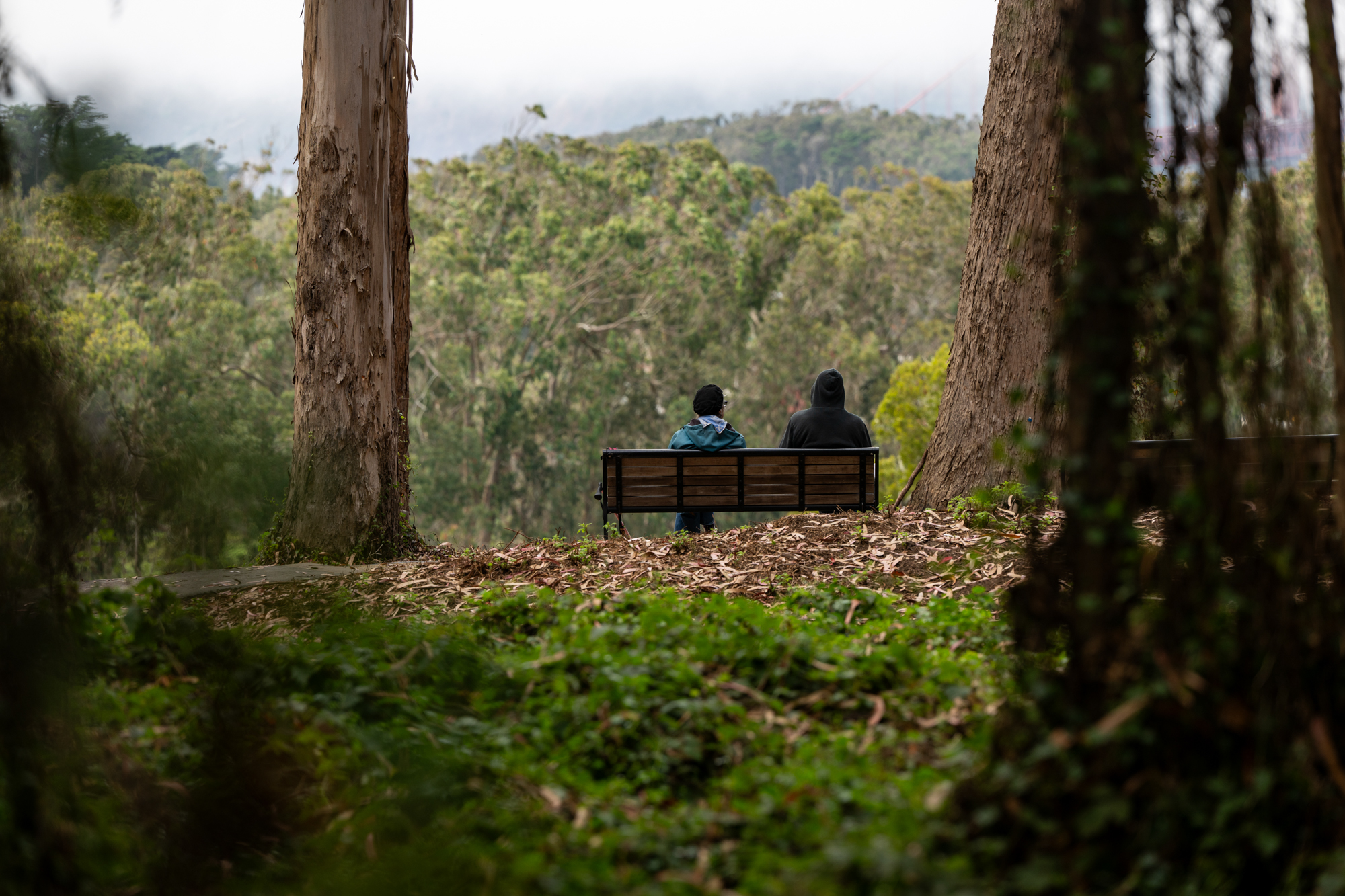
Two people sit at Cemetery Overlook in the Presidio of San Francisco on Sept. 4, 2025, which looks out over the National Cemetery and the San Francisco Bay. (Beth LaBerge/KQED)
If there’s one thing about San Francisco that’s unwaveringly impressive, it’s the city’s parks. Every resident has access to some kind of park within a 10-minute walk.
And the west side of the city is particularly blessed — between sprawling Golden Gate Park (it’s bigger than Manhattan’s Central Park) and the Presidio, there are more than 4,000 acres of parkland in the city’s boundaries.
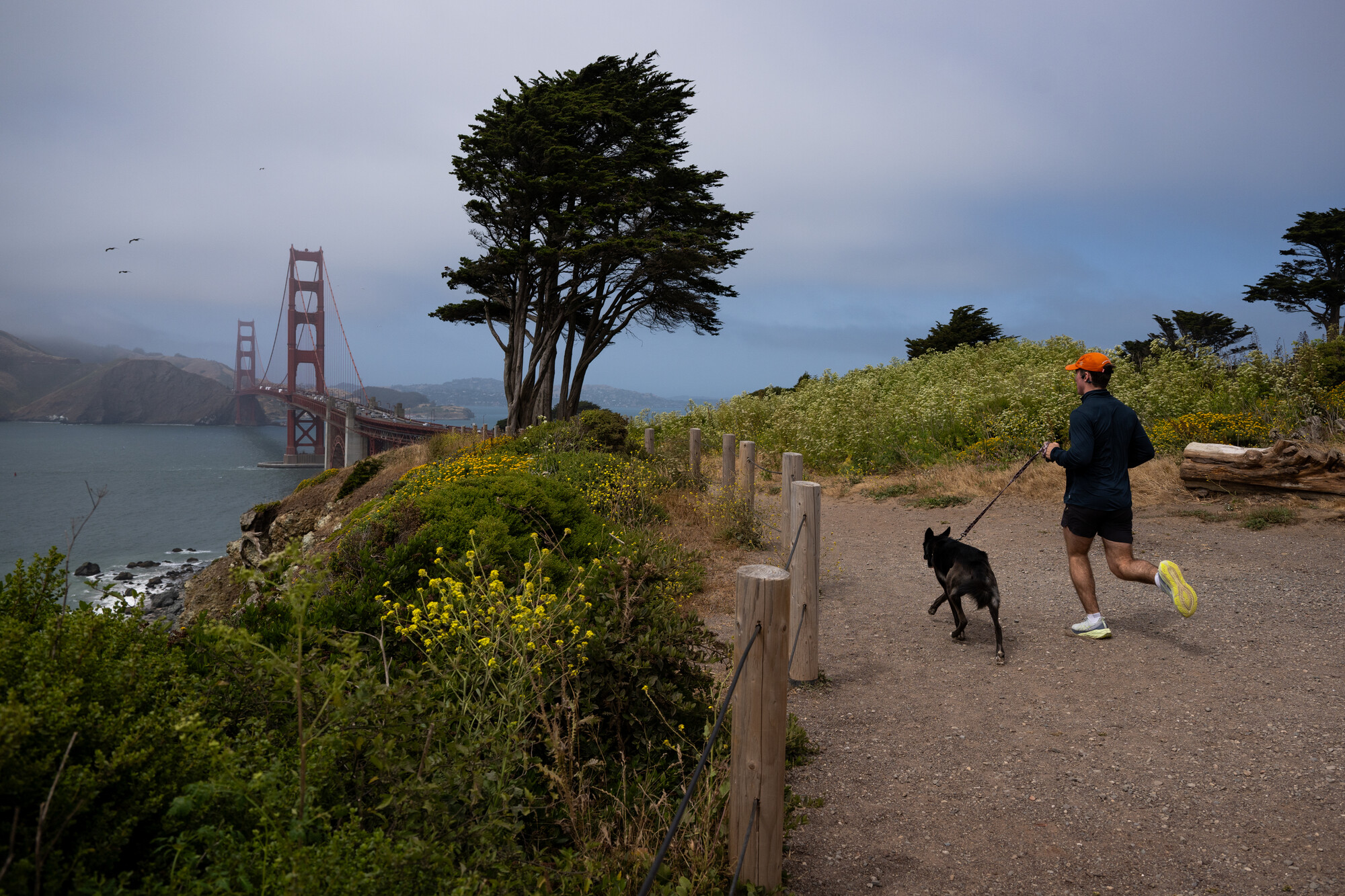
A jogger runs along part of the Batteries to Bluffs Trail in the Presidio of San Francisco on June 4, 2025. The coastal path offers views of the Golden Gate Bridge and Pacific Ocean, access to historic military sites and Marshall’s Beach. (Beth LaBerge/KQED)
While Golden Gate Park boasts ample museums and is perfect for a long stroll, if you’re really trying to immerse yourself in nature, consider taking your next hike this holiday weekend to the Presidio, where wildness can be found around every corner.
A former U.S. Army site turned national park, the Presidio can feel shockingly wild for how urban it is. Getting lost in its tangles of cypress, redwood and eucalyptus trees is easy to do.
You may even see its infamous coyotes, which inhabit the area and are often responsible for seasonal trail closures.
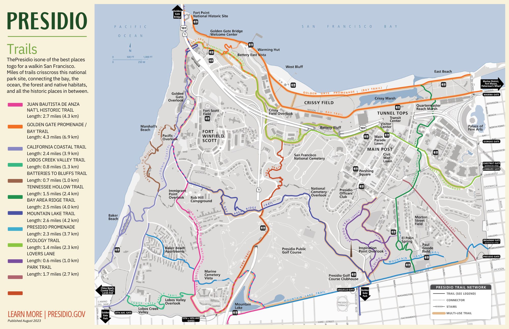
But head inland a bit and you’ll discover the park has far more than meets the eye, including a network of trails that take you through its most hidden, and some of its best, spots. Read on for four of the best hikes to discover the Presidio, from incredible views to off-the-beaten-path finds.
A word about safety: The Presidio is home to an active coyote population, so some sections of the park, like sections of the Park Trail and the Bay Area Ridge Trail, are closed to dogs in certain seasons to prevent dog-coyote conflicts. Remember to check for closures before heading out, keep your dog leashed and abide by all posted signs.
For a Presidio hike with a ‘wilderness’ feel: The Ecology Trail
One of the park’s shortest but most immersive trails is the Ecology Trail, which winds around a southeastern segment of the park and takes hikers through redwoods, native grasslands and even coastal wetland habitat.
The upper trail is pedestrian only, while the lower trail allows bikes. Stop at Inspiration Point Overlook for one of the best views in the park, overlooking Angel Island, the Palace of Fine Arts and Alcatraz.
Upper Ecology Trail, near Inspiration Point, in the Presidio of San Francisco on Sept. 4, 2025. (Beth LaBerge/KQED)
Along the way, don’t forget to detour to El Polín Spring, a natural spring that was foundational to the Indigenous people who lived in the area and the Spanish and U.S. armies who later occupied it.
Part of the Tennessee Hollow Watershed, the site of the spring was also home to Doña Juana Briones de Miranda, among the first settlers of then-Yerba Buena, who lived there with her family in the 1800s.
Presidio Trust spokesperson Lisa Petrie said when the park was first established, cleaning up and restoring native habitat to the spring and the surrounding ecosystem was a high priority.
“When the habitat was planted there, the area just started to thrive,” she said.
To get to the spring from the south, a zig-zagging trail winds downhill through scrubland to a boardwalk and the entrance of the spring, tucked away inside a sheltered oak-tree wildlife hub. Here, you’ll also find a “field station” housing materials for kids to learn about the spring.
Nearby signage, which details the importance of the water to native species and the people who lived nearby, encourages visitors to slow down and listen to the birds and the wind as it moves through the three main habitats of the area — wetland, coastal scrub and grassland.
“It just makes you feel like you’re in the wilderness,” Petrie said.
By the numbers: The Ecology Trail is 1.4 miles in total and takes about half an hour to complete, but adding on a detour to El Polín Spring will tack on another 15–20 minutes or so.
For a Presidio hike with history: The Park Trail
Bisecting the park north-south is the Park Trail, which winds adjacent to the San Francisco National Cemetery, up to the Presidio Golf Course, around Mountain Lake and terminating at the former U.S. Marine Hospital — which is now housing for Presidio residents.
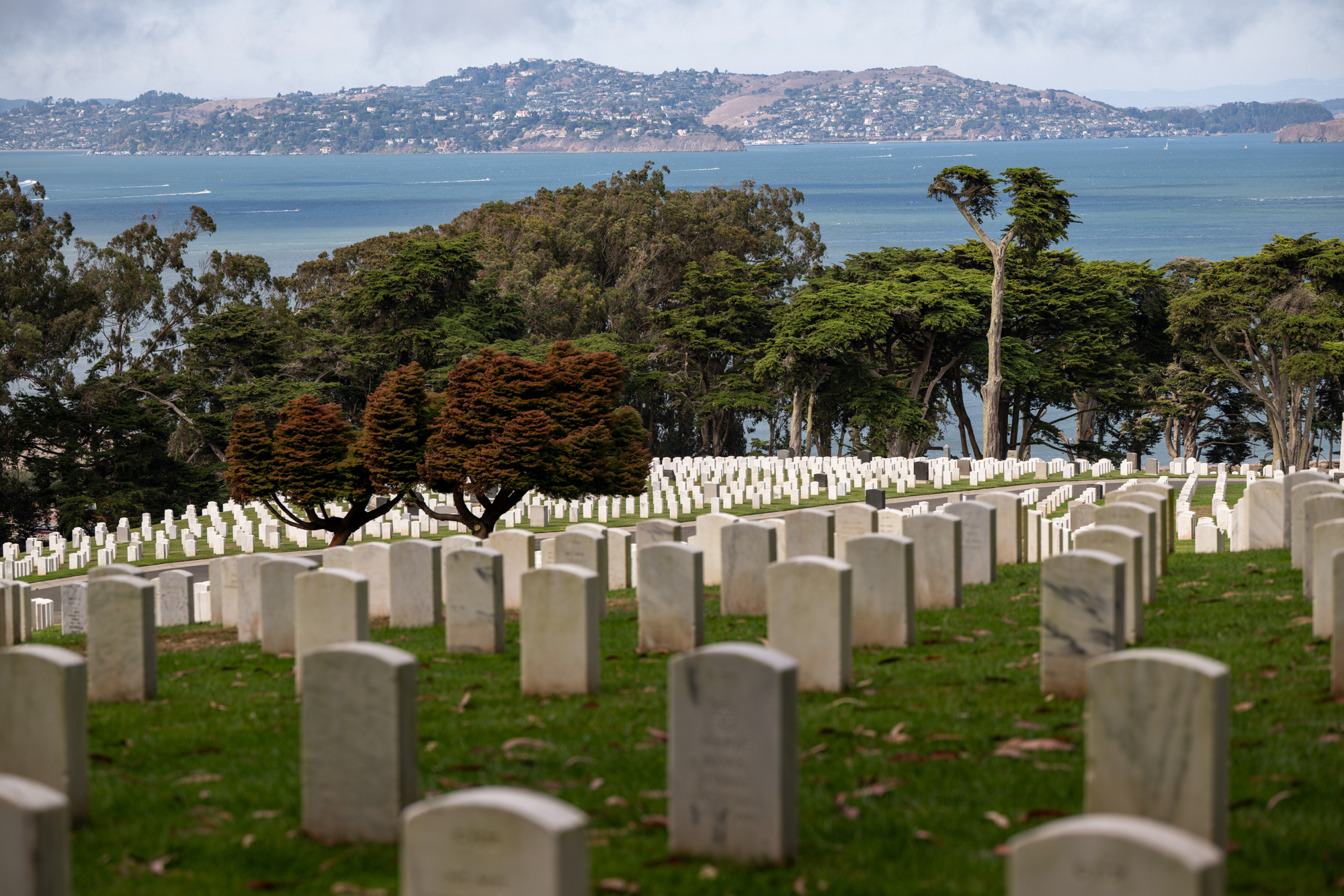
One major highlight of the trail is a quick detour to the National Cemetery Overlook, also accessible via the Bay Area Ridge Trail. The forest here is dense with green foliage and ivy crawling up eucalyptus trees. Above the cemetery is a place to sit and reflect or meander through a World War I monument adorned with excerpts from Archibald MacLeish’s poem The Young Dead Soldiers Do Not Speak.
Cemetery Overlook in the Presidio of San Francisco on Sept. 4, 2025, looks out over the National Cemetery and the San Francisco Bay. (Beth LaBerge/KQED)
Calvin Anderson, a San Francisco resident who was out walking to the overlook, said his son goes to school not too far away — so he often comes out to Inspiration Point and the Cemetery Overlook, both for the history and the views of the Golden Gate Bridge.
“I even have it tattooed on my arm,” he said of the bridge.
It’s not the only homage along this trail to those lost. At its northernmost end, you’ll find a pet cemetery. Then, as the Park Trail winds its way south, it passes near the Marine Cemetery Vista overlooking the park’s dune habitat, which honors merchant mariners who died at the nearby Marine Hospital, whose graves were rediscovered in 1989.
By the numbers: The Park Trail winds north to south for 1.7 miles in total. Add on detours to the National Cemetery Overlook and Marine Cemetery Vista, and it’ll come out closer to 2–2.5 miles for a little under an hour of walking.
For a Presidio hike with art: The Bay Area Ridge Trail
Near its southern start, the trail passes next to another Andy Goldsworthy sculpture called Spire. The artist built this artwork from 37 Monterey cypress trees that had to be removed during the park’s restoration, and it’s now surrounded by new trees planted at the time.
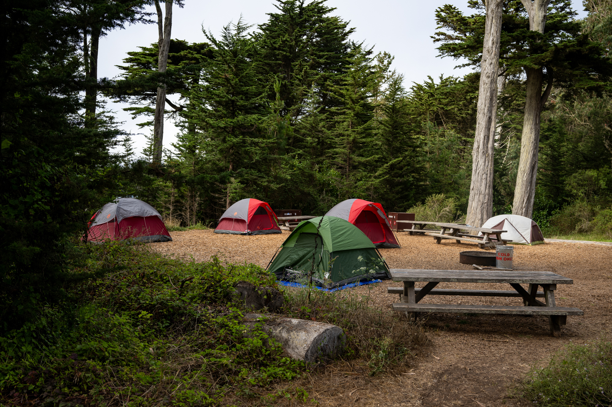
Tents are setup at Rob Hill Campground, above Immigrant Point Overlook, in the Presidio of San Francisco on Sept. 4, 2025. (Beth LaBerge/KQED)
As well as being an arresting sight, Spire is “almost acting like a measuring stick to see the natural progression of the new trees that were planted,” Petrie said. “It’s just a striking moment to be able to consider the various life cycles of trees.”
In addition to the National Cemetery Overlook, along the way you’ll skirt the Presidio Golf Course — as well as the Rob Hill Campground, the highest point in the Presidio, which until recently was the only campground within the city. During World War II, it was a lookout that then became a campground maintained by the Boy Scouts.
Today, it welcomes up to 30 people at each site during the summer months. Rob Hill Group Campground reservations get snapped up quickly on weekends, but tend to be easy to get on weekdays.
Behind the sites themselves is a dune restoration site and a forest with a fire circle. Petrie said if the weather is right, at nighttime while camping, you may even see stars and hear the evocative foghorn in the distance.
“You can also really hear the great horned owls up there,” she said.
By the numbers: The total length of this section of the Bay Area Ridge Trail is just 2.5 miles, and takes just under an hour to complete from one end to the other. If you’re planning to hike it point to point, it’s easily accessible by public transit on both ends via the 1 Muni bus from the south and the 28 from the north near the Golden Gate Bridge. Reservations at Rob Hill Campground cost $92 per night on weekdays and $240 on weekends.
For a Presidio hike with stunning views: Juan Bautista de Anza National Historic Trail
Luckily for you, its Presidio segment is just under three miles long, following the expedition’s route from Mountain Lake to the Golden Gate Bridge, with a whole lot of vistas along the way.
A view from Immigrant Point Overlook in the Presidio of San Francisco on Sept. 4, 2025. (Beth LaBerge/KQED)
In total, the park has eight scenic overlooks, which Petrie said were key to transforming the Presidio from a military base to a national park site.
The least assuming but most unique is the Lobos Valley Overlook, which gives a rare west-facing view of Sea Cliff and the Legion of Honor Museum beyond.
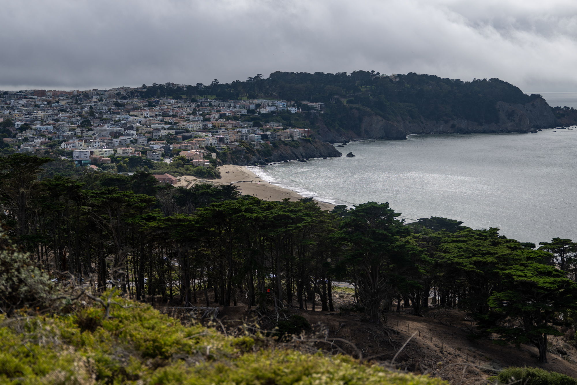
Then, Immigrant Point Overlook perches hikers above the Batteries-to-Bluffs trails, where the expanse of the Pacific Ocean beyond dominates the view, honoring immigrants to the United States who landed on these shores.
You’ll also encounter the dramatic Pacific Overlook and its hidden picnic tables, and the Golden Gate Overlook, which Petrie highlighted as one of the most “unusual, head-on” views of the bridge in the park.
While most of the trails in the park are up to two to three miles maximum, Petrie encouraged hikers to get creative to make a full day out of it.
“It’s amazing how you can do loops and put the trails together,” Petrie said.
By the numbers: At almost three miles, this section of trail takes around an hour to complete. Don’t forget to stop at Mountain Lake on your way out for a chance to spot birds and frogs at one of the city’s last natural lakes.
lower waypointnext waypoint
Player sponsored by
window.__IS_SSR__=true
window.__INITIAL_STATE__={
"attachmentsReducer": {
"audio_0": {
"type": "attachments",
"id": "audio_0",
"imgSizes": {
"kqedFullSize": {
"file": "https://ww2.kqed.org/news/wp-content/themes/KQED-unified/img/audio_bgs/background0.jpg"
}
}
},
"audio_1": {
"type": "attachments",
"id": "audio_1",
"imgSizes": {
"kqedFullSize": {
"file": "https://ww2.kqed.org/news/wp-content/themes/KQED-unified/img/audio_bgs/background1.jpg"
}
}
},
"audio_2": {
"type": "attachments",
"id": "audio_2",
"imgSizes": {
"kqedFullSize": {
"file": "https://ww2.kqed.org/news/wp-content/themes/KQED-unified/img/audio_bgs/background2.jpg"
}
}
},
"audio_3": {
"type": "attachments",
"id": "audio_3",
"imgSizes": {
"kqedFullSize": {
"file": "https://ww2.kqed.org/news/wp-content/themes/KQED-unified/img/audio_bgs/background3.jpg"
}
}
},
"audio_4": {
"type": "attachments",
"id": "audio_4",
"imgSizes": {
"kqedFullSize": {
"file": "https://ww2.kqed.org/news/wp-content/themes/KQED-unified/img/audio_bgs/background4.jpg"
}
}
},
"placeholder": {
"type": "attachments",
"id": "placeholder",
"imgSizes": {
"thumbnail": {
"file": "https://cdn.kqed.org/wp-content/uploads/2024/12/KQED-Default-Image-816638274-2000x1333-1-160x107.jpg",
"width": 160,
"height": 107,
"mimeType": "image/jpeg"
},
"medium": {
"file": "https://cdn.kqed.org/wp-content/uploads/2024/12/KQED-Default-Image-816638274-2000x1333-1-800x533.jpg",
"width": 800,
"height": 533,
"mimeType": "image/jpeg"
},
"medium_large": {
"file": "https://cdn.kqed.org/wp-content/uploads/2024/12/KQED-Default-Image-816638274-2000x1333-1-768x512.jpg",
"width": 768,
"height": 512,
"mimeType": "image/jpeg"
},
"large": {
"file": "https://cdn.kqed.org/wp-content/uploads/2024/12/KQED-Default-Image-816638274-2000x1333-1-1020x680.jpg",
"width": 1020,
"height": 680,
"mimeType": "image/jpeg"
},
"1536x1536": {
"file": "https://cdn.kqed.org/wp-content/uploads/2024/12/KQED-Default-Image-816638274-2000x1333-1-1536x1024.jpg",
"width": 1536,
"height": 1024,
"mimeType": "image/jpeg"
},
"fd-lrg": {
"file": "https://cdn.kqed.org/wp-content/uploads/2024/12/KQED-Default-Image-816638274-2000x1333-1-1536x1024.jpg",
"width": 1536,
"height": 1024,
"mimeType": "image/jpeg"
},
"fd-med": {
"file": "https://cdn.kqed.org/wp-content/uploads/2024/12/KQED-Default-Image-816638274-2000x1333-1-1020x680.jpg",
"width": 1020,
"height": 680,
"mimeType": "image/jpeg"
},
"fd-sm": {
"file": "https://cdn.kqed.org/wp-content/uploads/2024/12/KQED-Default-Image-816638274-2000x1333-1-800x533.jpg",
"width": 800,
"height": 533,
"mimeType": "image/jpeg"
},
"post-thumbnail": {
"file": "https://cdn.kqed.org/wp-content/uploads/2024/12/KQED-Default-Image-816638274-2000x1333-1-672x372.jpg",
"width": 672,
"height": 372,
"mimeType": "image/jpeg"
},
"twentyfourteen-full-width": {
"file": "https://cdn.kqed.org/wp-content/uploads/2024/12/KQED-Default-Image-816638274-2000x1333-1-1038x576.jpg",
"width": 1038,
"height": 576,
"mimeType": "image/jpeg"
},
"xxsmall": {
"file": "https://cdn.kqed.org/wp-content/uploads/2024/12/KQED-Default-Image-816638274-2000x1333-1-160x107.jpg",
"width": 160,
"height": 107,
"mimeType": "image/jpeg"
},
"xsmall": {
"file": "https://cdn.kqed.org/wp-content/uploads/2024/12/KQED-Default-Image-816638274-2000x1333-1-672x372.jpg",
"width": 672,
"height": 372,
"mimeType": "image/jpeg"
},
"small": {
"file": "https://cdn.kqed.org/wp-content/uploads/2024/12/KQED-Default-Image-816638274-2000x1333-1-672x372.jpg",
"width": 672,
"height": 372,
"mimeType": "image/jpeg"
},
"xlarge": {
"file": "https://cdn.kqed.org/wp-content/uploads/2024/12/KQED-Default-Image-816638274-2000x1333-1-1020x680.jpg",
"width": 1020,
"height": 680,
"mimeType": "image/jpeg"
},
"full-width": {
"file": "https://cdn.kqed.org/wp-content/uploads/2024/12/KQED-Default-Image-816638274-2000x1333-1-1920x1280.jpg",
"width": 1920,
"height": 1280,
"mimeType": "image/jpeg"
},
"guest-author-32": {
"file": "https://cdn.kqed.org/wp-content/uploads/2025/01/KQED-Default-Image-816638274-1333x1333-1-160x160.jpg",
"width": 32,
"height": 32,
"mimeType": "image/jpeg"
},
"guest-author-50": {
"file": "https://cdn.kqed.org/wp-content/uploads/2025/01/KQED-Default-Image-816638274-1333x1333-1-160x160.jpg",
"width": 50,
"height": 50,
"mimeType": "image/jpeg"
},
"guest-author-64": {
"file": "https://cdn.kqed.org/wp-content/uploads/2025/01/KQED-Default-Image-816638274-1333x1333-1-160x160.jpg",
"width": 64,
"height": 64,
"mimeType": "image/jpeg"
},
"guest-author-96": {
"file": "https://cdn.kqed.org/wp-content/uploads/2025/01/KQED-Default-Image-816638274-1333x1333-1-160x160.jpg",
"width": 96,
"height": 96,
"mimeType": "image/jpeg"
},
"guest-author-128": {
"file": "https://cdn.kqed.org/wp-content/uploads/2025/01/KQED-Default-Image-816638274-1333x1333-1-160x160.jpg",
"width": 128,
"height": 128,
"mimeType": "image/jpeg"
},
"detail": {
"file": "https://cdn.kqed.org/wp-content/uploads/2025/01/KQED-Default-Image-816638274-1333x1333-1-160x160.jpg",
"width": 160,
"height": 160,
"mimeType": "image/jpeg"
},
"kqedFullSize": {
"file": "https://cdn.kqed.org/wp-content/uploads/2024/12/KQED-Default-Image-816638274-2000x1333-1.jpg",
"width": 2000,
"height": 1333
}
}
},
"news_12055106": {
"type": "attachments",
"id": "news_12055106",
"meta": {
"index": "attachments_1716263798",
"site": "news",
"id": "12055106",
"found": true
},
"title": "250904-PRESIDIOHIKES-11-BL-KQED",
"publishDate": 1757351447,
"status": "inherit",
"parent": 12054079,
"modified": 1759962225,
"caption": "Two people sit at Cemetery Overlook in the Presidio of San Francisco on Sept. 4, 2025, which looks out over the National Cemetery and the San Francisco Bay.",
"credit": "Beth LaBerge/KQED",
"altTag": null,
"description": null,
"imgSizes": {
"thumbnail": {
"file": "https://cdn.kqed.org/wp-content/uploads/sites/10/2025/09/250904-PRESIDIOHIKES-11-BL-KQED-160x107.jpg",
"width": 160,
"height": 107,
"mimeType": "image/jpeg"
},
"1536x1536": {
"file": "https://cdn.kqed.org/wp-content/uploads/sites/10/2025/09/250904-PRESIDIOHIKES-11-BL-KQED-1536x1024.jpg",
"width": 1536,
"height": 1024,
"mimeType": "image/jpeg"
},
"post-thumbnail": {
"file": "https://cdn.kqed.org/wp-content/uploads/sites/10/2025/09/250904-PRESIDIOHIKES-11-BL-KQED-672x372.jpg",
"width": 672,
"height": 372,
"mimeType": "image/jpeg"
},
"twentyfourteen-full-width": {
"file": "https://cdn.kqed.org/wp-content/uploads/sites/10/2025/09/250904-PRESIDIOHIKES-11-BL-KQED-1038x576.jpg",
"width": 1038,
"height": 576,
"mimeType": "image/jpeg"
},
"kqedFullSize": {
"file": "https://cdn.kqed.org/wp-content/uploads/sites/10/2025/09/250904-PRESIDIOHIKES-11-BL-KQED.jpg",
"width": 2000,
"height": 1333
}
},
"isLoading": false,
"fetchFailed": false
}
},
"audioPlayerReducer": {
"postId": "stream_live",
"isPaused": true,
"isPlaying": false,
"pfsActive": false,
"pledgeModalIsOpen": true,
"playerDrawerIsOpen": false,
"liveAudioPlayStartedAt": 0,
"liveAudioPlayContext": ""
},
"authorsReducer": {
"sarahwright": {
"type": "authors",
"id": "11956",
"meta": {
"index": "authors_1716337520",
"id": "11956",
"found": true
},
"name": "Sarah Wright",
"firstName": "Sarah",
"lastName": "Wright",
"slug": "sarahwright",
"email": "swright@kqed.org",
"display_author_email": true,
"staff_mastheads": [],
"title": "Outdoors Engagement Reporter",
"bio": "Sarah Wright is KQED's Outdoors Engagement Reporter. Originally from Lake Tahoe, she completed a thru-hike of the Pacific Crest Trail in 2019 and was a U.S. Fulbright Program grantee to Argentina in 2023. Her journalism has appeared in The Guardian, The San Francisco Standard, The Palo Alto Weekly and the Half Moon Bay Review.",
"avatar": "https://secure.gravatar.com/avatar/c161a3d6441865cba25e6db4fa561099ad665799e9432e34da2b84d7e371524c?s=600&d=blank&r=g",
"twitter": null,
"bluesky": null,
"facebook": null,
"instagram": null,
"linkedin": null,
"sites": [
{
"site": "arts",
"roles": [
"editor"
]
},
{
"site": "news",
"roles": [
"editor"
]
},
{
"site": "science",
"roles": [
"contributor",
"author"
]
},
{
"site": "forum",
"roles": [
"editor"
]
}
],
"headData": {
"title": "Sarah Wright | KQED",
"description": "Outdoors Engagement Reporter",
"ogImgSrc": "https://secure.gravatar.com/avatar/c161a3d6441865cba25e6db4fa561099ad665799e9432e34da2b84d7e371524c?s=600&d=blank&r=g",
"twImgSrc": "https://secure.gravatar.com/avatar/c161a3d6441865cba25e6db4fa561099ad665799e9432e34da2b84d7e371524c?s=600&d=blank&r=g"
},
"isLoading": false,
"link": "/author/sarahwright"
}
},
"pagesReducer": {},
"pfsSessionReducer": {},
"postsReducer": {
"stream_live": {
"type": "live",
"id": "stream_live",
"audioUrl": "https://streams.kqed.org/kqedradio",
"title": "Live Stream",
"excerpt": "Live Stream information currently unavailable.",
"link": "/radio",
"featImg": "",
"label": {
"name": "KQED Live",
"link": "/"
}
},
"stream_kqedNewscast": {
"type": "posts",
"id": "stream_kqedNewscast",
"audioUrl": "https://www.kqed.org/.stream/anon/radio/RDnews/newscast.mp3?_=1",
"title": "KQED Newscast",
"featImg": "",
"label": {
"name": "88.5 FM",
"link": "/"
}
},
"news_12054079": {
"type": "posts",
"id": "news_12054079",
"meta": {
"index": "posts_1716263798",
"site": "news",
"id": "12054079",
"found": true
},
"articlePosition": 0,
"guestAuthors": [],
"slug": "best-hikes-san-francisco-presidio-views-trails-hiking",
"title": "4 Holiday Hikes to Explore the San Francisco Presidio, From Stunning Views to Historic Trails",
"publishDate": 1760035823,
"format": "standard",
"headTitle": "4 Holiday Hikes to Explore the San Francisco Presidio, From Stunning Views to Historic Trails | KQED",
"labelTerm": {
"site": "news"
},
"content": "\u003cp>If there’s one thing about San Francisco that’s unwaveringly impressive, it’s the city’s parks. Every resident has access to some kind of park \u003ca href=\"https://www.cbsnews.com/sanfrancisco/news/in-san-francisco-everyone-lives-within-a-10-minute-walk-of-a-park/\">within a 10-minute walk.\u003c/a>\u003c/p>\n\u003cp>And the west side of the city is particularly blessed — between sprawling Golden Gate Park (it’s bigger than Manhattan’s Central Park) and the Presidio, there are \u003ca href=\"https://sfrecpark.org/419/Who-We-Are\">more than 4,000 acres\u003c/a> of parkland in the city’s boundaries.\u003c/p>\n\u003cfigure id=\"attachment_12054109\" class=\"wp-caption alignnone\" style=\"max-width: 2000px\">\u003cimg loading=\"lazy\" decoding=\"async\" class=\"size-full wp-image-12054109\" src=\"https://cdn.kqed.org/wp-content/uploads/sites/10/2025/08/250604-HikingSFBluffs-03-BL_qed.jpg\" alt=\"\" width=\"2000\" height=\"1333\" srcset=\"https://cdn.kqed.org/wp-content/uploads/sites/10/2025/08/250604-HikingSFBluffs-03-BL_qed.jpg 2000w, https://cdn.kqed.org/wp-content/uploads/sites/10/2025/08/250604-HikingSFBluffs-03-BL_qed-160x107.jpg 160w, https://cdn.kqed.org/wp-content/uploads/sites/10/2025/08/250604-HikingSFBluffs-03-BL_qed-1536x1024.jpg 1536w\" sizes=\"auto, (max-width: 2000px) 100vw, 2000px\">\u003cfigcaption class=\"wp-caption-text\">A jogger runs along part of the Batteries to Bluffs Trail in the Presidio of San Francisco on June 4, 2025. The coastal path offers views of the Golden Gate Bridge and Pacific Ocean, access to historic military sites and Marshall’s Beach. \u003ccite>(Beth LaBerge/KQED)\u003c/cite>\u003c/figcaption>\u003c/figure>\n\u003cp>While Golden Gate Park boasts ample museums and is perfect for a long stroll, if you’re really trying to immerse yourself in nature, consider taking your next hike this holiday weekend to the Presidio, where wildness can be found around every corner.\u003c/p>\n\u003cp>[ad fullwidth]\u003c/p>\n\u003cp>A former U.S. Army site turned national park, the Presidio can feel shockingly wild for how urban it is. Getting lost in its tangles of \u003ca href=\"https://presidio.gov/about/sustainability/creating-a-sustainable-forest\">cypress, redwood and eucalyptus trees\u003c/a> is easy to do.\u003c/p>\n\u003cp>You may even see its \u003ca href=\"https://www.kqed.org/news/12046806/coyotes-are-in-pupping-season-in-the-bay-area-heres-how-to-keep-yourself-and-your-dog-safe\">infamous coyotes,\u003c/a> which inhabit the area and are often responsible for seasonal trail closures.\u003c/p>\n\u003cp>\u003cimg loading=\"lazy\" decoding=\"async\" class=\"aligncenter size-full wp-image-12054103\" src=\"https://cdn.kqed.org/wp-content/uploads/sites/10/2025/08/Trails-Map-Accessible.pdf.jpg\" alt=\"\" width=\"2000\" height=\"1294\" srcset=\"https://cdn.kqed.org/wp-content/uploads/sites/10/2025/08/Trails-Map-Accessible.pdf.jpg 2000w, https://cdn.kqed.org/wp-content/uploads/sites/10/2025/08/Trails-Map-Accessible.pdf-160x104.jpg 160w, https://cdn.kqed.org/wp-content/uploads/sites/10/2025/08/Trails-Map-Accessible.pdf-1536x994.jpg 1536w\" sizes=\"auto, (max-width: 2000px) 100vw, 2000px\">\u003c/p>\n\u003cp>The Presidio’s sheer size, however, can be initially daunting for many would-be explorers. Perhaps you’ve only visited \u003ca href=\"https://presidio.gov/explore/attractions/andy-goldsworthys-wood-line\">Andy Goldsworthy’s ever-decaying \u003cem>Wood Line\u003c/em>\u003c/a> while traveling on \u003ca href=\"https://presidio.gov/explore/attractions/lovers-lane-trail\">Lover’s Lane\u003c/a>, allegedly San Francisco’s oldest footpath. Or maybe you’ve taken on the popular \u003ca href=\"https://www.kqed.org/news/12042938/hiking-along-beautiful-bluffs-can-get-risky-heres-how-to-stay-safe\">Batteries to Bluffs\u003c/a> trail, or the stroll from Crissy Field along \u003ca href=\"https://presidio.gov/explore/attractions/golden-gate-promenade-bay-trail\">Golden Gate Promenade \u003c/a>to \u003ca href=\"https://presidio.gov/explore/attractions/fort-point-national-historic-site\">Fort Point\u003c/a> and the iconic bridge itself.\u003c/p>\n\u003cp>But head inland a bit and you’ll discover the park has far more than meets the eye, including a network of trails that take you through its most hidden, and some of its best, spots. Read on for four of the best hikes to discover the Presidio, from incredible views to off-the-beaten-path finds.\u003c/p>\n\u003cp>A word about safety: The Presidio is home to an active coyote population, so some sections of the park, like sections of the Park Trail and the Bay Area Ridge Trail, are closed to dogs in certain seasons to prevent dog-coyote conflicts. \u003ca href=\"https://presidio.gov/about/sustainability/coyotes-in-the-presidio\">Remember to check for closures\u003c/a> before heading out, keep your dog leashed and abide by all posted signs.\u003c/p>\n\u003ch2>For a Presidio hike with a ‘wilderness’ feel: The Ecology Trail\u003c/h2>\n\u003cp>One of the park’s shortest but most immersive trails is the \u003ca href=\"https://presidio.gov/explore/attractions/ecology-trail\">Ecology Trail\u003c/a>, which winds around a southeastern segment of the park and takes hikers through redwoods, native grasslands and even coastal wetland habitat.\u003c/p>\n\u003cp>The upper trail is pedestrian only, while the lower trail allows bikes. Stop at \u003ca href=\"https://presidio.gov/explore/attractions/inspiration-point-overlook\">Inspiration Point Overlook\u003c/a> for one of the best views in the park, overlooking Angel Island, the Palace of Fine Arts and Alcatraz.\u003c/p>\n\u003cfigure id=\"attachment_12055105\" class=\"wp-caption alignnone\" style=\"max-width: 2000px\">\u003cimg loading=\"lazy\" decoding=\"async\" class=\"size-full wp-image-12055105\" src=\"https://cdn.kqed.org/wp-content/uploads/sites/10/2025/09/250904-PRESIDIOHIKES-09-BL-KQED.jpg\" alt=\"\" width=\"2000\" height=\"1333\" srcset=\"https://cdn.kqed.org/wp-content/uploads/sites/10/2025/09/250904-PRESIDIOHIKES-09-BL-KQED.jpg 2000w, https://cdn.kqed.org/wp-content/uploads/sites/10/2025/09/250904-PRESIDIOHIKES-09-BL-KQED-160x107.jpg 160w, https://cdn.kqed.org/wp-content/uploads/sites/10/2025/09/250904-PRESIDIOHIKES-09-BL-KQED-1536x1024.jpg 1536w\" sizes=\"auto, (max-width: 2000px) 100vw, 2000px\">\u003cfigcaption class=\"wp-caption-text\">Upper Ecology Trail, near Inspiration Point, in the Presidio of San Francisco on Sept. 4, 2025. \u003ccite>(Beth LaBerge/KQED)\u003c/cite>\u003c/figcaption>\u003c/figure>\n\u003cp>Along the way, don’t forget to detour to \u003ca href=\"https://presidio.gov/explore/attractions/el-polin-spring\">El Polín Spring\u003c/a>, a natural spring that was foundational to the Indigenous people who lived in the area and the Spanish and U.S. armies who later occupied it.\u003c/p>\n\u003cp>Part of the Tennessee Hollow Watershed, the site of the spring was also home to \u003ca href=\"https://www.nps.gov/prsf/learn/historyculture/juana-briones.htm\">Doña Juana Briones de Miranda\u003c/a>, among the first settlers of then-Yerba Buena, who lived there with her family in the 1800s.\u003c/p>\n\u003cp>Presidio Trust spokesperson Lisa Petrie said when the park was first established, cleaning up and restoring native habitat to the spring and the surrounding ecosystem was a high priority.[aside postID=news_12052990 hero='https://cdn.kqed.org/wp-content/uploads/sites/10/2025/08/CampingGetty.jpg']Now, \u003ca href=\"https://presidio.gov/about/sustainability\">everything from great horned owls to frogs and even turtles\u003c/a> can be found there, and it’s also the site used to first reintroduce species that have been threatened back into the landscape.\u003c/p>\n\u003cp>“When the habitat was planted there, the area just started to thrive,” she said.\u003c/p>\n\u003cp>To get to the spring from the south, a zig-zagging trail winds downhill through scrubland to a boardwalk and the entrance of the spring, tucked away inside a sheltered oak-tree wildlife hub. Here, you’ll also find a “field station” housing materials for kids to learn about the spring.\u003c/p>\n\u003cp>Nearby signage, which details the importance of the water to native species and the people who lived nearby, encourages visitors to slow down and listen to the birds and the wind as it moves through the three main habitats of the area — wetland, coastal scrub and grassland.\u003c/p>\n\u003cp>“It just makes you feel like you’re in the wilderness,” Petrie said.\u003c/p>\n\u003cp>\u003cem>By the numbers: \u003c/em>The Ecology Trail is 1.4 miles in total and takes about half an hour to complete, but adding on a detour to El Polín Spring will tack on another 15–20 minutes or so.\u003c/p>\n\u003ch2>For a Presidio hike with history: The Park Trail\u003c/h2>\n\u003cp>Bisecting the park north-south is the \u003ca href=\"https://presidio.gov/explore/attractions/park-trail\">Park Trail\u003c/a>, which winds adjacent to the San Francisco National Cemetery, up to the Presidio Golf Course, around Mountain Lake and terminating at the former U.S. Marine Hospital — which is now housing for Presidio residents.\u003c/p>\n\u003cp>One major highlight of the trail is a quick detour to the \u003ca href=\"https://presidio.gov/explore/attractions/national-cemetery-overlook\">National Cemetery Overlook\u003c/a>, also accessible via the Bay Area Ridge Trail. The forest here is dense with green foliage and ivy crawling up eucalyptus trees. Above the cemetery is a place to sit and reflect or meander through a World War I monument adorned with excerpts from \u003ca href=\"https://www.nps.gov/wwim/learn/historyculture/young.htm\">Archibald MacLeish’s poem \u003cem>The Young Dead Soldiers Do Not Speak.\u003c/em>\u003c/a>\u003c/p>\n\u003cfigure id=\"attachment_12055107\" class=\"wp-caption alignnone\" style=\"max-width: 2000px\">\u003cimg loading=\"lazy\" decoding=\"async\" class=\"size-full wp-image-12055107\" src=\"https://cdn.kqed.org/wp-content/uploads/sites/10/2025/09/250904-PRESIDIOHIKES-13-BL-KQED.jpg\" alt=\"\" width=\"2000\" height=\"1333\" srcset=\"https://cdn.kqed.org/wp-content/uploads/sites/10/2025/09/250904-PRESIDIOHIKES-13-BL-KQED.jpg 2000w, https://cdn.kqed.org/wp-content/uploads/sites/10/2025/09/250904-PRESIDIOHIKES-13-BL-KQED-160x107.jpg 160w, https://cdn.kqed.org/wp-content/uploads/sites/10/2025/09/250904-PRESIDIOHIKES-13-BL-KQED-1536x1024.jpg 1536w\" sizes=\"auto, (max-width: 2000px) 100vw, 2000px\">\u003cfigcaption class=\"wp-caption-text\">Cemetery Overlook in the Presidio of San Francisco on Sept. 4, 2025, looks out over the National Cemetery and the San Francisco Bay. \u003ccite>(Beth LaBerge/KQED)\u003c/cite>\u003c/figcaption>\u003c/figure>\n\u003cp>Calvin Anderson, a San Francisco resident who was out walking to the overlook, said his son goes to school not too far away — so he often comes out to Inspiration Point and the Cemetery Overlook, both for the history and the views of the Golden Gate Bridge.\u003c/p>\n\u003cp>“I even have it tattooed on my arm,” he said of the bridge.\u003c/p>\n\u003cp>\u003c!-- iframe plugin v.4.3 wordpress.org/plugins/iframe/ -->\u003cbr>\n\u003ciframe loading=\"lazy\" src=\"https://www.google.com/maps/d/embed?mid=1WaXHWVkgLirukBHy8AuipWBKO60eYUY&ehbc=2E312F\" width=\"1920\" height=\"480\" scrolling=\"yes\" class=\"iframe-class\" frameborder=\"0\">\u003c/iframe>\u003c/p>\n\u003cp>It’s not the only homage along this trail to those lost. At its northernmost end, you’ll find a \u003ca href=\"https://presidio.gov/explore/attractions/presidio-pet-cemetery\">pet cemetery\u003c/a>. Then, as the Park Trail winds its way south, it passes near the \u003ca href=\"https://presidio.gov/explore/attractions/marine-cemetery-vista\">Marine Cemetery Vista\u003c/a> overlooking the park’s dune habitat, which honors merchant mariners who died at the nearby Marine Hospital, whose graves were rediscovered in 1989.\u003c/p>\n\u003cp>\u003cem>By the numbers: \u003c/em>The Park Trail winds north to south for 1.7 miles in total. Add on detours to the National Cemetery Overlook and Marine Cemetery Vista, and it’ll come out closer to 2–2.5 miles for a little under an hour of walking.\u003c/p>\n\u003ch2>For a Presidio hike with art: The Bay Area Ridge Trail\u003c/h2>\n\u003cp>The Bay Area Ridge Trail is a more than 500-mile network of trails that \u003ca href=\"https://ridgetrail.org/\">creates a ring around the entire Bay Area\u003c/a> — and\u003ca href=\"https://presidio.gov/explore/attractions/bay-area-ridge-trail\"> its Presidio segment \u003c/a>is a highlight.\u003c/p>\n\u003cp>Near its southern start, the trail passes next to \u003ca href=\"https://presidio.gov/explore/attractions/andy-goldsworthys-spire\">another Andy Goldsworthy sculpture called \u003cem>Spire\u003c/em>\u003c/a>\u003cem>. \u003c/em>The artist built this artwork from 37 Monterey cypress trees that had to be removed during the park’s restoration, and it’s now surrounded by new trees planted at the time.\u003c/p>\n\u003cfigure id=\"attachment_12055112\" class=\"wp-caption alignnone\" style=\"max-width: 2000px\">\u003cimg loading=\"lazy\" decoding=\"async\" class=\"size-full wp-image-12055112\" src=\"https://cdn.kqed.org/wp-content/uploads/sites/10/2025/09/250904-PRESIDIOHIKES-24-BL-KQED.jpg\" alt=\"\" width=\"2000\" height=\"1333\" srcset=\"https://cdn.kqed.org/wp-content/uploads/sites/10/2025/09/250904-PRESIDIOHIKES-24-BL-KQED.jpg 2000w, https://cdn.kqed.org/wp-content/uploads/sites/10/2025/09/250904-PRESIDIOHIKES-24-BL-KQED-160x107.jpg 160w, https://cdn.kqed.org/wp-content/uploads/sites/10/2025/09/250904-PRESIDIOHIKES-24-BL-KQED-1536x1024.jpg 1536w\" sizes=\"auto, (max-width: 2000px) 100vw, 2000px\">\u003cfigcaption class=\"wp-caption-text\">Tents are setup at Rob Hill Campground, above Immigrant Point Overlook, in the Presidio of San Francisco on Sept. 4, 2025. \u003ccite>(Beth LaBerge/KQED)\u003c/cite>\u003c/figcaption>\u003c/figure>\n\u003cp>As well as being an arresting sight, \u003cem>Spire \u003c/em>is “almost acting like a measuring stick to see the natural progression of the new trees that were planted,” Petrie said. “It’s just a striking moment to be able to consider the various life cycles of trees.”\u003c/p>\n\u003cp>In addition to the National Cemetery Overlook, along the way you’ll skirt the Presidio Golf Course — as well as the \u003ca href=\"https://presidio.gov/explore/attractions/rob-hill-campground\">Rob Hill Campground\u003c/a>, the highest point in the Presidio, which \u003ca href=\"https://rvparksf.com/\">until recently\u003c/a> was the only campground within the city. During World War II, it was a lookout that then became a campground maintained by the Boy Scouts.\u003c/p>\n\u003cp>Today, it welcomes up to 30 people at each site during the summer months. \u003ca href=\"https://www.recreation.gov/camping/campgrounds/10172170\">Rob Hill Group Campground reservations \u003c/a>get snapped up quickly on weekends, but tend to be easy to get on weekdays.\u003c/p>\n\u003cp>Behind the sites themselves is a dune restoration site and a forest with a fire circle. Petrie said if the weather is right, at nighttime while camping, you may even see stars and hear the evocative foghorn in the distance.\u003c/p>\n\u003cp>“You can also really hear the great horned owls up there,” she said.\u003c/p>\n\u003cp>\u003cem>By the numbers: \u003c/em>The total length of this section of the Bay Area Ridge Trail is just 2.5 miles, and takes just under an hour to complete from one end to the other. If you’re planning to hike it point to point, it’s easily accessible by public transit on both ends via the \u003ca href=\"https://www.sfmta.com/routes/1-california\">1 Muni bus\u003c/a> from the south and the \u003ca href=\"https://www.sfmta.com/routes/28-19th-avenue\">28 from the north near the Golden Gate Bridge.\u003c/a> Reservations at Rob Hill Campground cost $92 per night on weekdays and $240 on weekends.\u003c/p>\n\u003ch2>For a Presidio hike with stunning views: Juan Bautista de Anza National Historic Trail\u003c/h2>\n\u003cp>The 1,200-mile \u003ca href=\"https://presidio.gov/explore/attractions/juan-bautista-de-anza-national-historic-trail\">Juan Bautista de Anza Historic Trail \u003c/a>crosses three states and even an international border, \u003ca href=\"https://www.nps.gov/juba/planyourvisit/maps.htm\">following the colonizer’s route\u003c/a> from Sonora, Mexico, to San Francisco in 1776.\u003c/p>\n\u003cp>Luckily for you, its Presidio segment is just under three miles long, following the expedition’s route from Mountain Lake to the Golden Gate Bridge, with a whole lot of vistas along the way.\u003c/p>\n\u003cfigure id=\"attachment_12055110\" class=\"wp-caption alignnone\" style=\"max-width: 2000px\">\u003cimg loading=\"lazy\" decoding=\"async\" class=\"size-full wp-image-12055110\" src=\"https://cdn.kqed.org/wp-content/uploads/sites/10/2025/09/250904-PRESIDIOHIKES-21-BL-KQED.jpg\" alt=\"\" width=\"2000\" height=\"1333\" srcset=\"https://cdn.kqed.org/wp-content/uploads/sites/10/2025/09/250904-PRESIDIOHIKES-21-BL-KQED.jpg 2000w, https://cdn.kqed.org/wp-content/uploads/sites/10/2025/09/250904-PRESIDIOHIKES-21-BL-KQED-160x107.jpg 160w, https://cdn.kqed.org/wp-content/uploads/sites/10/2025/09/250904-PRESIDIOHIKES-21-BL-KQED-1536x1024.jpg 1536w\" sizes=\"auto, (max-width: 2000px) 100vw, 2000px\">\u003cfigcaption class=\"wp-caption-text\">A view from Immigrant Point Overlook in the Presidio of San Francisco on Sept. 4, 2025. \u003ccite>(Beth LaBerge/KQED)\u003c/cite>\u003c/figcaption>\u003c/figure>\n\u003cp>In total, the park has eight scenic overlooks, which Petrie said were key to transforming the Presidio from a military base to a national park site.\u003c/p>\n\u003cp>The least assuming but most unique is the \u003ca href=\"https://presidio.gov/explore/attractions/lobos-valley-overlook\">Lobos Valley Overlook\u003c/a>, which gives a rare west-facing view of Sea Cliff and the Legion of Honor Museum beyond.\u003c/p>\n\u003cp>Then, \u003ca href=\"https://presidio.gov/explore/attractions/immigrant-point-overlook\">Immigrant Point Overlook\u003c/a> perches hikers above the Batteries-to-Bluffs trails, where the expanse of the Pacific Ocean beyond dominates the view, honoring immigrants to the United States who landed on these shores.\u003c/p>\n\u003cp>You’ll also encounter the dramatic \u003ca href=\"https://presidio.gov/explore/attractions/pacific-overlook\">Pacific Overlook\u003c/a> and its hidden picnic tables, and the \u003ca href=\"https://presidio.gov/explore/attractions/golden-gate-overlook\">Golden Gate Overlook\u003c/a>, which Petrie highlighted as one of the most “unusual, head-on” views of the bridge in the park.\u003c/p>\n\u003cp>\u003c!-- iframe plugin v.4.3 wordpress.org/plugins/iframe/ -->\u003cbr>\n\u003ciframe loading=\"lazy\" src=\"https://www.google.com/maps/d/embed?mid=1cMScoOQYrt1ezTgUGz_2P_laW8aJMyg&ehbc=2E312F\" height=\"480\" width=\"100%\" scrolling=\"yes\" class=\"iframe-class\" frameborder=\"0\">\u003c/iframe>\u003c/p>\n\u003cp>While most of the trails in the park are up to two to three miles maximum, Petrie encouraged hikers to get creative to make a full day out of it.\u003c/p>\n\u003cp>“It’s amazing how you can do loops and put the trails together,” Petrie said.\u003c/p>\n\u003cp>\u003cem>By the numbers: \u003c/em>At almost three miles, this section of trail takes around an hour to complete. Don’t forget to stop at \u003ca href=\"https://presidio.gov/explore/attractions/mountain-lake\">Mountain Lake \u003c/a>on your way out for a chance to spot birds and frogs at one of the city’s last natural lakes.\u003c/p>\n\u003cp>https://docs.google.com/forms/d/e/1FAIpQLSeCeDp_MY_h4G6VWj_-VPl-BJlQ3Uya2H0vxRZZd_47BpXwVA/viewform?embedded=true\u003c/p>\n\u003cp>[ad floatright]\u003c/p>\n",
"blocks": [],
"excerpt": "There’s more to this national park than meets the eye. Here are four great trails for discovering the Presidio in San Francisco, from historical walks to stunning views.",
"status": "publish",
"parent": 0,
"modified": 1760040516,
"stats": {
"hasAudio": false,
"hasVideo": false,
"hasChartOrMap": true,
"iframeSrcs": [
"https://www.google.com/maps/d/embed"
],
"hasGoogleForm": true,
"hasGallery": false,
"hasHearkenModule": false,
"hasPolis": false,
"paragraphCount": 46,
"wordCount": 1930
},
"headData": {
"title": "4 Holiday Hikes to Explore the San Francisco Presidio, From Stunning Views to Historic Trails | KQED",
"description": "There’s more to this national park than meets the eye. Here are four great trails for discovering the Presidio in San Francisco, from historical walks to stunning views.",
"ogTitle": "",
"ogDescription": "",
"ogImgId": "",
"twTitle": "",
"twDescription": "",
"twImgId": "",
"schema": {
"@context": "https://schema.org",
"@type": "NewsArticle",
"headline": "4 Holiday Hikes to Explore the San Francisco Presidio, From Stunning Views to Historic Trails",
"datePublished": "2025-10-09T11:50:23-07:00",
"dateModified": "2025-10-09T13:08:36-07:00",
"image": "https://cdn.kqed.org/wp-content/uploads/2020/02/KQED-OG-Image@1x.png",
"isAccessibleForFree": "True",
"publisher": {
"@type": "NewsMediaOrganization",
"@id": "https://www.kqed.org/#organization",
"name": "KQED",
"logo": "https://cdn.kqed.org/wp-content/uploads/2020/02/KQED-OG-Image@1x.png",
"url": "https://www.kqed.org",
"sameAs": [
"https://www.facebook.com/KQED",
"https://twitter.com/KQED",
"https://www.instagram.com/kqed/",
"https://www.tiktok.com/@kqedofficial",
"https://www.linkedin.com/company/kqed",
"https://www.youtube.com/channel/UCeC0IOo7i1P_61zVUWbJ4nw"
]
},
"author": {
"@type": "Person",
"name": "Sarah Wright",
"jobTitle": "Outdoors Engagement Reporter",
"url": "https://www.kqed.org/author/sarahwright"
}
},
"authorsData": [],
"tagData": []
},
"primaryCategory": {
"termId": 34168,
"slug": "guides-and-explainers",
"name": "Guides and Explainers"
},
"sticky": false,
"nprStoryId": "kqed-12054079",
"templateType": "standard",
"featuredImageType": "standard",
"excludeFromSiteSearch": "Include",
"articleAge": "0",
"path": "/news/12054079/best-hikes-san-francisco-presidio-views-trails-hiking",
"audioTrackLength": null,
"parsedContent": [
{
"type": "contentString",
"content": "\u003cdiv class=\"post-body\">\u003cp>\u003cp>If there’s one thing about San Francisco that’s unwaveringly impressive, it’s the city’s parks. Every resident has access to some kind of park \u003ca href=\"https://www.cbsnews.com/sanfrancisco/news/in-san-francisco-everyone-lives-within-a-10-minute-walk-of-a-park/\">within a 10-minute walk.\u003c/a>\u003c/p>\n\u003cp>And the west side of the city is particularly blessed — between sprawling Golden Gate Park (it’s bigger than Manhattan’s Central Park) and the Presidio, there are \u003ca href=\"https://sfrecpark.org/419/Who-We-Are\">more than 4,000 acres\u003c/a> of parkland in the city’s boundaries.\u003c/p>\n\u003cfigure id=\"attachment_12054109\" class=\"wp-caption alignnone\" style=\"max-width: 2000px\">\u003cimg loading=\"lazy\" decoding=\"async\" class=\"size-full wp-image-12054109\" src=\"https://cdn.kqed.org/wp-content/uploads/sites/10/2025/08/250604-HikingSFBluffs-03-BL_qed.jpg\" alt=\"\" width=\"2000\" height=\"1333\" srcset=\"https://cdn.kqed.org/wp-content/uploads/sites/10/2025/08/250604-HikingSFBluffs-03-BL_qed.jpg 2000w, https://cdn.kqed.org/wp-content/uploads/sites/10/2025/08/250604-HikingSFBluffs-03-BL_qed-160x107.jpg 160w, https://cdn.kqed.org/wp-content/uploads/sites/10/2025/08/250604-HikingSFBluffs-03-BL_qed-1536x1024.jpg 1536w\" sizes=\"auto, (max-width: 2000px) 100vw, 2000px\">\u003cfigcaption class=\"wp-caption-text\">A jogger runs along part of the Batteries to Bluffs Trail in the Presidio of San Francisco on June 4, 2025. The coastal path offers views of the Golden Gate Bridge and Pacific Ocean, access to historic military sites and Marshall’s Beach. \u003ccite>(Beth LaBerge/KQED)\u003c/cite>\u003c/figcaption>\u003c/figure>\n\u003cp>While Golden Gate Park boasts ample museums and is perfect for a long stroll, if you’re really trying to immerse yourself in nature, consider taking your next hike this holiday weekend to the Presidio, where wildness can be found around every corner.\u003c/p>\n\u003cp>\u003c/p>\u003c/div>",
"attributes": {
"named": {},
"numeric": []
}
},
{
"type": "component",
"content": "",
"name": "ad",
"attributes": {
"named": {
"label": "fullwidth"
},
"numeric": [
"fullwidth"
]
}
},
{
"type": "contentString",
"content": "\u003cdiv class=\"post-body\">\u003cp>\u003c/p>\n\u003cp>A former U.S. Army site turned national park, the Presidio can feel shockingly wild for how urban it is. Getting lost in its tangles of \u003ca href=\"https://presidio.gov/about/sustainability/creating-a-sustainable-forest\">cypress, redwood and eucalyptus trees\u003c/a> is easy to do.\u003c/p>\n\u003cp>You may even see its \u003ca href=\"https://www.kqed.org/news/12046806/coyotes-are-in-pupping-season-in-the-bay-area-heres-how-to-keep-yourself-and-your-dog-safe\">infamous coyotes,\u003c/a> which inhabit the area and are often responsible for seasonal trail closures.\u003c/p>\n\u003cp>\u003cimg loading=\"lazy\" decoding=\"async\" class=\"aligncenter size-full wp-image-12054103\" src=\"https://cdn.kqed.org/wp-content/uploads/sites/10/2025/08/Trails-Map-Accessible.pdf.jpg\" alt=\"\" width=\"2000\" height=\"1294\" srcset=\"https://cdn.kqed.org/wp-content/uploads/sites/10/2025/08/Trails-Map-Accessible.pdf.jpg 2000w, https://cdn.kqed.org/wp-content/uploads/sites/10/2025/08/Trails-Map-Accessible.pdf-160x104.jpg 160w, https://cdn.kqed.org/wp-content/uploads/sites/10/2025/08/Trails-Map-Accessible.pdf-1536x994.jpg 1536w\" sizes=\"auto, (max-width: 2000px) 100vw, 2000px\">\u003c/p>\n\u003cp>The Presidio’s sheer size, however, can be initially daunting for many would-be explorers. Perhaps you’ve only visited \u003ca href=\"https://presidio.gov/explore/attractions/andy-goldsworthys-wood-line\">Andy Goldsworthy’s ever-decaying \u003cem>Wood Line\u003c/em>\u003c/a> while traveling on \u003ca href=\"https://presidio.gov/explore/attractions/lovers-lane-trail\">Lover’s Lane\u003c/a>, allegedly San Francisco’s oldest footpath. Or maybe you’ve taken on the popular \u003ca href=\"https://www.kqed.org/news/12042938/hiking-along-beautiful-bluffs-can-get-risky-heres-how-to-stay-safe\">Batteries to Bluffs\u003c/a> trail, or the stroll from Crissy Field along \u003ca href=\"https://presidio.gov/explore/attractions/golden-gate-promenade-bay-trail\">Golden Gate Promenade \u003c/a>to \u003ca href=\"https://presidio.gov/explore/attractions/fort-point-national-historic-site\">Fort Point\u003c/a> and the iconic bridge itself.\u003c/p>\n\u003cp>But head inland a bit and you’ll discover the park has far more than meets the eye, including a network of trails that take you through its most hidden, and some of its best, spots. Read on for four of the best hikes to discover the Presidio, from incredible views to off-the-beaten-path finds.\u003c/p>\n\u003cp>A word about safety: The Presidio is home to an active coyote population, so some sections of the park, like sections of the Park Trail and the Bay Area Ridge Trail, are closed to dogs in certain seasons to prevent dog-coyote conflicts. \u003ca href=\"https://presidio.gov/about/sustainability/coyotes-in-the-presidio\">Remember to check for closures\u003c/a> before heading out, keep your dog leashed and abide by all posted signs.\u003c/p>\n\u003ch2>For a Presidio hike with a ‘wilderness’ feel: The Ecology Trail\u003c/h2>\n\u003cp>One of the park’s shortest but most immersive trails is the \u003ca href=\"https://presidio.gov/explore/attractions/ecology-trail\">Ecology Trail\u003c/a>, which winds around a southeastern segment of the park and takes hikers through redwoods, native grasslands and even coastal wetland habitat.\u003c/p>\n\u003cp>The upper trail is pedestrian only, while the lower trail allows bikes. Stop at \u003ca href=\"https://presidio.gov/explore/attractions/inspiration-point-overlook\">Inspiration Point Overlook\u003c/a> for one of the best views in the park, overlooking Angel Island, the Palace of Fine Arts and Alcatraz.\u003c/p>\n\u003cfigure id=\"attachment_12055105\" class=\"wp-caption alignnone\" style=\"max-width: 2000px\">\u003cimg loading=\"lazy\" decoding=\"async\" class=\"size-full wp-image-12055105\" src=\"https://cdn.kqed.org/wp-content/uploads/sites/10/2025/09/250904-PRESIDIOHIKES-09-BL-KQED.jpg\" alt=\"\" width=\"2000\" height=\"1333\" srcset=\"https://cdn.kqed.org/wp-content/uploads/sites/10/2025/09/250904-PRESIDIOHIKES-09-BL-KQED.jpg 2000w, https://cdn.kqed.org/wp-content/uploads/sites/10/2025/09/250904-PRESIDIOHIKES-09-BL-KQED-160x107.jpg 160w, https://cdn.kqed.org/wp-content/uploads/sites/10/2025/09/250904-PRESIDIOHIKES-09-BL-KQED-1536x1024.jpg 1536w\" sizes=\"auto, (max-width: 2000px) 100vw, 2000px\">\u003cfigcaption class=\"wp-caption-text\">Upper Ecology Trail, near Inspiration Point, in the Presidio of San Francisco on Sept. 4, 2025. \u003ccite>(Beth LaBerge/KQED)\u003c/cite>\u003c/figcaption>\u003c/figure>\n\u003cp>Along the way, don’t forget to detour to \u003ca href=\"https://presidio.gov/explore/attractions/el-polin-spring\">El Polín Spring\u003c/a>, a natural spring that was foundational to the Indigenous people who lived in the area and the Spanish and U.S. armies who later occupied it.\u003c/p>\n\u003cp>Part of the Tennessee Hollow Watershed, the site of the spring was also home to \u003ca href=\"https://www.nps.gov/prsf/learn/historyculture/juana-briones.htm\">Doña Juana Briones de Miranda\u003c/a>, among the first settlers of then-Yerba Buena, who lived there with her family in the 1800s.\u003c/p>\n\u003cp>Presidio Trust spokesperson Lisa Petrie said when the park was first established, cleaning up and restoring native habitat to the spring and the surrounding ecosystem was a high priority.\u003c/p>\u003c/div>",
"attributes": {
"named": {},
"numeric": []
}
},
{
"type": "component",
"content": "",
"name": "aside",
"attributes": {
"named": {
"postid": "news_12052990",
"hero": "https://cdn.kqed.org/wp-content/uploads/sites/10/2025/08/CampingGetty.jpg",
"label": ""
},
"numeric": []
}
},
{
"type": "contentString",
"content": "\u003cdiv class=\"post-body\">\u003cp>Now, \u003ca href=\"https://presidio.gov/about/sustainability\">everything from great horned owls to frogs and even turtles\u003c/a> can be found there, and it’s also the site used to first reintroduce species that have been threatened back into the landscape.\u003c/p>\n\u003cp>“When the habitat was planted there, the area just started to thrive,” she said.\u003c/p>\n\u003cp>To get to the spring from the south, a zig-zagging trail winds downhill through scrubland to a boardwalk and the entrance of the spring, tucked away inside a sheltered oak-tree wildlife hub. Here, you’ll also find a “field station” housing materials for kids to learn about the spring.\u003c/p>\n\u003cp>Nearby signage, which details the importance of the water to native species and the people who lived nearby, encourages visitors to slow down and listen to the birds and the wind as it moves through the three main habitats of the area — wetland, coastal scrub and grassland.\u003c/p>\n\u003cp>“It just makes you feel like you’re in the wilderness,” Petrie said.\u003c/p>\n\u003cp>\u003cem>By the numbers: \u003c/em>The Ecology Trail is 1.4 miles in total and takes about half an hour to complete, but adding on a detour to El Polín Spring will tack on another 15–20 minutes or so.\u003c/p>\n\u003ch2>For a Presidio hike with history: The Park Trail\u003c/h2>\n\u003cp>Bisecting the park north-south is the \u003ca href=\"https://presidio.gov/explore/attractions/park-trail\">Park Trail\u003c/a>, which winds adjacent to the San Francisco National Cemetery, up to the Presidio Golf Course, around Mountain Lake and terminating at the former U.S. Marine Hospital — which is now housing for Presidio residents.\u003c/p>\n\u003cp>One major highlight of the trail is a quick detour to the \u003ca href=\"https://presidio.gov/explore/attractions/national-cemetery-overlook\">National Cemetery Overlook\u003c/a>, also accessible via the Bay Area Ridge Trail. The forest here is dense with green foliage and ivy crawling up eucalyptus trees. Above the cemetery is a place to sit and reflect or meander through a World War I monument adorned with excerpts from \u003ca href=\"https://www.nps.gov/wwim/learn/historyculture/young.htm\">Archibald MacLeish’s poem \u003cem>The Young Dead Soldiers Do Not Speak.\u003c/em>\u003c/a>\u003c/p>\n\u003cfigure id=\"attachment_12055107\" class=\"wp-caption alignnone\" style=\"max-width: 2000px\">\u003cimg loading=\"lazy\" decoding=\"async\" class=\"size-full wp-image-12055107\" src=\"https://cdn.kqed.org/wp-content/uploads/sites/10/2025/09/250904-PRESIDIOHIKES-13-BL-KQED.jpg\" alt=\"\" width=\"2000\" height=\"1333\" srcset=\"https://cdn.kqed.org/wp-content/uploads/sites/10/2025/09/250904-PRESIDIOHIKES-13-BL-KQED.jpg 2000w, https://cdn.kqed.org/wp-content/uploads/sites/10/2025/09/250904-PRESIDIOHIKES-13-BL-KQED-160x107.jpg 160w, https://cdn.kqed.org/wp-content/uploads/sites/10/2025/09/250904-PRESIDIOHIKES-13-BL-KQED-1536x1024.jpg 1536w\" sizes=\"auto, (max-width: 2000px) 100vw, 2000px\">\u003cfigcaption class=\"wp-caption-text\">Cemetery Overlook in the Presidio of San Francisco on Sept. 4, 2025, looks out over the National Cemetery and the San Francisco Bay. \u003ccite>(Beth LaBerge/KQED)\u003c/cite>\u003c/figcaption>\u003c/figure>\n\u003cp>Calvin Anderson, a San Francisco resident who was out walking to the overlook, said his son goes to school not too far away — so he often comes out to Inspiration Point and the Cemetery Overlook, both for the history and the views of the Golden Gate Bridge.\u003c/p>\n\u003cp>“I even have it tattooed on my arm,” he said of the bridge.\u003c/p>\n\u003cp>\u003c!-- iframe plugin v.4.3 wordpress.org/plugins/iframe/ -->\u003cbr>\n\u003ciframe loading=\"lazy\" src=\"https://www.google.com/maps/d/embed?mid=1WaXHWVkgLirukBHy8AuipWBKO60eYUY&ehbc=2E312F\" width=\"1920\" height=\"480\" scrolling=\"yes\" class=\"iframe-class\" frameborder=\"0\">\u003c/iframe>\u003c/p>\n\u003cp>It’s not the only homage along this trail to those lost. At its northernmost end, you’ll find a \u003ca href=\"https://presidio.gov/explore/attractions/presidio-pet-cemetery\">pet cemetery\u003c/a>. Then, as the Park Trail winds its way south, it passes near the \u003ca href=\"https://presidio.gov/explore/attractions/marine-cemetery-vista\">Marine Cemetery Vista\u003c/a> overlooking the park’s dune habitat, which honors merchant mariners who died at the nearby Marine Hospital, whose graves were rediscovered in 1989.\u003c/p>\n\u003cp>\u003cem>By the numbers: \u003c/em>The Park Trail winds north to south for 1.7 miles in total. Add on detours to the National Cemetery Overlook and Marine Cemetery Vista, and it’ll come out closer to 2–2.5 miles for a little under an hour of walking.\u003c/p>\n\u003ch2>For a Presidio hike with art: The Bay Area Ridge Trail\u003c/h2>\n\u003cp>The Bay Area Ridge Trail is a more than 500-mile network of trails that \u003ca href=\"https://ridgetrail.org/\">creates a ring around the entire Bay Area\u003c/a> — and\u003ca href=\"https://presidio.gov/explore/attractions/bay-area-ridge-trail\"> its Presidio segment \u003c/a>is a highlight.\u003c/p>\n\u003cp>Near its southern start, the trail passes next to \u003ca href=\"https://presidio.gov/explore/attractions/andy-goldsworthys-spire\">another Andy Goldsworthy sculpture called \u003cem>Spire\u003c/em>\u003c/a>\u003cem>. \u003c/em>The artist built this artwork from 37 Monterey cypress trees that had to be removed during the park’s restoration, and it’s now surrounded by new trees planted at the time.\u003c/p>\n\u003cfigure id=\"attachment_12055112\" class=\"wp-caption alignnone\" style=\"max-width: 2000px\">\u003cimg loading=\"lazy\" decoding=\"async\" class=\"size-full wp-image-12055112\" src=\"https://cdn.kqed.org/wp-content/uploads/sites/10/2025/09/250904-PRESIDIOHIKES-24-BL-KQED.jpg\" alt=\"\" width=\"2000\" height=\"1333\" srcset=\"https://cdn.kqed.org/wp-content/uploads/sites/10/2025/09/250904-PRESIDIOHIKES-24-BL-KQED.jpg 2000w, https://cdn.kqed.org/wp-content/uploads/sites/10/2025/09/250904-PRESIDIOHIKES-24-BL-KQED-160x107.jpg 160w, https://cdn.kqed.org/wp-content/uploads/sites/10/2025/09/250904-PRESIDIOHIKES-24-BL-KQED-1536x1024.jpg 1536w\" sizes=\"auto, (max-width: 2000px) 100vw, 2000px\">\u003cfigcaption class=\"wp-caption-text\">Tents are setup at Rob Hill Campground, above Immigrant Point Overlook, in the Presidio of San Francisco on Sept. 4, 2025. \u003ccite>(Beth LaBerge/KQED)\u003c/cite>\u003c/figcaption>\u003c/figure>\n\u003cp>As well as being an arresting sight, \u003cem>Spire \u003c/em>is “almost acting like a measuring stick to see the natural progression of the new trees that were planted,” Petrie said. “It’s just a striking moment to be able to consider the various life cycles of trees.”\u003c/p>\n\u003cp>In addition to the National Cemetery Overlook, along the way you’ll skirt the Presidio Golf Course — as well as the \u003ca href=\"https://presidio.gov/explore/attractions/rob-hill-campground\">Rob Hill Campground\u003c/a>, the highest point in the Presidio, which \u003ca href=\"https://rvparksf.com/\">until recently\u003c/a> was the only campground within the city. During World War II, it was a lookout that then became a campground maintained by the Boy Scouts.\u003c/p>\n\u003cp>Today, it welcomes up to 30 people at each site during the summer months. \u003ca href=\"https://www.recreation.gov/camping/campgrounds/10172170\">Rob Hill Group Campground reservations \u003c/a>get snapped up quickly on weekends, but tend to be easy to get on weekdays.\u003c/p>\n\u003cp>Behind the sites themselves is a dune restoration site and a forest with a fire circle. Petrie said if the weather is right, at nighttime while camping, you may even see stars and hear the evocative foghorn in the distance.\u003c/p>\n\u003cp>“You can also really hear the great horned owls up there,” she said.\u003c/p>\n\u003cp>\u003cem>By the numbers: \u003c/em>The total length of this section of the Bay Area Ridge Trail is just 2.5 miles, and takes just under an hour to complete from one end to the other. If you’re planning to hike it point to point, it’s easily accessible by public transit on both ends via the \u003ca href=\"https://www.sfmta.com/routes/1-california\">1 Muni bus\u003c/a> from the south and the \u003ca href=\"https://www.sfmta.com/routes/28-19th-avenue\">28 from the north near the Golden Gate Bridge.\u003c/a> Reservations at Rob Hill Campground cost $92 per night on weekdays and $240 on weekends.\u003c/p>\n\u003ch2>For a Presidio hike with stunning views: Juan Bautista de Anza National Historic Trail\u003c/h2>\n\u003cp>The 1,200-mile \u003ca href=\"https://presidio.gov/explore/attractions/juan-bautista-de-anza-national-historic-trail\">Juan Bautista de Anza Historic Trail \u003c/a>crosses three states and even an international border, \u003ca href=\"https://www.nps.gov/juba/planyourvisit/maps.htm\">following the colonizer’s route\u003c/a> from Sonora, Mexico, to San Francisco in 1776.\u003c/p>\n\u003cp>Luckily for you, its Presidio segment is just under three miles long, following the expedition’s route from Mountain Lake to the Golden Gate Bridge, with a whole lot of vistas along the way.\u003c/p>\n\u003cfigure id=\"attachment_12055110\" class=\"wp-caption alignnone\" style=\"max-width: 2000px\">\u003cimg loading=\"lazy\" decoding=\"async\" class=\"size-full wp-image-12055110\" src=\"https://cdn.kqed.org/wp-content/uploads/sites/10/2025/09/250904-PRESIDIOHIKES-21-BL-KQED.jpg\" alt=\"\" width=\"2000\" height=\"1333\" srcset=\"https://cdn.kqed.org/wp-content/uploads/sites/10/2025/09/250904-PRESIDIOHIKES-21-BL-KQED.jpg 2000w, https://cdn.kqed.org/wp-content/uploads/sites/10/2025/09/250904-PRESIDIOHIKES-21-BL-KQED-160x107.jpg 160w, https://cdn.kqed.org/wp-content/uploads/sites/10/2025/09/250904-PRESIDIOHIKES-21-BL-KQED-1536x1024.jpg 1536w\" sizes=\"auto, (max-width: 2000px) 100vw, 2000px\">\u003cfigcaption class=\"wp-caption-text\">A view from Immigrant Point Overlook in the Presidio of San Francisco on Sept. 4, 2025. \u003ccite>(Beth LaBerge/KQED)\u003c/cite>\u003c/figcaption>\u003c/figure>\n\u003cp>In total, the park has eight scenic overlooks, which Petrie said were key to transforming the Presidio from a military base to a national park site.\u003c/p>\n\u003cp>The least assuming but most unique is the \u003ca href=\"https://presidio.gov/explore/attractions/lobos-valley-overlook\">Lobos Valley Overlook\u003c/a>, which gives a rare west-facing view of Sea Cliff and the Legion of Honor Museum beyond.\u003c/p>\n\u003cp>Then, \u003ca href=\"https://presidio.gov/explore/attractions/immigrant-point-overlook\">Immigrant Point Overlook\u003c/a> perches hikers above the Batteries-to-Bluffs trails, where the expanse of the Pacific Ocean beyond dominates the view, honoring immigrants to the United States who landed on these shores.\u003c/p>\n\u003cp>You’ll also encounter the dramatic \u003ca href=\"https://presidio.gov/explore/attractions/pacific-overlook\">Pacific Overlook\u003c/a> and its hidden picnic tables, and the \u003ca href=\"https://presidio.gov/explore/attractions/golden-gate-overlook\">Golden Gate Overlook\u003c/a>, which Petrie highlighted as one of the most “unusual, head-on” views of the bridge in the park.\u003c/p>\n\u003cp>\u003c!-- iframe plugin v.4.3 wordpress.org/plugins/iframe/ -->\u003cbr>\n\u003ciframe loading=\"lazy\" src=\"https://www.google.com/maps/d/embed?mid=1cMScoOQYrt1ezTgUGz_2P_laW8aJMyg&ehbc=2E312F\" height=\"480\" width=\"100%\" scrolling=\"yes\" class=\"iframe-class\" frameborder=\"0\">\u003c/iframe>\u003c/p>\n\u003cp>While most of the trails in the park are up to two to three miles maximum, Petrie encouraged hikers to get creative to make a full day out of it.\u003c/p>\n\u003cp>“It’s amazing how you can do loops and put the trails together,” Petrie said.\u003c/p>\n\u003cp>\u003cem>By the numbers: \u003c/em>At almost three miles, this section of trail takes around an hour to complete. Don’t forget to stop at \u003ca href=\"https://presidio.gov/explore/attractions/mountain-lake\">Mountain Lake \u003c/a>on your way out for a chance to spot birds and frogs at one of the city’s last natural lakes.\u003c/p>\u003c/p>\u003cp>\u003cdiv class='utils-parseShortcode-shortcodes-__shortcodes__shortcodeWrapper'>\n \u003ciframe\n src='https://docs.google.com/forms/d/e/1FAIpQLSeCeDp_MY_h4G6VWj_-VPl-BJlQ3Uya2H0vxRZZd_47BpXwVA/viewform?embedded=true?embedded=true'\n title='https://docs.google.com/forms/d/e/1FAIpQLSeCeDp_MY_h4G6VWj_-VPl-BJlQ3Uya2H0vxRZZd_47BpXwVA/viewform?embedded=true'\n width='760' height='500'\n frameborder='0'\n marginheight='0' marginwidth='0'>\u003c/iframe>\u003c/div>\u003c/p>\u003cp>\u003cp>\u003c/p>\u003c/div>",
"attributes": {
"named": {},
"numeric": []
}
},
{
"type": "component",
"content": "",
"name": "ad",
"attributes": {
"named": {
"label": "floatright"
},
"numeric": [
"floatright"
]
}
},
{
"type": "contentString",
"content": "\u003cdiv class=\"post-body\">\u003cp>\u003c/p>\n\u003c/div>\u003c/p>",
"attributes": {
"named": {},
"numeric": []
}
}
],
"link": "/news/12054079/best-hikes-san-francisco-presidio-views-trails-hiking",
"authors": [
"11956"
],
"categories": [
"news_31795",
"news_34168",
"news_28250",
"news_8"
],
"tags": [
"news_32707",
"news_18538",
"news_24345",
"news_29828",
"news_17925",
"news_21950",
"news_5663",
"news_38",
"news_4170"
],
"featImg": "news_12055106",
"label": "news",
"isLoading": false,
"hasAllInfo": true
}
},
"podcastsReducer": {
"isFetching": false,
"fetchFailed": false,
"hasFetched": false,
"podcasts": {}
},
"radioProgramsReducer": {
"isFetching": false,
"fetchFailed": false,
"hasFetched": false,
"radioPrograms": {}
},
"programsReducer": {
"all-things-considered": {
"id": "all-things-considered",
"title": "All Things Considered",
"info": "Every weekday, \u003cem>All Things Considered\u003c/em> hosts Robert Siegel, Audie Cornish, Ari Shapiro, and Kelly McEvers present the program's trademark mix of news, interviews, commentaries, reviews, and offbeat features. Michel Martin hosts on the weekends.",
"airtime": "MON-FRI 1pm-2pm, 4:30pm-6:30pm\u003cbr />SAT-SUN 5pm-6pm",
"imageSrc": "https://cdn.kqed.org/wp-content/uploads/2024/04/All-Things-Considered-Podcast-Tile-360x360-1.jpg",
"officialWebsiteLink": "https://www.npr.org/programs/all-things-considered/",
"meta": {
"site": "news",
"source": "npr"
},
"link": "/radio/program/all-things-considered"
},
"american-suburb-podcast": {
"id": "american-suburb-podcast",
"title": "American Suburb: The Podcast",
"tagline": "The flip side of gentrification, told through one town",
"info": "Gentrification is changing cities across America, forcing people from neighborhoods they have long called home. Call them the displaced. Now those priced out of the Bay Area are looking for a better life in an unlikely place. American Suburb follows this migration to one California town along the Delta, 45 miles from San Francisco. But is this once sleepy suburb ready for them?",
"imageSrc": "https://cdn.kqed.org/wp-content/uploads/2024/04/American-Suburb-Podcast-Tile-703x703-1.jpg",
"officialWebsiteLink": "/news/series/american-suburb-podcast",
"meta": {
"site": "news",
"source": "kqed",
"order": 19
},
"link": "/news/series/american-suburb-podcast/",
"subscribe": {
"npr": "https://rpb3r.app.goo.gl/RBrW",
"apple": "https://itunes.apple.com/WebObjects/MZStore.woa/wa/viewPodcast?mt=2&id=1287748328",
"tuneIn": "https://tunein.com/radio/American-Suburb-p1086805/",
"rss": "https://ww2.kqed.org/news/series/american-suburb-podcast/feed/podcast",
"google": "https://podcasts.google.com/feed/aHR0cHM6Ly9mZWVkcy5tZWdhcGhvbmUuZm0vS1FJTkMzMDExODgxNjA5"
}
},
"baycurious": {
"id": "baycurious",
"title": "Bay Curious",
"tagline": "Exploring the Bay Area, one question at a time",
"info": "KQED’s new podcast, Bay Curious, gets to the bottom of the mysteries — both profound and peculiar — that give the Bay Area its unique identity. And we’ll do it with your help! You ask the questions. You decide what Bay Curious investigates. And you join us on the journey to find the answers.",
"imageSrc": "https://cdn.kqed.org/wp-content/uploads/2024/04/Bay-Curious-Podcast-Tile-703x703-1.jpg",
"imageAlt": "KQED Bay Curious",
"officialWebsiteLink": "/news/series/baycurious",
"meta": {
"site": "news",
"source": "kqed",
"order": 3
},
"link": "/podcasts/baycurious",
"subscribe": {
"apple": "https://podcasts.apple.com/us/podcast/bay-curious/id1172473406",
"npr": "https://www.npr.org/podcasts/500557090/bay-curious",
"rss": "https://ww2.kqed.org/news/category/bay-curious-podcast/feed/podcast",
"amazon": "https://music.amazon.com/podcasts/9a90d476-aa04-455d-9a4c-0871ed6216d4/bay-curious",
"stitcher": "https://www.stitcher.com/podcast/kqed/bay-curious",
"spotify": "https://open.spotify.com/show/6O76IdmhixfijmhTZLIJ8k"
}
},
"bbc-world-service": {
"id": "bbc-world-service",
"title": "BBC World Service",
"info": "The day's top stories from BBC News compiled twice daily in the week, once at weekends.",
"airtime": "MON-FRI 9pm-10pm, TUE-FRI 1am-2am",
"imageSrc": "https://cdn.kqed.org/wp-content/uploads/2024/04/BBC-World-Service-Podcast-Tile-360x360-1.jpg",
"officialWebsiteLink": "https://www.bbc.co.uk/sounds/play/live:bbc_world_service",
"meta": {
"site": "news",
"source": "BBC World Service"
},
"link": "/radio/program/bbc-world-service",
"subscribe": {
"apple": "https://itunes.apple.com/us/podcast/global-news-podcast/id135067274?mt=2",
"tuneIn": "https://tunein.com/radio/BBC-World-Service-p455581/",
"rss": "https://podcasts.files.bbci.co.uk/p02nq0gn.rss"
}
},
"californiareport": {
"id": "californiareport",
"title": "The California Report",
"tagline": "California, day by day",
"info": "KQED’s statewide radio news program providing daily coverage of issues, trends and public policy decisions.",
"imageSrc": "https://cdn.kqed.org/wp-content/uploads/2024/04/The-California-Report-Podcast-Tile-703x703-1.jpg",
"imageAlt": "KQED The California Report",
"officialWebsiteLink": "/californiareport",
"meta": {
"site": "news",
"source": "kqed",
"order": 8
},
"link": "/californiareport",
"subscribe": {
"apple": "https://podcasts.apple.com/us/podcast/kqeds-the-california-report/id79681292",
"amazon": "https://music.amazon.com/podcasts/26099305-72af-4542-9dde-ac1807fe36d5/kqed-s-the-california-report",
"npr": "https://www.npr.org/podcasts/432285393/the-california-report",
"stitcher": "https://www.stitcher.com/podcast/kqedfm-kqeds-the-california-report-podcast-8838",
"rss": "https://ww2.kqed.org/news/tag/tcram/feed/podcast"
}
},
"californiareportmagazine": {
"id": "californiareportmagazine",
"title": "The California Report Magazine",
"tagline": "Your state, your stories",
"info": "Every week, The California Report Magazine takes you on a road trip for the ears: to visit the places and meet the people who make California unique. The in-depth storytelling podcast from the California Report.",
"airtime": "FRI 4:30pm-5pm, 6:30pm-7pm, 11pm-11:30pm",
"imageSrc": "https://cdn.kqed.org/wp-content/uploads/2024/04/The-California-Report-Magazine-Podcast-Tile-703x703-1.jpg",
"imageAlt": "KQED The California Report Magazine",
"officialWebsiteLink": "/californiareportmagazine",
"meta": {
"site": "news",
"source": "kqed",
"order": 10
},
"link": "/californiareportmagazine",
"subscribe": {
"apple": "https://podcasts.apple.com/us/podcast/the-california-report-magazine/id1314750545",
"google": "https://podcasts.google.com/feed/aHR0cHM6Ly9mZWVkcy5tZWdhcGhvbmUuZm0vS1FJTkM3NjkwNjk1OTAz",
"npr": "https://www.npr.org/podcasts/564733126/the-california-report-magazine",
"stitcher": "https://www.stitcher.com/podcast/kqed/the-california-report-magazine",
"rss": "https://ww2.kqed.org/news/tag/tcrmag/feed/podcast"
}
},
"city-arts": {
"id": "city-arts",
"title": "City Arts & Lectures",
"info": "A one-hour radio program to hear celebrated writers, artists and thinkers address contemporary ideas and values, often discussing the creative process. Please note: tapes or transcripts are not available",
"imageSrc": "https://ww2.kqed.org/radio/wp-content/uploads/sites/50/2018/05/cityartsandlecture-300x300.jpg",
"officialWebsiteLink": "https://www.cityarts.net/",
"airtime": "SUN 1pm-2pm, TUE 10pm, WED 1am",
"meta": {
"site": "news",
"source": "City Arts & Lectures"
},
"link": "https://www.cityarts.net",
"subscribe": {
"tuneIn": "https://tunein.com/radio/City-Arts-and-Lectures-p692/",
"rss": "https://www.cityarts.net/feed/"
}
},
"closealltabs": {
"id": "closealltabs",
"title": "Close All Tabs",
"tagline": "Your irreverent guide to the trends redefining our world",
"info": "Close All Tabs breaks down how digital culture shapes our world through thoughtful insights and irreverent humor.",
"imageSrc": "https://cdn.kqed.org/wp-content/uploads/2025/02/CAT_2_Tile-scaled.jpg",
"imageAlt": "KQED Close All Tabs",
"officialWebsiteLink": "/podcasts/closealltabs",
"meta": {
"site": "news",
"source": "kqed",
"order": 1
},
"link": "/podcasts/closealltabs",
"subscribe": {
"apple": "https://podcasts.apple.com/us/podcast/close-all-tabs/id214663465",
"rss": "https://feeds.megaphone.fm/KQINC6993880386",
"amazon": "https://music.amazon.com/podcasts/92d9d4ac-67a3-4eed-b10a-fb45d45b1ef2/close-all-tabs",
"spotify": "https://open.spotify.com/show/6LAJFHnGK1pYXYzv6SIol6?si=deb0cae19813417c"
}
},
"code-switch-life-kit": {
"id": "code-switch-life-kit",
"title": "Code Switch / Life Kit",
"info": "\u003cem>Code Switch\u003c/em>, which listeners will hear in the first part of the hour, has fearless and much-needed conversations about race. Hosted by journalists of color, the show tackles the subject of race head-on, exploring how it impacts every part of society — from politics and pop culture to history, sports and more.\u003cbr />\u003cbr />\u003cem>Life Kit\u003c/em>, which will be in the second part of the hour, guides you through spaces and feelings no one prepares you for — from finances to mental health, from workplace microaggressions to imposter syndrome, from relationships to parenting. The show features experts with real world experience and shares their knowledge. Because everyone needs a little help being human.\u003cbr />\u003cbr />\u003ca href=\"https://www.npr.org/podcasts/510312/codeswitch\">\u003cem>Code Switch\u003c/em> offical site and podcast\u003c/a>\u003cbr />\u003ca href=\"https://www.npr.org/lifekit\">\u003cem>Life Kit\u003c/em> offical site and podcast\u003c/a>\u003cbr />",
"airtime": "SUN 9pm-10pm",
"imageSrc": "https://cdn.kqed.org/wp-content/uploads/2024/04/Code-Switch-Life-Kit-Podcast-Tile-360x360-1.jpg",
"meta": {
"site": "radio",
"source": "npr"
},
"link": "/radio/program/code-switch-life-kit",
"subscribe": {
"apple": "https://podcasts.apple.com/podcast/1112190608?mt=2&at=11l79Y&ct=nprdirectory",
"google": "https://podcasts.google.com/feed/aHR0cHM6Ly93d3cubnByLm9yZy9yc3MvcG9kY2FzdC5waHA_aWQ9NTEwMzEy",
"spotify": "https://open.spotify.com/show/3bExJ9JQpkwNhoHvaIIuyV",
"rss": "https://feeds.npr.org/510312/podcast.xml"
}
},
"commonwealth-club": {
"id": "commonwealth-club",
"title": "Commonwealth Club of California Podcast",
"info": "The Commonwealth Club of California is the nation's oldest and largest public affairs forum. As a non-partisan forum, The Club brings to the public airwaves diverse viewpoints on important topics. The Club's weekly radio broadcast - the oldest in the U.S., dating back to 1924 - is carried across the nation on public radio stations and is now podcasting. Our website archive features audio of our recent programs, as well as selected speeches from our long and distinguished history. This podcast feed is usually updated twice a week and is always un-edited.",
"airtime": "THU 10pm, FRI 1am",
"imageSrc": "https://cdn.kqed.org/wp-content/uploads/2024/04/Commonwealth-Club-Podcast-Tile-360x360-1.jpg",
"officialWebsiteLink": "https://www.commonwealthclub.org/podcasts",
"meta": {
"site": "news",
"source": "Commonwealth Club of California"
},
"link": "/radio/program/commonwealth-club",
"subscribe": {
"apple": "https://itunes.apple.com/us/podcast/commonwealth-club-of-california-podcast/id976334034?mt=2",
"google": "https://podcasts.google.com/feed/aHR0cDovL3d3dy5jb21tb253ZWFsdGhjbHViLm9yZy9hdWRpby9wb2RjYXN0L3dlZWtseS54bWw",
"tuneIn": "https://tunein.com/radio/Commonwealth-Club-of-California-p1060/"
}
},
"forum": {
"id": "forum",
"title": "Forum",
"tagline": "The conversation starts here",
"info": "KQED’s live call-in program discussing local, state, national and international issues, as well as in-depth interviews.",
"airtime": "MON-FRI 9am-11am, 10pm-11pm",
"imageSrc": "https://cdn.kqed.org/wp-content/uploads/2024/04/Forum-Podcast-Tile-703x703-1.jpg",
"imageAlt": "KQED Forum with Mina Kim and Alexis Madrigal",
"officialWebsiteLink": "/forum",
"meta": {
"site": "news",
"source": "kqed",
"order": 9
},
"link": "/forum",
"subscribe": {
"apple": "https://podcasts.apple.com/us/podcast/kqeds-forum/id73329719",
"google": "https://podcasts.google.com/feed/aHR0cHM6Ly9mZWVkcy5tZWdhcGhvbmUuZm0vS1FJTkM5NTU3MzgxNjMz",
"npr": "https://www.npr.org/podcasts/432307980/forum",
"stitcher": "https://www.stitcher.com/podcast/kqedfm-kqeds-forum-podcast",
"rss": "https://feeds.megaphone.fm/KQINC9557381633"
}
},
"freakonomics-radio": {
"id": "freakonomics-radio",
"title": "Freakonomics Radio",
"info": "Freakonomics Radio is a one-hour award-winning podcast and public-radio project hosted by Stephen Dubner, with co-author Steve Levitt as a regular guest. It is produced in partnership with WNYC.",
"imageSrc": "https://ww2.kqed.org/news/wp-content/uploads/sites/10/2018/05/freakonomicsRadio.png",
"officialWebsiteLink": "http://freakonomics.com/",
"airtime": "SUN 1am-2am, SAT 3pm-4pm",
"meta": {
"site": "radio",
"source": "WNYC"
},
"link": "/radio/program/freakonomics-radio",
"subscribe": {
"npr": "https://rpb3r.app.goo.gl/4s8b",
"apple": "https://itunes.apple.com/us/podcast/freakonomics-radio/id354668519",
"tuneIn": "https://tunein.com/podcasts/WNYC-Podcasts/Freakonomics-Radio-p272293/",
"rss": "https://feeds.feedburner.com/freakonomicsradio"
}
},
"fresh-air": {
"id": "fresh-air",
"title": "Fresh Air",
"info": "Hosted by Terry Gross, \u003cem>Fresh Air from WHYY\u003c/em> is the Peabody Award-winning weekday magazine of contemporary arts and issues. One of public radio's most popular programs, Fresh Air features intimate conversations with today's biggest luminaries.",
"airtime": "MON-FRI 7pm-8pm",
"imageSrc": "https://cdn.kqed.org/wp-content/uploads/2024/04/Fresh-Air-Podcast-Tile-360x360-1.jpg",
"officialWebsiteLink": "https://www.npr.org/programs/fresh-air/",
"meta": {
"site": "radio",
"source": "npr"
},
"link": "/radio/program/fresh-air",
"subscribe": {
"npr": "https://rpb3r.app.goo.gl/4s8b",
"apple": "https://itunes.apple.com/WebObjects/MZStore.woa/wa/viewPodcast?s=143441&mt=2&id=214089682&at=11l79Y&ct=nprdirectory",
"tuneIn": "https://tunein.com/radio/Fresh-Air-p17/",
"rss": "https://feeds.npr.org/381444908/podcast.xml"
}
},
"here-and-now": {
"id": "here-and-now",
"title": "Here & Now",
"info": "A live production of NPR and WBUR Boston, in collaboration with stations across the country, Here & Now reflects the fluid world of news as it's happening in the middle of the day, with timely, in-depth news, interviews and conversation. Hosted by Robin Young, Jeremy Hobson and Tonya Mosley.",
"airtime": "MON-THU 11am-12pm",
"imageSrc": "https://cdn.kqed.org/wp-content/uploads/2024/04/Here-And-Now-Podcast-Tile-360x360-1.jpg",
"officialWebsiteLink": "http://www.wbur.org/hereandnow",
"meta": {
"site": "news",
"source": "npr"
},
"link": "/radio/program/here-and-now",
"subsdcribe": {
"apple": "https://itunes.apple.com/WebObjects/MZStore.woa/wa/viewPodcast?mt=2&id=426698661",
"tuneIn": "https://tunein.com/radio/Here--Now-p211/",
"rss": "https://feeds.npr.org/510051/podcast.xml"
}
},
"hidden-brain": {
"id": "hidden-brain",
"title": "Hidden Brain",
"info": "Shankar Vedantam uses science and storytelling to reveal the unconscious patterns that drive human behavior, shape our choices and direct our relationships.",
"imageSrc": "https://ww2.kqed.org/radio/wp-content/uploads/sites/50/2018/05/hiddenbrain.jpg",
"officialWebsiteLink": "https://www.npr.org/series/423302056/hidden-brain",
"airtime": "SUN 7pm-8pm",
"meta": {
"site": "news",
"source": "NPR"
},
"link": "/radio/program/hidden-brain",
"subscribe": {
"apple": "https://itunes.apple.com/us/podcast/hidden-brain/id1028908750?mt=2",
"tuneIn": "https://tunein.com/podcasts/Science-Podcasts/Hidden-Brain-p787503/",
"rss": "https://feeds.npr.org/510308/podcast.xml"
}
},
"how-i-built-this": {
"id": "how-i-built-this",
"title": "How I Built This with Guy Raz",
"info": "Guy Raz dives into the stories behind some of the world's best known companies. How I Built This weaves a narrative journey about innovators, entrepreneurs and idealists—and the movements they built.",
"imageSrc": "https://ww2.kqed.org/news/wp-content/uploads/sites/10/2018/05/howIBuiltThis.png",
"officialWebsiteLink": "https://www.npr.org/podcasts/510313/how-i-built-this",
"airtime": "SUN 7:30pm-8pm",
"meta": {
"site": "news",
"source": "npr"
},
"link": "/radio/program/how-i-built-this",
"subscribe": {
"npr": "https://rpb3r.app.goo.gl/3zxy",
"apple": "https://itunes.apple.com/us/podcast/how-i-built-this-with-guy-raz/id1150510297?mt=2",
"tuneIn": "https://tunein.com/podcasts/Arts--Culture-Podcasts/How-I-Built-This-p910896/",
"rss": "https://feeds.npr.org/510313/podcast.xml"
}
},
"hyphenacion": {
"id": "hyphenacion",
"title": "Hyphenación",
"tagline": "Where conversation and cultura meet",
"info": "What kind of no sabo word is Hyphenación? For us, it’s about living within a hyphenation. Like being a third-gen Mexican-American from the Texas border now living that Bay Area Chicano life. Like Xorje! Each week we bring together a couple of hyphenated Latinos to talk all about personal life choices: family, careers, relationships, belonging … everything is on the table. ",
"imageSrc": "https://cdn.kqed.org/wp-content/uploads/2025/03/Hyphenacion_FinalAssets_PodcastTile.png",
"imageAlt": "KQED Hyphenación",
"officialWebsiteLink": "/podcasts/hyphenacion",
"meta": {
"site": "news",
"source": "kqed",
"order": 15
},
"link": "/podcasts/hyphenacion",
"subscribe": {
"apple": "https://podcasts.apple.com/us/podcast/hyphenaci%C3%B3n/id1191591838",
"spotify": "https://open.spotify.com/show/2p3Fifq96nw9BPcmFdIq0o?si=39209f7b25774f38",
"youtube": "https://www.youtube.com/c/kqedarts",
"amazon": "https://music.amazon.com/podcasts/6c3dd23c-93fb-4aab-97ba-1725fa6315f1/hyphenaci%C3%B3n",
"rss": "https://feeds.megaphone.fm/KQINC2275451163"
}
},
"jerrybrown": {
"id": "jerrybrown",
"title": "The Political Mind of Jerry Brown",
"tagline": "Lessons from a lifetime in politics",
"info": "The Political Mind of Jerry Brown brings listeners the wisdom of the former Governor, Mayor, and presidential candidate. Scott Shafer interviewed Brown for more than 40 hours, covering the former governor's life and half-century in the political game – and Brown has some lessons he'd like to share. ",
"imageSrc": "https://cdn.kqed.org/wp-content/uploads/2024/04/The-Political-Mind-of-Jerry-Brown-Podcast-Tile-703x703-1.jpg",
"imageAlt": "KQED The Political Mind of Jerry Brown",
"officialWebsiteLink": "/podcasts/jerrybrown",
"meta": {
"site": "news",
"source": "kqed",
"order": 18
},
"link": "/podcasts/jerrybrown",
"subscribe": {
"npr": "https://www.npr.org/podcasts/790253322/the-political-mind-of-jerry-brown",
"apple": "https://itunes.apple.com/us/podcast/id1492194549",
"rss": "https://ww2.kqed.org/news/series/jerrybrown/feed/podcast/",
"tuneIn": "http://tun.in/pjGcK",
"stitcher": "https://www.stitcher.com/podcast/kqed/the-political-mind-of-jerry-brown",
"spotify": "https://open.spotify.com/show/54C1dmuyFyKMFttY6X2j6r?si=K8SgRCoISNK6ZbjpXrX5-w",
"amazon": "https://music.amazon.com/podcasts/44420f75-3b0e-4301-ab3b-16da6b09e543/the-political-mind-of-jerry-brown"
}
},
"latino-usa": {
"id": "latino-usa",
"title": "Latino USA",
"airtime": "MON 1am-2am, SUN 6pm-7pm",
"info": "Latino USA, the radio journal of news and culture, is the only national, English-language radio program produced from a Latino perspective.",
"imageSrc": "https://ww2.kqed.org/radio/wp-content/uploads/sites/50/2018/04/latinoUsa.jpg",
"officialWebsiteLink": "http://latinousa.org/",
"meta": {
"site": "news",
"source": "npr"
},
"link": "/radio/program/latino-usa",
"subscribe": {
"npr": "https://rpb3r.app.goo.gl/xtTd",
"apple": "https://itunes.apple.com/WebObjects/MZStore.woa/wa/viewPodcast?s=143441&mt=2&id=79681317&at=11l79Y&ct=nprdirectory",
"tuneIn": "https://tunein.com/radio/Latino-USA-p621/",
"rss": "https://feeds.npr.org/510016/podcast.xml"
}
},
"marketplace": {
"id": "marketplace",
"title": "Marketplace",
"info": "Our flagship program, helmed by Kai Ryssdal, examines what the day in money delivered, through stories, conversations, newsworthy numbers and more. Updated Monday through Friday at about 3:30 p.m. PT.",
"airtime": "MON-FRI 4pm-4:30pm, MON-WED 6:30pm-7pm",
"imageSrc": "https://cdn.kqed.org/wp-content/uploads/2024/04/Marketplace-Podcast-Tile-360x360-1.jpg",
"officialWebsiteLink": "https://www.marketplace.org/",
"meta": {
"site": "news",
"source": "American Public Media"
},
"link": "/radio/program/marketplace",
"subscribe": {
"apple": "https://itunes.apple.com/WebObjects/MZStore.woa/wa/viewPodcast?s=143441&mt=2&id=201853034&at=11l79Y&ct=nprdirectory",
"tuneIn": "https://tunein.com/radio/APM-Marketplace-p88/",
"rss": "https://feeds.publicradio.org/public_feeds/marketplace-pm/rss/rss"
}
},
"masters-of-scale": {
"id": "masters-of-scale",
"title": "Masters of Scale",
"info": "Masters of Scale is an original podcast in which LinkedIn co-founder and Greylock Partner Reid Hoffman sets out to describe and prove theories that explain how great entrepreneurs take their companies from zero to a gazillion in ingenious fashion.",
"airtime": "Every other Wednesday June 12 through October 16 at 8pm (repeats Thursdays at 2am)",
"imageSrc": "https://cdn.kqed.org/wp-content/uploads/2024/04/Masters-of-Scale-Podcast-Tile-360x360-1.jpg",
"officialWebsiteLink": "https://mastersofscale.com/",
"meta": {
"site": "radio",
"source": "WaitWhat"
},
"link": "/radio/program/masters-of-scale",
"subscribe": {
"apple": "http://mastersofscale.app.link/",
"rss": "https://rss.art19.com/masters-of-scale"
}
},
"mindshift": {
"id": "mindshift",
"title": "MindShift",
"tagline": "A podcast about the future of learning and how we raise our kids",
"info": "The MindShift podcast explores the innovations in education that are shaping how kids learn. Hosts Ki Sung and Katrina Schwartz introduce listeners to educators, researchers, parents and students who are developing effective ways to improve how kids learn. We cover topics like how fed-up administrators are developing surprising tactics to deal with classroom disruptions; how listening to podcasts are helping kids develop reading skills; the consequences of overparenting; and why interdisciplinary learning can engage students on all ends of the traditional achievement spectrum. This podcast is part of the MindShift education site, a division of KQED News. KQED is an NPR/PBS member station based in San Francisco. You can also visit the MindShift website for episodes and supplemental blog posts or tweet us \u003ca href=\"https://twitter.com/MindShiftKQED\">@MindShiftKQED\u003c/a> or visit us at \u003ca href=\"/mindshift\">MindShift.KQED.org\u003c/a>",
"imageSrc": "https://cdn.kqed.org/wp-content/uploads/2024/04/Mindshift-Podcast-Tile-703x703-1.jpg",
"imageAlt": "KQED MindShift: How We Will Learn",
"officialWebsiteLink": "/mindshift/",
"meta": {
"site": "news",
"source": "kqed",
"order": 12
},
"link": "/podcasts/mindshift",
"subscribe": {
"apple": "https://podcasts.apple.com/us/podcast/mindshift-podcast/id1078765985",
"google": "https://podcasts.google.com/feed/aHR0cHM6Ly9mZWVkcy5tZWdhcGhvbmUuZm0vS1FJTkM1NzY0NjAwNDI5",
"npr": "https://www.npr.org/podcasts/464615685/mind-shift-podcast",
"stitcher": "https://www.stitcher.com/podcast/kqed/stories-teachers-share",
"spotify": "https://open.spotify.com/show/0MxSpNYZKNprFLCl7eEtyx"
}
},
"morning-edition": {
"id": "morning-edition",
"title": "Morning Edition",
"info": "\u003cem>Morning Edition\u003c/em> takes listeners around the country and the world with multi-faceted stories and commentaries every weekday. Hosts Steve Inskeep, David Greene and Rachel Martin bring you the latest breaking news and features to prepare you for the day.",
"airtime": "MON-FRI 3am-9am",
"imageSrc": "https://cdn.kqed.org/wp-content/uploads/2024/04/Morning-Edition-Podcast-Tile-360x360-1.jpg",
"officialWebsiteLink": "https://www.npr.org/programs/morning-edition/",
"meta": {
"site": "news",
"source": "npr"
},
"link": "/radio/program/morning-edition"
},
"onourwatch": {
"id": "onourwatch",
"title": "On Our Watch",
"tagline": "Deeply-reported investigative journalism",
"info": "For decades, the process for how police police themselves has been inconsistent – if not opaque. In some states, like California, these proceedings were completely hidden. After a new police transparency law unsealed scores of internal affairs files, our reporters set out to examine these cases and the shadow world of police discipline. On Our Watch brings listeners into the rooms where officers are questioned and witnesses are interrogated to find out who this system is really protecting. Is it the officers, or the public they've sworn to serve?",
"imageSrc": "https://cdn.kqed.org/wp-content/uploads/2024/04/On-Our-Watch-Podcast-Tile-703x703-1.jpg",
"imageAlt": "On Our Watch from NPR and KQED",
"officialWebsiteLink": "/podcasts/onourwatch",
"meta": {
"site": "news",
"source": "kqed",
"order": 11
},
"link": "/podcasts/onourwatch",
"subscribe": {
"apple": "https://podcasts.apple.com/podcast/id1567098962",
"google": "https://podcasts.google.com/feed/aHR0cHM6Ly9mZWVkcy5ucHIub3JnLzUxMDM2MC9wb2RjYXN0LnhtbD9zYz1nb29nbGVwb2RjYXN0cw",
"npr": "https://rpb3r.app.goo.gl/onourwatch",
"spotify": "https://open.spotify.com/show/0OLWoyizopu6tY1XiuX70x",
"tuneIn": "https://tunein.com/radio/On-Our-Watch-p1436229/",
"stitcher": "https://www.stitcher.com/show/on-our-watch",
"rss": "https://feeds.npr.org/510360/podcast.xml"
}
},
"on-the-media": {
"id": "on-the-media",
"title": "On The Media",
"info": "Our weekly podcast explores how the media 'sausage' is made, casts an incisive eye on fluctuations in the marketplace of ideas, and examines threats to the freedom of information and expression in America and abroad. For one hour a week, the show tries to lift the veil from the process of \"making media,\" especially news media, because it's through that lens that we see the world and the world sees us",
"airtime": "SUN 2pm-3pm, MON 12am-1am",
"imageSrc": "https://ww2.kqed.org/radio/wp-content/uploads/sites/50/2018/04/onTheMedia.png",
"officialWebsiteLink": "https://www.wnycstudios.org/shows/otm",
"meta": {
"site": "news",
"source": "wnyc"
},
"link": "/radio/program/on-the-media",
"subscribe": {
"apple": "https://itunes.apple.com/us/podcast/on-the-media/id73330715?mt=2",
"tuneIn": "https://tunein.com/radio/On-the-Media-p69/",
"rss": "http://feeds.wnyc.org/onthemedia"
}
},
"pbs-newshour": {
"id": "pbs-newshour",
"title": "PBS NewsHour",
"info": "Analysis, background reports and updates from the PBS NewsHour putting today's news in context.",
"airtime": "MON-FRI 3pm-4pm",
"imageSrc": "https://cdn.kqed.org/wp-content/uploads/2024/04/PBS-News-Hour-Podcast-Tile-360x360-1.jpg",
"officialWebsiteLink": "https://www.pbs.org/newshour/",
"meta": {
"site": "news",
"source": "pbs"
},
"link": "/radio/program/pbs-newshour",
"subscribe": {
"apple": "https://itunes.apple.com/us/podcast/pbs-newshour-full-show/id394432287?mt=2",
"tuneIn": "https://tunein.com/radio/PBS-NewsHour---Full-Show-p425698/",
"rss": "https://www.pbs.org/newshour/feeds/rss/podcasts/show"
}
},
"perspectives": {
"id": "perspectives",
"title": "Perspectives",
"tagline": "KQED's series of daily listener commentaries since 1991",
"info": "KQED's series of daily listener commentaries since 1991.",
"imageSrc": "https://cdn.kqed.org/wp-content/uploads/2025/01/Perspectives_Tile_Final.jpg",
"imageAlt": "KQED Perspectives",
"officialWebsiteLink": "/perspectives/",
"meta": {
"site": "radio",
"source": "kqed",
"order": 14
},
"link": "/perspectives",
"subscribe": {
"apple": "https://podcasts.apple.com/us/podcast/id73801135",
"npr": "https://www.npr.org/podcasts/432309616/perspectives",
"rss": "https://ww2.kqed.org/perspectives/category/perspectives/feed/",
"google": "https://podcasts.google.com/feed/aHR0cHM6Ly93dzIua3FlZC5vcmcvcGVyc3BlY3RpdmVzL2NhdGVnb3J5L3BlcnNwZWN0aXZlcy9mZWVkLw"
}
},
"planet-money": {
"id": "planet-money",
"title": "Planet Money",
"info": "The economy explained. Imagine you could call up a friend and say, Meet me at the bar and tell me what's going on with the economy. Now imagine that's actually a fun evening.",
"airtime": "SUN 3pm-4pm",
"imageSrc": "https://ww2.kqed.org/radio/wp-content/uploads/sites/50/2018/04/planetmoney.jpg",
"officialWebsiteLink": "https://www.npr.org/sections/money/",
"meta": {
"site": "news",
"source": "npr"
},
"link": "/radio/program/planet-money",
"subscribe": {
"npr": "https://rpb3r.app.goo.gl/M4f5",
"apple": "https://itunes.apple.com/us/podcast/planet-money/id290783428?mt=2",
"tuneIn": "https://tunein.com/podcasts/Business--Economics-Podcasts/Planet-Money-p164680/",
"rss": "https://feeds.npr.org/510289/podcast.xml"
}
},
"politicalbreakdown": {
"id": "politicalbreakdown",
"title": "Political Breakdown",
"tagline": "Politics from a personal perspective",
"info": "Political Breakdown is a new series that explores the political intersection of California and the nation. Each week hosts Scott Shafer and Marisa Lagos are joined with a new special guest to unpack politics -- with personality — and offer an insider’s glimpse at how politics happens.",
"airtime": "THU 6:30pm-7pm",
"imageSrc": "https://cdn.kqed.org/wp-content/uploads/2024/04/Political-Breakdown-2024-Podcast-Tile-703x703-1.jpg",
"imageAlt": "KQED Political Breakdown",
"officialWebsiteLink": "/podcasts/politicalbreakdown",
"meta": {
"site": "radio",
"source": "kqed",
"order": 5
},
"link": "/podcasts/politicalbreakdown",
"subscribe": {
"apple": "https://podcasts.apple.com/us/podcast/political-breakdown/id1327641087",
"amazon": "https://music.amazon.com/podcasts/e0c2d153-ad36-4c8d-901d-f1da6a724824/political-breakdown",
"npr": "https://www.npr.org/podcasts/572155894/political-breakdown",
"stitcher": "https://www.stitcher.com/podcast/kqed/political-breakdown",
"spotify": "https://open.spotify.com/show/07RVyIjIdk2WDuVehvBMoN",
"rss": "https://ww2.kqed.org/news/tag/political-breakdown/feed/podcast"
}
},
"possible": {
"id": "possible",
"title": "Possible",
"info": "Possible is hosted by entrepreneur Reid Hoffman and writer Aria Finger. Together in Possible, Hoffman and Finger lead enlightening discussions about building a brighter collective future. The show features interviews with visionary guests like Trevor Noah, Sam Altman and Janette Sadik-Khan. Possible paints an optimistic portrait of the world we can create through science, policy, business, art and our shared humanity. It asks: What if everything goes right for once? How can we get there? Each episode also includes a short fiction story generated by advanced AI GPT-4, serving as a thought-provoking springboard to speculate how humanity could leverage technology for good.",
"airtime": "SUN 2pm",
"imageSrc": "https://cdn.kqed.org/wp-content/uploads/2024/04/Possible-Podcast-Tile-360x360-1.jpg",
"officialWebsiteLink": "https://www.possible.fm/",
"meta": {
"site": "news",
"source": "Possible"
},
"link": "/radio/program/possible",
"subscribe": {
"apple": "https://podcasts.apple.com/us/podcast/possible/id1677184070",
"spotify": "https://open.spotify.com/show/730YpdUSNlMyPQwNnyjp4k"
}
},
"pri-the-world": {
"id": "pri-the-world",
"title": "PRI's The World: Latest Edition",
"info": "Each weekday, host Marco Werman and his team of producers bring you the world's most interesting stories in an hour of radio that reminds us just how small our planet really is.",
"airtime": "MON-FRI 2pm-3pm",
"imageSrc": "https://cdn.kqed.org/wp-content/uploads/2024/04/The-World-Podcast-Tile-360x360-1.jpg",
"officialWebsiteLink": "https://www.pri.org/programs/the-world",
"meta": {
"site": "news",
"source": "PRI"
},
"link": "/radio/program/pri-the-world",
"subscribe": {
"apple": "https://itunes.apple.com/us/podcast/pris-the-world-latest-edition/id278196007?mt=2",
"tuneIn": "https://tunein.com/podcasts/News--Politics-Podcasts/PRIs-The-World-p24/",
"rss": "http://feeds.feedburner.com/pri/theworld"
}
},
"radiolab": {
"id": "radiolab",
"title": "Radiolab",
"info": "A two-time Peabody Award-winner, Radiolab is an investigation told through sounds and stories, and centered around one big idea. In the Radiolab world, information sounds like music and science and culture collide. Hosted by Jad Abumrad and Robert Krulwich, the show is designed for listeners who demand skepticism, but appreciate wonder. WNYC Studios is the producer of other leading podcasts including Freakonomics Radio, Death, Sex & Money, On the Media and many more.",
"airtime": "SUN 12am-1am, SAT 2pm-3pm",
"imageSrc": "https://ww2.kqed.org/radio/wp-content/uploads/sites/50/2018/04/radiolab1400.png",
"officialWebsiteLink": "https://www.wnycstudios.org/shows/radiolab/",
"meta": {
"site": "science",
"source": "WNYC"
},
"link": "/radio/program/radiolab",
"subscribe": {
"apple": "https://itunes.apple.com/us/podcast/radiolab/id152249110?mt=2",
"tuneIn": "https://tunein.com/radio/RadioLab-p68032/",
"rss": "https://feeds.wnyc.org/radiolab"
}
},
"reveal": {
"id": "reveal",
"title": "Reveal",
"info": "Created by The Center for Investigative Reporting and PRX, Reveal is public radios first one-hour weekly radio show and podcast dedicated to investigative reporting. Credible, fact based and without a partisan agenda, Reveal combines the power and artistry of driveway moment storytelling with data-rich reporting on critically important issues. The result is stories that inform and inspire, arming our listeners with information to right injustices, hold the powerful accountable and improve lives.Reveal is hosted by Al Letson and showcases the award-winning work of CIR and newsrooms large and small across the nation. In a radio and podcast market crowded with choices, Reveal focuses on important and often surprising stories that illuminate the world for our listeners.",
"airtime": "SAT 4pm-5pm",
"imageSrc": "https://ww2.kqed.org/radio/wp-content/uploads/sites/50/2018/04/reveal300px.png",
"officialWebsiteLink": "https://www.revealnews.org/episodes/",
"meta": {
"site": "news",
"source": "npr"
},
"link": "/radio/program/reveal",
"subscribe": {
"apple": "https://itunes.apple.com/us/podcast/reveal/id886009669",
"tuneIn": "https://tunein.com/radio/Reveal-p679597/",
"rss": "http://feeds.revealradio.org/revealpodcast"
}
},
"rightnowish": {
"id": "rightnowish",
"title": "Rightnowish",
"tagline": "Art is where you find it",
"info": "Rightnowish digs into life in the Bay Area right now… ish. Journalist Pendarvis Harshaw takes us to galleries painted on the sides of liquor stores in West Oakland. We'll dance in warehouses in the Bayview, make smoothies with kids in South Berkeley, and listen to classical music in a 1984 Cutlass Supreme in Richmond. Every week, Pen talks to movers and shakers about how the Bay Area shapes what they create, and how they shape the place we call home.",
"imageSrc": "https://cdn.kqed.org/wp-content/uploads/2024/04/Rightnowish-Podcast-Tile-500x500-1.jpg",
"imageAlt": "KQED Rightnowish with Pendarvis Harshaw",
"officialWebsiteLink": "/podcasts/rightnowish",
"meta": {
"site": "arts",
"source": "kqed",
"order": 16
},
"link": "/podcasts/rightnowish",
"subscribe": {
"npr": "https://www.npr.org/podcasts/721590300/rightnowish",
"rss": "https://ww2.kqed.org/arts/programs/rightnowish/feed/podcast",
"apple": "https://podcasts.apple.com/us/podcast/rightnowish/id1482187648",
"stitcher": "https://www.stitcher.com/podcast/kqed/rightnowish",
"google": "https://podcasts.google.com/feed/aHR0cHM6Ly9mZWVkcy5tZWdhcGhvbmUuZm0vS1FJTkMxMjU5MTY3NDc4",
"spotify": "https://open.spotify.com/show/7kEJuafTzTVan7B78ttz1I"
}
},
"science-friday": {
"id": "science-friday",
"title": "Science Friday",
"info": "Science Friday is a weekly science talk show, broadcast live over public radio stations nationwide. Each week, the show focuses on science topics that are in the news and tries to bring an educated, balanced discussion to bear on the scientific issues at hand. Panels of expert guests join host Ira Flatow, a veteran science journalist, to discuss science and to take questions from listeners during the call-in portion of the program.",
"airtime": "FRI 11am-1pm",
"imageSrc": "https://cdn.kqed.org/wp-content/uploads/2024/04/Science-Friday-Podcast-Tile-360x360-1.jpg",
"officialWebsiteLink": "https://www.wnycstudios.org/shows/science-friday",
"meta": {
"site": "news",
"source": "npr"
},
"link": "/radio/program/science-friday",
"subscribe": {
"apple": "https://itunes.apple.com/WebObjects/MZStore.woa/wa/viewPodcast?s=143441&mt=2&id=73329284&at=11l79Y&ct=nprdirectory",
"tuneIn": "https://tunein.com/radio/Science-Friday-p394/",
"rss": "http://feeds.wnyc.org/science-friday"
}
},
"snap-judgment": {
"id": "snap-judgment",
"title": "Snap Judgment",
"tagline": "Real stories with killer beats",
"info": "The Snap Judgment radio show and podcast mixes real stories with killer beats to produce cinematic, dramatic radio. Snap's musical brand of storytelling dares listeners to see the world through the eyes of another. This is storytelling... with a BEAT!! Snap first aired on public radio stations nationwide in July 2010. Today, Snap Judgment airs on over 450 public radio stations and is brought to the airwaves by KQED & PRX.",
"airtime": "SAT 1pm-2pm, 9pm-10pm",
"imageSrc": "https://cdn.kqed.org/wp-content/uploads/2024/05/Snap-Judgment-Podcast-Tile-703x703-1.jpg",
"imageAlt": "KQED Snap Judgment",
"officialWebsiteLink": "https://snapjudgment.org",
"meta": {
"site": "arts",
"source": "kqed",
"order": 4
},
"link": "https://snapjudgment.org",
"subscribe": {
"apple": "https://podcasts.apple.com/us/podcast/snap-judgment/id283657561",
"npr": "https://www.npr.org/podcasts/449018144/snap-judgment",
"stitcher": "https://www.pandora.com/podcast/snap-judgment/PC:241?source=stitcher-sunset",
"spotify": "https://open.spotify.com/show/3Cct7ZWmxHNAtLgBTqjC5v",
"rss": "https://snap.feed.snapjudgment.org/"
}
},
"soldout": {
"id": "soldout",
"title": "SOLD OUT: Rethinking Housing in America",
"tagline": "A new future for housing",
"info": "Sold Out: Rethinking Housing in America",
"imageSrc": "https://cdn.kqed.org/wp-content/uploads/2024/04/Sold-Out-Podcast-Tile-703x703-1.jpg",
"imageAlt": "KQED Sold Out: Rethinking Housing in America",
"officialWebsiteLink": "/podcasts/soldout",
"meta": {
"site": "news",
"source": "kqed",
"order": 13
},
"link": "/podcasts/soldout",
"subscribe": {
"npr": "https://www.npr.org/podcasts/911586047/s-o-l-d-o-u-t-a-new-future-for-housing",
"apple": "https://podcasts.apple.com/us/podcast/introducing-sold-out-rethinking-housing-in-america/id1531354937",
"rss": "https://feeds.megaphone.fm/soldout",
"spotify": "https://open.spotify.com/show/38dTBSk2ISFoPiyYNoKn1X",
"stitcher": "https://www.stitcher.com/podcast/kqed/sold-out-rethinking-housing-in-america",
"tunein": "https://tunein.com/radio/SOLD-OUT-Rethinking-Housing-in-America-p1365871/"
}
},
"spooked": {
"id": "spooked",
"title": "Spooked",
"tagline": "True-life supernatural stories",
"info": "",
"imageSrc": "https://cdn.kqed.org/wp-content/uploads/2024/10/Spooked-Podcast-Tile-703x703-1.jpg",
"imageAlt": "KQED Spooked",
"officialWebsiteLink": "https://spookedpodcast.org/",
"meta": {
"site": "news",
"source": "kqed",
"order": 7
},
"link": "https://spookedpodcast.org/",
"subscribe": {
"apple": "https://podcasts.apple.com/us/podcast/spooked/id1279361017",
"npr": "https://www.npr.org/podcasts/549547848/snap-judgment-presents-spooked",
"spotify": "https://open.spotify.com/show/76571Rfl3m7PLJQZKQIGCT",
"rss": "https://feeds.simplecast.com/TBotaapn"
}
},
"tech-nation": {
"id": "tech-nation",
"title": "Tech Nation Radio Podcast",
"info": "Tech Nation is a weekly public radio program, hosted by Dr. Moira Gunn. Founded in 1993, it has grown from a simple interview show to a multi-faceted production, featuring conversations with noted technology and science leaders, and a weekly science and technology-related commentary.",
"airtime": "FRI 10pm",
"imageSrc": "https://cdn.kqed.org/wp-content/uploads/2024/04/Tech-Nation-Radio-Podcast-Tile-360x360-1.jpg",
"officialWebsiteLink": "http://technation.podomatic.com/",
"meta": {
"site": "science",
"source": "Tech Nation Media"
},
"link": "/radio/program/tech-nation",
"subscribe": {
"rss": "https://technation.podomatic.com/rss2.xml"
}
},
"ted-radio-hour": {
"id": "ted-radio-hour",
"title": "TED Radio Hour",
"info": "The TED Radio Hour is a journey through fascinating ideas, astonishing inventions, fresh approaches to old problems, and new ways to think and create.",
"airtime": "SUN 3pm-4pm, SAT 10pm-11pm",
"imageSrc": "https://ww2.kqed.org/radio/wp-content/uploads/sites/50/2018/04/tedRadioHour.jpg",
"officialWebsiteLink": "https://www.npr.org/programs/ted-radio-hour/?showDate=2018-06-22",
"meta": {
"site": "news",
"source": "npr"
},
"link": "/radio/program/ted-radio-hour",
"subscribe": {
"npr": "https://rpb3r.app.goo.gl/8vsS",
"apple": "https://itunes.apple.com/WebObjects/MZStore.woa/wa/viewPodcast?s=143441&mt=2&id=523121474&at=11l79Y&ct=nprdirectory",
"tuneIn": "https://tunein.com/radio/TED-Radio-Hour-p418021/",
"rss": "https://feeds.npr.org/510298/podcast.xml"
}
},
"thebay": {
"id": "thebay",
"title": "The Bay",
"tagline": "Local news to keep you rooted",
"info": "Host Devin Katayama walks you through the biggest story of the day with reporters and newsmakers.",
"imageSrc": "https://cdn.kqed.org/wp-content/uploads/2024/04/The-Bay-Podcast-Tile-703x703-1.jpg",
"imageAlt": "KQED The Bay",
"officialWebsiteLink": "/podcasts/thebay",
"meta": {
"site": "radio",
"source": "kqed",
"order": 2
},
"link": "/podcasts/thebay",
"subscribe": {
"apple": "https://podcasts.apple.com/us/podcast/the-bay/id1350043452",
"amazon": "https://music.amazon.com/podcasts/d800ea4c-7a2c-42f2-b861-edaf78a5db0b/the-bay",
"npr": "https://www.npr.org/podcasts/586725995/the-bay",
"stitcher": "https://www.stitcher.com/podcast/kqed/the-bay",
"spotify": "https://open.spotify.com/show/4BIKBKIujizLHlIlBNaAqQ",
"rss": "https://feeds.megaphone.fm/KQINC8259786327"
}
},
"thelatest": {
"id": "thelatest",
"title": "The Latest",
"tagline": "Trusted local news in real time",
"info": "",
"imageSrc": "https://cdn.kqed.org/wp-content/uploads/2025/05/The-Latest-2025-Podcast-Tile-703x703-1.jpg",
"imageAlt": "KQED The Latest",
"officialWebsiteLink": "/thelatest",
"meta": {
"site": "news",
"source": "kqed",
"order": 6
},
"link": "/thelatest",
"subscribe": {
"apple": "https://podcasts.apple.com/us/podcast/the-latest-from-kqed/id1197721799",
"npr": "https://www.npr.org/podcasts/1257949365/the-latest-from-k-q-e-d",
"spotify": "https://open.spotify.com/show/5KIIXMgM9GTi5AepwOYvIZ?si=bd3053fec7244dba",
"rss": "https://feeds.megaphone.fm/KQINC9137121918"
}
},
"theleap": {
"id": "theleap",
"title": "The Leap",
"tagline": "What if you closed your eyes, and jumped?",
"info": "Stories about people making dramatic, risky changes, told by award-winning public radio reporter Judy Campbell.",
"imageSrc": "https://cdn.kqed.org/wp-content/uploads/2024/04/The-Leap-Podcast-Tile-703x703-1.jpg",
"imageAlt": "KQED The Leap",
"officialWebsiteLink": "/podcasts/theleap",
"meta": {
"site": "news",
"source": "kqed",
"order": 17
},
"link": "/podcasts/theleap",
"subscribe": {
"apple": "https://podcasts.apple.com/us/podcast/the-leap/id1046668171",
"npr": "https://www.npr.org/podcasts/447248267/the-leap",
"stitcher": "https://www.stitcher.com/podcast/kqed/the-leap",
"spotify": "https://open.spotify.com/show/3sSlVHHzU0ytLwuGs1SD1U",
"rss": "https://ww2.kqed.org/news/programs/the-leap/feed/podcast"
}
},
"the-moth-radio-hour": {
"id": "the-moth-radio-hour",
"title": "The Moth Radio Hour",
"info": "Since its launch in 1997, The Moth has presented thousands of true stories, told live and without notes, to standing-room-only crowds worldwide. Moth storytellers stand alone, under a spotlight, with only a microphone and a roomful of strangers. The storyteller and the audience embark on a high-wire act of shared experience which is both terrifying and exhilarating. Since 2008, The Moth podcast has featured many of our favorite stories told live on Moth stages around the country. For information on all of our programs and live events, visit themoth.org.",
"airtime": "SAT 8pm-9pm and SUN 11am-12pm",
"imageSrc": "https://ww2.kqed.org/radio/wp-content/uploads/sites/50/2018/04/theMoth.jpg",
"officialWebsiteLink": "https://themoth.org/",
"meta": {
"site": "arts",
"source": "prx"
},
"link": "/radio/program/the-moth-radio-hour",
"subscribe": {
"apple": "https://itunes.apple.com/us/podcast/the-moth-podcast/id275699983?mt=2",
"tuneIn": "https://tunein.com/radio/The-Moth-p273888/",
"rss": "http://feeds.themoth.org/themothpodcast"
}
},
"the-new-yorker-radio-hour": {
"id": "the-new-yorker-radio-hour",
"title": "The New Yorker Radio Hour",
"info": "The New Yorker Radio Hour is a weekly program presented by the magazine's editor, David Remnick, and produced by WNYC Studios and The New Yorker. Each episode features a diverse mix of interviews, profiles, storytelling, and an occasional burst of humor inspired by the magazine, and shaped by its writers, artists, and editors. This isn't a radio version of a magazine, but something all its own, reflecting the rich possibilities of audio storytelling and conversation. Theme music for the show was composed and performed by Merrill Garbus of tUnE-YArDs.",
"airtime": "SAT 10am-11am",
"imageSrc": "https://cdn.kqed.org/wp-content/uploads/2024/04/The-New-Yorker-Podcast-Tile-360x360-1.jpg",
"officialWebsiteLink": "https://www.wnycstudios.org/shows/tnyradiohour",
"meta": {
"site": "arts",
"source": "WNYC"
},
"link": "/radio/program/the-new-yorker-radio-hour",
"subscribe": {
"apple": "https://itunes.apple.com/us/podcast/id1050430296",
"tuneIn": "https://tunein.com/podcasts/WNYC-Podcasts/New-Yorker-Radio-Hour-p803804/",
"rss": "https://feeds.feedburner.com/newyorkerradiohour"
}
},
"the-sam-sanders-show": {
"id": "the-sam-sanders-show",
"title": "The Sam Sanders Show",
"info": "One of public radio's most dynamic voices, Sam Sanders helped launch The NPR Politics Podcast and hosted NPR's hit show It's Been A Minute. Now, the award-winning host returns with something brand new, The Sam Sanders Show. Every week, Sam Sanders and friends dig into the culture that shapes our lives: what's driving the biggest trends, how artists really think, and even the memes you can't stop scrolling past. Sam is beloved for his way of unpacking the world and bringing you up close to fresh currents and engaging conversations. The Sam Sanders Show is smart, funny and always a good time.",
"airtime": "FRI 12-1pm AND SAT 11am-12pm",
"imageSrc": "https://cdn.kqed.org/wp-content/uploads/2025/11/The-Sam-Sanders-Show-Podcast-Tile-400x400-1.jpg",
"officialWebsiteLink": "https://www.kcrw.com/shows/the-sam-sanders-show/latest",
"meta": {
"site": "arts",
"source": "KCRW"
},
"link": "https://www.kcrw.com/shows/the-sam-sanders-show/latest",
"subscribe": {
"rss": "https://feed.cdnstream1.com/zjb/feed/download/ac/28/59/ac28594c-e1d0-4231-8728-61865cdc80e8.xml"
}
},
"the-splendid-table": {
"id": "the-splendid-table",
"title": "The Splendid Table",
"info": "\u003cem>The Splendid Table\u003c/em> hosts our nation's conversations about cooking, sustainability and food culture.",
"imageSrc": "https://cdn.kqed.org/wp-content/uploads/2024/04/The-Splendid-Table-Podcast-Tile-360x360-1.jpg",
"officialWebsiteLink": "https://www.splendidtable.org/",
"airtime": "SUN 10-11 pm",
"meta": {
"site": "radio",
"source": "npr"
},
"link": "/radio/program/the-splendid-table"
},
"this-american-life": {
"id": "this-american-life",
"title": "This American Life",
"info": "This American Life is a weekly public radio show, heard by 2.2 million people on more than 500 stations. Another 2.5 million people download the weekly podcast. It is hosted by Ira Glass, produced in collaboration with Chicago Public Media, delivered to stations by PRX The Public Radio Exchange, and has won all of the major broadcasting awards.",
"airtime": "SAT 12pm-1pm, 7pm-8pm",
"imageSrc": "https://ww2.kqed.org/radio/wp-content/uploads/sites/50/2018/04/thisAmericanLife.png",
"officialWebsiteLink": "https://www.thisamericanlife.org/",
"meta": {
"site": "news",
"source": "wbez"
},
"link": "/radio/program/this-american-life",
"subscribe": {
"apple": "https://itunes.apple.com/WebObjects/MZStore.woa/wa/viewPodcast?s=143441&mt=2&id=201671138&at=11l79Y&ct=nprdirectory",
"rss": "https://www.thisamericanlife.org/podcast/rss.xml"
}
},
"tinydeskradio": {
"id": "tinydeskradio",
"title": "Tiny Desk Radio",
"info": "We're bringing the best of Tiny Desk to the airwaves, only on public radio.",
"airtime": "SUN 8pm and SAT 9pm",
"imageSrc": "https://cdn.kqed.org/wp-content/uploads/2025/04/300x300-For-Member-Station-Logo-Tiny-Desk-Radio-@2x.png",
"officialWebsiteLink": "https://www.npr.org/series/g-s1-52030/tiny-desk-radio",
"meta": {
"site": "news",
"source": "npr"
},
"link": "/radio/program/tinydeskradio",
"subscribe": {
"rss": "https://feeds.npr.org/g-s1-52030/rss.xml"
}
},
"wait-wait-dont-tell-me": {
"id": "wait-wait-dont-tell-me",
"title": "Wait Wait... Don't Tell Me!",
"info": "Peter Sagal and Bill Kurtis host the weekly NPR News quiz show alongside some of the best and brightest news and entertainment personalities.",
"airtime": "SUN 10am-11am, SAT 11am-12pm, SAT 6pm-7pm",
"imageSrc": "https://cdn.kqed.org/wp-content/uploads/2024/04/Wait-Wait-Podcast-Tile-300x300-1.jpg",
"officialWebsiteLink": "https://www.npr.org/programs/wait-wait-dont-tell-me/",
"meta": {
"site": "news",
"source": "npr"
},
"link": "/radio/program/wait-wait-dont-tell-me",
"subscribe": {
"npr": "https://rpb3r.app.goo.gl/Xogv",
"apple": "https://itunes.apple.com/WebObjects/MZStore.woa/wa/viewPodcast?s=143441&mt=2&id=121493804&at=11l79Y&ct=nprdirectory",
"tuneIn": "https://tunein.com/radio/Wait-Wait-Dont-Tell-Me-p46/",
"rss": "https://feeds.npr.org/344098539/podcast.xml"
}
},
"weekend-edition-saturday": {
"id": "weekend-edition-saturday",
"title": "Weekend Edition Saturday",
"info": "Weekend Edition Saturday wraps up the week's news and offers a mix of analysis and features on a wide range of topics, including arts, sports, entertainment, and human interest stories. The two-hour program is hosted by NPR's Peabody Award-winning Scott Simon.",
"airtime": "SAT 5am-10am",
"imageSrc": "https://cdn.kqed.org/wp-content/uploads/2024/04/Weekend-Edition-Podcast-Tile-360x360-1.jpg",
"officialWebsiteLink": "https://www.npr.org/programs/weekend-edition-saturday/",
"meta": {
"site": "news",
"source": "npr"
},
"link": "/radio/program/weekend-edition-saturday"
},
"weekend-edition-sunday": {
"id": "weekend-edition-sunday",
"title": "Weekend Edition Sunday",
"info": "Weekend Edition Sunday features interviews with newsmakers, artists, scientists, politicians, musicians, writers, theologians and historians. The program has covered news events from Nelson Mandela's 1990 release from a South African prison to the capture of Saddam Hussein.",
"airtime": "SUN 5am-10am",
"imageSrc": "https://cdn.kqed.org/wp-content/uploads/2024/04/Weekend-Edition-Podcast-Tile-360x360-1.jpg",
"officialWebsiteLink": "https://www.npr.org/programs/weekend-edition-sunday/",
"meta": {
"site": "news",
"source": "npr"
},
"link": "/radio/program/weekend-edition-sunday"
}
},
"racesReducer": {},
"racesGenElectionReducer": {},
"racesGenElection2026Reducer": {},
"radioSchedulesReducer": {},
"listsReducer": {},
"recallGuideReducer": {
"intros": {},
"policy": {},
"candidates": {}
},
"savedArticleReducer": {
"articles": [],
"status": {}
},
"newslettersReducer": {
"isFetching": false,
"fetchFailed": false,
"hasFetched": false,
"newsletters": {},
"isSubscribing": false,
"isUnsubscribing": false,
"subscribedNewsletters": {}
},
"termsReducer": {
"about": {
"name": "About",
"type": "terms",
"id": "about",
"slug": "about",
"link": "/about",
"taxonomy": "site"
},
"arts": {
"name": "Arts & Culture",
"grouping": [
"arts",
"pop",
"trulyca"
],
"description": "KQED Arts provides daily in-depth coverage of the Bay Area's music, art, film, performing arts, literature and arts news, as well as cultural commentary and criticism.",
"type": "terms",
"id": "arts",
"slug": "arts",
"link": "/arts",
"taxonomy": "site"
},
"artschool": {
"name": "Art School",
"parent": "arts",
"type": "terms",
"id": "artschool",
"slug": "artschool",
"link": "/artschool",
"taxonomy": "site"
},
"bayareabites": {
"name": "KQED food",
"grouping": [
"food",
"bayareabites",
"checkplease"
],
"parent": "food",
"type": "terms",
"id": "bayareabites",
"slug": "bayareabites",
"link": "/food",
"taxonomy": "site"
},
"bayareahiphop": {
"name": "Bay Area Hiphop",
"type": "terms",
"id": "bayareahiphop",
"slug": "bayareahiphop",
"link": "/bayareahiphop",
"taxonomy": "site"
},
"campaign21": {
"name": "Campaign 21",
"type": "terms",
"id": "campaign21",
"slug": "campaign21",
"link": "/campaign21",
"taxonomy": "site"
},
"careers": {
"name": "Careers",
"type": "terms",
"id": "careers",
"slug": "careers",
"link": "/careers",
"taxonomy": "site"
},
"checkplease": {
"name": "KQED food",
"grouping": [
"food",
"bayareabites",
"checkplease"
],
"parent": "food",
"type": "terms",
"id": "checkplease",
"slug": "checkplease",
"link": "/food",
"taxonomy": "site"
},
"education": {
"name": "Education",
"grouping": [
"education"
],
"type": "terms",
"id": "education",
"slug": "education",
"link": "/education",
"taxonomy": "site"
},
"elections": {
"name": "Elections",
"type": "terms",
"id": "elections",
"slug": "elections",
"link": "/elections",
"taxonomy": "site"
},
"events": {
"name": "Events",
"type": "terms",
"id": "events",
"slug": "events",
"link": "/events",
"taxonomy": "site"
},
"event": {
"name": "Event",
"alias": "events",
"type": "terms",
"id": "event",
"slug": "event",
"link": "/event",
"taxonomy": "site"
},
"filmschoolshorts": {
"name": "Film School Shorts",
"type": "terms",
"id": "filmschoolshorts",
"slug": "filmschoolshorts",
"link": "/filmschoolshorts",
"taxonomy": "site"
},
"food": {
"name": "KQED food",
"grouping": [
"food",
"bayareabites",
"checkplease"
],
"type": "terms",
"id": "food",
"slug": "food",
"link": "/food",
"taxonomy": "site"
},
"forum": {
"name": "Forum",
"relatedContentQuery": "posts/forum?",
"parent": "news",
"type": "terms",
"id": "forum",
"slug": "forum",
"link": "/forum",
"taxonomy": "site"
},
"futureofyou": {
"name": "Future of You",
"grouping": [
"science",
"futureofyou"
],
"parent": "science",
"type": "terms",
"id": "futureofyou",
"slug": "futureofyou",
"link": "/futureofyou",
"taxonomy": "site"
},
"jpepinheart": {
"name": "KQED food",
"relatedContentQuery": "posts/food,bayareabites,checkplease",
"parent": "food",
"type": "terms",
"id": "jpepinheart",
"slug": "jpepinheart",
"link": "/food",
"taxonomy": "site"
},
"liveblog": {
"name": "Live Blog",
"type": "terms",
"id": "liveblog",
"slug": "liveblog",
"link": "/liveblog",
"taxonomy": "site"
},
"livetv": {
"name": "Live TV",
"parent": "tv",
"type": "terms",
"id": "livetv",
"slug": "livetv",
"link": "/livetv",
"taxonomy": "site"
},
"lowdown": {
"name": "The Lowdown",
"relatedContentQuery": "posts/lowdown?",
"parent": "news",
"type": "terms",
"id": "lowdown",
"slug": "lowdown",
"link": "/lowdown",
"taxonomy": "site"
},
"mindshift": {
"name": "Mindshift",
"parent": "news",
"description": "MindShift explores the future of education by highlighting the innovative – and sometimes counterintuitive – ways educators and parents are helping all children succeed.",
"type": "terms",
"id": "mindshift",
"slug": "mindshift",
"link": "/mindshift",
"taxonomy": "site"
},
"news": {
"name": "News",
"grouping": [
"news",
"forum"
],
"type": "terms",
"id": "news",
"slug": "news",
"link": "/news",
"taxonomy": "site"
},
"newsletters": {
"name": "newsletters",
"type": "terms",
"id": "newsletters",
"slug": "newsletters",
"link": "/newsletters",
"taxonomy": "site"
},
"perspectives": {
"name": "Perspectives",
"parent": "radio",
"type": "terms",
"id": "perspectives",
"slug": "perspectives",
"link": "/perspectives",
"taxonomy": "site"
},
"podcasts": {
"name": "Podcasts",
"type": "terms",
"id": "podcasts",
"slug": "podcasts",
"link": "/podcasts",
"taxonomy": "site"
},
"pop": {
"name": "Pop",
"parent": "arts",
"type": "terms",
"id": "pop",
"slug": "pop",
"link": "/pop",
"taxonomy": "site"
},
"pressroom": {
"name": "Pressroom",
"type": "terms",
"id": "pressroom",
"slug": "pressroom",
"link": "/pressroom",
"taxonomy": "site"
},
"quest": {
"name": "Quest",
"parent": "science",
"type": "terms",
"id": "quest",
"slug": "quest",
"link": "/quest",
"taxonomy": "site"
},
"radio": {
"name": "Radio",
"grouping": [
"forum",
"perspectives"
],
"description": "Listen to KQED Public Radio – home of Forum and The California Report – on 88.5 FM in San Francisco, 89.3 FM in Sacramento, 88.3 FM in Santa Rosa and 88.1 FM in Martinez.",
"type": "terms",
"id": "radio",
"slug": "radio",
"link": "/radio",
"taxonomy": "site"
},
"root": {
"name": "KQED",
"image": "https://ww2.kqed.org/app/uploads/2020/02/KQED-OG-Image@1x.png",
"imageWidth": 1200,
"imageHeight": 630,
"headData": {
"title": "KQED | News, Radio, Podcasts, TV | Public Media for Northern California",
"description": "KQED provides public radio, television, and independent reporting on issues that matter to the Bay Area. We’re the NPR and PBS member station for Northern California."
},
"type": "terms",
"id": "root",
"slug": "root",
"link": "/root",
"taxonomy": "site"
},
"science": {
"name": "Science",
"grouping": [
"science",
"futureofyou"
],
"description": "KQED Science brings you award-winning science and environment coverage from the Bay Area and beyond.",
"type": "terms",
"id": "science",
"slug": "science",
"link": "/science",
"taxonomy": "site"
},
"stateofhealth": {
"name": "State of Health",
"parent": "science",
"type": "terms",
"id": "stateofhealth",
"slug": "stateofhealth",
"link": "/stateofhealth",
"taxonomy": "site"
},
"support": {
"name": "Support",
"type": "terms",
"id": "support",
"slug": "support",
"link": "/support",
"taxonomy": "site"
},
"thedolist": {
"name": "The Do List",
"parent": "arts",
"type": "terms",
"id": "thedolist",
"slug": "thedolist",
"link": "/thedolist",
"taxonomy": "site"
},
"trulyca": {
"name": "Truly CA",
"grouping": [
"arts",
"pop",
"trulyca"
],
"parent": "arts",
"type": "terms",
"id": "trulyca",
"slug": "trulyca",
"link": "/trulyca",
"taxonomy": "site"
},
"tv": {
"name": "TV",
"type": "terms",
"id": "tv",
"slug": "tv",
"link": "/tv",
"taxonomy": "site"
},
"voterguide": {
"name": "Voter Guide",
"parent": "elections",
"alias": "elections",
"type": "terms",
"id": "voterguide",
"slug": "voterguide",
"link": "/voterguide",
"taxonomy": "site"
},
"guiaelectoral": {
"name": "Guia Electoral",
"parent": "elections",
"alias": "elections",
"type": "terms",
"id": "guiaelectoral",
"slug": "guiaelectoral",
"link": "/guiaelectoral",
"taxonomy": "site"
},
"news_31795": {
"type": "terms",
"id": "news_31795",
"meta": {
"index": "terms_1716263798",
"site": "news",
"id": "31795",
"found": true
},
"relationships": {},
"featImg": null,
"name": "California",
"description": null,
"taxonomy": "category",
"headData": {
"twImgId": null,
"twTitle": null,
"ogTitle": null,
"ogImgId": null,
"twDescription": null,
"description": null,
"title": "California Archives | KQED News",
"ogDescription": null
},
"ttid": 31812,
"slug": "california",
"isLoading": false,
"link": "/news/category/california"
},
"news_34168": {
"type": "terms",
"id": "news_34168",
"meta": {
"index": "terms_1716263798",
"site": "news",
"id": "34168",
"found": true
},
"relationships": {},
"name": "Guides and Explainers",
"slug": "guides-and-explainers",
"taxonomy": "category",
"description": null,
"featImg": null,
"headData": {
"title": "Guides and Explainers Archives | KQED News",
"description": null,
"ogTitle": null,
"ogDescription": null,
"ogImgId": null,
"twTitle": null,
"twDescription": null,
"twImgId": null
},
"ttid": 34185,
"isLoading": false,
"link": "/news/category/guides-and-explainers"
},
"news_28250": {
"type": "terms",
"id": "news_28250",
"meta": {
"index": "terms_1716263798",
"site": "news",
"id": "28250",
"found": true
},
"relationships": {},
"featImg": null,
"name": "Local",
"description": null,
"taxonomy": "category",
"headData": {
"twImgId": null,
"twTitle": null,
"ogTitle": null,
"ogImgId": null,
"twDescription": null,
"description": null,
"title": "Local Archives | KQED News",
"ogDescription": null
},
"ttid": 28267,
"slug": "local",
"isLoading": false,
"link": "/news/category/local"
},
"news_8": {
"type": "terms",
"id": "news_8",
"meta": {
"index": "terms_1716263798",
"site": "news",
"id": "8",
"found": true
},
"relationships": {},
"featImg": null,
"name": "News",
"description": null,
"taxonomy": "category",
"headData": {
"twImgId": null,
"twTitle": null,
"ogTitle": null,
"ogImgId": null,
"twDescription": null,
"description": null,
"title": "News Archives | KQED News",
"ogDescription": null
},
"ttid": 8,
"slug": "news",
"isLoading": false,
"link": "/news/category/news"
},
"news_32707": {
"type": "terms",
"id": "news_32707",
"meta": {
"index": "terms_1716263798",
"site": "news",
"id": "32707",
"found": true
},
"relationships": {},
"featImg": null,
"name": "audience-news",
"description": null,
"taxonomy": "tag",
"headData": {
"twImgId": null,
"twTitle": null,
"ogTitle": null,
"ogImgId": null,
"twDescription": null,
"description": null,
"title": "audience-news Archives | KQED News",
"ogDescription": null
},
"ttid": 32724,
"slug": "audience-news",
"isLoading": false,
"link": "/news/tag/audience-news"
},
"news_18538": {
"type": "terms",
"id": "news_18538",
"meta": {
"index": "terms_1716263798",
"site": "news",
"id": "18538",
"found": true
},
"relationships": {},
"featImg": null,
"name": "California",
"description": null,
"taxonomy": "tag",
"headData": {
"twImgId": null,
"twTitle": null,
"ogTitle": null,
"ogImgId": null,
"twDescription": null,
"description": null,
"title": "California Archives | KQED News",
"ogDescription": null
},
"ttid": 31,
"slug": "california",
"isLoading": false,
"link": "/news/tag/california"
},
"news_24345": {
"type": "terms",
"id": "news_24345",
"meta": {
"index": "terms_1716263798",
"site": "news",
"id": "24345",
"found": true
},
"relationships": {},
"featImg": null,
"name": "California State Parks",
"description": null,
"taxonomy": "tag",
"headData": {
"twImgId": null,
"twTitle": null,
"ogTitle": null,
"ogImgId": null,
"twDescription": null,
"description": null,
"title": "California State Parks Archives | KQED News",
"ogDescription": null
},
"ttid": 24362,
"slug": "california-state-parks",
"isLoading": false,
"link": "/news/tag/california-state-parks"
},
"news_29828": {
"type": "terms",
"id": "news_29828",
"meta": {
"index": "terms_1716263798",
"site": "news",
"id": "29828",
"found": true
},
"relationships": {},
"featImg": null,
"name": "hikes",
"description": null,
"taxonomy": "tag",
"headData": {
"twImgId": null,
"twTitle": null,
"ogTitle": null,
"ogImgId": null,
"twDescription": null,
"description": null,
"title": "hikes Archives | KQED News",
"ogDescription": null
},
"ttid": 29845,
"slug": "hikes",
"isLoading": false,
"link": "/news/tag/hikes"
},
"news_17925": {
"type": "terms",
"id": "news_17925",
"meta": {
"index": "terms_1716263798",
"site": "news",
"id": "17925",
"found": true
},
"relationships": {},
"featImg": null,
"name": "hiking",
"description": null,
"taxonomy": "tag",
"headData": {
"twImgId": null,
"twTitle": null,
"ogTitle": null,
"ogImgId": null,
"twDescription": null,
"description": null,
"title": "hiking Archives | KQED News",
"ogDescription": null
},
"ttid": 17959,
"slug": "hiking",
"isLoading": false,
"link": "/news/tag/hiking"
},
"news_21950": {
"type": "terms",
"id": "news_21950",
"meta": {
"index": "terms_1716263798",
"site": "news",
"id": "21950",
"found": true
},
"relationships": {},
"featImg": null,
"name": "nature",
"description": null,
"taxonomy": "tag",
"headData": {
"twImgId": null,
"twTitle": null,
"ogTitle": null,
"ogImgId": null,
"twDescription": null,
"description": null,
"title": "nature Archives | KQED News",
"ogDescription": null
},
"ttid": 21967,
"slug": "nature",
"isLoading": false,
"link": "/news/tag/nature"
},
"news_5663": {
"type": "terms",
"id": "news_5663",
"meta": {
"index": "terms_1716263798",
"site": "news",
"id": "5663",
"found": true
},
"relationships": {},
"featImg": null,
"name": "Presidio",
"description": null,
"taxonomy": "tag",
"headData": {
"twImgId": null,
"twTitle": null,
"ogTitle": null,
"ogImgId": null,
"twDescription": null,
"description": null,
"title": "Presidio Archives | KQED News",
"ogDescription": null
},
"ttid": 5687,
"slug": "presidio",
"isLoading": false,
"link": "/news/tag/presidio"
},
"news_38": {
"type": "terms",
"id": "news_38",
"meta": {
"index": "terms_1716263798",
"site": "news",
"id": "38",
"found": true
},
"relationships": {},
"featImg": null,
"name": "San Francisco",
"description": null,
"taxonomy": "tag",
"headData": {
"twImgId": null,
"twTitle": null,
"ogTitle": null,
"ogImgId": null,
"twDescription": null,
"description": null,
"title": "San Francisco Archives | KQED News",
"ogDescription": null
},
"ttid": 58,
"slug": "san-francisco",
"isLoading": false,
"link": "/news/tag/san-francisco"
},
"news_4170": {
"type": "terms",
"id": "news_4170",
"meta": {
"index": "terms_1716263798",
"site": "news",
"id": "4170",
"found": true
},
"relationships": {},
"featImg": null,
"name": "the Presidio",
"description": null,
"taxonomy": "tag",
"headData": {
"twImgId": null,
"twTitle": null,
"ogTitle": null,
"ogImgId": null,
"twDescription": null,
"description": null,
"title": "the Presidio Archives | KQED News",
"ogDescription": null
},
"ttid": 4189,
"slug": "the-presidio",
"isLoading": false,
"link": "/news/tag/the-presidio"
},
"news_33738": {
"type": "terms",
"id": "news_33738",
"meta": {
"index": "terms_1716263798",
"site": "news",
"id": "33738",
"found": true
},
"relationships": {},
"featImg": null,
"name": "California",
"description": null,
"taxonomy": "interest",
"headData": {
"twImgId": null,
"twTitle": null,
"ogTitle": null,
"ogImgId": null,
"twDescription": null,
"description": null,
"title": "California Archives | KQED News",
"ogDescription": null
},
"ttid": 33755,
"slug": "california",
"isLoading": false,
"link": "/news/interest/california"
},
"news_33733": {
"type": "terms",
"id": "news_33733",
"meta": {
"index": "terms_1716263798",
"site": "news",
"id": "33733",
"found": true
},
"relationships": {},
"featImg": null,
"name": "News",
"description": null,
"taxonomy": "interest",
"headData": {
"twImgId": null,
"twTitle": null,
"ogTitle": null,
"ogImgId": null,
"twDescription": null,
"description": null,
"title": "News Archives | KQED News",
"ogDescription": null
},
"ttid": 33750,
"slug": "news",
"isLoading": false,
"link": "/news/interest/news"
},
"news_33729": {
"type": "terms",
"id": "news_33729",
"meta": {
"index": "terms_1716263798",
"site": "news",
"id": "33729",
"found": true
},
"relationships": {},
"featImg": null,
"name": "San Francisco",
"description": null,
"taxonomy": "interest",
"headData": {
"twImgId": null,
"twTitle": null,
"ogTitle": null,
"ogImgId": null,
"twDescription": null,
"description": null,
"title": "San Francisco Archives | KQED News",
"ogDescription": null
},
"ttid": 33746,
"slug": "san-francisco",
"isLoading": false,
"link": "/news/interest/san-francisco"
}
},
"userPermissionsReducer": {
"wpLoggedIn": false
},
"eventsReducer": {},
"fssReducer": {},
"tvDailyScheduleReducer": {},
"tvWeeklyScheduleReducer": {},
"tvPrimetimeScheduleReducer": {},
"tvMonthlyScheduleReducer": {},
"userAccountReducer": {
"user": {
"email": null,
"emailStatus": "EMAIL_UNVALIDATED",
"loggedStatus": "LOGGED_OUT",
"loggingChecked": false,
"articles": [],
"firstName": null,
"lastName": null,
"phoneNumber": null,
"fetchingMembership": false,
"membershipError": false,
"memberships": [
{
"id": null,
"startDate": null,
"firstName": null,
"lastName": null,
"familyNumber": null,
"memberNumber": null,
"memberSince": null,
"expirationDate": null,
"pfsEligible": false,
"isSustaining": false,
"membershipLevel": "Prospect",
"membershipStatus": "Non Member",
"lastGiftDate": null,
"renewalDate": null,
"lastDonationAmount": null
}
]
},
"authModal": {
"isOpen": false,
"view": "LANDING_VIEW"
},
"error": null
},
"youthMediaReducer": {},
"checkPleaseReducer": {
"filterData": {
"region": {
"key": "Restaurant Region",
"filters": [
"Any Region"
]
},
"cuisine": {
"key": "Restaurant Cuisine",
"filters": [
"Any Cuisine"
]
}
},
"restaurantDataById": {},
"restaurantIdsSorted": [],
"error": null
},
"userAgentReducer": {
"userAgent": "Mozilla/5.0 AppleWebKit/537.36 (KHTML, like Gecko; compatible; ClaudeBot/1.0; +claudebot@anthropic.com)",
"isBot": true
}
}