upper waypoint

The Great Soaking Is Almost Over. Let the Great Dry-Out Begin

Save ArticleSave Article
Failed to save article

Please try again

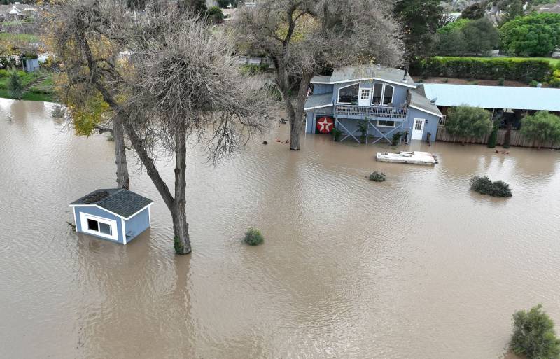
Two buildings are partially submerged in murky brown water. One small shack in the foreground, and a larger house in the background.
In an aerial view, a home is seen submerged in floodwater after the Salinas River overflowed its banks on Jan. 13, 2023, in Salinas. Several atmospheric river events continue to pound California with record rainfall and high winds. (Justin Sullivan/Getty Images)

You're probably ready for the Great Dry-Out of 2023 to begin.

But it's a little too early to declare an absolute end to the Great Soaking of '22–'23, which for three weeks beginning Dec. 26 has deluged Northern California with near-record volumes of rain and snow. The storm siege has triggered widespread flooding, knocked out power at least briefly to millions and killed as many as 21 people.

Forecasters say that the entire state will see a long, precipitation-free period beginning later this week. Before that, though, we're due for a brief encounter with a Wednesday evening storm that forecasters say will bring mostly light rain to the Bay Area.

The break will give residents, local governments and state agencies a chance to take stock of the damage and begin to clean up. A widely publicized estimate from the National Oceanic and Atmospheric Administration last week said the price tag on the three weeks of storms could top $1 billion. Other estimates have put the potential cost in the tens of billions.

Widespread power outages are part of that damage assessment. PG&E said Monday it has restored electricity to about 2.6 million customers who have lost power for varying periods since Dec. 30. The utility says about 6,500 are still without power. Hundreds of thousands more customers of other utilities have also suffered through blackouts as the series of storms blew down trees and snapped power lines.

Sponsored

"We are just about to the end of this," Jan Null, a veteran forecaster and consulting meteorologist who operates Golden Gate Weather Services, said in an interview Monday.

Null said the storm arriving late in the day Wednesday will bring no more than a quarter-inch of rain to most Bay Area locales. "But after that, the models are showing nothing for two weeks," he said.

Null, who is also a historian of San Francisco rainfall, noted that the three weeks ending Sunday night were the second-rainiest since record-keeping began in San Francisco in 1849. The only period that surpassed the recent series of storms came in January 1862, in the midst of the wettest recorded winter in the city's history.

Monday and Tuesday's lull in the rainy onslaught is allowing rivers and streams throughout the state to drop below flood level.

In a briefing Monday, the California Department of Water Resources said the series of storms — each of which wrung heavy precipitation out of a series of atmospheric rivers wafting in to the California coast from the southwest — has given a much-needed boost to the state's reservoirs and snowpack after two very dry winters.

State Climatologist Michael Anderson said the snowpack, the "frozen reservoir" that in a "normal" year provides one-third of the state's water supply, is at "epic levels."

Related Stories

Anderson noted that the storms that began rolling in after Dec. 26 were relatively cold. That meant virtually all of the precipitation that fell at higher elevations came down as snow. The result is a statewide snowpack that is currently 247% of average for this time of year — and 120% of its average level on April 1 — traditionally considered the peak date for the Sierra snowpack.

"We're ahead of the record snowpack of 1982–83," Anderson said. He added that the huge surplus of water currently locked up as snow in the mountains could pose a challenge later in the wet season.

"Looking to the future, this does set the stage for potentially dealing with flood issues as we move through the snowmelt season," Anderson said. But, he noted, that prospect is not imminent with continued cold temperatures expected to aid in preserving the snowpack in coming weeks.

The DWR said the storms have fueled a big increase in the volume of water stored in the state's reservoirs, though not at the eye-popping levels seen in the snowpack statistics.

Molly White, water operations manager for the State Water Project, said statewide reservoir levels are at 91% of average for mid-January. Huge increases have been seen at the SWP's Lake Oroville, where storage has nearly doubled since Dec. 26, to 2 million acre-feet, and at the federal Central Valley Project's Shasta Lake, where the amount of water captured has increased about 60% in three weeks.

Shasta, the state's largest reservoir, is at 82% of average for this point in the season; Oroville, the second-largest, is at 101%. White said that leaves a lot of room in both lakes before flood control concerns become an issue.
lower waypoint
next waypoint
Stunning Archival Photos of the 1906 Earthquake and FireCould Protesters Who Shut Down Golden Gate Bridge Be Charged With False Imprisonment?San Francisco Sues Oakland Over Plan to Change Airport NameDeath Doula Alua Arthur on How and Why to Prepare for the EndAlameda County DA Charges 3 Police Officers With Manslaughter in Death of Mario GonzalezAfter Parole, ICE Deported This Refugee Back to a Country He Never KnewDespite Progress, Black Californians Still Face Major Challenges In Closing Equality GapGaza Aid Flotilla to Include Bay Area ResidentsSF’s Equity Program Fails to Address Racial Disparities in Cannabis IndustryHow to Create Your Own ‘Garden Wonderland’