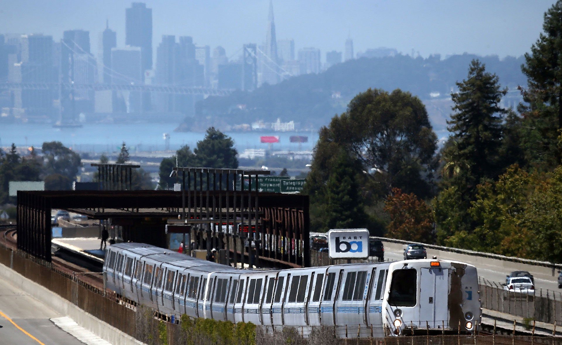
The Bay Area Rapid Transit System (BART) was designed from the beginning to be a 'trunk line' that would bring commuters and shoppers into Oakland and San Francisco from the suburbs.
UC Berkeley doctoral candidate Ziad Shafi has lived in several parts of the U.S. and in Europe. In Washington, D.C., he was impressed with the metro system, which took him most places he wanted to go. Same thing in many European cities. So, when he moved to the Bay Area and started riding BART, he was a little confused. Look at any BART map and you’ll see lines converging from Contra Costa and Alameda counties on a single corridor through the Transbay Tube across San Francisco and down the Peninsula to San Francisco International Airport and Millbrae.
“Metros and subways in European cities tend to be spread out, hitting every city corner,” Ziad said. “Why do four of the five BART lines (red, yellow, green, blue) go all the way from West Oakland to Daly City? It seems like a mistake.”
Ziad submitted his question to Bay Curious and it won a voting round, so a lot of people have been wondering why BART was designed this way.
Of course, what one person sees as a mistake can be another’s very deliberate strategy. And in this case, BART’s route is the product of what public officials, business interests and planners in the 1950s thought a rapid transit system should be. They planned BART as a system with a single main line on its route down to the Peninsula. (Yes, BART was originally envisioned as a system that would also run west through northern and parts of western San Francisco to the Golden Gate Bridge and beyond, but that plan died in 1962 when Marin County officials opted out of the system.)
The growing dominance of the automobile — and the massive highway construction that went along with it — lay behind the choice of a main line system whose central mission was to get commuters and shoppers from outlying areas to and from downtown San Francisco and Oakland.
A 1955 status report (PDF) prepared for the commission overseeing BART planning argued that the only way a regional rapid transit system would persuade drivers to get out of their cars was if service was fast, frequent and comfortable. Patronage would depend on having widely spaced stations, each with a huge parking lot or easy bus access.
Planners contrasted that with what they termed a “neighborhood system,” one that would be within walking distance of most Bay Area homes, and which would require lots of train lines and lots of stops. While that kind of service might be accessible, the frequency of stops and longer waits between trains would mean it was slower — and thus unlikely to woo drivers who were believed to value speed and personal convenience above all.
“The foregoing considerations compel in our minds a recommendation for a main line, trunk system, even without taking into account its much lower capital and operating costs as compared to a neighborhood system,” the 1955 memo said.
Aerial view of the Grove-Shafter Freeway and Bay Area Rapid Transit MacArthur Station construction on Aug. 29, 1970, in Oakland. (Russ Reed, from plane flown by Warren Boggess/MediaNews Group-Oakland Tribune via Getty Images)
Now, one shouldn’t forget that there was — and is — transit that ties into BART on both sides of the bay. In San Francisco, we’re talking about Muni, mostly. And in the East Bay, we’re talking about AC Transit. If you add those network maps to the rather skeletal BART system, transit looks much more robust — though yes, you’re required to jump from one operator to another to get to your destination.
There are a couple of important historical notes to touch upon regarding Muni and the possibility of more rapid transit in San Francisco.
San Francisco rejects new subway lines
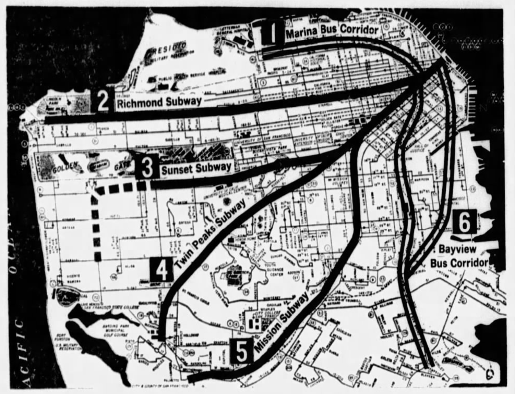
City officials had started touting the possibility of citywide subway service as far back as the first decade of the 20th century. Those initiatives were moved to the back burner several times — by “no” votes from the electorate, World War II and, later, by the belief that with BART on the way, such a system might be redundant. The last serious attempt to turn that idea into reality came in 1966.
Proposition B on the city’s November ballot that year included a $96.5 million bond issue that would help pay for construction of three new rapid transit subways across the city. The new routes — one to the Richmond District, one to the Sunset, one to the San Francisco State neighborhood by way of Twin Peaks — would take advantage of BART’s two-level subway tunnel under Market Street and make it possible to reach downtown in 20 minutes from anywhere along the line.
The measure, which would require tax increases, needed a two-thirds vote to pass. It garnered only a 57% “yes” vote. The plan was never revived.
A map the San Francisco Examiner printed just before the November 1966 vote on a bond issue to fund a Muni rapid transit network in San Francisco. The caption read: “Here’s a look at the overall transit plan showing the six major high-speed subways and bus lines. Routes 1, 4 and 6 would be financed by Proposition B. Passage of Proposition B at the Nov. 8 elections qualify the Muni for federal aid to build No. 2 and No. 2. BART is building No. 5.” (San Francisco Examiner via Newspapers.com)
Jason Henderson, a San Francisco State University professor of geography who has written extensively on the city’s transportation politics, said in his 2013 book “Street Fight” that the measure failed for a variety of reasons: a distaste for higher taxes and fear that the new subways would spur unwanted dense development. Voters were unconvinced the new transit plan, which would scrap the existing J, K, L, M and N streetcar lines, would be an improvement on Muni’s existing network. Henderson wrote:
“Some neighborhood groups were opposed to the proposal because the plan included restructuring of the bus routes so that the buses fed into the rapid transit trunk lines. … Passengers’ actual travel times would be higher with the transfer and restructuring of routes. The transit plan of 1966 discontinued almost all electric trolley bus service, replacing it with a diesel bus fleet. Some neighborhood groups opposed the proposal on these grounds because in San Francisco, with its many hills, diesel buses performed especially poorly and were extremely noisy compared to electric buses.”
But that’s the past. Is a denser, more efficient transit system — the kind our question-asker Ziad talked about — in our future?
In an interview with Bay Curious, Henderson said that in order to “decarbonize” rapidly enough to head off the worst effects of climate change, staggering levels of new investment will be necessary to build a regional rail system and interim systems like busways where it might be too expensive or time-consuming to build train lines.
“In Northern California, we’re a region that should be tied together by a train system that rivals or exceeds the freeway system we have,” Henderson said. “I think we could spend the next generation building that. And yes, it would cost hundreds of billions of dollars, but that’s what we’ve got to spend to address the climate issue.”
Making current system more efficient
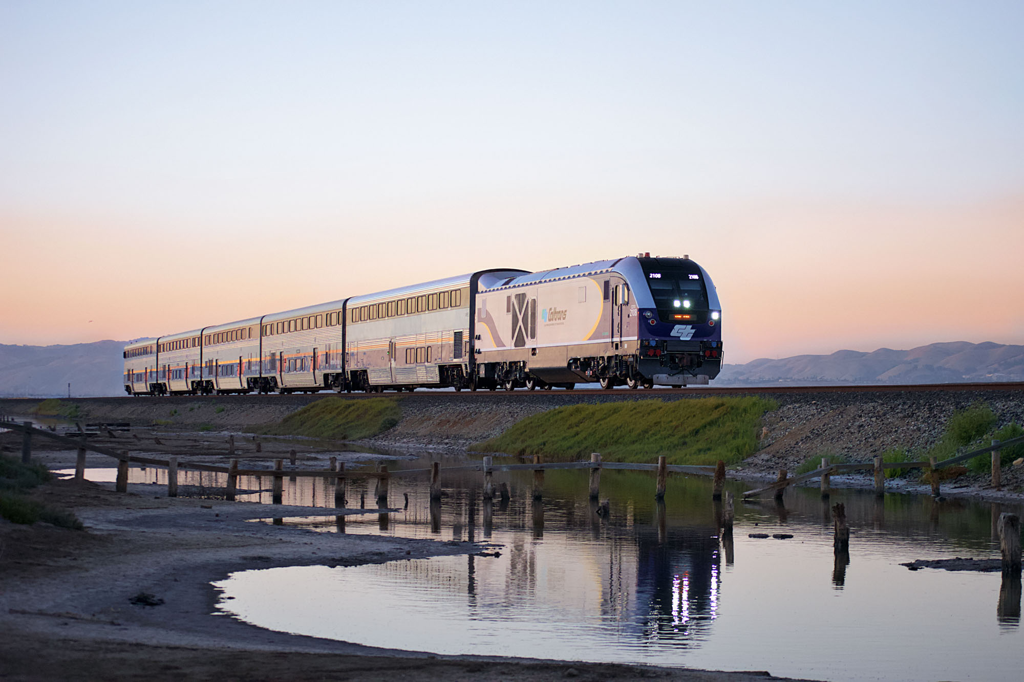
A regional rail system is coming — eventually. BART and other agencies are working on Link21, an effort to refine a plan for a second transbay rail crossing, and building out improved train service for the “megaregion” stretching to Sacramento and the northern San Joaquin Valley.
Amtrak California’s Capitol Corridor — seen here at Alviso on the south end of San Francisco Bay — is among the partners in the Link21 program to create improved regional rail service. (Max Camden/Link21-BART)
But like other big transportation projects in our region — San Francisco’s Central Subway, BART’s planned extension through downtown San José to Santa Clara, the planned extension of Caltrain to the Salesforce Transit Center, among others — a second transbay crossing promises to be not only expensive, but very slow in moving from plan to reality. Link21’s estimated date for completion is 2039.
Given the urgency of climate change and the role that clean transportation can play in providing a solution, Henderson is one of many people impatient to see progress.
“We gotta move fast,” he said. “We’ve got to be scaling up and rolling this stuff out this decade and in the early part of the ’30s if we’re gonna really seriously take on this climate issue. And we need to be inspiring the rest of the country.”
lower waypointnext waypoint
Player sponsored by
window.__IS_SSR__=true
window.__INITIAL_STATE__={
"attachmentsReducer": {
"audio_0": {
"type": "attachments",
"id": "audio_0",
"imgSizes": {
"kqedFullSize": {
"file": "https://ww2.kqed.org/news/wp-content/themes/KQED-unified/img/audio_bgs/background0.jpg"
}
}
},
"audio_1": {
"type": "attachments",
"id": "audio_1",
"imgSizes": {
"kqedFullSize": {
"file": "https://ww2.kqed.org/news/wp-content/themes/KQED-unified/img/audio_bgs/background1.jpg"
}
}
},
"audio_2": {
"type": "attachments",
"id": "audio_2",
"imgSizes": {
"kqedFullSize": {
"file": "https://ww2.kqed.org/news/wp-content/themes/KQED-unified/img/audio_bgs/background2.jpg"
}
}
},
"audio_3": {
"type": "attachments",
"id": "audio_3",
"imgSizes": {
"kqedFullSize": {
"file": "https://ww2.kqed.org/news/wp-content/themes/KQED-unified/img/audio_bgs/background3.jpg"
}
}
},
"audio_4": {
"type": "attachments",
"id": "audio_4",
"imgSizes": {
"kqedFullSize": {
"file": "https://ww2.kqed.org/news/wp-content/themes/KQED-unified/img/audio_bgs/background4.jpg"
}
}
},
"placeholder": {
"type": "attachments",
"id": "placeholder",
"imgSizes": {
"thumbnail": {
"file": "https://cdn.kqed.org/wp-content/uploads/2024/12/KQED-Default-Image-816638274-2000x1333-1-160x107.jpg",
"width": 160,
"height": 107,
"mimeType": "image/jpeg"
},
"medium": {
"file": "https://cdn.kqed.org/wp-content/uploads/2024/12/KQED-Default-Image-816638274-2000x1333-1-800x533.jpg",
"width": 800,
"height": 533,
"mimeType": "image/jpeg"
},
"medium_large": {
"file": "https://cdn.kqed.org/wp-content/uploads/2024/12/KQED-Default-Image-816638274-2000x1333-1-768x512.jpg",
"width": 768,
"height": 512,
"mimeType": "image/jpeg"
},
"large": {
"file": "https://cdn.kqed.org/wp-content/uploads/2024/12/KQED-Default-Image-816638274-2000x1333-1-1020x680.jpg",
"width": 1020,
"height": 680,
"mimeType": "image/jpeg"
},
"1536x1536": {
"file": "https://cdn.kqed.org/wp-content/uploads/2024/12/KQED-Default-Image-816638274-2000x1333-1-1536x1024.jpg",
"width": 1536,
"height": 1024,
"mimeType": "image/jpeg"
},
"fd-lrg": {
"file": "https://cdn.kqed.org/wp-content/uploads/2024/12/KQED-Default-Image-816638274-2000x1333-1-1536x1024.jpg",
"width": 1536,
"height": 1024,
"mimeType": "image/jpeg"
},
"fd-med": {
"file": "https://cdn.kqed.org/wp-content/uploads/2024/12/KQED-Default-Image-816638274-2000x1333-1-1020x680.jpg",
"width": 1020,
"height": 680,
"mimeType": "image/jpeg"
},
"fd-sm": {
"file": "https://cdn.kqed.org/wp-content/uploads/2024/12/KQED-Default-Image-816638274-2000x1333-1-800x533.jpg",
"width": 800,
"height": 533,
"mimeType": "image/jpeg"
},
"post-thumbnail": {
"file": "https://cdn.kqed.org/wp-content/uploads/2024/12/KQED-Default-Image-816638274-2000x1333-1-672x372.jpg",
"width": 672,
"height": 372,
"mimeType": "image/jpeg"
},
"twentyfourteen-full-width": {
"file": "https://cdn.kqed.org/wp-content/uploads/2024/12/KQED-Default-Image-816638274-2000x1333-1-1038x576.jpg",
"width": 1038,
"height": 576,
"mimeType": "image/jpeg"
},
"xxsmall": {
"file": "https://cdn.kqed.org/wp-content/uploads/2024/12/KQED-Default-Image-816638274-2000x1333-1-160x107.jpg",
"width": 160,
"height": 107,
"mimeType": "image/jpeg"
},
"xsmall": {
"file": "https://cdn.kqed.org/wp-content/uploads/2024/12/KQED-Default-Image-816638274-2000x1333-1-672x372.jpg",
"width": 672,
"height": 372,
"mimeType": "image/jpeg"
},
"small": {
"file": "https://cdn.kqed.org/wp-content/uploads/2024/12/KQED-Default-Image-816638274-2000x1333-1-672x372.jpg",
"width": 672,
"height": 372,
"mimeType": "image/jpeg"
},
"xlarge": {
"file": "https://cdn.kqed.org/wp-content/uploads/2024/12/KQED-Default-Image-816638274-2000x1333-1-1020x680.jpg",
"width": 1020,
"height": 680,
"mimeType": "image/jpeg"
},
"full-width": {
"file": "https://cdn.kqed.org/wp-content/uploads/2024/12/KQED-Default-Image-816638274-2000x1333-1-1920x1280.jpg",
"width": 1920,
"height": 1280,
"mimeType": "image/jpeg"
},
"guest-author-32": {
"file": "https://cdn.kqed.org/wp-content/uploads/2025/01/KQED-Default-Image-816638274-1333x1333-1-160x160.jpg",
"width": 32,
"height": 32,
"mimeType": "image/jpeg"
},
"guest-author-50": {
"file": "https://cdn.kqed.org/wp-content/uploads/2025/01/KQED-Default-Image-816638274-1333x1333-1-160x160.jpg",
"width": 50,
"height": 50,
"mimeType": "image/jpeg"
},
"guest-author-64": {
"file": "https://cdn.kqed.org/wp-content/uploads/2025/01/KQED-Default-Image-816638274-1333x1333-1-160x160.jpg",
"width": 64,
"height": 64,
"mimeType": "image/jpeg"
},
"guest-author-96": {
"file": "https://cdn.kqed.org/wp-content/uploads/2025/01/KQED-Default-Image-816638274-1333x1333-1-160x160.jpg",
"width": 96,
"height": 96,
"mimeType": "image/jpeg"
},
"guest-author-128": {
"file": "https://cdn.kqed.org/wp-content/uploads/2025/01/KQED-Default-Image-816638274-1333x1333-1-160x160.jpg",
"width": 128,
"height": 128,
"mimeType": "image/jpeg"
},
"detail": {
"file": "https://cdn.kqed.org/wp-content/uploads/2025/01/KQED-Default-Image-816638274-1333x1333-1-160x160.jpg",
"width": 160,
"height": 160,
"mimeType": "image/jpeg"
},
"kqedFullSize": {
"file": "https://cdn.kqed.org/wp-content/uploads/2024/12/KQED-Default-Image-816638274-2000x1333-1.jpg",
"width": 2000,
"height": 1333
}
}
},
"news_11932694": {
"type": "attachments",
"id": "news_11932694",
"meta": {
"index": "attachments_1716263798",
"site": "news",
"id": "11932694",
"found": true
},
"title": "Rockridge-BART-cropped",
"publishDate": 1668796508,
"status": "inherit",
"parent": 11932690,
"modified": 1746835406,
"caption": "A Bay Area Rapid Transit (BART) train pulls away from Oakland's Rockridge station on Aug. 2, 2013.",
"credit": "Justin Sullivan/Getty Images",
"altTag": "A BART train pulls out of an above-ground station. Cars whiz by alongside and the city of San Francisco looms in the background.",
"description": null,
"imgSizes": {
"medium": {
"file": "https://cdn.kqed.org/wp-content/uploads/sites/10/2022/11/Rockridge-BART-cropped-800x492.jpg",
"width": 800,
"height": 492,
"mimeType": "image/jpeg"
},
"large": {
"file": "https://cdn.kqed.org/wp-content/uploads/sites/10/2022/11/Rockridge-BART-cropped-1020x627.jpg",
"width": 1020,
"height": 627,
"mimeType": "image/jpeg"
},
"thumbnail": {
"file": "https://cdn.kqed.org/wp-content/uploads/sites/10/2022/11/Rockridge-BART-cropped-160x98.jpg",
"width": 160,
"height": 98,
"mimeType": "image/jpeg"
},
"1536x1536": {
"file": "https://cdn.kqed.org/wp-content/uploads/sites/10/2022/11/Rockridge-BART-cropped-1536x944.jpg",
"width": 1536,
"height": 944,
"mimeType": "image/jpeg"
},
"post-thumbnail": {
"file": "https://cdn.kqed.org/wp-content/uploads/sites/10/2022/11/Rockridge-BART-cropped-672x372.jpg",
"width": 672,
"height": 372,
"mimeType": "image/jpeg"
},
"twentyfourteen-full-width": {
"file": "https://cdn.kqed.org/wp-content/uploads/sites/10/2022/11/Rockridge-BART-cropped-1038x576.jpg",
"width": 1038,
"height": 576,
"mimeType": "image/jpeg"
},
"kqedFullSize": {
"file": "https://cdn.kqed.org/wp-content/uploads/sites/10/2022/11/Rockridge-BART-cropped.jpg",
"width": 1920,
"height": 1180
}
},
"isLoading": false,
"fetchFailed": false
}
},
"audioPlayerReducer": {
"postId": "stream_live",
"isPaused": true,
"isPlaying": false,
"pfsActive": false,
"pledgeModalIsOpen": true,
"playerDrawerIsOpen": false,
"liveAudioPlayStartedAt": 0,
"liveAudioPlayContext": ""
},
"authorsReducer": {
"danbrekke": {
"type": "authors",
"id": "222",
"meta": {
"index": "authors_1716337520",
"id": "222",
"found": true
},
"name": "Dan Brekke",
"firstName": "Dan",
"lastName": "Brekke",
"slug": "danbrekke",
"email": "dbrekke@kqed.org",
"display_author_email": true,
"staff_mastheads": [
"news",
"science"
],
"title": "KQED Editor and Reporter",
"bio": "Dan Brekke is a reporter and editor for KQED News, responsible for coverage of topics ranging from California water issues to the Bay Area's transportation challenges. In a newsroom career that began in Chicago in 1972, Dan has worked for \u003cem>The San Francisco Examiner,\u003c/em> Wired and TechTV and has been published in The New York Times, The New York Times Magazine, Business 2.0, Salon and elsewhere.\r\n\r\nSince joining KQED in 2007, Dan has reported, edited and produced both radio and online features and breaking news pieces. He has shared as both editor and reporter in four Society of Professional Journalists Norcal Excellence in Journalism awards and one Edward R. Murrow regional award. He was chosen for a spring 2017 residency at the Mesa Refuge to advance his research on California salmon.\r\n\r\nEmail Dan at: \u003ca href=\"mailto:dbrekke@kqed.org\">dbrekke@kqed.org\u003c/a>\r\n\r\n\u003cstrong>Twitter:\u003c/strong> \u003ca href=\"https://twitter.com/danbrekke\" rel=\"noopener noreferrer\">twitter.com/danbrekke\u003c/a>\r\n\u003cstrong>Facebook:\u003c/strong> \u003ca href=\"https://www.facebook.com/danbrekke\" rel=\"noopener noreferrer\">www.facebook.com/danbrekke\u003c/a>\r\n\u003cstrong>LinkedIn:\u003c/strong> \u003ca href=\"https://www.linkedin.com/in/danbrekke\" rel=\"noopener noreferrer\">www.linkedin.com/in/danbrekke\u003c/a>",
"avatar": "https://secure.gravatar.com/avatar/c8126230345efca3f7aa89b1a402be45?s=600&d=mm&r=g",
"twitter": "danbrekke",
"facebook": null,
"instagram": "https://www.instagram.com/dan.brekke/",
"linkedin": "https://www.linkedin.com/in/danbrekke/",
"sites": [
{
"site": "news",
"roles": [
"administrator",
"create_posts"
]
},
{
"site": "stateofhealth",
"roles": [
"editor"
]
},
{
"site": "science",
"roles": [
"editor"
]
},
{
"site": "quest",
"roles": [
"contributor"
]
},
{
"site": "food",
"roles": [
"contributor"
]
},
{
"site": "forum",
"roles": [
"contributor"
]
},
{
"site": "liveblog",
"roles": [
"editor"
]
}
],
"headData": {
"title": "Dan Brekke | KQED",
"description": "KQED Editor and Reporter",
"ogImgSrc": "https://secure.gravatar.com/avatar/c8126230345efca3f7aa89b1a402be45?s=600&d=mm&r=g",
"twImgSrc": "https://secure.gravatar.com/avatar/c8126230345efca3f7aa89b1a402be45?s=600&d=mm&r=g"
},
"isLoading": false,
"link": "/author/danbrekke"
}
},
"pagesReducer": {},
"pfsSessionReducer": {},
"postsReducer": {
"stream_live": {
"type": "live",
"id": "stream_live",
"audioUrl": "https://streams.kqed.org/kqedradio",
"title": "Live Stream",
"excerpt": "Live Stream information currently unavailable.",
"link": "/radio",
"featImg": "",
"label": {
"name": "KQED Live",
"link": "/"
}
},
"stream_kqedNewscast": {
"type": "posts",
"id": "stream_kqedNewscast",
"audioUrl": "https://www.kqed.org/.stream/anon/radio/RDnews/newscast.mp3?_=1",
"title": "KQED Newscast",
"featImg": "",
"label": {
"name": "88.5 FM",
"link": "/"
}
},
"news_11932690": {
"type": "posts",
"id": "news_11932690",
"meta": {
"index": "posts_1716263798",
"site": "news",
"id": "11932690",
"found": true
},
"articlePosition": 0,
"parent": 0,
"labelTerm": {},
"blocks": [],
"publishDate": 1669035719,
"format": "standard",
"title": "Why Doesn't BART Go More Places?",
"headTitle": "Why Doesn’t BART Go More Places? | KQED",
"content": "\u003cp>\u003ca href=\"https://bit.ly/3AlGTIB\">\u003cem>Read a transcript of this episode here.\u003c/em>\u003c/a>\u003c/p>\n\u003cp>UC Berkeley doctoral candidate Ziad Shafi has lived in several parts of the U.S. and in Europe. In Washington, D.C., he was impressed with the metro system, which took him most places he wanted to go. Same thing in many European cities. So, when he moved to the Bay Area and started riding BART, he was a little confused. Look at any BART map and you’ll see lines converging from Contra Costa and Alameda counties on a single corridor through the Transbay Tube across San Francisco and down the Peninsula to San Francisco International Airport and Millbrae.\u003c/p>\n\u003cp>“Metros and subways in European cities tend to be spread out, hitting every city corner,” Ziad said. “Why do four of the five BART lines (red, yellow, green, blue) go all the way from West Oakland to Daly City? It seems like a mistake.”\u003c/p>\n\u003cp>Ziad submitted his question to Bay Curious and it won \u003ca href=\"https://www.kqed.org/podcasts/baycurious/\">a voting round\u003c/a>, so a lot of people have been wondering why BART was designed this way.\u003c/p>\n\u003cp>[baycuriouspodcastinfo]\u003c/p>\n\u003cp>Of course, what one person sees as a mistake can be another’s very deliberate strategy. And in this case, BART’s route is the product of what public officials, business interests and planners in the 1950s thought a rapid transit system should be. They planned BART as a system with a single main line on its route down to the Peninsula. (Yes, BART was originally envisioned as a system that would also run west through northern and parts of western San Francisco to the Golden Gate Bridge and beyond, but that plan died in 1962 when Marin County officials opted out of the system.)\u003c/p>\n\u003cp>[ad fullwidth]\u003c/p>\n\u003cp>The growing dominance of the automobile — and the massive highway construction that went along with it — lay behind the choice of a main line system whose central mission was to get commuters and shoppers from outlying areas to and from downtown San Francisco and Oakland.\u003c/p>\n\u003cp>A \u003ca href=\"https://s3.documentcloud.org/documents/23314106/redundancy-in-public-transit-1980-adler-chapter-ix.pdf\">1955 status report (PDF)\u003c/a> prepared for the commission overseeing BART planning argued that the only way a regional rapid transit system would persuade drivers to get out of their cars was if service was fast, frequent and comfortable. Patronage would depend on having widely spaced stations, each with a huge parking lot or easy bus access.\u003c/p>\n\u003cp>[aside label=\"More Bay Curious BART Episodes\" link1=\"https://podcasts.apple.com/us/podcast/why-are-bart-trains-so-loud/id1172473406?i=1000392016987&ign-itscg=30200S&ign-itsct=podcast_box,Why Are BART Trains So Loud?\" link2=\"https://podcasts.apple.com/us/podcast/youre-really-really-curious-about-bart/id1172473406?i=1000464113096&ign-itscg=30200S&ign-itsct=podcast_box,You're Really Really Curious About BART\"]Planners contrasted that with what they termed a “neighborhood system,” one that would be within walking distance of most Bay Area homes, and which would require lots of train lines and lots of stops. While that kind of service might be accessible, the frequency of stops and longer waits between trains would mean it was slower — and thus unlikely to woo drivers who were believed to value speed and personal convenience above all.\u003c/p>\n\u003cp>“The foregoing considerations compel in our minds a recommendation for a main line, trunk system, even without taking into account its much lower capital and operating costs as compared to a neighborhood system,” the 1955 memo said.\u003c/p>\n\u003cfigure id=\"attachment_11932714\" class=\"wp-caption alignnone\" style=\"max-width: 800px\">\u003ca href=\"https://ww2.kqed.org/app/uploads/sites/10/2022/11/GettyImages-1318535223-scaled.jpg\">\u003cimg decoding=\"async\" loading=\"lazy\" class=\"size-medium wp-image-11932714\" src=\"https://ww2.kqed.org/app/uploads/sites/10/2022/11/GettyImages-1318535223-800x997.jpg\" alt=\"A 1970 aerial view of freeway and rapid transit construction in Oakland, California.\" width=\"800\" height=\"997\" srcset=\"https://ww2.kqed.org/app/uploads/sites/10/2022/11/GettyImages-1318535223-800x997.jpg 800w, https://ww2.kqed.org/app/uploads/sites/10/2022/11/GettyImages-1318535223-1020x1271.jpg 1020w, https://ww2.kqed.org/app/uploads/sites/10/2022/11/GettyImages-1318535223-160x199.jpg 160w, https://ww2.kqed.org/app/uploads/sites/10/2022/11/GettyImages-1318535223-1233x1536.jpg 1233w, https://ww2.kqed.org/app/uploads/sites/10/2022/11/GettyImages-1318535223-1644x2048.jpg 1644w, https://ww2.kqed.org/app/uploads/sites/10/2022/11/GettyImages-1318535223-1920x2392.jpg 1920w\" sizes=\"(max-width: 800px) 100vw, 800px\">\u003c/a>\u003cfigcaption class=\"wp-caption-text\">Aerial view of the Grove-Shafter Freeway and Bay Area Rapid Transit MacArthur Station construction on Aug. 29, 1970, in Oakland. \u003ccite>(Russ Reed, from plane flown by Warren Boggess/MediaNews Group-Oakland Tribune via Getty Images)\u003c/cite>\u003c/figcaption>\u003c/figure>\n\u003cp>Now, one shouldn’t forget that there was — and is — transit that ties into BART on both sides of the bay. In San Francisco, we’re talking about Muni, mostly. And in the East Bay, we’re talking about AC Transit. If you add those network maps to the rather skeletal BART system, transit looks much more robust — though yes, you’re required to jump from one operator to another to get to your destination.\u003c/p>\n\u003cp>There are a couple of important historical notes to touch upon regarding Muni and the possibility of more rapid transit in San Francisco.\u003c/p>\n\u003ch2>San Francisco rejects new subway lines\u003c/h2>\n\u003cp>City officials had started touting the possibility of citywide subway service as far back as the first decade of the 20th century. Those initiatives were moved to the back burner several times — by “no” votes from the electorate, World War II and, later, by the belief that with BART on the way, such a system might be redundant. The last serious attempt to turn that idea into reality came in 1966.\u003c/p>\n\u003cp>Proposition B on the city’s November ballot that year included a $96.5 million bond issue that would help pay for construction of three new rapid transit subways across the city. The new routes — one to the Richmond District, one to the Sunset, one to the San Francisco State neighborhood by way of Twin Peaks — would take advantage of BART’s two-level subway tunnel under Market Street and make it possible to reach downtown in 20 minutes from anywhere along the line.\u003c/p>\n\u003cp>The measure, which would require tax increases, needed a two-thirds vote to pass. It garnered only a 57% “yes” vote. The plan was never revived.\u003c/p>\n\u003cfigure id=\"attachment_11932710\" class=\"wp-caption alignnone\" style=\"max-width: 800px\">\u003ca href=\"https://ww2.kqed.org/app/uploads/sites/10/2022/11/Screen-Shot-2022-11-17-at-3.35.12-PM.png\">\u003cimg decoding=\"async\" loading=\"lazy\" class=\"size-medium wp-image-11932710\" src=\"https://ww2.kqed.org/app/uploads/sites/10/2022/11/Screen-Shot-2022-11-17-at-3.35.12-PM-800x613.png\" alt=\"A 1966 newspaper map showing proposed routes for San Francisco rapid transit.\" width=\"800\" height=\"613\" srcset=\"https://ww2.kqed.org/app/uploads/sites/10/2022/11/Screen-Shot-2022-11-17-at-3.35.12-PM-800x613.png 800w, https://ww2.kqed.org/app/uploads/sites/10/2022/11/Screen-Shot-2022-11-17-at-3.35.12-PM-1020x782.png 1020w, https://ww2.kqed.org/app/uploads/sites/10/2022/11/Screen-Shot-2022-11-17-at-3.35.12-PM-160x123.png 160w, https://ww2.kqed.org/app/uploads/sites/10/2022/11/Screen-Shot-2022-11-17-at-3.35.12-PM-1536x1177.png 1536w, https://ww2.kqed.org/app/uploads/sites/10/2022/11/Screen-Shot-2022-11-17-at-3.35.12-PM.png 1730w\" sizes=\"(max-width: 800px) 100vw, 800px\">\u003c/a>\u003cfigcaption class=\"wp-caption-text\">A map the San Francisco Examiner printed just before the November 1966 vote on a bond issue to fund a Muni rapid transit network in San Francisco. The caption read: “Here’s a look at the overall transit plan showing the six major high-speed subways and bus lines. Routes 1, 4 and 6 would be financed by Proposition B. Passage of Proposition B at the Nov. 8 elections qualify the Muni for federal aid to build No. 2 and No. 2. BART is building No. 5.” \u003ccite>(San Francisco Examiner via Newspapers.com)\u003c/cite>\u003c/figcaption>\u003c/figure>\n\u003cp>Jason Henderson, a San Francisco State University professor of geography who has written extensively on the city’s transportation politics, said in his 2013 book “\u003ca href=\"https://geog.sfsu.edu/publication/street-fight-politics-mobility-san-francisco\">Street Fight\u003c/a>” that the measure failed for a variety of reasons: a distaste for higher taxes and fear that the new subways would spur unwanted dense development. Voters were unconvinced the new transit plan, which would scrap the existing J, K, L, M and N streetcar lines, would be an improvement on Muni’s existing network. Henderson wrote:\u003c/p>\n\u003cblockquote>\u003cp>“Some neighborhood groups were opposed to the proposal because the plan included restructuring of the bus routes so that the buses fed into the rapid transit trunk lines. … Passengers’ actual travel times would be higher with the transfer and restructuring of routes. The transit plan of 1966 discontinued almost all electric trolley bus service, replacing it with a diesel bus fleet. Some neighborhood groups opposed the proposal on these grounds because in San Francisco, with its many hills, diesel buses performed especially poorly and were extremely noisy compared to electric buses.”\u003c/p>\u003c/blockquote>\n\u003cp>But that’s the past. Is a denser, more efficient transit system — the kind our question-asker Ziad talked about — in our future?\u003c/p>\n\u003cp>In an interview with Bay Curious, Henderson said that in order to “decarbonize” rapidly enough to head off the worst effects of climate change, staggering levels of new investment will be necessary to build a regional rail system and interim systems like busways where it might be too expensive or time-consuming to build train lines.\u003c/p>\n\u003cp>“In Northern California, we’re a region that should be tied together by a train system that rivals or exceeds the freeway system we have,” Henderson said. “I think we could spend the next generation building that. And yes, it would cost hundreds of billions of dollars, but that’s what we’ve got to spend to address the climate issue.”\u003c/p>\n\u003ch2>Making current system more efficient\u003c/h2>\n\u003cp>A regional rail system is coming — eventually. BART and other agencies are working on \u003ca href=\"https://link21program.org/en\">Link21\u003c/a>, an effort to refine a plan for a second transbay rail crossing, and building out improved train service for the “megaregion” stretching to Sacramento and the northern San Joaquin Valley.\u003c/p>\n\u003cfigure id=\"attachment_11932707\" class=\"wp-caption alignnone\" style=\"max-width: 800px\">\u003ca href=\"https://ww2.kqed.org/app/uploads/sites/10/2022/11/Capitol-Corridor-Alviso.jpeg\">\u003cimg decoding=\"async\" loading=\"lazy\" class=\"size-medium wp-image-11932707\" src=\"https://ww2.kqed.org/app/uploads/sites/10/2022/11/Capitol-Corridor-Alviso-800x533.jpeg\" alt=\"A passenger train reflected in a trackside puddle at sunset.\" width=\"800\" height=\"533\" srcset=\"https://ww2.kqed.org/app/uploads/sites/10/2022/11/Capitol-Corridor-Alviso-800x533.jpeg 800w, https://ww2.kqed.org/app/uploads/sites/10/2022/11/Capitol-Corridor-Alviso-1020x680.jpeg 1020w, https://ww2.kqed.org/app/uploads/sites/10/2022/11/Capitol-Corridor-Alviso-160x107.jpeg 160w, https://ww2.kqed.org/app/uploads/sites/10/2022/11/Capitol-Corridor-Alviso-1536x1024.jpeg 1536w, https://ww2.kqed.org/app/uploads/sites/10/2022/11/Capitol-Corridor-Alviso-1920x1280.jpeg 1920w, https://ww2.kqed.org/app/uploads/sites/10/2022/11/Capitol-Corridor-Alviso.jpeg 2000w\" sizes=\"(max-width: 800px) 100vw, 800px\">\u003c/a>\u003cfigcaption class=\"wp-caption-text\">Amtrak California’s Capitol Corridor — seen here at Alviso on the south end of San Francisco Bay — is among the partners in the Link21 program to create improved regional rail service. \u003ccite>(Max Camden/Link21-BART)\u003c/cite>\u003c/figcaption>\u003c/figure>\n\u003cp>But like other big transportation projects in our region — \u003ca href=\"https://omny.fm/shows/kqed-segmented-audio/san-franciscos-central-subway-opens-for-limited-se\" target=\"_blank\" rel=\"noreferrer noopener\">San Francisco’s Central Subway\u003c/a>, BART’s planned extension through downtown San José to Santa Clara, the planned extension of Caltrain to the Salesforce Transit Center, among others — a second transbay crossing promises to be not only expensive, but very slow in moving from plan to reality. Link21’s estimated date for completion is 2039.\u003c/p>\n\u003cp>Given the urgency of climate change and the role that clean transportation can play in providing a solution, Henderson is one of many people impatient to see progress.\u003c/p>\n\u003cp>“We gotta move fast,” he said. “We’ve got to be scaling up and rolling this stuff out this decade and in the early part of the ’30s if we’re gonna really seriously take on this climate issue. And we need to be inspiring the rest of the country.”\u003c/p>\n\u003cp>[ad floatright]\u003c/p>\n\u003cp>[baycuriousquestion]\u003c/p>\n\n",
"stats": {
"hasVideo": false,
"hasChartOrMap": false,
"hasAudio": false,
"hasPolis": false,
"wordCount": 1596,
"hasGoogleForm": false,
"hasGallery": false,
"hasHearkenModule": true,
"iframeSrcs": [],
"paragraphCount": 27
},
"modified": 1700531939,
"excerpt": "The Bay Area Rapid Transit System (BART) was designed from the beginning to be a 'trunk line' that would bring commuters and shoppers into Oakland and San Francisco from the suburbs.",
"headData": {
"twImgId": "",
"twTitle": "",
"ogTitle": "",
"ogImgId": "",
"twDescription": "",
"description": "The Bay Area Rapid Transit System (BART) was designed from the beginning to be a 'trunk line' that would bring commuters and shoppers into Oakland and San Francisco from the suburbs.",
"title": "Why Doesn't BART Go More Places? | KQED",
"ogDescription": "",
"schema": {
"@context": "https://schema.org",
"@type": "PodcastEpisode",
"datePublished": "2022-11-21T05:01:59-08:00",
"dateModified": "2023-11-20T17:58:59-08:00",
"image": "https://cdn.kqed.org/wp-content/uploads/sites/10/2022/11/Rockridge-BART-cropped-1020x627.jpg",
"isAccessibleForFree": "True",
"author": {
"@type": "Person",
"name": "Dan Brekke",
"jobTitle": "KQED Editor and Reporter",
"url": "https://www.kqed.org/author/danbrekke"
},
"name": "Why Doesn't BART Go More Places? | KQED",
"url": "https://www.kqed.org/news/11932690/why-doesnt-bart-go-more-places",
"description": "The Bay Area Rapid Transit System (BART) was designed from the beginning to be a 'trunk line' that would bring commuters and shoppers into Oakland and San Francisco from the suburbs.",
"associatedMedia": {
"@type": "MediaObject",
"contentUrl": "https://www.podtrac.com/pts/redirect.mp3/traffic.megaphone.fm/KQINC6753928462.mp3?updated=1668636444",
"encodingFormat": "audio/mpeg"
},
"partOfSeries": {
"@type": "PodcastSeries",
"name": "Bay Curious",
"url": "https://www.kqed.org/podcasts/baycurious",
"description": "A podcast exploring the Bay Area one question at a time KQED’s Bay Curious gets to the bottom of the mysteries — both profound and peculiar — that give the Bay Area its unique identity. And we’ll do it with your help! You ask the questions. You decide what Bay Curious investigates. And you join us on the journey to find the answers. What's your question? Bay Curious monthly newsletter We're launching it soon! Sign up so you don't miss it when it drops.",
"image": "https://ww2.kqed.org/app/uploads/sites/10/2016/11/BayCuriousLogoFinal01-e1493662037229.png",
"publisher": {
"@type": "NewsMediaOrganization",
"name": "KQED Inc.",
"logo": "https://cdn.kqed.org/wp-content/uploads/2023/04/KQED-logo_Black-01.png",
"url": "https://www.kqed.org",
"sameAs": [
"https://www.facebook.com/KQED",
"https://twitter.com/KQED",
"https://www.instagram.com/kqed/",
"https://www.tiktok.com/@kqedofficial",
"https://www.linkedin.com/company/kqed",
"https://www.youtube.com/channel/UCeC0IOo7i1P_61zVUWbJ4nw"
]
}
}
},
"authorsData": [],
"tagData": []
},
"guestAuthors": [],
"slug": "why-doesnt-bart-go-more-places",
"status": "publish",
"sourceUrl": "https://www.kqed.org/podcasts/baycurious",
"audioUrl": "https://www.podtrac.com/pts/redirect.mp3/traffic.megaphone.fm/KQINC6753928462.mp3?updated=1668636444",
"excludeFromSiteSearch": "Include",
"source": "Bay Curious",
"path": "/news/11932690/why-doesnt-bart-go-more-places",
"audioTrackLength": null,
"parsedContent": [
{
"type": "contentString",
"content": "\u003cdiv class=\"post-body\">\u003cp>\u003cp>\u003ca href=\"https://bit.ly/3AlGTIB\">\u003cem>Read a transcript of this episode here.\u003c/em>\u003c/a>\u003c/p>\n\u003cp>UC Berkeley doctoral candidate Ziad Shafi has lived in several parts of the U.S. and in Europe. In Washington, D.C., he was impressed with the metro system, which took him most places he wanted to go. Same thing in many European cities. So, when he moved to the Bay Area and started riding BART, he was a little confused. Look at any BART map and you’ll see lines converging from Contra Costa and Alameda counties on a single corridor through the Transbay Tube across San Francisco and down the Peninsula to San Francisco International Airport and Millbrae.\u003c/p>\n\u003cp>“Metros and subways in European cities tend to be spread out, hitting every city corner,” Ziad said. “Why do four of the five BART lines (red, yellow, green, blue) go all the way from West Oakland to Daly City? It seems like a mistake.”\u003c/p>\n\u003cp>Ziad submitted his question to Bay Curious and it won \u003ca href=\"https://www.kqed.org/podcasts/baycurious/\">a voting round\u003c/a>, so a lot of people have been wondering why BART was designed this way.\u003c/p>\n\u003cp>\u003c/p>\u003cp>\u003caside class=\"alignleft utils-parseShortcode-shortcodes-__bayCuriousPodcastShortcode__bayCurious\">\u003cimg src=https://cdn.kqed.org/wp-content/uploads/2023/02/bayCuriousLogo.png alt=\"Bay Curious Podcast\" loading=\"lazy\" />\n \u003ca href=\"/news/series/baycurious\">Bay Curious\u003c/a> is a podcast that answers your questions about the Bay Area.\n Subscribe on \u003ca href=\"https://itunes.apple.com/us/podcast/bay-curious/id1172473406\" target=\"_blank\" rel=\"noopener noreferrer\">Apple Podcasts\u003c/a>,\n \u003ca href=\"http://www.npr.org/podcasts/500557090/bay-curious\" target=\"_blank\" rel=\"noopener noreferrer\">NPR One\u003c/a> or your favorite podcast platform.\u003c/aside>\u003c/p>\u003cp>\u003c/p>\n\u003cp>Of course, what one person sees as a mistake can be another’s very deliberate strategy. And in this case, BART’s route is the product of what public officials, business interests and planners in the 1950s thought a rapid transit system should be. They planned BART as a system with a single main line on its route down to the Peninsula. (Yes, BART was originally envisioned as a system that would also run west through northern and parts of western San Francisco to the Golden Gate Bridge and beyond, but that plan died in 1962 when Marin County officials opted out of the system.)\u003c/p>\n\u003cp>\u003c/p>\u003c/div>",
"attributes": {
"named": {},
"numeric": []
}
},
{
"type": "component",
"content": "",
"name": "ad",
"attributes": {
"named": {
"label": "fullwidth"
},
"numeric": [
"fullwidth"
]
}
},
{
"type": "contentString",
"content": "\u003cdiv class=\"post-body\">\u003cp>\u003c/p>\n\u003cp>The growing dominance of the automobile — and the massive highway construction that went along with it — lay behind the choice of a main line system whose central mission was to get commuters and shoppers from outlying areas to and from downtown San Francisco and Oakland.\u003c/p>\n\u003cp>A \u003ca href=\"https://s3.documentcloud.org/documents/23314106/redundancy-in-public-transit-1980-adler-chapter-ix.pdf\">1955 status report (PDF)\u003c/a> prepared for the commission overseeing BART planning argued that the only way a regional rapid transit system would persuade drivers to get out of their cars was if service was fast, frequent and comfortable. Patronage would depend on having widely spaced stations, each with a huge parking lot or easy bus access.\u003c/p>\n\u003cp>\u003c/p>\u003c/div>",
"attributes": {
"named": {},
"numeric": []
}
},
{
"type": "component",
"content": "",
"name": "aside",
"attributes": {
"named": {
"label": "More Bay Curious BART Episodes ",
"link1": "https://podcasts.apple.com/us/podcast/why-are-bart-trains-so-loud/id1172473406?i=1000392016987&ign-itscg=30200S&ign-itsct=podcast_box,Why Are BART Trains So Loud?",
"link2": "https://podcasts.apple.com/us/podcast/youre-really-really-curious-about-bart/id1172473406?i=1000464113096&ign-itscg=30200S&ign-itsct=podcast_box,You're Really Really Curious About BART"
},
"numeric": []
}
},
{
"type": "contentString",
"content": "\u003cdiv class=\"post-body\">\u003cp>Planners contrasted that with what they termed a “neighborhood system,” one that would be within walking distance of most Bay Area homes, and which would require lots of train lines and lots of stops. While that kind of service might be accessible, the frequency of stops and longer waits between trains would mean it was slower — and thus unlikely to woo drivers who were believed to value speed and personal convenience above all.\u003c/p>\n\u003cp>“The foregoing considerations compel in our minds a recommendation for a main line, trunk system, even without taking into account its much lower capital and operating costs as compared to a neighborhood system,” the 1955 memo said.\u003c/p>\n\u003cfigure id=\"attachment_11932714\" class=\"wp-caption alignnone\" style=\"max-width: 800px\">\u003ca href=\"https://ww2.kqed.org/app/uploads/sites/10/2022/11/GettyImages-1318535223-scaled.jpg\">\u003cimg decoding=\"async\" loading=\"lazy\" class=\"size-medium wp-image-11932714\" src=\"https://ww2.kqed.org/app/uploads/sites/10/2022/11/GettyImages-1318535223-800x997.jpg\" alt=\"A 1970 aerial view of freeway and rapid transit construction in Oakland, California.\" width=\"800\" height=\"997\" srcset=\"https://ww2.kqed.org/app/uploads/sites/10/2022/11/GettyImages-1318535223-800x997.jpg 800w, https://ww2.kqed.org/app/uploads/sites/10/2022/11/GettyImages-1318535223-1020x1271.jpg 1020w, https://ww2.kqed.org/app/uploads/sites/10/2022/11/GettyImages-1318535223-160x199.jpg 160w, https://ww2.kqed.org/app/uploads/sites/10/2022/11/GettyImages-1318535223-1233x1536.jpg 1233w, https://ww2.kqed.org/app/uploads/sites/10/2022/11/GettyImages-1318535223-1644x2048.jpg 1644w, https://ww2.kqed.org/app/uploads/sites/10/2022/11/GettyImages-1318535223-1920x2392.jpg 1920w\" sizes=\"(max-width: 800px) 100vw, 800px\">\u003c/a>\u003cfigcaption class=\"wp-caption-text\">Aerial view of the Grove-Shafter Freeway and Bay Area Rapid Transit MacArthur Station construction on Aug. 29, 1970, in Oakland. \u003ccite>(Russ Reed, from plane flown by Warren Boggess/MediaNews Group-Oakland Tribune via Getty Images)\u003c/cite>\u003c/figcaption>\u003c/figure>\n\u003cp>Now, one shouldn’t forget that there was — and is — transit that ties into BART on both sides of the bay. In San Francisco, we’re talking about Muni, mostly. And in the East Bay, we’re talking about AC Transit. If you add those network maps to the rather skeletal BART system, transit looks much more robust — though yes, you’re required to jump from one operator to another to get to your destination.\u003c/p>\n\u003cp>There are a couple of important historical notes to touch upon regarding Muni and the possibility of more rapid transit in San Francisco.\u003c/p>\n\u003ch2>San Francisco rejects new subway lines\u003c/h2>\n\u003cp>City officials had started touting the possibility of citywide subway service as far back as the first decade of the 20th century. Those initiatives were moved to the back burner several times — by “no” votes from the electorate, World War II and, later, by the belief that with BART on the way, such a system might be redundant. The last serious attempt to turn that idea into reality came in 1966.\u003c/p>\n\u003cp>Proposition B on the city’s November ballot that year included a $96.5 million bond issue that would help pay for construction of three new rapid transit subways across the city. The new routes — one to the Richmond District, one to the Sunset, one to the San Francisco State neighborhood by way of Twin Peaks — would take advantage of BART’s two-level subway tunnel under Market Street and make it possible to reach downtown in 20 minutes from anywhere along the line.\u003c/p>\n\u003cp>The measure, which would require tax increases, needed a two-thirds vote to pass. It garnered only a 57% “yes” vote. The plan was never revived.\u003c/p>\n\u003cfigure id=\"attachment_11932710\" class=\"wp-caption alignnone\" style=\"max-width: 800px\">\u003ca href=\"https://ww2.kqed.org/app/uploads/sites/10/2022/11/Screen-Shot-2022-11-17-at-3.35.12-PM.png\">\u003cimg decoding=\"async\" loading=\"lazy\" class=\"size-medium wp-image-11932710\" src=\"https://ww2.kqed.org/app/uploads/sites/10/2022/11/Screen-Shot-2022-11-17-at-3.35.12-PM-800x613.png\" alt=\"A 1966 newspaper map showing proposed routes for San Francisco rapid transit.\" width=\"800\" height=\"613\" srcset=\"https://ww2.kqed.org/app/uploads/sites/10/2022/11/Screen-Shot-2022-11-17-at-3.35.12-PM-800x613.png 800w, https://ww2.kqed.org/app/uploads/sites/10/2022/11/Screen-Shot-2022-11-17-at-3.35.12-PM-1020x782.png 1020w, https://ww2.kqed.org/app/uploads/sites/10/2022/11/Screen-Shot-2022-11-17-at-3.35.12-PM-160x123.png 160w, https://ww2.kqed.org/app/uploads/sites/10/2022/11/Screen-Shot-2022-11-17-at-3.35.12-PM-1536x1177.png 1536w, https://ww2.kqed.org/app/uploads/sites/10/2022/11/Screen-Shot-2022-11-17-at-3.35.12-PM.png 1730w\" sizes=\"(max-width: 800px) 100vw, 800px\">\u003c/a>\u003cfigcaption class=\"wp-caption-text\">A map the San Francisco Examiner printed just before the November 1966 vote on a bond issue to fund a Muni rapid transit network in San Francisco. The caption read: “Here’s a look at the overall transit plan showing the six major high-speed subways and bus lines. Routes 1, 4 and 6 would be financed by Proposition B. Passage of Proposition B at the Nov. 8 elections qualify the Muni for federal aid to build No. 2 and No. 2. BART is building No. 5.” \u003ccite>(San Francisco Examiner via Newspapers.com)\u003c/cite>\u003c/figcaption>\u003c/figure>\n\u003cp>Jason Henderson, a San Francisco State University professor of geography who has written extensively on the city’s transportation politics, said in his 2013 book “\u003ca href=\"https://geog.sfsu.edu/publication/street-fight-politics-mobility-san-francisco\">Street Fight\u003c/a>” that the measure failed for a variety of reasons: a distaste for higher taxes and fear that the new subways would spur unwanted dense development. Voters were unconvinced the new transit plan, which would scrap the existing J, K, L, M and N streetcar lines, would be an improvement on Muni’s existing network. Henderson wrote:\u003c/p>\n\u003cblockquote>\u003cp>“Some neighborhood groups were opposed to the proposal because the plan included restructuring of the bus routes so that the buses fed into the rapid transit trunk lines. … Passengers’ actual travel times would be higher with the transfer and restructuring of routes. The transit plan of 1966 discontinued almost all electric trolley bus service, replacing it with a diesel bus fleet. Some neighborhood groups opposed the proposal on these grounds because in San Francisco, with its many hills, diesel buses performed especially poorly and were extremely noisy compared to electric buses.”\u003c/p>\u003c/blockquote>\n\u003cp>But that’s the past. Is a denser, more efficient transit system — the kind our question-asker Ziad talked about — in our future?\u003c/p>\n\u003cp>In an interview with Bay Curious, Henderson said that in order to “decarbonize” rapidly enough to head off the worst effects of climate change, staggering levels of new investment will be necessary to build a regional rail system and interim systems like busways where it might be too expensive or time-consuming to build train lines.\u003c/p>\n\u003cp>“In Northern California, we’re a region that should be tied together by a train system that rivals or exceeds the freeway system we have,” Henderson said. “I think we could spend the next generation building that. And yes, it would cost hundreds of billions of dollars, but that’s what we’ve got to spend to address the climate issue.”\u003c/p>\n\u003ch2>Making current system more efficient\u003c/h2>\n\u003cp>A regional rail system is coming — eventually. BART and other agencies are working on \u003ca href=\"https://link21program.org/en\">Link21\u003c/a>, an effort to refine a plan for a second transbay rail crossing, and building out improved train service for the “megaregion” stretching to Sacramento and the northern San Joaquin Valley.\u003c/p>\n\u003cfigure id=\"attachment_11932707\" class=\"wp-caption alignnone\" style=\"max-width: 800px\">\u003ca href=\"https://ww2.kqed.org/app/uploads/sites/10/2022/11/Capitol-Corridor-Alviso.jpeg\">\u003cimg decoding=\"async\" loading=\"lazy\" class=\"size-medium wp-image-11932707\" src=\"https://ww2.kqed.org/app/uploads/sites/10/2022/11/Capitol-Corridor-Alviso-800x533.jpeg\" alt=\"A passenger train reflected in a trackside puddle at sunset.\" width=\"800\" height=\"533\" srcset=\"https://ww2.kqed.org/app/uploads/sites/10/2022/11/Capitol-Corridor-Alviso-800x533.jpeg 800w, https://ww2.kqed.org/app/uploads/sites/10/2022/11/Capitol-Corridor-Alviso-1020x680.jpeg 1020w, https://ww2.kqed.org/app/uploads/sites/10/2022/11/Capitol-Corridor-Alviso-160x107.jpeg 160w, https://ww2.kqed.org/app/uploads/sites/10/2022/11/Capitol-Corridor-Alviso-1536x1024.jpeg 1536w, https://ww2.kqed.org/app/uploads/sites/10/2022/11/Capitol-Corridor-Alviso-1920x1280.jpeg 1920w, https://ww2.kqed.org/app/uploads/sites/10/2022/11/Capitol-Corridor-Alviso.jpeg 2000w\" sizes=\"(max-width: 800px) 100vw, 800px\">\u003c/a>\u003cfigcaption class=\"wp-caption-text\">Amtrak California’s Capitol Corridor — seen here at Alviso on the south end of San Francisco Bay — is among the partners in the Link21 program to create improved regional rail service. \u003ccite>(Max Camden/Link21-BART)\u003c/cite>\u003c/figcaption>\u003c/figure>\n\u003cp>But like other big transportation projects in our region — \u003ca href=\"https://omny.fm/shows/kqed-segmented-audio/san-franciscos-central-subway-opens-for-limited-se\" target=\"_blank\" rel=\"noreferrer noopener\">San Francisco’s Central Subway\u003c/a>, BART’s planned extension through downtown San José to Santa Clara, the planned extension of Caltrain to the Salesforce Transit Center, among others — a second transbay crossing promises to be not only expensive, but very slow in moving from plan to reality. Link21’s estimated date for completion is 2039.\u003c/p>\n\u003cp>Given the urgency of climate change and the role that clean transportation can play in providing a solution, Henderson is one of many people impatient to see progress.\u003c/p>\n\u003cp>“We gotta move fast,” he said. “We’ve got to be scaling up and rolling this stuff out this decade and in the early part of the ’30s if we’re gonna really seriously take on this climate issue. And we need to be inspiring the rest of the country.”\u003c/p>\n\u003cp>\u003c/p>\u003c/div>",
"attributes": {
"named": {},
"numeric": []
}
},
{
"type": "component",
"content": "",
"name": "ad",
"attributes": {
"named": {
"label": "floatright"
},
"numeric": [
"floatright"
]
}
},
{
"type": "contentString",
"content": "\u003cdiv class=\"post-body\">\u003cp>\u003c/p>\n\u003cp>\u003c/p>\u003c/div>",
"attributes": {
"named": {},
"numeric": []
}
},
{
"type": "component",
"content": "",
"name": "baycuriousquestion",
"attributes": {
"named": {
"label": ""
},
"numeric": []
}
},
{
"type": "contentString",
"content": "\u003cdiv class=\"post-body\">\u003cp>\u003c/p>\n\n\u003c/div>\u003c/p>",
"attributes": {
"named": {},
"numeric": []
}
}
],
"link": "/news/11932690/why-doesnt-bart-go-more-places",
"authors": [
"222"
],
"programs": [
"news_33523"
],
"series": [
"news_17986"
],
"categories": [
"news_28250",
"news_8",
"news_33520",
"news_1397"
],
"tags": [
"news_269",
"news_3631",
"news_1764"
],
"featImg": "news_11932694",
"label": "source_news_11932690",
"isLoading": false,
"hasAllInfo": true
}
},
"podcastsReducer": {
"isFetching": false,
"fetchFailed": false,
"hasFetched": false,
"podcasts": {}
},
"radioProgramsReducer": {
"isFetching": false,
"fetchFailed": false,
"hasFetched": false,
"radioPrograms": {}
},
"programsReducer": {
"all-things-considered": {
"id": "all-things-considered",
"title": "All Things Considered",
"info": "Every weekday, \u003cem>All Things Considered\u003c/em> hosts Robert Siegel, Audie Cornish, Ari Shapiro, and Kelly McEvers present the program's trademark mix of news, interviews, commentaries, reviews, and offbeat features. Michel Martin hosts on the weekends.",
"airtime": "MON-FRI 1pm-2pm, 4:30pm-6:30pm\u003cbr />SAT-SUN 5pm-6pm",
"imageSrc": "https://cdn.kqed.org/wp-content/uploads/2024/04/All-Things-Considered-Podcast-Tile-360x360-1.jpg",
"officialWebsiteLink": "https://www.npr.org/programs/all-things-considered/",
"meta": {
"site": "news",
"source": "npr"
},
"link": "/radio/program/all-things-considered"
},
"american-suburb-podcast": {
"id": "american-suburb-podcast",
"title": "American Suburb: The Podcast",
"tagline": "The flip side of gentrification, told through one town",
"info": "Gentrification is changing cities across America, forcing people from neighborhoods they have long called home. Call them the displaced. Now those priced out of the Bay Area are looking for a better life in an unlikely place. American Suburb follows this migration to one California town along the Delta, 45 miles from San Francisco. But is this once sleepy suburb ready for them?",
"imageSrc": "https://cdn.kqed.org/wp-content/uploads/2024/04/American-Suburb-Podcast-Tile-703x703-1.jpg",
"officialWebsiteLink": "/news/series/american-suburb-podcast",
"meta": {
"site": "news",
"source": "kqed",
"order": 19
},
"link": "/news/series/american-suburb-podcast/",
"subscribe": {
"npr": "https://rpb3r.app.goo.gl/RBrW",
"apple": "https://itunes.apple.com/WebObjects/MZStore.woa/wa/viewPodcast?mt=2&id=1287748328",
"tuneIn": "https://tunein.com/radio/American-Suburb-p1086805/",
"rss": "https://ww2.kqed.org/news/series/american-suburb-podcast/feed/podcast",
"google": "https://podcasts.google.com/feed/aHR0cHM6Ly9mZWVkcy5tZWdhcGhvbmUuZm0vS1FJTkMzMDExODgxNjA5"
}
},
"baycurious": {
"id": "baycurious",
"title": "Bay Curious",
"tagline": "Exploring the Bay Area, one question at a time",
"info": "KQED’s new podcast, Bay Curious, gets to the bottom of the mysteries — both profound and peculiar — that give the Bay Area its unique identity. And we’ll do it with your help! You ask the questions. You decide what Bay Curious investigates. And you join us on the journey to find the answers.",
"imageSrc": "https://cdn.kqed.org/wp-content/uploads/2024/04/Bay-Curious-Podcast-Tile-703x703-1.jpg",
"imageAlt": "KQED Bay Curious",
"officialWebsiteLink": "/news/series/baycurious",
"meta": {
"site": "news",
"source": "kqed",
"order": 3
},
"link": "/podcasts/baycurious",
"subscribe": {
"apple": "https://podcasts.apple.com/us/podcast/bay-curious/id1172473406",
"npr": "https://www.npr.org/podcasts/500557090/bay-curious",
"rss": "https://ww2.kqed.org/news/category/bay-curious-podcast/feed/podcast",
"amazon": "https://music.amazon.com/podcasts/9a90d476-aa04-455d-9a4c-0871ed6216d4/bay-curious",
"stitcher": "https://www.stitcher.com/podcast/kqed/bay-curious",
"spotify": "https://open.spotify.com/show/6O76IdmhixfijmhTZLIJ8k"
}
},
"bbc-world-service": {
"id": "bbc-world-service",
"title": "BBC World Service",
"info": "The day's top stories from BBC News compiled twice daily in the week, once at weekends.",
"airtime": "MON-FRI 9pm-10pm, TUE-FRI 1am-2am",
"imageSrc": "https://cdn.kqed.org/wp-content/uploads/2024/04/BBC-World-Service-Podcast-Tile-360x360-1.jpg",
"officialWebsiteLink": "https://www.bbc.co.uk/sounds/play/live:bbc_world_service",
"meta": {
"site": "news",
"source": "BBC World Service"
},
"link": "/radio/program/bbc-world-service",
"subscribe": {
"apple": "https://itunes.apple.com/us/podcast/global-news-podcast/id135067274?mt=2",
"tuneIn": "https://tunein.com/radio/BBC-World-Service-p455581/",
"rss": "https://podcasts.files.bbci.co.uk/p02nq0gn.rss"
}
},
"californiareport": {
"id": "californiareport",
"title": "The California Report",
"tagline": "California, day by day",
"info": "KQED’s statewide radio news program providing daily coverage of issues, trends and public policy decisions.",
"imageSrc": "https://cdn.kqed.org/wp-content/uploads/2024/04/The-California-Report-Podcast-Tile-703x703-1.jpg",
"imageAlt": "KQED The California Report",
"officialWebsiteLink": "/californiareport",
"meta": {
"site": "news",
"source": "kqed",
"order": 8
},
"link": "/californiareport",
"subscribe": {
"apple": "https://podcasts.apple.com/us/podcast/kqeds-the-california-report/id79681292",
"amazon": "https://music.amazon.com/podcasts/26099305-72af-4542-9dde-ac1807fe36d5/kqed-s-the-california-report",
"npr": "https://www.npr.org/podcasts/432285393/the-california-report",
"stitcher": "https://www.stitcher.com/podcast/kqedfm-kqeds-the-california-report-podcast-8838",
"rss": "https://ww2.kqed.org/news/tag/tcram/feed/podcast"
}
},
"californiareportmagazine": {
"id": "californiareportmagazine",
"title": "The California Report Magazine",
"tagline": "Your state, your stories",
"info": "Every week, The California Report Magazine takes you on a road trip for the ears: to visit the places and meet the people who make California unique. The in-depth storytelling podcast from the California Report.",
"airtime": "FRI 4:30pm-5pm, 6:30pm-7pm, 11pm-11:30pm",
"imageSrc": "https://cdn.kqed.org/wp-content/uploads/2024/04/The-California-Report-Magazine-Podcast-Tile-703x703-1.jpg",
"imageAlt": "KQED The California Report Magazine",
"officialWebsiteLink": "/californiareportmagazine",
"meta": {
"site": "news",
"source": "kqed",
"order": 10
},
"link": "/californiareportmagazine",
"subscribe": {
"apple": "https://podcasts.apple.com/us/podcast/the-california-report-magazine/id1314750545",
"google": "https://podcasts.google.com/feed/aHR0cHM6Ly9mZWVkcy5tZWdhcGhvbmUuZm0vS1FJTkM3NjkwNjk1OTAz",
"npr": "https://www.npr.org/podcasts/564733126/the-california-report-magazine",
"stitcher": "https://www.stitcher.com/podcast/kqed/the-california-report-magazine",
"rss": "https://ww2.kqed.org/news/tag/tcrmag/feed/podcast"
}
},
"city-arts": {
"id": "city-arts",
"title": "City Arts & Lectures",
"info": "A one-hour radio program to hear celebrated writers, artists and thinkers address contemporary ideas and values, often discussing the creative process. Please note: tapes or transcripts are not available",
"imageSrc": "https://ww2.kqed.org/radio/wp-content/uploads/sites/50/2018/05/cityartsandlecture-300x300.jpg",
"officialWebsiteLink": "https://www.cityarts.net/",
"airtime": "SUN 1pm-2pm, TUE 10pm, WED 1am",
"meta": {
"site": "news",
"source": "City Arts & Lectures"
},
"link": "https://www.cityarts.net",
"subscribe": {
"tuneIn": "https://tunein.com/radio/City-Arts-and-Lectures-p692/",
"rss": "https://www.cityarts.net/feed/"
}
},
"closealltabs": {
"id": "closealltabs",
"title": "Close All Tabs",
"tagline": "Your irreverent guide to the trends redefining our world",
"info": "Close All Tabs breaks down how digital culture shapes our world through thoughtful insights and irreverent humor.",
"imageSrc": "https://cdn.kqed.org/wp-content/uploads/2025/02/CAT_2_Tile-scaled.jpg",
"imageAlt": "KQED Close All Tabs",
"officialWebsiteLink": "/podcasts/closealltabs",
"meta": {
"site": "news",
"source": "kqed",
"order": 1
},
"link": "/podcasts/closealltabs",
"subscribe": {
"apple": "https://podcasts.apple.com/us/podcast/close-all-tabs/id214663465",
"rss": "https://feeds.megaphone.fm/KQINC6993880386",
"amazon": "https://music.amazon.com/podcasts/92d9d4ac-67a3-4eed-b10a-fb45d45b1ef2/close-all-tabs",
"spotify": "https://open.spotify.com/show/6LAJFHnGK1pYXYzv6SIol6?si=deb0cae19813417c"
}
},
"code-switch-life-kit": {
"id": "code-switch-life-kit",
"title": "Code Switch / Life Kit",
"info": "\u003cem>Code Switch\u003c/em>, which listeners will hear in the first part of the hour, has fearless and much-needed conversations about race. Hosted by journalists of color, the show tackles the subject of race head-on, exploring how it impacts every part of society — from politics and pop culture to history, sports and more.\u003cbr />\u003cbr />\u003cem>Life Kit\u003c/em>, which will be in the second part of the hour, guides you through spaces and feelings no one prepares you for — from finances to mental health, from workplace microaggressions to imposter syndrome, from relationships to parenting. The show features experts with real world experience and shares their knowledge. Because everyone needs a little help being human.\u003cbr />\u003cbr />\u003ca href=\"https://www.npr.org/podcasts/510312/codeswitch\">\u003cem>Code Switch\u003c/em> offical site and podcast\u003c/a>\u003cbr />\u003ca href=\"https://www.npr.org/lifekit\">\u003cem>Life Kit\u003c/em> offical site and podcast\u003c/a>\u003cbr />",
"airtime": "SUN 9pm-10pm",
"imageSrc": "https://cdn.kqed.org/wp-content/uploads/2024/04/Code-Switch-Life-Kit-Podcast-Tile-360x360-1.jpg",
"meta": {
"site": "radio",
"source": "npr"
},
"link": "/radio/program/code-switch-life-kit",
"subscribe": {
"apple": "https://podcasts.apple.com/podcast/1112190608?mt=2&at=11l79Y&ct=nprdirectory",
"google": "https://podcasts.google.com/feed/aHR0cHM6Ly93d3cubnByLm9yZy9yc3MvcG9kY2FzdC5waHA_aWQ9NTEwMzEy",
"spotify": "https://open.spotify.com/show/3bExJ9JQpkwNhoHvaIIuyV",
"rss": "https://feeds.npr.org/510312/podcast.xml"
}
},
"commonwealth-club": {
"id": "commonwealth-club",
"title": "Commonwealth Club of California Podcast",
"info": "The Commonwealth Club of California is the nation's oldest and largest public affairs forum. As a non-partisan forum, The Club brings to the public airwaves diverse viewpoints on important topics. The Club's weekly radio broadcast - the oldest in the U.S., dating back to 1924 - is carried across the nation on public radio stations and is now podcasting. Our website archive features audio of our recent programs, as well as selected speeches from our long and distinguished history. This podcast feed is usually updated twice a week and is always un-edited.",
"airtime": "THU 10pm, FRI 1am",
"imageSrc": "https://cdn.kqed.org/wp-content/uploads/2024/04/Commonwealth-Club-Podcast-Tile-360x360-1.jpg",
"officialWebsiteLink": "https://www.commonwealthclub.org/podcasts",
"meta": {
"site": "news",
"source": "Commonwealth Club of California"
},
"link": "/radio/program/commonwealth-club",
"subscribe": {
"apple": "https://itunes.apple.com/us/podcast/commonwealth-club-of-california-podcast/id976334034?mt=2",
"google": "https://podcasts.google.com/feed/aHR0cDovL3d3dy5jb21tb253ZWFsdGhjbHViLm9yZy9hdWRpby9wb2RjYXN0L3dlZWtseS54bWw",
"tuneIn": "https://tunein.com/radio/Commonwealth-Club-of-California-p1060/"
}
},
"forum": {
"id": "forum",
"title": "Forum",
"tagline": "The conversation starts here",
"info": "KQED’s live call-in program discussing local, state, national and international issues, as well as in-depth interviews.",
"airtime": "MON-FRI 9am-11am, 10pm-11pm",
"imageSrc": "https://cdn.kqed.org/wp-content/uploads/2024/04/Forum-Podcast-Tile-703x703-1.jpg",
"imageAlt": "KQED Forum with Mina Kim and Alexis Madrigal",
"officialWebsiteLink": "/forum",
"meta": {
"site": "news",
"source": "kqed",
"order": 9
},
"link": "/forum",
"subscribe": {
"apple": "https://podcasts.apple.com/us/podcast/kqeds-forum/id73329719",
"google": "https://podcasts.google.com/feed/aHR0cHM6Ly9mZWVkcy5tZWdhcGhvbmUuZm0vS1FJTkM5NTU3MzgxNjMz",
"npr": "https://www.npr.org/podcasts/432307980/forum",
"stitcher": "https://www.stitcher.com/podcast/kqedfm-kqeds-forum-podcast",
"rss": "https://feeds.megaphone.fm/KQINC9557381633"
}
},
"freakonomics-radio": {
"id": "freakonomics-radio",
"title": "Freakonomics Radio",
"info": "Freakonomics Radio is a one-hour award-winning podcast and public-radio project hosted by Stephen Dubner, with co-author Steve Levitt as a regular guest. It is produced in partnership with WNYC.",
"imageSrc": "https://ww2.kqed.org/news/wp-content/uploads/sites/10/2018/05/freakonomicsRadio.png",
"officialWebsiteLink": "http://freakonomics.com/",
"airtime": "SUN 1am-2am, SAT 3pm-4pm",
"meta": {
"site": "radio",
"source": "WNYC"
},
"link": "/radio/program/freakonomics-radio",
"subscribe": {
"npr": "https://rpb3r.app.goo.gl/4s8b",
"apple": "https://itunes.apple.com/us/podcast/freakonomics-radio/id354668519",
"tuneIn": "https://tunein.com/podcasts/WNYC-Podcasts/Freakonomics-Radio-p272293/",
"rss": "https://feeds.feedburner.com/freakonomicsradio"
}
},
"fresh-air": {
"id": "fresh-air",
"title": "Fresh Air",
"info": "Hosted by Terry Gross, \u003cem>Fresh Air from WHYY\u003c/em> is the Peabody Award-winning weekday magazine of contemporary arts and issues. One of public radio's most popular programs, Fresh Air features intimate conversations with today's biggest luminaries.",
"airtime": "MON-FRI 7pm-8pm",
"imageSrc": "https://cdn.kqed.org/wp-content/uploads/2024/04/Fresh-Air-Podcast-Tile-360x360-1.jpg",
"officialWebsiteLink": "https://www.npr.org/programs/fresh-air/",
"meta": {
"site": "radio",
"source": "npr"
},
"link": "/radio/program/fresh-air",
"subscribe": {
"npr": "https://rpb3r.app.goo.gl/4s8b",
"apple": "https://itunes.apple.com/WebObjects/MZStore.woa/wa/viewPodcast?s=143441&mt=2&id=214089682&at=11l79Y&ct=nprdirectory",
"tuneIn": "https://tunein.com/radio/Fresh-Air-p17/",
"rss": "https://feeds.npr.org/381444908/podcast.xml"
}
},
"here-and-now": {
"id": "here-and-now",
"title": "Here & Now",
"info": "A live production of NPR and WBUR Boston, in collaboration with stations across the country, Here & Now reflects the fluid world of news as it's happening in the middle of the day, with timely, in-depth news, interviews and conversation. Hosted by Robin Young, Jeremy Hobson and Tonya Mosley.",
"airtime": "MON-THU 11am-12pm",
"imageSrc": "https://cdn.kqed.org/wp-content/uploads/2024/04/Here-And-Now-Podcast-Tile-360x360-1.jpg",
"officialWebsiteLink": "http://www.wbur.org/hereandnow",
"meta": {
"site": "news",
"source": "npr"
},
"link": "/radio/program/here-and-now",
"subsdcribe": {
"apple": "https://itunes.apple.com/WebObjects/MZStore.woa/wa/viewPodcast?mt=2&id=426698661",
"tuneIn": "https://tunein.com/radio/Here--Now-p211/",
"rss": "https://feeds.npr.org/510051/podcast.xml"
}
},
"hidden-brain": {
"id": "hidden-brain",
"title": "Hidden Brain",
"info": "Shankar Vedantam uses science and storytelling to reveal the unconscious patterns that drive human behavior, shape our choices and direct our relationships.",
"imageSrc": "https://ww2.kqed.org/radio/wp-content/uploads/sites/50/2018/05/hiddenbrain.jpg",
"officialWebsiteLink": "https://www.npr.org/series/423302056/hidden-brain",
"airtime": "SUN 7pm-8pm",
"meta": {
"site": "news",
"source": "NPR"
},
"link": "/radio/program/hidden-brain",
"subscribe": {
"apple": "https://itunes.apple.com/us/podcast/hidden-brain/id1028908750?mt=2",
"tuneIn": "https://tunein.com/podcasts/Science-Podcasts/Hidden-Brain-p787503/",
"rss": "https://feeds.npr.org/510308/podcast.xml"
}
},
"how-i-built-this": {
"id": "how-i-built-this",
"title": "How I Built This with Guy Raz",
"info": "Guy Raz dives into the stories behind some of the world's best known companies. How I Built This weaves a narrative journey about innovators, entrepreneurs and idealists—and the movements they built.",
"imageSrc": "https://ww2.kqed.org/news/wp-content/uploads/sites/10/2018/05/howIBuiltThis.png",
"officialWebsiteLink": "https://www.npr.org/podcasts/510313/how-i-built-this",
"airtime": "SUN 7:30pm-8pm",
"meta": {
"site": "news",
"source": "npr"
},
"link": "/radio/program/how-i-built-this",
"subscribe": {
"npr": "https://rpb3r.app.goo.gl/3zxy",
"apple": "https://itunes.apple.com/us/podcast/how-i-built-this-with-guy-raz/id1150510297?mt=2",
"tuneIn": "https://tunein.com/podcasts/Arts--Culture-Podcasts/How-I-Built-This-p910896/",
"rss": "https://feeds.npr.org/510313/podcast.xml"
}
},
"hyphenacion": {
"id": "hyphenacion",
"title": "Hyphenación",
"tagline": "Where conversation and cultura meet",
"info": "What kind of no sabo word is Hyphenación? For us, it’s about living within a hyphenation. Like being a third-gen Mexican-American from the Texas border now living that Bay Area Chicano life. Like Xorje! Each week we bring together a couple of hyphenated Latinos to talk all about personal life choices: family, careers, relationships, belonging … everything is on the table. ",
"imageSrc": "https://cdn.kqed.org/wp-content/uploads/2025/03/Hyphenacion_FinalAssets_PodcastTile.png",
"imageAlt": "KQED Hyphenación",
"officialWebsiteLink": "/podcasts/hyphenacion",
"meta": {
"site": "news",
"source": "kqed",
"order": 15
},
"link": "/podcasts/hyphenacion",
"subscribe": {
"apple": "https://podcasts.apple.com/us/podcast/hyphenaci%C3%B3n/id1191591838",
"spotify": "https://open.spotify.com/show/2p3Fifq96nw9BPcmFdIq0o?si=39209f7b25774f38",
"youtube": "https://www.youtube.com/c/kqedarts",
"amazon": "https://music.amazon.com/podcasts/6c3dd23c-93fb-4aab-97ba-1725fa6315f1/hyphenaci%C3%B3n",
"rss": "https://feeds.megaphone.fm/KQINC2275451163"
}
},
"jerrybrown": {
"id": "jerrybrown",
"title": "The Political Mind of Jerry Brown",
"tagline": "Lessons from a lifetime in politics",
"info": "The Political Mind of Jerry Brown brings listeners the wisdom of the former Governor, Mayor, and presidential candidate. Scott Shafer interviewed Brown for more than 40 hours, covering the former governor's life and half-century in the political game – and Brown has some lessons he'd like to share. ",
"imageSrc": "https://cdn.kqed.org/wp-content/uploads/2024/04/The-Political-Mind-of-Jerry-Brown-Podcast-Tile-703x703-1.jpg",
"imageAlt": "KQED The Political Mind of Jerry Brown",
"officialWebsiteLink": "/podcasts/jerrybrown",
"meta": {
"site": "news",
"source": "kqed",
"order": 18
},
"link": "/podcasts/jerrybrown",
"subscribe": {
"npr": "https://www.npr.org/podcasts/790253322/the-political-mind-of-jerry-brown",
"apple": "https://itunes.apple.com/us/podcast/id1492194549",
"rss": "https://ww2.kqed.org/news/series/jerrybrown/feed/podcast/",
"tuneIn": "http://tun.in/pjGcK",
"stitcher": "https://www.stitcher.com/podcast/kqed/the-political-mind-of-jerry-brown",
"spotify": "https://open.spotify.com/show/54C1dmuyFyKMFttY6X2j6r?si=K8SgRCoISNK6ZbjpXrX5-w",
"amazon": "https://music.amazon.com/podcasts/44420f75-3b0e-4301-ab3b-16da6b09e543/the-political-mind-of-jerry-brown"
}
},
"latino-usa": {
"id": "latino-usa",
"title": "Latino USA",
"airtime": "MON 1am-2am, SUN 6pm-7pm",
"info": "Latino USA, the radio journal of news and culture, is the only national, English-language radio program produced from a Latino perspective.",
"imageSrc": "https://ww2.kqed.org/radio/wp-content/uploads/sites/50/2018/04/latinoUsa.jpg",
"officialWebsiteLink": "http://latinousa.org/",
"meta": {
"site": "news",
"source": "npr"
},
"link": "/radio/program/latino-usa",
"subscribe": {
"npr": "https://rpb3r.app.goo.gl/xtTd",
"apple": "https://itunes.apple.com/WebObjects/MZStore.woa/wa/viewPodcast?s=143441&mt=2&id=79681317&at=11l79Y&ct=nprdirectory",
"tuneIn": "https://tunein.com/radio/Latino-USA-p621/",
"rss": "https://feeds.npr.org/510016/podcast.xml"
}
},
"marketplace": {
"id": "marketplace",
"title": "Marketplace",
"info": "Our flagship program, helmed by Kai Ryssdal, examines what the day in money delivered, through stories, conversations, newsworthy numbers and more. Updated Monday through Friday at about 3:30 p.m. PT.",
"airtime": "MON-FRI 4pm-4:30pm, MON-WED 6:30pm-7pm",
"imageSrc": "https://cdn.kqed.org/wp-content/uploads/2024/04/Marketplace-Podcast-Tile-360x360-1.jpg",
"officialWebsiteLink": "https://www.marketplace.org/",
"meta": {
"site": "news",
"source": "American Public Media"
},
"link": "/radio/program/marketplace",
"subscribe": {
"apple": "https://itunes.apple.com/WebObjects/MZStore.woa/wa/viewPodcast?s=143441&mt=2&id=201853034&at=11l79Y&ct=nprdirectory",
"tuneIn": "https://tunein.com/radio/APM-Marketplace-p88/",
"rss": "https://feeds.publicradio.org/public_feeds/marketplace-pm/rss/rss"
}
},
"masters-of-scale": {
"id": "masters-of-scale",
"title": "Masters of Scale",
"info": "Masters of Scale is an original podcast in which LinkedIn co-founder and Greylock Partner Reid Hoffman sets out to describe and prove theories that explain how great entrepreneurs take their companies from zero to a gazillion in ingenious fashion.",
"airtime": "Every other Wednesday June 12 through October 16 at 8pm (repeats Thursdays at 2am)",
"imageSrc": "https://cdn.kqed.org/wp-content/uploads/2024/04/Masters-of-Scale-Podcast-Tile-360x360-1.jpg",
"officialWebsiteLink": "https://mastersofscale.com/",
"meta": {
"site": "radio",
"source": "WaitWhat"
},
"link": "/radio/program/masters-of-scale",
"subscribe": {
"apple": "http://mastersofscale.app.link/",
"rss": "https://rss.art19.com/masters-of-scale"
}
},
"mindshift": {
"id": "mindshift",
"title": "MindShift",
"tagline": "A podcast about the future of learning and how we raise our kids",
"info": "The MindShift podcast explores the innovations in education that are shaping how kids learn. Hosts Ki Sung and Katrina Schwartz introduce listeners to educators, researchers, parents and students who are developing effective ways to improve how kids learn. We cover topics like how fed-up administrators are developing surprising tactics to deal with classroom disruptions; how listening to podcasts are helping kids develop reading skills; the consequences of overparenting; and why interdisciplinary learning can engage students on all ends of the traditional achievement spectrum. This podcast is part of the MindShift education site, a division of KQED News. KQED is an NPR/PBS member station based in San Francisco. You can also visit the MindShift website for episodes and supplemental blog posts or tweet us \u003ca href=\"https://twitter.com/MindShiftKQED\">@MindShiftKQED\u003c/a> or visit us at \u003ca href=\"/mindshift\">MindShift.KQED.org\u003c/a>",
"imageSrc": "https://cdn.kqed.org/wp-content/uploads/2024/04/Mindshift-Podcast-Tile-703x703-1.jpg",
"imageAlt": "KQED MindShift: How We Will Learn",
"officialWebsiteLink": "/mindshift/",
"meta": {
"site": "news",
"source": "kqed",
"order": 12
},
"link": "/podcasts/mindshift",
"subscribe": {
"apple": "https://podcasts.apple.com/us/podcast/mindshift-podcast/id1078765985",
"google": "https://podcasts.google.com/feed/aHR0cHM6Ly9mZWVkcy5tZWdhcGhvbmUuZm0vS1FJTkM1NzY0NjAwNDI5",
"npr": "https://www.npr.org/podcasts/464615685/mind-shift-podcast",
"stitcher": "https://www.stitcher.com/podcast/kqed/stories-teachers-share",
"spotify": "https://open.spotify.com/show/0MxSpNYZKNprFLCl7eEtyx"
}
},
"morning-edition": {
"id": "morning-edition",
"title": "Morning Edition",
"info": "\u003cem>Morning Edition\u003c/em> takes listeners around the country and the world with multi-faceted stories and commentaries every weekday. Hosts Steve Inskeep, David Greene and Rachel Martin bring you the latest breaking news and features to prepare you for the day.",
"airtime": "MON-FRI 3am-9am",
"imageSrc": "https://cdn.kqed.org/wp-content/uploads/2024/04/Morning-Edition-Podcast-Tile-360x360-1.jpg",
"officialWebsiteLink": "https://www.npr.org/programs/morning-edition/",
"meta": {
"site": "news",
"source": "npr"
},
"link": "/radio/program/morning-edition"
},
"onourwatch": {
"id": "onourwatch",
"title": "On Our Watch",
"tagline": "Deeply-reported investigative journalism",
"info": "For decades, the process for how police police themselves has been inconsistent – if not opaque. In some states, like California, these proceedings were completely hidden. After a new police transparency law unsealed scores of internal affairs files, our reporters set out to examine these cases and the shadow world of police discipline. On Our Watch brings listeners into the rooms where officers are questioned and witnesses are interrogated to find out who this system is really protecting. Is it the officers, or the public they've sworn to serve?",
"imageSrc": "https://cdn.kqed.org/wp-content/uploads/2024/04/On-Our-Watch-Podcast-Tile-703x703-1.jpg",
"imageAlt": "On Our Watch from NPR and KQED",
"officialWebsiteLink": "/podcasts/onourwatch",
"meta": {
"site": "news",
"source": "kqed",
"order": 11
},
"link": "/podcasts/onourwatch",
"subscribe": {
"apple": "https://podcasts.apple.com/podcast/id1567098962",
"google": "https://podcasts.google.com/feed/aHR0cHM6Ly9mZWVkcy5ucHIub3JnLzUxMDM2MC9wb2RjYXN0LnhtbD9zYz1nb29nbGVwb2RjYXN0cw",
"npr": "https://rpb3r.app.goo.gl/onourwatch",
"spotify": "https://open.spotify.com/show/0OLWoyizopu6tY1XiuX70x",
"tuneIn": "https://tunein.com/radio/On-Our-Watch-p1436229/",
"stitcher": "https://www.stitcher.com/show/on-our-watch",
"rss": "https://feeds.npr.org/510360/podcast.xml"
}
},
"on-the-media": {
"id": "on-the-media",
"title": "On The Media",
"info": "Our weekly podcast explores how the media 'sausage' is made, casts an incisive eye on fluctuations in the marketplace of ideas, and examines threats to the freedom of information and expression in America and abroad. For one hour a week, the show tries to lift the veil from the process of \"making media,\" especially news media, because it's through that lens that we see the world and the world sees us",
"airtime": "SUN 2pm-3pm, MON 12am-1am",
"imageSrc": "https://ww2.kqed.org/radio/wp-content/uploads/sites/50/2018/04/onTheMedia.png",
"officialWebsiteLink": "https://www.wnycstudios.org/shows/otm",
"meta": {
"site": "news",
"source": "wnyc"
},
"link": "/radio/program/on-the-media",
"subscribe": {
"apple": "https://itunes.apple.com/us/podcast/on-the-media/id73330715?mt=2",
"tuneIn": "https://tunein.com/radio/On-the-Media-p69/",
"rss": "http://feeds.wnyc.org/onthemedia"
}
},
"pbs-newshour": {
"id": "pbs-newshour",
"title": "PBS NewsHour",
"info": "Analysis, background reports and updates from the PBS NewsHour putting today's news in context.",
"airtime": "MON-FRI 3pm-4pm",
"imageSrc": "https://cdn.kqed.org/wp-content/uploads/2024/04/PBS-News-Hour-Podcast-Tile-360x360-1.jpg",
"officialWebsiteLink": "https://www.pbs.org/newshour/",
"meta": {
"site": "news",
"source": "pbs"
},
"link": "/radio/program/pbs-newshour",
"subscribe": {
"apple": "https://itunes.apple.com/us/podcast/pbs-newshour-full-show/id394432287?mt=2",
"tuneIn": "https://tunein.com/radio/PBS-NewsHour---Full-Show-p425698/",
"rss": "https://www.pbs.org/newshour/feeds/rss/podcasts/show"
}
},
"perspectives": {
"id": "perspectives",
"title": "Perspectives",
"tagline": "KQED's series of daily listener commentaries since 1991",
"info": "KQED's series of daily listener commentaries since 1991.",
"imageSrc": "https://cdn.kqed.org/wp-content/uploads/2025/01/Perspectives_Tile_Final.jpg",
"imageAlt": "KQED Perspectives",
"officialWebsiteLink": "/perspectives/",
"meta": {
"site": "radio",
"source": "kqed",
"order": 14
},
"link": "/perspectives",
"subscribe": {
"apple": "https://podcasts.apple.com/us/podcast/id73801135",
"npr": "https://www.npr.org/podcasts/432309616/perspectives",
"rss": "https://ww2.kqed.org/perspectives/category/perspectives/feed/",
"google": "https://podcasts.google.com/feed/aHR0cHM6Ly93dzIua3FlZC5vcmcvcGVyc3BlY3RpdmVzL2NhdGVnb3J5L3BlcnNwZWN0aXZlcy9mZWVkLw"
}
},
"planet-money": {
"id": "planet-money",
"title": "Planet Money",
"info": "The economy explained. Imagine you could call up a friend and say, Meet me at the bar and tell me what's going on with the economy. Now imagine that's actually a fun evening.",
"airtime": "SUN 3pm-4pm",
"imageSrc": "https://ww2.kqed.org/radio/wp-content/uploads/sites/50/2018/04/planetmoney.jpg",
"officialWebsiteLink": "https://www.npr.org/sections/money/",
"meta": {
"site": "news",
"source": "npr"
},
"link": "/radio/program/planet-money",
"subscribe": {
"npr": "https://rpb3r.app.goo.gl/M4f5",
"apple": "https://itunes.apple.com/us/podcast/planet-money/id290783428?mt=2",
"tuneIn": "https://tunein.com/podcasts/Business--Economics-Podcasts/Planet-Money-p164680/",
"rss": "https://feeds.npr.org/510289/podcast.xml"
}
},
"politicalbreakdown": {
"id": "politicalbreakdown",
"title": "Political Breakdown",
"tagline": "Politics from a personal perspective",
"info": "Political Breakdown is a new series that explores the political intersection of California and the nation. Each week hosts Scott Shafer and Marisa Lagos are joined with a new special guest to unpack politics -- with personality — and offer an insider’s glimpse at how politics happens.",
"airtime": "THU 6:30pm-7pm",
"imageSrc": "https://cdn.kqed.org/wp-content/uploads/2024/04/Political-Breakdown-2024-Podcast-Tile-703x703-1.jpg",
"imageAlt": "KQED Political Breakdown",
"officialWebsiteLink": "/podcasts/politicalbreakdown",
"meta": {
"site": "radio",
"source": "kqed",
"order": 5
},
"link": "/podcasts/politicalbreakdown",
"subscribe": {
"apple": "https://podcasts.apple.com/us/podcast/political-breakdown/id1327641087",
"amazon": "https://music.amazon.com/podcasts/e0c2d153-ad36-4c8d-901d-f1da6a724824/political-breakdown",
"npr": "https://www.npr.org/podcasts/572155894/political-breakdown",
"stitcher": "https://www.stitcher.com/podcast/kqed/political-breakdown",
"spotify": "https://open.spotify.com/show/07RVyIjIdk2WDuVehvBMoN",
"rss": "https://ww2.kqed.org/news/tag/political-breakdown/feed/podcast"
}
},
"possible": {
"id": "possible",
"title": "Possible",
"info": "Possible is hosted by entrepreneur Reid Hoffman and writer Aria Finger. Together in Possible, Hoffman and Finger lead enlightening discussions about building a brighter collective future. The show features interviews with visionary guests like Trevor Noah, Sam Altman and Janette Sadik-Khan. Possible paints an optimistic portrait of the world we can create through science, policy, business, art and our shared humanity. It asks: What if everything goes right for once? How can we get there? Each episode also includes a short fiction story generated by advanced AI GPT-4, serving as a thought-provoking springboard to speculate how humanity could leverage technology for good.",
"airtime": "SUN 2pm",
"imageSrc": "https://cdn.kqed.org/wp-content/uploads/2024/04/Possible-Podcast-Tile-360x360-1.jpg",
"officialWebsiteLink": "https://www.possible.fm/",
"meta": {
"site": "news",
"source": "Possible"
},
"link": "/radio/program/possible",
"subscribe": {
"apple": "https://podcasts.apple.com/us/podcast/possible/id1677184070",
"spotify": "https://open.spotify.com/show/730YpdUSNlMyPQwNnyjp4k"
}
},
"pri-the-world": {
"id": "pri-the-world",
"title": "PRI's The World: Latest Edition",
"info": "Each weekday, host Marco Werman and his team of producers bring you the world's most interesting stories in an hour of radio that reminds us just how small our planet really is.",
"airtime": "MON-FRI 2pm-3pm",
"imageSrc": "https://cdn.kqed.org/wp-content/uploads/2024/04/The-World-Podcast-Tile-360x360-1.jpg",
"officialWebsiteLink": "https://www.pri.org/programs/the-world",
"meta": {
"site": "news",
"source": "PRI"
},
"link": "/radio/program/pri-the-world",
"subscribe": {
"apple": "https://itunes.apple.com/us/podcast/pris-the-world-latest-edition/id278196007?mt=2",
"tuneIn": "https://tunein.com/podcasts/News--Politics-Podcasts/PRIs-The-World-p24/",
"rss": "http://feeds.feedburner.com/pri/theworld"
}
},
"radiolab": {
"id": "radiolab",
"title": "Radiolab",
"info": "A two-time Peabody Award-winner, Radiolab is an investigation told through sounds and stories, and centered around one big idea. In the Radiolab world, information sounds like music and science and culture collide. Hosted by Jad Abumrad and Robert Krulwich, the show is designed for listeners who demand skepticism, but appreciate wonder. WNYC Studios is the producer of other leading podcasts including Freakonomics Radio, Death, Sex & Money, On the Media and many more.",
"airtime": "SUN 12am-1am, SAT 2pm-3pm",
"imageSrc": "https://ww2.kqed.org/radio/wp-content/uploads/sites/50/2018/04/radiolab1400.png",
"officialWebsiteLink": "https://www.wnycstudios.org/shows/radiolab/",
"meta": {
"site": "science",
"source": "WNYC"
},
"link": "/radio/program/radiolab",
"subscribe": {
"apple": "https://itunes.apple.com/us/podcast/radiolab/id152249110?mt=2",
"tuneIn": "https://tunein.com/radio/RadioLab-p68032/",
"rss": "https://feeds.wnyc.org/radiolab"
}
},
"reveal": {
"id": "reveal",
"title": "Reveal",
"info": "Created by The Center for Investigative Reporting and PRX, Reveal is public radios first one-hour weekly radio show and podcast dedicated to investigative reporting. Credible, fact based and without a partisan agenda, Reveal combines the power and artistry of driveway moment storytelling with data-rich reporting on critically important issues. The result is stories that inform and inspire, arming our listeners with information to right injustices, hold the powerful accountable and improve lives.Reveal is hosted by Al Letson and showcases the award-winning work of CIR and newsrooms large and small across the nation. In a radio and podcast market crowded with choices, Reveal focuses on important and often surprising stories that illuminate the world for our listeners.",
"airtime": "SAT 4pm-5pm",
"imageSrc": "https://ww2.kqed.org/radio/wp-content/uploads/sites/50/2018/04/reveal300px.png",
"officialWebsiteLink": "https://www.revealnews.org/episodes/",
"meta": {
"site": "news",
"source": "npr"
},
"link": "/radio/program/reveal",
"subscribe": {
"apple": "https://itunes.apple.com/us/podcast/reveal/id886009669",
"tuneIn": "https://tunein.com/radio/Reveal-p679597/",
"rss": "http://feeds.revealradio.org/revealpodcast"
}
},
"rightnowish": {
"id": "rightnowish",
"title": "Rightnowish",
"tagline": "Art is where you find it",
"info": "Rightnowish digs into life in the Bay Area right now… ish. Journalist Pendarvis Harshaw takes us to galleries painted on the sides of liquor stores in West Oakland. We'll dance in warehouses in the Bayview, make smoothies with kids in South Berkeley, and listen to classical music in a 1984 Cutlass Supreme in Richmond. Every week, Pen talks to movers and shakers about how the Bay Area shapes what they create, and how they shape the place we call home.",
"imageSrc": "https://cdn.kqed.org/wp-content/uploads/2024/04/Rightnowish-Podcast-Tile-500x500-1.jpg",
"imageAlt": "KQED Rightnowish with Pendarvis Harshaw",
"officialWebsiteLink": "/podcasts/rightnowish",
"meta": {
"site": "arts",
"source": "kqed",
"order": 16
},
"link": "/podcasts/rightnowish",
"subscribe": {
"npr": "https://www.npr.org/podcasts/721590300/rightnowish",
"rss": "https://ww2.kqed.org/arts/programs/rightnowish/feed/podcast",
"apple": "https://podcasts.apple.com/us/podcast/rightnowish/id1482187648",
"stitcher": "https://www.stitcher.com/podcast/kqed/rightnowish",
"google": "https://podcasts.google.com/feed/aHR0cHM6Ly9mZWVkcy5tZWdhcGhvbmUuZm0vS1FJTkMxMjU5MTY3NDc4",
"spotify": "https://open.spotify.com/show/7kEJuafTzTVan7B78ttz1I"
}
},
"science-friday": {
"id": "science-friday",
"title": "Science Friday",
"info": "Science Friday is a weekly science talk show, broadcast live over public radio stations nationwide. Each week, the show focuses on science topics that are in the news and tries to bring an educated, balanced discussion to bear on the scientific issues at hand. Panels of expert guests join host Ira Flatow, a veteran science journalist, to discuss science and to take questions from listeners during the call-in portion of the program.",
"airtime": "FRI 11am-1pm",
"imageSrc": "https://cdn.kqed.org/wp-content/uploads/2024/04/Science-Friday-Podcast-Tile-360x360-1.jpg",
"officialWebsiteLink": "https://www.wnycstudios.org/shows/science-friday",
"meta": {
"site": "news",
"source": "npr"
},
"link": "/radio/program/science-friday",
"subscribe": {
"apple": "https://itunes.apple.com/WebObjects/MZStore.woa/wa/viewPodcast?s=143441&mt=2&id=73329284&at=11l79Y&ct=nprdirectory",
"tuneIn": "https://tunein.com/radio/Science-Friday-p394/",
"rss": "http://feeds.wnyc.org/science-friday"
}
},
"snap-judgment": {
"id": "snap-judgment",
"title": "Snap Judgment",
"tagline": "Real stories with killer beats",
"info": "The Snap Judgment radio show and podcast mixes real stories with killer beats to produce cinematic, dramatic radio. Snap's musical brand of storytelling dares listeners to see the world through the eyes of another. This is storytelling... with a BEAT!! Snap first aired on public radio stations nationwide in July 2010. Today, Snap Judgment airs on over 450 public radio stations and is brought to the airwaves by KQED & PRX.",
"airtime": "SAT 1pm-2pm, 9pm-10pm",
"imageSrc": "https://cdn.kqed.org/wp-content/uploads/2024/05/Snap-Judgment-Podcast-Tile-703x703-1.jpg",
"imageAlt": "KQED Snap Judgment",
"officialWebsiteLink": "https://snapjudgment.org",
"meta": {
"site": "arts",
"source": "kqed",
"order": 4
},
"link": "https://snapjudgment.org",
"subscribe": {
"apple": "https://podcasts.apple.com/us/podcast/snap-judgment/id283657561",
"npr": "https://www.npr.org/podcasts/449018144/snap-judgment",
"stitcher": "https://www.pandora.com/podcast/snap-judgment/PC:241?source=stitcher-sunset",
"spotify": "https://open.spotify.com/show/3Cct7ZWmxHNAtLgBTqjC5v",
"rss": "https://snap.feed.snapjudgment.org/"
}
},
"soldout": {
"id": "soldout",
"title": "SOLD OUT: Rethinking Housing in America",
"tagline": "A new future for housing",
"info": "Sold Out: Rethinking Housing in America",
"imageSrc": "https://cdn.kqed.org/wp-content/uploads/2024/04/Sold-Out-Podcast-Tile-703x703-1.jpg",
"imageAlt": "KQED Sold Out: Rethinking Housing in America",
"officialWebsiteLink": "/podcasts/soldout",
"meta": {
"site": "news",
"source": "kqed",
"order": 13
},
"link": "/podcasts/soldout",
"subscribe": {
"npr": "https://www.npr.org/podcasts/911586047/s-o-l-d-o-u-t-a-new-future-for-housing",
"apple": "https://podcasts.apple.com/us/podcast/introducing-sold-out-rethinking-housing-in-america/id1531354937",
"rss": "https://feeds.megaphone.fm/soldout",
"spotify": "https://open.spotify.com/show/38dTBSk2ISFoPiyYNoKn1X",
"stitcher": "https://www.stitcher.com/podcast/kqed/sold-out-rethinking-housing-in-america",
"tunein": "https://tunein.com/radio/SOLD-OUT-Rethinking-Housing-in-America-p1365871/"
}
},
"spooked": {
"id": "spooked",
"title": "Spooked",
"tagline": "True-life supernatural stories",
"info": "",
"imageSrc": "https://cdn.kqed.org/wp-content/uploads/2024/10/Spooked-Podcast-Tile-703x703-1.jpg",
"imageAlt": "KQED Spooked",
"officialWebsiteLink": "https://spookedpodcast.org/",
"meta": {
"site": "news",
"source": "kqed",
"order": 7
},
"link": "https://spookedpodcast.org/",
"subscribe": {
"apple": "https://podcasts.apple.com/us/podcast/spooked/id1279361017",
"npr": "https://www.npr.org/podcasts/549547848/snap-judgment-presents-spooked",
"spotify": "https://open.spotify.com/show/76571Rfl3m7PLJQZKQIGCT",
"rss": "https://feeds.simplecast.com/TBotaapn"
}
},
"tech-nation": {
"id": "tech-nation",
"title": "Tech Nation Radio Podcast",
"info": "Tech Nation is a weekly public radio program, hosted by Dr. Moira Gunn. Founded in 1993, it has grown from a simple interview show to a multi-faceted production, featuring conversations with noted technology and science leaders, and a weekly science and technology-related commentary.",
"airtime": "FRI 10pm",
"imageSrc": "https://cdn.kqed.org/wp-content/uploads/2024/04/Tech-Nation-Radio-Podcast-Tile-360x360-1.jpg",
"officialWebsiteLink": "http://technation.podomatic.com/",
"meta": {
"site": "science",
"source": "Tech Nation Media"
},
"link": "/radio/program/tech-nation",
"subscribe": {
"rss": "https://technation.podomatic.com/rss2.xml"
}
},
"ted-radio-hour": {
"id": "ted-radio-hour",
"title": "TED Radio Hour",
"info": "The TED Radio Hour is a journey through fascinating ideas, astonishing inventions, fresh approaches to old problems, and new ways to think and create.",
"airtime": "SUN 3pm-4pm, SAT 10pm-11pm",
"imageSrc": "https://ww2.kqed.org/radio/wp-content/uploads/sites/50/2018/04/tedRadioHour.jpg",
"officialWebsiteLink": "https://www.npr.org/programs/ted-radio-hour/?showDate=2018-06-22",
"meta": {
"site": "news",
"source": "npr"
},
"link": "/radio/program/ted-radio-hour",
"subscribe": {
"npr": "https://rpb3r.app.goo.gl/8vsS",
"apple": "https://itunes.apple.com/WebObjects/MZStore.woa/wa/viewPodcast?s=143441&mt=2&id=523121474&at=11l79Y&ct=nprdirectory",
"tuneIn": "https://tunein.com/radio/TED-Radio-Hour-p418021/",
"rss": "https://feeds.npr.org/510298/podcast.xml"
}
},
"thebay": {
"id": "thebay",
"title": "The Bay",
"tagline": "Local news to keep you rooted",
"info": "Host Devin Katayama walks you through the biggest story of the day with reporters and newsmakers.",
"imageSrc": "https://cdn.kqed.org/wp-content/uploads/2024/04/The-Bay-Podcast-Tile-703x703-1.jpg",
"imageAlt": "KQED The Bay",
"officialWebsiteLink": "/podcasts/thebay",
"meta": {
"site": "radio",
"source": "kqed",
"order": 2
},
"link": "/podcasts/thebay",
"subscribe": {
"apple": "https://podcasts.apple.com/us/podcast/the-bay/id1350043452",
"amazon": "https://music.amazon.com/podcasts/d800ea4c-7a2c-42f2-b861-edaf78a5db0b/the-bay",
"npr": "https://www.npr.org/podcasts/586725995/the-bay",
"stitcher": "https://www.stitcher.com/podcast/kqed/the-bay",
"spotify": "https://open.spotify.com/show/4BIKBKIujizLHlIlBNaAqQ",
"rss": "https://feeds.megaphone.fm/KQINC8259786327"
}
},
"thelatest": {
"id": "thelatest",
"title": "The Latest",
"tagline": "Trusted local news in real time",
"info": "",
"imageSrc": "https://cdn.kqed.org/wp-content/uploads/2025/05/The-Latest-2025-Podcast-Tile-703x703-1.jpg",
"imageAlt": "KQED The Latest",
"officialWebsiteLink": "/thelatest",
"meta": {
"site": "news",
"source": "kqed",
"order": 6
},
"link": "/thelatest",
"subscribe": {
"apple": "https://podcasts.apple.com/us/podcast/the-latest-from-kqed/id1197721799",
"npr": "https://www.npr.org/podcasts/1257949365/the-latest-from-k-q-e-d",
"spotify": "https://open.spotify.com/show/5KIIXMgM9GTi5AepwOYvIZ?si=bd3053fec7244dba",
"rss": "https://feeds.megaphone.fm/KQINC9137121918"
}
},
"theleap": {
"id": "theleap",
"title": "The Leap",
"tagline": "What if you closed your eyes, and jumped?",
"info": "Stories about people making dramatic, risky changes, told by award-winning public radio reporter Judy Campbell.",
"imageSrc": "https://cdn.kqed.org/wp-content/uploads/2024/04/The-Leap-Podcast-Tile-703x703-1.jpg",
"imageAlt": "KQED The Leap",
"officialWebsiteLink": "/podcasts/theleap",
"meta": {
"site": "news",
"source": "kqed",
"order": 17
},
"link": "/podcasts/theleap",
"subscribe": {
"apple": "https://podcasts.apple.com/us/podcast/the-leap/id1046668171",
"npr": "https://www.npr.org/podcasts/447248267/the-leap",
"stitcher": "https://www.stitcher.com/podcast/kqed/the-leap",
"spotify": "https://open.spotify.com/show/3sSlVHHzU0ytLwuGs1SD1U",
"rss": "https://ww2.kqed.org/news/programs/the-leap/feed/podcast"
}
},
"the-moth-radio-hour": {
"id": "the-moth-radio-hour",
"title": "The Moth Radio Hour",
"info": "Since its launch in 1997, The Moth has presented thousands of true stories, told live and without notes, to standing-room-only crowds worldwide. Moth storytellers stand alone, under a spotlight, with only a microphone and a roomful of strangers. The storyteller and the audience embark on a high-wire act of shared experience which is both terrifying and exhilarating. Since 2008, The Moth podcast has featured many of our favorite stories told live on Moth stages around the country. For information on all of our programs and live events, visit themoth.org.",
"airtime": "SAT 8pm-9pm and SUN 11am-12pm",
"imageSrc": "https://ww2.kqed.org/radio/wp-content/uploads/sites/50/2018/04/theMoth.jpg",
"officialWebsiteLink": "https://themoth.org/",
"meta": {
"site": "arts",
"source": "prx"
},
"link": "/radio/program/the-moth-radio-hour",
"subscribe": {
"apple": "https://itunes.apple.com/us/podcast/the-moth-podcast/id275699983?mt=2",
"tuneIn": "https://tunein.com/radio/The-Moth-p273888/",
"rss": "http://feeds.themoth.org/themothpodcast"
}
},
"the-new-yorker-radio-hour": {
"id": "the-new-yorker-radio-hour",
"title": "The New Yorker Radio Hour",
"info": "The New Yorker Radio Hour is a weekly program presented by the magazine's editor, David Remnick, and produced by WNYC Studios and The New Yorker. Each episode features a diverse mix of interviews, profiles, storytelling, and an occasional burst of humor inspired by the magazine, and shaped by its writers, artists, and editors. This isn't a radio version of a magazine, but something all its own, reflecting the rich possibilities of audio storytelling and conversation. Theme music for the show was composed and performed by Merrill Garbus of tUnE-YArDs.",
"airtime": "SAT 10am-11am",
"imageSrc": "https://cdn.kqed.org/wp-content/uploads/2024/04/The-New-Yorker-Podcast-Tile-360x360-1.jpg",
"officialWebsiteLink": "https://www.wnycstudios.org/shows/tnyradiohour",
"meta": {
"site": "arts",
"source": "WNYC"
},
"link": "/radio/program/the-new-yorker-radio-hour",
"subscribe": {
"apple": "https://itunes.apple.com/us/podcast/id1050430296",
"tuneIn": "https://tunein.com/podcasts/WNYC-Podcasts/New-Yorker-Radio-Hour-p803804/",
"rss": "https://feeds.feedburner.com/newyorkerradiohour"
}
},
"the-sam-sanders-show": {
"id": "the-sam-sanders-show",
"title": "The Sam Sanders Show",
"info": "One of public radio's most dynamic voices, Sam Sanders helped launch The NPR Politics Podcast and hosted NPR's hit show It's Been A Minute. Now, the award-winning host returns with something brand new, The Sam Sanders Show. Every week, Sam Sanders and friends dig into the culture that shapes our lives: what's driving the biggest trends, how artists really think, and even the memes you can't stop scrolling past. Sam is beloved for his way of unpacking the world and bringing you up close to fresh currents and engaging conversations. The Sam Sanders Show is smart, funny and always a good time.",
"airtime": "FRI 12-1pm AND SAT 11am-12pm",
"imageSrc": "https://cdn.kqed.org/wp-content/uploads/2025/11/The-Sam-Sanders-Show-Podcast-Tile-400x400-1.jpg",
"officialWebsiteLink": "https://www.kcrw.com/shows/the-sam-sanders-show/latest",
"meta": {
"site": "arts",
"source": "KCRW"
},
"link": "https://www.kcrw.com/shows/the-sam-sanders-show/latest",
"subscribe": {
"rss": "https://feed.cdnstream1.com/zjb/feed/download/ac/28/59/ac28594c-e1d0-4231-8728-61865cdc80e8.xml"
}
},
"the-splendid-table": {
"id": "the-splendid-table",
"title": "The Splendid Table",
"info": "\u003cem>The Splendid Table\u003c/em> hosts our nation's conversations about cooking, sustainability and food culture.",
"imageSrc": "https://cdn.kqed.org/wp-content/uploads/2024/04/The-Splendid-Table-Podcast-Tile-360x360-1.jpg",
"officialWebsiteLink": "https://www.splendidtable.org/",
"airtime": "SUN 10-11 pm",
"meta": {
"site": "radio",
"source": "npr"
},
"link": "/radio/program/the-splendid-table"
},
"this-american-life": {
"id": "this-american-life",
"title": "This American Life",
"info": "This American Life is a weekly public radio show, heard by 2.2 million people on more than 500 stations. Another 2.5 million people download the weekly podcast. It is hosted by Ira Glass, produced in collaboration with Chicago Public Media, delivered to stations by PRX The Public Radio Exchange, and has won all of the major broadcasting awards.",
"airtime": "SAT 12pm-1pm, 7pm-8pm",
"imageSrc": "https://ww2.kqed.org/radio/wp-content/uploads/sites/50/2018/04/thisAmericanLife.png",
"officialWebsiteLink": "https://www.thisamericanlife.org/",
"meta": {
"site": "news",
"source": "wbez"
},
"link": "/radio/program/this-american-life",
"subscribe": {
"apple": "https://itunes.apple.com/WebObjects/MZStore.woa/wa/viewPodcast?s=143441&mt=2&id=201671138&at=11l79Y&ct=nprdirectory",
"rss": "https://www.thisamericanlife.org/podcast/rss.xml"
}
},
"tinydeskradio": {
"id": "tinydeskradio",
"title": "Tiny Desk Radio",
"info": "We're bringing the best of Tiny Desk to the airwaves, only on public radio.",
"airtime": "SUN 8pm and SAT 9pm",
"imageSrc": "https://cdn.kqed.org/wp-content/uploads/2025/04/300x300-For-Member-Station-Logo-Tiny-Desk-Radio-@2x.png",
"officialWebsiteLink": "https://www.npr.org/series/g-s1-52030/tiny-desk-radio",
"meta": {
"site": "news",
"source": "npr"
},
"link": "/radio/program/tinydeskradio",
"subscribe": {
"rss": "https://feeds.npr.org/g-s1-52030/rss.xml"
}
},
"wait-wait-dont-tell-me": {
"id": "wait-wait-dont-tell-me",
"title": "Wait Wait... Don't Tell Me!",
"info": "Peter Sagal and Bill Kurtis host the weekly NPR News quiz show alongside some of the best and brightest news and entertainment personalities.",
"airtime": "SUN 10am-11am, SAT 11am-12pm, SAT 6pm-7pm",
"imageSrc": "https://cdn.kqed.org/wp-content/uploads/2024/04/Wait-Wait-Podcast-Tile-300x300-1.jpg",
"officialWebsiteLink": "https://www.npr.org/programs/wait-wait-dont-tell-me/",
"meta": {
"site": "news",
"source": "npr"
},
"link": "/radio/program/wait-wait-dont-tell-me",
"subscribe": {
"npr": "https://rpb3r.app.goo.gl/Xogv",
"apple": "https://itunes.apple.com/WebObjects/MZStore.woa/wa/viewPodcast?s=143441&mt=2&id=121493804&at=11l79Y&ct=nprdirectory",
"tuneIn": "https://tunein.com/radio/Wait-Wait-Dont-Tell-Me-p46/",
"rss": "https://feeds.npr.org/344098539/podcast.xml"
}
},
"weekend-edition-saturday": {
"id": "weekend-edition-saturday",
"title": "Weekend Edition Saturday",
"info": "Weekend Edition Saturday wraps up the week's news and offers a mix of analysis and features on a wide range of topics, including arts, sports, entertainment, and human interest stories. The two-hour program is hosted by NPR's Peabody Award-winning Scott Simon.",
"airtime": "SAT 5am-10am",
"imageSrc": "https://cdn.kqed.org/wp-content/uploads/2024/04/Weekend-Edition-Podcast-Tile-360x360-1.jpg",
"officialWebsiteLink": "https://www.npr.org/programs/weekend-edition-saturday/",
"meta": {
"site": "news",
"source": "npr"
},
"link": "/radio/program/weekend-edition-saturday"
},
"weekend-edition-sunday": {
"id": "weekend-edition-sunday",
"title": "Weekend Edition Sunday",
"info": "Weekend Edition Sunday features interviews with newsmakers, artists, scientists, politicians, musicians, writers, theologians and historians. The program has covered news events from Nelson Mandela's 1990 release from a South African prison to the capture of Saddam Hussein.",
"airtime": "SUN 5am-10am",
"imageSrc": "https://cdn.kqed.org/wp-content/uploads/2024/04/Weekend-Edition-Podcast-Tile-360x360-1.jpg",
"officialWebsiteLink": "https://www.npr.org/programs/weekend-edition-sunday/",
"meta": {
"site": "news",
"source": "npr"
},
"link": "/radio/program/weekend-edition-sunday"
}
},
"racesReducer": {},
"racesGenElectionReducer": {},
"racesGenElection2026Reducer": {},
"radioSchedulesReducer": {},
"listsReducer": {},
"recallGuideReducer": {
"intros": {},
"policy": {},
"candidates": {}
},
"savedArticleReducer": {
"articles": [],
"status": {}
},
"newslettersReducer": {
"isFetching": false,
"fetchFailed": false,
"hasFetched": false,
"newsletters": {},
"isSubscribing": false,
"isUnsubscribing": false,
"subscribedNewsletters": {}
},
"termsReducer": {
"about": {
"name": "About",
"type": "terms",
"id": "about",
"slug": "about",
"link": "/about",
"taxonomy": "site"
},
"arts": {
"name": "Arts & Culture",
"grouping": [
"arts",
"pop",
"trulyca"
],
"description": "KQED Arts provides daily in-depth coverage of the Bay Area's music, art, film, performing arts, literature and arts news, as well as cultural commentary and criticism.",
"type": "terms",
"id": "arts",
"slug": "arts",
"link": "/arts",
"taxonomy": "site"
},
"artschool": {
"name": "Art School",
"parent": "arts",
"type": "terms",
"id": "artschool",
"slug": "artschool",
"link": "/artschool",
"taxonomy": "site"
},
"bayareabites": {
"name": "KQED food",
"grouping": [
"food",
"bayareabites",
"checkplease"
],
"parent": "food",
"type": "terms",
"id": "bayareabites",
"slug": "bayareabites",
"link": "/food",
"taxonomy": "site"
},
"bayareahiphop": {
"name": "Bay Area Hiphop",
"type": "terms",
"id": "bayareahiphop",
"slug": "bayareahiphop",
"link": "/bayareahiphop",
"taxonomy": "site"
},
"campaign21": {
"name": "Campaign 21",
"type": "terms",
"id": "campaign21",
"slug": "campaign21",
"link": "/campaign21",
"taxonomy": "site"
},
"careers": {
"name": "Careers",
"type": "terms",
"id": "careers",
"slug": "careers",
"link": "/careers",
"taxonomy": "site"
},
"checkplease": {
"name": "KQED food",
"grouping": [
"food",
"bayareabites",
"checkplease"
],
"parent": "food",
"type": "terms",
"id": "checkplease",
"slug": "checkplease",
"link": "/food",
"taxonomy": "site"
},
"education": {
"name": "Education",
"grouping": [
"education"
],
"type": "terms",
"id": "education",
"slug": "education",
"link": "/education",
"taxonomy": "site"
},
"elections": {
"name": "Elections",
"type": "terms",
"id": "elections",
"slug": "elections",
"link": "/elections",
"taxonomy": "site"
},
"events": {
"name": "Events",
"type": "terms",
"id": "events",
"slug": "events",
"link": "/events",
"taxonomy": "site"
},
"event": {
"name": "Event",
"alias": "events",
"type": "terms",
"id": "event",
"slug": "event",
"link": "/event",
"taxonomy": "site"
},
"filmschoolshorts": {
"name": "Film School Shorts",
"type": "terms",
"id": "filmschoolshorts",
"slug": "filmschoolshorts",
"link": "/filmschoolshorts",
"taxonomy": "site"
},
"food": {
"name": "KQED food",
"grouping": [
"food",
"bayareabites",
"checkplease"
],
"type": "terms",
"id": "food",
"slug": "food",
"link": "/food",
"taxonomy": "site"
},
"forum": {
"name": "Forum",
"relatedContentQuery": "posts/forum?",
"parent": "news",
"type": "terms",
"id": "forum",
"slug": "forum",
"link": "/forum",
"taxonomy": "site"
},
"futureofyou": {
"name": "Future of You",
"grouping": [
"science",
"futureofyou"
],
"parent": "science",
"type": "terms",
"id": "futureofyou",
"slug": "futureofyou",
"link": "/futureofyou",
"taxonomy": "site"
},
"jpepinheart": {
"name": "KQED food",
"relatedContentQuery": "posts/food,bayareabites,checkplease",
"parent": "food",
"type": "terms",
"id": "jpepinheart",
"slug": "jpepinheart",
"link": "/food",
"taxonomy": "site"
},
"liveblog": {
"name": "Live Blog",
"type": "terms",
"id": "liveblog",
"slug": "liveblog",
"link": "/liveblog",
"taxonomy": "site"
},
"livetv": {
"name": "Live TV",
"parent": "tv",
"type": "terms",
"id": "livetv",
"slug": "livetv",
"link": "/livetv",
"taxonomy": "site"
},
"lowdown": {
"name": "The Lowdown",
"relatedContentQuery": "posts/lowdown?",
"parent": "news",
"type": "terms",
"id": "lowdown",
"slug": "lowdown",
"link": "/lowdown",
"taxonomy": "site"
},
"mindshift": {
"name": "Mindshift",
"parent": "news",
"description": "MindShift explores the future of education by highlighting the innovative – and sometimes counterintuitive – ways educators and parents are helping all children succeed.",
"type": "terms",
"id": "mindshift",
"slug": "mindshift",
"link": "/mindshift",
"taxonomy": "site"
},
"news": {
"name": "News",
"grouping": [
"news",
"forum"
],
"type": "terms",
"id": "news",
"slug": "news",
"link": "/news",
"taxonomy": "site"
},
"newsletters": {
"name": "newsletters",
"type": "terms",
"id": "newsletters",
"slug": "newsletters",
"link": "/newsletters",
"taxonomy": "site"
},
"perspectives": {
"name": "Perspectives",
"parent": "radio",
"type": "terms",
"id": "perspectives",
"slug": "perspectives",
"link": "/perspectives",
"taxonomy": "site"
},
"podcasts": {
"name": "Podcasts",
"type": "terms",
"id": "podcasts",
"slug": "podcasts",
"link": "/podcasts",
"taxonomy": "site"
},
"pop": {
"name": "Pop",
"parent": "arts",
"type": "terms",
"id": "pop",
"slug": "pop",
"link": "/pop",
"taxonomy": "site"
},
"pressroom": {
"name": "Pressroom",
"type": "terms",
"id": "pressroom",
"slug": "pressroom",
"link": "/pressroom",
"taxonomy": "site"
},
"quest": {
"name": "Quest",
"parent": "science",
"type": "terms",
"id": "quest",
"slug": "quest",
"link": "/quest",
"taxonomy": "site"
},
"radio": {
"name": "Radio",
"grouping": [
"forum",
"perspectives"
],
"description": "Listen to KQED Public Radio – home of Forum and The California Report – on 88.5 FM in San Francisco, 89.3 FM in Sacramento, 88.3 FM in Santa Rosa and 88.1 FM in Martinez.",
"type": "terms",
"id": "radio",
"slug": "radio",
"link": "/radio",
"taxonomy": "site"
},
"root": {
"name": "KQED",
"image": "https://ww2.kqed.org/app/uploads/2020/02/KQED-OG-Image@1x.png",
"imageWidth": 1200,
"imageHeight": 630,
"headData": {
"title": "KQED | News, Radio, Podcasts, TV | Public Media for Northern California",
"description": "KQED provides public radio, television, and independent reporting on issues that matter to the Bay Area. We’re the NPR and PBS member station for Northern California."
},
"type": "terms",
"id": "root",
"slug": "root",
"link": "/root",
"taxonomy": "site"
},
"science": {
"name": "Science",
"grouping": [
"science",
"futureofyou"
],
"description": "KQED Science brings you award-winning science and environment coverage from the Bay Area and beyond.",
"type": "terms",
"id": "science",
"slug": "science",
"link": "/science",
"taxonomy": "site"
},
"stateofhealth": {
"name": "State of Health",
"parent": "science",
"type": "terms",
"id": "stateofhealth",
"slug": "stateofhealth",
"link": "/stateofhealth",
"taxonomy": "site"
},
"support": {
"name": "Support",
"type": "terms",
"id": "support",
"slug": "support",
"link": "/support",
"taxonomy": "site"
},
"thedolist": {
"name": "The Do List",
"parent": "arts",
"type": "terms",
"id": "thedolist",
"slug": "thedolist",
"link": "/thedolist",
"taxonomy": "site"
},
"trulyca": {
"name": "Truly CA",
"grouping": [
"arts",
"pop",
"trulyca"
],
"parent": "arts",
"type": "terms",
"id": "trulyca",
"slug": "trulyca",
"link": "/trulyca",
"taxonomy": "site"
},
"tv": {
"name": "TV",
"type": "terms",
"id": "tv",
"slug": "tv",
"link": "/tv",
"taxonomy": "site"
},
"voterguide": {
"name": "Voter Guide",
"parent": "elections",
"alias": "elections",
"type": "terms",
"id": "voterguide",
"slug": "voterguide",
"link": "/voterguide",
"taxonomy": "site"
},
"guiaelectoral": {
"name": "Guia Electoral",
"parent": "elections",
"alias": "elections",
"type": "terms",
"id": "guiaelectoral",
"slug": "guiaelectoral",
"link": "/guiaelectoral",
"taxonomy": "site"
},
"source_news_11932690": {
"type": "terms",
"id": "source_news_11932690",
"meta": {
"override": true
},
"name": "Bay Curious",
"link": "https://www.kqed.org/podcasts/baycurious",
"isLoading": false
},
"news_33523": {
"type": "terms",
"id": "news_33523",
"meta": {
"index": "terms_1716263798",
"site": "news",
"id": "33523",
"found": true
},
"relationships": {},
"featImg": null,
"name": "Bay Curious",
"description": null,
"taxonomy": "program",
"headData": {
"twImgId": null,
"twTitle": null,
"ogTitle": null,
"ogImgId": null,
"twDescription": null,
"description": null,
"title": "Bay Curious Archives | KQED News",
"ogDescription": null
},
"ttid": 33540,
"slug": "bay-curious",
"isLoading": false,
"link": "/news/program/bay-curious"
},
"news_17986": {
"type": "terms",
"id": "news_17986",
"meta": {
"index": "terms_1716263798",
"site": "news",
"id": "17986",
"found": true
},
"relationships": {},
"featImg": "https://ww2.kqed.org/app/uploads/sites/10/2016/11/BayCuriousLogoFinal01-e1493662037229.png",
"name": "Bay Curious",
"description": "\u003ch2>A podcast exploring the Bay Area one question at a time\u003c/h2>\r\n\r\n\u003caside>\r\n\u003cdiv style=\"width: 100%; padding-right: 20px;\">\r\n\r\nKQED’s \u003cstrong>Bay Curious\u003c/strong> gets to the bottom of the mysteries — both profound and peculiar — that give the Bay Area its unique identity. And we’ll do it with your help! You ask the questions. You decide what Bay Curious investigates. And you join us on the journey to find the answers.\r\n\u003cbr />\r\n\u003cspan class=\"alignleft\">\u003ca href=\"https://itunes.apple.com/us/podcast/id1172473406\">\u003cimg width=\"75px\" src=\"https://ww2.kqed.org/news/wp-content/uploads/sites/10/2016/11/DownloadOniTunes_100x100.png\">\u003c/a> \u003ca href=\"https://goo.gl/app/playmusic?ibi=com.google.PlayMusic&isi=691797987&ius=googleplaymusic&link=https://play.google.com/music/m/Ipi2mc5aqfen4nr2daayiziiyuy?t%3DBay_Curious\">\u003cimg width=\"75px\" src=\"https://ww2.kqed.org/news/wp-content/uploads/sites/10/2016/11/Google_Play_100x100.png\">\u003c/a>\u003c/span>\u003c/div>\r\n\u003c/aside> \r\n\u003ch2>What's your question?\u003c/h2>\r\n\u003cdiv id=\"huxq6\" class=\"curiosity-module\" data-pym-src=\"//modules.wearehearken.com/kqed/curiosity_modules/133\">\u003c/div>\r\n\u003cscript src=\"//assets.wearehearken.com/production/thirdparty/p.m.js\">\u003c/script>\r\n\u003ch2>Bay Curious monthly newsletter\u003c/h2>\r\nWe're launching it soon! \u003ca href=\"https://docs.google.com/forms/d/e/1FAIpQLSdEtzbyNbSQkRHCCAkKhoGiAl3Bd0zWxhk0ZseJ1KH_o_ZDjQ/viewform\" target=\"_blank\">Sign up\u003c/a> so you don't miss it when it drops.\r\n",
"taxonomy": "series",
"headData": {
"twImgId": null,
"twTitle": null,
"ogTitle": null,
"ogImgId": null,
"twDescription": null,
"description": "A podcast exploring the Bay Area one question at a time KQED’s Bay Curious gets to the bottom of the mysteries — both profound and peculiar — that give the Bay Area its unique identity. And we’ll do it with your help! You ask the questions. You decide what Bay Curious investigates. And you join us on the journey to find the answers. What's your question? Bay Curious monthly newsletter We're launching it soon! Sign up so you don't miss it when it drops.",
"title": "Bay Curious Archives | KQED News",
"ogDescription": null
},
"ttid": 18020,
"slug": "baycurious",
"isLoading": false,
"link": "/news/series/baycurious"
},
"news_28250": {
"type": "terms",
"id": "news_28250",
"meta": {
"index": "terms_1716263798",
"site": "news",
"id": "28250",
"found": true
},
"relationships": {},
"featImg": null,
"name": "Local",
"description": null,
"taxonomy": "category",
"headData": {
"twImgId": null,
"twTitle": null,
"ogTitle": null,
"ogImgId": null,
"twDescription": null,
"description": null,
"title": "Local Archives | KQED News",
"ogDescription": null
},
"ttid": 28267,
"slug": "local",
"isLoading": false,
"link": "/news/category/local"
},
"news_8": {
"type": "terms",
"id": "news_8",
"meta": {
"index": "terms_1716263798",
"site": "news",
"id": "8",
"found": true
},
"relationships": {},
"featImg": null,
"name": "News",
"description": null,
"taxonomy": "category",
"headData": {
"twImgId": null,
"twTitle": null,
"ogTitle": null,
"ogImgId": null,
"twDescription": null,
"description": null,
"title": "News Archives | KQED News",
"ogDescription": null
},
"ttid": 8,
"slug": "news",
"isLoading": false,
"link": "/news/category/news"
},
"news_33520": {
"type": "terms",
"id": "news_33520",
"meta": {
"index": "terms_1716263798",
"site": "news",
"id": "33520",
"found": true
},
"relationships": {},
"featImg": null,
"name": "Podcast",
"description": null,
"taxonomy": "category",
"headData": {
"twImgId": null,
"twTitle": null,
"ogTitle": null,
"ogImgId": null,
"twDescription": null,
"description": null,
"title": "Podcast Archives | KQED News",
"ogDescription": null
},
"ttid": 33537,
"slug": "podcast",
"isLoading": false,
"link": "/news/category/podcast"
},
"news_1397": {
"type": "terms",
"id": "news_1397",
"meta": {
"index": "terms_1716263798",
"site": "news",
"id": "1397",
"found": true
},
"relationships": {},
"featImg": null,
"name": "Transportation",
"description": null,
"taxonomy": "category",
"headData": {
"twImgId": null,
"twTitle": null,
"ogTitle": null,
"ogImgId": null,
"twDescription": null,
"description": null,
"title": "Transportation Archives | KQED News",
"ogDescription": null
},
"ttid": 1409,
"slug": "transportation",
"isLoading": false,
"link": "/news/category/transportation"
},
"news_269": {
"type": "terms",
"id": "news_269",
"meta": {
"index": "terms_1716263798",
"site": "news",
"id": "269",
"found": true
},
"relationships": {},
"featImg": null,
"name": "BART",
"description": null,
"taxonomy": "tag",
"headData": {
"twImgId": null,
"twTitle": null,
"ogTitle": null,
"ogImgId": null,
"twDescription": null,
"description": null,
"title": "BART Archives | KQED News",
"ogDescription": null
},
"ttid": 277,
"slug": "bart",
"isLoading": false,
"link": "/news/tag/bart"
},
"news_3631": {
"type": "terms",
"id": "news_3631",
"meta": {
"index": "terms_1716263798",
"site": "news",
"id": "3631",
"found": true
},
"relationships": {},
"featImg": null,
"name": "Bay Area History",
"description": null,
"taxonomy": "tag",
"headData": {
"twImgId": null,
"twTitle": null,
"ogTitle": null,
"ogImgId": null,
"twDescription": null,
"description": null,
"title": "Bay Area History Archives | KQED News",
"ogDescription": null
},
"ttid": 3649,
"slug": "bay-area-history",
"isLoading": false,
"link": "/news/tag/bay-area-history"
},
"news_1764": {
"type": "terms",
"id": "news_1764",
"meta": {
"index": "terms_1716263798",
"site": "news",
"id": "1764",
"found": true
},
"relationships": {},
"featImg": null,
"name": "public transit",
"description": null,
"taxonomy": "tag",
"headData": {
"twImgId": null,
"twTitle": null,
"ogTitle": null,
"ogImgId": null,
"twDescription": null,
"description": null,
"title": "public transit Archives | KQED News",
"ogDescription": null
},
"ttid": 1777,
"slug": "public-transit",
"isLoading": false,
"link": "/news/tag/public-transit"
}
},
"userPermissionsReducer": {
"wpLoggedIn": false
},
"eventsReducer": {},
"fssReducer": {},
"tvDailyScheduleReducer": {},
"tvWeeklyScheduleReducer": {},
"tvPrimetimeScheduleReducer": {},
"tvMonthlyScheduleReducer": {},
"userAccountReducer": {
"user": {
"email": null,
"emailStatus": "EMAIL_UNVALIDATED",
"loggedStatus": "LOGGED_OUT",
"loggingChecked": false,
"articles": [],
"firstName": null,
"lastName": null,
"phoneNumber": null,
"fetchingMembership": false,
"membershipError": false,
"memberships": [
{
"id": null,
"startDate": null,
"firstName": null,
"lastName": null,
"familyNumber": null,
"memberNumber": null,
"memberSince": null,
"expirationDate": null,
"pfsEligible": false,
"isSustaining": false,
"membershipLevel": "Prospect",
"membershipStatus": "Non Member",
"lastGiftDate": null,
"renewalDate": null,
"lastDonationAmount": null
}
]
},
"authModal": {
"isOpen": false,
"view": "LANDING_VIEW"
},
"error": null
},
"youthMediaReducer": {},
"checkPleaseReducer": {
"filterData": {
"region": {
"key": "Restaurant Region",
"filters": [
"Any Region"
]
},
"cuisine": {
"key": "Restaurant Cuisine",
"filters": [
"Any Cuisine"
]
}
},
"restaurantDataById": {},
"restaurantIdsSorted": [],
"error": null
},
"userAgentReducer": {
"userAgent": "Mozilla/5.0 AppleWebKit/537.36 (KHTML, like Gecko; compatible; ClaudeBot/1.0; +claudebot@anthropic.com)",
"isBot": true
}
}