upper waypoint

Land Managers Have Big Ideas for Sonoma Creek Baylands

02:13
Save ArticleSave Article
Failed to save article

Please try again

The drained marshes around the San Pablo Bay, including the Sonoma Creek Baylands, are frequently flooded. (Robert Janover/Sonoma Land Trust)

This is part of our ongoing series about where taxpayer funds from 2016's Measure AA to restore the San Francisco Bay are going. Find all the stories here.

The San Pablo Bay comprises the north end of the larger San Francisco Bay and its shores reach three North Bay counties.

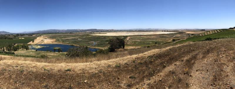
From the top of a hill near the Sonoma Raceway and overlooking Sonoma Creek, you can get a good look at this vast body of water and what’s left of its surrounding wetlands. Julian Meisler, with the Sonoma Land Trust, says this area used to be an expanse of tidal wetlands.

“If you came here 150 years ago this would have been tidal marsh and open water,” says Meisler. “You might have seen bears, eagles, salmon and steelhead swimming up Sonoma Creek.”

But all that changed in the mid 1800s when farmers and landowners built levees, drained the marshes and generally cut off the North Bay's streams from the San Pablo Bay. Because of that, the land here subsided, or dropped, by more than six feet below sea level, says Meisler. That drop has resulted in chronic flooding, even from minor storms. According to a report from the Sonoma Land Trust, landowners and wildlife agencies in this area now rely on pumps to prevent flooding almost every day.

Sonoma Creek is cut off from the Bay and surrounding tidal marshes thanks to a series of levees. (Tiffany Camhi/KQED News)

The $150,000 granted from Measure AA, will address this constant flooding by helping develop a plan for something called landscape or large-scale restoration. This kind of restoration considers how several parcels of land might affect each other and the best way for each parcel’s restoration efforts to work in unison.

Sponsored

“This allows large-scale processes to work like water flowing over big areas, wildlife being able to move over not just two to five acres but over hundreds of thousands of acres,” says Meisler. “Those are opportunities that just don't exist in many places and the level of flood protection that you can get from large-scale wetland restoration dwarfs what you can do in smaller projects.”

Meisler says this project will prioritize not only habitat restoration, but also some vital infrastructure in the area: both Highway 37 and the SMART railroad run through the heart of the San Pablo Bay.

And when it comes to the San Pablo Bay, Meisler says, we don't really have a choice. The overwhelming expectation is that if we do not adapt to sea level rise, flooding in this area will continue to get worse.

“The Bay is coming whether we like it or not and we need to prepare for it,” says Meisler.

lower waypoint
next waypoint
Stunning Archival Photos of the 1906 Earthquake and FireCould Protesters Who Shut Down Golden Gate Bridge Be Charged With False Imprisonment?Why Nearly 50 California Hospitals Were Forced to End Maternity Ward ServicesSan Francisco Sues Oakland Over Plan to Change Airport NameFederal Bureau of Prisons Challenges Judge’s Order Delaying Inmate Transfers from FCI DublinDemocrats Again Vote Down California Ban on Unhoused EncampmentsFirst Trump Criminal Trial Underway in New YorkAlameda County DA Charges 3 Police Officers With Manslaughter in Death of Mario GonzalezDeath Doula Alua Arthur on How and Why to Prepare for the EndDespite Progress, Black Californians Still Face Major Challenges In Closing Equality Gap