upper waypoint

Firefighters Make Progress in Controlling Blaze East of Mount Diablo

Save ArticleSave Article
Failed to save article

Please try again

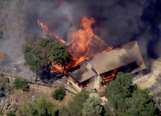
A frame grab of helicopter video showing a home destroyed in Wednesday afternoon's Marsh Fire, near Clayton.  (KTVU)

Update 7:30 a.m. Thursday: Cal Fire says the Marsh Fire southeast of Clayton has burned 247 acres and is now 60 percent contained.

Although the firefighting agency says an aggressive response after the blaze broke out Wednesday afternoon halted its forward progress, evacuation orders remain in place for residents in the sparsely populated area southeast of the junction of Morgan Territory and Marsh Creek Roads.

Cal Fire says one residence and three outbuildings burned after the fire broke out shortly before 3 p.m. Wednesday. Another 100 structures are threatened.

About 180 firefighters are working to finish containment lines.

Original post (last pdated 6:10 p.m. Wednesday)
Sponsored

Contra Costa County authorities ordered emergency evacuations Wednesday afternoon as a wildfire sped through hilly, wooded terrain southeast of the town of Clayton and east of Mount Diablo.

Contra Costa firefighters backed up by Cal Fire crews, air tankers and water-dropping helicopters responded to the fire near the intersection of Marsh Creek Road and Morgan Territory Road.

At least one home was destroyed by the fire, which started about 3 p.m. Cal Fire estimated the blaze had burned 225 acres as of 6:10 p.m.

Firefighters are contending with temperatures near 100 degrees and winds gusting over 20 mph.

The Contra County Sheriff's Office first issued evacuation orders for Leon Drive, a street just southeast of the Marsh Creek-Morgan Territory junction in an area dotted with small ranch properties and rural homes.

At about 5:30 p.m., the sheriff's office expanded the evacuation order to include a roughly 6-mile stretch of Marsh Creek Road between Deer Valley Road and Morgan Territory Road.

Among the squadron of fixed-wing aircraft called in to try to stop the fire's spread was a 747.

This story will be updated.

lower waypoint
next waypoint
Stunning Archival Photos of the 1906 Earthquake and FireCould Protesters Who Shut Down Golden Gate Bridge Be Charged With False Imprisonment?San Francisco Sues Oakland Over Plan to Change Airport NameAlameda County DA Charges 3 Police Officers With Manslaughter in Death of Mario GonzalezDeath Doula Alua Arthur on How and Why to Prepare for the EndAfter Parole, ICE Deported This Refugee Back to a Country He Never KnewDespite Progress, Black Californians Still Face Major Challenges In Closing Equality GapGaza Aid Flotilla to Include Bay Area ResidentsSF’s Equity Program Fails to Address Racial Disparities in Cannabis IndustryWhy Is Google Removing News Links for Some Californians?