upper waypoint

Rim Fire Update: Blaze Continues to Roar, Crosses Into Yosemite National Park

Save ArticleSave Article
Failed to save article

Please try again

Fire crews near Groveland, a community west of Yosemite National Park threatened by the Rim Fire. (Justin Sullivan/Getty Images)

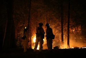
Latest post: Blaze Slows But Remains Extremely Dangerous

Details, as of 10:30 p.m. PDT Friday: The fire that's been burning all week just west of Yosemite took another giant leap in size Friday, with U.S. Forest Service and CalFire reporting the blaze, named the Rim Fire, has now covered more than 125,000 acres (more below on how big that really is). The conflagration is just 5 percent contained, and a force of nearly 2,700 firefighters, backed by big aerial tankers, is struggling to stop the blaze as gusty winds drive it through rugged, hard-to-reach terrain. Fire officials say the blaze threatens 5,500 homes. So far, four homes have burned along with about a dozen other structures.

  • Early Friday, the fire crossed the western boundary of Yosemite National Park, burning in a remote area near Lake Eleanor. The blaze remains far from iconic park destinations like Yosemite Valley.
  • Later in the day, officials said the fire had spread west toward the Highway 108, the route between the town of Sonora and Sonora Pass, and that aerial tankers were flying missions to try to slow the spread of the blaze in that direction.
  • So far, the gated resort town of Pine Mountain Lake (population 2,800) and rural settlement of Buck Meadows (50 people) are the only communities facing a mandatory evacuation. But authorities issued evacuation advisories for several other towns, including Tuolumne City (population 1,800), Groveland (600) and Ponderosa Hills.
  • Gov. Jerry Brown declared a state of emergency for San Francisco, which has major water and hydropower resources in the fire area. The declaration makes state funds available to the city to respond to the threat to the facilities and could free federal funding to help offset the city's costs in replacing electrical power it's been unable to generate during the fire. Earlier, Brown declared a state of emergency for Tuolumne County to help local officials with their emergency response.
  • Highway 120 west of Yosemite, the main route to the park from the Bay Area, remains closed. Travelers can still get into the park on Highway 140 (via Merced), Highway 41 (via Oakhurst) and on Highway 120 east of the park (via Lee Vining and Tioga Pass).
  • San Francisco has shut down two powerhouses in the fire zone and is waiting to get the all-clear from fire officials before sending crews in to inspect them. The facilities are part of the city's Hetch Hetchy water and power system and can generate 160 megawatts of power. The city uses that electricity to run Muni, light City Hall, and for the rest of its municipal needs. For the time being, it's replacing the power with energy "banked" with PG&E and by buying electricity from other providers.
  • Hotels and resorts in the area have been shut down, along with several municipal high-country vacation retreats such as San Francisco's Camp Mather. We haven't seen any hard numbers on how many people have actually been evacuated from the area.
  • KQED News Associate Berkeleyside reports that UC Berkeley has closed its popular camp, Lair of the Bear. The city of Berkeley's Tuolumne Family Camp, San Jose's city camp and the Jewish Camp Tawonga have also been evacuated.
  • Air quality regulators in Reno have issued an alert for unhealthy air for the next several days as smoke from the Rim Fire and a second blaze farther north in the Sierra, the American Fire, is carried to the northeast.

Now, how big is 125,000 acres? Some news organizations, like NPR, have taken to reporting the size of fires in square miles instead of acres, apparently in the belief that listeners and readers can better grasp the magnitude of the events that way. So, 105,000 acres is 196 square miles. Here's still another way to think of the size of this fire, which has grown eightfold in area since early Wednesday:

One hundred ninety-six square miles is:

  • About four times the area of San Francisco.
  • Roughly equivalent to the combined area of Richmond, El Cerrito, Albany, Berkeley, Emeryville, and Oakland—in other words, nearly everything between the bay shore and crest of the East Bay hills from the Richmond-San Rafael Bridge down to the Oakland Airport.
  • All of San Jose's sprawling 180 square miles, with the city of Santa Clara thrown in for good measure.

Here's KPCC's graphic summary of the Rim Fire:

Sponsored

And here's the latest (9:45 p.m. Friday) on the fire from the Associated Press:

FRESNO — A giant wildfire raging out of control grew to nearly 200 square miles and spread into Yosemite National Park on Friday, as California Gov. Jerry Brown declared a state of emergency for the city of San Francisco 150 miles away because of the threat to the city's utilities.

The fire hit the park at the height of summer season, as officials geared up for a busy Labor Day weekend. It has closed some backcountry hiking but was not threatening the Yosemite Valley region, one of California's most popular tourist destinations that features such iconic sights as the Half Dome and El Capitan rock formations and Bridalveil and Yosemite falls.

The blaze did, however, pose a threat to the lines and stations that pipe power to the city of San Francisco, so Brown, who had declared an emergency for the fire area earlier in the week, made the unusual move of extending the emergency declaration to the city across the state.

San Francisco gets 85 percent of its water from the Yosemite-area Hetch Hetchy reservoir that is about 4 miles from the fire, though that had yet to be affected. But it was forced to shut down two of its three hydroelectric power stations in the area.

The city has so far been able to buy power on the open market and use existing supplies, but further disruptions or damage could have an effect, according to city power officials and the governor's statement.

The declaration frees funding and resources to help the city and makes it eligible for more federal funds to help with power shortages and outages or water problems.

The weeklong blaze on the timbered slopes of the Western Sierra Nevada has spread to 196 square miles and was only 5 percent contained. It continued to grow in several directions, although "most of the fire activity is pushing to the east right into Yosemite," said Daniel Berlant, spokesman for the California Department of Forestry and Fire Protection.

Smoke blowing across the Sierra into the state of Nevada forced officials in several counties to cancel outdoor school activities and issue health advisories, especially for people with respiratory problems.

Authorities urged more evacuations in nearby communities where thousands have already been forced out by flames.

The fire was threatening about 5,500 residences, according to the U.S. Forest Service. The blaze has destroyed four homes and 12 outbuildings in several different areas. More than 2,000 firefighters were on the lines and one sustained a heat-related injury.

While the park remained open, the blaze closed a 4-mile stretch of State Route 120, one of three entrances into Yosemite on the west side. Two other western routes and an eastern route were open.

Within the park, the blaze was burning on about 17 square miles in a remote area around Lake Eleanor, Yosemite spokeswoman Kari Cobb said.

Backcountry permits are required to hike in that area, Cobb said. The park was no longer issuing those and had contacted every person who had received a permit to go there. Two roads into that area were closed and occupants of a campground near the Route 120 west entrance were relocated.

"We don't have anybody we know of in that area based on the permits we have out now," she said.

The fire was more than 20 miles from Yosemite Valley and skies there were "crystal clear," Cobb said.

"Right now there are no closures, and no visitor services are being affected in the park," he said. "We just have to take one day at a time depending on fire activity."

On Friday, officials issued voluntary evacuation advisories for two new towns — Tuolumne City, population 1,800, and Ponderosa Hills, a community of several hundred — which are about five miles from the fire line, Forest Service spokesman Jerry Snyder said.

A mandatory evacuation order remained in effect for part of Pine Mountain Lake, a summer gated community a few miles from the fire.

"It feels a little bit like a war zone, with helicopters flying overhead, bombers dropping retardant and 10 engine companies stationed on our street," said Ken Codeglia, a retired Pine Mountain Lake resident who decided to stay to protect his house with his own hoses and fire retardant system. "But if the fire gets very hot and firefighters evacuate, I will run with them."

Officials previously advised voluntary evacuations of more than a thousand other homes, several organized camps and at least two campgrounds in the area outside the park's boundary.

More homes, businesses and hotels are threatened in nearby Groveland, a community of 600 about 5 miles from the fire and 25 miles from the entrance of Yosemite.

Usually filled with tourists, the streets are now swarming with firefighters, evacuees, and news crews, said Doug Edwards, owner of Hotel Charlotte on Main Street.

"We usually book out six months solid with no vacancies and turn away 30-40 people a night. That's all changed," Edwards said. "All we're getting for the next three weeks is cancellations. It's a huge impact on the community in terms of revenue dollars."

Park fire crews are working to clear brush and other fire fuels from the Merced and Tuolumne Groves of Giant Sequoias as a precaution.

The fire is raging in the same region where a 1987 fire killed a firefighter, burned hundreds of thousands of acres, and forced several thousand people out of their homes.

___

Sponsored

Associated Press writers Jason Dearen, Lisa Leff and Andrew Dalton in San Francisco also contributed to this report.

lower waypoint
next waypoint
Pro-Palestinian Protests Sweep Bay Area College Campuses Amid Surging National MovementAt Least 16 People Died in California After Medics Injected Sedatives During Police EncountersCalifornia Regulators Just Approved New Rule to Cap Health Care Costs. Here's How It WorksState Court Upholds Alameda County Tax Measure Yielding Hundreds of Millions for Child CareYouth Takeover: Parents (and Teachers) Just Don't UnderstandSan José Adding Hundreds of License Plate Readers Amid Privacy and Efficacy ConcernsCalifornia Law Letting Property Owners Split Lots to Build New Homes Is 'Unconstitutional,' Judge RulesViolence Escalates in Sudan as Civil War Enters Second YearSF Emergency Dispatchers Struggle to Respond Amid Outdated Systems, Severe UnderstaffingWomen at Troubled East Bay Prison Forced to Relocate Across the Country