How Drones Could Advance Polar Science and Navigation (Once They Work Out the Kinks)
One thing we know: the Antarctic is a very different animal than the Arctic when it comes to interpreting ice patterns.
Brandon R. Reynolds
X marks the spot. Aerovironment's Kevin Volbrecht and NOAA team members use a giant net to snag a research drone at the end of its flight -- they hope. (Brandon R. Reynolds)
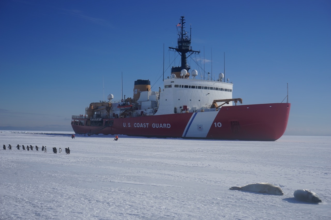
The sixth in a series of dispatches from freelance writer Brandon Reynolds aboard the USCG icebreaker Polar Star, on its annual resupply mission to the research base, McMurdo Station. It’s a critical task imperiled by the nation’s aging, shrinking fleet of ice-breaking ships.
On the lost continent of Antarctica, what has been discovered most are superlatives. Antarctica is the coldest, driest, windiest, highest continent on Earth. It can also be one of the most treacherous, as the recent death of British explorer Henry Worsley underscores. Since the days of Amundsen, Scott and Shackleton, science here has been a matter of feel as much as anything else.
Nowadays science is more bureaucratic. It’s to be expected when many nations converge on a continent and all stand around pretending they don’t want to take it over.
“Take us to your leader:” Antarctic wildlife turns out to greet Polar Star when she reaches the pack ice. (Brandon R. Reynolds)
The U.S. Coast Guard icebreaker Polar Star once supported science on its missions: releasing weather balloons and buoys to measure oceanic tides and temperatures, that esoteric stuff that’s seeking answers to questions you never thought to ask. The National Science Foundation pays for the Polar Star’s mission once it drops below the Antarctic Circle, and its priorities now have stripped the science off Polar Star so that now the icebreaker’s only job is to clear the channel for the ships to bring food and fuel and booze and equipment and t-shirts, the raw materials needed not just to run a research station and the science that goes on there, but to connect an entire continent.
So science doesn’t much happen on Polar Star anymore. The shipping container that once housed all the science equipment has become a cigar lounge of the apocalypse, and the onboard lab is used to store bicycles. But science has stowed away, and it looks like toys.
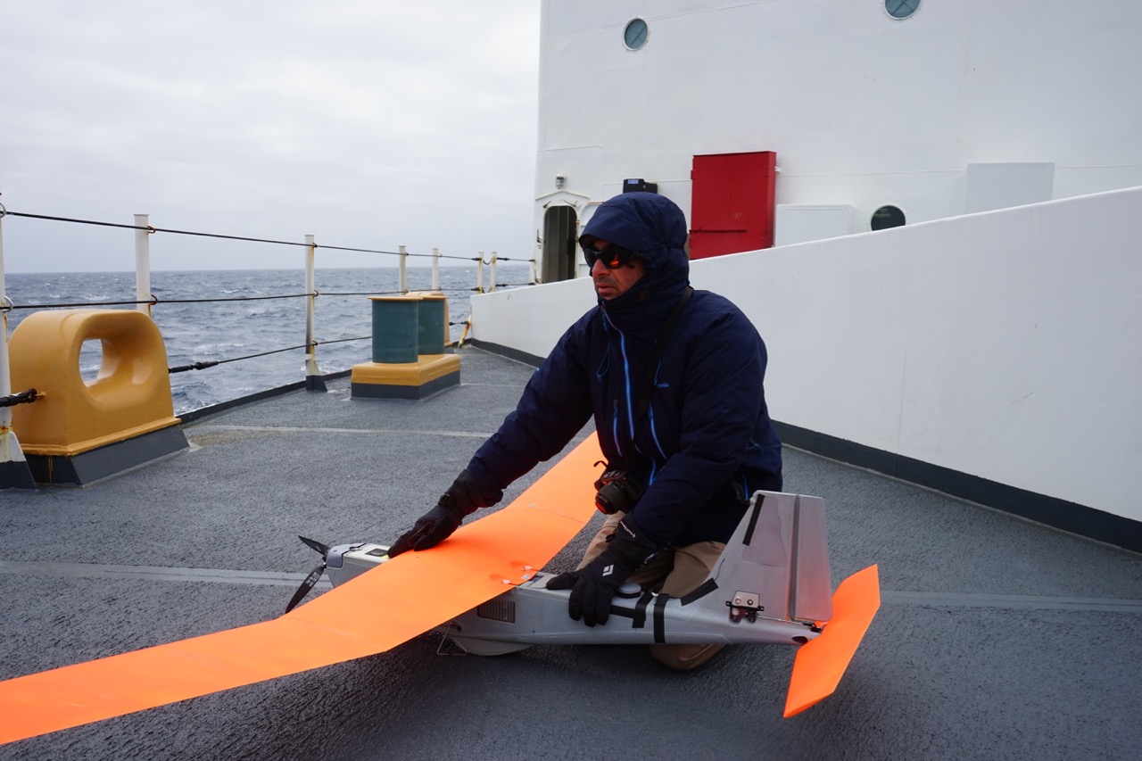
Todd Jacobs of NOAA holds the Puma down against high winds. (Brandon R. Reynolds)
The National Oceanic and Atmospheric Administration has attached a delegation to this year’s Deep Freeze. The Coast Guard, just like any American in any public park these days, is fascinated by all the drones flying around, and wondered: How the hell can we make these things useful?
NOAA’s been exploring the use of drones, or “unmanned aerial vehicles,” depending on your sensitivity to the word “drone,” for counting marine mammals and birds, tracking oil spills, and surveilling protected fisheries. “Aha!,” said the Coast Guard. The two agencies have been partnering for the last few years on using drones for those “dirty, dull, and dangerous” jobs, says Todd Jacobs, Project Manager for NOAA’s Unmanned Aircraft Systems Program Office. Send the drones to those places where the risk of boredom or death is high. “These are places that you couldn’t otherwise get to without unmanned aircraft,” says Jacobs.
For this trip, the Coast Guard was interested in using drones to scout ice conditions ahead of the ship. In the past, there have been helicopters, which are far more costly to operate. Jacobs and a team from UAV-maker Aerovironment brought some electric-motor-driven gliders with nine-foot wingspans, traditionally used to assess battlefield conditions or silently track, say, suspected terrorists. “I see it as a swords-to-ploughshares kind of conversion,” Jacobs says. “To get another life out of them I think is kind of a big win for the American public.”
The Aerovironment Puma is the big brother of the militarily popular Raven. It can be hand-launched, flown manually or auto-piloted, fly up to four hours, and land on water, which is how NOAA retrieves it after many flights. On Polar Star, a prototype net-capture system has been set up on the flight deck to catch the thing.
Kevin Volbrecht of Aerovironment fishes the Puma out of the drink. (Brandon R. Reynolds)
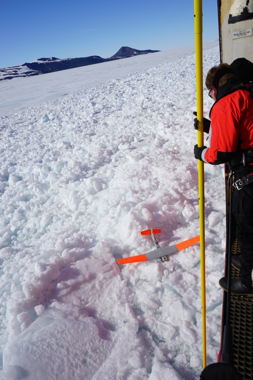
On the Coast Guard’s Arctic icebreaker Healy last summer, the team reports that the Puma flew well and true. On Polar Star, it hasn’t done so great. There have been crashes on ice and water caused by wind and other, as-yet-undiagnosed problems, and delays and cancellations due to scheduling issues with the research base at McMurdo Station. The NOAA and Aerovironment teams are frustrated, but they keep patching the birds back together and sending them aloft. They got it out to 25 nautical miles on one run, which is a pioneering first for Antarctic unmanned flight. If they figure it all out, drone technology could at least supplement some of the dangerous/boring things the helos tend to do and expand the ability to map the continent in real-time. On the lost continent, they continue the Antarctic tradition of discovering perseverance in a place that pretty much wants to destroy all of man’s puny works.
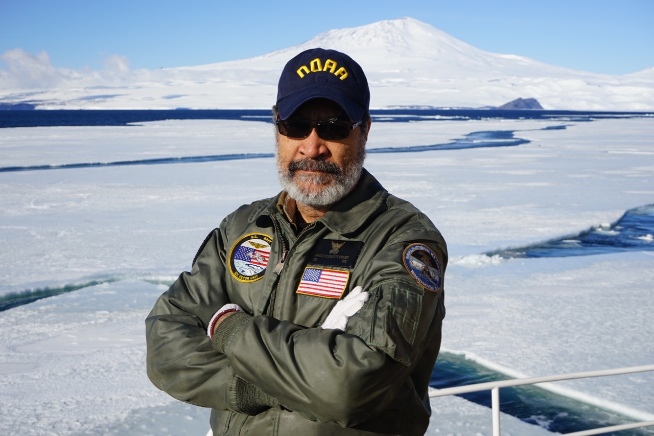
Backing up the Puma mission is another bit of ice science, led by Pablo Clemente-Colón of NOAA’s National Ice Center in Suitland, Maryland. Clemente-Colón is chief scientist at NIC and an expert in sea ice, a satellite oceanographer who scopes out the ice condition from far above. NIC analyst Chris Readinger is also aboard. He provides satellite photos to help the crew make navigational decisions, but this is the first time in a few years that there have been people aboard who can read that information and interpret, say, how old the ice is, or how stable.
Pablo Clemente-Colón, chief scientist of NOAA’s National Ice Center. (Brandon R. Reynolds)
Clemente-Colón has been at it since 1979. He’s spent most of the last decade summering in the Arctic with NOAA, NSF, and the Coast Guard, studying the age and melting patterns of ice. It’s not enough to look at how much ice there is. As with most things, the truth is below the surface.
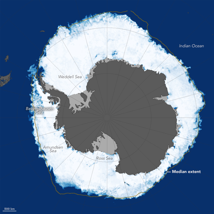
“First-year” ice, the two-meter stuff that we’re crashing through here, will often melt during the summers, creating open water before refreezing in the winter. Multiyear sea ice, which can be a decade old, is much thicker and less prone to melting, generally. It’s more stable. So looking at the extent of surface ice won’t tell the whole story, says Clemente-Colón. Sea ice could extend farther than in previous years, but if it’s first-year, it’s thinner, so the total volume of ice out there is less.
“Which means that for the next summer it could melt much more rapidly and you would have more weeks or months of open water during the summer than if the cover contained a significantly larger volume of multiyear ice.” That creates positive feedback, he says. “The more the cover retreats during the summer, the more heat is absorbed by the ocean, the more there is a delay in the next freezing, and the less opportunity for the ice to really sustain itself through the years.”
Sea ice around Antarctica reached its annual peak in October, 2015. The extent was a retreat from recent record highs. (NASA Earth Observatory)
In the Arctic, these changes are more readily apparent, because it’s all ice and no land. In Antarctica, the giant cap of ice on the continent, plus the circulating Southern Ocean, keeps the system more stable. Don’t look here for answers to what all this will do to your local weather. Clemente-Colón says it raises a lot of questions, which are challenges, which seems to be the primary export of the polar regions.
“What are the changes in that system? How are those changes affecting the planetary climate? I don’t think we’re there yet,” he says. “Even in the Arctic where we know that the changes are real, it’s sometimes difficult to link those changes to what’s happening in lower latitudes.”
Next: Where to From Here?
Brandon R. Reynolds lives in Los Angeles but currently summers in the Antarctic Circle. He has written for San Francisco Magazine, SF Weekly, The Atlantic, and Oxford American (not the dictionary).
lower waypointnext waypoint
Player sponsored by
window.__IS_SSR__=true
window.__INITIAL_STATE__={
"attachmentsReducer": {
"audio_0": {
"type": "attachments",
"id": "audio_0",
"imgSizes": {
"kqedFullSize": {
"file": "https://ww2.kqed.org/news/wp-content/themes/KQED-unified/img/audio_bgs/background0.jpg"
}
}
},
"audio_1": {
"type": "attachments",
"id": "audio_1",
"imgSizes": {
"kqedFullSize": {
"file": "https://ww2.kqed.org/news/wp-content/themes/KQED-unified/img/audio_bgs/background1.jpg"
}
}
},
"audio_2": {
"type": "attachments",
"id": "audio_2",
"imgSizes": {
"kqedFullSize": {
"file": "https://ww2.kqed.org/news/wp-content/themes/KQED-unified/img/audio_bgs/background2.jpg"
}
}
},
"audio_3": {
"type": "attachments",
"id": "audio_3",
"imgSizes": {
"kqedFullSize": {
"file": "https://ww2.kqed.org/news/wp-content/themes/KQED-unified/img/audio_bgs/background3.jpg"
}
}
},
"audio_4": {
"type": "attachments",
"id": "audio_4",
"imgSizes": {
"kqedFullSize": {
"file": "https://ww2.kqed.org/news/wp-content/themes/KQED-unified/img/audio_bgs/background4.jpg"
}
}
},
"placeholder": {
"type": "attachments",
"id": "placeholder",
"imgSizes": {
"thumbnail": {
"file": "https://cdn.kqed.org/wp-content/uploads/2024/12/KQED-Default-Image-816638274-2000x1333-1-160x107.jpg",
"width": 160,
"height": 107,
"mimeType": "image/jpeg"
},
"medium": {
"file": "https://cdn.kqed.org/wp-content/uploads/2024/12/KQED-Default-Image-816638274-2000x1333-1-800x533.jpg",
"width": 800,
"height": 533,
"mimeType": "image/jpeg"
},
"medium_large": {
"file": "https://cdn.kqed.org/wp-content/uploads/2024/12/KQED-Default-Image-816638274-2000x1333-1-768x512.jpg",
"width": 768,
"height": 512,
"mimeType": "image/jpeg"
},
"large": {
"file": "https://cdn.kqed.org/wp-content/uploads/2024/12/KQED-Default-Image-816638274-2000x1333-1-1020x680.jpg",
"width": 1020,
"height": 680,
"mimeType": "image/jpeg"
},
"1536x1536": {
"file": "https://cdn.kqed.org/wp-content/uploads/2024/12/KQED-Default-Image-816638274-2000x1333-1-1536x1024.jpg",
"width": 1536,
"height": 1024,
"mimeType": "image/jpeg"
},
"fd-lrg": {
"file": "https://cdn.kqed.org/wp-content/uploads/2024/12/KQED-Default-Image-816638274-2000x1333-1-1536x1024.jpg",
"width": 1536,
"height": 1024,
"mimeType": "image/jpeg"
},
"fd-med": {
"file": "https://cdn.kqed.org/wp-content/uploads/2024/12/KQED-Default-Image-816638274-2000x1333-1-1020x680.jpg",
"width": 1020,
"height": 680,
"mimeType": "image/jpeg"
},
"fd-sm": {
"file": "https://cdn.kqed.org/wp-content/uploads/2024/12/KQED-Default-Image-816638274-2000x1333-1-800x533.jpg",
"width": 800,
"height": 533,
"mimeType": "image/jpeg"
},
"post-thumbnail": {
"file": "https://cdn.kqed.org/wp-content/uploads/2024/12/KQED-Default-Image-816638274-2000x1333-1-672x372.jpg",
"width": 672,
"height": 372,
"mimeType": "image/jpeg"
},
"twentyfourteen-full-width": {
"file": "https://cdn.kqed.org/wp-content/uploads/2024/12/KQED-Default-Image-816638274-2000x1333-1-1038x576.jpg",
"width": 1038,
"height": 576,
"mimeType": "image/jpeg"
},
"xxsmall": {
"file": "https://cdn.kqed.org/wp-content/uploads/2024/12/KQED-Default-Image-816638274-2000x1333-1-160x107.jpg",
"width": 160,
"height": 107,
"mimeType": "image/jpeg"
},
"xsmall": {
"file": "https://cdn.kqed.org/wp-content/uploads/2024/12/KQED-Default-Image-816638274-2000x1333-1-672x372.jpg",
"width": 672,
"height": 372,
"mimeType": "image/jpeg"
},
"small": {
"file": "https://cdn.kqed.org/wp-content/uploads/2024/12/KQED-Default-Image-816638274-2000x1333-1-672x372.jpg",
"width": 672,
"height": 372,
"mimeType": "image/jpeg"
},
"xlarge": {
"file": "https://cdn.kqed.org/wp-content/uploads/2024/12/KQED-Default-Image-816638274-2000x1333-1-1020x680.jpg",
"width": 1020,
"height": 680,
"mimeType": "image/jpeg"
},
"full-width": {
"file": "https://cdn.kqed.org/wp-content/uploads/2024/12/KQED-Default-Image-816638274-2000x1333-1-1920x1280.jpg",
"width": 1920,
"height": 1280,
"mimeType": "image/jpeg"
},
"guest-author-32": {
"file": "https://cdn.kqed.org/wp-content/uploads/2025/01/KQED-Default-Image-816638274-1333x1333-1-160x160.jpg",
"width": 32,
"height": 32,
"mimeType": "image/jpeg"
},
"guest-author-50": {
"file": "https://cdn.kqed.org/wp-content/uploads/2025/01/KQED-Default-Image-816638274-1333x1333-1-160x160.jpg",
"width": 50,
"height": 50,
"mimeType": "image/jpeg"
},
"guest-author-64": {
"file": "https://cdn.kqed.org/wp-content/uploads/2025/01/KQED-Default-Image-816638274-1333x1333-1-160x160.jpg",
"width": 64,
"height": 64,
"mimeType": "image/jpeg"
},
"guest-author-96": {
"file": "https://cdn.kqed.org/wp-content/uploads/2025/01/KQED-Default-Image-816638274-1333x1333-1-160x160.jpg",
"width": 96,
"height": 96,
"mimeType": "image/jpeg"
},
"guest-author-128": {
"file": "https://cdn.kqed.org/wp-content/uploads/2025/01/KQED-Default-Image-816638274-1333x1333-1-160x160.jpg",
"width": 128,
"height": 128,
"mimeType": "image/jpeg"
},
"detail": {
"file": "https://cdn.kqed.org/wp-content/uploads/2025/01/KQED-Default-Image-816638274-1333x1333-1-160x160.jpg",
"width": 160,
"height": 160,
"mimeType": "image/jpeg"
},
"kqedFullSize": {
"file": "https://cdn.kqed.org/wp-content/uploads/2024/12/KQED-Default-Image-816638274-2000x1333-1.jpg",
"width": 2000,
"height": 1333
}
}
},
"science_493522": {
"type": "attachments",
"id": "science_493522",
"meta": {
"index": "attachments_1716263798",
"site": "science",
"id": "493522",
"found": true
},
"parent": 493068,
"imgSizes": {
"twentyfourteen-full-width": {
"file": "https://ww2.kqed.org/app/uploads/sites/35/2016/01/net-1038x576.jpg",
"width": 1038,
"mimeType": "image/jpeg",
"height": 576
},
"thumbnail": {
"file": "https://ww2.kqed.org/app/uploads/sites/35/2016/01/net-400x267.jpg",
"width": 400,
"mimeType": "image/jpeg",
"height": 267
},
"fd-sm": {
"file": "https://ww2.kqed.org/app/uploads/sites/35/2016/01/net-960x640.jpg",
"width": 960,
"mimeType": "image/jpeg",
"height": 640
},
"post-thumbnail": {
"file": "https://ww2.kqed.org/app/uploads/sites/35/2016/01/net-672x372.jpg",
"width": 672,
"mimeType": "image/jpeg",
"height": 372
},
"kqedFullSize": {
"file": "https://ww2.kqed.org/app/uploads/sites/35/2016/01/net.jpg",
"width": 1280,
"height": 853
},
"guest-author-96": {
"file": "https://ww2.kqed.org/app/uploads/sites/35/2016/01/net-96x96.jpg",
"width": 96,
"mimeType": "image/jpeg",
"height": 96
},
"medium": {
"file": "https://ww2.kqed.org/app/uploads/sites/35/2016/01/net-800x533.jpg",
"width": 800,
"mimeType": "image/jpeg",
"height": 533
},
"guest-author-64": {
"file": "https://ww2.kqed.org/app/uploads/sites/35/2016/01/net-64x64.jpg",
"width": 64,
"mimeType": "image/jpeg",
"height": 64
},
"guest-author-32": {
"file": "https://ww2.kqed.org/app/uploads/sites/35/2016/01/net-32x32.jpg",
"width": 32,
"mimeType": "image/jpeg",
"height": 32
},
"fd-med": {
"file": "https://ww2.kqed.org/app/uploads/sites/35/2016/01/net-1180x786.jpg",
"width": 1180,
"mimeType": "image/jpeg",
"height": 786
},
"detail": {
"file": "https://ww2.kqed.org/app/uploads/sites/35/2016/01/net-75x75.jpg",
"width": 75,
"mimeType": "image/jpeg",
"height": 75
},
"medium_large": {
"file": "https://ww2.kqed.org/app/uploads/sites/35/2016/01/net-768x512.jpg",
"width": 768,
"mimeType": "image/jpeg",
"height": 512
},
"guest-author-128": {
"file": "https://ww2.kqed.org/app/uploads/sites/35/2016/01/net-128x128.jpg",
"width": 128,
"mimeType": "image/jpeg",
"height": 128
}
},
"publishDate": 1453845454,
"modified": 1453850655,
"caption": "X marks the spot. Aerovironment's Kevin Volbrecht and NOAA team members use a giant net to snag a research drone at the end of its flight -- they hope.",
"description": "X marks the spot. Aerovironment's Kevin Volbrecht and NOAA team members use a giant net to snag a research drone at the end of its flight -- they hope.",
"title": "net",
"credit": "Brandon R. Reynolds",
"status": "inherit",
"isLoading": false,
"fetchFailed": false
}
},
"audioPlayerReducer": {
"postId": "stream_live",
"isPaused": true,
"isPlaying": false,
"pfsActive": false,
"pledgeModalIsOpen": true,
"playerDrawerIsOpen": false,
"liveAudioPlayStartedAt": 0,
"liveAudioPlayContext": ""
},
"authorsReducer": {
"byline_science_493068": {
"type": "authors",
"id": "byline_science_493068",
"meta": {
"override": true
},
"slug": "byline_science_493068",
"name": "\u003cstrong>Brandon R. Reynolds\u003c/strong>",
"isLoading": false
}
},
"pagesReducer": {},
"pfsSessionReducer": {},
"postsReducer": {
"stream_live": {
"type": "live",
"id": "stream_live",
"audioUrl": "https://streams.kqed.org/kqedradio",
"title": "Live Stream",
"excerpt": "Live Stream information currently unavailable.",
"link": "/radio",
"featImg": "",
"label": {
"name": "KQED Live",
"link": "/"
}
},
"stream_kqedNewscast": {
"type": "posts",
"id": "stream_kqedNewscast",
"audioUrl": "https://www.kqed.org/.stream/anon/radio/RDnews/newscast.mp3?_=1",
"title": "KQED Newscast",
"featImg": "",
"label": {
"name": "88.5 FM",
"link": "/"
}
},
"science_493068": {
"type": "posts",
"id": "science_493068",
"meta": {
"index": "posts_1716263798",
"site": "science",
"id": "493068",
"found": true
},
"articlePosition": 0,
"parent": 0,
"labelTerm": {
"site": "science",
"term": 2827
},
"blocks": [],
"publishDate": 1453906825,
"format": "standard",
"title": "How Drones Could Advance Polar Science and Navigation (Once They Work Out the Kinks)",
"headTitle": "How Drones Could Advance Polar Science and Navigation (Once They Work Out the Kinks) | KQED",
"content": "\u003cp>\u003cem>The sixth in a \u003ca href=\"http://ww2.kqed.org/science/series/breaking-the-ice/\">series of dispatches\u003c/a> from freelance writer Brandon Reynolds aboard the USCG icebreaker Polar Star, on its annual resupply mission to the research base, McMurdo Station. It’s a critical task imperiled by the nation’s aging, shrinking fleet of ice-breaking ships.\u003c/em>\u003c/p>\n\u003cp>On the lost continent of Antarctica, what has been discovered most are superlatives. Antarctica is the coldest, driest, windiest, highest continent on Earth. It can also be one of the most treacherous, as the recent \u003ca href=\"http://www.nytimes.com/2016/01/26/world/europe/henry-worsley-british-explorer.html?_r=0\">death of British explorer Henry Worsley\u003c/a> underscores. Since the days of \u003ca href=\"https://en.wikipedia.org/wiki/Heroic_Age_of_Antarctic_Exploration\">Amundsen, Scott and Shackleton\u003c/a>, science here has been a matter of feel as much as anything else.\u003c/p>\n\u003cp>Nowadays science is more bureaucratic. It’s to be expected when many nations converge on a continent and all stand around pretending they don’t want to take it over.\u003c/p>\n\u003cfigure id=\"attachment_493682\" class=\"wp-caption alignleft\" style=\"max-width: 1280px\">\u003cimg loading=\"lazy\" decoding=\"async\" class=\"size-full wp-image-493682\" src=\"http://ww2.kqed.org/science/wp-content/uploads/sites/35/2016/01/DSC01668.jpg\" alt=\"Antarctic wildlife turns out to greet Polar Star when she reaches the pack ice.\" width=\"1280\" height=\"853\" srcset=\"https://cdn.kqed.org/wp-content/uploads/sites/35/2016/01/DSC01668.jpg 1280w, https://cdn.kqed.org/wp-content/uploads/sites/35/2016/01/DSC01668-400x267.jpg 400w, https://cdn.kqed.org/wp-content/uploads/sites/35/2016/01/DSC01668-800x533.jpg 800w, https://cdn.kqed.org/wp-content/uploads/sites/35/2016/01/DSC01668-768x512.jpg 768w, https://cdn.kqed.org/wp-content/uploads/sites/35/2016/01/DSC01668-1180x786.jpg 1180w, https://cdn.kqed.org/wp-content/uploads/sites/35/2016/01/DSC01668-960x640.jpg 960w\" sizes=\"(max-width: 1280px) 100vw, 1280px\">\u003cfigcaption class=\"wp-caption-text\">“Take us to your leader:” Antarctic wildlife turns out to greet Polar Star when she reaches the pack ice. \u003ccite>(Brandon R. Reynolds)\u003c/cite>\u003c/figcaption>\u003c/figure>\n\u003cp>The \u003ca href=\"http://ww2.kqed.org/science/2014/11/03/aging-u-s-icebreaker-fleet-may-imperil-polar-science/\">U.S. Coast Guard icebreaker Polar Star\u003c/a> once supported science on its missions: releasing weather balloons and buoys to measure oceanic tides and temperatures, that esoteric stuff that’s seeking answers to questions you never thought to ask. The National Science Foundation pays for the Polar Star’s mission once it drops below the Antarctic Circle, and its priorities now have stripped the science off Polar Star so that now the icebreaker’s only job is to clear the channel for the ships to bring food and fuel and booze and equipment and t-shirts, the raw materials needed not just to run a research station and the science that goes on there, but to connect an entire continent.\u003c/p>\n\u003cp>So science doesn’t much happen on Polar Star anymore. The shipping container that once housed all the science equipment has become a cigar lounge of the apocalypse, and the onboard lab is used to store bicycles. But science has stowed away, and it looks like toys.\u003c/p>\n\u003cfigure id=\"attachment_493524\" class=\"wp-caption alignright\" style=\"max-width: 1280px\">\u003cimg loading=\"lazy\" decoding=\"async\" class=\"wp-image-493524 size-full\" src=\"http://ww2.kqed.org/science/wp-content/uploads/sites/35/2016/01/jacobs.jpg\" alt=\"Todd Jacobs of NOAA holds the Puma down against high winds.\" width=\"1280\" height=\"853\" srcset=\"https://cdn.kqed.org/wp-content/uploads/sites/35/2016/01/jacobs.jpg 1280w, https://cdn.kqed.org/wp-content/uploads/sites/35/2016/01/jacobs-400x267.jpg 400w, https://cdn.kqed.org/wp-content/uploads/sites/35/2016/01/jacobs-800x533.jpg 800w, https://cdn.kqed.org/wp-content/uploads/sites/35/2016/01/jacobs-768x512.jpg 768w, https://cdn.kqed.org/wp-content/uploads/sites/35/2016/01/jacobs-1180x786.jpg 1180w, https://cdn.kqed.org/wp-content/uploads/sites/35/2016/01/jacobs-960x640.jpg 960w\" sizes=\"(max-width: 1280px) 100vw, 1280px\">\u003cfigcaption class=\"wp-caption-text\">Todd Jacobs of NOAA holds the Puma down against high winds. \u003ccite>(Brandon R. Reynolds)\u003c/cite>\u003c/figcaption>\u003c/figure>\n\u003cp>The National Oceanic and Atmospheric Administration has attached a delegation to this year’s Deep Freeze. The Coast Guard, just like any American in any public park these days, is fascinated by all the drones flying around, and wondered: How the hell can we make these things useful?\u003c/p>\n\u003cp>[ad fullwidth]\u003c/p>\n\u003cp>NOAA’s been exploring the use of drones, or “unmanned aerial vehicles,” depending on your sensitivity to the word “drone,” for counting marine mammals and birds, tracking oil spills, and surveilling protected fisheries. “Aha!,” said the Coast Guard. The two agencies have been partnering for the last few years on using drones for those “dirty, dull, and dangerous” jobs, says Todd Jacobs, Project Manager for \u003ca href=\"http://uas.noaa.gov/\">NOAA’s Unmanned Aircraft Systems Program\u003c/a> Office. Send the drones to those places where the risk of boredom or death is high. “These are places that you couldn’t otherwise get to without unmanned aircraft,” says Jacobs.\u003c/p>\n\u003cp>For this trip, the Coast Guard was interested in using drones to scout ice conditions ahead of the ship. In the past, there have been helicopters, which are far more costly to operate. Jacobs and a team from UAV-maker Aerovironment brought some \u003ca href=\"http://www.avinc.com/uas/small_uas/puma/\">electric-motor-driven gliders\u003c/a> with nine-foot wingspans, traditionally used to assess battlefield conditions or silently track, say, suspected terrorists. “I see it as a swords-to-ploughshares kind of conversion,” Jacobs says. “To get another life out of them I think is kind of a big win for the American public.”\u003c/p>\n\u003cp>The Aerovironment Puma is the big brother of the militarily popular Raven. It can be hand-launched, flown manually or auto-piloted, fly up to four hours, and land on water, which is how NOAA retrieves it after many flights. On Polar Star, a prototype net-capture system has been set up on the flight deck to catch the thing.\u003c/p>\n\u003cfigure id=\"attachment_493528\" class=\"wp-caption alignright\" style=\"max-width: 853px\">\u003cimg loading=\"lazy\" decoding=\"async\" class=\"wp-image-493528 size-full\" src=\"http://ww2.kqed.org/science/wp-content/uploads/sites/35/2016/01/fishing2.jpg\" alt=\"Kevin Volbrecht of Aerovironment fishes the Puma out of the drink.\" width=\"853\" height=\"1280\" srcset=\"https://cdn.kqed.org/wp-content/uploads/sites/35/2016/01/fishing2.jpg 853w, https://cdn.kqed.org/wp-content/uploads/sites/35/2016/01/fishing2-400x600.jpg 400w, https://cdn.kqed.org/wp-content/uploads/sites/35/2016/01/fishing2-800x1200.jpg 800w, https://cdn.kqed.org/wp-content/uploads/sites/35/2016/01/fishing2-768x1152.jpg 768w\" sizes=\"(max-width: 853px) 100vw, 853px\">\u003cfigcaption class=\"wp-caption-text\">Kevin Volbrecht of Aerovironment fishes the Puma out of the drink. \u003ccite>(Brandon R. Reynolds)\u003c/cite>\u003c/figcaption>\u003c/figure>\n\u003cp>On the Coast Guard’s Arctic icebreaker Healy last summer, the team reports that the Puma flew well and true. On Polar Star, it hasn’t done so great. There have been crashes on ice and water caused by wind and other, as-yet-undiagnosed problems, and delays and cancellations due to scheduling issues with the research base at \u003ca href=\"http://www.coolantarctica.com/Bases/McMurdo/mcmurdo-base-antarctica.php\">McMurdo Station\u003c/a>. The NOAA and Aerovironment teams are frustrated, but they keep patching the birds back together and sending them aloft. They got it out to 25 nautical miles on one run, which is a pioneering first for Antarctic unmanned flight. If they figure it all out, drone technology could at least supplement some of the dangerous/boring things the helos tend to do and expand the ability to map the continent in real-time. On the lost continent, they continue the Antarctic tradition of discovering perseverance in a place that pretty much wants to destroy all of man’s puny works.\u003c/p>\n\u003cp>Backing up the Puma mission is another bit of ice science, led by Pablo Clemente-Colón of NOAA’s \u003ca href=\"http://www.natice.noaa.gov/\">National Ice Center\u003c/a> in Suitland, Maryland. Clemente-Colón is chief scientist at NIC and an expert in sea ice, a satellite oceanographer who scopes out the ice condition from far above. NIC analyst Chris Readinger is also aboard. He provides satellite photos to help the crew make navigational decisions, but this is the first time in a few years that there have been people aboard who can read that information and interpret, say, how old the ice is, or how stable.\u003c/p>\n\u003cfigure id=\"attachment_493525\" class=\"wp-caption alignleft\" style=\"max-width: 1280px\">\u003cimg loading=\"lazy\" decoding=\"async\" class=\"size-full wp-image-493525\" src=\"http://ww2.kqed.org/science/wp-content/uploads/sites/35/2016/01/pablo.jpg\" alt=\"Pablo Clemente-Colón, chief scientist of NOAA's National Ice Center.\" width=\"1280\" height=\"853\" srcset=\"https://cdn.kqed.org/wp-content/uploads/sites/35/2016/01/pablo.jpg 1280w, https://cdn.kqed.org/wp-content/uploads/sites/35/2016/01/pablo-400x267.jpg 400w, https://cdn.kqed.org/wp-content/uploads/sites/35/2016/01/pablo-800x533.jpg 800w, https://cdn.kqed.org/wp-content/uploads/sites/35/2016/01/pablo-768x512.jpg 768w, https://cdn.kqed.org/wp-content/uploads/sites/35/2016/01/pablo-1180x786.jpg 1180w, https://cdn.kqed.org/wp-content/uploads/sites/35/2016/01/pablo-960x640.jpg 960w\" sizes=\"(max-width: 1280px) 100vw, 1280px\">\u003cfigcaption class=\"wp-caption-text\">Pablo Clemente-Colón, chief scientist of NOAA’s National Ice Center. \u003ccite>(Brandon R. Reynolds)\u003c/cite>\u003c/figcaption>\u003c/figure>\n\u003cp>Clemente-Colón has been at it since 1979. He’s spent most of the last decade summering in the Arctic with NOAA, NSF, and the Coast Guard, studying the age and melting patterns of ice. It’s not enough to look at how much ice there is. As with most things, the truth is below the surface.\u003c/p>\n\u003cp>“First-year” ice, the two-meter stuff that we’re crashing through here, will often melt during the summers, creating open water before refreezing in the winter. Multiyear sea ice, which can be a decade old, is much thicker and less prone to melting, generally. It’s more stable. So looking at the \u003ca href=\"http://earthobservatory.nasa.gov/Features/WorldOfChange/sea_ice_south.php\">extent of surface ice\u003c/a> won’t tell the whole story, says Clemente-Colón. Sea ice could extend farther than in previous years, but if it’s first-year, it’s thinner, so the total volume of ice out there is less.\u003c/p>\n\u003cp>“Which means that for the next summer it could melt much more rapidly and you would have \u003ca href=\"http://earthobservatory.nasa.gov/IOTD/view.php?id=86822\">more weeks or months of open water\u003c/a> during the summer than if the cover contained a significantly larger volume of multiyear ice.” That creates positive feedback, he says. “The more the cover retreats during the summer, the more heat is absorbed by the ocean, the more there is a delay in the next freezing, and the less opportunity for the ice to really sustain itself through the years.”\u003c/p>\n\u003cfigure id=\"attachment_493603\" class=\"wp-caption alignleft\" style=\"max-width: 720px\">\u003cimg loading=\"lazy\" decoding=\"async\" class=\"size-full wp-image-493603\" src=\"http://ww2.kqed.org/science/wp-content/uploads/sites/35/2016/01/spseaice_am2_2015279.jpg\" alt=\"Sea ice around Antarctica reached its annual peak in October, 2015. The extent was a retreat from recent record highs.\" width=\"720\" height=\"720\" srcset=\"https://cdn.kqed.org/wp-content/uploads/sites/35/2016/01/spseaice_am2_2015279.jpg 720w, https://cdn.kqed.org/wp-content/uploads/sites/35/2016/01/spseaice_am2_2015279-400x400.jpg 400w, https://cdn.kqed.org/wp-content/uploads/sites/35/2016/01/spseaice_am2_2015279-32x32.jpg 32w, https://cdn.kqed.org/wp-content/uploads/sites/35/2016/01/spseaice_am2_2015279-64x64.jpg 64w, https://cdn.kqed.org/wp-content/uploads/sites/35/2016/01/spseaice_am2_2015279-96x96.jpg 96w, https://cdn.kqed.org/wp-content/uploads/sites/35/2016/01/spseaice_am2_2015279-128x128.jpg 128w, https://cdn.kqed.org/wp-content/uploads/sites/35/2016/01/spseaice_am2_2015279-75x75.jpg 75w\" sizes=\"(max-width: 720px) 100vw, 720px\">\u003cfigcaption class=\"wp-caption-text\">Sea ice around Antarctica reached its annual peak in October, 2015. The extent was a retreat from recent record highs. \u003ccite>(NASA Earth Observatory)\u003c/cite>\u003c/figcaption>\u003c/figure>\n\u003cp>In the Arctic, these changes are more readily apparent, because it’s all ice and no land. In Antarctica, \u003ca href=\"http://earthobservatory.nasa.gov/Features/WorldOfChange/sea_ice_south.php\">the giant cap of ice\u003c/a> on the continent, plus the circulating Southern Ocean, keeps the system more stable. Don’t look here for answers to what all this will do to your local weather. Clemente-Colón says it raises a lot of questions, which are challenges, which seems to be the primary export of the polar regions.\u003c/p>\n\u003cp>“What are the changes in that system? How are those changes affecting the planetary climate? I don’t think we’re there yet,” he says. “Even in the Arctic where we know that the changes are real, it’s sometimes difficult to link those changes to what’s happening in lower latitudes.”\u003c/p>\n\u003cp>\u003cem>Next: Where to From Here?\u003c/em>\u003c/p>\n\u003cp>[ad floatright]\u003c/p>\n\u003cp>\u003cem>Brandon R. Reynolds lives in Los Angeles but currently summers in the Antarctic Circle. He has written for San Francisco Magazine, SF Weekly, The Atlantic, and Oxford American (not the dictionary).\u003c/em>\u003c/p>\n\n",
"stats": {
"hasVideo": false,
"hasChartOrMap": false,
"hasAudio": false,
"hasPolis": false,
"wordCount": 1431,
"hasGoogleForm": false,
"hasGallery": false,
"hasHearkenModule": false,
"iframeSrcs": [],
"paragraphCount": 20
},
"modified": 1704930724,
"excerpt": "One thing we know: the Antarctic is a very different animal than the Arctic when it comes to interpreting ice patterns.",
"headData": {
"twImgId": "",
"twTitle": "",
"ogTitle": "",
"ogImgId": "",
"twDescription": "",
"description": "One thing we know: the Antarctic is a very different animal than the Arctic when it comes to interpreting ice patterns.",
"title": "How Drones Could Advance Polar Science and Navigation (Once They Work Out the Kinks) | KQED",
"ogDescription": "",
"schema": {
"@context": "https://schema.org",
"@type": "Article",
"headline": "How Drones Could Advance Polar Science and Navigation (Once They Work Out the Kinks)",
"datePublished": "2016-01-27T07:00:25-08:00",
"dateModified": "2024-01-10T15:52:04-08:00",
"image": "https://cdn.kqed.org/wp-content/uploads/2020/02/KQED-OG-Image@1x.png"
},
"authorsData": [],
"tagData": []
},
"guestAuthors": [],
"slug": "how-drones-could-advance-polar-science-and-navigation-once-they-work-out-the-kinks",
"status": "publish",
"nprByline": "\u003cstrong>Brandon R. Reynolds\u003c/strong>",
"sticky": false,
"path": "/science/493068/how-drones-could-advance-polar-science-and-navigation-once-they-work-out-the-kinks",
"audioTrackLength": null,
"parsedContent": [
{
"type": "contentString",
"content": "\u003cdiv class=\"post-body\">\u003cp>\u003cp>\u003cem>The sixth in a \u003ca href=\"http://ww2.kqed.org/science/series/breaking-the-ice/\">series of dispatches\u003c/a> from freelance writer Brandon Reynolds aboard the USCG icebreaker Polar Star, on its annual resupply mission to the research base, McMurdo Station. It’s a critical task imperiled by the nation’s aging, shrinking fleet of ice-breaking ships.\u003c/em>\u003c/p>\n\u003cp>On the lost continent of Antarctica, what has been discovered most are superlatives. Antarctica is the coldest, driest, windiest, highest continent on Earth. It can also be one of the most treacherous, as the recent \u003ca href=\"http://www.nytimes.com/2016/01/26/world/europe/henry-worsley-british-explorer.html?_r=0\">death of British explorer Henry Worsley\u003c/a> underscores. Since the days of \u003ca href=\"https://en.wikipedia.org/wiki/Heroic_Age_of_Antarctic_Exploration\">Amundsen, Scott and Shackleton\u003c/a>, science here has been a matter of feel as much as anything else.\u003c/p>\n\u003cp>Nowadays science is more bureaucratic. It’s to be expected when many nations converge on a continent and all stand around pretending they don’t want to take it over.\u003c/p>\n\u003cfigure id=\"attachment_493682\" class=\"wp-caption alignleft\" style=\"max-width: 1280px\">\u003cimg loading=\"lazy\" decoding=\"async\" class=\"size-full wp-image-493682\" src=\"http://ww2.kqed.org/science/wp-content/uploads/sites/35/2016/01/DSC01668.jpg\" alt=\"Antarctic wildlife turns out to greet Polar Star when she reaches the pack ice.\" width=\"1280\" height=\"853\" srcset=\"https://cdn.kqed.org/wp-content/uploads/sites/35/2016/01/DSC01668.jpg 1280w, https://cdn.kqed.org/wp-content/uploads/sites/35/2016/01/DSC01668-400x267.jpg 400w, https://cdn.kqed.org/wp-content/uploads/sites/35/2016/01/DSC01668-800x533.jpg 800w, https://cdn.kqed.org/wp-content/uploads/sites/35/2016/01/DSC01668-768x512.jpg 768w, https://cdn.kqed.org/wp-content/uploads/sites/35/2016/01/DSC01668-1180x786.jpg 1180w, https://cdn.kqed.org/wp-content/uploads/sites/35/2016/01/DSC01668-960x640.jpg 960w\" sizes=\"(max-width: 1280px) 100vw, 1280px\">\u003cfigcaption class=\"wp-caption-text\">“Take us to your leader:” Antarctic wildlife turns out to greet Polar Star when she reaches the pack ice. \u003ccite>(Brandon R. Reynolds)\u003c/cite>\u003c/figcaption>\u003c/figure>\n\u003cp>The \u003ca href=\"http://ww2.kqed.org/science/2014/11/03/aging-u-s-icebreaker-fleet-may-imperil-polar-science/\">U.S. Coast Guard icebreaker Polar Star\u003c/a> once supported science on its missions: releasing weather balloons and buoys to measure oceanic tides and temperatures, that esoteric stuff that’s seeking answers to questions you never thought to ask. The National Science Foundation pays for the Polar Star’s mission once it drops below the Antarctic Circle, and its priorities now have stripped the science off Polar Star so that now the icebreaker’s only job is to clear the channel for the ships to bring food and fuel and booze and equipment and t-shirts, the raw materials needed not just to run a research station and the science that goes on there, but to connect an entire continent.\u003c/p>\n\u003cp>So science doesn’t much happen on Polar Star anymore. The shipping container that once housed all the science equipment has become a cigar lounge of the apocalypse, and the onboard lab is used to store bicycles. But science has stowed away, and it looks like toys.\u003c/p>\n\u003cfigure id=\"attachment_493524\" class=\"wp-caption alignright\" style=\"max-width: 1280px\">\u003cimg loading=\"lazy\" decoding=\"async\" class=\"wp-image-493524 size-full\" src=\"http://ww2.kqed.org/science/wp-content/uploads/sites/35/2016/01/jacobs.jpg\" alt=\"Todd Jacobs of NOAA holds the Puma down against high winds.\" width=\"1280\" height=\"853\" srcset=\"https://cdn.kqed.org/wp-content/uploads/sites/35/2016/01/jacobs.jpg 1280w, https://cdn.kqed.org/wp-content/uploads/sites/35/2016/01/jacobs-400x267.jpg 400w, https://cdn.kqed.org/wp-content/uploads/sites/35/2016/01/jacobs-800x533.jpg 800w, https://cdn.kqed.org/wp-content/uploads/sites/35/2016/01/jacobs-768x512.jpg 768w, https://cdn.kqed.org/wp-content/uploads/sites/35/2016/01/jacobs-1180x786.jpg 1180w, https://cdn.kqed.org/wp-content/uploads/sites/35/2016/01/jacobs-960x640.jpg 960w\" sizes=\"(max-width: 1280px) 100vw, 1280px\">\u003cfigcaption class=\"wp-caption-text\">Todd Jacobs of NOAA holds the Puma down against high winds. \u003ccite>(Brandon R. Reynolds)\u003c/cite>\u003c/figcaption>\u003c/figure>\n\u003cp>The National Oceanic and Atmospheric Administration has attached a delegation to this year’s Deep Freeze. The Coast Guard, just like any American in any public park these days, is fascinated by all the drones flying around, and wondered: How the hell can we make these things useful?\u003c/p>\n\u003cp>\u003c/p>\u003c/div>",
"attributes": {
"named": {},
"numeric": []
}
},
{
"type": "component",
"content": "",
"name": "ad",
"attributes": {
"named": {
"label": "fullwidth"
},
"numeric": [
"fullwidth"
]
}
},
{
"type": "contentString",
"content": "\u003cdiv class=\"post-body\">\u003cp>\u003c/p>\n\u003cp>NOAA’s been exploring the use of drones, or “unmanned aerial vehicles,” depending on your sensitivity to the word “drone,” for counting marine mammals and birds, tracking oil spills, and surveilling protected fisheries. “Aha!,” said the Coast Guard. The two agencies have been partnering for the last few years on using drones for those “dirty, dull, and dangerous” jobs, says Todd Jacobs, Project Manager for \u003ca href=\"http://uas.noaa.gov/\">NOAA’s Unmanned Aircraft Systems Program\u003c/a> Office. Send the drones to those places where the risk of boredom or death is high. “These are places that you couldn’t otherwise get to without unmanned aircraft,” says Jacobs.\u003c/p>\n\u003cp>For this trip, the Coast Guard was interested in using drones to scout ice conditions ahead of the ship. In the past, there have been helicopters, which are far more costly to operate. Jacobs and a team from UAV-maker Aerovironment brought some \u003ca href=\"http://www.avinc.com/uas/small_uas/puma/\">electric-motor-driven gliders\u003c/a> with nine-foot wingspans, traditionally used to assess battlefield conditions or silently track, say, suspected terrorists. “I see it as a swords-to-ploughshares kind of conversion,” Jacobs says. “To get another life out of them I think is kind of a big win for the American public.”\u003c/p>\n\u003cp>The Aerovironment Puma is the big brother of the militarily popular Raven. It can be hand-launched, flown manually or auto-piloted, fly up to four hours, and land on water, which is how NOAA retrieves it after many flights. On Polar Star, a prototype net-capture system has been set up on the flight deck to catch the thing.\u003c/p>\n\u003cfigure id=\"attachment_493528\" class=\"wp-caption alignright\" style=\"max-width: 853px\">\u003cimg loading=\"lazy\" decoding=\"async\" class=\"wp-image-493528 size-full\" src=\"http://ww2.kqed.org/science/wp-content/uploads/sites/35/2016/01/fishing2.jpg\" alt=\"Kevin Volbrecht of Aerovironment fishes the Puma out of the drink.\" width=\"853\" height=\"1280\" srcset=\"https://cdn.kqed.org/wp-content/uploads/sites/35/2016/01/fishing2.jpg 853w, https://cdn.kqed.org/wp-content/uploads/sites/35/2016/01/fishing2-400x600.jpg 400w, https://cdn.kqed.org/wp-content/uploads/sites/35/2016/01/fishing2-800x1200.jpg 800w, https://cdn.kqed.org/wp-content/uploads/sites/35/2016/01/fishing2-768x1152.jpg 768w\" sizes=\"(max-width: 853px) 100vw, 853px\">\u003cfigcaption class=\"wp-caption-text\">Kevin Volbrecht of Aerovironment fishes the Puma out of the drink. \u003ccite>(Brandon R. Reynolds)\u003c/cite>\u003c/figcaption>\u003c/figure>\n\u003cp>On the Coast Guard’s Arctic icebreaker Healy last summer, the team reports that the Puma flew well and true. On Polar Star, it hasn’t done so great. There have been crashes on ice and water caused by wind and other, as-yet-undiagnosed problems, and delays and cancellations due to scheduling issues with the research base at \u003ca href=\"http://www.coolantarctica.com/Bases/McMurdo/mcmurdo-base-antarctica.php\">McMurdo Station\u003c/a>. The NOAA and Aerovironment teams are frustrated, but they keep patching the birds back together and sending them aloft. They got it out to 25 nautical miles on one run, which is a pioneering first for Antarctic unmanned flight. If they figure it all out, drone technology could at least supplement some of the dangerous/boring things the helos tend to do and expand the ability to map the continent in real-time. On the lost continent, they continue the Antarctic tradition of discovering perseverance in a place that pretty much wants to destroy all of man’s puny works.\u003c/p>\n\u003cp>Backing up the Puma mission is another bit of ice science, led by Pablo Clemente-Colón of NOAA’s \u003ca href=\"http://www.natice.noaa.gov/\">National Ice Center\u003c/a> in Suitland, Maryland. Clemente-Colón is chief scientist at NIC and an expert in sea ice, a satellite oceanographer who scopes out the ice condition from far above. NIC analyst Chris Readinger is also aboard. He provides satellite photos to help the crew make navigational decisions, but this is the first time in a few years that there have been people aboard who can read that information and interpret, say, how old the ice is, or how stable.\u003c/p>\n\u003cfigure id=\"attachment_493525\" class=\"wp-caption alignleft\" style=\"max-width: 1280px\">\u003cimg loading=\"lazy\" decoding=\"async\" class=\"size-full wp-image-493525\" src=\"http://ww2.kqed.org/science/wp-content/uploads/sites/35/2016/01/pablo.jpg\" alt=\"Pablo Clemente-Colón, chief scientist of NOAA's National Ice Center.\" width=\"1280\" height=\"853\" srcset=\"https://cdn.kqed.org/wp-content/uploads/sites/35/2016/01/pablo.jpg 1280w, https://cdn.kqed.org/wp-content/uploads/sites/35/2016/01/pablo-400x267.jpg 400w, https://cdn.kqed.org/wp-content/uploads/sites/35/2016/01/pablo-800x533.jpg 800w, https://cdn.kqed.org/wp-content/uploads/sites/35/2016/01/pablo-768x512.jpg 768w, https://cdn.kqed.org/wp-content/uploads/sites/35/2016/01/pablo-1180x786.jpg 1180w, https://cdn.kqed.org/wp-content/uploads/sites/35/2016/01/pablo-960x640.jpg 960w\" sizes=\"(max-width: 1280px) 100vw, 1280px\">\u003cfigcaption class=\"wp-caption-text\">Pablo Clemente-Colón, chief scientist of NOAA’s National Ice Center. \u003ccite>(Brandon R. Reynolds)\u003c/cite>\u003c/figcaption>\u003c/figure>\n\u003cp>Clemente-Colón has been at it since 1979. He’s spent most of the last decade summering in the Arctic with NOAA, NSF, and the Coast Guard, studying the age and melting patterns of ice. It’s not enough to look at how much ice there is. As with most things, the truth is below the surface.\u003c/p>\n\u003cp>“First-year” ice, the two-meter stuff that we’re crashing through here, will often melt during the summers, creating open water before refreezing in the winter. Multiyear sea ice, which can be a decade old, is much thicker and less prone to melting, generally. It’s more stable. So looking at the \u003ca href=\"http://earthobservatory.nasa.gov/Features/WorldOfChange/sea_ice_south.php\">extent of surface ice\u003c/a> won’t tell the whole story, says Clemente-Colón. Sea ice could extend farther than in previous years, but if it’s first-year, it’s thinner, so the total volume of ice out there is less.\u003c/p>\n\u003cp>“Which means that for the next summer it could melt much more rapidly and you would have \u003ca href=\"http://earthobservatory.nasa.gov/IOTD/view.php?id=86822\">more weeks or months of open water\u003c/a> during the summer than if the cover contained a significantly larger volume of multiyear ice.” That creates positive feedback, he says. “The more the cover retreats during the summer, the more heat is absorbed by the ocean, the more there is a delay in the next freezing, and the less opportunity for the ice to really sustain itself through the years.”\u003c/p>\n\u003cfigure id=\"attachment_493603\" class=\"wp-caption alignleft\" style=\"max-width: 720px\">\u003cimg loading=\"lazy\" decoding=\"async\" class=\"size-full wp-image-493603\" src=\"http://ww2.kqed.org/science/wp-content/uploads/sites/35/2016/01/spseaice_am2_2015279.jpg\" alt=\"Sea ice around Antarctica reached its annual peak in October, 2015. The extent was a retreat from recent record highs.\" width=\"720\" height=\"720\" srcset=\"https://cdn.kqed.org/wp-content/uploads/sites/35/2016/01/spseaice_am2_2015279.jpg 720w, https://cdn.kqed.org/wp-content/uploads/sites/35/2016/01/spseaice_am2_2015279-400x400.jpg 400w, https://cdn.kqed.org/wp-content/uploads/sites/35/2016/01/spseaice_am2_2015279-32x32.jpg 32w, https://cdn.kqed.org/wp-content/uploads/sites/35/2016/01/spseaice_am2_2015279-64x64.jpg 64w, https://cdn.kqed.org/wp-content/uploads/sites/35/2016/01/spseaice_am2_2015279-96x96.jpg 96w, https://cdn.kqed.org/wp-content/uploads/sites/35/2016/01/spseaice_am2_2015279-128x128.jpg 128w, https://cdn.kqed.org/wp-content/uploads/sites/35/2016/01/spseaice_am2_2015279-75x75.jpg 75w\" sizes=\"(max-width: 720px) 100vw, 720px\">\u003cfigcaption class=\"wp-caption-text\">Sea ice around Antarctica reached its annual peak in October, 2015. The extent was a retreat from recent record highs. \u003ccite>(NASA Earth Observatory)\u003c/cite>\u003c/figcaption>\u003c/figure>\n\u003cp>In the Arctic, these changes are more readily apparent, because it’s all ice and no land. In Antarctica, \u003ca href=\"http://earthobservatory.nasa.gov/Features/WorldOfChange/sea_ice_south.php\">the giant cap of ice\u003c/a> on the continent, plus the circulating Southern Ocean, keeps the system more stable. Don’t look here for answers to what all this will do to your local weather. Clemente-Colón says it raises a lot of questions, which are challenges, which seems to be the primary export of the polar regions.\u003c/p>\n\u003cp>“What are the changes in that system? How are those changes affecting the planetary climate? I don’t think we’re there yet,” he says. “Even in the Arctic where we know that the changes are real, it’s sometimes difficult to link those changes to what’s happening in lower latitudes.”\u003c/p>\n\u003cp>\u003cem>Next: Where to From Here?\u003c/em>\u003c/p>\n\u003cp>\u003c/p>\u003c/div>",
"attributes": {
"named": {},
"numeric": []
}
},
{
"type": "component",
"content": "",
"name": "ad",
"attributes": {
"named": {
"label": "floatright"
},
"numeric": [
"floatright"
]
}
},
{
"type": "contentString",
"content": "\u003cdiv class=\"post-body\">\u003cp>\u003c/p>\n\u003cp>\u003cem>Brandon R. Reynolds lives in Los Angeles but currently summers in the Antarctic Circle. He has written for San Francisco Magazine, SF Weekly, The Atlantic, and Oxford American (not the dictionary).\u003c/em>\u003c/p>\n\n\u003c/div>\u003c/p>",
"attributes": {
"named": {},
"numeric": []
}
}
],
"link": "/science/493068/how-drones-could-advance-polar-science-and-navigation-once-they-work-out-the-kinks",
"authors": [
"byline_science_493068"
],
"series": [
"science_2827"
],
"categories": [
"science_31",
"science_89",
"science_35",
"science_40"
],
"tags": [
"science_386",
"science_2088",
"science_2818"
],
"featImg": "science_493522",
"label": "science_2827",
"isLoading": false,
"hasAllInfo": true
}
},
"podcastsReducer": {
"isFetching": false,
"fetchFailed": false,
"hasFetched": false,
"podcasts": {}
},
"radioProgramsReducer": {
"isFetching": false,
"fetchFailed": false,
"hasFetched": false,
"radioPrograms": {}
},
"programsReducer": {
"all-things-considered": {
"id": "all-things-considered",
"title": "All Things Considered",
"info": "Every weekday, \u003cem>All Things Considered\u003c/em> hosts Robert Siegel, Audie Cornish, Ari Shapiro, and Kelly McEvers present the program's trademark mix of news, interviews, commentaries, reviews, and offbeat features. Michel Martin hosts on the weekends.",
"airtime": "MON-FRI 1pm-2pm, 4:30pm-6:30pm\u003cbr />SAT-SUN 5pm-6pm",
"imageSrc": "https://cdn.kqed.org/wp-content/uploads/2024/04/All-Things-Considered-Podcast-Tile-360x360-1.jpg",
"officialWebsiteLink": "https://www.npr.org/programs/all-things-considered/",
"meta": {
"site": "news",
"source": "npr"
},
"link": "/radio/program/all-things-considered"
},
"american-suburb-podcast": {
"id": "american-suburb-podcast",
"title": "American Suburb: The Podcast",
"tagline": "The flip side of gentrification, told through one town",
"info": "Gentrification is changing cities across America, forcing people from neighborhoods they have long called home. Call them the displaced. Now those priced out of the Bay Area are looking for a better life in an unlikely place. American Suburb follows this migration to one California town along the Delta, 45 miles from San Francisco. But is this once sleepy suburb ready for them?",
"imageSrc": "https://cdn.kqed.org/wp-content/uploads/2024/04/American-Suburb-Podcast-Tile-703x703-1.jpg",
"officialWebsiteLink": "/news/series/american-suburb-podcast",
"meta": {
"site": "news",
"source": "kqed",
"order": 19
},
"link": "/news/series/american-suburb-podcast/",
"subscribe": {
"npr": "https://rpb3r.app.goo.gl/RBrW",
"apple": "https://itunes.apple.com/WebObjects/MZStore.woa/wa/viewPodcast?mt=2&id=1287748328",
"tuneIn": "https://tunein.com/radio/American-Suburb-p1086805/",
"rss": "https://ww2.kqed.org/news/series/american-suburb-podcast/feed/podcast",
"google": "https://podcasts.google.com/feed/aHR0cHM6Ly9mZWVkcy5tZWdhcGhvbmUuZm0vS1FJTkMzMDExODgxNjA5"
}
},
"baycurious": {
"id": "baycurious",
"title": "Bay Curious",
"tagline": "Exploring the Bay Area, one question at a time",
"info": "KQED’s new podcast, Bay Curious, gets to the bottom of the mysteries — both profound and peculiar — that give the Bay Area its unique identity. And we’ll do it with your help! You ask the questions. You decide what Bay Curious investigates. And you join us on the journey to find the answers.",
"imageSrc": "https://cdn.kqed.org/wp-content/uploads/2024/04/Bay-Curious-Podcast-Tile-703x703-1.jpg",
"imageAlt": "KQED Bay Curious",
"officialWebsiteLink": "/news/series/baycurious",
"meta": {
"site": "news",
"source": "kqed",
"order": 3
},
"link": "/podcasts/baycurious",
"subscribe": {
"apple": "https://podcasts.apple.com/us/podcast/bay-curious/id1172473406",
"npr": "https://www.npr.org/podcasts/500557090/bay-curious",
"rss": "https://ww2.kqed.org/news/category/bay-curious-podcast/feed/podcast",
"amazon": "https://music.amazon.com/podcasts/9a90d476-aa04-455d-9a4c-0871ed6216d4/bay-curious",
"stitcher": "https://www.stitcher.com/podcast/kqed/bay-curious",
"spotify": "https://open.spotify.com/show/6O76IdmhixfijmhTZLIJ8k"
}
},
"bbc-world-service": {
"id": "bbc-world-service",
"title": "BBC World Service",
"info": "The day's top stories from BBC News compiled twice daily in the week, once at weekends.",
"airtime": "MON-FRI 9pm-10pm, TUE-FRI 1am-2am",
"imageSrc": "https://cdn.kqed.org/wp-content/uploads/2024/04/BBC-World-Service-Podcast-Tile-360x360-1.jpg",
"officialWebsiteLink": "https://www.bbc.co.uk/sounds/play/live:bbc_world_service",
"meta": {
"site": "news",
"source": "BBC World Service"
},
"link": "/radio/program/bbc-world-service",
"subscribe": {
"apple": "https://itunes.apple.com/us/podcast/global-news-podcast/id135067274?mt=2",
"tuneIn": "https://tunein.com/radio/BBC-World-Service-p455581/",
"rss": "https://podcasts.files.bbci.co.uk/p02nq0gn.rss"
}
},
"californiareport": {
"id": "californiareport",
"title": "The California Report",
"tagline": "California, day by day",
"info": "KQED’s statewide radio news program providing daily coverage of issues, trends and public policy decisions.",
"imageSrc": "https://cdn.kqed.org/wp-content/uploads/2024/04/The-California-Report-Podcast-Tile-703x703-1.jpg",
"imageAlt": "KQED The California Report",
"officialWebsiteLink": "/californiareport",
"meta": {
"site": "news",
"source": "kqed",
"order": 8
},
"link": "/californiareport",
"subscribe": {
"apple": "https://podcasts.apple.com/us/podcast/kqeds-the-california-report/id79681292",
"amazon": "https://music.amazon.com/podcasts/26099305-72af-4542-9dde-ac1807fe36d5/kqed-s-the-california-report",
"npr": "https://www.npr.org/podcasts/432285393/the-california-report",
"stitcher": "https://www.stitcher.com/podcast/kqedfm-kqeds-the-california-report-podcast-8838",
"rss": "https://ww2.kqed.org/news/tag/tcram/feed/podcast"
}
},
"californiareportmagazine": {
"id": "californiareportmagazine",
"title": "The California Report Magazine",
"tagline": "Your state, your stories",
"info": "Every week, The California Report Magazine takes you on a road trip for the ears: to visit the places and meet the people who make California unique. The in-depth storytelling podcast from the California Report.",
"airtime": "FRI 4:30pm-5pm, 6:30pm-7pm, 11pm-11:30pm",
"imageSrc": "https://cdn.kqed.org/wp-content/uploads/2024/04/The-California-Report-Magazine-Podcast-Tile-703x703-1.jpg",
"imageAlt": "KQED The California Report Magazine",
"officialWebsiteLink": "/californiareportmagazine",
"meta": {
"site": "news",
"source": "kqed",
"order": 10
},
"link": "/californiareportmagazine",
"subscribe": {
"apple": "https://podcasts.apple.com/us/podcast/the-california-report-magazine/id1314750545",
"google": "https://podcasts.google.com/feed/aHR0cHM6Ly9mZWVkcy5tZWdhcGhvbmUuZm0vS1FJTkM3NjkwNjk1OTAz",
"npr": "https://www.npr.org/podcasts/564733126/the-california-report-magazine",
"stitcher": "https://www.stitcher.com/podcast/kqed/the-california-report-magazine",
"rss": "https://ww2.kqed.org/news/tag/tcrmag/feed/podcast"
}
},
"city-arts": {
"id": "city-arts",
"title": "City Arts & Lectures",
"info": "A one-hour radio program to hear celebrated writers, artists and thinkers address contemporary ideas and values, often discussing the creative process. Please note: tapes or transcripts are not available",
"imageSrc": "https://ww2.kqed.org/radio/wp-content/uploads/sites/50/2018/05/cityartsandlecture-300x300.jpg",
"officialWebsiteLink": "https://www.cityarts.net/",
"airtime": "SUN 1pm-2pm, TUE 10pm, WED 1am",
"meta": {
"site": "news",
"source": "City Arts & Lectures"
},
"link": "https://www.cityarts.net",
"subscribe": {
"tuneIn": "https://tunein.com/radio/City-Arts-and-Lectures-p692/",
"rss": "https://www.cityarts.net/feed/"
}
},
"closealltabs": {
"id": "closealltabs",
"title": "Close All Tabs",
"tagline": "Your irreverent guide to the trends redefining our world",
"info": "Close All Tabs breaks down how digital culture shapes our world through thoughtful insights and irreverent humor.",
"imageSrc": "https://cdn.kqed.org/wp-content/uploads/2025/02/CAT_2_Tile-scaled.jpg",
"imageAlt": "KQED Close All Tabs",
"officialWebsiteLink": "/podcasts/closealltabs",
"meta": {
"site": "news",
"source": "kqed",
"order": 1
},
"link": "/podcasts/closealltabs",
"subscribe": {
"apple": "https://podcasts.apple.com/us/podcast/close-all-tabs/id214663465",
"rss": "https://feeds.megaphone.fm/KQINC6993880386",
"amazon": "https://music.amazon.com/podcasts/92d9d4ac-67a3-4eed-b10a-fb45d45b1ef2/close-all-tabs",
"spotify": "https://open.spotify.com/show/6LAJFHnGK1pYXYzv6SIol6?si=deb0cae19813417c"
}
},
"code-switch-life-kit": {
"id": "code-switch-life-kit",
"title": "Code Switch / Life Kit",
"info": "\u003cem>Code Switch\u003c/em>, which listeners will hear in the first part of the hour, has fearless and much-needed conversations about race. Hosted by journalists of color, the show tackles the subject of race head-on, exploring how it impacts every part of society — from politics and pop culture to history, sports and more.\u003cbr />\u003cbr />\u003cem>Life Kit\u003c/em>, which will be in the second part of the hour, guides you through spaces and feelings no one prepares you for — from finances to mental health, from workplace microaggressions to imposter syndrome, from relationships to parenting. The show features experts with real world experience and shares their knowledge. Because everyone needs a little help being human.\u003cbr />\u003cbr />\u003ca href=\"https://www.npr.org/podcasts/510312/codeswitch\">\u003cem>Code Switch\u003c/em> offical site and podcast\u003c/a>\u003cbr />\u003ca href=\"https://www.npr.org/lifekit\">\u003cem>Life Kit\u003c/em> offical site and podcast\u003c/a>\u003cbr />",
"airtime": "SUN 9pm-10pm",
"imageSrc": "https://cdn.kqed.org/wp-content/uploads/2024/04/Code-Switch-Life-Kit-Podcast-Tile-360x360-1.jpg",
"meta": {
"site": "radio",
"source": "npr"
},
"link": "/radio/program/code-switch-life-kit",
"subscribe": {
"apple": "https://podcasts.apple.com/podcast/1112190608?mt=2&at=11l79Y&ct=nprdirectory",
"google": "https://podcasts.google.com/feed/aHR0cHM6Ly93d3cubnByLm9yZy9yc3MvcG9kY2FzdC5waHA_aWQ9NTEwMzEy",
"spotify": "https://open.spotify.com/show/3bExJ9JQpkwNhoHvaIIuyV",
"rss": "https://feeds.npr.org/510312/podcast.xml"
}
},
"commonwealth-club": {
"id": "commonwealth-club",
"title": "Commonwealth Club of California Podcast",
"info": "The Commonwealth Club of California is the nation's oldest and largest public affairs forum. As a non-partisan forum, The Club brings to the public airwaves diverse viewpoints on important topics. The Club's weekly radio broadcast - the oldest in the U.S., dating back to 1924 - is carried across the nation on public radio stations and is now podcasting. Our website archive features audio of our recent programs, as well as selected speeches from our long and distinguished history. This podcast feed is usually updated twice a week and is always un-edited.",
"airtime": "THU 10pm, FRI 1am",
"imageSrc": "https://cdn.kqed.org/wp-content/uploads/2024/04/Commonwealth-Club-Podcast-Tile-360x360-1.jpg",
"officialWebsiteLink": "https://www.commonwealthclub.org/podcasts",
"meta": {
"site": "news",
"source": "Commonwealth Club of California"
},
"link": "/radio/program/commonwealth-club",
"subscribe": {
"apple": "https://itunes.apple.com/us/podcast/commonwealth-club-of-california-podcast/id976334034?mt=2",
"google": "https://podcasts.google.com/feed/aHR0cDovL3d3dy5jb21tb253ZWFsdGhjbHViLm9yZy9hdWRpby9wb2RjYXN0L3dlZWtseS54bWw",
"tuneIn": "https://tunein.com/radio/Commonwealth-Club-of-California-p1060/"
}
},
"forum": {
"id": "forum",
"title": "Forum",
"tagline": "The conversation starts here",
"info": "KQED’s live call-in program discussing local, state, national and international issues, as well as in-depth interviews.",
"airtime": "MON-FRI 9am-11am, 10pm-11pm",
"imageSrc": "https://cdn.kqed.org/wp-content/uploads/2024/04/Forum-Podcast-Tile-703x703-1.jpg",
"imageAlt": "KQED Forum with Mina Kim and Alexis Madrigal",
"officialWebsiteLink": "/forum",
"meta": {
"site": "news",
"source": "kqed",
"order": 9
},
"link": "/forum",
"subscribe": {
"apple": "https://podcasts.apple.com/us/podcast/kqeds-forum/id73329719",
"google": "https://podcasts.google.com/feed/aHR0cHM6Ly9mZWVkcy5tZWdhcGhvbmUuZm0vS1FJTkM5NTU3MzgxNjMz",
"npr": "https://www.npr.org/podcasts/432307980/forum",
"stitcher": "https://www.stitcher.com/podcast/kqedfm-kqeds-forum-podcast",
"rss": "https://feeds.megaphone.fm/KQINC9557381633"
}
},
"freakonomics-radio": {
"id": "freakonomics-radio",
"title": "Freakonomics Radio",
"info": "Freakonomics Radio is a one-hour award-winning podcast and public-radio project hosted by Stephen Dubner, with co-author Steve Levitt as a regular guest. It is produced in partnership with WNYC.",
"imageSrc": "https://ww2.kqed.org/news/wp-content/uploads/sites/10/2018/05/freakonomicsRadio.png",
"officialWebsiteLink": "http://freakonomics.com/",
"airtime": "SUN 1am-2am, SAT 3pm-4pm",
"meta": {
"site": "radio",
"source": "WNYC"
},
"link": "/radio/program/freakonomics-radio",
"subscribe": {
"npr": "https://rpb3r.app.goo.gl/4s8b",
"apple": "https://itunes.apple.com/us/podcast/freakonomics-radio/id354668519",
"tuneIn": "https://tunein.com/podcasts/WNYC-Podcasts/Freakonomics-Radio-p272293/",
"rss": "https://feeds.feedburner.com/freakonomicsradio"
}
},
"fresh-air": {
"id": "fresh-air",
"title": "Fresh Air",
"info": "Hosted by Terry Gross, \u003cem>Fresh Air from WHYY\u003c/em> is the Peabody Award-winning weekday magazine of contemporary arts and issues. One of public radio's most popular programs, Fresh Air features intimate conversations with today's biggest luminaries.",
"airtime": "MON-FRI 7pm-8pm",
"imageSrc": "https://cdn.kqed.org/wp-content/uploads/2024/04/Fresh-Air-Podcast-Tile-360x360-1.jpg",
"officialWebsiteLink": "https://www.npr.org/programs/fresh-air/",
"meta": {
"site": "radio",
"source": "npr"
},
"link": "/radio/program/fresh-air",
"subscribe": {
"npr": "https://rpb3r.app.goo.gl/4s8b",
"apple": "https://itunes.apple.com/WebObjects/MZStore.woa/wa/viewPodcast?s=143441&mt=2&id=214089682&at=11l79Y&ct=nprdirectory",
"tuneIn": "https://tunein.com/radio/Fresh-Air-p17/",
"rss": "https://feeds.npr.org/381444908/podcast.xml"
}
},
"here-and-now": {
"id": "here-and-now",
"title": "Here & Now",
"info": "A live production of NPR and WBUR Boston, in collaboration with stations across the country, Here & Now reflects the fluid world of news as it's happening in the middle of the day, with timely, in-depth news, interviews and conversation. Hosted by Robin Young, Jeremy Hobson and Tonya Mosley.",
"airtime": "MON-THU 11am-12pm",
"imageSrc": "https://cdn.kqed.org/wp-content/uploads/2024/04/Here-And-Now-Podcast-Tile-360x360-1.jpg",
"officialWebsiteLink": "http://www.wbur.org/hereandnow",
"meta": {
"site": "news",
"source": "npr"
},
"link": "/radio/program/here-and-now",
"subsdcribe": {
"apple": "https://itunes.apple.com/WebObjects/MZStore.woa/wa/viewPodcast?mt=2&id=426698661",
"tuneIn": "https://tunein.com/radio/Here--Now-p211/",
"rss": "https://feeds.npr.org/510051/podcast.xml"
}
},
"hidden-brain": {
"id": "hidden-brain",
"title": "Hidden Brain",
"info": "Shankar Vedantam uses science and storytelling to reveal the unconscious patterns that drive human behavior, shape our choices and direct our relationships.",
"imageSrc": "https://ww2.kqed.org/radio/wp-content/uploads/sites/50/2018/05/hiddenbrain.jpg",
"officialWebsiteLink": "https://www.npr.org/series/423302056/hidden-brain",
"airtime": "SUN 7pm-8pm",
"meta": {
"site": "news",
"source": "NPR"
},
"link": "/radio/program/hidden-brain",
"subscribe": {
"apple": "https://itunes.apple.com/us/podcast/hidden-brain/id1028908750?mt=2",
"tuneIn": "https://tunein.com/podcasts/Science-Podcasts/Hidden-Brain-p787503/",
"rss": "https://feeds.npr.org/510308/podcast.xml"
}
},
"how-i-built-this": {
"id": "how-i-built-this",
"title": "How I Built This with Guy Raz",
"info": "Guy Raz dives into the stories behind some of the world's best known companies. How I Built This weaves a narrative journey about innovators, entrepreneurs and idealists—and the movements they built.",
"imageSrc": "https://ww2.kqed.org/news/wp-content/uploads/sites/10/2018/05/howIBuiltThis.png",
"officialWebsiteLink": "https://www.npr.org/podcasts/510313/how-i-built-this",
"airtime": "SUN 7:30pm-8pm",
"meta": {
"site": "news",
"source": "npr"
},
"link": "/radio/program/how-i-built-this",
"subscribe": {
"npr": "https://rpb3r.app.goo.gl/3zxy",
"apple": "https://itunes.apple.com/us/podcast/how-i-built-this-with-guy-raz/id1150510297?mt=2",
"tuneIn": "https://tunein.com/podcasts/Arts--Culture-Podcasts/How-I-Built-This-p910896/",
"rss": "https://feeds.npr.org/510313/podcast.xml"
}
},
"hyphenacion": {
"id": "hyphenacion",
"title": "Hyphenación",
"tagline": "Where conversation and cultura meet",
"info": "What kind of no sabo word is Hyphenación? For us, it’s about living within a hyphenation. Like being a third-gen Mexican-American from the Texas border now living that Bay Area Chicano life. Like Xorje! Each week we bring together a couple of hyphenated Latinos to talk all about personal life choices: family, careers, relationships, belonging … everything is on the table. ",
"imageSrc": "https://cdn.kqed.org/wp-content/uploads/2025/03/Hyphenacion_FinalAssets_PodcastTile.png",
"imageAlt": "KQED Hyphenación",
"officialWebsiteLink": "/podcasts/hyphenacion",
"meta": {
"site": "news",
"source": "kqed",
"order": 15
},
"link": "/podcasts/hyphenacion",
"subscribe": {
"apple": "https://podcasts.apple.com/us/podcast/hyphenaci%C3%B3n/id1191591838",
"spotify": "https://open.spotify.com/show/2p3Fifq96nw9BPcmFdIq0o?si=39209f7b25774f38",
"youtube": "https://www.youtube.com/c/kqedarts",
"amazon": "https://music.amazon.com/podcasts/6c3dd23c-93fb-4aab-97ba-1725fa6315f1/hyphenaci%C3%B3n",
"rss": "https://feeds.megaphone.fm/KQINC2275451163"
}
},
"jerrybrown": {
"id": "jerrybrown",
"title": "The Political Mind of Jerry Brown",
"tagline": "Lessons from a lifetime in politics",
"info": "The Political Mind of Jerry Brown brings listeners the wisdom of the former Governor, Mayor, and presidential candidate. Scott Shafer interviewed Brown for more than 40 hours, covering the former governor's life and half-century in the political game – and Brown has some lessons he'd like to share. ",
"imageSrc": "https://cdn.kqed.org/wp-content/uploads/2024/04/The-Political-Mind-of-Jerry-Brown-Podcast-Tile-703x703-1.jpg",
"imageAlt": "KQED The Political Mind of Jerry Brown",
"officialWebsiteLink": "/podcasts/jerrybrown",
"meta": {
"site": "news",
"source": "kqed",
"order": 18
},
"link": "/podcasts/jerrybrown",
"subscribe": {
"npr": "https://www.npr.org/podcasts/790253322/the-political-mind-of-jerry-brown",
"apple": "https://itunes.apple.com/us/podcast/id1492194549",
"rss": "https://ww2.kqed.org/news/series/jerrybrown/feed/podcast/",
"tuneIn": "http://tun.in/pjGcK",
"stitcher": "https://www.stitcher.com/podcast/kqed/the-political-mind-of-jerry-brown",
"spotify": "https://open.spotify.com/show/54C1dmuyFyKMFttY6X2j6r?si=K8SgRCoISNK6ZbjpXrX5-w",
"amazon": "https://music.amazon.com/podcasts/44420f75-3b0e-4301-ab3b-16da6b09e543/the-political-mind-of-jerry-brown"
}
},
"latino-usa": {
"id": "latino-usa",
"title": "Latino USA",
"airtime": "MON 1am-2am, SUN 6pm-7pm",
"info": "Latino USA, the radio journal of news and culture, is the only national, English-language radio program produced from a Latino perspective.",
"imageSrc": "https://ww2.kqed.org/radio/wp-content/uploads/sites/50/2018/04/latinoUsa.jpg",
"officialWebsiteLink": "http://latinousa.org/",
"meta": {
"site": "news",
"source": "npr"
},
"link": "/radio/program/latino-usa",
"subscribe": {
"npr": "https://rpb3r.app.goo.gl/xtTd",
"apple": "https://itunes.apple.com/WebObjects/MZStore.woa/wa/viewPodcast?s=143441&mt=2&id=79681317&at=11l79Y&ct=nprdirectory",
"tuneIn": "https://tunein.com/radio/Latino-USA-p621/",
"rss": "https://feeds.npr.org/510016/podcast.xml"
}
},
"marketplace": {
"id": "marketplace",
"title": "Marketplace",
"info": "Our flagship program, helmed by Kai Ryssdal, examines what the day in money delivered, through stories, conversations, newsworthy numbers and more. Updated Monday through Friday at about 3:30 p.m. PT.",
"airtime": "MON-FRI 4pm-4:30pm, MON-WED 6:30pm-7pm",
"imageSrc": "https://cdn.kqed.org/wp-content/uploads/2024/04/Marketplace-Podcast-Tile-360x360-1.jpg",
"officialWebsiteLink": "https://www.marketplace.org/",
"meta": {
"site": "news",
"source": "American Public Media"
},
"link": "/radio/program/marketplace",
"subscribe": {
"apple": "https://itunes.apple.com/WebObjects/MZStore.woa/wa/viewPodcast?s=143441&mt=2&id=201853034&at=11l79Y&ct=nprdirectory",
"tuneIn": "https://tunein.com/radio/APM-Marketplace-p88/",
"rss": "https://feeds.publicradio.org/public_feeds/marketplace-pm/rss/rss"
}
},
"masters-of-scale": {
"id": "masters-of-scale",
"title": "Masters of Scale",
"info": "Masters of Scale is an original podcast in which LinkedIn co-founder and Greylock Partner Reid Hoffman sets out to describe and prove theories that explain how great entrepreneurs take their companies from zero to a gazillion in ingenious fashion.",
"airtime": "Every other Wednesday June 12 through October 16 at 8pm (repeats Thursdays at 2am)",
"imageSrc": "https://cdn.kqed.org/wp-content/uploads/2024/04/Masters-of-Scale-Podcast-Tile-360x360-1.jpg",
"officialWebsiteLink": "https://mastersofscale.com/",
"meta": {
"site": "radio",
"source": "WaitWhat"
},
"link": "/radio/program/masters-of-scale",
"subscribe": {
"apple": "http://mastersofscale.app.link/",
"rss": "https://rss.art19.com/masters-of-scale"
}
},
"mindshift": {
"id": "mindshift",
"title": "MindShift",
"tagline": "A podcast about the future of learning and how we raise our kids",
"info": "The MindShift podcast explores the innovations in education that are shaping how kids learn. Hosts Ki Sung and Katrina Schwartz introduce listeners to educators, researchers, parents and students who are developing effective ways to improve how kids learn. We cover topics like how fed-up administrators are developing surprising tactics to deal with classroom disruptions; how listening to podcasts are helping kids develop reading skills; the consequences of overparenting; and why interdisciplinary learning can engage students on all ends of the traditional achievement spectrum. This podcast is part of the MindShift education site, a division of KQED News. KQED is an NPR/PBS member station based in San Francisco. You can also visit the MindShift website for episodes and supplemental blog posts or tweet us \u003ca href=\"https://twitter.com/MindShiftKQED\">@MindShiftKQED\u003c/a> or visit us at \u003ca href=\"/mindshift\">MindShift.KQED.org\u003c/a>",
"imageSrc": "https://cdn.kqed.org/wp-content/uploads/2024/04/Mindshift-Podcast-Tile-703x703-1.jpg",
"imageAlt": "KQED MindShift: How We Will Learn",
"officialWebsiteLink": "/mindshift/",
"meta": {
"site": "news",
"source": "kqed",
"order": 12
},
"link": "/podcasts/mindshift",
"subscribe": {
"apple": "https://podcasts.apple.com/us/podcast/mindshift-podcast/id1078765985",
"google": "https://podcasts.google.com/feed/aHR0cHM6Ly9mZWVkcy5tZWdhcGhvbmUuZm0vS1FJTkM1NzY0NjAwNDI5",
"npr": "https://www.npr.org/podcasts/464615685/mind-shift-podcast",
"stitcher": "https://www.stitcher.com/podcast/kqed/stories-teachers-share",
"spotify": "https://open.spotify.com/show/0MxSpNYZKNprFLCl7eEtyx"
}
},
"morning-edition": {
"id": "morning-edition",
"title": "Morning Edition",
"info": "\u003cem>Morning Edition\u003c/em> takes listeners around the country and the world with multi-faceted stories and commentaries every weekday. Hosts Steve Inskeep, David Greene and Rachel Martin bring you the latest breaking news and features to prepare you for the day.",
"airtime": "MON-FRI 3am-9am",
"imageSrc": "https://cdn.kqed.org/wp-content/uploads/2024/04/Morning-Edition-Podcast-Tile-360x360-1.jpg",
"officialWebsiteLink": "https://www.npr.org/programs/morning-edition/",
"meta": {
"site": "news",
"source": "npr"
},
"link": "/radio/program/morning-edition"
},
"onourwatch": {
"id": "onourwatch",
"title": "On Our Watch",
"tagline": "Deeply-reported investigative journalism",
"info": "For decades, the process for how police police themselves has been inconsistent – if not opaque. In some states, like California, these proceedings were completely hidden. After a new police transparency law unsealed scores of internal affairs files, our reporters set out to examine these cases and the shadow world of police discipline. On Our Watch brings listeners into the rooms where officers are questioned and witnesses are interrogated to find out who this system is really protecting. Is it the officers, or the public they've sworn to serve?",
"imageSrc": "https://cdn.kqed.org/wp-content/uploads/2024/04/On-Our-Watch-Podcast-Tile-703x703-1.jpg",
"imageAlt": "On Our Watch from NPR and KQED",
"officialWebsiteLink": "/podcasts/onourwatch",
"meta": {
"site": "news",
"source": "kqed",
"order": 11
},
"link": "/podcasts/onourwatch",
"subscribe": {
"apple": "https://podcasts.apple.com/podcast/id1567098962",
"google": "https://podcasts.google.com/feed/aHR0cHM6Ly9mZWVkcy5ucHIub3JnLzUxMDM2MC9wb2RjYXN0LnhtbD9zYz1nb29nbGVwb2RjYXN0cw",
"npr": "https://rpb3r.app.goo.gl/onourwatch",
"spotify": "https://open.spotify.com/show/0OLWoyizopu6tY1XiuX70x",
"tuneIn": "https://tunein.com/radio/On-Our-Watch-p1436229/",
"stitcher": "https://www.stitcher.com/show/on-our-watch",
"rss": "https://feeds.npr.org/510360/podcast.xml"
}
},
"on-the-media": {
"id": "on-the-media",
"title": "On The Media",
"info": "Our weekly podcast explores how the media 'sausage' is made, casts an incisive eye on fluctuations in the marketplace of ideas, and examines threats to the freedom of information and expression in America and abroad. For one hour a week, the show tries to lift the veil from the process of \"making media,\" especially news media, because it's through that lens that we see the world and the world sees us",
"airtime": "SUN 2pm-3pm, MON 12am-1am",
"imageSrc": "https://ww2.kqed.org/radio/wp-content/uploads/sites/50/2018/04/onTheMedia.png",
"officialWebsiteLink": "https://www.wnycstudios.org/shows/otm",
"meta": {
"site": "news",
"source": "wnyc"
},
"link": "/radio/program/on-the-media",
"subscribe": {
"apple": "https://itunes.apple.com/us/podcast/on-the-media/id73330715?mt=2",
"tuneIn": "https://tunein.com/radio/On-the-Media-p69/",
"rss": "http://feeds.wnyc.org/onthemedia"
}
},
"pbs-newshour": {
"id": "pbs-newshour",
"title": "PBS NewsHour",
"info": "Analysis, background reports and updates from the PBS NewsHour putting today's news in context.",
"airtime": "MON-FRI 3pm-4pm",
"imageSrc": "https://cdn.kqed.org/wp-content/uploads/2024/04/PBS-News-Hour-Podcast-Tile-360x360-1.jpg",
"officialWebsiteLink": "https://www.pbs.org/newshour/",
"meta": {
"site": "news",
"source": "pbs"
},
"link": "/radio/program/pbs-newshour",
"subscribe": {
"apple": "https://itunes.apple.com/us/podcast/pbs-newshour-full-show/id394432287?mt=2",
"tuneIn": "https://tunein.com/radio/PBS-NewsHour---Full-Show-p425698/",
"rss": "https://www.pbs.org/newshour/feeds/rss/podcasts/show"
}
},
"perspectives": {
"id": "perspectives",
"title": "Perspectives",
"tagline": "KQED's series of daily listener commentaries since 1991",
"info": "KQED's series of daily listener commentaries since 1991.",
"imageSrc": "https://cdn.kqed.org/wp-content/uploads/2025/01/Perspectives_Tile_Final.jpg",
"imageAlt": "KQED Perspectives",
"officialWebsiteLink": "/perspectives/",
"meta": {
"site": "radio",
"source": "kqed",
"order": 14
},
"link": "/perspectives",
"subscribe": {
"apple": "https://podcasts.apple.com/us/podcast/id73801135",
"npr": "https://www.npr.org/podcasts/432309616/perspectives",
"rss": "https://ww2.kqed.org/perspectives/category/perspectives/feed/",
"google": "https://podcasts.google.com/feed/aHR0cHM6Ly93dzIua3FlZC5vcmcvcGVyc3BlY3RpdmVzL2NhdGVnb3J5L3BlcnNwZWN0aXZlcy9mZWVkLw"
}
},
"planet-money": {
"id": "planet-money",
"title": "Planet Money",
"info": "The economy explained. Imagine you could call up a friend and say, Meet me at the bar and tell me what's going on with the economy. Now imagine that's actually a fun evening.",
"airtime": "SUN 3pm-4pm",
"imageSrc": "https://ww2.kqed.org/radio/wp-content/uploads/sites/50/2018/04/planetmoney.jpg",
"officialWebsiteLink": "https://www.npr.org/sections/money/",
"meta": {
"site": "news",
"source": "npr"
},
"link": "/radio/program/planet-money",
"subscribe": {
"npr": "https://rpb3r.app.goo.gl/M4f5",
"apple": "https://itunes.apple.com/us/podcast/planet-money/id290783428?mt=2",
"tuneIn": "https://tunein.com/podcasts/Business--Economics-Podcasts/Planet-Money-p164680/",
"rss": "https://feeds.npr.org/510289/podcast.xml"
}
},
"politicalbreakdown": {
"id": "politicalbreakdown",
"title": "Political Breakdown",
"tagline": "Politics from a personal perspective",
"info": "Political Breakdown is a new series that explores the political intersection of California and the nation. Each week hosts Scott Shafer and Marisa Lagos are joined with a new special guest to unpack politics -- with personality — and offer an insider’s glimpse at how politics happens.",
"airtime": "THU 6:30pm-7pm",
"imageSrc": "https://cdn.kqed.org/wp-content/uploads/2024/04/Political-Breakdown-2024-Podcast-Tile-703x703-1.jpg",
"imageAlt": "KQED Political Breakdown",
"officialWebsiteLink": "/podcasts/politicalbreakdown",
"meta": {
"site": "radio",
"source": "kqed",
"order": 5
},
"link": "/podcasts/politicalbreakdown",
"subscribe": {
"apple": "https://podcasts.apple.com/us/podcast/political-breakdown/id1327641087",
"amazon": "https://music.amazon.com/podcasts/e0c2d153-ad36-4c8d-901d-f1da6a724824/political-breakdown",
"npr": "https://www.npr.org/podcasts/572155894/political-breakdown",
"stitcher": "https://www.stitcher.com/podcast/kqed/political-breakdown",
"spotify": "https://open.spotify.com/show/07RVyIjIdk2WDuVehvBMoN",
"rss": "https://ww2.kqed.org/news/tag/political-breakdown/feed/podcast"
}
},
"possible": {
"id": "possible",
"title": "Possible",
"info": "Possible is hosted by entrepreneur Reid Hoffman and writer Aria Finger. Together in Possible, Hoffman and Finger lead enlightening discussions about building a brighter collective future. The show features interviews with visionary guests like Trevor Noah, Sam Altman and Janette Sadik-Khan. Possible paints an optimistic portrait of the world we can create through science, policy, business, art and our shared humanity. It asks: What if everything goes right for once? How can we get there? Each episode also includes a short fiction story generated by advanced AI GPT-4, serving as a thought-provoking springboard to speculate how humanity could leverage technology for good.",
"airtime": "SUN 2pm",
"imageSrc": "https://cdn.kqed.org/wp-content/uploads/2024/04/Possible-Podcast-Tile-360x360-1.jpg",
"officialWebsiteLink": "https://www.possible.fm/",
"meta": {
"site": "news",
"source": "Possible"
},
"link": "/radio/program/possible",
"subscribe": {
"apple": "https://podcasts.apple.com/us/podcast/possible/id1677184070",
"spotify": "https://open.spotify.com/show/730YpdUSNlMyPQwNnyjp4k"
}
},
"pri-the-world": {
"id": "pri-the-world",
"title": "PRI's The World: Latest Edition",
"info": "Each weekday, host Marco Werman and his team of producers bring you the world's most interesting stories in an hour of radio that reminds us just how small our planet really is.",
"airtime": "MON-FRI 2pm-3pm",
"imageSrc": "https://cdn.kqed.org/wp-content/uploads/2024/04/The-World-Podcast-Tile-360x360-1.jpg",
"officialWebsiteLink": "https://www.pri.org/programs/the-world",
"meta": {
"site": "news",
"source": "PRI"
},
"link": "/radio/program/pri-the-world",
"subscribe": {
"apple": "https://itunes.apple.com/us/podcast/pris-the-world-latest-edition/id278196007?mt=2",
"tuneIn": "https://tunein.com/podcasts/News--Politics-Podcasts/PRIs-The-World-p24/",
"rss": "http://feeds.feedburner.com/pri/theworld"
}
},
"radiolab": {
"id": "radiolab",
"title": "Radiolab",
"info": "A two-time Peabody Award-winner, Radiolab is an investigation told through sounds and stories, and centered around one big idea. In the Radiolab world, information sounds like music and science and culture collide. Hosted by Jad Abumrad and Robert Krulwich, the show is designed for listeners who demand skepticism, but appreciate wonder. WNYC Studios is the producer of other leading podcasts including Freakonomics Radio, Death, Sex & Money, On the Media and many more.",
"airtime": "SUN 12am-1am, SAT 2pm-3pm",
"imageSrc": "https://ww2.kqed.org/radio/wp-content/uploads/sites/50/2018/04/radiolab1400.png",
"officialWebsiteLink": "https://www.wnycstudios.org/shows/radiolab/",
"meta": {
"site": "science",
"source": "WNYC"
},
"link": "/radio/program/radiolab",
"subscribe": {
"apple": "https://itunes.apple.com/us/podcast/radiolab/id152249110?mt=2",
"tuneIn": "https://tunein.com/radio/RadioLab-p68032/",
"rss": "https://feeds.wnyc.org/radiolab"
}
},
"reveal": {
"id": "reveal",
"title": "Reveal",
"info": "Created by The Center for Investigative Reporting and PRX, Reveal is public radios first one-hour weekly radio show and podcast dedicated to investigative reporting. Credible, fact based and without a partisan agenda, Reveal combines the power and artistry of driveway moment storytelling with data-rich reporting on critically important issues. The result is stories that inform and inspire, arming our listeners with information to right injustices, hold the powerful accountable and improve lives.Reveal is hosted by Al Letson and showcases the award-winning work of CIR and newsrooms large and small across the nation. In a radio and podcast market crowded with choices, Reveal focuses on important and often surprising stories that illuminate the world for our listeners.",
"airtime": "SAT 4pm-5pm",
"imageSrc": "https://ww2.kqed.org/radio/wp-content/uploads/sites/50/2018/04/reveal300px.png",
"officialWebsiteLink": "https://www.revealnews.org/episodes/",
"meta": {
"site": "news",
"source": "npr"
},
"link": "/radio/program/reveal",
"subscribe": {
"apple": "https://itunes.apple.com/us/podcast/reveal/id886009669",
"tuneIn": "https://tunein.com/radio/Reveal-p679597/",
"rss": "http://feeds.revealradio.org/revealpodcast"
}
},
"rightnowish": {
"id": "rightnowish",
"title": "Rightnowish",
"tagline": "Art is where you find it",
"info": "Rightnowish digs into life in the Bay Area right now… ish. Journalist Pendarvis Harshaw takes us to galleries painted on the sides of liquor stores in West Oakland. We'll dance in warehouses in the Bayview, make smoothies with kids in South Berkeley, and listen to classical music in a 1984 Cutlass Supreme in Richmond. Every week, Pen talks to movers and shakers about how the Bay Area shapes what they create, and how they shape the place we call home.",
"imageSrc": "https://cdn.kqed.org/wp-content/uploads/2024/04/Rightnowish-Podcast-Tile-500x500-1.jpg",
"imageAlt": "KQED Rightnowish with Pendarvis Harshaw",
"officialWebsiteLink": "/podcasts/rightnowish",
"meta": {
"site": "arts",
"source": "kqed",
"order": 16
},
"link": "/podcasts/rightnowish",
"subscribe": {
"npr": "https://www.npr.org/podcasts/721590300/rightnowish",
"rss": "https://ww2.kqed.org/arts/programs/rightnowish/feed/podcast",
"apple": "https://podcasts.apple.com/us/podcast/rightnowish/id1482187648",
"stitcher": "https://www.stitcher.com/podcast/kqed/rightnowish",
"google": "https://podcasts.google.com/feed/aHR0cHM6Ly9mZWVkcy5tZWdhcGhvbmUuZm0vS1FJTkMxMjU5MTY3NDc4",
"spotify": "https://open.spotify.com/show/7kEJuafTzTVan7B78ttz1I"
}
},
"science-friday": {
"id": "science-friday",
"title": "Science Friday",
"info": "Science Friday is a weekly science talk show, broadcast live over public radio stations nationwide. Each week, the show focuses on science topics that are in the news and tries to bring an educated, balanced discussion to bear on the scientific issues at hand. Panels of expert guests join host Ira Flatow, a veteran science journalist, to discuss science and to take questions from listeners during the call-in portion of the program.",
"airtime": "FRI 11am-1pm",
"imageSrc": "https://cdn.kqed.org/wp-content/uploads/2024/04/Science-Friday-Podcast-Tile-360x360-1.jpg",
"officialWebsiteLink": "https://www.wnycstudios.org/shows/science-friday",
"meta": {
"site": "news",
"source": "npr"
},
"link": "/radio/program/science-friday",
"subscribe": {
"apple": "https://itunes.apple.com/WebObjects/MZStore.woa/wa/viewPodcast?s=143441&mt=2&id=73329284&at=11l79Y&ct=nprdirectory",
"tuneIn": "https://tunein.com/radio/Science-Friday-p394/",
"rss": "http://feeds.wnyc.org/science-friday"
}
},
"snap-judgment": {
"id": "snap-judgment",
"title": "Snap Judgment",
"tagline": "Real stories with killer beats",
"info": "The Snap Judgment radio show and podcast mixes real stories with killer beats to produce cinematic, dramatic radio. Snap's musical brand of storytelling dares listeners to see the world through the eyes of another. This is storytelling... with a BEAT!! Snap first aired on public radio stations nationwide in July 2010. Today, Snap Judgment airs on over 450 public radio stations and is brought to the airwaves by KQED & PRX.",
"airtime": "SAT 1pm-2pm, 9pm-10pm",
"imageSrc": "https://cdn.kqed.org/wp-content/uploads/2024/05/Snap-Judgment-Podcast-Tile-703x703-1.jpg",
"imageAlt": "KQED Snap Judgment",
"officialWebsiteLink": "https://snapjudgment.org",
"meta": {
"site": "arts",
"source": "kqed",
"order": 4
},
"link": "https://snapjudgment.org",
"subscribe": {
"apple": "https://podcasts.apple.com/us/podcast/snap-judgment/id283657561",
"npr": "https://www.npr.org/podcasts/449018144/snap-judgment",
"stitcher": "https://www.pandora.com/podcast/snap-judgment/PC:241?source=stitcher-sunset",
"spotify": "https://open.spotify.com/show/3Cct7ZWmxHNAtLgBTqjC5v",
"rss": "https://snap.feed.snapjudgment.org/"
}
},
"soldout": {
"id": "soldout",
"title": "SOLD OUT: Rethinking Housing in America",
"tagline": "A new future for housing",
"info": "Sold Out: Rethinking Housing in America",
"imageSrc": "https://cdn.kqed.org/wp-content/uploads/2024/04/Sold-Out-Podcast-Tile-703x703-1.jpg",
"imageAlt": "KQED Sold Out: Rethinking Housing in America",
"officialWebsiteLink": "/podcasts/soldout",
"meta": {
"site": "news",
"source": "kqed",
"order": 13
},
"link": "/podcasts/soldout",
"subscribe": {
"npr": "https://www.npr.org/podcasts/911586047/s-o-l-d-o-u-t-a-new-future-for-housing",
"apple": "https://podcasts.apple.com/us/podcast/introducing-sold-out-rethinking-housing-in-america/id1531354937",
"rss": "https://feeds.megaphone.fm/soldout",
"spotify": "https://open.spotify.com/show/38dTBSk2ISFoPiyYNoKn1X",
"stitcher": "https://www.stitcher.com/podcast/kqed/sold-out-rethinking-housing-in-america",
"tunein": "https://tunein.com/radio/SOLD-OUT-Rethinking-Housing-in-America-p1365871/"
}
},
"spooked": {
"id": "spooked",
"title": "Spooked",
"tagline": "True-life supernatural stories",
"info": "",
"imageSrc": "https://cdn.kqed.org/wp-content/uploads/2024/10/Spooked-Podcast-Tile-703x703-1.jpg",
"imageAlt": "KQED Spooked",
"officialWebsiteLink": "https://spookedpodcast.org/",
"meta": {
"site": "news",
"source": "kqed",
"order": 7
},
"link": "https://spookedpodcast.org/",
"subscribe": {
"apple": "https://podcasts.apple.com/us/podcast/spooked/id1279361017",
"npr": "https://www.npr.org/podcasts/549547848/snap-judgment-presents-spooked",
"spotify": "https://open.spotify.com/show/76571Rfl3m7PLJQZKQIGCT",
"rss": "https://feeds.simplecast.com/TBotaapn"
}
},
"tech-nation": {
"id": "tech-nation",
"title": "Tech Nation Radio Podcast",
"info": "Tech Nation is a weekly public radio program, hosted by Dr. Moira Gunn. Founded in 1993, it has grown from a simple interview show to a multi-faceted production, featuring conversations with noted technology and science leaders, and a weekly science and technology-related commentary.",
"airtime": "FRI 10pm",
"imageSrc": "https://cdn.kqed.org/wp-content/uploads/2024/04/Tech-Nation-Radio-Podcast-Tile-360x360-1.jpg",
"officialWebsiteLink": "http://technation.podomatic.com/",
"meta": {
"site": "science",
"source": "Tech Nation Media"
},
"link": "/radio/program/tech-nation",
"subscribe": {
"rss": "https://technation.podomatic.com/rss2.xml"
}
},
"ted-radio-hour": {
"id": "ted-radio-hour",
"title": "TED Radio Hour",
"info": "The TED Radio Hour is a journey through fascinating ideas, astonishing inventions, fresh approaches to old problems, and new ways to think and create.",
"airtime": "SUN 3pm-4pm, SAT 10pm-11pm",
"imageSrc": "https://ww2.kqed.org/radio/wp-content/uploads/sites/50/2018/04/tedRadioHour.jpg",
"officialWebsiteLink": "https://www.npr.org/programs/ted-radio-hour/?showDate=2018-06-22",
"meta": {
"site": "news",
"source": "npr"
},
"link": "/radio/program/ted-radio-hour",
"subscribe": {
"npr": "https://rpb3r.app.goo.gl/8vsS",
"apple": "https://itunes.apple.com/WebObjects/MZStore.woa/wa/viewPodcast?s=143441&mt=2&id=523121474&at=11l79Y&ct=nprdirectory",
"tuneIn": "https://tunein.com/radio/TED-Radio-Hour-p418021/",
"rss": "https://feeds.npr.org/510298/podcast.xml"
}
},
"thebay": {
"id": "thebay",
"title": "The Bay",
"tagline": "Local news to keep you rooted",
"info": "Host Devin Katayama walks you through the biggest story of the day with reporters and newsmakers.",
"imageSrc": "https://cdn.kqed.org/wp-content/uploads/2024/04/The-Bay-Podcast-Tile-703x703-1.jpg",
"imageAlt": "KQED The Bay",
"officialWebsiteLink": "/podcasts/thebay",
"meta": {
"site": "radio",
"source": "kqed",
"order": 2
},
"link": "/podcasts/thebay",
"subscribe": {
"apple": "https://podcasts.apple.com/us/podcast/the-bay/id1350043452",
"amazon": "https://music.amazon.com/podcasts/d800ea4c-7a2c-42f2-b861-edaf78a5db0b/the-bay",
"npr": "https://www.npr.org/podcasts/586725995/the-bay",
"stitcher": "https://www.stitcher.com/podcast/kqed/the-bay",
"spotify": "https://open.spotify.com/show/4BIKBKIujizLHlIlBNaAqQ",
"rss": "https://feeds.megaphone.fm/KQINC8259786327"
}
},
"thelatest": {
"id": "thelatest",
"title": "The Latest",
"tagline": "Trusted local news in real time",
"info": "",
"imageSrc": "https://cdn.kqed.org/wp-content/uploads/2025/05/The-Latest-2025-Podcast-Tile-703x703-1.jpg",
"imageAlt": "KQED The Latest",
"officialWebsiteLink": "/thelatest",
"meta": {
"site": "news",
"source": "kqed",
"order": 6
},
"link": "/thelatest",
"subscribe": {
"apple": "https://podcasts.apple.com/us/podcast/the-latest-from-kqed/id1197721799",
"npr": "https://www.npr.org/podcasts/1257949365/the-latest-from-k-q-e-d",
"spotify": "https://open.spotify.com/show/5KIIXMgM9GTi5AepwOYvIZ?si=bd3053fec7244dba",
"rss": "https://feeds.megaphone.fm/KQINC9137121918"
}
},
"theleap": {
"id": "theleap",
"title": "The Leap",
"tagline": "What if you closed your eyes, and jumped?",
"info": "Stories about people making dramatic, risky changes, told by award-winning public radio reporter Judy Campbell.",
"imageSrc": "https://cdn.kqed.org/wp-content/uploads/2024/04/The-Leap-Podcast-Tile-703x703-1.jpg",
"imageAlt": "KQED The Leap",
"officialWebsiteLink": "/podcasts/theleap",
"meta": {
"site": "news",
"source": "kqed",
"order": 17
},
"link": "/podcasts/theleap",
"subscribe": {
"apple": "https://podcasts.apple.com/us/podcast/the-leap/id1046668171",
"npr": "https://www.npr.org/podcasts/447248267/the-leap",
"stitcher": "https://www.stitcher.com/podcast/kqed/the-leap",
"spotify": "https://open.spotify.com/show/3sSlVHHzU0ytLwuGs1SD1U",
"rss": "https://ww2.kqed.org/news/programs/the-leap/feed/podcast"
}
},
"the-moth-radio-hour": {
"id": "the-moth-radio-hour",
"title": "The Moth Radio Hour",
"info": "Since its launch in 1997, The Moth has presented thousands of true stories, told live and without notes, to standing-room-only crowds worldwide. Moth storytellers stand alone, under a spotlight, with only a microphone and a roomful of strangers. The storyteller and the audience embark on a high-wire act of shared experience which is both terrifying and exhilarating. Since 2008, The Moth podcast has featured many of our favorite stories told live on Moth stages around the country. For information on all of our programs and live events, visit themoth.org.",
"airtime": "SAT 8pm-9pm and SUN 11am-12pm",
"imageSrc": "https://ww2.kqed.org/radio/wp-content/uploads/sites/50/2018/04/theMoth.jpg",
"officialWebsiteLink": "https://themoth.org/",
"meta": {
"site": "arts",
"source": "prx"
},
"link": "/radio/program/the-moth-radio-hour",
"subscribe": {
"apple": "https://itunes.apple.com/us/podcast/the-moth-podcast/id275699983?mt=2",
"tuneIn": "https://tunein.com/radio/The-Moth-p273888/",
"rss": "http://feeds.themoth.org/themothpodcast"
}
},
"the-new-yorker-radio-hour": {
"id": "the-new-yorker-radio-hour",
"title": "The New Yorker Radio Hour",
"info": "The New Yorker Radio Hour is a weekly program presented by the magazine's editor, David Remnick, and produced by WNYC Studios and The New Yorker. Each episode features a diverse mix of interviews, profiles, storytelling, and an occasional burst of humor inspired by the magazine, and shaped by its writers, artists, and editors. This isn't a radio version of a magazine, but something all its own, reflecting the rich possibilities of audio storytelling and conversation. Theme music for the show was composed and performed by Merrill Garbus of tUnE-YArDs.",
"airtime": "SAT 10am-11am",
"imageSrc": "https://cdn.kqed.org/wp-content/uploads/2024/04/The-New-Yorker-Podcast-Tile-360x360-1.jpg",
"officialWebsiteLink": "https://www.wnycstudios.org/shows/tnyradiohour",
"meta": {
"site": "arts",
"source": "WNYC"
},
"link": "/radio/program/the-new-yorker-radio-hour",
"subscribe": {
"apple": "https://itunes.apple.com/us/podcast/id1050430296",
"tuneIn": "https://tunein.com/podcasts/WNYC-Podcasts/New-Yorker-Radio-Hour-p803804/",
"rss": "https://feeds.feedburner.com/newyorkerradiohour"
}
},
"the-sam-sanders-show": {
"id": "the-sam-sanders-show",
"title": "The Sam Sanders Show",
"info": "One of public radio's most dynamic voices, Sam Sanders helped launch The NPR Politics Podcast and hosted NPR's hit show It's Been A Minute. Now, the award-winning host returns with something brand new, The Sam Sanders Show. Every week, Sam Sanders and friends dig into the culture that shapes our lives: what's driving the biggest trends, how artists really think, and even the memes you can't stop scrolling past. Sam is beloved for his way of unpacking the world and bringing you up close to fresh currents and engaging conversations. The Sam Sanders Show is smart, funny and always a good time.",
"airtime": "FRI 12-1pm AND SAT 11am-12pm",
"imageSrc": "https://cdn.kqed.org/wp-content/uploads/2025/11/The-Sam-Sanders-Show-Podcast-Tile-400x400-1.jpg",
"officialWebsiteLink": "https://www.kcrw.com/shows/the-sam-sanders-show/latest",
"meta": {
"site": "arts",
"source": "KCRW"
},
"link": "https://www.kcrw.com/shows/the-sam-sanders-show/latest",
"subscribe": {
"rss": "https://feed.cdnstream1.com/zjb/feed/download/ac/28/59/ac28594c-e1d0-4231-8728-61865cdc80e8.xml"
}
},
"the-splendid-table": {
"id": "the-splendid-table",
"title": "The Splendid Table",
"info": "\u003cem>The Splendid Table\u003c/em> hosts our nation's conversations about cooking, sustainability and food culture.",
"imageSrc": "https://cdn.kqed.org/wp-content/uploads/2024/04/The-Splendid-Table-Podcast-Tile-360x360-1.jpg",
"officialWebsiteLink": "https://www.splendidtable.org/",
"airtime": "SUN 10-11 pm",
"meta": {
"site": "radio",
"source": "npr"
},
"link": "/radio/program/the-splendid-table"
},
"this-american-life": {
"id": "this-american-life",
"title": "This American Life",
"info": "This American Life is a weekly public radio show, heard by 2.2 million people on more than 500 stations. Another 2.5 million people download the weekly podcast. It is hosted by Ira Glass, produced in collaboration with Chicago Public Media, delivered to stations by PRX The Public Radio Exchange, and has won all of the major broadcasting awards.",
"airtime": "SAT 12pm-1pm, 7pm-8pm",
"imageSrc": "https://ww2.kqed.org/radio/wp-content/uploads/sites/50/2018/04/thisAmericanLife.png",
"officialWebsiteLink": "https://www.thisamericanlife.org/",
"meta": {
"site": "news",
"source": "wbez"
},
"link": "/radio/program/this-american-life",
"subscribe": {
"apple": "https://itunes.apple.com/WebObjects/MZStore.woa/wa/viewPodcast?s=143441&mt=2&id=201671138&at=11l79Y&ct=nprdirectory",
"rss": "https://www.thisamericanlife.org/podcast/rss.xml"
}
},
"tinydeskradio": {
"id": "tinydeskradio",
"title": "Tiny Desk Radio",
"info": "We're bringing the best of Tiny Desk to the airwaves, only on public radio.",
"airtime": "SUN 8pm and SAT 9pm",
"imageSrc": "https://cdn.kqed.org/wp-content/uploads/2025/04/300x300-For-Member-Station-Logo-Tiny-Desk-Radio-@2x.png",
"officialWebsiteLink": "https://www.npr.org/series/g-s1-52030/tiny-desk-radio",
"meta": {
"site": "news",
"source": "npr"
},
"link": "/radio/program/tinydeskradio",
"subscribe": {
"rss": "https://feeds.npr.org/g-s1-52030/rss.xml"
}
},
"wait-wait-dont-tell-me": {
"id": "wait-wait-dont-tell-me",
"title": "Wait Wait... Don't Tell Me!",
"info": "Peter Sagal and Bill Kurtis host the weekly NPR News quiz show alongside some of the best and brightest news and entertainment personalities.",
"airtime": "SUN 10am-11am, SAT 11am-12pm, SAT 6pm-7pm",
"imageSrc": "https://cdn.kqed.org/wp-content/uploads/2024/04/Wait-Wait-Podcast-Tile-300x300-1.jpg",
"officialWebsiteLink": "https://www.npr.org/programs/wait-wait-dont-tell-me/",
"meta": {
"site": "news",
"source": "npr"
},
"link": "/radio/program/wait-wait-dont-tell-me",
"subscribe": {
"npr": "https://rpb3r.app.goo.gl/Xogv",
"apple": "https://itunes.apple.com/WebObjects/MZStore.woa/wa/viewPodcast?s=143441&mt=2&id=121493804&at=11l79Y&ct=nprdirectory",
"tuneIn": "https://tunein.com/radio/Wait-Wait-Dont-Tell-Me-p46/",
"rss": "https://feeds.npr.org/344098539/podcast.xml"
}
},
"weekend-edition-saturday": {
"id": "weekend-edition-saturday",
"title": "Weekend Edition Saturday",
"info": "Weekend Edition Saturday wraps up the week's news and offers a mix of analysis and features on a wide range of topics, including arts, sports, entertainment, and human interest stories. The two-hour program is hosted by NPR's Peabody Award-winning Scott Simon.",
"airtime": "SAT 5am-10am",
"imageSrc": "https://cdn.kqed.org/wp-content/uploads/2024/04/Weekend-Edition-Podcast-Tile-360x360-1.jpg",
"officialWebsiteLink": "https://www.npr.org/programs/weekend-edition-saturday/",
"meta": {
"site": "news",
"source": "npr"
},
"link": "/radio/program/weekend-edition-saturday"
},
"weekend-edition-sunday": {
"id": "weekend-edition-sunday",
"title": "Weekend Edition Sunday",
"info": "Weekend Edition Sunday features interviews with newsmakers, artists, scientists, politicians, musicians, writers, theologians and historians. The program has covered news events from Nelson Mandela's 1990 release from a South African prison to the capture of Saddam Hussein.",
"airtime": "SUN 5am-10am",
"imageSrc": "https://cdn.kqed.org/wp-content/uploads/2024/04/Weekend-Edition-Podcast-Tile-360x360-1.jpg",
"officialWebsiteLink": "https://www.npr.org/programs/weekend-edition-sunday/",
"meta": {
"site": "news",
"source": "npr"
},
"link": "/radio/program/weekend-edition-sunday"
}
},
"racesReducer": {},
"racesGenElectionReducer": {},
"racesGenElection2026Reducer": {},
"radioSchedulesReducer": {},
"listsReducer": {},
"recallGuideReducer": {
"intros": {},
"policy": {},
"candidates": {}
},
"savedArticleReducer": {
"articles": [],
"status": {}
},
"newslettersReducer": {
"isFetching": false,
"fetchFailed": false,
"hasFetched": false,
"newsletters": {},
"isSubscribing": false,
"isUnsubscribing": false,
"subscribedNewsletters": {}
},
"termsReducer": {
"about": {
"name": "About",
"type": "terms",
"id": "about",
"slug": "about",
"link": "/about",
"taxonomy": "site"
},
"arts": {
"name": "Arts & Culture",
"grouping": [
"arts",
"pop",
"trulyca"
],
"description": "KQED Arts provides daily in-depth coverage of the Bay Area's music, art, film, performing arts, literature and arts news, as well as cultural commentary and criticism.",
"type": "terms",
"id": "arts",
"slug": "arts",
"link": "/arts",
"taxonomy": "site"
},
"artschool": {
"name": "Art School",
"parent": "arts",
"type": "terms",
"id": "artschool",
"slug": "artschool",
"link": "/artschool",
"taxonomy": "site"
},
"bayareabites": {
"name": "KQED food",
"grouping": [
"food",
"bayareabites",
"checkplease"
],
"parent": "food",
"type": "terms",
"id": "bayareabites",
"slug": "bayareabites",
"link": "/food",
"taxonomy": "site"
},
"bayareahiphop": {
"name": "Bay Area Hiphop",
"type": "terms",
"id": "bayareahiphop",
"slug": "bayareahiphop",
"link": "/bayareahiphop",
"taxonomy": "site"
},
"campaign21": {
"name": "Campaign 21",
"type": "terms",
"id": "campaign21",
"slug": "campaign21",
"link": "/campaign21",
"taxonomy": "site"
},
"careers": {
"name": "Careers",
"type": "terms",
"id": "careers",
"slug": "careers",
"link": "/careers",
"taxonomy": "site"
},
"checkplease": {
"name": "KQED food",
"grouping": [
"food",
"bayareabites",
"checkplease"
],
"parent": "food",
"type": "terms",
"id": "checkplease",
"slug": "checkplease",
"link": "/food",
"taxonomy": "site"
},
"education": {
"name": "Education",
"grouping": [
"education"
],
"type": "terms",
"id": "education",
"slug": "education",
"link": "/education",
"taxonomy": "site"
},
"elections": {
"name": "Elections",
"type": "terms",
"id": "elections",
"slug": "elections",
"link": "/elections",
"taxonomy": "site"
},
"events": {
"name": "Events",
"type": "terms",
"id": "events",
"slug": "events",
"link": "/events",
"taxonomy": "site"
},
"event": {
"name": "Event",
"alias": "events",
"type": "terms",
"id": "event",
"slug": "event",
"link": "/event",
"taxonomy": "site"
},
"filmschoolshorts": {
"name": "Film School Shorts",
"type": "terms",
"id": "filmschoolshorts",
"slug": "filmschoolshorts",
"link": "/filmschoolshorts",
"taxonomy": "site"
},
"food": {
"name": "KQED food",
"grouping": [
"food",
"bayareabites",
"checkplease"
],
"type": "terms",
"id": "food",
"slug": "food",
"link": "/food",
"taxonomy": "site"
},
"forum": {
"name": "Forum",
"relatedContentQuery": "posts/forum?",
"parent": "news",
"type": "terms",
"id": "forum",
"slug": "forum",
"link": "/forum",
"taxonomy": "site"
},
"futureofyou": {
"name": "Future of You",
"grouping": [
"science",
"futureofyou"
],
"parent": "science",
"type": "terms",
"id": "futureofyou",
"slug": "futureofyou",
"link": "/futureofyou",
"taxonomy": "site"
},
"jpepinheart": {
"name": "KQED food",
"relatedContentQuery": "posts/food,bayareabites,checkplease",
"parent": "food",
"type": "terms",
"id": "jpepinheart",
"slug": "jpepinheart",
"link": "/food",
"taxonomy": "site"
},
"liveblog": {
"name": "Live Blog",
"type": "terms",
"id": "liveblog",
"slug": "liveblog",
"link": "/liveblog",
"taxonomy": "site"
},
"livetv": {
"name": "Live TV",
"parent": "tv",
"type": "terms",
"id": "livetv",
"slug": "livetv",
"link": "/livetv",
"taxonomy": "site"
},
"lowdown": {
"name": "The Lowdown",
"relatedContentQuery": "posts/lowdown?",
"parent": "news",
"type": "terms",
"id": "lowdown",
"slug": "lowdown",
"link": "/lowdown",
"taxonomy": "site"
},
"mindshift": {
"name": "Mindshift",
"parent": "news",
"description": "MindShift explores the future of education by highlighting the innovative – and sometimes counterintuitive – ways educators and parents are helping all children succeed.",
"type": "terms",
"id": "mindshift",
"slug": "mindshift",
"link": "/mindshift",
"taxonomy": "site"
},
"news": {
"name": "News",
"grouping": [
"news",
"forum"
],
"type": "terms",
"id": "news",
"slug": "news",
"link": "/news",
"taxonomy": "site"
},
"newsletters": {
"name": "newsletters",
"type": "terms",
"id": "newsletters",
"slug": "newsletters",
"link": "/newsletters",
"taxonomy": "site"
},
"perspectives": {
"name": "Perspectives",
"parent": "radio",
"type": "terms",
"id": "perspectives",
"slug": "perspectives",
"link": "/perspectives",
"taxonomy": "site"
},
"podcasts": {
"name": "Podcasts",
"type": "terms",
"id": "podcasts",
"slug": "podcasts",
"link": "/podcasts",
"taxonomy": "site"
},
"pop": {
"name": "Pop",
"parent": "arts",
"type": "terms",
"id": "pop",
"slug": "pop",
"link": "/pop",
"taxonomy": "site"
},
"pressroom": {
"name": "Pressroom",
"type": "terms",
"id": "pressroom",
"slug": "pressroom",
"link": "/pressroom",
"taxonomy": "site"
},
"quest": {
"name": "Quest",
"parent": "science",
"type": "terms",
"id": "quest",
"slug": "quest",
"link": "/quest",
"taxonomy": "site"
},
"radio": {
"name": "Radio",
"grouping": [
"forum",
"perspectives"
],
"description": "Listen to KQED Public Radio – home of Forum and The California Report – on 88.5 FM in San Francisco, 89.3 FM in Sacramento, 88.3 FM in Santa Rosa and 88.1 FM in Martinez.",
"type": "terms",
"id": "radio",
"slug": "radio",
"link": "/radio",
"taxonomy": "site"
},
"root": {
"name": "KQED",
"image": "https://ww2.kqed.org/app/uploads/2020/02/KQED-OG-Image@1x.png",
"imageWidth": 1200,
"imageHeight": 630,
"headData": {
"title": "KQED | News, Radio, Podcasts, TV | Public Media for Northern California",
"description": "KQED provides public radio, television, and independent reporting on issues that matter to the Bay Area. We’re the NPR and PBS member station for Northern California."
},
"type": "terms",
"id": "root",
"slug": "root",
"link": "/root",
"taxonomy": "site"
},
"science": {
"name": "Science",
"grouping": [
"science",
"futureofyou"
],
"description": "KQED Science brings you award-winning science and environment coverage from the Bay Area and beyond.",
"type": "terms",
"id": "science",
"slug": "science",
"link": "/science",
"taxonomy": "site"
},
"stateofhealth": {
"name": "State of Health",
"parent": "science",
"type": "terms",
"id": "stateofhealth",
"slug": "stateofhealth",
"link": "/stateofhealth",
"taxonomy": "site"
},
"support": {
"name": "Support",
"type": "terms",
"id": "support",
"slug": "support",
"link": "/support",
"taxonomy": "site"
},
"thedolist": {
"name": "The Do List",
"parent": "arts",
"type": "terms",
"id": "thedolist",
"slug": "thedolist",
"link": "/thedolist",
"taxonomy": "site"
},
"trulyca": {
"name": "Truly CA",
"grouping": [
"arts",
"pop",
"trulyca"
],
"parent": "arts",
"type": "terms",
"id": "trulyca",
"slug": "trulyca",
"link": "/trulyca",
"taxonomy": "site"
},
"tv": {
"name": "TV",
"type": "terms",
"id": "tv",
"slug": "tv",
"link": "/tv",
"taxonomy": "site"
},
"voterguide": {
"name": "Voter Guide",
"parent": "elections",
"alias": "elections",
"type": "terms",
"id": "voterguide",
"slug": "voterguide",
"link": "/voterguide",
"taxonomy": "site"
},
"guiaelectoral": {
"name": "Guia Electoral",
"parent": "elections",
"alias": "elections",
"type": "terms",
"id": "guiaelectoral",
"slug": "guiaelectoral",
"link": "/guiaelectoral",
"taxonomy": "site"
},
"science_2827": {
"type": "terms",
"id": "science_2827",
"meta": {
"index": "terms_1716263798",
"site": "science",
"id": "2827",
"found": true
},
"relationships": {},
"featImg": null,
"name": "Breaking the Ice for Polar Science",
"description": "\u003cimg src=\"http://ww2.kqed.org/science/wp-content/uploads/sites/35/2016/01/Polar-star-series-image-800x533.jpeg\" alt=\"Polar star series image\" width=\"800\" height=\"533\" class=\"alignright size-medium wp-image-468583\" />Freelance writer Brandon Reynolds chronicles his Antarctic journey aboard the USCG icebreaker Polar Star.",
"taxonomy": "series",
"headData": {
"twImgId": null,
"twTitle": null,
"ogTitle": null,
"ogImgId": null,
"twDescription": null,
"description": "Freelance writer Brandon Reynolds chronicles his Antarctic journey aboard the USCG icebreaker Polar Star.",
"title": "Breaking the Ice for Polar Science Archives | KQED Science",
"ogDescription": null
},
"ttid": 2827,
"slug": "breaking-the-ice",
"isLoading": false,
"link": "/science/series/breaking-the-ice"
},
"science_31": {
"type": "terms",
"id": "science_31",
"meta": {
"index": "terms_1716263798",
"site": "science",
"id": "31",
"found": true
},
"relationships": {},
"featImg": null,
"name": "Climate",
"description": null,
"taxonomy": "category",
"headData": {
"twImgId": null,
"twTitle": null,
"ogTitle": null,
"ogImgId": null,
"twDescription": null,
"description": null,
"title": "Climate Archives | KQED Science",
"ogDescription": null
},
"ttid": 33,
"slug": "climate",
"isLoading": false,
"link": "/science/category/climate"
},
"science_89": {
"type": "terms",
"id": "science_89",
"meta": {
"index": "terms_1716263798",
"site": "science",
"id": "89",
"found": true
},
"relationships": {},
"featImg": null,
"name": "Engineering",
"description": null,
"taxonomy": "category",
"headData": {
"twImgId": null,
"twTitle": null,
"ogTitle": null,
"ogImgId": null,
"twDescription": null,
"description": null,
"title": "Engineering Archives | KQED Science",
"ogDescription": null
},
"ttid": 92,
"slug": "engineering",
"isLoading": false,
"link": "/science/category/engineering"
},
"science_35": {
"type": "terms",
"id": "science_35",
"meta": {
"index": "terms_1716263798",
"site": "science",
"id": "35",
"found": true
},
"relationships": {},
"featImg": null,
"name": "Environment",
"description": null,
"taxonomy": "category",
"headData": {
"twImgId": null,
"twTitle": null,
"ogTitle": null,
"ogImgId": null,
"twDescription": null,
"description": null,
"title": "Environment Archives | KQED Science",
"ogDescription": null
},
"ttid": 37,
"slug": "environment",
"isLoading": false,
"link": "/science/category/environment"
},
"science_40": {
"type": "terms",
"id": "science_40",
"meta": {
"index": "terms_1716263798",
"site": "science",
"id": "40",
"found": true
},
"relationships": {},
"featImg": null,
"name": "News",
"description": null,
"taxonomy": "category",
"headData": {
"twImgId": null,
"twTitle": null,
"ogTitle": null,
"ogImgId": null,
"twDescription": null,
"description": null,
"title": "News Archives | KQED Science",
"ogDescription": null
},
"ttid": 42,
"slug": "news",
"isLoading": false,
"link": "/science/category/news"
},
"science_386": {
"type": "terms",
"id": "science_386",
"meta": {
"index": "terms_1716263798",
"site": "science",
"id": "386",
"found": true
},
"relationships": {},
"featImg": null,
"name": "drones",
"description": null,
"taxonomy": "tag",
"headData": {
"twImgId": null,
"twTitle": null,
"ogTitle": null,
"ogImgId": null,
"twDescription": null,
"description": null,
"title": "drones Archives | KQED Science",
"ogDescription": null
},
"ttid": 392,
"slug": "drones",
"isLoading": false,
"link": "/science/tag/drones"
},
"science_2088": {
"type": "terms",
"id": "science_2088",
"meta": {
"index": "terms_1716263798",
"site": "science",
"id": "2088",
"found": true
},
"relationships": {},
"featImg": null,
"name": "ice",
"description": null,
"taxonomy": "tag",
"headData": {
"twImgId": null,
"twTitle": null,
"ogTitle": null,
"ogImgId": null,
"twDescription": null,
"description": null,
"title": "ice Archives | KQED Science",
"ogDescription": null
},
"ttid": 2099,
"slug": "ice",
"isLoading": false,
"link": "/science/tag/ice"
},
"science_2818": {
"type": "terms",
"id": "science_2818",
"meta": {
"index": "terms_1716263798",
"site": "science",
"id": "2818",
"found": true
},
"relationships": {},
"featImg": null,
"name": "polar science",
"description": null,
"taxonomy": "tag",
"headData": {
"twImgId": null,
"twTitle": null,
"ogTitle": null,
"ogImgId": null,
"twDescription": null,
"description": null,
"title": "polar science Archives | KQED Science",
"ogDescription": null
},
"ttid": 2818,
"slug": "polar-science",
"isLoading": false,
"link": "/science/tag/polar-science"
}
},
"userPermissionsReducer": {
"wpLoggedIn": false
},
"eventsReducer": {},
"fssReducer": {},
"tvDailyScheduleReducer": {},
"tvWeeklyScheduleReducer": {},
"tvPrimetimeScheduleReducer": {},
"tvMonthlyScheduleReducer": {},
"userAccountReducer": {
"user": {
"email": null,
"emailStatus": "EMAIL_UNVALIDATED",
"loggedStatus": "LOGGED_OUT",
"loggingChecked": false,
"articles": [],
"firstName": null,
"lastName": null,
"phoneNumber": null,
"fetchingMembership": false,
"membershipError": false,
"memberships": [
{
"id": null,
"startDate": null,
"firstName": null,
"lastName": null,
"familyNumber": null,
"memberNumber": null,
"memberSince": null,
"expirationDate": null,
"pfsEligible": false,
"isSustaining": false,
"membershipLevel": "Prospect",
"membershipStatus": "Non Member",
"lastGiftDate": null,
"renewalDate": null,
"lastDonationAmount": null
}
]
},
"authModal": {
"isOpen": false,
"view": "LANDING_VIEW"
},
"error": null
},
"youthMediaReducer": {},
"checkPleaseReducer": {
"filterData": {
"region": {
"key": "Restaurant Region",
"filters": [
"Any Region"
]
},
"cuisine": {
"key": "Restaurant Cuisine",
"filters": [
"Any Cuisine"
]
}
},
"restaurantDataById": {},
"restaurantIdsSorted": [],
"error": null
},
"userAgentReducer": {
"userAgent": "Mozilla/5.0 AppleWebKit/537.36 (KHTML, like Gecko; compatible; ClaudeBot/1.0; +claudebot@anthropic.com)",
"isBot": true
}
}