He motioned around himself. “This, I would say, is one of our most iconic places in San Francisco. We’ve got the Golden Gate Bridge. And behind you is Angel Island. And over there is Alcatraz.”
East Bay cities sprawled along the hills in the distance, on the far side of the blue choppy water, while the Presidio, green and tidy, covered the nearby hills.
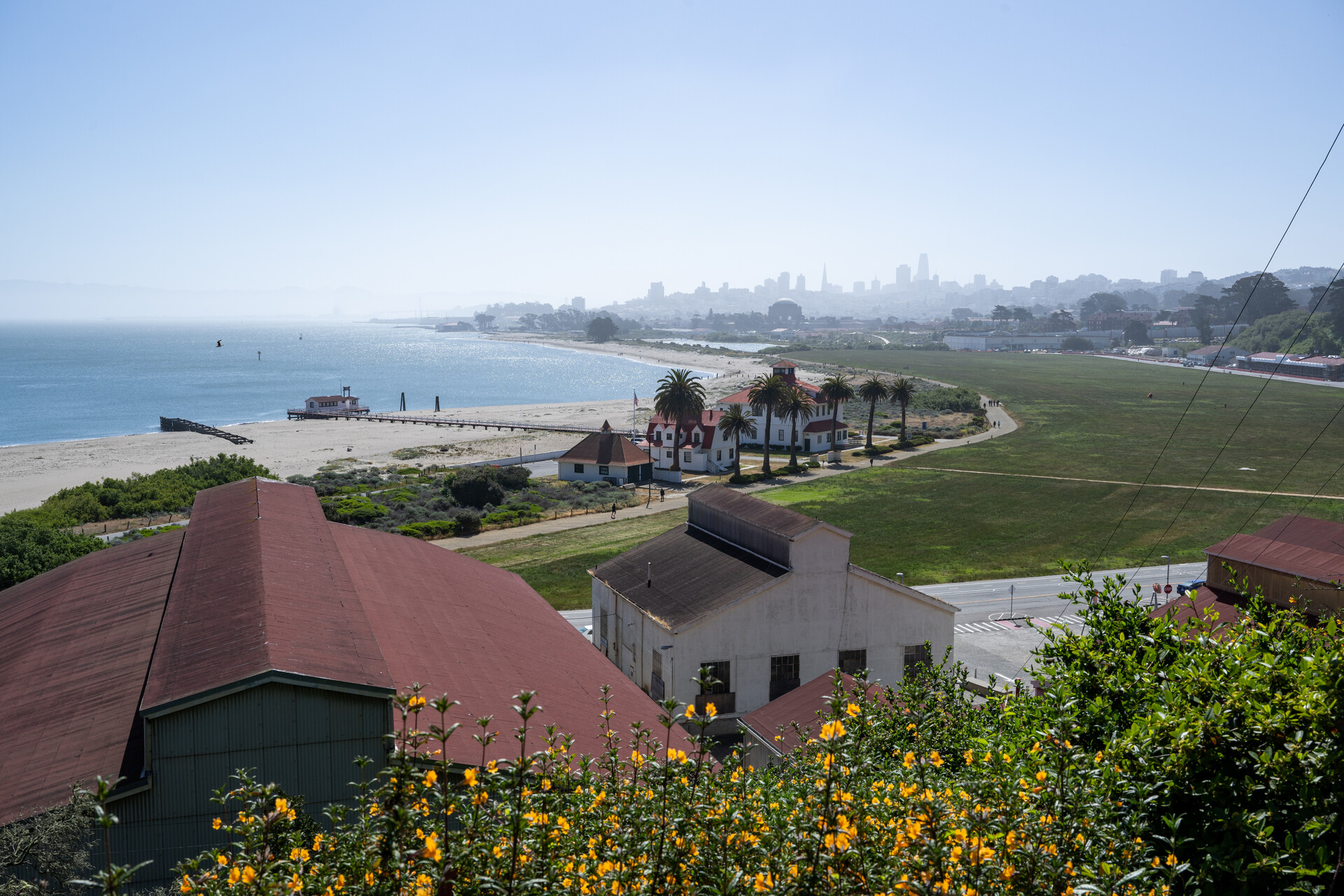
Over a million people a year visit Crissy Field, he told the group. One of the first of these individuals to make this area famous — post-Western settlement — was someone who grew up in San Francisco: Ansel Adams. On an iPad, Larsen showed an image of a photo taken by Adams of the mouth of the Bay and the Golden Gate Bridge under construction.
Adams was four years old during the 1906 earthquake. During one of the aftershocks, he was thrown into a garden wall and broke his nose. The injury stayed with him his whole life. Larsen showed a picture of Adams as an older man.
“And you can see, even as a much older person, his nose still looks pretty mangled,” he said. “That was one of the factors that led to him being kind of solitary and taking up a lot of time in nature.”
It was not necessarily a more genteel time back then. “Kids bullied him in school,” he added. “They treated him poorly and teased him about his nose.”
As he grew, he developed a remarkable gift for capturing natural beauty in black-and-white photography.
“We take our hats off to Ansel Adams and thank him for highlighting the beauty of this area.”
Expensive challenges ahead
As the group moved further up the field toward the bridge, Larsen advised care and awareness.
“I do want to warn you that, as you’ve noticed by now, we do have a fair number of bicycles moving by,” he said. “And not all of them are highly skilled riders. So keep an eye out so you don’t get run over.”
After alerting guests to the physical area and its physical dangers, Larsen conjured up what Crissy Field looked like 15,000 years ago. Mammoths, saber-toothed tigers and giant ground sloths roamed the area. A mammoth tooth was even found atop Twin Peaks, which must have been hosting some mighty fine forage to have inspired a large animal to make such a trek.
As it was at the end of the last glacial period, more water was tied up in ice and sea levels were around 400 feet lower in San Francisco Bay. What we know as the Bay then was a large grassy valley with a river running through it out to the ocean.
Now, the Bay is currently rising at the rate of about a quarter of an inch a year. That doesn’t feel like much to worry about year over year, but think about the world over the lifespan of today’s kids, and it becomes alarming. The state estimates it could rise by as much as 6.6 feet (PDF) by the end of the century.
Sea-level rise doesn’t affect all areas equally. As a near example, Larsen pointed to Alcatraz and compared it to Crissy Beach. The first is surrounded by steep rocky cliffs, the latter is low-lying and much more vulnerable. It’s a problem common in the Bay.
“Here in San Francisco, of course, we’ve got a lot of low-lying areas. We’re standing in one of them,” Larsen said. “If you go around the Embarcadero, the city is now in the process of planning a new seawall. We’ve got a big challenge for many of those piers and the Embarcadero itself is barely above sea level. We’ve got some big and expensive challenges ahead.”
A new seawall, projected to cost $5 billion, will extend from Fisherman’s Wharf around the Embarcadero to the Giant’s ballpark. It’s paid for in part with a taxpayer-approved bond.
Larsen predicted that residents of coastal areas, especially those in expensive neighborhoods like the nearby Marina District, will lobby heavily in future years for the city, state and government to take action. This raises the question of whether people in less economically endowed neighborhoods don’t deserve the same protections — perhaps more, as they’re less financially able to adapt.
“And if you multiply this out across the world, with all the low-lying cities that are like Miami and New Orleans and New York, it’s a major, major challenge that the country faces.”
The water is rising primarily because of two reasons. One is the melting of ice sheets in Greenland and Antarctica. About 400 billion tons of water per year enters the oceans. The other is thermal expansion. Warm water takes up more space than cold water.
“The Bay is also predicted to become saltier,” Larsen said. “We’re going to see less inflow of river water from the central Valley of the Sierra. The warmer it is, the more water evaporates and the less that’s going to be in the rivers flowing down to us.”
Larsen showed the walkers one of his favorite scientific figures: the Keeling Curve. It’s a line of sine curve wiggles trending inexorably upward, charting the decadeslong rise in atmospheric carbon dioxide concentrations as read at the remote Mauna Loa Observatory in Hawaii. The data set was started by Charles David Keeling in 1958.
For Larsen, a trained geologist who formerly led the Smithsonian Tropical Research Institute, the interest is both professional and personal.
“This graph is actually so important to communicating and understanding climate change that it’s written carved in stone in the wall of the foyer or the entrance to the National Academy of Sciences in Washington, D.C. As a scientist, I often contemplated getting a tattoo.”
He has not ruled it out. But where would he put it?
“Because I’d want to add a data point every couple of years.”
It would have to rise across his torso, toward his head.
“And so then I thought, well, maybe it’ll go up my neck. I still haven’t gotten the tattoo, but who knows. It may happen.”
Not hopeless
Contemplating climate change is always sobering. “Change is scary,” the saying goes, and climate change is the mother of all scary changes. It’s poised to alter everything we know about living on Earth. But when we look at the future, Larsen said, all is not bleak.
Largely, we know what we need to do to improve our future: stop burning fossil fuels, run our economies on cleaner electrons, inch our lifestyles toward sustainable choices and give the natural world a hand in helping us out. We are now in the midst of a clean energy transition and most climate experts believe there is no turning back.
Chrissy Field is a powerful testament to the human ability to fix environmental problems when we set our minds and wallets to it. Equally, it’s a testament to the natural world’s ability to bounce back when it’s given a chance to.
At the time of the 1906 earthquake, Crissy Field was a brackish tidal marsh. Much of the rubble from the quake was dumped into the marsh, filling it in. It became a site for the 1915 Panama Pacific International Exposition. It then became part of the Presidio military base (which the U.S. Army controlled beginning in 1846) and as the primary airfield used by the U.S. on the West Coast from 1921 to 1936.
The Crissy of Crissy Field was Major Dana H. Crissy, a Presidio artilleryman who loved flying. He died during a multi-pilot effort to be the first to cross the United States by plane. His plane crashed near Salt Lake City, Utah. The Army named the airstrip, which sat on the site of the current restored marsh, in his honor. The landing strip was in operation until the ’70s.
By the time the National Park Service acquired it in the early ’90s, Larsen said, “it was essentially a hazardous waste site.”
Military use had left contaminated soil. Many tons of asphalt and concrete had to be removed. Remediation took years.
But now there is once again a marsh at Crissy Field, albeit a rehabilitated one. Wildlife has returned to the area, including California halibut, Pacific staghorn sculpin and dozens of other fish.
Snowy plovers, once locally extinct, nest again in the dunes of Crissy Field. They’re ground nesters, which is why it’s important to keep dogs on leashes and out of the dunes.
In all, Larsen said, 135 bird species visit the area. He paused to listen to one — a black, white and gray beauty, possibly a kind of tern.
“I think it’s a least tern that’s trying to harass my monologue,” he said. “You’ll see them diving, catching small fish.”
The group admired the scene. Families threaded paths along the sand. Joggers trotted by. Wind rippled the lupine and sticky monkey flower growing on the dunes. And a bird — possibly the harasser — darted in and out of view.
See interactive then-and-now photos of Crissy Field