In the Age of Fast-Moving Fires, What's the Best Way to Get People Out?
During the Camp Fire, residents of Paradise, California took to the one main road out of town, and it quickly became a parking lot. So some communities and academics are looking at new ways to evacuate during a fast-moving blaze.
Cars abandoned by Paradise residents during the November 2018 Camp Fire. (Justin Sullivan/Getty Images)
Foresthill Road, which extends from Interstate 80 deep into the Tahoe National Forest, is a beautiful drive. Well-paved and scenic, it takes you across the North Fork American River over the breathtaking Foresthill Bridge, one of the tallest spans in the country. As you move farther from the highway and closer to the Sierra Nevada Foothills, it’s the density of the growing number of trees lining each side of the roadway that claims your attention.
The road’s 5-star TripAdvisor rating makes sense; it’s the kind of drive you take for fun.
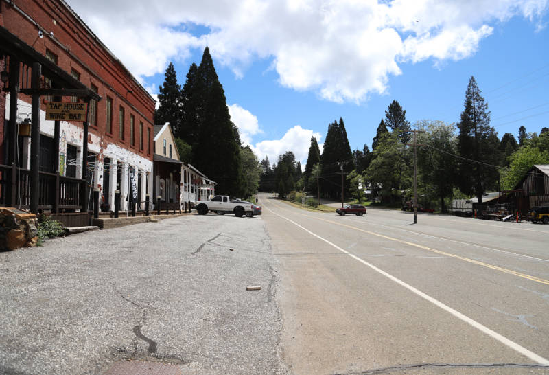
Yet, it’s also the source of considerable anxiety for Foresthill, a community of around 1,500 residents. That’s because there’s only a single main route in and out of town, and Foresthill Road, with one narrow lane going and one narrow lane coming, is it.
A Potential Disaster
During a wildfire, you could imagine, the roads would clutter with the cars of panicking people all trying to make it out of town one step ahead of the flames.
That’s something Gary Kirk thinks about. A lot.
“A single ingress-egress is not good for a community,” said Kirk, a volunteer firefighter for decades who worked his way up to captain at the Foresthill Fire Protection District. He’s retired now and spends his time as director of the Foresthill Fire Safe Council, a nonprofit group working to keep residents prepared for wildfires.
He knows this community inside and out — what makes it prone to wildfire danger and what makes it a beautiful place to live. He’s hunted and fished in the area for years, and he loves living in the forest. But in the event of a wildfire, he said, Foresthill Road could be disastrous.
“I know Paradise. I’ve been there several times. And Skyway was just like Foresthill Road,” he said, referring to the main route out of the town that last year became synonymous with lethal California fires.
Compared to Paradise, according to a USA Today-California Network analysis of wildfire evacuation routes, Foresthill actually has a worse population-to-lane ratio.
Kirk’s not the only one who worries.
“I think it’s a big concern for most of the people here,” said Shonne Elgin, a resident since 1989.
Foresthill Road in Foresthill, California is the only main route in and out of town. (Lindsey Moore/KQED)
‘The Fire Was Outrunning Us’
When the Camp Fire swept through Paradise in November 2018, residents took to Skyway en masse, and 27,000 people, with flames bearing down, were caught in gridlock. Some residents abandoned their cars to flee on foot. Others were found dead in their vehicles. For some who made it out, it took up to 10 hours to get to an evacuation center.
“The fire was outrunning us, in terms of our ability to notify people, get evacuations done, before we even knew we were in a race.” Butte County Sheriff Kory Honea toldKQED in the aftermath of the catastrophe.
“Are there better ways to notify people? Are there better ways to conduct evacuations? Those are all things that I want to look at, perhaps have studies done, to determine if there are lessons to be learned.”
Still, Honea said, nothing could have prepared Butte County and Paradise for the disaster of the Camp Fire. The town and county indeed had an evacuationplan, one that included dividing the town into 14 zones, the creation of assembly areas, and even a fire drill.
The systems that the county put in place helped to get tens of thousands of people to safety, Honea said, but they still couldn’t defend against the speed of the Camp Fire.
“Is the system perfect?” he said. “There’s no system that is ever perfect.”
Rethinking Evacuations
Many other towns living under the threat of wildfire don’t have a plan, perfect or not. A recent USA Today California Network survey found that just 22 percent of at-risk communities have robust evacuation plans available to the public.
Placer County, which would oversee an evacuation of Foresthill, is working on its own blueprint for leaving town during a wildfire, and officials hope to have it finished this summer. But it’s not necessarily one you might expect.
“A lot of people think that we’re going to come up with a specific evacuation route — that this is the way you have to go out. And that’s just not the case, because the fire’s going to predict how we’re going to do the evacuation,” said Ty Conners, a sergeant with the Placer County Sheriff’s Office, who works as the station commander for Colfax and Foresthill.
Conners was a first responder during the Camp Fire and saw for himself what happens when an entire community tries to leave on one road.
“They had a very good evacuation plan,” Conners said. “Only thing is, that fire was moving so fast that even if you have the best plan, you can’t beat the fire.”
Seeing the devastation in Butte County has caused Conners to re-examine town evacuations.
“Giving people an evacuation route, trying to get them out— yeah, it’s important,” he said. “But if you’re not going to be able to do it … divert people to these temporary safe refuge areas.”
The idea is that if you have a fast-moving fire and only one way out, residents would be directed to somewhere in town with defensible space and fewer trees, making it safe to take shelter.
In Foresthill, Conners said, that could be the local high school.
“The Foresthill High School has a huge area of clear-cut,” he said. “That’s a place that’s a temporary safe refuge for people to congregate and go while the actual fire front pushes through, and then you can evacuate them out.”
Simulating Disaster
Temporary refuge could indeed be the answer when there’s a fast-moving fire and limited escape routes, says Dapeng Li, an assistant professor of geography at South Dakota State University.
“There are many places we can use as the shelters,” Li said. “For example, places like high schools, where there are a lot of open spaces, or other facilities in town.”
Li studies wildfire evacuations by overlaying fire progression models with traffic simulations to see how incoming flames can influence exit plans, making them dynamic.
“We could use a traffic simulation model to estimate how much time we would need for the community to evacuate,” he said. “If we don’t have enough lead time, we might need to ask them to go to those shelters or to shelter in place.”
Using this modeling technique, Li said, a community can virtually explore an infinite number of evacuation scenarios when it comes to how a wildfire progresses. For example, officials might see what would happen when a fire is spreading from a particular direction and shutting down a specific portion of roadway.
“We can also do simulations [for] if we build a new evacuation route,” Li said. “That could be used for planning and transportation purposes.”
The idea is that if emergency managers were to model different wildfire situations, they could devise multiple plans from which to choose when disaster strikes.
California counties could make use of similar models in order to create contingency evacuation plans, Li said, but it would take time, resources and a lot of training.
“If we are to make an evacuation plan, we need to consider different scenarios,” he said.
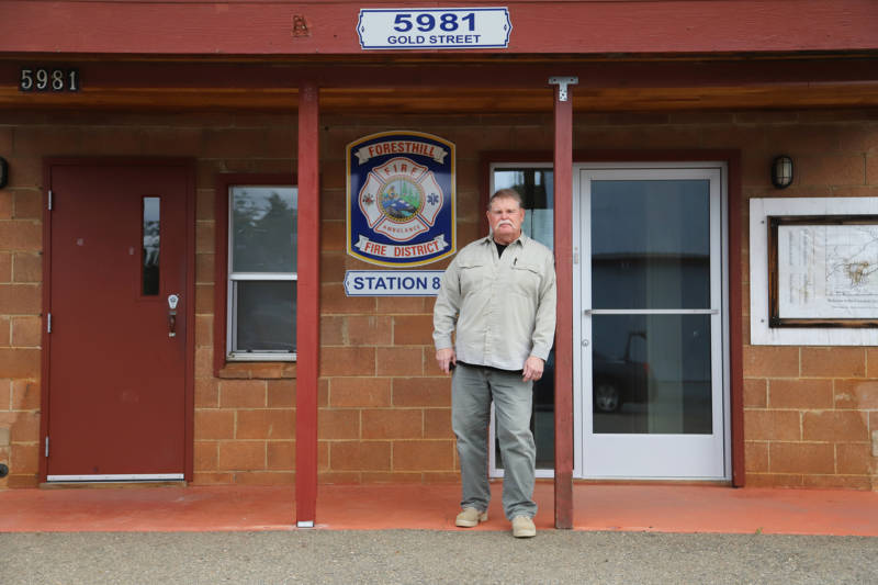
Gary Kirk, Foresthill Firesafe Council director, outside of the Foresthill fire station, May 20, 2019. (Lindsey Moore/KQED)
It Starts With an Alert
Even if a community has foolproof and adaptable evacuation protocols in place, there’s still the matter of letting residents know there’s a wildfire.
During both the Camp Fire and the North Bay fires of 2017, county officials came under scrutiny for using so-called “opt-in” alert systems, which only sent emergency notifications to people if they’d signed up for the service.
In Butte County, that emergency system is called “Code Red.” In the aftermath of the Camp Fire, many residents toldKQED they didn’t learn about the fire from officials, but rather through word of mouth, media reports, or actually seeing or smelling flames.
In March, the Governor’s Office of Emergency Services released statewide guidelines for counties on how to issue emergency alerts. The 85-page document suggests a number of ways communities can better prepare for disasters, including using Wireless Emergency Alerts, or WEA, a system run by the Federal Emergency Management Agency that allows geo-targeted notifications to be sent, much like an amber alert, to every cellphone in a given area.
The guidelines provide “consistency across all of our 58 counties and jurisdictions,” said Cal OES director Mark Ghilarducci. While the suggested protocols stop short of requiring use of WEA, Ghilarducci hopes they’ll push communities in the right direction.
“Without establishing a mandate, [we] recommend the use of WEA and the expectation [is] that all of the counties would use WEA,” he said. “And this guideline was put together as a collaborative effort with our local government partners, and every indication is that that will become the standard bearer in the state.”
Officials in Placer County are prepared to use WEA in the event of a devastating fire in Foresthill, according to Holly Powers, the county’s assistant director of emergency services.
“Our alerting protocol is across the board,” she said, noting that in some remote areas WEA may not be enough to reach every resident.
“Something that a lot of people may not realize is that WEA is based on cell towers and cell data,” Powers said. “So if you have a fire that burns down a cell tower, even if I sent a WEA alert, it’s not going to be able to go through.”
‘Be Prepared’
For isolated areas like Foresthill, where cell service could be an issue, it’s important for people to know one another and to stay informed, says Gary Kirk.
That’s where his Fire Safe Council comes in.
“This time of the year is when we start really ramping up to get this information out to people,” Kirk said. “We do hold meetings once a month, and we get the community together.”
There are also communities in the area certified by the National Fire Protection Association’s Firewise USA program, Kirk said. The program teaches wildfire preparedness and fire safety initiatives, such as brush clearing. Kirk said these communities could potentially serve as temporary refuge during a fire.
Of course, the entire town isn’t showing up to Kirk’s monthly meetings. But the idea is that if you get some people informed, they’ll spread the word about what to do in the event of a fire, until eventually everyone is living and breathing fire safety.
“It’s a chain reaction that we try to create,” he said. “And it works.”
Still, for a community like Foresthill, there’s no real formula for an evacuation where everything goes just right. If you’re living in an isolated and fire-prone area, the most important thing is:
Always be ready.
lower waypointnext waypoint
Player sponsored by
window.__IS_SSR__=true
window.__INITIAL_STATE__={
"attachmentsReducer": {
"audio_0": {
"type": "attachments",
"id": "audio_0",
"imgSizes": {
"kqedFullSize": {
"file": "https://ww2.kqed.org/news/wp-content/themes/KQED-unified/img/audio_bgs/background0.jpg"
}
}
},
"audio_1": {
"type": "attachments",
"id": "audio_1",
"imgSizes": {
"kqedFullSize": {
"file": "https://ww2.kqed.org/news/wp-content/themes/KQED-unified/img/audio_bgs/background1.jpg"
}
}
},
"audio_2": {
"type": "attachments",
"id": "audio_2",
"imgSizes": {
"kqedFullSize": {
"file": "https://ww2.kqed.org/news/wp-content/themes/KQED-unified/img/audio_bgs/background2.jpg"
}
}
},
"audio_3": {
"type": "attachments",
"id": "audio_3",
"imgSizes": {
"kqedFullSize": {
"file": "https://ww2.kqed.org/news/wp-content/themes/KQED-unified/img/audio_bgs/background3.jpg"
}
}
},
"audio_4": {
"type": "attachments",
"id": "audio_4",
"imgSizes": {
"kqedFullSize": {
"file": "https://ww2.kqed.org/news/wp-content/themes/KQED-unified/img/audio_bgs/background4.jpg"
}
}
},
"placeholder": {
"type": "attachments",
"id": "placeholder",
"imgSizes": {
"thumbnail": {
"file": "https://cdn.kqed.org/wp-content/uploads/2024/12/KQED-Default-Image-816638274-2000x1333-1-160x107.jpg",
"width": 160,
"height": 107,
"mimeType": "image/jpeg"
},
"medium": {
"file": "https://cdn.kqed.org/wp-content/uploads/2024/12/KQED-Default-Image-816638274-2000x1333-1-800x533.jpg",
"width": 800,
"height": 533,
"mimeType": "image/jpeg"
},
"medium_large": {
"file": "https://cdn.kqed.org/wp-content/uploads/2024/12/KQED-Default-Image-816638274-2000x1333-1-768x512.jpg",
"width": 768,
"height": 512,
"mimeType": "image/jpeg"
},
"large": {
"file": "https://cdn.kqed.org/wp-content/uploads/2024/12/KQED-Default-Image-816638274-2000x1333-1-1020x680.jpg",
"width": 1020,
"height": 680,
"mimeType": "image/jpeg"
},
"1536x1536": {
"file": "https://cdn.kqed.org/wp-content/uploads/2024/12/KQED-Default-Image-816638274-2000x1333-1-1536x1024.jpg",
"width": 1536,
"height": 1024,
"mimeType": "image/jpeg"
},
"fd-lrg": {
"file": "https://cdn.kqed.org/wp-content/uploads/2024/12/KQED-Default-Image-816638274-2000x1333-1-1536x1024.jpg",
"width": 1536,
"height": 1024,
"mimeType": "image/jpeg"
},
"fd-med": {
"file": "https://cdn.kqed.org/wp-content/uploads/2024/12/KQED-Default-Image-816638274-2000x1333-1-1020x680.jpg",
"width": 1020,
"height": 680,
"mimeType": "image/jpeg"
},
"fd-sm": {
"file": "https://cdn.kqed.org/wp-content/uploads/2024/12/KQED-Default-Image-816638274-2000x1333-1-800x533.jpg",
"width": 800,
"height": 533,
"mimeType": "image/jpeg"
},
"post-thumbnail": {
"file": "https://cdn.kqed.org/wp-content/uploads/2024/12/KQED-Default-Image-816638274-2000x1333-1-672x372.jpg",
"width": 672,
"height": 372,
"mimeType": "image/jpeg"
},
"twentyfourteen-full-width": {
"file": "https://cdn.kqed.org/wp-content/uploads/2024/12/KQED-Default-Image-816638274-2000x1333-1-1038x576.jpg",
"width": 1038,
"height": 576,
"mimeType": "image/jpeg"
},
"xxsmall": {
"file": "https://cdn.kqed.org/wp-content/uploads/2024/12/KQED-Default-Image-816638274-2000x1333-1-160x107.jpg",
"width": 160,
"height": 107,
"mimeType": "image/jpeg"
},
"xsmall": {
"file": "https://cdn.kqed.org/wp-content/uploads/2024/12/KQED-Default-Image-816638274-2000x1333-1-672x372.jpg",
"width": 672,
"height": 372,
"mimeType": "image/jpeg"
},
"small": {
"file": "https://cdn.kqed.org/wp-content/uploads/2024/12/KQED-Default-Image-816638274-2000x1333-1-672x372.jpg",
"width": 672,
"height": 372,
"mimeType": "image/jpeg"
},
"xlarge": {
"file": "https://cdn.kqed.org/wp-content/uploads/2024/12/KQED-Default-Image-816638274-2000x1333-1-1020x680.jpg",
"width": 1020,
"height": 680,
"mimeType": "image/jpeg"
},
"full-width": {
"file": "https://cdn.kqed.org/wp-content/uploads/2024/12/KQED-Default-Image-816638274-2000x1333-1-1920x1280.jpg",
"width": 1920,
"height": 1280,
"mimeType": "image/jpeg"
},
"guest-author-32": {
"file": "https://cdn.kqed.org/wp-content/uploads/2025/01/KQED-Default-Image-816638274-1333x1333-1-160x160.jpg",
"width": 32,
"height": 32,
"mimeType": "image/jpeg"
},
"guest-author-50": {
"file": "https://cdn.kqed.org/wp-content/uploads/2025/01/KQED-Default-Image-816638274-1333x1333-1-160x160.jpg",
"width": 50,
"height": 50,
"mimeType": "image/jpeg"
},
"guest-author-64": {
"file": "https://cdn.kqed.org/wp-content/uploads/2025/01/KQED-Default-Image-816638274-1333x1333-1-160x160.jpg",
"width": 64,
"height": 64,
"mimeType": "image/jpeg"
},
"guest-author-96": {
"file": "https://cdn.kqed.org/wp-content/uploads/2025/01/KQED-Default-Image-816638274-1333x1333-1-160x160.jpg",
"width": 96,
"height": 96,
"mimeType": "image/jpeg"
},
"guest-author-128": {
"file": "https://cdn.kqed.org/wp-content/uploads/2025/01/KQED-Default-Image-816638274-1333x1333-1-160x160.jpg",
"width": 128,
"height": 128,
"mimeType": "image/jpeg"
},
"detail": {
"file": "https://cdn.kqed.org/wp-content/uploads/2025/01/KQED-Default-Image-816638274-1333x1333-1-160x160.jpg",
"width": 160,
"height": 160,
"mimeType": "image/jpeg"
},
"kqedFullSize": {
"file": "https://cdn.kqed.org/wp-content/uploads/2024/12/KQED-Default-Image-816638274-2000x1333-1.jpg",
"width": 2000,
"height": 1333
}
}
},
"science_1942662": {
"type": "attachments",
"id": "science_1942662",
"meta": {
"index": "attachments_1716263798",
"site": "science",
"id": "1942662",
"found": true
},
"parent": 1942547,
"imgSizes": {
"twentyfourteen-full-width": {
"file": "https://ww2.kqed.org/app/uploads/sites/35/2029/05/Paradise-Camp-Fire-Cars-1038x576.jpg",
"width": 1038,
"mimeType": "image/jpeg",
"height": 576
},
"thumbnail": {
"file": "https://ww2.kqed.org/app/uploads/sites/35/2029/05/Paradise-Camp-Fire-Cars-160x106.jpg",
"width": 160,
"mimeType": "image/jpeg",
"height": 106
},
"post-thumbnail": {
"file": "https://ww2.kqed.org/app/uploads/sites/35/2029/05/Paradise-Camp-Fire-Cars-672x372.jpg",
"width": 672,
"mimeType": "image/jpeg",
"height": 372
},
"kqedFullSize": {
"file": "https://ww2.kqed.org/app/uploads/sites/35/2029/05/Paradise-Camp-Fire-Cars-e1559342897687.jpg",
"width": 1920,
"height": 1269
},
"large": {
"file": "https://ww2.kqed.org/app/uploads/sites/35/2029/05/Paradise-Camp-Fire-Cars-1020x674.jpg",
"width": 1020,
"mimeType": "image/jpeg",
"height": 674
},
"complete_open_graph": {
"file": "https://ww2.kqed.org/app/uploads/sites/35/2029/05/Paradise-Camp-Fire-Cars-1200x793.jpg",
"width": 1200,
"mimeType": "image/jpeg",
"height": 793
},
"full-width": {
"file": "https://ww2.kqed.org/app/uploads/sites/35/2029/05/Paradise-Camp-Fire-Cars-1920x1269.jpg",
"width": 1920,
"mimeType": "image/jpeg",
"height": 1269
},
"medium": {
"file": "https://ww2.kqed.org/app/uploads/sites/35/2029/05/Paradise-Camp-Fire-Cars-800x529.jpg",
"width": 800,
"mimeType": "image/jpeg",
"height": 529
},
"medium_large": {
"file": "https://ww2.kqed.org/app/uploads/sites/35/2029/05/Paradise-Camp-Fire-Cars-768x508.jpg",
"width": 768,
"mimeType": "image/jpeg",
"height": 508
}
},
"publishDate": 1559342877,
"modified": 1566433166,
"caption": "Cars abandoned by Paradise residents during the November 2018 Camp Fire. ",
"description": null,
"title": "Rapidly-Spreading Wildfire In California's Butte County Prompts Evacuations",
"credit": "Justin Sullivan/Getty Images",
"status": "inherit",
"isLoading": false,
"fetchFailed": false
}
},
"audioPlayerReducer": {
"postId": "stream_live",
"isPaused": true,
"isPlaying": false,
"pfsActive": false,
"pledgeModalIsOpen": true,
"playerDrawerIsOpen": false,
"liveAudioPlayStartedAt": 0,
"liveAudioPlayContext": ""
},
"authorsReducer": {
"jeremysiegel": {
"type": "authors",
"id": "11258",
"meta": {
"index": "authors_1716337520",
"id": "11258",
"found": true
},
"name": "Jeremy Siegel",
"firstName": "Jeremy",
"lastName": "Siegel",
"slug": "jeremysiegel",
"email": "jsiegel@kqed.org",
"display_author_email": false,
"staff_mastheads": [],
"title": "KQED Contributor",
"bio": "Jeremy Siegel is is the weekend afternoon news anchor for KQED. His reporting can be heard on KQED News, Morning Edition, All Things Considered and The California Report. Jeremy's coverage of the Camp Fire in Butte County won the 2019 Society of Professional Journalists, Northern California Chapter, Excellence in Journalism Award for Breaking News. Jeremy grew up in Cincinnati, Ohio, and graduated from UC Berkeley.",
"avatar": "https://secure.gravatar.com/avatar/3921a64ceb9ed5d0ba47d9ae9782f1ab?s=600&d=blank&r=g",
"twitter": "jersiegel",
"facebook": null,
"instagram": null,
"linkedin": null,
"sites": [
{
"site": "arts",
"roles": []
},
{
"site": "news",
"roles": [
"subscriber"
]
},
{
"site": "science",
"roles": []
}
],
"headData": {
"title": "Jeremy Siegel | KQED",
"description": "KQED Contributor",
"ogImgSrc": "https://secure.gravatar.com/avatar/3921a64ceb9ed5d0ba47d9ae9782f1ab?s=600&d=blank&r=g",
"twImgSrc": "https://secure.gravatar.com/avatar/3921a64ceb9ed5d0ba47d9ae9782f1ab?s=600&d=blank&r=g"
},
"isLoading": false,
"link": "/author/jeremysiegel"
}
},
"pagesReducer": {},
"pfsSessionReducer": {},
"postsReducer": {
"stream_live": {
"type": "live",
"id": "stream_live",
"audioUrl": "https://streams.kqed.org/kqedradio",
"title": "Live Stream",
"excerpt": "Live Stream information currently unavailable.",
"link": "/radio",
"featImg": "",
"label": {
"name": "KQED Live",
"link": "/"
}
},
"stream_kqedNewscast": {
"type": "posts",
"id": "stream_kqedNewscast",
"audioUrl": "https://www.kqed.org/.stream/anon/radio/RDnews/newscast.mp3?_=1",
"title": "KQED Newscast",
"featImg": "",
"label": {
"name": "88.5 FM",
"link": "/"
}
},
"science_1942547": {
"type": "posts",
"id": "science_1942547",
"meta": {
"index": "posts_1716263798",
"site": "science",
"id": "1942547",
"found": true
},
"articlePosition": 0,
"parent": 0,
"labelTerm": {},
"blocks": [],
"publishDate": 1559545294,
"format": "audio",
"title": "In the Age of Fast-Moving Fires, What's the Best Way to Get People Out?",
"headTitle": "In the Age of Fast-Moving Fires, What’s the Best Way to Get People Out? | KQED",
"content": "\u003cp>\u003cspan style=\"font-size: 4.6875em; float: left; line-height: 0.733em; padding: 0.05em 0.1em 0 0; font-family: times, serif, georgia;\">F\u003c/span>oresthill Road, which extends from Interstate 80 deep into the Tahoe National Forest, is a beautiful drive. Well-paved and scenic, it takes you across the North Fork American River over the breathtaking Foresthill Bridge, one of the tallest spans in the country. As you move farther from the highway and closer to the Sierra Nevada Foothills, it’s the density of the growing number of trees lining each side of the roadway that claims your attention.\u003c/p>\n\u003cp>[pullquote size=\"medium\"]New ideas on how to protect residents when the entire community is engulfed in flames include ditching a single ‘this way out’ evacuation route.[/pullquote]The road’s 5-star \u003ca href=\"https://www.tripadvisor.com/ShowUserReviews-g32396-d113865-r275617274-Foresthill_Divide-Foresthill_California.html\">TripAdvisor rating\u003c/a> makes sense; it’s the kind of drive you take for fun.\u003c/p>\n\u003cp>Yet, it’s also the source of considerable anxiety for Foresthill, a community of around 1,500 residents. That’s because there’s only a single main route in and out of town, and Foresthill Road, with one narrow lane going and one narrow lane coming, is it.\u003c/p>\n\u003cp>\u003cstrong>A Potential Disaster\u003c/strong>\u003c/p>\n\u003cp>During a wildfire, you could imagine, the roads would clutter with the cars of panicking people all trying to make it out of town one step ahead of the flames.\u003c/p>\n\u003cp>That’s something Gary Kirk thinks about. A lot.\u003c/p>\n\u003cp>“A single ingress-egress is not good for a community,” said Kirk, a volunteer firefighter for decades who worked his way up to captain at the Foresthill Fire Protection District. He’s retired now and spends his time as director of the Foresthill Fire Safe Council, a nonprofit group working to keep residents prepared for wildfires.\u003c/p>\n\u003cp>He knows this community inside and out — what makes it prone to wildfire danger and what makes it a beautiful place to live. He’s hunted and fished in the area for years, and he loves living in the forest. But in the event of a wildfire, he said, Foresthill Road could be disastrous.\u003c/p>\n\u003cp>“I know Paradise. I’ve been there several times. And Skyway was just like Foresthill Road,” he said, referring to the main route out of the town that last year became \u003ca href=\"https://www.kqed.org/news/tag/paradise\" target=\"_blank\" rel=\"noopener\">synonymous\u003c/a> with lethal California fires.\u003c/p>\n\u003cp>Compared to Paradise, according to a USA Today-California Network \u003ca href=\"https://www.apnews.com/6f621c1c54734d0b95d374556c2cf5c0\" target=\"_blank\" rel=\"noopener\">analysis\u003c/a> of wildfire evacuation routes, Foresthill actually has a \u003ca href=\"https://www.vvdailypress.com/news/20190504/few-ways-out-escape-routes-limited-in-california-towns-at-risk-from-fires\" target=\"_blank\" rel=\"noopener\">worse population-to-lane ratio\u003c/a>.\u003c/p>\n\u003cp>Kirk’s not the only one who worries.\u003c/p>\n\u003cp>“I think it’s a big concern for most of the people here,” said Shonne Elgin, a resident since 1989.\u003c/p>\n\u003cfigure id=\"attachment_1942699\" class=\"wp-caption alignnone\" style=\"max-width: 800px\">\u003cimg loading=\"lazy\" decoding=\"async\" class=\"size-medium wp-image-1942699\" src=\"https://ww2.kqed.org/science/wp-content/uploads/sites/35/2029/05/Foresthill-Wildfire-800x546.jpg\" alt=\"\" width=\"800\" height=\"546\" srcset=\"https://cdn.kqed.org/wp-content/uploads/sites/35/2029/05/Foresthill-Wildfire-800x546.jpg 800w, https://cdn.kqed.org/wp-content/uploads/sites/35/2029/05/Foresthill-Wildfire-160x109.jpg 160w, https://cdn.kqed.org/wp-content/uploads/sites/35/2029/05/Foresthill-Wildfire-768x524.jpg 768w, https://cdn.kqed.org/wp-content/uploads/sites/35/2029/05/Foresthill-Wildfire-1020x696.jpg 1020w, https://cdn.kqed.org/wp-content/uploads/sites/35/2029/05/Foresthill-Wildfire-1200x819.jpg 1200w, https://cdn.kqed.org/wp-content/uploads/sites/35/2029/05/Foresthill-Wildfire.jpg 1920w\" sizes=\"(max-width: 800px) 100vw, 800px\">\u003cfigcaption class=\"wp-caption-text\">Foresthill Road in Foresthill, California is the only main route in and out of town. \u003ccite>(Lindsey Moore/KQED)\u003c/cite>\u003c/figcaption>\u003c/figure>\n\u003cp>\u003cstrong>‘The Fire Was Outrunning Us’\u003c/strong>\u003c/p>\n\u003cp>When the Camp Fire swept through Paradise in November 2018, residents took to Skyway en masse, and 27,000 people, with flames bearing down, were caught in gridlock. Some residents abandoned their cars to flee on foot. Others were found dead in their vehicles. For some who made it out, it took up to 10 hours to get to an evacuation center.\u003c/p>\n\u003cp>“The fire was outrunning us, in terms of our ability to notify people, get evacuations done, before we even knew we were in a race.” Butte County Sheriff Kory Honea \u003ca href=\"https://www.kqed.org/news/11711175/butte-county-to-reassess-emergency-alert-system-in-aftermath-of-camp-fire\">told\u003c/a> \u003ca href=\"https://www.kqed.org/news/11711175/butte-county-to-reassess-emergency-alert-system-in-aftermath-of-camp-fire\">KQED\u003c/a> in the aftermath of the catastrophe.\u003c/p>\n\u003cp>“Are there better ways to notify people? Are there better ways to conduct evacuations? Those are all things that I want to look at, perhaps have studies done, to determine if there are lessons to be learned.”\u003c/p>\n\u003cp>Still, Honea said, nothing could have prepared Butte County and Paradise for the disaster of the Camp Fire. The town and county indeed had an \u003ca href=\"https://www.townofparadise.com/index.php/residents/emergency-services-information\">evacuation\u003c/a> \u003ca href=\"https://www.townofparadise.com/index.php/residents/emergency-services-information\">plan\u003c/a>, one that included dividing the town into 14 zones, the creation of assembly areas, and even a fire drill.\u003c/p>\n\u003cp>The systems that the county put in place helped to get tens of thousands of people to safety, Honea said, but they still couldn’t defend against the speed of the Camp Fire.\u003c/p>\n\u003cp>“Is the system perfect?” he said. “There’s no system that is ever perfect.”\u003cbr>\n[ad fullwidth]\u003c/p>\n\u003cp>\u003cstrong>Rethinking Evacuations\u003c/strong>\u003c/p>\n\u003cp>Many other towns living under the threat of wildfire don’t have a plan, perfect or not. A recent USA Today California Network \u003ca href=\"https://www.sacbee.com/news/state/california/fires/article229547244.html\" target=\"_blank\" rel=\"noopener\">survey\u003c/a> found that just 22 percent of at-risk communities have robust evacuation plans available to the public.\u003c/p>\n\u003cp>Placer County, which would oversee an evacuation of Foresthill, is working on its own blueprint for leaving town during a wildfire, and officials hope to have it finished this summer. But it’s not necessarily one you might expect.\u003c/p>\n\u003cp>“A lot of people think that we’re going to come up with a specific evacuation route — that this is the way you have to go out. And that’s just not the case, because the fire’s going to predict how we’re going to do the evacuation,” said Ty Conners, a sergeant with the Placer County Sheriff’s Office, who works as the station commander for Colfax and Foresthill.\u003c/p>\n\u003cp>Conners was a first responder during the Camp Fire and saw for himself what happens when an entire community tries to leave on one road.\u003c/p>\n\u003cp>“They had a very good evacuation plan,” Conners said. “Only thing is, that fire was moving so fast that even if you have the best plan, you can’t beat the fire.”\u003c/p>\n\u003cp>Seeing the devastation in Butte County has caused Conners to re-examine town evacuations.\u003c/p>\n\u003cp>“Giving people an evacuation route, trying to get them out— yeah, it’s important,” he said. “But if you’re not going to be able to do it … divert people to these temporary safe refuge areas.”\u003c/p>\n\u003cp>The idea is that if you have a fast-moving fire and only one way out, residents would be directed to somewhere in town with defensible space and fewer trees, making it safe to take shelter.\u003c/p>\n\u003cp>In Foresthill, Conners said, that could be the local high school.\u003c/p>\n\u003cp>“The Foresthill High School has a huge area of clear-cut,” he said. “That’s a place that’s a temporary safe refuge for people to congregate and go while the actual fire front pushes through, and then you can evacuate them out.”\u003c/p>\n\u003cp>\u003cstrong>Simulating Disaster\u003c/strong>\u003c/p>\n\u003cp>Temporary refuge could indeed be the answer when there’s a fast-moving fire and limited escape routes, says Dapeng Li, an assistant professor of geography at South Dakota State University.\u003c/p>\n\u003cp>“There are many places we can use as the shelters,” Li said. “For example, places like high schools, where there are a lot of open spaces, or other facilities in town.”\u003c/p>\n\u003cp>Li studies wildfire evacuations by overlaying fire progression models with traffic simulations to see how incoming flames can influence exit plans, making them dynamic.\u003c/p>\n\u003cp>“We could use a traffic simulation model to estimate how much time we would need for the community to evacuate,” he said. “If we don’t have enough lead time, we might need to ask them to go to those shelters or to shelter in place.”\u003c/p>\n\u003cp>Using this modeling technique, Li said, a community can virtually explore an infinite number of evacuation scenarios when it comes to how a wildfire progresses. For example, officials might see what would happen when a fire is spreading from a particular direction and shutting down a specific portion of roadway.\u003c/p>\n\u003cp>“We can also do simulations [for] if we build a new evacuation route,” Li said. “That could be used for planning and transportation purposes.”\u003c/p>\n\u003cp>The idea is that if emergency managers were to model different wildfire situations, they could devise multiple plans from which to choose when disaster strikes.\u003c/p>\n\u003cp>California counties could make use of similar models in order to create contingency evacuation plans, Li said, but it would take time, resources and a lot of training.\u003c/p>\n\u003cp>“If we are to make an evacuation plan, we need to consider different scenarios,” he said.\u003c/p>\n\u003cfigure id=\"attachment_1942701\" class=\"wp-caption alignnone\" style=\"max-width: 800px\">\u003cimg loading=\"lazy\" decoding=\"async\" class=\"size-medium wp-image-1942701\" src=\"https://ww2.kqed.org/science/wp-content/uploads/sites/35/2029/05/Foresthill-evacuations-wildfire-800x533.jpg\" alt=\"\" width=\"800\" height=\"533\" srcset=\"https://cdn.kqed.org/wp-content/uploads/sites/35/2029/05/Foresthill-evacuations-wildfire-800x533.jpg 800w, https://cdn.kqed.org/wp-content/uploads/sites/35/2029/05/Foresthill-evacuations-wildfire-160x107.jpg 160w, https://cdn.kqed.org/wp-content/uploads/sites/35/2029/05/Foresthill-evacuations-wildfire-768x512.jpg 768w, https://cdn.kqed.org/wp-content/uploads/sites/35/2029/05/Foresthill-evacuations-wildfire-1020x680.jpg 1020w, https://cdn.kqed.org/wp-content/uploads/sites/35/2029/05/Foresthill-evacuations-wildfire-1200x800.jpg 1200w, https://cdn.kqed.org/wp-content/uploads/sites/35/2029/05/Foresthill-evacuations-wildfire.jpg 1920w\" sizes=\"(max-width: 800px) 100vw, 800px\">\u003cfigcaption class=\"wp-caption-text\">Gary Kirk, Foresthill Firesafe Council director, outside of the Foresthill fire station, May 20, 2019. \u003ccite>(Lindsey Moore/KQED)\u003c/cite>\u003c/figcaption>\u003c/figure>\n\u003cp>\u003cstrong>It Starts With an Alert\u003c/strong>\u003c/p>\n\u003cp>Even if a community has foolproof and adaptable evacuation protocols in place, there’s still the matter of letting residents know there’s a wildfire.\u003c/p>\n\u003cp>During both the Camp Fire and the North Bay fires of 2017, county officials came under scrutiny for using so-called “opt-in” alert systems, which only sent emergency notifications to people if they’d signed up for the service.\u003c/p>\n\u003cp>In Butte County, that emergency system is called “\u003ca href=\"https://public.coderedweb.com/CNE/en-US/BFA19C579EA5\" target=\"_blank\" rel=\"noopener\">Code Red\u003c/a>.” In the aftermath of the Camp Fire, many residents \u003ca href=\"https://www.kqed.org/news/11711175/butte-county-to-reassess-emergency-alert-system-in-aftermath-of-camp-fire\">told\u003c/a> \u003ca href=\"https://www.kqed.org/news/11711175/butte-county-to-reassess-emergency-alert-system-in-aftermath-of-camp-fire\">KQED\u003c/a> they didn’t learn about the fire from officials, but rather through word of mouth, media reports, or actually seeing or smelling flames.\u003c/p>\n\u003cp>In March, the Governor’s Office of Emergency Services released statewide \u003ca href=\"http://calalerts.org/documents/2019-CA-Alert-Warning-Guidelines.pdf\">guidelines\u003c/a> for counties on how to issue emergency alerts. The 85-page document suggests a number of ways communities can better prepare for disasters, including using Wireless Emergency Alerts, or WEA, a system run by the Federal Emergency Management Agency that allows geo-targeted notifications to be sent, much like an amber alert, to every cellphone in a given area.\u003c/p>\n\u003cp>The guidelines provide “consistency across all of our 58 counties and jurisdictions,” said Cal OES director Mark Ghilarducci. While the suggested protocols stop short of requiring use of WEA, Ghilarducci hopes they’ll push communities in the right direction.\u003c/p>\n\u003cp>“Without establishing a mandate, [we] recommend the use of WEA and the expectation [is] that all of the counties would use WEA,” he said. “And this guideline was put together as a collaborative effort with our local government partners, and every indication is that that will become the standard bearer in the state.”\u003c/p>\n\u003cp>Officials in Placer County are prepared to use WEA in the event of a devastating fire in Foresthill, according to Holly Powers, the county’s assistant director of emergency services.\u003c/p>\n\u003cp>“Our alerting protocol is across the board,” she said, noting that in some remote areas WEA may not be enough to reach every resident.\u003c/p>\n\u003cp>“Something that a lot of people may not realize is that WEA is based on cell towers and cell data,” Powers said. “So if you have a fire that burns down a cell tower, even if I sent a WEA alert, it’s not going to be able to go through.”\u003c/p>\n\u003cp>\u003cstrong>‘Be Prepared’\u003c/strong>\u003c/p>\n\u003cp>For isolated areas like Foresthill, where cell service could be an issue, it’s important for people to know one another and to stay informed, says Gary Kirk.\u003c/p>\n\u003cp>That’s where his Fire Safe Council comes in.\u003c/p>\n\u003cp>“This time of the year is when we start really ramping up to get this information out to people,” Kirk said. “We do hold meetings once a month, and we get the community together.”\u003c/p>\n\u003cp>There are also communities in the area certified by the National Fire Protection Association’s \u003ca href=\"https://www.nfpa.org/Public-Education/By-topic/Wildfire/Firewise-USA\" target=\"_blank\" rel=\"noopener\">Firewise USA program\u003c/a>, Kirk said. The program teaches wildfire preparedness and fire safety initiatives, such as brush clearing. Kirk said these communities could potentially serve as temporary refuge during a fire.\u003c/p>\n\u003cp>Of course, the entire town isn’t showing up to Kirk’s monthly meetings. But the idea is that if you get some people informed, they’ll spread the word about what to do in the event of a fire, until eventually everyone is living and breathing fire safety.\u003c/p>\n\u003cp>“It’s a chain reaction that we try to create,” he said. “And it works.”\u003c/p>\n\u003cp>Still, for a community like Foresthill, there’s no real formula for an evacuation where everything goes just right. If you’re living in an isolated and fire-prone area, the most important thing is:\u003c/p>\n\u003cp>Always be ready.\u003c/p>\n\u003cp>https://www.youtube.com/watch?time_continue=5&v=pfbEcMeYFFA\u003c/p>\n\u003cp>[ad floatright]\u003c/p>\n",
"stats": {
"hasVideo": true,
"hasChartOrMap": false,
"hasAudio": false,
"hasPolis": false,
"wordCount": 2056,
"hasGoogleForm": false,
"hasGallery": false,
"hasHearkenModule": false,
"iframeSrcs": [],
"paragraphCount": 60
},
"modified": 1704848637,
"excerpt": "During the Camp Fire, residents of Paradise, California took to the one main road out of town, and it quickly became a parking lot. So some communities and academics are looking at new ways to evacuate during a fast-moving blaze.",
"headData": {
"twImgId": "",
"twTitle": "",
"ogTitle": "",
"ogImgId": "",
"twDescription": "",
"description": "During the Camp Fire, residents of Paradise, California took to the one main road out of town, and it quickly became a parking lot. So some communities and academics are looking at new ways to evacuate during a fast-moving blaze.",
"title": "In the Age of Fast-Moving Fires, What's the Best Way to Get People Out? | KQED",
"ogDescription": "",
"schema": {
"@context": "https://schema.org",
"@type": "Article",
"headline": "In the Age of Fast-Moving Fires, What's the Best Way to Get People Out?",
"datePublished": "2019-06-03T00:01:34-07:00",
"dateModified": "2024-01-09T17:03:57-08:00",
"image": "https://ww2.kqed.org/app/uploads/sites/35/2029/05/Paradise-Camp-Fire-Cars-1020x674.jpg",
"author": {
"@type": "Person",
"name": "Jeremy Siegel",
"jobTitle": "KQED Contributor",
"url": "https://www.kqed.org/author/jeremysiegel"
}
},
"authorsData": [],
"tagData": []
},
"guestAuthors": [],
"slug": "in-the-age-of-the-crazy-fast-fire-a-good-evacuation-plan-may-not-be-enough",
"status": "publish",
"sourceUrl": "https://www.kqed.org/science/tag/livingwithwildfire",
"audioUrl": "https://www.kqed.org/.stream/anon/radio/science/2019/06/SiegelLivingWithWildfireEvacuations.mp3",
"sticky": false,
"audioTrackLength": 424,
"source": "Living With Wildfire",
"path": "/science/1942547/in-the-age-of-the-crazy-fast-fire-a-good-evacuation-plan-may-not-be-enough",
"parsedContent": [
{
"type": "contentString",
"content": "\u003cdiv class=\"post-body\">\u003cp>\u003cp>\u003cspan style=\"font-size: 4.6875em; float: left; line-height: 0.733em; padding: 0.05em 0.1em 0 0; font-family: times, serif, georgia;\">F\u003c/span>oresthill Road, which extends from Interstate 80 deep into the Tahoe National Forest, is a beautiful drive. Well-paved and scenic, it takes you across the North Fork American River over the breathtaking Foresthill Bridge, one of the tallest spans in the country. As you move farther from the highway and closer to the Sierra Nevada Foothills, it’s the density of the growing number of trees lining each side of the roadway that claims your attention.\u003c/p>\n\u003cp>\u003c/p>\u003c/div>",
"attributes": {
"named": {},
"numeric": []
}
},
{
"type": "component",
"content": "New ideas on how to protect residents when the entire community is engulfed in flames include ditching a single ‘this way out’ evacuation route.",
"name": "pullquote",
"attributes": {
"named": {
"size": "medium",
"label": ""
},
"numeric": []
}
},
{
"type": "contentString",
"content": "\u003cdiv class=\"post-body\">\u003cp>The road’s 5-star \u003ca href=\"https://www.tripadvisor.com/ShowUserReviews-g32396-d113865-r275617274-Foresthill_Divide-Foresthill_California.html\">TripAdvisor rating\u003c/a> makes sense; it’s the kind of drive you take for fun.\u003c/p>\n\u003cp>Yet, it’s also the source of considerable anxiety for Foresthill, a community of around 1,500 residents. That’s because there’s only a single main route in and out of town, and Foresthill Road, with one narrow lane going and one narrow lane coming, is it.\u003c/p>\n\u003cp>\u003cstrong>A Potential Disaster\u003c/strong>\u003c/p>\n\u003cp>During a wildfire, you could imagine, the roads would clutter with the cars of panicking people all trying to make it out of town one step ahead of the flames.\u003c/p>\n\u003cp>That’s something Gary Kirk thinks about. A lot.\u003c/p>\n\u003cp>“A single ingress-egress is not good for a community,” said Kirk, a volunteer firefighter for decades who worked his way up to captain at the Foresthill Fire Protection District. He’s retired now and spends his time as director of the Foresthill Fire Safe Council, a nonprofit group working to keep residents prepared for wildfires.\u003c/p>\n\u003cp>He knows this community inside and out — what makes it prone to wildfire danger and what makes it a beautiful place to live. He’s hunted and fished in the area for years, and he loves living in the forest. But in the event of a wildfire, he said, Foresthill Road could be disastrous.\u003c/p>\n\u003cp>“I know Paradise. I’ve been there several times. And Skyway was just like Foresthill Road,” he said, referring to the main route out of the town that last year became \u003ca href=\"https://www.kqed.org/news/tag/paradise\" target=\"_blank\" rel=\"noopener\">synonymous\u003c/a> with lethal California fires.\u003c/p>\n\u003cp>Compared to Paradise, according to a USA Today-California Network \u003ca href=\"https://www.apnews.com/6f621c1c54734d0b95d374556c2cf5c0\" target=\"_blank\" rel=\"noopener\">analysis\u003c/a> of wildfire evacuation routes, Foresthill actually has a \u003ca href=\"https://www.vvdailypress.com/news/20190504/few-ways-out-escape-routes-limited-in-california-towns-at-risk-from-fires\" target=\"_blank\" rel=\"noopener\">worse population-to-lane ratio\u003c/a>.\u003c/p>\n\u003cp>Kirk’s not the only one who worries.\u003c/p>\n\u003cp>“I think it’s a big concern for most of the people here,” said Shonne Elgin, a resident since 1989.\u003c/p>\n\u003cfigure id=\"attachment_1942699\" class=\"wp-caption alignnone\" style=\"max-width: 800px\">\u003cimg loading=\"lazy\" decoding=\"async\" class=\"size-medium wp-image-1942699\" src=\"https://ww2.kqed.org/science/wp-content/uploads/sites/35/2029/05/Foresthill-Wildfire-800x546.jpg\" alt=\"\" width=\"800\" height=\"546\" srcset=\"https://cdn.kqed.org/wp-content/uploads/sites/35/2029/05/Foresthill-Wildfire-800x546.jpg 800w, https://cdn.kqed.org/wp-content/uploads/sites/35/2029/05/Foresthill-Wildfire-160x109.jpg 160w, https://cdn.kqed.org/wp-content/uploads/sites/35/2029/05/Foresthill-Wildfire-768x524.jpg 768w, https://cdn.kqed.org/wp-content/uploads/sites/35/2029/05/Foresthill-Wildfire-1020x696.jpg 1020w, https://cdn.kqed.org/wp-content/uploads/sites/35/2029/05/Foresthill-Wildfire-1200x819.jpg 1200w, https://cdn.kqed.org/wp-content/uploads/sites/35/2029/05/Foresthill-Wildfire.jpg 1920w\" sizes=\"(max-width: 800px) 100vw, 800px\">\u003cfigcaption class=\"wp-caption-text\">Foresthill Road in Foresthill, California is the only main route in and out of town. \u003ccite>(Lindsey Moore/KQED)\u003c/cite>\u003c/figcaption>\u003c/figure>\n\u003cp>\u003cstrong>‘The Fire Was Outrunning Us’\u003c/strong>\u003c/p>\n\u003cp>When the Camp Fire swept through Paradise in November 2018, residents took to Skyway en masse, and 27,000 people, with flames bearing down, were caught in gridlock. Some residents abandoned their cars to flee on foot. Others were found dead in their vehicles. For some who made it out, it took up to 10 hours to get to an evacuation center.\u003c/p>\n\u003cp>“The fire was outrunning us, in terms of our ability to notify people, get evacuations done, before we even knew we were in a race.” Butte County Sheriff Kory Honea \u003ca href=\"https://www.kqed.org/news/11711175/butte-county-to-reassess-emergency-alert-system-in-aftermath-of-camp-fire\">told\u003c/a> \u003ca href=\"https://www.kqed.org/news/11711175/butte-county-to-reassess-emergency-alert-system-in-aftermath-of-camp-fire\">KQED\u003c/a> in the aftermath of the catastrophe.\u003c/p>\n\u003cp>“Are there better ways to notify people? Are there better ways to conduct evacuations? Those are all things that I want to look at, perhaps have studies done, to determine if there are lessons to be learned.”\u003c/p>\n\u003cp>Still, Honea said, nothing could have prepared Butte County and Paradise for the disaster of the Camp Fire. The town and county indeed had an \u003ca href=\"https://www.townofparadise.com/index.php/residents/emergency-services-information\">evacuation\u003c/a> \u003ca href=\"https://www.townofparadise.com/index.php/residents/emergency-services-information\">plan\u003c/a>, one that included dividing the town into 14 zones, the creation of assembly areas, and even a fire drill.\u003c/p>\n\u003cp>The systems that the county put in place helped to get tens of thousands of people to safety, Honea said, but they still couldn’t defend against the speed of the Camp Fire.\u003c/p>\n\u003cp>“Is the system perfect?” he said. “There’s no system that is ever perfect.”\u003cbr>\n\u003c/p>\u003c/div>",
"attributes": {
"named": {},
"numeric": []
}
},
{
"type": "component",
"content": "",
"name": "ad",
"attributes": {
"named": {
"label": "fullwidth"
},
"numeric": [
"fullwidth"
]
}
},
{
"type": "contentString",
"content": "\u003cdiv class=\"post-body\">\u003cp>\u003c/p>\n\u003cp>\u003cstrong>Rethinking Evacuations\u003c/strong>\u003c/p>\n\u003cp>Many other towns living under the threat of wildfire don’t have a plan, perfect or not. A recent USA Today California Network \u003ca href=\"https://www.sacbee.com/news/state/california/fires/article229547244.html\" target=\"_blank\" rel=\"noopener\">survey\u003c/a> found that just 22 percent of at-risk communities have robust evacuation plans available to the public.\u003c/p>\n\u003cp>Placer County, which would oversee an evacuation of Foresthill, is working on its own blueprint for leaving town during a wildfire, and officials hope to have it finished this summer. But it’s not necessarily one you might expect.\u003c/p>\n\u003cp>“A lot of people think that we’re going to come up with a specific evacuation route — that this is the way you have to go out. And that’s just not the case, because the fire’s going to predict how we’re going to do the evacuation,” said Ty Conners, a sergeant with the Placer County Sheriff’s Office, who works as the station commander for Colfax and Foresthill.\u003c/p>\n\u003cp>Conners was a first responder during the Camp Fire and saw for himself what happens when an entire community tries to leave on one road.\u003c/p>\n\u003cp>“They had a very good evacuation plan,” Conners said. “Only thing is, that fire was moving so fast that even if you have the best plan, you can’t beat the fire.”\u003c/p>\n\u003cp>Seeing the devastation in Butte County has caused Conners to re-examine town evacuations.\u003c/p>\n\u003cp>“Giving people an evacuation route, trying to get them out— yeah, it’s important,” he said. “But if you’re not going to be able to do it … divert people to these temporary safe refuge areas.”\u003c/p>\n\u003cp>The idea is that if you have a fast-moving fire and only one way out, residents would be directed to somewhere in town with defensible space and fewer trees, making it safe to take shelter.\u003c/p>\n\u003cp>In Foresthill, Conners said, that could be the local high school.\u003c/p>\n\u003cp>“The Foresthill High School has a huge area of clear-cut,” he said. “That’s a place that’s a temporary safe refuge for people to congregate and go while the actual fire front pushes through, and then you can evacuate them out.”\u003c/p>\n\u003cp>\u003cstrong>Simulating Disaster\u003c/strong>\u003c/p>\n\u003cp>Temporary refuge could indeed be the answer when there’s a fast-moving fire and limited escape routes, says Dapeng Li, an assistant professor of geography at South Dakota State University.\u003c/p>\n\u003cp>“There are many places we can use as the shelters,” Li said. “For example, places like high schools, where there are a lot of open spaces, or other facilities in town.”\u003c/p>\n\u003cp>Li studies wildfire evacuations by overlaying fire progression models with traffic simulations to see how incoming flames can influence exit plans, making them dynamic.\u003c/p>\n\u003cp>“We could use a traffic simulation model to estimate how much time we would need for the community to evacuate,” he said. “If we don’t have enough lead time, we might need to ask them to go to those shelters or to shelter in place.”\u003c/p>\n\u003cp>Using this modeling technique, Li said, a community can virtually explore an infinite number of evacuation scenarios when it comes to how a wildfire progresses. For example, officials might see what would happen when a fire is spreading from a particular direction and shutting down a specific portion of roadway.\u003c/p>\n\u003cp>“We can also do simulations [for] if we build a new evacuation route,” Li said. “That could be used for planning and transportation purposes.”\u003c/p>\n\u003cp>The idea is that if emergency managers were to model different wildfire situations, they could devise multiple plans from which to choose when disaster strikes.\u003c/p>\n\u003cp>California counties could make use of similar models in order to create contingency evacuation plans, Li said, but it would take time, resources and a lot of training.\u003c/p>\n\u003cp>“If we are to make an evacuation plan, we need to consider different scenarios,” he said.\u003c/p>\n\u003cfigure id=\"attachment_1942701\" class=\"wp-caption alignnone\" style=\"max-width: 800px\">\u003cimg loading=\"lazy\" decoding=\"async\" class=\"size-medium wp-image-1942701\" src=\"https://ww2.kqed.org/science/wp-content/uploads/sites/35/2029/05/Foresthill-evacuations-wildfire-800x533.jpg\" alt=\"\" width=\"800\" height=\"533\" srcset=\"https://cdn.kqed.org/wp-content/uploads/sites/35/2029/05/Foresthill-evacuations-wildfire-800x533.jpg 800w, https://cdn.kqed.org/wp-content/uploads/sites/35/2029/05/Foresthill-evacuations-wildfire-160x107.jpg 160w, https://cdn.kqed.org/wp-content/uploads/sites/35/2029/05/Foresthill-evacuations-wildfire-768x512.jpg 768w, https://cdn.kqed.org/wp-content/uploads/sites/35/2029/05/Foresthill-evacuations-wildfire-1020x680.jpg 1020w, https://cdn.kqed.org/wp-content/uploads/sites/35/2029/05/Foresthill-evacuations-wildfire-1200x800.jpg 1200w, https://cdn.kqed.org/wp-content/uploads/sites/35/2029/05/Foresthill-evacuations-wildfire.jpg 1920w\" sizes=\"(max-width: 800px) 100vw, 800px\">\u003cfigcaption class=\"wp-caption-text\">Gary Kirk, Foresthill Firesafe Council director, outside of the Foresthill fire station, May 20, 2019. \u003ccite>(Lindsey Moore/KQED)\u003c/cite>\u003c/figcaption>\u003c/figure>\n\u003cp>\u003cstrong>It Starts With an Alert\u003c/strong>\u003c/p>\n\u003cp>Even if a community has foolproof and adaptable evacuation protocols in place, there’s still the matter of letting residents know there’s a wildfire.\u003c/p>\n\u003cp>During both the Camp Fire and the North Bay fires of 2017, county officials came under scrutiny for using so-called “opt-in” alert systems, which only sent emergency notifications to people if they’d signed up for the service.\u003c/p>\n\u003cp>In Butte County, that emergency system is called “\u003ca href=\"https://public.coderedweb.com/CNE/en-US/BFA19C579EA5\" target=\"_blank\" rel=\"noopener\">Code Red\u003c/a>.” In the aftermath of the Camp Fire, many residents \u003ca href=\"https://www.kqed.org/news/11711175/butte-county-to-reassess-emergency-alert-system-in-aftermath-of-camp-fire\">told\u003c/a> \u003ca href=\"https://www.kqed.org/news/11711175/butte-county-to-reassess-emergency-alert-system-in-aftermath-of-camp-fire\">KQED\u003c/a> they didn’t learn about the fire from officials, but rather through word of mouth, media reports, or actually seeing or smelling flames.\u003c/p>\n\u003cp>In March, the Governor’s Office of Emergency Services released statewide \u003ca href=\"http://calalerts.org/documents/2019-CA-Alert-Warning-Guidelines.pdf\">guidelines\u003c/a> for counties on how to issue emergency alerts. The 85-page document suggests a number of ways communities can better prepare for disasters, including using Wireless Emergency Alerts, or WEA, a system run by the Federal Emergency Management Agency that allows geo-targeted notifications to be sent, much like an amber alert, to every cellphone in a given area.\u003c/p>\n\u003cp>The guidelines provide “consistency across all of our 58 counties and jurisdictions,” said Cal OES director Mark Ghilarducci. While the suggested protocols stop short of requiring use of WEA, Ghilarducci hopes they’ll push communities in the right direction.\u003c/p>\n\u003cp>“Without establishing a mandate, [we] recommend the use of WEA and the expectation [is] that all of the counties would use WEA,” he said. “And this guideline was put together as a collaborative effort with our local government partners, and every indication is that that will become the standard bearer in the state.”\u003c/p>\n\u003cp>Officials in Placer County are prepared to use WEA in the event of a devastating fire in Foresthill, according to Holly Powers, the county’s assistant director of emergency services.\u003c/p>\n\u003cp>“Our alerting protocol is across the board,” she said, noting that in some remote areas WEA may not be enough to reach every resident.\u003c/p>\n\u003cp>“Something that a lot of people may not realize is that WEA is based on cell towers and cell data,” Powers said. “So if you have a fire that burns down a cell tower, even if I sent a WEA alert, it’s not going to be able to go through.”\u003c/p>\n\u003cp>\u003cstrong>‘Be Prepared’\u003c/strong>\u003c/p>\n\u003cp>For isolated areas like Foresthill, where cell service could be an issue, it’s important for people to know one another and to stay informed, says Gary Kirk.\u003c/p>\n\u003cp>That’s where his Fire Safe Council comes in.\u003c/p>\n\u003cp>“This time of the year is when we start really ramping up to get this information out to people,” Kirk said. “We do hold meetings once a month, and we get the community together.”\u003c/p>\n\u003cp>There are also communities in the area certified by the National Fire Protection Association’s \u003ca href=\"https://www.nfpa.org/Public-Education/By-topic/Wildfire/Firewise-USA\" target=\"_blank\" rel=\"noopener\">Firewise USA program\u003c/a>, Kirk said. The program teaches wildfire preparedness and fire safety initiatives, such as brush clearing. Kirk said these communities could potentially serve as temporary refuge during a fire.\u003c/p>\n\u003cp>Of course, the entire town isn’t showing up to Kirk’s monthly meetings. But the idea is that if you get some people informed, they’ll spread the word about what to do in the event of a fire, until eventually everyone is living and breathing fire safety.\u003c/p>\n\u003cp>“It’s a chain reaction that we try to create,” he said. “And it works.”\u003c/p>\n\u003cp>Still, for a community like Foresthill, there’s no real formula for an evacuation where everything goes just right. If you’re living in an isolated and fire-prone area, the most important thing is:\u003c/p>\n\u003cp>Always be ready.\u003c/p>\u003c/p>\u003cp>\u003cspan class='utils-parseShortcode-shortcodes-__youtubeShortcode__embedYoutube'>\n \u003cspan class='utils-parseShortcode-shortcodes-__youtubeShortcode__embedYoutubeInside'>\n \u003ciframe\n loading='lazy'\n class='utils-parseShortcode-shortcodes-__youtubeShortcode__youtubePlayer'\n type='text/html'\n src='//www.youtube.com/embed/pfbEcMeYFFA'\n title='//www.youtube.com/embed/pfbEcMeYFFA'\n allowfullscreen='true'\n style='border:0;'>\u003c/iframe>\n \u003c/span>\n \u003c/span>\u003c/p>\u003cp>\u003cp>\u003c/p>\u003c/div>",
"attributes": {
"named": {},
"numeric": []
}
},
{
"type": "component",
"content": "",
"name": "ad",
"attributes": {
"named": {
"label": "floatright"
},
"numeric": [
"floatright"
]
}
},
{
"type": "contentString",
"content": "\u003cdiv class=\"post-body\">\u003cp>\u003c/p>\n\u003c/div>\u003c/p>",
"attributes": {
"named": {},
"numeric": []
}
}
],
"link": "/science/1942547/in-the-age-of-the-crazy-fast-fire-a-good-evacuation-plan-may-not-be-enough",
"authors": [
"11258"
],
"categories": [
"science_40",
"science_3730"
],
"tags": [
"science_3833",
"science_3988",
"science_3830",
"science_113"
],
"featImg": "science_1942662",
"label": "source_science_1942547",
"isLoading": false,
"hasAllInfo": true
}
},
"podcastsReducer": {
"isFetching": false,
"fetchFailed": false,
"hasFetched": false,
"podcasts": {}
},
"radioProgramsReducer": {
"isFetching": false,
"fetchFailed": false,
"hasFetched": false,
"radioPrograms": {}
},
"programsReducer": {
"all-things-considered": {
"id": "all-things-considered",
"title": "All Things Considered",
"info": "Every weekday, \u003cem>All Things Considered\u003c/em> hosts Robert Siegel, Audie Cornish, Ari Shapiro, and Kelly McEvers present the program's trademark mix of news, interviews, commentaries, reviews, and offbeat features. Michel Martin hosts on the weekends.",
"airtime": "MON-FRI 1pm-2pm, 4:30pm-6:30pm\u003cbr />SAT-SUN 5pm-6pm",
"imageSrc": "https://cdn.kqed.org/wp-content/uploads/2024/04/All-Things-Considered-Podcast-Tile-360x360-1.jpg",
"officialWebsiteLink": "https://www.npr.org/programs/all-things-considered/",
"meta": {
"site": "news",
"source": "npr"
},
"link": "/radio/program/all-things-considered"
},
"american-suburb-podcast": {
"id": "american-suburb-podcast",
"title": "American Suburb: The Podcast",
"tagline": "The flip side of gentrification, told through one town",
"info": "Gentrification is changing cities across America, forcing people from neighborhoods they have long called home. Call them the displaced. Now those priced out of the Bay Area are looking for a better life in an unlikely place. American Suburb follows this migration to one California town along the Delta, 45 miles from San Francisco. But is this once sleepy suburb ready for them?",
"imageSrc": "https://cdn.kqed.org/wp-content/uploads/2024/04/American-Suburb-Podcast-Tile-703x703-1.jpg",
"officialWebsiteLink": "/news/series/american-suburb-podcast",
"meta": {
"site": "news",
"source": "kqed",
"order": 19
},
"link": "/news/series/american-suburb-podcast/",
"subscribe": {
"npr": "https://rpb3r.app.goo.gl/RBrW",
"apple": "https://itunes.apple.com/WebObjects/MZStore.woa/wa/viewPodcast?mt=2&id=1287748328",
"tuneIn": "https://tunein.com/radio/American-Suburb-p1086805/",
"rss": "https://ww2.kqed.org/news/series/american-suburb-podcast/feed/podcast",
"google": "https://podcasts.google.com/feed/aHR0cHM6Ly9mZWVkcy5tZWdhcGhvbmUuZm0vS1FJTkMzMDExODgxNjA5"
}
},
"baycurious": {
"id": "baycurious",
"title": "Bay Curious",
"tagline": "Exploring the Bay Area, one question at a time",
"info": "KQED’s new podcast, Bay Curious, gets to the bottom of the mysteries — both profound and peculiar — that give the Bay Area its unique identity. And we’ll do it with your help! You ask the questions. You decide what Bay Curious investigates. And you join us on the journey to find the answers.",
"imageSrc": "https://cdn.kqed.org/wp-content/uploads/2024/04/Bay-Curious-Podcast-Tile-703x703-1.jpg",
"imageAlt": "KQED Bay Curious",
"officialWebsiteLink": "/news/series/baycurious",
"meta": {
"site": "news",
"source": "kqed",
"order": 3
},
"link": "/podcasts/baycurious",
"subscribe": {
"apple": "https://podcasts.apple.com/us/podcast/bay-curious/id1172473406",
"npr": "https://www.npr.org/podcasts/500557090/bay-curious",
"rss": "https://ww2.kqed.org/news/category/bay-curious-podcast/feed/podcast",
"amazon": "https://music.amazon.com/podcasts/9a90d476-aa04-455d-9a4c-0871ed6216d4/bay-curious",
"stitcher": "https://www.stitcher.com/podcast/kqed/bay-curious",
"spotify": "https://open.spotify.com/show/6O76IdmhixfijmhTZLIJ8k"
}
},
"bbc-world-service": {
"id": "bbc-world-service",
"title": "BBC World Service",
"info": "The day's top stories from BBC News compiled twice daily in the week, once at weekends.",
"airtime": "MON-FRI 9pm-10pm, TUE-FRI 1am-2am",
"imageSrc": "https://cdn.kqed.org/wp-content/uploads/2024/04/BBC-World-Service-Podcast-Tile-360x360-1.jpg",
"officialWebsiteLink": "https://www.bbc.co.uk/sounds/play/live:bbc_world_service",
"meta": {
"site": "news",
"source": "BBC World Service"
},
"link": "/radio/program/bbc-world-service",
"subscribe": {
"apple": "https://itunes.apple.com/us/podcast/global-news-podcast/id135067274?mt=2",
"tuneIn": "https://tunein.com/radio/BBC-World-Service-p455581/",
"rss": "https://podcasts.files.bbci.co.uk/p02nq0gn.rss"
}
},
"californiareport": {
"id": "californiareport",
"title": "The California Report",
"tagline": "California, day by day",
"info": "KQED’s statewide radio news program providing daily coverage of issues, trends and public policy decisions.",
"imageSrc": "https://cdn.kqed.org/wp-content/uploads/2024/04/The-California-Report-Podcast-Tile-703x703-1.jpg",
"imageAlt": "KQED The California Report",
"officialWebsiteLink": "/californiareport",
"meta": {
"site": "news",
"source": "kqed",
"order": 8
},
"link": "/californiareport",
"subscribe": {
"apple": "https://podcasts.apple.com/us/podcast/kqeds-the-california-report/id79681292",
"amazon": "https://music.amazon.com/podcasts/26099305-72af-4542-9dde-ac1807fe36d5/kqed-s-the-california-report",
"npr": "https://www.npr.org/podcasts/432285393/the-california-report",
"stitcher": "https://www.stitcher.com/podcast/kqedfm-kqeds-the-california-report-podcast-8838",
"rss": "https://ww2.kqed.org/news/tag/tcram/feed/podcast"
}
},
"californiareportmagazine": {
"id": "californiareportmagazine",
"title": "The California Report Magazine",
"tagline": "Your state, your stories",
"info": "Every week, The California Report Magazine takes you on a road trip for the ears: to visit the places and meet the people who make California unique. The in-depth storytelling podcast from the California Report.",
"airtime": "FRI 4:30pm-5pm, 6:30pm-7pm, 11pm-11:30pm",
"imageSrc": "https://cdn.kqed.org/wp-content/uploads/2024/04/The-California-Report-Magazine-Podcast-Tile-703x703-1.jpg",
"imageAlt": "KQED The California Report Magazine",
"officialWebsiteLink": "/californiareportmagazine",
"meta": {
"site": "news",
"source": "kqed",
"order": 10
},
"link": "/californiareportmagazine",
"subscribe": {
"apple": "https://podcasts.apple.com/us/podcast/the-california-report-magazine/id1314750545",
"google": "https://podcasts.google.com/feed/aHR0cHM6Ly9mZWVkcy5tZWdhcGhvbmUuZm0vS1FJTkM3NjkwNjk1OTAz",
"npr": "https://www.npr.org/podcasts/564733126/the-california-report-magazine",
"stitcher": "https://www.stitcher.com/podcast/kqed/the-california-report-magazine",
"rss": "https://ww2.kqed.org/news/tag/tcrmag/feed/podcast"
}
},
"city-arts": {
"id": "city-arts",
"title": "City Arts & Lectures",
"info": "A one-hour radio program to hear celebrated writers, artists and thinkers address contemporary ideas and values, often discussing the creative process. Please note: tapes or transcripts are not available",
"imageSrc": "https://ww2.kqed.org/radio/wp-content/uploads/sites/50/2018/05/cityartsandlecture-300x300.jpg",
"officialWebsiteLink": "https://www.cityarts.net/",
"airtime": "SUN 1pm-2pm, TUE 10pm, WED 1am",
"meta": {
"site": "news",
"source": "City Arts & Lectures"
},
"link": "https://www.cityarts.net",
"subscribe": {
"tuneIn": "https://tunein.com/radio/City-Arts-and-Lectures-p692/",
"rss": "https://www.cityarts.net/feed/"
}
},
"closealltabs": {
"id": "closealltabs",
"title": "Close All Tabs",
"tagline": "Your irreverent guide to the trends redefining our world",
"info": "Close All Tabs breaks down how digital culture shapes our world through thoughtful insights and irreverent humor.",
"imageSrc": "https://cdn.kqed.org/wp-content/uploads/2025/02/CAT_2_Tile-scaled.jpg",
"imageAlt": "KQED Close All Tabs",
"officialWebsiteLink": "/podcasts/closealltabs",
"meta": {
"site": "news",
"source": "kqed",
"order": 1
},
"link": "/podcasts/closealltabs",
"subscribe": {
"apple": "https://podcasts.apple.com/us/podcast/close-all-tabs/id214663465",
"rss": "https://feeds.megaphone.fm/KQINC6993880386",
"amazon": "https://music.amazon.com/podcasts/92d9d4ac-67a3-4eed-b10a-fb45d45b1ef2/close-all-tabs",
"spotify": "https://open.spotify.com/show/6LAJFHnGK1pYXYzv6SIol6?si=deb0cae19813417c"
}
},
"code-switch-life-kit": {
"id": "code-switch-life-kit",
"title": "Code Switch / Life Kit",
"info": "\u003cem>Code Switch\u003c/em>, which listeners will hear in the first part of the hour, has fearless and much-needed conversations about race. Hosted by journalists of color, the show tackles the subject of race head-on, exploring how it impacts every part of society — from politics and pop culture to history, sports and more.\u003cbr />\u003cbr />\u003cem>Life Kit\u003c/em>, which will be in the second part of the hour, guides you through spaces and feelings no one prepares you for — from finances to mental health, from workplace microaggressions to imposter syndrome, from relationships to parenting. The show features experts with real world experience and shares their knowledge. Because everyone needs a little help being human.\u003cbr />\u003cbr />\u003ca href=\"https://www.npr.org/podcasts/510312/codeswitch\">\u003cem>Code Switch\u003c/em> offical site and podcast\u003c/a>\u003cbr />\u003ca href=\"https://www.npr.org/lifekit\">\u003cem>Life Kit\u003c/em> offical site and podcast\u003c/a>\u003cbr />",
"airtime": "SUN 9pm-10pm",
"imageSrc": "https://cdn.kqed.org/wp-content/uploads/2024/04/Code-Switch-Life-Kit-Podcast-Tile-360x360-1.jpg",
"meta": {
"site": "radio",
"source": "npr"
},
"link": "/radio/program/code-switch-life-kit",
"subscribe": {
"apple": "https://podcasts.apple.com/podcast/1112190608?mt=2&at=11l79Y&ct=nprdirectory",
"google": "https://podcasts.google.com/feed/aHR0cHM6Ly93d3cubnByLm9yZy9yc3MvcG9kY2FzdC5waHA_aWQ9NTEwMzEy",
"spotify": "https://open.spotify.com/show/3bExJ9JQpkwNhoHvaIIuyV",
"rss": "https://feeds.npr.org/510312/podcast.xml"
}
},
"commonwealth-club": {
"id": "commonwealth-club",
"title": "Commonwealth Club of California Podcast",
"info": "The Commonwealth Club of California is the nation's oldest and largest public affairs forum. As a non-partisan forum, The Club brings to the public airwaves diverse viewpoints on important topics. The Club's weekly radio broadcast - the oldest in the U.S., dating back to 1924 - is carried across the nation on public radio stations and is now podcasting. Our website archive features audio of our recent programs, as well as selected speeches from our long and distinguished history. This podcast feed is usually updated twice a week and is always un-edited.",
"airtime": "THU 10pm, FRI 1am",
"imageSrc": "https://cdn.kqed.org/wp-content/uploads/2024/04/Commonwealth-Club-Podcast-Tile-360x360-1.jpg",
"officialWebsiteLink": "https://www.commonwealthclub.org/podcasts",
"meta": {
"site": "news",
"source": "Commonwealth Club of California"
},
"link": "/radio/program/commonwealth-club",
"subscribe": {
"apple": "https://itunes.apple.com/us/podcast/commonwealth-club-of-california-podcast/id976334034?mt=2",
"google": "https://podcasts.google.com/feed/aHR0cDovL3d3dy5jb21tb253ZWFsdGhjbHViLm9yZy9hdWRpby9wb2RjYXN0L3dlZWtseS54bWw",
"tuneIn": "https://tunein.com/radio/Commonwealth-Club-of-California-p1060/"
}
},
"forum": {
"id": "forum",
"title": "Forum",
"tagline": "The conversation starts here",
"info": "KQED’s live call-in program discussing local, state, national and international issues, as well as in-depth interviews.",
"airtime": "MON-FRI 9am-11am, 10pm-11pm",
"imageSrc": "https://cdn.kqed.org/wp-content/uploads/2024/04/Forum-Podcast-Tile-703x703-1.jpg",
"imageAlt": "KQED Forum with Mina Kim and Alexis Madrigal",
"officialWebsiteLink": "/forum",
"meta": {
"site": "news",
"source": "kqed",
"order": 9
},
"link": "/forum",
"subscribe": {
"apple": "https://podcasts.apple.com/us/podcast/kqeds-forum/id73329719",
"google": "https://podcasts.google.com/feed/aHR0cHM6Ly9mZWVkcy5tZWdhcGhvbmUuZm0vS1FJTkM5NTU3MzgxNjMz",
"npr": "https://www.npr.org/podcasts/432307980/forum",
"stitcher": "https://www.stitcher.com/podcast/kqedfm-kqeds-forum-podcast",
"rss": "https://feeds.megaphone.fm/KQINC9557381633"
}
},
"freakonomics-radio": {
"id": "freakonomics-radio",
"title": "Freakonomics Radio",
"info": "Freakonomics Radio is a one-hour award-winning podcast and public-radio project hosted by Stephen Dubner, with co-author Steve Levitt as a regular guest. It is produced in partnership with WNYC.",
"imageSrc": "https://ww2.kqed.org/news/wp-content/uploads/sites/10/2018/05/freakonomicsRadio.png",
"officialWebsiteLink": "http://freakonomics.com/",
"airtime": "SUN 1am-2am, SAT 3pm-4pm",
"meta": {
"site": "radio",
"source": "WNYC"
},
"link": "/radio/program/freakonomics-radio",
"subscribe": {
"npr": "https://rpb3r.app.goo.gl/4s8b",
"apple": "https://itunes.apple.com/us/podcast/freakonomics-radio/id354668519",
"tuneIn": "https://tunein.com/podcasts/WNYC-Podcasts/Freakonomics-Radio-p272293/",
"rss": "https://feeds.feedburner.com/freakonomicsradio"
}
},
"fresh-air": {
"id": "fresh-air",
"title": "Fresh Air",
"info": "Hosted by Terry Gross, \u003cem>Fresh Air from WHYY\u003c/em> is the Peabody Award-winning weekday magazine of contemporary arts and issues. One of public radio's most popular programs, Fresh Air features intimate conversations with today's biggest luminaries.",
"airtime": "MON-FRI 7pm-8pm",
"imageSrc": "https://cdn.kqed.org/wp-content/uploads/2024/04/Fresh-Air-Podcast-Tile-360x360-1.jpg",
"officialWebsiteLink": "https://www.npr.org/programs/fresh-air/",
"meta": {
"site": "radio",
"source": "npr"
},
"link": "/radio/program/fresh-air",
"subscribe": {
"npr": "https://rpb3r.app.goo.gl/4s8b",
"apple": "https://itunes.apple.com/WebObjects/MZStore.woa/wa/viewPodcast?s=143441&mt=2&id=214089682&at=11l79Y&ct=nprdirectory",
"tuneIn": "https://tunein.com/radio/Fresh-Air-p17/",
"rss": "https://feeds.npr.org/381444908/podcast.xml"
}
},
"here-and-now": {
"id": "here-and-now",
"title": "Here & Now",
"info": "A live production of NPR and WBUR Boston, in collaboration with stations across the country, Here & Now reflects the fluid world of news as it's happening in the middle of the day, with timely, in-depth news, interviews and conversation. Hosted by Robin Young, Jeremy Hobson and Tonya Mosley.",
"airtime": "MON-THU 11am-12pm",
"imageSrc": "https://cdn.kqed.org/wp-content/uploads/2024/04/Here-And-Now-Podcast-Tile-360x360-1.jpg",
"officialWebsiteLink": "http://www.wbur.org/hereandnow",
"meta": {
"site": "news",
"source": "npr"
},
"link": "/radio/program/here-and-now",
"subsdcribe": {
"apple": "https://itunes.apple.com/WebObjects/MZStore.woa/wa/viewPodcast?mt=2&id=426698661",
"tuneIn": "https://tunein.com/radio/Here--Now-p211/",
"rss": "https://feeds.npr.org/510051/podcast.xml"
}
},
"hidden-brain": {
"id": "hidden-brain",
"title": "Hidden Brain",
"info": "Shankar Vedantam uses science and storytelling to reveal the unconscious patterns that drive human behavior, shape our choices and direct our relationships.",
"imageSrc": "https://ww2.kqed.org/radio/wp-content/uploads/sites/50/2018/05/hiddenbrain.jpg",
"officialWebsiteLink": "https://www.npr.org/series/423302056/hidden-brain",
"airtime": "SUN 7pm-8pm",
"meta": {
"site": "news",
"source": "NPR"
},
"link": "/radio/program/hidden-brain",
"subscribe": {
"apple": "https://itunes.apple.com/us/podcast/hidden-brain/id1028908750?mt=2",
"tuneIn": "https://tunein.com/podcasts/Science-Podcasts/Hidden-Brain-p787503/",
"rss": "https://feeds.npr.org/510308/podcast.xml"
}
},
"how-i-built-this": {
"id": "how-i-built-this",
"title": "How I Built This with Guy Raz",
"info": "Guy Raz dives into the stories behind some of the world's best known companies. How I Built This weaves a narrative journey about innovators, entrepreneurs and idealists—and the movements they built.",
"imageSrc": "https://ww2.kqed.org/news/wp-content/uploads/sites/10/2018/05/howIBuiltThis.png",
"officialWebsiteLink": "https://www.npr.org/podcasts/510313/how-i-built-this",
"airtime": "SUN 7:30pm-8pm",
"meta": {
"site": "news",
"source": "npr"
},
"link": "/radio/program/how-i-built-this",
"subscribe": {
"npr": "https://rpb3r.app.goo.gl/3zxy",
"apple": "https://itunes.apple.com/us/podcast/how-i-built-this-with-guy-raz/id1150510297?mt=2",
"tuneIn": "https://tunein.com/podcasts/Arts--Culture-Podcasts/How-I-Built-This-p910896/",
"rss": "https://feeds.npr.org/510313/podcast.xml"
}
},
"hyphenacion": {
"id": "hyphenacion",
"title": "Hyphenación",
"tagline": "Where conversation and cultura meet",
"info": "What kind of no sabo word is Hyphenación? For us, it’s about living within a hyphenation. Like being a third-gen Mexican-American from the Texas border now living that Bay Area Chicano life. Like Xorje! Each week we bring together a couple of hyphenated Latinos to talk all about personal life choices: family, careers, relationships, belonging … everything is on the table. ",
"imageSrc": "https://cdn.kqed.org/wp-content/uploads/2025/03/Hyphenacion_FinalAssets_PodcastTile.png",
"imageAlt": "KQED Hyphenación",
"officialWebsiteLink": "/podcasts/hyphenacion",
"meta": {
"site": "news",
"source": "kqed",
"order": 15
},
"link": "/podcasts/hyphenacion",
"subscribe": {
"apple": "https://podcasts.apple.com/us/podcast/hyphenaci%C3%B3n/id1191591838",
"spotify": "https://open.spotify.com/show/2p3Fifq96nw9BPcmFdIq0o?si=39209f7b25774f38",
"youtube": "https://www.youtube.com/c/kqedarts",
"amazon": "https://music.amazon.com/podcasts/6c3dd23c-93fb-4aab-97ba-1725fa6315f1/hyphenaci%C3%B3n",
"rss": "https://feeds.megaphone.fm/KQINC2275451163"
}
},
"jerrybrown": {
"id": "jerrybrown",
"title": "The Political Mind of Jerry Brown",
"tagline": "Lessons from a lifetime in politics",
"info": "The Political Mind of Jerry Brown brings listeners the wisdom of the former Governor, Mayor, and presidential candidate. Scott Shafer interviewed Brown for more than 40 hours, covering the former governor's life and half-century in the political game – and Brown has some lessons he'd like to share. ",
"imageSrc": "https://cdn.kqed.org/wp-content/uploads/2024/04/The-Political-Mind-of-Jerry-Brown-Podcast-Tile-703x703-1.jpg",
"imageAlt": "KQED The Political Mind of Jerry Brown",
"officialWebsiteLink": "/podcasts/jerrybrown",
"meta": {
"site": "news",
"source": "kqed",
"order": 18
},
"link": "/podcasts/jerrybrown",
"subscribe": {
"npr": "https://www.npr.org/podcasts/790253322/the-political-mind-of-jerry-brown",
"apple": "https://itunes.apple.com/us/podcast/id1492194549",
"rss": "https://ww2.kqed.org/news/series/jerrybrown/feed/podcast/",
"tuneIn": "http://tun.in/pjGcK",
"stitcher": "https://www.stitcher.com/podcast/kqed/the-political-mind-of-jerry-brown",
"spotify": "https://open.spotify.com/show/54C1dmuyFyKMFttY6X2j6r?si=K8SgRCoISNK6ZbjpXrX5-w",
"amazon": "https://music.amazon.com/podcasts/44420f75-3b0e-4301-ab3b-16da6b09e543/the-political-mind-of-jerry-brown"
}
},
"latino-usa": {
"id": "latino-usa",
"title": "Latino USA",
"airtime": "MON 1am-2am, SUN 6pm-7pm",
"info": "Latino USA, the radio journal of news and culture, is the only national, English-language radio program produced from a Latino perspective.",
"imageSrc": "https://ww2.kqed.org/radio/wp-content/uploads/sites/50/2018/04/latinoUsa.jpg",
"officialWebsiteLink": "http://latinousa.org/",
"meta": {
"site": "news",
"source": "npr"
},
"link": "/radio/program/latino-usa",
"subscribe": {
"npr": "https://rpb3r.app.goo.gl/xtTd",
"apple": "https://itunes.apple.com/WebObjects/MZStore.woa/wa/viewPodcast?s=143441&mt=2&id=79681317&at=11l79Y&ct=nprdirectory",
"tuneIn": "https://tunein.com/radio/Latino-USA-p621/",
"rss": "https://feeds.npr.org/510016/podcast.xml"
}
},
"marketplace": {
"id": "marketplace",
"title": "Marketplace",
"info": "Our flagship program, helmed by Kai Ryssdal, examines what the day in money delivered, through stories, conversations, newsworthy numbers and more. Updated Monday through Friday at about 3:30 p.m. PT.",
"airtime": "MON-FRI 4pm-4:30pm, MON-WED 6:30pm-7pm",
"imageSrc": "https://cdn.kqed.org/wp-content/uploads/2024/04/Marketplace-Podcast-Tile-360x360-1.jpg",
"officialWebsiteLink": "https://www.marketplace.org/",
"meta": {
"site": "news",
"source": "American Public Media"
},
"link": "/radio/program/marketplace",
"subscribe": {
"apple": "https://itunes.apple.com/WebObjects/MZStore.woa/wa/viewPodcast?s=143441&mt=2&id=201853034&at=11l79Y&ct=nprdirectory",
"tuneIn": "https://tunein.com/radio/APM-Marketplace-p88/",
"rss": "https://feeds.publicradio.org/public_feeds/marketplace-pm/rss/rss"
}
},
"masters-of-scale": {
"id": "masters-of-scale",
"title": "Masters of Scale",
"info": "Masters of Scale is an original podcast in which LinkedIn co-founder and Greylock Partner Reid Hoffman sets out to describe and prove theories that explain how great entrepreneurs take their companies from zero to a gazillion in ingenious fashion.",
"airtime": "Every other Wednesday June 12 through October 16 at 8pm (repeats Thursdays at 2am)",
"imageSrc": "https://cdn.kqed.org/wp-content/uploads/2024/04/Masters-of-Scale-Podcast-Tile-360x360-1.jpg",
"officialWebsiteLink": "https://mastersofscale.com/",
"meta": {
"site": "radio",
"source": "WaitWhat"
},
"link": "/radio/program/masters-of-scale",
"subscribe": {
"apple": "http://mastersofscale.app.link/",
"rss": "https://rss.art19.com/masters-of-scale"
}
},
"mindshift": {
"id": "mindshift",
"title": "MindShift",
"tagline": "A podcast about the future of learning and how we raise our kids",
"info": "The MindShift podcast explores the innovations in education that are shaping how kids learn. Hosts Ki Sung and Katrina Schwartz introduce listeners to educators, researchers, parents and students who are developing effective ways to improve how kids learn. We cover topics like how fed-up administrators are developing surprising tactics to deal with classroom disruptions; how listening to podcasts are helping kids develop reading skills; the consequences of overparenting; and why interdisciplinary learning can engage students on all ends of the traditional achievement spectrum. This podcast is part of the MindShift education site, a division of KQED News. KQED is an NPR/PBS member station based in San Francisco. You can also visit the MindShift website for episodes and supplemental blog posts or tweet us \u003ca href=\"https://twitter.com/MindShiftKQED\">@MindShiftKQED\u003c/a> or visit us at \u003ca href=\"/mindshift\">MindShift.KQED.org\u003c/a>",
"imageSrc": "https://cdn.kqed.org/wp-content/uploads/2024/04/Mindshift-Podcast-Tile-703x703-1.jpg",
"imageAlt": "KQED MindShift: How We Will Learn",
"officialWebsiteLink": "/mindshift/",
"meta": {
"site": "news",
"source": "kqed",
"order": 12
},
"link": "/podcasts/mindshift",
"subscribe": {
"apple": "https://podcasts.apple.com/us/podcast/mindshift-podcast/id1078765985",
"google": "https://podcasts.google.com/feed/aHR0cHM6Ly9mZWVkcy5tZWdhcGhvbmUuZm0vS1FJTkM1NzY0NjAwNDI5",
"npr": "https://www.npr.org/podcasts/464615685/mind-shift-podcast",
"stitcher": "https://www.stitcher.com/podcast/kqed/stories-teachers-share",
"spotify": "https://open.spotify.com/show/0MxSpNYZKNprFLCl7eEtyx"
}
},
"morning-edition": {
"id": "morning-edition",
"title": "Morning Edition",
"info": "\u003cem>Morning Edition\u003c/em> takes listeners around the country and the world with multi-faceted stories and commentaries every weekday. Hosts Steve Inskeep, David Greene and Rachel Martin bring you the latest breaking news and features to prepare you for the day.",
"airtime": "MON-FRI 3am-9am",
"imageSrc": "https://cdn.kqed.org/wp-content/uploads/2024/04/Morning-Edition-Podcast-Tile-360x360-1.jpg",
"officialWebsiteLink": "https://www.npr.org/programs/morning-edition/",
"meta": {
"site": "news",
"source": "npr"
},
"link": "/radio/program/morning-edition"
},
"onourwatch": {
"id": "onourwatch",
"title": "On Our Watch",
"tagline": "Deeply-reported investigative journalism",
"info": "For decades, the process for how police police themselves has been inconsistent – if not opaque. In some states, like California, these proceedings were completely hidden. After a new police transparency law unsealed scores of internal affairs files, our reporters set out to examine these cases and the shadow world of police discipline. On Our Watch brings listeners into the rooms where officers are questioned and witnesses are interrogated to find out who this system is really protecting. Is it the officers, or the public they've sworn to serve?",
"imageSrc": "https://cdn.kqed.org/wp-content/uploads/2024/04/On-Our-Watch-Podcast-Tile-703x703-1.jpg",
"imageAlt": "On Our Watch from NPR and KQED",
"officialWebsiteLink": "/podcasts/onourwatch",
"meta": {
"site": "news",
"source": "kqed",
"order": 11
},
"link": "/podcasts/onourwatch",
"subscribe": {
"apple": "https://podcasts.apple.com/podcast/id1567098962",
"google": "https://podcasts.google.com/feed/aHR0cHM6Ly9mZWVkcy5ucHIub3JnLzUxMDM2MC9wb2RjYXN0LnhtbD9zYz1nb29nbGVwb2RjYXN0cw",
"npr": "https://rpb3r.app.goo.gl/onourwatch",
"spotify": "https://open.spotify.com/show/0OLWoyizopu6tY1XiuX70x",
"tuneIn": "https://tunein.com/radio/On-Our-Watch-p1436229/",
"stitcher": "https://www.stitcher.com/show/on-our-watch",
"rss": "https://feeds.npr.org/510360/podcast.xml"
}
},
"on-the-media": {
"id": "on-the-media",
"title": "On The Media",
"info": "Our weekly podcast explores how the media 'sausage' is made, casts an incisive eye on fluctuations in the marketplace of ideas, and examines threats to the freedom of information and expression in America and abroad. For one hour a week, the show tries to lift the veil from the process of \"making media,\" especially news media, because it's through that lens that we see the world and the world sees us",
"airtime": "SUN 2pm-3pm, MON 12am-1am",
"imageSrc": "https://ww2.kqed.org/radio/wp-content/uploads/sites/50/2018/04/onTheMedia.png",
"officialWebsiteLink": "https://www.wnycstudios.org/shows/otm",
"meta": {
"site": "news",
"source": "wnyc"
},
"link": "/radio/program/on-the-media",
"subscribe": {
"apple": "https://itunes.apple.com/us/podcast/on-the-media/id73330715?mt=2",
"tuneIn": "https://tunein.com/radio/On-the-Media-p69/",
"rss": "http://feeds.wnyc.org/onthemedia"
}
},
"pbs-newshour": {
"id": "pbs-newshour",
"title": "PBS NewsHour",
"info": "Analysis, background reports and updates from the PBS NewsHour putting today's news in context.",
"airtime": "MON-FRI 3pm-4pm",
"imageSrc": "https://cdn.kqed.org/wp-content/uploads/2024/04/PBS-News-Hour-Podcast-Tile-360x360-1.jpg",
"officialWebsiteLink": "https://www.pbs.org/newshour/",
"meta": {
"site": "news",
"source": "pbs"
},
"link": "/radio/program/pbs-newshour",
"subscribe": {
"apple": "https://itunes.apple.com/us/podcast/pbs-newshour-full-show/id394432287?mt=2",
"tuneIn": "https://tunein.com/radio/PBS-NewsHour---Full-Show-p425698/",
"rss": "https://www.pbs.org/newshour/feeds/rss/podcasts/show"
}
},
"perspectives": {
"id": "perspectives",
"title": "Perspectives",
"tagline": "KQED's series of daily listener commentaries since 1991",
"info": "KQED's series of daily listener commentaries since 1991.",
"imageSrc": "https://cdn.kqed.org/wp-content/uploads/2025/01/Perspectives_Tile_Final.jpg",
"imageAlt": "KQED Perspectives",
"officialWebsiteLink": "/perspectives/",
"meta": {
"site": "radio",
"source": "kqed",
"order": 14
},
"link": "/perspectives",
"subscribe": {
"apple": "https://podcasts.apple.com/us/podcast/id73801135",
"npr": "https://www.npr.org/podcasts/432309616/perspectives",
"rss": "https://ww2.kqed.org/perspectives/category/perspectives/feed/",
"google": "https://podcasts.google.com/feed/aHR0cHM6Ly93dzIua3FlZC5vcmcvcGVyc3BlY3RpdmVzL2NhdGVnb3J5L3BlcnNwZWN0aXZlcy9mZWVkLw"
}
},
"planet-money": {
"id": "planet-money",
"title": "Planet Money",
"info": "The economy explained. Imagine you could call up a friend and say, Meet me at the bar and tell me what's going on with the economy. Now imagine that's actually a fun evening.",
"airtime": "SUN 3pm-4pm",
"imageSrc": "https://ww2.kqed.org/radio/wp-content/uploads/sites/50/2018/04/planetmoney.jpg",
"officialWebsiteLink": "https://www.npr.org/sections/money/",
"meta": {
"site": "news",
"source": "npr"
},
"link": "/radio/program/planet-money",
"subscribe": {
"npr": "https://rpb3r.app.goo.gl/M4f5",
"apple": "https://itunes.apple.com/us/podcast/planet-money/id290783428?mt=2",
"tuneIn": "https://tunein.com/podcasts/Business--Economics-Podcasts/Planet-Money-p164680/",
"rss": "https://feeds.npr.org/510289/podcast.xml"
}
},
"politicalbreakdown": {
"id": "politicalbreakdown",
"title": "Political Breakdown",
"tagline": "Politics from a personal perspective",
"info": "Political Breakdown is a new series that explores the political intersection of California and the nation. Each week hosts Scott Shafer and Marisa Lagos are joined with a new special guest to unpack politics -- with personality — and offer an insider’s glimpse at how politics happens.",
"airtime": "THU 6:30pm-7pm",
"imageSrc": "https://cdn.kqed.org/wp-content/uploads/2024/04/Political-Breakdown-2024-Podcast-Tile-703x703-1.jpg",
"imageAlt": "KQED Political Breakdown",
"officialWebsiteLink": "/podcasts/politicalbreakdown",
"meta": {
"site": "radio",
"source": "kqed",
"order": 5
},
"link": "/podcasts/politicalbreakdown",
"subscribe": {
"apple": "https://podcasts.apple.com/us/podcast/political-breakdown/id1327641087",
"amazon": "https://music.amazon.com/podcasts/e0c2d153-ad36-4c8d-901d-f1da6a724824/political-breakdown",
"npr": "https://www.npr.org/podcasts/572155894/political-breakdown",
"stitcher": "https://www.stitcher.com/podcast/kqed/political-breakdown",
"spotify": "https://open.spotify.com/show/07RVyIjIdk2WDuVehvBMoN",
"rss": "https://ww2.kqed.org/news/tag/political-breakdown/feed/podcast"
}
},
"possible": {
"id": "possible",
"title": "Possible",
"info": "Possible is hosted by entrepreneur Reid Hoffman and writer Aria Finger. Together in Possible, Hoffman and Finger lead enlightening discussions about building a brighter collective future. The show features interviews with visionary guests like Trevor Noah, Sam Altman and Janette Sadik-Khan. Possible paints an optimistic portrait of the world we can create through science, policy, business, art and our shared humanity. It asks: What if everything goes right for once? How can we get there? Each episode also includes a short fiction story generated by advanced AI GPT-4, serving as a thought-provoking springboard to speculate how humanity could leverage technology for good.",
"airtime": "SUN 2pm",
"imageSrc": "https://cdn.kqed.org/wp-content/uploads/2024/04/Possible-Podcast-Tile-360x360-1.jpg",
"officialWebsiteLink": "https://www.possible.fm/",
"meta": {
"site": "news",
"source": "Possible"
},
"link": "/radio/program/possible",
"subscribe": {
"apple": "https://podcasts.apple.com/us/podcast/possible/id1677184070",
"spotify": "https://open.spotify.com/show/730YpdUSNlMyPQwNnyjp4k"
}
},
"pri-the-world": {
"id": "pri-the-world",
"title": "PRI's The World: Latest Edition",
"info": "Each weekday, host Marco Werman and his team of producers bring you the world's most interesting stories in an hour of radio that reminds us just how small our planet really is.",
"airtime": "MON-FRI 2pm-3pm",
"imageSrc": "https://cdn.kqed.org/wp-content/uploads/2024/04/The-World-Podcast-Tile-360x360-1.jpg",
"officialWebsiteLink": "https://www.pri.org/programs/the-world",
"meta": {
"site": "news",
"source": "PRI"
},
"link": "/radio/program/pri-the-world",
"subscribe": {
"apple": "https://itunes.apple.com/us/podcast/pris-the-world-latest-edition/id278196007?mt=2",
"tuneIn": "https://tunein.com/podcasts/News--Politics-Podcasts/PRIs-The-World-p24/",
"rss": "http://feeds.feedburner.com/pri/theworld"
}
},
"radiolab": {
"id": "radiolab",
"title": "Radiolab",
"info": "A two-time Peabody Award-winner, Radiolab is an investigation told through sounds and stories, and centered around one big idea. In the Radiolab world, information sounds like music and science and culture collide. Hosted by Jad Abumrad and Robert Krulwich, the show is designed for listeners who demand skepticism, but appreciate wonder. WNYC Studios is the producer of other leading podcasts including Freakonomics Radio, Death, Sex & Money, On the Media and many more.",
"airtime": "SUN 12am-1am, SAT 2pm-3pm",
"imageSrc": "https://ww2.kqed.org/radio/wp-content/uploads/sites/50/2018/04/radiolab1400.png",
"officialWebsiteLink": "https://www.wnycstudios.org/shows/radiolab/",
"meta": {
"site": "science",
"source": "WNYC"
},
"link": "/radio/program/radiolab",
"subscribe": {
"apple": "https://itunes.apple.com/us/podcast/radiolab/id152249110?mt=2",
"tuneIn": "https://tunein.com/radio/RadioLab-p68032/",
"rss": "https://feeds.wnyc.org/radiolab"
}
},
"reveal": {
"id": "reveal",
"title": "Reveal",
"info": "Created by The Center for Investigative Reporting and PRX, Reveal is public radios first one-hour weekly radio show and podcast dedicated to investigative reporting. Credible, fact based and without a partisan agenda, Reveal combines the power and artistry of driveway moment storytelling with data-rich reporting on critically important issues. The result is stories that inform and inspire, arming our listeners with information to right injustices, hold the powerful accountable and improve lives.Reveal is hosted by Al Letson and showcases the award-winning work of CIR and newsrooms large and small across the nation. In a radio and podcast market crowded with choices, Reveal focuses on important and often surprising stories that illuminate the world for our listeners.",
"airtime": "SAT 4pm-5pm",
"imageSrc": "https://ww2.kqed.org/radio/wp-content/uploads/sites/50/2018/04/reveal300px.png",
"officialWebsiteLink": "https://www.revealnews.org/episodes/",
"meta": {
"site": "news",
"source": "npr"
},
"link": "/radio/program/reveal",
"subscribe": {
"apple": "https://itunes.apple.com/us/podcast/reveal/id886009669",
"tuneIn": "https://tunein.com/radio/Reveal-p679597/",
"rss": "http://feeds.revealradio.org/revealpodcast"
}
},
"rightnowish": {
"id": "rightnowish",
"title": "Rightnowish",
"tagline": "Art is where you find it",
"info": "Rightnowish digs into life in the Bay Area right now… ish. Journalist Pendarvis Harshaw takes us to galleries painted on the sides of liquor stores in West Oakland. We'll dance in warehouses in the Bayview, make smoothies with kids in South Berkeley, and listen to classical music in a 1984 Cutlass Supreme in Richmond. Every week, Pen talks to movers and shakers about how the Bay Area shapes what they create, and how they shape the place we call home.",
"imageSrc": "https://cdn.kqed.org/wp-content/uploads/2024/04/Rightnowish-Podcast-Tile-500x500-1.jpg",
"imageAlt": "KQED Rightnowish with Pendarvis Harshaw",
"officialWebsiteLink": "/podcasts/rightnowish",
"meta": {
"site": "arts",
"source": "kqed",
"order": 16
},
"link": "/podcasts/rightnowish",
"subscribe": {
"npr": "https://www.npr.org/podcasts/721590300/rightnowish",
"rss": "https://ww2.kqed.org/arts/programs/rightnowish/feed/podcast",
"apple": "https://podcasts.apple.com/us/podcast/rightnowish/id1482187648",
"stitcher": "https://www.stitcher.com/podcast/kqed/rightnowish",
"google": "https://podcasts.google.com/feed/aHR0cHM6Ly9mZWVkcy5tZWdhcGhvbmUuZm0vS1FJTkMxMjU5MTY3NDc4",
"spotify": "https://open.spotify.com/show/7kEJuafTzTVan7B78ttz1I"
}
},
"science-friday": {
"id": "science-friday",
"title": "Science Friday",
"info": "Science Friday is a weekly science talk show, broadcast live over public radio stations nationwide. Each week, the show focuses on science topics that are in the news and tries to bring an educated, balanced discussion to bear on the scientific issues at hand. Panels of expert guests join host Ira Flatow, a veteran science journalist, to discuss science and to take questions from listeners during the call-in portion of the program.",
"airtime": "FRI 11am-1pm",
"imageSrc": "https://cdn.kqed.org/wp-content/uploads/2024/04/Science-Friday-Podcast-Tile-360x360-1.jpg",
"officialWebsiteLink": "https://www.wnycstudios.org/shows/science-friday",
"meta": {
"site": "news",
"source": "npr"
},
"link": "/radio/program/science-friday",
"subscribe": {
"apple": "https://itunes.apple.com/WebObjects/MZStore.woa/wa/viewPodcast?s=143441&mt=2&id=73329284&at=11l79Y&ct=nprdirectory",
"tuneIn": "https://tunein.com/radio/Science-Friday-p394/",
"rss": "http://feeds.wnyc.org/science-friday"
}
},
"snap-judgment": {
"id": "snap-judgment",
"title": "Snap Judgment",
"tagline": "Real stories with killer beats",
"info": "The Snap Judgment radio show and podcast mixes real stories with killer beats to produce cinematic, dramatic radio. Snap's musical brand of storytelling dares listeners to see the world through the eyes of another. This is storytelling... with a BEAT!! Snap first aired on public radio stations nationwide in July 2010. Today, Snap Judgment airs on over 450 public radio stations and is brought to the airwaves by KQED & PRX.",
"airtime": "SAT 1pm-2pm, 9pm-10pm",
"imageSrc": "https://cdn.kqed.org/wp-content/uploads/2024/05/Snap-Judgment-Podcast-Tile-703x703-1.jpg",
"imageAlt": "KQED Snap Judgment",
"officialWebsiteLink": "https://snapjudgment.org",
"meta": {
"site": "arts",
"source": "kqed",
"order": 4
},
"link": "https://snapjudgment.org",
"subscribe": {
"apple": "https://podcasts.apple.com/us/podcast/snap-judgment/id283657561",
"npr": "https://www.npr.org/podcasts/449018144/snap-judgment",
"stitcher": "https://www.pandora.com/podcast/snap-judgment/PC:241?source=stitcher-sunset",
"spotify": "https://open.spotify.com/show/3Cct7ZWmxHNAtLgBTqjC5v",
"rss": "https://snap.feed.snapjudgment.org/"
}
},
"soldout": {
"id": "soldout",
"title": "SOLD OUT: Rethinking Housing in America",
"tagline": "A new future for housing",
"info": "Sold Out: Rethinking Housing in America",
"imageSrc": "https://cdn.kqed.org/wp-content/uploads/2024/04/Sold-Out-Podcast-Tile-703x703-1.jpg",
"imageAlt": "KQED Sold Out: Rethinking Housing in America",
"officialWebsiteLink": "/podcasts/soldout",
"meta": {
"site": "news",
"source": "kqed",
"order": 13
},
"link": "/podcasts/soldout",
"subscribe": {
"npr": "https://www.npr.org/podcasts/911586047/s-o-l-d-o-u-t-a-new-future-for-housing",
"apple": "https://podcasts.apple.com/us/podcast/introducing-sold-out-rethinking-housing-in-america/id1531354937",
"rss": "https://feeds.megaphone.fm/soldout",
"spotify": "https://open.spotify.com/show/38dTBSk2ISFoPiyYNoKn1X",
"stitcher": "https://www.stitcher.com/podcast/kqed/sold-out-rethinking-housing-in-america",
"tunein": "https://tunein.com/radio/SOLD-OUT-Rethinking-Housing-in-America-p1365871/"
}
},
"spooked": {
"id": "spooked",
"title": "Spooked",
"tagline": "True-life supernatural stories",
"info": "",
"imageSrc": "https://cdn.kqed.org/wp-content/uploads/2024/10/Spooked-Podcast-Tile-703x703-1.jpg",
"imageAlt": "KQED Spooked",
"officialWebsiteLink": "https://spookedpodcast.org/",
"meta": {
"site": "news",
"source": "kqed",
"order": 7
},
"link": "https://spookedpodcast.org/",
"subscribe": {
"apple": "https://podcasts.apple.com/us/podcast/spooked/id1279361017",
"npr": "https://www.npr.org/podcasts/549547848/snap-judgment-presents-spooked",
"spotify": "https://open.spotify.com/show/76571Rfl3m7PLJQZKQIGCT",
"rss": "https://feeds.simplecast.com/TBotaapn"
}
},
"tech-nation": {
"id": "tech-nation",
"title": "Tech Nation Radio Podcast",
"info": "Tech Nation is a weekly public radio program, hosted by Dr. Moira Gunn. Founded in 1993, it has grown from a simple interview show to a multi-faceted production, featuring conversations with noted technology and science leaders, and a weekly science and technology-related commentary.",
"airtime": "FRI 10pm",
"imageSrc": "https://cdn.kqed.org/wp-content/uploads/2024/04/Tech-Nation-Radio-Podcast-Tile-360x360-1.jpg",
"officialWebsiteLink": "http://technation.podomatic.com/",
"meta": {
"site": "science",
"source": "Tech Nation Media"
},
"link": "/radio/program/tech-nation",
"subscribe": {
"rss": "https://technation.podomatic.com/rss2.xml"
}
},
"ted-radio-hour": {
"id": "ted-radio-hour",
"title": "TED Radio Hour",
"info": "The TED Radio Hour is a journey through fascinating ideas, astonishing inventions, fresh approaches to old problems, and new ways to think and create.",
"airtime": "SUN 3pm-4pm, SAT 10pm-11pm",
"imageSrc": "https://ww2.kqed.org/radio/wp-content/uploads/sites/50/2018/04/tedRadioHour.jpg",
"officialWebsiteLink": "https://www.npr.org/programs/ted-radio-hour/?showDate=2018-06-22",
"meta": {
"site": "news",
"source": "npr"
},
"link": "/radio/program/ted-radio-hour",
"subscribe": {
"npr": "https://rpb3r.app.goo.gl/8vsS",
"apple": "https://itunes.apple.com/WebObjects/MZStore.woa/wa/viewPodcast?s=143441&mt=2&id=523121474&at=11l79Y&ct=nprdirectory",
"tuneIn": "https://tunein.com/radio/TED-Radio-Hour-p418021/",
"rss": "https://feeds.npr.org/510298/podcast.xml"
}
},
"thebay": {
"id": "thebay",
"title": "The Bay",
"tagline": "Local news to keep you rooted",
"info": "Host Devin Katayama walks you through the biggest story of the day with reporters and newsmakers.",
"imageSrc": "https://cdn.kqed.org/wp-content/uploads/2024/04/The-Bay-Podcast-Tile-703x703-1.jpg",
"imageAlt": "KQED The Bay",
"officialWebsiteLink": "/podcasts/thebay",
"meta": {
"site": "radio",
"source": "kqed",
"order": 2
},
"link": "/podcasts/thebay",
"subscribe": {
"apple": "https://podcasts.apple.com/us/podcast/the-bay/id1350043452",
"amazon": "https://music.amazon.com/podcasts/d800ea4c-7a2c-42f2-b861-edaf78a5db0b/the-bay",
"npr": "https://www.npr.org/podcasts/586725995/the-bay",
"stitcher": "https://www.stitcher.com/podcast/kqed/the-bay",
"spotify": "https://open.spotify.com/show/4BIKBKIujizLHlIlBNaAqQ",
"rss": "https://feeds.megaphone.fm/KQINC8259786327"
}
},
"thelatest": {
"id": "thelatest",
"title": "The Latest",
"tagline": "Trusted local news in real time",
"info": "",
"imageSrc": "https://cdn.kqed.org/wp-content/uploads/2025/05/The-Latest-2025-Podcast-Tile-703x703-1.jpg",
"imageAlt": "KQED The Latest",
"officialWebsiteLink": "/thelatest",
"meta": {
"site": "news",
"source": "kqed",
"order": 6
},
"link": "/thelatest",
"subscribe": {
"apple": "https://podcasts.apple.com/us/podcast/the-latest-from-kqed/id1197721799",
"npr": "https://www.npr.org/podcasts/1257949365/the-latest-from-k-q-e-d",
"spotify": "https://open.spotify.com/show/5KIIXMgM9GTi5AepwOYvIZ?si=bd3053fec7244dba",
"rss": "https://feeds.megaphone.fm/KQINC9137121918"
}
},
"theleap": {
"id": "theleap",
"title": "The Leap",
"tagline": "What if you closed your eyes, and jumped?",
"info": "Stories about people making dramatic, risky changes, told by award-winning public radio reporter Judy Campbell.",
"imageSrc": "https://cdn.kqed.org/wp-content/uploads/2024/04/The-Leap-Podcast-Tile-703x703-1.jpg",
"imageAlt": "KQED The Leap",
"officialWebsiteLink": "/podcasts/theleap",
"meta": {
"site": "news",
"source": "kqed",
"order": 17
},
"link": "/podcasts/theleap",
"subscribe": {
"apple": "https://podcasts.apple.com/us/podcast/the-leap/id1046668171",
"npr": "https://www.npr.org/podcasts/447248267/the-leap",
"stitcher": "https://www.stitcher.com/podcast/kqed/the-leap",
"spotify": "https://open.spotify.com/show/3sSlVHHzU0ytLwuGs1SD1U",
"rss": "https://ww2.kqed.org/news/programs/the-leap/feed/podcast"
}
},
"the-moth-radio-hour": {
"id": "the-moth-radio-hour",
"title": "The Moth Radio Hour",
"info": "Since its launch in 1997, The Moth has presented thousands of true stories, told live and without notes, to standing-room-only crowds worldwide. Moth storytellers stand alone, under a spotlight, with only a microphone and a roomful of strangers. The storyteller and the audience embark on a high-wire act of shared experience which is both terrifying and exhilarating. Since 2008, The Moth podcast has featured many of our favorite stories told live on Moth stages around the country. For information on all of our programs and live events, visit themoth.org.",
"airtime": "SAT 8pm-9pm and SUN 11am-12pm",
"imageSrc": "https://ww2.kqed.org/radio/wp-content/uploads/sites/50/2018/04/theMoth.jpg",
"officialWebsiteLink": "https://themoth.org/",
"meta": {
"site": "arts",
"source": "prx"
},
"link": "/radio/program/the-moth-radio-hour",
"subscribe": {
"apple": "https://itunes.apple.com/us/podcast/the-moth-podcast/id275699983?mt=2",
"tuneIn": "https://tunein.com/radio/The-Moth-p273888/",
"rss": "http://feeds.themoth.org/themothpodcast"
}
},
"the-new-yorker-radio-hour": {
"id": "the-new-yorker-radio-hour",
"title": "The New Yorker Radio Hour",
"info": "The New Yorker Radio Hour is a weekly program presented by the magazine's editor, David Remnick, and produced by WNYC Studios and The New Yorker. Each episode features a diverse mix of interviews, profiles, storytelling, and an occasional burst of humor inspired by the magazine, and shaped by its writers, artists, and editors. This isn't a radio version of a magazine, but something all its own, reflecting the rich possibilities of audio storytelling and conversation. Theme music for the show was composed and performed by Merrill Garbus of tUnE-YArDs.",
"airtime": "SAT 10am-11am",
"imageSrc": "https://cdn.kqed.org/wp-content/uploads/2024/04/The-New-Yorker-Podcast-Tile-360x360-1.jpg",
"officialWebsiteLink": "https://www.wnycstudios.org/shows/tnyradiohour",
"meta": {
"site": "arts",
"source": "WNYC"
},
"link": "/radio/program/the-new-yorker-radio-hour",
"subscribe": {
"apple": "https://itunes.apple.com/us/podcast/id1050430296",
"tuneIn": "https://tunein.com/podcasts/WNYC-Podcasts/New-Yorker-Radio-Hour-p803804/",
"rss": "https://feeds.feedburner.com/newyorkerradiohour"
}
},
"the-sam-sanders-show": {
"id": "the-sam-sanders-show",
"title": "The Sam Sanders Show",
"info": "One of public radio's most dynamic voices, Sam Sanders helped launch The NPR Politics Podcast and hosted NPR's hit show It's Been A Minute. Now, the award-winning host returns with something brand new, The Sam Sanders Show. Every week, Sam Sanders and friends dig into the culture that shapes our lives: what's driving the biggest trends, how artists really think, and even the memes you can't stop scrolling past. Sam is beloved for his way of unpacking the world and bringing you up close to fresh currents and engaging conversations. The Sam Sanders Show is smart, funny and always a good time.",
"airtime": "FRI 12-1pm AND SAT 11am-12pm",
"imageSrc": "https://cdn.kqed.org/wp-content/uploads/2025/11/The-Sam-Sanders-Show-Podcast-Tile-400x400-1.jpg",
"officialWebsiteLink": "https://www.kcrw.com/shows/the-sam-sanders-show/latest",
"meta": {
"site": "arts",
"source": "KCRW"
},
"link": "https://www.kcrw.com/shows/the-sam-sanders-show/latest",
"subscribe": {
"rss": "https://feed.cdnstream1.com/zjb/feed/download/ac/28/59/ac28594c-e1d0-4231-8728-61865cdc80e8.xml"
}
},
"the-splendid-table": {
"id": "the-splendid-table",
"title": "The Splendid Table",
"info": "\u003cem>The Splendid Table\u003c/em> hosts our nation's conversations about cooking, sustainability and food culture.",
"imageSrc": "https://cdn.kqed.org/wp-content/uploads/2024/04/The-Splendid-Table-Podcast-Tile-360x360-1.jpg",
"officialWebsiteLink": "https://www.splendidtable.org/",
"airtime": "SUN 10-11 pm",
"meta": {
"site": "radio",
"source": "npr"
},
"link": "/radio/program/the-splendid-table"
},
"this-american-life": {
"id": "this-american-life",
"title": "This American Life",
"info": "This American Life is a weekly public radio show, heard by 2.2 million people on more than 500 stations. Another 2.5 million people download the weekly podcast. It is hosted by Ira Glass, produced in collaboration with Chicago Public Media, delivered to stations by PRX The Public Radio Exchange, and has won all of the major broadcasting awards.",
"airtime": "SAT 12pm-1pm, 7pm-8pm",
"imageSrc": "https://ww2.kqed.org/radio/wp-content/uploads/sites/50/2018/04/thisAmericanLife.png",
"officialWebsiteLink": "https://www.thisamericanlife.org/",
"meta": {
"site": "news",
"source": "wbez"
},
"link": "/radio/program/this-american-life",
"subscribe": {
"apple": "https://itunes.apple.com/WebObjects/MZStore.woa/wa/viewPodcast?s=143441&mt=2&id=201671138&at=11l79Y&ct=nprdirectory",
"rss": "https://www.thisamericanlife.org/podcast/rss.xml"
}
},
"tinydeskradio": {
"id": "tinydeskradio",
"title": "Tiny Desk Radio",
"info": "We're bringing the best of Tiny Desk to the airwaves, only on public radio.",
"airtime": "SUN 8pm and SAT 9pm",
"imageSrc": "https://cdn.kqed.org/wp-content/uploads/2025/04/300x300-For-Member-Station-Logo-Tiny-Desk-Radio-@2x.png",
"officialWebsiteLink": "https://www.npr.org/series/g-s1-52030/tiny-desk-radio",
"meta": {
"site": "news",
"source": "npr"
},
"link": "/radio/program/tinydeskradio",
"subscribe": {
"rss": "https://feeds.npr.org/g-s1-52030/rss.xml"
}
},
"wait-wait-dont-tell-me": {
"id": "wait-wait-dont-tell-me",
"title": "Wait Wait... Don't Tell Me!",
"info": "Peter Sagal and Bill Kurtis host the weekly NPR News quiz show alongside some of the best and brightest news and entertainment personalities.",
"airtime": "SUN 10am-11am, SAT 11am-12pm, SAT 6pm-7pm",
"imageSrc": "https://cdn.kqed.org/wp-content/uploads/2024/04/Wait-Wait-Podcast-Tile-300x300-1.jpg",
"officialWebsiteLink": "https://www.npr.org/programs/wait-wait-dont-tell-me/",
"meta": {
"site": "news",
"source": "npr"
},
"link": "/radio/program/wait-wait-dont-tell-me",
"subscribe": {
"npr": "https://rpb3r.app.goo.gl/Xogv",
"apple": "https://itunes.apple.com/WebObjects/MZStore.woa/wa/viewPodcast?s=143441&mt=2&id=121493804&at=11l79Y&ct=nprdirectory",
"tuneIn": "https://tunein.com/radio/Wait-Wait-Dont-Tell-Me-p46/",
"rss": "https://feeds.npr.org/344098539/podcast.xml"
}
},
"weekend-edition-saturday": {
"id": "weekend-edition-saturday",
"title": "Weekend Edition Saturday",
"info": "Weekend Edition Saturday wraps up the week's news and offers a mix of analysis and features on a wide range of topics, including arts, sports, entertainment, and human interest stories. The two-hour program is hosted by NPR's Peabody Award-winning Scott Simon.",
"airtime": "SAT 5am-10am",
"imageSrc": "https://cdn.kqed.org/wp-content/uploads/2024/04/Weekend-Edition-Podcast-Tile-360x360-1.jpg",
"officialWebsiteLink": "https://www.npr.org/programs/weekend-edition-saturday/",
"meta": {
"site": "news",
"source": "npr"
},
"link": "/radio/program/weekend-edition-saturday"
},
"weekend-edition-sunday": {
"id": "weekend-edition-sunday",
"title": "Weekend Edition Sunday",
"info": "Weekend Edition Sunday features interviews with newsmakers, artists, scientists, politicians, musicians, writers, theologians and historians. The program has covered news events from Nelson Mandela's 1990 release from a South African prison to the capture of Saddam Hussein.",
"airtime": "SUN 5am-10am",
"imageSrc": "https://cdn.kqed.org/wp-content/uploads/2024/04/Weekend-Edition-Podcast-Tile-360x360-1.jpg",
"officialWebsiteLink": "https://www.npr.org/programs/weekend-edition-sunday/",
"meta": {
"site": "news",
"source": "npr"
},
"link": "/radio/program/weekend-edition-sunday"
}
},
"racesReducer": {},
"racesGenElectionReducer": {},
"racesGenElection2026Reducer": {},
"radioSchedulesReducer": {},
"listsReducer": {},
"recallGuideReducer": {
"intros": {},
"policy": {},
"candidates": {}
},
"savedArticleReducer": {
"articles": [],
"status": {}
},
"newslettersReducer": {
"isFetching": false,
"fetchFailed": false,
"hasFetched": false,
"newsletters": {},
"isSubscribing": false,
"isUnsubscribing": false,
"subscribedNewsletters": {}
},
"termsReducer": {
"about": {
"name": "About",
"type": "terms",
"id": "about",
"slug": "about",
"link": "/about",
"taxonomy": "site"
},
"arts": {
"name": "Arts & Culture",
"grouping": [
"arts",
"pop",
"trulyca"
],
"description": "KQED Arts provides daily in-depth coverage of the Bay Area's music, art, film, performing arts, literature and arts news, as well as cultural commentary and criticism.",
"type": "terms",
"id": "arts",
"slug": "arts",
"link": "/arts",
"taxonomy": "site"
},
"artschool": {
"name": "Art School",
"parent": "arts",
"type": "terms",
"id": "artschool",
"slug": "artschool",
"link": "/artschool",
"taxonomy": "site"
},
"bayareabites": {
"name": "KQED food",
"grouping": [
"food",
"bayareabites",
"checkplease"
],
"parent": "food",
"type": "terms",
"id": "bayareabites",
"slug": "bayareabites",
"link": "/food",
"taxonomy": "site"
},
"bayareahiphop": {
"name": "Bay Area Hiphop",
"type": "terms",
"id": "bayareahiphop",
"slug": "bayareahiphop",
"link": "/bayareahiphop",
"taxonomy": "site"
},
"campaign21": {
"name": "Campaign 21",
"type": "terms",
"id": "campaign21",
"slug": "campaign21",
"link": "/campaign21",
"taxonomy": "site"
},
"careers": {
"name": "Careers",
"type": "terms",
"id": "careers",
"slug": "careers",
"link": "/careers",
"taxonomy": "site"
},
"checkplease": {
"name": "KQED food",
"grouping": [
"food",
"bayareabites",
"checkplease"
],
"parent": "food",
"type": "terms",
"id": "checkplease",
"slug": "checkplease",
"link": "/food",
"taxonomy": "site"
},
"education": {
"name": "Education",
"grouping": [
"education"
],
"type": "terms",
"id": "education",
"slug": "education",
"link": "/education",
"taxonomy": "site"
},
"elections": {
"name": "Elections",
"type": "terms",
"id": "elections",
"slug": "elections",
"link": "/elections",
"taxonomy": "site"
},
"events": {
"name": "Events",
"type": "terms",
"id": "events",
"slug": "events",
"link": "/events",
"taxonomy": "site"
},
"event": {
"name": "Event",
"alias": "events",
"type": "terms",
"id": "event",
"slug": "event",
"link": "/event",
"taxonomy": "site"
},
"filmschoolshorts": {
"name": "Film School Shorts",
"type": "terms",
"id": "filmschoolshorts",
"slug": "filmschoolshorts",
"link": "/filmschoolshorts",
"taxonomy": "site"
},
"food": {
"name": "KQED food",
"grouping": [
"food",
"bayareabites",
"checkplease"
],
"type": "terms",
"id": "food",
"slug": "food",
"link": "/food",
"taxonomy": "site"
},
"forum": {
"name": "Forum",
"relatedContentQuery": "posts/forum?",
"parent": "news",
"type": "terms",
"id": "forum",
"slug": "forum",
"link": "/forum",
"taxonomy": "site"
},
"futureofyou": {
"name": "Future of You",
"grouping": [
"science",
"futureofyou"
],
"parent": "science",
"type": "terms",
"id": "futureofyou",
"slug": "futureofyou",
"link": "/futureofyou",
"taxonomy": "site"
},
"jpepinheart": {
"name": "KQED food",
"relatedContentQuery": "posts/food,bayareabites,checkplease",
"parent": "food",
"type": "terms",
"id": "jpepinheart",
"slug": "jpepinheart",
"link": "/food",
"taxonomy": "site"
},
"liveblog": {
"name": "Live Blog",
"type": "terms",
"id": "liveblog",
"slug": "liveblog",
"link": "/liveblog",
"taxonomy": "site"
},
"livetv": {
"name": "Live TV",
"parent": "tv",
"type": "terms",
"id": "livetv",
"slug": "livetv",
"link": "/livetv",
"taxonomy": "site"
},
"lowdown": {
"name": "The Lowdown",
"relatedContentQuery": "posts/lowdown?",
"parent": "news",
"type": "terms",
"id": "lowdown",
"slug": "lowdown",
"link": "/lowdown",
"taxonomy": "site"
},
"mindshift": {
"name": "Mindshift",
"parent": "news",
"description": "MindShift explores the future of education by highlighting the innovative – and sometimes counterintuitive – ways educators and parents are helping all children succeed.",
"type": "terms",
"id": "mindshift",
"slug": "mindshift",
"link": "/mindshift",
"taxonomy": "site"
},
"news": {
"name": "News",
"grouping": [
"news",
"forum"
],
"type": "terms",
"id": "news",
"slug": "news",
"link": "/news",
"taxonomy": "site"
},
"newsletters": {
"name": "newsletters",
"type": "terms",
"id": "newsletters",
"slug": "newsletters",
"link": "/newsletters",
"taxonomy": "site"
},
"perspectives": {
"name": "Perspectives",
"parent": "radio",
"type": "terms",
"id": "perspectives",
"slug": "perspectives",
"link": "/perspectives",
"taxonomy": "site"
},
"podcasts": {
"name": "Podcasts",
"type": "terms",
"id": "podcasts",
"slug": "podcasts",
"link": "/podcasts",
"taxonomy": "site"
},
"pop": {
"name": "Pop",
"parent": "arts",
"type": "terms",
"id": "pop",
"slug": "pop",
"link": "/pop",
"taxonomy": "site"
},
"pressroom": {
"name": "Pressroom",
"type": "terms",
"id": "pressroom",
"slug": "pressroom",
"link": "/pressroom",
"taxonomy": "site"
},
"quest": {
"name": "Quest",
"parent": "science",
"type": "terms",
"id": "quest",
"slug": "quest",
"link": "/quest",
"taxonomy": "site"
},
"radio": {
"name": "Radio",
"grouping": [
"forum",
"perspectives"
],
"description": "Listen to KQED Public Radio – home of Forum and The California Report – on 88.5 FM in San Francisco, 89.3 FM in Sacramento, 88.3 FM in Santa Rosa and 88.1 FM in Martinez.",
"type": "terms",
"id": "radio",
"slug": "radio",
"link": "/radio",
"taxonomy": "site"
},
"root": {
"name": "KQED",
"image": "https://ww2.kqed.org/app/uploads/2020/02/KQED-OG-Image@1x.png",
"imageWidth": 1200,
"imageHeight": 630,
"headData": {
"title": "KQED | News, Radio, Podcasts, TV | Public Media for Northern California",
"description": "KQED provides public radio, television, and independent reporting on issues that matter to the Bay Area. We’re the NPR and PBS member station for Northern California."
},
"type": "terms",
"id": "root",
"slug": "root",
"link": "/root",
"taxonomy": "site"
},
"science": {
"name": "Science",
"grouping": [
"science",
"futureofyou"
],
"description": "KQED Science brings you award-winning science and environment coverage from the Bay Area and beyond.",
"type": "terms",
"id": "science",
"slug": "science",
"link": "/science",
"taxonomy": "site"
},
"stateofhealth": {
"name": "State of Health",
"parent": "science",
"type": "terms",
"id": "stateofhealth",
"slug": "stateofhealth",
"link": "/stateofhealth",
"taxonomy": "site"
},
"support": {
"name": "Support",
"type": "terms",
"id": "support",
"slug": "support",
"link": "/support",
"taxonomy": "site"
},
"thedolist": {
"name": "The Do List",
"parent": "arts",
"type": "terms",
"id": "thedolist",
"slug": "thedolist",
"link": "/thedolist",
"taxonomy": "site"
},
"trulyca": {
"name": "Truly CA",
"grouping": [
"arts",
"pop",
"trulyca"
],
"parent": "arts",
"type": "terms",
"id": "trulyca",
"slug": "trulyca",
"link": "/trulyca",
"taxonomy": "site"
},
"tv": {
"name": "TV",
"type": "terms",
"id": "tv",
"slug": "tv",
"link": "/tv",
"taxonomy": "site"
},
"voterguide": {
"name": "Voter Guide",
"parent": "elections",
"alias": "elections",
"type": "terms",
"id": "voterguide",
"slug": "voterguide",
"link": "/voterguide",
"taxonomy": "site"
},
"guiaelectoral": {
"name": "Guia Electoral",
"parent": "elections",
"alias": "elections",
"type": "terms",
"id": "guiaelectoral",
"slug": "guiaelectoral",
"link": "/guiaelectoral",
"taxonomy": "site"
},
"source_science_1942547": {
"type": "terms",
"id": "source_science_1942547",
"meta": {
"override": true
},
"name": "Living With Wildfire",
"link": "https://www.kqed.org/science/tag/livingwithwildfire",
"isLoading": false
},
"science_40": {
"type": "terms",
"id": "science_40",
"meta": {
"index": "terms_1716263798",
"site": "science",
"id": "40",
"found": true
},
"relationships": {},
"featImg": null,
"name": "News",
"description": null,
"taxonomy": "category",
"headData": {
"twImgId": null,
"twTitle": null,
"ogTitle": null,
"ogImgId": null,
"twDescription": null,
"description": null,
"title": "News Archives | KQED Science",
"ogDescription": null
},
"ttid": 42,
"slug": "news",
"isLoading": false,
"link": "/science/category/news"
},
"science_3730": {
"type": "terms",
"id": "science_3730",
"meta": {
"index": "terms_1716263798",
"site": "science",
"id": "3730",
"found": true
},
"relationships": {},
"featImg": null,
"name": "Wildfires",
"description": null,
"taxonomy": "category",
"headData": {
"twImgId": null,
"twTitle": null,
"ogTitle": null,
"ogImgId": null,
"twDescription": null,
"description": null,
"title": "Wildfires Archives | KQED Science",
"ogDescription": null
},
"ttid": 3730,
"slug": "wildfires",
"isLoading": false,
"link": "/science/category/wildfires"
},
"science_3833": {
"type": "terms",
"id": "science_3833",
"meta": {
"index": "terms_1716263798",
"site": "science",
"id": "3833",
"found": true
},
"relationships": {},
"featImg": null,
"name": "FeatureRadio",
"description": null,
"taxonomy": "tag",
"headData": {
"twImgId": null,
"twTitle": null,
"ogTitle": null,
"ogImgId": null,
"twDescription": null,
"description": null,
"title": "FeatureRadio Archives | KQED Science",
"ogDescription": null
},
"ttid": 3833,
"slug": "featureradio",
"isLoading": false,
"link": "/science/tag/featureradio"
},
"science_3988": {
"type": "terms",
"id": "science_3988",
"meta": {
"index": "terms_1716263798",
"site": "science",
"id": "3988",
"found": true
},
"relationships": {},
"featImg": null,
"name": "livingwithwildfire",
"description": null,
"taxonomy": "tag",
"headData": {
"twImgId": null,
"twTitle": null,
"ogTitle": null,
"ogImgId": null,
"twDescription": null,
"description": null,
"title": "livingwithwildfire Archives | KQED Science",
"ogDescription": null
},
"ttid": 3988,
"slug": "livingwithwildfire",
"isLoading": false,
"link": "/science/tag/livingwithwildfire"
},
"science_3830": {
"type": "terms",
"id": "science_3830",
"meta": {
"index": "terms_1716263798",
"site": "science",
"id": "3830",
"found": true
},
"relationships": {},
"featImg": null,
"name": "Staff",
"description": null,
"taxonomy": "tag",
"headData": {
"twImgId": null,
"twTitle": null,
"ogTitle": null,
"ogImgId": null,
"twDescription": null,
"description": null,
"title": "Staff Archives | KQED Science",
"ogDescription": null
},
"ttid": 3830,
"slug": "staff",
"isLoading": false,
"link": "/science/tag/staff"
},
"science_113": {
"type": "terms",
"id": "science_113",
"meta": {
"index": "terms_1716263798",
"site": "science",
"id": "113",
"found": true
},
"relationships": {},
"featImg": null,
"name": "wildfire",
"description": null,
"taxonomy": "tag",
"headData": {
"twImgId": null,
"twTitle": null,
"ogTitle": null,
"ogImgId": null,
"twDescription": null,
"description": null,
"title": "wildfire Archives | KQED Science",
"ogDescription": null
},
"ttid": 117,
"slug": "wildfire",
"isLoading": false,
"link": "/science/tag/wildfire"
}
},
"userPermissionsReducer": {
"wpLoggedIn": false
},
"eventsReducer": {},
"fssReducer": {},
"tvDailyScheduleReducer": {},
"tvWeeklyScheduleReducer": {},
"tvPrimetimeScheduleReducer": {},
"tvMonthlyScheduleReducer": {},
"userAccountReducer": {
"user": {
"email": null,
"emailStatus": "EMAIL_UNVALIDATED",
"loggedStatus": "LOGGED_OUT",
"loggingChecked": false,
"articles": [],
"firstName": null,
"lastName": null,
"phoneNumber": null,
"fetchingMembership": false,
"membershipError": false,
"memberships": [
{
"id": null,
"startDate": null,
"firstName": null,
"lastName": null,
"familyNumber": null,
"memberNumber": null,
"memberSince": null,
"expirationDate": null,
"pfsEligible": false,
"isSustaining": false,
"membershipLevel": "Prospect",
"membershipStatus": "Non Member",
"lastGiftDate": null,
"renewalDate": null,
"lastDonationAmount": null
}
]
},
"authModal": {
"isOpen": false,
"view": "LANDING_VIEW"
},
"error": null
},
"youthMediaReducer": {},
"checkPleaseReducer": {
"filterData": {
"region": {
"key": "Restaurant Region",
"filters": [
"Any Region"
]
},
"cuisine": {
"key": "Restaurant Cuisine",
"filters": [
"Any Cuisine"
]
}
},
"restaurantDataById": {},
"restaurantIdsSorted": [],
"error": null
},
"userAgentReducer": {
"userAgent": "Mozilla/5.0 AppleWebKit/537.36 (KHTML, like Gecko; compatible; ClaudeBot/1.0; +claudebot@anthropic.com)",
"isBot": true
}
}