upper waypoint

Study Says 2014 Napa Quake May Be Linked to Groundwater Changes

Save ArticleSave Article
Failed to save article

Please try again

The 6.0-magnitude earthquake that shook Napa and surrounding communities in August 2014 was the largest to hit the Bay Area in 25 years.  (Craig Miller/KQED)

Research suggests the magnitude 6.0 earthquake that rocked California wine country in August 2014 may have been caused by an expansion of Earth’s crust due to seasonally receding groundwater under the Napa and Sonoma valleys.

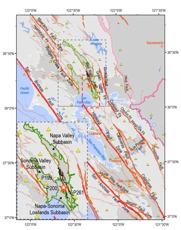
The vineyard-filled valleys flank the West Napa Fault, which produced the quake that killed one person, injured several hundred and caused more than $500 million in losses.

The study recently published in the American Geophysical Union’s Journal of Geophysical Research: Solid Earth suggests land between the valleys is stretched each summer as groundwater levels fall beneath the valleys and the ground in the valleys sinks and contracts.

The amount of the horizontal stretching measured is tiny — about 3 millimeters (0.12 inch) — but enough to stress faults, according to the researchers.

“We think it’s more of a localized effect, something related to the groundwater system. We don’t know if it is groundwater pumping specifically, or something related to how the natural aquifer system works, or a combination,” said lead author Meredith Kraner, formerly of the Department of Geosciences at Stony Brook University in New York and now with the University of Nevada, Reno.

A star marks the epicenter of the 2014 South Napa earthquake and the black traces the West Napa Fault. Contraction in the Sonoma and Napa Valley groundwater subbasins, outlined in green, pulls on the Earth’s crust, contributing to stress on the fault and potentially triggering the 2014 earthquake, according to a new study. (AGU Journal of Geophysical Research: Solid Earth)

Co-authors were William E. Holt of Stony Brook University and Adrian A. Borsa of the Scripps Institution of Oceanography at the University of California, San Diego.

Sponsored

The early morning Napa quake on Aug. 24, was the largest to hit the San Francisco Bay Area since the magnitude 6.9 Loma Prieta earthquake of Oct. 17, 1989.

It left 8 miles of surface rupture and damaged many historical masonry buildings and older residences, according to the U.S. Geological Survey.

“The weight of groundwater flexes the Earth’s crust, and changes in groundwater have been associated with earthquakes around the world,” the study said. “For example, the unloading of water weight as the Sierra Nevada snowpack melts each spring has been connected to increased frequency of earthquakes in the summer in California.”

lower waypoint
next waypoint
California’s New 1600-Acre State Park Set to Open This SummerHomeowners Insurance Market Stretched Even Thinner as 2 More Companies Leave CaliforniaSame-Sex Couples Face Higher Climate Change Risks, New UCLA Study ShowsHoping for a 2024 'Super Bloom'? Where to See Wildflowers in the Bay AreaEver Wake Up Frozen in the Middle of the Night, With a Shadowy Figure in the Room?These Face Mites Really Grow on YouSchizophrenia: What It's Like to Hear VoicesThis is NOT a Dandelion.Do Little Earthquakes Mean the Big One Is Close at Hand?Where to See Cherry Blossoms in the Bay Area This Spring