upper waypoint

Landfill and Liquefaction

Save ArticleSave Article
Failed to save article

Please try again

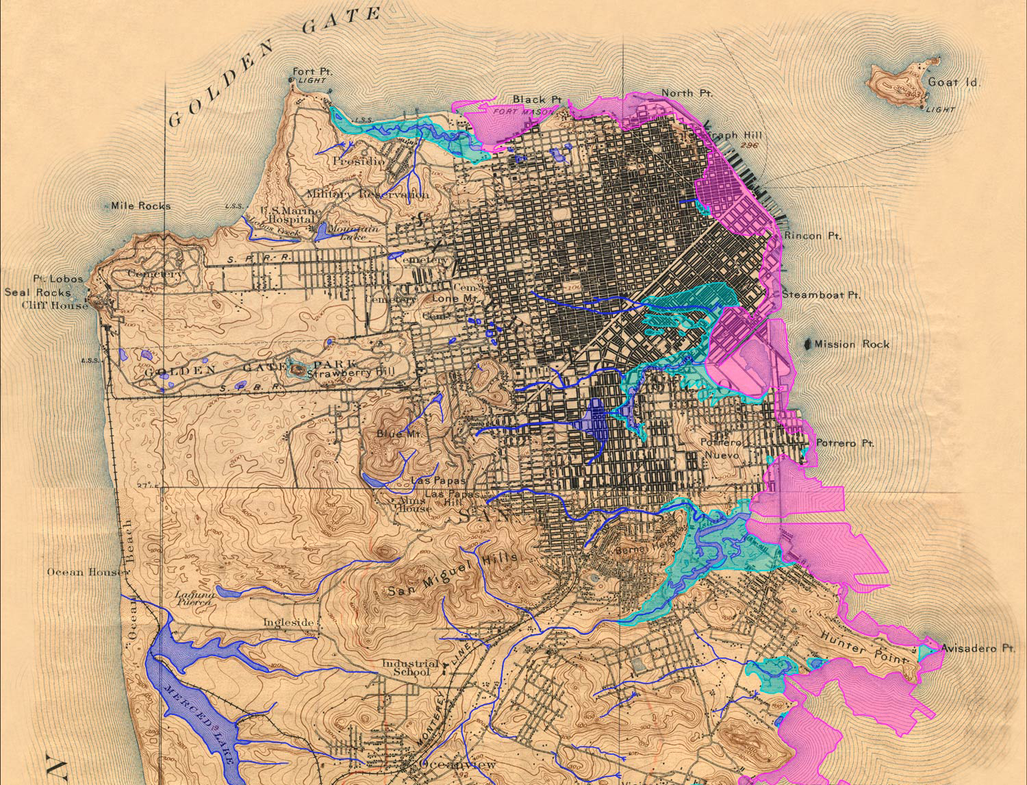
Although it may not be obvious at first glance, the bay side of San Francisco is largely artificial. The huge increase in population associated with the California Gold Rush of the mid 1800s resulted in San Francisco becoming the major port on the west coast. In some cases, people seeking riches in the Sierra Nevada headed off to the mountains and simply abandoned their ships in San Francisco. Some of these ships ended up being used as landfill and, year after year, the shoreline along the northern and eastern sides of the city was modified.

The area where Market Street meets the Embarcadero was among the earliest areas to be extended into the bay, but landfill -- a combination of sediment dredged from the bay with rubble -- continued to be used to create new "land" for decades to come.

The map below* shows this modification quite nicely. Original creeks and streams are in blue, marshes in aqua-green, and modern landfill in pink.

Sponsored

What I like about this map is how the pink landfill areas highlight the old shoreline. Note where the original creeks and marshlands met the bay. What is now a relatively straight shoreline was once very irregular with several natural embayments. Mission Bay was once an actual bay. I find it fascinating to picture the city in this way -- the way it was a little over a century ago.

The areas that are now landfill are important to consider not just as interesting history, but also in the context of earthquake hazards. Last week I discussed Bay Area seismic hazard preparedness and an important component of getting ready is to learn about how different types of land respond to the shaking.

The map above** was produced by the USGS and shows the liquefaction hazard -- red is very high hazard, orange is high, yellow moderate, green low, and no color is very low. Liquefaction is essentially when loose sediment behaves like a fluid when shaken, which can result is serious damage to buildings and houses.

Note the correspondence between the red areas on the liquefaction hazard map with the map showing where landfill and old marshes are. While it may seem like solid ground when you are walking or driving on the street it's important to remember that the fill underneath is quite loose compared to actual bedrock.

~

* This great map, and many more, can be found at the website for the Oakland Museum of California: http://museumca.org

** See the entire zoomable map, learn more about liquefaction hazard, and how the USGS made this map here.

37.760564217910726 -122.40723038557917

lower waypoint
next waypoint