Location
The park is 15 miles west of San Rafael on Sir Francis Drake Boulevard.
P.O. Box 251
Lagunitas, CA 94938
415-488-9897
Please call the park for current hours of operation at the phone number above.
Download a trail map and more about the park.
Special thanks to Ranger Vic Graves and Damien Jones, Supervising State Park Ranger – Marin Sector North Parks of the California State Parks for their participation.
Robin Marks of the Exploratorium contributed to this Exploration.
[/tab]
[tab name="Intertidal Diversity"]
Intertidal Diversity
In the rocky intertidal zone along the coast of California, you are a giant. As you walk out on the rocks during low tide, your huge feet dwarf the intertidal's tiny inhabitants. With one sweep of your eyes, you can look at an entire ecosystem.
As the rock slopes from the land to the sea, there is a steep gradient in environmental conditions. High on the shore, organisms spend most of the day exposed to air. Closer to the ocean, organisms spend most of their time submerged in water. These differences in the environment set up the intertidal zones. Different species inhabit these different zones.
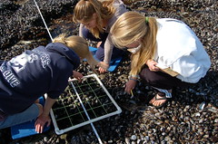 Scientists have been studying intertidal zonation for years. Ecologists continue to study how organisms interact with the intertidal environment, and each other. These high school students are studying intertidal ecology, using a quadrat and a transect tape.
Evolution from the Oceans
All of the major branches on the tree of life originated in the ocean. And descendants from most of those branches can be found in the intertidal zone of today: seaweed, sponges, sea stars, mussels, crabs – each represents a different evolutionary lineage.
Seaweed comes in three colors
There are three groups of algae: browns, reds, and greens. Each group is a separate branch on the tree of life. Each group has a different combination of pigments; these pigments reflect light at different wavelengths, giving each group its characteristic color. Different pigments also absorb light at different wavelengths; the ability to catch and use light is important for photosynthesis.
The brown algae group includes the giant kelps that live just offshore, as well as tiny diatoms. The red algae group includes a seaweed familiar to sushi lovers, called Nori. This seaweed is common on the California coast. The green algae group contains Ulva, a bright green, sheet-like seaweed that grows on rocks and on docks in marinas. Away from the ocean, mosses, ferns, conifers and flowering plants evolved from the humble green algae.
As the climate changes, so does the intertidal
 Intertidal inhabitants are being affected by climate change; there is evidence that the geographic ranges of many species of invertebrates have shifted further north, just since the 1930s. And one species, the Volcano Barnacle (Tetraclita rubsecens) has shifted just within the last 20-30 years. Prior to 1980, it was never found north of San Francisco. Today, this barnacle clings to the rocks as far north as Oregon. Some species can move north in response to climate change; other species can't. These organisms live on the edge of the land and the sea, and have to deal with climate change in both those realms.
[/tab]
[tab name="Visitor Photos"]
Latest Visitor Photos
Join the Natural Bridges State Beach photo group on Flickr to share your photos of this amazing place.
[slickr-flickr search="groups" id="1075081@N22" type="gallery" items="49" flickr_link="on" descriptions="on"]
[/tab]
[end_tabset]
Quest Educational Resources
Additional Links