The parking lot is closed on weekends, except for permitted events. To obtain a permit for your wedding or group event, call the SFPUC at 650-872-5900.
Nearby Open Space Attractions
The newly-opened portion of the SFPUC Peninsula Watershed’s Fifield-Cahill Ridge Trail, accessible through guided tours, starts at Skyline Quarry on Highway 92 and extends northward to the watershed boundary at the Portola Ridge Gate, where it connects with the Golden Gate National Recreation Area trail system and the Sweeney Ridge section of the Bay Area Ridge Trail. For tour reservations, see trail.sfwater.org or call 650-652-3203.
The historic Sawyer Camp Trail-once a segment of the main route between San Francisco and Half Moon Bay-winds approximately six miles through SFPUC Watershed land from Crystal Springs Reservoir to San Andreas Lake.
Special thanks to John Fournet and Betsy Lauppe Rhodes of the San Francisco Public Utilities Commission, for assisting us on this project.
[/tab]
[tab name="Never the Same River Twice"]
Cruising Down The River: A Paddle Exploration of the Lower Russian River
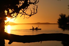 "Rivers know this: there is no hurry. We shall get there some day."- A. A. Milne, Pooh's Little Instruction Book. Photo provided by George Scott Zastrow PhotographyThe Russian River begins its ramblings in the northern California redwood forests of Mendocino County, gently flowing south through Sonoma County, past lush vineyards and the towns of Geyserville, Healdsburg and Guerneville, before turning and winding its way to the Pacific Ocean. The river is a popular summertime destination for Bay Area residents and is also home to a vibrant and diverse wildlife community.
One of the wildest spots on the main stem of the Russian River is near its mouth where the river meets the sea. Here at the estuary the waters widen and the influences of two dynamic ecosystems merge. We have explored estuary environments before, discovering their beauty, learning about the fluctuating environment, the impact of human interaction and the challenges of restoration. But for this Quest Exploration we trade in our walking sticks for kayak paddles. The only way to be fully immersed in the river environment is to take to the water.
A young steelhead jumps at a dragonfly, an Osprey lands in its nest above, a family of river otters frolics along the riverbanks. The river is a verdant but fragile part of California's natural heritage. Exploring the lower stretch of the Russian River, from Duncans Mills to Jenner, provides a micro-climate glimpse of the varied river terrain; winding from the warm inland mountains and forests, past breezy oaks, willows and grasslands, to fog-draped Tule marshes and coastal dunes. And as we slowly drift down the river, the aquatic ecosystems are changing too, from fresh to salty brackish water.
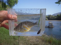 The Russian River Tule Perch, (Hysterocarpus traskii pomo), is the only genetically endemic (biologically native) fish in the Russian River.When we think of rivers we usually just think of the main stem, the stream we see flowing in the waterway. But rivers begin at the tops of mountains. The whole area of land that drains into a river is called the watershed. The Russian River watershed encompasses 1485 square miles of mountains and valleys, forests and agriculture, cities and towns, 95 percent of which is private property. All of the water running off this land makes its way into and down the 110 mile stretch of the main stem before finally meeting the Pacific Ocean at Jenner, California. The river supplies drinking water for over a half million people in Mendocino, Sonoma and Marin counties while during the summer it is also one of the most heavily used rivers for canoeing and kayaking in the nation. The river provides critical habitat for birds and other wildlife, as well as many species of fish including three endangered salmonid species and the endemic Russian River Tule Perch.
The area of the river that we are exploring is located within the coastal fog belt of the outer North Coast Ranges. Here cool, moist, maritime conditions contrast the warmer dryer continental climate of the inland watershed. Tree species such as Redwood (Sequoia sempervirens), Douglas Fir (Pseudotsuga menziesii), Tanoak (Lithocarpus densiflorus) and Pacific Madrone (A. menziesii) dominate the forested landscape. The south-facing slopes and ridgelines are quilted with upland Coastal Prairie that serves as a reminder of the once vast and diverse grassland that stretched along the northern California Coast.
Old-timers tell tales of the Russian River at a time when the redwood trees growing along the riverbanks were so huge, their branches stretched across the entire river, touching in the middle, and creating a shaded tunnel that the cool water gently flowed through. Today most of the big trees are long gone, but the second and third-growth timbers still provide homes for waterfowl, eagles, owls, osprey, heron and a host of other birdlife.
Native riparian plant communities support a high level of biological diversity and are particularly important to the life cycle of fish such as endangered salmon. The native vegetation also helps control erosion during the winter flood stages and can mitigate over-sedimentation of the river.
On our paddle we glided past an osprey and great blue heron roosting site that is testament to a thriving river environment. In one 50-yard stretch we could see at least four large osprey nests, each with a courting pair calling out to one another as they were busy rearing this year's young brood. The success of these fish-eating raptors, at the top of the river food chain, is encouraging, showing a thriving food-web of fish and invertebrates in the aquatic ecosystem below the nests.
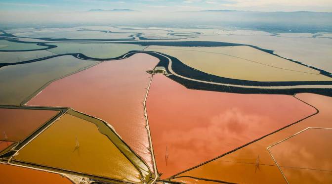
As we enter the estuary and approach historic Penny Island, The river begins a transformation both readily seen and unseen. Scientists from the Sonoma County Water Agency and National Marine Fisheries Service are now actively studying this region. 12 data collection stations have been installed in the estuary, taking readings of the salinity and water temperature and measuring the levels of bacteria and oxygen in the river. The scientists are also working with the USGS to test for pharmaceuticals, heavy metals and wastewater residue in the estuary.
The Russian River estuary has an incredibly rich biodiversity. Over 50 species of fish have been identified in the lagoon, including Chinook Salmon, Tule Perch, Starry Flounder, American Shad and Bay Pipefish. The estuary is a nursery and particularly important for fish such as young steelhead who use this area to grow and adapt to saltwater before entering the ocean. It's this mixing of two distinct ecosystems that makes the estuary environment so vibrant; a confluence of life where an upriver animal such as the Northern River Otter, might interact with an ocean species such as a harbor seal.
In the tale "The Wind in the Willows" Rat said of the river, "It's my world, and I don't want any other. What it hasn't got is not worth having, and what it doesn't know is not worth knowing. Lord! The times we've had together!" Ever changing, ever moving, always full of surprises, maybe the pre-Socratic philosopher Heraclitus said it best, "you never set foot in the same river twice."
[/tab]
[tab name="Visitor Photos"]
Visitor Photos
Join our Lower Russian River photo group on Flickr to share your photos of this amazing place.
[slickr-flickr search="groups" id="1408535@N24" type="gallery" items="49" flickr_link="on" descriptions="on"]
[/tab]
[end_tabset]
Quest Educational Resources
Additional Links
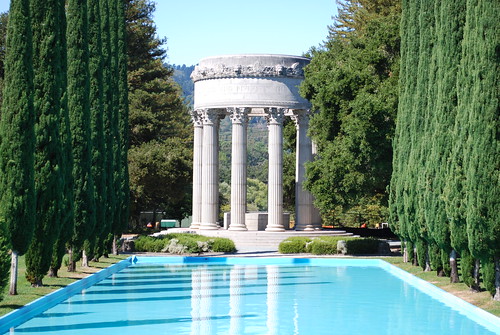 The Pulgas Water Temple was built at the terminus of the Hetch Hetchy aqueduct as a monument to the new water system. It’s located within the watershed, just south of Crystal Springs reservoir. An inscription at the top reads, "I give waters in the wilderness and rivers in the desert, to give drink to my people," a biblical quote from Isaiah. The San Francisco Peninsula Watershed, managed by the San Francisco Public Utilities Commission, is home to trails that offer access to remote wilderness, Northern California geology, and opportunities to enjoy ridge-top vistas of our watershed lands, reservoirs, the Pacific Ocean and San Francisco Bay.