This post will no longer be updated.
Update, 12 p.m. Friday: The weather in Northern California was significantly calmer on Friday, offering a brief respite before two more atmospheric rivers slam the region this weekend and into next week.
As of Friday morning, evacuation and shelter-in-place orders had been lifted in Sacramento County. In Sonoma County, the evacuation warning was still in effect for all residents living near the Russian River floodway and its tributaries from Healdsburg to Jenner, where the river is likely to flood in the coming days. Marin County issued a flood watch from 4 a.m. Saturday to 4 p.m. Tuesday. Various roads also remained closed throughout Alameda and Contra Costa counties.
In coastal areas on Friday, wave heights were significantly lower than in previous days, although the surf remained dangerous along much of the coast. As of Friday afternoon, an evacuation order was lifted for the low-lying areas of the Rio Del Mar Esplanade in Santa Cruz County, but an evacuation warning remained in effect for low-lying residences in sections of nearby Capitola.
As of Friday morning, Pacific Gas and Electric had restored power to more than 200,000 customers, but said that tens of thousands of residents in its service area were still without power, including up to 17,000 customers in the Bay Area, according to reporting from Bay City News. The utility reportedly mobilized 3,000 workers and contractors to continue repair work before the next storm.
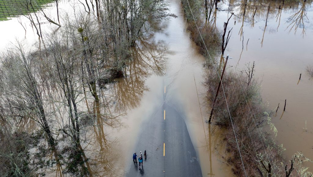
The recent succession of storms have helped with California’s drought conditions, moving the state out of the “exceptional drought” category, but the precipitation won’t be nearly enough to officially end the four-year drought.
Update, 4 p.m. Thursday: Pacific Gas and Electric on Thursday afternoon said about 440,000 customers across its vast service area — including a number of schools — lost power at some point on Wednesday or Thursday morning. Roughly 325,000 have had their power restored, and another 40,000 should be back online by late Thursday, the utility said.
Customers who still don’t have power after today could be in for a long wait, said Janisse Quiñones, PG&E’s senior vice president of electric operations.
“Because we don’t have access to many of the areas, or the conditions are really dangerous for our crews, trees are falling around them, we have flooding and soil movement when they are trying to restore our service,” Quiñones said in an afternoon press briefing. She noted that winds late Wednesday reached close to 100 mph in some higher-elevation service areas. “Right now our [helicopters] are grounded. The weather is preventing us from bringing any aerial equipment up in the air.”
Quiñones said there are 369 PG&E restoration crews currently out in the field, along with about 25 crews from other West Coast utilities providing mutual aid. But the succession of storms and the short windows of time between them have made restoration efforts challenging, she added.
“We have a series of storms coming in the system. We got hit on New Year’s [Eve] with a storm, we got hit yesterday with a storm, we’re expecting a storm Saturday, and another storm system Monday, which creates a very limited window of opening for restoration for our crews,” she said.
Quiñones urged anyone who sees a downed power line to first call 911 and then contact PG&E — and to never touch or get near it.
Update, 2:30 p.m. Thursday: Authorities have released more information about a 2-year-old boy who was killed by a falling tree in the Sonoma County community of Occidental on Wednesday.
The boy was sitting in his living room around 5 p.m. when the tree fell and landed on top of the mobile home, pinning him underneath, sheriff’s Sgt. Juan Valencia told KQED.
The boy’s father and some neighbors had pulled the boy from under the tree by the time first responders arrived, Valencia said. They performed CPR and the child was pronounced dead at 5:48 p.m.
The boy was one of at least two people who died in Wednesday’s storm. Fairfield police said a 19-year-old woman was killed when her car hydroplaned on a wet road and struck a pole.
Meanwhile, authorities shuttered numerous roadways due to downed trees, power lines and other hazards.
A rockslide closed a stretch of Highway 1 between Stinson Beach and Muir Beach, Marin County said on Twitter. Further down the coast, a section of the coastal highway in Carmel was closed due to massive waves reaching the roadway, and another section south of Big Sur was closed because of falling rock.
Picture of slide on #Hwy1 from this morning at Polar Star, one mile south of Ragged Point. Contractor engaged to help clear. Full closure remains in place. Assessments ongoing. Continue to ask public to please keep out of the closure area which will permit crews to work safely. pic.twitter.com/9TmAebtqJn
— Caltrans District 5 (@CaltransD5) January 5, 2023
A landslide also blocked a lane of northbound Highway 1 in Pacifica, just past Manor Drive, police said.
Update, 1 p.m. Thursday: Santa Cruz County authorities lifted evacuation orders Thursday morning for potential flood areas as the worst of the storm has passed, but huge waves and high tides from the atmospheric river remained a threat to residents in coastal areas.
“If you can evacuate safely, please do so immediately. If you are unable to evacuate, please shelter in place, move away from ocean facing windows,” the county sheriff’s office said in a statement.
The National Weather Service warned of dangerous swimming and surfing conditions as 20- to 30-foot-high waves hit the central California coastline. The waves broke apart two piers in Santa Cruz County, and flooded the picture-postcard town of Capitola. Dramatic eyewitness videos show water thrashing against waterfront restaurants and businesses.
Capitola Beach and Pier are under siege with tide and surf still rising. pic.twitter.com/89b1CAGfg6
— sports business (@soulfocussports) January 5, 2023
Nearby, the California Highway Patrol urged people to avoid coming to Seacliff State Beach in Aptos because of coastal flooding. An old concrete ship broke away from the beach’s pier.
In low-lying areas of Marin County, a combination of the rain and tides flooded some roadways. Authorities closed Miller Avenue, a major thoroughfare, and urged drivers to slow down and avoid large bodies of standing water.
Meanwhile, forecasters dialed back flood predictions for the Russian River in Sonoma County. The National Weather Service previously projected the area could become inundated by Thursday afternoon, potentially causing minor flooding in Guerneville, Monte Rio and other parts of the popular vacation getaway.
The river is now forecast to reach flood stage on Sunday afternoon.
Update, 11 a.m. Thursday: Forecasters said lighter rain and isolated thunderstorms are expected to pass through the Bay Area the rest of Thursday, giving residents a bit of a break to clean up and assess damages before another storm arrives Saturday.
A flood watch remains in effect until 4 p.m. because additional rainfall to an already soaked region could lead to rapid rises along creeks, streams and flood-prone areas, the National Weather Service said.
“We’re not done with the water just yet,” said Brayden Murdock, a meteorologist with the weather service’s Bay Area office. “With our next pattern coming through, it’s going to be almost daily where we see some wet conditions. Luckily not seeing the rainfall amounts like we saw with the main rainband last night, but still we’re not done with this wet pattern.”
In the South Bay, gusty winds and towering waves split the Capitola wharf in half and flooded the Santa Cruz County seaside town. The waves also breached the seawall in Pacifica and prompted the weather service to issue a high surf warning until 3 a.m. Friday, urging beachgoers to stay off jetties and coastal rocks and stay out of the surf zone. Beaches could be hit by up to 30-foot waves.
The storm has caused significant damage throughout the county and along the coast, including heavy damage to piers in Capitola and Seacliff. High tide and large surf is a dangerous combination - avoid the coast. pic.twitter.com/XiyuJBQUFB
— Santa Cruz County (@sccounty) January 5, 2023
The latest in a series of atmospheric rivers slammed into the Bay Area late Wednesday, causing widespread flooding and power outages affecting nearly 145,000 Pacific Gas and Electric customers. The weather contributed to at least two deaths: a toddler who was killed after a tree fell onto a house in the Sonoma County town of Occidental, and a Fairfield woman whose car hydroplaned on a wet road and slammed into a pole.
In San Francisco, a family was rescued by firefighters Wednesday evening when a tree fell onto their car on Larkin Street. Near the zoo, another tree fell onto a person who had to be rushed to a trauma center in stable condition, the city’s Fire Department tweeted.
Firefighters responded to dozens of calls about downed trees and power lines. Winds gusting to 85 mph forced the cancellation of more than 70 flights at San Francisco International Airport.
Nearby in South San Francisco, the winds knocked over the roof of a Valero gas station’s canopy, damaging at least one fueling station. The city opened a temporary evacuation center for the more than 3,000 residents who were without power Thursday morning.
Update, 8:30 a.m. Thursday: Heavy rain and damaging winds from the “bomb cyclone” knocked down trees, flooded roads and cut power to tens of thousands of homes and businesses as of Thursday morning, and contributed to the deaths of at least two people.
A toddler was killed Wednesday night after a tree fell and landed on a house in the Sonoma County town of Occidental, volunteer firefighters there told local media. In Fairfield, a 19-year-old woman was killed after she lost control of her vehicle on a flooded road and slammed into a utility pole, police said.
The storm dropped heavy rain in parts of the Bay Area. A preliminary rainfall report from the National Weather Service estimates that as much as 4 to 5 inches of rain fell over a 24-hour period in the mountains south of Monterey, while most of the rest of the region received 1 to 2 inches.
But any additional rain to areas already soaked by multiple storms since Christmas is prompting fears of mudslides, flooding and downed power lines and trees. California issued a state of emergency to support response to the storm and recovery efforts.
Nearly 170,000 homes and businesses were without power in California Thursday morning, according to poweroutage.us.
Radar Update 6:52 AM - Don't put away those umbrellas yet. Here's a radar loop over the last hour showing showers. Some showers may be heavy at times. Allow extra time for the commute. For the rest of today showers and even thunderstorms are still possible. #cawx pic.twitter.com/WUq7TQGMDX
— NWS Bay Area (@NWSBayArea) January 5, 2023
Original story, 8:45 p.m. Wednesday: Gusting winds of up to 85 mph in parts of the Bay Area bore down on the region Wednesday afternoon, and the heaviest rainfall of the “bomb cyclone” hit in the early evening, with heavy rain and winds to continue into Thursday.
The storm prompted evacuation warnings, triggered landslides, closed roads and downed trees. But the morning rain totals were less than predicted, with about a half-inch falling in San Francisco, said Mary Ellen Carroll, executive director of San Francisco’s Department of Emergency Management.
“It has been a quiet day … until about an hour ago,” Carroll said as winds and rainfall picked up in the late afternoon. “The storm we have all been waiting for is here.”