
When Nicole was growing up, her grandmother always told her: Don’t live anywhere built on artificial fill. Her uncle also had strong memories of watching the Marina District burn after the 1989 Loma Prieta earthquake, when parts of the ground liquefied, causing buildings to collapse and gas lines to break.
Nicole wants to follow her grandmother’s advice, but she needs to know a few things: “What neighborhoods and cities in the Bay Area are built on filled land? And what are those cities and neighborhoods doing to mitigate the risk of liquefaction?”
What is fill?
Often, when we colloquially refer to fill around the Bay Area, we’re actually referring to two different things:
- Artificial fill
- Former or “reclaimed” marshlands and wetlands.
Artificial fill is land that was created by piling up soil, mud, rocks, rubble and dirt. In many cases, mud was pumped up from the bottom of the San Francisco Bay to fill in piles of rocks, then allowed to dry.
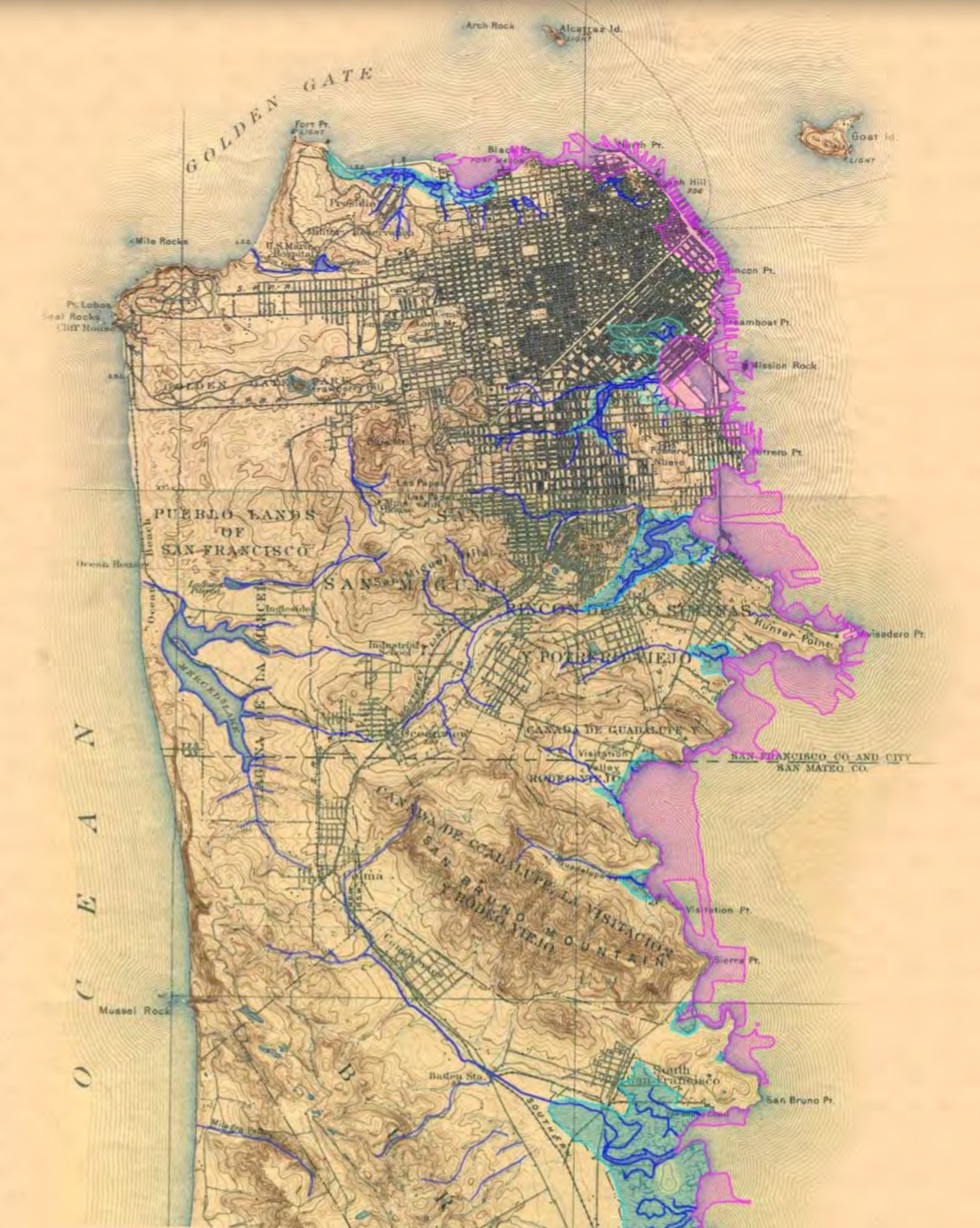
In most cases, this fill was put on top of low-lying areas or shallow wetlands and marshlands. For example, Treasure Island was made by piling rocks and mud on the shoals north of Yerba Buena Island. The land that is now the Marina neighborhood in San Francisco was originally filled in for the 1915 Panama-Pacific International Exposition — in some cases using debris and rubble from the 1906 earthquake.

Reclaimed marshlands and wetlands are not technically fill. However, building levees and draining marshes did change the coastline of the bay, allowing for more development.
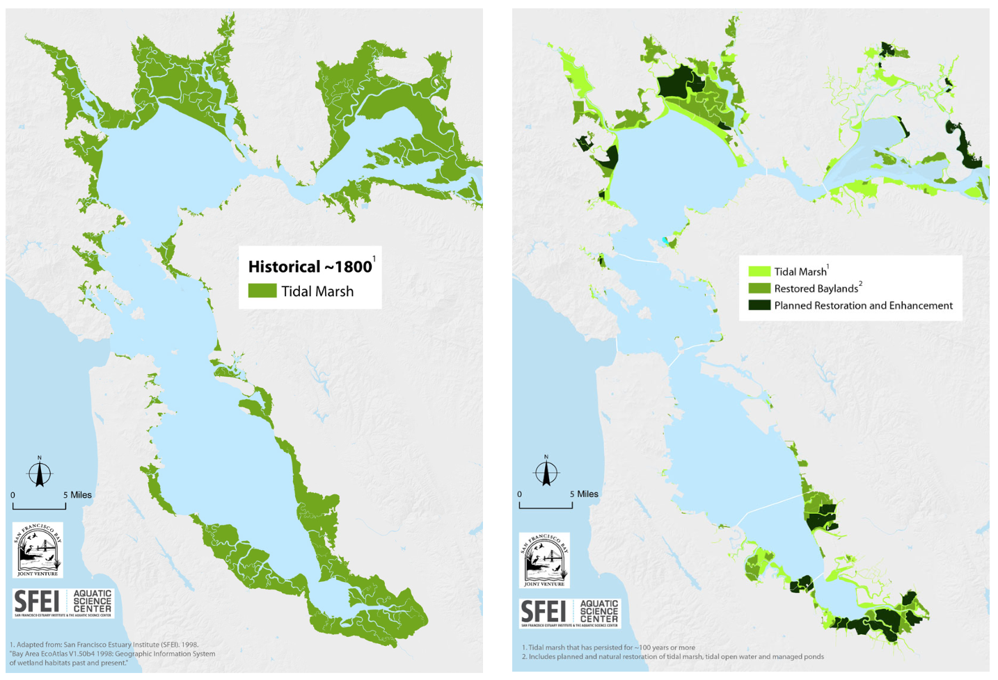
Hundreds of years ago, the coastline of the Bay Area looked very different. In many places, the edges of the bay were marshland or wetlands. During the late 1800s and early 1900s, lots of that got drained. People built levees and “reclaimed” the land for what they considered useful purposes, like agriculture. These days, some of those levees have been torn down and land is being returned to tidal marshes.
Why did we use fill in the Bay Area?
Because fill in the bay let us build, live and farm on land that was previously uninhabitable.
In the mid-1800s, the U.S. Congress passed the U.S. Swamp Land Acts. These were originally designed to help Louisiana drain its swamp lands and build levees — but were quickly put to use in other states. The laws allowed people to claim wetlands or marshlands as their own property if they drained it and used it for an agricultural purpose. This led to a spree of building levees and draining wetlands.
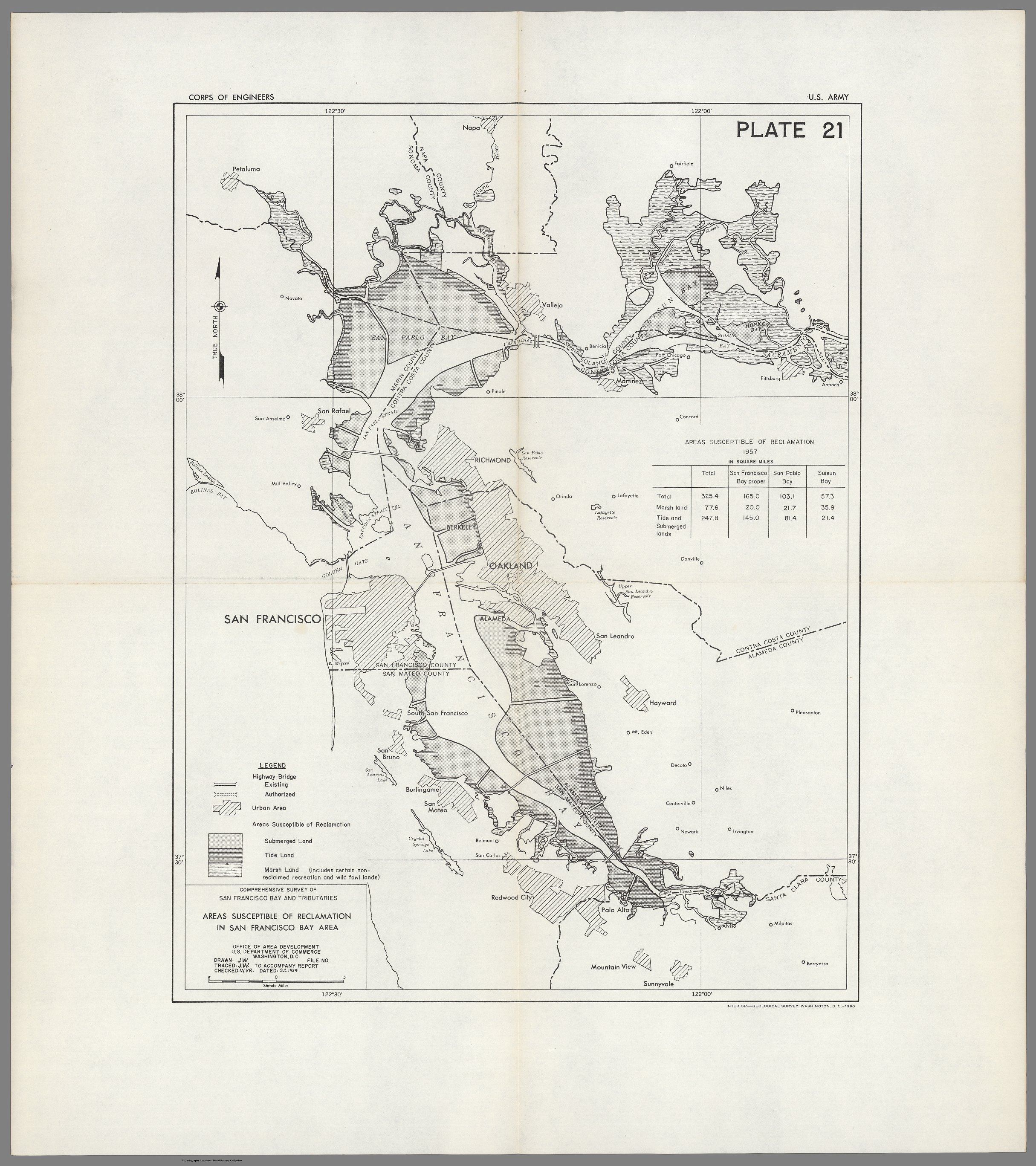
In the late 1950s, the Army Corps of Engineers did a study on the development of the Bay Area. They found 243 square miles of land “available for reclamation” had been reclaimed. That’s a lot of former marshlands, wetlands and tidal lands to have drained or filled.
You can read the full study here. It’s wild.
What are the problems with artificial fill?
By the 1960s, we mostly stopped filling in the Bay because of growing environmental concerns. After the Army Corps of Engineers did its study of the Bay Area, they published a map projecting what the bay would look like if we continued to fill it in. The picture so alarmed people that eventually the state Legislature put an end to bay fill.
The other major problem with artificial fill, which wasn’t well known 100 years ago, is the earthquake danger.
According to Keith Knudsen of the U.S. Geological Survey, the fill built on top of bay mud or soft ground is at risk for ground failure or liquefaction during an earthquake. A lot of that old fill was not built with the best engineering practices. It was also frequently placed on top of mud or soft deposits, which amplify shaking. When you have high ground water, loose materials and heavy shaking, those deposits can stop behaving like a solid, and start behaving like a liquid, said Knudsen.
The ground turns into a sort of quicksand. Buildings on top can sink and crack. Also things that are in the ground and filled with air, like sewage pipes, can float to the surface.
“Lots of bad things can happen if the ground liquefies,” Knudsen said.
What’s being done to mitigate those issues?
The best way to prevent liquefaction and ground failure is to take steps when you’re first creating the artificial fill.
Treasure Island is one of few places in the Bay Area where a large new development is planned to go in on top of artificial fill. Developers there are able to test more intense mitigation techniques. Using things like wick drains and vibratory compaction, they’re draining the water out of the ground, shaking it to settle the loose materials and then pushing down on the fill with heavy dirt loads to compact it.
You can read more about what’s happening there in our two-part series about the artificial island.
The bad news, though, for most of the Bay Area is that it’s hard to go back and re-engineer buildings that are already built. Once an entire neighborhood is constructed, options are even more limited. Anything done to mitigate the risk for one building could affect the others. For example, the San Francisco Transbay Terminal developers used “dewatering” techniques to suck the water out of the ground before they built the terminal. Now developers of the sinking Millennium Tower say that affected their building.
We do have some standard practices for new buildings built on top of fill:
- Slab or mat foundations — if part of the ground liquefies, then the whole building will sink or tilt in one piece instead of cracking
- Friction piles — it’s a kind of pile foundation that goes deep down, through the fill, into the mud. Some buildings have piles that go all the way to the bedrock
One of the biggest things that changed after the 1989 earthquake were new requirements to notify people who live in hazard zones. You can use the California Earthquake Hazard Zones App to plug in your address and see if you live in an area at high risk for liquefaction or landslides in the event of an earthquake. The USGS also puts out updated hazard zone maps.
But, just because you’re in a liquefaction hazard zone doesn’t necessarily mean you live on fill — or vice versa. And those former marshlands and tidal wetlands are not at high risk for liquefaction if the bay mud didn’t have artificial fill put on top of it.
OK, so which parts of the Bay Area are fill?
We have maps to show you!
The only way to know for sure if you live on fill is to hire a geologist and do a boring into the ground. Short of that, the other way is to map the geological deposits the way the USGS does.
“We overlay them on current maps and then the boundary between what used to be the coastline and what is currently the coastline … that’s been filled,” Knudsen said. USGS also does additional topography work to put together detailed maps of geological deposits. While this can miss individual buildings or neighborhoods, it’s the most accurate record of the whole Bay Area.
Using that USGS data, we created this map showing artificial fill areas and former tidal marshlands or wetlands.
Lisa Pickoff-White contributed to this story.