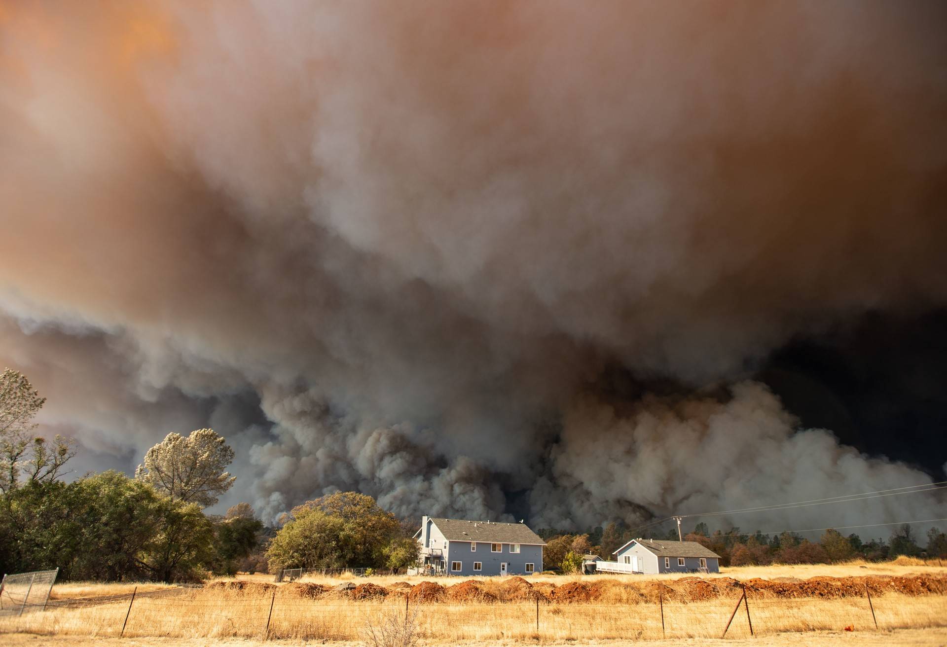
California fire officials have learned through hard experience to temper their optimism.
Having just endured more than a decade of rampaging fires — 14 of the 20 most destructive fires in state history have occurred since 2007 — fire bosses say this year the glass is half-full.
“We’ve got a few things going for us at the moment,” said Scott McLean, a spokesman for Cal Fire, the state firefighting agency. “We still have a snowpack. Our upper elevations haven’t dried out. Because of that, we are able to continue our fuel-reduction projects.”
Yes, this year featured a wet winter — usually good news for fire officials. But so did 2017, one of the state’s wettest winters in half a century and one of the most devastating years for wildfire.
Clearing and cutting has helped eliminate some of the brush and trees that fuel the flames. But California’s forests are still clogged with 147 million dead trees, and counting. And the late-winter rains encouraged the growth of grasses and other highly combustible plants.
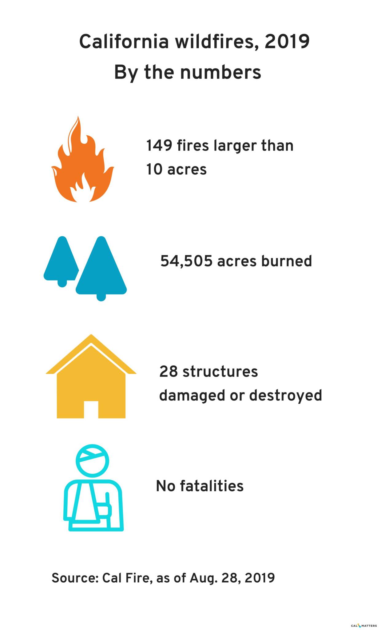
Cal Fire battled 164 fires across the state in the third week of August, many of them small. History shows that September and October, with their hot, fierce winds, are the worst months for fire. And “this week we have dry lightning predicted,” McLean said. That could spark fires in the state’s northern forests.
On the other hand, state officials have been showering Cal Fire with financial aid. The agency’s ranks are bolstered by an additional 400 seasonal firefighters and 13 new engines and crews to operate them. And the state is taking delivery of a new Sikorsky S-70i Firehawk helicopter next month, the first of 12 replacement firefighting helicopters.
“We’ve got everything out of maintenance; everything’s ready,” McLean said.
But don’t look for California’s biggest air tool to come to a rescue anytime soon. The converted 747 jet, which can carry 24,0000 gallons of water or retardant, is currently flying over the Amazon, fighting fires in Brazil.
Mapping the Fire Threat
Cal Fire is in the process of updating its map of wildfire-hazard zones, identifying areas of fire danger and assigning degrees of risk to those places. The California Public Utilities Commission is revising its fire map as well. So are the state’s power providers and insurance companies.
They’re all trying to better predict where and how wildfires may strike, as officials across the state seek to gain some advantage over fire’s growing menace.
In the case of Cal Fire, the mapmaking — painstaking and devilishly complex, combining detailed data about weather, topography, vegetation and the placement of roads and homes — was last undertaken about 12 years ago. Officials say that doesn’t mean the 2007 version is out of date.
“When you look at hazards by themselves, they are long-term factors that don’t often change,” said Daniel Berlant, Cal Fire assistant deputy director and chief of planning and risk analysis. “The slope of topography is not going to change in a decade.”
But much else has changed. A debilitating drought has come and gone. That and widespread insect infestation wiped out trees in especially fire-prone regions of the state. And more and more Californians are living in the very landscapes that are most flammable.
Cal Fire’s map is used largely by counties and local authorities in making decisions about construction in high-fire-hazard zones and fire-mitigation measures from homeowners.
Berlant said the document’s “major overhaul” will include the latest science, particularly sophisticated new models for where and how wind drives wildfires. It will be completed sometime next year, he said.
The utility commission’s map is somewhat different. It breaks the state into a grid of one-mile squares, focusing on power companies’ lines and equipment and assigning fire threats. The identification of risk areas dictates what prevention efforts the companies should undertake to safeguard their property from fire.
The map includes Cal Fire and utility-company data, updated yearly.
Mason Withers, who helps run San Diego Gas & Electric’s risk-management group, said his company assumes the worst-case scenario in all of its 4,000-square-mile service territory and assigns its own fire-potential index.
“If vegetation could be dry, we assume it is dry. We assume winds will get as bad as they can get,” he said.