This partial transcript was computer-generated. While our team has reviewed it, there may be errors.
Alexis Madrigal: Welcome to Forum. I’m Alexis Madrigal. Pretty much as long as I’ve been conscious, scientists have been arguing that global warming would lead to rising sea levels. But it’s one thing to see a chart in a book or a color-coded map, and quite another to have a big king tide show just what it means to bump up the level of the ocean by a foot or two.
The king tides of early this month were one of the starkest signs that our low-lying coastal areas are indeed in trouble. They’re deeply vulnerable to flooding. And though we’ve been talking about climate change for decades, the seriousness of purpose and depth of funding for real solutions really are not there.
So this morning, we’re going to give you a little recap of what happened in the North Bay and try to lay out what it says about our future shoreline and infrastructure.
We’re joined this morning by Kristina Hill, professor in the College of Environmental Design at UC Berkeley. Welcome.
Kristina Hill: Thank you.
Alexis Madrigal: We’re joined by Michael Germeraad, a resilience planner with the Association of Bay Area Governments and the Metropolitan Transportation Commission. Welcome.
Michael Germeraad: Hi there. Happy to be here.
Alexis Madrigal: And we’ve got our own Ezra David Romero, a climate reporter here at KQED. Welcome.
Ezra David Romero: Hello.
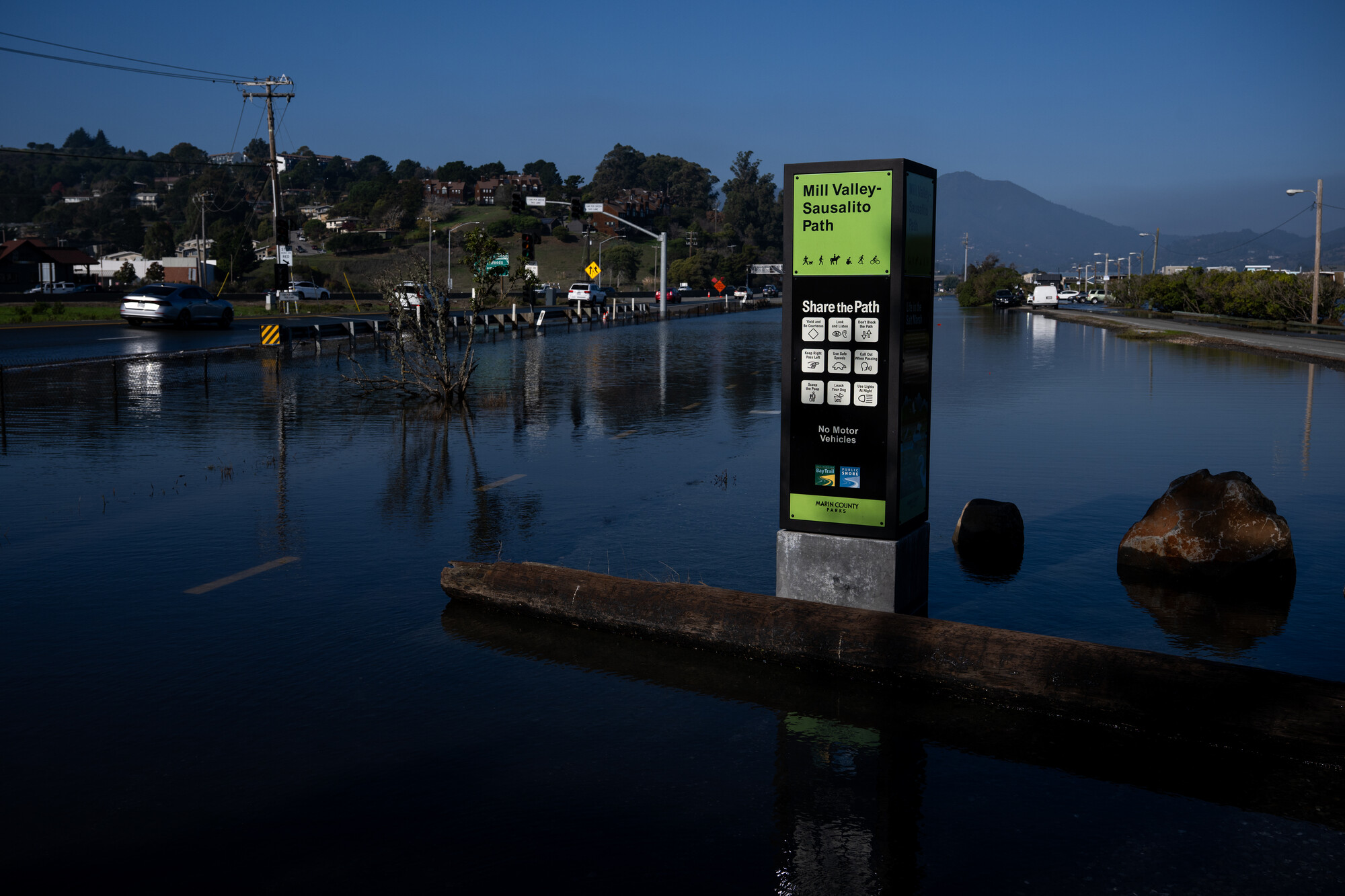
Alexis Madrigal: So just for context — it was over the holidays a bit — what happened with these recent floods in Marin?
Ezra David Romero: Basically, we had regular king tides. They happen multiple times a year, often the worst are in the winter. We had some in December on a sunny day, and there was some flooding, and it was fine.
And then we had multiple weeks of rain — it had been raining since Christmas — so everything was super saturated. The ground was super saturated. And then we had the king tides. And then we had this low-pressure system, a regular storm, that added water on top of that.
So those king tides were exacerbated, meaning they were about a quarter to a third of a foot higher than they were forecast to be. But this is a game of inches, right? This is a really low-lying area in Marin County.
You have these high mountains that drop down pretty fast on the leeward side, and then this narrow corridor that can flood really easily. A lot of it is built on fill or old wetlands, and some of it is sinking.
So you had water coming in, you had all this rain coming down from the mountains, and you had more storm surge — that’s when wind and rain push water onto land. And you saw places like Highway 101 near San Rafael flood, and also near Larkspur.
Alexis Madrigal: Mm-hmm.
Ezra David Romero: And then you saw places in San Rafael, Sausalito —
Alexis Madrigal: Corte Madera.
Ezra David Romero: Corte Madera — all these areas flood further inland than they normally do.
I went out on a tour last Monday, and I heard a lot of people say they were surprised, or that this was a wake-up call, even though I’ve been writing about this for years and we have people on the show today who have been alerting the public.
So it was a big surprise for some people. But what was also surprising is that with king tides, the floods come in and out every day because they follow the tides. But when you have another kind of flood — like in Pajaro a few years ago, where a levee breaks and the water just sits there — it’s a different kind of exposure.
This time, you basically had three days of whiplash, where the water was coming in and out. That’s what happened.
Alexis Madrigal: Yeah. Wow.
Kristina Hill, when you looked at what happened — you see the photos come out and you plot it on a map — one thing that struck me is that these are complex systems. When we think of sea level rise, at least when I do, you kind of see it as sweeping up. But of course, there are creek dynamics, groundwater dynamics, and all these other factors.
When you’re looking at the map and the flooding, what are you seeing?
Kristina Hill: We often think about the shoreline as wedge-shaped, like it’s just going to creep up. But in flat areas, especially areas that have been pumped or built on old wetlands like the San Rafael Canal District, it’s more like a bowl.
There are some straws attached to that bowl — those are our pump stations. When there’s rain, tidal flooding, and groundwater rising from below, it’s like the bowl has holes in the bottom and water can rise up into it.
Then you wish you had more straws to pull that water out, but you don’t, and the existing straws are overwhelmed. So you see flooding.
Ezra David Romero: Yeah. To prove that point, when I went out last Wednesday to report in San Rafael, I talked to a guy who runs a karate studio near a marina.
He got a call and tried to get there — he lives in Sausalito — but he couldn’t because Highway 101 was closed. When he finally arrived, he realized flooding was coming in from the front, but all their mats were popping up in the back.
The ground was so saturated that groundwater was rising and pushing up through the seams of the building, flooding it from the inside out. It really shows how wet these bowls are when all these conditions align.
Alexis Madrigal: That’s so interesting. Kristina Hill, is this role of groundwater in sea-level-induced flooding something we’re still learning about? Because I think most people still imagine sea level rise as water going over the top, not coming up from below.
Kristina Hill: Right. We need better words for this. We should be calling this tidal flooding, rain-driven flooding, and groundwater-driven flooding. Together, they’re called compound flooding.
If we’re not specific, we could spend billions preventing tidal flooding and still flood from groundwater.
Alexis Madrigal: Can you describe what sea level rise does to groundwater?
Kristina Hill: As the sea rises, it’s like you’re lying on a couch with your foot under a pillow. When you lift your foot, the pillow rises.
The ocean extends underneath the land. As it rises, it exerts pressure on the freshwater groundwater sitting on top of it. That groundwater has to rise too. Within about a quarter mile of the shoreline, groundwater will rise almost one-to-one with sea level.
Alexis Madrigal: Michael, from a regional resilience perspective, is this a North Bay-specific problem, or is it broader?
Michael Germeraad: It’s region-wide. Marin County often sees itself on the front line, but San Mateo County, for example, often ranks number one in dollars at risk.
When we inventory what’s needed just to address the first 4.9 feet of flooding, we estimate around $100 billion across the region. There are hundreds of projects underway. Marin is just one place where action is needed sooner.
Alexis Madrigal: And that 4.9 feet could be sea level rise alone, or a combination of sea level rise, king tides, storms, and other factors.
Michael Germeraad: Exactly. That number helps tell multiple stories — protection against permanent flooding and temporary events like king tides and storms. It also shows what the end of the century could look like on a sunny day.
Kristina Hill: I’d add that the $100 billion mostly addresses tidal flooding. Nobody has calculated what it will cost to deal with compound flooding — groundwater rising behind levees and floodwalls, plus rain accumulating behind them during more intense storms.
That $100 billion addresses maybe a third of the problem. Our engineering solutions are designed for temporary flooding, not a permanently higher sea level. That changes everything inland of those levees.
Ezra David Romero: Two things on that. That study also found the cost of inaction is about $230 billion. If we don’t act, far more money is at risk.
And in places like San Rafael, pumps are running constantly because of groundwater rise. They’re built for stormwater, not salinity. So they end up pumping brackish water back into the bay during king tides, creating this circular system.
Alexis Madrigal: It’s interesting — I usually think of flood control as dams or big river systems, but we have extensive systems here too.
Kristina Hill: We do. There’s pumping in private buildings, public systems protecting BART, and systems keeping streets from flooding. It’s an ad hoc network, public and private, with no registry.
That makes it hard to predict impacts. For example, if you pump freshwater groundwater down a foot, you can raise the saltwater boundary underneath by as much as 40 feet. That means buildings not designed to sit in saltwater suddenly are.
Alexis Madrigal: So you’re shifting the saltwater–freshwater boundary underground.
Kristina Hill: Exactly — a vertical version of the X2 line. That accelerates corrosion in pipes, conduits, and foundations, and makes our seismic environment less safe.
Alexis Madrigal: Christina, these are all big bummers. Thank you for explaining them.
We’re talking about the flooding in Marin this January and what it says about our infrastructure’s vulnerabilities. We’re joined by Kristina Hill from UC Berkeley, Ezra David Romero, climate reporter at KQED, and Michael Germeraad from ABAG and MTC.
We want to hear from you. Were you affected by the flooding? Was it a surprise? What are you doing about it?
Call us at 866-733-6786. That’s 866-733-6786. You can also email forum@kqed.org.
I’m Alexis Madrigal. Stay tuned.