window.__IS_SSR__=true
window.__INITIAL_STATE__={
"attachmentsReducer": {
"audio_0": {
"type": "attachments",
"id": "audio_0",
"imgSizes": {
"kqedFullSize": {
"file": "https://ww2.kqed.org/news/wp-content/themes/KQED-unified/img/audio_bgs/background0.jpg"
}
}
},
"audio_1": {
"type": "attachments",
"id": "audio_1",
"imgSizes": {
"kqedFullSize": {
"file": "https://ww2.kqed.org/news/wp-content/themes/KQED-unified/img/audio_bgs/background1.jpg"
}
}
},
"audio_2": {
"type": "attachments",
"id": "audio_2",
"imgSizes": {
"kqedFullSize": {
"file": "https://ww2.kqed.org/news/wp-content/themes/KQED-unified/img/audio_bgs/background2.jpg"
}
}
},
"audio_3": {
"type": "attachments",
"id": "audio_3",
"imgSizes": {
"kqedFullSize": {
"file": "https://ww2.kqed.org/news/wp-content/themes/KQED-unified/img/audio_bgs/background3.jpg"
}
}
},
"audio_4": {
"type": "attachments",
"id": "audio_4",
"imgSizes": {
"kqedFullSize": {
"file": "https://ww2.kqed.org/news/wp-content/themes/KQED-unified/img/audio_bgs/background4.jpg"
}
}
},
"placeholder": {
"type": "attachments",
"id": "placeholder",
"imgSizes": {
"thumbnail": {
"file": "https://cdn.kqed.org/wp-content/uploads/2024/12/KQED-Default-Image-816638274-2000x1333-1-160x107.jpg",
"width": 160,
"height": 107,
"mimeType": "image/jpeg"
},
"medium": {
"file": "https://cdn.kqed.org/wp-content/uploads/2024/12/KQED-Default-Image-816638274-2000x1333-1-800x533.jpg",
"width": 800,
"height": 533,
"mimeType": "image/jpeg"
},
"medium_large": {
"file": "https://cdn.kqed.org/wp-content/uploads/2024/12/KQED-Default-Image-816638274-2000x1333-1-768x512.jpg",
"width": 768,
"height": 512,
"mimeType": "image/jpeg"
},
"large": {
"file": "https://cdn.kqed.org/wp-content/uploads/2024/12/KQED-Default-Image-816638274-2000x1333-1-1020x680.jpg",
"width": 1020,
"height": 680,
"mimeType": "image/jpeg"
},
"1536x1536": {
"file": "https://cdn.kqed.org/wp-content/uploads/2024/12/KQED-Default-Image-816638274-2000x1333-1-1536x1024.jpg",
"width": 1536,
"height": 1024,
"mimeType": "image/jpeg"
},
"fd-lrg": {
"file": "https://cdn.kqed.org/wp-content/uploads/2024/12/KQED-Default-Image-816638274-2000x1333-1-1536x1024.jpg",
"width": 1536,
"height": 1024,
"mimeType": "image/jpeg"
},
"fd-med": {
"file": "https://cdn.kqed.org/wp-content/uploads/2024/12/KQED-Default-Image-816638274-2000x1333-1-1020x680.jpg",
"width": 1020,
"height": 680,
"mimeType": "image/jpeg"
},
"fd-sm": {
"file": "https://cdn.kqed.org/wp-content/uploads/2024/12/KQED-Default-Image-816638274-2000x1333-1-800x533.jpg",
"width": 800,
"height": 533,
"mimeType": "image/jpeg"
},
"post-thumbnail": {
"file": "https://cdn.kqed.org/wp-content/uploads/2024/12/KQED-Default-Image-816638274-2000x1333-1-672x372.jpg",
"width": 672,
"height": 372,
"mimeType": "image/jpeg"
},
"twentyfourteen-full-width": {
"file": "https://cdn.kqed.org/wp-content/uploads/2024/12/KQED-Default-Image-816638274-2000x1333-1-1038x576.jpg",
"width": 1038,
"height": 576,
"mimeType": "image/jpeg"
},
"xxsmall": {
"file": "https://cdn.kqed.org/wp-content/uploads/2024/12/KQED-Default-Image-816638274-2000x1333-1-160x107.jpg",
"width": 160,
"height": 107,
"mimeType": "image/jpeg"
},
"xsmall": {
"file": "https://cdn.kqed.org/wp-content/uploads/2024/12/KQED-Default-Image-816638274-2000x1333-1-672x372.jpg",
"width": 672,
"height": 372,
"mimeType": "image/jpeg"
},
"small": {
"file": "https://cdn.kqed.org/wp-content/uploads/2024/12/KQED-Default-Image-816638274-2000x1333-1-672x372.jpg",
"width": 672,
"height": 372,
"mimeType": "image/jpeg"
},
"xlarge": {
"file": "https://cdn.kqed.org/wp-content/uploads/2024/12/KQED-Default-Image-816638274-2000x1333-1-1020x680.jpg",
"width": 1020,
"height": 680,
"mimeType": "image/jpeg"
},
"full-width": {
"file": "https://cdn.kqed.org/wp-content/uploads/2024/12/KQED-Default-Image-816638274-2000x1333-1-1920x1280.jpg",
"width": 1920,
"height": 1280,
"mimeType": "image/jpeg"
},
"guest-author-32": {
"file": "https://cdn.kqed.org/wp-content/uploads/2025/01/KQED-Default-Image-816638274-1333x1333-1-160x160.jpg",
"width": 32,
"height": 32,
"mimeType": "image/jpeg"
},
"guest-author-50": {
"file": "https://cdn.kqed.org/wp-content/uploads/2025/01/KQED-Default-Image-816638274-1333x1333-1-160x160.jpg",
"width": 50,
"height": 50,
"mimeType": "image/jpeg"
},
"guest-author-64": {
"file": "https://cdn.kqed.org/wp-content/uploads/2025/01/KQED-Default-Image-816638274-1333x1333-1-160x160.jpg",
"width": 64,
"height": 64,
"mimeType": "image/jpeg"
},
"guest-author-96": {
"file": "https://cdn.kqed.org/wp-content/uploads/2025/01/KQED-Default-Image-816638274-1333x1333-1-160x160.jpg",
"width": 96,
"height": 96,
"mimeType": "image/jpeg"
},
"guest-author-128": {
"file": "https://cdn.kqed.org/wp-content/uploads/2025/01/KQED-Default-Image-816638274-1333x1333-1-160x160.jpg",
"width": 128,
"height": 128,
"mimeType": "image/jpeg"
},
"detail": {
"file": "https://cdn.kqed.org/wp-content/uploads/2025/01/KQED-Default-Image-816638274-1333x1333-1-160x160.jpg",
"width": 160,
"height": 160,
"mimeType": "image/jpeg"
},
"kqedFullSize": {
"file": "https://cdn.kqed.org/wp-content/uploads/2024/12/KQED-Default-Image-816638274-2000x1333-1.jpg",
"width": 2000,
"height": 1333
}
}
},
"science_21454": {
"type": "attachments",
"id": "science_21454",
"meta": {
"index": "attachments_1716263798",
"site": "science",
"id": "21454",
"found": true
},
"parent": 21444,
"imgSizes": {
"kqedFullSize": {
"file": "https://ww2.kqed.org/app/uploads/sites/35/2014/09/DryCreek_wide_4915.jpg",
"width": 640,
"height": 360
}
},
"publishDate": 1410215255,
"modified": 1410215255,
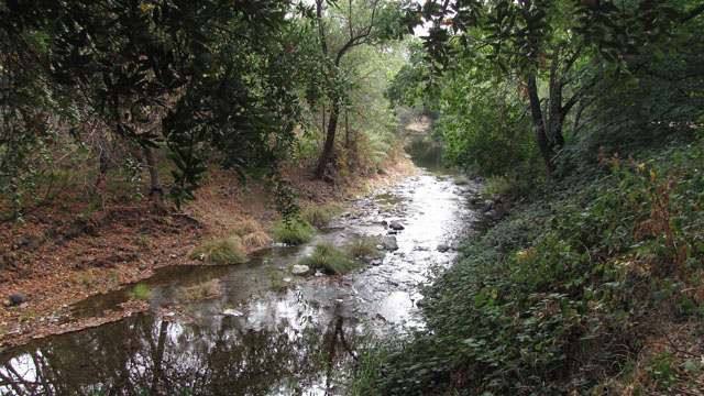
"caption": "Dry Creek in the west Napa Valley was bone-dry when the quake struck, but sprang back to life three days afterward. (Craig Miller/KQED)",
"description": "Dry Creek in the west Napa Valley was bone-dry when the quake struck, but sprang back to life three days afterward. (Craig Miller/KQED)",
"title": "DryCreek_wide_4915",
"credit": null,
"status": "inherit",
"isLoading": false,
"fetchFailed": false
},
"science_21290": {
"type": "attachments",
"id": "science_21290",
"meta": {
"index": "attachments_1716263798",
"site": "science",
"id": "21290",
"found": true
},
"parent": 21289,
"imgSizes": {
"kqedFullSize": {
"file": "https://ww2.kqed.org/app/uploads/sites/35/2014/09/SAFODtop.jpg",
"width": 640,
"height": 360
}
},
"publishDate": 1409720432,
"modified": 1409720432,
"caption": "Drilling of the San Andreas Fault Observatory at Depth was in progress when I visited the site in Parkfield, California, in September 2005 (Andrew Alden photo)",
"description": null,
"title": "SAFODtop",
"credit": null,
"status": "inherit",
"isLoading": false,
"fetchFailed": false
},
"science_21251": {
"type": "attachments",
"id": "science_21251",
"meta": {
"index": "attachments_1716263798",
"site": "science",
"id": "21251",
"found": true
},
"parent": 21247,
"imgSizes": {
"kqedFullSize": {
"file": "https://ww2.kqed.org/app/uploads/sites/35/2014/09/Fault_CottageWy_4872.jpg",
"width": 640,
"height": 360
}
},
"publishDate": 1409683868,
"modified": 1409683868,
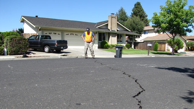
"caption": "Seismologist David Schwartz examines a crack in suburban Napa that he says shows a few centimeters of side-slip -- a clue to faulting below. (Craig Miller/KQED)",
"description": "Seismologist David Schwartz examines a crack in suburban Napa that he says shows a few centimeters of side-slip -- a clue to faulting below. (Craig Miller/KQED)",
"title": "Fault_CottageWy_4872",
"credit": null,
"status": "inherit",
"isLoading": false,
"fetchFailed": false
},
"science_21124": {
"type": "attachments",
"id": "science_21124",
"meta": {
"index": "attachments_1716263798",
"site": "science",
"id": "21124",
"found": true
},
"parent": 21123,
"imgSizes": {
"kqedFullSize": {
"file": "https://ww2.kqed.org/app/uploads/sites/35/2014/08/Without-Warning1.jpg",
"width": 640,
"height": 360
}
},
"publishDate": 1409262703,
"modified": 1409262703,
"caption": "Sean, Heather and Angie experience a major earthquake in \"\u003ca href=\"https://digital.darkhorse.com/profile/4951.without-warning/\">Without Warning\u003c/a>,\" a brand-new comic book issued by Dark Horse Comics with support from the National Earthquake Hazard Reduction Program, the Cascadia Region Earthquake Workgroup and the Oregon State Office of Emergency Management. Angie is the one with the suitable shoes (David Hahn/NEHRP)",
"description": null,
"title": "Without-Warning1",
"credit": null,
"status": "inherit",
"isLoading": false,
"fetchFailed": false
},
"science_20983": {
"type": "attachments",
"id": "science_20983",
"meta": {
"index": "attachments_1716263798",
"site": "science",
"id": "20983",
"found": true
},
"parent": 20956,
"imgSizes": {
"kqedFullSize": {
"file": "https://ww2.kqed.org/app/uploads/sites/35/2014/08/454081604-640x431-e1408937362954.jpg",
"width": 640,
"height": 360
}
},
"publishDate": 1408937319,
"modified": 1408937319,
"caption": "A passerby stops to take a picture of damage to the Napa post office. (Justin Sullivan/Getty Images)",
"description": "A passerby stops to take a picture of damage to the Napa post office. (Justin Sullivan/Getty Images)",
"title": "454081604-640x431",
"credit": null,
"status": "inherit",
"isLoading": false,
"fetchFailed": false
},
"science_20940": {
"type": "attachments",
"id": "science_20940",
"meta": {
"index": "attachments_1716263798",
"site": "science",
"id": "20940",
"found": true
},
"parent": 20918,
"imgSizes": {
"kqedFullSize": {
"file": "https://ww2.kqed.org/app/uploads/sites/35/2014/08/shakealertgrab-e1408910332386.jpg",
"width": 460,
"height": 313
}
},
"publishDate": 1408910196,
"modified": 1408910196,
"caption": "Screengrab from UC Berkeley ShakeAlert video. ",
"description": null,
"title": "shakealertgrab",
"credit": null,
"status": "inherit",
"isLoading": false,
"fetchFailed": false
},
"science_20889": {
"type": "attachments",
"id": "science_20889",
"meta": {
"index": "attachments_1716263798",
"site": "science",
"id": "20889",
"found": true
},
"parent": 20888,
"imgSizes": {
"kqedFullSize": {
"file": "https://ww2.kqed.org/app/uploads/sites/35/2014/08/20888-thumb.jpg",
"width": 640,
"height": 381
}
},
"publishDate": 1408876335,
"modified": 1408876335,
"caption": null,
"description": null,
"title": "Thumbnail for 20888",
"credit": null,
"status": "inherit",
"isLoading": false,
"fetchFailed": false
},
"science_20784": {
"type": "attachments",
"id": "science_20784",
"meta": {
"index": "attachments_1716263798",
"site": "science",
"id": "20784",
"found": true
},
"parent": 20771,
"imgSizes": {
"kqedFullSize": {
"file": "https://ww2.kqed.org/app/uploads/sites/35/2014/08/RS4110_aqueduct20120131-scr1.jpg",
"width": 640,
"height": 360
}
},
"publishDate": 1408650023,
"modified": 1408650023,
"caption": "With less water weighing California down, parts of the land are rising, says a new study. (David McNew/Getty Images)",
"description": "With less water weighing California down, parts of the land are rising, says a new study. (David McNew/Getty Images)",
"title": "RS4110_aqueduct20120131-scr",
"credit": null,
"status": "inherit",
"isLoading": false,
"fetchFailed": false
},
"science_20767": {
"type": "attachments",
"id": "science_20767",
"meta": {
"index": "attachments_1716263798",
"site": "science",
"id": "20767",
"found": true
},
"parent": 20765,
"imgSizes": {
"kqedFullSize": {
"file": "https://ww2.kqed.org/app/uploads/sites/35/2014/08/LAquila-EQ-Bugnara_Castle.jpg",
"width": 640,
"height": 360
}
},
"publishDate": 1408647193,
"modified": 1408647193,
"caption": "The 12th-century Palazzo Ducale in Bugnara, Italy, suffered roof damage in the L'Aquila earthquake of 2009 (Susan Cardwell/Wikimedia \u003ca href=\"http://creativecommons.org/licenses/by-sa/2.5/it/deed.en\">CC\u003c/a>)",
"description": null,
"title": "LAquila-EQ-Bugnara_Castle",
"credit": null,
"status": "inherit",
"isLoading": false,
"fetchFailed": false
},
"science_20593": {
"type": "attachments",
"id": "science_20593",
"meta": {
"index": "attachments_1716263798",
"site": "science",
"id": "20593",
"found": true
},
"parent": 20591,
"imgSizes": {
"kqedFullSize": {
"file": "https://ww2.kqed.org/app/uploads/sites/35/2014/08/SAF-Highland.png",
"width": 640,
"height": 360
}
},
"publishDate": 1408041660,
"modified": 1408041660,
"caption": "San Andreas fault (approximate location on the red line) runs through Highland at the foot of the San Bernardino Mountains. The young neighborhood is organized around the fault, treating it as a greenbelt and water feature—a real-estate asset. (\u003ca href=\"http://www.thulescientific.com/san-andreas-fault-map.html\">Sanandreasfault.org\u003c/a>)",
"description": null,
"title": "SAF-Highland",
"credit": null,
"status": "inherit",
"isLoading": false,
"fetchFailed": false
},
"science_20335": {
"type": "attachments",
"id": "science_20335",
"meta": {
"index": "attachments_1716263798",
"site": "science",
"id": "20335",
"found": true
},
"parent": 20334,
"imgSizes": {
"kqedFullSize": {
"file": "https://ww2.kqed.org/app/uploads/sites/35/2014/08/minpicsphalerite.jpg",
"width": 500,
"height": 400
}
},
"publishDate": 1407284214,
"modified": 1407284214,
"caption": "*\nSphalerite, zinc sulfide, is commonly found wherever metal ores are concentrated, including interesting places like seafloor black smokers. New work shows that this simple mineral has geochemical powers suitable for helping life evolve from the mineral kingdom. (Wikimedia Commons)",
"description": null,
"title": "minpicsphalerite",
"credit": null,
"status": "inherit",
"isLoading": false,
"fetchFailed": false
},
"science_20135": {
"type": "attachments",
"id": "science_20135",
"meta": {
"index": "attachments_1716263798",
"site": "science",
"id": "20135",
"found": true
},
"parent": 20134,
"imgSizes": {
"kqedFullSize": {
"file": "https://ww2.kqed.org/app/uploads/sites/35/2014/07/tahoe-tsu-from-eagle-rock.jpg",
"width": 640,
"height": 360
}
},
"publishDate": 1406838955,
"modified": 1406838955,
"caption": "Eagle Rock, above the town of Tahoe Pines, overlooks the northern part of McKinney Bay, a giant landslide scar bitten out of Lake Tahoe. The rock sits in the glacial valley of Blackwood Creek, but the moraine at its toe is missing—evidence that the slide and mega-tsunami erased it after the latest ice age. (Andrew Alden photo)",
"description": null,
"title": "tahoe-tsu-from-eagle-rock",
"credit": null,
"status": "inherit",
"isLoading": false,
"fetchFailed": false
}
},
"audioPlayerReducer": {
"postId": "stream_live",
"isPaused": true,
"isPlaying": false,
"pfsActive": false,
"pledgeModalIsOpen": true,
"playerDrawerIsOpen": false,
"liveAudioPlayStartedAt": 0,
"liveAudioPlayContext": ""
},
"authorsReducer": {
"andrea-kissack": {
"type": "authors",
"id": "212",
"meta": {
"index": "authors_1716337520",
"id": "212",
"found": true
},
"name": "Andrea Kissack",
"firstName": "Andrea",
"lastName": "Kissack",
"slug": "andrea-kissack",
"email": "akissack@kqed.org",
"display_author_email": false,
"staff_mastheads": [],
"title": "KQED Contributor",
"bio": "Andrea has nearly three decades of experience working as a reporter, anchor, producer and editor for public radio, large market television news and CBS radio. In her current role as KQED’s Sr. Science Editor, Andrea helps lead a talented team covering science, technology, health and the environment for broadcast and digital platforms. Most recently she helped KQED launch a new, multimedia initiative covering the intersection of technology, health and medical science. She has earned a number of accolades for her work including awards from the Radio and Television News Directors Association, the National Academy of Television Arts and Sciences and the Associated Press. Her work can be seen, and heard, on a number of networks, Including NPR, PBS, CBS and the BBC.",
"avatar": "https://secure.gravatar.com/avatar/3eae7a251f0aee43b3c0137a636cb386?s=600&d=blank&r=g",
"twitter": "andreakissack",
"facebook": null,
"instagram": null,
"linkedin": null,
"sites": [
{
"site": "news",
"roles": [
"subscriber"
]
},
{
"site": "stateofhealth",
"roles": [
"subscriber"
]
},
{
"site": "science",
"roles": []
},
{
"site": "quest",
"roles": [
"add_users",
"create_users",
"edit_files",
"edit_users",
"level_10",
"level_8",
"level_9",
"promote_users",
"view_cimy_extra_fields",
"subscriber"
]
}
],
"headData": {
"title": "Andrea Kissack | KQED",
"description": "KQED Contributor",
"ogImgSrc": "https://secure.gravatar.com/avatar/3eae7a251f0aee43b3c0137a636cb386?s=600&d=blank&r=g",
"twImgSrc": "https://secure.gravatar.com/avatar/3eae7a251f0aee43b3c0137a636cb386?s=600&d=blank&r=g"
},
"isLoading": false,
"link": "/author/andrea-kissack"
},
"cmiller": {
"type": "authors",
"id": "221",
"meta": {
"index": "authors_1716337520",
"id": "221",
"found": true
},
"name": "Craig Miller",
"firstName": "Craig",
"lastName": "Miller",
"slug": "cmiller",
"email": "craig@voxterra.net",
"display_author_email": false,
"staff_mastheads": [
"science"
],
"title": "Editor Emeritus, Science",
"bio": "Craig is a former KQED Science editor, specializing in weather, climate, water & energy issues, with a little seismology thrown in just to shake things up. Prior to that, he launched and led the station's award-winning multimedia project, Climate Watch. Craig is also an accomplished writer/producer of television documentaries, with a focus on natural resource issues.",
"avatar": "https://secure.gravatar.com/avatar/b91661df645e001a9cafe0861fa685f9?s=600&d=blank&r=g",
"twitter": "voxterra",
"facebook": null,
"instagram": null,
"linkedin": null,
"sites": [
{
"site": "news",
"roles": [
"author"
]
},
{
"site": "futureofyou",
"roles": [
"editor"
]
},
{
"site": "stateofhealth",
"roles": [
"author"
]
},
{
"site": "science",
"roles": [
"editor"
]
},
{
"site": "quest",
"roles": [
"editor"
]
}
],
"headData": {
"title": "Craig Miller | KQED",
"description": "Editor Emeritus, Science",
"ogImgSrc": "https://secure.gravatar.com/avatar/b91661df645e001a9cafe0861fa685f9?s=600&d=blank&r=g",
"twImgSrc": "https://secure.gravatar.com/avatar/b91661df645e001a9cafe0861fa685f9?s=600&d=blank&r=g"
},
"isLoading": false,
"link": "/author/cmiller"
},
"lindseyhoshaw": {
"type": "authors",
"id": "5432",
"meta": {
"index": "authors_1716337520",
"id": "5432",
"found": true
},
"name": "Lindsey Hoshaw",
"firstName": "Lindsey",
"lastName": "Hoshaw",
"slug": "lindseyhoshaw",
"email": "lhoshaw@kqed.org",
"display_author_email": false,
"staff_mastheads": [],
"title": "KQED Contributor",
"bio": "Lindsey Hoshaw is a former interactive producer for KQED Science. Before joining KQED, Lindsey was a science correspondent for The New York Times, The Boston Globe, Forbes and Scientific American. On Twitter @lindseyhoshaw",
"avatar": "https://secure.gravatar.com/avatar/274b07694c998eaa8f26cfabaa941186?s=600&d=mm&r=g",
"twitter": "lindseyhoshaw",
"facebook": "lindsey.hoshaw.9",
"instagram": null,
"linkedin": null,
"sites": [
{
"site": "arts",
"roles": [
"author"
]
},
{
"site": "news",
"roles": [
"subscriber"
]
},
{
"site": "futureofyou",
"roles": [
"editor"
]
},
{
"site": "bayareabites",
"roles": [
"contributor"
]
},
{
"site": "stateofhealth",
"roles": [
"author"
]
},
{
"site": "science",
"roles": [
"edit_theme_options",
"subscriber"
]
},
{
"site": "quest",
"roles": [
"edit_post_subscriptions",
"edit_usergroups",
"unfiltered_html",
"unfiltered_upload",
"leadcoordinator",
"editor"
]
},
{
"site": "food",
"roles": []
}
],
"headData": {
"title": "Lindsey Hoshaw | KQED",
"description": "KQED Contributor",
"ogImgSrc": "https://secure.gravatar.com/avatar/274b07694c998eaa8f26cfabaa941186?s=600&d=mm&r=g",
"twImgSrc": "https://secure.gravatar.com/avatar/274b07694c998eaa8f26cfabaa941186?s=600&d=mm&r=g"
},
"isLoading": false,
"link": "/author/lindseyhoshaw"
},
"andrew-alden": {
"type": "authors",
"id": "6228",
"meta": {
"index": "authors_1716337520",
"id": "6228",
"found": true
},
"name": "Andrew Alden",
"firstName": "Andrew",
"lastName": "Alden",
"slug": "andrew-alden",
"email": "alden@andrew-alden.com",
"display_author_email": false,
"staff_mastheads": [],
"title": null,
"bio": "Andrew Alden earned his geology degree at the University of New Hampshire and moved back to the Bay Area to work at the U.S. Geological Survey for six years. He has \u003ca href=\"http://geology.about.com/\">written on geology for About.com\u003c/a> since its founding in 1997. In 2007, he started the Oakland Geology blog, which won recognition as \"Best of the East Bay\" from the \u003ci>East Bay Express\u003c/i> in 2010. In writing about geology in the Bay Area and surroundings, he hopes to share some of the useful and pleasurable insights that geologists give us—not just facts about the deep past, but an attitude that might be called the \u003ci>deep present\u003c/i>.\r\n\r\nRead his \u003ca href=\"http://science.kqed.org/quest/author/andrew-alden/\">previous contributions\u003c/a> to \u003ca href=\"http://http://science.kqed.org/quest/\">QUEST\u003c/a>, a project dedicated to exploring the Science of Sustainability.",
"avatar": "https://secure.gravatar.com/avatar/9eaa0afc32f98c5fc7ce634437334a64?s=600&d=blank&r=g",
"twitter": null,
"facebook": null,
"instagram": null,
"linkedin": null,
"sites": [
{
"site": "science",
"roles": [
"author"
]
},
{
"site": "quest",
"roles": [
"subscriber"
]
}
],
"headData": {
"title": "Andrew Alden | KQED",
"description": null,
"ogImgSrc": "https://secure.gravatar.com/avatar/9eaa0afc32f98c5fc7ce634437334a64?s=600&d=blank&r=g",
"twImgSrc": "https://secure.gravatar.com/avatar/9eaa0afc32f98c5fc7ce634437334a64?s=600&d=blank&r=g"
},
"isLoading": false,
"link": "/author/andrew-alden"
},
"kqedscience": {
"type": "authors",
"id": "6387",
"meta": {
"index": "authors_1716337520",
"id": "6387",
"found": true
},
"name": "KQED Science",
"firstName": "KQED",
"lastName": "Science",
"slug": "kqedscience",
"email": "kqedscience@gmail.com",
"display_author_email": false,
"staff_mastheads": [],
"title": null,
"bio": "KQED Science brings you award-winning science and environment coverage from the Bay Area and beyond by the flagship Northern California PBS and NPR affiliate.",
"avatar": "https://secure.gravatar.com/avatar/5a295ff49cf82a8c0f30937d3f788b2f?s=600&d=blank&r=g",
"twitter": null,
"facebook": null,
"instagram": null,
"linkedin": null,
"sites": [
{
"site": "science",
"roles": [
"contributor"
]
},
{
"site": "quest",
"roles": [
"editor"
]
},
{
"site": "food",
"roles": [
"contributor"
]
}
],
"headData": {
"title": "KQED Science | KQED",
"description": null,
"ogImgSrc": "https://secure.gravatar.com/avatar/5a295ff49cf82a8c0f30937d3f788b2f?s=600&d=blank&r=g",
"twImgSrc": "https://secure.gravatar.com/avatar/5a295ff49cf82a8c0f30937d3f788b2f?s=600&d=blank&r=g"
},
"isLoading": false,
"link": "/author/kqedscience"
}
},
"pagesReducer": {
"science_category_geology": {
"type": "terms",
"id": "science_38",
"meta": {
"index": "terms_1716263798",
"site": "science",
"id": "38",
"score": 13.559036
},
"featImg": null,
"name": "Geology",
"description": null,
"taxonomy": "category",
"headData": {
"twImgId": null,
"twTitle": null,
"ogTitle": null,
"ogImgId": null,
"twDescription": null,
"description": null,
"title": "Geology Archives | KQED Science",
"ogDescription": null
},
"ttid": 40,
"slug": "geology",
"isLoading": false,
"title": "Geology",
"pageMeta": {
"site": "science",
"WpPageTemplate": "page-topic-editorial",
"currentPage": 13
},
"blocks": [
{
"blockName": "kqed/post-list",
"attrs": {
"layout": "cardArticle2",
"query": "posts/science?category=geology",
"seeMore": false,
"paginated": true,
"page": 13
}
},
{
"blockName": "kqed/ad"
}
]
}
},
"pfsSessionReducer": {},
"postsReducer": {
"stream_live": {
"type": "live",
"id": "stream_live",
"audioUrl": "https://hls.kqed.org/hls/kqed_app/playlist.m3u8",
"title": "Live Stream",
"excerpt": "Live Stream information currently unavailable.",
"link": "/radio",
"featImg": "",
"label": {
"name": "KQED Live",
"link": "/"
}
},
"stream_kqedNewscast": {
"type": "posts",
"id": "stream_kqedNewscast",
"audioUrl": "https://www.kqed.org/.stream/anon/radio/RDnews/newscast.mp3?_=1",
"title": "KQED Newscast",
"featImg": "",
"label": {
"name": "88.5 FM",
"link": "/"
}
},
"science_21444": {
"type": "posts",
"id": "science_21444",
"meta": {
"index": "posts_1716263798",
"site": "science",
"id": "21444",
"score": null,
"sort": [
1410246068000
]
},
"parent": 0,
"labelTerm": {
"site": "science",
"term": 1151
},
"blocks": [],
"publishDate": 1410246068,
"format": "aside",
"title": "Quake-Revived Streams Could Keep Flowing for a While",
"headTitle": "Quake-Revived Streams Could Keep Flowing for a While | KQED",
"content": "\u003cfigure id=\"attachment_21454\" class=\"wp-caption aligncenter\" style=\"max-width: 640px\">\u003ca href=\"http://ww2.kqed.org/science/wp-content/uploads/sites/35/2014/09/DryCreek_wide_4915.jpg\">\u003cimg loading=\"lazy\" decoding=\"async\" class=\"size-full wp-image-21454\" src=\"http://ww2.kqed.org/science/wp-content/uploads/sites/35/2014/09/DryCreek_wide_4915.jpg\" alt=\"Dry Creek in the west Napa Valley was bone-dry when the quake struck, but sprang back to life three days afterward. (Craig Miller/KQED)\" width=\"640\" height=\"360\">\u003c/a>\u003cfigcaption class=\"wp-caption-text\">Dry Creek in the west Napa Valley was bone-dry when the quake struck, but sprang to life three days later. (Craig Miller/KQED)\u003c/figcaption>\u003c/figure>\n\u003cp>Normally, Dry Creek, just west of Napa, lives up to its name this time of year. But three days after the South Napa Earthquake, it suddenly sprang to life.\u003c/p>\n\u003cp>“This was completely dry and right now it’s running at the rate that we’d normally see in May or so,” said Garrett Buckland, overlooking a stretch of the creek about 2.5 miles above where it empties into the Napa River. Buckland is a vineyard consultant who pays close attention to the hydrology of the Napa Valley. In September, he said, Dry Creek doesn’t usually make it as far as the river.\u003c/p>\n\u003cp>When he started hearing the sound of moving water shortly after the magnitude-6.0 temblor, Buckland said he wasn’t entirely surprised; he said the same thing happened after a 4.9 temblor near here in 2000. Based on that experience, Buckland was willing to make a prediction.\u003c/p>\n\u003cp>[contextly_sidebar id=”2PiNvzNzd7sL8IuJr3cHhhBSSlxRgtHY”]\u003c/p>\n\u003cp>“This will continue to flow all the way until it dries up next year,” he ventured. “All those changes in cracks and adjustments to the fissures all across this area are really just releasing a ton of really, really cold, crisp, clean groundwater, basically.”\u003c/p>\n\u003cp>[ad fullwidth]\u003c/p>\n\u003cp>The resurgence of Dry Creek is just one of \u003ca title=\"Press-Dem - post\" href=\"http://www.pressdemocrat.com/home/2655382-181/napa-quake-jumpstarts-stream-flows\">many similar stories\u003c/a> that have arisen since the August 24 quake that struck the Napa Valley and damaged buildings in at least three significant North Bay cities. But the \u003ca title=\"Q-Sci - post\" href=\"http://ww2.kqed.org/science/2014/09/02/napa-quake-forces-redrawing-of-fault-maps/\">underground dynamics\u003c/a> that started it all are complicated and not nearly as clear as the crystalline water bubbling up from below.\u003c/p>\n\u003cp>Just as elusive is the question of how long it will last. Geologists say this is a common occurrence following earthquakes and doesn’t often last more than a matter of weeks. But there are some optimists out there.\u003c/p>\n\u003cp>“These ephemerals are flowing across the entire Mayacama Range (the western Napa Valley slope),” hydrologist Robert Shibatani, who toured the area last week, wrote in an email to KQED. “Nor is it necessarily a temporary event; streams are still running two weeks after the temblor.”\u003c/p>\n\u003cp>Shibatani surmises that on the west side of Napa Valley, the quake didn’t create new springs so much as it opened new connections between underground aquifers, creating a fresh supply for existing springs. If so, these new \u003ca title=\"SFC - post\" href=\"http://www.sfgate.com/default/article/Surprise-bonanza-since-Napa-quake-dry-creeks-now-5739098.php#page-1\">flows could continue\u003c/a> into the rainy season — but there’s really no way to know.\u003c/p>\n\u003cfigure id=\"attachment_21457\" class=\"wp-caption aligncenter\" style=\"max-width: 640px\">\u003ca href=\"http://ww2.kqed.org/science/wp-content/uploads/sites/35/2014/09/DryCreek_riffle_4912.jpg\">\u003cimg loading=\"lazy\" decoding=\"async\" class=\"size-full wp-image-21457\" src=\"http://ww2.kqed.org/science/wp-content/uploads/sites/35/2014/09/DryCreek_riffle_4912.jpg\" alt=\"One hydrologist estimates the flow rates on some quake-revived streams could be significant in view of the current drought. (Craig Miller/KQED)\" width=\"640\" height=\"360\">\u003c/a>\u003cfigcaption class=\"wp-caption-text\">One hydrologist estimates the flow rates on some quake-revived streams could be significant in view of the current drought. (Craig Miller/KQED)\u003c/figcaption>\u003c/figure>\n\u003cp>“These flows could represent new base flows, which would be a significant enhancement to overall water supply yield to this area of northern California.”\u003c/p>\n\u003cp>One thing that gives Shibatani hope of some permanence is the volume of water he’s seen — up to 10 or 12 cubic feet per second, which, over the course of a year, would be enough to supply thousands of typical households.\u003c/p>\n\u003cp>“That kind of volume is considerable given the state of our current drought,” he says.\u003c/p>\n\u003cp>There remain some slippery questions, such as whether upstream wells might start running dry, and ultimately, to whom this wet new windfall belongs.\u003c/p>\n\u003cp>“As a ‘natural’ stream flow (albeit new), initial indications [from state water regulators] are that they would be considered ‘riparian’ rights and permissible for diversion,” says Shibatani. “I think that someone needs to really get a sense of the overall scale of this.”\u003c/p>\n\u003cp>As for Buckland, who grew up virtually on the banks of Dry Creek, a spawning stream for salmon and steelhead, he’s just happy to see it running with such gusto at the driest time of the year.\u003c/p>\n\u003cp>\u003c/p>\n\u003cp>“Hopefully this is something that’ll really help out our fishery,” he says, “but it’s amazing what nature can do for us.”\u003c/p>\n\n",
"stats": {
"hasVideo": false,
"hasChartOrMap": false,
"hasAudio": false,
"hasPolis": false,
"wordCount": 694,
"hasGoogleForm": false,
"hasGallery": false,
"hasHearkenModule": false,
"iframeSrcs": [],
"paragraphCount": 18
},
"modified": 1704932982,
"excerpt": "The Napa quake jump-started several streams in the Napa and adjoining valleys, but how long they'll run and where the water is coming from is hard to pin down.",
"headData": {
"twImgId": "",
"twTitle": "",
"ogTitle": "",
"ogImgId": "",
"twDescription": "",
"description": "The Napa quake jump-started several streams in the Napa and adjoining valleys, but how long they'll run and where the water is coming from is hard to pin down.",
"title": "Quake-Revived Streams Could Keep Flowing for a While | KQED",
"ogDescription": "",
"schema": {
"@context": "https://schema.org",
"@type": "Article",
"headline": "Quake-Revived Streams Could Keep Flowing for a While",
"datePublished": "2014-09-09T00:01:08-07:00",
"dateModified": "2024-01-10T16:29:42-08:00",
"image": "https://cdn.kqed.org/wp-content/uploads/2020/02/KQED-OG-Image@1x.png"
}
},
"guestAuthors": [],
"slug": "quake-revived-streams-could-keep-flowing-for-a-while",
"status": "publish",
"sticky": false,
"path": "/science/21444/quake-revived-streams-could-keep-flowing-for-a-while",
"audioTrackLength": null,
"parsedContent": [
{
"type": "contentString",
"content": "\u003cdiv class=\"post-body\">\u003cp>\u003cfigure id=\"attachment_21454\" class=\"wp-caption aligncenter\" style=\"max-width: 640px\">\u003ca href=\"http://ww2.kqed.org/science/wp-content/uploads/sites/35/2014/09/DryCreek_wide_4915.jpg\">\u003cimg loading=\"lazy\" decoding=\"async\" class=\"size-full wp-image-21454\" src=\"http://ww2.kqed.org/science/wp-content/uploads/sites/35/2014/09/DryCreek_wide_4915.jpg\" alt=\"Dry Creek in the west Napa Valley was bone-dry when the quake struck, but sprang back to life three days afterward. (Craig Miller/KQED)\" width=\"640\" height=\"360\">\u003c/a>\u003cfigcaption class=\"wp-caption-text\">Dry Creek in the west Napa Valley was bone-dry when the quake struck, but sprang to life three days later. (Craig Miller/KQED)\u003c/figcaption>\u003c/figure>\n\u003cp>Normally, Dry Creek, just west of Napa, lives up to its name this time of year. But three days after the South Napa Earthquake, it suddenly sprang to life.\u003c/p>\n\u003cp>“This was completely dry and right now it’s running at the rate that we’d normally see in May or so,” said Garrett Buckland, overlooking a stretch of the creek about 2.5 miles above where it empties into the Napa River. Buckland is a vineyard consultant who pays close attention to the hydrology of the Napa Valley. In September, he said, Dry Creek doesn’t usually make it as far as the river.\u003c/p>\n\u003cp>When he started hearing the sound of moving water shortly after the magnitude-6.0 temblor, Buckland said he wasn’t entirely surprised; he said the same thing happened after a 4.9 temblor near here in 2000. Based on that experience, Buckland was willing to make a prediction.\u003c/p>\n\u003cp>\u003c/p>\u003cp>\u003c/p>\u003cp>\u003c/p>\n\u003cp>“This will continue to flow all the way until it dries up next year,” he ventured. “All those changes in cracks and adjustments to the fissures all across this area are really just releasing a ton of really, really cold, crisp, clean groundwater, basically.”\u003c/p>\n\u003cp>\u003c/p>\u003c/div>",
"attributes": {
"named": {},
"numeric": []
}
},
{
"type": "component",
"content": "",
"name": "ad",
"attributes": {
"named": {
"label": "fullwidth"
},
"numeric": [
"fullwidth"
]
}
},
{
"type": "contentString",
"content": "\u003cdiv class=\"post-body\">\u003cp>\u003c/p>\n\u003cp>The resurgence of Dry Creek is just one of \u003ca title=\"Press-Dem - post\" href=\"http://www.pressdemocrat.com/home/2655382-181/napa-quake-jumpstarts-stream-flows\">many similar stories\u003c/a> that have arisen since the August 24 quake that struck the Napa Valley and damaged buildings in at least three significant North Bay cities. But the \u003ca title=\"Q-Sci - post\" href=\"http://ww2.kqed.org/science/2014/09/02/napa-quake-forces-redrawing-of-fault-maps/\">underground dynamics\u003c/a> that started it all are complicated and not nearly as clear as the crystalline water bubbling up from below.\u003c/p>\n\u003cp>Just as elusive is the question of how long it will last. Geologists say this is a common occurrence following earthquakes and doesn’t often last more than a matter of weeks. But there are some optimists out there.\u003c/p>\n\u003cp>“These ephemerals are flowing across the entire Mayacama Range (the western Napa Valley slope),” hydrologist Robert Shibatani, who toured the area last week, wrote in an email to KQED. “Nor is it necessarily a temporary event; streams are still running two weeks after the temblor.”\u003c/p>\n\u003cp>Shibatani surmises that on the west side of Napa Valley, the quake didn’t create new springs so much as it opened new connections between underground aquifers, creating a fresh supply for existing springs. If so, these new \u003ca title=\"SFC - post\" href=\"http://www.sfgate.com/default/article/Surprise-bonanza-since-Napa-quake-dry-creeks-now-5739098.php#page-1\">flows could continue\u003c/a> into the rainy season — but there’s really no way to know.\u003c/p>\n\u003cfigure id=\"attachment_21457\" class=\"wp-caption aligncenter\" style=\"max-width: 640px\">\u003ca href=\"http://ww2.kqed.org/science/wp-content/uploads/sites/35/2014/09/DryCreek_riffle_4912.jpg\">\u003cimg loading=\"lazy\" decoding=\"async\" class=\"size-full wp-image-21457\" src=\"http://ww2.kqed.org/science/wp-content/uploads/sites/35/2014/09/DryCreek_riffle_4912.jpg\" alt=\"One hydrologist estimates the flow rates on some quake-revived streams could be significant in view of the current drought. (Craig Miller/KQED)\" width=\"640\" height=\"360\">\u003c/a>\u003cfigcaption class=\"wp-caption-text\">One hydrologist estimates the flow rates on some quake-revived streams could be significant in view of the current drought. (Craig Miller/KQED)\u003c/figcaption>\u003c/figure>\n\u003cp>“These flows could represent new base flows, which would be a significant enhancement to overall water supply yield to this area of northern California.”\u003c/p>\n\u003cp>One thing that gives Shibatani hope of some permanence is the volume of water he’s seen — up to 10 or 12 cubic feet per second, which, over the course of a year, would be enough to supply thousands of typical households.\u003c/p>\n\u003cp>“That kind of volume is considerable given the state of our current drought,” he says.\u003c/p>\n\u003cp>There remain some slippery questions, such as whether upstream wells might start running dry, and ultimately, to whom this wet new windfall belongs.\u003c/p>\n\u003cp>“As a ‘natural’ stream flow (albeit new), initial indications [from state water regulators] are that they would be considered ‘riparian’ rights and permissible for diversion,” says Shibatani. “I think that someone needs to really get a sense of the overall scale of this.”\u003c/p>\n\u003cp>As for Buckland, who grew up virtually on the banks of Dry Creek, a spawning stream for salmon and steelhead, he’s just happy to see it running with such gusto at the driest time of the year.\u003c/p>\n\u003cp>\u003c/p>\n\u003cp>“Hopefully this is something that’ll really help out our fishery,” he says, “but it’s amazing what nature can do for us.”\u003c/p>\n\n\u003c/div>\u003c/p>",
"attributes": {
"named": {},
"numeric": []
}
}
],
"link": "/science/21444/quake-revived-streams-could-keep-flowing-for-a-while",
"authors": [
"221"
],
"series": [
"science_1151"
],
"categories": [
"science_38",
"science_40",
"science_98"
],
"tags": [
"science_64",
"science_1231",
"science_179",
"science_1841"
],
"featImg": "science_21454",
"label": "science_1151"
},
"science_21289": {
"type": "posts",
"id": "science_21289",
"meta": {
"index": "posts_1716263798",
"site": "science",
"id": "21289",
"score": null,
"sort": [
1409853582000
]
},
"parent": 0,
"labelTerm": {
"site": "science"
},
"blocks": [],
"publishDate": 1409853582,
"format": "aside",
"title": "Scientists Concerned as San Andreas Fault Observatory Seeks Additional Funds",
"headTitle": "Scientists Concerned as San Andreas Fault Observatory Seeks Additional Funds | KQED",
"content": "\u003cfigure id=\"attachment_21290\" class=\"wp-caption aligncenter\" style=\"max-width: 640px\">\u003ca href=\"http://ww2.kqed.org/science/wp-content/uploads/sites/35/2014/09/SAFODtop.jpg\">\u003cimg loading=\"lazy\" decoding=\"async\" src=\"http://ww2.kqed.org/science/wp-content/uploads/sites/35/2014/09/SAFODtop.jpg\" alt=\"SAFOD drilling site\" width=\"640\" height=\"360\" class=\"size-full wp-image-21290\">\u003c/a>\u003cfigcaption class=\"wp-caption-text\">Drilling of the San Andreas Fault Observatory at Depth was in progress when I visited the site in Parkfield, California, in September 2005 (Andrew Alden photo)\u003c/figcaption>\u003c/figure>\n\u003cp>It was a truly history-making mission to the deep Earth that drilled a 2-mile borehole to the active trace of the San Andreas fault. Today the San Andreas Fault Observatory at Depth, or SAFOD, languishes just short of its goal, and scientists are scratching for funds to place instruments where they were meant to be.\u003c/p>\n\u003cp>SAFOD began ten years ago as the boldest part of the great \u003ca href=\"http://www.earthscope.org/science/observatories\">EarthScope research program\u003c/a>. Two other EarthScope projects have crossed the nation with a giant movable set of seismometers (USArray) and blanketed the western states with GPS receivers to monitor crustal movements (Plate Boundary Observatory). The SAFOD project gave us the means to witness earthquakes close up, while they happen.\u003c/p>\n\u003cp>A site was picked in the tiny town of Parkfield, California, where the San Andreas fault is well behaved (for a fault) and where earthquake scientists have had a presence for many years. A scientific drill rig was set up on a site provided by a generous cattle rancher, and work began in 2002 with an exploratory hole. Three years later, I saw the rig in action as it prepared the main borehole, which started straight down, then curved eastward to intersect the fault from the side. As expected, the fault zone itself was marked by about 200 meters of shattered and altered rock.\u003c/p>\n\u003cfigure id=\"attachment_21291\" class=\"wp-caption aligncenter\" style=\"max-width: 500px\">\u003ca href=\"http://ww2.kqed.org/science/wp-content/uploads/sites/35/2014/09/SAFODgrit.jpg\">\u003cimg loading=\"lazy\" decoding=\"async\" src=\"http://ww2.kqed.org/science/wp-content/uploads/sites/35/2014/09/SAFODgrit.jpg\" alt=\"SAFOD grit\" width=\"500\" height=\"368\" class=\"size-full wp-image-21291\">\u003c/a>\u003cfigcaption class=\"wp-caption-text\">Pulverized rock from the borehole was separated from the drilling mud after each ten meters of progress. Minerals and microfossils in this grit enabled the drillers to map the underground in detail as they went (Andrew Alden)\u003c/figcaption>\u003c/figure>\n\u003cp>The next trick was to find the active plane in that wide fault zone. The borehole was lined with steel casing and then monitored for a couple of years. The fault was pinpointed in two places where it was gradually warping the casing. The next phase of the project targeted these places, drilling sidetracks from the main hole and collecting cores of undisturbed rock from them. These alcoves were where a set of six sensitive instruments—the downhole observatory—was installed in September 2008.\u003c/p>\n\u003cfigure id=\"attachment_21292\" class=\"wp-caption aligncenter\" style=\"max-width: 500px\">\u003ca href=\"http://ww2.kqed.org/science/wp-content/uploads/sites/35/2014/09/SAFOD-1stCore.jpg\">\u003cimg loading=\"lazy\" decoding=\"async\" src=\"http://ww2.kqed.org/science/wp-content/uploads/sites/35/2014/09/SAFOD-1stCore.jpg\" alt=\"SAFOD first core\" width=\"500\" height=\"333\" class=\"size-full wp-image-21292\">\u003c/a>\u003cfigcaption class=\"wp-caption-text\">The first core is retrieved on August 6, 2007. The cores came up hot, around boiling temperature (Clay Hamilton/SAFOD)\u003c/figcaption>\u003c/figure>\n\u003cp>The cores, as precious as moon rocks, were displayed to the press on October 5, 2007. It was a privilege to see them with my own eyes. Today they are stored in a Texas facility, where samples are parceled out to qualified researchers. \u003c/p>\n\u003cfigure id=\"attachment_21293\" class=\"wp-caption aligncenter\" style=\"max-width: 600px\">\u003ca href=\"http://ww2.kqed.org/science/wp-content/uploads/sites/35/2014/09/SAFODcoreclose.jpg\">\u003cimg loading=\"lazy\" decoding=\"async\" src=\"http://ww2.kqed.org/science/wp-content/uploads/sites/35/2014/09/SAFODcoreclose.jpg\" alt=\"SAOFD core closeup\" width=\"600\" height=\"433\" class=\"size-full wp-image-21293\">\u003c/a>\u003cfigcaption class=\"wp-caption-text\">Life-size photo of the core from the fault zone. The brown is slippery clay; the green rock is serpentinite (Andrew Alden)\u003c/figcaption>\u003c/figure>\n\u003cp>Unfortunately, the downhole instruments failed after a few weeks in the harsh conditions. A new seismometer was lowered into the hole and continues to yield good data; SAFOD scientist Bill Ellsworth told me that a replacement is on the way. But beyond a shoestring of funding that various sources have been scraping together, the money is gone and we’re left with half the result that scientists hoped for. \u003c/p>\n\u003cp>[ad fullwidth]\u003c/p>\n\u003cp>The National Science Foundation, which paid for EarthScope, announced in April that it wouldn’t spend any more on SAFOD, ignoring the pleas of a wide set of quake scientists. \u003ca href=\"http://www.insidebayarea.com/ci_26444137/earthquake-study-drifts-scientists-seek-money\">Earlier this week, the Mercury News reported\u003c/a> that the project’s scientists are preparing an unsolicited bid for funding to the NSF, on an equal footing with hundreds of other research proposals.\u003c/p>\n\u003cp>\u003c/p>\n\u003cp>If they succeed, it would be a good thing as SAFOD is not alone. Japan’s well-funded \u003ca href=\"http://www.jamstec.go.jp/chikyu/nantroseize/e/\">NanTroSEIZE program\u003c/a> has been drilling across active faults under the seafloor, and the \u003ca href=\"http://www.icdp-online.org/projects/world/australia-and-new-zealand/alpine-fault/\">Deep Fault Drilling Project\u003c/a> is drilling across a major fault in New Zealand. These days, we could really use fresh data from the San Andreas.\u003c/p>\n\n",
"stats": {
"hasVideo": false,
"hasChartOrMap": false,
"hasAudio": false,
"hasPolis": false,
"wordCount": 649,
"hasGoogleForm": false,
"hasGallery": false,
"hasHearkenModule": false,
"iframeSrcs": [],
"paragraphCount": 10
},
"modified": 1704933016,
"excerpt": "A few million dollars -- that's all scientists ask for to revive a breakthrough underground laboratory sitting precisely on the San Andreas fault.",
"headData": {
"twImgId": "",
"twTitle": "",
"ogTitle": "",
"ogImgId": "",
"twDescription": "",
"description": "A few million dollars -- that's all scientists ask for to revive a breakthrough underground laboratory sitting precisely on the San Andreas fault.",
"title": "Scientists Concerned as San Andreas Fault Observatory Seeks Additional Funds | KQED",
"ogDescription": "",
"schema": {
"@context": "https://schema.org",
"@type": "Article",
"headline": "Scientists Concerned as San Andreas Fault Observatory Seeks Additional Funds",
"datePublished": "2014-09-04T10:59:42-07:00",
"dateModified": "2024-01-10T16:30:16-08:00",
"image": "https://cdn.kqed.org/wp-content/uploads/2020/02/KQED-OG-Image@1x.png"
}
},
"guestAuthors": [],
"slug": "scientists-concerned-as-san-andreas-fault-observatory-seeks-additional-funds",
"status": "publish",
"sticky": false,
"path": "/science/21289/scientists-concerned-as-san-andreas-fault-observatory-seeks-additional-funds",
"audioTrackLength": null,
"parsedContent": [
{
"type": "contentString",
"content": "\u003cdiv class=\"post-body\">\u003cp>\u003cfigure id=\"attachment_21290\" class=\"wp-caption aligncenter\" style=\"max-width: 640px\">\u003ca href=\"http://ww2.kqed.org/science/wp-content/uploads/sites/35/2014/09/SAFODtop.jpg\">\u003cimg loading=\"lazy\" decoding=\"async\" src=\"http://ww2.kqed.org/science/wp-content/uploads/sites/35/2014/09/SAFODtop.jpg\" alt=\"SAFOD drilling site\" width=\"640\" height=\"360\" class=\"size-full wp-image-21290\">\u003c/a>\u003cfigcaption class=\"wp-caption-text\">Drilling of the San Andreas Fault Observatory at Depth was in progress when I visited the site in Parkfield, California, in September 2005 (Andrew Alden photo)\u003c/figcaption>\u003c/figure>\n\u003cp>It was a truly history-making mission to the deep Earth that drilled a 2-mile borehole to the active trace of the San Andreas fault. Today the San Andreas Fault Observatory at Depth, or SAFOD, languishes just short of its goal, and scientists are scratching for funds to place instruments where they were meant to be.\u003c/p>\n\u003cp>SAFOD began ten years ago as the boldest part of the great \u003ca href=\"http://www.earthscope.org/science/observatories\">EarthScope research program\u003c/a>. Two other EarthScope projects have crossed the nation with a giant movable set of seismometers (USArray) and blanketed the western states with GPS receivers to monitor crustal movements (Plate Boundary Observatory). The SAFOD project gave us the means to witness earthquakes close up, while they happen.\u003c/p>\n\u003cp>A site was picked in the tiny town of Parkfield, California, where the San Andreas fault is well behaved (for a fault) and where earthquake scientists have had a presence for many years. A scientific drill rig was set up on a site provided by a generous cattle rancher, and work began in 2002 with an exploratory hole. Three years later, I saw the rig in action as it prepared the main borehole, which started straight down, then curved eastward to intersect the fault from the side. As expected, the fault zone itself was marked by about 200 meters of shattered and altered rock.\u003c/p>\n\u003cfigure id=\"attachment_21291\" class=\"wp-caption aligncenter\" style=\"max-width: 500px\">\u003ca href=\"http://ww2.kqed.org/science/wp-content/uploads/sites/35/2014/09/SAFODgrit.jpg\">\u003cimg loading=\"lazy\" decoding=\"async\" src=\"http://ww2.kqed.org/science/wp-content/uploads/sites/35/2014/09/SAFODgrit.jpg\" alt=\"SAFOD grit\" width=\"500\" height=\"368\" class=\"size-full wp-image-21291\">\u003c/a>\u003cfigcaption class=\"wp-caption-text\">Pulverized rock from the borehole was separated from the drilling mud after each ten meters of progress. Minerals and microfossils in this grit enabled the drillers to map the underground in detail as they went (Andrew Alden)\u003c/figcaption>\u003c/figure>\n\u003cp>The next trick was to find the active plane in that wide fault zone. The borehole was lined with steel casing and then monitored for a couple of years. The fault was pinpointed in two places where it was gradually warping the casing. The next phase of the project targeted these places, drilling sidetracks from the main hole and collecting cores of undisturbed rock from them. These alcoves were where a set of six sensitive instruments—the downhole observatory—was installed in September 2008.\u003c/p>\n\u003cfigure id=\"attachment_21292\" class=\"wp-caption aligncenter\" style=\"max-width: 500px\">\u003ca href=\"http://ww2.kqed.org/science/wp-content/uploads/sites/35/2014/09/SAFOD-1stCore.jpg\">\u003cimg loading=\"lazy\" decoding=\"async\" src=\"http://ww2.kqed.org/science/wp-content/uploads/sites/35/2014/09/SAFOD-1stCore.jpg\" alt=\"SAFOD first core\" width=\"500\" height=\"333\" class=\"size-full wp-image-21292\">\u003c/a>\u003cfigcaption class=\"wp-caption-text\">The first core is retrieved on August 6, 2007. The cores came up hot, around boiling temperature (Clay Hamilton/SAFOD)\u003c/figcaption>\u003c/figure>\n\u003cp>The cores, as precious as moon rocks, were displayed to the press on October 5, 2007. It was a privilege to see them with my own eyes. Today they are stored in a Texas facility, where samples are parceled out to qualified researchers. \u003c/p>\n\u003cfigure id=\"attachment_21293\" class=\"wp-caption aligncenter\" style=\"max-width: 600px\">\u003ca href=\"http://ww2.kqed.org/science/wp-content/uploads/sites/35/2014/09/SAFODcoreclose.jpg\">\u003cimg loading=\"lazy\" decoding=\"async\" src=\"http://ww2.kqed.org/science/wp-content/uploads/sites/35/2014/09/SAFODcoreclose.jpg\" alt=\"SAOFD core closeup\" width=\"600\" height=\"433\" class=\"size-full wp-image-21293\">\u003c/a>\u003cfigcaption class=\"wp-caption-text\">Life-size photo of the core from the fault zone. The brown is slippery clay; the green rock is serpentinite (Andrew Alden)\u003c/figcaption>\u003c/figure>\n\u003cp>Unfortunately, the downhole instruments failed after a few weeks in the harsh conditions. A new seismometer was lowered into the hole and continues to yield good data; SAFOD scientist Bill Ellsworth told me that a replacement is on the way. But beyond a shoestring of funding that various sources have been scraping together, the money is gone and we’re left with half the result that scientists hoped for. \u003c/p>\n\u003cp>\u003c/p>\u003c/div>",
"attributes": {
"named": {},
"numeric": []
}
},
{
"type": "component",
"content": "",
"name": "ad",
"attributes": {
"named": {
"label": "fullwidth"
},
"numeric": [
"fullwidth"
]
}
},
{
"type": "contentString",
"content": "\u003cdiv class=\"post-body\">\u003cp>\u003c/p>\n\u003cp>The National Science Foundation, which paid for EarthScope, announced in April that it wouldn’t spend any more on SAFOD, ignoring the pleas of a wide set of quake scientists. \u003ca href=\"http://www.insidebayarea.com/ci_26444137/earthquake-study-drifts-scientists-seek-money\">Earlier this week, the Mercury News reported\u003c/a> that the project’s scientists are preparing an unsolicited bid for funding to the NSF, on an equal footing with hundreds of other research proposals.\u003c/p>\n\u003cp>\u003c/p>\n\u003cp>If they succeed, it would be a good thing as SAFOD is not alone. Japan’s well-funded \u003ca href=\"http://www.jamstec.go.jp/chikyu/nantroseize/e/\">NanTroSEIZE program\u003c/a> has been drilling across active faults under the seafloor, and the \u003ca href=\"http://www.icdp-online.org/projects/world/australia-and-new-zealand/alpine-fault/\">Deep Fault Drilling Project\u003c/a> is drilling across a major fault in New Zealand. These days, we could really use fresh data from the San Andreas.\u003c/p>\n\n\u003c/div>\u003c/p>",
"attributes": {
"named": {},
"numeric": []
}
}
],
"link": "/science/21289/scientists-concerned-as-san-andreas-fault-observatory-seeks-additional-funds",
"authors": [
"6228"
],
"categories": [
"science_38"
],
"featImg": "science_21290",
"label": "science"
},
"science_21247": {
"type": "posts",
"id": "science_21247",
"meta": {
"index": "posts_1716263798",
"site": "science",
"id": "21247",
"score": null,
"sort": [
1409688667000
]
},
"parent": 0,
"labelTerm": {
"site": "science"
},
"blocks": [],
"publishDate": 1409688667,
"format": "aside",
"title": "Napa Quake Forces Redrawing of Fault Maps",
"headTitle": "Napa Quake Forces Redrawing of Fault Maps | KQED",
"content": "\u003cfigure id=\"attachment_21251\" class=\"wp-caption aligncenter\" style=\"max-width: 640px\">\u003ca href=\"http://ww2.kqed.org/science/wp-content/uploads/sites/35/2014/09/Fault_CottageWy_4872.jpg\">\u003cimg loading=\"lazy\" decoding=\"async\" class=\"size-full wp-image-21251\" src=\"http://ww2.kqed.org/science/wp-content/uploads/sites/35/2014/09/Fault_CottageWy_4872.jpg\" alt=\"Seismologist David Schwartz examines a crack in suburban Napa that he says shows a few centimeters of side-slip -- a clue to faulting below. (Craig Miller/KQED)\" width=\"640\" height=\"360\">\u003c/a>\u003cfigcaption class=\"wp-caption-text\">Geologist David Schwartz examines a crack in suburban Napa that he says shows a few centimeters of side-slip — a clue to faulting far below the surface. (Craig Miller/KQED)\u003c/figcaption>\u003c/figure>\n\u003cp>At least one good thing will come of the recent \u003ca title=\"Q - NewsFix - SNQ\" href=\"http://ww2.kqed.org/news/2014/08/24/quake-rolls-through-bay-area/\">South Napa Earthquake\u003c/a> that shook the wine country on August 24: It will lead to much better maps of active faulting in that area. The bad news: There is likely far more shake potential in the Napa Valley than was previously attributed to the faulting there.\u003c/p>\n\u003cp>“I think it’s hard to walk away from this and think otherwise,” says geologist David Schwartz of the U.S. Geological Survey in Menlo Park.\u003c/p>\n\u003cp>The 6.0 quake has provided an instant laboratory for geologists and seismologists, whose prior knowledge of the \u003ca title=\"USGS - PDF - W. Napa Fault Zone\" href=\"http://earthquake.usgs.gov/research/external/reports/05HQAG0002.pdf\">West Napa Fault Zone\u003c/a> was sketchy at best. One thing that’s already emerged is that the fault that triggered the 6.0 temblor is longer than they realized. “The earthquake has helped to identify some pieces of it that are clearly active,” says Schwartz. That’s important because prior to the shaking, all scientists knew of many area faults was that they had been active sometime within the last 130,000 years.\u003c/p>\n\u003cp>The map below shows what teams from USGS, the California Geological Survey, UC Davis and others had plotted as of August 26, just two days after the quake. Schwartz says the map is preliminary but provides a “pretty good approximation” of the likely final map. The colored lines are previously mapped faults, red indicating the “youngest” or most recently active.\u003c/p>\n\u003cfigure id=\"attachment_21264\" class=\"wp-caption aligncenter\" style=\"max-width: 1064px\">\u003ca href=\"http://ww2.kqed.org/science/wp-content/uploads/sites/35/2014/09/WNFZPrelim_1408261.jpeg\">\u003cimg loading=\"lazy\" decoding=\"async\" class=\"size-full wp-image-21264\" src=\"http://ww2.kqed.org/science/wp-content/uploads/sites/35/2014/09/WNFZPrelim_1408261.jpeg\" alt=\"Red dots indicate where scientists had located surface fractures that trace underlying faults, as of August 26. (USGS)\" width=\"1064\" height=\"1099\">\u003c/a>\u003cfigcaption class=\"wp-caption-text\">Red dots indicate where scientists had located surface fractures that trace underlying faults, as of August 26. (USGS)\u003c/figcaption>\u003c/figure>\n\u003cp>Schwartz was among a battalion of scientists who have been combing the Napa Valley, looking for evidence of “lateral slip.” These are essentially cracks where the two sides of the fracture moved in opposite directions. They’re visual clues to the exact location of \u003ca title=\"Exploratorium - fault types\" href=\"http://www.exploratorium.edu/faultline/basics/faults.html\">“strike-slip” faults\u003c/a> miles below the surface. The most extreme examples found so far in the wake of the South Napa Quake show about 18 (updated) inches of lateral offset. Scientists have to weed out the many instances of buckled pavement, broken sidewalks and the like, which were simply due to the shaking.\u003c/p>\n\u003cp>[ad fullwidth]\u003c/p>\n\u003cp>Two things stand out. First, the quake caused a surprising amount of ruptures at the Earth’s surface. “To me it was really surprising how well defined and long this was for a magnitude-6,” says Schwartz, “which is really kind of at the threshold of the magnitude at which we actually see surface ruptures.”\u003c/p>\n\u003cp>And second, there’s more going on under the west side of Napa Valley than anyone realized. Preliminary mapping of side-slip at the surface reveals a fault in the Brown’s Valley Section of the West Napa Fault Zone that extends well beyond what was known. One trace on the far west side appears to extend about six miles beyond what was mapped prior to the quake.\u003c/p>\n\u003cfigure id=\"attachment_21253\" class=\"wp-caption aligncenter\" style=\"max-width: 640px\">\u003ca href=\"http://ww2.kqed.org/science/wp-content/uploads/sites/35/2014/09/RedwoodRd_4864.jpg\">\u003cimg loading=\"lazy\" decoding=\"async\" class=\"size-full wp-image-21253\" src=\"http://ww2.kqed.org/science/wp-content/uploads/sites/35/2014/09/RedwoodRd_4864.jpg\" alt=\"Highway lane markings offer highly visible clues to geologists looking for evidence of lateral slip. Scientists noted this fracture on Redwood Road, on Napa's west side. (Craig Miller/KQED)\" width=\"640\" height=\"360\">\u003c/a>\u003cfigcaption class=\"wp-caption-text\">Highway lane markings offer highly visible clues to geologists looking for evidence of lateral slip. Scientists noted this fracture on Redwood Road, on Napa’s west side. (Craig Miller/KQED)\u003c/figcaption>\u003c/figure>\n\u003cp>For official purposes, geologists had identified only a short stretch near the Napa County Airport as recently active. “That slip has to go somewhere,” says Schwartz. “It doesn’t just end at the Napa Valley Airport. It’s in the Earth’s crust going northwest up into Napa Valley. Which fault or faults it’s released on really hasn’t been known.”\u003c/p>\n\u003cp>Schwartz says it will take some time to complete the picture, but remapping the jumble of north-south faults in the area will likely change the official fault maps and lead to building restrictions along the most active faults.\u003c/p>\n\u003cp>\u003c/p>\n\u003cp>“The bottom line,” he says, “is that the young faulting we see at the south end — that deformation, that slip — certainly continues north into Napa Valley. What it sits on, exactly, that’s the question.”\u003c/p>\n\n",
"stats": {
"hasVideo": false,
"hasChartOrMap": false,
"hasAudio": false,
"hasPolis": false,
"wordCount": 708,
"hasGoogleForm": false,
"hasGallery": false,
"hasHearkenModule": false,
"iframeSrcs": [],
"paragraphCount": 12
},
"modified": 1704933038,
"excerpt": "Some surprises emerge, which could lead to additional building restrictions in the Napa Valley.",
"headData": {
"twImgId": "",
"twTitle": "",
"ogTitle": "",
"ogImgId": "",
"twDescription": "",
"description": "Some surprises emerge, which could lead to additional building restrictions in the Napa Valley.",
"title": "Napa Quake Forces Redrawing of Fault Maps | KQED",
"ogDescription": "",
"schema": {
"@context": "https://schema.org",
"@type": "Article",
"headline": "Napa Quake Forces Redrawing of Fault Maps",
"datePublished": "2014-09-02T13:11:07-07:00",
"dateModified": "2024-01-10T16:30:38-08:00",
"image": "https://cdn.kqed.org/wp-content/uploads/2020/02/KQED-OG-Image@1x.png"
}
},
"guestAuthors": [],
"slug": "napa-quake-forces-redrawing-of-fault-maps",
"status": "publish",
"sticky": false,
"path": "/science/21247/napa-quake-forces-redrawing-of-fault-maps",
"audioTrackLength": null,
"parsedContent": [
{
"type": "contentString",
"content": "\u003cdiv class=\"post-body\">\u003cp>\u003cfigure id=\"attachment_21251\" class=\"wp-caption aligncenter\" style=\"max-width: 640px\">\u003ca href=\"http://ww2.kqed.org/science/wp-content/uploads/sites/35/2014/09/Fault_CottageWy_4872.jpg\">\u003cimg loading=\"lazy\" decoding=\"async\" class=\"size-full wp-image-21251\" src=\"http://ww2.kqed.org/science/wp-content/uploads/sites/35/2014/09/Fault_CottageWy_4872.jpg\" alt=\"Seismologist David Schwartz examines a crack in suburban Napa that he says shows a few centimeters of side-slip -- a clue to faulting below. (Craig Miller/KQED)\" width=\"640\" height=\"360\">\u003c/a>\u003cfigcaption class=\"wp-caption-text\">Geologist David Schwartz examines a crack in suburban Napa that he says shows a few centimeters of side-slip — a clue to faulting far below the surface. (Craig Miller/KQED)\u003c/figcaption>\u003c/figure>\n\u003cp>At least one good thing will come of the recent \u003ca title=\"Q - NewsFix - SNQ\" href=\"http://ww2.kqed.org/news/2014/08/24/quake-rolls-through-bay-area/\">South Napa Earthquake\u003c/a> that shook the wine country on August 24: It will lead to much better maps of active faulting in that area. The bad news: There is likely far more shake potential in the Napa Valley than was previously attributed to the faulting there.\u003c/p>\n\u003cp>“I think it’s hard to walk away from this and think otherwise,” says geologist David Schwartz of the U.S. Geological Survey in Menlo Park.\u003c/p>\n\u003cp>The 6.0 quake has provided an instant laboratory for geologists and seismologists, whose prior knowledge of the \u003ca title=\"USGS - PDF - W. Napa Fault Zone\" href=\"http://earthquake.usgs.gov/research/external/reports/05HQAG0002.pdf\">West Napa Fault Zone\u003c/a> was sketchy at best. One thing that’s already emerged is that the fault that triggered the 6.0 temblor is longer than they realized. “The earthquake has helped to identify some pieces of it that are clearly active,” says Schwartz. That’s important because prior to the shaking, all scientists knew of many area faults was that they had been active sometime within the last 130,000 years.\u003c/p>\n\u003cp>The map below shows what teams from USGS, the California Geological Survey, UC Davis and others had plotted as of August 26, just two days after the quake. Schwartz says the map is preliminary but provides a “pretty good approximation” of the likely final map. The colored lines are previously mapped faults, red indicating the “youngest” or most recently active.\u003c/p>\n\u003cfigure id=\"attachment_21264\" class=\"wp-caption aligncenter\" style=\"max-width: 1064px\">\u003ca href=\"http://ww2.kqed.org/science/wp-content/uploads/sites/35/2014/09/WNFZPrelim_1408261.jpeg\">\u003cimg loading=\"lazy\" decoding=\"async\" class=\"size-full wp-image-21264\" src=\"http://ww2.kqed.org/science/wp-content/uploads/sites/35/2014/09/WNFZPrelim_1408261.jpeg\" alt=\"Red dots indicate where scientists had located surface fractures that trace underlying faults, as of August 26. (USGS)\" width=\"1064\" height=\"1099\">\u003c/a>\u003cfigcaption class=\"wp-caption-text\">Red dots indicate where scientists had located surface fractures that trace underlying faults, as of August 26. (USGS)\u003c/figcaption>\u003c/figure>\n\u003cp>Schwartz was among a battalion of scientists who have been combing the Napa Valley, looking for evidence of “lateral slip.” These are essentially cracks where the two sides of the fracture moved in opposite directions. They’re visual clues to the exact location of \u003ca title=\"Exploratorium - fault types\" href=\"http://www.exploratorium.edu/faultline/basics/faults.html\">“strike-slip” faults\u003c/a> miles below the surface. The most extreme examples found so far in the wake of the South Napa Quake show about 18 (updated) inches of lateral offset. Scientists have to weed out the many instances of buckled pavement, broken sidewalks and the like, which were simply due to the shaking.\u003c/p>\n\u003cp>\u003c/p>\u003c/div>",
"attributes": {
"named": {},
"numeric": []
}
},
{
"type": "component",
"content": "",
"name": "ad",
"attributes": {
"named": {
"label": "fullwidth"
},
"numeric": [
"fullwidth"
]
}
},
{
"type": "contentString",
"content": "\u003cdiv class=\"post-body\">\u003cp>\u003c/p>\n\u003cp>Two things stand out. First, the quake caused a surprising amount of ruptures at the Earth’s surface. “To me it was really surprising how well defined and long this was for a magnitude-6,” says Schwartz, “which is really kind of at the threshold of the magnitude at which we actually see surface ruptures.”\u003c/p>\n\u003cp>And second, there’s more going on under the west side of Napa Valley than anyone realized. Preliminary mapping of side-slip at the surface reveals a fault in the Brown’s Valley Section of the West Napa Fault Zone that extends well beyond what was known. One trace on the far west side appears to extend about six miles beyond what was mapped prior to the quake.\u003c/p>\n\u003cfigure id=\"attachment_21253\" class=\"wp-caption aligncenter\" style=\"max-width: 640px\">\u003ca href=\"http://ww2.kqed.org/science/wp-content/uploads/sites/35/2014/09/RedwoodRd_4864.jpg\">\u003cimg loading=\"lazy\" decoding=\"async\" class=\"size-full wp-image-21253\" src=\"http://ww2.kqed.org/science/wp-content/uploads/sites/35/2014/09/RedwoodRd_4864.jpg\" alt=\"Highway lane markings offer highly visible clues to geologists looking for evidence of lateral slip. Scientists noted this fracture on Redwood Road, on Napa's west side. (Craig Miller/KQED)\" width=\"640\" height=\"360\">\u003c/a>\u003cfigcaption class=\"wp-caption-text\">Highway lane markings offer highly visible clues to geologists looking for evidence of lateral slip. Scientists noted this fracture on Redwood Road, on Napa’s west side. (Craig Miller/KQED)\u003c/figcaption>\u003c/figure>\n\u003cp>For official purposes, geologists had identified only a short stretch near the Napa County Airport as recently active. “That slip has to go somewhere,” says Schwartz. “It doesn’t just end at the Napa Valley Airport. It’s in the Earth’s crust going northwest up into Napa Valley. Which fault or faults it’s released on really hasn’t been known.”\u003c/p>\n\u003cp>Schwartz says it will take some time to complete the picture, but remapping the jumble of north-south faults in the area will likely change the official fault maps and lead to building restrictions along the most active faults.\u003c/p>\n\u003cp>\u003c/p>\n\u003cp>“The bottom line,” he says, “is that the young faulting we see at the south end — that deformation, that slip — certainly continues north into Napa Valley. What it sits on, exactly, that’s the question.”\u003c/p>\n\n\u003c/div>\u003c/p>",
"attributes": {
"named": {},
"numeric": []
}
}
],
"link": "/science/21247/napa-quake-forces-redrawing-of-fault-maps",
"authors": [
"221"
],
"categories": [
"science_38",
"science_40"
],
"tags": [
"science_64",
"science_1864",
"science_1841"
],
"featImg": "science_21251",
"label": "science"
},
"science_21123": {
"type": "posts",
"id": "science_21123",
"meta": {
"index": "posts_1716263798",
"site": "science",
"id": "21123",
"score": null,
"sort": [
1409268773000
]
},
"parent": 0,
"labelTerm": {
"site": "science"
},
"blocks": [],
"publishDate": 1409268773,
"format": "aside",
"title": "Now That the Shaking's Over from the South Napa Earthquake, Read This Comic",
"headTitle": "Now That the Shaking’s Over from the South Napa Earthquake, Read This Comic | KQED",
"content": "\u003cfigure id=\"attachment_21124\" class=\"wp-caption aligncenter\" style=\"max-width: 640px\">\u003ca href=\"http://ww2.kqed.org/science/wp-content/uploads/sites/35/2014/08/Without-Warning1.jpg\">\u003cimg loading=\"lazy\" decoding=\"async\" src=\"http://ww2.kqed.org/science/wp-content/uploads/sites/35/2014/08/Without-Warning1.jpg\" alt=\"Without Warning comic book\" width=\"640\" height=\"360\" class=\"size-full wp-image-21124\">\u003c/a>\u003cfigcaption class=\"wp-caption-text\">Sean, Heather and Angie experience a major earthquake in “\u003ca href=\"https://digital.darkhorse.com/profile/4951.without-warning/\">Without Warning\u003c/a>,” a brand-new comic book issued by Dark Horse Comics with support from the National Earthquake Hazard Reduction Program, the Cascadia Region Earthquake Workgroup and the Oregon State Office of Emergency Management. Angie is the one with the suitable shoes (David Hahn/NEHRP)\u003c/figcaption>\u003c/figure>\n\u003cp>The magnitude-6 South Napa earthquake that struck the Bay Area in the early hours of August 24 is winding down. The well-anticipated series of aftershocks is tailing off, just as the scientists told us. September is upon us, and it happens to be \u003ca href=\"http://www.community.fema.gov/connect.ti/cfghome/grouphome\">National Preparedness Month\u003c/a>. For those of us concerned about the next earthquake, it’s time to sit down and . . . read a comic book.\u003c/p>\n\u003cp>People like me can write every day about dealing with earthquakes, and they do. That’s great if written material hits your sweet spot. But there are a thousand ways to tell a story, and one of the best is in drawings. And it’s particularly timely that a free 16-page comic book has just been issued to bring the earthquake scenario to vivid life. Titled “\u003ca href=\"https://digital.darkhorse.com/profile/4951.without-warning/\">Without Warning\u003c/a>,” it tells about a few hours in the life of Angie, a student at Cascadia High School, on the day a major earthquake strikes. \u003c/p>\n\u003cp>In a deft, understated way, it makes a lot of points about how we can respond to disastrous earthquakes. Angie isn’t a superhero, although she shares Superman’s blue-highlighted black hair. Retrieving her little sister from school and getting her home safely for her birthday is all she accomplishes. But she does her part. Along the way she practices first aid, shares information, pulls a guy out of the river and keeps a cool head. Her Community Emergency Response Team (\u003ca href=\"http://www.fema.gov/community-emergency-response-teams\">CERT\u003c/a>) training and her ever-present backpack serve her well. \u003c/p>\n\u003cp>Not everyone listens. Angie’s schoolmate Heather panics and roars off in her car, where she will surely add to congestion on the broken roads and unnecessary demands on the overwhelmed hospitals. Maybe Angie didn’t say the right thing to her. Maybe there isn’t always a right thing to say or do. But what she does makes a difference, and what she does is achievable by almost anyone, maybe even you.\u003c/p>\n\u003cp>\u003ca href=\"http://ww2.kqed.org/science/wp-content/uploads/sites/35/2014/08/Without-Warning2.png\">\u003cimg loading=\"lazy\" decoding=\"async\" src=\"http://ww2.kqed.org/science/wp-content/uploads/sites/35/2014/08/Without-Warning2.png\" alt=\"Without-Warning2\" width=\"600\" height=\"430\" class=\"aligncenter size-full wp-image-21125\">\u003c/a>\u003c/p>\n\u003cp>[ad fullwidth]\u003c/p>\n\u003cp>The Federal Emergency Management Agency (FEMA) and other agencies supported this project. I have to say that \u003ca href=\"http://science.kqed.org/quest/2011/12/15/getting-started-on-earthquake-preparedness/\">motivation is a problem for me\u003c/a>, even though I think about earthquakes every day. And \u003ca href=\"http://science.kqed.org/quest/2012/06/21/faulty-civic-awareness-with-the-hayward-fault/\">our local cities seem to go out of their way to avoid the topic\u003c/a>. Whatever breaks through this resistance is OK with me.\u003c/p>\n\u003cp>\u003c/p>\n\u003cp>FEMA is charged with reaching as many people as possible with life-saving information. It’s got the \u003ca href=\"http://www.ready.gov/\">Ready.gov\u003c/a> website with materials in 13 languages, it’s got staffed offices all over the country working with local emergency providers (\u003ca href=\"http://www.fema.gov/fema-region-ix-arizona-california-hawaii-nevada-pacific-islands\">we’re in Region 9\u003c/a>), it’s on \u003ca href=\"http://www.facebook.com/readygov\">Facebook\u003c/a> and on \u003ca href=\"http://www.twitter.com/readygov\">Twitter\u003c/a> and \u003ca href=\"http://www.ready.gov/social-media\">lots of other social-media outlets\u003c/a>. Earthquakes are only one of many threats it addresses, so you should make Ready.gov your friend. \u003c/p>\n\n",
"stats": {
"hasVideo": false,
"hasChartOrMap": false,
"hasAudio": false,
"hasPolis": false,
"wordCount": 529,
"hasGoogleForm": false,
"hasGallery": false,
"hasHearkenModule": false,
"iframeSrcs": [],
"paragraphCount": 9
},
"modified": 1704933052,
"excerpt": "Among the helpful advice and resources that government agencies are sharing after the South Napa earthquake, the most effective product may be the newly released comic book \"Without Warning.\"",
"headData": {
"twImgId": "",
"twTitle": "",
"ogTitle": "",
"ogImgId": "",
"twDescription": "",
"description": "Among the helpful advice and resources that government agencies are sharing after the South Napa earthquake, the most effective product may be the newly released comic book "Without Warning."",
"title": "Now That the Shaking's Over from the South Napa Earthquake, Read This Comic | KQED",
"ogDescription": "",
"schema": {
"@context": "https://schema.org",
"@type": "Article",
"headline": "Now That the Shaking's Over from the South Napa Earthquake, Read This Comic",
"datePublished": "2014-08-28T16:32:53-07:00",
"dateModified": "2024-01-10T16:30:52-08:00",
"image": "https://cdn.kqed.org/wp-content/uploads/2020/02/KQED-OG-Image@1x.png"
}
},
"guestAuthors": [],
"slug": "now-that-the-shakings-over-from-the-south-napa-earthquake-read-this-comic",
"status": "publish",
"sticky": false,
"path": "/science/21123/now-that-the-shakings-over-from-the-south-napa-earthquake-read-this-comic",
"audioTrackLength": null,
"parsedContent": [
{
"type": "contentString",
"content": "\u003cdiv class=\"post-body\">\u003cp>\u003cfigure id=\"attachment_21124\" class=\"wp-caption aligncenter\" style=\"max-width: 640px\">\u003ca href=\"http://ww2.kqed.org/science/wp-content/uploads/sites/35/2014/08/Without-Warning1.jpg\">\u003cimg loading=\"lazy\" decoding=\"async\" src=\"http://ww2.kqed.org/science/wp-content/uploads/sites/35/2014/08/Without-Warning1.jpg\" alt=\"Without Warning comic book\" width=\"640\" height=\"360\" class=\"size-full wp-image-21124\">\u003c/a>\u003cfigcaption class=\"wp-caption-text\">Sean, Heather and Angie experience a major earthquake in “\u003ca href=\"https://digital.darkhorse.com/profile/4951.without-warning/\">Without Warning\u003c/a>,” a brand-new comic book issued by Dark Horse Comics with support from the National Earthquake Hazard Reduction Program, the Cascadia Region Earthquake Workgroup and the Oregon State Office of Emergency Management. Angie is the one with the suitable shoes (David Hahn/NEHRP)\u003c/figcaption>\u003c/figure>\n\u003cp>The magnitude-6 South Napa earthquake that struck the Bay Area in the early hours of August 24 is winding down. The well-anticipated series of aftershocks is tailing off, just as the scientists told us. September is upon us, and it happens to be \u003ca href=\"http://www.community.fema.gov/connect.ti/cfghome/grouphome\">National Preparedness Month\u003c/a>. For those of us concerned about the next earthquake, it’s time to sit down and . . . read a comic book.\u003c/p>\n\u003cp>People like me can write every day about dealing with earthquakes, and they do. That’s great if written material hits your sweet spot. But there are a thousand ways to tell a story, and one of the best is in drawings. And it’s particularly timely that a free 16-page comic book has just been issued to bring the earthquake scenario to vivid life. Titled “\u003ca href=\"https://digital.darkhorse.com/profile/4951.without-warning/\">Without Warning\u003c/a>,” it tells about a few hours in the life of Angie, a student at Cascadia High School, on the day a major earthquake strikes. \u003c/p>\n\u003cp>In a deft, understated way, it makes a lot of points about how we can respond to disastrous earthquakes. Angie isn’t a superhero, although she shares Superman’s blue-highlighted black hair. Retrieving her little sister from school and getting her home safely for her birthday is all she accomplishes. But she does her part. Along the way she practices first aid, shares information, pulls a guy out of the river and keeps a cool head. Her Community Emergency Response Team (\u003ca href=\"http://www.fema.gov/community-emergency-response-teams\">CERT\u003c/a>) training and her ever-present backpack serve her well. \u003c/p>\n\u003cp>Not everyone listens. Angie’s schoolmate Heather panics and roars off in her car, where she will surely add to congestion on the broken roads and unnecessary demands on the overwhelmed hospitals. Maybe Angie didn’t say the right thing to her. Maybe there isn’t always a right thing to say or do. But what she does makes a difference, and what she does is achievable by almost anyone, maybe even you.\u003c/p>\n\u003cp>\u003ca href=\"http://ww2.kqed.org/science/wp-content/uploads/sites/35/2014/08/Without-Warning2.png\">\u003cimg loading=\"lazy\" decoding=\"async\" src=\"http://ww2.kqed.org/science/wp-content/uploads/sites/35/2014/08/Without-Warning2.png\" alt=\"Without-Warning2\" width=\"600\" height=\"430\" class=\"aligncenter size-full wp-image-21125\">\u003c/a>\u003c/p>\n\u003cp>\u003c/p>\u003c/div>",
"attributes": {
"named": {},
"numeric": []
}
},
{
"type": "component",
"content": "",
"name": "ad",
"attributes": {
"named": {
"label": "fullwidth"
},
"numeric": [
"fullwidth"
]
}
},
{
"type": "contentString",
"content": "\u003cdiv class=\"post-body\">\u003cp>\u003c/p>\n\u003cp>The Federal Emergency Management Agency (FEMA) and other agencies supported this project. I have to say that \u003ca href=\"http://science.kqed.org/quest/2011/12/15/getting-started-on-earthquake-preparedness/\">motivation is a problem for me\u003c/a>, even though I think about earthquakes every day. And \u003ca href=\"http://science.kqed.org/quest/2012/06/21/faulty-civic-awareness-with-the-hayward-fault/\">our local cities seem to go out of their way to avoid the topic\u003c/a>. Whatever breaks through this resistance is OK with me.\u003c/p>\n\u003cp>\u003c/p>\n\u003cp>FEMA is charged with reaching as many people as possible with life-saving information. It’s got the \u003ca href=\"http://www.ready.gov/\">Ready.gov\u003c/a> website with materials in 13 languages, it’s got staffed offices all over the country working with local emergency providers (\u003ca href=\"http://www.fema.gov/fema-region-ix-arizona-california-hawaii-nevada-pacific-islands\">we’re in Region 9\u003c/a>), it’s on \u003ca href=\"http://www.facebook.com/readygov\">Facebook\u003c/a> and on \u003ca href=\"http://www.twitter.com/readygov\">Twitter\u003c/a> and \u003ca href=\"http://www.ready.gov/social-media\">lots of other social-media outlets\u003c/a>. Earthquakes are only one of many threats it addresses, so you should make Ready.gov your friend. \u003c/p>\n\n\u003c/div>\u003c/p>",
"attributes": {
"named": {},
"numeric": []
}
}
],
"link": "/science/21123/now-that-the-shakings-over-from-the-south-napa-earthquake-read-this-comic",
"authors": [
"6228"
],
"categories": [
"science_38"
],
"tags": [
"science_427",
"science_316"
],
"featImg": "science_21124",
"label": "science"
},
"science_20956": {
"type": "posts",
"id": "science_20956",
"meta": {
"index": "posts_1716263798",
"site": "science",
"id": "20956",
"score": null,
"sort": [
1408973409000
]
},
"parent": 0,
"labelTerm": {
"site": "science"
},
"blocks": [],
"publishDate": 1408973409,
"format": "aside",
"title": "South Napa Quake: What Scientists Know So Far",
"headTitle": "South Napa Quake: What Scientists Know So Far | KQED",
"content": "\u003cp>http://www.kqed.org/.stream/anon/radio/science/2014/08/20140825science.mp3\u003cbr>\n\u003cbr>\nThe \u003ca href=\"http://ww2.kqed.org/news/2014/08/24/quake-rolls-through-bay-area/\">6.0-magnitude earthquake\u003c/a> that shook Napa and surrounding communities on Sunday was the largest to hit the Bay Area in 25 years. More than 100 people were treated for injuries at Queen of the Valley Hospital, streets buckled and wine bottles flew from store shelves. \u003c/p>\n\u003cfigure id=\"attachment_20983\" class=\"wp-caption aligncenter\" style=\"max-width: 640px\">\u003ca href=\"http://ww2.kqed.org/science/wp-content/uploads/sites/35/2014/08/454081604-640x431-e1408937362954.jpg\">\u003cimg loading=\"lazy\" decoding=\"async\" src=\"http://ww2.kqed.org/science/wp-content/uploads/sites/35/2014/08/454081604-640x431-e1408937362954.jpg\" alt=\"A passerby stops to take a picture of damage to the Napa post office. (Justin Sullivan/Getty Images)\" width=\"640\" height=\"360\" class=\"size-full wp-image-20983\">\u003c/a>\u003cfigcaption class=\"wp-caption-text\">A passerby stops to take a picture of damage to the Napa post office. (Justin Sullivan/Getty Images)\u003c/figcaption>\u003c/figure>\n\u003cp>The USGS has issued an advisory that another strong temblor could happen in the area of the South Napa Earthquake in the next few days, but the chances of that are diminishing quickly. Meanwhile, scientists are still trying to find out more about the fault where Sunday’s earthquake occurred. They are focusing on the small West Napa Fault. \u003c/p>\n\u003cp>\u003cstrong>KQED Senior Science Editor spoke with Brad Aagaard, geophysicist with USGS based in Menlo Park. He explained what experts know so far.\u003c/strong>\u003c/p>\n\u003cp>Brad Aagaard: The West Napa Fault is a fault that is mapped primarily directly west of the city of Napa, along the edge of the foothills. And as you go further south into the region of the magnitude 6.0 earthquake of Sunday morning, it’s expected at the surface to become much less. We don’t yet know whether this earthquake occurred on the West Napa Fault or just in its vicinity on a smaller structure.\u003c/p>\n\u003cp>\u003cstrong>Andrea Kissack: So you’re not even sure you know what fault line this is on yet?\u003c/strong>\u003c/p>\n\u003cp>[ad fullwidth]\u003c/p>\n\u003cp>That’s correct.\u003c/p>\n\u003cp>\u003cstrong>Do you know what other faults it could be connected to yet, or do you need to know what fault line it is first?\u003c/strong>\u003c/p>\n\u003cp>There is the Franklin Fault which is mapped in this vicinity, but this also could be on an un-mapped fault that is a smaller structure that is yet to be recognized.\u003c/p>\n\u003cp>\u003cstrong>Are there other dormant, little-known faults in the area and does this quake change the way you’re looking at these less known faults?\u003c/strong>\u003c/p>\n\u003cp>Throughout the San Francisco Bay Area we are in the middle of the San Andreas Fault system. So even the Hayward Rogers Creek Fault on the east side of the bay is really considered part of the San Andreas Fault System, and there are a lot of smaller structures that link these faults together. \u003c/p>\n\u003cp>We can make magnitude-6.0 earthquakes on any of these smaller structures but we would not expect a magnitude-7.0 earthquake on these smaller structures. We would expect those on our primary faults such as the San Andreas Fault and the Hayward Rogers Creek Fault.\u003c/p>\n\u003cp>\u003cstrong>What kind of quake was this? Can you tell me more about the mechanics of it?\u003c/strong>\u003c/p>\n\u003cp>Throughout the Bay Area most of our faults are strike-slip faults, where one side of the fault moves laterally relative to the other side, and this is a result of our plate boundary here along the San Andreas Fault System with the Pacific plate moving to the North relative to the North American plate. With that plate motion being accommodated with one plate sliding past another that’s why most faults are accommodating that lateral motion. [contextly_sidebar id=”LdoY9ftd3tEmjEqctgGGaaV35p3SP5aC”]\u003c/p>\n\u003cp>Sunday’s magnitude-6.0 earthquake accommodated this side swept motion and even the alignment of the fault is very consistent with the orientation of the plate boundary.\u003c/p>\n\u003cp>\u003cstrong>The USGS characterized this as a violent shaking quake but reports from near the epicenter really varied. Some people in American Canyon described only a moderate shaking. Why would there be such disparities?\u003c/strong>\u003c/p>\n\u003cp>The level of shaking is really controlled by the local ground conditions and precisely where you are relative to where the earthquake is. Locations closer to sediments — central parts of the river valleys — where the material is softer, so it tends to amplify the shaking. If you’re out in the hills, especially if you’re on hard bedrock, you tend to have more rigid material underneath you so that’s going to cause a different, lower amplitude of shaking. Also in this particular earthquake, because it was a strike-slip the energy tends to be focused along the fault. So if you’re even just a few miles perpendicular to the fault you can have very different shaking than you are if you’re aligned with the fault.\u003c/p>\n\u003cfigure id=\"attachment_20995\" class=\"wp-caption aligncenter\" style=\"max-width: 625px\">\u003cimg loading=\"lazy\" decoding=\"async\" src=\"http://ww2.kqed.org/science/wp-content/uploads/sites/35/2014/08/quakecomparison.jpg\" alt=\"(David Pierce/KQED)\" width=\"625\" height=\"528\" class=\"size-full wp-image-20995\">\u003cfigcaption class=\"wp-caption-text\">(David Pierce/KQED)\u003c/figcaption>\u003c/figure>\n\u003cp>\u003cstrong>This is the largest quake to hit the Bay Area in 25 years, how much stronger was the Loma Prieta quake and what were the similarities and differences between these two?\u003c/strong>\u003c/p>\n\u003cp>So the Loma Prieta earthquake was a magnitude-6.9 event and even though it occurred down in the Santa Cruz mountains, closer to Santa Cruz, it did cause damage in San Francisco and Oakland and it was the Oakland area where most of the loss of life was so that sort of gives you the difference in scale between a magnitude 6.9, which releases 30 times more energy than a magnitude-6.0 earthquake. We’re seeing most of the damage of this magnitude-6.0 earthquake concentrated within about 10 kilometers or six miles of where the earthquake occurred, and this is sort of consistent with a smaller size event compared to the size event of the Loma Prieta size.\u003c/p>\n\u003cp>\u003cstrong>There is an early warning system being piloted in California. How did it measure up in this quake?\u003c/strong>\u003c/p>\n\u003cp>\u003c/p>\n\u003cp>The \u003ca href=\"http://ww2.kqed.org/science/2014/08/24/uc-berkeley-early-warning-system-predicted-south-napa-earthquake/\">early warning system worked\u003c/a> in this case. The prototype would have provided ten seconds of warning in the San Francisco area and that few seconds of warning is very important for people to be able to take action such as do drop, cover and hold on before the strong shaking hits them. If you’re closer to the earthquake you have less warning and so it’s a reminder that people need to be prepared to immediately take action, do a drop cover and hold on when they feel an earthquake.\u003c/p>\n\n",
"stats": {
"hasVideo": false,
"hasChartOrMap": false,
"hasAudio": true,
"hasPolis": false,
"wordCount": 1008,
"hasGoogleForm": false,
"hasGallery": false,
"hasHearkenModule": false,
"iframeSrcs": [],
"paragraphCount": 21
},
"modified": 1704933084,
"excerpt": "Scientists are still trying to find out more about the fault where Sunday’s earthquake occurred. They are focusing on the small West Napa Fault. ",
"headData": {
"twImgId": "",
"twTitle": "",
"ogTitle": "",
"ogImgId": "",
"twDescription": "",
"description": "Scientists are still trying to find out more about the fault where Sunday’s earthquake occurred. They are focusing on the small West Napa Fault. ",
"title": "South Napa Quake: What Scientists Know So Far | KQED",
"ogDescription": "",
"schema": {
"@context": "https://schema.org",
"@type": "Article",
"headline": "South Napa Quake: What Scientists Know So Far",
"datePublished": "2014-08-25T06:30:09-07:00",
"dateModified": "2024-01-10T16:31:24-08:00",
"image": "https://cdn.kqed.org/wp-content/uploads/2020/02/KQED-OG-Image@1x.png"
}
},
"guestAuthors": [],
"slug": "south-napa-quake-what-scientists-know-so-far",
"status": "publish",
"sticky": false,
"path": "/science/20956/south-napa-quake-what-scientists-know-so-far",
"audioUrl": "http://www.kqed.org/.stream/anon/radio/science/2014/08/20140825science.mp3",
"audioDuration": null,
"audioTrackLength": null,
"parsedContent": [
{
"type": "contentString",
"content": "\u003cdiv class=\"post-body\">\u003cp>\u003cp>http://www.kqed.org/.stream/anon/radio/science/2014/08/20140825science.mp3\u003cbr>\n\u003cbr>\nThe \u003ca href=\"http://ww2.kqed.org/news/2014/08/24/quake-rolls-through-bay-area/\">6.0-magnitude earthquake\u003c/a> that shook Napa and surrounding communities on Sunday was the largest to hit the Bay Area in 25 years. More than 100 people were treated for injuries at Queen of the Valley Hospital, streets buckled and wine bottles flew from store shelves. \u003c/p>\n\u003cfigure id=\"attachment_20983\" class=\"wp-caption aligncenter\" style=\"max-width: 640px\">\u003ca href=\"http://ww2.kqed.org/science/wp-content/uploads/sites/35/2014/08/454081604-640x431-e1408937362954.jpg\">\u003cimg loading=\"lazy\" decoding=\"async\" src=\"http://ww2.kqed.org/science/wp-content/uploads/sites/35/2014/08/454081604-640x431-e1408937362954.jpg\" alt=\"A passerby stops to take a picture of damage to the Napa post office. (Justin Sullivan/Getty Images)\" width=\"640\" height=\"360\" class=\"size-full wp-image-20983\">\u003c/a>\u003cfigcaption class=\"wp-caption-text\">A passerby stops to take a picture of damage to the Napa post office. (Justin Sullivan/Getty Images)\u003c/figcaption>\u003c/figure>\n\u003cp>The USGS has issued an advisory that another strong temblor could happen in the area of the South Napa Earthquake in the next few days, but the chances of that are diminishing quickly. Meanwhile, scientists are still trying to find out more about the fault where Sunday’s earthquake occurred. They are focusing on the small West Napa Fault. \u003c/p>\n\u003cp>\u003cstrong>KQED Senior Science Editor spoke with Brad Aagaard, geophysicist with USGS based in Menlo Park. He explained what experts know so far.\u003c/strong>\u003c/p>\n\u003cp>Brad Aagaard: The West Napa Fault is a fault that is mapped primarily directly west of the city of Napa, along the edge of the foothills. And as you go further south into the region of the magnitude 6.0 earthquake of Sunday morning, it’s expected at the surface to become much less. We don’t yet know whether this earthquake occurred on the West Napa Fault or just in its vicinity on a smaller structure.\u003c/p>\n\u003cp>\u003cstrong>Andrea Kissack: So you’re not even sure you know what fault line this is on yet?\u003c/strong>\u003c/p>\n\u003cp>\u003c/p>\u003c/div>",
"attributes": {
"named": {},
"numeric": []
}
},
{
"type": "component",
"content": "",
"name": "ad",
"attributes": {
"named": {
"label": "fullwidth"
},
"numeric": [
"fullwidth"
]
}
},
{
"type": "contentString",
"content": "\u003cdiv class=\"post-body\">\u003cp>\u003c/p>\n\u003cp>That’s correct.\u003c/p>\n\u003cp>\u003cstrong>Do you know what other faults it could be connected to yet, or do you need to know what fault line it is first?\u003c/strong>\u003c/p>\n\u003cp>There is the Franklin Fault which is mapped in this vicinity, but this also could be on an un-mapped fault that is a smaller structure that is yet to be recognized.\u003c/p>\n\u003cp>\u003cstrong>Are there other dormant, little-known faults in the area and does this quake change the way you’re looking at these less known faults?\u003c/strong>\u003c/p>\n\u003cp>Throughout the San Francisco Bay Area we are in the middle of the San Andreas Fault system. So even the Hayward Rogers Creek Fault on the east side of the bay is really considered part of the San Andreas Fault System, and there are a lot of smaller structures that link these faults together. \u003c/p>\n\u003cp>We can make magnitude-6.0 earthquakes on any of these smaller structures but we would not expect a magnitude-7.0 earthquake on these smaller structures. We would expect those on our primary faults such as the San Andreas Fault and the Hayward Rogers Creek Fault.\u003c/p>\n\u003cp>\u003cstrong>What kind of quake was this? Can you tell me more about the mechanics of it?\u003c/strong>\u003c/p>\n\u003cp>Throughout the Bay Area most of our faults are strike-slip faults, where one side of the fault moves laterally relative to the other side, and this is a result of our plate boundary here along the San Andreas Fault System with the Pacific plate moving to the North relative to the North American plate. With that plate motion being accommodated with one plate sliding past another that’s why most faults are accommodating that lateral motion. \u003c/p>\u003cp>\u003c/p>\u003cp>\u003c/p>\n\u003cp>Sunday’s magnitude-6.0 earthquake accommodated this side swept motion and even the alignment of the fault is very consistent with the orientation of the plate boundary.\u003c/p>\n\u003cp>\u003cstrong>The USGS characterized this as a violent shaking quake but reports from near the epicenter really varied. Some people in American Canyon described only a moderate shaking. Why would there be such disparities?\u003c/strong>\u003c/p>\n\u003cp>The level of shaking is really controlled by the local ground conditions and precisely where you are relative to where the earthquake is. Locations closer to sediments — central parts of the river valleys — where the material is softer, so it tends to amplify the shaking. If you’re out in the hills, especially if you’re on hard bedrock, you tend to have more rigid material underneath you so that’s going to cause a different, lower amplitude of shaking. Also in this particular earthquake, because it was a strike-slip the energy tends to be focused along the fault. So if you’re even just a few miles perpendicular to the fault you can have very different shaking than you are if you’re aligned with the fault.\u003c/p>\n\u003cfigure id=\"attachment_20995\" class=\"wp-caption aligncenter\" style=\"max-width: 625px\">\u003cimg loading=\"lazy\" decoding=\"async\" src=\"http://ww2.kqed.org/science/wp-content/uploads/sites/35/2014/08/quakecomparison.jpg\" alt=\"(David Pierce/KQED)\" width=\"625\" height=\"528\" class=\"size-full wp-image-20995\">\u003cfigcaption class=\"wp-caption-text\">(David Pierce/KQED)\u003c/figcaption>\u003c/figure>\n\u003cp>\u003cstrong>This is the largest quake to hit the Bay Area in 25 years, how much stronger was the Loma Prieta quake and what were the similarities and differences between these two?\u003c/strong>\u003c/p>\n\u003cp>So the Loma Prieta earthquake was a magnitude-6.9 event and even though it occurred down in the Santa Cruz mountains, closer to Santa Cruz, it did cause damage in San Francisco and Oakland and it was the Oakland area where most of the loss of life was so that sort of gives you the difference in scale between a magnitude 6.9, which releases 30 times more energy than a magnitude-6.0 earthquake. We’re seeing most of the damage of this magnitude-6.0 earthquake concentrated within about 10 kilometers or six miles of where the earthquake occurred, and this is sort of consistent with a smaller size event compared to the size event of the Loma Prieta size.\u003c/p>\n\u003cp>\u003cstrong>There is an early warning system being piloted in California. How did it measure up in this quake?\u003c/strong>\u003c/p>\n\u003cp>\u003c/p>\n\u003cp>The \u003ca href=\"http://ww2.kqed.org/science/2014/08/24/uc-berkeley-early-warning-system-predicted-south-napa-earthquake/\">early warning system worked\u003c/a> in this case. The prototype would have provided ten seconds of warning in the San Francisco area and that few seconds of warning is very important for people to be able to take action such as do drop, cover and hold on before the strong shaking hits them. If you’re closer to the earthquake you have less warning and so it’s a reminder that people need to be prepared to immediately take action, do a drop cover and hold on when they feel an earthquake.\u003c/p>\n\n\u003c/div>\u003c/p>",
"attributes": {
"named": {},
"numeric": []
}
}
],
"link": "/science/20956/south-napa-quake-what-scientists-know-so-far",
"authors": [
"212"
],
"categories": [
"science_38",
"science_40"
],
"tags": [
"science_257",
"science_64",
"science_1842",
"science_1841",
"science_838"
],
"featImg": "science_20983",
"label": "science"
},
"science_20918": {
"type": "posts",
"id": "science_20918",
"meta": {
"index": "posts_1716263798",
"site": "science",
"id": "20918",
"score": null,
"sort": [
1408909889000
]
},
"parent": 0,
"labelTerm": {
"site": "science"
},
"blocks": [],
"publishDate": 1408909889,
"format": "aside",
"title": "UC Berkeley System Gave Early Warning of South Napa Earthquake",
"headTitle": "UC Berkeley System Gave Early Warning of South Napa Earthquake | KQED",
"content": "\u003cp>Five seconds before the \u003ca href=\"http://ww2.kqed.org/news/2014/08/24/quake-rolls-through-bay-area/\">South Napa Earthquake\u003c/a> struck, UC Berkeley’s \u003ca href=\"http://www.shakealert.org/\">ShakeAlert\u003c/a> detected the quake.\u003c/p>\n\u003cp>https://www.youtube.com/watch?v=muXhT3FTrJI\u003c/p>\n\u003cp>The university’s early warning project is intended to give residents a heads-up before an earthquake strikes and damage occurs.\u003c/p>\n\u003cp>To predict the quakes, scientists use a sensor to detect the arrival of the first round of waves called primary waves or p-waves. These waves are fast but rarely cause any damage. P-waves are followed by secondary waves or s-waves which are slower but do more harm.[contextly_sidebar id=”qvdJXVAzTvC6dZ1064dGIrqEPMDJ67bS”]\u003c/p>\n\u003cp>ShakeAlert provided warning at the UC Berkeley Seismological Laboratory and to users in San Francisco, Oakland and San Jose. The system is being developed by \u003ca style=\"color: #551a8b\" href=\"http://www.elarms.org/\">UC Berkeley\u003c/a> and the United States Geological Survey in cooperation with scientists at \u003ca href=\"http://www.eew.caltech.edu/\">California Institute of Technology\u003c/a> and \u003ca href=\"http://www.pnsn.org/\">University of Washington\u003c/a>.\u003c/p>\n\u003cp>[ad fullwidth]\u003c/p>\n\u003cp>Last September, Governor Jerry Brown \u003ca href=\"http://leginfo.legislature.ca.gov/faces/billNavClient.xhtml?bill_id=201320140SB135\">approved a bill\u003c/a> to create an early warning system. The bill requires that sensors be installed to detect earthquakes and that operators figure out a way to alert the public.\u003c/p>\n\u003cp>However, ShakeAlert doesn’t have enough backing to scale up, according to Richard Allen who directs the \u003ca href=\"http://seismo.berkeley.edu/\">Berkeley Seismological Laboratory\u003c/a>.\u003c/p>\n\u003cp>It will cost $80 million over five years to test and deploy the system and another $12 million a year for operational costs.\u003c/p>\n\u003cp>After Alaska, California experiences more earthquakes than any other state and an early warning system could provide a model for others, if it receives enough funding.\u003c/p>\n\u003cp>Currently there is no national early warning system.\u003c/p>\n\u003cp>Instead, under the \u003ca href=\"http://www.fema.gov/robert-t-stafford-disaster-relief-and-emergency-assistance-act-public-law-93-288-amended\">Disaster Relief Act of 1974\u003c/a>, the USGS must issue alerts and improve public safety around earthquakes. While USGS already sends rapid, automatic earthquake information via the Internet, email, text messages and social media it does not currently employ an early warning system.\u003c/p>\n\u003cp>\u003c/p>\n\u003cp>Funds to test ShakeAlert are currently provided by the Bay Area Rapid Transit System, Google, the City of San Francisco and The Gordon and Betty Moore Foundation. But it will take a long term financial commitment in order to keep the system running.\u003c/p>\n\n",
"stats": {
"hasVideo": true,
"hasChartOrMap": false,
"hasAudio": false,
"hasPolis": false,
"wordCount": 358,
"hasGoogleForm": false,
"hasGallery": false,
"hasHearkenModule": false,
"iframeSrcs": [],
"paragraphCount": 13
},
"modified": 1704933086,
"excerpt": "Five seconds before the South Napa Earthquake struck, UC Berkeley’s ShakeAlert detected the quake. ",
"headData": {
"twImgId": "",
"twTitle": "",
"ogTitle": "",
"ogImgId": "",
"twDescription": "",
"description": "Five seconds before the South Napa Earthquake struck, UC Berkeley’s ShakeAlert detected the quake. ",
"title": "UC Berkeley System Gave Early Warning of South Napa Earthquake | KQED",
"ogDescription": "",
"schema": {
"@context": "https://schema.org",
"@type": "Article",
"headline": "UC Berkeley System Gave Early Warning of South Napa Earthquake",
"datePublished": "2014-08-24T12:51:29-07:00",
"dateModified": "2024-01-10T16:31:26-08:00",
"image": "https://cdn.kqed.org/wp-content/uploads/2020/02/KQED-OG-Image@1x.png"
}
},
"guestAuthors": [],
"slug": "uc-berkeley-early-warning-system-predicted-south-napa-earthquake",
"status": "publish",
"sticky": false,
"path": "/science/20918/uc-berkeley-early-warning-system-predicted-south-napa-earthquake",
"audioTrackLength": null,
"parsedContent": [
{
"type": "contentString",
"content": "\u003cdiv class=\"post-body\">\u003cp>\u003cp>Five seconds before the \u003ca href=\"http://ww2.kqed.org/news/2014/08/24/quake-rolls-through-bay-area/\">South Napa Earthquake\u003c/a> struck, UC Berkeley’s \u003ca href=\"http://www.shakealert.org/\">ShakeAlert\u003c/a> detected the quake.\u003c/p>\u003c/p>\u003cp>\u003cspan class='utils-parseShortcode-shortcodes-__youtubeShortcode__embedYoutube'>\n \u003cspan class='utils-parseShortcode-shortcodes-__youtubeShortcode__embedYoutubeInside'>\n \u003ciframe\n loading='lazy'\n class='utils-parseShortcode-shortcodes-__youtubeShortcode__youtubePlayer'\n type='text/html'\n src='//www.youtube.com/embed/muXhT3FTrJI'\n title='//www.youtube.com/embed/muXhT3FTrJI'\n allowfullscreen='true'\n style='border:0;'>\u003c/iframe>\n \u003c/span>\n \u003c/span>\u003c/p>\u003cp>\u003cp>The university’s early warning project is intended to give residents a heads-up before an earthquake strikes and damage occurs.\u003c/p>\n\u003cp>To predict the quakes, scientists use a sensor to detect the arrival of the first round of waves called primary waves or p-waves. These waves are fast but rarely cause any damage. P-waves are followed by secondary waves or s-waves which are slower but do more harm.\u003c/p>\u003cp>\u003c/p>\u003cp>\u003c/p>\n\u003cp>ShakeAlert provided warning at the UC Berkeley Seismological Laboratory and to users in San Francisco, Oakland and San Jose. The system is being developed by \u003ca style=\"color: #551a8b\" href=\"http://www.elarms.org/\">UC Berkeley\u003c/a> and the United States Geological Survey in cooperation with scientists at \u003ca href=\"http://www.eew.caltech.edu/\">California Institute of Technology\u003c/a> and \u003ca href=\"http://www.pnsn.org/\">University of Washington\u003c/a>.\u003c/p>\n\u003cp>\u003c/p>\u003c/div>",
"attributes": {
"named": {},
"numeric": []
}
},
{
"type": "component",
"content": "",
"name": "ad",
"attributes": {
"named": {
"label": "fullwidth"
},
"numeric": [
"fullwidth"
]
}
},
{
"type": "contentString",
"content": "\u003cdiv class=\"post-body\">\u003cp>\u003c/p>\n\u003cp>Last September, Governor Jerry Brown \u003ca href=\"http://leginfo.legislature.ca.gov/faces/billNavClient.xhtml?bill_id=201320140SB135\">approved a bill\u003c/a> to create an early warning system. The bill requires that sensors be installed to detect earthquakes and that operators figure out a way to alert the public.\u003c/p>\n\u003cp>However, ShakeAlert doesn’t have enough backing to scale up, according to Richard Allen who directs the \u003ca href=\"http://seismo.berkeley.edu/\">Berkeley Seismological Laboratory\u003c/a>.\u003c/p>\n\u003cp>It will cost $80 million over five years to test and deploy the system and another $12 million a year for operational costs.\u003c/p>\n\u003cp>After Alaska, California experiences more earthquakes than any other state and an early warning system could provide a model for others, if it receives enough funding.\u003c/p>\n\u003cp>Currently there is no national early warning system.\u003c/p>\n\u003cp>Instead, under the \u003ca href=\"http://www.fema.gov/robert-t-stafford-disaster-relief-and-emergency-assistance-act-public-law-93-288-amended\">Disaster Relief Act of 1974\u003c/a>, the USGS must issue alerts and improve public safety around earthquakes. While USGS already sends rapid, automatic earthquake information via the Internet, email, text messages and social media it does not currently employ an early warning system.\u003c/p>\n\u003cp>\u003c/p>\n\u003cp>Funds to test ShakeAlert are currently provided by the Bay Area Rapid Transit System, Google, the City of San Francisco and The Gordon and Betty Moore Foundation. But it will take a long term financial commitment in order to keep the system running.\u003c/p>\n\n\u003c/div>\u003c/p>",
"attributes": {
"named": {},
"numeric": []
}
}
],
"link": "/science/20918/uc-berkeley-early-warning-system-predicted-south-napa-earthquake",
"authors": [
"5432"
],
"categories": [
"science_38",
"science_40"
],
"tags": [
"science_257",
"science_1841"
],
"featImg": "science_20940",
"label": "science"
},
"science_20903": {
"type": "posts",
"id": "science_20903",
"meta": {
"index": "posts_1716263798",
"site": "science",
"id": "20903",
"score": null,
"sort": [
1408906489000
]
},
"parent": 0,
"labelTerm": {
"site": "science"
},
"blocks": [],
"publishDate": 1408906489,
"format": "aside",
"title": "What Causes Earthquakes?",
"headTitle": "What Causes Earthquakes? | KQED",
"content": "\u003cp>\u003cstrong>By Andrea Aust, Lindsey Hoshaw and Jenny Oh\u003c/strong>\u003c/p>\n\u003cp>You may have felt a jolt in the middle of the night when the \u003ca href=\"http://ww2.kqed.org/news/2014/08/24/quake-rolls-through-bay-area/\">South Napa Earthquake\u003c/a> struck at 3:20 a.m.\u003c/p>\n\u003cp>But what causes the earth to shake and how does it happen? Well, the earth is constantly shifting and the Earth’s crust is broken up into many rocky plates, like pieces of a puzzle.\u003c/p>\n\u003cp>These plates are constantly moving, albeit very slowly, over the softer red-hot rock of the mantle underneath. As the plates move past each other, along fault zones, they sometimes get caught and pressure builds up.[contextly_sidebar id=”1dl7hFQuHmcfskSJTBGs7WlXqlNP0jqY”]\u003c/p>\n\u003cp>When the plates finally give and slip due to the increased pressure, energy is released as seismic waves, causing the ground to shake. This is an earthquake.\u003c/p>\n\u003cp>[ad fullwidth]\u003c/p>\n\u003cp>\u003ca href=\"http://science.kqed.org/quest/files/2012/02/INFOGRAPHIC-WITH-TEXT-v5.jpg\">\u003cimg loading=\"lazy\" decoding=\"async\" class=\"alignnone wp-image-32380 size-full\" title=\"INFOGRAPHIC-WITH-TEXT-v2640\" src=\"http://science.kqed.org/quest/files/2012/02/INFOGRAPHIC-WITH-TEXT-v5_640.jpg\" alt=\"\" width=\"640\" height=\"360\">\u003c/a>\u003c/p>\n\u003cp>The epicenter of an earthquake is determined by triangulation. This means that seismic data is needed from at least three different locations, and where this data intersects tells us the epicenter. When an earthquake occurs, it is recorded on numerous seismographs located in different directions.\u003c/p>\n\u003cp>The seismograms at these locations show when the first seismic waves, the primary waves, arrive and then when the next waves, the secondary waves, arrive. Knowing how fast each of these waves travel, scientists can calculate how far away the epicenter was from each seismograph.[contextly_sidebar id=”sCbTjuKLIYIJi8CvAxTnpHwMHJGYRA9h”]\u003c/p>\n\u003cp>What they don’t know is the precise direction the waves came from –- the direction of the epicenter. Scientists then must use a map. Around each of three seismograph locations, a circle is drawn on the map with a radius that equals the known distance to the epicenter. These three circles intersect at a single point. This point is the location of the earthquake’s epicenter.\u003c/p>\n\u003cp>And while we can pinpoint where an earthquake originated, we haven’t gotten much better at predicting them. We can detect earthquakes \u003ca href=\"http://ww2.kqed.org/science/2014/08/24/uc-berkeley-early-warning-system-predicted-south-napa-earthquake/\">several seconds in advance\u003c/a> like researchers at the University of California Berkeley did for the South Napa earthquake. But we can’t predict them days or months into the future.\u003c/p>\n\u003cp>\u003c/p>\n\u003cp>As we better understand how they occur we can construct buildings to withstand a certain amount of shaking and even take fault lines into account as we build new cities. Aside from that, having an \u003ca href=\"http://ww2.kqed.org/news/2014/08/24/how-to-prepare-for-an-earthquake/\">emergency kit\u003c/a> can help and perhaps one day, the early warning system will give us not just seconds but minutes.\u003c/p>\n\n",
"stats": {
"hasVideo": false,
"hasChartOrMap": false,
"hasAudio": false,
"hasPolis": false,
"wordCount": 422,
"hasGoogleForm": false,
"hasGallery": false,
"hasHearkenModule": false,
"iframeSrcs": [],
"paragraphCount": 13
},
"modified": 1704933091,
"excerpt": "The earth is constantly shifting and the Earth’s crust is broken up into many rocky plates, like pieces of a puzzle. ",
"headData": {
"twImgId": "",
"twTitle": "",
"ogTitle": "",
"ogImgId": "",
"twDescription": "",
"description": "The earth is constantly shifting and the Earth’s crust is broken up into many rocky plates, like pieces of a puzzle. ",
"title": "What Causes Earthquakes? | KQED",
"ogDescription": "",
"schema": {
"@context": "https://schema.org",
"@type": "Article",
"headline": "What Causes Earthquakes?",
"datePublished": "2014-08-24T11:54:49-07:00",
"dateModified": "2024-01-10T16:31:31-08:00",
"image": "https://cdn.kqed.org/wp-content/uploads/2020/02/KQED-OG-Image@1x.png"
}
},
"guestAuthors": [],
"slug": "what-causes-earthquakes",
"status": "publish",
"sticky": false,
"path": "/science/20903/what-causes-earthquakes",
"audioTrackLength": null,
"parsedContent": [
{
"type": "contentString",
"content": "\u003cdiv class=\"post-body\">\u003cp>\u003cp>\u003cstrong>By Andrea Aust, Lindsey Hoshaw and Jenny Oh\u003c/strong>\u003c/p>\n\u003cp>You may have felt a jolt in the middle of the night when the \u003ca href=\"http://ww2.kqed.org/news/2014/08/24/quake-rolls-through-bay-area/\">South Napa Earthquake\u003c/a> struck at 3:20 a.m.\u003c/p>\n\u003cp>But what causes the earth to shake and how does it happen? Well, the earth is constantly shifting and the Earth’s crust is broken up into many rocky plates, like pieces of a puzzle.\u003c/p>\n\u003cp>These plates are constantly moving, albeit very slowly, over the softer red-hot rock of the mantle underneath. As the plates move past each other, along fault zones, they sometimes get caught and pressure builds up.\u003c/p>\u003cp>\u003c/p>\u003cp>\u003c/p>\n\u003cp>When the plates finally give and slip due to the increased pressure, energy is released as seismic waves, causing the ground to shake. This is an earthquake.\u003c/p>\n\u003cp>\u003c/p>\u003c/div>",
"attributes": {
"named": {},
"numeric": []
}
},
{
"type": "component",
"content": "",
"name": "ad",
"attributes": {
"named": {
"label": "fullwidth"
},
"numeric": [
"fullwidth"
]
}
},
{
"type": "contentString",
"content": "\u003cdiv class=\"post-body\">\u003cp>\u003c/p>\n\u003cp>\u003ca href=\"http://science.kqed.org/quest/files/2012/02/INFOGRAPHIC-WITH-TEXT-v5.jpg\">\u003cimg loading=\"lazy\" decoding=\"async\" class=\"alignnone wp-image-32380 size-full\" title=\"INFOGRAPHIC-WITH-TEXT-v2640\" src=\"http://science.kqed.org/quest/files/2012/02/INFOGRAPHIC-WITH-TEXT-v5_640.jpg\" alt=\"\" width=\"640\" height=\"360\">\u003c/a>\u003c/p>\n\u003cp>The epicenter of an earthquake is determined by triangulation. This means that seismic data is needed from at least three different locations, and where this data intersects tells us the epicenter. When an earthquake occurs, it is recorded on numerous seismographs located in different directions.\u003c/p>\n\u003cp>The seismograms at these locations show when the first seismic waves, the primary waves, arrive and then when the next waves, the secondary waves, arrive. Knowing how fast each of these waves travel, scientists can calculate how far away the epicenter was from each seismograph.\u003c/p>\u003cp>\u003c/p>\u003cp>\u003c/p>\n\u003cp>What they don’t know is the precise direction the waves came from –- the direction of the epicenter. Scientists then must use a map. Around each of three seismograph locations, a circle is drawn on the map with a radius that equals the known distance to the epicenter. These three circles intersect at a single point. This point is the location of the earthquake’s epicenter.\u003c/p>\n\u003cp>And while we can pinpoint where an earthquake originated, we haven’t gotten much better at predicting them. We can detect earthquakes \u003ca href=\"http://ww2.kqed.org/science/2014/08/24/uc-berkeley-early-warning-system-predicted-south-napa-earthquake/\">several seconds in advance\u003c/a> like researchers at the University of California Berkeley did for the South Napa earthquake. But we can’t predict them days or months into the future.\u003c/p>\n\u003cp>\u003c/p>\n\u003cp>As we better understand how they occur we can construct buildings to withstand a certain amount of shaking and even take fault lines into account as we build new cities. Aside from that, having an \u003ca href=\"http://ww2.kqed.org/news/2014/08/24/how-to-prepare-for-an-earthquake/\">emergency kit\u003c/a> can help and perhaps one day, the early warning system will give us not just seconds but minutes.\u003c/p>\n\n\u003c/div>\u003c/p>",
"attributes": {
"named": {},
"numeric": []
}
}
],
"link": "/science/20903/what-causes-earthquakes",
"authors": [
"6387"
],
"categories": [
"science_38",
"science_40"
],
"tags": [
"science_257",
"science_1841"
],
"featImg": "science_20889",
"label": "science"
},
"science_20771": {
"type": "posts",
"id": "science_20771",
"meta": {
"index": "posts_1716263798",
"site": "science",
"id": "20771",
"score": null,
"sort": [
1408649856000
]
},
"parent": 0,
"labelTerm": {
"site": "science",
"term": 1151
},
"blocks": [],
"publishDate": 1408649856,
"format": "aside",
"title": "Epic Drought in West Is Literally Moving Mountains",
"headTitle": "Epic Drought in West Is Literally Moving Mountains | KQED",
"content": "\u003cp>\u003cstrong>By Bobby Magill\u003cbr>\n\u003ca href=\"http://www.climatecentral.org/news/epic-drought-in-west-is-moving-mountains-17924\">Climate Central\u003c/a>\u003c/strong>\u003c/p>\n\u003cp>Climate change is driving the Greenland Ice Sheet to melt, which \u003ca href=\"http://www.climatecentral.org/news/new-greenland-ice-melt-fuels-sea-level-rise-concerns-17187\">is contributing\u003c/a> to \u003ca href=\"http://sealevel.climatecentral.org\">sea level rise\u003c/a>. But imagine that the same amount of water melting from Greenland each year is being lost in California and the rest of the West because of the \u003ca href=\"http://www.climatecentral.org/news/ongoing-coverage-of-historic-drought-in-us\">epic drought\u003c/a> there.\u003c/p>\n\u003cp>What happens? The land in the West begins to rise.\u003c/p>\n\u003cfigure id=\"attachment_20778\" class=\"wp-caption aligncenter\" style=\"max-width: 850px\">\u003ca href=\"http://ww2.kqed.org/science/wp-content/uploads/sites/35/2014/08/RS4110_aqueduct20120131-scr.jpg\">\u003cimg loading=\"lazy\" decoding=\"async\" src=\"http://ww2.kqed.org/science/wp-content/uploads/sites/35/2014/08/RS4110_aqueduct20120131-scr.jpg\" alt=\"With less water weighing California down, parts of the land are rising, says a new study. (David McNew/Getty Images)\" width=\"850\" height=\"567\" class=\"size-full wp-image-20778\">\u003c/a>\u003cfigcaption class=\"wp-caption-text\">With less water weighing California down, parts of the land are rising, says a new study. (David McNew/Getty Images)\u003c/figcaption>\u003c/figure>\n\u003cp>In fact, some parts of California’s mountains have been uplifted as much as 15 millimeters (about 0.6 inches) in the past 18 months because the massive amount of water lost in the drought is no longer weighing down the land, causing it to rise a bit like an uncoiled spring, a \u003ca href=\"https://scripps.ucsd.edu/news/severe-drought-causing-western-us-rise?hash=1c60e2ada1b6a93c03fb0e26e6f83dd4\">new study\u003c/a> shows.\u003c/p>\n\u003cp>For the first time, scientists are now able to measure how much surface and groundwater is lost during droughts by measuring how much the land rises as it dries. Those are the conclusions of the new study published Aug. 21 in the journal Science by researchers at the Scripps Institution of Oceanography at the the University of California, San Diego.\u003c/p>\n\u003cp>[ad fullwidth]\u003c/p>\n\u003cp>The drought that is devastating California and much of the West has dried the region so much that 240 gigatons worth of surface and groundwater have been lost, roughly the equivalent to a 3.9-inch layer of water over the entire West, or the annual loss of mass from the Greenland Ice Sheet, according to the study.\u003c/p>\n\u003cp>While some of California’s mountains have risen by about 0.6 inches since early 2013, the West overall has risen by an average of about 0.157 inches.\u003c/p>\n\u003cp>“Groundwater is a load on the Earth’s crust,” said Klaus Jacob, a seismologist at Columbia University’s Lamont-Doherty Earth Observatory in Palisades, N.Y., who is unaffiliated with the study. “A load compresses the crust elastically, hence it subsides. When you take that load away (by the drought) the crust decompresses and the surface rises. From the amount of rising, one can estimate the amount of the water deficit.”\u003c/p>\n\u003cp>The drought-related uplifting was discovered when researchers were analyzing data from GPS stations within the National Science Foundation’s \u003ca href=\"http://pbo.unavco.org\">Plate Boundary Observatory\u003c/a>. One researcher noticed that all of the GPS stations moved upward since 2003, coinciding with the timing of the current drought.\u003c/p>\n\u003cp>But most of the movement occurred since last year as the West’s drought has become more and more extreme, said Duncan Agnew, a professor at the Institute of Geophysics and Planetary Physics at the Scripps Institution of Oceanography at UC-San Diego, and a study co-author.\u003c/p>\n\u003cp>“The implications of this have yet to play out,” Agnew said. “What we’ve shown is that there is a measurement technique we can use to get a total water loss — water loss in places where we have no direct measurements.”\u003c/p>\n\u003cp>He said such uplifting likely occurs in every drought, but it has never been observed before because scientists did not have the tools to detect the uplifting until now.\u003c/p>\n\u003cp>[contextly_sidebar id=”uGC1QJcQHnqwBdUMz5Xv82QK3pkdj5VE”]\u003c/p>\n\u003cp>“That’s why this study is interesting,” Agnew said. “We can use this set of tools, which were installed for a different purpose in order to monitor water changes.”\u003c/p>\n\u003cp>He said the uplifting likely has no significant effect on earthquake potential in California and elsewhere even though loss of ground and surface water has added stress to major faults in the region.\u003c/p>\n\u003cp>“The total amount of stress that’s been added in the last 18 months from drought is the same amount of stress that’s added every week because of plate techtonics,” he said.\u003c/p>\n\u003cp>Jacob said the study shows that the changes in the elevation of the landscape and the stress on faults are so small the effect will be extremely minor.\u003c/p>\n\u003cp>But, Jacob said, the significance of the study is that it shows a new way for scientists to estimate total water loss during times of drought, which would be more difficult to estimate without being able to detect how much the land is being uplifted in dry years.\u003c/p>\n\u003cp>\u003c/p>\n\u003cp>\u003ca href=\"http://www.climatecentral.org/\">Climate Central\u003c/a> \u003cem>is an independent organization that researches and reports on climate change.\u003c/em>\u003c/p>\n\n",
"stats": {
"hasVideo": false,
"hasChartOrMap": false,
"hasAudio": false,
"hasPolis": false,
"wordCount": 732,
"hasGoogleForm": false,
"hasGallery": false,
"hasHearkenModule": false,
"iframeSrcs": [],
"paragraphCount": 21
},
"modified": 1704933112,
"excerpt": "Some parts of California’s mountains have been uplifted by as much as half an inch in the past 18 months because the massive amount of water lost in the drought is no longer weighing down the land, causing it to rise a bit like an uncoiled spring.",
"headData": {
"twImgId": "",
"twTitle": "",
"ogTitle": "",
"ogImgId": "",
"twDescription": "",
"description": "Some parts of California’s mountains have been uplifted by as much as half an inch in the past 18 months because the massive amount of water lost in the drought is no longer weighing down the land, causing it to rise a bit like an uncoiled spring.",
"title": "Epic Drought in West Is Literally Moving Mountains | KQED",
"ogDescription": "",
"schema": {
"@context": "https://schema.org",
"@type": "Article",
"headline": "Epic Drought in West Is Literally Moving Mountains",
"datePublished": "2014-08-21T12:37:36-07:00",
"dateModified": "2024-01-10T16:31:52-08:00",
"image": "https://cdn.kqed.org/wp-content/uploads/2020/02/KQED-OG-Image@1x.png"
}
},
"guestAuthors": [],
"slug": "epic-drought-in-west-is-literally-moving-mountains",
"status": "publish",
"sticky": false,
"path": "/science/20771/epic-drought-in-west-is-literally-moving-mountains",
"audioTrackLength": null,
"parsedContent": [
{
"type": "contentString",
"content": "\u003cdiv class=\"post-body\">\u003cp>\u003cp>\u003cstrong>By Bobby Magill\u003cbr>\n\u003ca href=\"http://www.climatecentral.org/news/epic-drought-in-west-is-moving-mountains-17924\">Climate Central\u003c/a>\u003c/strong>\u003c/p>\n\u003cp>Climate change is driving the Greenland Ice Sheet to melt, which \u003ca href=\"http://www.climatecentral.org/news/new-greenland-ice-melt-fuels-sea-level-rise-concerns-17187\">is contributing\u003c/a> to \u003ca href=\"http://sealevel.climatecentral.org\">sea level rise\u003c/a>. But imagine that the same amount of water melting from Greenland each year is being lost in California and the rest of the West because of the \u003ca href=\"http://www.climatecentral.org/news/ongoing-coverage-of-historic-drought-in-us\">epic drought\u003c/a> there.\u003c/p>\n\u003cp>What happens? The land in the West begins to rise.\u003c/p>\n\u003cfigure id=\"attachment_20778\" class=\"wp-caption aligncenter\" style=\"max-width: 850px\">\u003ca href=\"http://ww2.kqed.org/science/wp-content/uploads/sites/35/2014/08/RS4110_aqueduct20120131-scr.jpg\">\u003cimg loading=\"lazy\" decoding=\"async\" src=\"http://ww2.kqed.org/science/wp-content/uploads/sites/35/2014/08/RS4110_aqueduct20120131-scr.jpg\" alt=\"With less water weighing California down, parts of the land are rising, says a new study. (David McNew/Getty Images)\" width=\"850\" height=\"567\" class=\"size-full wp-image-20778\">\u003c/a>\u003cfigcaption class=\"wp-caption-text\">With less water weighing California down, parts of the land are rising, says a new study. (David McNew/Getty Images)\u003c/figcaption>\u003c/figure>\n\u003cp>In fact, some parts of California’s mountains have been uplifted as much as 15 millimeters (about 0.6 inches) in the past 18 months because the massive amount of water lost in the drought is no longer weighing down the land, causing it to rise a bit like an uncoiled spring, a \u003ca href=\"https://scripps.ucsd.edu/news/severe-drought-causing-western-us-rise?hash=1c60e2ada1b6a93c03fb0e26e6f83dd4\">new study\u003c/a> shows.\u003c/p>\n\u003cp>For the first time, scientists are now able to measure how much surface and groundwater is lost during droughts by measuring how much the land rises as it dries. Those are the conclusions of the new study published Aug. 21 in the journal Science by researchers at the Scripps Institution of Oceanography at the the University of California, San Diego.\u003c/p>\n\u003cp>\u003c/p>\u003c/div>",
"attributes": {
"named": {},
"numeric": []
}
},
{
"type": "component",
"content": "",
"name": "ad",
"attributes": {
"named": {
"label": "fullwidth"
},
"numeric": [
"fullwidth"
]
}
},
{
"type": "contentString",
"content": "\u003cdiv class=\"post-body\">\u003cp>\u003c/p>\n\u003cp>The drought that is devastating California and much of the West has dried the region so much that 240 gigatons worth of surface and groundwater have been lost, roughly the equivalent to a 3.9-inch layer of water over the entire West, or the annual loss of mass from the Greenland Ice Sheet, according to the study.\u003c/p>\n\u003cp>While some of California’s mountains have risen by about 0.6 inches since early 2013, the West overall has risen by an average of about 0.157 inches.\u003c/p>\n\u003cp>“Groundwater is a load on the Earth’s crust,” said Klaus Jacob, a seismologist at Columbia University’s Lamont-Doherty Earth Observatory in Palisades, N.Y., who is unaffiliated with the study. “A load compresses the crust elastically, hence it subsides. When you take that load away (by the drought) the crust decompresses and the surface rises. From the amount of rising, one can estimate the amount of the water deficit.”\u003c/p>\n\u003cp>The drought-related uplifting was discovered when researchers were analyzing data from GPS stations within the National Science Foundation’s \u003ca href=\"http://pbo.unavco.org\">Plate Boundary Observatory\u003c/a>. One researcher noticed that all of the GPS stations moved upward since 2003, coinciding with the timing of the current drought.\u003c/p>\n\u003cp>But most of the movement occurred since last year as the West’s drought has become more and more extreme, said Duncan Agnew, a professor at the Institute of Geophysics and Planetary Physics at the Scripps Institution of Oceanography at UC-San Diego, and a study co-author.\u003c/p>\n\u003cp>“The implications of this have yet to play out,” Agnew said. “What we’ve shown is that there is a measurement technique we can use to get a total water loss — water loss in places where we have no direct measurements.”\u003c/p>\n\u003cp>He said such uplifting likely occurs in every drought, but it has never been observed before because scientists did not have the tools to detect the uplifting until now.\u003c/p>\n\u003cp>\u003c/p>\u003cp>\u003c/p>\u003cp>\u003c/p>\n\u003cp>“That’s why this study is interesting,” Agnew said. “We can use this set of tools, which were installed for a different purpose in order to monitor water changes.”\u003c/p>\n\u003cp>He said the uplifting likely has no significant effect on earthquake potential in California and elsewhere even though loss of ground and surface water has added stress to major faults in the region.\u003c/p>\n\u003cp>“The total amount of stress that’s been added in the last 18 months from drought is the same amount of stress that’s added every week because of plate techtonics,” he said.\u003c/p>\n\u003cp>Jacob said the study shows that the changes in the elevation of the landscape and the stress on faults are so small the effect will be extremely minor.\u003c/p>\n\u003cp>But, Jacob said, the significance of the study is that it shows a new way for scientists to estimate total water loss during times of drought, which would be more difficult to estimate without being able to detect how much the land is being uplifted in dry years.\u003c/p>\n\u003cp>\u003c/p>\n\u003cp>\u003ca href=\"http://www.climatecentral.org/\">Climate Central\u003c/a> \u003cem>is an independent organization that researches and reports on climate change.\u003c/em>\u003c/p>\n\n\u003c/div>\u003c/p>",
"attributes": {
"named": {},
"numeric": []
}
}
],
"link": "/science/20771/epic-drought-in-west-is-literally-moving-mountains",
"authors": [
"6387"
],
"series": [
"science_1151"
],
"categories": [
"science_38",
"science_40",
"science_98"
],
"tags": [
"science_1678",
"science_572",
"science_64",
"science_490"
],
"featImg": "science_20784",
"label": "science_1151"
},
"science_20765": {
"type": "posts",
"id": "science_20765",
"meta": {
"index": "posts_1716263798",
"site": "science",
"id": "20765",
"score": null,
"sort": [
1408648330000
]
},
"parent": 0,
"labelTerm": {
"site": "science"
},
"blocks": [],
"publishDate": 1408648330,
"format": "aside",
"title": "New-Generation Earthquake Forecasting Swings into Operation in Italy",
"headTitle": "New-Generation Earthquake Forecasting Swings into Operation in Italy | KQED",
"content": "\u003cfigure id=\"attachment_20767\" class=\"wp-caption aligncenter\" style=\"max-width: 640px\">\u003ca href=\"http://ww2.kqed.org/science/wp-content/uploads/sites/35/2014/08/LAquila-EQ-Bugnara_Castle.jpg\">\u003cimg loading=\"lazy\" decoding=\"async\" src=\"http://ww2.kqed.org/science/wp-content/uploads/sites/35/2014/08/LAquila-EQ-Bugnara_Castle.jpg\" alt=\"Italian castle with quake damage\" width=\"640\" height=\"360\" class=\"size-full wp-image-20767\">\u003c/a>\u003cfigcaption class=\"wp-caption-text\">The 12th-century Palazzo Ducale in Bugnara, Italy, suffered roof damage in the L’Aquila earthquake of 2009 (Susan Cardwell/Wikimedia \u003ca href=\"http://creativecommons.org/licenses/by-sa/2.5/it/deed.en\">CC\u003c/a>)\u003c/figcaption>\u003c/figure>\n\u003cp>Scientists are starting to roll out the next generation of earthquake forecasts, based on a smorgasbord of theoretical advances. \u003ca href=\"http://www.scec.org/ucerf2/\">While California has been using some features of this new approach\u003c/a>, Italy is breaking new ground with a system that will issue routine seismic forecasts for the whole country—in technical terms, an operational system. Leaders in this effort explain and defend their approach in two articles in the September issue of the journal \u003ci>Seismological Research Letters\u003c/i> (SRL).[contextly_sidebar id=”6weu5cCYYr1k2YDULl1lLBiVdzZ1RrGT”]\u003c/p>\n\u003cp>The Italian system, now in beta testing, is described in an SRL article by three scientists from the \u003ca href=\"http://www.distar.unina.it/en/terremoti/pericolosita-sismica-ingv\">Seismic Hazard Center\u003c/a> of the National Institute of Geophysics and Volcanology. It will create products similar to the map below, showing a forecast for earthquakes of magnitude 4 or greater during the first week of 2014.\u003c/p>\n\u003cfigure id=\"attachment_20768\" class=\"wp-caption aligncenter\" style=\"max-width: 565px\">\u003ca href=\"http://ww2.kqed.org/science/wp-content/uploads/sites/35/2014/08/Italy-EQ-forecast.png\">\u003cimg loading=\"lazy\" decoding=\"async\" src=\"http://ww2.kqed.org/science/wp-content/uploads/sites/35/2014/08/Italy-EQ-forecast.png\" alt=\"Italy quake forecast\" width=\"565\" height=\"435\" class=\"size-full wp-image-20768\">\u003c/a>\u003cfigcaption class=\"wp-caption-text\">Probabilities of magnitude-4+ events during the week starting December 31, 2013. The island of Sardinia is grayed out because it isn’t included for now; so is the highly active Etna volcano, in Sicily. Notice how small the odds are. (from Marzocchi et al., “The establishment of an operational earthquake forecasting system in Italy,” SRL, doi: 10.1785/0220130219)\u003c/figcaption>\u003c/figure>\n\u003cp>We’re used to weather forecasts that give the odds of rain tomorrow. The Italian operational earthquake forecasts will work essentially the same way. The difference with earthquakes is that on any given day—even any given month or year—the odds of one happening are quite small. Seismologists know that, and the public will have to learn that as well. Once they do, they should be less prone to alarmists, cranks and frauds. This will be a good thing.\u003c/p>\n\u003cp>Let’s take a dramatic example. We all know that big earthquakes have aftershocks. For a few days, earthquakes become hundreds, even thousands of times more likely! But sizeable aftershocks, within one magnitude unit of the mainshock, have odds of roughly 1 percent, and even that’s only in the first two or three days afterward. \u003c/p>\n\u003cp>That doesn’t sound like much, and it isn’t, but that level of information is still powerful. Consider this: Would people buy a lottery ticket if the state temporarily raised the chance of winning by a hundred times? They probably would, because by analogy that’s what they do when the prizes grow large.\u003c/p>\n\u003cp>[ad fullwidth]\u003c/p>\n\u003cp>But while people notice this kind of thing, they don’t overreact, either. Public panic thrives in the absence of official information. The Italian system will need a lot of fine-tuning and review before it’s tested on the public. (For instance, the colors on the map look more alarming than they should.) Underlying the operational system are the best quake-prediction models we have, fully open to all users and under continual testing by the \u003ca href=\"http://www.cseptesting.org/\">Collaboratory for the Study of Earthquake Predictability\u003c/a>. It is, in a word, the best science available.[contextly_sidebar id=”epps1FrSegYW6amzkgZiDXf7ZeNiGnYh”]\u003c/p>\n\u003cp>Earthquake scientists have been slow to share this kind of information before. The best research-grade prediction schemes are improving, but they still work only a few times better than chance. But \u003ca href=\"http://en.wikipedia.org/wiki/2009_L%27Aquila_earthquake\">the deadly L’Aquila, Italy, earthquake of April 2009\u003c/a> forced scientists’ hands when the official panel of earthquake experts who failed to issue a prediction or a warning at the time were convicted of manslaughter and sentenced to 6 years in jail. (The case is being retried.) \u003c/p>\n\u003cp>Is it better to share imperfect knowledge with the public, or to avoid panic and misinterpretation by keeping it confidential? The message of L’Aquila was that for better or worse, the science must be shared. An expert panel, the International Commission on Earthquake Forecasting, prepared a \u003ca href=\"http://www.annalsofgeophysics.eu/index.php/annals/article/view/5350/5371\">comprehensive report on earthquake-prediction science\u003c/a> for the Italian government in 2011 that led to the birth of the new Italian system. In a second SRL article, members of that panel led by UCLA’s Thomas Jordan argue, “Models that are uncertain and cannot explain everything can still be very useful.” \u003c/p>\n\u003cp>Operational earthquake forecasting puts this statement into action with two essential principles. The first is a transparency principle: “authoritative scientific information about future earthquake activity should not be withheld from the public.” One of the most pernicious myths among earthquake paranoids is that the government knows the truth but is hiding it from us. This myth holds enough power to have dragged the Italian seismologists into a manslaughter trial. \u003c/p>\n\u003cp>The second principle is that “authoritative scientific information about future earthquake activity should be developed independently of its applications to risk assessment and mitigation.” Seismologists will be the first to admit that they aren’t competent to issue alarms, order evacuations, improve building codes, enforce zoning ordinances, and all of the other useful things that scientific knowledge can contribute to. You might call this a firewall principle, because it frees scientists from the threat of persecution. But I prefer to think of it as an inclusion principle: for society to work best, science must have an equal place at the table along with other authorities.\u003c/p>\n\u003cp>\u003c/p>\n\u003cp>To scientists, earthquake forecasting is still in its infancy. But operational systems are being built because the rest of us still want the information, even if scientists think it’s rudimentary. I think we can learn to handle it, just as we handle weather forecasts. And this way the public can grow in knowledge at the same time as scientists learn.\u003c/p>\n\n",
"stats": {
"hasVideo": false,
"hasChartOrMap": false,
"hasAudio": false,
"hasPolis": false,
"wordCount": 948,
"hasGoogleForm": false,
"hasGallery": false,
"hasHearkenModule": false,
"iframeSrcs": [],
"paragraphCount": 13
},
"modified": 1704933113,
"excerpt": "Italy is approaching the next frontier in earthquake forecasting: an \"operational\" system that will make quake forecasts routine, whose contents we can take in stride.",
"headData": {
"twImgId": "",
"twTitle": "",
"ogTitle": "",
"ogImgId": "",
"twDescription": "",
"description": "Italy is approaching the next frontier in earthquake forecasting: an "operational" system that will make quake forecasts routine, whose contents we can take in stride.",
"title": "New-Generation Earthquake Forecasting Swings into Operation in Italy | KQED",
"ogDescription": "",
"schema": {
"@context": "https://schema.org",
"@type": "Article",
"headline": "New-Generation Earthquake Forecasting Swings into Operation in Italy",
"datePublished": "2014-08-21T12:12:10-07:00",
"dateModified": "2024-01-10T16:31:53-08:00",
"image": "https://cdn.kqed.org/wp-content/uploads/2020/02/KQED-OG-Image@1x.png"
}
},
"guestAuthors": [],
"slug": "new-generation-earthquake-forecasting-swings-into-operation-in-italy",
"status": "publish",
"sticky": false,
"path": "/science/20765/new-generation-earthquake-forecasting-swings-into-operation-in-italy",
"audioTrackLength": null,
"parsedContent": [
{
"type": "contentString",
"content": "\u003cdiv class=\"post-body\">\u003cp>\u003cfigure id=\"attachment_20767\" class=\"wp-caption aligncenter\" style=\"max-width: 640px\">\u003ca href=\"http://ww2.kqed.org/science/wp-content/uploads/sites/35/2014/08/LAquila-EQ-Bugnara_Castle.jpg\">\u003cimg loading=\"lazy\" decoding=\"async\" src=\"http://ww2.kqed.org/science/wp-content/uploads/sites/35/2014/08/LAquila-EQ-Bugnara_Castle.jpg\" alt=\"Italian castle with quake damage\" width=\"640\" height=\"360\" class=\"size-full wp-image-20767\">\u003c/a>\u003cfigcaption class=\"wp-caption-text\">The 12th-century Palazzo Ducale in Bugnara, Italy, suffered roof damage in the L’Aquila earthquake of 2009 (Susan Cardwell/Wikimedia \u003ca href=\"http://creativecommons.org/licenses/by-sa/2.5/it/deed.en\">CC\u003c/a>)\u003c/figcaption>\u003c/figure>\n\u003cp>Scientists are starting to roll out the next generation of earthquake forecasts, based on a smorgasbord of theoretical advances. \u003ca href=\"http://www.scec.org/ucerf2/\">While California has been using some features of this new approach\u003c/a>, Italy is breaking new ground with a system that will issue routine seismic forecasts for the whole country—in technical terms, an operational system. Leaders in this effort explain and defend their approach in two articles in the September issue of the journal \u003ci>Seismological Research Letters\u003c/i> (SRL).\u003c/p>\u003cp>\u003c/p>\u003cp>\u003c/p>\n\u003cp>The Italian system, now in beta testing, is described in an SRL article by three scientists from the \u003ca href=\"http://www.distar.unina.it/en/terremoti/pericolosita-sismica-ingv\">Seismic Hazard Center\u003c/a> of the National Institute of Geophysics and Volcanology. It will create products similar to the map below, showing a forecast for earthquakes of magnitude 4 or greater during the first week of 2014.\u003c/p>\n\u003cfigure id=\"attachment_20768\" class=\"wp-caption aligncenter\" style=\"max-width: 565px\">\u003ca href=\"http://ww2.kqed.org/science/wp-content/uploads/sites/35/2014/08/Italy-EQ-forecast.png\">\u003cimg loading=\"lazy\" decoding=\"async\" src=\"http://ww2.kqed.org/science/wp-content/uploads/sites/35/2014/08/Italy-EQ-forecast.png\" alt=\"Italy quake forecast\" width=\"565\" height=\"435\" class=\"size-full wp-image-20768\">\u003c/a>\u003cfigcaption class=\"wp-caption-text\">Probabilities of magnitude-4+ events during the week starting December 31, 2013. The island of Sardinia is grayed out because it isn’t included for now; so is the highly active Etna volcano, in Sicily. Notice how small the odds are. (from Marzocchi et al., “The establishment of an operational earthquake forecasting system in Italy,” SRL, doi: 10.1785/0220130219)\u003c/figcaption>\u003c/figure>\n\u003cp>We’re used to weather forecasts that give the odds of rain tomorrow. The Italian operational earthquake forecasts will work essentially the same way. The difference with earthquakes is that on any given day—even any given month or year—the odds of one happening are quite small. Seismologists know that, and the public will have to learn that as well. Once they do, they should be less prone to alarmists, cranks and frauds. This will be a good thing.\u003c/p>\n\u003cp>Let’s take a dramatic example. We all know that big earthquakes have aftershocks. For a few days, earthquakes become hundreds, even thousands of times more likely! But sizeable aftershocks, within one magnitude unit of the mainshock, have odds of roughly 1 percent, and even that’s only in the first two or three days afterward. \u003c/p>\n\u003cp>That doesn’t sound like much, and it isn’t, but that level of information is still powerful. Consider this: Would people buy a lottery ticket if the state temporarily raised the chance of winning by a hundred times? They probably would, because by analogy that’s what they do when the prizes grow large.\u003c/p>\n\u003cp>\u003c/p>\u003c/div>",
"attributes": {
"named": {},
"numeric": []
}
},
{
"type": "component",
"content": "",
"name": "ad",
"attributes": {
"named": {
"label": "fullwidth"
},
"numeric": [
"fullwidth"
]
}
},
{
"type": "contentString",
"content": "\u003cdiv class=\"post-body\">\u003cp>\u003c/p>\n\u003cp>But while people notice this kind of thing, they don’t overreact, either. Public panic thrives in the absence of official information. The Italian system will need a lot of fine-tuning and review before it’s tested on the public. (For instance, the colors on the map look more alarming than they should.) Underlying the operational system are the best quake-prediction models we have, fully open to all users and under continual testing by the \u003ca href=\"http://www.cseptesting.org/\">Collaboratory for the Study of Earthquake Predictability\u003c/a>. It is, in a word, the best science available.\u003c/p>\u003cp>\u003c/p>\u003cp>\u003c/p>\n\u003cp>Earthquake scientists have been slow to share this kind of information before. The best research-grade prediction schemes are improving, but they still work only a few times better than chance. But \u003ca href=\"http://en.wikipedia.org/wiki/2009_L%27Aquila_earthquake\">the deadly L’Aquila, Italy, earthquake of April 2009\u003c/a> forced scientists’ hands when the official panel of earthquake experts who failed to issue a prediction or a warning at the time were convicted of manslaughter and sentenced to 6 years in jail. (The case is being retried.) \u003c/p>\n\u003cp>Is it better to share imperfect knowledge with the public, or to avoid panic and misinterpretation by keeping it confidential? The message of L’Aquila was that for better or worse, the science must be shared. An expert panel, the International Commission on Earthquake Forecasting, prepared a \u003ca href=\"http://www.annalsofgeophysics.eu/index.php/annals/article/view/5350/5371\">comprehensive report on earthquake-prediction science\u003c/a> for the Italian government in 2011 that led to the birth of the new Italian system. In a second SRL article, members of that panel led by UCLA’s Thomas Jordan argue, “Models that are uncertain and cannot explain everything can still be very useful.” \u003c/p>\n\u003cp>Operational earthquake forecasting puts this statement into action with two essential principles. The first is a transparency principle: “authoritative scientific information about future earthquake activity should not be withheld from the public.” One of the most pernicious myths among earthquake paranoids is that the government knows the truth but is hiding it from us. This myth holds enough power to have dragged the Italian seismologists into a manslaughter trial. \u003c/p>\n\u003cp>The second principle is that “authoritative scientific information about future earthquake activity should be developed independently of its applications to risk assessment and mitigation.” Seismologists will be the first to admit that they aren’t competent to issue alarms, order evacuations, improve building codes, enforce zoning ordinances, and all of the other useful things that scientific knowledge can contribute to. You might call this a firewall principle, because it frees scientists from the threat of persecution. But I prefer to think of it as an inclusion principle: for society to work best, science must have an equal place at the table along with other authorities.\u003c/p>\n\u003cp>\u003c/p>\n\u003cp>To scientists, earthquake forecasting is still in its infancy. But operational systems are being built because the rest of us still want the information, even if scientists think it’s rudimentary. I think we can learn to handle it, just as we handle weather forecasts. And this way the public can grow in knowledge at the same time as scientists learn.\u003c/p>\n\n\u003c/div>\u003c/p>",
"attributes": {
"named": {},
"numeric": []
}
}
],
"link": "/science/20765/new-generation-earthquake-forecasting-swings-into-operation-in-italy",
"authors": [
"6228"
],
"categories": [
"science_38"
],
"tags": [
"science_529",
"science_550"
],
"featImg": "science_20767",
"label": "science"
},
"science_20591": {
"type": "posts",
"id": "science_20591",
"meta": {
"index": "posts_1716263798",
"site": "science",
"id": "20591",
"score": null,
"sort": [
1408043858000
]
},
"parent": 0,
"labelTerm": {
"site": "science"
},
"blocks": [],
"publishDate": 1408043858,
"format": "aside",
"title": "Parks Attract Affluent Homeowners to Earthquake Fault Zones Despite Risks",
"headTitle": "Parks Attract Affluent Homeowners to Earthquake Fault Zones Despite Risks | KQED",
"content": "\u003cfigure id=\"attachment_20592\" class=\"wp-caption aligncenter\" style=\"max-width: 600px\">\u003ca href=\"http://ww2.kqed.org/science/wp-content/uploads/sites/35/2014/08/SanJacinto-in-LomaLinda.jpg\">\u003cimg loading=\"lazy\" decoding=\"async\" src=\"http://ww2.kqed.org/science/wp-content/uploads/sites/35/2014/08/SanJacinto-in-LomaLinda.jpg\" alt=\"Fault-zone park in Loma Linda\" width=\"600\" height=\"450\" class=\"size-full wp-image-20592\">\u003c/a>\u003cfigcaption class=\"wp-caption-text\">The San Jacinto fault cuts through this residential development in Loma Linda’s South Pointe neighborhood. State law forbidding construction near the fault has resulted in the fault becoming an amenity as well as a liability (Google Maps)\u003c/figcaption>\u003c/figure>\n\u003cp>Since 1972, California law has forbidden builders and homeowners from building on earthquake faults that cross their property. 40 years later, some of those strips of hazardous land have turned into amenities: unexpected greenbelts that have attracted high-value homes and people to match, according to \u003ca href=\"http://onlinelibrary.wiley.com/doi/10.1002/2014EF000241/abstract\">a study in the upcoming issue of the journal Earth’s Future\u003c/a>.\u003c/p>\n\u003cp>The 1972 law began as the Alquist-Priolo State Special Studies Zone Act, a name designed to reassure the skittish. It mandates that the state map all hazardous active faults, and all property owners within a certain distance of the fault must disclose the fact to would-be buyers.\u003c/p>\n\u003cp>Wouldn’t this scare people away from houses sitting next to an earthquake fault? The Bay Area’s largest set of such homes is on the Hayward fault, which runs the length of the East Bay from Point Pinole to Fremont. I’ve heard stories of fault-line residents who resent visitors gawking at their cracked sidewalks and warped driveways. I once owned a home in an Alquist-Priolo zone, and it was a nervous-making experience to inform prospects during the sales process. Yet the homes still sell. And now the law has a more straightforward name, the Alquist-Priolo Earthquake Fault Zone Act.\u003c/p>\n\u003cp>Existing homes on the fault are exempt from doing much about it, which takes some of the sting out of the predicament. So while you’ll see decrepit houses or vacant lots here and there along our active faults, studies have shown that the Alquist-Priolo law has little effect on home values. The law makes a real difference in greenfield developments, where new homes are built on previously empty land. In the new study, a team of researchers led by \u003ca href=\"http://www.uvu.edu/profpages/profiles/show/user_id/10893\">Nathan Toké\u003c/a> started out thinking that the law might stigmatize these places, but they found instead that wealthy people appear to be attracted to the fault.\u003c/p>\n\u003cp>For a fun way to use Google Earth, plug in \u003ca href=\"http://earthquake.usgs.gov/learn/kml.php\">the government’s maps of earthquake faults\u003c/a> as you hover over Southern California cities. You’ll soon see places where greenbelts and parks line up along an active fault. This image shows part of the suburban town of Highland, just east of San Bernardino, where the San Andreas fault runs.\u003c/p>\n\u003cfigure id=\"attachment_20593\" class=\"wp-caption aligncenter\" style=\"max-width: 640px\">\u003ca href=\"http://ww2.kqed.org/science/wp-content/uploads/sites/35/2014/08/SAF-Highland.png\">\u003cimg loading=\"lazy\" decoding=\"async\" src=\"http://ww2.kqed.org/science/wp-content/uploads/sites/35/2014/08/SAF-Highland.png\" alt=\"San Andreas fault in Highland, CA\" width=\"640\" height=\"360\" class=\"size-full wp-image-20593\">\u003c/a>\u003cfigcaption class=\"wp-caption-text\">San Andreas fault (approximate location on the red line) runs through Highland at the foot of the San Bernardino Mountains. The young neighborhood is organized around the fault, treating it as a greenbelt and water feature—a real-estate asset. (\u003ca href=\"http://www.thulescientific.com/san-andreas-fault-map.html\">Sanandreasfault.org\u003c/a>)\u003c/figcaption>\u003c/figure>\n\u003cp>This curious pattern is familiar to most of us who think a lot about earthquake policy. Toké’s team went a step further, using geographic databases to examine the effect more precisely. They had detailed census data to overlay on the official Alquist-Priolo maps—household wealth, residents’ ages, minority status, population density, age of the housing stock and so on. From this data they devised a measure of “social vulnerability” for each census tract. As expected, their analysis showed that highly vulnerable tracts are clustered near environmentally toxic locations. But when it came to the hazard of earthquake shaking, Alquist-Priolo zones are favored by what you might call the socially invulnerable—well-off people with good jobs.\u003c/p>\n\u003cp>[ad fullwidth]\u003c/p>\n\u003cp>Toké’s team turned to satellite images and showed that the same pattern holds in terms of green vegetation: while toxic zones (with their socially vulnerable inhabitants) are barren, the Alquist-Priolo zones are lush. Finally, they zeroed in on a handful of these paradoxical places and looked at the real estate. These new developments with their “fault zone parks” have the most valuable land parcels. Toké concluded that “people with access to financial and political resources, those with low social vulnerability, strive to live in neighborhoods with parks, even in the face of forewarned risk from natural hazards.”\u003c/p>\n\u003cp>This all makes intuitive sense once it’s explained. And it’s plausible that new homes near the fault would be built extra strong for their wealthy buyers. That’s how we want things to be. But for the rest of us outside the Alquist-Priolo zones, the law adds no protection against earthquake shaking (or the other hazards endured by the poor). Toké points out that the law’s unintended effect was to attract “socially empowered residents” to the fault zone by promoting parks. “The effort to mitigate earthquake hazards thus, in surprising ways, may help reinforce existing environmental injustices.” More parks elsewhere might be the key: “One of the most important observations from this study is that the distribution of high social vulnerability is more strongly tied to the absence of the amenity of parks and greenspace than to natural hazards.”\u003c/p>\n\u003cp>\u003c/p>\n\u003cp>A more pressing question that Toké’s study did not address is what to do with Alquist-Priolo zones that are covered with pre-existing homes. What can we do on the Hayward fault? We will not know until the next major earthquake clears the ground there, in which case the work of Toké and other researchers may give us some clues for how to rebuild. A telling example might be that of Signal Hill, a little city surrounded by Long Beach. It sits on a hill raised by forces on the Newport-Inglewood fault and is surrounded by Alquist-Priolo zones. The hill was empty and available for residential development because history gave this locality a different sort of earthquake: for over 50 years \u003ca href=\"http://www.cityofsignalhill.org/index.aspx?NID=218\">it was a giant oilfield\u003c/a>.\u003c/p>\n\n",
"stats": {
"hasVideo": false,
"hasChartOrMap": false,
"hasAudio": false,
"hasPolis": false,
"wordCount": 990,
"hasGoogleForm": false,
"hasGallery": false,
"hasHearkenModule": false,
"iframeSrcs": [],
"paragraphCount": 11
},
"modified": 1704933137,
"excerpt": "The Alquist-Priolo law keeps new homes away from active earthquake faults. But a study finds that the resulting 'fault zone parks' attract wealthy residents despite the seismic hazard.",
"headData": {
"twImgId": "",
"twTitle": "",
"ogTitle": "",
"ogImgId": "",
"twDescription": "",
"description": "The Alquist-Priolo law keeps new homes away from active earthquake faults. But a study finds that the resulting 'fault zone parks' attract wealthy residents despite the seismic hazard.",
"title": "Parks Attract Affluent Homeowners to Earthquake Fault Zones Despite Risks | KQED",
"ogDescription": "",
"schema": {
"@context": "https://schema.org",
"@type": "Article",
"headline": "Parks Attract Affluent Homeowners to Earthquake Fault Zones Despite Risks",
"datePublished": "2014-08-14T12:17:38-07:00",
"dateModified": "2024-01-10T16:32:17-08:00",
"image": "https://cdn.kqed.org/wp-content/uploads/2020/02/KQED-OG-Image@1x.png"
}
},
"guestAuthors": [],
"slug": "parks-attract-affluent-homeowners-to-earthquake-fault-zones-despite-risks",
"status": "publish",
"sticky": false,
"path": "/science/20591/parks-attract-affluent-homeowners-to-earthquake-fault-zones-despite-risks",
"audioTrackLength": null,
"parsedContent": [
{
"type": "contentString",
"content": "\u003cdiv class=\"post-body\">\u003cp>\u003cfigure id=\"attachment_20592\" class=\"wp-caption aligncenter\" style=\"max-width: 600px\">\u003ca href=\"http://ww2.kqed.org/science/wp-content/uploads/sites/35/2014/08/SanJacinto-in-LomaLinda.jpg\">\u003cimg loading=\"lazy\" decoding=\"async\" src=\"http://ww2.kqed.org/science/wp-content/uploads/sites/35/2014/08/SanJacinto-in-LomaLinda.jpg\" alt=\"Fault-zone park in Loma Linda\" width=\"600\" height=\"450\" class=\"size-full wp-image-20592\">\u003c/a>\u003cfigcaption class=\"wp-caption-text\">The San Jacinto fault cuts through this residential development in Loma Linda’s South Pointe neighborhood. State law forbidding construction near the fault has resulted in the fault becoming an amenity as well as a liability (Google Maps)\u003c/figcaption>\u003c/figure>\n\u003cp>Since 1972, California law has forbidden builders and homeowners from building on earthquake faults that cross their property. 40 years later, some of those strips of hazardous land have turned into amenities: unexpected greenbelts that have attracted high-value homes and people to match, according to \u003ca href=\"http://onlinelibrary.wiley.com/doi/10.1002/2014EF000241/abstract\">a study in the upcoming issue of the journal Earth’s Future\u003c/a>.\u003c/p>\n\u003cp>The 1972 law began as the Alquist-Priolo State Special Studies Zone Act, a name designed to reassure the skittish. It mandates that the state map all hazardous active faults, and all property owners within a certain distance of the fault must disclose the fact to would-be buyers.\u003c/p>\n\u003cp>Wouldn’t this scare people away from houses sitting next to an earthquake fault? The Bay Area’s largest set of such homes is on the Hayward fault, which runs the length of the East Bay from Point Pinole to Fremont. I’ve heard stories of fault-line residents who resent visitors gawking at their cracked sidewalks and warped driveways. I once owned a home in an Alquist-Priolo zone, and it was a nervous-making experience to inform prospects during the sales process. Yet the homes still sell. And now the law has a more straightforward name, the Alquist-Priolo Earthquake Fault Zone Act.\u003c/p>\n\u003cp>Existing homes on the fault are exempt from doing much about it, which takes some of the sting out of the predicament. So while you’ll see decrepit houses or vacant lots here and there along our active faults, studies have shown that the Alquist-Priolo law has little effect on home values. The law makes a real difference in greenfield developments, where new homes are built on previously empty land. In the new study, a team of researchers led by \u003ca href=\"http://www.uvu.edu/profpages/profiles/show/user_id/10893\">Nathan Toké\u003c/a> started out thinking that the law might stigmatize these places, but they found instead that wealthy people appear to be attracted to the fault.\u003c/p>\n\u003cp>For a fun way to use Google Earth, plug in \u003ca href=\"http://earthquake.usgs.gov/learn/kml.php\">the government’s maps of earthquake faults\u003c/a> as you hover over Southern California cities. You’ll soon see places where greenbelts and parks line up along an active fault. This image shows part of the suburban town of Highland, just east of San Bernardino, where the San Andreas fault runs.\u003c/p>\n\u003cfigure id=\"attachment_20593\" class=\"wp-caption aligncenter\" style=\"max-width: 640px\">\u003ca href=\"http://ww2.kqed.org/science/wp-content/uploads/sites/35/2014/08/SAF-Highland.png\">\u003cimg loading=\"lazy\" decoding=\"async\" src=\"http://ww2.kqed.org/science/wp-content/uploads/sites/35/2014/08/SAF-Highland.png\" alt=\"San Andreas fault in Highland, CA\" width=\"640\" height=\"360\" class=\"size-full wp-image-20593\">\u003c/a>\u003cfigcaption class=\"wp-caption-text\">San Andreas fault (approximate location on the red line) runs through Highland at the foot of the San Bernardino Mountains. The young neighborhood is organized around the fault, treating it as a greenbelt and water feature—a real-estate asset. (\u003ca href=\"http://www.thulescientific.com/san-andreas-fault-map.html\">Sanandreasfault.org\u003c/a>)\u003c/figcaption>\u003c/figure>\n\u003cp>This curious pattern is familiar to most of us who think a lot about earthquake policy. Toké’s team went a step further, using geographic databases to examine the effect more precisely. They had detailed census data to overlay on the official Alquist-Priolo maps—household wealth, residents’ ages, minority status, population density, age of the housing stock and so on. From this data they devised a measure of “social vulnerability” for each census tract. As expected, their analysis showed that highly vulnerable tracts are clustered near environmentally toxic locations. But when it came to the hazard of earthquake shaking, Alquist-Priolo zones are favored by what you might call the socially invulnerable—well-off people with good jobs.\u003c/p>\n\u003cp>\u003c/p>\u003c/div>",
"attributes": {
"named": {},
"numeric": []
}
},
{
"type": "component",
"content": "",
"name": "ad",
"attributes": {
"named": {
"label": "fullwidth"
},
"numeric": [
"fullwidth"
]
}
},
{
"type": "contentString",
"content": "\u003cdiv class=\"post-body\">\u003cp>\u003c/p>\n\u003cp>Toké’s team turned to satellite images and showed that the same pattern holds in terms of green vegetation: while toxic zones (with their socially vulnerable inhabitants) are barren, the Alquist-Priolo zones are lush. Finally, they zeroed in on a handful of these paradoxical places and looked at the real estate. These new developments with their “fault zone parks” have the most valuable land parcels. Toké concluded that “people with access to financial and political resources, those with low social vulnerability, strive to live in neighborhoods with parks, even in the face of forewarned risk from natural hazards.”\u003c/p>\n\u003cp>This all makes intuitive sense once it’s explained. And it’s plausible that new homes near the fault would be built extra strong for their wealthy buyers. That’s how we want things to be. But for the rest of us outside the Alquist-Priolo zones, the law adds no protection against earthquake shaking (or the other hazards endured by the poor). Toké points out that the law’s unintended effect was to attract “socially empowered residents” to the fault zone by promoting parks. “The effort to mitigate earthquake hazards thus, in surprising ways, may help reinforce existing environmental injustices.” More parks elsewhere might be the key: “One of the most important observations from this study is that the distribution of high social vulnerability is more strongly tied to the absence of the amenity of parks and greenspace than to natural hazards.”\u003c/p>\n\u003cp>\u003c/p>\n\u003cp>A more pressing question that Toké’s study did not address is what to do with Alquist-Priolo zones that are covered with pre-existing homes. What can we do on the Hayward fault? We will not know until the next major earthquake clears the ground there, in which case the work of Toké and other researchers may give us some clues for how to rebuild. A telling example might be that of Signal Hill, a little city surrounded by Long Beach. It sits on a hill raised by forces on the Newport-Inglewood fault and is surrounded by Alquist-Priolo zones. The hill was empty and available for residential development because history gave this locality a different sort of earthquake: for over 50 years \u003ca href=\"http://www.cityofsignalhill.org/index.aspx?NID=218\">it was a giant oilfield\u003c/a>.\u003c/p>\n\n\u003c/div>\u003c/p>",
"attributes": {
"named": {},
"numeric": []
}
}
],
"link": "/science/20591/parks-attract-affluent-homeowners-to-earthquake-fault-zones-despite-risks",
"authors": [
"6228"
],
"categories": [
"science_35",
"science_38"
],
"tags": [
"science_427",
"science_1754",
"science_64",
"science_546"
],
"featImg": "science_20593",
"label": "science"
},
"science_20334": {
"type": "posts",
"id": "science_20334",
"meta": {
"index": "posts_1716263798",
"site": "science",
"id": "20334",
"score": null,
"sort": [
1407420009000
]
},
"parent": 0,
"labelTerm": {
"site": "science"
},
"blocks": [],
"publishDate": 1407420009,
"format": "aside",
"title": "A Simple Mineral Has Geochemical Power That Helps Spark Life",
"headTitle": "A Simple Mineral Has Geochemical Power That Helps Spark Life | KQED",
"content": "\u003cfigure id=\"attachment_20335\" class=\"wp-caption aligncenter\" style=\"max-width: 500px\">\u003ca href=\"http://ww2.kqed.org/science/wp-content/uploads/sites/35/2014/08/minpicsphalerite.jpg\">\u003cimg loading=\"lazy\" decoding=\"async\" src=\"http://ww2.kqed.org/science/wp-content/uploads/sites/35/2014/08/minpicsphalerite.jpg\" alt=\"Sphalerite\" width=\"500\" height=\"400\" class=\"size-full wp-image-20335\">\u003c/a>\u003cfigcaption class=\"wp-caption-text\">Sphalerite, zinc sulfide, is commonly found wherever metal ores are concentrated, including interesting places like seafloor black smokers. New work shows that this simple mineral has geochemical powers suitable for helping life evolve from the mineral kingdom. (Wikimedia Commons)\u003c/figcaption>\u003c/figure>\n\u003cp>A research team in Arizona has found that common zinc ore may have a key role as a catalyst—a chemical magic wand—in the complex chain that must have led to the start of life on Earth. \u003ca href=\"http://www.pnas.org/content/early/2014/07/23/1324222111\">Their new paper in the \u003ci>Proceedings of the National Academy of Science\u003c/i> (\u003ci>PNAS\u003c/i>)\u003c/a> shows that the widespread mineral sphalerite acts as an unexpected catalyst with organic matter, adding a new power tool to the workshop that gave rise to life.\u003c/p>\n\u003cp>How did the mineral world bootstrap itself into the first forms of life? This is the question propelling a burgeoning area of research. \u003c/p>\n\u003cp>Ordinary chemistry is little help. Creationists always argue that you can’t turn a bunch of dead chemicals into living things by random chance. That’s correct as far as it goes. The key is to start with a high-energy hydrothermal setting, where everything is more chemically active. Most of the basic ingredients of life—organic compounds based on carbon—are formed and transformed in very hot places. A few kilometers below the Earth’s surface, as well as at “black smoker” vents on the seafloor, temperatures are well above the boiling point and the necessary chemical reactions of organic compounds are possible. Oil and natural gas, for instance, are organic remains of once-living things that have been transformed in the hot depths. \u003c/p>\n\u003cp>Lab experiments at hydrothermal conditions generally reproduce the right chemical reactions, but the reactions happen way too slow. The trick that life has mastered is to rely on enzymes—chemical shortcuts using catalysts. Enzymes are proteins that include catalytic metal atoms in strategic places. Something in the exact configuration of the metal in the enzyme molecule fits a target molecule as a key fits a lock, and a reaction can happen rapidly that otherwise would take forever. \u003c/p>\n\u003cp>Enzymes are well and good, but they’re complicated molecules that raise the same objection as life itself. Life had to arise with the help of catalysts that are simpler than locks and keys. So origins-of-life researchers have been seeing what various ordinary minerals can do in hot water full of organic material. This is where the new \u003ci>PNAS\u003c/i> paper fits in.\u003c/p>\n\u003cp>[ad fullwidth]\u003c/p>\n\u003cp>A research team at Arizona State University, led by graduate student Jessie Shipp, exposed a mixture of the organic compound dimethylcyclohexane and water to high temperature and pressure. Dimethylcyclohexane exists in two different configurations, called \u003ci>cis\u003c/i> and \u003ci>trans\u003c/i>, and each can switch to the other given enough chemical energy. In past experiments, this conversion happened at a ridiculously slow rate, but when Shipp ran the experiment with a bit of powdered zinc sulfide—known to geologists as the mineral sphalerite—the reaction went to completion within a few days. It was easy to tell because the water was actually heavy water made with deuterium or double-weight hydrogen. Her team could confirm that the dimethylcyclohexane took deuterium from the water, which means that the sphalerite surface was helping to break the strong chemical bond between oxygen and hydrogen.\u003c/p>\n\u003cp>Consider this analogy. Ordinary chemical reactions proceed like a swimmer in a pool, who can only move so fast in open water. But the swimmer can use the wall at the end of the pool to push off with extra speed and energy. The wall represents the catalyst—it doesn’t do anything, but its configuration makes possible what would otherwise be impossible. Here’s a diagram from Shipp’s paper showing the mechanism.\u003c/p>\n\u003cfigure id=\"attachment_20337\" class=\"wp-caption aligncenter\" style=\"max-width: 641px\">\u003ca href=\"http://ww2.kqed.org/science/wp-content/uploads/sites/35/2014/08/sphalerite-catalysis.png\">\u003cimg loading=\"lazy\" decoding=\"async\" src=\"http://ww2.kqed.org/science/wp-content/uploads/sites/35/2014/08/sphalerite-catalysis.png\" alt=\"Sphalerite catalysis\" width=\"641\" height=\"360\" class=\"size-full wp-image-20337\">\u003c/a>\u003cfigcaption class=\"wp-caption-text\">\u003ci>Trans\u003c/i> dimethylcyclohexane and heavy water (D\u003csub>2\u003c/sub>O) molecules approach the surface of sphalerite (ZnS) and are partially dismantled there. The liberated deuterium is taken up by the dimethylcyclohexane as it leaves the mineral surface in a mixture of \u003ci>trans\u003c/i> and \u003ci>cis\u003c/i> forms. From Figure 2 of Shipp et al., “\u003ca href=\"http://www.pnas.org/content/early/2014/07/23/1324222111\">Sphalerite is a geochemical catalyst for carbon-hydrogen bond activation\u003c/a>” (PNAS)\u003c/figcaption>\u003c/figure>\n\u003cp>Breaking water apart is a big deal. Shipp’s study is a strong proof-of-concept exercise that supports the mineral scenario for the origin of life. Several other minerals, like mica and various clays, have also been shown to favor reactions essential for life. Shipp’s work establishes sphalerite as a high-powered tool in the natural workshop. It also suggests, in her words, that “studies of the hydrothermal chemistry of such organic structures in the absence of minerals may be completely irrelevant to actual geochemical systems.” Those sound like fighting words to me.\u003c/p>\n\u003cp>\u003c/p>\n\u003cp>Origin-of-life research is like the space program in that the knowledge we gain is both precious in itself, as food for philosophers, and useful in ways that no one predicts. As we seek the answer, findings along the way promise to advance the ways we do other things. Shipp points, in particular, to green chemistry, or ways to carry out industrial processes without expensive ingredients or poisonous conditions. One beauty of her findings is that the reaction promoted by sphalerite is very clean, with few contaminants and byproducts. If we could harness cheap, robust minerals like common sphalerite for these purposes, then refineries could become more benign and sustainable places.\u003c/p>\n\n",
"stats": {
"hasVideo": false,
"hasChartOrMap": false,
"hasAudio": false,
"hasPolis": false,
"wordCount": 909,
"hasGoogleForm": false,
"hasGallery": false,
"hasHearkenModule": false,
"iframeSrcs": [],
"paragraphCount": 11
},
"modified": 1704933167,
"excerpt": "New work shows that the simple mineral sphalerite has geochemical powers suitable for helping life to arise from precursors in the mineral kingdom.",
"headData": {
"twImgId": "",
"twTitle": "",
"ogTitle": "",
"ogImgId": "",
"twDescription": "",
"description": "New work shows that the simple mineral sphalerite has geochemical powers suitable for helping life to arise from precursors in the mineral kingdom.",
"title": "A Simple Mineral Has Geochemical Power That Helps Spark Life | KQED",
"ogDescription": "",
"schema": {
"@context": "https://schema.org",
"@type": "Article",
"headline": "A Simple Mineral Has Geochemical Power That Helps Spark Life",
"datePublished": "2014-08-07T07:00:09-07:00",
"dateModified": "2024-01-10T16:32:47-08:00",
"image": "https://cdn.kqed.org/wp-content/uploads/2020/02/KQED-OG-Image@1x.png"
}
},
"guestAuthors": [],
"slug": "a-simple-mineral-has-geochemical-powers-that-helps-spark-life",
"status": "publish",
"sticky": false,
"path": "/science/20334/a-simple-mineral-has-geochemical-powers-that-helps-spark-life",
"audioTrackLength": null,
"parsedContent": [
{
"type": "contentString",
"content": "\u003cdiv class=\"post-body\">\u003cp>\u003cfigure id=\"attachment_20335\" class=\"wp-caption aligncenter\" style=\"max-width: 500px\">\u003ca href=\"http://ww2.kqed.org/science/wp-content/uploads/sites/35/2014/08/minpicsphalerite.jpg\">\u003cimg loading=\"lazy\" decoding=\"async\" src=\"http://ww2.kqed.org/science/wp-content/uploads/sites/35/2014/08/minpicsphalerite.jpg\" alt=\"Sphalerite\" width=\"500\" height=\"400\" class=\"size-full wp-image-20335\">\u003c/a>\u003cfigcaption class=\"wp-caption-text\">Sphalerite, zinc sulfide, is commonly found wherever metal ores are concentrated, including interesting places like seafloor black smokers. New work shows that this simple mineral has geochemical powers suitable for helping life evolve from the mineral kingdom. (Wikimedia Commons)\u003c/figcaption>\u003c/figure>\n\u003cp>A research team in Arizona has found that common zinc ore may have a key role as a catalyst—a chemical magic wand—in the complex chain that must have led to the start of life on Earth. \u003ca href=\"http://www.pnas.org/content/early/2014/07/23/1324222111\">Their new paper in the \u003ci>Proceedings of the National Academy of Science\u003c/i> (\u003ci>PNAS\u003c/i>)\u003c/a> shows that the widespread mineral sphalerite acts as an unexpected catalyst with organic matter, adding a new power tool to the workshop that gave rise to life.\u003c/p>\n\u003cp>How did the mineral world bootstrap itself into the first forms of life? This is the question propelling a burgeoning area of research. \u003c/p>\n\u003cp>Ordinary chemistry is little help. Creationists always argue that you can’t turn a bunch of dead chemicals into living things by random chance. That’s correct as far as it goes. The key is to start with a high-energy hydrothermal setting, where everything is more chemically active. Most of the basic ingredients of life—organic compounds based on carbon—are formed and transformed in very hot places. A few kilometers below the Earth’s surface, as well as at “black smoker” vents on the seafloor, temperatures are well above the boiling point and the necessary chemical reactions of organic compounds are possible. Oil and natural gas, for instance, are organic remains of once-living things that have been transformed in the hot depths. \u003c/p>\n\u003cp>Lab experiments at hydrothermal conditions generally reproduce the right chemical reactions, but the reactions happen way too slow. The trick that life has mastered is to rely on enzymes—chemical shortcuts using catalysts. Enzymes are proteins that include catalytic metal atoms in strategic places. Something in the exact configuration of the metal in the enzyme molecule fits a target molecule as a key fits a lock, and a reaction can happen rapidly that otherwise would take forever. \u003c/p>\n\u003cp>Enzymes are well and good, but they’re complicated molecules that raise the same objection as life itself. Life had to arise with the help of catalysts that are simpler than locks and keys. So origins-of-life researchers have been seeing what various ordinary minerals can do in hot water full of organic material. This is where the new \u003ci>PNAS\u003c/i> paper fits in.\u003c/p>\n\u003cp>\u003c/p>\u003c/div>",
"attributes": {
"named": {},
"numeric": []
}
},
{
"type": "component",
"content": "",
"name": "ad",
"attributes": {
"named": {
"label": "fullwidth"
},
"numeric": [
"fullwidth"
]
}
},
{
"type": "contentString",
"content": "\u003cdiv class=\"post-body\">\u003cp>\u003c/p>\n\u003cp>A research team at Arizona State University, led by graduate student Jessie Shipp, exposed a mixture of the organic compound dimethylcyclohexane and water to high temperature and pressure. Dimethylcyclohexane exists in two different configurations, called \u003ci>cis\u003c/i> and \u003ci>trans\u003c/i>, and each can switch to the other given enough chemical energy. In past experiments, this conversion happened at a ridiculously slow rate, but when Shipp ran the experiment with a bit of powdered zinc sulfide—known to geologists as the mineral sphalerite—the reaction went to completion within a few days. It was easy to tell because the water was actually heavy water made with deuterium or double-weight hydrogen. Her team could confirm that the dimethylcyclohexane took deuterium from the water, which means that the sphalerite surface was helping to break the strong chemical bond between oxygen and hydrogen.\u003c/p>\n\u003cp>Consider this analogy. Ordinary chemical reactions proceed like a swimmer in a pool, who can only move so fast in open water. But the swimmer can use the wall at the end of the pool to push off with extra speed and energy. The wall represents the catalyst—it doesn’t do anything, but its configuration makes possible what would otherwise be impossible. Here’s a diagram from Shipp’s paper showing the mechanism.\u003c/p>\n\u003cfigure id=\"attachment_20337\" class=\"wp-caption aligncenter\" style=\"max-width: 641px\">\u003ca href=\"http://ww2.kqed.org/science/wp-content/uploads/sites/35/2014/08/sphalerite-catalysis.png\">\u003cimg loading=\"lazy\" decoding=\"async\" src=\"http://ww2.kqed.org/science/wp-content/uploads/sites/35/2014/08/sphalerite-catalysis.png\" alt=\"Sphalerite catalysis\" width=\"641\" height=\"360\" class=\"size-full wp-image-20337\">\u003c/a>\u003cfigcaption class=\"wp-caption-text\">\u003ci>Trans\u003c/i> dimethylcyclohexane and heavy water (D\u003csub>2\u003c/sub>O) molecules approach the surface of sphalerite (ZnS) and are partially dismantled there. The liberated deuterium is taken up by the dimethylcyclohexane as it leaves the mineral surface in a mixture of \u003ci>trans\u003c/i> and \u003ci>cis\u003c/i> forms. From Figure 2 of Shipp et al., “\u003ca href=\"http://www.pnas.org/content/early/2014/07/23/1324222111\">Sphalerite is a geochemical catalyst for carbon-hydrogen bond activation\u003c/a>” (PNAS)\u003c/figcaption>\u003c/figure>\n\u003cp>Breaking water apart is a big deal. Shipp’s study is a strong proof-of-concept exercise that supports the mineral scenario for the origin of life. Several other minerals, like mica and various clays, have also been shown to favor reactions essential for life. Shipp’s work establishes sphalerite as a high-powered tool in the natural workshop. It also suggests, in her words, that “studies of the hydrothermal chemistry of such organic structures in the absence of minerals may be completely irrelevant to actual geochemical systems.” Those sound like fighting words to me.\u003c/p>\n\u003cp>\u003c/p>\n\u003cp>Origin-of-life research is like the space program in that the knowledge we gain is both precious in itself, as food for philosophers, and useful in ways that no one predicts. As we seek the answer, findings along the way promise to advance the ways we do other things. Shipp points, in particular, to green chemistry, or ways to carry out industrial processes without expensive ingredients or poisonous conditions. One beauty of her findings is that the reaction promoted by sphalerite is very clean, with few contaminants and byproducts. If we could harness cheap, robust minerals like common sphalerite for these purposes, then refineries could become more benign and sustainable places.\u003c/p>\n\n\u003c/div>\u003c/p>",
"attributes": {
"named": {},
"numeric": []
}
}
],
"link": "/science/20334/a-simple-mineral-has-geochemical-powers-that-helps-spark-life",
"authors": [
"6228"
],
"categories": [
"science_29",
"science_38"
],
"featImg": "science_20335",
"label": "science"
},
"science_20134": {
"type": "posts",
"id": "science_20134",
"meta": {
"index": "posts_1716263798",
"site": "science",
"id": "20134",
"score": null,
"sort": [
1406841412000
]
},
"parent": 0,
"labelTerm": {
"site": "science"
},
"blocks": [],
"publishDate": 1406841412,
"format": "aside",
"title": "The 'Tahoe Tsunami': New Study Envisions Early Geologic Event",
"headTitle": "The ‘Tahoe Tsunami’: New Study Envisions Early Geologic Event | KQED",
"content": "\u003cfigure id=\"attachment_20135\" class=\"wp-caption aligncenter\" style=\"max-width: 640px\">\u003ca href=\"http://ww2.kqed.org/science/wp-content/uploads/sites/35/2014/07/tahoe-tsu-from-eagle-rock.jpg\">\u003cimg loading=\"lazy\" decoding=\"async\" src=\"http://ww2.kqed.org/science/wp-content/uploads/sites/35/2014/07/tahoe-tsu-from-eagle-rock.jpg\" alt=\"Lake Tahoe landslide scar\" width=\"640\" height=\"360\" class=\"size-full wp-image-20135\">\u003c/a>\u003cfigcaption class=\"wp-caption-text\">Eagle Rock, above the town of Tahoe Pines, overlooks the northern part of McKinney Bay, a giant landslide scar bitten out of the flank of Lake Tahoe. The rock sits in the glacial valley of Blackwood Creek, but the moraine at its toe is missing—evidence that the slide and mega-tsunami erased it after the latest ice age. (Andrew Alden photo)\u003c/figcaption>\u003c/figure>\n\u003cp>Once upon a time, geologists tell us, a massive chunk of Lake Tahoe’s western shore collapsed into the water in a tremendous landslide. The water responded by sloshing high onto the surrounding shores in a series of landslide tsunamis. \u003ca href=\"http://geosphere.gsapubs.org/content/10/4/757.abstract\">A major new study in the journal \u003ci>Geosphere\u003c/i>\u003c/a> adds much new detail to that story, tracing massive features around and beneath the lake. And it places the date of the fearsome event near the time that humans first visited it.\u003c/p>\n\u003cp>Lake Tahoe is a peaceful mountain resort area today, but its geologic past has been long and violent. Its very presence is due to tectonic stretching of the Earth’s crust across Nevada, which has opened large basins from California’s Sierra Nevada crest all the way to Salt Lake City, Utah. The Tahoe basin has been there for roughly 3 million years, during which time it’s seen outbreaks of volcanism and countless major earthquakes. \u003c/p>\n\u003cp>Forty years ago the first sonar survey of Lake Tahoe showed evidence that bite-shaped McKinney Bay, in the middle of the lake’s western shore, is a scar left by a very large landslide and that huge pieces of that slide, as much as a kilometer long, are strewn across the lake bottom. Another sonar survey in 1998 revealed the slide in startling detail, as seen below.\u003c/p>\n\u003cfigure id=\"attachment_20136\" class=\"wp-caption aligncenter\" style=\"max-width: 600px\">\u003ca href=\"http://ww2.kqed.org/science/wp-content/uploads/sites/35/2014/07/tahoe-tsu-DEM.png\">\u003cimg loading=\"lazy\" decoding=\"async\" src=\"http://ww2.kqed.org/science/wp-content/uploads/sites/35/2014/07/tahoe-tsu-DEM.png\" alt=\"Lake Tahoe DEM\" width=\"600\" height=\"360\" class=\"size-full wp-image-20136\">\u003c/a>\u003cfigcaption class=\"wp-caption-text\">Digital elevation model of central Lake Tahoe showing McKinney Bay (left) and landslide deposits crossing the entire lake (from \u003ca href=\"http://tahoe.usgs.gov/bath_download.html\">USGS data\u003c/a>)\u003c/figcaption>\u003c/figure>\n\u003cp>Since that time, as funding permits, geologists have sent submarine-mounted cameras into the lake and taken core samples of its sediment. They’ve also tramped the shores and mountainsides, mapping the signs the catastrophe left there. \u003c/p>\n\u003cp>The new paper in the August issue of the journal \u003ci>Geosphere\u003c/i>, by veteran researchers\u003ca href=\"http://openhouse.wr.usgs.gov/2009/2006/moore.html\"> James G. Moore\u003c/a>, \u003ca href=\"http://www.researchgate.net/profile/Richard_Schweickert\">Richard Schweikert\u003c/a> and \u003ca href=\"http://www.scu.edu/engineering/me/faculty/kitts.cfm\">Christopher Kitts\u003c/a>, assembles the evidence old and new into a scenario of that convulsive day. Much of their paper represents significant progress on the Tahoe tsunami problem.\u003c/p>\n\u003cp>[ad fullwidth]\u003c/p>\n\u003cp>The landslide involved a body of rock made unstable by movement on a large-scale fault along the western shore. The slide, presumably triggered by an earthquake on that fault, sent some 12.5 cubic kilometers of rock and sediment into the lake, where it pushed a corresponding amount of water out of the way as huge tsunamis, perhaps 100 meters high. Much of this water burst over the lake’s outlet at Tahoe City and rushed down the Truckee River, where house-sized boulders litter the riverbed today as far downstream as Verdi at the Nevada border.\u003c/p>\n\u003cp>The rest of the water washed ashore all around the lake in what the authors call a “megasplash.” Not only was the water already very muddy from the landslide, but it washed away even more sediment, plucking the landscape down to bare rock wherever it went. The authors estimate that the lake was left perhaps 10 meters lower, because most of the lake is ringed with a terrace of fresh sediment at about that depth. The lake would have sloshed back and forth for days afterward, and surely more landslides were being triggered at the time. The sediment terraces probably built up over a period of weeks.\u003c/p>\n\u003cp>These brand-new terraces, in turn, quickly began to collapse of their own weight, forming high-density “turbidity flows” that rolled down the slopes of the lakebed digging channels along the way. The authors mapped 15 of these submerged channels around the lake that lead from the terraces down to the lake’s floor about 500 meters deep. At the bottom of the channels, the mudflows settled down into thick aprons of sediment, where they sit today. The channels and the aprons bear gigantic ripple marks that are as much as 400 meters from crest to crest. Here are two of those channel-and-apron complexes, directly across from the slide.\u003c/p>\n\u003cfigure id=\"attachment_20137\" class=\"wp-caption aligncenter\" style=\"max-width: 600px\">\u003ca href=\"http://ww2.kqed.org/science/wp-content/uploads/sites/35/2014/07/tahoe-tsu-ripples.png\">\u003cimg loading=\"lazy\" decoding=\"async\" src=\"http://ww2.kqed.org/science/wp-content/uploads/sites/35/2014/07/tahoe-tsu-ripples.png\" alt=\"Tsunami ripples in Lake Tahoe\" width=\"600\" height=\"500\" class=\"size-full wp-image-20137\">\u003c/a>\u003cfigcaption class=\"wp-caption-text\">Giant ripple marks on the surface of the Glenbrook (top) and Logan Shoals (bottom) sediment wave channel systems (from \u003ca href=\"http://tahoe.usgs.gov/bath_download.html\">USGS data\u003c/a>)\u003c/figcaption>\u003c/figure>\n\u003cp>The authors say that the lake must have been muddy for years, and its shores a barren wasteland. All of the mud gradually blanketed the whole lake bed, making the landslide-related features look much older than they really are. Mapping on land also delineated a sheet of clean sand as thick as 2 meters spread across the flat lands at Lake Tahoe’s south end, a sign that the area was swept by large waves. More detective work on land helped the authors narrow down the time of the megaslide and megasplash to some time between 21 and 12 thousand years ago. All of this evidence fits into a terrifying picture of geologic uproar.\u003c/p>\n\u003cp>\u003c/p>\n\u003cp>Such things are found elsewhere in the world, but not in a place as visible as Lake Tahoe. The authors conclude that “this one-time event in a closed lake basin provides a benchmark that can be compared to the processes that produced similar features in the ocean.” They also warn that the ground on either side of McKinney Bay is made of the same stuff and could cause similar events. These wouldn’t be half the size of the McKinney Bay slide, but they would be dire enough.\u003c/p>\n\n",
"stats": {
"hasVideo": false,
"hasChartOrMap": false,
"hasAudio": false,
"hasPolis": false,
"wordCount": 951,
"hasGoogleForm": false,
"hasGallery": false,
"hasHearkenModule": false,
"iframeSrcs": [],
"paragraphCount": 12
},
"modified": 1704933203,
"excerpt": "A new paper marshals evidence detailing the catastrophic landslide and mega-tsunami that struck Lake Tahoe during the late Pleistocene.",
"headData": {
"twImgId": "",
"twTitle": "",
"ogTitle": "",
"ogImgId": "",
"twDescription": "",
"description": "A new paper marshals evidence detailing the catastrophic landslide and mega-tsunami that struck Lake Tahoe during the late Pleistocene.",
"title": "The 'Tahoe Tsunami': New Study Envisions Early Geologic Event | KQED",
"ogDescription": "",
"schema": {
"@context": "https://schema.org",
"@type": "Article",
"headline": "The 'Tahoe Tsunami': New Study Envisions Early Geologic Event",
"datePublished": "2014-07-31T14:16:52-07:00",
"dateModified": "2024-01-10T16:33:23-08:00",
"image": "https://cdn.kqed.org/wp-content/uploads/2020/02/KQED-OG-Image@1x.png"
}
},
"guestAuthors": [],
"slug": "the-tahoe-tsunami-new-study-envisions-early-geologic-event",
"status": "publish",
"sticky": false,
"path": "/science/20134/the-tahoe-tsunami-new-study-envisions-early-geologic-event",
"audioTrackLength": null,
"parsedContent": [
{
"type": "contentString",
"content": "\u003cdiv class=\"post-body\">\u003cp>\u003cfigure id=\"attachment_20135\" class=\"wp-caption aligncenter\" style=\"max-width: 640px\">\u003ca href=\"http://ww2.kqed.org/science/wp-content/uploads/sites/35/2014/07/tahoe-tsu-from-eagle-rock.jpg\">\u003cimg loading=\"lazy\" decoding=\"async\" src=\"http://ww2.kqed.org/science/wp-content/uploads/sites/35/2014/07/tahoe-tsu-from-eagle-rock.jpg\" alt=\"Lake Tahoe landslide scar\" width=\"640\" height=\"360\" class=\"size-full wp-image-20135\">\u003c/a>\u003cfigcaption class=\"wp-caption-text\">Eagle Rock, above the town of Tahoe Pines, overlooks the northern part of McKinney Bay, a giant landslide scar bitten out of the flank of Lake Tahoe. The rock sits in the glacial valley of Blackwood Creek, but the moraine at its toe is missing—evidence that the slide and mega-tsunami erased it after the latest ice age. (Andrew Alden photo)\u003c/figcaption>\u003c/figure>\n\u003cp>Once upon a time, geologists tell us, a massive chunk of Lake Tahoe’s western shore collapsed into the water in a tremendous landslide. The water responded by sloshing high onto the surrounding shores in a series of landslide tsunamis. \u003ca href=\"http://geosphere.gsapubs.org/content/10/4/757.abstract\">A major new study in the journal \u003ci>Geosphere\u003c/i>\u003c/a> adds much new detail to that story, tracing massive features around and beneath the lake. And it places the date of the fearsome event near the time that humans first visited it.\u003c/p>\n\u003cp>Lake Tahoe is a peaceful mountain resort area today, but its geologic past has been long and violent. Its very presence is due to tectonic stretching of the Earth’s crust across Nevada, which has opened large basins from California’s Sierra Nevada crest all the way to Salt Lake City, Utah. The Tahoe basin has been there for roughly 3 million years, during which time it’s seen outbreaks of volcanism and countless major earthquakes. \u003c/p>\n\u003cp>Forty years ago the first sonar survey of Lake Tahoe showed evidence that bite-shaped McKinney Bay, in the middle of the lake’s western shore, is a scar left by a very large landslide and that huge pieces of that slide, as much as a kilometer long, are strewn across the lake bottom. Another sonar survey in 1998 revealed the slide in startling detail, as seen below.\u003c/p>\n\u003cfigure id=\"attachment_20136\" class=\"wp-caption aligncenter\" style=\"max-width: 600px\">\u003ca href=\"http://ww2.kqed.org/science/wp-content/uploads/sites/35/2014/07/tahoe-tsu-DEM.png\">\u003cimg loading=\"lazy\" decoding=\"async\" src=\"http://ww2.kqed.org/science/wp-content/uploads/sites/35/2014/07/tahoe-tsu-DEM.png\" alt=\"Lake Tahoe DEM\" width=\"600\" height=\"360\" class=\"size-full wp-image-20136\">\u003c/a>\u003cfigcaption class=\"wp-caption-text\">Digital elevation model of central Lake Tahoe showing McKinney Bay (left) and landslide deposits crossing the entire lake (from \u003ca href=\"http://tahoe.usgs.gov/bath_download.html\">USGS data\u003c/a>)\u003c/figcaption>\u003c/figure>\n\u003cp>Since that time, as funding permits, geologists have sent submarine-mounted cameras into the lake and taken core samples of its sediment. They’ve also tramped the shores and mountainsides, mapping the signs the catastrophe left there. \u003c/p>\n\u003cp>The new paper in the August issue of the journal \u003ci>Geosphere\u003c/i>, by veteran researchers\u003ca href=\"http://openhouse.wr.usgs.gov/2009/2006/moore.html\"> James G. Moore\u003c/a>, \u003ca href=\"http://www.researchgate.net/profile/Richard_Schweickert\">Richard Schweikert\u003c/a> and \u003ca href=\"http://www.scu.edu/engineering/me/faculty/kitts.cfm\">Christopher Kitts\u003c/a>, assembles the evidence old and new into a scenario of that convulsive day. Much of their paper represents significant progress on the Tahoe tsunami problem.\u003c/p>\n\u003cp>\u003c/p>\u003c/div>",
"attributes": {
"named": {},
"numeric": []
}
},
{
"type": "component",
"content": "",
"name": "ad",
"attributes": {
"named": {
"label": "fullwidth"
},
"numeric": [
"fullwidth"
]
}
},
{
"type": "contentString",
"content": "\u003cdiv class=\"post-body\">\u003cp>\u003c/p>\n\u003cp>The landslide involved a body of rock made unstable by movement on a large-scale fault along the western shore. The slide, presumably triggered by an earthquake on that fault, sent some 12.5 cubic kilometers of rock and sediment into the lake, where it pushed a corresponding amount of water out of the way as huge tsunamis, perhaps 100 meters high. Much of this water burst over the lake’s outlet at Tahoe City and rushed down the Truckee River, where house-sized boulders litter the riverbed today as far downstream as Verdi at the Nevada border.\u003c/p>\n\u003cp>The rest of the water washed ashore all around the lake in what the authors call a “megasplash.” Not only was the water already very muddy from the landslide, but it washed away even more sediment, plucking the landscape down to bare rock wherever it went. The authors estimate that the lake was left perhaps 10 meters lower, because most of the lake is ringed with a terrace of fresh sediment at about that depth. The lake would have sloshed back and forth for days afterward, and surely more landslides were being triggered at the time. The sediment terraces probably built up over a period of weeks.\u003c/p>\n\u003cp>These brand-new terraces, in turn, quickly began to collapse of their own weight, forming high-density “turbidity flows” that rolled down the slopes of the lakebed digging channels along the way. The authors mapped 15 of these submerged channels around the lake that lead from the terraces down to the lake’s floor about 500 meters deep. At the bottom of the channels, the mudflows settled down into thick aprons of sediment, where they sit today. The channels and the aprons bear gigantic ripple marks that are as much as 400 meters from crest to crest. Here are two of those channel-and-apron complexes, directly across from the slide.\u003c/p>\n\u003cfigure id=\"attachment_20137\" class=\"wp-caption aligncenter\" style=\"max-width: 600px\">\u003ca href=\"http://ww2.kqed.org/science/wp-content/uploads/sites/35/2014/07/tahoe-tsu-ripples.png\">\u003cimg loading=\"lazy\" decoding=\"async\" src=\"http://ww2.kqed.org/science/wp-content/uploads/sites/35/2014/07/tahoe-tsu-ripples.png\" alt=\"Tsunami ripples in Lake Tahoe\" width=\"600\" height=\"500\" class=\"size-full wp-image-20137\">\u003c/a>\u003cfigcaption class=\"wp-caption-text\">Giant ripple marks on the surface of the Glenbrook (top) and Logan Shoals (bottom) sediment wave channel systems (from \u003ca href=\"http://tahoe.usgs.gov/bath_download.html\">USGS data\u003c/a>)\u003c/figcaption>\u003c/figure>\n\u003cp>The authors say that the lake must have been muddy for years, and its shores a barren wasteland. All of the mud gradually blanketed the whole lake bed, making the landslide-related features look much older than they really are. Mapping on land also delineated a sheet of clean sand as thick as 2 meters spread across the flat lands at Lake Tahoe’s south end, a sign that the area was swept by large waves. More detective work on land helped the authors narrow down the time of the megaslide and megasplash to some time between 21 and 12 thousand years ago. All of this evidence fits into a terrifying picture of geologic uproar.\u003c/p>\n\u003cp>\u003c/p>\n\u003cp>Such things are found elsewhere in the world, but not in a place as visible as Lake Tahoe. The authors conclude that “this one-time event in a closed lake basin provides a benchmark that can be compared to the processes that produced similar features in the ocean.” They also warn that the ground on either side of McKinney Bay is made of the same stuff and could cause similar events. These wouldn’t be half the size of the McKinney Bay slide, but they would be dire enough.\u003c/p>\n\n\u003c/div>\u003c/p>",
"attributes": {
"named": {},
"numeric": []
}
}
],
"link": "/science/20134/the-tahoe-tsunami-new-study-envisions-early-geologic-event",
"authors": [
"6228"
],
"categories": [
"science_38"
],
"tags": [
"science_5185"
],
"featImg": "science_20135",
"label": "science"
}
},
"podcastsReducer": {
"isFetching": false,
"fetchFailed": false,
"hasFetched": false,
"podcasts": {}
},
"radioProgramsReducer": {
"isFetching": false,
"fetchFailed": false,
"hasFetched": false,
"radioPrograms": {}
},
"radioSearchSegmentsReducer": {},
"programsReducer": {
"all-things-considered": {
"id": "all-things-considered",
"title": "All Things Considered",
"info": "Every weekday, \u003cem>All Things Considered\u003c/em> hosts Robert Siegel, Audie Cornish, Ari Shapiro, and Kelly McEvers present the program's trademark mix of news, interviews, commentaries, reviews, and offbeat features. Michel Martin hosts on the weekends.",
"airtime": "MON-FRI 1pm-2pm, 4:30pm-6:30pm\u003cbr />SAT-SUN 5pm-6pm",
"imageSrc": "https://cdn.kqed.org/wp-content/uploads/2024/04/All-Things-Considered-Podcast-Tile-360x360-1.jpg",
"officialWebsiteLink": "https://www.npr.org/programs/all-things-considered/",
"meta": {
"site": "news",
"source": "npr"
},
"link": "/radio/program/all-things-considered"
},
"american-suburb-podcast": {
"id": "american-suburb-podcast",
"title": "American Suburb: The Podcast",
"tagline": "The flip side of gentrification, told through one town",
"info": "Gentrification is changing cities across America, forcing people from neighborhoods they have long called home. Call them the displaced. Now those priced out of the Bay Area are looking for a better life in an unlikely place. American Suburb follows this migration to one California town along the Delta, 45 miles from San Francisco. But is this once sleepy suburb ready for them?",
"imageSrc": "https://cdn.kqed.org/wp-content/uploads/2024/04/American-Suburb-Podcast-Tile-703x703-1.jpg",
"officialWebsiteLink": "/news/series/american-suburb-podcast",
"meta": {
"site": "news",
"source": "kqed",
"order": 19
},
"link": "/news/series/american-suburb-podcast/",
"subscribe": {
"npr": "https://rpb3r.app.goo.gl/RBrW",
"apple": "https://itunes.apple.com/WebObjects/MZStore.woa/wa/viewPodcast?mt=2&id=1287748328",
"tuneIn": "https://tunein.com/radio/American-Suburb-p1086805/",
"rss": "https://ww2.kqed.org/news/series/american-suburb-podcast/feed/podcast",
"google": "https://podcasts.google.com/feed/aHR0cHM6Ly9mZWVkcy5tZWdhcGhvbmUuZm0vS1FJTkMzMDExODgxNjA5"
}
},
"baycurious": {
"id": "baycurious",
"title": "Bay Curious",
"tagline": "Exploring the Bay Area, one question at a time",
"info": "KQED’s new podcast, Bay Curious, gets to the bottom of the mysteries — both profound and peculiar — that give the Bay Area its unique identity. And we’ll do it with your help! You ask the questions. You decide what Bay Curious investigates. And you join us on the journey to find the answers.",
"imageSrc": "https://cdn.kqed.org/wp-content/uploads/2024/04/Bay-Curious-Podcast-Tile-703x703-1.jpg",
"imageAlt": "KQED Bay Curious",
"officialWebsiteLink": "/news/series/baycurious",
"meta": {
"site": "news",
"source": "kqed",
"order": 3
},
"link": "/podcasts/baycurious",
"subscribe": {
"apple": "https://podcasts.apple.com/us/podcast/bay-curious/id1172473406",
"npr": "https://www.npr.org/podcasts/500557090/bay-curious",
"rss": "https://ww2.kqed.org/news/category/bay-curious-podcast/feed/podcast",
"amazon": "https://music.amazon.com/podcasts/9a90d476-aa04-455d-9a4c-0871ed6216d4/bay-curious",
"stitcher": "https://www.stitcher.com/podcast/kqed/bay-curious",
"spotify": "https://open.spotify.com/show/6O76IdmhixfijmhTZLIJ8k"
}
},
"bbc-world-service": {
"id": "bbc-world-service",
"title": "BBC World Service",
"info": "The day's top stories from BBC News compiled twice daily in the week, once at weekends.",
"airtime": "MON-FRI 9pm-10pm, TUE-FRI 1am-2am",
"imageSrc": "https://cdn.kqed.org/wp-content/uploads/2024/04/BBC-World-Service-Podcast-Tile-360x360-1.jpg",
"officialWebsiteLink": "https://www.bbc.co.uk/sounds/play/live:bbc_world_service",
"meta": {
"site": "news",
"source": "BBC World Service"
},
"link": "/radio/program/bbc-world-service",
"subscribe": {
"apple": "https://itunes.apple.com/us/podcast/global-news-podcast/id135067274?mt=2",
"tuneIn": "https://tunein.com/radio/BBC-World-Service-p455581/",
"rss": "https://podcasts.files.bbci.co.uk/p02nq0gn.rss"
}
},
"californiareport": {
"id": "californiareport",
"title": "The California Report",
"tagline": "California, day by day",
"info": "KQED’s statewide radio news program providing daily coverage of issues, trends and public policy decisions.",
"imageSrc": "https://cdn.kqed.org/wp-content/uploads/2024/04/The-California-Report-Podcast-Tile-703x703-1.jpg",
"imageAlt": "KQED The California Report",
"officialWebsiteLink": "/californiareport",
"meta": {
"site": "news",
"source": "kqed",
"order": 8
},
"link": "/californiareport",
"subscribe": {
"apple": "https://podcasts.apple.com/us/podcast/kqeds-the-california-report/id79681292",
"amazon": "https://music.amazon.com/podcasts/26099305-72af-4542-9dde-ac1807fe36d5/kqed-s-the-california-report",
"npr": "https://www.npr.org/podcasts/432285393/the-california-report",
"stitcher": "https://www.stitcher.com/podcast/kqedfm-kqeds-the-california-report-podcast-8838",
"rss": "https://ww2.kqed.org/news/tag/tcram/feed/podcast"
}
},
"californiareportmagazine": {
"id": "californiareportmagazine",
"title": "The California Report Magazine",
"tagline": "Your state, your stories",
"info": "Every week, The California Report Magazine takes you on a road trip for the ears: to visit the places and meet the people who make California unique. The in-depth storytelling podcast from the California Report.",
"airtime": "FRI 4:30pm-5pm, 6:30pm-7pm, 11pm-11:30pm",
"imageSrc": "https://cdn.kqed.org/wp-content/uploads/2024/04/The-California-Report-Magazine-Podcast-Tile-703x703-1.jpg",
"imageAlt": "KQED The California Report Magazine",
"officialWebsiteLink": "/californiareportmagazine",
"meta": {
"site": "news",
"source": "kqed",
"order": 10
},
"link": "/californiareportmagazine",
"subscribe": {
"apple": "https://podcasts.apple.com/us/podcast/the-california-report-magazine/id1314750545",
"google": "https://podcasts.google.com/feed/aHR0cHM6Ly9mZWVkcy5tZWdhcGhvbmUuZm0vS1FJTkM3NjkwNjk1OTAz",
"npr": "https://www.npr.org/podcasts/564733126/the-california-report-magazine",
"stitcher": "https://www.stitcher.com/podcast/kqed/the-california-report-magazine",
"rss": "https://ww2.kqed.org/news/tag/tcrmag/feed/podcast"
}
},
"city-arts": {
"id": "city-arts",
"title": "City Arts & Lectures",
"info": "A one-hour radio program to hear celebrated writers, artists and thinkers address contemporary ideas and values, often discussing the creative process. Please note: tapes or transcripts are not available",
"imageSrc": "https://ww2.kqed.org/radio/wp-content/uploads/sites/50/2018/05/cityartsandlecture-300x300.jpg",
"officialWebsiteLink": "https://www.cityarts.net/",
"airtime": "SUN 1pm-2pm, TUE 10pm, WED 1am",
"meta": {
"site": "news",
"source": "City Arts & Lectures"
},
"link": "https://www.cityarts.net",
"subscribe": {
"tuneIn": "https://tunein.com/radio/City-Arts-and-Lectures-p692/",
"rss": "https://www.cityarts.net/feed/"
}
},
"closealltabs": {
"id": "closealltabs",
"title": "Close All Tabs",
"tagline": "Your irreverent guide to the trends redefining our world",
"info": "Close All Tabs breaks down how digital culture shapes our world through thoughtful insights and irreverent humor.",
"imageSrc": "https://cdn.kqed.org/wp-content/uploads/2025/02/CAT_2_Tile-scaled.jpg",
"imageAlt": "KQED Close All Tabs",
"officialWebsiteLink": "/podcasts/closealltabs",
"meta": {
"site": "news",
"source": "kqed",
"order": 1
},
"link": "/podcasts/closealltabs",
"subscribe": {
"apple": "https://podcasts.apple.com/us/podcast/close-all-tabs/id214663465",
"rss": "https://feeds.megaphone.fm/KQINC6993880386",
"amazon": "https://music.amazon.com/podcasts/92d9d4ac-67a3-4eed-b10a-fb45d45b1ef2/close-all-tabs",
"spotify": "https://open.spotify.com/show/6LAJFHnGK1pYXYzv6SIol6?si=deb0cae19813417c"
}
},
"code-switch-life-kit": {
"id": "code-switch-life-kit",
"title": "Code Switch / Life Kit",
"info": "\u003cem>Code Switch\u003c/em>, which listeners will hear in the first part of the hour, has fearless and much-needed conversations about race. Hosted by journalists of color, the show tackles the subject of race head-on, exploring how it impacts every part of society — from politics and pop culture to history, sports and more.\u003cbr />\u003cbr />\u003cem>Life Kit\u003c/em>, which will be in the second part of the hour, guides you through spaces and feelings no one prepares you for — from finances to mental health, from workplace microaggressions to imposter syndrome, from relationships to parenting. The show features experts with real world experience and shares their knowledge. Because everyone needs a little help being human.\u003cbr />\u003cbr />\u003ca href=\"https://www.npr.org/podcasts/510312/codeswitch\">\u003cem>Code Switch\u003c/em> offical site and podcast\u003c/a>\u003cbr />\u003ca href=\"https://www.npr.org/lifekit\">\u003cem>Life Kit\u003c/em> offical site and podcast\u003c/a>\u003cbr />",
"airtime": "SUN 9pm-10pm",
"imageSrc": "https://cdn.kqed.org/wp-content/uploads/2024/04/Code-Switch-Life-Kit-Podcast-Tile-360x360-1.jpg",
"meta": {
"site": "radio",
"source": "npr"
},
"link": "/radio/program/code-switch-life-kit",
"subscribe": {
"apple": "https://podcasts.apple.com/podcast/1112190608?mt=2&at=11l79Y&ct=nprdirectory",
"google": "https://podcasts.google.com/feed/aHR0cHM6Ly93d3cubnByLm9yZy9yc3MvcG9kY2FzdC5waHA_aWQ9NTEwMzEy",
"spotify": "https://open.spotify.com/show/3bExJ9JQpkwNhoHvaIIuyV",
"rss": "https://feeds.npr.org/510312/podcast.xml"
}
},
"commonwealth-club": {
"id": "commonwealth-club",
"title": "Commonwealth Club of California Podcast",
"info": "The Commonwealth Club of California is the nation's oldest and largest public affairs forum. As a non-partisan forum, The Club brings to the public airwaves diverse viewpoints on important topics. The Club's weekly radio broadcast - the oldest in the U.S., dating back to 1924 - is carried across the nation on public radio stations and is now podcasting. Our website archive features audio of our recent programs, as well as selected speeches from our long and distinguished history. This podcast feed is usually updated twice a week and is always un-edited.",
"airtime": "THU 10pm, FRI 1am",
"imageSrc": "https://cdn.kqed.org/wp-content/uploads/2024/04/Commonwealth-Club-Podcast-Tile-360x360-1.jpg",
"officialWebsiteLink": "https://www.commonwealthclub.org/podcasts",
"meta": {
"site": "news",
"source": "Commonwealth Club of California"
},
"link": "/radio/program/commonwealth-club",
"subscribe": {
"apple": "https://itunes.apple.com/us/podcast/commonwealth-club-of-california-podcast/id976334034?mt=2",
"google": "https://podcasts.google.com/feed/aHR0cDovL3d3dy5jb21tb253ZWFsdGhjbHViLm9yZy9hdWRpby9wb2RjYXN0L3dlZWtseS54bWw",
"tuneIn": "https://tunein.com/radio/Commonwealth-Club-of-California-p1060/"
}
},
"forum": {
"id": "forum",
"title": "Forum",
"tagline": "The conversation starts here",
"info": "KQED’s live call-in program discussing local, state, national and international issues, as well as in-depth interviews.",
"airtime": "MON-FRI 9am-11am, 10pm-11pm",
"imageSrc": "https://cdn.kqed.org/wp-content/uploads/2024/04/Forum-Podcast-Tile-703x703-1.jpg",
"imageAlt": "KQED Forum with Mina Kim and Alexis Madrigal",
"officialWebsiteLink": "/forum",
"meta": {
"site": "news",
"source": "kqed",
"order": 9
},
"link": "/forum",
"subscribe": {
"apple": "https://podcasts.apple.com/us/podcast/kqeds-forum/id73329719",
"google": "https://podcasts.google.com/feed/aHR0cHM6Ly9mZWVkcy5tZWdhcGhvbmUuZm0vS1FJTkM5NTU3MzgxNjMz",
"npr": "https://www.npr.org/podcasts/432307980/forum",
"stitcher": "https://www.stitcher.com/podcast/kqedfm-kqeds-forum-podcast",
"rss": "https://feeds.megaphone.fm/KQINC9557381633"
}
},
"freakonomics-radio": {
"id": "freakonomics-radio",
"title": "Freakonomics Radio",
"info": "Freakonomics Radio is a one-hour award-winning podcast and public-radio project hosted by Stephen Dubner, with co-author Steve Levitt as a regular guest. It is produced in partnership with WNYC.",
"imageSrc": "https://ww2.kqed.org/news/wp-content/uploads/sites/10/2018/05/freakonomicsRadio.png",
"officialWebsiteLink": "http://freakonomics.com/",
"airtime": "SUN 1am-2am, SAT 3pm-4pm",
"meta": {
"site": "radio",
"source": "WNYC"
},
"link": "/radio/program/freakonomics-radio",
"subscribe": {
"npr": "https://rpb3r.app.goo.gl/4s8b",
"apple": "https://itunes.apple.com/us/podcast/freakonomics-radio/id354668519",
"tuneIn": "https://tunein.com/podcasts/WNYC-Podcasts/Freakonomics-Radio-p272293/",
"rss": "https://feeds.feedburner.com/freakonomicsradio"
}
},
"fresh-air": {
"id": "fresh-air",
"title": "Fresh Air",
"info": "Hosted by Terry Gross, \u003cem>Fresh Air from WHYY\u003c/em> is the Peabody Award-winning weekday magazine of contemporary arts and issues. One of public radio's most popular programs, Fresh Air features intimate conversations with today's biggest luminaries.",
"airtime": "MON-FRI 7pm-8pm",
"imageSrc": "https://cdn.kqed.org/wp-content/uploads/2024/04/Fresh-Air-Podcast-Tile-360x360-1.jpg",
"officialWebsiteLink": "https://www.npr.org/programs/fresh-air/",
"meta": {
"site": "radio",
"source": "npr"
},
"link": "/radio/program/fresh-air",
"subscribe": {
"npr": "https://rpb3r.app.goo.gl/4s8b",
"apple": "https://itunes.apple.com/WebObjects/MZStore.woa/wa/viewPodcast?s=143441&mt=2&id=214089682&at=11l79Y&ct=nprdirectory",
"tuneIn": "https://tunein.com/radio/Fresh-Air-p17/",
"rss": "https://feeds.npr.org/381444908/podcast.xml"
}
},
"here-and-now": {
"id": "here-and-now",
"title": "Here & Now",
"info": "A live production of NPR and WBUR Boston, in collaboration with stations across the country, Here & Now reflects the fluid world of news as it's happening in the middle of the day, with timely, in-depth news, interviews and conversation. Hosted by Robin Young, Jeremy Hobson and Tonya Mosley.",
"airtime": "MON-THU 11am-12pm",
"imageSrc": "https://cdn.kqed.org/wp-content/uploads/2024/04/Here-And-Now-Podcast-Tile-360x360-1.jpg",
"officialWebsiteLink": "http://www.wbur.org/hereandnow",
"meta": {
"site": "news",
"source": "npr"
},
"link": "/radio/program/here-and-now",
"subsdcribe": {
"apple": "https://itunes.apple.com/WebObjects/MZStore.woa/wa/viewPodcast?mt=2&id=426698661",
"tuneIn": "https://tunein.com/radio/Here--Now-p211/",
"rss": "https://feeds.npr.org/510051/podcast.xml"
}
},
"hidden-brain": {
"id": "hidden-brain",
"title": "Hidden Brain",
"info": "Shankar Vedantam uses science and storytelling to reveal the unconscious patterns that drive human behavior, shape our choices and direct our relationships.",
"imageSrc": "https://ww2.kqed.org/radio/wp-content/uploads/sites/50/2018/05/hiddenbrain.jpg",
"officialWebsiteLink": "https://www.npr.org/series/423302056/hidden-brain",
"airtime": "SUN 7pm-8pm",
"meta": {
"site": "news",
"source": "NPR"
},
"link": "/radio/program/hidden-brain",
"subscribe": {
"apple": "https://itunes.apple.com/us/podcast/hidden-brain/id1028908750?mt=2",
"tuneIn": "https://tunein.com/podcasts/Science-Podcasts/Hidden-Brain-p787503/",
"rss": "https://feeds.npr.org/510308/podcast.xml"
}
},
"how-i-built-this": {
"id": "how-i-built-this",
"title": "How I Built This with Guy Raz",
"info": "Guy Raz dives into the stories behind some of the world's best known companies. How I Built This weaves a narrative journey about innovators, entrepreneurs and idealists—and the movements they built.",
"imageSrc": "https://ww2.kqed.org/news/wp-content/uploads/sites/10/2018/05/howIBuiltThis.png",
"officialWebsiteLink": "https://www.npr.org/podcasts/510313/how-i-built-this",
"airtime": "SUN 7:30pm-8pm",
"meta": {
"site": "news",
"source": "npr"
},
"link": "/radio/program/how-i-built-this",
"subscribe": {
"npr": "https://rpb3r.app.goo.gl/3zxy",
"apple": "https://itunes.apple.com/us/podcast/how-i-built-this-with-guy-raz/id1150510297?mt=2",
"tuneIn": "https://tunein.com/podcasts/Arts--Culture-Podcasts/How-I-Built-This-p910896/",
"rss": "https://feeds.npr.org/510313/podcast.xml"
}
},
"hyphenacion": {
"id": "hyphenacion",
"title": "Hyphenación",
"tagline": "Where conversation and cultura meet",
"info": "What kind of no sabo word is Hyphenación? For us, it’s about living within a hyphenation. Like being a third-gen Mexican-American from the Texas border now living that Bay Area Chicano life. Like Xorje! Each week we bring together a couple of hyphenated Latinos to talk all about personal life choices: family, careers, relationships, belonging … everything is on the table. ",
"imageSrc": "https://cdn.kqed.org/wp-content/uploads/2025/03/Hyphenacion_FinalAssets_PodcastTile.png",
"imageAlt": "KQED Hyphenación",
"officialWebsiteLink": "/podcasts/hyphenacion",
"meta": {
"site": "news",
"source": "kqed",
"order": 15
},
"link": "/podcasts/hyphenacion",
"subscribe": {
"apple": "https://podcasts.apple.com/us/podcast/hyphenaci%C3%B3n/id1191591838",
"spotify": "https://open.spotify.com/show/2p3Fifq96nw9BPcmFdIq0o?si=39209f7b25774f38",
"youtube": "https://www.youtube.com/c/kqedarts",
"amazon": "https://music.amazon.com/podcasts/6c3dd23c-93fb-4aab-97ba-1725fa6315f1/hyphenaci%C3%B3n",
"rss": "https://feeds.megaphone.fm/KQINC2275451163"
}
},
"jerrybrown": {
"id": "jerrybrown",
"title": "The Political Mind of Jerry Brown",
"tagline": "Lessons from a lifetime in politics",
"info": "The Political Mind of Jerry Brown brings listeners the wisdom of the former Governor, Mayor, and presidential candidate. Scott Shafer interviewed Brown for more than 40 hours, covering the former governor's life and half-century in the political game – and Brown has some lessons he'd like to share. ",
"imageSrc": "https://cdn.kqed.org/wp-content/uploads/2024/04/The-Political-Mind-of-Jerry-Brown-Podcast-Tile-703x703-1.jpg",
"imageAlt": "KQED The Political Mind of Jerry Brown",
"officialWebsiteLink": "/podcasts/jerrybrown",
"meta": {
"site": "news",
"source": "kqed",
"order": 18
},
"link": "/podcasts/jerrybrown",
"subscribe": {
"npr": "https://www.npr.org/podcasts/790253322/the-political-mind-of-jerry-brown",
"apple": "https://itunes.apple.com/us/podcast/id1492194549",
"rss": "https://ww2.kqed.org/news/series/jerrybrown/feed/podcast/",
"tuneIn": "http://tun.in/pjGcK",
"stitcher": "https://www.stitcher.com/podcast/kqed/the-political-mind-of-jerry-brown",
"spotify": "https://open.spotify.com/show/54C1dmuyFyKMFttY6X2j6r?si=K8SgRCoISNK6ZbjpXrX5-w",
"amazon": "https://music.amazon.com/podcasts/44420f75-3b0e-4301-ab3b-16da6b09e543/the-political-mind-of-jerry-brown"
}
},
"latino-usa": {
"id": "latino-usa",
"title": "Latino USA",
"airtime": "MON 1am-2am, SUN 6pm-7pm",
"info": "Latino USA, the radio journal of news and culture, is the only national, English-language radio program produced from a Latino perspective.",
"imageSrc": "https://ww2.kqed.org/radio/wp-content/uploads/sites/50/2018/04/latinoUsa.jpg",
"officialWebsiteLink": "http://latinousa.org/",
"meta": {
"site": "news",
"source": "npr"
},
"link": "/radio/program/latino-usa",
"subscribe": {
"npr": "https://rpb3r.app.goo.gl/xtTd",
"apple": "https://itunes.apple.com/WebObjects/MZStore.woa/wa/viewPodcast?s=143441&mt=2&id=79681317&at=11l79Y&ct=nprdirectory",
"tuneIn": "https://tunein.com/radio/Latino-USA-p621/",
"rss": "https://feeds.npr.org/510016/podcast.xml"
}
},
"marketplace": {
"id": "marketplace",
"title": "Marketplace",
"info": "Our flagship program, helmed by Kai Ryssdal, examines what the day in money delivered, through stories, conversations, newsworthy numbers and more. Updated Monday through Friday at about 3:30 p.m. PT.",
"airtime": "MON-FRI 4pm-4:30pm, MON-WED 6:30pm-7pm",
"imageSrc": "https://cdn.kqed.org/wp-content/uploads/2024/04/Marketplace-Podcast-Tile-360x360-1.jpg",
"officialWebsiteLink": "https://www.marketplace.org/",
"meta": {
"site": "news",
"source": "American Public Media"
},
"link": "/radio/program/marketplace",
"subscribe": {
"apple": "https://itunes.apple.com/WebObjects/MZStore.woa/wa/viewPodcast?s=143441&mt=2&id=201853034&at=11l79Y&ct=nprdirectory",
"tuneIn": "https://tunein.com/radio/APM-Marketplace-p88/",
"rss": "https://feeds.publicradio.org/public_feeds/marketplace-pm/rss/rss"
}
},
"masters-of-scale": {
"id": "masters-of-scale",
"title": "Masters of Scale",
"info": "Masters of Scale is an original podcast in which LinkedIn co-founder and Greylock Partner Reid Hoffman sets out to describe and prove theories that explain how great entrepreneurs take their companies from zero to a gazillion in ingenious fashion.",
"airtime": "Every other Wednesday June 12 through October 16 at 8pm (repeats Thursdays at 2am)",
"imageSrc": "https://cdn.kqed.org/wp-content/uploads/2024/04/Masters-of-Scale-Podcast-Tile-360x360-1.jpg",
"officialWebsiteLink": "https://mastersofscale.com/",
"meta": {
"site": "radio",
"source": "WaitWhat"
},
"link": "/radio/program/masters-of-scale",
"subscribe": {
"apple": "http://mastersofscale.app.link/",
"rss": "https://rss.art19.com/masters-of-scale"
}
},
"mindshift": {
"id": "mindshift",
"title": "MindShift",
"tagline": "A podcast about the future of learning and how we raise our kids",
"info": "The MindShift podcast explores the innovations in education that are shaping how kids learn. Hosts Ki Sung and Katrina Schwartz introduce listeners to educators, researchers, parents and students who are developing effective ways to improve how kids learn. We cover topics like how fed-up administrators are developing surprising tactics to deal with classroom disruptions; how listening to podcasts are helping kids develop reading skills; the consequences of overparenting; and why interdisciplinary learning can engage students on all ends of the traditional achievement spectrum. This podcast is part of the MindShift education site, a division of KQED News. KQED is an NPR/PBS member station based in San Francisco. You can also visit the MindShift website for episodes and supplemental blog posts or tweet us \u003ca href=\"https://twitter.com/MindShiftKQED\">@MindShiftKQED\u003c/a> or visit us at \u003ca href=\"/mindshift\">MindShift.KQED.org\u003c/a>",
"imageSrc": "https://cdn.kqed.org/wp-content/uploads/2024/04/Mindshift-Podcast-Tile-703x703-1.jpg",
"imageAlt": "KQED MindShift: How We Will Learn",
"officialWebsiteLink": "/mindshift/",
"meta": {
"site": "news",
"source": "kqed",
"order": 12
},
"link": "/podcasts/mindshift",
"subscribe": {
"apple": "https://podcasts.apple.com/us/podcast/mindshift-podcast/id1078765985",
"google": "https://podcasts.google.com/feed/aHR0cHM6Ly9mZWVkcy5tZWdhcGhvbmUuZm0vS1FJTkM1NzY0NjAwNDI5",
"npr": "https://www.npr.org/podcasts/464615685/mind-shift-podcast",
"stitcher": "https://www.stitcher.com/podcast/kqed/stories-teachers-share",
"spotify": "https://open.spotify.com/show/0MxSpNYZKNprFLCl7eEtyx"
}
},
"morning-edition": {
"id": "morning-edition",
"title": "Morning Edition",
"info": "\u003cem>Morning Edition\u003c/em> takes listeners around the country and the world with multi-faceted stories and commentaries every weekday. Hosts Steve Inskeep, David Greene and Rachel Martin bring you the latest breaking news and features to prepare you for the day.",
"airtime": "MON-FRI 3am-9am",
"imageSrc": "https://cdn.kqed.org/wp-content/uploads/2024/04/Morning-Edition-Podcast-Tile-360x360-1.jpg",
"officialWebsiteLink": "https://www.npr.org/programs/morning-edition/",
"meta": {
"site": "news",
"source": "npr"
},
"link": "/radio/program/morning-edition"
},
"onourwatch": {
"id": "onourwatch",
"title": "On Our Watch",
"tagline": "Deeply-reported investigative journalism",
"info": "For decades, the process for how police police themselves has been inconsistent – if not opaque. In some states, like California, these proceedings were completely hidden. After a new police transparency law unsealed scores of internal affairs files, our reporters set out to examine these cases and the shadow world of police discipline. On Our Watch brings listeners into the rooms where officers are questioned and witnesses are interrogated to find out who this system is really protecting. Is it the officers, or the public they've sworn to serve?",
"imageSrc": "https://cdn.kqed.org/wp-content/uploads/2024/04/On-Our-Watch-Podcast-Tile-703x703-1.jpg",
"imageAlt": "On Our Watch from NPR and KQED",
"officialWebsiteLink": "/podcasts/onourwatch",
"meta": {
"site": "news",
"source": "kqed",
"order": 11
},
"link": "/podcasts/onourwatch",
"subscribe": {
"apple": "https://podcasts.apple.com/podcast/id1567098962",
"google": "https://podcasts.google.com/feed/aHR0cHM6Ly9mZWVkcy5ucHIub3JnLzUxMDM2MC9wb2RjYXN0LnhtbD9zYz1nb29nbGVwb2RjYXN0cw",
"npr": "https://rpb3r.app.goo.gl/onourwatch",
"spotify": "https://open.spotify.com/show/0OLWoyizopu6tY1XiuX70x",
"tuneIn": "https://tunein.com/radio/On-Our-Watch-p1436229/",
"stitcher": "https://www.stitcher.com/show/on-our-watch",
"rss": "https://feeds.npr.org/510360/podcast.xml"
}
},
"on-the-media": {
"id": "on-the-media",
"title": "On The Media",
"info": "Our weekly podcast explores how the media 'sausage' is made, casts an incisive eye on fluctuations in the marketplace of ideas, and examines threats to the freedom of information and expression in America and abroad. For one hour a week, the show tries to lift the veil from the process of \"making media,\" especially news media, because it's through that lens that we see the world and the world sees us",
"airtime": "SUN 2pm-3pm, MON 12am-1am",
"imageSrc": "https://ww2.kqed.org/radio/wp-content/uploads/sites/50/2018/04/onTheMedia.png",
"officialWebsiteLink": "https://www.wnycstudios.org/shows/otm",
"meta": {
"site": "news",
"source": "wnyc"
},
"link": "/radio/program/on-the-media",
"subscribe": {
"apple": "https://itunes.apple.com/us/podcast/on-the-media/id73330715?mt=2",
"tuneIn": "https://tunein.com/radio/On-the-Media-p69/",
"rss": "http://feeds.wnyc.org/onthemedia"
}
},
"pbs-newshour": {
"id": "pbs-newshour",
"title": "PBS NewsHour",
"info": "Analysis, background reports and updates from the PBS NewsHour putting today's news in context.",
"airtime": "MON-FRI 3pm-4pm",
"imageSrc": "https://cdn.kqed.org/wp-content/uploads/2024/04/PBS-News-Hour-Podcast-Tile-360x360-1.jpg",
"officialWebsiteLink": "https://www.pbs.org/newshour/",
"meta": {
"site": "news",
"source": "pbs"
},
"link": "/radio/program/pbs-newshour",
"subscribe": {
"apple": "https://itunes.apple.com/us/podcast/pbs-newshour-full-show/id394432287?mt=2",
"tuneIn": "https://tunein.com/radio/PBS-NewsHour---Full-Show-p425698/",
"rss": "https://www.pbs.org/newshour/feeds/rss/podcasts/show"
}
},
"perspectives": {
"id": "perspectives",
"title": "Perspectives",
"tagline": "KQED's series of daily listener commentaries since 1991",
"info": "KQED's series of daily listener commentaries since 1991.",
"imageSrc": "https://cdn.kqed.org/wp-content/uploads/2025/01/Perspectives_Tile_Final.jpg",
"imageAlt": "KQED Perspectives",
"officialWebsiteLink": "/perspectives/",
"meta": {
"site": "radio",
"source": "kqed",
"order": 14
},
"link": "/perspectives",
"subscribe": {
"apple": "https://podcasts.apple.com/us/podcast/id73801135",
"npr": "https://www.npr.org/podcasts/432309616/perspectives",
"rss": "https://ww2.kqed.org/perspectives/category/perspectives/feed/",
"google": "https://podcasts.google.com/feed/aHR0cHM6Ly93dzIua3FlZC5vcmcvcGVyc3BlY3RpdmVzL2NhdGVnb3J5L3BlcnNwZWN0aXZlcy9mZWVkLw"
}
},
"planet-money": {
"id": "planet-money",
"title": "Planet Money",
"info": "The economy explained. Imagine you could call up a friend and say, Meet me at the bar and tell me what's going on with the economy. Now imagine that's actually a fun evening.",
"airtime": "SUN 3pm-4pm",
"imageSrc": "https://ww2.kqed.org/radio/wp-content/uploads/sites/50/2018/04/planetmoney.jpg",
"officialWebsiteLink": "https://www.npr.org/sections/money/",
"meta": {
"site": "news",
"source": "npr"
},
"link": "/radio/program/planet-money",
"subscribe": {
"npr": "https://rpb3r.app.goo.gl/M4f5",
"apple": "https://itunes.apple.com/us/podcast/planet-money/id290783428?mt=2",
"tuneIn": "https://tunein.com/podcasts/Business--Economics-Podcasts/Planet-Money-p164680/",
"rss": "https://feeds.npr.org/510289/podcast.xml"
}
},
"politicalbreakdown": {
"id": "politicalbreakdown",
"title": "Political Breakdown",
"tagline": "Politics from a personal perspective",
"info": "Political Breakdown is a new series that explores the political intersection of California and the nation. Each week hosts Scott Shafer and Marisa Lagos are joined with a new special guest to unpack politics -- with personality — and offer an insider’s glimpse at how politics happens.",
"airtime": "THU 6:30pm-7pm",
"imageSrc": "https://cdn.kqed.org/wp-content/uploads/2024/04/Political-Breakdown-2024-Podcast-Tile-703x703-1.jpg",
"imageAlt": "KQED Political Breakdown",
"officialWebsiteLink": "/podcasts/politicalbreakdown",
"meta": {
"site": "radio",
"source": "kqed",
"order": 5
},
"link": "/podcasts/politicalbreakdown",
"subscribe": {
"apple": "https://podcasts.apple.com/us/podcast/political-breakdown/id1327641087",
"amazon": "https://music.amazon.com/podcasts/e0c2d153-ad36-4c8d-901d-f1da6a724824/political-breakdown",
"npr": "https://www.npr.org/podcasts/572155894/political-breakdown",
"stitcher": "https://www.stitcher.com/podcast/kqed/political-breakdown",
"spotify": "https://open.spotify.com/show/07RVyIjIdk2WDuVehvBMoN",
"rss": "https://ww2.kqed.org/news/tag/political-breakdown/feed/podcast"
}
},
"possible": {
"id": "possible",
"title": "Possible",
"info": "Possible is hosted by entrepreneur Reid Hoffman and writer Aria Finger. Together in Possible, Hoffman and Finger lead enlightening discussions about building a brighter collective future. The show features interviews with visionary guests like Trevor Noah, Sam Altman and Janette Sadik-Khan. Possible paints an optimistic portrait of the world we can create through science, policy, business, art and our shared humanity. It asks: What if everything goes right for once? How can we get there? Each episode also includes a short fiction story generated by advanced AI GPT-4, serving as a thought-provoking springboard to speculate how humanity could leverage technology for good.",
"airtime": "SUN 2pm",
"imageSrc": "https://cdn.kqed.org/wp-content/uploads/2024/04/Possible-Podcast-Tile-360x360-1.jpg",
"officialWebsiteLink": "https://www.possible.fm/",
"meta": {
"site": "news",
"source": "Possible"
},
"link": "/radio/program/possible",
"subscribe": {
"apple": "https://podcasts.apple.com/us/podcast/possible/id1677184070",
"spotify": "https://open.spotify.com/show/730YpdUSNlMyPQwNnyjp4k"
}
},
"pri-the-world": {
"id": "pri-the-world",
"title": "PRI's The World: Latest Edition",
"info": "Each weekday, host Marco Werman and his team of producers bring you the world's most interesting stories in an hour of radio that reminds us just how small our planet really is.",
"airtime": "MON-FRI 2pm-3pm",
"imageSrc": "https://cdn.kqed.org/wp-content/uploads/2024/04/The-World-Podcast-Tile-360x360-1.jpg",
"officialWebsiteLink": "https://www.pri.org/programs/the-world",
"meta": {
"site": "news",
"source": "PRI"
},
"link": "/radio/program/pri-the-world",
"subscribe": {
"apple": "https://itunes.apple.com/us/podcast/pris-the-world-latest-edition/id278196007?mt=2",
"tuneIn": "https://tunein.com/podcasts/News--Politics-Podcasts/PRIs-The-World-p24/",
"rss": "http://feeds.feedburner.com/pri/theworld"
}
},
"radiolab": {
"id": "radiolab",
"title": "Radiolab",
"info": "A two-time Peabody Award-winner, Radiolab is an investigation told through sounds and stories, and centered around one big idea. In the Radiolab world, information sounds like music and science and culture collide. Hosted by Jad Abumrad and Robert Krulwich, the show is designed for listeners who demand skepticism, but appreciate wonder. WNYC Studios is the producer of other leading podcasts including Freakonomics Radio, Death, Sex & Money, On the Media and many more.",
"airtime": "SUN 12am-1am, SAT 2pm-3pm",
"imageSrc": "https://ww2.kqed.org/radio/wp-content/uploads/sites/50/2018/04/radiolab1400.png",
"officialWebsiteLink": "https://www.wnycstudios.org/shows/radiolab/",
"meta": {
"site": "science",
"source": "WNYC"
},
"link": "/radio/program/radiolab",
"subscribe": {
"apple": "https://itunes.apple.com/us/podcast/radiolab/id152249110?mt=2",
"tuneIn": "https://tunein.com/radio/RadioLab-p68032/",
"rss": "https://feeds.wnyc.org/radiolab"
}
},
"reveal": {
"id": "reveal",
"title": "Reveal",
"info": "Created by The Center for Investigative Reporting and PRX, Reveal is public radios first one-hour weekly radio show and podcast dedicated to investigative reporting. Credible, fact based and without a partisan agenda, Reveal combines the power and artistry of driveway moment storytelling with data-rich reporting on critically important issues. The result is stories that inform and inspire, arming our listeners with information to right injustices, hold the powerful accountable and improve lives.Reveal is hosted by Al Letson and showcases the award-winning work of CIR and newsrooms large and small across the nation. In a radio and podcast market crowded with choices, Reveal focuses on important and often surprising stories that illuminate the world for our listeners.",
"airtime": "SAT 4pm-5pm",
"imageSrc": "https://ww2.kqed.org/radio/wp-content/uploads/sites/50/2018/04/reveal300px.png",
"officialWebsiteLink": "https://www.revealnews.org/episodes/",
"meta": {
"site": "news",
"source": "npr"
},
"link": "/radio/program/reveal",
"subscribe": {
"apple": "https://itunes.apple.com/us/podcast/reveal/id886009669",
"tuneIn": "https://tunein.com/radio/Reveal-p679597/",
"rss": "http://feeds.revealradio.org/revealpodcast"
}
},
"rightnowish": {
"id": "rightnowish",
"title": "Rightnowish",
"tagline": "Art is where you find it",
"info": "Rightnowish digs into life in the Bay Area right now… ish. Journalist Pendarvis Harshaw takes us to galleries painted on the sides of liquor stores in West Oakland. We'll dance in warehouses in the Bayview, make smoothies with kids in South Berkeley, and listen to classical music in a 1984 Cutlass Supreme in Richmond. Every week, Pen talks to movers and shakers about how the Bay Area shapes what they create, and how they shape the place we call home.",
"imageSrc": "https://cdn.kqed.org/wp-content/uploads/2024/04/Rightnowish-Podcast-Tile-500x500-1.jpg",
"imageAlt": "KQED Rightnowish with Pendarvis Harshaw",
"officialWebsiteLink": "/podcasts/rightnowish",
"meta": {
"site": "arts",
"source": "kqed",
"order": 16
},
"link": "/podcasts/rightnowish",
"subscribe": {
"npr": "https://www.npr.org/podcasts/721590300/rightnowish",
"rss": "https://ww2.kqed.org/arts/programs/rightnowish/feed/podcast",
"apple": "https://podcasts.apple.com/us/podcast/rightnowish/id1482187648",
"stitcher": "https://www.stitcher.com/podcast/kqed/rightnowish",
"google": "https://podcasts.google.com/feed/aHR0cHM6Ly9mZWVkcy5tZWdhcGhvbmUuZm0vS1FJTkMxMjU5MTY3NDc4",
"spotify": "https://open.spotify.com/show/7kEJuafTzTVan7B78ttz1I"
}
},
"science-friday": {
"id": "science-friday",
"title": "Science Friday",
"info": "Science Friday is a weekly science talk show, broadcast live over public radio stations nationwide. Each week, the show focuses on science topics that are in the news and tries to bring an educated, balanced discussion to bear on the scientific issues at hand. Panels of expert guests join host Ira Flatow, a veteran science journalist, to discuss science and to take questions from listeners during the call-in portion of the program.",
"airtime": "FRI 11am-1pm",
"imageSrc": "https://cdn.kqed.org/wp-content/uploads/2024/04/Science-Friday-Podcast-Tile-360x360-1.jpg",
"officialWebsiteLink": "https://www.wnycstudios.org/shows/science-friday",
"meta": {
"site": "news",
"source": "npr"
},
"link": "/radio/program/science-friday",
"subscribe": {
"apple": "https://itunes.apple.com/WebObjects/MZStore.woa/wa/viewPodcast?s=143441&mt=2&id=73329284&at=11l79Y&ct=nprdirectory",
"tuneIn": "https://tunein.com/radio/Science-Friday-p394/",
"rss": "http://feeds.wnyc.org/science-friday"
}
},
"snap-judgment": {
"id": "snap-judgment",
"title": "Snap Judgment",
"tagline": "Real stories with killer beats",
"info": "The Snap Judgment radio show and podcast mixes real stories with killer beats to produce cinematic, dramatic radio. Snap's musical brand of storytelling dares listeners to see the world through the eyes of another. This is storytelling... with a BEAT!! Snap first aired on public radio stations nationwide in July 2010. Today, Snap Judgment airs on over 450 public radio stations and is brought to the airwaves by KQED & PRX.",
"airtime": "SAT 1pm-2pm, 9pm-10pm",
"imageSrc": "https://cdn.kqed.org/wp-content/uploads/2024/05/Snap-Judgment-Podcast-Tile-703x703-1.jpg",
"imageAlt": "KQED Snap Judgment",
"officialWebsiteLink": "https://snapjudgment.org",
"meta": {
"site": "arts",
"source": "kqed",
"order": 4
},
"link": "https://snapjudgment.org",
"subscribe": {
"apple": "https://podcasts.apple.com/us/podcast/snap-judgment/id283657561",
"npr": "https://www.npr.org/podcasts/449018144/snap-judgment",
"stitcher": "https://www.pandora.com/podcast/snap-judgment/PC:241?source=stitcher-sunset",
"spotify": "https://open.spotify.com/show/3Cct7ZWmxHNAtLgBTqjC5v",
"rss": "https://snap.feed.snapjudgment.org/"
}
},
"soldout": {
"id": "soldout",
"title": "SOLD OUT: Rethinking Housing in America",
"tagline": "A new future for housing",
"info": "Sold Out: Rethinking Housing in America",
"imageSrc": "https://cdn.kqed.org/wp-content/uploads/2024/04/Sold-Out-Podcast-Tile-703x703-1.jpg",
"imageAlt": "KQED Sold Out: Rethinking Housing in America",
"officialWebsiteLink": "/podcasts/soldout",
"meta": {
"site": "news",
"source": "kqed",
"order": 13
},
"link": "/podcasts/soldout",
"subscribe": {
"npr": "https://www.npr.org/podcasts/911586047/s-o-l-d-o-u-t-a-new-future-for-housing",
"apple": "https://podcasts.apple.com/us/podcast/introducing-sold-out-rethinking-housing-in-america/id1531354937",
"rss": "https://feeds.megaphone.fm/soldout",
"spotify": "https://open.spotify.com/show/38dTBSk2ISFoPiyYNoKn1X",
"stitcher": "https://www.stitcher.com/podcast/kqed/sold-out-rethinking-housing-in-america",
"tunein": "https://tunein.com/radio/SOLD-OUT-Rethinking-Housing-in-America-p1365871/"
}
},
"spooked": {
"id": "spooked",
"title": "Spooked",
"tagline": "True-life supernatural stories",
"info": "",
"imageSrc": "https://cdn.kqed.org/wp-content/uploads/2024/10/Spooked-Podcast-Tile-703x703-1.jpg",
"imageAlt": "KQED Spooked",
"officialWebsiteLink": "https://spookedpodcast.org/",
"meta": {
"site": "news",
"source": "kqed",
"order": 7
},
"link": "https://spookedpodcast.org/",
"subscribe": {
"apple": "https://podcasts.apple.com/us/podcast/spooked/id1279361017",
"npr": "https://www.npr.org/podcasts/549547848/snap-judgment-presents-spooked",
"spotify": "https://open.spotify.com/show/76571Rfl3m7PLJQZKQIGCT",
"rss": "https://feeds.simplecast.com/TBotaapn"
}
},
"tech-nation": {
"id": "tech-nation",
"title": "Tech Nation Radio Podcast",
"info": "Tech Nation is a weekly public radio program, hosted by Dr. Moira Gunn. Founded in 1993, it has grown from a simple interview show to a multi-faceted production, featuring conversations with noted technology and science leaders, and a weekly science and technology-related commentary.",
"airtime": "FRI 10pm",
"imageSrc": "https://cdn.kqed.org/wp-content/uploads/2024/04/Tech-Nation-Radio-Podcast-Tile-360x360-1.jpg",
"officialWebsiteLink": "http://technation.podomatic.com/",
"meta": {
"site": "science",
"source": "Tech Nation Media"
},
"link": "/radio/program/tech-nation",
"subscribe": {
"rss": "https://technation.podomatic.com/rss2.xml"
}
},
"ted-radio-hour": {
"id": "ted-radio-hour",
"title": "TED Radio Hour",
"info": "The TED Radio Hour is a journey through fascinating ideas, astonishing inventions, fresh approaches to old problems, and new ways to think and create.",
"airtime": "SUN 3pm-4pm, SAT 10pm-11pm",
"imageSrc": "https://ww2.kqed.org/radio/wp-content/uploads/sites/50/2018/04/tedRadioHour.jpg",
"officialWebsiteLink": "https://www.npr.org/programs/ted-radio-hour/?showDate=2018-06-22",
"meta": {
"site": "news",
"source": "npr"
},
"link": "/radio/program/ted-radio-hour",
"subscribe": {
"npr": "https://rpb3r.app.goo.gl/8vsS",
"apple": "https://itunes.apple.com/WebObjects/MZStore.woa/wa/viewPodcast?s=143441&mt=2&id=523121474&at=11l79Y&ct=nprdirectory",
"tuneIn": "https://tunein.com/radio/TED-Radio-Hour-p418021/",
"rss": "https://feeds.npr.org/510298/podcast.xml"
}
},
"thebay": {
"id": "thebay",
"title": "The Bay",
"tagline": "Local news to keep you rooted",
"info": "Host Devin Katayama walks you through the biggest story of the day with reporters and newsmakers.",
"imageSrc": "https://cdn.kqed.org/wp-content/uploads/2024/04/The-Bay-Podcast-Tile-703x703-1.jpg",
"imageAlt": "KQED The Bay",
"officialWebsiteLink": "/podcasts/thebay",
"meta": {
"site": "radio",
"source": "kqed",
"order": 2
},
"link": "/podcasts/thebay",
"subscribe": {
"apple": "https://podcasts.apple.com/us/podcast/the-bay/id1350043452",
"amazon": "https://music.amazon.com/podcasts/d800ea4c-7a2c-42f2-b861-edaf78a5db0b/the-bay",
"npr": "https://www.npr.org/podcasts/586725995/the-bay",
"stitcher": "https://www.stitcher.com/podcast/kqed/the-bay",
"spotify": "https://open.spotify.com/show/4BIKBKIujizLHlIlBNaAqQ",
"rss": "https://feeds.megaphone.fm/KQINC8259786327"
}
},
"thelatest": {
"id": "thelatest",
"title": "The Latest",
"tagline": "Trusted local news in real time",
"info": "",
"imageSrc": "https://cdn.kqed.org/wp-content/uploads/2025/05/The-Latest-2025-Podcast-Tile-703x703-1.jpg",
"imageAlt": "KQED The Latest",
"officialWebsiteLink": "/thelatest",
"meta": {
"site": "news",
"source": "kqed",
"order": 6
},
"link": "/thelatest",
"subscribe": {
"apple": "https://podcasts.apple.com/us/podcast/the-latest-from-kqed/id1197721799",
"npr": "https://www.npr.org/podcasts/1257949365/the-latest-from-k-q-e-d",
"spotify": "https://open.spotify.com/show/5KIIXMgM9GTi5AepwOYvIZ?si=bd3053fec7244dba",
"rss": "https://feeds.megaphone.fm/KQINC9137121918"
}
},
"theleap": {
"id": "theleap",
"title": "The Leap",
"tagline": "What if you closed your eyes, and jumped?",
"info": "Stories about people making dramatic, risky changes, told by award-winning public radio reporter Judy Campbell.",
"imageSrc": "https://cdn.kqed.org/wp-content/uploads/2024/04/The-Leap-Podcast-Tile-703x703-1.jpg",
"imageAlt": "KQED The Leap",
"officialWebsiteLink": "/podcasts/theleap",
"meta": {
"site": "news",
"source": "kqed",
"order": 17
},
"link": "/podcasts/theleap",
"subscribe": {
"apple": "https://podcasts.apple.com/us/podcast/the-leap/id1046668171",
"npr": "https://www.npr.org/podcasts/447248267/the-leap",
"stitcher": "https://www.stitcher.com/podcast/kqed/the-leap",
"spotify": "https://open.spotify.com/show/3sSlVHHzU0ytLwuGs1SD1U",
"rss": "https://ww2.kqed.org/news/programs/the-leap/feed/podcast"
}
},
"the-moth-radio-hour": {
"id": "the-moth-radio-hour",
"title": "The Moth Radio Hour",
"info": "Since its launch in 1997, The Moth has presented thousands of true stories, told live and without notes, to standing-room-only crowds worldwide. Moth storytellers stand alone, under a spotlight, with only a microphone and a roomful of strangers. The storyteller and the audience embark on a high-wire act of shared experience which is both terrifying and exhilarating. Since 2008, The Moth podcast has featured many of our favorite stories told live on Moth stages around the country. For information on all of our programs and live events, visit themoth.org.",
"airtime": "SAT 8pm-9pm and SUN 11am-12pm",
"imageSrc": "https://ww2.kqed.org/radio/wp-content/uploads/sites/50/2018/04/theMoth.jpg",
"officialWebsiteLink": "https://themoth.org/",
"meta": {
"site": "arts",
"source": "prx"
},
"link": "/radio/program/the-moth-radio-hour",
"subscribe": {
"apple": "https://itunes.apple.com/us/podcast/the-moth-podcast/id275699983?mt=2",
"tuneIn": "https://tunein.com/radio/The-Moth-p273888/",
"rss": "http://feeds.themoth.org/themothpodcast"
}
},
"the-new-yorker-radio-hour": {
"id": "the-new-yorker-radio-hour",
"title": "The New Yorker Radio Hour",
"info": "The New Yorker Radio Hour is a weekly program presented by the magazine's editor, David Remnick, and produced by WNYC Studios and The New Yorker. Each episode features a diverse mix of interviews, profiles, storytelling, and an occasional burst of humor inspired by the magazine, and shaped by its writers, artists, and editors. This isn't a radio version of a magazine, but something all its own, reflecting the rich possibilities of audio storytelling and conversation. Theme music for the show was composed and performed by Merrill Garbus of tUnE-YArDs.",
"airtime": "SAT 10am-11am",
"imageSrc": "https://cdn.kqed.org/wp-content/uploads/2024/04/The-New-Yorker-Podcast-Tile-360x360-1.jpg",
"officialWebsiteLink": "https://www.wnycstudios.org/shows/tnyradiohour",
"meta": {
"site": "arts",
"source": "WNYC"
},
"link": "/radio/program/the-new-yorker-radio-hour",
"subscribe": {
"apple": "https://itunes.apple.com/us/podcast/id1050430296",
"tuneIn": "https://tunein.com/podcasts/WNYC-Podcasts/New-Yorker-Radio-Hour-p803804/",
"rss": "https://feeds.feedburner.com/newyorkerradiohour"
}
},
"the-sam-sanders-show": {
"id": "the-sam-sanders-show",
"title": "The Sam Sanders Show",
"info": "One of public radio's most dynamic voices, Sam Sanders helped launch The NPR Politics Podcast and hosted NPR's hit show It's Been A Minute. Now, the award-winning host returns with something brand new, The Sam Sanders Show. Every week, Sam Sanders and friends dig into the culture that shapes our lives: what's driving the biggest trends, how artists really think, and even the memes you can't stop scrolling past. Sam is beloved for his way of unpacking the world and bringing you up close to fresh currents and engaging conversations. The Sam Sanders Show is smart, funny and always a good time.",
"airtime": "FRI 12-1pm AND SAT 11am-12pm",
"imageSrc": "https://cdn.kqed.org/wp-content/uploads/2025/11/The-Sam-Sanders-Show-Podcast-Tile-400x400-1.jpg",
"officialWebsiteLink": "https://www.kcrw.com/shows/the-sam-sanders-show/latest",
"meta": {
"site": "arts",
"source": "KCRW"
},
"link": "https://www.kcrw.com/shows/the-sam-sanders-show/latest",
"subscribe": {
"rss": "https://feed.cdnstream1.com/zjb/feed/download/ac/28/59/ac28594c-e1d0-4231-8728-61865cdc80e8.xml"
}
},
"the-splendid-table": {
"id": "the-splendid-table",
"title": "The Splendid Table",
"info": "\u003cem>The Splendid Table\u003c/em> hosts our nation's conversations about cooking, sustainability and food culture.",
"imageSrc": "https://cdn.kqed.org/wp-content/uploads/2024/04/The-Splendid-Table-Podcast-Tile-360x360-1.jpg",
"officialWebsiteLink": "https://www.splendidtable.org/",
"airtime": "SUN 10-11 pm",
"meta": {
"site": "radio",
"source": "npr"
},
"link": "/radio/program/the-splendid-table"
},
"this-american-life": {
"id": "this-american-life",
"title": "This American Life",
"info": "This American Life is a weekly public radio show, heard by 2.2 million people on more than 500 stations. Another 2.5 million people download the weekly podcast. It is hosted by Ira Glass, produced in collaboration with Chicago Public Media, delivered to stations by PRX The Public Radio Exchange, and has won all of the major broadcasting awards.",
"airtime": "SAT 12pm-1pm, 7pm-8pm",
"imageSrc": "https://ww2.kqed.org/radio/wp-content/uploads/sites/50/2018/04/thisAmericanLife.png",
"officialWebsiteLink": "https://www.thisamericanlife.org/",
"meta": {
"site": "news",
"source": "wbez"
},
"link": "/radio/program/this-american-life",
"subscribe": {
"apple": "https://itunes.apple.com/WebObjects/MZStore.woa/wa/viewPodcast?s=143441&mt=2&id=201671138&at=11l79Y&ct=nprdirectory",
"rss": "https://www.thisamericanlife.org/podcast/rss.xml"
}
},
"tinydeskradio": {
"id": "tinydeskradio",
"title": "Tiny Desk Radio",
"info": "We're bringing the best of Tiny Desk to the airwaves, only on public radio.",
"airtime": "SUN 8pm and SAT 9pm",
"imageSrc": "https://cdn.kqed.org/wp-content/uploads/2025/04/300x300-For-Member-Station-Logo-Tiny-Desk-Radio-@2x.png",
"officialWebsiteLink": "https://www.npr.org/series/g-s1-52030/tiny-desk-radio",
"meta": {
"site": "news",
"source": "npr"
},
"link": "/radio/program/tinydeskradio",
"subscribe": {
"rss": "https://feeds.npr.org/g-s1-52030/rss.xml"
}
},
"wait-wait-dont-tell-me": {
"id": "wait-wait-dont-tell-me",
"title": "Wait Wait... Don't Tell Me!",
"info": "Peter Sagal and Bill Kurtis host the weekly NPR News quiz show alongside some of the best and brightest news and entertainment personalities.",
"airtime": "SUN 10am-11am, SAT 11am-12pm, SAT 6pm-7pm",
"imageSrc": "https://cdn.kqed.org/wp-content/uploads/2024/04/Wait-Wait-Podcast-Tile-300x300-1.jpg",
"officialWebsiteLink": "https://www.npr.org/programs/wait-wait-dont-tell-me/",
"meta": {
"site": "news",
"source": "npr"
},
"link": "/radio/program/wait-wait-dont-tell-me",
"subscribe": {
"npr": "https://rpb3r.app.goo.gl/Xogv",
"apple": "https://itunes.apple.com/WebObjects/MZStore.woa/wa/viewPodcast?s=143441&mt=2&id=121493804&at=11l79Y&ct=nprdirectory",
"tuneIn": "https://tunein.com/radio/Wait-Wait-Dont-Tell-Me-p46/",
"rss": "https://feeds.npr.org/344098539/podcast.xml"
}
},
"weekend-edition-saturday": {
"id": "weekend-edition-saturday",
"title": "Weekend Edition Saturday",
"info": "Weekend Edition Saturday wraps up the week's news and offers a mix of analysis and features on a wide range of topics, including arts, sports, entertainment, and human interest stories. The two-hour program is hosted by NPR's Peabody Award-winning Scott Simon.",
"airtime": "SAT 5am-10am",
"imageSrc": "https://cdn.kqed.org/wp-content/uploads/2024/04/Weekend-Edition-Podcast-Tile-360x360-1.jpg",
"officialWebsiteLink": "https://www.npr.org/programs/weekend-edition-saturday/",
"meta": {
"site": "news",
"source": "npr"
},
"link": "/radio/program/weekend-edition-saturday"
},
"weekend-edition-sunday": {
"id": "weekend-edition-sunday",
"title": "Weekend Edition Sunday",
"info": "Weekend Edition Sunday features interviews with newsmakers, artists, scientists, politicians, musicians, writers, theologians and historians. The program has covered news events from Nelson Mandela's 1990 release from a South African prison to the capture of Saddam Hussein.",
"airtime": "SUN 5am-10am",
"imageSrc": "https://cdn.kqed.org/wp-content/uploads/2024/04/Weekend-Edition-Podcast-Tile-360x360-1.jpg",
"officialWebsiteLink": "https://www.npr.org/programs/weekend-edition-sunday/",
"meta": {
"site": "news",
"source": "npr"
},
"link": "/radio/program/weekend-edition-sunday"
}
},
"racesReducer": {},
"racesGenElectionReducer": {},
"racesGenElection2026Reducer": {},
"racesGeneralEl2026Reducer": {},
"radioSchedulesReducer": {},
"listsReducer": {
"posts/science?category=geology": {
"isFetching": false,
"latestQuery": {
"from": 144,
"size": 12
},
"vitalsOnly": false,
"totalRequested": 12,
"isLoading": false,
"isLoadingMore": true,
"total": {
"value": 311,
"relation": "eq"
},
"items": [
"science_21444",
"science_21289",
"science_21247",
"science_21123",
"science_20956",
"science_20918",
"science_20903",
"science_20771",
"science_20765",
"science_20591",
"science_20334",
"science_20134"
],
"complete": true
}
},
"recallGuideReducer": {
"intros": {},
"policy": {},
"candidates": {}
},
"savedArticleReducer": {
"articles": [],
"status": {}
},
"newslettersReducer": {
"isFetching": false,
"fetchFailed": false,
"hasFetched": false,
"newsletters": {},
"isSubscribing": false,
"isUnsubscribing": false,
"subscribedNewsletters": {}
},
"termsReducer": {
"about": {
"name": "About",
"type": "terms",
"id": "about",
"slug": "about",
"link": "/about",
"taxonomy": "site"
},
"arts": {
"name": "Arts & Culture",
"grouping": [
"arts",
"pop",
"trulyca"
],
"description": "KQED Arts provides daily in-depth coverage of the Bay Area's music, art, film, performing arts, literature and arts news, as well as cultural commentary and criticism.",
"type": "terms",
"id": "arts",
"slug": "arts",
"link": "/arts",
"taxonomy": "site"
},
"artschool": {
"name": "Art School",
"parent": "arts",
"type": "terms",
"id": "artschool",
"slug": "artschool",
"link": "/artschool",
"taxonomy": "site"
},
"bayareabites": {
"name": "KQED food",
"grouping": [
"food",
"bayareabites",
"checkplease"
],
"parent": "food",
"type": "terms",
"id": "bayareabites",
"slug": "bayareabites",
"link": "/food",
"taxonomy": "site"
},
"bayareahiphop": {
"name": "Bay Area Hiphop",
"type": "terms",
"id": "bayareahiphop",
"slug": "bayareahiphop",
"link": "/bayareahiphop",
"taxonomy": "site"
},
"campaign21": {
"name": "Campaign 21",
"type": "terms",
"id": "campaign21",
"slug": "campaign21",
"link": "/campaign21",
"taxonomy": "site"
},
"careers": {
"name": "Careers",
"type": "terms",
"id": "careers",
"slug": "careers",
"link": "/careers",
"taxonomy": "site"
},
"checkplease": {
"name": "KQED food",
"grouping": [
"food",
"bayareabites",
"checkplease"
],
"parent": "food",
"type": "terms",
"id": "checkplease",
"slug": "checkplease",
"link": "/food",
"taxonomy": "site"
},
"education": {
"name": "Education",
"grouping": [
"education"
],
"type": "terms",
"id": "education",
"slug": "education",
"link": "/education",
"taxonomy": "site"
},
"elections": {
"name": "Elections",
"type": "terms",
"id": "elections",
"slug": "elections",
"link": "/elections",
"taxonomy": "site"
},
"events": {
"name": "Events",
"type": "terms",
"id": "events",
"slug": "events",
"link": "/events",
"taxonomy": "site"
},
"event": {
"name": "Event",
"alias": "events",
"type": "terms",
"id": "event",
"slug": "event",
"link": "/event",
"taxonomy": "site"
},
"filmschoolshorts": {
"name": "Film School Shorts",
"type": "terms",
"id": "filmschoolshorts",
"slug": "filmschoolshorts",
"link": "/filmschoolshorts",
"taxonomy": "site"
},
"food": {
"name": "KQED food",
"grouping": [
"food",
"bayareabites",
"checkplease"
],
"type": "terms",
"id": "food",
"slug": "food",
"link": "/food",
"taxonomy": "site"
},
"forum": {
"name": "Forum",
"relatedContentQuery": "posts/forum?",
"parent": "news",
"type": "terms",
"id": "forum",
"slug": "forum",
"link": "/forum",
"taxonomy": "site"
},
"futureofyou": {
"name": "Future of You",
"grouping": [
"science",
"futureofyou"
],
"parent": "science",
"type": "terms",
"id": "futureofyou",
"slug": "futureofyou",
"link": "/futureofyou",
"taxonomy": "site"
},
"jpepinheart": {
"name": "KQED food",
"relatedContentQuery": "posts/food,bayareabites,checkplease",
"parent": "food",
"type": "terms",
"id": "jpepinheart",
"slug": "jpepinheart",
"link": "/food",
"taxonomy": "site"
},
"liveblog": {
"name": "Live Blog",
"type": "terms",
"id": "liveblog",
"slug": "liveblog",
"link": "/liveblog",
"taxonomy": "site"
},
"livetv": {
"name": "Live TV",
"parent": "tv",
"type": "terms",
"id": "livetv",
"slug": "livetv",
"link": "/livetv",
"taxonomy": "site"
},
"lowdown": {
"name": "The Lowdown",
"relatedContentQuery": "posts/lowdown?",
"parent": "news",
"type": "terms",
"id": "lowdown",
"slug": "lowdown",
"link": "/lowdown",
"taxonomy": "site"
},
"mindshift": {
"name": "Mindshift",
"parent": "news",
"description": "MindShift explores the future of education by highlighting the innovative – and sometimes counterintuitive – ways educators and parents are helping all children succeed.",
"type": "terms",
"id": "mindshift",
"slug": "mindshift",
"link": "/mindshift",
"taxonomy": "site"
},
"news": {
"name": "News",
"grouping": [
"news",
"forum"
],
"type": "terms",
"id": "news",
"slug": "news",
"link": "/news",
"taxonomy": "site"
},
"newsletters": {
"name": "newsletters",
"type": "terms",
"id": "newsletters",
"slug": "newsletters",
"link": "/newsletters",
"taxonomy": "site"
},
"perspectives": {
"name": "Perspectives",
"parent": "radio",
"type": "terms",
"id": "perspectives",
"slug": "perspectives",
"link": "/perspectives",
"taxonomy": "site"
},
"podcasts": {
"name": "Podcasts",
"type": "terms",
"id": "podcasts",
"slug": "podcasts",
"link": "/podcasts",
"taxonomy": "site"
},
"pop": {
"name": "Pop",
"parent": "arts",
"type": "terms",
"id": "pop",
"slug": "pop",
"link": "/pop",
"taxonomy": "site"
},
"pressroom": {
"name": "Pressroom",
"type": "terms",
"id": "pressroom",
"slug": "pressroom",
"link": "/pressroom",
"taxonomy": "site"
},
"quest": {
"name": "Quest",
"parent": "science",
"type": "terms",
"id": "quest",
"slug": "quest",
"link": "/quest",
"taxonomy": "site"
},
"radio": {
"name": "Radio",
"grouping": [
"forum",
"perspectives"
],
"description": "Listen to KQED Public Radio – home of Forum and The California Report – on 88.5 FM in San Francisco, 89.3 FM in Sacramento, 88.3 FM in Santa Rosa and 88.1 FM in Martinez.",
"type": "terms",
"id": "radio",
"slug": "radio",
"link": "/radio",
"taxonomy": "site"
},
"root": {
"name": "KQED",
"image": "https://ww2.kqed.org/app/uploads/2020/02/KQED-OG-Image@1x.png",
"imageWidth": 1200,
"imageHeight": 630,
"headData": {
"title": "KQED | News, Radio, Podcasts, TV | Public Media for Northern California",
"description": "KQED provides public radio, television, and independent reporting on issues that matter to the Bay Area. We’re the NPR and PBS member station for Northern California."
},
"type": "terms",
"id": "root",
"slug": "root",
"link": "/root",
"taxonomy": "site"
},
"science": {
"name": "Science",
"grouping": [
"science",
"futureofyou"
],
"description": "KQED Science brings you award-winning science and environment coverage from the Bay Area and beyond.",
"type": "terms",
"id": "science",
"slug": "science",
"link": "/science",
"taxonomy": "site"
},
"stateofhealth": {
"name": "State of Health",
"parent": "science",
"type": "terms",
"id": "stateofhealth",
"slug": "stateofhealth",
"link": "/stateofhealth",
"taxonomy": "site"
},
"support": {
"name": "Support",
"type": "terms",
"id": "support",
"slug": "support",
"link": "/support",
"taxonomy": "site"
},
"thedolist": {
"name": "The Do List",
"parent": "arts",
"type": "terms",
"id": "thedolist",
"slug": "thedolist",
"link": "/thedolist",
"taxonomy": "site"
},
"trulyca": {
"name": "Truly CA",
"grouping": [
"arts",
"pop",
"trulyca"
],
"parent": "arts",
"type": "terms",
"id": "trulyca",
"slug": "trulyca",
"link": "/trulyca",
"taxonomy": "site"
},
"tv": {
"name": "TV",
"type": "terms",
"id": "tv",
"slug": "tv",
"link": "/tv",
"taxonomy": "site"
},
"voterguide": {
"name": "Voter Guide",
"parent": "elections",
"alias": "elections",
"type": "terms",
"id": "voterguide",
"slug": "voterguide",
"link": "/voterguide",
"taxonomy": "site"
},
"guiaelectoral": {
"name": "Guia Electoral",
"parent": "elections",
"alias": "elections",
"type": "terms",
"id": "guiaelectoral",
"slug": "guiaelectoral",
"link": "/guiaelectoral",
"taxonomy": "site"
},
"science_category_geology": {
"isLoading": true
},
"science_38": {
"type": "terms",
"id": "science_38",
"meta": {
"index": "terms_1716263798",
"site": "science",
"id": "38",
"found": true
},
"relationships": {},
"featImg": null,
"name": "Geology",
"description": null,
"taxonomy": "category",
"headData": {
"twImgId": null,
"twTitle": null,
"ogTitle": null,
"ogImgId": null,
"twDescription": null,
"description": null,
"title": "Geology Archives | KQED Science",
"ogDescription": null
},
"ttid": 40,
"slug": "geology",
"isLoading": false,
"link": "/science/category/geology"
},
"science_1151": {
"type": "terms",
"id": "science_1151",
"meta": {
"index": "terms_1716263798",
"site": "science",
"id": "1151",
"found": true
},
"relationships": {},
"featImg": null,
"name": "Drought Watch",
"description": "\u003cem>What California's reservoirs look like right now (From KQED's \u003ca href=\"http://ww2.kqed.org/lowdown/\">The Lowdown\u003c/a>)\u003c/em>\r\n\r\n[iframe src=\"http://kroodsma.com/KQED/water-supply-master/public/map.html\" width=\"640\" height=\"720\" frameborder=\"0\" scrolling=\"no\"]\r\n\r\n\u003cem>We’re collecting all of our California drought coverage here, starting with the current state of the drought, then providing the \u003ca href=\"#background\">background\u003c/a> and rounding up \u003ca href=\"#river\">all the stories\u003c/a> we’ve produced.\u003c/em>\r\n\r\n\u003cstrong>Relief at Last\r\n\u003c/strong>\r\n\r\nIn early April, after more than five years of the most withering drought on record, California Governor Jerry Brown finally lifted the emergency drought order he issued in January of 2014. By that time, the record-setting winter of 2016-17 had removed all doubt that the drought was over, though concerns over depleted groundwater levels still remain. According to the \u003ca href=\"http://droughtmonitor.unl.edu/\" target=\"_blank\">U.S. Drought Monitor\u003c/a>, less than 10 percent of California remains in “moderate drought” — compared to nearly 100 percent of the state a year ago.\r\n\r\n[http_redir]",
"taxonomy": "series",
"headData": {
"twImgId": null,
"twTitle": null,
"ogTitle": null,
"ogImgId": null,
"twDescription": null,
"description": "What California's reservoirs look like right now (From KQED's The Lowdown) [iframe src=\"http://kroodsma.com/KQED/water-supply-master/public/map.html\" width=\"640\" height=\"720\" frameborder=\"0\" scrolling=\"no\"] We’re collecting all of our California drought coverage here, starting with the current state of the drought, then providing the background and rounding up all the stories we’ve produced. Relief at Last In early April, after more than five years of the most withering drought on record, California Governor Jerry Brown finally lifted the emergency drought order he issued in January of 2014. By that time, the record-setting winter of 2016-17 had removed all doubt that the drought was over, though concerns over depleted groundwater levels still remain. According to the U.S. Drought Monitor, less than 10 percent of California remains in “moderate drought” — compared to nearly 100 percent of the state a year ago. [http_redir]",
"title": "Drought Watch Archives | KQED Science",
"ogDescription": null
},
"ttid": 1160,
"slug": "california-drought-watch",
"isLoading": false,
"link": "/science/series/california-drought-watch"
},
"science_40": {
"type": "terms",
"id": "science_40",
"meta": {
"index": "terms_1716263798",
"site": "science",
"id": "40",
"found": true
},
"relationships": {},
"featImg": null,
"name": "News",
"description": null,
"taxonomy": "category",
"headData": {
"twImgId": null,
"twTitle": null,
"ogTitle": null,
"ogImgId": null,
"twDescription": null,
"description": null,
"title": "News Archives | KQED Science",
"ogDescription": null
},
"ttid": 42,
"slug": "news",
"isLoading": false,
"link": "/science/category/news"
},
"science_98": {
"type": "terms",
"id": "science_98",
"meta": {
"index": "terms_1716263798",
"site": "science",
"id": "98",
"found": true
},
"relationships": {},
"featImg": null,
"name": "Water",
"description": null,
"taxonomy": "category",
"headData": {
"twImgId": null,
"twTitle": null,
"ogTitle": null,
"ogImgId": null,
"twDescription": null,
"description": null,
"title": "Water Archives | KQED Science",
"ogDescription": null
},
"ttid": 102,
"slug": "water",
"isLoading": false,
"link": "/science/category/water"
},
"science_64": {
"type": "terms",
"id": "science_64",
"meta": {
"index": "terms_1716263798",
"site": "science",
"id": "64",
"found": true
},
"relationships": {},
"featImg": null,
"name": "full-image",
"description": null,
"taxonomy": "tag",
"headData": {
"twImgId": null,
"twTitle": null,
"ogTitle": null,
"ogImgId": null,
"twDescription": null,
"description": null,
"title": "full-image Archives | KQED Science",
"ogDescription": null
},
"ttid": 67,
"slug": "full-image",
"isLoading": false,
"link": "/science/tag/full-image"
},
"science_1231": {
"type": "terms",
"id": "science_1231",
"meta": {
"index": "terms_1716263798",
"site": "science",
"id": "1231",
"found": true
},
"relationships": {},
"featImg": null,
"name": "napa valley",
"description": null,
"taxonomy": "tag",
"headData": {
"twImgId": null,
"twTitle": null,
"ogTitle": null,
"ogImgId": null,
"twDescription": null,
"description": null,
"title": "napa valley Archives | KQED Science",
"ogDescription": null
},
"ttid": 1240,
"slug": "napa-valley",
"isLoading": false,
"link": "/science/tag/napa-valley"
},
"science_179": {
"type": "terms",
"id": "science_179",
"meta": {
"index": "terms_1716263798",
"site": "science",
"id": "179",
"found": true
},
"relationships": {},
"featImg": null,
"name": "nature",
"description": null,
"taxonomy": "tag",
"headData": {
"twImgId": null,
"twTitle": null,
"ogTitle": null,
"ogImgId": null,
"twDescription": null,
"description": null,
"title": "nature Archives | KQED Science",
"ogDescription": null
},
"ttid": 183,
"slug": "nature",
"isLoading": false,
"link": "/science/tag/nature"
},
"science_1841": {
"type": "terms",
"id": "science_1841",
"meta": {
"index": "terms_1716263798",
"site": "science",
"id": "1841",
"found": true
},
"relationships": {},
"featImg": null,
"name": "south napa earthquake",
"description": null,
"taxonomy": "tag",
"headData": {
"twImgId": null,
"twTitle": null,
"ogTitle": null,
"ogImgId": null,
"twDescription": null,
"description": null,
"title": "south napa earthquake Archives | KQED Science",
"ogDescription": null
},
"ttid": 1852,
"slug": "south-napa-earthquake",
"isLoading": false,
"link": "/science/tag/south-napa-earthquake"
},
"science_1864": {
"type": "terms",
"id": "science_1864",
"meta": {
"index": "terms_1716263798",
"site": "science",
"id": "1864",
"found": true
},
"relationships": {},
"featImg": null,
"name": "seismic",
"description": null,
"taxonomy": "tag",
"headData": {
"twImgId": null,
"twTitle": null,
"ogTitle": null,
"ogImgId": null,
"twDescription": null,
"description": null,
"title": "seismic Archives | KQED Science",
"ogDescription": null
},
"ttid": 1875,
"slug": "seismic",
"isLoading": false,
"link": "/science/tag/seismic"
},
"science_427": {
"type": "terms",
"id": "science_427",
"meta": {
"index": "terms_1716263798",
"site": "science",
"id": "427",
"found": true
},
"relationships": {},
"featImg": null,
"name": "earthquakes",
"description": null,
"taxonomy": "tag",
"headData": {
"twImgId": null,
"twTitle": null,
"ogTitle": null,
"ogImgId": null,
"twDescription": null,
"description": null,
"title": "earthquakes Archives | KQED Science",
"ogDescription": null
},
"ttid": 433,
"slug": "earthquakes",
"isLoading": false,
"link": "/science/tag/earthquakes"
},
"science_316": {
"type": "terms",
"id": "science_316",
"meta": {
"index": "terms_1716263798",
"site": "science",
"id": "316",
"found": true
},
"relationships": {},
"featImg": null,
"name": "FEMA",
"description": null,
"taxonomy": "tag",
"headData": {
"twImgId": null,
"twTitle": null,
"ogTitle": null,
"ogImgId": null,
"twDescription": null,
"description": null,
"title": "FEMA Archives | KQED Science",
"ogDescription": null
},
"ttid": 322,
"slug": "fema",
"isLoading": false,
"link": "/science/tag/fema"
},
"science_257": {
"type": "terms",
"id": "science_257",
"meta": {
"index": "terms_1716263798",
"site": "science",
"id": "257",
"found": true
},
"relationships": {},
"featImg": null,
"name": "earthquake",
"description": null,
"taxonomy": "tag",
"headData": {
"twImgId": null,
"twTitle": null,
"ogTitle": null,
"ogImgId": null,
"twDescription": null,
"description": null,
"title": "earthquake Archives | KQED Science",
"ogDescription": null
},
"ttid": 261,
"slug": "earthquake",
"isLoading": false,
"link": "/science/tag/earthquake"
},
"science_1842": {
"type": "terms",
"id": "science_1842",
"meta": {
"index": "terms_1716263798",
"site": "science",
"id": "1842",
"found": true
},
"relationships": {},
"featImg": null,
"name": "loma prieta earthquake",
"description": null,
"taxonomy": "tag",
"headData": {
"twImgId": null,
"twTitle": null,
"ogTitle": null,
"ogImgId": null,
"twDescription": null,
"description": null,
"title": "loma prieta earthquake Archives | KQED Science",
"ogDescription": null
},
"ttid": 1853,
"slug": "loma-prieta-earthquake",
"isLoading": false,
"link": "/science/tag/loma-prieta-earthquake"
},
"science_838": {
"type": "terms",
"id": "science_838",
"meta": {
"index": "terms_1716263798",
"site": "science",
"id": "838",
"found": true
},
"relationships": {},
"featImg": null,
"name": "USGS",
"description": null,
"taxonomy": "tag",
"headData": {
"twImgId": null,
"twTitle": null,
"ogTitle": null,
"ogImgId": null,
"twDescription": null,
"description": null,
"title": "USGS Archives | KQED Science",
"ogDescription": null
},
"ttid": 844,
"slug": "usgs-2",
"isLoading": false,
"link": "/science/tag/usgs-2"
},
"science_1678": {
"type": "terms",
"id": "science_1678",
"meta": {
"index": "terms_1716263798",
"site": "science",
"id": "1678",
"found": true
},
"relationships": {},
"featImg": null,
"name": "climate central",
"description": null,
"taxonomy": "tag",
"headData": {
"twImgId": null,
"twTitle": null,
"ogTitle": null,
"ogImgId": null,
"twDescription": null,
"description": null,
"title": "climate central Archives | KQED Science",
"ogDescription": null
},
"ttid": 1687,
"slug": "climate-central",
"isLoading": false,
"link": "/science/tag/climate-central"
},
"science_572": {
"type": "terms",
"id": "science_572",
"meta": {
"index": "terms_1716263798",
"site": "science",
"id": "572",
"found": true
},
"relationships": {},
"featImg": null,
"name": "drought",
"description": null,
"taxonomy": "tag",
"headData": {
"twImgId": null,
"twTitle": null,
"ogTitle": null,
"ogImgId": null,
"twDescription": null,
"description": null,
"title": "drought Archives | KQED Science",
"ogDescription": null
},
"ttid": 578,
"slug": "drought",
"isLoading": false,
"link": "/science/tag/drought"
},
"science_490": {
"type": "terms",
"id": "science_490",
"meta": {
"index": "terms_1716263798",
"site": "science",
"id": "490",
"found": true
},
"relationships": {},
"featImg": null,
"name": "groundwater",
"description": null,
"taxonomy": "tag",
"headData": {
"twImgId": null,
"twTitle": null,
"ogTitle": null,
"ogImgId": null,
"twDescription": null,
"description": null,
"title": "groundwater Archives | KQED Science",
"ogDescription": null
},
"ttid": 496,
"slug": "groundwater",
"isLoading": false,
"link": "/science/tag/groundwater"
},
"science_529": {
"type": "terms",
"id": "science_529",
"meta": {
"index": "terms_1716263798",
"site": "science",
"id": "529",
"found": true
},
"relationships": {},
"featImg": null,
"name": "earthquake prediction",
"description": null,
"taxonomy": "tag",
"headData": {
"twImgId": null,
"twTitle": null,
"ogTitle": null,
"ogImgId": null,
"twDescription": null,
"description": null,
"title": "earthquake prediction Archives | KQED Science",
"ogDescription": null
},
"ttid": 535,
"slug": "earthquake-prediction",
"isLoading": false,
"link": "/science/tag/earthquake-prediction"
},
"science_550": {
"type": "terms",
"id": "science_550",
"meta": {
"index": "terms_1716263798",
"site": "science",
"id": "550",
"found": true
},
"relationships": {},
"featImg": null,
"name": "seismology",
"description": null,
"taxonomy": "tag",
"headData": {
"twImgId": null,
"twTitle": null,
"ogTitle": null,
"ogImgId": null,
"twDescription": null,
"description": null,
"title": "seismology Archives | KQED Science",
"ogDescription": null
},
"ttid": 556,
"slug": "seismology",
"isLoading": false,
"link": "/science/tag/seismology"
},
"science_35": {
"type": "terms",
"id": "science_35",
"meta": {
"index": "terms_1716263798",
"site": "science",
"id": "35",
"found": true
},
"relationships": {},
"featImg": null,
"name": "Environment",
"description": null,
"taxonomy": "category",
"headData": {
"twImgId": null,
"twTitle": null,
"ogTitle": null,
"ogImgId": null,
"twDescription": null,
"description": null,
"title": "Environment Archives | KQED Science",
"ogDescription": null
},
"ttid": 37,
"slug": "environment",
"isLoading": false,
"link": "/science/category/environment"
},
"science_1754": {
"type": "terms",
"id": "science_1754",
"meta": {
"index": "terms_1716263798",
"site": "science",
"id": "1754",
"found": true
},
"relationships": {},
"featImg": null,
"name": "environmental justice",
"description": null,
"taxonomy": "tag",
"headData": {
"twImgId": null,
"twTitle": null,
"ogTitle": null,
"ogImgId": null,
"twDescription": null,
"description": null,
"title": "environmental justice Archives | KQED Science",
"ogDescription": null
},
"ttid": 1764,
"slug": "environmental-justice",
"isLoading": false,
"link": "/science/tag/environmental-justice"
},
"science_546": {
"type": "terms",
"id": "science_546",
"meta": {
"index": "terms_1716263798",
"site": "science",
"id": "546",
"found": true
},
"relationships": {},
"featImg": null,
"name": "san andreas fault",
"description": null,
"taxonomy": "tag",
"headData": {
"twImgId": null,
"twTitle": null,
"ogTitle": null,
"ogImgId": null,
"twDescription": null,
"description": null,
"title": "san andreas fault Archives | KQED Science",
"ogDescription": null
},
"ttid": 552,
"slug": "san-andreas-fault",
"isLoading": false,
"link": "/science/tag/san-andreas-fault"
},
"science_29": {
"type": "terms",
"id": "science_29",
"meta": {
"index": "terms_1716263798",
"site": "science",
"id": "29",
"found": true
},
"relationships": {},
"featImg": null,
"name": "Chemistry",
"description": null,
"taxonomy": "category",
"headData": {
"twImgId": null,
"twTitle": null,
"ogTitle": null,
"ogImgId": null,
"twDescription": null,
"description": null,
"title": "Chemistry Archives | KQED Science",
"ogDescription": null
},
"ttid": 31,
"slug": "chemistry",
"isLoading": false,
"link": "/science/category/chemistry"
},
"science_5185": {
"type": "terms",
"id": "science_5185",
"meta": {
"index": "terms_1716263798",
"site": "science",
"id": "5185",
"found": true
},
"relationships": {},
"featImg": null,
"name": "Lake Tahoe",
"description": null,
"taxonomy": "tag",
"headData": {
"twImgId": null,
"twTitle": null,
"ogTitle": null,
"ogImgId": null,
"twDescription": null,
"description": null,
"title": "Lake Tahoe Archives | KQED Science",
"ogDescription": null
},
"ttid": 5185,
"slug": "lake-tahoe",
"isLoading": false,
"link": "/science/tag/lake-tahoe"
}
},
"userPermissionsReducer": {
"wpLoggedIn": false
},
"eventsReducer": {},
"fssReducer": {},
"tvDailyScheduleReducer": {},
"tvWeeklyScheduleReducer": {},
"tvPrimetimeScheduleReducer": {},
"tvMonthlyScheduleReducer": {},
"userAccountReducer": {
"user": {
"email": null,
"emailStatus": "EMAIL_UNVALIDATED",
"loggedStatus": "LOGGED_OUT",
"loggingChecked": false,
"articles": [],
"firstName": null,
"lastName": null,
"phoneNumber": null,
"fetchingMembership": false,
"membershipError": false,
"memberships": [
{
"id": null,
"startDate": null,
"firstName": null,
"lastName": null,
"familyNumber": null,
"memberNumber": null,
"memberSince": null,
"expirationDate": null,
"pfsEligible": false,
"isSustaining": false,
"membershipLevel": "Prospect",
"membershipStatus": "Non Member",
"lastGiftDate": null,
"renewalDate": null,
"lastDonationAmount": null
}
]
},
"authModal": {
"isOpen": false,
"view": "LANDING_VIEW"
},
"error": null
},
"youthMediaReducer": {},
"checkPleaseReducer": {
"filterData": {
"region": {
"key": "Restaurant Region",
"filters": [
"Any Region"
]
},
"cuisine": {
"key": "Restaurant Cuisine",
"filters": [
"Any Cuisine"
]
}
},
"restaurantDataById": {},
"restaurantIdsSorted": [],
"error": null
},
"userAgentReducer": {
"userAgent": "Mozilla/5.0 AppleWebKit/537.36 (KHTML, like Gecko; compatible; ClaudeBot/1.0; +claudebot@anthropic.com)",
"isBot": true
},
"requestOutcomesReducer": {
"notFound": []
},
"navPromosReducer": {
"isFetching": false,
"fetchFailed": false,
"hasFetched": true,
"promos": {
"news": {
"name": "2026 Voter Guide",
"link": "/voterguide",
"imageURL": "https://cdn.kqed.org/wp-content/uploads/2026/10/Nav-News-Nov2026ElectionCoverage@2x-7bd4aad4.png",
"description": "Get informed in minutes with our Voter Guide for California’s November 3 election."
},
"podcasts-radio": {},
"video-tv": {},
"events": {},
"support": {}
}
}
}