window.__IS_SSR__=true
window.__INITIAL_STATE__={
"attachmentsReducer": {
"audio_0": {
"type": "attachments",
"id": "audio_0",
"imgSizes": {
"kqedFullSize": {
"file": "https://ww2.kqed.org/news/wp-content/themes/KQED-unified/img/audio_bgs/background0.jpg"
}
}
},
"audio_1": {
"type": "attachments",
"id": "audio_1",
"imgSizes": {
"kqedFullSize": {
"file": "https://ww2.kqed.org/news/wp-content/themes/KQED-unified/img/audio_bgs/background1.jpg"
}
}
},
"audio_2": {
"type": "attachments",
"id": "audio_2",
"imgSizes": {
"kqedFullSize": {
"file": "https://ww2.kqed.org/news/wp-content/themes/KQED-unified/img/audio_bgs/background2.jpg"
}
}
},
"audio_3": {
"type": "attachments",
"id": "audio_3",
"imgSizes": {
"kqedFullSize": {
"file": "https://ww2.kqed.org/news/wp-content/themes/KQED-unified/img/audio_bgs/background3.jpg"
}
}
},
"audio_4": {
"type": "attachments",
"id": "audio_4",
"imgSizes": {
"kqedFullSize": {
"file": "https://ww2.kqed.org/news/wp-content/themes/KQED-unified/img/audio_bgs/background4.jpg"
}
}
},
"placeholder": {
"type": "attachments",
"id": "placeholder",
"imgSizes": {
"thumbnail": {
"file": "https://cdn.kqed.org/wp-content/uploads/2024/12/KQED-Default-Image-816638274-2000x1333-1-160x107.jpg",
"width": 160,
"height": 107,
"mimeType": "image/jpeg"
},
"medium": {
"file": "https://cdn.kqed.org/wp-content/uploads/2024/12/KQED-Default-Image-816638274-2000x1333-1-800x533.jpg",
"width": 800,
"height": 533,
"mimeType": "image/jpeg"
},
"medium_large": {
"file": "https://cdn.kqed.org/wp-content/uploads/2024/12/KQED-Default-Image-816638274-2000x1333-1-768x512.jpg",
"width": 768,
"height": 512,
"mimeType": "image/jpeg"
},
"large": {
"file": "https://cdn.kqed.org/wp-content/uploads/2024/12/KQED-Default-Image-816638274-2000x1333-1-1020x680.jpg",
"width": 1020,
"height": 680,
"mimeType": "image/jpeg"
},
"1536x1536": {
"file": "https://cdn.kqed.org/wp-content/uploads/2024/12/KQED-Default-Image-816638274-2000x1333-1-1536x1024.jpg",
"width": 1536,
"height": 1024,
"mimeType": "image/jpeg"
},
"fd-lrg": {
"file": "https://cdn.kqed.org/wp-content/uploads/2024/12/KQED-Default-Image-816638274-2000x1333-1-1536x1024.jpg",
"width": 1536,
"height": 1024,
"mimeType": "image/jpeg"
},
"fd-med": {
"file": "https://cdn.kqed.org/wp-content/uploads/2024/12/KQED-Default-Image-816638274-2000x1333-1-1020x680.jpg",
"width": 1020,
"height": 680,
"mimeType": "image/jpeg"
},
"fd-sm": {
"file": "https://cdn.kqed.org/wp-content/uploads/2024/12/KQED-Default-Image-816638274-2000x1333-1-800x533.jpg",
"width": 800,
"height": 533,
"mimeType": "image/jpeg"
},
"post-thumbnail": {
"file": "https://cdn.kqed.org/wp-content/uploads/2024/12/KQED-Default-Image-816638274-2000x1333-1-672x372.jpg",
"width": 672,
"height": 372,
"mimeType": "image/jpeg"
},
"twentyfourteen-full-width": {
"file": "https://cdn.kqed.org/wp-content/uploads/2024/12/KQED-Default-Image-816638274-2000x1333-1-1038x576.jpg",
"width": 1038,
"height": 576,
"mimeType": "image/jpeg"
},
"xxsmall": {
"file": "https://cdn.kqed.org/wp-content/uploads/2024/12/KQED-Default-Image-816638274-2000x1333-1-160x107.jpg",
"width": 160,
"height": 107,
"mimeType": "image/jpeg"
},
"xsmall": {
"file": "https://cdn.kqed.org/wp-content/uploads/2024/12/KQED-Default-Image-816638274-2000x1333-1-672x372.jpg",
"width": 672,
"height": 372,
"mimeType": "image/jpeg"
},
"small": {
"file": "https://cdn.kqed.org/wp-content/uploads/2024/12/KQED-Default-Image-816638274-2000x1333-1-672x372.jpg",
"width": 672,
"height": 372,
"mimeType": "image/jpeg"
},
"xlarge": {
"file": "https://cdn.kqed.org/wp-content/uploads/2024/12/KQED-Default-Image-816638274-2000x1333-1-1020x680.jpg",
"width": 1020,
"height": 680,
"mimeType": "image/jpeg"
},
"full-width": {
"file": "https://cdn.kqed.org/wp-content/uploads/2024/12/KQED-Default-Image-816638274-2000x1333-1-1920x1280.jpg",
"width": 1920,
"height": 1280,
"mimeType": "image/jpeg"
},
"guest-author-32": {
"file": "https://cdn.kqed.org/wp-content/uploads/2025/01/KQED-Default-Image-816638274-1333x1333-1-160x160.jpg",
"width": 32,
"height": 32,
"mimeType": "image/jpeg"
},
"guest-author-50": {
"file": "https://cdn.kqed.org/wp-content/uploads/2025/01/KQED-Default-Image-816638274-1333x1333-1-160x160.jpg",
"width": 50,
"height": 50,
"mimeType": "image/jpeg"
},
"guest-author-64": {
"file": "https://cdn.kqed.org/wp-content/uploads/2025/01/KQED-Default-Image-816638274-1333x1333-1-160x160.jpg",
"width": 64,
"height": 64,
"mimeType": "image/jpeg"
},
"guest-author-96": {
"file": "https://cdn.kqed.org/wp-content/uploads/2025/01/KQED-Default-Image-816638274-1333x1333-1-160x160.jpg",
"width": 96,
"height": 96,
"mimeType": "image/jpeg"
},
"guest-author-128": {
"file": "https://cdn.kqed.org/wp-content/uploads/2025/01/KQED-Default-Image-816638274-1333x1333-1-160x160.jpg",
"width": 128,
"height": 128,
"mimeType": "image/jpeg"
},
"detail": {
"file": "https://cdn.kqed.org/wp-content/uploads/2025/01/KQED-Default-Image-816638274-1333x1333-1-160x160.jpg",
"width": 160,
"height": 160,
"mimeType": "image/jpeg"
},
"kqedFullSize": {
"file": "https://cdn.kqed.org/wp-content/uploads/2024/12/KQED-Default-Image-816638274-2000x1333-1.jpg",
"width": 2000,
"height": 1333
}
}
},
"science_202541": {
"type": "attachments",
"id": "science_202541",
"meta": {
"index": "attachments_1716263798",
"site": "science",
"id": "202541",
"found": true
},
"parent": 202449,
"imgSizes": {
"twentyfourteen-full-width": {
"file": "https://ww2.kqed.org/app/uploads/sites/35/2015/08/Fig_bridge-1038x576.jpg",
"width": 1038,
"mimeType": "image/jpeg",
"height": 576
},
"thumbnail": {
"file": "https://ww2.kqed.org/app/uploads/sites/35/2015/08/Fig_bridge-400x233.jpg",
"width": 400,
"mimeType": "image/jpeg",
"height": 233
},
"fd-sm": {
"file": "https://ww2.kqed.org/app/uploads/sites/35/2015/08/Fig_bridge-960x560.jpg",
"width": 960,
"mimeType": "image/jpeg",
"height": 560
},
"post-thumbnail": {
"file": "https://ww2.kqed.org/app/uploads/sites/35/2015/08/Fig_bridge-672x372.jpg",
"width": 672,
"mimeType": "image/jpeg",
"height": 372
},
"kqedFullSize": {
"file": "https://ww2.kqed.org/app/uploads/sites/35/2015/08/Fig_bridge.jpg",
"width": 2998,
"height": 1750
},
"large": {
"file": "https://ww2.kqed.org/app/uploads/sites/35/2015/08/Fig_bridge-1440x841.jpg",
"width": 1440,
"mimeType": "image/jpeg",
"height": 841
},
"guest-author-96": {
"file": "https://ww2.kqed.org/app/uploads/sites/35/2015/08/Fig_bridge-96x96.jpg",
"width": 96,
"mimeType": "image/jpeg",
"height": 96
},
"medium": {
"file": "https://ww2.kqed.org/app/uploads/sites/35/2015/08/Fig_bridge-800x467.jpg",
"width": 800,
"mimeType": "image/jpeg",
"height": 467
},
"guest-author-64": {
"file": "https://ww2.kqed.org/app/uploads/sites/35/2015/08/Fig_bridge-64x64.jpg",
"width": 64,
"mimeType": "image/jpeg",
"height": 64
},
"guest-author-32": {
"file": "https://ww2.kqed.org/app/uploads/sites/35/2015/08/Fig_bridge-32x32.jpg",
"width": 32,
"mimeType": "image/jpeg",
"height": 32
},
"fd-lrg": {
"file": "https://ww2.kqed.org/app/uploads/sites/35/2015/08/Fig_bridge-1920x1121.jpg",
"width": 1920,
"mimeType": "image/jpeg",
"height": 1121
},
"fd-med": {
"file": "https://ww2.kqed.org/app/uploads/sites/35/2015/08/Fig_bridge-1180x689.jpg",
"width": 1180,
"mimeType": "image/jpeg",
"height": 689
},
"detail": {
"file": "https://ww2.kqed.org/app/uploads/sites/35/2015/08/Fig_bridge-75x75.jpg",
"width": 75,
"mimeType": "image/jpeg",
"height": 75
},
"guest-author-128": {
"file": "https://ww2.kqed.org/app/uploads/sites/35/2015/08/Fig_bridge-128x128.jpg",
"width": 128,
"mimeType": "image/jpeg",
"height": 128
}
},
"publishDate": 1440034693,
"modified": 1440035545,
"caption": "The Russell Avenue bridge over the Delta-Mendota Canal in Firebaugh had subsided so much by last month that there’s almost no space between the bottom of the bridge and the canal water. Repairs are estimated at roughly $2.5 million.\n",
"description": "The Russell Avenue bridge, over the Delta Mendota Canal in Firebaugh, Calif., had subsided so much by last month that there’s almost no space between the bottom of the bridge and the water. Repairs are estimated at roughly $2.5 million.\n",
"title": "Subsidence",
"credit": "Department of Water Resources",
"status": "inherit",
"isLoading": false,
"fetchFailed": false
},
"science_168272": {
"type": "attachments",
"id": "science_168272",
"meta": {
"index": "attachments_1716263798",
"site": "science",
"id": "168272",
"found": true
},
"parent": 168271,
"imgSizes": {
"twentyfourteen-full-width": {
"file": "https://ww2.kqed.org/app/uploads/sites/35/2015/08/geysers-plant-1038x576.jpg",
"width": 1038,
"mimeType": "image/jpeg",
"height": 576
},
"thumbnail": {
"file": "https://ww2.kqed.org/app/uploads/sites/35/2015/08/geysers-plant-400x225.jpg",
"width": 400,
"mimeType": "image/jpeg",
"height": 225
},
"fd-sm": {
"file": "https://ww2.kqed.org/app/uploads/sites/35/2015/08/geysers-plant-960x540.jpg",
"width": 960,
"mimeType": "image/jpeg",
"height": 540
},
"post-thumbnail": {
"file": "https://ww2.kqed.org/app/uploads/sites/35/2015/08/geysers-plant-672x372.jpg",
"width": 672,
"mimeType": "image/jpeg",
"height": 372
},
"kqedFullSize": {
"file": "https://ww2.kqed.org/app/uploads/sites/35/2015/08/geysers-plant.jpg",
"width": 1500,
"height": 844
},
"large": {
"file": "https://ww2.kqed.org/app/uploads/sites/35/2015/08/geysers-plant-1440x810.jpg",
"width": 1440,
"mimeType": "image/jpeg",
"height": 810
},
"guest-author-96": {
"file": "https://ww2.kqed.org/app/uploads/sites/35/2015/08/geysers-plant-96x96.jpg",
"width": 96,
"mimeType": "image/jpeg",
"height": 96
},
"medium": {
"file": "https://ww2.kqed.org/app/uploads/sites/35/2015/08/geysers-plant-800x450.jpg",
"width": 800,
"mimeType": "image/jpeg",
"height": 450
},
"guest-author-64": {
"file": "https://ww2.kqed.org/app/uploads/sites/35/2015/08/geysers-plant-64x64.jpg",
"width": 64,
"mimeType": "image/jpeg",
"height": 64
},
"guest-author-32": {
"file": "https://ww2.kqed.org/app/uploads/sites/35/2015/08/geysers-plant-32x32.jpg",
"width": 32,
"mimeType": "image/jpeg",
"height": 32
},
"fd-med": {
"file": "https://ww2.kqed.org/app/uploads/sites/35/2015/08/geysers-plant-1180x664.jpg",
"width": 1180,
"mimeType": "image/jpeg",
"height": 664
},
"detail": {
"file": "https://ww2.kqed.org/app/uploads/sites/35/2015/08/geysers-plant-75x75.jpg",
"width": 75,
"mimeType": "image/jpeg",
"height": 75
},
"guest-author-128": {
"file": "https://ww2.kqed.org/app/uploads/sites/35/2015/08/geysers-plant-128x128.jpg",
"width": 128,
"mimeType": "image/jpeg",
"height": 128
}
},
"publishDate": 1438795823,
"modified": 1438800788,
"caption": "Steam pipelines snake from production wells to a power plant, at The Geysers geothermal field. The plant consists of a turbine room in front and a row of cooling towers behind. In cold weather, the cooling towers emit tall columns of cloud.",
"description": null,
"title": "Geysers power plant",
"credit": "Andrew Alden/KQED",
"status": "inherit",
"isLoading": false,
"fetchFailed": false
},
"science_151342": {
"type": "attachments",
"id": "science_151342",
"meta": {
"index": "attachments_1716263798",
"site": "science",
"id": "151342",
"found": true
},
"parent": 151341,
"imgSizes": {
"thumbnail": {
"file": "https://ww2.kqed.org/app/uploads/sites/35/2015/07/ElCapitan-400x225.jpg",
"width": 400,
"mimeType": "image/jpeg",
"height": 225
},
"fd-sm": {
"file": "https://ww2.kqed.org/app/uploads/sites/35/2015/07/ElCapitan-960x540.jpg",
"width": 960,
"mimeType": "image/jpeg",
"height": 540
},
"post-thumbnail": {
"file": "https://ww2.kqed.org/app/uploads/sites/35/2015/07/ElCapitan-672x372.jpg",
"width": 672,
"mimeType": "image/jpeg",
"height": 372
},
"kqedFullSize": {
"file": "https://ww2.kqed.org/app/uploads/sites/35/2015/07/ElCapitan.jpg",
"width": 1000,
"height": 562
},
"guest-author-96": {
"file": "https://ww2.kqed.org/app/uploads/sites/35/2015/07/ElCapitan-96x96.jpg",
"width": 96,
"mimeType": "image/jpeg",
"height": 96
},
"medium": {
"file": "https://ww2.kqed.org/app/uploads/sites/35/2015/07/ElCapitan-800x450.jpg",
"width": 800,
"mimeType": "image/jpeg",
"height": 450
},
"guest-author-64": {
"file": "https://ww2.kqed.org/app/uploads/sites/35/2015/07/ElCapitan-64x64.jpg",
"width": 64,
"mimeType": "image/jpeg",
"height": 64
},
"detail": {
"file": "https://ww2.kqed.org/app/uploads/sites/35/2015/07/ElCapitan-75x75.jpg",
"width": 75,
"mimeType": "image/jpeg",
"height": 75
},
"guest-author-32": {
"file": "https://ww2.kqed.org/app/uploads/sites/35/2015/07/ElCapitan-32x32.jpg",
"width": 32,
"mimeType": "image/jpeg",
"height": 32
},
"guest-author-128": {
"file": "https://ww2.kqed.org/app/uploads/sites/35/2015/07/ElCapitan-128x128.jpg",
"width": 128,
"mimeType": "image/jpeg",
"height": 128
}
},
"publishDate": 1438192110,
"modified": 1438202028,
"caption": "The southeast face of Yosemite's El Capitan, shown here, is mapped in detail in a new paper that sheds light on the behavior of the large granite bodies of the Sierra Nevada. Explore this image at \u003ca href=\"http://www.xrez.com/portfolio/0707YO_p01/\">Xrez.com\u003c/a> ",
"description": null,
"title": "Yosemite",
"credit": "Xrez Studio",
"status": "inherit",
"isLoading": false,
"fetchFailed": false
},
"science_124441": {
"type": "attachments",
"id": "science_124441",
"meta": {
"index": "attachments_1716263798",
"site": "science",
"id": "124441",
"found": true
},
"parent": 123833,
"imgSizes": {
"twentyfourteen-full-width": {
"file": "https://ww2.kqed.org/app/uploads/sites/35/2015/07/t-rex-1038x576.jpg",
"width": 1038,
"mimeType": "image/jpeg",
"height": 576
},
"thumbnail": {
"file": "https://ww2.kqed.org/app/uploads/sites/35/2015/07/t-rex-400x300.jpg",
"width": 400,
"mimeType": "image/jpeg",
"height": 300
},
"fd-sm": {
"file": "https://ww2.kqed.org/app/uploads/sites/35/2015/07/t-rex-960x720.jpg",
"width": 960,
"mimeType": "image/jpeg",
"height": 720
},
"post-thumbnail": {
"file": "https://ww2.kqed.org/app/uploads/sites/35/2015/07/t-rex-672x372.jpg",
"width": 672,
"mimeType": "image/jpeg",
"height": 372
},
"kqedFullSize": {
"file": "https://ww2.kqed.org/app/uploads/sites/35/2015/07/t-rex-e1441839603995.jpg",
"width": 1920,
"height": 1440
},
"large": {
"file": "https://ww2.kqed.org/app/uploads/sites/35/2015/07/t-rex-1440x1080.jpg",
"width": 1440,
"mimeType": "image/jpeg",
"height": 1080
},
"guest-author-96": {
"file": "https://ww2.kqed.org/app/uploads/sites/35/2015/07/t-rex-96x96.jpg",
"width": 96,
"mimeType": "image/jpeg",
"height": 96
},
"medium": {
"file": "https://ww2.kqed.org/app/uploads/sites/35/2015/07/t-rex-800x600.jpg",
"width": 800,
"mimeType": "image/jpeg",
"height": 600
},
"guest-author-64": {
"file": "https://ww2.kqed.org/app/uploads/sites/35/2015/07/t-rex-64x64.jpg",
"width": 64,
"mimeType": "image/jpeg",
"height": 64
},
"guest-author-32": {
"file": "https://ww2.kqed.org/app/uploads/sites/35/2015/07/t-rex-32x32.jpg",
"width": 32,
"mimeType": "image/jpeg",
"height": 32
},
"fd-lrg": {
"file": "https://ww2.kqed.org/app/uploads/sites/35/2015/07/t-rex-1400x1050.jpg",
"width": 1400,
"mimeType": "image/jpeg",
"height": 1050
},
"fd-med": {
"file": "https://ww2.kqed.org/app/uploads/sites/35/2015/07/t-rex-1180x885.jpg",
"width": 1180,
"mimeType": "image/jpeg",
"height": 885
},
"detail": {
"file": "https://ww2.kqed.org/app/uploads/sites/35/2015/07/t-rex-75x75.jpg",
"width": 75,
"mimeType": "image/jpeg",
"height": 75
},
"guest-author-128": {
"file": "https://ww2.kqed.org/app/uploads/sites/35/2015/07/t-rex-128x128.jpg",
"width": 128,
"mimeType": "image/jpeg",
"height": 128
}
},
"publishDate": 1437173719,
"modified": 1437175178,
"caption": "A Tyrannosaurus rex looms large at the Royal Tyrrell Museum in Alberta, Canada.",
"description": null,
"title": "t-rex",
"credit": "Travis S./flickr",
"status": "inherit",
"isLoading": false,
"fetchFailed": false
},
"science_119775": {
"type": "attachments",
"id": "science_119775",
"meta": {
"index": "attachments_1716263798",
"site": "science",
"id": "119775",
"found": true
},
"parent": 119774,
"imgSizes": {
"twentyfourteen-full-width": {
"file": "https://ww2.kqed.org/app/uploads/sites/35/2015/07/cachecreek-x-section-1038x576.jpg",
"width": 1038,
"mimeType": "image/jpeg",
"height": 576
},
"thumbnail": {
"file": "https://ww2.kqed.org/app/uploads/sites/35/2015/07/cachecreek-x-section-400x225.jpg",
"width": 400,
"mimeType": "image/jpeg",
"height": 225
},
"fd-sm": {
"file": "https://ww2.kqed.org/app/uploads/sites/35/2015/07/cachecreek-x-section-960x539.jpg",
"width": 960,
"mimeType": "image/jpeg",
"height": 539
},
"post-thumbnail": {
"file": "https://ww2.kqed.org/app/uploads/sites/35/2015/07/cachecreek-x-section-672x372.jpg",
"width": 672,
"mimeType": "image/jpeg",
"height": 372
},
"kqedFullSize": {
"file": "https://ww2.kqed.org/app/uploads/sites/35/2015/07/cachecreek-x-section.jpg",
"width": 1100,
"height": 618
},
"guest-author-96": {
"file": "https://ww2.kqed.org/app/uploads/sites/35/2015/07/cachecreek-x-section-96x96.jpg",
"width": 96,
"mimeType": "image/jpeg",
"height": 96
},
"medium": {
"file": "https://ww2.kqed.org/app/uploads/sites/35/2015/07/cachecreek-x-section-800x449.jpg",
"width": 800,
"mimeType": "image/jpeg",
"height": 449
},
"guest-author-64": {
"file": "https://ww2.kqed.org/app/uploads/sites/35/2015/07/cachecreek-x-section-64x64.jpg",
"width": 64,
"mimeType": "image/jpeg",
"height": 64
},
"detail": {
"file": "https://ww2.kqed.org/app/uploads/sites/35/2015/07/cachecreek-x-section-75x75.jpg",
"width": 75,
"mimeType": "image/jpeg",
"height": 75
},
"guest-author-32": {
"file": "https://ww2.kqed.org/app/uploads/sites/35/2015/07/cachecreek-x-section-32x32.jpg",
"width": 32,
"mimeType": "image/jpeg",
"height": 32
},
"guest-author-128": {
"file": "https://ww2.kqed.org/app/uploads/sites/35/2015/07/cachecreek-x-section-128x128.jpg",
"width": 128,
"mimeType": "image/jpeg",
"height": 128
}
},
"publishDate": 1436993010,
"modified": 1437011691,
"caption": "A textbook example of stratified rocks is exposed along Cache Creek, east of Clear Lake in Cache Creek Regional Park, part of the new Berryessa Snow Mountain National Monument. ",
"description": null,
"title": "Berryessa National Monument",
"credit": "Andrew Alden/KQED",
"status": "inherit",
"isLoading": false,
"fetchFailed": false
},
"science_107276": {
"type": "attachments",
"id": "science_107276",
"meta": {
"index": "attachments_1716263798",
"site": "science",
"id": "107276",
"found": true
},
"parent": 107169,
"imgSizes": {
"twentyfourteen-full-width": {
"file": "https://ww2.kqed.org/app/uploads/sites/35/2015/07/RS693_putahcreek2-1038x576.jpg",
"width": 1038,
"mimeType": "image/jpeg",
"height": 576
},
"thumbnail": {
"file": "https://ww2.kqed.org/app/uploads/sites/35/2015/07/RS693_putahcreek2-400x300.jpg",
"width": 400,
"mimeType": "image/jpeg",
"height": 300
},
"fd-sm": {
"file": "https://ww2.kqed.org/app/uploads/sites/35/2015/07/RS693_putahcreek2-960x720.jpg",
"width": 960,
"mimeType": "image/jpeg",
"height": 720
},
"post-thumbnail": {
"file": "https://ww2.kqed.org/app/uploads/sites/35/2015/07/RS693_putahcreek2-672x372.jpg",
"width": 672,
"mimeType": "image/jpeg",
"height": 372
},
"kqedFullSize": {
"file": "https://ww2.kqed.org/app/uploads/sites/35/2015/07/RS693_putahcreek2-e1436998451384.jpg",
"width": 1920,
"height": 1440
},
"large": {
"file": "https://ww2.kqed.org/app/uploads/sites/35/2015/07/RS693_putahcreek2-1440x1080.jpg",
"width": 1440,
"mimeType": "image/jpeg",
"height": 1080
},
"guest-author-96": {
"file": "https://ww2.kqed.org/app/uploads/sites/35/2015/07/RS693_putahcreek2-96x96.jpg",
"width": 96,
"mimeType": "image/jpeg",
"height": 96
},
"medium": {
"file": "https://ww2.kqed.org/app/uploads/sites/35/2015/07/RS693_putahcreek2-800x600.jpg",
"width": 800,
"mimeType": "image/jpeg",
"height": 600
},
"guest-author-64": {
"file": "https://ww2.kqed.org/app/uploads/sites/35/2015/07/RS693_putahcreek2-64x64.jpg",
"width": 64,
"mimeType": "image/jpeg",
"height": 64
},
"guest-author-32": {
"file": "https://ww2.kqed.org/app/uploads/sites/35/2015/07/RS693_putahcreek2-32x32.jpg",
"width": 32,
"mimeType": "image/jpeg",
"height": 32
},
"fd-med": {
"file": "https://ww2.kqed.org/app/uploads/sites/35/2015/07/RS693_putahcreek2-1180x885.jpg",
"width": 1180,
"mimeType": "image/jpeg",
"height": 885
},
"detail": {
"file": "https://ww2.kqed.org/app/uploads/sites/35/2015/07/RS693_putahcreek2-75x75.jpg",
"width": 75,
"mimeType": "image/jpeg",
"height": 75
},
"guest-author-128": {
"file": "https://ww2.kqed.org/app/uploads/sites/35/2015/07/RS693_putahcreek2-128x128.jpg",
"width": 128,
"mimeType": "image/jpeg",
"height": 128
}
},
"publishDate": 1436490084,
"modified": 1436490172,
"caption": "Sprawling Lake Berryessa marks the southern end of the new Berryessa-Snow Mountain National Monument, though the lake itself is not included.",
"description": "Sprawling Lake Berryessa marks the southern end of the new Berryessa-Snow Mountain National Monument, though the lake itself is not included.",
"title": "RS693_putahcreek2",
"credit": "Craig Miller/KQED",
"status": "inherit",
"isLoading": false,
"fetchFailed": false
},
"science_104382": {
"type": "attachments",
"id": "science_104382",
"meta": {
"index": "attachments_1716263798",
"site": "science",
"id": "104382",
"found": true
},
"parent": 104381,
"imgSizes": {
"thumbnail": {
"file": "https://ww2.kqed.org/app/uploads/sites/35/2015/07/ceratops-400x225.png",
"width": 400,
"mimeType": "image/png",
"height": 225
},
"fd-sm": {
"file": "https://ww2.kqed.org/app/uploads/sites/35/2015/07/ceratops-960x540.png",
"width": 960,
"mimeType": "image/png",
"height": 540
},
"post-thumbnail": {
"file": "https://ww2.kqed.org/app/uploads/sites/35/2015/07/ceratops-672x372.png",
"width": 672,
"mimeType": "image/png",
"height": 372
},
"kqedFullSize": {
"file": "https://ww2.kqed.org/app/uploads/sites/35/2015/07/ceratops.png",
"width": 1022,
"height": 575
},
"guest-author-96": {
"file": "https://ww2.kqed.org/app/uploads/sites/35/2015/07/ceratops-96x96.png",
"width": 96,
"mimeType": "image/png",
"height": 96
},
"medium": {
"file": "https://ww2.kqed.org/app/uploads/sites/35/2015/07/ceratops-800x450.png",
"width": 800,
"mimeType": "image/png",
"height": 450
},
"guest-author-64": {
"file": "https://ww2.kqed.org/app/uploads/sites/35/2015/07/ceratops-64x64.png",
"width": 64,
"mimeType": "image/png",
"height": 64
},
"detail": {
"file": "https://ww2.kqed.org/app/uploads/sites/35/2015/07/ceratops-75x75.png",
"width": 75,
"mimeType": "image/png",
"height": 75
},
"guest-author-32": {
"file": "https://ww2.kqed.org/app/uploads/sites/35/2015/07/ceratops-32x32.png",
"width": 32,
"mimeType": "image/png",
"height": 32
},
"guest-author-128": {
"file": "https://ww2.kqed.org/app/uploads/sites/35/2015/07/ceratops-128x128.png",
"width": 128,
"mimeType": "image/png",
"height": 128
}
},
"publishDate": 1436377720,
"modified": 1436377755,
"caption": "Reconstructed skeleton of \u003ci>Wendiceratops\u003c/i>, with bones represented by fossils shown in blue. Ceratopsid dinosaurs share the distinctive frill behind the skull and the facial horns. (Evans/PLOS)",
"description": null,
"title": "ceratops",
"credit": null,
"status": "inherit",
"isLoading": false,
"fetchFailed": false
},
"science_84777": {
"type": "attachments",
"id": "science_84777",
"meta": {
"index": "attachments_1716263798",
"site": "science",
"id": "84777",
"found": true
},
"parent": 77888,
"imgSizes": {
"twentyfourteen-full-width": {
"file": "https://ww2.kqed.org/app/uploads/sites/35/2015/06/176858772_a3d25cbf3e_o-1038x576.jpg",
"width": 1038,
"mimeType": "image/jpeg",
"height": 576
},
"thumbnail": {
"file": "https://ww2.kqed.org/app/uploads/sites/35/2015/06/176858772_a3d25cbf3e_o-400x267.jpg",
"width": 400,
"mimeType": "image/jpeg",
"height": 267
},
"fd-sm": {
"file": "https://ww2.kqed.org/app/uploads/sites/35/2015/06/176858772_a3d25cbf3e_o-960x640.jpg",
"width": 960,
"mimeType": "image/jpeg",
"height": 640
},
"post-thumbnail": {
"file": "https://ww2.kqed.org/app/uploads/sites/35/2015/06/176858772_a3d25cbf3e_o-672x372.jpg",
"width": 672,
"mimeType": "image/jpeg",
"height": 372
},
"kqedFullSize": {
"file": "https://ww2.kqed.org/app/uploads/sites/35/2015/06/176858772_a3d25cbf3e_o.jpg",
"width": 3110,
"height": 2074
},
"large": {
"file": "https://ww2.kqed.org/app/uploads/sites/35/2015/06/176858772_a3d25cbf3e_o-1440x960.jpg",
"width": 1440,
"mimeType": "image/jpeg",
"height": 960
},
"guest-author-96": {
"file": "https://ww2.kqed.org/app/uploads/sites/35/2015/06/176858772_a3d25cbf3e_o-96x96.jpg",
"width": 96,
"mimeType": "image/jpeg",
"height": 96
},
"medium": {
"file": "https://ww2.kqed.org/app/uploads/sites/35/2015/06/176858772_a3d25cbf3e_o-800x534.jpg",
"width": 800,
"mimeType": "image/jpeg",
"height": 534
},
"guest-author-64": {
"file": "https://ww2.kqed.org/app/uploads/sites/35/2015/06/176858772_a3d25cbf3e_o-64x64.jpg",
"width": 64,
"mimeType": "image/jpeg",
"height": 64
},
"guest-author-32": {
"file": "https://ww2.kqed.org/app/uploads/sites/35/2015/06/176858772_a3d25cbf3e_o-32x32.jpg",
"width": 32,
"mimeType": "image/jpeg",
"height": 32
},
"fd-med": {
"file": "https://ww2.kqed.org/app/uploads/sites/35/2015/06/176858772_a3d25cbf3e_o-1180x787.jpg",
"width": 1180,
"mimeType": "image/jpeg",
"height": 787
},
"detail": {
"file": "https://ww2.kqed.org/app/uploads/sites/35/2015/06/176858772_a3d25cbf3e_o-75x75.jpg",
"width": 75,
"mimeType": "image/jpeg",
"height": 75
},
"guest-author-128": {
"file": "https://ww2.kqed.org/app/uploads/sites/35/2015/06/176858772_a3d25cbf3e_o-128x128.jpg",
"width": 128,
"mimeType": "image/jpeg",
"height": 128
}
},
"publishDate": 1435618719,
"modified": 1435619318,
"caption": "Nature's fireworks: up-close with a St. John's Wort flower.",
"description": "https://www.flickr.com/photos/watch-me-now/176858772",
"title": "176858772_a3d25cbf3e_o",
"credit": "Tom Szymanski/flickr",
"status": "inherit",
"isLoading": false,
"fetchFailed": false
},
"science_73146": {
"type": "attachments",
"id": "science_73146",
"meta": {
"index": "attachments_1716263798",
"site": "science",
"id": "73146",
"found": true
},
"parent": 73144,
"imgSizes": {
"twentyfourteen-full-width": {
"file": "https://ww2.kqed.org/app/uploads/sites/35/2015/06/sapas-mons-venus-1038x576.png",
"width": 1038,
"mimeType": "image/png",
"height": 576
},
"thumbnail": {
"file": "https://ww2.kqed.org/app/uploads/sites/35/2015/06/sapas-mons-venus-400x225.png",
"width": 400,
"mimeType": "image/png",
"height": 225
},
"fd-sm": {
"file": "https://ww2.kqed.org/app/uploads/sites/35/2015/06/sapas-mons-venus-960x540.png",
"width": 960,
"mimeType": "image/png",
"height": 540
},
"post-thumbnail": {
"file": "https://ww2.kqed.org/app/uploads/sites/35/2015/06/sapas-mons-venus-672x372.png",
"width": 672,
"mimeType": "image/png",
"height": 372
},
"kqedFullSize": {
"file": "https://ww2.kqed.org/app/uploads/sites/35/2015/06/sapas-mons-venus.png",
"width": 1920,
"height": 1080
},
"large": {
"file": "https://ww2.kqed.org/app/uploads/sites/35/2015/06/sapas-mons-venus-1440x810.png",
"width": 1440,
"mimeType": "image/png",
"height": 810
},
"guest-author-96": {
"file": "https://ww2.kqed.org/app/uploads/sites/35/2015/06/sapas-mons-venus-96x96.png",
"width": 96,
"mimeType": "image/png",
"height": 96
},
"medium": {
"file": "https://ww2.kqed.org/app/uploads/sites/35/2015/06/sapas-mons-venus-800x450.png",
"width": 800,
"mimeType": "image/png",
"height": 450
},
"guest-author-64": {
"file": "https://ww2.kqed.org/app/uploads/sites/35/2015/06/sapas-mons-venus-64x64.png",
"width": 64,
"mimeType": "image/png",
"height": 64
},
"guest-author-32": {
"file": "https://ww2.kqed.org/app/uploads/sites/35/2015/06/sapas-mons-venus-32x32.png",
"width": 32,
"mimeType": "image/png",
"height": 32
},
"fd-med": {
"file": "https://ww2.kqed.org/app/uploads/sites/35/2015/06/sapas-mons-venus-1180x664.png",
"width": 1180,
"mimeType": "image/png",
"height": 664
},
"detail": {
"file": "https://ww2.kqed.org/app/uploads/sites/35/2015/06/sapas-mons-venus-75x75.png",
"width": 75,
"mimeType": "image/png",
"height": 75
},
"guest-author-128": {
"file": "https://ww2.kqed.org/app/uploads/sites/35/2015/06/sapas-mons-venus-128x128.png",
"width": 128,
"mimeType": "image/png",
"height": 128
}
},
"publishDate": 1435170439,
"modified": 1435170457,
"caption": "Lava flows extend around the volcano Sapas Mons in this radar image from the Magellan mission. (NASA/JPL)",
"description": null,
"title": "sapas-mons-venus",
"credit": null,
"status": "inherit",
"isLoading": false,
"fetchFailed": false
},
"science_56660": {
"type": "attachments",
"id": "science_56660",
"meta": {
"index": "attachments_1716263798",
"site": "science",
"id": "56660",
"found": true
},
"parent": 29109,
"imgSizes": {
"twentyfourteen-full-width": {
"file": "https://ww2.kqed.org/app/uploads/sites/35/2015/06/RS693_putahcreek2-1038x576.jpg",
"width": 1038,
"mimeType": "image/jpeg",
"height": 576
},
"thumbnail": {
"file": "https://ww2.kqed.org/app/uploads/sites/35/2015/06/RS693_putahcreek2-400x300.jpg",
"width": 400,
"mimeType": "image/jpeg",
"height": 300
},
"fd-sm": {
"file": "https://ww2.kqed.org/app/uploads/sites/35/2015/06/RS693_putahcreek2-960x720.jpg",
"width": 960,
"mimeType": "image/jpeg",
"height": 720
},
"post-thumbnail": {
"file": "https://ww2.kqed.org/app/uploads/sites/35/2015/06/RS693_putahcreek2-672x372.jpg",
"width": 672,
"mimeType": "image/jpeg",
"height": 372
},
"kqedFullSize": {
"file": "https://ww2.kqed.org/app/uploads/sites/35/2015/06/RS693_putahcreek2.jpg",
"width": 4000,
"height": 3000
},
"large": {
"file": "https://ww2.kqed.org/app/uploads/sites/35/2015/06/RS693_putahcreek2-1440x1080.jpg",
"width": 1440,
"mimeType": "image/jpeg",
"height": 1080
},
"guest-author-96": {
"file": "https://ww2.kqed.org/app/uploads/sites/35/2015/06/RS693_putahcreek2-96x96.jpg",
"width": 96,
"mimeType": "image/jpeg",
"height": 96
},
"medium": {
"file": "https://ww2.kqed.org/app/uploads/sites/35/2015/06/RS693_putahcreek2-800x600.jpg",
"width": 800,
"mimeType": "image/jpeg",
"height": 600
},
"guest-author-64": {
"file": "https://ww2.kqed.org/app/uploads/sites/35/2015/06/RS693_putahcreek2-64x64.jpg",
"width": 64,
"mimeType": "image/jpeg",
"height": 64
},
"guest-author-32": {
"file": "https://ww2.kqed.org/app/uploads/sites/35/2015/06/RS693_putahcreek2-32x32.jpg",
"width": 32,
"mimeType": "image/jpeg",
"height": 32
},
"fd-med": {
"file": "https://ww2.kqed.org/app/uploads/sites/35/2015/06/RS693_putahcreek2-1180x885.jpg",
"width": 1180,
"mimeType": "image/jpeg",
"height": 885
},
"detail": {
"file": "https://ww2.kqed.org/app/uploads/sites/35/2015/06/RS693_putahcreek2-75x75.jpg",
"width": 75,
"mimeType": "image/jpeg",
"height": 75
},
"guest-author-128": {
"file": "https://ww2.kqed.org/app/uploads/sites/35/2015/06/RS693_putahcreek2-128x128.jpg",
"width": 128,
"mimeType": "image/jpeg",
"height": 128
}
},
"publishDate": 1434495599,
"modified": 1434495720,
"caption": "Lake Berryessa in October of 2012. The lake is no longer part of a proposed national monument.",
"description": "Lake Berryessa in October of 2012. The lake is no longer part of a proposed national monument.",
"title": "RS693_putahcreek2",
"credit": "Craig Miller/KQED",
"status": "inherit",
"isLoading": false,
"fetchFailed": false
},
"science_58351": {
"type": "attachments",
"id": "science_58351",
"meta": {
"index": "attachments_1716263798",
"site": "science",
"id": "58351",
"found": true
},
"parent": 58350,
"imgSizes": {
"thumbnail": {
"file": "https://ww2.kqed.org/app/uploads/sites/35/2015/06/fluvial-mars-400x303.jpg",
"width": 400,
"mimeType": "image/jpeg",
"height": 303
},
"post-thumbnail": {
"file": "https://ww2.kqed.org/app/uploads/sites/35/2015/06/fluvial-mars-600x372.jpg",
"width": 600,
"mimeType": "image/jpeg",
"height": 372
},
"kqedFullSize": {
"file": "https://ww2.kqed.org/app/uploads/sites/35/2015/06/fluvial-mars.jpg",
"width": 600,
"height": 454
},
"guest-author-96": {
"file": "https://ww2.kqed.org/app/uploads/sites/35/2015/06/fluvial-mars-96x96.jpg",
"width": 96,
"mimeType": "image/jpeg",
"height": 96
},
"guest-author-64": {
"file": "https://ww2.kqed.org/app/uploads/sites/35/2015/06/fluvial-mars-64x64.jpg",
"width": 64,
"mimeType": "image/jpeg",
"height": 64
},
"detail": {
"file": "https://ww2.kqed.org/app/uploads/sites/35/2015/06/fluvial-mars-75x75.jpg",
"width": 75,
"mimeType": "image/jpeg",
"height": 75
},
"guest-author-32": {
"file": "https://ww2.kqed.org/app/uploads/sites/35/2015/06/fluvial-mars-32x32.jpg",
"width": 32,
"mimeType": "image/jpeg",
"height": 32
},
"guest-author-128": {
"file": "https://ww2.kqed.org/app/uploads/sites/35/2015/06/fluvial-mars-128x128.jpg",
"width": 128,
"mimeType": "image/jpeg",
"height": 128
}
},
"publishDate": 1434562738,
"modified": 1434576373,
"caption": "These ancient river valleys coursing down the side of the Martian volcano Hecates are evidence the planet had water. But whether Mars could have supported life depends on when it was wet, and for how long. (NASA)",
"description": "These ancient river valleys coursing down the side of the Martian volcano Hecates are evidence the planet had water. But whether Mars could have supported life depends on when it was wet, and for how long. (NASA)",
"title": "Mars",
"credit": null,
"status": "inherit",
"isLoading": false,
"fetchFailed": false
},
"science_43277": {
"type": "attachments",
"id": "science_43277",
"meta": {
"index": "attachments_1716263798",
"site": "science",
"id": "43277",
"found": true
},
"parent": 43276,
"imgSizes": {
"thumbnail": {
"file": "https://ww2.kqed.org/app/uploads/sites/35/2015/06/ground-surface-detonation-400x225.jpg",
"width": 400,
"mimeType": "image/jpeg",
"height": 225
},
"post-thumbnail": {
"file": "https://ww2.kqed.org/app/uploads/sites/35/2015/06/ground-surface-detonation-672x372.jpg",
"width": 672,
"mimeType": "image/jpeg",
"height": 372
},
"kqedFullSize": {
"file": "https://ww2.kqed.org/app/uploads/sites/35/2015/06/ground-surface-detonation.jpg",
"width": 800,
"height": 450
},
"guest-author-96": {
"file": "https://ww2.kqed.org/app/uploads/sites/35/2015/06/ground-surface-detonation-96x96.jpg",
"width": 96,
"mimeType": "image/jpeg",
"height": 96
},
"medium": {
"file": "https://ww2.kqed.org/app/uploads/sites/35/2015/06/ground-surface-detonation-800x450.jpg",
"width": 800,
"mimeType": "image/jpeg",
"height": 450
},
"guest-author-64": {
"file": "https://ww2.kqed.org/app/uploads/sites/35/2015/06/ground-surface-detonation-64x64.jpg",
"width": 64,
"mimeType": "image/jpeg",
"height": 64
},
"detail": {
"file": "https://ww2.kqed.org/app/uploads/sites/35/2015/06/ground-surface-detonation-75x75.jpg",
"width": 75,
"mimeType": "image/jpeg",
"height": 75
},
"guest-author-32": {
"file": "https://ww2.kqed.org/app/uploads/sites/35/2015/06/ground-surface-detonation-32x32.jpg",
"width": 32,
"mimeType": "image/jpeg",
"height": 32
},
"guest-author-128": {
"file": "https://ww2.kqed.org/app/uploads/sites/35/2015/06/ground-surface-detonation-128x128.jpg",
"width": 128,
"mimeType": "image/jpeg",
"height": 128
}
},
"publishDate": 1433957802,
"modified": 1433958867,
"caption": "Large explosions, like this one destroying munitions in Iraq, set off vibrations in the ground that can be monitored by seismometers hundreds of miles away. (Defense.gov)",
"description": "Large explosions, like this one destroying munitions in Iraq, set off vibrations in the ground that can be monitored by seismometers hundreds of miles away. (Defense.gov)",
"title": "seismology",
"credit": null,
"status": "inherit",
"isLoading": false,
"fetchFailed": false
}
},
"audioPlayerReducer": {
"postId": "stream_live",
"isPaused": true,
"isPlaying": false,
"pfsActive": false,
"pledgeModalIsOpen": true,
"playerDrawerIsOpen": false,
"liveAudioPlayStartedAt": 0,
"liveAudioPlayContext": ""
},
"authorsReducer": {
"byline_science_202449": {
"type": "authors",
"id": "byline_science_202449",
"meta": {
"override": true
},
"slug": "byline_science_202449",
"name": "Kerry Klein",
"isLoading": false
},
"cmiller": {
"type": "authors",
"id": "221",
"meta": {
"index": "authors_1716337520",
"id": "221",
"found": true
},
"name": "Craig Miller",
"firstName": "Craig",
"lastName": "Miller",
"slug": "cmiller",
"email": "craig@voxterra.net",
"display_author_email": false,
"staff_mastheads": [
"science"
],
"title": "Editor Emeritus, Science",
"bio": "Craig is a former KQED Science editor, specializing in weather, climate, water & energy issues, with a little seismology thrown in just to shake things up. Prior to that, he launched and led the station's award-winning multimedia project, Climate Watch. Craig is also an accomplished writer/producer of television documentaries, with a focus on natural resource issues.",
"avatar": "https://secure.gravatar.com/avatar/b91661df645e001a9cafe0861fa685f9?s=600&d=blank&r=g",
"twitter": "voxterra",
"facebook": null,
"instagram": null,
"linkedin": null,
"sites": [
{
"site": "news",
"roles": [
"author"
]
},
{
"site": "futureofyou",
"roles": [
"editor"
]
},
{
"site": "stateofhealth",
"roles": [
"author"
]
},
{
"site": "science",
"roles": [
"editor"
]
},
{
"site": "quest",
"roles": [
"editor"
]
}
],
"headData": {
"title": "Craig Miller | KQED",
"description": "Editor Emeritus, Science",
"ogImgSrc": "https://secure.gravatar.com/avatar/b91661df645e001a9cafe0861fa685f9?s=600&d=blank&r=g",
"twImgSrc": "https://secure.gravatar.com/avatar/b91661df645e001a9cafe0861fa685f9?s=600&d=blank&r=g"
},
"isLoading": false,
"link": "/author/cmiller"
},
"andrew-alden": {
"type": "authors",
"id": "6228",
"meta": {
"index": "authors_1716337520",
"id": "6228",
"found": true
},
"name": "Andrew Alden",
"firstName": "Andrew",
"lastName": "Alden",
"slug": "andrew-alden",
"email": "alden@andrew-alden.com",
"display_author_email": false,
"staff_mastheads": [],
"title": null,
"bio": "Andrew Alden earned his geology degree at the University of New Hampshire and moved back to the Bay Area to work at the U.S. Geological Survey for six years. He has \u003ca href=\"http://geology.about.com/\">written on geology for About.com\u003c/a> since its founding in 1997. In 2007, he started the Oakland Geology blog, which won recognition as \"Best of the East Bay\" from the \u003ci>East Bay Express\u003c/i> in 2010. In writing about geology in the Bay Area and surroundings, he hopes to share some of the useful and pleasurable insights that geologists give us—not just facts about the deep past, but an attitude that might be called the \u003ci>deep present\u003c/i>.\r\n\r\nRead his \u003ca href=\"http://science.kqed.org/quest/author/andrew-alden/\">previous contributions\u003c/a> to \u003ca href=\"http://http://science.kqed.org/quest/\">QUEST\u003c/a>, a project dedicated to exploring the Science of Sustainability.",
"avatar": "https://secure.gravatar.com/avatar/9eaa0afc32f98c5fc7ce634437334a64?s=600&d=blank&r=g",
"twitter": null,
"facebook": null,
"instagram": null,
"linkedin": null,
"sites": [
{
"site": "science",
"roles": [
"author"
]
},
{
"site": "quest",
"roles": [
"subscriber"
]
}
],
"headData": {
"title": "Andrew Alden | KQED",
"description": null,
"ogImgSrc": "https://secure.gravatar.com/avatar/9eaa0afc32f98c5fc7ce634437334a64?s=600&d=blank&r=g",
"twImgSrc": "https://secure.gravatar.com/avatar/9eaa0afc32f98c5fc7ce634437334a64?s=600&d=blank&r=g"
},
"isLoading": false,
"link": "/author/andrew-alden"
},
"dpotter": {
"type": "authors",
"id": "6609",
"meta": {
"index": "authors_1716337520",
"id": "6609",
"found": true
},
"name": "Daniel Potter",
"firstName": "Daniel",
"lastName": "Potter",
"slug": "dpotter",
"email": "dpotter@kqed.org",
"display_author_email": false,
"staff_mastheads": [],
"title": "KQED Contributor",
"bio": "Daniel Potter is a reporter for KQED Science. Before that, he worked at Nashville Public Radio for six years. He’s gathered tape for The New York Times, contributed to a growing list of podcasts, and done national features for NPR on everything from bats to meningitis. He tweets at @hellodanpo.",
"avatar": "https://secure.gravatar.com/avatar/59396b9ad9c672dd4cd1d3e453425f12?s=600&d=blank&r=g",
"twitter": "hellodanpo",
"facebook": null,
"instagram": null,
"linkedin": null,
"sites": [
{
"site": "futureofyou",
"roles": [
"author"
]
},
{
"site": "science",
"roles": []
}
],
"headData": {
"title": "Daniel Potter | KQED",
"description": "KQED Contributor",
"ogImgSrc": "https://secure.gravatar.com/avatar/59396b9ad9c672dd4cd1d3e453425f12?s=600&d=blank&r=g",
"twImgSrc": "https://secure.gravatar.com/avatar/59396b9ad9c672dd4cd1d3e453425f12?s=600&d=blank&r=g"
},
"isLoading": false,
"link": "/author/dpotter"
},
"jvarner": {
"type": "authors",
"id": "8639",
"meta": {
"index": "authors_1716337520",
"id": "8639",
"found": true
},
"name": "Johanna Varner",
"firstName": "Johanna",
"lastName": "Varner",
"slug": "jvarner",
"email": "jvarner@kqed.org",
"display_author_email": false,
"staff_mastheads": [],
"title": null,
"bio": "Johanna Varner is excited to join KQED Science as a 2015 AAAS Mass Media Fellow. She recently finished her PhD in Biology from University of Utah, where she studied how small mammals are responding to climate change. She also has past lives as an engineer, a blueberry farmer, and a baker. Outside of the lab, Johanna has been active in designing authentic field research experiences for K-12 students and giving interactive public presentations about local mammals. You can find her on twitter at @johannavarner",
"avatar": "https://secure.gravatar.com/avatar/35ae0c7a361af670964ce707e56c052c?s=600&d=blank&r=g",
"twitter": null,
"facebook": null,
"instagram": null,
"linkedin": null,
"sites": [
{
"site": "news",
"roles": [
"author"
]
},
{
"site": "science",
"roles": [
"editor"
]
}
],
"headData": {
"title": "Johanna Varner | KQED",
"description": null,
"ogImgSrc": "https://secure.gravatar.com/avatar/35ae0c7a361af670964ce707e56c052c?s=600&d=blank&r=g",
"twImgSrc": "https://secure.gravatar.com/avatar/35ae0c7a361af670964ce707e56c052c?s=600&d=blank&r=g"
},
"isLoading": false,
"link": "/author/jvarner"
}
},
"pagesReducer": {
"science_category_geology": {
"type": "terms",
"id": "science_38",
"meta": {
"index": "terms_1716263798",
"site": "science",
"id": "38",
"score": 13.559078
},
"featImg": null,
"name": "Geology",
"description": null,
"taxonomy": "category",
"headData": {
"twImgId": null,
"twTitle": null,
"ogTitle": null,
"ogImgId": null,
"twDescription": null,
"description": null,
"title": "Geology Archives | KQED Science",
"ogDescription": null
},
"ttid": 40,
"slug": "geology",
"isLoading": false,
"title": "Geology",
"pageMeta": {
"site": "science",
"WpPageTemplate": "page-topic-editorial",
"currentPage": 8
},
"blocks": [
{
"blockName": "kqed/post-list",
"attrs": {
"layout": "cardArticle2",
"query": "posts/science?category=geology",
"seeMore": false,
"paginated": true,
"page": 8
}
},
{
"blockName": "kqed/ad"
}
]
}
},
"pfsSessionReducer": {},
"postsReducer": {
"stream_live": {
"type": "live",
"id": "stream_live",
"audioUrl": "https://hls.kqed.org/hls/kqed_app/playlist.m3u8",
"title": "Live Stream",
"excerpt": "Live Stream information currently unavailable.",
"link": "/radio",
"featImg": "",
"label": {
"name": "KQED Live",
"link": "/"
}
},
"stream_kqedNewscast": {
"type": "posts",
"id": "stream_kqedNewscast",
"audioUrl": "https://www.kqed.org/.stream/anon/radio/RDnews/newscast.mp3?_=1",
"title": "KQED Newscast",
"featImg": "",
"label": {
"name": "88.5 FM",
"link": "/"
}
},
"science_202449": {
"type": "posts",
"id": "science_202449",
"meta": {
"index": "posts_1716263798",
"site": "science",
"id": "202449",
"score": null,
"sort": [
1440035423000
]
},
"parent": 0,
"labelTerm": {
"site": "science",
"term": 1151
},
"blocks": [],
"publishDate": 1440035423,
"format": "standard",
"title": "In Current Drought, Central Valley Is Sinking Faster Than We Thought",
"headTitle": "In Current Drought, Central Valley Is Sinking Faster Than We Thought | KQED",
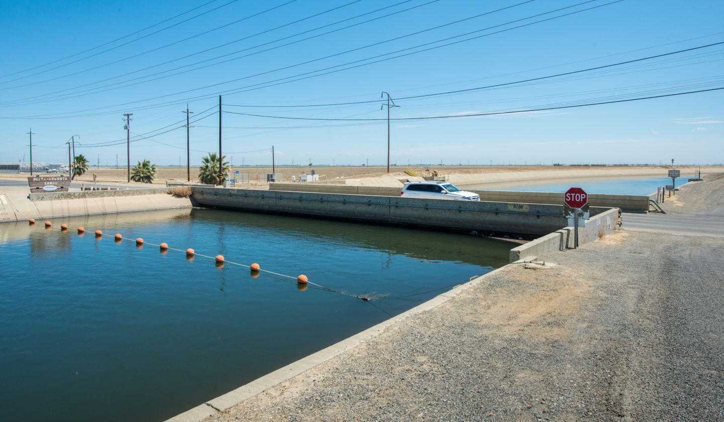
"content": "\u003cp>A new report reveals that California’s increased reliance on groundwater pumping is causing Central California to sink much faster than officials estimated.\u003c/p>\n\u003cp>The report, released today, shows that in just eight months last year, the Kings County town of Corcoran sank nearly 13 inches, while in Merced County, the unincorporated community of El Nido sank roughly ten inches. \u003c/p>\n\u003cp>“If our current drought continues or drought returns in the near future,” says Mark Cowin, director of the state Department of Water Resources, “we don’t believe we can sustain this kind of pumping and the effects that are occurring.” \u003c/p>\n\u003cp>[soundcloud url=”https://api.soundcloud.com/tracks/220129717″ params=”color=ff5500&auto_play=false&hide_related=false&show_comments=true&show_user=true&show_reposts=false” width=”100%” height=”166″ iframe=”true” /]\u003c/p>\n\u003caside class=\"pullquote alignright\">“Clearly, agricultural pumping is part of the issue we have to deal with here.”\u003ccite>Mark Cowin,\u003cbr>Director, Department of Water Resources\u003c/cite>\u003c/aside>\n\u003cp>The report from NASA’s Jet Propulsion Lab used satellite imaging to capture elevation data, and was commissioned by the Department of Water Resources.\u003c/p>\n\u003cp>[ad fullwidth]\u003c/p>\n\u003cp>This sinking of land, known as subsidence, is a known consequence of groundwater pumping and a problem that California’s been dealing with for decades. But it’s gotten worse as the state’s become drier. \u003c/p>\n\u003cp>In the entire three years of drought that ended in 2009, Corcoran sank three feet, El Nido close to two feet.\u003c/p>\n\u003cp>“The thing that particularly stands out for us was the increasing rates of subsidence that we saw in the most recent time period,” says the department’s Deputy Drought Manager, Jeanine Jones. \u003c/p>\n\u003cp>Subsidence occurs when water is drawn out of underground aquifers. Within an aquifer, water is held in permeable sediments, and when it’s pumped out, the grains in the sediments compact. Without recharge from rain and snowmelt, Central Valley aquifers are slumping, as Californians rely more and more heavily on groundwater for drinking and irrigation.\u003c/p>\n\u003cfigure id=\"attachment_202544\" class=\"wp-caption alignright\" style=\"max-width: 800px\">\u003ca href=\"http://ww2.kqed.org/science/wp-content/uploads/sites/35/2015/08/Fig_NASA.png\">\u003cimg loading=\"lazy\" decoding=\"async\" src=\"http://ww2.kqed.org/science/wp-content/uploads/sites/35/2015/08/Fig_NASA-800x766.png\" alt=\"In the San Joaquin Valley, from May-December 2014. land near the communities of Corcoran and El Nido subsided the most.\" width=\"800\" height=\"766\" class=\"size-medium wp-image-202544\" srcset=\"https://cdn.kqed.org/wp-content/uploads/sites/35/2015/08/Fig_NASA-800x766.png 800w, https://cdn.kqed.org/wp-content/uploads/sites/35/2015/08/Fig_NASA-400x383.png 400w, https://cdn.kqed.org/wp-content/uploads/sites/35/2015/08/Fig_NASA-1180x1130.png 1180w, https://cdn.kqed.org/wp-content/uploads/sites/35/2015/08/Fig_NASA-960x919.png 960w, https://cdn.kqed.org/wp-content/uploads/sites/35/2015/08/Fig_NASA-32x32.png 32w, https://cdn.kqed.org/wp-content/uploads/sites/35/2015/08/Fig_NASA.png 1202w\" sizes=\"(max-width: 800px) 100vw, 800px\">\u003c/a>\u003cfigcaption class=\"wp-caption-text\">In the San Joaquin Valley, from May-December 2014. land near the communities of Corcoran and El Nido subsided the most. \u003ccite>(NASA)\u003c/cite>\u003c/figcaption>\u003c/figure>\n\u003cp>“Agricultural pumping makes up the great majority of the total amount of pumping that occurs in the Central Valley,” says Cowin. “Clearly, agricultural pumping is part of the issue we have to deal with here.”\u003c/p>\n\u003cp>The subsidence poses a problem for the state’s infrastructure. Roads can buckle, building foundations can crack, and officials worry about the California Aqueduct, a long canal that snakes through the valley to deliver water to Southern California. The report found that a stretch of the aqueduct has already subsided between eight and 13 inches.\u003c/p>\n\u003cp>Jones says the state is beginning to talk with county governments about what they can do to reduce groundwater pumping and slow further subsidence. Glenn County, for example, recently put a 6-month moratorium on new well permits. \u003c/p>\n\u003cp>Water Resources department director Mark Cowin acknowledges that finding solutions will take time.\u003c/p>\n\u003cp>“We’re not ready to take a draconian approach to correcting this issue,” Cowin says. “We’re at the stage where we want to work with local governments, in particular counties, to come up with the right near-term approaches.”\u003c/p>\n\u003cp>The department will also be making $10 million available to counties with stressed groundwater basins, to beef up water conservation.\u003c/p>\n\u003cp>\u003c/p>\n\u003cp>\u003cem>Kerry Klein comes to The California Report by way of the Science Communication graduate program at U.C. Santa Cruz. A geologist by training, Klein previously worked in the mining and geothermal energy industries. After transitioning to journalism, she worked for the Science Podcast, Valley Public Radio, the San Jose Mercury News and the Salinas Californian, reporting on drought, agriculture, space and roadkill.\u003c/em> \u003c/p>\n\n",
"stats": {
"hasVideo": false,
"hasChartOrMap": false,
"hasAudio": false,
"hasPolis": false,
"wordCount": 645,
"hasGoogleForm": false,
"hasGallery": false,
"hasHearkenModule": false,
"iframeSrcs": [],
"paragraphCount": 18
},
"modified": 1704931422,
"excerpt": "Satellite imaging data found a portion of the California Aqueduct, which carries drinking water to Los Angeles, sank 8 inches in less than a year.",
"headData": {
"twImgId": "",
"twTitle": "",
"ogTitle": "",
"ogImgId": "",
"twDescription": "",
"description": "Satellite imaging data found a portion of the California Aqueduct, which carries drinking water to Los Angeles, sank 8 inches in less than a year.",
"title": "In Current Drought, Central Valley Is Sinking Faster Than We Thought | KQED",
"ogDescription": "",
"schema": {
"@context": "https://schema.org",
"@type": "Article",
"headline": "In Current Drought, Central Valley Is Sinking Faster Than We Thought",
"datePublished": "2015-08-19T18:50:23-07:00",
"dateModified": "2024-01-10T16:03:42-08:00",
"image": "https://cdn.kqed.org/wp-content/uploads/2020/02/KQED-OG-Image@1x.png"
}
},
"guestAuthors": [],
"slug": "central-valley-is-sinking-faster-than-we-thought-in-current-drought",
"status": "publish",
"nprByline": "Kerry Klein",
"sticky": false,
"path": "/science/202449/central-valley-is-sinking-faster-than-we-thought-in-current-drought",
"audioTrackLength": null,
"parsedContent": [
{
"type": "contentString",
"content": "\u003cdiv class=\"post-body\">\u003cp>\u003cp>A new report reveals that California’s increased reliance on groundwater pumping is causing Central California to sink much faster than officials estimated.\u003c/p>\n\u003cp>The report, released today, shows that in just eight months last year, the Kings County town of Corcoran sank nearly 13 inches, while in Merced County, the unincorporated community of El Nido sank roughly ten inches. \u003c/p>\n\u003cp>“If our current drought continues or drought returns in the near future,” says Mark Cowin, director of the state Department of Water Resources, “we don’t believe we can sustain this kind of pumping and the effects that are occurring.” \u003c/p>\n\u003cp>\u003c/p>\u003cp>\u003cdiv class='utils-parseShortcode-shortcodes-__shortcodes__shortcodeWrapper'>\n \u003ciframe width='”100%”' height='”166″'\n scrolling='no' frameborder='no'\n src='https://w.soundcloud.com/player/?url=”https://api.soundcloud.com/tracks/220129717″&visual=true&”color=ff5500&auto_play=false&hide_related=false&show_comments=true&show_user=true&show_reposts=false”'\n title='”https://api.soundcloud.com/tracks/220129717″'>\n \u003c/iframe>\n \u003c/div>\u003c/p>\u003cp>\u003c/p>\n\u003caside class=\"pullquote alignright\">“Clearly, agricultural pumping is part of the issue we have to deal with here.”\u003ccite>Mark Cowin,\u003cbr>Director, Department of Water Resources\u003c/cite>\u003c/aside>\n\u003cp>The report from NASA’s Jet Propulsion Lab used satellite imaging to capture elevation data, and was commissioned by the Department of Water Resources.\u003c/p>\n\u003cp>\u003c/p>\u003c/div>",
"attributes": {
"named": {},
"numeric": []
}
},
{
"type": "component",
"content": "",
"name": "ad",
"attributes": {
"named": {
"label": "fullwidth"
},
"numeric": [
"fullwidth"
]
}
},
{
"type": "contentString",
"content": "\u003cdiv class=\"post-body\">\u003cp>\u003c/p>\n\u003cp>This sinking of land, known as subsidence, is a known consequence of groundwater pumping and a problem that California’s been dealing with for decades. But it’s gotten worse as the state’s become drier. \u003c/p>\n\u003cp>In the entire three years of drought that ended in 2009, Corcoran sank three feet, El Nido close to two feet.\u003c/p>\n\u003cp>“The thing that particularly stands out for us was the increasing rates of subsidence that we saw in the most recent time period,” says the department’s Deputy Drought Manager, Jeanine Jones. \u003c/p>\n\u003cp>Subsidence occurs when water is drawn out of underground aquifers. Within an aquifer, water is held in permeable sediments, and when it’s pumped out, the grains in the sediments compact. Without recharge from rain and snowmelt, Central Valley aquifers are slumping, as Californians rely more and more heavily on groundwater for drinking and irrigation.\u003c/p>\n\u003cfigure id=\"attachment_202544\" class=\"wp-caption alignright\" style=\"max-width: 800px\">\u003ca href=\"http://ww2.kqed.org/science/wp-content/uploads/sites/35/2015/08/Fig_NASA.png\">\u003cimg loading=\"lazy\" decoding=\"async\" src=\"http://ww2.kqed.org/science/wp-content/uploads/sites/35/2015/08/Fig_NASA-800x766.png\" alt=\"In the San Joaquin Valley, from May-December 2014. land near the communities of Corcoran and El Nido subsided the most.\" width=\"800\" height=\"766\" class=\"size-medium wp-image-202544\" srcset=\"https://cdn.kqed.org/wp-content/uploads/sites/35/2015/08/Fig_NASA-800x766.png 800w, https://cdn.kqed.org/wp-content/uploads/sites/35/2015/08/Fig_NASA-400x383.png 400w, https://cdn.kqed.org/wp-content/uploads/sites/35/2015/08/Fig_NASA-1180x1130.png 1180w, https://cdn.kqed.org/wp-content/uploads/sites/35/2015/08/Fig_NASA-960x919.png 960w, https://cdn.kqed.org/wp-content/uploads/sites/35/2015/08/Fig_NASA-32x32.png 32w, https://cdn.kqed.org/wp-content/uploads/sites/35/2015/08/Fig_NASA.png 1202w\" sizes=\"(max-width: 800px) 100vw, 800px\">\u003c/a>\u003cfigcaption class=\"wp-caption-text\">In the San Joaquin Valley, from May-December 2014. land near the communities of Corcoran and El Nido subsided the most. \u003ccite>(NASA)\u003c/cite>\u003c/figcaption>\u003c/figure>\n\u003cp>“Agricultural pumping makes up the great majority of the total amount of pumping that occurs in the Central Valley,” says Cowin. “Clearly, agricultural pumping is part of the issue we have to deal with here.”\u003c/p>\n\u003cp>The subsidence poses a problem for the state’s infrastructure. Roads can buckle, building foundations can crack, and officials worry about the California Aqueduct, a long canal that snakes through the valley to deliver water to Southern California. The report found that a stretch of the aqueduct has already subsided between eight and 13 inches.\u003c/p>\n\u003cp>Jones says the state is beginning to talk with county governments about what they can do to reduce groundwater pumping and slow further subsidence. Glenn County, for example, recently put a 6-month moratorium on new well permits. \u003c/p>\n\u003cp>Water Resources department director Mark Cowin acknowledges that finding solutions will take time.\u003c/p>\n\u003cp>“We’re not ready to take a draconian approach to correcting this issue,” Cowin says. “We’re at the stage where we want to work with local governments, in particular counties, to come up with the right near-term approaches.”\u003c/p>\n\u003cp>The department will also be making $10 million available to counties with stressed groundwater basins, to beef up water conservation.\u003c/p>\n\u003cp>\u003c/p>\n\u003cp>\u003cem>Kerry Klein comes to The California Report by way of the Science Communication graduate program at U.C. Santa Cruz. A geologist by training, Klein previously worked in the mining and geothermal energy industries. After transitioning to journalism, she worked for the Science Podcast, Valley Public Radio, the San Jose Mercury News and the Salinas Californian, reporting on drought, agriculture, space and roadkill.\u003c/em> \u003c/p>\n\n\u003c/div>\u003c/p>",
"attributes": {
"named": {},
"numeric": []
}
}
],
"link": "/science/202449/central-valley-is-sinking-faster-than-we-thought-in-current-drought",
"authors": [
"byline_science_202449"
],
"series": [
"science_1151"
],
"categories": [
"science_38",
"science_40",
"science_98"
],
"tags": [
"science_686",
"science_572"
],
"featImg": "science_202541",
"label": "science_1151"
},
"science_168271": {
"type": "posts",
"id": "science_168271",
"meta": {
"index": "posts_1716263798",
"site": "science",
"id": "168271",
"score": null,
"sort": [
1438866042000
]
},
"parent": 0,
"labelTerm": {
"site": "science"
},
"blocks": [],
"publishDate": 1438866042,
"format": "standard",
"title": "Geothermal Update: What's New at The Geysers",
"headTitle": "Geothermal Update: What’s New at The Geysers | KQED",
"content": "\u003cp>The Geysers geothermal field, in the Coast Range near Clear Lake, has been supplying California with clean electricity for 55 years. Over time, the output of this field has slowly declined, raising questions about how long we could rely on it. But a recent experiment offers confidence that we can keep drawing power from The Geysers for many decades to come, by tapping its superheated deeper layers.\u003c/p>\n\u003cp>Most conventional electricity is generated by turning a turbine with a flow of hot steam. Supplying the energy to make that steam is a central issue of our time.\u003c/p>\n\u003cp>Unlike all other energy sources — fossil fuels, large-scale solar, nuclear, biomass — \u003ca href=\"http://science.kqed.org/quest/video/geothermal-heats-up/\">geothermal power is unique\u003c/a> in that the steam is already there. The steam in The Geysers geothermal field is heated to an average of 465 degrees by a geologically young body of magma high in the Earth’s crust, related to \u003ca href=\"http://science.kqed.org/quest/2011/04/28/bay-area-volcanoes/\">the volcanic district around Clear Lake\u003c/a>.\u003c/p>\n\u003cfigure id=\"attachment_168273\" class=\"wp-caption alignright\" style=\"max-width: 600px\">\u003ca href=\"http://ww2.kqed.org/science/wp-content/uploads/sites/35/2015/08/geysers-sign.jpg\">\u003cimg loading=\"lazy\" decoding=\"async\" class=\"size-full wp-image-168273\" src=\"http://ww2.kqed.org/science/wp-content/uploads/sites/35/2015/08/geysers-sign.jpg\" alt=\"Sign at fumarole field\" width=\"600\" height=\"450\" srcset=\"https://cdn.kqed.org/wp-content/uploads/sites/35/2015/08/geysers-sign.jpg 600w, https://cdn.kqed.org/wp-content/uploads/sites/35/2015/08/geysers-sign-400x300.jpg 400w\" sizes=\"(max-width: 600px) 100vw, 600px\">\u003c/a>\u003cfigcaption class=\"wp-caption-text\">Natural hot springs and steam-venting fumaroles concentrated along Big Sulphur Creek gave The Geysers its name in the 1850s. There are no true geysers — springs with steam-propelled eruptions of hot water — here or anywhere else in California. \u003ccite>(Andrew Alden/KQED)\u003c/cite>\u003c/figcaption>\u003c/figure>\n\u003cp>The “fuel” of a geothermal field is water, which is heated into steam by hot rock. Pouring cold water on hot rocks tends to make them crack, opening up fractures that allow efficient steam production. But steam wells slowly decline in their output, as fractures in the deep rock fill with minerals.\u003c/p>\n\u003cp>The Geysers geothermal field as a whole loses capacity by a percent or two each year. In recent years, Calpine has been exploring the northwest end of the geothermal field, where unfractured rocks as hot as 750 degrees are found. The results from its latest experiment are encouraging.\u003c/p>\n\u003cp>[ad fullwidth]\u003c/p>\n\u003cp>\u003cstrong>The Push for Green Power\u003c/strong>\u003c/p>\n\u003cp>Lately the state government’s push for renewable green power has made geothermal electricity more desirable than ever. And the flexibility of the steam source, easy to regulate just by turning a valve, makes The Geysers valuable for helping the electric grid cope with the natural fluctuations of wind and solar power.\u003c/p>\n\u003cp>The Geysers field is the world’s largest producer of geothermal power. It puts out about the same amount of electricity as a large conventional fossil-fuel plant — enough to power every household in San Francisco, Oakland and San Jose.\u003c/p>\n\u003cfigure id=\"attachment_168274\" class=\"wp-caption alignleft\" style=\"max-width: 390px\">\u003ca href=\"http://ww2.kqed.org/science/wp-content/uploads/sites/35/2015/08/geysers-cannedheat.jpg\">\u003cimg loading=\"lazy\" decoding=\"async\" class=\" wp-image-168274\" src=\"http://ww2.kqed.org/science/wp-content/uploads/sites/35/2015/08/geysers-cannedheat.jpg\" alt=\"Canned heat\" width=\"390\" height=\"292\" srcset=\"https://cdn.kqed.org/wp-content/uploads/sites/35/2015/08/geysers-cannedheat.jpg 600w, https://cdn.kqed.org/wp-content/uploads/sites/35/2015/08/geysers-cannedheat-400x300.jpg 400w\" sizes=\"(max-width: 390px) 100vw, 390px\">\u003c/a>\u003cfigcaption class=\"wp-caption-text\">Drilling at The Geysers began in 1955 and electricity production began with a UNOCAL power plant in 1960. The Calpine visitors center in Middletown features this commemorative artifact. \u003ccite>(Andrew Alden/KQED)\u003c/cite>\u003c/figcaption>\u003c/figure>\n\u003cp>Energy from The Geysers represents more than one-third of America’s geothermal electricity. Put another way, it represents 18 percent of California’s \u003ca href=\"http://www.energy.ca.gov/renewables/\">renewable energy\u003c/a>, which also includes wind, solar, biomass and small hydroelectric sources.\u003c/p>\n\u003cp>Three companies operate today in The Geysers geothermal field. \u003ca href=\"http://www.geysers.com/\">Calpine\u003c/a> is dominant with 15 power plants. \u003ca href=\"http://www.ncpa.com/\">Northern California Power Agency\u003c/a> runs two plants and \u003ca href=\"http://www.bottlerockpower.com/\">Bottle Rock Power\u003c/a> has one. Recently I took part in a tour of The Geysers field led by Calpine geologists, where I heard about the company’s operations and future plans. The photos in this story all come from that day.\u003c/p>\n\u003cp>\u003cb>A Dialogue Between Economics and Geology\u003c/b>\u003c/p>\n\u003cp>Power companies have tapped the natural underground steam at The Geysers to generate electricity since 1960. During that time, the story of the steam field has been a dialogue between society and geology.\u003c/p>\n\u003cp>In the 1980s, high oil and gas prices, plus new tax incentives, led to as many as a dozen operators drilling wells at The Geysers, each one tapping the steam as fast as it could. The reservoir’s steam supply began to run low.\u003c/p>\n\u003cp>Two things fixed the situation. First, the field came under majority control by Calpine, allowing it to be managed instead of exploited. Second, operators found a more sustainable way to run this gigantic natural steam boiler.\u003c/p>\n\u003cfigure id=\"attachment_168275\" class=\"wp-caption alignright\" style=\"max-width: 600px\">\u003ca href=\"http://ww2.kqed.org/science/wp-content/uploads/sites/35/2015/08/geysers-venting.jpg\">\u003cimg loading=\"lazy\" decoding=\"async\" class=\"size-full wp-image-168275\" src=\"http://ww2.kqed.org/science/wp-content/uploads/sites/35/2015/08/geysers-venting.jpg\" alt=\"Live steam at The Geysers\" width=\"600\" height=\"450\" srcset=\"https://cdn.kqed.org/wp-content/uploads/sites/35/2015/08/geysers-venting.jpg 600w, https://cdn.kqed.org/wp-content/uploads/sites/35/2015/08/geysers-venting-400x300.jpg 400w\" sizes=\"(max-width: 600px) 100vw, 600px\">\u003c/a>\u003cfigcaption class=\"wp-caption-text\">Calpine geologist Joe Beall jumped out of our tour bus to show us some actual steam fresh from the underground. Most of this moisture originated as wastewater from nearby cities. \u003ccite>(Andrew Alden/KQED)\u003c/cite>\u003c/figcaption>\u003c/figure>\n\u003cp>The Geysers field’s natural water supply is limited, so operators have always recycled as much as they could, condensing the steam once it goes through the turbines and pumping it back underground. Some water is always lost to the atmosphere. Adding new water to this cycle creates what’s called an “enhanced geothermal system.”\u003c/p>\n\u003cp>The new water used to replenish the steam reservoir is clean but nonpotable wastewater, piped in from the towns around Clear Lake starting in 1997, and from Santa Rosa in 2003. Today Calpine’s 333 steam wells are served by 60 injection wells that feed this water down to the deep hot rock.\u003c/p>\n\u003cp>\u003cb>The Earthquake Problem\u003c/b>\u003c/p>\n\u003cp>The high-energy process of pouring cold water onto hot rocks to crack them is done regularly to refresh the wells. But it produces lots of earthquakes. Nearly all are too small to be felt, although they show up on the \u003ca href=\"http://earthquake.usgs.gov/earthquakes/map/\">government earthquake map\u003c/a>. But a handful each year reach magnitudes above 3, strong enough to cause noticeable shaking in communities next to the steam field. Calpine officials say they’re tinkering with the plant’s practices to minimize these, and \u003ca href=\"http://www.geysers.com/smac.aspx\">it provides regular updates to residents\u003c/a>.\u003c/p>\n\u003cp>So far in 2015, the number of earthquakes of all sizes has been far below recent numbers. Indeed, just three magnitude-3 events have happened. Part of this decrease may be related to the ongoing drought, because water injection has been less than usual. But maybe it also signals an advance in managing the beast. Earthquake activity has been declining steadily for almost 25 years.\u003c/p>\n\u003cfigure id=\"attachment_168276\" class=\"wp-caption alignleft\" style=\"max-width: 401px\">\u003ca href=\"http://ww2.kqed.org/science/wp-content/uploads/sites/35/2015/08/geysers-turbines.jpg\">\u003cimg loading=\"lazy\" decoding=\"async\" class=\" wp-image-168276\" src=\"http://ww2.kqed.org/science/wp-content/uploads/sites/35/2015/08/geysers-turbines.jpg\" alt=\"Spare geothermal turbines\" width=\"401\" height=\"300\" srcset=\"https://cdn.kqed.org/wp-content/uploads/sites/35/2015/08/geysers-turbines.jpg 600w, https://cdn.kqed.org/wp-content/uploads/sites/35/2015/08/geysers-turbines-400x300.jpg 400w\" sizes=\"(max-width: 401px) 100vw, 401px\">\u003c/a>\u003cfigcaption class=\"wp-caption-text\">Spare turbines in the Socrates Number 18 power plant. \u003ccite>(Andrew Alden/KQED)\u003c/cite>\u003c/figcaption>\u003c/figure>\n\u003cp>Calpine’s staff scientists are collaborating on several different research projects to better understand the release of seismic energy by geothermal power activity. In one of these, \u003ca href=\"http://esd1.lbl.gov/research/projects/induced_seismicity/egs/\">Lawrence Berkeley Lab\u003c/a> studies enhanced geothermal system fields at The Geysers and elsewhere. The U.S. Geological Survey and UC Berkeley operate \u003ca href=\"http://seismo.berkeley.edu/bdsn/bdsn.overview.html\">a network of strong-motion instruments\u003c/a> at The Geysers in an effort to learn what distinguishes harmless earthquakes from significant ones, avoiding false alarms.\u003c/p>\n\u003cp>\u003cb>The Future of The Geysers\u003c/b>\u003c/p>\n\u003cp>While the northwest end of the field shows promise, it also presents problems. Wells drilled there in the 1990s produced steam with relatively large amounts of corrosive gases. Sulfur gases are routinely scrubbed from Geysers steam and supplied to chemical manufacturers as pure sulfur. Scrubbing chlorine gases takes an extra step, and an extra expense, between the well and the power plant.\u003c/p>\n\u003cp>In 2010 Calpine re-entered a 1980s-vintage well to drill deeper into the hottest zone and inject water into it. Calpine’s May 2015 \u003ca href=\"http://energy.gov/sites/prod/files/2015/06/f23/Track4_EGS_2.7_Geysers_EGS_Demonstration.pdf\">presentation\u003c/a> about the project to a \u003ca href=\"http://energy.gov/eere/geothermal/2015-peer-review-presentations-geothermal-energy\">U.S. Department of Energy meeting\u003c/a> goes into great detail. Pumping tests went on from 2012 to 2014 and succeeded in gently cracking a sizeable body of hot rock, making its heat available to turn water into lots of steam.\u003c/p>\n\u003cp>The experiment was a qualified success. Steam from the fresh water flushed out most of the corrosive gases, and steam production was plentiful. Earthquakes occurred, but their greater depth and greater distance from inhabited places reduces their impact. The main hitch was that chlorine gases ate a hole in the steel borehole lining. Calpine will monitor the hole until 2017, then pick a more robust alloy — steel or titanium — to line the pipe and proceed with the next stage of its exploration.\u003c/p>\n\u003cp>[ad floatright]\u003c/p>\n\u003cp>Once safe procedures can be worked out, Calpine is prepared to move into the northwest sector. The same procedures will open up the deeper zones in the rest of the steam field, increasing the power that can be extracted and extending the life of the Geysers geothermal resource.\u003c/p>\n\n",
"stats": {
"hasVideo": false,
"hasChartOrMap": false,
"hasAudio": false,
"hasPolis": false,
"wordCount": 1323,
"hasGoogleForm": false,
"hasGallery": false,
"hasHearkenModule": false,
"iframeSrcs": [],
"paragraphCount": 27
},
"modified": 1704931470,
"excerpt": "Key experiments point the way toward a long, productive life for the world's largest geothermal field",
"headData": {
"twImgId": "",
"twTitle": "",
"ogTitle": "",
"ogImgId": "",
"twDescription": "",
"description": "Key experiments point the way toward a long, productive life for the world's largest geothermal field",
"title": "Geothermal Update: What's New at The Geysers | KQED",
"ogDescription": "",
"schema": {
"@context": "https://schema.org",
"@type": "Article",
"headline": "Geothermal Update: What's New at The Geysers",
"datePublished": "2015-08-06T06:00:42-07:00",
"dateModified": "2024-01-10T16:04:30-08:00",
"image": "https://cdn.kqed.org/wp-content/uploads/2020/02/KQED-OG-Image@1x.png"
}
},
"guestAuthors": [],
"slug": "geothermal-update-whats-new-at-the-geysers",
"status": "publish",
"sticky": false,
"path": "/science/168271/geothermal-update-whats-new-at-the-geysers",
"audioTrackLength": null,
"parsedContent": [
{
"type": "contentString",
"content": "\u003cdiv class=\"post-body\">\u003cp>\u003cp>The Geysers geothermal field, in the Coast Range near Clear Lake, has been supplying California with clean electricity for 55 years. Over time, the output of this field has slowly declined, raising questions about how long we could rely on it. But a recent experiment offers confidence that we can keep drawing power from The Geysers for many decades to come, by tapping its superheated deeper layers.\u003c/p>\n\u003cp>Most conventional electricity is generated by turning a turbine with a flow of hot steam. Supplying the energy to make that steam is a central issue of our time.\u003c/p>\n\u003cp>Unlike all other energy sources — fossil fuels, large-scale solar, nuclear, biomass — \u003ca href=\"http://science.kqed.org/quest/video/geothermal-heats-up/\">geothermal power is unique\u003c/a> in that the steam is already there. The steam in The Geysers geothermal field is heated to an average of 465 degrees by a geologically young body of magma high in the Earth’s crust, related to \u003ca href=\"http://science.kqed.org/quest/2011/04/28/bay-area-volcanoes/\">the volcanic district around Clear Lake\u003c/a>.\u003c/p>\n\u003cfigure id=\"attachment_168273\" class=\"wp-caption alignright\" style=\"max-width: 600px\">\u003ca href=\"http://ww2.kqed.org/science/wp-content/uploads/sites/35/2015/08/geysers-sign.jpg\">\u003cimg loading=\"lazy\" decoding=\"async\" class=\"size-full wp-image-168273\" src=\"http://ww2.kqed.org/science/wp-content/uploads/sites/35/2015/08/geysers-sign.jpg\" alt=\"Sign at fumarole field\" width=\"600\" height=\"450\" srcset=\"https://cdn.kqed.org/wp-content/uploads/sites/35/2015/08/geysers-sign.jpg 600w, https://cdn.kqed.org/wp-content/uploads/sites/35/2015/08/geysers-sign-400x300.jpg 400w\" sizes=\"(max-width: 600px) 100vw, 600px\">\u003c/a>\u003cfigcaption class=\"wp-caption-text\">Natural hot springs and steam-venting fumaroles concentrated along Big Sulphur Creek gave The Geysers its name in the 1850s. There are no true geysers — springs with steam-propelled eruptions of hot water — here or anywhere else in California. \u003ccite>(Andrew Alden/KQED)\u003c/cite>\u003c/figcaption>\u003c/figure>\n\u003cp>The “fuel” of a geothermal field is water, which is heated into steam by hot rock. Pouring cold water on hot rocks tends to make them crack, opening up fractures that allow efficient steam production. But steam wells slowly decline in their output, as fractures in the deep rock fill with minerals.\u003c/p>\n\u003cp>The Geysers geothermal field as a whole loses capacity by a percent or two each year. In recent years, Calpine has been exploring the northwest end of the geothermal field, where unfractured rocks as hot as 750 degrees are found. The results from its latest experiment are encouraging.\u003c/p>\n\u003cp>\u003c/p>\u003c/div>",
"attributes": {
"named": {},
"numeric": []
}
},
{
"type": "component",
"content": "",
"name": "ad",
"attributes": {
"named": {
"label": "fullwidth"
},
"numeric": [
"fullwidth"
]
}
},
{
"type": "contentString",
"content": "\u003cdiv class=\"post-body\">\u003cp>\u003c/p>\n\u003cp>\u003cstrong>The Push for Green Power\u003c/strong>\u003c/p>\n\u003cp>Lately the state government’s push for renewable green power has made geothermal electricity more desirable than ever. And the flexibility of the steam source, easy to regulate just by turning a valve, makes The Geysers valuable for helping the electric grid cope with the natural fluctuations of wind and solar power.\u003c/p>\n\u003cp>The Geysers field is the world’s largest producer of geothermal power. It puts out about the same amount of electricity as a large conventional fossil-fuel plant — enough to power every household in San Francisco, Oakland and San Jose.\u003c/p>\n\u003cfigure id=\"attachment_168274\" class=\"wp-caption alignleft\" style=\"max-width: 390px\">\u003ca href=\"http://ww2.kqed.org/science/wp-content/uploads/sites/35/2015/08/geysers-cannedheat.jpg\">\u003cimg loading=\"lazy\" decoding=\"async\" class=\" wp-image-168274\" src=\"http://ww2.kqed.org/science/wp-content/uploads/sites/35/2015/08/geysers-cannedheat.jpg\" alt=\"Canned heat\" width=\"390\" height=\"292\" srcset=\"https://cdn.kqed.org/wp-content/uploads/sites/35/2015/08/geysers-cannedheat.jpg 600w, https://cdn.kqed.org/wp-content/uploads/sites/35/2015/08/geysers-cannedheat-400x300.jpg 400w\" sizes=\"(max-width: 390px) 100vw, 390px\">\u003c/a>\u003cfigcaption class=\"wp-caption-text\">Drilling at The Geysers began in 1955 and electricity production began with a UNOCAL power plant in 1960. The Calpine visitors center in Middletown features this commemorative artifact. \u003ccite>(Andrew Alden/KQED)\u003c/cite>\u003c/figcaption>\u003c/figure>\n\u003cp>Energy from The Geysers represents more than one-third of America’s geothermal electricity. Put another way, it represents 18 percent of California’s \u003ca href=\"http://www.energy.ca.gov/renewables/\">renewable energy\u003c/a>, which also includes wind, solar, biomass and small hydroelectric sources.\u003c/p>\n\u003cp>Three companies operate today in The Geysers geothermal field. \u003ca href=\"http://www.geysers.com/\">Calpine\u003c/a> is dominant with 15 power plants. \u003ca href=\"http://www.ncpa.com/\">Northern California Power Agency\u003c/a> runs two plants and \u003ca href=\"http://www.bottlerockpower.com/\">Bottle Rock Power\u003c/a> has one. Recently I took part in a tour of The Geysers field led by Calpine geologists, where I heard about the company’s operations and future plans. The photos in this story all come from that day.\u003c/p>\n\u003cp>\u003cb>A Dialogue Between Economics and Geology\u003c/b>\u003c/p>\n\u003cp>Power companies have tapped the natural underground steam at The Geysers to generate electricity since 1960. During that time, the story of the steam field has been a dialogue between society and geology.\u003c/p>\n\u003cp>In the 1980s, high oil and gas prices, plus new tax incentives, led to as many as a dozen operators drilling wells at The Geysers, each one tapping the steam as fast as it could. The reservoir’s steam supply began to run low.\u003c/p>\n\u003cp>Two things fixed the situation. First, the field came under majority control by Calpine, allowing it to be managed instead of exploited. Second, operators found a more sustainable way to run this gigantic natural steam boiler.\u003c/p>\n\u003cfigure id=\"attachment_168275\" class=\"wp-caption alignright\" style=\"max-width: 600px\">\u003ca href=\"http://ww2.kqed.org/science/wp-content/uploads/sites/35/2015/08/geysers-venting.jpg\">\u003cimg loading=\"lazy\" decoding=\"async\" class=\"size-full wp-image-168275\" src=\"http://ww2.kqed.org/science/wp-content/uploads/sites/35/2015/08/geysers-venting.jpg\" alt=\"Live steam at The Geysers\" width=\"600\" height=\"450\" srcset=\"https://cdn.kqed.org/wp-content/uploads/sites/35/2015/08/geysers-venting.jpg 600w, https://cdn.kqed.org/wp-content/uploads/sites/35/2015/08/geysers-venting-400x300.jpg 400w\" sizes=\"(max-width: 600px) 100vw, 600px\">\u003c/a>\u003cfigcaption class=\"wp-caption-text\">Calpine geologist Joe Beall jumped out of our tour bus to show us some actual steam fresh from the underground. Most of this moisture originated as wastewater from nearby cities. \u003ccite>(Andrew Alden/KQED)\u003c/cite>\u003c/figcaption>\u003c/figure>\n\u003cp>The Geysers field’s natural water supply is limited, so operators have always recycled as much as they could, condensing the steam once it goes through the turbines and pumping it back underground. Some water is always lost to the atmosphere. Adding new water to this cycle creates what’s called an “enhanced geothermal system.”\u003c/p>\n\u003cp>The new water used to replenish the steam reservoir is clean but nonpotable wastewater, piped in from the towns around Clear Lake starting in 1997, and from Santa Rosa in 2003. Today Calpine’s 333 steam wells are served by 60 injection wells that feed this water down to the deep hot rock.\u003c/p>\n\u003cp>\u003cb>The Earthquake Problem\u003c/b>\u003c/p>\n\u003cp>The high-energy process of pouring cold water onto hot rocks to crack them is done regularly to refresh the wells. But it produces lots of earthquakes. Nearly all are too small to be felt, although they show up on the \u003ca href=\"http://earthquake.usgs.gov/earthquakes/map/\">government earthquake map\u003c/a>. But a handful each year reach magnitudes above 3, strong enough to cause noticeable shaking in communities next to the steam field. Calpine officials say they’re tinkering with the plant’s practices to minimize these, and \u003ca href=\"http://www.geysers.com/smac.aspx\">it provides regular updates to residents\u003c/a>.\u003c/p>\n\u003cp>So far in 2015, the number of earthquakes of all sizes has been far below recent numbers. Indeed, just three magnitude-3 events have happened. Part of this decrease may be related to the ongoing drought, because water injection has been less than usual. But maybe it also signals an advance in managing the beast. Earthquake activity has been declining steadily for almost 25 years.\u003c/p>\n\u003cfigure id=\"attachment_168276\" class=\"wp-caption alignleft\" style=\"max-width: 401px\">\u003ca href=\"http://ww2.kqed.org/science/wp-content/uploads/sites/35/2015/08/geysers-turbines.jpg\">\u003cimg loading=\"lazy\" decoding=\"async\" class=\" wp-image-168276\" src=\"http://ww2.kqed.org/science/wp-content/uploads/sites/35/2015/08/geysers-turbines.jpg\" alt=\"Spare geothermal turbines\" width=\"401\" height=\"300\" srcset=\"https://cdn.kqed.org/wp-content/uploads/sites/35/2015/08/geysers-turbines.jpg 600w, https://cdn.kqed.org/wp-content/uploads/sites/35/2015/08/geysers-turbines-400x300.jpg 400w\" sizes=\"(max-width: 401px) 100vw, 401px\">\u003c/a>\u003cfigcaption class=\"wp-caption-text\">Spare turbines in the Socrates Number 18 power plant. \u003ccite>(Andrew Alden/KQED)\u003c/cite>\u003c/figcaption>\u003c/figure>\n\u003cp>Calpine’s staff scientists are collaborating on several different research projects to better understand the release of seismic energy by geothermal power activity. In one of these, \u003ca href=\"http://esd1.lbl.gov/research/projects/induced_seismicity/egs/\">Lawrence Berkeley Lab\u003c/a> studies enhanced geothermal system fields at The Geysers and elsewhere. The U.S. Geological Survey and UC Berkeley operate \u003ca href=\"http://seismo.berkeley.edu/bdsn/bdsn.overview.html\">a network of strong-motion instruments\u003c/a> at The Geysers in an effort to learn what distinguishes harmless earthquakes from significant ones, avoiding false alarms.\u003c/p>\n\u003cp>\u003cb>The Future of The Geysers\u003c/b>\u003c/p>\n\u003cp>While the northwest end of the field shows promise, it also presents problems. Wells drilled there in the 1990s produced steam with relatively large amounts of corrosive gases. Sulfur gases are routinely scrubbed from Geysers steam and supplied to chemical manufacturers as pure sulfur. Scrubbing chlorine gases takes an extra step, and an extra expense, between the well and the power plant.\u003c/p>\n\u003cp>In 2010 Calpine re-entered a 1980s-vintage well to drill deeper into the hottest zone and inject water into it. Calpine’s May 2015 \u003ca href=\"http://energy.gov/sites/prod/files/2015/06/f23/Track4_EGS_2.7_Geysers_EGS_Demonstration.pdf\">presentation\u003c/a> about the project to a \u003ca href=\"http://energy.gov/eere/geothermal/2015-peer-review-presentations-geothermal-energy\">U.S. Department of Energy meeting\u003c/a> goes into great detail. Pumping tests went on from 2012 to 2014 and succeeded in gently cracking a sizeable body of hot rock, making its heat available to turn water into lots of steam.\u003c/p>\n\u003cp>The experiment was a qualified success. Steam from the fresh water flushed out most of the corrosive gases, and steam production was plentiful. Earthquakes occurred, but their greater depth and greater distance from inhabited places reduces their impact. The main hitch was that chlorine gases ate a hole in the steel borehole lining. Calpine will monitor the hole until 2017, then pick a more robust alloy — steel or titanium — to line the pipe and proceed with the next stage of its exploration.\u003c/p>\n\u003cp>\u003c/p>\u003c/div>",
"attributes": {
"named": {},
"numeric": []
}
},
{
"type": "component",
"content": "",
"name": "ad",
"attributes": {
"named": {
"label": "floatright"
},
"numeric": [
"floatright"
]
}
},
{
"type": "contentString",
"content": "\u003cdiv class=\"post-body\">\u003cp>\u003c/p>\n\u003cp>Once safe procedures can be worked out, Calpine is prepared to move into the northwest sector. The same procedures will open up the deeper zones in the rest of the steam field, increasing the power that can be extracted and extending the life of the Geysers geothermal resource.\u003c/p>\n\n\u003c/div>\u003c/p>",
"attributes": {
"named": {},
"numeric": []
}
}
],
"link": "/science/168271/geothermal-update-whats-new-at-the-geysers",
"authors": [
"6228"
],
"categories": [
"science_33",
"science_38"
],
"featImg": "science_168272",
"label": "science"
},
"science_151341": {
"type": "posts",
"id": "science_151341",
"meta": {
"index": "posts_1716263798",
"site": "science",
"id": "151341",
"score": null,
"sort": [
1438261209000
]
},
"parent": 0,
"labelTerm": {
"site": "science"
},
"blocks": [],
"publishDate": 1438261209,
"format": "standard",
"title": "Ancient Magma Chamber Revealed in El Capitan's Rocks",
"headTitle": "Ancient Magma Chamber Revealed in El Capitan’s Rocks | KQED",
"content": "\u003cp>The millions of people who visit Yosemite Valley each year see the place in many different ways. When they gaze at the 3,000-foot face of El Capitan, many visitors open their mouths in awe. Elite climbers think, “I want to conquer that wall.” Geologists think, “I want to study that outcrop.”\u003c/p>\n\u003cp>Now geologists have mapped the rocks of El Capitan’s vertical face using a combination of high-tech and high climbing. \u003ca href=\"http://geosphere.gsapubs.org/content/early/2015/07/01/GES01133.1.abstract\">The research\u003c/a>, published this month in the journal \u003ca href=\"http://geosphere.gsapubs.org/\">Geosphere\u003c/a>, was not just a great stunt, but also an attempt to help solve the deep scientific problem of how granite is made.\u003c/p>\n\u003cp>Yosemite Valley cuts deeply into the great bodies of granite, called plutons, that make up the core of the Sierra Nevada. El Capitan offers a particularly thick and clean slice into these plutons, offering much more detail than drill holes can provide. \u003c/p>\n\u003cp>Over the years, the valley has been a laboratory for cutting-edge techniques in geology. It helps that Greg Stock, the park’s chief geologist, is a rock-climber himself. \u003c/p>\n\u003cfigure id=\"attachment_151343\" class=\"wp-caption alignnone\" style=\"max-width: 800px\">\u003ca href=\"http://ww2.kqed.org/science/wp-content/uploads/sites/35/2015/07/Capitan-closeup.jpg\">\u003cimg loading=\"lazy\" decoding=\"async\" src=\"http://ww2.kqed.org/science/wp-content/uploads/sites/35/2015/07/Capitan-closeup-800x600.jpg\" alt=\"Detail of El Capitan\" width=\"800\" height=\"600\" class=\"size-medium wp-image-151343\" srcset=\"https://cdn.kqed.org/wp-content/uploads/sites/35/2015/07/Capitan-closeup.jpg 800w, https://cdn.kqed.org/wp-content/uploads/sites/35/2015/07/Capitan-closeup-400x300.jpg 400w\" sizes=\"(max-width: 800px) 100vw, 800px\">\u003c/a>\u003cfigcaption class=\"wp-caption-text\">Close-up of the dark feature called “North America” on El Capitan. Exposures like this record some three million years of activity in a magma chamber that was once miles underground. \u003ccite>(Xrez Studio)\u003c/cite>\u003c/figcaption>\u003c/figure>\n\u003cp>One of Stock’s first ideas was the \u003ca href=\"http://www.nps.gov/yose/learn/nature/panoramic.htm\">Yosemite Panoramic Imaging Project\u003c/a>. On May 31, 2008, twenty teams of photographers snapped the high rock walls of the valley with high-resolution cameras. The images were then rendered into a gigantic 3D computer model that can be explored online, much like a \u003ca href=\"http://science.kqed.org/quest/2012/02/23/gigapans-panoramas-that-bring-you-all-the-way-there/\">Gigapan image\u003c/a>.\u003c/p>\n\u003cp>[ad fullwidth]\u003c/p>\n\u003cp>The first use of the Yosemite Panorama was to keep track of rock falls. More than 1,000 significant rock falls have been \u003ca href=\"http://pubs.usgs.gov/ds/746/\">reported in the valley since 1857\u003c/a>, and Stock says most rock falls aren’t even reported. \u003c/p>\n\u003cp>Other users of the Panorama have included climbers planning routes and rescuers planning rescues. But geologists need more than just the Panorama’s pictures; they need close-up contact with rocks, plus samples of them to analyze in the lab.\u003c/p>\n\u003cfigure id=\"attachment_151344\" class=\"wp-caption alignright\" style=\"max-width: 800px\">\u003ca href=\"http://ww2.kqed.org/science/wp-content/uploads/sites/35/2015/07/ElCapitan-ages.png\">\u003cimg loading=\"lazy\" decoding=\"async\" src=\"http://ww2.kqed.org/science/wp-content/uploads/sites/35/2015/07/ElCapitan-ages-800x471.png\" alt=\"Age map of El Capitan\" width=\"800\" height=\"471\" class=\"size-medium wp-image-151344\" srcset=\"https://cdn.kqed.org/wp-content/uploads/sites/35/2015/07/ElCapitan-ages-800x471.png 800w, https://cdn.kqed.org/wp-content/uploads/sites/35/2015/07/ElCapitan-ages-400x236.png 400w, https://cdn.kqed.org/wp-content/uploads/sites/35/2015/07/ElCapitan-ages-960x566.png 960w, https://cdn.kqed.org/wp-content/uploads/sites/35/2015/07/ElCapitan-ages.png 974w\" sizes=\"(max-width: 800px) 100vw, 800px\">\u003c/a>\u003cfigcaption class=\"wp-caption-text\">The major rock units in El Capitan along with selected ages, in millions of years. \u003ccite>(Putnam/Geological Society of America)\u003c/cite>\u003c/figcaption>\u003c/figure>\n\u003cp>El Capitan is a good target for geologists using the Panorama because climbers can access it through dozens of routes they’ve pioneered on its cliffs. Geologist Roger Putnam of the University of North Carolina enlisted the help of climbers to collect rock samples and take close-up photos. \u003c/p>\n\u003cp>Putnam and five coauthors determined that the granite dates from around 100 million years ago, when it first solidified from a molten state. They worked out a history spanning some three million years, during which the rocks of El Capitan rose in the form of plutons in eight separate events. At that time the pluton was many miles deep underground, part of a system feeding lava upward to a great chain of volcanoes. The volcanoes were comparable to today’s Cascade Range, but erosion since that time has erased their traces, leaving only their deep granite roots exposed in Yosemite.\u003c/p>\n\u003cp>\u003c/p>\n\u003cp>This research tells us something new about the nature of plutons. One school of thought holds that plutons are large liquid bodies that allow large mineral crystals to settle out like meatballs in stew. Another school argues that plutons behave more like concrete, with the solidifying magma trapping everything in pretty much the state it arrived. Putnam’s group concludes that the concrete model is a better fit for Yosemite’s plutons.\u003c/p>\n\n",
"stats": {
"hasVideo": false,
"hasChartOrMap": false,
"hasAudio": false,
"hasPolis": false,
"wordCount": 600,
"hasGoogleForm": false,
"hasGallery": false,
"hasHearkenModule": false,
"iframeSrcs": [],
"paragraphCount": 12
},
"modified": 1704931503,
"excerpt": "A circus-like team of climbers and geologists has mapped Yosemite's granite in unprecedented detail.",
"headData": {
"twImgId": "",
"twTitle": "",
"ogTitle": "",
"ogImgId": "",
"twDescription": "",
"description": "A circus-like team of climbers and geologists has mapped Yosemite's granite in unprecedented detail.",
"title": "Ancient Magma Chamber Revealed in El Capitan's Rocks | KQED",
"ogDescription": "",
"schema": {
"@context": "https://schema.org",
"@type": "Article",
"headline": "Ancient Magma Chamber Revealed in El Capitan's Rocks",
"datePublished": "2015-07-30T06:00:09-07:00",
"dateModified": "2024-01-10T16:05:03-08:00",
"image": "https://cdn.kqed.org/wp-content/uploads/2020/02/KQED-OG-Image@1x.png"
}
},
"guestAuthors": [],
"slug": "ancient-magma-chamber-revealed-in-el-capitans-rocks",
"status": "publish",
"sticky": false,
"path": "/science/151341/ancient-magma-chamber-revealed-in-el-capitans-rocks",
"audioTrackLength": null,
"parsedContent": [
{
"type": "contentString",
"content": "\u003cdiv class=\"post-body\">\u003cp>\u003cp>The millions of people who visit Yosemite Valley each year see the place in many different ways. When they gaze at the 3,000-foot face of El Capitan, many visitors open their mouths in awe. Elite climbers think, “I want to conquer that wall.” Geologists think, “I want to study that outcrop.”\u003c/p>\n\u003cp>Now geologists have mapped the rocks of El Capitan’s vertical face using a combination of high-tech and high climbing. \u003ca href=\"http://geosphere.gsapubs.org/content/early/2015/07/01/GES01133.1.abstract\">The research\u003c/a>, published this month in the journal \u003ca href=\"http://geosphere.gsapubs.org/\">Geosphere\u003c/a>, was not just a great stunt, but also an attempt to help solve the deep scientific problem of how granite is made.\u003c/p>\n\u003cp>Yosemite Valley cuts deeply into the great bodies of granite, called plutons, that make up the core of the Sierra Nevada. El Capitan offers a particularly thick and clean slice into these plutons, offering much more detail than drill holes can provide. \u003c/p>\n\u003cp>Over the years, the valley has been a laboratory for cutting-edge techniques in geology. It helps that Greg Stock, the park’s chief geologist, is a rock-climber himself. \u003c/p>\n\u003cfigure id=\"attachment_151343\" class=\"wp-caption alignnone\" style=\"max-width: 800px\">\u003ca href=\"http://ww2.kqed.org/science/wp-content/uploads/sites/35/2015/07/Capitan-closeup.jpg\">\u003cimg loading=\"lazy\" decoding=\"async\" src=\"http://ww2.kqed.org/science/wp-content/uploads/sites/35/2015/07/Capitan-closeup-800x600.jpg\" alt=\"Detail of El Capitan\" width=\"800\" height=\"600\" class=\"size-medium wp-image-151343\" srcset=\"https://cdn.kqed.org/wp-content/uploads/sites/35/2015/07/Capitan-closeup.jpg 800w, https://cdn.kqed.org/wp-content/uploads/sites/35/2015/07/Capitan-closeup-400x300.jpg 400w\" sizes=\"(max-width: 800px) 100vw, 800px\">\u003c/a>\u003cfigcaption class=\"wp-caption-text\">Close-up of the dark feature called “North America” on El Capitan. Exposures like this record some three million years of activity in a magma chamber that was once miles underground. \u003ccite>(Xrez Studio)\u003c/cite>\u003c/figcaption>\u003c/figure>\n\u003cp>One of Stock’s first ideas was the \u003ca href=\"http://www.nps.gov/yose/learn/nature/panoramic.htm\">Yosemite Panoramic Imaging Project\u003c/a>. On May 31, 2008, twenty teams of photographers snapped the high rock walls of the valley with high-resolution cameras. The images were then rendered into a gigantic 3D computer model that can be explored online, much like a \u003ca href=\"http://science.kqed.org/quest/2012/02/23/gigapans-panoramas-that-bring-you-all-the-way-there/\">Gigapan image\u003c/a>.\u003c/p>\n\u003cp>\u003c/p>\u003c/div>",
"attributes": {
"named": {},
"numeric": []
}
},
{
"type": "component",
"content": "",
"name": "ad",
"attributes": {
"named": {
"label": "fullwidth"
},
"numeric": [
"fullwidth"
]
}
},
{
"type": "contentString",
"content": "\u003cdiv class=\"post-body\">\u003cp>\u003c/p>\n\u003cp>The first use of the Yosemite Panorama was to keep track of rock falls. More than 1,000 significant rock falls have been \u003ca href=\"http://pubs.usgs.gov/ds/746/\">reported in the valley since 1857\u003c/a>, and Stock says most rock falls aren’t even reported. \u003c/p>\n\u003cp>Other users of the Panorama have included climbers planning routes and rescuers planning rescues. But geologists need more than just the Panorama’s pictures; they need close-up contact with rocks, plus samples of them to analyze in the lab.\u003c/p>\n\u003cfigure id=\"attachment_151344\" class=\"wp-caption alignright\" style=\"max-width: 800px\">\u003ca href=\"http://ww2.kqed.org/science/wp-content/uploads/sites/35/2015/07/ElCapitan-ages.png\">\u003cimg loading=\"lazy\" decoding=\"async\" src=\"http://ww2.kqed.org/science/wp-content/uploads/sites/35/2015/07/ElCapitan-ages-800x471.png\" alt=\"Age map of El Capitan\" width=\"800\" height=\"471\" class=\"size-medium wp-image-151344\" srcset=\"https://cdn.kqed.org/wp-content/uploads/sites/35/2015/07/ElCapitan-ages-800x471.png 800w, https://cdn.kqed.org/wp-content/uploads/sites/35/2015/07/ElCapitan-ages-400x236.png 400w, https://cdn.kqed.org/wp-content/uploads/sites/35/2015/07/ElCapitan-ages-960x566.png 960w, https://cdn.kqed.org/wp-content/uploads/sites/35/2015/07/ElCapitan-ages.png 974w\" sizes=\"(max-width: 800px) 100vw, 800px\">\u003c/a>\u003cfigcaption class=\"wp-caption-text\">The major rock units in El Capitan along with selected ages, in millions of years. \u003ccite>(Putnam/Geological Society of America)\u003c/cite>\u003c/figcaption>\u003c/figure>\n\u003cp>El Capitan is a good target for geologists using the Panorama because climbers can access it through dozens of routes they’ve pioneered on its cliffs. Geologist Roger Putnam of the University of North Carolina enlisted the help of climbers to collect rock samples and take close-up photos. \u003c/p>\n\u003cp>Putnam and five coauthors determined that the granite dates from around 100 million years ago, when it first solidified from a molten state. They worked out a history spanning some three million years, during which the rocks of El Capitan rose in the form of plutons in eight separate events. At that time the pluton was many miles deep underground, part of a system feeding lava upward to a great chain of volcanoes. The volcanoes were comparable to today’s Cascade Range, but erosion since that time has erased their traces, leaving only their deep granite roots exposed in Yosemite.\u003c/p>\n\u003cp>\u003c/p>\n\u003cp>This research tells us something new about the nature of plutons. One school of thought holds that plutons are large liquid bodies that allow large mineral crystals to settle out like meatballs in stew. Another school argues that plutons behave more like concrete, with the solidifying magma trapping everything in pretty much the state it arrived. Putnam’s group concludes that the concrete model is a better fit for Yosemite’s plutons.\u003c/p>\n\n\u003c/div>\u003c/p>",
"attributes": {
"named": {},
"numeric": []
}
}
],
"link": "/science/151341/ancient-magma-chamber-revealed-in-el-capitans-rocks",
"authors": [
"6228"
],
"categories": [
"science_38"
],
"tags": [
"science_159"
],
"featImg": "science_151342",
"label": "science"
},
"science_123833": {
"type": "posts",
"id": "science_123833",
"meta": {
"index": "posts_1716263798",
"site": "science",
"id": "123833",
"score": null,
"sort": [
1437397209000
]
},
"parent": 0,
"labelTerm": {
"site": "science"
},
"blocks": [],
"publishDate": 1437397209,
"format": "standard",
"title": "If You Think You Understand the Death of the Dinosaurs, You’re Wrong",
"headTitle": "If You Think You Understand the Death of the Dinosaurs, You’re Wrong | KQED",
"content": "\u003cp>http://www.kqed.org/.stream/anon/radio/science/2015/07/20150720ScienceDinosaurrocks.mp3\u003c/p>\n\u003cp>A “Jurassic Park” sequel is once again dominating the box office this summer, underscoring the star power of dinosaurs. But, captivated as we are with bringing them back, scientists still argue over what caused their extinction 66 million years ago.\u003c/p>\n\u003cp>It’s not as settled as you might think.\u003c/p>\n\u003cp>I put the question to Charles Marshall, director of the University of California \u003ca href=\"http://www.ucmp.berkeley.edu/\">Museum of Paleontology\u003c/a> in Berkeley: “Do we know what killed the dinosaurs?”\u003c/p>\n\u003cp>“No.” He repeated it emphatically, “No.” (Pause) “I guess the answer is no.”\u003c/p>\n\u003caside class=\"pullquote alignleft\">‘There were dozens of hypotheses, and basically no one took any of them seriously.’\u003ccite>Charles Marshall,UC Museum of Paleontology Director\u003c/cite>\u003c/aside>\n\u003cp>We were sitting in Marshall’s fifth-floor office, not far from the skull of a triceratops relative and some fossilized feet the size of tree stumps. He told me as recently as the 1970s, there wasn’t even a good guess as to what killed the dinosaurs.\u003c/p>\n\u003cp>[ad fullwidth]\u003c/p>\n\u003cp>“There were dozens of hypotheses, and basically no one took any of them seriously.”\u003c/p>\n\u003cp>That is, until Berkeley scientists — led by Luis Alvarez (a Nobel laureate in physics) and his geologist son Walter Alvarez — brought forward the idea that Earth was slammed by a meteorite or comet roughly the size of San Francisco.\u003c/p>\n\u003cp>The theory and its backers got a major boost a few years later with the discovery of a 110-mile-wide crater on present-day Mexico’s Yucatan Peninsula.\u003c/p>\n\u003cp>“With the finding of the smoking gun, then the fact that there was a large meteorite started to become broadly accepted,” Marshall said. “So it sort’ve started to evolve into meteorite versus volcanism as the two hypotheses.”\u003c/p>\n\u003cfigure id=\"attachment_124231\" class=\"wp-caption alignright\" style=\"max-width: 800px\">\u003ca href=\"http://ww2.kqed.org/science/wp-content/uploads/sites/35/2015/07/IMG_8518.jpg\">\u003cimg loading=\"lazy\" decoding=\"async\" class=\"size-medium wp-image-124231\" src=\"http://ww2.kqed.org/science/wp-content/uploads/sites/35/2015/07/IMG_8518-800x600.jpg\" alt=\"Charles Marshall looks at a cast of a bird related to puffins and the Great Auk, found in southern California’s Monterey Formation.\" width=\"800\" height=\"600\" srcset=\"https://cdn.kqed.org/wp-content/uploads/sites/35/2015/07/IMG_8518-800x600.jpg 800w, https://cdn.kqed.org/wp-content/uploads/sites/35/2015/07/IMG_8518-400x300.jpg 400w, https://cdn.kqed.org/wp-content/uploads/sites/35/2015/07/IMG_8518-1440x1080.jpg 1440w, https://cdn.kqed.org/wp-content/uploads/sites/35/2015/07/IMG_8518-1400x1050.jpg 1400w, https://cdn.kqed.org/wp-content/uploads/sites/35/2015/07/IMG_8518-1180x885.jpg 1180w, https://cdn.kqed.org/wp-content/uploads/sites/35/2015/07/IMG_8518-960x720.jpg 960w\" sizes=\"(max-width: 800px) 100vw, 800px\">\u003c/a>\u003cfigcaption class=\"wp-caption-text\">Charles Marshall looks at a cast of a bird related to puffins and the Great Auk, found in southern California’s Monterey Formation. \u003ccite>(Daniel Potter/KQED)\u003c/cite>\u003c/figcaption>\u003c/figure>\n\u003cp>Indeed, volcanoes have been hard to keep off the list of known suspects. Going back hundreds of millions of years, every other big extinction (barring the present day’s) is connected to volcanism.\u003c/p>\n\u003cp>Plus, around the same time as the meteorite impact and the disappearance of dinosaurs from the fossil record (along with many species, down to tiny ocean creatures), there was also a massive wave of volcanic activity in India – in a place known as the Deccan Traps.\u003c/p>\n\u003cp>So for years scientists have argued back and forth: Impact! Volcanoes! Impact! …\u003c/p>\n\u003cp>Until recently, when Berkeley geophysicist Mark Richards \u003ca href=\"http://gsabulletin.gsapubs.org/content/early/2015/04/30/B31167.1.abstract\">offered this idea\u003c/a>: “I realized that the size of the impact is likely large enough to have triggered volcanic systems around the planet.”\u003c/p>\n\u003cp>\u003cstrong>Bigger Than Big\u003c/strong>\u003c/p>\n\u003cp>Richards calculates that the energy of a rock the size of Mount Everest slamming down from space was enough to unleash a magnitude 11 quake. That is not a typo. When I told Richards I thought the scale only went to 10, he told me that’s actually not true.\u003c/p>\n\u003cp>In earthquake terms, higher than 10 is a nightmare. Such a quake would be hundreds of times worse than the “big one” that hit San Francisco in 1906. Richards says it would’ve rattled the globe – even the volcanoes on the other side of the world in India.\u003c/p>\n\u003cfigure id=\"attachment_124232\" class=\"wp-caption alignleft\" style=\"max-width: 414px\">\u003ca href=\"http://ww2.kqed.org/science/wp-content/uploads/sites/35/2015/07/IMG_8537-e1437167252247.jpg\">\u003cimg loading=\"lazy\" decoding=\"async\" class=\" wp-image-124232\" src=\"http://ww2.kqed.org/science/wp-content/uploads/sites/35/2015/07/IMG_8537-e1437167252247-800x738.jpg\" alt=\"A relative to the present day Komodo dragon, the owner of this skull (left) sported flippers and could grow more than 20 feet long. To the right in Charles Marshall's lab sits an Allosaurus foot.\" width=\"414\" height=\"382\" srcset=\"https://cdn.kqed.org/wp-content/uploads/sites/35/2015/07/IMG_8537-e1437167252247-800x738.jpg 800w, https://cdn.kqed.org/wp-content/uploads/sites/35/2015/07/IMG_8537-e1437167252247-400x369.jpg 400w, https://cdn.kqed.org/wp-content/uploads/sites/35/2015/07/IMG_8537-e1437167252247-1440x1329.jpg 1440w, https://cdn.kqed.org/wp-content/uploads/sites/35/2015/07/IMG_8537-e1437167252247-1400x1292.jpg 1400w, https://cdn.kqed.org/wp-content/uploads/sites/35/2015/07/IMG_8537-e1437167252247-1180x1089.jpg 1180w, https://cdn.kqed.org/wp-content/uploads/sites/35/2015/07/IMG_8537-e1437167252247-960x886.jpg 960w, https://cdn.kqed.org/wp-content/uploads/sites/35/2015/07/IMG_8537-e1437167252247.jpg 2007w\" sizes=\"(max-width: 414px) 100vw, 414px\">\u003c/a>\u003cfigcaption class=\"wp-caption-text\">A relative to the present day Komodo dragon, the owner of this skull (left) sported flippers and could grow more than 20 feet long. To the right in Charles Marshall’s lab sits an Allosaurus foot. \u003ccite>(Daniel Potter/KQED)\u003c/cite>\u003c/figcaption>\u003c/figure>\n\u003cp>“So the idea is that system may have been kicked into high gear by the impact.”\u003c/p>\n\u003cp>Richards is careful to say that if he’s right, and the two events are connected, we still don’t know precisely what killed the dinosaurs. Rather, the proposal points the way toward a new investigation, says Paul Renne, director of the \u003ca href=\"http://www.bgc.org/\">Berkeley Geochronology Center\u003c/a> and coauthor of Richards’ paper.\u003c/p>\n\u003cp>“We just have to abandon the idea that it’s one or the other,” Renne said.\u003c/p>\n\u003cp>Both the impact itself and a wave of volcanism would have the potential to unleash massive outpourings of noxious gases, resulting in wild swings in temperature.\u003c/p>\n\u003cp>One factor might’ve been a release of CO2, say from so much vaporized limestone, resulting, along with other greenhouse gases, in a long-term warming effect.\u003c/p>\n\u003cfigure id=\"attachment_124230\" class=\"wp-caption alignright\" style=\"max-width: 530px\">\u003ca href=\"http://ww2.kqed.org/science/wp-content/uploads/sites/35/2015/07/4DPotter1.jpg\">\u003cimg loading=\"lazy\" decoding=\"async\" class=\" wp-image-124230\" src=\"http://ww2.kqed.org/science/wp-content/uploads/sites/35/2015/07/4DPotter1-800x600.jpg\" alt=\"India’s Deccan Traps, described by geologists as a “large igneous province,” were formed over thousands of years as layer upon layer of lava flowed out and cooled, right around the same time the dinosaurs died.\" width=\"530\" height=\"397\" srcset=\"https://cdn.kqed.org/wp-content/uploads/sites/35/2015/07/4DPotter1-800x600.jpg 800w, https://cdn.kqed.org/wp-content/uploads/sites/35/2015/07/4DPotter1-400x300.jpg 400w, https://cdn.kqed.org/wp-content/uploads/sites/35/2015/07/4DPotter1-1440x1080.jpg 1440w, https://cdn.kqed.org/wp-content/uploads/sites/35/2015/07/4DPotter1-1400x1050.jpg 1400w, https://cdn.kqed.org/wp-content/uploads/sites/35/2015/07/4DPotter1-1180x885.jpg 1180w, https://cdn.kqed.org/wp-content/uploads/sites/35/2015/07/4DPotter1-960x720.jpg 960w\" sizes=\"(max-width: 530px) 100vw, 530px\">\u003c/a>\u003cfigcaption class=\"wp-caption-text\">India’s Deccan Traps, described by geologists as a “large igneous province,” were formed over hundreds of thousands of years as layer upon layer of lava flowed out and cooled, right around the same time the dinosaurs died. \u003ccite>(Paul Renne/BGC)\u003c/cite>\u003c/figcaption>\u003c/figure>\n\u003cp>Renne says there could’ve also been an abundance of sulfate aerosols, “which, if they get up into the atmosphere, can actually reflect enough sunlight it results in cooling.”\u003c/p>\n\u003cp>In fact, one could argue for a double event – sudden cooling first, followed by a long, hot period from the greenhouse effect. Whether the dinosaurs died in a single bad weekend, or the lifetime of an animal as the food web collapsed, or several millenia, remains unclear.\u003c/p>\n\u003cp>“The potential effects of either an impact or massive volcanism in many respects can be the same. The symptoms would be indistinguishable,” Renne says.\u003c/p>\n\u003cp>\u003cstrong>Increasing Precision\u003c/strong>\u003c/p>\n\u003cp>To better understand the impact and its possible connection to the eruptions in India, the next step will be establishing a narrower range of dates. For Renne, this entails using a basement room full of mass spectrometers to test rocks from the Deccan Traps. Canvas sacks full of such rocks are heaped in the hallway outside his office.\u003c/p>\n\u003cp>“I’m a rock aficionado, and I have lots of beautiful rocks and big crystals. These are some of the ugliest rocks you’ll ever see,” Renne said, producing a sample that to my untrained eye might as well have been gravel from a nearby quarry.\u003c/p>\n\u003cfigure id=\"attachment_124234\" class=\"wp-caption alignleft\" style=\"max-width: 355px\">\u003ca href=\"http://ww2.kqed.org/science/wp-content/uploads/sites/35/2015/07/Skeletons.jpg\">\u003cimg loading=\"lazy\" decoding=\"async\" class=\" wp-image-124234\" src=\"http://ww2.kqed.org/science/wp-content/uploads/sites/35/2015/07/Skeletons-800x1067.jpg\" alt=\"A fossilized Pteranodon swoops above Tyrannosaurus rex at the University of California Museum of Paleontology in Berkeley.\" width=\"355\" height=\"474\" srcset=\"https://cdn.kqed.org/wp-content/uploads/sites/35/2015/07/Skeletons-800x1067.jpg 800w, https://cdn.kqed.org/wp-content/uploads/sites/35/2015/07/Skeletons-400x533.jpg 400w, https://cdn.kqed.org/wp-content/uploads/sites/35/2015/07/Skeletons-1440x1920.jpg 1440w, https://cdn.kqed.org/wp-content/uploads/sites/35/2015/07/Skeletons-1400x1867.jpg 1400w, https://cdn.kqed.org/wp-content/uploads/sites/35/2015/07/Skeletons-1180x1573.jpg 1180w, https://cdn.kqed.org/wp-content/uploads/sites/35/2015/07/Skeletons-960x1280.jpg 960w\" sizes=\"(max-width: 355px) 100vw, 355px\">\u003c/a>\u003cfigcaption class=\"wp-caption-text\">A fossilized Pteranodon swoops above Tyrannosaurus rex at the University of California Museum of Paleontology in Berkeley. \u003ccite>(Daniel Potter/KQED)\u003c/cite>\u003c/figcaption>\u003c/figure>\n\u003cp>Dating these rocks is a slow process, involving shipping a few dozen milligrams out of state to be irradiated and then sent back for testing. It can take months.\u003c/p>\n\u003cp>Nearby is a wood-paneled room that houses a magnetometer — another tool for dating prehistoric rocks. This is Courtney Sprain’s speciality; she’s a Ph.D. student who also coauthored Richards’ paper.\u003c/p>\n\u003cp>Sprain spends part of each summer in Montana gathering samples from coal beds, and told me by the end of each day she tends to resemble a chimneysweep.\u003c/p>\n\u003cp>When the Earth’s magnetic core shifts (we’re not sure why this happens), it leaves a record in the rocks. Sprain teases out these clues to refine the timescale.\u003c/p>\n\u003cp>“We’re getting precision of 20-thousand years,” she says, “whereas before it was 500-thousand, a million.”\u003c/p>\n\u003cp>Really, what would be ideal, if unrealistic, is precision down to what day of the week the impact occurred. But getting it under 10,000 years would be helpful.\u003c/p>\n\u003cp>Geologist Eldridge Moores, a distinguished professor emeritus at U.C. Davis, known for his role in the John McPhee book “Assembling California,” says it’s like a detective trying to figure out someone’s exact time of death.\u003c/p>\n\u003cp>“You have to know that – it’s essential information before you can answer the next question, which is why. The same is true with the dinosaurs.”\u003c/p>\n\u003cp>Moores was sitting with me at his house in Davis, a copy of Mark Richards’ paper on the dining room table before him, when I asked him the question: Do we know what killed the dinosaurs?\u003c/p>\n\u003cp>[ad floatright]\u003c/p>\n\u003cp>He told me no — but he thinks we’re getting closer.\u003c/p>\n\n",
"stats": {
"hasVideo": false,
"hasChartOrMap": false,
"hasAudio": true,
"hasPolis": false,
"wordCount": 1342,
"hasGoogleForm": false,
"hasGallery": false,
"hasHearkenModule": false,
"iframeSrcs": [],
"paragraphCount": 39
},
"modified": 1704931542,
"excerpt": "A meteorite killed the dinosaurs. Or was it volcanism? U.C. Berkeley scientists say the two were connected.",
"headData": {
"twImgId": "",
"twTitle": "",
"ogTitle": "",
"ogImgId": "",
"twDescription": "",
"description": "A meteorite killed the dinosaurs. Or was it volcanism? U.C. Berkeley scientists say the two were connected.",
"title": "If You Think You Understand the Death of the Dinosaurs, You’re Wrong | KQED",
"ogDescription": "",
"schema": {
"@context": "https://schema.org",
"@type": "Article",
"headline": "If You Think You Understand the Death of the Dinosaurs, You’re Wrong",
"datePublished": "2015-07-20T06:00:09-07:00",
"dateModified": "2024-01-10T16:05:42-08:00",
"image": "https://cdn.kqed.org/wp-content/uploads/2020/02/KQED-OG-Image@1x.png"
}
},
"guestAuthors": [],
"slug": "if-you-think-you-understand-the-death-of-the-dinosaurs-youre-wrong",
"status": "publish",
"sticky": false,
"path": "/science/123833/if-you-think-you-understand-the-death-of-the-dinosaurs-youre-wrong",
"audioUrl": "http://www.kqed.org/.stream/anon/radio/science/2015/07/20150720ScienceDinosaurrocks.mp3",
"audioDuration": null,
"audioTrackLength": null,
"parsedContent": [
{
"type": "contentString",
"content": "\u003cdiv class=\"post-body\">\u003cp>\u003c/p>\u003c/div>",
"attributes": {
"named": {},
"numeric": []
}
},
{
"type": "component",
"content": "",
"name": "audioLink",
"attributes": {
"named": {
"src": "http://www.kqed.org/.stream/anon/radio/science/2015/07/20150720ScienceDinosaurrocks.mp3"
},
"numeric": []
}
},
{
"type": "contentString",
"content": "\u003cdiv class=\"post-body\">\u003cp>\u003cp>A “Jurassic Park” sequel is once again dominating the box office this summer, underscoring the star power of dinosaurs. But, captivated as we are with bringing them back, scientists still argue over what caused their extinction 66 million years ago.\u003c/p>\n\u003cp>It’s not as settled as you might think.\u003c/p>\n\u003cp>I put the question to Charles Marshall, director of the University of California \u003ca href=\"http://www.ucmp.berkeley.edu/\">Museum of Paleontology\u003c/a> in Berkeley: “Do we know what killed the dinosaurs?”\u003c/p>\n\u003cp>“No.” He repeated it emphatically, “No.” (Pause) “I guess the answer is no.”\u003c/p>\n\u003caside class=\"pullquote alignleft\">‘There were dozens of hypotheses, and basically no one took any of them seriously.’\u003ccite>Charles Marshall,UC Museum of Paleontology Director\u003c/cite>\u003c/aside>\n\u003cp>We were sitting in Marshall’s fifth-floor office, not far from the skull of a triceratops relative and some fossilized feet the size of tree stumps. He told me as recently as the 1970s, there wasn’t even a good guess as to what killed the dinosaurs.\u003c/p>\n\u003cp>\u003c/p>\u003c/div>",
"attributes": {
"named": {},
"numeric": []
}
},
{
"type": "component",
"content": "",
"name": "ad",
"attributes": {
"named": {
"label": "fullwidth"
},
"numeric": [
"fullwidth"
]
}
},
{
"type": "contentString",
"content": "\u003cdiv class=\"post-body\">\u003cp>\u003c/p>\n\u003cp>“There were dozens of hypotheses, and basically no one took any of them seriously.”\u003c/p>\n\u003cp>That is, until Berkeley scientists — led by Luis Alvarez (a Nobel laureate in physics) and his geologist son Walter Alvarez — brought forward the idea that Earth was slammed by a meteorite or comet roughly the size of San Francisco.\u003c/p>\n\u003cp>The theory and its backers got a major boost a few years later with the discovery of a 110-mile-wide crater on present-day Mexico’s Yucatan Peninsula.\u003c/p>\n\u003cp>“With the finding of the smoking gun, then the fact that there was a large meteorite started to become broadly accepted,” Marshall said. “So it sort’ve started to evolve into meteorite versus volcanism as the two hypotheses.”\u003c/p>\n\u003cfigure id=\"attachment_124231\" class=\"wp-caption alignright\" style=\"max-width: 800px\">\u003ca href=\"http://ww2.kqed.org/science/wp-content/uploads/sites/35/2015/07/IMG_8518.jpg\">\u003cimg loading=\"lazy\" decoding=\"async\" class=\"size-medium wp-image-124231\" src=\"http://ww2.kqed.org/science/wp-content/uploads/sites/35/2015/07/IMG_8518-800x600.jpg\" alt=\"Charles Marshall looks at a cast of a bird related to puffins and the Great Auk, found in southern California’s Monterey Formation.\" width=\"800\" height=\"600\" srcset=\"https://cdn.kqed.org/wp-content/uploads/sites/35/2015/07/IMG_8518-800x600.jpg 800w, https://cdn.kqed.org/wp-content/uploads/sites/35/2015/07/IMG_8518-400x300.jpg 400w, https://cdn.kqed.org/wp-content/uploads/sites/35/2015/07/IMG_8518-1440x1080.jpg 1440w, https://cdn.kqed.org/wp-content/uploads/sites/35/2015/07/IMG_8518-1400x1050.jpg 1400w, https://cdn.kqed.org/wp-content/uploads/sites/35/2015/07/IMG_8518-1180x885.jpg 1180w, https://cdn.kqed.org/wp-content/uploads/sites/35/2015/07/IMG_8518-960x720.jpg 960w\" sizes=\"(max-width: 800px) 100vw, 800px\">\u003c/a>\u003cfigcaption class=\"wp-caption-text\">Charles Marshall looks at a cast of a bird related to puffins and the Great Auk, found in southern California’s Monterey Formation. \u003ccite>(Daniel Potter/KQED)\u003c/cite>\u003c/figcaption>\u003c/figure>\n\u003cp>Indeed, volcanoes have been hard to keep off the list of known suspects. Going back hundreds of millions of years, every other big extinction (barring the present day’s) is connected to volcanism.\u003c/p>\n\u003cp>Plus, around the same time as the meteorite impact and the disappearance of dinosaurs from the fossil record (along with many species, down to tiny ocean creatures), there was also a massive wave of volcanic activity in India – in a place known as the Deccan Traps.\u003c/p>\n\u003cp>So for years scientists have argued back and forth: Impact! Volcanoes! Impact! …\u003c/p>\n\u003cp>Until recently, when Berkeley geophysicist Mark Richards \u003ca href=\"http://gsabulletin.gsapubs.org/content/early/2015/04/30/B31167.1.abstract\">offered this idea\u003c/a>: “I realized that the size of the impact is likely large enough to have triggered volcanic systems around the planet.”\u003c/p>\n\u003cp>\u003cstrong>Bigger Than Big\u003c/strong>\u003c/p>\n\u003cp>Richards calculates that the energy of a rock the size of Mount Everest slamming down from space was enough to unleash a magnitude 11 quake. That is not a typo. When I told Richards I thought the scale only went to 10, he told me that’s actually not true.\u003c/p>\n\u003cp>In earthquake terms, higher than 10 is a nightmare. Such a quake would be hundreds of times worse than the “big one” that hit San Francisco in 1906. Richards says it would’ve rattled the globe – even the volcanoes on the other side of the world in India.\u003c/p>\n\u003cfigure id=\"attachment_124232\" class=\"wp-caption alignleft\" style=\"max-width: 414px\">\u003ca href=\"http://ww2.kqed.org/science/wp-content/uploads/sites/35/2015/07/IMG_8537-e1437167252247.jpg\">\u003cimg loading=\"lazy\" decoding=\"async\" class=\" wp-image-124232\" src=\"http://ww2.kqed.org/science/wp-content/uploads/sites/35/2015/07/IMG_8537-e1437167252247-800x738.jpg\" alt=\"A relative to the present day Komodo dragon, the owner of this skull (left) sported flippers and could grow more than 20 feet long. To the right in Charles Marshall's lab sits an Allosaurus foot.\" width=\"414\" height=\"382\" srcset=\"https://cdn.kqed.org/wp-content/uploads/sites/35/2015/07/IMG_8537-e1437167252247-800x738.jpg 800w, https://cdn.kqed.org/wp-content/uploads/sites/35/2015/07/IMG_8537-e1437167252247-400x369.jpg 400w, https://cdn.kqed.org/wp-content/uploads/sites/35/2015/07/IMG_8537-e1437167252247-1440x1329.jpg 1440w, https://cdn.kqed.org/wp-content/uploads/sites/35/2015/07/IMG_8537-e1437167252247-1400x1292.jpg 1400w, https://cdn.kqed.org/wp-content/uploads/sites/35/2015/07/IMG_8537-e1437167252247-1180x1089.jpg 1180w, https://cdn.kqed.org/wp-content/uploads/sites/35/2015/07/IMG_8537-e1437167252247-960x886.jpg 960w, https://cdn.kqed.org/wp-content/uploads/sites/35/2015/07/IMG_8537-e1437167252247.jpg 2007w\" sizes=\"(max-width: 414px) 100vw, 414px\">\u003c/a>\u003cfigcaption class=\"wp-caption-text\">A relative to the present day Komodo dragon, the owner of this skull (left) sported flippers and could grow more than 20 feet long. To the right in Charles Marshall’s lab sits an Allosaurus foot. \u003ccite>(Daniel Potter/KQED)\u003c/cite>\u003c/figcaption>\u003c/figure>\n\u003cp>“So the idea is that system may have been kicked into high gear by the impact.”\u003c/p>\n\u003cp>Richards is careful to say that if he’s right, and the two events are connected, we still don’t know precisely what killed the dinosaurs. Rather, the proposal points the way toward a new investigation, says Paul Renne, director of the \u003ca href=\"http://www.bgc.org/\">Berkeley Geochronology Center\u003c/a> and coauthor of Richards’ paper.\u003c/p>\n\u003cp>“We just have to abandon the idea that it’s one or the other,” Renne said.\u003c/p>\n\u003cp>Both the impact itself and a wave of volcanism would have the potential to unleash massive outpourings of noxious gases, resulting in wild swings in temperature.\u003c/p>\n\u003cp>One factor might’ve been a release of CO2, say from so much vaporized limestone, resulting, along with other greenhouse gases, in a long-term warming effect.\u003c/p>\n\u003cfigure id=\"attachment_124230\" class=\"wp-caption alignright\" style=\"max-width: 530px\">\u003ca href=\"http://ww2.kqed.org/science/wp-content/uploads/sites/35/2015/07/4DPotter1.jpg\">\u003cimg loading=\"lazy\" decoding=\"async\" class=\" wp-image-124230\" src=\"http://ww2.kqed.org/science/wp-content/uploads/sites/35/2015/07/4DPotter1-800x600.jpg\" alt=\"India’s Deccan Traps, described by geologists as a “large igneous province,” were formed over thousands of years as layer upon layer of lava flowed out and cooled, right around the same time the dinosaurs died.\" width=\"530\" height=\"397\" srcset=\"https://cdn.kqed.org/wp-content/uploads/sites/35/2015/07/4DPotter1-800x600.jpg 800w, https://cdn.kqed.org/wp-content/uploads/sites/35/2015/07/4DPotter1-400x300.jpg 400w, https://cdn.kqed.org/wp-content/uploads/sites/35/2015/07/4DPotter1-1440x1080.jpg 1440w, https://cdn.kqed.org/wp-content/uploads/sites/35/2015/07/4DPotter1-1400x1050.jpg 1400w, https://cdn.kqed.org/wp-content/uploads/sites/35/2015/07/4DPotter1-1180x885.jpg 1180w, https://cdn.kqed.org/wp-content/uploads/sites/35/2015/07/4DPotter1-960x720.jpg 960w\" sizes=\"(max-width: 530px) 100vw, 530px\">\u003c/a>\u003cfigcaption class=\"wp-caption-text\">India’s Deccan Traps, described by geologists as a “large igneous province,” were formed over hundreds of thousands of years as layer upon layer of lava flowed out and cooled, right around the same time the dinosaurs died. \u003ccite>(Paul Renne/BGC)\u003c/cite>\u003c/figcaption>\u003c/figure>\n\u003cp>Renne says there could’ve also been an abundance of sulfate aerosols, “which, if they get up into the atmosphere, can actually reflect enough sunlight it results in cooling.”\u003c/p>\n\u003cp>In fact, one could argue for a double event – sudden cooling first, followed by a long, hot period from the greenhouse effect. Whether the dinosaurs died in a single bad weekend, or the lifetime of an animal as the food web collapsed, or several millenia, remains unclear.\u003c/p>\n\u003cp>“The potential effects of either an impact or massive volcanism in many respects can be the same. The symptoms would be indistinguishable,” Renne says.\u003c/p>\n\u003cp>\u003cstrong>Increasing Precision\u003c/strong>\u003c/p>\n\u003cp>To better understand the impact and its possible connection to the eruptions in India, the next step will be establishing a narrower range of dates. For Renne, this entails using a basement room full of mass spectrometers to test rocks from the Deccan Traps. Canvas sacks full of such rocks are heaped in the hallway outside his office.\u003c/p>\n\u003cp>“I’m a rock aficionado, and I have lots of beautiful rocks and big crystals. These are some of the ugliest rocks you’ll ever see,” Renne said, producing a sample that to my untrained eye might as well have been gravel from a nearby quarry.\u003c/p>\n\u003cfigure id=\"attachment_124234\" class=\"wp-caption alignleft\" style=\"max-width: 355px\">\u003ca href=\"http://ww2.kqed.org/science/wp-content/uploads/sites/35/2015/07/Skeletons.jpg\">\u003cimg loading=\"lazy\" decoding=\"async\" class=\" wp-image-124234\" src=\"http://ww2.kqed.org/science/wp-content/uploads/sites/35/2015/07/Skeletons-800x1067.jpg\" alt=\"A fossilized Pteranodon swoops above Tyrannosaurus rex at the University of California Museum of Paleontology in Berkeley.\" width=\"355\" height=\"474\" srcset=\"https://cdn.kqed.org/wp-content/uploads/sites/35/2015/07/Skeletons-800x1067.jpg 800w, https://cdn.kqed.org/wp-content/uploads/sites/35/2015/07/Skeletons-400x533.jpg 400w, https://cdn.kqed.org/wp-content/uploads/sites/35/2015/07/Skeletons-1440x1920.jpg 1440w, https://cdn.kqed.org/wp-content/uploads/sites/35/2015/07/Skeletons-1400x1867.jpg 1400w, https://cdn.kqed.org/wp-content/uploads/sites/35/2015/07/Skeletons-1180x1573.jpg 1180w, https://cdn.kqed.org/wp-content/uploads/sites/35/2015/07/Skeletons-960x1280.jpg 960w\" sizes=\"(max-width: 355px) 100vw, 355px\">\u003c/a>\u003cfigcaption class=\"wp-caption-text\">A fossilized Pteranodon swoops above Tyrannosaurus rex at the University of California Museum of Paleontology in Berkeley. \u003ccite>(Daniel Potter/KQED)\u003c/cite>\u003c/figcaption>\u003c/figure>\n\u003cp>Dating these rocks is a slow process, involving shipping a few dozen milligrams out of state to be irradiated and then sent back for testing. It can take months.\u003c/p>\n\u003cp>Nearby is a wood-paneled room that houses a magnetometer — another tool for dating prehistoric rocks. This is Courtney Sprain’s speciality; she’s a Ph.D. student who also coauthored Richards’ paper.\u003c/p>\n\u003cp>Sprain spends part of each summer in Montana gathering samples from coal beds, and told me by the end of each day she tends to resemble a chimneysweep.\u003c/p>\n\u003cp>When the Earth’s magnetic core shifts (we’re not sure why this happens), it leaves a record in the rocks. Sprain teases out these clues to refine the timescale.\u003c/p>\n\u003cp>“We’re getting precision of 20-thousand years,” she says, “whereas before it was 500-thousand, a million.”\u003c/p>\n\u003cp>Really, what would be ideal, if unrealistic, is precision down to what day of the week the impact occurred. But getting it under 10,000 years would be helpful.\u003c/p>\n\u003cp>Geologist Eldridge Moores, a distinguished professor emeritus at U.C. Davis, known for his role in the John McPhee book “Assembling California,” says it’s like a detective trying to figure out someone’s exact time of death.\u003c/p>\n\u003cp>“You have to know that – it’s essential information before you can answer the next question, which is why. The same is true with the dinosaurs.”\u003c/p>\n\u003cp>Moores was sitting with me at his house in Davis, a copy of Mark Richards’ paper on the dining room table before him, when I asked him the question: Do we know what killed the dinosaurs?\u003c/p>\n\u003cp>\u003c/p>\u003c/div>",
"attributes": {
"named": {},
"numeric": []
}
},
{
"type": "component",
"content": "",
"name": "ad",
"attributes": {
"named": {
"label": "floatright"
},
"numeric": [
"floatright"
]
}
},
{
"type": "contentString",
"content": "\u003cdiv class=\"post-body\">\u003cp>\u003c/p>\n\u003cp>He told me no — but he thinks we’re getting closer.\u003c/p>\n\n\u003c/div>\u003c/p>",
"attributes": {
"named": {},
"numeric": []
}
}
],
"link": "/science/123833/if-you-think-you-understand-the-death-of-the-dinosaurs-youre-wrong",
"authors": [
"6609"
],
"categories": [
"science_30",
"science_31",
"science_38",
"science_40",
"science_43"
],
"tags": [
"science_2145",
"science_260",
"science_575",
"science_944"
],
"featImg": "science_124441",
"label": "science"
},
"science_119774": {
"type": "posts",
"id": "science_119774",
"meta": {
"index": "posts_1716263798",
"site": "science",
"id": "119774",
"score": null,
"sort": [
1437051604000
]
},
"parent": 0,
"labelTerm": {
"site": "science"
},
"blocks": [],
"publishDate": 1437051604,
"format": "standard",
"title": "Geologic Highlights of California's New National Monument",
"headTitle": "Geologic Highlights of California’s New National Monument | KQED",
"content": "\u003cp>President Obama’s declaration that a large swath of Coast Range land will become the Berryessa Snow Mountain National Monument pleased a lot of people, including lovers of rocks. The park displays signs of a long sequence of dramatic geologic activity including the clash of tectonic plates, extensive volcanism and the wrenching of modern earthquake faults.\u003c/p>\n\u003cp>The area is full of interest for roadside rockhounds and backpacker geologists alike. You can find details for many engaging day trips in the links provided in this story.\u003c/p>\n\u003cp>The new national monument stretches nearly 100 miles from north to south, through the eastern part of the Coast Range. For Eldridge Moores at the University of California, Davis — who may well be the current dean of California geology — the area is his geological back yard. As part of the intensive, years-long lobbying and planning effort that led to the new park’s creation, Moores put together the geologic map shown below.\u003c/p>\n\u003cfigure id=\"attachment_119777\" class=\"wp-caption alignright\" style=\"max-width: 600px\">\u003ca href=\"http://ww2.kqed.org/science/wp-content/uploads/sites/35/2015/07/BSMNM-serpvolc.jpg\">\u003cimg loading=\"lazy\" decoding=\"async\" class=\"size-full wp-image-119777\" src=\"http://ww2.kqed.org/science/wp-content/uploads/sites/35/2015/07/BSMNM-serpvolc.jpg\" alt=\"Serpentinite mud volcano deposit\" width=\"600\" height=\"397\" srcset=\"https://cdn.kqed.org/wp-content/uploads/sites/35/2015/07/BSMNM-serpvolc.jpg 600w, https://cdn.kqed.org/wp-content/uploads/sites/35/2015/07/BSMNM-serpvolc-400x265.jpg 400w\" sizes=\"(max-width: 600px) 100vw, 600px\">\u003c/a>\u003cfigcaption class=\"wp-caption-text\">Serpentinite boulders, embedded in mud-volcano material, crop out along State Route 128 west of Lake Berryessa. (Andrew Alden/KQED)\u003c/figcaption>\u003c/figure>\n\u003cp>\u003cstrong>Sandstones and Subduction\u003c/strong>\u003c/p>\n\u003cp>The southernmost bit of the national monument, just south of Lake Berryessa, features large, classic outcrops of the tilted-up sandstone beds that make up the western flank of the Central Valley. I highlight them in my tour of \u003ca href=\"http://science.kqed.org/quest/2012/01/26/geological-outings-around-the-bay-mount-vaca-and-the-monticello-dam/\">Mount Vaca and the Monticello Dam\u003c/a>.\u003c/p>\n\u003cp>[ad fullwidth]\u003c/p>\n\u003cp>There are many places to inspect an ancient boundary between tectonic plates: a former subduction zone, where rocks of an oceanic precursor of the Pacific Plate plunged beneath the North America Plate. Numerous exposures of serpentine rock from the old seafloor include some rare examples of mud volcanoes, like those found today in the active subduction zone of the Marianas Trench south of Japan.\u003c/p>\n\u003cp>More signs of the deep-sea are found in \u003ca href=\"http://geology.about.com/od/fossilstimeevolution/ig/fossil-pictures/fossil-cold-seep.htm\">fossils of cold-seep communities\u003c/a>. These are places on the seafloor where methane and other organic materials rise up through the overlying sediment and support colonies of organisms. The geologic map points out six localities of these uncommon fossils.\u003c/p>\n\u003cp>\u003ca href=\"http://science.kqed.org/quest/2012/06/28/side-trips-from-interstate-5-stony-creek-valley/\">Stony Creek Valley\u003c/a>, near the northernmost edge of the new park, is also a good place to explore the old subduction zone where the landscape is wide open and traffic is light.\u003c/p>\n\u003cfigure id=\"attachment_119776\" class=\"wp-caption alignnone\" style=\"max-width: 691px\">\u003ca href=\"http://ww2.kqed.org/science/wp-content/uploads/sites/35/2015/07/BSNMNgeomap.png\">\u003cimg loading=\"lazy\" decoding=\"async\" class=\"size-full wp-image-119776\" src=\"http://ww2.kqed.org/science/wp-content/uploads/sites/35/2015/07/BSNMNgeomap.png\" alt=\"Geology of the BSMNM\" width=\"691\" height=\"1000\" srcset=\"https://cdn.kqed.org/wp-content/uploads/sites/35/2015/07/BSNMNgeomap.png 691w, https://cdn.kqed.org/wp-content/uploads/sites/35/2015/07/BSNMNgeomap-400x579.png 400w\" sizes=\"(max-width: 691px) 100vw, 691px\">\u003c/a>\u003cfigcaption class=\"wp-caption-text\">Geology of the Berryessa Snow Mountain National Monument, by Eldridge Moores. (Janice Fong/U.C. Davis)\u003c/figcaption>\u003c/figure>\n\u003cp>\u003cstrong>Volcanoes Old and Young\u003c/strong>\u003c/p>\n\u003cp>Real volcanoes are a big part of the national monument. The rocks making up Snow Mountain were once a large undersea volcano. Late in the Mesozoic Era, this underwater mountain was swept into the subduction zone and carried as deep as 20 miles before it resurfaced.\u003c/p>\n\u003cp>Clear Lake and its surrounding \u003ca href=\"http://science.kqed.org/quest/2011/04/28/bay-area-volcanoes/\">volcanic features\u003c/a> form the backdrop for the central part of the national monument. The heat and chemical activity of volcanism has created notable deposits of \u003ca href=\"http://science.kqed.org/quest/2011/07/21/bay-area-mercury/\">mercury\u003c/a>, gold and other metals across the region.\u003c/p>\n\u003cfigure id=\"attachment_119778\" class=\"wp-caption alignleft\" style=\"max-width: 392px\">\u003ca href=\"http://ww2.kqed.org/science/wp-content/uploads/sites/35/2015/07/BSMNM-clearlake.jpg\">\u003cimg loading=\"lazy\" decoding=\"async\" class=\" wp-image-119778\" src=\"http://ww2.kqed.org/science/wp-content/uploads/sites/35/2015/07/BSMNM-clearlake-800x530.jpg\" alt=\"Konocti and mercury mine\" width=\"392\" height=\"260\" srcset=\"https://cdn.kqed.org/wp-content/uploads/sites/35/2015/07/BSMNM-clearlake.jpg 800w, https://cdn.kqed.org/wp-content/uploads/sites/35/2015/07/BSMNM-clearlake-400x265.jpg 400w\" sizes=\"(max-width: 392px) 100vw, 392px\">\u003c/a>\u003cfigcaption class=\"wp-caption-text\">The inactive volcano Mount Konocti overlooks a former mercury mine, now being mitigated, on the east side of Clear Lake. (Andrew Alden/KQED)\u003c/figcaption>\u003c/figure>\n\u003cp>\u003cstrong>Contemporary Tectonics\u003cbr>\n\u003c/strong>\u003cbr>\nState Route 20 crosses the waist of the new park, also passing the north shore of Clear Lake and meeting up with the canyon of Cache Creek. If you take that route, you’ll see the evidence for Clear Lake’s \u003ca href=\"http://science.kqed.org/quest/2012/04/19/the-switching-outlets-of-clear-lake/\">back-and-forth drainage during recent geologic time\u003c/a>.\u003c/p>\n\u003cp>Active faults of the wide San Andreas fault zone crack their way through the park. Foremost of these is the Bartlett Springs fault, just west of Snow Mountain. Gradually, scientists are mapping bits of more active faults through this remote area, like the \u003ca href=\"http://ww2.kqed.org/science/2015/01/22/when-finding-faults-geologists-must-sometimes-become-ditch-diggers/\">recently discovered Kuikui fault\u003c/a>.\u003c/p>\n\u003cp>\u003ca href=\"https://www.whitehouse.gov/the-press-office/2015/07/10/presidential-proclamation-establishment-berryessa-snow-mountain-national\">The President’s proclamation of July 10\u003c/a> is as good an introduction as any to more of the notable features—geological, biological and cultural—in the 330,780 acres of the Berryessa Snow Mountain National Monument. Eldridge Moores goes into deeper geological detail \u003ca href=\"http://protectbsm.com/2015/06/30/the-berryessa-snow-mountain-region-its-remarkable-geologic-features/\">in a post\u003c/a> on the Protect BSM blog.\u003c/p>\n\u003cp>\u003c/p>\n\u003cp>The U.S. Forest Service is the lead manager of the national monument and hosts \u003ca href=\"http://www.fs.fed.us/visit/berryessa-snow-mountain-national-monument\">its official website\u003c/a>. More maps, news, and fact sheets can be found at \u003ca href=\"http://berryessasnowmountain.org/\">berryessasnowmountain.org\u003c/a>. And the \u003ca href=\"http://protectbsm.com/\">Protect BSM blog\u003c/a> will give you an appreciation for the dogged, smart activism that was needed to get this land preserved by the President.\u003c/p>\n\n",
"stats": {
"hasVideo": false,
"hasChartOrMap": false,
"hasAudio": false,
"hasPolis": false,
"wordCount": 713,
"hasGoogleForm": false,
"hasGallery": false,
"hasHearkenModule": false,
"iframeSrcs": [],
"paragraphCount": 17
},
"modified": 1704931552,
"excerpt": "Rocks, minerals, faults and fossils star in California's new Berryessa Snow Mountain National Monument.",
"headData": {
"twImgId": "",
"twTitle": "",
"ogTitle": "",
"ogImgId": "",
"twDescription": "",
"description": "Rocks, minerals, faults and fossils star in California's new Berryessa Snow Mountain National Monument.",
"title": "Geologic Highlights of California's New National Monument | KQED",
"ogDescription": "",
"schema": {
"@context": "https://schema.org",
"@type": "Article",
"headline": "Geologic Highlights of California's New National Monument",
"datePublished": "2015-07-16T06:00:04-07:00",
"dateModified": "2024-01-10T16:05:52-08:00",
"image": "https://cdn.kqed.org/wp-content/uploads/2020/02/KQED-OG-Image@1x.png"
}
},
"guestAuthors": [],
"slug": "geologic-highlights-of-californias-new-national-monument",
"status": "publish",
"sticky": false,
"path": "/science/119774/geologic-highlights-of-californias-new-national-monument",
"audioTrackLength": null,
"parsedContent": [
{
"type": "contentString",
"content": "\u003cdiv class=\"post-body\">\u003cp>\u003cp>President Obama’s declaration that a large swath of Coast Range land will become the Berryessa Snow Mountain National Monument pleased a lot of people, including lovers of rocks. The park displays signs of a long sequence of dramatic geologic activity including the clash of tectonic plates, extensive volcanism and the wrenching of modern earthquake faults.\u003c/p>\n\u003cp>The area is full of interest for roadside rockhounds and backpacker geologists alike. You can find details for many engaging day trips in the links provided in this story.\u003c/p>\n\u003cp>The new national monument stretches nearly 100 miles from north to south, through the eastern part of the Coast Range. For Eldridge Moores at the University of California, Davis — who may well be the current dean of California geology — the area is his geological back yard. As part of the intensive, years-long lobbying and planning effort that led to the new park’s creation, Moores put together the geologic map shown below.\u003c/p>\n\u003cfigure id=\"attachment_119777\" class=\"wp-caption alignright\" style=\"max-width: 600px\">\u003ca href=\"http://ww2.kqed.org/science/wp-content/uploads/sites/35/2015/07/BSMNM-serpvolc.jpg\">\u003cimg loading=\"lazy\" decoding=\"async\" class=\"size-full wp-image-119777\" src=\"http://ww2.kqed.org/science/wp-content/uploads/sites/35/2015/07/BSMNM-serpvolc.jpg\" alt=\"Serpentinite mud volcano deposit\" width=\"600\" height=\"397\" srcset=\"https://cdn.kqed.org/wp-content/uploads/sites/35/2015/07/BSMNM-serpvolc.jpg 600w, https://cdn.kqed.org/wp-content/uploads/sites/35/2015/07/BSMNM-serpvolc-400x265.jpg 400w\" sizes=\"(max-width: 600px) 100vw, 600px\">\u003c/a>\u003cfigcaption class=\"wp-caption-text\">Serpentinite boulders, embedded in mud-volcano material, crop out along State Route 128 west of Lake Berryessa. (Andrew Alden/KQED)\u003c/figcaption>\u003c/figure>\n\u003cp>\u003cstrong>Sandstones and Subduction\u003c/strong>\u003c/p>\n\u003cp>The southernmost bit of the national monument, just south of Lake Berryessa, features large, classic outcrops of the tilted-up sandstone beds that make up the western flank of the Central Valley. I highlight them in my tour of \u003ca href=\"http://science.kqed.org/quest/2012/01/26/geological-outings-around-the-bay-mount-vaca-and-the-monticello-dam/\">Mount Vaca and the Monticello Dam\u003c/a>.\u003c/p>\n\u003cp>\u003c/p>\u003c/div>",
"attributes": {
"named": {},
"numeric": []
}
},
{
"type": "component",
"content": "",
"name": "ad",
"attributes": {
"named": {
"label": "fullwidth"
},
"numeric": [
"fullwidth"
]
}
},
{
"type": "contentString",
"content": "\u003cdiv class=\"post-body\">\u003cp>\u003c/p>\n\u003cp>There are many places to inspect an ancient boundary between tectonic plates: a former subduction zone, where rocks of an oceanic precursor of the Pacific Plate plunged beneath the North America Plate. Numerous exposures of serpentine rock from the old seafloor include some rare examples of mud volcanoes, like those found today in the active subduction zone of the Marianas Trench south of Japan.\u003c/p>\n\u003cp>More signs of the deep-sea are found in \u003ca href=\"http://geology.about.com/od/fossilstimeevolution/ig/fossil-pictures/fossil-cold-seep.htm\">fossils of cold-seep communities\u003c/a>. These are places on the seafloor where methane and other organic materials rise up through the overlying sediment and support colonies of organisms. The geologic map points out six localities of these uncommon fossils.\u003c/p>\n\u003cp>\u003ca href=\"http://science.kqed.org/quest/2012/06/28/side-trips-from-interstate-5-stony-creek-valley/\">Stony Creek Valley\u003c/a>, near the northernmost edge of the new park, is also a good place to explore the old subduction zone where the landscape is wide open and traffic is light.\u003c/p>\n\u003cfigure id=\"attachment_119776\" class=\"wp-caption alignnone\" style=\"max-width: 691px\">\u003ca href=\"http://ww2.kqed.org/science/wp-content/uploads/sites/35/2015/07/BSNMNgeomap.png\">\u003cimg loading=\"lazy\" decoding=\"async\" class=\"size-full wp-image-119776\" src=\"http://ww2.kqed.org/science/wp-content/uploads/sites/35/2015/07/BSNMNgeomap.png\" alt=\"Geology of the BSMNM\" width=\"691\" height=\"1000\" srcset=\"https://cdn.kqed.org/wp-content/uploads/sites/35/2015/07/BSNMNgeomap.png 691w, https://cdn.kqed.org/wp-content/uploads/sites/35/2015/07/BSNMNgeomap-400x579.png 400w\" sizes=\"(max-width: 691px) 100vw, 691px\">\u003c/a>\u003cfigcaption class=\"wp-caption-text\">Geology of the Berryessa Snow Mountain National Monument, by Eldridge Moores. (Janice Fong/U.C. Davis)\u003c/figcaption>\u003c/figure>\n\u003cp>\u003cstrong>Volcanoes Old and Young\u003c/strong>\u003c/p>\n\u003cp>Real volcanoes are a big part of the national monument. The rocks making up Snow Mountain were once a large undersea volcano. Late in the Mesozoic Era, this underwater mountain was swept into the subduction zone and carried as deep as 20 miles before it resurfaced.\u003c/p>\n\u003cp>Clear Lake and its surrounding \u003ca href=\"http://science.kqed.org/quest/2011/04/28/bay-area-volcanoes/\">volcanic features\u003c/a> form the backdrop for the central part of the national monument. The heat and chemical activity of volcanism has created notable deposits of \u003ca href=\"http://science.kqed.org/quest/2011/07/21/bay-area-mercury/\">mercury\u003c/a>, gold and other metals across the region.\u003c/p>\n\u003cfigure id=\"attachment_119778\" class=\"wp-caption alignleft\" style=\"max-width: 392px\">\u003ca href=\"http://ww2.kqed.org/science/wp-content/uploads/sites/35/2015/07/BSMNM-clearlake.jpg\">\u003cimg loading=\"lazy\" decoding=\"async\" class=\" wp-image-119778\" src=\"http://ww2.kqed.org/science/wp-content/uploads/sites/35/2015/07/BSMNM-clearlake-800x530.jpg\" alt=\"Konocti and mercury mine\" width=\"392\" height=\"260\" srcset=\"https://cdn.kqed.org/wp-content/uploads/sites/35/2015/07/BSMNM-clearlake.jpg 800w, https://cdn.kqed.org/wp-content/uploads/sites/35/2015/07/BSMNM-clearlake-400x265.jpg 400w\" sizes=\"(max-width: 392px) 100vw, 392px\">\u003c/a>\u003cfigcaption class=\"wp-caption-text\">The inactive volcano Mount Konocti overlooks a former mercury mine, now being mitigated, on the east side of Clear Lake. (Andrew Alden/KQED)\u003c/figcaption>\u003c/figure>\n\u003cp>\u003cstrong>Contemporary Tectonics\u003cbr>\n\u003c/strong>\u003cbr>\nState Route 20 crosses the waist of the new park, also passing the north shore of Clear Lake and meeting up with the canyon of Cache Creek. If you take that route, you’ll see the evidence for Clear Lake’s \u003ca href=\"http://science.kqed.org/quest/2012/04/19/the-switching-outlets-of-clear-lake/\">back-and-forth drainage during recent geologic time\u003c/a>.\u003c/p>\n\u003cp>Active faults of the wide San Andreas fault zone crack their way through the park. Foremost of these is the Bartlett Springs fault, just west of Snow Mountain. Gradually, scientists are mapping bits of more active faults through this remote area, like the \u003ca href=\"http://ww2.kqed.org/science/2015/01/22/when-finding-faults-geologists-must-sometimes-become-ditch-diggers/\">recently discovered Kuikui fault\u003c/a>.\u003c/p>\n\u003cp>\u003ca href=\"https://www.whitehouse.gov/the-press-office/2015/07/10/presidential-proclamation-establishment-berryessa-snow-mountain-national\">The President’s proclamation of July 10\u003c/a> is as good an introduction as any to more of the notable features—geological, biological and cultural—in the 330,780 acres of the Berryessa Snow Mountain National Monument. Eldridge Moores goes into deeper geological detail \u003ca href=\"http://protectbsm.com/2015/06/30/the-berryessa-snow-mountain-region-its-remarkable-geologic-features/\">in a post\u003c/a> on the Protect BSM blog.\u003c/p>\n\u003cp>\u003c/p>\n\u003cp>The U.S. Forest Service is the lead manager of the national monument and hosts \u003ca href=\"http://www.fs.fed.us/visit/berryessa-snow-mountain-national-monument\">its official website\u003c/a>. More maps, news, and fact sheets can be found at \u003ca href=\"http://berryessasnowmountain.org/\">berryessasnowmountain.org\u003c/a>. And the \u003ca href=\"http://protectbsm.com/\">Protect BSM blog\u003c/a> will give you an appreciation for the dogged, smart activism that was needed to get this land preserved by the President.\u003c/p>\n\n\u003c/div>\u003c/p>",
"attributes": {
"named": {},
"numeric": []
}
}
],
"link": "/science/119774/geologic-highlights-of-californias-new-national-monument",
"authors": [
"6228"
],
"categories": [
"science_38"
],
"tags": [
"science_2166",
"science_591"
],
"featImg": "science_119775",
"label": "science"
},
"science_107169": {
"type": "posts",
"id": "science_107169",
"meta": {
"index": "posts_1716263798",
"site": "science",
"id": "107169",
"score": null,
"sort": [
1436500874000
]
},
"parent": 0,
"labelTerm": {
"site": "science"
},
"blocks": [],
"publishDate": 1436500874,
"format": "standard",
"title": "Berryessa-Snow Mountain Becomes California's Newest National Monument",
"headTitle": "Berryessa-Snow Mountain Becomes California’s Newest National Monument | KQED",
"content": "\u003cp>\u003cem>UPDATED to reflect conflicting size estimates.\u003c/em>\u003c/p>\n\u003cp>President Obama used his own authority on Friday to make it official: A vast and varied expanse stretching from just northeast of Napa, into Mendocino County, will become the \u003ca href=\"http://berryessasnowmountain.org/\">Berryessa-Snow Mountain National Monument\u003c/a>.\u003c/p>\n\u003cp>The designation, under the 1906 Antiquities Act, could create California’s biggest national monument–slightly edging out the recently-designated \u003ca href=\"http://www.fs.fed.us/visit/san-gabriel-mountains-national-monument\">San Gabriel Mountains National Monument\u003c/a> in Southern California. Initial announcements carried conflicting versions of the monument’s size, from just under 331,000 acres to nearly 360,000.\u003c/p>\n\u003cp>The action caps nearly a decade of work by supporters who had pursued both congressional and presidential action to get monument status for lands.\u003c/p>\n\u003cp>“I’m ecstatic,” said Bob Schneider, policy director at Tuleyome, the Woodland-based group that has been leading the charge. At least two bills by Representative Mike Thompson (D-St. Helena) had stalled in congress. He sounded almost more relieved than ecstatic in a statement.\u003c/p>\n\u003cp>[ad fullwidth]\u003c/p>\n\u003cp>“After years of tireless work by countless numbers of people, the Berryessa snow mountain region is finally getting the permanent protection it deserves,” said Thompson.\u003c/p>\n\u003cp>\u003ca href=\"http://ww2.kqed.org/science/wp-content/uploads/sites/35/2015/06/Berryessa_map.jpeg\">\u003cimg loading=\"lazy\" decoding=\"async\" class=\"alignnone size-full wp-image-56839\" src=\"http://ww2.kqed.org/science/wp-content/uploads/sites/35/2015/06/Berryessa_map.jpeg\" alt=\"Berryessa_map\" width=\"693\" height=\"1024\" srcset=\"https://cdn.kqed.org/wp-content/uploads/sites/35/2015/06/Berryessa_map.jpeg 693w, https://cdn.kqed.org/wp-content/uploads/sites/35/2015/06/Berryessa_map-400x591.jpeg 400w\" sizes=\"(max-width: 693px) 100vw, 693px\">\u003c/a>Proponents call the region a “largely undiscovered national treasure.” Michael Brune, the national head of the Sierra Club, agrees.\u003c/p>\n\u003cp>“It goes up about a hundred miles to the north to Snow Mountain and in between you’ve got got beautiful wintering habitat for bald eagles,” Brune told me at a spot along Highway 128, overlooking Putah Creek, in a 2013 interview.\u003c/p>\n\u003cp>The apparent confusion over the size is not entirely surprising. Far from being a neatly outlined tract, the new monument is a loose patchwork of various federal lands managed by different agencies. If the Interior figure of 330,780 acres stands, San Gabriel would remain California’s largest national monument.\u003c/p>\n\u003cp>Brune threw his weight behind the move to set aside the Berryessa expanse. “Tule elk are here,” he added, “You’ve got beautiful rolling hills on the western part of the valley. It’s a place that is close to Sacramento, close to the Bay Area, but very wild,” said Brune.\u003c/p>\n\u003cp>The \u003ca title=\"USFS - Snow Mtn\" href=\"http://www.fs.usda.gov/recarea/mendocino/recreation/recarea/?recid=25214\">Snow Mountain Wilderness Area\u003c/a> lies near the north end. At the south end is Lake Berryessa, a 16,000-acre reservoir and recreational magnet that had originally been proposed as part of the monument, but \u003ca href=\"http://ww2.kqed.org/science/2015/06/20/lake-in-limbo-suspense-surrounds-proposed-berryessa-national-monument/\">was excluded\u003c/a> in Thompson’s most recent bill, the presumptive template for Obama’s action.\u003c/p>\n\u003cp>Berryessa’s not a natural lake. It was created in 1957 when the Bureau of Reclamation penned up Putah Creek with the 300-foot-high Monticello Dam. Some area residents wary of special protections for the region cited the “man-made” lake in their \u003ca href=\"http://science.kqed.org/quest/audio/another-try-for-californias-second-national-conservation-area/?utm_source=rss&utm_medium=rss&utm_campaign=another-try-for-californias-second-national-conservation-area\">arguments against a monument\u003c/a> designation. The Antiquities Act reserves special status for “objects of historic or scientific interest.” Interior Secretary Sally Jewell conceded that could be an obstacle to inclusion of the lake.\u003c/p>\n\u003cp>\u003c/p>\n\u003cp>National Monument designation has often been a precursor to areas becoming national parks, as was the case with the recently upgraded \u003ca href=\"http://www.nps.gov/pinn/index.htm\">Pinnacles National Park\u003c/a>, south of the Bay Area. As a monument, Berryessa-Snow Mountain will be managed jointly by the federal Bureau of Land Management and U.S. Forest Service.\u003c/p>\n\n",
"stats": {
"hasVideo": false,
"hasChartOrMap": false,
"hasAudio": false,
"hasPolis": false,
"wordCount": 552,
"hasGoogleForm": false,
"hasGallery": false,
"hasHearkenModule": false,
"iframeSrcs": [],
"paragraphCount": 15
},
"modified": 1704931581,
"excerpt": "Environmentalists call the vast expanse of lands a \"hotspot for biodiversity\" and an \"undiscovered national treasure.\" It's about to be discovered.",
"headData": {
"twImgId": "",
"twTitle": "",
"ogTitle": "",
"ogImgId": "",
"twDescription": "",
"description": "Environmentalists call the vast expanse of lands a "hotspot for biodiversity" and an "undiscovered national treasure." It's about to be discovered.",
"title": "Berryessa-Snow Mountain Becomes California's Newest National Monument | KQED",
"ogDescription": "",
"schema": {
"@context": "https://schema.org",
"@type": "Article",
"headline": "Berryessa-Snow Mountain Becomes California's Newest National Monument",
"datePublished": "2015-07-09T21:01:14-07:00",
"dateModified": "2024-01-10T16:06:21-08:00",
"image": "https://cdn.kqed.org/wp-content/uploads/2020/02/KQED-OG-Image@1x.png"
}
},
"guestAuthors": [],
"slug": "berryessa-snow-mountain-becomes-californias-newest-national-monument",
"status": "publish",
"sticky": false,
"path": "/science/107169/berryessa-snow-mountain-becomes-californias-newest-national-monument",
"audioTrackLength": null,
"parsedContent": [
{
"type": "contentString",
"content": "\u003cdiv class=\"post-body\">\u003cp>\u003cp>\u003cem>UPDATED to reflect conflicting size estimates.\u003c/em>\u003c/p>\n\u003cp>President Obama used his own authority on Friday to make it official: A vast and varied expanse stretching from just northeast of Napa, into Mendocino County, will become the \u003ca href=\"http://berryessasnowmountain.org/\">Berryessa-Snow Mountain National Monument\u003c/a>.\u003c/p>\n\u003cp>The designation, under the 1906 Antiquities Act, could create California’s biggest national monument–slightly edging out the recently-designated \u003ca href=\"http://www.fs.fed.us/visit/san-gabriel-mountains-national-monument\">San Gabriel Mountains National Monument\u003c/a> in Southern California. Initial announcements carried conflicting versions of the monument’s size, from just under 331,000 acres to nearly 360,000.\u003c/p>\n\u003cp>The action caps nearly a decade of work by supporters who had pursued both congressional and presidential action to get monument status for lands.\u003c/p>\n\u003cp>“I’m ecstatic,” said Bob Schneider, policy director at Tuleyome, the Woodland-based group that has been leading the charge. At least two bills by Representative Mike Thompson (D-St. Helena) had stalled in congress. He sounded almost more relieved than ecstatic in a statement.\u003c/p>\n\u003cp>\u003c/p>\u003c/div>",
"attributes": {
"named": {},
"numeric": []
}
},
{
"type": "component",
"content": "",
"name": "ad",
"attributes": {
"named": {
"label": "fullwidth"
},
"numeric": [
"fullwidth"
]
}
},
{
"type": "contentString",
"content": "\u003cdiv class=\"post-body\">\u003cp>\u003c/p>\n\u003cp>“After years of tireless work by countless numbers of people, the Berryessa snow mountain region is finally getting the permanent protection it deserves,” said Thompson.\u003c/p>\n\u003cp>\u003ca href=\"http://ww2.kqed.org/science/wp-content/uploads/sites/35/2015/06/Berryessa_map.jpeg\">\u003cimg loading=\"lazy\" decoding=\"async\" class=\"alignnone size-full wp-image-56839\" src=\"http://ww2.kqed.org/science/wp-content/uploads/sites/35/2015/06/Berryessa_map.jpeg\" alt=\"Berryessa_map\" width=\"693\" height=\"1024\" srcset=\"https://cdn.kqed.org/wp-content/uploads/sites/35/2015/06/Berryessa_map.jpeg 693w, https://cdn.kqed.org/wp-content/uploads/sites/35/2015/06/Berryessa_map-400x591.jpeg 400w\" sizes=\"(max-width: 693px) 100vw, 693px\">\u003c/a>Proponents call the region a “largely undiscovered national treasure.” Michael Brune, the national head of the Sierra Club, agrees.\u003c/p>\n\u003cp>“It goes up about a hundred miles to the north to Snow Mountain and in between you’ve got got beautiful wintering habitat for bald eagles,” Brune told me at a spot along Highway 128, overlooking Putah Creek, in a 2013 interview.\u003c/p>\n\u003cp>The apparent confusion over the size is not entirely surprising. Far from being a neatly outlined tract, the new monument is a loose patchwork of various federal lands managed by different agencies. If the Interior figure of 330,780 acres stands, San Gabriel would remain California’s largest national monument.\u003c/p>\n\u003cp>Brune threw his weight behind the move to set aside the Berryessa expanse. “Tule elk are here,” he added, “You’ve got beautiful rolling hills on the western part of the valley. It’s a place that is close to Sacramento, close to the Bay Area, but very wild,” said Brune.\u003c/p>\n\u003cp>The \u003ca title=\"USFS - Snow Mtn\" href=\"http://www.fs.usda.gov/recarea/mendocino/recreation/recarea/?recid=25214\">Snow Mountain Wilderness Area\u003c/a> lies near the north end. At the south end is Lake Berryessa, a 16,000-acre reservoir and recreational magnet that had originally been proposed as part of the monument, but \u003ca href=\"http://ww2.kqed.org/science/2015/06/20/lake-in-limbo-suspense-surrounds-proposed-berryessa-national-monument/\">was excluded\u003c/a> in Thompson’s most recent bill, the presumptive template for Obama’s action.\u003c/p>\n\u003cp>Berryessa’s not a natural lake. It was created in 1957 when the Bureau of Reclamation penned up Putah Creek with the 300-foot-high Monticello Dam. Some area residents wary of special protections for the region cited the “man-made” lake in their \u003ca href=\"http://science.kqed.org/quest/audio/another-try-for-californias-second-national-conservation-area/?utm_source=rss&utm_medium=rss&utm_campaign=another-try-for-californias-second-national-conservation-area\">arguments against a monument\u003c/a> designation. The Antiquities Act reserves special status for “objects of historic or scientific interest.” Interior Secretary Sally Jewell conceded that could be an obstacle to inclusion of the lake.\u003c/p>\n\u003cp>\u003c/p>\n\u003cp>National Monument designation has often been a precursor to areas becoming national parks, as was the case with the recently upgraded \u003ca href=\"http://www.nps.gov/pinn/index.htm\">Pinnacles National Park\u003c/a>, south of the Bay Area. As a monument, Berryessa-Snow Mountain will be managed jointly by the federal Bureau of Land Management and U.S. Forest Service.\u003c/p>\n\n\u003c/div>\u003c/p>",
"attributes": {
"named": {},
"numeric": []
}
}
],
"link": "/science/107169/berryessa-snow-mountain-becomes-californias-newest-national-monument",
"authors": [
"221"
],
"categories": [
"science_35",
"science_38",
"science_40"
],
"tags": [
"science_2166",
"science_2170"
],
"featImg": "science_107276",
"label": "science"
},
"science_104381": {
"type": "posts",
"id": "science_104381",
"meta": {
"index": "posts_1716263798",
"site": "science",
"id": "104381",
"score": null,
"sort": [
1436467331000
]
},
"parent": 0,
"labelTerm": {
"site": "science"
},
"blocks": [],
"publishDate": 1436467331,
"format": "standard",
"title": "Wendy's Ceratops, a New Face in the Dinosaur Line",
"headTitle": "Wendy’s Ceratops, a New Face in the Dinosaur Line | KQED",
"content": "\u003cp>Fossils of an early relative of \u003ci>Triceratops\u003c/i>, part of the horn-headed ceratopsid group of dinosaurs, have been recovered from the rocks of southern Canada. The find helps fill a gap in the evolution of these iconic, long-extinct creatures.\u003c/p>\n\u003cp>\u003ci>Triceratops\u003c/i> and its relatives were four-legged animals that had distinctive horns on their faces (\u003ci>ceratops\u003c/i> is scientific Greek for “horn-face”) and large bony frills behind their heads. They appear to have eaten brushy plants and lived in herds, making them the elephants, rhinos and zebras of their day.\u003c/p>\n\u003cp>The newest member of the ceratopsid group was given the name \u003ci>Wendiceratops pinhornensis\u003c/i> by its discoverers, \u003ca href=\"https://evanslab.wordpress.com/people/\">David Evans\u003c/a> of the Royal Ontario Museum and \u003ca href=\"http://www.phaetongroup.com/ryan.php\">Michael Ryan\u003c/a> of the Cleveland Museum of Natural History. “Wendiceratops” honors fossil-hunter Wendy Sloboda and “pinhornensis” refers to the Pinhorn Provincial Grazing Reserve in southern Alberta, where more than 200 its bones were dug up. Evans and Ryan painstakingly describe the bison-sized dinosaur in a \u003ca href=\"http://dx.plos.org/10.1371/journal.pone.0130007\">paper\u003c/a> in the open-access journal \u003ca href=\"https://www.plos.org/\">PLOS ONE\u003c/a>.\u003c/p>\n\u003cp>The newly described species had an unusually flamboyant head for its time. It’s significant because at 79 million years of age it represents the beginning of an explosion in diversity among the ceratopsids.\u003c/p>\n\u003cfigure id=\"attachment_104383\" class=\"wp-caption alignnone\" style=\"max-width: 800px\">\u003ca href=\"http://ww2.kqed.org/science/wp-content/uploads/sites/35/2015/07/Wendiceratops_live.jpg\">\u003cimg loading=\"lazy\" decoding=\"async\" class=\"size-medium wp-image-104383\" src=\"http://ww2.kqed.org/science/wp-content/uploads/sites/35/2015/07/Wendiceratops_live-800x656.jpg\" alt=\"Head of Wendiceratops\" width=\"800\" height=\"656\" srcset=\"https://cdn.kqed.org/wp-content/uploads/sites/35/2015/07/Wendiceratops_live-800x656.jpg 800w, https://cdn.kqed.org/wp-content/uploads/sites/35/2015/07/Wendiceratops_live-400x328.jpg 400w, https://cdn.kqed.org/wp-content/uploads/sites/35/2015/07/Wendiceratops_live-960x787.jpg 960w, https://cdn.kqed.org/wp-content/uploads/sites/35/2015/07/Wendiceratops_live.jpg 1000w\" sizes=\"(max-width: 800px) 100vw, 800px\">\u003c/a>\u003cfigcaption class=\"wp-caption-text\">\u003ci>Wendiceratops pinhornensis\u003c/i>, as reconstructed by scientific illustrator \u003ca href=\"http://www.ddufault.com/paleo.html\">Danielle Dufault\u003c/a> for the Royal Ontario Museum (Dufault/PLOS) \u003ccite>(Danielle Dufault/PLOS)\u003c/cite>\u003c/figcaption>\u003c/figure>\n\u003cp>Ceratopsids are part of a much larger group of dinosaurs called the ceratopsians, which originated about 160 million years ago. The oldest ceratopsids have been found only in China in rocks about 90 million years old. After a gap of 10 million years, ceratopsids appeared in North America, where they thrived for the rest of the Cretaceous Period, from about 80 to 66 million years ago. They finally went extinct in the \u003ca href=\"http://ww2.kqed.org/science/2014/12/18/dinosaur-extinction-new-research-favors-volcanism-as-cause/\">catastrophic events that ended the Cretaceous\u003c/a>.\u003c/p>\n\u003cp>[ad fullwidth]\u003c/p>\n\u003cp>The \u003ci>Wendiceratops\u003c/i> fossils came from a “bonebed” that contained remains of at least four individuals. More than 200 fossils were retrieved from a space the size of a living room, excavated between 2011 and 2014. This is an unusually good record for an early American ceratopsid species, most of which are known from just a few fossil fragments. The collection has examples of most of the important bones.\u003c/p>\n\u003cfigure id=\"attachment_104384\" class=\"wp-caption alignnone\" style=\"max-width: 800px\">\u003ca href=\"http://ww2.kqed.org/science/wp-content/uploads/sites/35/2015/07/Wendiceratops_quarry.jpg\">\u003cimg loading=\"lazy\" decoding=\"async\" class=\"size-medium wp-image-104384\" src=\"http://ww2.kqed.org/science/wp-content/uploads/sites/35/2015/07/Wendiceratops_quarry-800x584.jpg\" alt=\"Wendiceratops quarry\" width=\"800\" height=\"584\" srcset=\"https://cdn.kqed.org/wp-content/uploads/sites/35/2015/07/Wendiceratops_quarry.jpg 800w, https://cdn.kqed.org/wp-content/uploads/sites/35/2015/07/Wendiceratops_quarry-400x292.jpg 400w\" sizes=\"(max-width: 800px) 100vw, 800px\">\u003c/a>\u003cfigcaption class=\"wp-caption-text\">The \u003ci>Wendiceratops\u003c/i> quarry in southern Alberta. The diggers are standing at the level of the bonebed. Rock exposures like these have yielded thousands of dinosaur fossils in the U.S. and Canada. The Bay Area at this time was \u003ca href=\"https://oaklandgeology.wordpress.com/2015/06/29/shepherd-canyon-type-localities-of-oakland-rocks/\">deep underwater\u003c/a>. (Evans)\u003c/figcaption>\u003c/figure>\n\u003cp>The most distinctive part of \u003ci>Wendiceratops\u003c/i> is its frill. The flaring top of the frill, or parietal bone, has several gently pointed spikes that flop forward like bangs. And the knobs along the sides and base of the frill lie in a line as even and consistent as a movie star’s teeth.\u003c/p>\n\u003cfigure id=\"attachment_104385\" class=\"wp-caption alignnone\" style=\"max-width: 800px\">\u003ca href=\"http://ww2.kqed.org/science/wp-content/uploads/sites/35/2015/07/wendi-frill.png\">\u003cimg loading=\"lazy\" decoding=\"async\" class=\"size-medium wp-image-104385\" src=\"http://ww2.kqed.org/science/wp-content/uploads/sites/35/2015/07/wendi-frill-800x527.png\" alt=\"Frill bones of ceratopsids\" width=\"800\" height=\"527\" srcset=\"https://cdn.kqed.org/wp-content/uploads/sites/35/2015/07/wendi-frill-800x527.png 800w, https://cdn.kqed.org/wp-content/uploads/sites/35/2015/07/wendi-frill-400x263.png 400w, https://cdn.kqed.org/wp-content/uploads/sites/35/2015/07/wendi-frill-960x632.png 960w, https://cdn.kqed.org/wp-content/uploads/sites/35/2015/07/wendi-frill.png 1008w\" sizes=\"(max-width: 800px) 100vw, 800px\">\u003c/a>\u003cfigcaption class=\"wp-caption-text\">The frill bones of \u003ci>Wendiceratops\u003c/i>, at center, consist of the central parietal bone and the two squamous bones below. Surrounding it are parietals of other ceratopsids: (left to right) \u003ci>Xenoceratops\u003c/i>, \u003ci>Centrosaurus\u003c/i>, \u003ci>Styracosaurus\u003c/i>, \u003ci>Achelosaurus\u003c/i>, \u003ci>Albertaceratops\u003c/i>, \u003ci>Pachyrhinosaurus\u003c/i>, \u003ci>Einiosaurus\u003c/i> and \u003ci>Diabloceratops\u003c/i>. (Evans/PLOS)\u003c/figcaption>\u003c/figure>\n\u003cp>Another feature of professional interest to Evans and Ryan is the nose horn, represented in the fossils by its bony core. (Until more fossils are found, we can only guess at the horn’s actual shape.) Their analysis shows that nose horns probably evolved at least two separate times in this line of dinosaurs. As in other cases of convergent evolution, the horns originated in different ways, but ended up looking the same.\u003c/p>\n\u003cp>\u003c/p>\n\u003cp>Evans and Ryan note that \u003ci>Wendiceratops\u003c/i> shared the Cretaceous plains with several other ceratopsid species, such as \u003ca href=\"https://en.wikipedia.org/wiki/Albertaceratops\">\u003ci>Albertaceratops\u003c/i>\u003c/a>. This fits with the idea that the famous ornamented frills of the ceratopsids served to tell apart the different species, although they also may have helped the animals regulate their body temperature.\u003c/p>\n\n",
"stats": {
"hasVideo": false,
"hasChartOrMap": false,
"hasAudio": false,
"hasPolis": false,
"wordCount": 639,
"hasGoogleForm": false,
"hasGallery": false,
"hasHearkenModule": false,
"iframeSrcs": [],
"paragraphCount": 11
},
"modified": 1704931583,
"excerpt": "An intriguing, attractive early member of the Triceratops tribe is newly described from Canadian rocks.",
"headData": {
"twImgId": "",
"twTitle": "",
"ogTitle": "",
"ogImgId": "",
"twDescription": "",
"description": "An intriguing, attractive early member of the Triceratops tribe is newly described from Canadian rocks.",
"title": "Wendy's Ceratops, a New Face in the Dinosaur Line | KQED",
"ogDescription": "",
"schema": {
"@context": "https://schema.org",
"@type": "Article",
"headline": "Wendy's Ceratops, a New Face in the Dinosaur Line",
"datePublished": "2015-07-09T11:42:11-07:00",
"dateModified": "2024-01-10T16:06:23-08:00",
"image": "https://cdn.kqed.org/wp-content/uploads/2020/02/KQED-OG-Image@1x.png"
}
},
"guestAuthors": [],
"slug": "wendys-ceratops-a-new-face-in-the-dinosaur-line",
"status": "publish",
"sticky": false,
"path": "/science/104381/wendys-ceratops-a-new-face-in-the-dinosaur-line",
"audioTrackLength": null,
"parsedContent": [
{
"type": "contentString",
"content": "\u003cdiv class=\"post-body\">\u003cp>\u003cp>Fossils of an early relative of \u003ci>Triceratops\u003c/i>, part of the horn-headed ceratopsid group of dinosaurs, have been recovered from the rocks of southern Canada. The find helps fill a gap in the evolution of these iconic, long-extinct creatures.\u003c/p>\n\u003cp>\u003ci>Triceratops\u003c/i> and its relatives were four-legged animals that had distinctive horns on their faces (\u003ci>ceratops\u003c/i> is scientific Greek for “horn-face”) and large bony frills behind their heads. They appear to have eaten brushy plants and lived in herds, making them the elephants, rhinos and zebras of their day.\u003c/p>\n\u003cp>The newest member of the ceratopsid group was given the name \u003ci>Wendiceratops pinhornensis\u003c/i> by its discoverers, \u003ca href=\"https://evanslab.wordpress.com/people/\">David Evans\u003c/a> of the Royal Ontario Museum and \u003ca href=\"http://www.phaetongroup.com/ryan.php\">Michael Ryan\u003c/a> of the Cleveland Museum of Natural History. “Wendiceratops” honors fossil-hunter Wendy Sloboda and “pinhornensis” refers to the Pinhorn Provincial Grazing Reserve in southern Alberta, where more than 200 its bones were dug up. Evans and Ryan painstakingly describe the bison-sized dinosaur in a \u003ca href=\"http://dx.plos.org/10.1371/journal.pone.0130007\">paper\u003c/a> in the open-access journal \u003ca href=\"https://www.plos.org/\">PLOS ONE\u003c/a>.\u003c/p>\n\u003cp>The newly described species had an unusually flamboyant head for its time. It’s significant because at 79 million years of age it represents the beginning of an explosion in diversity among the ceratopsids.\u003c/p>\n\u003cfigure id=\"attachment_104383\" class=\"wp-caption alignnone\" style=\"max-width: 800px\">\u003ca href=\"http://ww2.kqed.org/science/wp-content/uploads/sites/35/2015/07/Wendiceratops_live.jpg\">\u003cimg loading=\"lazy\" decoding=\"async\" class=\"size-medium wp-image-104383\" src=\"http://ww2.kqed.org/science/wp-content/uploads/sites/35/2015/07/Wendiceratops_live-800x656.jpg\" alt=\"Head of Wendiceratops\" width=\"800\" height=\"656\" srcset=\"https://cdn.kqed.org/wp-content/uploads/sites/35/2015/07/Wendiceratops_live-800x656.jpg 800w, https://cdn.kqed.org/wp-content/uploads/sites/35/2015/07/Wendiceratops_live-400x328.jpg 400w, https://cdn.kqed.org/wp-content/uploads/sites/35/2015/07/Wendiceratops_live-960x787.jpg 960w, https://cdn.kqed.org/wp-content/uploads/sites/35/2015/07/Wendiceratops_live.jpg 1000w\" sizes=\"(max-width: 800px) 100vw, 800px\">\u003c/a>\u003cfigcaption class=\"wp-caption-text\">\u003ci>Wendiceratops pinhornensis\u003c/i>, as reconstructed by scientific illustrator \u003ca href=\"http://www.ddufault.com/paleo.html\">Danielle Dufault\u003c/a> for the Royal Ontario Museum (Dufault/PLOS) \u003ccite>(Danielle Dufault/PLOS)\u003c/cite>\u003c/figcaption>\u003c/figure>\n\u003cp>Ceratopsids are part of a much larger group of dinosaurs called the ceratopsians, which originated about 160 million years ago. The oldest ceratopsids have been found only in China in rocks about 90 million years old. After a gap of 10 million years, ceratopsids appeared in North America, where they thrived for the rest of the Cretaceous Period, from about 80 to 66 million years ago. They finally went extinct in the \u003ca href=\"http://ww2.kqed.org/science/2014/12/18/dinosaur-extinction-new-research-favors-volcanism-as-cause/\">catastrophic events that ended the Cretaceous\u003c/a>.\u003c/p>\n\u003cp>\u003c/p>\u003c/div>",
"attributes": {
"named": {},
"numeric": []
}
},
{
"type": "component",
"content": "",
"name": "ad",
"attributes": {
"named": {
"label": "fullwidth"
},
"numeric": [
"fullwidth"
]
}
},
{
"type": "contentString",
"content": "\u003cdiv class=\"post-body\">\u003cp>\u003c/p>\n\u003cp>The \u003ci>Wendiceratops\u003c/i> fossils came from a “bonebed” that contained remains of at least four individuals. More than 200 fossils were retrieved from a space the size of a living room, excavated between 2011 and 2014. This is an unusually good record for an early American ceratopsid species, most of which are known from just a few fossil fragments. The collection has examples of most of the important bones.\u003c/p>\n\u003cfigure id=\"attachment_104384\" class=\"wp-caption alignnone\" style=\"max-width: 800px\">\u003ca href=\"http://ww2.kqed.org/science/wp-content/uploads/sites/35/2015/07/Wendiceratops_quarry.jpg\">\u003cimg loading=\"lazy\" decoding=\"async\" class=\"size-medium wp-image-104384\" src=\"http://ww2.kqed.org/science/wp-content/uploads/sites/35/2015/07/Wendiceratops_quarry-800x584.jpg\" alt=\"Wendiceratops quarry\" width=\"800\" height=\"584\" srcset=\"https://cdn.kqed.org/wp-content/uploads/sites/35/2015/07/Wendiceratops_quarry.jpg 800w, https://cdn.kqed.org/wp-content/uploads/sites/35/2015/07/Wendiceratops_quarry-400x292.jpg 400w\" sizes=\"(max-width: 800px) 100vw, 800px\">\u003c/a>\u003cfigcaption class=\"wp-caption-text\">The \u003ci>Wendiceratops\u003c/i> quarry in southern Alberta. The diggers are standing at the level of the bonebed. Rock exposures like these have yielded thousands of dinosaur fossils in the U.S. and Canada. The Bay Area at this time was \u003ca href=\"https://oaklandgeology.wordpress.com/2015/06/29/shepherd-canyon-type-localities-of-oakland-rocks/\">deep underwater\u003c/a>. (Evans)\u003c/figcaption>\u003c/figure>\n\u003cp>The most distinctive part of \u003ci>Wendiceratops\u003c/i> is its frill. The flaring top of the frill, or parietal bone, has several gently pointed spikes that flop forward like bangs. And the knobs along the sides and base of the frill lie in a line as even and consistent as a movie star’s teeth.\u003c/p>\n\u003cfigure id=\"attachment_104385\" class=\"wp-caption alignnone\" style=\"max-width: 800px\">\u003ca href=\"http://ww2.kqed.org/science/wp-content/uploads/sites/35/2015/07/wendi-frill.png\">\u003cimg loading=\"lazy\" decoding=\"async\" class=\"size-medium wp-image-104385\" src=\"http://ww2.kqed.org/science/wp-content/uploads/sites/35/2015/07/wendi-frill-800x527.png\" alt=\"Frill bones of ceratopsids\" width=\"800\" height=\"527\" srcset=\"https://cdn.kqed.org/wp-content/uploads/sites/35/2015/07/wendi-frill-800x527.png 800w, https://cdn.kqed.org/wp-content/uploads/sites/35/2015/07/wendi-frill-400x263.png 400w, https://cdn.kqed.org/wp-content/uploads/sites/35/2015/07/wendi-frill-960x632.png 960w, https://cdn.kqed.org/wp-content/uploads/sites/35/2015/07/wendi-frill.png 1008w\" sizes=\"(max-width: 800px) 100vw, 800px\">\u003c/a>\u003cfigcaption class=\"wp-caption-text\">The frill bones of \u003ci>Wendiceratops\u003c/i>, at center, consist of the central parietal bone and the two squamous bones below. Surrounding it are parietals of other ceratopsids: (left to right) \u003ci>Xenoceratops\u003c/i>, \u003ci>Centrosaurus\u003c/i>, \u003ci>Styracosaurus\u003c/i>, \u003ci>Achelosaurus\u003c/i>, \u003ci>Albertaceratops\u003c/i>, \u003ci>Pachyrhinosaurus\u003c/i>, \u003ci>Einiosaurus\u003c/i> and \u003ci>Diabloceratops\u003c/i>. (Evans/PLOS)\u003c/figcaption>\u003c/figure>\n\u003cp>Another feature of professional interest to Evans and Ryan is the nose horn, represented in the fossils by its bony core. (Until more fossils are found, we can only guess at the horn’s actual shape.) Their analysis shows that nose horns probably evolved at least two separate times in this line of dinosaurs. As in other cases of convergent evolution, the horns originated in different ways, but ended up looking the same.\u003c/p>\n\u003cp>\u003c/p>\n\u003cp>Evans and Ryan note that \u003ci>Wendiceratops\u003c/i> shared the Cretaceous plains with several other ceratopsid species, such as \u003ca href=\"https://en.wikipedia.org/wiki/Albertaceratops\">\u003ci>Albertaceratops\u003c/i>\u003c/a>. This fits with the idea that the famous ornamented frills of the ceratopsids served to tell apart the different species, although they also may have helped the animals regulate their body temperature.\u003c/p>\n\n\u003c/div>\u003c/p>",
"attributes": {
"named": {},
"numeric": []
}
}
],
"link": "/science/104381/wendys-ceratops-a-new-face-in-the-dinosaur-line",
"authors": [
"6228"
],
"categories": [
"science_30",
"science_38",
"science_40"
],
"tags": [
"science_2145",
"science_116",
"science_349"
],
"featImg": "science_104382",
"label": "science"
},
"science_77888": {
"type": "posts",
"id": "science_77888",
"meta": {
"index": "posts_1716263798",
"site": "science",
"id": "77888",
"score": null,
"sort": [
1435932001000
]
},
"parent": 0,
"labelTerm": {
"site": "science"
},
"blocks": [],
"publishDate": 1435932001,
"format": "standard",
"title": "Take a (Science) Hike: Five Great Bay Area Excursions",
"headTitle": "Take a (Science) Hike: Five Great Bay Area Excursions | KQED",
"content": "\u003cp>Amid the fireworks, picnics and concerts happening over Independence Day, many Bay Area residents are also looking to explore the great outdoors. Here are five accessible hikes that also provide opportunities to learn about science, nature and the environment.\u003c/p>\n\u003chr>\n\u003cp> \u003c/p>\n\u003cfigure id=\"attachment_77890\" class=\"wp-caption aligncenter\" style=\"max-width: 800px\">\u003ca href=\"http://ww2.kqed.org/science/wp-content/uploads/sites/35/2015/06/8443220498_1708484588_o.jpg\">\u003cimg loading=\"lazy\" decoding=\"async\" class=\"wp-image-77890 size-medium\" src=\"http://ww2.kqed.org/science/wp-content/uploads/sites/35/2015/06/8443220498_1708484588_o-800x498.jpg\" alt=\"A northern elephant seal along the California coast. Elephant seals come out of the water to molt between May and July and to breed between December and April.\" width=\"800\" height=\"498\" srcset=\"https://cdn.kqed.org/wp-content/uploads/sites/35/2015/06/8443220498_1708484588_o-800x498.jpg 800w, https://cdn.kqed.org/wp-content/uploads/sites/35/2015/06/8443220498_1708484588_o-400x249.jpg 400w, https://cdn.kqed.org/wp-content/uploads/sites/35/2015/06/8443220498_1708484588_o-1440x896.jpg 1440w, https://cdn.kqed.org/wp-content/uploads/sites/35/2015/06/8443220498_1708484588_o-1180x735.jpg 1180w, https://cdn.kqed.org/wp-content/uploads/sites/35/2015/06/8443220498_1708484588_o-960x598.jpg 960w\" sizes=\"(max-width: 800px) 100vw, 800px\">\u003c/a>\u003cfigcaption class=\"wp-caption-text\">A northern elephant seal along the California coast. Elephant seals come out of the water to molt between May and July and to breed between December and April. \u003ccite>(Frank Schulenburg/flickr)\u003c/cite>\u003c/figcaption>\u003c/figure>\n\u003cp>\u003cstrong>1. See Elephant Seals onshore\u003c/strong>\u003cbr>\n\u003cstrong class=\"wp-image-77890 size-medium\">Location: \u003c/strong>\u003ca href=\"http://www.parks.ca.gov/?page_id=523\">Año Nuevo State Park\u003c/a>, Santa Cruz (Santa Cruz County)\u003cbr>\n\u003cstrong>Hike Difficulty: \u003c/strong>Moderate (3 – 4 miles; 3 hours round trip)\u003c/p>\n\u003cp>Although they spend much of their lives in search of food at sea, \u003ca href=\"http://www.parks.ca.gov/?page_id=1115\" target=\"_blank\" rel=\"noopener\">elephant seals\u003c/a> come ashore to molt in the summer months. Early July is a great time to see thousands of seals on land, shedding last year’s skin and hair.\u003c/p>\n\u003cp>To observe the seals, you’ll need to acquire a free permit at the entrance station, between 8:30 a.m. and 3:30 p.m. Follow the \u003ca href=\"http://www.parks.ca.gov/?page_id=27619\" target=\"_blank\" rel=\"noopener\">Año Nuevo Point Trail\u003c/a> to the coast. Along the way, you will cross over sand dunes, through a stand of Monterey pines, and past a five-ton ship hull – all that remains of a schooner that wrecked here in 1913. You may also encounter a variety of \u003ca href=\"http://www.parks.ca.gov/?page_id=1129\" target=\"_blank\" rel=\"noopener\">birds\u003c/a> and the occasional garter snake.\u003c/p>\n\u003chr>\n\u003cfigure id=\"attachment_77997\" class=\"wp-caption aligncenter\" style=\"max-width: 800px\">\u003ca href=\"http://ww2.kqed.org/science/wp-content/uploads/sites/35/2015/06/RS6244_Fitzgerald_Montara_8.jpg\">\u003cimg loading=\"lazy\" decoding=\"async\" class=\"wp-image-77997 size-medium\" src=\"http://ww2.kqed.org/science/wp-content/uploads/sites/35/2015/06/RS6244_Fitzgerald_Montara_8-800x533.jpg\" alt=\"Fitzgerald Marine Reserve, just south of Pacifica. At low tide, you can observe anemones, crabs, shellfish and other animals in the rocky tidepools.\" width=\"800\" height=\"533\" srcset=\"https://cdn.kqed.org/wp-content/uploads/sites/35/2015/06/RS6244_Fitzgerald_Montara_8-800x533.jpg 800w, https://cdn.kqed.org/wp-content/uploads/sites/35/2015/06/RS6244_Fitzgerald_Montara_8-400x267.jpg 400w, https://cdn.kqed.org/wp-content/uploads/sites/35/2015/06/RS6244_Fitzgerald_Montara_8-1440x960.jpg 1440w, https://cdn.kqed.org/wp-content/uploads/sites/35/2015/06/RS6244_Fitzgerald_Montara_8-1180x787.jpg 1180w, https://cdn.kqed.org/wp-content/uploads/sites/35/2015/06/RS6244_Fitzgerald_Montara_8-960x640.jpg 960w\" sizes=\"(max-width: 800px) 100vw, 800px\">\u003c/a>\u003cfigcaption class=\"wp-caption-text\">Fitzgerald Marine Reserve, just south of Pacifica. At low tide, you can observe a diversity of colorful animals in the rocky tidepools. \u003ccite>(Deborah Svoboda/KQED)\u003c/cite>\u003c/figcaption>\u003c/figure>\n\u003cp>\u003cstrong>2. Explore California’s intertidal zone\u003c/strong>\u003cbr>\n\u003cstrong class=\"wp-image-77997 size-medium\">Location\u003c/strong>: \u003ca href=\"https://parks.smcgov.org/fitzgerald-marine-reserve\">Fitzgerald Marine Preserve\u003c/a>, Moss Beach (San Mateo County)\u003cbr>\n\u003cstrong>Hike Difficulty:\u003c/strong> Easy (less than 1 mile, 1 hour round trip).\u003c/p>\n\u003cp>[ad fullwidth]\u003c/p>\n\u003cp>California’s intertidal zone is home to a variety of \u003ca href=\"http://www.fitzgeraldreserve.org/newffmrsite/wp-content/uploads/2013/04/TideZoneGuide1.pdf\" target=\"_blank\" rel=\"noopener\">marine animals\u003c/a>, including snails, barnacles, limpets, crabs, anemones, urchins and sea stars. But these animals are best appreciated at low tide, when the rocky pools are exposed and accessible from the beach.\u003c/p>\n\u003cp>Plan your visit to arrive at the north end of the \u003ca href=\"https://parks.smcgov.org/fitzgerald-marine-reserve\" target=\"_blank\" rel=\"noopener\">Fitzgerald Marine Preserve\u003c/a> within an hour of \u003ca href=\"http://www.protides.com/california/2193/2015/07/\" target=\"_blank\" rel=\"noopener\">low tide\u003c/a>. If tides are high when you visit, you can still explore the \u003ca href=\"https://parks.smcgov.org/fitzgerald-marine-reserve-trails\" target=\"_blank\" rel=\"noopener\">bluff-top trails\u003c/a>, or walk to \u003ca href=\"http://gurmeet.net/hiking/hikes/Low_Tide_Hike_In_Fitzgerald_Marine_Reserve.html\" target=\"_blank\" rel=\"noopener\">Pillar Point\u003c/a> for more coastal scenery. The area also has \u003ca href=\"http://science.kqed.org/quest/2011/11/10/geological-outings-around-the-bay-fitzgerald-marine-preserve/\" target=\"_blank\" rel=\"noopener\">unique geology\u003c/a>, including the San Gregorio fault and dramatic curved features called \u003ca href=\"http://parks.smcgov.org/sites/parks.smcgov.org/files/FMR-self-guided-tour.pdf\" target=\"_blank\" rel=\"noopener\">synclines\u003c/a>, where rock layers have been folded, bent and eroded with time.\u003c/p>\n\u003chr>\n\u003cp> \u003c/p>\n\u003cfigure id=\"attachment_78094\" class=\"wp-caption aligncenter\" style=\"max-width: 800px\">\u003ca href=\"http://ww2.kqed.org/science/wp-content/uploads/sites/35/2015/06/2860538793_c0746668f6_o.jpg\">\u003cimg loading=\"lazy\" decoding=\"async\" class=\"wp-image-78094 size-medium\" src=\"http://ww2.kqed.org/science/wp-content/uploads/sites/35/2015/06/2860538793_c0746668f6_o-800x536.jpg\" alt=\"View up the Pioneer Tree trail. Many Bay Area redwood groves are found on hilly terrain like this, which provides a different ecosystem than the floodplains that host some more northern coast redwoods. \" width=\"800\" height=\"536\" srcset=\"https://cdn.kqed.org/wp-content/uploads/sites/35/2015/06/2860538793_c0746668f6_o-800x536.jpg 800w, https://cdn.kqed.org/wp-content/uploads/sites/35/2015/06/2860538793_c0746668f6_o-400x268.jpg 400w, https://cdn.kqed.org/wp-content/uploads/sites/35/2015/06/2860538793_c0746668f6_o-1180x790.jpg 1180w, https://cdn.kqed.org/wp-content/uploads/sites/35/2015/06/2860538793_c0746668f6_o-960x643.jpg 960w, https://cdn.kqed.org/wp-content/uploads/sites/35/2015/06/2860538793_c0746668f6_o.jpg 1280w\" sizes=\"(max-width: 800px) 100vw, 800px\">\u003c/a>\u003cfigcaption class=\"wp-caption-text\">View along the Pioneer Tree trail. Most Bay Area redwood groves are found on hilly terrain, which creates a variety of microclimates for other plants and animals. \u003ccite>(KQED Quest)\u003c/cite>\u003c/figcaption>\u003c/figure>\n\u003cp>\u003cstrong>3. Enjoy a shady redwood grove\u003c/strong>\u003cbr>\n\u003cstrong class=\"wp-image-78094 size-medium\">Location: \u003c/strong>\u003ca href=\"http://www.parks.ca.gov/?page_id=469\">Samuel P. Taylor State Park\u003c/a>, Lagunitas (Marin County)\u003cbr>\n\u003cstrong>Hike Difficulty:\u003c/strong> Moderate (2.5 miles, 1 – 3 hours)\u003c/p>\n\u003cp>Redwoods are the tallest trees in the world, often exceeding 300 feet. They are also among the most \u003ca href=\"http://science.kqed.org/quest/science-hike/samuel-p-taylor-state-park-exploration/#tabs-15090-0-1%22\" target=\"_blank\" rel=\"noopener\">resilient\u003c/a>. Compared to other trees, redwoods have thick bark with little oil, which makes them less likely to catch fire. They can also absorb water directly from fog, allowing them to survive dry spells with little rainfall. Even so, California’s current drought may be \u003ca href=\"http://berkeleysciencereview.com/article/big-trees-big-trouble/\" target=\"_blank\" rel=\"noopener\">taking a toll\u003c/a> on these iconic trees.\u003c/p>\n\u003cp>Visit the \u003ca href=\"http://www.redwoodhikes.com/Taylor/Pioneer.html\" target=\"_blank\" rel=\"noopener\">Pioneer Tree Trail\u003c/a> for a shady walk through a fern-filled grove of old growth coast redwoods. You can make a loop by including a half mile of the paved \u003ca href=\"http://www.parks.ca.gov/pages/469/files/SamuelPTaylorWebBrochure2012.pdf\" target=\"_blank\" rel=\"noopener\">Cross Marin Trail\u003c/a>, which follows the historic North Pacific Coast Railroad. Afterwards, cool off with a swim in Lagunitas Creek.\u003c/p>\n\u003chr>\n\u003cp> \u003c/p>\n\u003cfigure id=\"attachment_78192\" class=\"wp-caption aligncenter\" style=\"max-width: 800px\">\u003ca href=\"http://ww2.kqed.org/science/wp-content/uploads/sites/35/2015/06/5010300509_9f498ef041_o.jpg\">\u003cimg loading=\"lazy\" decoding=\"async\" class=\"wp-image-78192 size-medium\" src=\"http://ww2.kqed.org/science/wp-content/uploads/sites/35/2015/06/5010300509_9f498ef041_o-800x450.jpg\" alt=\"One of the labyrinths at the bottom of the quarry at Round Top volcano.\" width=\"800\" height=\"450\" srcset=\"https://cdn.kqed.org/wp-content/uploads/sites/35/2015/06/5010300509_9f498ef041_o-800x450.jpg 800w, https://cdn.kqed.org/wp-content/uploads/sites/35/2015/06/5010300509_9f498ef041_o-400x225.jpg 400w, https://cdn.kqed.org/wp-content/uploads/sites/35/2015/06/5010300509_9f498ef041_o-1440x809.jpg 1440w, https://cdn.kqed.org/wp-content/uploads/sites/35/2015/06/5010300509_9f498ef041_o-1180x663.jpg 1180w, https://cdn.kqed.org/wp-content/uploads/sites/35/2015/06/5010300509_9f498ef041_o-960x540.jpg 960w\" sizes=\"(max-width: 800px) 100vw, 800px\">\u003c/a>\u003cfigcaption class=\"wp-caption-text\">The labyrinths at the bottom of the quarry at Round Top volcano. \u003ccite>(Stefan Klocek/flickr)\u003c/cite>\u003c/figcaption>\u003c/figure>\n\u003cp>\u003cstrong>4. Hike into the heart of a volcano\u003c/strong>\u003cbr>\n\u003cstrong class=\"wp-image-78192 size-medium\">Location:\u003c/strong> \u003ca href=\"http://www.ebparks.org/parks/sibley\">Sibley Volcanic Natural Preserve\u003c/a>, Oakland (Alameda County)\u003cbr>\n\u003cstrong>Hike Difficulty:\u003c/strong> Moderate (2.5 miles, 1 – 3 hours)\u003c/p>\n\u003cp>The ridge above the east bay is home to \u003ca href=\"http://science.kqed.org/quest/science-hike/sibley-volcanic-regional-preserve-exploration/\">an ancient volcano\u003c/a>. Now it is one of the highest peaks in the area, but 10 million years ago, Round Top volcano spewed forth most of the lava that underlies the Berkeley hills. Since then, tectonic forces have uplifted the area and forced the volcano on its side. And in recent times, a quarry exposed the very heart of the volcano, exposing its unique geological history.\u003c/p>\n\u003cp>\u003ca href=\"http://www.ebparks.org/parks/sibley\">Sibley Volcanic Park\u003c/a> visitor center has a brochure with a self-guided tour that highlights the area’s geology. Hike through a sequence of sedimentary and volcanic rocks on the Round Top loop trail, while enjoying beautiful views of the Bay and Marin County. You can also explore the \u003ca href=\"http://www.sfgate.com/bayarea/article/Spooky-and-Spiritual-No-one-knows-who-carved-2910155.php\" target=\"_blank\" rel=\"noopener\">mysterious labyrinths\u003c/a> at the bottom of the volcanic quarry. And bring Fido – this hike is dog-friendly.\u003c/p>\n\u003chr>\n\u003cp> \u003c/p>\n\u003cfigure id=\"attachment_78201\" class=\"wp-caption aligncenter\" style=\"max-width: 800px\">\u003ca href=\"http://ww2.kqed.org/science/wp-content/uploads/sites/35/2015/06/5675009672_0866d7b0f3_o.jpg\">\u003cimg loading=\"lazy\" decoding=\"async\" class=\"wp-image-78201 size-medium\" src=\"http://ww2.kqed.org/science/wp-content/uploads/sites/35/2015/06/5675009672_0866d7b0f3_o-800x533.jpg\" alt=\"Walking through the tidal marshes at the Don Edwards SF Bay National Wildlife Refuge.\" width=\"800\" height=\"533\" srcset=\"https://cdn.kqed.org/wp-content/uploads/sites/35/2015/06/5675009672_0866d7b0f3_o-800x533.jpg 800w, https://cdn.kqed.org/wp-content/uploads/sites/35/2015/06/5675009672_0866d7b0f3_o-400x267.jpg 400w, https://cdn.kqed.org/wp-content/uploads/sites/35/2015/06/5675009672_0866d7b0f3_o-1440x960.jpg 1440w, https://cdn.kqed.org/wp-content/uploads/sites/35/2015/06/5675009672_0866d7b0f3_o-1180x787.jpg 1180w, https://cdn.kqed.org/wp-content/uploads/sites/35/2015/06/5675009672_0866d7b0f3_o-960x640.jpg 960w\" sizes=\"(max-width: 800px) 100vw, 800px\">\u003c/a>\u003cfigcaption class=\"wp-caption-text\">Sunrise over the tidal marshes at the Don Edwards San Francisco Bay National Wildlife Refuge. \u003ccite>(Calwhiz/Flickr)\u003c/cite>\u003c/figcaption>\u003c/figure>\n\u003cp>\u003cstrong>5. Spot wetland birds\u003c/strong>\u003cbr>\n\u003cstrong class=\"wp-image-78201 size-medium\">Location: \u003c/strong> \u003ca href=\"http://www.fws.gov/refuge/don_edwards_san_francisco_bay/\">Don Edwards San Francisco Bay National Wildlife Refuge\u003c/a>, Fremont (Santa Clara County)\u003cbr>\n\u003cstrong>Hike Difficulty:\u003c/strong> Easy (1.8 miles, 1 hour)\u003c/p>\n\u003cp>Wetlands provide important habitat to hundreds of species of invertebrates, fish, birds and mammals. They are also one of our most threatened ecosystems: about 85 percent of the bay’s original tidal marshes and shorelines have been developed or altered by humans.\u003c/p>\n\u003cp>The \u003ca href=\"http://www.fws.gov/refuge/Don_Edwards_San_Francisco_Bay/about.html\">Don Edwards San Francisco Bay National Wildlife Refuge\u003c/a> is the nation’s first urban wildlife refuge, occupying 30,000 acres in the South Bay. Start your tour near the \u003ca href=\"http://www.fws.gov/refuge/don_edwards_san_francisco_bay/activities.html\">Visitor Center\u003c/a> in Fremont, where you can rent binoculars and family birding packs. Follow the \u003ca href=\"http://www.fws.gov/uploadedFiles/Headquarterstrailmaps.pdf\">Tidelands Trail\u003c/a> through ponds, sloughs and marshes that are home to \u003ca href=\"http://www.fws.gov/uploadedFiles/SF_Bay%20birdlist.pdf\">birds\u003c/a> like herons, plovers, sandpipers and avocets. Feel like going farther? The refuge has over 30 miles of trails, many of which also allow bikes.\u003c/p>\n\u003chr>\n\u003cp>Check out QUEST’s \u003ca href=\"http://science.kqed.org/quest/science-hike/\">regional science hikes \u003c/a>for more ideas.\u003c/p>\n\u003cp>\u003c/p>\n\u003cp>Know other great science-themed hikes? Let us know in the comments!\u003c/p>\n\n",
"stats": {
"hasVideo": false,
"hasChartOrMap": false,
"hasAudio": false,
"hasPolis": false,
"wordCount": 952,
"hasGoogleForm": false,
"hasGallery": false,
"hasHearkenModule": false,
"iframeSrcs": [],
"paragraphCount": 20
},
"modified": 1704931619,
"excerpt": "This holiday weekend, get outdoors and take a walk on the science side. ",
"headData": {
"twImgId": "",
"twTitle": "",
"ogTitle": "",
"ogImgId": "",
"twDescription": "",
"description": "This holiday weekend, get outdoors and take a walk on the science side. ",
"title": "Take a (Science) Hike: Five Great Bay Area Excursions | KQED",
"ogDescription": "",
"schema": {
"@context": "https://schema.org",
"@type": "Article",
"headline": "Take a (Science) Hike: Five Great Bay Area Excursions",
"datePublished": "2015-07-03T07:00:01-07:00",
"dateModified": "2024-01-10T16:06:59-08:00",
"image": "https://cdn.kqed.org/wp-content/uploads/2020/02/KQED-OG-Image@1x.png"
}
},
"guestAuthors": [],
"slug": "take-a-science-hike-five-great-bay-area-excursions",
"status": "publish",
"sticky": false,
"path": "/science/77888/take-a-science-hike-five-great-bay-area-excursions",
"audioTrackLength": null,
"parsedContent": [
{
"type": "contentString",
"content": "\u003cdiv class=\"post-body\">\u003cp>\u003cp>Amid the fireworks, picnics and concerts happening over Independence Day, many Bay Area residents are also looking to explore the great outdoors. Here are five accessible hikes that also provide opportunities to learn about science, nature and the environment.\u003c/p>\n\u003chr>\n\u003cp> \u003c/p>\n\u003cfigure id=\"attachment_77890\" class=\"wp-caption aligncenter\" style=\"max-width: 800px\">\u003ca href=\"http://ww2.kqed.org/science/wp-content/uploads/sites/35/2015/06/8443220498_1708484588_o.jpg\">\u003cimg loading=\"lazy\" decoding=\"async\" class=\"wp-image-77890 size-medium\" src=\"http://ww2.kqed.org/science/wp-content/uploads/sites/35/2015/06/8443220498_1708484588_o-800x498.jpg\" alt=\"A northern elephant seal along the California coast. Elephant seals come out of the water to molt between May and July and to breed between December and April.\" width=\"800\" height=\"498\" srcset=\"https://cdn.kqed.org/wp-content/uploads/sites/35/2015/06/8443220498_1708484588_o-800x498.jpg 800w, https://cdn.kqed.org/wp-content/uploads/sites/35/2015/06/8443220498_1708484588_o-400x249.jpg 400w, https://cdn.kqed.org/wp-content/uploads/sites/35/2015/06/8443220498_1708484588_o-1440x896.jpg 1440w, https://cdn.kqed.org/wp-content/uploads/sites/35/2015/06/8443220498_1708484588_o-1180x735.jpg 1180w, https://cdn.kqed.org/wp-content/uploads/sites/35/2015/06/8443220498_1708484588_o-960x598.jpg 960w\" sizes=\"(max-width: 800px) 100vw, 800px\">\u003c/a>\u003cfigcaption class=\"wp-caption-text\">A northern elephant seal along the California coast. Elephant seals come out of the water to molt between May and July and to breed between December and April. \u003ccite>(Frank Schulenburg/flickr)\u003c/cite>\u003c/figcaption>\u003c/figure>\n\u003cp>\u003cstrong>1. See Elephant Seals onshore\u003c/strong>\u003cbr>\n\u003cstrong class=\"wp-image-77890 size-medium\">Location: \u003c/strong>\u003ca href=\"http://www.parks.ca.gov/?page_id=523\">Año Nuevo State Park\u003c/a>, Santa Cruz (Santa Cruz County)\u003cbr>\n\u003cstrong>Hike Difficulty: \u003c/strong>Moderate (3 – 4 miles; 3 hours round trip)\u003c/p>\n\u003cp>Although they spend much of their lives in search of food at sea, \u003ca href=\"http://www.parks.ca.gov/?page_id=1115\" target=\"_blank\" rel=\"noopener\">elephant seals\u003c/a> come ashore to molt in the summer months. Early July is a great time to see thousands of seals on land, shedding last year’s skin and hair.\u003c/p>\n\u003cp>To observe the seals, you’ll need to acquire a free permit at the entrance station, between 8:30 a.m. and 3:30 p.m. Follow the \u003ca href=\"http://www.parks.ca.gov/?page_id=27619\" target=\"_blank\" rel=\"noopener\">Año Nuevo Point Trail\u003c/a> to the coast. Along the way, you will cross over sand dunes, through a stand of Monterey pines, and past a five-ton ship hull – all that remains of a schooner that wrecked here in 1913. You may also encounter a variety of \u003ca href=\"http://www.parks.ca.gov/?page_id=1129\" target=\"_blank\" rel=\"noopener\">birds\u003c/a> and the occasional garter snake.\u003c/p>\n\u003chr>\n\u003cfigure id=\"attachment_77997\" class=\"wp-caption aligncenter\" style=\"max-width: 800px\">\u003ca href=\"http://ww2.kqed.org/science/wp-content/uploads/sites/35/2015/06/RS6244_Fitzgerald_Montara_8.jpg\">\u003cimg loading=\"lazy\" decoding=\"async\" class=\"wp-image-77997 size-medium\" src=\"http://ww2.kqed.org/science/wp-content/uploads/sites/35/2015/06/RS6244_Fitzgerald_Montara_8-800x533.jpg\" alt=\"Fitzgerald Marine Reserve, just south of Pacifica. At low tide, you can observe anemones, crabs, shellfish and other animals in the rocky tidepools.\" width=\"800\" height=\"533\" srcset=\"https://cdn.kqed.org/wp-content/uploads/sites/35/2015/06/RS6244_Fitzgerald_Montara_8-800x533.jpg 800w, https://cdn.kqed.org/wp-content/uploads/sites/35/2015/06/RS6244_Fitzgerald_Montara_8-400x267.jpg 400w, https://cdn.kqed.org/wp-content/uploads/sites/35/2015/06/RS6244_Fitzgerald_Montara_8-1440x960.jpg 1440w, https://cdn.kqed.org/wp-content/uploads/sites/35/2015/06/RS6244_Fitzgerald_Montara_8-1180x787.jpg 1180w, https://cdn.kqed.org/wp-content/uploads/sites/35/2015/06/RS6244_Fitzgerald_Montara_8-960x640.jpg 960w\" sizes=\"(max-width: 800px) 100vw, 800px\">\u003c/a>\u003cfigcaption class=\"wp-caption-text\">Fitzgerald Marine Reserve, just south of Pacifica. At low tide, you can observe a diversity of colorful animals in the rocky tidepools. \u003ccite>(Deborah Svoboda/KQED)\u003c/cite>\u003c/figcaption>\u003c/figure>\n\u003cp>\u003cstrong>2. Explore California’s intertidal zone\u003c/strong>\u003cbr>\n\u003cstrong class=\"wp-image-77997 size-medium\">Location\u003c/strong>: \u003ca href=\"https://parks.smcgov.org/fitzgerald-marine-reserve\">Fitzgerald Marine Preserve\u003c/a>, Moss Beach (San Mateo County)\u003cbr>\n\u003cstrong>Hike Difficulty:\u003c/strong> Easy (less than 1 mile, 1 hour round trip).\u003c/p>\n\u003cp>\u003c/p>\u003c/div>",
"attributes": {
"named": {},
"numeric": []
}
},
{
"type": "component",
"content": "",
"name": "ad",
"attributes": {
"named": {
"label": "fullwidth"
},
"numeric": [
"fullwidth"
]
}
},
{
"type": "contentString",
"content": "\u003cdiv class=\"post-body\">\u003cp>\u003c/p>\n\u003cp>California’s intertidal zone is home to a variety of \u003ca href=\"http://www.fitzgeraldreserve.org/newffmrsite/wp-content/uploads/2013/04/TideZoneGuide1.pdf\" target=\"_blank\" rel=\"noopener\">marine animals\u003c/a>, including snails, barnacles, limpets, crabs, anemones, urchins and sea stars. But these animals are best appreciated at low tide, when the rocky pools are exposed and accessible from the beach.\u003c/p>\n\u003cp>Plan your visit to arrive at the north end of the \u003ca href=\"https://parks.smcgov.org/fitzgerald-marine-reserve\" target=\"_blank\" rel=\"noopener\">Fitzgerald Marine Preserve\u003c/a> within an hour of \u003ca href=\"http://www.protides.com/california/2193/2015/07/\" target=\"_blank\" rel=\"noopener\">low tide\u003c/a>. If tides are high when you visit, you can still explore the \u003ca href=\"https://parks.smcgov.org/fitzgerald-marine-reserve-trails\" target=\"_blank\" rel=\"noopener\">bluff-top trails\u003c/a>, or walk to \u003ca href=\"http://gurmeet.net/hiking/hikes/Low_Tide_Hike_In_Fitzgerald_Marine_Reserve.html\" target=\"_blank\" rel=\"noopener\">Pillar Point\u003c/a> for more coastal scenery. The area also has \u003ca href=\"http://science.kqed.org/quest/2011/11/10/geological-outings-around-the-bay-fitzgerald-marine-preserve/\" target=\"_blank\" rel=\"noopener\">unique geology\u003c/a>, including the San Gregorio fault and dramatic curved features called \u003ca href=\"http://parks.smcgov.org/sites/parks.smcgov.org/files/FMR-self-guided-tour.pdf\" target=\"_blank\" rel=\"noopener\">synclines\u003c/a>, where rock layers have been folded, bent and eroded with time.\u003c/p>\n\u003chr>\n\u003cp> \u003c/p>\n\u003cfigure id=\"attachment_78094\" class=\"wp-caption aligncenter\" style=\"max-width: 800px\">\u003ca href=\"http://ww2.kqed.org/science/wp-content/uploads/sites/35/2015/06/2860538793_c0746668f6_o.jpg\">\u003cimg loading=\"lazy\" decoding=\"async\" class=\"wp-image-78094 size-medium\" src=\"http://ww2.kqed.org/science/wp-content/uploads/sites/35/2015/06/2860538793_c0746668f6_o-800x536.jpg\" alt=\"View up the Pioneer Tree trail. Many Bay Area redwood groves are found on hilly terrain like this, which provides a different ecosystem than the floodplains that host some more northern coast redwoods. \" width=\"800\" height=\"536\" srcset=\"https://cdn.kqed.org/wp-content/uploads/sites/35/2015/06/2860538793_c0746668f6_o-800x536.jpg 800w, https://cdn.kqed.org/wp-content/uploads/sites/35/2015/06/2860538793_c0746668f6_o-400x268.jpg 400w, https://cdn.kqed.org/wp-content/uploads/sites/35/2015/06/2860538793_c0746668f6_o-1180x790.jpg 1180w, https://cdn.kqed.org/wp-content/uploads/sites/35/2015/06/2860538793_c0746668f6_o-960x643.jpg 960w, https://cdn.kqed.org/wp-content/uploads/sites/35/2015/06/2860538793_c0746668f6_o.jpg 1280w\" sizes=\"(max-width: 800px) 100vw, 800px\">\u003c/a>\u003cfigcaption class=\"wp-caption-text\">View along the Pioneer Tree trail. Most Bay Area redwood groves are found on hilly terrain, which creates a variety of microclimates for other plants and animals. \u003ccite>(KQED Quest)\u003c/cite>\u003c/figcaption>\u003c/figure>\n\u003cp>\u003cstrong>3. Enjoy a shady redwood grove\u003c/strong>\u003cbr>\n\u003cstrong class=\"wp-image-78094 size-medium\">Location: \u003c/strong>\u003ca href=\"http://www.parks.ca.gov/?page_id=469\">Samuel P. Taylor State Park\u003c/a>, Lagunitas (Marin County)\u003cbr>\n\u003cstrong>Hike Difficulty:\u003c/strong> Moderate (2.5 miles, 1 – 3 hours)\u003c/p>\n\u003cp>Redwoods are the tallest trees in the world, often exceeding 300 feet. They are also among the most \u003ca href=\"http://science.kqed.org/quest/science-hike/samuel-p-taylor-state-park-exploration/#tabs-15090-0-1%22\" target=\"_blank\" rel=\"noopener\">resilient\u003c/a>. Compared to other trees, redwoods have thick bark with little oil, which makes them less likely to catch fire. They can also absorb water directly from fog, allowing them to survive dry spells with little rainfall. Even so, California’s current drought may be \u003ca href=\"http://berkeleysciencereview.com/article/big-trees-big-trouble/\" target=\"_blank\" rel=\"noopener\">taking a toll\u003c/a> on these iconic trees.\u003c/p>\n\u003cp>Visit the \u003ca href=\"http://www.redwoodhikes.com/Taylor/Pioneer.html\" target=\"_blank\" rel=\"noopener\">Pioneer Tree Trail\u003c/a> for a shady walk through a fern-filled grove of old growth coast redwoods. You can make a loop by including a half mile of the paved \u003ca href=\"http://www.parks.ca.gov/pages/469/files/SamuelPTaylorWebBrochure2012.pdf\" target=\"_blank\" rel=\"noopener\">Cross Marin Trail\u003c/a>, which follows the historic North Pacific Coast Railroad. Afterwards, cool off with a swim in Lagunitas Creek.\u003c/p>\n\u003chr>\n\u003cp> \u003c/p>\n\u003cfigure id=\"attachment_78192\" class=\"wp-caption aligncenter\" style=\"max-width: 800px\">\u003ca href=\"http://ww2.kqed.org/science/wp-content/uploads/sites/35/2015/06/5010300509_9f498ef041_o.jpg\">\u003cimg loading=\"lazy\" decoding=\"async\" class=\"wp-image-78192 size-medium\" src=\"http://ww2.kqed.org/science/wp-content/uploads/sites/35/2015/06/5010300509_9f498ef041_o-800x450.jpg\" alt=\"One of the labyrinths at the bottom of the quarry at Round Top volcano.\" width=\"800\" height=\"450\" srcset=\"https://cdn.kqed.org/wp-content/uploads/sites/35/2015/06/5010300509_9f498ef041_o-800x450.jpg 800w, https://cdn.kqed.org/wp-content/uploads/sites/35/2015/06/5010300509_9f498ef041_o-400x225.jpg 400w, https://cdn.kqed.org/wp-content/uploads/sites/35/2015/06/5010300509_9f498ef041_o-1440x809.jpg 1440w, https://cdn.kqed.org/wp-content/uploads/sites/35/2015/06/5010300509_9f498ef041_o-1180x663.jpg 1180w, https://cdn.kqed.org/wp-content/uploads/sites/35/2015/06/5010300509_9f498ef041_o-960x540.jpg 960w\" sizes=\"(max-width: 800px) 100vw, 800px\">\u003c/a>\u003cfigcaption class=\"wp-caption-text\">The labyrinths at the bottom of the quarry at Round Top volcano. \u003ccite>(Stefan Klocek/flickr)\u003c/cite>\u003c/figcaption>\u003c/figure>\n\u003cp>\u003cstrong>4. Hike into the heart of a volcano\u003c/strong>\u003cbr>\n\u003cstrong class=\"wp-image-78192 size-medium\">Location:\u003c/strong> \u003ca href=\"http://www.ebparks.org/parks/sibley\">Sibley Volcanic Natural Preserve\u003c/a>, Oakland (Alameda County)\u003cbr>\n\u003cstrong>Hike Difficulty:\u003c/strong> Moderate (2.5 miles, 1 – 3 hours)\u003c/p>\n\u003cp>The ridge above the east bay is home to \u003ca href=\"http://science.kqed.org/quest/science-hike/sibley-volcanic-regional-preserve-exploration/\">an ancient volcano\u003c/a>. Now it is one of the highest peaks in the area, but 10 million years ago, Round Top volcano spewed forth most of the lava that underlies the Berkeley hills. Since then, tectonic forces have uplifted the area and forced the volcano on its side. And in recent times, a quarry exposed the very heart of the volcano, exposing its unique geological history.\u003c/p>\n\u003cp>\u003ca href=\"http://www.ebparks.org/parks/sibley\">Sibley Volcanic Park\u003c/a> visitor center has a brochure with a self-guided tour that highlights the area’s geology. Hike through a sequence of sedimentary and volcanic rocks on the Round Top loop trail, while enjoying beautiful views of the Bay and Marin County. You can also explore the \u003ca href=\"http://www.sfgate.com/bayarea/article/Spooky-and-Spiritual-No-one-knows-who-carved-2910155.php\" target=\"_blank\" rel=\"noopener\">mysterious labyrinths\u003c/a> at the bottom of the volcanic quarry. And bring Fido – this hike is dog-friendly.\u003c/p>\n\u003chr>\n\u003cp> \u003c/p>\n\u003cfigure id=\"attachment_78201\" class=\"wp-caption aligncenter\" style=\"max-width: 800px\">\u003ca href=\"http://ww2.kqed.org/science/wp-content/uploads/sites/35/2015/06/5675009672_0866d7b0f3_o.jpg\">\u003cimg loading=\"lazy\" decoding=\"async\" class=\"wp-image-78201 size-medium\" src=\"http://ww2.kqed.org/science/wp-content/uploads/sites/35/2015/06/5675009672_0866d7b0f3_o-800x533.jpg\" alt=\"Walking through the tidal marshes at the Don Edwards SF Bay National Wildlife Refuge.\" width=\"800\" height=\"533\" srcset=\"https://cdn.kqed.org/wp-content/uploads/sites/35/2015/06/5675009672_0866d7b0f3_o-800x533.jpg 800w, https://cdn.kqed.org/wp-content/uploads/sites/35/2015/06/5675009672_0866d7b0f3_o-400x267.jpg 400w, https://cdn.kqed.org/wp-content/uploads/sites/35/2015/06/5675009672_0866d7b0f3_o-1440x960.jpg 1440w, https://cdn.kqed.org/wp-content/uploads/sites/35/2015/06/5675009672_0866d7b0f3_o-1180x787.jpg 1180w, https://cdn.kqed.org/wp-content/uploads/sites/35/2015/06/5675009672_0866d7b0f3_o-960x640.jpg 960w\" sizes=\"(max-width: 800px) 100vw, 800px\">\u003c/a>\u003cfigcaption class=\"wp-caption-text\">Sunrise over the tidal marshes at the Don Edwards San Francisco Bay National Wildlife Refuge. \u003ccite>(Calwhiz/Flickr)\u003c/cite>\u003c/figcaption>\u003c/figure>\n\u003cp>\u003cstrong>5. Spot wetland birds\u003c/strong>\u003cbr>\n\u003cstrong class=\"wp-image-78201 size-medium\">Location: \u003c/strong> \u003ca href=\"http://www.fws.gov/refuge/don_edwards_san_francisco_bay/\">Don Edwards San Francisco Bay National Wildlife Refuge\u003c/a>, Fremont (Santa Clara County)\u003cbr>\n\u003cstrong>Hike Difficulty:\u003c/strong> Easy (1.8 miles, 1 hour)\u003c/p>\n\u003cp>Wetlands provide important habitat to hundreds of species of invertebrates, fish, birds and mammals. They are also one of our most threatened ecosystems: about 85 percent of the bay’s original tidal marshes and shorelines have been developed or altered by humans.\u003c/p>\n\u003cp>The \u003ca href=\"http://www.fws.gov/refuge/Don_Edwards_San_Francisco_Bay/about.html\">Don Edwards San Francisco Bay National Wildlife Refuge\u003c/a> is the nation’s first urban wildlife refuge, occupying 30,000 acres in the South Bay. Start your tour near the \u003ca href=\"http://www.fws.gov/refuge/don_edwards_san_francisco_bay/activities.html\">Visitor Center\u003c/a> in Fremont, where you can rent binoculars and family birding packs. Follow the \u003ca href=\"http://www.fws.gov/uploadedFiles/Headquarterstrailmaps.pdf\">Tidelands Trail\u003c/a> through ponds, sloughs and marshes that are home to \u003ca href=\"http://www.fws.gov/uploadedFiles/SF_Bay%20birdlist.pdf\">birds\u003c/a> like herons, plovers, sandpipers and avocets. Feel like going farther? The refuge has over 30 miles of trails, many of which also allow bikes.\u003c/p>\n\u003chr>\n\u003cp>Check out QUEST’s \u003ca href=\"http://science.kqed.org/quest/science-hike/\">regional science hikes \u003c/a>for more ideas.\u003c/p>\n\u003cp>\u003c/p>\n\u003cp>Know other great science-themed hikes? Let us know in the comments!\u003c/p>\n\n\u003c/div>\u003c/p>",
"attributes": {
"named": {},
"numeric": []
}
}
],
"link": "/science/77888/take-a-science-hike-five-great-bay-area-excursions",
"authors": [
"8639"
],
"categories": [
"science_30",
"science_35",
"science_38",
"science_40"
],
"tags": [
"science_254",
"science_179",
"science_804"
],
"featImg": "science_84777",
"label": "science"
},
"science_73144": {
"type": "posts",
"id": "science_73144",
"meta": {
"index": "posts_1716263798",
"site": "science",
"id": "73144",
"score": null,
"sort": [
1435237216000
]
},
"parent": 0,
"labelTerm": {
"site": "science"
},
"blocks": [],
"publishDate": 1435237216,
"format": "standard",
"title": "Active Volcanoes Spotted on Venus",
"headTitle": "Active Volcanoes Spotted on Venus | KQED",
"content": "\u003cp>Planetary scientists have found what they think is a smoking gun proving that the planet Venus is geologically alive—volcanoes in the act of erupting lava. Short-lived pulses of heat energy, sensed through the planet’s thick atmosphere by the Venus Express spacecraft, are explained as the red-hot glow of active pools and flows of molten rock.\u003c/p>\n\u003cp>Venus is often called our sister planet, being much like Earth in its size and rocky composition, but it’s more like hell than Earth. Its atmosphere is a thick blanket of carbon dioxide topped with a haze of sulfuric acid that completely hides the surface from view.\u003c/p>\n\u003cp>The greenhouse effect from this atmosphere makes Venus hotter than the fiercest pizza oven, at about 850 degrees Fahrenheit. The air pressure on the ground is like being 3,000 feet deep in the ocean, and the CO\u003csub>2\u003c/sub> gas is so thick that spacecraft have fallen through it to land without needing parachutes—although their electronics quickly failed in the searing heat.\u003c/p>\n\u003cp>Between 1975 and 1982, a handful of Soviet landers made \u003ca href=\"http://mentallandscape.com/C_CatalogVenus.htm\">the only visible-light images we have of the surface of Venus\u003c/a>. All the pictures show a landscape of volcanic rocks.\u003c/p>\n\u003cp>Between 1990 and 1994, the Magellan spacecraft used radar to map the surface of Venus in detail. We’ve learned that, other than some impact craters, the surface consists entirely of different kinds of lava. The volcanoes responsible range from little domes to sets of huge fractures thousands of miles long.\u003c/p>\n\u003cfigure id=\"attachment_74114\" class=\"wp-caption alignright\" style=\"max-width: 600px\">\u003ca href=\"http://ww2.kqed.org/science/wp-content/uploads/sites/35/2015/06/venus-lava-flows.png\">\u003cimg loading=\"lazy\" decoding=\"async\" class=\"size-full wp-image-74114\" src=\"http://ww2.kqed.org/science/wp-content/uploads/sites/35/2015/06/venus-lava-flows.png\" alt=\"Lava flows on Venus\" width=\"600\" height=\"419\" srcset=\"https://cdn.kqed.org/wp-content/uploads/sites/35/2015/06/venus-lava-flows.png 600w, https://cdn.kqed.org/wp-content/uploads/sites/35/2015/06/venus-lava-flows-400x279.png 400w\" sizes=\"(max-width: 600px) 100vw, 600px\">\u003c/a>\u003cfigcaption class=\"wp-caption-text\">Lava flows on the east flank of the volcano Sapas Mons in a radar image from the Magellan mission. (NASA/JPL)\u003c/figcaption>\u003c/figure>\n\u003cp>So we know Venus is covered with lava, most of it looking fresh. The Soviet landers recorded lightning and thunder, \u003ca href=\"http://ww2.kqed.org/science/2015/03/05/volcanoes-and-lightning-make-tiny-glass-balls-together/\">typical in volcanic eruptions\u003c/a>. And satellites have detected short-lived pulses of sulfur gases in the atmosphere, also typical of eruptions. It’s a safe guess Venus didn’t stop all of its eruptions, forever, just yesterday.\u003c/p>\n\u003cp>[ad fullwidth]\u003c/p>\n\u003cp>However, to be sure volcanism is really happening today on Venus, science wanted a clincher. In \u003ca href=\"http://onlinelibrary.wiley.com/doi/10.1002/2015GL064088/full\">a new paper\u003c/a> in the journal \u003ca href=\"http://agupubs.onlinelibrary.wiley.com/agu/journal/10.1002/%28ISSN%291944-8007/\">Geophysical Research Letters\u003c/a>, a team led by Eugene Shalygin of the \u003ca href=\"http://www.mps.mpg.de/en\">Max Planck Institute for Solar System Research\u003c/a> presents direct evidence of erupting lava in a large set of fissures named Ganis Chasma.\u003c/p>\n\u003cp>(A tip of the hat to Planetary Society ace reporter Emily Lakdawalla for noting that \u003ca href=\"http://www.planetary.org/blogs/emily-lakdawalla/2015/06181637-transient-hot-spots-on-venus.html\">the paper’s authors called Ganis Chasma by the wrong name\u003c/a>, confusing it with the nearby Ganiki Planitia.)\u003c/p>\n\u003cfigure id=\"attachment_73147\" class=\"wp-caption alignleft\" style=\"max-width: 364px\">\u003ca href=\"http://ww2.kqed.org/science/wp-content/uploads/sites/35/2015/06/venus-global.png\">\u003cimg loading=\"lazy\" decoding=\"async\" class=\" wp-image-73147\" src=\"http://ww2.kqed.org/science/wp-content/uploads/sites/35/2015/06/venus-global-800x794.png\" alt=\"Venus location map\" width=\"364\" height=\"361\" srcset=\"https://cdn.kqed.org/wp-content/uploads/sites/35/2015/06/venus-global-800x794.png 800w, https://cdn.kqed.org/wp-content/uploads/sites/35/2015/06/venus-global-400x397.png 400w, https://cdn.kqed.org/wp-content/uploads/sites/35/2015/06/venus-global-32x32.png 32w, https://cdn.kqed.org/wp-content/uploads/sites/35/2015/06/venus-global-64x64.png 64w, https://cdn.kqed.org/wp-content/uploads/sites/35/2015/06/venus-global-96x96.png 96w, https://cdn.kqed.org/wp-content/uploads/sites/35/2015/06/venus-global-128x128.png 128w, https://cdn.kqed.org/wp-content/uploads/sites/35/2015/06/venus-global-75x75.png 75w, https://cdn.kqed.org/wp-content/uploads/sites/35/2015/06/venus-global.png 816w\" sizes=\"(max-width: 364px) 100vw, 364px\">\u003c/a>\u003cfigcaption class=\"wp-caption-text\">Radar map of Venus showing the location of Ganis Chasma, a large set of fissures flanking the volcano Ozza Mons, itself part of the great Aphrodite Terra volcanic structure. (NASA/JPL)\u003c/figcaption>\u003c/figure>\n\u003cp>The evidence was recorded by an infrared camera on the spacecraft Venus Express, launched by the European Space Agency in 2005. Before ending its work late last year and burning up in the Venusian atmosphere, Venus Express used its camera to study the planet at night.\u003c/p>\n\u003cp>The orbiting camera was sensitive to infrared light at wavelengths at which Venus’s atmosphere is somewhat transparent, but the pictures were like watching a scene through heavy, blowing fog. Nevertheless, it detected four different places in Ganis Chasma that were slightly hotter than their surroundings. During earlier and later visits, these hot spots were absent.\u003c/p>\n\u003cp>Shalygin and his five coauthors systematically eliminated camera errors and other explanations. They calculated that a fairly small pool of lava, maybe the size of Hawaii’s Halemaumau crater, could look like a large patch of slightly warmer temperature when seen through the blurring atmosphere of Venus. A larger flow of lava, cooling down after its eruption, would do the same.\u003c/p>\n\u003cp>The Ganis Chasma eruptions appear to resemble basaltic fissure eruptions on Earth, like those of the volcanoes of Hawaii and Iceland. Here, lava flows may take years to cool down, but the hot spots on Venus disappeared in a matter of months. The authors speculate that the dense atmosphere cools the lava quickly, just as seawater does on Earth.\u003c/p>\n\u003cfigure id=\"attachment_73148\" class=\"wp-caption alignright\" style=\"max-width: 476px\">\u003ca href=\"http://ww2.kqed.org/science/wp-content/uploads/sites/35/2015/06/venus-volcs.png\">\u003cimg loading=\"lazy\" decoding=\"async\" class=\" wp-image-73148\" src=\"http://ww2.kqed.org/science/wp-content/uploads/sites/35/2015/06/venus-volcs-800x450.png\" alt=\"Eruptive hot spots, Ganis Chasma, Venus\" width=\"476\" height=\"268\" srcset=\"https://cdn.kqed.org/wp-content/uploads/sites/35/2015/06/venus-volcs-800x450.png 800w, https://cdn.kqed.org/wp-content/uploads/sites/35/2015/06/venus-volcs-400x225.png 400w, https://cdn.kqed.org/wp-content/uploads/sites/35/2015/06/venus-volcs.png 900w\" sizes=\"(max-width: 476px) 100vw, 476px\">\u003c/a>\u003cfigcaption class=\"wp-caption-text\">Hot spots on Ganis Chasma recorded by Venus Express. The spots lie exactly where eruptions are expected. (Shalygin/American Geophysical Union)\u003c/figcaption>\u003c/figure>\n\u003cp>The authors recommend that we keep a close eye on Ganis Chasma and Atla Regio, the larger volcanic region of which it’s a part. Of course, there are no spacecraft at Venus at the moment. Twenty years after the Magellan mission, our current radar technology \u003ca href=\"http://www.planetary.org/blogs/guest-blogs/van-kane/20150302-understanding-venus.html\">could map Venus as well as we’re mapping Mars\u003c/a> in visible light.\u003c/p>\n\u003cp>\u003c/p>\n\u003cp>But scientists have had no luck getting a new radar mapping mission off the ground. Venus researchers, like all scientists who rely on spacecraft missions, play a high-stakes gambling game as they make funding proposals to two major sponsors: NASA and the European Space Agency. ESA just finished choosing its next set of medium-class missions, and Venus lost out in that round. Now NASA is considering 28 proposals for its next round of Discovery-class missions, and there are said to be \u003ca href=\"http://www.thespacereview.com/article/2722/1\">four Venus proposals\u003c/a> in play there.\u003c/p>\n\n",
"stats": {
"hasVideo": false,
"hasChartOrMap": false,
"hasAudio": false,
"hasPolis": false,
"wordCount": 854,
"hasGoogleForm": false,
"hasGallery": false,
"hasHearkenModule": false,
"iframeSrcs": [],
"paragraphCount": 16
},
"modified": 1704931651,
"excerpt": "Spacecraft captures evidence of molten lava, clinching the argument that Venus is geologically alive.",
"headData": {
"twImgId": "",
"twTitle": "",
"ogTitle": "",
"ogImgId": "",
"twDescription": "",
"description": "Spacecraft captures evidence of molten lava, clinching the argument that Venus is geologically alive.",
"title": "Active Volcanoes Spotted on Venus | KQED",
"ogDescription": "",
"schema": {
"@context": "https://schema.org",
"@type": "Article",
"headline": "Active Volcanoes Spotted on Venus",
"datePublished": "2015-06-25T06:00:16-07:00",
"dateModified": "2024-01-10T16:07:31-08:00",
"image": "https://cdn.kqed.org/wp-content/uploads/2020/02/KQED-OG-Image@1x.png"
}
},
"guestAuthors": [],
"slug": "active-volcanoes-spotted-on-venus",
"status": "publish",
"sticky": false,
"path": "/science/73144/active-volcanoes-spotted-on-venus",
"audioTrackLength": null,
"parsedContent": [
{
"type": "contentString",
"content": "\u003cdiv class=\"post-body\">\u003cp>\u003cp>Planetary scientists have found what they think is a smoking gun proving that the planet Venus is geologically alive—volcanoes in the act of erupting lava. Short-lived pulses of heat energy, sensed through the planet’s thick atmosphere by the Venus Express spacecraft, are explained as the red-hot glow of active pools and flows of molten rock.\u003c/p>\n\u003cp>Venus is often called our sister planet, being much like Earth in its size and rocky composition, but it’s more like hell than Earth. Its atmosphere is a thick blanket of carbon dioxide topped with a haze of sulfuric acid that completely hides the surface from view.\u003c/p>\n\u003cp>The greenhouse effect from this atmosphere makes Venus hotter than the fiercest pizza oven, at about 850 degrees Fahrenheit. The air pressure on the ground is like being 3,000 feet deep in the ocean, and the CO\u003csub>2\u003c/sub> gas is so thick that spacecraft have fallen through it to land without needing parachutes—although their electronics quickly failed in the searing heat.\u003c/p>\n\u003cp>Between 1975 and 1982, a handful of Soviet landers made \u003ca href=\"http://mentallandscape.com/C_CatalogVenus.htm\">the only visible-light images we have of the surface of Venus\u003c/a>. All the pictures show a landscape of volcanic rocks.\u003c/p>\n\u003cp>Between 1990 and 1994, the Magellan spacecraft used radar to map the surface of Venus in detail. We’ve learned that, other than some impact craters, the surface consists entirely of different kinds of lava. The volcanoes responsible range from little domes to sets of huge fractures thousands of miles long.\u003c/p>\n\u003cfigure id=\"attachment_74114\" class=\"wp-caption alignright\" style=\"max-width: 600px\">\u003ca href=\"http://ww2.kqed.org/science/wp-content/uploads/sites/35/2015/06/venus-lava-flows.png\">\u003cimg loading=\"lazy\" decoding=\"async\" class=\"size-full wp-image-74114\" src=\"http://ww2.kqed.org/science/wp-content/uploads/sites/35/2015/06/venus-lava-flows.png\" alt=\"Lava flows on Venus\" width=\"600\" height=\"419\" srcset=\"https://cdn.kqed.org/wp-content/uploads/sites/35/2015/06/venus-lava-flows.png 600w, https://cdn.kqed.org/wp-content/uploads/sites/35/2015/06/venus-lava-flows-400x279.png 400w\" sizes=\"(max-width: 600px) 100vw, 600px\">\u003c/a>\u003cfigcaption class=\"wp-caption-text\">Lava flows on the east flank of the volcano Sapas Mons in a radar image from the Magellan mission. (NASA/JPL)\u003c/figcaption>\u003c/figure>\n\u003cp>So we know Venus is covered with lava, most of it looking fresh. The Soviet landers recorded lightning and thunder, \u003ca href=\"http://ww2.kqed.org/science/2015/03/05/volcanoes-and-lightning-make-tiny-glass-balls-together/\">typical in volcanic eruptions\u003c/a>. And satellites have detected short-lived pulses of sulfur gases in the atmosphere, also typical of eruptions. It’s a safe guess Venus didn’t stop all of its eruptions, forever, just yesterday.\u003c/p>\n\u003cp>\u003c/p>\u003c/div>",
"attributes": {
"named": {},
"numeric": []
}
},
{
"type": "component",
"content": "",
"name": "ad",
"attributes": {
"named": {
"label": "fullwidth"
},
"numeric": [
"fullwidth"
]
}
},
{
"type": "contentString",
"content": "\u003cdiv class=\"post-body\">\u003cp>\u003c/p>\n\u003cp>However, to be sure volcanism is really happening today on Venus, science wanted a clincher. In \u003ca href=\"http://onlinelibrary.wiley.com/doi/10.1002/2015GL064088/full\">a new paper\u003c/a> in the journal \u003ca href=\"http://agupubs.onlinelibrary.wiley.com/agu/journal/10.1002/%28ISSN%291944-8007/\">Geophysical Research Letters\u003c/a>, a team led by Eugene Shalygin of the \u003ca href=\"http://www.mps.mpg.de/en\">Max Planck Institute for Solar System Research\u003c/a> presents direct evidence of erupting lava in a large set of fissures named Ganis Chasma.\u003c/p>\n\u003cp>(A tip of the hat to Planetary Society ace reporter Emily Lakdawalla for noting that \u003ca href=\"http://www.planetary.org/blogs/emily-lakdawalla/2015/06181637-transient-hot-spots-on-venus.html\">the paper’s authors called Ganis Chasma by the wrong name\u003c/a>, confusing it with the nearby Ganiki Planitia.)\u003c/p>\n\u003cfigure id=\"attachment_73147\" class=\"wp-caption alignleft\" style=\"max-width: 364px\">\u003ca href=\"http://ww2.kqed.org/science/wp-content/uploads/sites/35/2015/06/venus-global.png\">\u003cimg loading=\"lazy\" decoding=\"async\" class=\" wp-image-73147\" src=\"http://ww2.kqed.org/science/wp-content/uploads/sites/35/2015/06/venus-global-800x794.png\" alt=\"Venus location map\" width=\"364\" height=\"361\" srcset=\"https://cdn.kqed.org/wp-content/uploads/sites/35/2015/06/venus-global-800x794.png 800w, https://cdn.kqed.org/wp-content/uploads/sites/35/2015/06/venus-global-400x397.png 400w, https://cdn.kqed.org/wp-content/uploads/sites/35/2015/06/venus-global-32x32.png 32w, https://cdn.kqed.org/wp-content/uploads/sites/35/2015/06/venus-global-64x64.png 64w, https://cdn.kqed.org/wp-content/uploads/sites/35/2015/06/venus-global-96x96.png 96w, https://cdn.kqed.org/wp-content/uploads/sites/35/2015/06/venus-global-128x128.png 128w, https://cdn.kqed.org/wp-content/uploads/sites/35/2015/06/venus-global-75x75.png 75w, https://cdn.kqed.org/wp-content/uploads/sites/35/2015/06/venus-global.png 816w\" sizes=\"(max-width: 364px) 100vw, 364px\">\u003c/a>\u003cfigcaption class=\"wp-caption-text\">Radar map of Venus showing the location of Ganis Chasma, a large set of fissures flanking the volcano Ozza Mons, itself part of the great Aphrodite Terra volcanic structure. (NASA/JPL)\u003c/figcaption>\u003c/figure>\n\u003cp>The evidence was recorded by an infrared camera on the spacecraft Venus Express, launched by the European Space Agency in 2005. Before ending its work late last year and burning up in the Venusian atmosphere, Venus Express used its camera to study the planet at night.\u003c/p>\n\u003cp>The orbiting camera was sensitive to infrared light at wavelengths at which Venus’s atmosphere is somewhat transparent, but the pictures were like watching a scene through heavy, blowing fog. Nevertheless, it detected four different places in Ganis Chasma that were slightly hotter than their surroundings. During earlier and later visits, these hot spots were absent.\u003c/p>\n\u003cp>Shalygin and his five coauthors systematically eliminated camera errors and other explanations. They calculated that a fairly small pool of lava, maybe the size of Hawaii’s Halemaumau crater, could look like a large patch of slightly warmer temperature when seen through the blurring atmosphere of Venus. A larger flow of lava, cooling down after its eruption, would do the same.\u003c/p>\n\u003cp>The Ganis Chasma eruptions appear to resemble basaltic fissure eruptions on Earth, like those of the volcanoes of Hawaii and Iceland. Here, lava flows may take years to cool down, but the hot spots on Venus disappeared in a matter of months. The authors speculate that the dense atmosphere cools the lava quickly, just as seawater does on Earth.\u003c/p>\n\u003cfigure id=\"attachment_73148\" class=\"wp-caption alignright\" style=\"max-width: 476px\">\u003ca href=\"http://ww2.kqed.org/science/wp-content/uploads/sites/35/2015/06/venus-volcs.png\">\u003cimg loading=\"lazy\" decoding=\"async\" class=\" wp-image-73148\" src=\"http://ww2.kqed.org/science/wp-content/uploads/sites/35/2015/06/venus-volcs-800x450.png\" alt=\"Eruptive hot spots, Ganis Chasma, Venus\" width=\"476\" height=\"268\" srcset=\"https://cdn.kqed.org/wp-content/uploads/sites/35/2015/06/venus-volcs-800x450.png 800w, https://cdn.kqed.org/wp-content/uploads/sites/35/2015/06/venus-volcs-400x225.png 400w, https://cdn.kqed.org/wp-content/uploads/sites/35/2015/06/venus-volcs.png 900w\" sizes=\"(max-width: 476px) 100vw, 476px\">\u003c/a>\u003cfigcaption class=\"wp-caption-text\">Hot spots on Ganis Chasma recorded by Venus Express. The spots lie exactly where eruptions are expected. (Shalygin/American Geophysical Union)\u003c/figcaption>\u003c/figure>\n\u003cp>The authors recommend that we keep a close eye on Ganis Chasma and Atla Regio, the larger volcanic region of which it’s a part. Of course, there are no spacecraft at Venus at the moment. Twenty years after the Magellan mission, our current radar technology \u003ca href=\"http://www.planetary.org/blogs/guest-blogs/van-kane/20150302-understanding-venus.html\">could map Venus as well as we’re mapping Mars\u003c/a> in visible light.\u003c/p>\n\u003cp>\u003c/p>\n\u003cp>But scientists have had no luck getting a new radar mapping mission off the ground. Venus researchers, like all scientists who rely on spacecraft missions, play a high-stakes gambling game as they make funding proposals to two major sponsors: NASA and the European Space Agency. ESA just finished choosing its next set of medium-class missions, and Venus lost out in that round. Now NASA is considering 28 proposals for its next round of Discovery-class missions, and there are said to be \u003ca href=\"http://www.thespacereview.com/article/2722/1\">four Venus proposals\u003c/a> in play there.\u003c/p>\n\n\u003c/div>\u003c/p>",
"attributes": {
"named": {},
"numeric": []
}
}
],
"link": "/science/73144/active-volcanoes-spotted-on-venus",
"authors": [
"6228"
],
"categories": [
"science_28",
"science_38"
],
"tags": [
"science_5195",
"science_944"
],
"featImg": "science_73146",
"label": "science"
},
"science_29109": {
"type": "posts",
"id": "science_29109",
"meta": {
"index": "posts_1716263798",
"site": "science",
"id": "29109",
"score": null,
"sort": [
1434805253000
]
},
"parent": 0,
"labelTerm": {
"site": "science"
},
"blocks": [],
"publishDate": 1434805253,
"format": "standard",
"title": "Lake in Limbo: Suspense Surrounds Proposed Berryessa National Monument",
"headTitle": "Lake in Limbo: Suspense Surrounds Proposed Berryessa National Monument | KQED",
"content": "\u003cp>A 360,000-acre patchwork of federal lands north of the Bay Area may yet become California’s next national monument, but it will happen without a major component — or so it seems.\u003c/p>\n\u003cp>How Lake Berryessa came to be removed from the proposed \u003ca href=\"http://berryessasnowmountain.org/\">Berryessa-Snow Mountain National Monument\u003c/a> remains a mystery even to the most keen observers.\u003c/p>\n\u003cp>“We can’t know for sure,” says Bob Schneider, senior policy director at Tuleyome, a Woodland-based conservation group that’s been pushing for the monument for at least seven years.\u003c/p>\n\u003cp>A spokesman for Representative Mike Thompson (D-St. Helena) has said only that Thompson made the call himself before reintroducing his bid to create the monument in January. Supporters have been pursuing a “dual track” to monument status, seeking both a presidential designation and congressional action.\u003c/p>\n\u003cp>But Thompson’s latest version of the bill, which remains stalled in committee, is murky on the status of the the 20,000-acre lake, currently managed by the federal Bureau of Reclamation. The only clue is a \u003ca href=\"http://berryessasnowmountain.org/pdf/Berryessa%20Snow%20Mtn%20National%20Monument%20Map%20-%20Official%20-%20Feb.%202015.pdf\">revised map of the proposed monument\u003c/a>, that excludes Berryessa.\u003c/p>\n\u003cp>[ad fullwidth]\u003c/p>\n\u003cp>“It doesn’t actually say anything in writing about what is included,” says Peter Kilkus, whose web-based \u003ca href=\"http://www.lakeberryessanews.com/\">Lake Berryessa News\u003c/a> has been a voice for opposition to the monument. “We have to depend on the map.”\u003c/p>\n\u003cfigure id=\"attachment_60628\" class=\"wp-caption alignnone\" style=\"max-width: 800px\">\u003ca href=\"http://ww2.kqed.org/science/wp-content/uploads/sites/35/2015/06/IMG_3007.jpg\">\u003cimg loading=\"lazy\" decoding=\"async\" class=\"size-medium wp-image-60628\" src=\"http://ww2.kqed.org/science/wp-content/uploads/sites/35/2015/06/IMG_3007-800x600.jpg\" alt=\"Congressman Mike Thompson assured boaters that they would still be able to use Lake Berryessa as they have been -- but ultimately removed the lake from the plan, anyway.\" width=\"800\" height=\"600\" srcset=\"https://cdn.kqed.org/wp-content/uploads/sites/35/2015/06/IMG_3007-800x600.jpg 800w, https://cdn.kqed.org/wp-content/uploads/sites/35/2015/06/IMG_3007-400x300.jpg 400w, https://cdn.kqed.org/wp-content/uploads/sites/35/2015/06/IMG_3007-1440x1080.jpg 1440w, https://cdn.kqed.org/wp-content/uploads/sites/35/2015/06/IMG_3007-1180x885.jpg 1180w, https://cdn.kqed.org/wp-content/uploads/sites/35/2015/06/IMG_3007-960x720.jpg 960w\" sizes=\"(max-width: 800px) 100vw, 800px\">\u003c/a>\u003cfigcaption class=\"wp-caption-text\">Congressman Mike Thompson assured boaters that they would still be able to use Lake Berryessa as they have been — but ultimately removed the lake from the proposed national monument. \u003ccite>(Craig Miller/KQED)\u003c/cite>\u003c/figcaption>\u003c/figure>\n\u003cp>Concerned about potential new restrictions on recreational use of the lake, opponents of the monument designation have long argued that \u003ca title=\"USBOR - Berryessa\" href=\"http://www.usbr.gov/mp/ccao/berryessa/\">Lake Berryessa\u003c/a> lacks the national significance required for inclusion under the \u003ca href=\"https://en.wikipedia.org/wiki/Antiquities_Act\">Antiquities Act\u003c/a>, as it was created by \u003ca title=\"Wiki - Monticello Dam\" href=\"http://en.wikipedia.org/wiki/Monticello_Dam\">damming Putah Creek\u003c/a> in the 1950s. In an interview with KQED, Interior Secretary Sally Jewell cited the “man-made lake” as a possible issue after she \u003ca title=\"Q-Sci - post\" href=\"http://ww2.kqed.org/science/audio/future-of-berryessa-snow-mountain-lands-in-limbo/\">toured the area\u003c/a> in December. Jewell has not made public what recommendations she may have made to President Obama regarding the lands.\u003c/p>\n\u003cp>\u003cstrong>A Changing Footprint\u003cbr>\n\u003c/strong>\u003c/p>\n\u003cp>But just as the lake has vanished from the proposed monument, other lands not in the previous proposal have been added.\u003c/p>\n\u003cp>\u003ca href=\"http://ww2.kqed.org/science/wp-content/uploads/sites/35/2015/06/Berryessa_map.jpeg\">\u003cimg loading=\"lazy\" decoding=\"async\" class=\"alignnone size-full wp-image-56839\" src=\"http://ww2.kqed.org/science/wp-content/uploads/sites/35/2015/06/Berryessa_map.jpeg\" alt=\"Berryessa_map\" width=\"693\" height=\"1024\" srcset=\"https://cdn.kqed.org/wp-content/uploads/sites/35/2015/06/Berryessa_map.jpeg 693w, https://cdn.kqed.org/wp-content/uploads/sites/35/2015/06/Berryessa_map-400x591.jpeg 400w\" sizes=\"(max-width: 693px) 100vw, 693px\">\u003c/a>\u003c/p>\n\u003cp>“The lake is out,” says Schneider, “but all of \u003ca href=\"http://www.wilderness.net/NWPS/wildView?WID=559\">Snow Mountain Wilderness\u003c/a> is in now, including the areas in Glenn and Colusa Counties.”\u003c/p>\n\u003cp>Schneider says Berryessa Peak is still included, so the name of the proposed monument still makes sense.\u003c/p>\n\u003cp>All of the changes taken together increase slightly the total acreage of the tract and would still make it California’s largest national monument, edging out the recently created \u003ca href=\"http://www.fs.fed.us/visit/san-gabriel-mountains-national-monument\">San Gabriel Mountains National Monument\u003c/a>.\u003c/p>\n\u003cp>Supporters say the would-be monument’s north-south orientation and rising elevation makes it an ideal migration corridor for plants and animals forced to move by the warming climate.\u003c/p>\n\u003cp>On a recent stroll down the main street of Winters, the closest town of any size to the south end of Lake Berryessa, it was a challenge to find anyone who was familiar with the monument proposal, let alone those with strong opinions about what lands should be included. One local resident deferred to her elementary school-age daughter, whose class had written letters of support to President Obama.\u003c/p>\n\u003cp>Meanwhile official support continues to build. The California legislature added its collective voice to the chorus in April, passing a resolution authored by Napa Democrat Bill Dodd calling on the president to designate Berryessa-Snow Mountain as a national monument using his executive authority. The Brown administration was already on record approving. Various local governments have passed similar resolutions.\u003c/p>\n\u003cp>Even Eldridge Moores, a UC Davis geologist and one of the deans of plate tectonics science, appeared at a Sacramento hearing to extoll the area’s unique attributes. Moores says the region amounts to a real-world museum exhibit, detailing the slow-motion tectonic collision that created the coast ranges, and for that matter, California.\u003c/p>\n\u003cp>“Only a few places on the planet illustrate the scientific process as clearly as does the Berryessa region,” Moores told lawmakers.\u003c/p>\n\u003cp>Since the San Gabriels designation last year, Obama has created \u003ca href=\"https://www.whitehouse.gov/the-press-office/2015/02/19/fact-sheet-launching-every-kid-park-initiative-and-designating-new-natio\">three more national monuments\u003c/a>, in Illinois, Colorado and Hawaii. Berryessa remains in limbo.\u003c/p>\n\u003cp>\u003c/p>\n\u003cp> \u003c/p>\n\n",
"stats": {
"hasVideo": false,
"hasChartOrMap": false,
"hasAudio": false,
"hasPolis": false,
"wordCount": 721,
"hasGoogleForm": false,
"hasGallery": false,
"hasHearkenModule": false,
"iframeSrcs": [],
"paragraphCount": 21
},
"modified": 1704931666,
"excerpt": "As boosters and critics wait -- and wait -- for word on a proposed national monument for Northern California, it remains unclear what lands would actually be included.",
"headData": {
"twImgId": "",
"twTitle": "",
"ogTitle": "",
"ogImgId": "",
"twDescription": "",
"description": "As boosters and critics wait -- and wait -- for word on a proposed national monument for Northern California, it remains unclear what lands would actually be included.",
"title": "Lake in Limbo: Suspense Surrounds Proposed Berryessa National Monument | KQED",
"ogDescription": "",
"schema": {
"@context": "https://schema.org",
"@type": "Article",
"headline": "Lake in Limbo: Suspense Surrounds Proposed Berryessa National Monument",
"datePublished": "2015-06-20T06:00:53-07:00",
"dateModified": "2024-01-10T16:07:46-08:00",
"image": "https://cdn.kqed.org/wp-content/uploads/2020/02/KQED-OG-Image@1x.png"
}
},
"guestAuthors": [],
"slug": "lake-in-limbo-suspense-surrounds-proposed-berryessa-national-monument",
"status": "publish",
"sticky": false,
"path": "/science/29109/lake-in-limbo-suspense-surrounds-proposed-berryessa-national-monument",
"audioTrackLength": null,
"parsedContent": [
{
"type": "contentString",
"content": "\u003cdiv class=\"post-body\">\u003cp>\u003cp>A 360,000-acre patchwork of federal lands north of the Bay Area may yet become California’s next national monument, but it will happen without a major component — or so it seems.\u003c/p>\n\u003cp>How Lake Berryessa came to be removed from the proposed \u003ca href=\"http://berryessasnowmountain.org/\">Berryessa-Snow Mountain National Monument\u003c/a> remains a mystery even to the most keen observers.\u003c/p>\n\u003cp>“We can’t know for sure,” says Bob Schneider, senior policy director at Tuleyome, a Woodland-based conservation group that’s been pushing for the monument for at least seven years.\u003c/p>\n\u003cp>A spokesman for Representative Mike Thompson (D-St. Helena) has said only that Thompson made the call himself before reintroducing his bid to create the monument in January. Supporters have been pursuing a “dual track” to monument status, seeking both a presidential designation and congressional action.\u003c/p>\n\u003cp>But Thompson’s latest version of the bill, which remains stalled in committee, is murky on the status of the the 20,000-acre lake, currently managed by the federal Bureau of Reclamation. The only clue is a \u003ca href=\"http://berryessasnowmountain.org/pdf/Berryessa%20Snow%20Mtn%20National%20Monument%20Map%20-%20Official%20-%20Feb.%202015.pdf\">revised map of the proposed monument\u003c/a>, that excludes Berryessa.\u003c/p>\n\u003cp>\u003c/p>\u003c/div>",
"attributes": {
"named": {},
"numeric": []
}
},
{
"type": "component",
"content": "",
"name": "ad",
"attributes": {
"named": {
"label": "fullwidth"
},
"numeric": [
"fullwidth"
]
}
},
{
"type": "contentString",
"content": "\u003cdiv class=\"post-body\">\u003cp>\u003c/p>\n\u003cp>“It doesn’t actually say anything in writing about what is included,” says Peter Kilkus, whose web-based \u003ca href=\"http://www.lakeberryessanews.com/\">Lake Berryessa News\u003c/a> has been a voice for opposition to the monument. “We have to depend on the map.”\u003c/p>\n\u003cfigure id=\"attachment_60628\" class=\"wp-caption alignnone\" style=\"max-width: 800px\">\u003ca href=\"http://ww2.kqed.org/science/wp-content/uploads/sites/35/2015/06/IMG_3007.jpg\">\u003cimg loading=\"lazy\" decoding=\"async\" class=\"size-medium wp-image-60628\" src=\"http://ww2.kqed.org/science/wp-content/uploads/sites/35/2015/06/IMG_3007-800x600.jpg\" alt=\"Congressman Mike Thompson assured boaters that they would still be able to use Lake Berryessa as they have been -- but ultimately removed the lake from the plan, anyway.\" width=\"800\" height=\"600\" srcset=\"https://cdn.kqed.org/wp-content/uploads/sites/35/2015/06/IMG_3007-800x600.jpg 800w, https://cdn.kqed.org/wp-content/uploads/sites/35/2015/06/IMG_3007-400x300.jpg 400w, https://cdn.kqed.org/wp-content/uploads/sites/35/2015/06/IMG_3007-1440x1080.jpg 1440w, https://cdn.kqed.org/wp-content/uploads/sites/35/2015/06/IMG_3007-1180x885.jpg 1180w, https://cdn.kqed.org/wp-content/uploads/sites/35/2015/06/IMG_3007-960x720.jpg 960w\" sizes=\"(max-width: 800px) 100vw, 800px\">\u003c/a>\u003cfigcaption class=\"wp-caption-text\">Congressman Mike Thompson assured boaters that they would still be able to use Lake Berryessa as they have been — but ultimately removed the lake from the proposed national monument. \u003ccite>(Craig Miller/KQED)\u003c/cite>\u003c/figcaption>\u003c/figure>\n\u003cp>Concerned about potential new restrictions on recreational use of the lake, opponents of the monument designation have long argued that \u003ca title=\"USBOR - Berryessa\" href=\"http://www.usbr.gov/mp/ccao/berryessa/\">Lake Berryessa\u003c/a> lacks the national significance required for inclusion under the \u003ca href=\"https://en.wikipedia.org/wiki/Antiquities_Act\">Antiquities Act\u003c/a>, as it was created by \u003ca title=\"Wiki - Monticello Dam\" href=\"http://en.wikipedia.org/wiki/Monticello_Dam\">damming Putah Creek\u003c/a> in the 1950s. In an interview with KQED, Interior Secretary Sally Jewell cited the “man-made lake” as a possible issue after she \u003ca title=\"Q-Sci - post\" href=\"http://ww2.kqed.org/science/audio/future-of-berryessa-snow-mountain-lands-in-limbo/\">toured the area\u003c/a> in December. Jewell has not made public what recommendations she may have made to President Obama regarding the lands.\u003c/p>\n\u003cp>\u003cstrong>A Changing Footprint\u003cbr>\n\u003c/strong>\u003c/p>\n\u003cp>But just as the lake has vanished from the proposed monument, other lands not in the previous proposal have been added.\u003c/p>\n\u003cp>\u003ca href=\"http://ww2.kqed.org/science/wp-content/uploads/sites/35/2015/06/Berryessa_map.jpeg\">\u003cimg loading=\"lazy\" decoding=\"async\" class=\"alignnone size-full wp-image-56839\" src=\"http://ww2.kqed.org/science/wp-content/uploads/sites/35/2015/06/Berryessa_map.jpeg\" alt=\"Berryessa_map\" width=\"693\" height=\"1024\" srcset=\"https://cdn.kqed.org/wp-content/uploads/sites/35/2015/06/Berryessa_map.jpeg 693w, https://cdn.kqed.org/wp-content/uploads/sites/35/2015/06/Berryessa_map-400x591.jpeg 400w\" sizes=\"(max-width: 693px) 100vw, 693px\">\u003c/a>\u003c/p>\n\u003cp>“The lake is out,” says Schneider, “but all of \u003ca href=\"http://www.wilderness.net/NWPS/wildView?WID=559\">Snow Mountain Wilderness\u003c/a> is in now, including the areas in Glenn and Colusa Counties.”\u003c/p>\n\u003cp>Schneider says Berryessa Peak is still included, so the name of the proposed monument still makes sense.\u003c/p>\n\u003cp>All of the changes taken together increase slightly the total acreage of the tract and would still make it California’s largest national monument, edging out the recently created \u003ca href=\"http://www.fs.fed.us/visit/san-gabriel-mountains-national-monument\">San Gabriel Mountains National Monument\u003c/a>.\u003c/p>\n\u003cp>Supporters say the would-be monument’s north-south orientation and rising elevation makes it an ideal migration corridor for plants and animals forced to move by the warming climate.\u003c/p>\n\u003cp>On a recent stroll down the main street of Winters, the closest town of any size to the south end of Lake Berryessa, it was a challenge to find anyone who was familiar with the monument proposal, let alone those with strong opinions about what lands should be included. One local resident deferred to her elementary school-age daughter, whose class had written letters of support to President Obama.\u003c/p>\n\u003cp>Meanwhile official support continues to build. The California legislature added its collective voice to the chorus in April, passing a resolution authored by Napa Democrat Bill Dodd calling on the president to designate Berryessa-Snow Mountain as a national monument using his executive authority. The Brown administration was already on record approving. Various local governments have passed similar resolutions.\u003c/p>\n\u003cp>Even Eldridge Moores, a UC Davis geologist and one of the deans of plate tectonics science, appeared at a Sacramento hearing to extoll the area’s unique attributes. Moores says the region amounts to a real-world museum exhibit, detailing the slow-motion tectonic collision that created the coast ranges, and for that matter, California.\u003c/p>\n\u003cp>“Only a few places on the planet illustrate the scientific process as clearly as does the Berryessa region,” Moores told lawmakers.\u003c/p>\n\u003cp>Since the San Gabriels designation last year, Obama has created \u003ca href=\"https://www.whitehouse.gov/the-press-office/2015/02/19/fact-sheet-launching-every-kid-park-initiative-and-designating-new-natio\">three more national monuments\u003c/a>, in Illinois, Colorado and Hawaii. Berryessa remains in limbo.\u003c/p>\n\u003cp>\u003c/p>\n\u003cp> \u003c/p>\n\n\u003c/div>\u003c/p>",
"attributes": {
"named": {},
"numeric": []
}
}
],
"link": "/science/29109/lake-in-limbo-suspense-surrounds-proposed-berryessa-national-monument",
"authors": [
"221"
],
"categories": [
"science_35",
"science_38",
"science_40"
],
"tags": [
"science_2166",
"science_2170"
],
"featImg": "science_56660",
"label": "science"
},
"science_58350": {
"type": "posts",
"id": "science_58350",
"meta": {
"index": "posts_1716263798",
"site": "science",
"id": "58350",
"score": null,
"sort": [
1434632437000
]
},
"parent": 0,
"labelTerm": {
"site": "science"
},
"blocks": [],
"publishDate": 1434632437,
"format": "standard",
"title": "Young Mars: The Red Planet Started Out White",
"headTitle": "Young Mars: The Red Planet Started Out White | KQED",
"content": "\u003cp>Mars is full of evidence that running water once crisscrossed its surface. Many scientists argue that in its early days, the red planet was nearly blue—a relatively warm place with lakes and even an ocean around its north pole. But a sophisticated climate model suggests instead that Mars started out as a cold, icy planet.\u003c/p>\n\u003cp>We’ve always wondered whether Mars has supported life. Just a century ago, Mars was widely thought to be inhabited by intelligent beings who had built a gigantic network of canals to cope with its desert climate. (The canals are now explained as optical illusions affecting telescopic observers.)\u003c/p>\n\u003cp>Today, even though the planet appears completely sterile, it’s still a driving question whether Mars has ever had the conditions for life to begin, or at least to survive.\u003c/p>\n\u003caside class=\"pullquote alignright\">The quest for life on Mars needs to answer two questions: When was Mars wet? And for how long?\u003c/aside>\n\u003cp>Mars today is bone-dry and colder than Antarctica. Although it must have formed originally with lots of water and air, its weak gravity couldn’t keep water vapor and other gases from escaping to space.\u003c/p>\n\u003cp>But we’re sure that during its first billion years or so, before the atmosphere escaped, Mars had rain and snow. Scientists think there was probably water enough for a large ocean in the lowlands around its north pole.\u003c/p>\n\u003cp>[ad fullwidth]\u003c/p>\n\u003cp>The evidence is compelling. Orbiting spacecraft have mapped landforms that can only be riverbeds, water-carved canyons and coastlines from a former ocean basin. Robot landers have photographed features in rocks, like \u003ca href=\"http://science.kqed.org/quest/2013/01/17/placing-a-bet-on-the-surface-of-mars/\">crossbeds in sandstone\u003c/a>, that only flowing water can produce. And they’ve found chemical evidence of minerals, like clays and \u003ca href=\"http://science.kqed.org/quest/2012/01/05/a-most-earthly-mineral-on-mars/\">gypsum\u003c/a>, that require water to form.\u003c/p>\n\u003cp>The presence of water proves Mars once had what scientists call habitable conditions. But it’s not enough just to establish that water once existed. The evidence from Earth suggests it takes many millions of years, and a specific range of physical and chemical conditions, for life to \u003ci>arise\u003c/i>.\u003c/p>\n\u003cfigure id=\"attachment_58718\" class=\"wp-caption alignright\" style=\"max-width: 504px\">\u003ca href=\"http://ww2.kqed.org/science/wp-content/uploads/sites/35/2015/06/Mars.jpg\">\u003cimg loading=\"lazy\" decoding=\"async\" class=\" wp-image-58718\" src=\"http://ww2.kqed.org/science/wp-content/uploads/sites/35/2015/06/Mars-1440x900.jpg\" alt=\"This image shows layered sedimentary rocks on the floor of an impact crater north of Eberswalde Crater. There may have been a lake in this crater billions of years ago. (NASA/JPL-Caltech/Univ. of Arizona)\" width=\"504\" height=\"315\" srcset=\"https://cdn.kqed.org/wp-content/uploads/sites/35/2015/06/Mars-1440x900.jpg 1440w, https://cdn.kqed.org/wp-content/uploads/sites/35/2015/06/Mars-400x250.jpg 400w, https://cdn.kqed.org/wp-content/uploads/sites/35/2015/06/Mars-800x500.jpg 800w, https://cdn.kqed.org/wp-content/uploads/sites/35/2015/06/Mars-1180x738.jpg 1180w, https://cdn.kqed.org/wp-content/uploads/sites/35/2015/06/Mars-960x600.jpg 960w\" sizes=\"(max-width: 504px) 100vw, 504px\">\u003c/a>\u003cfigcaption class=\"wp-caption-text\">This image shows layered sedimentary rocks on the floor of an impact crater north of Eberswalde Crater. There may have been a lake in this crater billions of years ago. (NASA/JPL-Caltech/Univ. of Arizona)\u003c/figcaption>\u003c/figure>\n\u003cp>The quest for life on Mars needs to answer two questions: When was Mars wet? And for how long?\u003c/p>\n\u003cp>The evidence allows some scientists to argue that Mars was warm and wet very early, between 4 and 3 billion years ago. (All the planets are about 4.6 billion years old.) Others hold that conditions must have been dry and frozen most of the time, with brief periods of warmth and running water after geologic events like major volcanic episodes or large asteroid impacts. The prospects for life on Mars depend strongly on these details.\u003c/p>\n\u003cp>Yet a third group of researchers is approaching the history of Mars from another direction. They ask questions like, How do you build a Mars that starts out warm and wet? What kinds of global climate were once possible on Mars?\u003c/p>\n\u003cp>\u003ca href=\"http://people.seas.harvard.edu/~rwordsworth/\">Robin Wordsworth\u003c/a> is one of those people. His research team at Harvard has a state-of-the-art computer model that can reproduce any given planet and its atmosphere in three dimensions. It’s aimed at \u003ca href=\"http://ww2.kqed.org/science/2014/06/26/studying-exoplanets-what-a-thousand-points-of-light-might-reveal-about-earth/\">rocky exoplanets in general\u003c/a>, not just Mars. He trained the model on Mars with the help of colleagues Laura Kerber of Caltech, Raymond Pierrehumbert of the University of Chicago, François Forget of the Laplace Institute in Paris and James Head of Brown University.\u003c/p>\n\u003cfigure id=\"attachment_58810\" class=\"wp-caption alignleft\" style=\"max-width: 399px\">\u003ca href=\"http://ww2.kqed.org/science/wp-content/uploads/sites/35/2015/06/Alluvial-this-one.jpg\">\u003cimg loading=\"lazy\" decoding=\"async\" class=\" wp-image-58810\" src=\"http://ww2.kqed.org/science/wp-content/uploads/sites/35/2015/06/Alluvial-this-one-1440x900.jpg\" alt=\"The sinuous ridges on the Orson Welles bajada mark the paths water took as it flowed into this crater. The sinuosity of the ridges tells us something about the speed of the water flow. Fast-moving flows tend to be straighter than slow-moving. (NASA/JPL-Caltech/Univ. of Arizona)\" width=\"399\" height=\"249\" srcset=\"https://cdn.kqed.org/wp-content/uploads/sites/35/2015/06/Alluvial-this-one-1440x900.jpg 1440w, https://cdn.kqed.org/wp-content/uploads/sites/35/2015/06/Alluvial-this-one-400x250.jpg 400w, https://cdn.kqed.org/wp-content/uploads/sites/35/2015/06/Alluvial-this-one-800x500.jpg 800w, https://cdn.kqed.org/wp-content/uploads/sites/35/2015/06/Alluvial-this-one-1180x738.jpg 1180w, https://cdn.kqed.org/wp-content/uploads/sites/35/2015/06/Alluvial-this-one-960x600.jpg 960w\" sizes=\"(max-width: 399px) 100vw, 399px\">\u003c/a>\u003cfigcaption class=\"wp-caption-text\">This sinuous ridges on the Orson Welles bajada marks a path that water took as it flowed into this crater. The sinuosity of the ridges tells us something about the speed of the water flow. Fast-moving flows tend to be straighter than slow-moving. (NASA/JPL-Caltech/Univ. of Arizona)\u003c/figcaption>\u003c/figure>\n\u003cp>\u003ca href=\"http://onlinelibrary.wiley.com/doi/10.1002/2015JE004787/full\">Wordsworth’s study\u003c/a>, accepted for publication in the \u003ca href=\"http://agupubs.onlinelibrary.wiley.com/agu/jgr/journal/10.1002/%28ISSN%292169-9100/\">Journal of Geophysical Research: Planets\u003c/a>, uses his global atmospheric model to recreate the Martian climate 3 or 4 billion years ago. We know several things about that time: the sun was about three-fourths as bright as it is today, the Martian poles were tilted much more strongly, the planet’s greenhouse atmosphere was much thicker than today and most of its surface features were the same as they are today.\u003c/p>\n\u003cp>Wordsworth ran two different versions of ancient Mars by manipulating the atmosphere. One had a relatively thin atmosphere, a frozen ocean and was cold, averaging -55 degrees Fahrenheit. The other had an extra-thick atmosphere, was heated by an extra-hot sun and was warm enough to support liquid water and rainfall, averaging 50 degrees Fahrenheit.\u003c/p>\n\u003cp>The model proceeded to calculate how the winds would blow, how clouds would form, where rain and snow would fall and how the streams would flow.\u003c/p>\n\u003cfigure id=\"attachment_58352\" class=\"wp-caption alignright\" style=\"max-width: 470px\">\u003ca href=\"http://ww2.kqed.org/science/wp-content/uploads/sites/35/2015/06/wet-and-dry-marses.jpg\">\u003cimg loading=\"lazy\" decoding=\"async\" class=\" wp-image-58352\" src=\"http://ww2.kqed.org/science/wp-content/uploads/sites/35/2015/06/wet-and-dry-marses-800x450.jpg\" alt=\"Warm Mars and Cold Mars\" width=\"470\" height=\"264\" srcset=\"https://cdn.kqed.org/wp-content/uploads/sites/35/2015/06/wet-and-dry-marses-800x450.jpg 800w, https://cdn.kqed.org/wp-content/uploads/sites/35/2015/06/wet-and-dry-marses-400x225.jpg 400w, https://cdn.kqed.org/wp-content/uploads/sites/35/2015/06/wet-and-dry-marses-1440x810.jpg 1440w, https://cdn.kqed.org/wp-content/uploads/sites/35/2015/06/wet-and-dry-marses-1180x664.jpg 1180w, https://cdn.kqed.org/wp-content/uploads/sites/35/2015/06/wet-and-dry-marses-960x540.jpg 960w, https://cdn.kqed.org/wp-content/uploads/sites/35/2015/06/wet-and-dry-marses.jpg 1920w\" sizes=\"(max-width: 470px) 100vw, 470px\">\u003c/a>\u003cfigcaption class=\"wp-caption-text\">Warm, wet Mars (left) and cold, dry Mars (right) have very different appearances and produce very different effects on the landscape. Cold Mars is a much better match to the erosional patterns of water that we see on the planet today. (Robin Wordsworth)\u003c/figcaption>\u003c/figure>\n\u003cp>In the warm scenario, the model predicted high precipitation in certain regions like Arabia Terra and the Hellas basin, but water-carved landforms are scarce in those places. Likewise it predicted a “rain shadow” downwind of the great Tharsis bulge, but features made by water are abundant there instead.\u003c/p>\n\u003cp>In the cold scenario, the steep axial tilt of Mars (nearly twice its present value, at 41.8 degrees) meant that snow and ice accumulated not around the poles but around the equator, especially in the highlands. This concentrated water-carved landforms in that region too, which is where they’re found today.\u003c/p>\n\u003cp>In general, Wordsworth found it hard to make a warm Mars work at all. It required unrealistic conditions, and the results didn’t match the landscape. It was easier to have a cold Mars that could be warmed up every once in a while. Orbital changes, volcanism, and cosmic impacts could all do the job and send water coursing over the Martian surface, leaving the telltale signs that remain today.\u003c/p>\n\u003cp>[ad floatright]\u003c/p>\n\u003cp>This is a pioneering study that relies on many simplifying assumptions. But it strongly suggests that Mars in its youth was white, not blue, before it turned red. Still unknown is whether Mars was ever green.\u003c/p>\n\n",
"stats": {
"hasVideo": false,
"hasChartOrMap": false,
"hasAudio": false,
"hasPolis": false,
"wordCount": 1069,
"hasGoogleForm": false,
"hasGallery": false,
"hasHearkenModule": false,
"iframeSrcs": [],
"paragraphCount": 20
},
"modified": 1704931675,
"excerpt": "A pioneering study of Mars' early atmosphere suggests the planet was cold and dry, not warm and wet.",
"headData": {
"twImgId": "",
"twTitle": "",
"ogTitle": "",
"ogImgId": "",
"twDescription": "",
"description": "A pioneering study of Mars' early atmosphere suggests the planet was cold and dry, not warm and wet.",
"title": "Young Mars: The Red Planet Started Out White | KQED",
"ogDescription": "",
"schema": {
"@context": "https://schema.org",
"@type": "Article",
"headline": "Young Mars: The Red Planet Started Out White",
"datePublished": "2015-06-18T06:00:37-07:00",
"dateModified": "2024-01-10T16:07:55-08:00",
"image": "https://cdn.kqed.org/wp-content/uploads/2020/02/KQED-OG-Image@1x.png"
}
},
"guestAuthors": [],
"slug": "young-mars-the-red-planet-started-out-white",
"status": "publish",
"sticky": false,
"path": "/science/58350/young-mars-the-red-planet-started-out-white",
"audioTrackLength": null,
"parsedContent": [
{
"type": "contentString",
"content": "\u003cdiv class=\"post-body\">\u003cp>\u003cp>Mars is full of evidence that running water once crisscrossed its surface. Many scientists argue that in its early days, the red planet was nearly blue—a relatively warm place with lakes and even an ocean around its north pole. But a sophisticated climate model suggests instead that Mars started out as a cold, icy planet.\u003c/p>\n\u003cp>We’ve always wondered whether Mars has supported life. Just a century ago, Mars was widely thought to be inhabited by intelligent beings who had built a gigantic network of canals to cope with its desert climate. (The canals are now explained as optical illusions affecting telescopic observers.)\u003c/p>\n\u003cp>Today, even though the planet appears completely sterile, it’s still a driving question whether Mars has ever had the conditions for life to begin, or at least to survive.\u003c/p>\n\u003caside class=\"pullquote alignright\">The quest for life on Mars needs to answer two questions: When was Mars wet? And for how long?\u003c/aside>\n\u003cp>Mars today is bone-dry and colder than Antarctica. Although it must have formed originally with lots of water and air, its weak gravity couldn’t keep water vapor and other gases from escaping to space.\u003c/p>\n\u003cp>But we’re sure that during its first billion years or so, before the atmosphere escaped, Mars had rain and snow. Scientists think there was probably water enough for a large ocean in the lowlands around its north pole.\u003c/p>\n\u003cp>\u003c/p>\u003c/div>",
"attributes": {
"named": {},
"numeric": []
}
},
{
"type": "component",
"content": "",
"name": "ad",
"attributes": {
"named": {
"label": "fullwidth"
},
"numeric": [
"fullwidth"
]
}
},
{
"type": "contentString",
"content": "\u003cdiv class=\"post-body\">\u003cp>\u003c/p>\n\u003cp>The evidence is compelling. Orbiting spacecraft have mapped landforms that can only be riverbeds, water-carved canyons and coastlines from a former ocean basin. Robot landers have photographed features in rocks, like \u003ca href=\"http://science.kqed.org/quest/2013/01/17/placing-a-bet-on-the-surface-of-mars/\">crossbeds in sandstone\u003c/a>, that only flowing water can produce. And they’ve found chemical evidence of minerals, like clays and \u003ca href=\"http://science.kqed.org/quest/2012/01/05/a-most-earthly-mineral-on-mars/\">gypsum\u003c/a>, that require water to form.\u003c/p>\n\u003cp>The presence of water proves Mars once had what scientists call habitable conditions. But it’s not enough just to establish that water once existed. The evidence from Earth suggests it takes many millions of years, and a specific range of physical and chemical conditions, for life to \u003ci>arise\u003c/i>.\u003c/p>\n\u003cfigure id=\"attachment_58718\" class=\"wp-caption alignright\" style=\"max-width: 504px\">\u003ca href=\"http://ww2.kqed.org/science/wp-content/uploads/sites/35/2015/06/Mars.jpg\">\u003cimg loading=\"lazy\" decoding=\"async\" class=\" wp-image-58718\" src=\"http://ww2.kqed.org/science/wp-content/uploads/sites/35/2015/06/Mars-1440x900.jpg\" alt=\"This image shows layered sedimentary rocks on the floor of an impact crater north of Eberswalde Crater. There may have been a lake in this crater billions of years ago. (NASA/JPL-Caltech/Univ. of Arizona)\" width=\"504\" height=\"315\" srcset=\"https://cdn.kqed.org/wp-content/uploads/sites/35/2015/06/Mars-1440x900.jpg 1440w, https://cdn.kqed.org/wp-content/uploads/sites/35/2015/06/Mars-400x250.jpg 400w, https://cdn.kqed.org/wp-content/uploads/sites/35/2015/06/Mars-800x500.jpg 800w, https://cdn.kqed.org/wp-content/uploads/sites/35/2015/06/Mars-1180x738.jpg 1180w, https://cdn.kqed.org/wp-content/uploads/sites/35/2015/06/Mars-960x600.jpg 960w\" sizes=\"(max-width: 504px) 100vw, 504px\">\u003c/a>\u003cfigcaption class=\"wp-caption-text\">This image shows layered sedimentary rocks on the floor of an impact crater north of Eberswalde Crater. There may have been a lake in this crater billions of years ago. (NASA/JPL-Caltech/Univ. of Arizona)\u003c/figcaption>\u003c/figure>\n\u003cp>The quest for life on Mars needs to answer two questions: When was Mars wet? And for how long?\u003c/p>\n\u003cp>The evidence allows some scientists to argue that Mars was warm and wet very early, between 4 and 3 billion years ago. (All the planets are about 4.6 billion years old.) Others hold that conditions must have been dry and frozen most of the time, with brief periods of warmth and running water after geologic events like major volcanic episodes or large asteroid impacts. The prospects for life on Mars depend strongly on these details.\u003c/p>\n\u003cp>Yet a third group of researchers is approaching the history of Mars from another direction. They ask questions like, How do you build a Mars that starts out warm and wet? What kinds of global climate were once possible on Mars?\u003c/p>\n\u003cp>\u003ca href=\"http://people.seas.harvard.edu/~rwordsworth/\">Robin Wordsworth\u003c/a> is one of those people. His research team at Harvard has a state-of-the-art computer model that can reproduce any given planet and its atmosphere in three dimensions. It’s aimed at \u003ca href=\"http://ww2.kqed.org/science/2014/06/26/studying-exoplanets-what-a-thousand-points-of-light-might-reveal-about-earth/\">rocky exoplanets in general\u003c/a>, not just Mars. He trained the model on Mars with the help of colleagues Laura Kerber of Caltech, Raymond Pierrehumbert of the University of Chicago, François Forget of the Laplace Institute in Paris and James Head of Brown University.\u003c/p>\n\u003cfigure id=\"attachment_58810\" class=\"wp-caption alignleft\" style=\"max-width: 399px\">\u003ca href=\"http://ww2.kqed.org/science/wp-content/uploads/sites/35/2015/06/Alluvial-this-one.jpg\">\u003cimg loading=\"lazy\" decoding=\"async\" class=\" wp-image-58810\" src=\"http://ww2.kqed.org/science/wp-content/uploads/sites/35/2015/06/Alluvial-this-one-1440x900.jpg\" alt=\"The sinuous ridges on the Orson Welles bajada mark the paths water took as it flowed into this crater. The sinuosity of the ridges tells us something about the speed of the water flow. Fast-moving flows tend to be straighter than slow-moving. (NASA/JPL-Caltech/Univ. of Arizona)\" width=\"399\" height=\"249\" srcset=\"https://cdn.kqed.org/wp-content/uploads/sites/35/2015/06/Alluvial-this-one-1440x900.jpg 1440w, https://cdn.kqed.org/wp-content/uploads/sites/35/2015/06/Alluvial-this-one-400x250.jpg 400w, https://cdn.kqed.org/wp-content/uploads/sites/35/2015/06/Alluvial-this-one-800x500.jpg 800w, https://cdn.kqed.org/wp-content/uploads/sites/35/2015/06/Alluvial-this-one-1180x738.jpg 1180w, https://cdn.kqed.org/wp-content/uploads/sites/35/2015/06/Alluvial-this-one-960x600.jpg 960w\" sizes=\"(max-width: 399px) 100vw, 399px\">\u003c/a>\u003cfigcaption class=\"wp-caption-text\">This sinuous ridges on the Orson Welles bajada marks a path that water took as it flowed into this crater. The sinuosity of the ridges tells us something about the speed of the water flow. Fast-moving flows tend to be straighter than slow-moving. (NASA/JPL-Caltech/Univ. of Arizona)\u003c/figcaption>\u003c/figure>\n\u003cp>\u003ca href=\"http://onlinelibrary.wiley.com/doi/10.1002/2015JE004787/full\">Wordsworth’s study\u003c/a>, accepted for publication in the \u003ca href=\"http://agupubs.onlinelibrary.wiley.com/agu/jgr/journal/10.1002/%28ISSN%292169-9100/\">Journal of Geophysical Research: Planets\u003c/a>, uses his global atmospheric model to recreate the Martian climate 3 or 4 billion years ago. We know several things about that time: the sun was about three-fourths as bright as it is today, the Martian poles were tilted much more strongly, the planet’s greenhouse atmosphere was much thicker than today and most of its surface features were the same as they are today.\u003c/p>\n\u003cp>Wordsworth ran two different versions of ancient Mars by manipulating the atmosphere. One had a relatively thin atmosphere, a frozen ocean and was cold, averaging -55 degrees Fahrenheit. The other had an extra-thick atmosphere, was heated by an extra-hot sun and was warm enough to support liquid water and rainfall, averaging 50 degrees Fahrenheit.\u003c/p>\n\u003cp>The model proceeded to calculate how the winds would blow, how clouds would form, where rain and snow would fall and how the streams would flow.\u003c/p>\n\u003cfigure id=\"attachment_58352\" class=\"wp-caption alignright\" style=\"max-width: 470px\">\u003ca href=\"http://ww2.kqed.org/science/wp-content/uploads/sites/35/2015/06/wet-and-dry-marses.jpg\">\u003cimg loading=\"lazy\" decoding=\"async\" class=\" wp-image-58352\" src=\"http://ww2.kqed.org/science/wp-content/uploads/sites/35/2015/06/wet-and-dry-marses-800x450.jpg\" alt=\"Warm Mars and Cold Mars\" width=\"470\" height=\"264\" srcset=\"https://cdn.kqed.org/wp-content/uploads/sites/35/2015/06/wet-and-dry-marses-800x450.jpg 800w, https://cdn.kqed.org/wp-content/uploads/sites/35/2015/06/wet-and-dry-marses-400x225.jpg 400w, https://cdn.kqed.org/wp-content/uploads/sites/35/2015/06/wet-and-dry-marses-1440x810.jpg 1440w, https://cdn.kqed.org/wp-content/uploads/sites/35/2015/06/wet-and-dry-marses-1180x664.jpg 1180w, https://cdn.kqed.org/wp-content/uploads/sites/35/2015/06/wet-and-dry-marses-960x540.jpg 960w, https://cdn.kqed.org/wp-content/uploads/sites/35/2015/06/wet-and-dry-marses.jpg 1920w\" sizes=\"(max-width: 470px) 100vw, 470px\">\u003c/a>\u003cfigcaption class=\"wp-caption-text\">Warm, wet Mars (left) and cold, dry Mars (right) have very different appearances and produce very different effects on the landscape. Cold Mars is a much better match to the erosional patterns of water that we see on the planet today. (Robin Wordsworth)\u003c/figcaption>\u003c/figure>\n\u003cp>In the warm scenario, the model predicted high precipitation in certain regions like Arabia Terra and the Hellas basin, but water-carved landforms are scarce in those places. Likewise it predicted a “rain shadow” downwind of the great Tharsis bulge, but features made by water are abundant there instead.\u003c/p>\n\u003cp>In the cold scenario, the steep axial tilt of Mars (nearly twice its present value, at 41.8 degrees) meant that snow and ice accumulated not around the poles but around the equator, especially in the highlands. This concentrated water-carved landforms in that region too, which is where they’re found today.\u003c/p>\n\u003cp>In general, Wordsworth found it hard to make a warm Mars work at all. It required unrealistic conditions, and the results didn’t match the landscape. It was easier to have a cold Mars that could be warmed up every once in a while. Orbital changes, volcanism, and cosmic impacts could all do the job and send water coursing over the Martian surface, leaving the telltale signs that remain today.\u003c/p>\n\u003cp>\u003c/p>\u003c/div>",
"attributes": {
"named": {},
"numeric": []
}
},
{
"type": "component",
"content": "",
"name": "ad",
"attributes": {
"named": {
"label": "floatright"
},
"numeric": [
"floatright"
]
}
},
{
"type": "contentString",
"content": "\u003cdiv class=\"post-body\">\u003cp>\u003c/p>\n\u003cp>This is a pioneering study that relies on many simplifying assumptions. But it strongly suggests that Mars in its youth was white, not blue, before it turned red. Still unknown is whether Mars was ever green.\u003c/p>\n\n\u003c/div>\u003c/p>",
"attributes": {
"named": {},
"numeric": []
}
}
],
"link": "/science/58350/young-mars-the-red-planet-started-out-white",
"authors": [
"6228"
],
"categories": [
"science_28",
"science_31",
"science_38"
],
"tags": [
"science_1852",
"science_1000",
"science_5179",
"science_201"
],
"featImg": "science_58351",
"label": "science"
},
"science_43276": {
"type": "posts",
"id": "science_43276",
"meta": {
"index": "posts_1716263798",
"site": "science",
"id": "43276",
"score": null,
"sort": [
1434027610000
]
},
"parent": 0,
"labelTerm": {
"site": "science"
},
"blocks": [],
"publishDate": 1434027610,
"format": "standard",
"title": "Forensic Seismology's New Tool Investigates at a Distance",
"headTitle": "Forensic Seismology’s New Tool Investigates at a Distance | KQED",
"content": "\u003cp>Two scientists at Lawrence Livermore National Laboratory have devised a new tool to detect and measure large explosions based on their distant vibrations. The new technique could help people who are responding to industrial accidents or investigating terrorist actions. A better idea of an explosion’s nature and power can guide rescue efforts and help assign the correct cause.\u003c/p>\n\u003cp>“Forensic seismologists” Michael Pasyanos and Sean Ford \u003ca href=\"http://onlinelibrary.wiley.com/doi/10.1002/2015GL063624/abstract\">published their technique\u003c/a> last month in the journal \u003ca href=\"http://agupubs.onlinelibrary.wiley.com/agu/journal/10.1002/%28ISSN%291944-8007/\">Geophysical Research Letters\u003c/a>. They calibrated their method using military tests at White Sands in New Mexico, then successfully tested it on a deadly explosion in the Syrian civil war.\u003c/p>\n\u003cp>\u003cstrong>The Cold War Influence\u003cbr>\n\u003c/strong>\u003cbr>\nExplosions have been an important topic in seismology since the Cold War, when governments needed to distinguish nuclear bomb tests from natural earthquakes. Advances starting in the 1960s enabled worldwide networks of seismometers not just to identify these underground explosions, but to gauge their size and detect any attempts to muffle them.\u003c/p>\n\u003cp>In 1996, \u003ca href=\"http://www.ctbto.org/verification-regime/monitoring-technologies-how-they-work/seismic-monitoring/\">seismometers became one of four technologies\u003c/a> named in the Comprehensive Test Ban Treaty for monitoring nuclear tests around the world. (\u003ca href=\"http://www.ctbto.org/the-treaty/developments-after-1996/2013-dprk-announced-nuclear-test/\">See the treaty organization’s response\u003c/a> to the latest North Korean test in 2013.)\u003c/p>\n\u003cfigure id=\"attachment_43278\" class=\"wp-caption alignright\" style=\"max-width: 433px\">\u003ca href=\"http://ww2.kqed.org/science/wp-content/uploads/sites/35/2015/06/project-gnome-llnl.jpg\">\u003cimg loading=\"lazy\" decoding=\"async\" class=\" wp-image-43278\" src=\"http://ww2.kqed.org/science/wp-content/uploads/sites/35/2015/06/project-gnome-llnl.jpg\" alt='\"Fully contained\" underground explosion, Project Gnome, 1961' width=\"433\" height=\"346\" srcset=\"https://cdn.kqed.org/wp-content/uploads/sites/35/2015/06/project-gnome-llnl.jpg 600w, https://cdn.kqed.org/wp-content/uploads/sites/35/2015/06/project-gnome-llnl-400x320.jpg 400w\" sizes=\"(max-width: 433px) 100vw, 433px\">\u003c/a>\u003cfigcaption class=\"wp-caption-text\">In 1961, Project Gnome exploded a 30-kiloton nuclear bomb nearly 1200 feet underground near Carlsbad, New Mexico, leaving this cavity. Seismologists studied it as part of the Vela Uniform project. (Lawrence Livermore National Laboratory)\u003c/figcaption>\u003c/figure>\n\u003cp>Later research has studied all kinds of smaller energetic events on the earth’s surface: \u003ca href=\"http://www.bssaonline.org/content/92/2/527.short\">truck bombs\u003c/a>, \u003ca href=\"http://geology.about.com/od/seismo_forensics/a/kursk.htm\">a Russian submarine explosion\u003c/a>, the \u003ca href=\"http://adsabs.harvard.edu/abs/2002AGUSM.U22A..07W\">1995 Oklahoma City bombing\u003c/a> and \u003ca href=\"http://seismo.berkeley.edu/~peggy/Utah20070806.htm\">a mine collapse in Utah\u003c/a>. As these punch the ground, they send out seismic waves that are recorded by seismometers.\u003c/p>\n\u003cp>[ad fullwidth]\u003c/p>\n\u003cp>Today forensic seismologists have a good handle on two kinds of explosions: those deep underground and those at or above the ground. Nuclear tests are deep or “fully contained” blasts, with their energy efficiently converted into earthquake vibrations.\u003c/p>\n\u003cp>Things like airplane crashes, railcar explosions, truck bombs and industrial accidents are surface or “uncontained” blasts. The physics is different in these two cases, but it’s well understood.\u003c/p>\n\u003cp>That leaves out the category of partly contained events—shallow explosions. These are events, like excavation blasts or sabotage explosions, that break the ground \u003cem>and \u003c/em>spill energy into the air as audible sound and moving rubble. This “free surface effect” complicates attempts to measure the explosion’s energy, or yield.\u003c/p>\n\u003cp>“A yield estimate is often very important to investigators and governmental agencies seeking to understand the precise cause of an explosion,” Pasyanos says.\u003c/p>\n\u003cp>\u003cstrong>The Problem of Shallow Explosions\u003cbr>\n\u003c/strong>\u003cbr>\nAs a first step in understanding shallow explosions, Pasyanos and Ford adapted a measuring method that Pasyanos had recently created for fully contained explosions. It employs seismic vibrations of many different frequencies, yielding sophisticated results that can be matched to a specific yield and depth.\u003c/p>\n\u003cp>That method became weak for explosions close to the ground, because it could not estimate yield and depth separately. Pasyanos and Ford got around that “yield-depth trade-off” by incorporating detailed information about the local ground, including its geology and how seismic waves behave in it. Other information, like acoustic data and news reports, can also help reduce the uncertainties in the method.\u003c/p>\n\u003cfigure id=\"attachment_43279\" class=\"wp-caption alignright\" style=\"max-width: 384px\">\u003ca href=\"http://ww2.kqed.org/science/wp-content/uploads/sites/35/2015/06/bomb-test.jpg\">\u003cimg loading=\"lazy\" decoding=\"async\" class=\" wp-image-43279\" src=\"http://ww2.kqed.org/science/wp-content/uploads/sites/35/2015/06/bomb-test.jpg\" alt=\"Explosions like this experimental blast in New Mexico helped Lawrence Livermore Lab researchers to calibrate their new method of measuring underground explosions. (Defense Threat Reduction Agency)\" width=\"384\" height=\"288\">\u003c/a>\u003cfigcaption class=\"wp-caption-text\">Explosions like this experimental blast in New Mexico helped Lawrence Livermore Lab researchers calibrate their new method of measuring underground explosions. (Defense Threat Reduction Agency)\u003c/figcaption>\u003c/figure>\n\u003cp>Pasyanos and Ford used a set of experimental explosions at White Sands Missile Range in 2012, named Humming Roadrunner, to calibrate their method. One of these detonations involved 20 tons of explosives buried in a tunnel.\u003c/p>\n\u003cp>Pasyanos saw an opportunity to test the new tool when he watched \u003ca href=\"https://www.youtube.com/watch?v=Ls4v1S1MeDU\">news footage of a Syrian explosion on May 14, 2014\u003c/a>. Rebels had dug a tunnel beneath a Syrian armed forces base and claimed they set off 60 tons of explosives. The detonation broke the ground open and sent debris high into the air, a clear sign of a partly contained event. “I can model this,” Pasyanos thought.\u003c/p>\n\u003cp>The explosion had been recorded by seismometers in Turkey. The geologic map of Syria showed the area had a rocky surface. After examining the video and entering all their data into the new tool, Pasyanos and Ford estimated a range of yields between 6 and 50 tons, depending on the explosion’s depth. Assuming the explosives had been placed two meters deep, their best estimate was 40 tons.\u003c/p>\n\u003cp>The discrepancy between 40 and 60 tons could arise from many reasons. On the rebels’ side, they may have exaggerated, their explosives may have been inferior, or the material didn’t completely detonate. On the researchers’ side, there were uncertainties in the geology and the various moving parts of their mathematical model. But on the whole, Pasyanos and Ford write, “our estimate for the yield appears reasonable.”\u003c/p>\n\u003cp>\u003c/p>\n\u003cp>The two researchers are optimistic that their new method will be easy to improve. As explosions of all kinds continue, forensic seismologists around the world are ready for better tools like this.\u003c/p>\n\n",
"stats": {
"hasVideo": false,
"hasChartOrMap": false,
"hasAudio": false,
"hasPolis": false,
"wordCount": 856,
"hasGoogleForm": false,
"hasGallery": false,
"hasHearkenModule": false,
"iframeSrcs": [],
"paragraphCount": 18
},
"modified": 1704931697,
"excerpt": "Method uses seismic signals to take some of the mystery out of blasts occurring near the Earth's surface.",
"headData": {
"twImgId": "",
"twTitle": "",
"ogTitle": "",
"ogImgId": "",
"twDescription": "",
"description": "Method uses seismic signals to take some of the mystery out of blasts occurring near the Earth's surface.",
"title": "Forensic Seismology's New Tool Investigates at a Distance | KQED",
"ogDescription": "",
"schema": {
"@context": "https://schema.org",
"@type": "Article",
"headline": "Forensic Seismology's New Tool Investigates at a Distance",
"datePublished": "2015-06-11T06:00:10-07:00",
"dateModified": "2024-01-10T16:08:17-08:00",
"image": "https://cdn.kqed.org/wp-content/uploads/2020/02/KQED-OG-Image@1x.png"
}
},
"guestAuthors": [],
"slug": "forensic-seismologys-new-tool-investigates-at-a-distance",
"status": "publish",
"sticky": false,
"path": "/science/43276/forensic-seismologys-new-tool-investigates-at-a-distance",
"audioTrackLength": null,
"parsedContent": [
{
"type": "contentString",
"content": "\u003cdiv class=\"post-body\">\u003cp>\u003cp>Two scientists at Lawrence Livermore National Laboratory have devised a new tool to detect and measure large explosions based on their distant vibrations. The new technique could help people who are responding to industrial accidents or investigating terrorist actions. A better idea of an explosion’s nature and power can guide rescue efforts and help assign the correct cause.\u003c/p>\n\u003cp>“Forensic seismologists” Michael Pasyanos and Sean Ford \u003ca href=\"http://onlinelibrary.wiley.com/doi/10.1002/2015GL063624/abstract\">published their technique\u003c/a> last month in the journal \u003ca href=\"http://agupubs.onlinelibrary.wiley.com/agu/journal/10.1002/%28ISSN%291944-8007/\">Geophysical Research Letters\u003c/a>. They calibrated their method using military tests at White Sands in New Mexico, then successfully tested it on a deadly explosion in the Syrian civil war.\u003c/p>\n\u003cp>\u003cstrong>The Cold War Influence\u003cbr>\n\u003c/strong>\u003cbr>\nExplosions have been an important topic in seismology since the Cold War, when governments needed to distinguish nuclear bomb tests from natural earthquakes. Advances starting in the 1960s enabled worldwide networks of seismometers not just to identify these underground explosions, but to gauge their size and detect any attempts to muffle them.\u003c/p>\n\u003cp>In 1996, \u003ca href=\"http://www.ctbto.org/verification-regime/monitoring-technologies-how-they-work/seismic-monitoring/\">seismometers became one of four technologies\u003c/a> named in the Comprehensive Test Ban Treaty for monitoring nuclear tests around the world. (\u003ca href=\"http://www.ctbto.org/the-treaty/developments-after-1996/2013-dprk-announced-nuclear-test/\">See the treaty organization’s response\u003c/a> to the latest North Korean test in 2013.)\u003c/p>\n\u003cfigure id=\"attachment_43278\" class=\"wp-caption alignright\" style=\"max-width: 433px\">\u003ca href=\"http://ww2.kqed.org/science/wp-content/uploads/sites/35/2015/06/project-gnome-llnl.jpg\">\u003cimg loading=\"lazy\" decoding=\"async\" class=\" wp-image-43278\" src=\"http://ww2.kqed.org/science/wp-content/uploads/sites/35/2015/06/project-gnome-llnl.jpg\" alt='\"Fully contained\" underground explosion, Project Gnome, 1961' width=\"433\" height=\"346\" srcset=\"https://cdn.kqed.org/wp-content/uploads/sites/35/2015/06/project-gnome-llnl.jpg 600w, https://cdn.kqed.org/wp-content/uploads/sites/35/2015/06/project-gnome-llnl-400x320.jpg 400w\" sizes=\"(max-width: 433px) 100vw, 433px\">\u003c/a>\u003cfigcaption class=\"wp-caption-text\">In 1961, Project Gnome exploded a 30-kiloton nuclear bomb nearly 1200 feet underground near Carlsbad, New Mexico, leaving this cavity. Seismologists studied it as part of the Vela Uniform project. (Lawrence Livermore National Laboratory)\u003c/figcaption>\u003c/figure>\n\u003cp>Later research has studied all kinds of smaller energetic events on the earth’s surface: \u003ca href=\"http://www.bssaonline.org/content/92/2/527.short\">truck bombs\u003c/a>, \u003ca href=\"http://geology.about.com/od/seismo_forensics/a/kursk.htm\">a Russian submarine explosion\u003c/a>, the \u003ca href=\"http://adsabs.harvard.edu/abs/2002AGUSM.U22A..07W\">1995 Oklahoma City bombing\u003c/a> and \u003ca href=\"http://seismo.berkeley.edu/~peggy/Utah20070806.htm\">a mine collapse in Utah\u003c/a>. As these punch the ground, they send out seismic waves that are recorded by seismometers.\u003c/p>\n\u003cp>\u003c/p>\u003c/div>",
"attributes": {
"named": {},
"numeric": []
}
},
{
"type": "component",
"content": "",
"name": "ad",
"attributes": {
"named": {
"label": "fullwidth"
},
"numeric": [
"fullwidth"
]
}
},
{
"type": "contentString",
"content": "\u003cdiv class=\"post-body\">\u003cp>\u003c/p>\n\u003cp>Today forensic seismologists have a good handle on two kinds of explosions: those deep underground and those at or above the ground. Nuclear tests are deep or “fully contained” blasts, with their energy efficiently converted into earthquake vibrations.\u003c/p>\n\u003cp>Things like airplane crashes, railcar explosions, truck bombs and industrial accidents are surface or “uncontained” blasts. The physics is different in these two cases, but it’s well understood.\u003c/p>\n\u003cp>That leaves out the category of partly contained events—shallow explosions. These are events, like excavation blasts or sabotage explosions, that break the ground \u003cem>and \u003c/em>spill energy into the air as audible sound and moving rubble. This “free surface effect” complicates attempts to measure the explosion’s energy, or yield.\u003c/p>\n\u003cp>“A yield estimate is often very important to investigators and governmental agencies seeking to understand the precise cause of an explosion,” Pasyanos says.\u003c/p>\n\u003cp>\u003cstrong>The Problem of Shallow Explosions\u003cbr>\n\u003c/strong>\u003cbr>\nAs a first step in understanding shallow explosions, Pasyanos and Ford adapted a measuring method that Pasyanos had recently created for fully contained explosions. It employs seismic vibrations of many different frequencies, yielding sophisticated results that can be matched to a specific yield and depth.\u003c/p>\n\u003cp>That method became weak for explosions close to the ground, because it could not estimate yield and depth separately. Pasyanos and Ford got around that “yield-depth trade-off” by incorporating detailed information about the local ground, including its geology and how seismic waves behave in it. Other information, like acoustic data and news reports, can also help reduce the uncertainties in the method.\u003c/p>\n\u003cfigure id=\"attachment_43279\" class=\"wp-caption alignright\" style=\"max-width: 384px\">\u003ca href=\"http://ww2.kqed.org/science/wp-content/uploads/sites/35/2015/06/bomb-test.jpg\">\u003cimg loading=\"lazy\" decoding=\"async\" class=\" wp-image-43279\" src=\"http://ww2.kqed.org/science/wp-content/uploads/sites/35/2015/06/bomb-test.jpg\" alt=\"Explosions like this experimental blast in New Mexico helped Lawrence Livermore Lab researchers to calibrate their new method of measuring underground explosions. (Defense Threat Reduction Agency)\" width=\"384\" height=\"288\">\u003c/a>\u003cfigcaption class=\"wp-caption-text\">Explosions like this experimental blast in New Mexico helped Lawrence Livermore Lab researchers calibrate their new method of measuring underground explosions. (Defense Threat Reduction Agency)\u003c/figcaption>\u003c/figure>\n\u003cp>Pasyanos and Ford used a set of experimental explosions at White Sands Missile Range in 2012, named Humming Roadrunner, to calibrate their method. One of these detonations involved 20 tons of explosives buried in a tunnel.\u003c/p>\n\u003cp>Pasyanos saw an opportunity to test the new tool when he watched \u003ca href=\"https://www.youtube.com/watch?v=Ls4v1S1MeDU\">news footage of a Syrian explosion on May 14, 2014\u003c/a>. Rebels had dug a tunnel beneath a Syrian armed forces base and claimed they set off 60 tons of explosives. The detonation broke the ground open and sent debris high into the air, a clear sign of a partly contained event. “I can model this,” Pasyanos thought.\u003c/p>\n\u003cp>The explosion had been recorded by seismometers in Turkey. The geologic map of Syria showed the area had a rocky surface. After examining the video and entering all their data into the new tool, Pasyanos and Ford estimated a range of yields between 6 and 50 tons, depending on the explosion’s depth. Assuming the explosives had been placed two meters deep, their best estimate was 40 tons.\u003c/p>\n\u003cp>The discrepancy between 40 and 60 tons could arise from many reasons. On the rebels’ side, they may have exaggerated, their explosives may have been inferior, or the material didn’t completely detonate. On the researchers’ side, there were uncertainties in the geology and the various moving parts of their mathematical model. But on the whole, Pasyanos and Ford write, “our estimate for the yield appears reasonable.”\u003c/p>\n\u003cp>\u003c/p>\n\u003cp>The two researchers are optimistic that their new method will be easy to improve. As explosions of all kinds continue, forensic seismologists around the world are ready for better tools like this.\u003c/p>\n\n\u003c/div>\u003c/p>",
"attributes": {
"named": {},
"numeric": []
}
}
],
"link": "/science/43276/forensic-seismologys-new-tool-investigates-at-a-distance",
"authors": [
"6228"
],
"categories": [
"science_38"
],
"tags": [
"science_427"
],
"featImg": "science_43277",
"label": "science"
}
},
"podcastsReducer": {
"isFetching": false,
"fetchFailed": false,
"hasFetched": false,
"podcasts": {}
},
"radioProgramsReducer": {
"isFetching": false,
"fetchFailed": false,
"hasFetched": false,
"radioPrograms": {}
},
"radioSearchSegmentsReducer": {},
"programsReducer": {
"all-things-considered": {
"id": "all-things-considered",
"title": "All Things Considered",
"info": "Every weekday, \u003cem>All Things Considered\u003c/em> hosts Robert Siegel, Audie Cornish, Ari Shapiro, and Kelly McEvers present the program's trademark mix of news, interviews, commentaries, reviews, and offbeat features. Michel Martin hosts on the weekends.",
"airtime": "MON-FRI 1pm-2pm, 4:30pm-6:30pm\u003cbr />SAT-SUN 5pm-6pm",
"imageSrc": "https://cdn.kqed.org/wp-content/uploads/2024/04/All-Things-Considered-Podcast-Tile-360x360-1.jpg",
"officialWebsiteLink": "https://www.npr.org/programs/all-things-considered/",
"meta": {
"site": "news",
"source": "npr"
},
"link": "/radio/program/all-things-considered"
},
"american-suburb-podcast": {
"id": "american-suburb-podcast",
"title": "American Suburb: The Podcast",
"tagline": "The flip side of gentrification, told through one town",
"info": "Gentrification is changing cities across America, forcing people from neighborhoods they have long called home. Call them the displaced. Now those priced out of the Bay Area are looking for a better life in an unlikely place. American Suburb follows this migration to one California town along the Delta, 45 miles from San Francisco. But is this once sleepy suburb ready for them?",
"imageSrc": "https://cdn.kqed.org/wp-content/uploads/2024/04/American-Suburb-Podcast-Tile-703x703-1.jpg",
"officialWebsiteLink": "/news/series/american-suburb-podcast",
"meta": {
"site": "news",
"source": "kqed",
"order": 19
},
"link": "/news/series/american-suburb-podcast/",
"subscribe": {
"npr": "https://rpb3r.app.goo.gl/RBrW",
"apple": "https://itunes.apple.com/WebObjects/MZStore.woa/wa/viewPodcast?mt=2&id=1287748328",
"tuneIn": "https://tunein.com/radio/American-Suburb-p1086805/",
"rss": "https://ww2.kqed.org/news/series/american-suburb-podcast/feed/podcast",
"google": "https://podcasts.google.com/feed/aHR0cHM6Ly9mZWVkcy5tZWdhcGhvbmUuZm0vS1FJTkMzMDExODgxNjA5"
}
},
"baycurious": {
"id": "baycurious",
"title": "Bay Curious",
"tagline": "Exploring the Bay Area, one question at a time",
"info": "KQED’s new podcast, Bay Curious, gets to the bottom of the mysteries — both profound and peculiar — that give the Bay Area its unique identity. And we’ll do it with your help! You ask the questions. You decide what Bay Curious investigates. And you join us on the journey to find the answers.",
"imageSrc": "https://cdn.kqed.org/wp-content/uploads/2024/04/Bay-Curious-Podcast-Tile-703x703-1.jpg",
"imageAlt": "KQED Bay Curious",
"officialWebsiteLink": "/news/series/baycurious",
"meta": {
"site": "news",
"source": "kqed",
"order": 3
},
"link": "/podcasts/baycurious",
"subscribe": {
"apple": "https://podcasts.apple.com/us/podcast/bay-curious/id1172473406",
"npr": "https://www.npr.org/podcasts/500557090/bay-curious",
"rss": "https://ww2.kqed.org/news/category/bay-curious-podcast/feed/podcast",
"amazon": "https://music.amazon.com/podcasts/9a90d476-aa04-455d-9a4c-0871ed6216d4/bay-curious",
"stitcher": "https://www.stitcher.com/podcast/kqed/bay-curious",
"spotify": "https://open.spotify.com/show/6O76IdmhixfijmhTZLIJ8k"
}
},
"bbc-world-service": {
"id": "bbc-world-service",
"title": "BBC World Service",
"info": "The day's top stories from BBC News compiled twice daily in the week, once at weekends.",
"airtime": "MON-FRI 9pm-10pm, TUE-FRI 1am-2am",
"imageSrc": "https://cdn.kqed.org/wp-content/uploads/2024/04/BBC-World-Service-Podcast-Tile-360x360-1.jpg",
"officialWebsiteLink": "https://www.bbc.co.uk/sounds/play/live:bbc_world_service",
"meta": {
"site": "news",
"source": "BBC World Service"
},
"link": "/radio/program/bbc-world-service",
"subscribe": {
"apple": "https://itunes.apple.com/us/podcast/global-news-podcast/id135067274?mt=2",
"tuneIn": "https://tunein.com/radio/BBC-World-Service-p455581/",
"rss": "https://podcasts.files.bbci.co.uk/p02nq0gn.rss"
}
},
"californiareport": {
"id": "californiareport",
"title": "The California Report",
"tagline": "California, day by day",
"info": "KQED’s statewide radio news program providing daily coverage of issues, trends and public policy decisions.",
"imageSrc": "https://cdn.kqed.org/wp-content/uploads/2024/04/The-California-Report-Podcast-Tile-703x703-1.jpg",
"imageAlt": "KQED The California Report",
"officialWebsiteLink": "/californiareport",
"meta": {
"site": "news",
"source": "kqed",
"order": 8
},
"link": "/californiareport",
"subscribe": {
"apple": "https://podcasts.apple.com/us/podcast/kqeds-the-california-report/id79681292",
"amazon": "https://music.amazon.com/podcasts/26099305-72af-4542-9dde-ac1807fe36d5/kqed-s-the-california-report",
"npr": "https://www.npr.org/podcasts/432285393/the-california-report",
"stitcher": "https://www.stitcher.com/podcast/kqedfm-kqeds-the-california-report-podcast-8838",
"rss": "https://ww2.kqed.org/news/tag/tcram/feed/podcast"
}
},
"californiareportmagazine": {
"id": "californiareportmagazine",
"title": "The California Report Magazine",
"tagline": "Your state, your stories",
"info": "Every week, The California Report Magazine takes you on a road trip for the ears: to visit the places and meet the people who make California unique. The in-depth storytelling podcast from the California Report.",
"airtime": "FRI 4:30pm-5pm, 6:30pm-7pm, 11pm-11:30pm",
"imageSrc": "https://cdn.kqed.org/wp-content/uploads/2024/04/The-California-Report-Magazine-Podcast-Tile-703x703-1.jpg",
"imageAlt": "KQED The California Report Magazine",
"officialWebsiteLink": "/californiareportmagazine",
"meta": {
"site": "news",
"source": "kqed",
"order": 10
},
"link": "/californiareportmagazine",
"subscribe": {
"apple": "https://podcasts.apple.com/us/podcast/the-california-report-magazine/id1314750545",
"google": "https://podcasts.google.com/feed/aHR0cHM6Ly9mZWVkcy5tZWdhcGhvbmUuZm0vS1FJTkM3NjkwNjk1OTAz",
"npr": "https://www.npr.org/podcasts/564733126/the-california-report-magazine",
"stitcher": "https://www.stitcher.com/podcast/kqed/the-california-report-magazine",
"rss": "https://ww2.kqed.org/news/tag/tcrmag/feed/podcast"
}
},
"city-arts": {
"id": "city-arts",
"title": "City Arts & Lectures",
"info": "A one-hour radio program to hear celebrated writers, artists and thinkers address contemporary ideas and values, often discussing the creative process. Please note: tapes or transcripts are not available",
"imageSrc": "https://ww2.kqed.org/radio/wp-content/uploads/sites/50/2018/05/cityartsandlecture-300x300.jpg",
"officialWebsiteLink": "https://www.cityarts.net/",
"airtime": "SUN 1pm-2pm, TUE 10pm, WED 1am",
"meta": {
"site": "news",
"source": "City Arts & Lectures"
},
"link": "https://www.cityarts.net",
"subscribe": {
"tuneIn": "https://tunein.com/radio/City-Arts-and-Lectures-p692/",
"rss": "https://www.cityarts.net/feed/"
}
},
"closealltabs": {
"id": "closealltabs",
"title": "Close All Tabs",
"tagline": "Your irreverent guide to the trends redefining our world",
"info": "Close All Tabs breaks down how digital culture shapes our world through thoughtful insights and irreverent humor.",
"imageSrc": "https://cdn.kqed.org/wp-content/uploads/2025/02/CAT_2_Tile-scaled.jpg",
"imageAlt": "KQED Close All Tabs",
"officialWebsiteLink": "/podcasts/closealltabs",
"meta": {
"site": "news",
"source": "kqed",
"order": 1
},
"link": "/podcasts/closealltabs",
"subscribe": {
"apple": "https://podcasts.apple.com/us/podcast/close-all-tabs/id214663465",
"rss": "https://feeds.megaphone.fm/KQINC6993880386",
"amazon": "https://music.amazon.com/podcasts/92d9d4ac-67a3-4eed-b10a-fb45d45b1ef2/close-all-tabs",
"spotify": "https://open.spotify.com/show/6LAJFHnGK1pYXYzv6SIol6?si=deb0cae19813417c"
}
},
"code-switch-life-kit": {
"id": "code-switch-life-kit",
"title": "Code Switch / Life Kit",
"info": "\u003cem>Code Switch\u003c/em>, which listeners will hear in the first part of the hour, has fearless and much-needed conversations about race. Hosted by journalists of color, the show tackles the subject of race head-on, exploring how it impacts every part of society — from politics and pop culture to history, sports and more.\u003cbr />\u003cbr />\u003cem>Life Kit\u003c/em>, which will be in the second part of the hour, guides you through spaces and feelings no one prepares you for — from finances to mental health, from workplace microaggressions to imposter syndrome, from relationships to parenting. The show features experts with real world experience and shares their knowledge. Because everyone needs a little help being human.\u003cbr />\u003cbr />\u003ca href=\"https://www.npr.org/podcasts/510312/codeswitch\">\u003cem>Code Switch\u003c/em> offical site and podcast\u003c/a>\u003cbr />\u003ca href=\"https://www.npr.org/lifekit\">\u003cem>Life Kit\u003c/em> offical site and podcast\u003c/a>\u003cbr />",
"airtime": "SUN 9pm-10pm",
"imageSrc": "https://cdn.kqed.org/wp-content/uploads/2024/04/Code-Switch-Life-Kit-Podcast-Tile-360x360-1.jpg",
"meta": {
"site": "radio",
"source": "npr"
},
"link": "/radio/program/code-switch-life-kit",
"subscribe": {
"apple": "https://podcasts.apple.com/podcast/1112190608?mt=2&at=11l79Y&ct=nprdirectory",
"google": "https://podcasts.google.com/feed/aHR0cHM6Ly93d3cubnByLm9yZy9yc3MvcG9kY2FzdC5waHA_aWQ9NTEwMzEy",
"spotify": "https://open.spotify.com/show/3bExJ9JQpkwNhoHvaIIuyV",
"rss": "https://feeds.npr.org/510312/podcast.xml"
}
},
"commonwealth-club": {
"id": "commonwealth-club",
"title": "Commonwealth Club of California Podcast",
"info": "The Commonwealth Club of California is the nation's oldest and largest public affairs forum. As a non-partisan forum, The Club brings to the public airwaves diverse viewpoints on important topics. The Club's weekly radio broadcast - the oldest in the U.S., dating back to 1924 - is carried across the nation on public radio stations and is now podcasting. Our website archive features audio of our recent programs, as well as selected speeches from our long and distinguished history. This podcast feed is usually updated twice a week and is always un-edited.",
"airtime": "THU 10pm, FRI 1am",
"imageSrc": "https://cdn.kqed.org/wp-content/uploads/2024/04/Commonwealth-Club-Podcast-Tile-360x360-1.jpg",
"officialWebsiteLink": "https://www.commonwealthclub.org/podcasts",
"meta": {
"site": "news",
"source": "Commonwealth Club of California"
},
"link": "/radio/program/commonwealth-club",
"subscribe": {
"apple": "https://itunes.apple.com/us/podcast/commonwealth-club-of-california-podcast/id976334034?mt=2",
"google": "https://podcasts.google.com/feed/aHR0cDovL3d3dy5jb21tb253ZWFsdGhjbHViLm9yZy9hdWRpby9wb2RjYXN0L3dlZWtseS54bWw",
"tuneIn": "https://tunein.com/radio/Commonwealth-Club-of-California-p1060/"
}
},
"forum": {
"id": "forum",
"title": "Forum",
"tagline": "The conversation starts here",
"info": "KQED’s live call-in program discussing local, state, national and international issues, as well as in-depth interviews.",
"airtime": "MON-FRI 9am-11am, 10pm-11pm",
"imageSrc": "https://cdn.kqed.org/wp-content/uploads/2024/04/Forum-Podcast-Tile-703x703-1.jpg",
"imageAlt": "KQED Forum with Mina Kim and Alexis Madrigal",
"officialWebsiteLink": "/forum",
"meta": {
"site": "news",
"source": "kqed",
"order": 9
},
"link": "/forum",
"subscribe": {
"apple": "https://podcasts.apple.com/us/podcast/kqeds-forum/id73329719",
"google": "https://podcasts.google.com/feed/aHR0cHM6Ly9mZWVkcy5tZWdhcGhvbmUuZm0vS1FJTkM5NTU3MzgxNjMz",
"npr": "https://www.npr.org/podcasts/432307980/forum",
"stitcher": "https://www.stitcher.com/podcast/kqedfm-kqeds-forum-podcast",
"rss": "https://feeds.megaphone.fm/KQINC9557381633"
}
},
"freakonomics-radio": {
"id": "freakonomics-radio",
"title": "Freakonomics Radio",
"info": "Freakonomics Radio is a one-hour award-winning podcast and public-radio project hosted by Stephen Dubner, with co-author Steve Levitt as a regular guest. It is produced in partnership with WNYC.",
"imageSrc": "https://ww2.kqed.org/news/wp-content/uploads/sites/10/2018/05/freakonomicsRadio.png",
"officialWebsiteLink": "http://freakonomics.com/",
"airtime": "SUN 1am-2am, SAT 3pm-4pm",
"meta": {
"site": "radio",
"source": "WNYC"
},
"link": "/radio/program/freakonomics-radio",
"subscribe": {
"npr": "https://rpb3r.app.goo.gl/4s8b",
"apple": "https://itunes.apple.com/us/podcast/freakonomics-radio/id354668519",
"tuneIn": "https://tunein.com/podcasts/WNYC-Podcasts/Freakonomics-Radio-p272293/",
"rss": "https://feeds.feedburner.com/freakonomicsradio"
}
},
"fresh-air": {
"id": "fresh-air",
"title": "Fresh Air",
"info": "Hosted by Terry Gross, \u003cem>Fresh Air from WHYY\u003c/em> is the Peabody Award-winning weekday magazine of contemporary arts and issues. One of public radio's most popular programs, Fresh Air features intimate conversations with today's biggest luminaries.",
"airtime": "MON-FRI 7pm-8pm",
"imageSrc": "https://cdn.kqed.org/wp-content/uploads/2024/04/Fresh-Air-Podcast-Tile-360x360-1.jpg",
"officialWebsiteLink": "https://www.npr.org/programs/fresh-air/",
"meta": {
"site": "radio",
"source": "npr"
},
"link": "/radio/program/fresh-air",
"subscribe": {
"npr": "https://rpb3r.app.goo.gl/4s8b",
"apple": "https://itunes.apple.com/WebObjects/MZStore.woa/wa/viewPodcast?s=143441&mt=2&id=214089682&at=11l79Y&ct=nprdirectory",
"tuneIn": "https://tunein.com/radio/Fresh-Air-p17/",
"rss": "https://feeds.npr.org/381444908/podcast.xml"
}
},
"here-and-now": {
"id": "here-and-now",
"title": "Here & Now",
"info": "A live production of NPR and WBUR Boston, in collaboration with stations across the country, Here & Now reflects the fluid world of news as it's happening in the middle of the day, with timely, in-depth news, interviews and conversation. Hosted by Robin Young, Jeremy Hobson and Tonya Mosley.",
"airtime": "MON-THU 11am-12pm",
"imageSrc": "https://cdn.kqed.org/wp-content/uploads/2024/04/Here-And-Now-Podcast-Tile-360x360-1.jpg",
"officialWebsiteLink": "http://www.wbur.org/hereandnow",
"meta": {
"site": "news",
"source": "npr"
},
"link": "/radio/program/here-and-now",
"subsdcribe": {
"apple": "https://itunes.apple.com/WebObjects/MZStore.woa/wa/viewPodcast?mt=2&id=426698661",
"tuneIn": "https://tunein.com/radio/Here--Now-p211/",
"rss": "https://feeds.npr.org/510051/podcast.xml"
}
},
"hidden-brain": {
"id": "hidden-brain",
"title": "Hidden Brain",
"info": "Shankar Vedantam uses science and storytelling to reveal the unconscious patterns that drive human behavior, shape our choices and direct our relationships.",
"imageSrc": "https://ww2.kqed.org/radio/wp-content/uploads/sites/50/2018/05/hiddenbrain.jpg",
"officialWebsiteLink": "https://www.npr.org/series/423302056/hidden-brain",
"airtime": "SUN 7pm-8pm",
"meta": {
"site": "news",
"source": "NPR"
},
"link": "/radio/program/hidden-brain",
"subscribe": {
"apple": "https://itunes.apple.com/us/podcast/hidden-brain/id1028908750?mt=2",
"tuneIn": "https://tunein.com/podcasts/Science-Podcasts/Hidden-Brain-p787503/",
"rss": "https://feeds.npr.org/510308/podcast.xml"
}
},
"how-i-built-this": {
"id": "how-i-built-this",
"title": "How I Built This with Guy Raz",
"info": "Guy Raz dives into the stories behind some of the world's best known companies. How I Built This weaves a narrative journey about innovators, entrepreneurs and idealists—and the movements they built.",
"imageSrc": "https://ww2.kqed.org/news/wp-content/uploads/sites/10/2018/05/howIBuiltThis.png",
"officialWebsiteLink": "https://www.npr.org/podcasts/510313/how-i-built-this",
"airtime": "SUN 7:30pm-8pm",
"meta": {
"site": "news",
"source": "npr"
},
"link": "/radio/program/how-i-built-this",
"subscribe": {
"npr": "https://rpb3r.app.goo.gl/3zxy",
"apple": "https://itunes.apple.com/us/podcast/how-i-built-this-with-guy-raz/id1150510297?mt=2",
"tuneIn": "https://tunein.com/podcasts/Arts--Culture-Podcasts/How-I-Built-This-p910896/",
"rss": "https://feeds.npr.org/510313/podcast.xml"
}
},
"hyphenacion": {
"id": "hyphenacion",
"title": "Hyphenación",
"tagline": "Where conversation and cultura meet",
"info": "What kind of no sabo word is Hyphenación? For us, it’s about living within a hyphenation. Like being a third-gen Mexican-American from the Texas border now living that Bay Area Chicano life. Like Xorje! Each week we bring together a couple of hyphenated Latinos to talk all about personal life choices: family, careers, relationships, belonging … everything is on the table. ",
"imageSrc": "https://cdn.kqed.org/wp-content/uploads/2025/03/Hyphenacion_FinalAssets_PodcastTile.png",
"imageAlt": "KQED Hyphenación",
"officialWebsiteLink": "/podcasts/hyphenacion",
"meta": {
"site": "news",
"source": "kqed",
"order": 15
},
"link": "/podcasts/hyphenacion",
"subscribe": {
"apple": "https://podcasts.apple.com/us/podcast/hyphenaci%C3%B3n/id1191591838",
"spotify": "https://open.spotify.com/show/2p3Fifq96nw9BPcmFdIq0o?si=39209f7b25774f38",
"youtube": "https://www.youtube.com/c/kqedarts",
"amazon": "https://music.amazon.com/podcasts/6c3dd23c-93fb-4aab-97ba-1725fa6315f1/hyphenaci%C3%B3n",
"rss": "https://feeds.megaphone.fm/KQINC2275451163"
}
},
"jerrybrown": {
"id": "jerrybrown",
"title": "The Political Mind of Jerry Brown",
"tagline": "Lessons from a lifetime in politics",
"info": "The Political Mind of Jerry Brown brings listeners the wisdom of the former Governor, Mayor, and presidential candidate. Scott Shafer interviewed Brown for more than 40 hours, covering the former governor's life and half-century in the political game – and Brown has some lessons he'd like to share. ",
"imageSrc": "https://cdn.kqed.org/wp-content/uploads/2024/04/The-Political-Mind-of-Jerry-Brown-Podcast-Tile-703x703-1.jpg",
"imageAlt": "KQED The Political Mind of Jerry Brown",
"officialWebsiteLink": "/podcasts/jerrybrown",
"meta": {
"site": "news",
"source": "kqed",
"order": 18
},
"link": "/podcasts/jerrybrown",
"subscribe": {
"npr": "https://www.npr.org/podcasts/790253322/the-political-mind-of-jerry-brown",
"apple": "https://itunes.apple.com/us/podcast/id1492194549",
"rss": "https://ww2.kqed.org/news/series/jerrybrown/feed/podcast/",
"tuneIn": "http://tun.in/pjGcK",
"stitcher": "https://www.stitcher.com/podcast/kqed/the-political-mind-of-jerry-brown",
"spotify": "https://open.spotify.com/show/54C1dmuyFyKMFttY6X2j6r?si=K8SgRCoISNK6ZbjpXrX5-w",
"amazon": "https://music.amazon.com/podcasts/44420f75-3b0e-4301-ab3b-16da6b09e543/the-political-mind-of-jerry-brown"
}
},
"latino-usa": {
"id": "latino-usa",
"title": "Latino USA",
"airtime": "MON 1am-2am, SUN 6pm-7pm",
"info": "Latino USA, the radio journal of news and culture, is the only national, English-language radio program produced from a Latino perspective.",
"imageSrc": "https://ww2.kqed.org/radio/wp-content/uploads/sites/50/2018/04/latinoUsa.jpg",
"officialWebsiteLink": "http://latinousa.org/",
"meta": {
"site": "news",
"source": "npr"
},
"link": "/radio/program/latino-usa",
"subscribe": {
"npr": "https://rpb3r.app.goo.gl/xtTd",
"apple": "https://itunes.apple.com/WebObjects/MZStore.woa/wa/viewPodcast?s=143441&mt=2&id=79681317&at=11l79Y&ct=nprdirectory",
"tuneIn": "https://tunein.com/radio/Latino-USA-p621/",
"rss": "https://feeds.npr.org/510016/podcast.xml"
}
},
"marketplace": {
"id": "marketplace",
"title": "Marketplace",
"info": "Our flagship program, helmed by Kai Ryssdal, examines what the day in money delivered, through stories, conversations, newsworthy numbers and more. Updated Monday through Friday at about 3:30 p.m. PT.",
"airtime": "MON-FRI 4pm-4:30pm, MON-WED 6:30pm-7pm",
"imageSrc": "https://cdn.kqed.org/wp-content/uploads/2024/04/Marketplace-Podcast-Tile-360x360-1.jpg",
"officialWebsiteLink": "https://www.marketplace.org/",
"meta": {
"site": "news",
"source": "American Public Media"
},
"link": "/radio/program/marketplace",
"subscribe": {
"apple": "https://itunes.apple.com/WebObjects/MZStore.woa/wa/viewPodcast?s=143441&mt=2&id=201853034&at=11l79Y&ct=nprdirectory",
"tuneIn": "https://tunein.com/radio/APM-Marketplace-p88/",
"rss": "https://feeds.publicradio.org/public_feeds/marketplace-pm/rss/rss"
}
},
"masters-of-scale": {
"id": "masters-of-scale",
"title": "Masters of Scale",
"info": "Masters of Scale is an original podcast in which LinkedIn co-founder and Greylock Partner Reid Hoffman sets out to describe and prove theories that explain how great entrepreneurs take their companies from zero to a gazillion in ingenious fashion.",
"airtime": "Every other Wednesday June 12 through October 16 at 8pm (repeats Thursdays at 2am)",
"imageSrc": "https://cdn.kqed.org/wp-content/uploads/2024/04/Masters-of-Scale-Podcast-Tile-360x360-1.jpg",
"officialWebsiteLink": "https://mastersofscale.com/",
"meta": {
"site": "radio",
"source": "WaitWhat"
},
"link": "/radio/program/masters-of-scale",
"subscribe": {
"apple": "http://mastersofscale.app.link/",
"rss": "https://rss.art19.com/masters-of-scale"
}
},
"mindshift": {
"id": "mindshift",
"title": "MindShift",
"tagline": "A podcast about the future of learning and how we raise our kids",
"info": "The MindShift podcast explores the innovations in education that are shaping how kids learn. Hosts Ki Sung and Katrina Schwartz introduce listeners to educators, researchers, parents and students who are developing effective ways to improve how kids learn. We cover topics like how fed-up administrators are developing surprising tactics to deal with classroom disruptions; how listening to podcasts are helping kids develop reading skills; the consequences of overparenting; and why interdisciplinary learning can engage students on all ends of the traditional achievement spectrum. This podcast is part of the MindShift education site, a division of KQED News. KQED is an NPR/PBS member station based in San Francisco. You can also visit the MindShift website for episodes and supplemental blog posts or tweet us \u003ca href=\"https://twitter.com/MindShiftKQED\">@MindShiftKQED\u003c/a> or visit us at \u003ca href=\"/mindshift\">MindShift.KQED.org\u003c/a>",
"imageSrc": "https://cdn.kqed.org/wp-content/uploads/2024/04/Mindshift-Podcast-Tile-703x703-1.jpg",
"imageAlt": "KQED MindShift: How We Will Learn",
"officialWebsiteLink": "/mindshift/",
"meta": {
"site": "news",
"source": "kqed",
"order": 12
},
"link": "/podcasts/mindshift",
"subscribe": {
"apple": "https://podcasts.apple.com/us/podcast/mindshift-podcast/id1078765985",
"google": "https://podcasts.google.com/feed/aHR0cHM6Ly9mZWVkcy5tZWdhcGhvbmUuZm0vS1FJTkM1NzY0NjAwNDI5",
"npr": "https://www.npr.org/podcasts/464615685/mind-shift-podcast",
"stitcher": "https://www.stitcher.com/podcast/kqed/stories-teachers-share",
"spotify": "https://open.spotify.com/show/0MxSpNYZKNprFLCl7eEtyx"
}
},
"morning-edition": {
"id": "morning-edition",
"title": "Morning Edition",
"info": "\u003cem>Morning Edition\u003c/em> takes listeners around the country and the world with multi-faceted stories and commentaries every weekday. Hosts Steve Inskeep, David Greene and Rachel Martin bring you the latest breaking news and features to prepare you for the day.",
"airtime": "MON-FRI 3am-9am",
"imageSrc": "https://cdn.kqed.org/wp-content/uploads/2024/04/Morning-Edition-Podcast-Tile-360x360-1.jpg",
"officialWebsiteLink": "https://www.npr.org/programs/morning-edition/",
"meta": {
"site": "news",
"source": "npr"
},
"link": "/radio/program/morning-edition"
},
"onourwatch": {
"id": "onourwatch",
"title": "On Our Watch",
"tagline": "Deeply-reported investigative journalism",
"info": "For decades, the process for how police police themselves has been inconsistent – if not opaque. In some states, like California, these proceedings were completely hidden. After a new police transparency law unsealed scores of internal affairs files, our reporters set out to examine these cases and the shadow world of police discipline. On Our Watch brings listeners into the rooms where officers are questioned and witnesses are interrogated to find out who this system is really protecting. Is it the officers, or the public they've sworn to serve?",
"imageSrc": "https://cdn.kqed.org/wp-content/uploads/2024/04/On-Our-Watch-Podcast-Tile-703x703-1.jpg",
"imageAlt": "On Our Watch from NPR and KQED",
"officialWebsiteLink": "/podcasts/onourwatch",
"meta": {
"site": "news",
"source": "kqed",
"order": 11
},
"link": "/podcasts/onourwatch",
"subscribe": {
"apple": "https://podcasts.apple.com/podcast/id1567098962",
"google": "https://podcasts.google.com/feed/aHR0cHM6Ly9mZWVkcy5ucHIub3JnLzUxMDM2MC9wb2RjYXN0LnhtbD9zYz1nb29nbGVwb2RjYXN0cw",
"npr": "https://rpb3r.app.goo.gl/onourwatch",
"spotify": "https://open.spotify.com/show/0OLWoyizopu6tY1XiuX70x",
"tuneIn": "https://tunein.com/radio/On-Our-Watch-p1436229/",
"stitcher": "https://www.stitcher.com/show/on-our-watch",
"rss": "https://feeds.npr.org/510360/podcast.xml"
}
},
"on-the-media": {
"id": "on-the-media",
"title": "On The Media",
"info": "Our weekly podcast explores how the media 'sausage' is made, casts an incisive eye on fluctuations in the marketplace of ideas, and examines threats to the freedom of information and expression in America and abroad. For one hour a week, the show tries to lift the veil from the process of \"making media,\" especially news media, because it's through that lens that we see the world and the world sees us",
"airtime": "SUN 2pm-3pm, MON 12am-1am",
"imageSrc": "https://ww2.kqed.org/radio/wp-content/uploads/sites/50/2018/04/onTheMedia.png",
"officialWebsiteLink": "https://www.wnycstudios.org/shows/otm",
"meta": {
"site": "news",
"source": "wnyc"
},
"link": "/radio/program/on-the-media",
"subscribe": {
"apple": "https://itunes.apple.com/us/podcast/on-the-media/id73330715?mt=2",
"tuneIn": "https://tunein.com/radio/On-the-Media-p69/",
"rss": "http://feeds.wnyc.org/onthemedia"
}
},
"pbs-newshour": {
"id": "pbs-newshour",
"title": "PBS NewsHour",
"info": "Analysis, background reports and updates from the PBS NewsHour putting today's news in context.",
"airtime": "MON-FRI 3pm-4pm",
"imageSrc": "https://cdn.kqed.org/wp-content/uploads/2024/04/PBS-News-Hour-Podcast-Tile-360x360-1.jpg",
"officialWebsiteLink": "https://www.pbs.org/newshour/",
"meta": {
"site": "news",
"source": "pbs"
},
"link": "/radio/program/pbs-newshour",
"subscribe": {
"apple": "https://itunes.apple.com/us/podcast/pbs-newshour-full-show/id394432287?mt=2",
"tuneIn": "https://tunein.com/radio/PBS-NewsHour---Full-Show-p425698/",
"rss": "https://www.pbs.org/newshour/feeds/rss/podcasts/show"
}
},
"perspectives": {
"id": "perspectives",
"title": "Perspectives",
"tagline": "KQED's series of daily listener commentaries since 1991",
"info": "KQED's series of daily listener commentaries since 1991.",
"imageSrc": "https://cdn.kqed.org/wp-content/uploads/2025/01/Perspectives_Tile_Final.jpg",
"imageAlt": "KQED Perspectives",
"officialWebsiteLink": "/perspectives/",
"meta": {
"site": "radio",
"source": "kqed",
"order": 14
},
"link": "/perspectives",
"subscribe": {
"apple": "https://podcasts.apple.com/us/podcast/id73801135",
"npr": "https://www.npr.org/podcasts/432309616/perspectives",
"rss": "https://ww2.kqed.org/perspectives/category/perspectives/feed/",
"google": "https://podcasts.google.com/feed/aHR0cHM6Ly93dzIua3FlZC5vcmcvcGVyc3BlY3RpdmVzL2NhdGVnb3J5L3BlcnNwZWN0aXZlcy9mZWVkLw"
}
},
"planet-money": {
"id": "planet-money",
"title": "Planet Money",
"info": "The economy explained. Imagine you could call up a friend and say, Meet me at the bar and tell me what's going on with the economy. Now imagine that's actually a fun evening.",
"airtime": "SUN 3pm-4pm",
"imageSrc": "https://ww2.kqed.org/radio/wp-content/uploads/sites/50/2018/04/planetmoney.jpg",
"officialWebsiteLink": "https://www.npr.org/sections/money/",
"meta": {
"site": "news",
"source": "npr"
},
"link": "/radio/program/planet-money",
"subscribe": {
"npr": "https://rpb3r.app.goo.gl/M4f5",
"apple": "https://itunes.apple.com/us/podcast/planet-money/id290783428?mt=2",
"tuneIn": "https://tunein.com/podcasts/Business--Economics-Podcasts/Planet-Money-p164680/",
"rss": "https://feeds.npr.org/510289/podcast.xml"
}
},
"politicalbreakdown": {
"id": "politicalbreakdown",
"title": "Political Breakdown",
"tagline": "Politics from a personal perspective",
"info": "Political Breakdown is a new series that explores the political intersection of California and the nation. Each week hosts Scott Shafer and Marisa Lagos are joined with a new special guest to unpack politics -- with personality — and offer an insider’s glimpse at how politics happens.",
"airtime": "THU 6:30pm-7pm",
"imageSrc": "https://cdn.kqed.org/wp-content/uploads/2024/04/Political-Breakdown-2024-Podcast-Tile-703x703-1.jpg",
"imageAlt": "KQED Political Breakdown",
"officialWebsiteLink": "/podcasts/politicalbreakdown",
"meta": {
"site": "radio",
"source": "kqed",
"order": 5
},
"link": "/podcasts/politicalbreakdown",
"subscribe": {
"apple": "https://podcasts.apple.com/us/podcast/political-breakdown/id1327641087",
"amazon": "https://music.amazon.com/podcasts/e0c2d153-ad36-4c8d-901d-f1da6a724824/political-breakdown",
"npr": "https://www.npr.org/podcasts/572155894/political-breakdown",
"stitcher": "https://www.stitcher.com/podcast/kqed/political-breakdown",
"spotify": "https://open.spotify.com/show/07RVyIjIdk2WDuVehvBMoN",
"rss": "https://ww2.kqed.org/news/tag/political-breakdown/feed/podcast"
}
},
"possible": {
"id": "possible",
"title": "Possible",
"info": "Possible is hosted by entrepreneur Reid Hoffman and writer Aria Finger. Together in Possible, Hoffman and Finger lead enlightening discussions about building a brighter collective future. The show features interviews with visionary guests like Trevor Noah, Sam Altman and Janette Sadik-Khan. Possible paints an optimistic portrait of the world we can create through science, policy, business, art and our shared humanity. It asks: What if everything goes right for once? How can we get there? Each episode also includes a short fiction story generated by advanced AI GPT-4, serving as a thought-provoking springboard to speculate how humanity could leverage technology for good.",
"airtime": "SUN 2pm",
"imageSrc": "https://cdn.kqed.org/wp-content/uploads/2024/04/Possible-Podcast-Tile-360x360-1.jpg",
"officialWebsiteLink": "https://www.possible.fm/",
"meta": {
"site": "news",
"source": "Possible"
},
"link": "/radio/program/possible",
"subscribe": {
"apple": "https://podcasts.apple.com/us/podcast/possible/id1677184070",
"spotify": "https://open.spotify.com/show/730YpdUSNlMyPQwNnyjp4k"
}
},
"pri-the-world": {
"id": "pri-the-world",
"title": "PRI's The World: Latest Edition",
"info": "Each weekday, host Marco Werman and his team of producers bring you the world's most interesting stories in an hour of radio that reminds us just how small our planet really is.",
"airtime": "MON-FRI 2pm-3pm",
"imageSrc": "https://cdn.kqed.org/wp-content/uploads/2024/04/The-World-Podcast-Tile-360x360-1.jpg",
"officialWebsiteLink": "https://www.pri.org/programs/the-world",
"meta": {
"site": "news",
"source": "PRI"
},
"link": "/radio/program/pri-the-world",
"subscribe": {
"apple": "https://itunes.apple.com/us/podcast/pris-the-world-latest-edition/id278196007?mt=2",
"tuneIn": "https://tunein.com/podcasts/News--Politics-Podcasts/PRIs-The-World-p24/",
"rss": "http://feeds.feedburner.com/pri/theworld"
}
},
"radiolab": {
"id": "radiolab",
"title": "Radiolab",
"info": "A two-time Peabody Award-winner, Radiolab is an investigation told through sounds and stories, and centered around one big idea. In the Radiolab world, information sounds like music and science and culture collide. Hosted by Jad Abumrad and Robert Krulwich, the show is designed for listeners who demand skepticism, but appreciate wonder. WNYC Studios is the producer of other leading podcasts including Freakonomics Radio, Death, Sex & Money, On the Media and many more.",
"airtime": "SUN 12am-1am, SAT 2pm-3pm",
"imageSrc": "https://ww2.kqed.org/radio/wp-content/uploads/sites/50/2018/04/radiolab1400.png",
"officialWebsiteLink": "https://www.wnycstudios.org/shows/radiolab/",
"meta": {
"site": "science",
"source": "WNYC"
},
"link": "/radio/program/radiolab",
"subscribe": {
"apple": "https://itunes.apple.com/us/podcast/radiolab/id152249110?mt=2",
"tuneIn": "https://tunein.com/radio/RadioLab-p68032/",
"rss": "https://feeds.wnyc.org/radiolab"
}
},
"reveal": {
"id": "reveal",
"title": "Reveal",
"info": "Created by The Center for Investigative Reporting and PRX, Reveal is public radios first one-hour weekly radio show and podcast dedicated to investigative reporting. Credible, fact based and without a partisan agenda, Reveal combines the power and artistry of driveway moment storytelling with data-rich reporting on critically important issues. The result is stories that inform and inspire, arming our listeners with information to right injustices, hold the powerful accountable and improve lives.Reveal is hosted by Al Letson and showcases the award-winning work of CIR and newsrooms large and small across the nation. In a radio and podcast market crowded with choices, Reveal focuses on important and often surprising stories that illuminate the world for our listeners.",
"airtime": "SAT 4pm-5pm",
"imageSrc": "https://ww2.kqed.org/radio/wp-content/uploads/sites/50/2018/04/reveal300px.png",
"officialWebsiteLink": "https://www.revealnews.org/episodes/",
"meta": {
"site": "news",
"source": "npr"
},
"link": "/radio/program/reveal",
"subscribe": {
"apple": "https://itunes.apple.com/us/podcast/reveal/id886009669",
"tuneIn": "https://tunein.com/radio/Reveal-p679597/",
"rss": "http://feeds.revealradio.org/revealpodcast"
}
},
"rightnowish": {
"id": "rightnowish",
"title": "Rightnowish",
"tagline": "Art is where you find it",
"info": "Rightnowish digs into life in the Bay Area right now… ish. Journalist Pendarvis Harshaw takes us to galleries painted on the sides of liquor stores in West Oakland. We'll dance in warehouses in the Bayview, make smoothies with kids in South Berkeley, and listen to classical music in a 1984 Cutlass Supreme in Richmond. Every week, Pen talks to movers and shakers about how the Bay Area shapes what they create, and how they shape the place we call home.",
"imageSrc": "https://cdn.kqed.org/wp-content/uploads/2024/04/Rightnowish-Podcast-Tile-500x500-1.jpg",
"imageAlt": "KQED Rightnowish with Pendarvis Harshaw",
"officialWebsiteLink": "/podcasts/rightnowish",
"meta": {
"site": "arts",
"source": "kqed",
"order": 16
},
"link": "/podcasts/rightnowish",
"subscribe": {
"npr": "https://www.npr.org/podcasts/721590300/rightnowish",
"rss": "https://ww2.kqed.org/arts/programs/rightnowish/feed/podcast",
"apple": "https://podcasts.apple.com/us/podcast/rightnowish/id1482187648",
"stitcher": "https://www.stitcher.com/podcast/kqed/rightnowish",
"google": "https://podcasts.google.com/feed/aHR0cHM6Ly9mZWVkcy5tZWdhcGhvbmUuZm0vS1FJTkMxMjU5MTY3NDc4",
"spotify": "https://open.spotify.com/show/7kEJuafTzTVan7B78ttz1I"
}
},
"science-friday": {
"id": "science-friday",
"title": "Science Friday",
"info": "Science Friday is a weekly science talk show, broadcast live over public radio stations nationwide. Each week, the show focuses on science topics that are in the news and tries to bring an educated, balanced discussion to bear on the scientific issues at hand. Panels of expert guests join host Ira Flatow, a veteran science journalist, to discuss science and to take questions from listeners during the call-in portion of the program.",
"airtime": "FRI 11am-1pm",
"imageSrc": "https://cdn.kqed.org/wp-content/uploads/2024/04/Science-Friday-Podcast-Tile-360x360-1.jpg",
"officialWebsiteLink": "https://www.wnycstudios.org/shows/science-friday",
"meta": {
"site": "news",
"source": "npr"
},
"link": "/radio/program/science-friday",
"subscribe": {
"apple": "https://itunes.apple.com/WebObjects/MZStore.woa/wa/viewPodcast?s=143441&mt=2&id=73329284&at=11l79Y&ct=nprdirectory",
"tuneIn": "https://tunein.com/radio/Science-Friday-p394/",
"rss": "http://feeds.wnyc.org/science-friday"
}
},
"snap-judgment": {
"id": "snap-judgment",
"title": "Snap Judgment",
"tagline": "Real stories with killer beats",
"info": "The Snap Judgment radio show and podcast mixes real stories with killer beats to produce cinematic, dramatic radio. Snap's musical brand of storytelling dares listeners to see the world through the eyes of another. This is storytelling... with a BEAT!! Snap first aired on public radio stations nationwide in July 2010. Today, Snap Judgment airs on over 450 public radio stations and is brought to the airwaves by KQED & PRX.",
"airtime": "SAT 1pm-2pm, 9pm-10pm",
"imageSrc": "https://cdn.kqed.org/wp-content/uploads/2024/05/Snap-Judgment-Podcast-Tile-703x703-1.jpg",
"imageAlt": "KQED Snap Judgment",
"officialWebsiteLink": "https://snapjudgment.org",
"meta": {
"site": "arts",
"source": "kqed",
"order": 4
},
"link": "https://snapjudgment.org",
"subscribe": {
"apple": "https://podcasts.apple.com/us/podcast/snap-judgment/id283657561",
"npr": "https://www.npr.org/podcasts/449018144/snap-judgment",
"stitcher": "https://www.pandora.com/podcast/snap-judgment/PC:241?source=stitcher-sunset",
"spotify": "https://open.spotify.com/show/3Cct7ZWmxHNAtLgBTqjC5v",
"rss": "https://snap.feed.snapjudgment.org/"
}
},
"soldout": {
"id": "soldout",
"title": "SOLD OUT: Rethinking Housing in America",
"tagline": "A new future for housing",
"info": "Sold Out: Rethinking Housing in America",
"imageSrc": "https://cdn.kqed.org/wp-content/uploads/2024/04/Sold-Out-Podcast-Tile-703x703-1.jpg",
"imageAlt": "KQED Sold Out: Rethinking Housing in America",
"officialWebsiteLink": "/podcasts/soldout",
"meta": {
"site": "news",
"source": "kqed",
"order": 13
},
"link": "/podcasts/soldout",
"subscribe": {
"npr": "https://www.npr.org/podcasts/911586047/s-o-l-d-o-u-t-a-new-future-for-housing",
"apple": "https://podcasts.apple.com/us/podcast/introducing-sold-out-rethinking-housing-in-america/id1531354937",
"rss": "https://feeds.megaphone.fm/soldout",
"spotify": "https://open.spotify.com/show/38dTBSk2ISFoPiyYNoKn1X",
"stitcher": "https://www.stitcher.com/podcast/kqed/sold-out-rethinking-housing-in-america",
"tunein": "https://tunein.com/radio/SOLD-OUT-Rethinking-Housing-in-America-p1365871/"
}
},
"spooked": {
"id": "spooked",
"title": "Spooked",
"tagline": "True-life supernatural stories",
"info": "",
"imageSrc": "https://cdn.kqed.org/wp-content/uploads/2024/10/Spooked-Podcast-Tile-703x703-1.jpg",
"imageAlt": "KQED Spooked",
"officialWebsiteLink": "https://spookedpodcast.org/",
"meta": {
"site": "news",
"source": "kqed",
"order": 7
},
"link": "https://spookedpodcast.org/",
"subscribe": {
"apple": "https://podcasts.apple.com/us/podcast/spooked/id1279361017",
"npr": "https://www.npr.org/podcasts/549547848/snap-judgment-presents-spooked",
"spotify": "https://open.spotify.com/show/76571Rfl3m7PLJQZKQIGCT",
"rss": "https://feeds.simplecast.com/TBotaapn"
}
},
"tech-nation": {
"id": "tech-nation",
"title": "Tech Nation Radio Podcast",
"info": "Tech Nation is a weekly public radio program, hosted by Dr. Moira Gunn. Founded in 1993, it has grown from a simple interview show to a multi-faceted production, featuring conversations with noted technology and science leaders, and a weekly science and technology-related commentary.",
"airtime": "FRI 10pm",
"imageSrc": "https://cdn.kqed.org/wp-content/uploads/2024/04/Tech-Nation-Radio-Podcast-Tile-360x360-1.jpg",
"officialWebsiteLink": "http://technation.podomatic.com/",
"meta": {
"site": "science",
"source": "Tech Nation Media"
},
"link": "/radio/program/tech-nation",
"subscribe": {
"rss": "https://technation.podomatic.com/rss2.xml"
}
},
"ted-radio-hour": {
"id": "ted-radio-hour",
"title": "TED Radio Hour",
"info": "The TED Radio Hour is a journey through fascinating ideas, astonishing inventions, fresh approaches to old problems, and new ways to think and create.",
"airtime": "SUN 3pm-4pm, SAT 10pm-11pm",
"imageSrc": "https://ww2.kqed.org/radio/wp-content/uploads/sites/50/2018/04/tedRadioHour.jpg",
"officialWebsiteLink": "https://www.npr.org/programs/ted-radio-hour/?showDate=2018-06-22",
"meta": {
"site": "news",
"source": "npr"
},
"link": "/radio/program/ted-radio-hour",
"subscribe": {
"npr": "https://rpb3r.app.goo.gl/8vsS",
"apple": "https://itunes.apple.com/WebObjects/MZStore.woa/wa/viewPodcast?s=143441&mt=2&id=523121474&at=11l79Y&ct=nprdirectory",
"tuneIn": "https://tunein.com/radio/TED-Radio-Hour-p418021/",
"rss": "https://feeds.npr.org/510298/podcast.xml"
}
},
"thebay": {
"id": "thebay",
"title": "The Bay",
"tagline": "Local news to keep you rooted",
"info": "Host Devin Katayama walks you through the biggest story of the day with reporters and newsmakers.",
"imageSrc": "https://cdn.kqed.org/wp-content/uploads/2024/04/The-Bay-Podcast-Tile-703x703-1.jpg",
"imageAlt": "KQED The Bay",
"officialWebsiteLink": "/podcasts/thebay",
"meta": {
"site": "radio",
"source": "kqed",
"order": 2
},
"link": "/podcasts/thebay",
"subscribe": {
"apple": "https://podcasts.apple.com/us/podcast/the-bay/id1350043452",
"amazon": "https://music.amazon.com/podcasts/d800ea4c-7a2c-42f2-b861-edaf78a5db0b/the-bay",
"npr": "https://www.npr.org/podcasts/586725995/the-bay",
"stitcher": "https://www.stitcher.com/podcast/kqed/the-bay",
"spotify": "https://open.spotify.com/show/4BIKBKIujizLHlIlBNaAqQ",
"rss": "https://feeds.megaphone.fm/KQINC8259786327"
}
},
"thelatest": {
"id": "thelatest",
"title": "The Latest",
"tagline": "Trusted local news in real time",
"info": "",
"imageSrc": "https://cdn.kqed.org/wp-content/uploads/2025/05/The-Latest-2025-Podcast-Tile-703x703-1.jpg",
"imageAlt": "KQED The Latest",
"officialWebsiteLink": "/thelatest",
"meta": {
"site": "news",
"source": "kqed",
"order": 6
},
"link": "/thelatest",
"subscribe": {
"apple": "https://podcasts.apple.com/us/podcast/the-latest-from-kqed/id1197721799",
"npr": "https://www.npr.org/podcasts/1257949365/the-latest-from-k-q-e-d",
"spotify": "https://open.spotify.com/show/5KIIXMgM9GTi5AepwOYvIZ?si=bd3053fec7244dba",
"rss": "https://feeds.megaphone.fm/KQINC9137121918"
}
},
"theleap": {
"id": "theleap",
"title": "The Leap",
"tagline": "What if you closed your eyes, and jumped?",
"info": "Stories about people making dramatic, risky changes, told by award-winning public radio reporter Judy Campbell.",
"imageSrc": "https://cdn.kqed.org/wp-content/uploads/2024/04/The-Leap-Podcast-Tile-703x703-1.jpg",
"imageAlt": "KQED The Leap",
"officialWebsiteLink": "/podcasts/theleap",
"meta": {
"site": "news",
"source": "kqed",
"order": 17
},
"link": "/podcasts/theleap",
"subscribe": {
"apple": "https://podcasts.apple.com/us/podcast/the-leap/id1046668171",
"npr": "https://www.npr.org/podcasts/447248267/the-leap",
"stitcher": "https://www.stitcher.com/podcast/kqed/the-leap",
"spotify": "https://open.spotify.com/show/3sSlVHHzU0ytLwuGs1SD1U",
"rss": "https://ww2.kqed.org/news/programs/the-leap/feed/podcast"
}
},
"the-moth-radio-hour": {
"id": "the-moth-radio-hour",
"title": "The Moth Radio Hour",
"info": "Since its launch in 1997, The Moth has presented thousands of true stories, told live and without notes, to standing-room-only crowds worldwide. Moth storytellers stand alone, under a spotlight, with only a microphone and a roomful of strangers. The storyteller and the audience embark on a high-wire act of shared experience which is both terrifying and exhilarating. Since 2008, The Moth podcast has featured many of our favorite stories told live on Moth stages around the country. For information on all of our programs and live events, visit themoth.org.",
"airtime": "SAT 8pm-9pm and SUN 11am-12pm",
"imageSrc": "https://ww2.kqed.org/radio/wp-content/uploads/sites/50/2018/04/theMoth.jpg",
"officialWebsiteLink": "https://themoth.org/",
"meta": {
"site": "arts",
"source": "prx"
},
"link": "/radio/program/the-moth-radio-hour",
"subscribe": {
"apple": "https://itunes.apple.com/us/podcast/the-moth-podcast/id275699983?mt=2",
"tuneIn": "https://tunein.com/radio/The-Moth-p273888/",
"rss": "http://feeds.themoth.org/themothpodcast"
}
},
"the-new-yorker-radio-hour": {
"id": "the-new-yorker-radio-hour",
"title": "The New Yorker Radio Hour",
"info": "The New Yorker Radio Hour is a weekly program presented by the magazine's editor, David Remnick, and produced by WNYC Studios and The New Yorker. Each episode features a diverse mix of interviews, profiles, storytelling, and an occasional burst of humor inspired by the magazine, and shaped by its writers, artists, and editors. This isn't a radio version of a magazine, but something all its own, reflecting the rich possibilities of audio storytelling and conversation. Theme music for the show was composed and performed by Merrill Garbus of tUnE-YArDs.",
"airtime": "SAT 10am-11am",
"imageSrc": "https://cdn.kqed.org/wp-content/uploads/2024/04/The-New-Yorker-Podcast-Tile-360x360-1.jpg",
"officialWebsiteLink": "https://www.wnycstudios.org/shows/tnyradiohour",
"meta": {
"site": "arts",
"source": "WNYC"
},
"link": "/radio/program/the-new-yorker-radio-hour",
"subscribe": {
"apple": "https://itunes.apple.com/us/podcast/id1050430296",
"tuneIn": "https://tunein.com/podcasts/WNYC-Podcasts/New-Yorker-Radio-Hour-p803804/",
"rss": "https://feeds.feedburner.com/newyorkerradiohour"
}
},
"the-sam-sanders-show": {
"id": "the-sam-sanders-show",
"title": "The Sam Sanders Show",
"info": "One of public radio's most dynamic voices, Sam Sanders helped launch The NPR Politics Podcast and hosted NPR's hit show It's Been A Minute. Now, the award-winning host returns with something brand new, The Sam Sanders Show. Every week, Sam Sanders and friends dig into the culture that shapes our lives: what's driving the biggest trends, how artists really think, and even the memes you can't stop scrolling past. Sam is beloved for his way of unpacking the world and bringing you up close to fresh currents and engaging conversations. The Sam Sanders Show is smart, funny and always a good time.",
"airtime": "FRI 12-1pm AND SAT 11am-12pm",
"imageSrc": "https://cdn.kqed.org/wp-content/uploads/2025/11/The-Sam-Sanders-Show-Podcast-Tile-400x400-1.jpg",
"officialWebsiteLink": "https://www.kcrw.com/shows/the-sam-sanders-show/latest",
"meta": {
"site": "arts",
"source": "KCRW"
},
"link": "https://www.kcrw.com/shows/the-sam-sanders-show/latest",
"subscribe": {
"rss": "https://feed.cdnstream1.com/zjb/feed/download/ac/28/59/ac28594c-e1d0-4231-8728-61865cdc80e8.xml"
}
},
"the-splendid-table": {
"id": "the-splendid-table",
"title": "The Splendid Table",
"info": "\u003cem>The Splendid Table\u003c/em> hosts our nation's conversations about cooking, sustainability and food culture.",
"imageSrc": "https://cdn.kqed.org/wp-content/uploads/2024/04/The-Splendid-Table-Podcast-Tile-360x360-1.jpg",
"officialWebsiteLink": "https://www.splendidtable.org/",
"airtime": "SUN 10-11 pm",
"meta": {
"site": "radio",
"source": "npr"
},
"link": "/radio/program/the-splendid-table"
},
"this-american-life": {
"id": "this-american-life",
"title": "This American Life",
"info": "This American Life is a weekly public radio show, heard by 2.2 million people on more than 500 stations. Another 2.5 million people download the weekly podcast. It is hosted by Ira Glass, produced in collaboration with Chicago Public Media, delivered to stations by PRX The Public Radio Exchange, and has won all of the major broadcasting awards.",
"airtime": "SAT 12pm-1pm, 7pm-8pm",
"imageSrc": "https://ww2.kqed.org/radio/wp-content/uploads/sites/50/2018/04/thisAmericanLife.png",
"officialWebsiteLink": "https://www.thisamericanlife.org/",
"meta": {
"site": "news",
"source": "wbez"
},
"link": "/radio/program/this-american-life",
"subscribe": {
"apple": "https://itunes.apple.com/WebObjects/MZStore.woa/wa/viewPodcast?s=143441&mt=2&id=201671138&at=11l79Y&ct=nprdirectory",
"rss": "https://www.thisamericanlife.org/podcast/rss.xml"
}
},
"tinydeskradio": {
"id": "tinydeskradio",
"title": "Tiny Desk Radio",
"info": "We're bringing the best of Tiny Desk to the airwaves, only on public radio.",
"airtime": "SUN 8pm and SAT 9pm",
"imageSrc": "https://cdn.kqed.org/wp-content/uploads/2025/04/300x300-For-Member-Station-Logo-Tiny-Desk-Radio-@2x.png",
"officialWebsiteLink": "https://www.npr.org/series/g-s1-52030/tiny-desk-radio",
"meta": {
"site": "news",
"source": "npr"
},
"link": "/radio/program/tinydeskradio",
"subscribe": {
"rss": "https://feeds.npr.org/g-s1-52030/rss.xml"
}
},
"wait-wait-dont-tell-me": {
"id": "wait-wait-dont-tell-me",
"title": "Wait Wait... Don't Tell Me!",
"info": "Peter Sagal and Bill Kurtis host the weekly NPR News quiz show alongside some of the best and brightest news and entertainment personalities.",
"airtime": "SUN 10am-11am, SAT 11am-12pm, SAT 6pm-7pm",
"imageSrc": "https://cdn.kqed.org/wp-content/uploads/2024/04/Wait-Wait-Podcast-Tile-300x300-1.jpg",
"officialWebsiteLink": "https://www.npr.org/programs/wait-wait-dont-tell-me/",
"meta": {
"site": "news",
"source": "npr"
},
"link": "/radio/program/wait-wait-dont-tell-me",
"subscribe": {
"npr": "https://rpb3r.app.goo.gl/Xogv",
"apple": "https://itunes.apple.com/WebObjects/MZStore.woa/wa/viewPodcast?s=143441&mt=2&id=121493804&at=11l79Y&ct=nprdirectory",
"tuneIn": "https://tunein.com/radio/Wait-Wait-Dont-Tell-Me-p46/",
"rss": "https://feeds.npr.org/344098539/podcast.xml"
}
},
"weekend-edition-saturday": {
"id": "weekend-edition-saturday",
"title": "Weekend Edition Saturday",
"info": "Weekend Edition Saturday wraps up the week's news and offers a mix of analysis and features on a wide range of topics, including arts, sports, entertainment, and human interest stories. The two-hour program is hosted by NPR's Peabody Award-winning Scott Simon.",
"airtime": "SAT 5am-10am",
"imageSrc": "https://cdn.kqed.org/wp-content/uploads/2024/04/Weekend-Edition-Podcast-Tile-360x360-1.jpg",
"officialWebsiteLink": "https://www.npr.org/programs/weekend-edition-saturday/",
"meta": {
"site": "news",
"source": "npr"
},
"link": "/radio/program/weekend-edition-saturday"
},
"weekend-edition-sunday": {
"id": "weekend-edition-sunday",
"title": "Weekend Edition Sunday",
"info": "Weekend Edition Sunday features interviews with newsmakers, artists, scientists, politicians, musicians, writers, theologians and historians. The program has covered news events from Nelson Mandela's 1990 release from a South African prison to the capture of Saddam Hussein.",
"airtime": "SUN 5am-10am",
"imageSrc": "https://cdn.kqed.org/wp-content/uploads/2024/04/Weekend-Edition-Podcast-Tile-360x360-1.jpg",
"officialWebsiteLink": "https://www.npr.org/programs/weekend-edition-sunday/",
"meta": {
"site": "news",
"source": "npr"
},
"link": "/radio/program/weekend-edition-sunday"
}
},
"racesReducer": {},
"racesGenElectionReducer": {},
"racesGenElection2026Reducer": {},
"racesGeneralEl2026Reducer": {},
"radioSchedulesReducer": {},
"listsReducer": {
"posts/science?category=geology": {
"isFetching": false,
"latestQuery": {
"from": 84,
"size": 12
},
"vitalsOnly": false,
"totalRequested": 12,
"isLoading": false,
"isLoadingMore": true,
"total": {
"value": 311,
"relation": "eq"
},
"items": [
"science_202449",
"science_168271",
"science_151341",
"science_123833",
"science_119774",
"science_107169",
"science_104381",
"science_77888",
"science_73144",
"science_29109",
"science_58350",
"science_43276"
],
"complete": true
}
},
"recallGuideReducer": {
"intros": {},
"policy": {},
"candidates": {}
},
"savedArticleReducer": {
"articles": [],
"status": {}
},
"newslettersReducer": {
"isFetching": false,
"fetchFailed": false,
"hasFetched": false,
"newsletters": {},
"isSubscribing": false,
"isUnsubscribing": false,
"subscribedNewsletters": {}
},
"termsReducer": {
"about": {
"name": "About",
"type": "terms",
"id": "about",
"slug": "about",
"link": "/about",
"taxonomy": "site"
},
"arts": {
"name": "Arts & Culture",
"grouping": [
"arts",
"pop",
"trulyca"
],
"description": "KQED Arts provides daily in-depth coverage of the Bay Area's music, art, film, performing arts, literature and arts news, as well as cultural commentary and criticism.",
"type": "terms",
"id": "arts",
"slug": "arts",
"link": "/arts",
"taxonomy": "site"
},
"artschool": {
"name": "Art School",
"parent": "arts",
"type": "terms",
"id": "artschool",
"slug": "artschool",
"link": "/artschool",
"taxonomy": "site"
},
"bayareabites": {
"name": "KQED food",
"grouping": [
"food",
"bayareabites",
"checkplease"
],
"parent": "food",
"type": "terms",
"id": "bayareabites",
"slug": "bayareabites",
"link": "/food",
"taxonomy": "site"
},
"bayareahiphop": {
"name": "Bay Area Hiphop",
"type": "terms",
"id": "bayareahiphop",
"slug": "bayareahiphop",
"link": "/bayareahiphop",
"taxonomy": "site"
},
"campaign21": {
"name": "Campaign 21",
"type": "terms",
"id": "campaign21",
"slug": "campaign21",
"link": "/campaign21",
"taxonomy": "site"
},
"careers": {
"name": "Careers",
"type": "terms",
"id": "careers",
"slug": "careers",
"link": "/careers",
"taxonomy": "site"
},
"checkplease": {
"name": "KQED food",
"grouping": [
"food",
"bayareabites",
"checkplease"
],
"parent": "food",
"type": "terms",
"id": "checkplease",
"slug": "checkplease",
"link": "/food",
"taxonomy": "site"
},
"education": {
"name": "Education",
"grouping": [
"education"
],
"type": "terms",
"id": "education",
"slug": "education",
"link": "/education",
"taxonomy": "site"
},
"elections": {
"name": "Elections",
"type": "terms",
"id": "elections",
"slug": "elections",
"link": "/elections",
"taxonomy": "site"
},
"events": {
"name": "Events",
"type": "terms",
"id": "events",
"slug": "events",
"link": "/events",
"taxonomy": "site"
},
"event": {
"name": "Event",
"alias": "events",
"type": "terms",
"id": "event",
"slug": "event",
"link": "/event",
"taxonomy": "site"
},
"filmschoolshorts": {
"name": "Film School Shorts",
"type": "terms",
"id": "filmschoolshorts",
"slug": "filmschoolshorts",
"link": "/filmschoolshorts",
"taxonomy": "site"
},
"food": {
"name": "KQED food",
"grouping": [
"food",
"bayareabites",
"checkplease"
],
"type": "terms",
"id": "food",
"slug": "food",
"link": "/food",
"taxonomy": "site"
},
"forum": {
"name": "Forum",
"relatedContentQuery": "posts/forum?",
"parent": "news",
"type": "terms",
"id": "forum",
"slug": "forum",
"link": "/forum",
"taxonomy": "site"
},
"futureofyou": {
"name": "Future of You",
"grouping": [
"science",
"futureofyou"
],
"parent": "science",
"type": "terms",
"id": "futureofyou",
"slug": "futureofyou",
"link": "/futureofyou",
"taxonomy": "site"
},
"jpepinheart": {
"name": "KQED food",
"relatedContentQuery": "posts/food,bayareabites,checkplease",
"parent": "food",
"type": "terms",
"id": "jpepinheart",
"slug": "jpepinheart",
"link": "/food",
"taxonomy": "site"
},
"liveblog": {
"name": "Live Blog",
"type": "terms",
"id": "liveblog",
"slug": "liveblog",
"link": "/liveblog",
"taxonomy": "site"
},
"livetv": {
"name": "Live TV",
"parent": "tv",
"type": "terms",
"id": "livetv",
"slug": "livetv",
"link": "/livetv",
"taxonomy": "site"
},
"lowdown": {
"name": "The Lowdown",
"relatedContentQuery": "posts/lowdown?",
"parent": "news",
"type": "terms",
"id": "lowdown",
"slug": "lowdown",
"link": "/lowdown",
"taxonomy": "site"
},
"mindshift": {
"name": "Mindshift",
"parent": "news",
"description": "MindShift explores the future of education by highlighting the innovative – and sometimes counterintuitive – ways educators and parents are helping all children succeed.",
"type": "terms",
"id": "mindshift",
"slug": "mindshift",
"link": "/mindshift",
"taxonomy": "site"
},
"news": {
"name": "News",
"grouping": [
"news",
"forum"
],
"type": "terms",
"id": "news",
"slug": "news",
"link": "/news",
"taxonomy": "site"
},
"newsletters": {
"name": "newsletters",
"type": "terms",
"id": "newsletters",
"slug": "newsletters",
"link": "/newsletters",
"taxonomy": "site"
},
"perspectives": {
"name": "Perspectives",
"parent": "radio",
"type": "terms",
"id": "perspectives",
"slug": "perspectives",
"link": "/perspectives",
"taxonomy": "site"
},
"podcasts": {
"name": "Podcasts",
"type": "terms",
"id": "podcasts",
"slug": "podcasts",
"link": "/podcasts",
"taxonomy": "site"
},
"pop": {
"name": "Pop",
"parent": "arts",
"type": "terms",
"id": "pop",
"slug": "pop",
"link": "/pop",
"taxonomy": "site"
},
"pressroom": {
"name": "Pressroom",
"type": "terms",
"id": "pressroom",
"slug": "pressroom",
"link": "/pressroom",
"taxonomy": "site"
},
"quest": {
"name": "Quest",
"parent": "science",
"type": "terms",
"id": "quest",
"slug": "quest",
"link": "/quest",
"taxonomy": "site"
},
"radio": {
"name": "Radio",
"grouping": [
"forum",
"perspectives"
],
"description": "Listen to KQED Public Radio – home of Forum and The California Report – on 88.5 FM in San Francisco, 89.3 FM in Sacramento, 88.3 FM in Santa Rosa and 88.1 FM in Martinez.",
"type": "terms",
"id": "radio",
"slug": "radio",
"link": "/radio",
"taxonomy": "site"
},
"root": {
"name": "KQED",
"image": "https://ww2.kqed.org/app/uploads/2020/02/KQED-OG-Image@1x.png",
"imageWidth": 1200,
"imageHeight": 630,
"headData": {
"title": "KQED | News, Radio, Podcasts, TV | Public Media for Northern California",
"description": "KQED provides public radio, television, and independent reporting on issues that matter to the Bay Area. We’re the NPR and PBS member station for Northern California."
},
"type": "terms",
"id": "root",
"slug": "root",
"link": "/root",
"taxonomy": "site"
},
"science": {
"name": "Science",
"grouping": [
"science",
"futureofyou"
],
"description": "KQED Science brings you award-winning science and environment coverage from the Bay Area and beyond.",
"type": "terms",
"id": "science",
"slug": "science",
"link": "/science",
"taxonomy": "site"
},
"stateofhealth": {
"name": "State of Health",
"parent": "science",
"type": "terms",
"id": "stateofhealth",
"slug": "stateofhealth",
"link": "/stateofhealth",
"taxonomy": "site"
},
"support": {
"name": "Support",
"type": "terms",
"id": "support",
"slug": "support",
"link": "/support",
"taxonomy": "site"
},
"thedolist": {
"name": "The Do List",
"parent": "arts",
"type": "terms",
"id": "thedolist",
"slug": "thedolist",
"link": "/thedolist",
"taxonomy": "site"
},
"trulyca": {
"name": "Truly CA",
"grouping": [
"arts",
"pop",
"trulyca"
],
"parent": "arts",
"type": "terms",
"id": "trulyca",
"slug": "trulyca",
"link": "/trulyca",
"taxonomy": "site"
},
"tv": {
"name": "TV",
"type": "terms",
"id": "tv",
"slug": "tv",
"link": "/tv",
"taxonomy": "site"
},
"voterguide": {
"name": "Voter Guide",
"parent": "elections",
"alias": "elections",
"type": "terms",
"id": "voterguide",
"slug": "voterguide",
"link": "/voterguide",
"taxonomy": "site"
},
"guiaelectoral": {
"name": "Guia Electoral",
"parent": "elections",
"alias": "elections",
"type": "terms",
"id": "guiaelectoral",
"slug": "guiaelectoral",
"link": "/guiaelectoral",
"taxonomy": "site"
},
"science_category_geology": {
"isLoading": true
},
"science_38": {
"type": "terms",
"id": "science_38",
"meta": {
"index": "terms_1716263798",
"site": "science",
"id": "38",
"found": true
},
"relationships": {},
"featImg": null,
"name": "Geology",
"description": null,
"taxonomy": "category",
"headData": {
"twImgId": null,
"twTitle": null,
"ogTitle": null,
"ogImgId": null,
"twDescription": null,
"description": null,
"title": "Geology Archives | KQED Science",
"ogDescription": null
},
"ttid": 40,
"slug": "geology",
"isLoading": false,
"link": "/science/category/geology"
},
"science_1151": {
"type": "terms",
"id": "science_1151",
"meta": {
"index": "terms_1716263798",
"site": "science",
"id": "1151",
"found": true
},
"relationships": {},
"featImg": null,
"name": "Drought Watch",
"description": "\u003cem>What California's reservoirs look like right now (From KQED's \u003ca href=\"http://ww2.kqed.org/lowdown/\">The Lowdown\u003c/a>)\u003c/em>\r\n\r\n[iframe src=\"http://kroodsma.com/KQED/water-supply-master/public/map.html\" width=\"640\" height=\"720\" frameborder=\"0\" scrolling=\"no\"]\r\n\r\n\u003cem>We’re collecting all of our California drought coverage here, starting with the current state of the drought, then providing the \u003ca href=\"#background\">background\u003c/a> and rounding up \u003ca href=\"#river\">all the stories\u003c/a> we’ve produced.\u003c/em>\r\n\r\n\u003cstrong>Relief at Last\r\n\u003c/strong>\r\n\r\nIn early April, after more than five years of the most withering drought on record, California Governor Jerry Brown finally lifted the emergency drought order he issued in January of 2014. By that time, the record-setting winter of 2016-17 had removed all doubt that the drought was over, though concerns over depleted groundwater levels still remain. According to the \u003ca href=\"http://droughtmonitor.unl.edu/\" target=\"_blank\">U.S. Drought Monitor\u003c/a>, less than 10 percent of California remains in “moderate drought” — compared to nearly 100 percent of the state a year ago.\r\n\r\n[http_redir]",
"taxonomy": "series",
"headData": {
"twImgId": null,
"twTitle": null,
"ogTitle": null,
"ogImgId": null,
"twDescription": null,
"description": "What California's reservoirs look like right now (From KQED's The Lowdown) [iframe src=\"http://kroodsma.com/KQED/water-supply-master/public/map.html\" width=\"640\" height=\"720\" frameborder=\"0\" scrolling=\"no\"] We’re collecting all of our California drought coverage here, starting with the current state of the drought, then providing the background and rounding up all the stories we’ve produced. Relief at Last In early April, after more than five years of the most withering drought on record, California Governor Jerry Brown finally lifted the emergency drought order he issued in January of 2014. By that time, the record-setting winter of 2016-17 had removed all doubt that the drought was over, though concerns over depleted groundwater levels still remain. According to the U.S. Drought Monitor, less than 10 percent of California remains in “moderate drought” — compared to nearly 100 percent of the state a year ago. [http_redir]",
"title": "Drought Watch Archives | KQED Science",
"ogDescription": null
},
"ttid": 1160,
"slug": "california-drought-watch",
"isLoading": false,
"link": "/science/series/california-drought-watch"
},
"science_40": {
"type": "terms",
"id": "science_40",
"meta": {
"index": "terms_1716263798",
"site": "science",
"id": "40",
"found": true
},
"relationships": {},
"featImg": null,
"name": "News",
"description": null,
"taxonomy": "category",
"headData": {
"twImgId": null,
"twTitle": null,
"ogTitle": null,
"ogImgId": null,
"twDescription": null,
"description": null,
"title": "News Archives | KQED Science",
"ogDescription": null
},
"ttid": 42,
"slug": "news",
"isLoading": false,
"link": "/science/category/news"
},
"science_98": {
"type": "terms",
"id": "science_98",
"meta": {
"index": "terms_1716263798",
"site": "science",
"id": "98",
"found": true
},
"relationships": {},
"featImg": null,
"name": "Water",
"description": null,
"taxonomy": "category",
"headData": {
"twImgId": null,
"twTitle": null,
"ogTitle": null,
"ogImgId": null,
"twDescription": null,
"description": null,
"title": "Water Archives | KQED Science",
"ogDescription": null
},
"ttid": 102,
"slug": "water",
"isLoading": false,
"link": "/science/category/water"
},
"science_686": {
"type": "terms",
"id": "science_686",
"meta": {
"index": "terms_1716263798",
"site": "science",
"id": "686",
"found": true
},
"relationships": {},
"featImg": null,
"name": "central valley",
"description": null,
"taxonomy": "tag",
"headData": {
"twImgId": null,
"twTitle": null,
"ogTitle": null,
"ogImgId": null,
"twDescription": null,
"description": null,
"title": "central valley Archives | KQED Science",
"ogDescription": null
},
"ttid": 693,
"slug": "central-valley",
"isLoading": false,
"link": "/science/tag/central-valley"
},
"science_572": {
"type": "terms",
"id": "science_572",
"meta": {
"index": "terms_1716263798",
"site": "science",
"id": "572",
"found": true
},
"relationships": {},
"featImg": null,
"name": "drought",
"description": null,
"taxonomy": "tag",
"headData": {
"twImgId": null,
"twTitle": null,
"ogTitle": null,
"ogImgId": null,
"twDescription": null,
"description": null,
"title": "drought Archives | KQED Science",
"ogDescription": null
},
"ttid": 578,
"slug": "drought",
"isLoading": false,
"link": "/science/tag/drought"
},
"science_33": {
"type": "terms",
"id": "science_33",
"meta": {
"index": "terms_1716263798",
"site": "science",
"id": "33",
"found": true
},
"relationships": {},
"featImg": null,
"name": "Energy",
"description": null,
"taxonomy": "category",
"headData": {
"twImgId": null,
"twTitle": null,
"ogTitle": null,
"ogImgId": null,
"twDescription": null,
"description": null,
"title": "Energy Archives | KQED Science",
"ogDescription": null
},
"ttid": 35,
"slug": "energy",
"isLoading": false,
"link": "/science/category/energy"
},
"science_159": {
"type": "terms",
"id": "science_159",
"meta": {
"index": "terms_1716263798",
"site": "science",
"id": "159",
"found": true
},
"relationships": {},
"featImg": null,
"name": "Yosemite",
"description": null,
"taxonomy": "tag",
"headData": {
"twImgId": null,
"twTitle": null,
"ogTitle": null,
"ogImgId": null,
"twDescription": null,
"description": null,
"title": "Yosemite Archives | KQED Science",
"ogDescription": null
},
"ttid": 163,
"slug": "yosemite",
"isLoading": false,
"link": "/science/tag/yosemite"
},
"science_30": {
"type": "terms",
"id": "science_30",
"meta": {
"index": "terms_1716263798",
"site": "science",
"id": "30",
"found": true
},
"relationships": {},
"featImg": null,
"name": "Biology",
"description": null,
"taxonomy": "category",
"headData": {
"twImgId": null,
"twTitle": null,
"ogTitle": null,
"ogImgId": null,
"twDescription": null,
"description": null,
"title": "Biology Archives | KQED Science",
"ogDescription": null
},
"ttid": 32,
"slug": "biology",
"isLoading": false,
"link": "/science/category/biology"
},
"science_31": {
"type": "terms",
"id": "science_31",
"meta": {
"index": "terms_1716263798",
"site": "science",
"id": "31",
"found": true
},
"relationships": {},
"featImg": null,
"name": "Climate",
"description": null,
"taxonomy": "category",
"headData": {
"twImgId": null,
"twTitle": null,
"ogTitle": null,
"ogImgId": null,
"twDescription": null,
"description": null,
"title": "Climate Archives | KQED Science",
"ogDescription": null
},
"ttid": 33,
"slug": "climate",
"isLoading": false,
"link": "/science/category/climate"
},
"science_43": {
"type": "terms",
"id": "science_43",
"meta": {
"index": "terms_1716263798",
"site": "science",
"id": "43",
"found": true
},
"relationships": {},
"featImg": null,
"name": "Radio",
"description": null,
"taxonomy": "category",
"headData": {
"twImgId": null,
"twTitle": null,
"ogTitle": null,
"ogImgId": null,
"twDescription": null,
"description": null,
"title": "Radio Archives | KQED Science",
"ogDescription": null
},
"ttid": 45,
"slug": "radio",
"isLoading": false,
"link": "/science/category/radio"
},
"science_2145": {
"type": "terms",
"id": "science_2145",
"meta": {
"index": "terms_1716263798",
"site": "science",
"id": "2145",
"found": true
},
"relationships": {},
"featImg": null,
"name": "dinosaurs",
"description": null,
"taxonomy": "tag",
"headData": {
"twImgId": null,
"twTitle": null,
"ogTitle": null,
"ogImgId": null,
"twDescription": null,
"description": null,
"title": "dinosaurs Archives | KQED Science",
"ogDescription": null
},
"ttid": 2156,
"slug": "dinosaurs",
"isLoading": false,
"link": "/science/tag/dinosaurs"
},
"science_260": {
"type": "terms",
"id": "science_260",
"meta": {
"index": "terms_1716263798",
"site": "science",
"id": "260",
"found": true
},
"relationships": {},
"featImg": null,
"name": "extinction",
"description": null,
"taxonomy": "tag",
"headData": {
"twImgId": null,
"twTitle": null,
"ogTitle": null,
"ogImgId": null,
"twDescription": null,
"description": null,
"title": "extinction Archives | KQED Science",
"ogDescription": null
},
"ttid": 264,
"slug": "extinction",
"isLoading": false,
"link": "/science/tag/extinction"
},
"science_575": {
"type": "terms",
"id": "science_575",
"meta": {
"index": "terms_1716263798",
"site": "science",
"id": "575",
"found": true
},
"relationships": {},
"featImg": null,
"name": "meteorite",
"description": null,
"taxonomy": "tag",
"headData": {
"twImgId": null,
"twTitle": null,
"ogTitle": null,
"ogImgId": null,
"twDescription": null,
"description": null,
"title": "meteorite Archives | KQED Science",
"ogDescription": null
},
"ttid": 581,
"slug": "meteorite",
"isLoading": false,
"link": "/science/tag/meteorite"
},
"science_944": {
"type": "terms",
"id": "science_944",
"meta": {
"index": "terms_1716263798",
"site": "science",
"id": "944",
"found": true
},
"relationships": {},
"featImg": null,
"name": "volcanoes",
"description": null,
"taxonomy": "tag",
"headData": {
"twImgId": null,
"twTitle": null,
"ogTitle": null,
"ogImgId": null,
"twDescription": null,
"description": null,
"title": "volcanoes Archives | KQED Science",
"ogDescription": null
},
"ttid": 951,
"slug": "volcanoes",
"isLoading": false,
"link": "/science/tag/volcanoes"
},
"science_2166": {
"type": "terms",
"id": "science_2166",
"meta": {
"index": "terms_1716263798",
"site": "science",
"id": "2166",
"found": true
},
"relationships": {},
"featImg": null,
"name": "Lake Berryessa",
"description": null,
"taxonomy": "tag",
"headData": {
"twImgId": null,
"twTitle": null,
"ogTitle": null,
"ogImgId": null,
"twDescription": null,
"description": null,
"title": "Lake Berryessa Archives | KQED Science",
"ogDescription": null
},
"ttid": 2177,
"slug": "lake-berryessa",
"isLoading": false,
"link": "/science/tag/lake-berryessa"
},
"science_591": {
"type": "terms",
"id": "science_591",
"meta": {
"index": "terms_1716263798",
"site": "science",
"id": "591",
"found": true
},
"relationships": {},
"featImg": null,
"name": "plate tectonics",
"description": null,
"taxonomy": "tag",
"headData": {
"twImgId": null,
"twTitle": null,
"ogTitle": null,
"ogImgId": null,
"twDescription": null,
"description": null,
"title": "plate tectonics Archives | KQED Science",
"ogDescription": null
},
"ttid": 597,
"slug": "plate-tectonics",
"isLoading": false,
"link": "/science/tag/plate-tectonics"
},
"science_35": {
"type": "terms",
"id": "science_35",
"meta": {
"index": "terms_1716263798",
"site": "science",
"id": "35",
"found": true
},
"relationships": {},
"featImg": null,
"name": "Environment",
"description": null,
"taxonomy": "category",
"headData": {
"twImgId": null,
"twTitle": null,
"ogTitle": null,
"ogImgId": null,
"twDescription": null,
"description": null,
"title": "Environment Archives | KQED Science",
"ogDescription": null
},
"ttid": 37,
"slug": "environment",
"isLoading": false,
"link": "/science/category/environment"
},
"science_2170": {
"type": "terms",
"id": "science_2170",
"meta": {
"index": "terms_1716263798",
"site": "science",
"id": "2170",
"found": true
},
"relationships": {},
"featImg": null,
"name": "national monument",
"description": null,
"taxonomy": "tag",
"headData": {
"twImgId": null,
"twTitle": null,
"ogTitle": null,
"ogImgId": null,
"twDescription": null,
"description": null,
"title": "national monument Archives | KQED Science",
"ogDescription": null
},
"ttid": 2181,
"slug": "national-monument",
"isLoading": false,
"link": "/science/tag/national-monument"
},
"science_116": {
"type": "terms",
"id": "science_116",
"meta": {
"index": "terms_1716263798",
"site": "science",
"id": "116",
"found": true
},
"relationships": {},
"featImg": null,
"name": "evolution",
"description": null,
"taxonomy": "tag",
"headData": {
"twImgId": null,
"twTitle": null,
"ogTitle": null,
"ogImgId": null,
"twDescription": null,
"description": null,
"title": "evolution Archives | KQED Science",
"ogDescription": null
},
"ttid": 120,
"slug": "evolution",
"isLoading": false,
"link": "/science/tag/evolution"
},
"science_349": {
"type": "terms",
"id": "science_349",
"meta": {
"index": "terms_1716263798",
"site": "science",
"id": "349",
"found": true
},
"relationships": {},
"featImg": null,
"name": "fossils",
"description": null,
"taxonomy": "tag",
"headData": {
"twImgId": null,
"twTitle": null,
"ogTitle": null,
"ogImgId": null,
"twDescription": null,
"description": null,
"title": "fossils Archives | KQED Science",
"ogDescription": null
},
"ttid": 355,
"slug": "fossils",
"isLoading": false,
"link": "/science/tag/fossils"
},
"science_254": {
"type": "terms",
"id": "science_254",
"meta": {
"index": "terms_1716263798",
"site": "science",
"id": "254",
"found": true
},
"relationships": {},
"featImg": null,
"name": "hiking",
"description": null,
"taxonomy": "tag",
"headData": {
"twImgId": null,
"twTitle": null,
"ogTitle": null,
"ogImgId": null,
"twDescription": null,
"description": null,
"title": "hiking Archives | KQED Science",
"ogDescription": null
},
"ttid": 258,
"slug": "hiking",
"isLoading": false,
"link": "/science/tag/hiking"
},
"science_179": {
"type": "terms",
"id": "science_179",
"meta": {
"index": "terms_1716263798",
"site": "science",
"id": "179",
"found": true
},
"relationships": {},
"featImg": null,
"name": "nature",
"description": null,
"taxonomy": "tag",
"headData": {
"twImgId": null,
"twTitle": null,
"ogTitle": null,
"ogImgId": null,
"twDescription": null,
"description": null,
"title": "nature Archives | KQED Science",
"ogDescription": null
},
"ttid": 183,
"slug": "nature",
"isLoading": false,
"link": "/science/tag/nature"
},
"science_804": {
"type": "terms",
"id": "science_804",
"meta": {
"index": "terms_1716263798",
"site": "science",
"id": "804",
"found": true
},
"relationships": {},
"featImg": null,
"name": "wildlife",
"description": null,
"taxonomy": "tag",
"headData": {
"twImgId": null,
"twTitle": null,
"ogTitle": null,
"ogImgId": null,
"twDescription": null,
"description": null,
"title": "wildlife Archives | KQED Science",
"ogDescription": null
},
"ttid": 811,
"slug": "wildlife",
"isLoading": false,
"link": "/science/tag/wildlife"
},
"science_28": {
"type": "terms",
"id": "science_28",
"meta": {
"index": "terms_1716263798",
"site": "science",
"id": "28",
"found": true
},
"relationships": {},
"featImg": null,
"name": "Astronomy",
"description": "Explore the universe with KQED Science! Dive into the latest astronomy news, discover celestial events, and unravel the mysteries of outer space.",
"taxonomy": "category",
"headData": {
"twImgId": null,
"twTitle": null,
"ogTitle": null,
"ogImgId": null,
"twDescription": null,
"description": "Explore the universe with KQED Science! Dive into the latest astronomy news, discover celestial events, and unravel the mysteries of outer space.",
"title": "Astronomy Articles | KQED Science",
"ogDescription": null
},
"ttid": 30,
"slug": "astronomy",
"isLoading": false,
"link": "/science/category/astronomy"
},
"science_5195": {
"type": "terms",
"id": "science_5195",
"meta": {
"index": "terms_1716263798",
"site": "science",
"id": "5195",
"found": true
},
"relationships": {},
"featImg": null,
"name": "Venus",
"description": null,
"taxonomy": "tag",
"headData": {
"twImgId": null,
"twTitle": null,
"ogTitle": null,
"ogImgId": null,
"twDescription": null,
"description": null,
"title": "Venus Archives | KQED Science",
"ogDescription": null
},
"ttid": 5195,
"slug": "venus",
"isLoading": false,
"link": "/science/tag/venus"
},
"science_1852": {
"type": "terms",
"id": "science_1852",
"meta": {
"index": "terms_1716263798",
"site": "science",
"id": "1852",
"found": true
},
"relationships": {},
"featImg": null,
"name": "atmosphere",
"description": null,
"taxonomy": "tag",
"headData": {
"twImgId": null,
"twTitle": null,
"ogTitle": null,
"ogImgId": null,
"twDescription": null,
"description": null,
"title": "atmosphere Archives | KQED Science",
"ogDescription": null
},
"ttid": 1863,
"slug": "atmosphere",
"isLoading": false,
"link": "/science/tag/atmosphere"
},
"science_1000": {
"type": "terms",
"id": "science_1000",
"meta": {
"index": "terms_1716263798",
"site": "science",
"id": "1000",
"found": true
},
"relationships": {},
"featImg": null,
"name": "climate modeling",
"description": null,
"taxonomy": "tag",
"headData": {
"twImgId": null,
"twTitle": null,
"ogTitle": null,
"ogImgId": null,
"twDescription": null,
"description": null,
"title": "climate modeling Archives | KQED Science",
"ogDescription": null
},
"ttid": 1008,
"slug": "climate-modeling",
"isLoading": false,
"link": "/science/tag/climate-modeling"
},
"science_5179": {
"type": "terms",
"id": "science_5179",
"meta": {
"index": "terms_1716263798",
"site": "science",
"id": "5179",
"found": true
},
"relationships": {},
"featImg": null,
"name": "Mars",
"description": null,
"taxonomy": "tag",
"headData": {
"twImgId": null,
"twTitle": null,
"ogTitle": null,
"ogImgId": null,
"twDescription": null,
"description": null,
"title": "Mars Archives | KQED Science",
"ogDescription": null
},
"ttid": 5179,
"slug": "mars",
"isLoading": false,
"link": "/science/tag/mars"
},
"science_201": {
"type": "terms",
"id": "science_201",
"meta": {
"index": "terms_1716263798",
"site": "science",
"id": "201",
"found": true
},
"relationships": {},
"featImg": null,
"name": "water",
"description": null,
"taxonomy": "tag",
"headData": {
"twImgId": null,
"twTitle": null,
"ogTitle": null,
"ogImgId": null,
"twDescription": null,
"description": null,
"title": "water Archives | KQED Science",
"ogDescription": null
},
"ttid": 205,
"slug": "water-2",
"isLoading": false,
"link": "/science/tag/water-2"
},
"science_427": {
"type": "terms",
"id": "science_427",
"meta": {
"index": "terms_1716263798",
"site": "science",
"id": "427",
"found": true
},
"relationships": {},
"featImg": null,
"name": "earthquakes",
"description": null,
"taxonomy": "tag",
"headData": {
"twImgId": null,
"twTitle": null,
"ogTitle": null,
"ogImgId": null,
"twDescription": null,
"description": null,
"title": "earthquakes Archives | KQED Science",
"ogDescription": null
},
"ttid": 433,
"slug": "earthquakes",
"isLoading": false,
"link": "/science/tag/earthquakes"
}
},
"userPermissionsReducer": {
"wpLoggedIn": false
},
"eventsReducer": {},
"fssReducer": {},
"tvDailyScheduleReducer": {},
"tvWeeklyScheduleReducer": {},
"tvPrimetimeScheduleReducer": {},
"tvMonthlyScheduleReducer": {},
"userAccountReducer": {
"user": {
"email": null,
"emailStatus": "EMAIL_UNVALIDATED",
"loggedStatus": "LOGGED_OUT",
"loggingChecked": false,
"articles": [],
"firstName": null,
"lastName": null,
"phoneNumber": null,
"fetchingMembership": false,
"membershipError": false,
"memberships": [
{
"id": null,
"startDate": null,
"firstName": null,
"lastName": null,
"familyNumber": null,
"memberNumber": null,
"memberSince": null,
"expirationDate": null,
"pfsEligible": false,
"isSustaining": false,
"membershipLevel": "Prospect",
"membershipStatus": "Non Member",
"lastGiftDate": null,
"renewalDate": null,
"lastDonationAmount": null
}
]
},
"authModal": {
"isOpen": false,
"view": "LANDING_VIEW"
},
"error": null
},
"youthMediaReducer": {},
"checkPleaseReducer": {
"filterData": {
"region": {
"key": "Restaurant Region",
"filters": [
"Any Region"
]
},
"cuisine": {
"key": "Restaurant Cuisine",
"filters": [
"Any Cuisine"
]
}
},
"restaurantDataById": {},
"restaurantIdsSorted": [],
"error": null
},
"userAgentReducer": {
"userAgent": "Mozilla/5.0 AppleWebKit/537.36 (KHTML, like Gecko; compatible; ClaudeBot/1.0; +claudebot@anthropic.com)",
"isBot": true
},
"requestOutcomesReducer": {
"notFound": []
},
"navPromosReducer": {
"isFetching": false,
"fetchFailed": false,
"hasFetched": true,
"promos": {
"news": {
"name": "2026 Voter Guide",
"link": "/voterguide",
"imageURL": "https://cdn.kqed.org/wp-content/uploads/2026/10/Nav-News-Nov2026ElectionCoverage@2x-7bd4aad4.png",
"description": "Get informed in minutes with our Voter Guide for California’s November 3 election."
},
"podcasts-radio": {},
"video-tv": {},
"events": {},
"support": {}
}
}
}