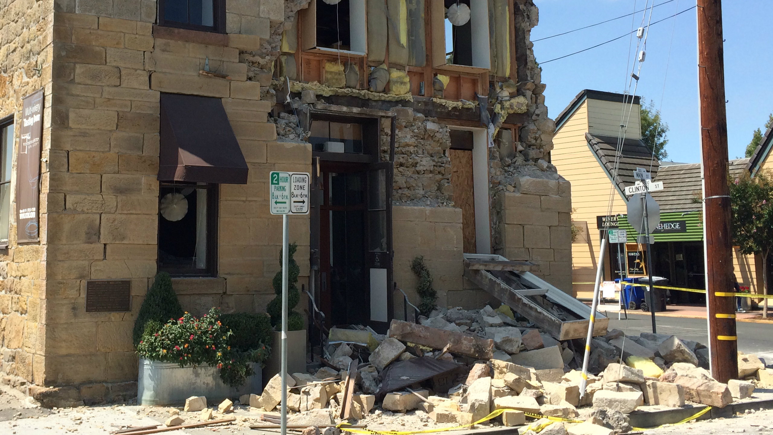
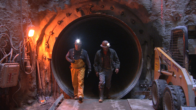
window.__IS_SSR__=true
window.__INITIAL_STATE__={
"attachmentsReducer": {
"audio_0": {
"type": "attachments",
"id": "audio_0",
"imgSizes": {
"kqedFullSize": {
"file": "https://ww2.kqed.org/news/wp-content/themes/KQED-unified/img/audio_bgs/background0.jpg"
}
}
},
"audio_1": {
"type": "attachments",
"id": "audio_1",
"imgSizes": {
"kqedFullSize": {
"file": "https://ww2.kqed.org/news/wp-content/themes/KQED-unified/img/audio_bgs/background1.jpg"
}
}
},
"audio_2": {
"type": "attachments",
"id": "audio_2",
"imgSizes": {
"kqedFullSize": {
"file": "https://ww2.kqed.org/news/wp-content/themes/KQED-unified/img/audio_bgs/background2.jpg"
}
}
},
"audio_3": {
"type": "attachments",
"id": "audio_3",
"imgSizes": {
"kqedFullSize": {
"file": "https://ww2.kqed.org/news/wp-content/themes/KQED-unified/img/audio_bgs/background3.jpg"
}
}
},
"audio_4": {
"type": "attachments",
"id": "audio_4",
"imgSizes": {
"kqedFullSize": {
"file": "https://ww2.kqed.org/news/wp-content/themes/KQED-unified/img/audio_bgs/background4.jpg"
}
}
},
"placeholder": {
"type": "attachments",
"id": "placeholder",
"imgSizes": {
"thumbnail": {
"file": "https://cdn.kqed.org/wp-content/uploads/2024/12/KQED-Default-Image-816638274-2000x1333-1-160x107.jpg",
"width": 160,
"height": 107,
"mimeType": "image/jpeg"
},
"medium": {
"file": "https://cdn.kqed.org/wp-content/uploads/2024/12/KQED-Default-Image-816638274-2000x1333-1-800x533.jpg",
"width": 800,
"height": 533,
"mimeType": "image/jpeg"
},
"medium_large": {
"file": "https://cdn.kqed.org/wp-content/uploads/2024/12/KQED-Default-Image-816638274-2000x1333-1-768x512.jpg",
"width": 768,
"height": 512,
"mimeType": "image/jpeg"
},
"large": {
"file": "https://cdn.kqed.org/wp-content/uploads/2024/12/KQED-Default-Image-816638274-2000x1333-1-1020x680.jpg",
"width": 1020,
"height": 680,
"mimeType": "image/jpeg"
},
"1536x1536": {
"file": "https://cdn.kqed.org/wp-content/uploads/2024/12/KQED-Default-Image-816638274-2000x1333-1-1536x1024.jpg",
"width": 1536,
"height": 1024,
"mimeType": "image/jpeg"
},
"fd-lrg": {
"file": "https://cdn.kqed.org/wp-content/uploads/2024/12/KQED-Default-Image-816638274-2000x1333-1-1536x1024.jpg",
"width": 1536,
"height": 1024,
"mimeType": "image/jpeg"
},
"fd-med": {
"file": "https://cdn.kqed.org/wp-content/uploads/2024/12/KQED-Default-Image-816638274-2000x1333-1-1020x680.jpg",
"width": 1020,
"height": 680,
"mimeType": "image/jpeg"
},
"fd-sm": {
"file": "https://cdn.kqed.org/wp-content/uploads/2024/12/KQED-Default-Image-816638274-2000x1333-1-800x533.jpg",
"width": 800,
"height": 533,
"mimeType": "image/jpeg"
},
"post-thumbnail": {
"file": "https://cdn.kqed.org/wp-content/uploads/2024/12/KQED-Default-Image-816638274-2000x1333-1-672x372.jpg",
"width": 672,
"height": 372,
"mimeType": "image/jpeg"
},
"twentyfourteen-full-width": {
"file": "https://cdn.kqed.org/wp-content/uploads/2024/12/KQED-Default-Image-816638274-2000x1333-1-1038x576.jpg",
"width": 1038,
"height": 576,
"mimeType": "image/jpeg"
},
"xxsmall": {
"file": "https://cdn.kqed.org/wp-content/uploads/2024/12/KQED-Default-Image-816638274-2000x1333-1-160x107.jpg",
"width": 160,
"height": 107,
"mimeType": "image/jpeg"
},
"xsmall": {
"file": "https://cdn.kqed.org/wp-content/uploads/2024/12/KQED-Default-Image-816638274-2000x1333-1-672x372.jpg",
"width": 672,
"height": 372,
"mimeType": "image/jpeg"
},
"small": {
"file": "https://cdn.kqed.org/wp-content/uploads/2024/12/KQED-Default-Image-816638274-2000x1333-1-672x372.jpg",
"width": 672,
"height": 372,
"mimeType": "image/jpeg"
},
"xlarge": {
"file": "https://cdn.kqed.org/wp-content/uploads/2024/12/KQED-Default-Image-816638274-2000x1333-1-1020x680.jpg",
"width": 1020,
"height": 680,
"mimeType": "image/jpeg"
},
"full-width": {
"file": "https://cdn.kqed.org/wp-content/uploads/2024/12/KQED-Default-Image-816638274-2000x1333-1-1920x1280.jpg",
"width": 1920,
"height": 1280,
"mimeType": "image/jpeg"
},
"guest-author-32": {
"file": "https://cdn.kqed.org/wp-content/uploads/2025/01/KQED-Default-Image-816638274-1333x1333-1-160x160.jpg",
"width": 32,
"height": 32,
"mimeType": "image/jpeg"
},
"guest-author-50": {
"file": "https://cdn.kqed.org/wp-content/uploads/2025/01/KQED-Default-Image-816638274-1333x1333-1-160x160.jpg",
"width": 50,
"height": 50,
"mimeType": "image/jpeg"
},
"guest-author-64": {
"file": "https://cdn.kqed.org/wp-content/uploads/2025/01/KQED-Default-Image-816638274-1333x1333-1-160x160.jpg",
"width": 64,
"height": 64,
"mimeType": "image/jpeg"
},
"guest-author-96": {
"file": "https://cdn.kqed.org/wp-content/uploads/2025/01/KQED-Default-Image-816638274-1333x1333-1-160x160.jpg",
"width": 96,
"height": 96,
"mimeType": "image/jpeg"
},
"guest-author-128": {
"file": "https://cdn.kqed.org/wp-content/uploads/2025/01/KQED-Default-Image-816638274-1333x1333-1-160x160.jpg",
"width": 128,
"height": 128,
"mimeType": "image/jpeg"
},
"detail": {
"file": "https://cdn.kqed.org/wp-content/uploads/2025/01/KQED-Default-Image-816638274-1333x1333-1-160x160.jpg",
"width": 160,
"height": 160,
"mimeType": "image/jpeg"
},
"kqedFullSize": {
"file": "https://cdn.kqed.org/wp-content/uploads/2024/12/KQED-Default-Image-816638274-2000x1333-1.jpg",
"width": 2000,
"height": 1333
}
}
},
"science_27883": {
"type": "attachments",
"id": "science_27883",
"meta": {
"index": "attachments_1716263798",
"site": "science",
"id": "27883",
"found": true
},
"parent": 27882,
"imgSizes": {
"kqedFullSize": {
"file": "https://ww2.kqed.org/app/uploads/sites/35/2015/03/galunggung-lightning-usgs.jpg",
"width": 800,
"height": 450
}
},
"publishDate": 1425535178,
"modified": 1450903735,
"caption": "Volcanic lightning lashes the eruption cloud over Galunggung, in Indonesia, in this 1984 photo. This discharge of energy creates abundant tiny spheres of melted rock that mix with the ash as it settles earthward and enters the geologic cycle.",
"description": null,
"title": "galunggung-lightning-usgs",
"credit": "U.S. Geological Survey",
"status": "inherit",
"isLoading": false,
"fetchFailed": false
},
"science_27859": {
"type": "attachments",
"id": "science_27859",
"meta": {
"index": "attachments_1716263798",
"site": "science",
"id": "27859",
"found": true
},
"parent": 27848,
"imgSizes": {
"kqedFullSize": {
"file": "https://ww2.kqed.org/app/uploads/sites/35/2015/03/Erol-Kalkan-2A1.jpg",
"width": 2560,
"height": 1440
}
},
"publishDate": 1425433871,
"modified": 1425434007,
"caption": "After the Napa quake, structural engineers more than 1,800 thousand damaged buildings for prohibited or restricted access. (Photo: Erol Kalkan/USGS)",
"description": "After the Napa quake, structural engineers more than 1,800 thousand damaged buildings for prohibited or restricted access. (Photo: Erol Kalkan/USGS)",
"title": "Erol Kalkan 2A",
"credit": null,
"status": "inherit",
"isLoading": false,
"fetchFailed": false
},
"science_27536": {
"type": "attachments",
"id": "science_27536",
"meta": {
"index": "attachments_1716263798",
"site": "science",
"id": "27536",
"found": true
},
"parent": 27515,
"imgSizes": {
"kqedFullSize": {
"file": "https://ww2.kqed.org/app/uploads/sites/35/2015/02/tunnel_opening1.jpg",
"width": 640,
"height": 360
}
},
"publishDate": 1424737221,
"modified": 1424737246,
"caption": "Workers with the San Francisco Public Utilities Commission inspect the New Irvington Tunnel, which will carry an average of 265 million gallons of water a day. (Owen Bissell/KQED)",
"description": null,
"title": "tunnel_opening",
"credit": null,
"status": "inherit",
"isLoading": false,
"fetchFailed": false
},
"science_27353": {
"type": "attachments",
"id": "science_27353",
"meta": {
"index": "attachments_1716263798",
"site": "science",
"id": "27353",
"found": true
},
"parent": 27352,
"imgSizes": {
"kqedFullSize": {
"file": "https://ww2.kqed.org/app/uploads/sites/35/2015/02/inducedEQs-CA.png",
"width": 800,
"height": 450
}
},
"publishDate": 1424321772,
"modified": 1424321799,
"caption": "A typical sample of daily earthquakes in California is a mixture of natural events and artificial events. In this case, geothermal power plants at The Geysers in the north and the Coso Geothermal Field in the east produce continual small quakes plus a few events large enough to be felt. (KQED/USGS)",
"description": null,
"title": "inducedEQs-CA",
"credit": null,
"status": "inherit",
"isLoading": false,
"fetchFailed": false
},
"science_26968": {
"type": "attachments",
"id": "science_26968",
"meta": {
"index": "attachments_1716263798",
"site": "science",
"id": "26968",
"found": true
},
"parent": 26967,
"imgSizes": {
"kqedFullSize": {
"file": "https://ww2.kqed.org/app/uploads/sites/35/2015/02/ambientwaves.jpg",
"width": 800,
"height": 450
}
},
"publishDate": 1423086686,
"modified": 1423086699,
"caption": "The background noise of the deep Earth resembles the random behavior of the sea surface. But advanced techniques can extract robust data from these whispers of information. (Andrew Alden)",
"description": null,
"title": "ambientwaves",
"credit": null,
"status": "inherit",
"isLoading": false,
"fetchFailed": false
},
"science_26691": {
"type": "attachments",
"id": "science_26691",
"meta": {
"index": "attachments_1716263798",
"site": "science",
"id": "26691",
"found": true
},
"parent": 26690,
"imgSizes": {
"kqedFullSize": {
"file": "https://ww2.kqed.org/app/uploads/sites/35/2015/01/cornelia-top.jpg",
"width": 800,
"height": 450
}
},
"publishDate": 1422558832,
"modified": 1422558851,
"caption": "The crater Cornelia, on Vesta, is a prime example of gullies and deposits that could only have formed in the presence of liquid water. (NASA/JPL-Caltech/UCLA/MPS/DLR/IDA)",
"description": null,
"title": "cornelia-top",
"credit": null,
"status": "inherit",
"isLoading": false,
"fetchFailed": false
},
"science_26631": {
"type": "attachments",
"id": "science_26631",
"meta": {
"index": "attachments_1716263798",
"site": "science",
"id": "26631",
"found": true
},
"parent": 26629,
"imgSizes": {
"kqedFullSize": {
"file": "https://ww2.kqed.org/app/uploads/sites/35/2015/01/SMAP.png",
"width": 620,
"height": 300
}
},
"publishDate": 1422407307,
"modified": 1422407372,
"caption": "NASA's SMAP satellite will capture microwave radiation from the Earth to measure soil moisture. (NASA)",
"description": "NASA's SMAP satellite will capture microwave radiation from the Earth to measure soil moisture. (NASA)",
"title": "SMAP",
"credit": null,
"status": "inherit",
"isLoading": false,
"fetchFailed": false
},
"science_26524": {
"type": "attachments",
"id": "science_26524",
"meta": {
"index": "attachments_1716263798",
"site": "science",
"id": "26524",
"found": true
},
"parent": 26523,
"imgSizes": {
"kqedFullSize": {
"file": "https://ww2.kqed.org/app/uploads/sites/35/2015/01/hand-diggers.jpg",
"width": 800,
"height": 450
}
},
"publishDate": 1421955484,
"modified": 1421955507,
"caption": "Volunteers hand-dig a trench to study an earthquake fault near Eureka in August 2014. They were rewarded, said researcher Sylvia Nicovich, by getting \"to camp and swim in the beautiful Van Duzen River, eat fireside roasted burgers, and enjoy each other's company.\" (Nicovich)",
"description": null,
"title": "hand-diggers",
"credit": null,
"status": "inherit",
"isLoading": false,
"fetchFailed": false
},
"science_26318": {
"type": "attachments",
"id": "science_26318",
"meta": {
"index": "attachments_1716263798",
"site": "science",
"id": "26318",
"found": true
},
"parent": 26317,
"imgSizes": {
"kqedFullSize": {
"file": "https://ww2.kqed.org/app/uploads/sites/35/2015/01/SF-tide-gauges.jpg",
"width": 800,
"height": 450
}
},
"publishDate": 1421351688,
"modified": 1421351729,
"caption": "Sea level is the result of a complex set of forces and influences on land, on the seafloor and in the water between them. Estimating sea-level rise from imperfect data is a scientific challenge that may progress through more sophisticated statistics. (\u003ca href=\"https://www.flickr.com/photos/daver6/\">Dave R\u003c/a>/\u003ca href=\"https://creativecommons.org/licenses/by-nc/2.0/\">CC-BY-NC\u003c/a>)",
"description": null,
"title": "SF-tide-gauges",
"credit": null,
"status": "inherit",
"isLoading": false,
"fetchFailed": false
},
"science_26068": {
"type": "attachments",
"id": "science_26068",
"meta": {
"index": "attachments_1716263798",
"site": "science",
"id": "26068",
"found": true
},
"parent": 26067,
"imgSizes": {
"kqedFullSize": {
"file": "https://ww2.kqed.org/app/uploads/sites/35/2015/01/potomacflood.jpg",
"width": 800,
"height": 450
}
},
"publishDate": 1420745797,
"modified": 1420745816,
"caption": "After Hurricane Isabel in 2003, Great Falls on the Potomac River was overwhelmed by muddy floodwater carrying soil washed from historic upland farms. Precise measurement of soil erosion over large areas is a crucial part of learning sustainable farming practices, but is notoriously hard to do given the variability of nature. (Paul Bierman, University of Vermont)",
"description": null,
"title": "potomacflood",
"credit": null,
"status": "inherit",
"isLoading": false,
"fetchFailed": false
},
"science_25307": {
"type": "attachments",
"id": "science_25307",
"meta": {
"index": "attachments_1716263798",
"site": "science",
"id": "25307",
"found": true
},
"parent": 25305,
"imgSizes": {
"kqedFullSize": {
"file": "https://ww2.kqed.org/app/uploads/sites/35/2014/12/Napa_quake-e1418960288287.jpg",
"width": 640,
"height": 360
}
},
"publishDate": 1418960210,
"modified": 1418960290,
"caption": "Dan Kavarian, chief building official with the City of Napa, surveys a building that was damaged by a 6.0 earthquake on August 24, 2014 in Napa, California. (Photo by Justin Sullivan/Getty Images)",
"description": null,
"title": "Napa_quake",
"credit": null,
"status": "inherit",
"isLoading": false,
"fetchFailed": false
}
},
"audioPlayerReducer": {
"postId": "stream_live",
"isPaused": true,
"isPlaying": false,
"pfsActive": false,
"pledgeModalIsOpen": true,
"playerDrawerIsOpen": false,
"liveAudioPlayStartedAt": 0,
"liveAudioPlayContext": ""
},
"authorsReducer": {
"cmiller": {
"type": "authors",
"id": "221",
"meta": {
"index": "authors_1716337520",
"id": "221",
"found": true
},
"name": "Craig Miller",
"firstName": "Craig",
"lastName": "Miller",
"slug": "cmiller",
"email": "craig@voxterra.net",
"display_author_email": false,
"staff_mastheads": [
"science"
],
"title": "Editor Emeritus, Science",
"bio": "Craig is a former KQED Science editor, specializing in weather, climate, water & energy issues, with a little seismology thrown in just to shake things up. Prior to that, he launched and led the station's award-winning multimedia project, Climate Watch. Craig is also an accomplished writer/producer of television documentaries, with a focus on natural resource issues.",
"avatar": "https://secure.gravatar.com/avatar/b91661df645e001a9cafe0861fa685f9?s=600&d=blank&r=g",
"twitter": "voxterra",
"facebook": null,
"instagram": null,
"linkedin": null,
"sites": [
{
"site": "news",
"roles": [
"author"
]
},
{
"site": "futureofyou",
"roles": [
"editor"
]
},
{
"site": "stateofhealth",
"roles": [
"author"
]
},
{
"site": "science",
"roles": [
"editor"
]
},
{
"site": "quest",
"roles": [
"editor"
]
}
],
"headData": {
"title": "Craig Miller | KQED",
"description": "Editor Emeritus, Science",
"ogImgSrc": "https://secure.gravatar.com/avatar/b91661df645e001a9cafe0861fa685f9?s=600&d=blank&r=g",
"twImgSrc": "https://secure.gravatar.com/avatar/b91661df645e001a9cafe0861fa685f9?s=600&d=blank&r=g"
},
"isLoading": false,
"link": "/author/cmiller"
},
"lindseyhoshaw": {
"type": "authors",
"id": "5432",
"meta": {
"index": "authors_1716337520",
"id": "5432",
"found": true
},
"name": "Lindsey Hoshaw",
"firstName": "Lindsey",
"lastName": "Hoshaw",
"slug": "lindseyhoshaw",
"email": "lhoshaw@kqed.org",
"display_author_email": false,
"staff_mastheads": [],
"title": "KQED Contributor",
"bio": "Lindsey Hoshaw is a former interactive producer for KQED Science. Before joining KQED, Lindsey was a science correspondent for The New York Times, The Boston Globe, Forbes and Scientific American. On Twitter @lindseyhoshaw",
"avatar": "https://secure.gravatar.com/avatar/274b07694c998eaa8f26cfabaa941186?s=600&d=mm&r=g",
"twitter": "lindseyhoshaw",
"facebook": "lindsey.hoshaw.9",
"instagram": null,
"linkedin": null,
"sites": [
{
"site": "arts",
"roles": [
"author"
]
},
{
"site": "news",
"roles": [
"subscriber"
]
},
{
"site": "futureofyou",
"roles": [
"editor"
]
},
{
"site": "bayareabites",
"roles": [
"contributor"
]
},
{
"site": "stateofhealth",
"roles": [
"author"
]
},
{
"site": "science",
"roles": [
"edit_theme_options",
"subscriber"
]
},
{
"site": "quest",
"roles": [
"edit_post_subscriptions",
"edit_usergroups",
"unfiltered_html",
"unfiltered_upload",
"leadcoordinator",
"editor"
]
},
{
"site": "food",
"roles": []
}
],
"headData": {
"title": "Lindsey Hoshaw | KQED",
"description": "KQED Contributor",
"ogImgSrc": "https://secure.gravatar.com/avatar/274b07694c998eaa8f26cfabaa941186?s=600&d=mm&r=g",
"twImgSrc": "https://secure.gravatar.com/avatar/274b07694c998eaa8f26cfabaa941186?s=600&d=mm&r=g"
},
"isLoading": false,
"link": "/author/lindseyhoshaw"
},
"sheraz-sadiq": {
"type": "authors",
"id": "6176",
"meta": {
"index": "authors_1716337520",
"id": "6176",
"found": true
},
"name": "Sheraz Sadiq",
"firstName": "Sheraz",
"lastName": "Sadiq",
"slug": "sheraz-sadiq",
"email": "ssadiq@kqed.org",
"display_author_email": false,
"staff_mastheads": [],
"title": "KQED Contributor",
"bio": "Sheraz Sadiq is an Emmy Award-winning producer at San Francisco PBS affiliate KQED. In 2012, he received the AAAS Kavli Science Journalism award for a story he produced about the seismic retrofit of the Hetch Hetchy water delivery system which serves the San Francisco Bay Area. In addition to producing television content for KQED Science, he has also created online features and written news articles on scientific subjects ranging from astronomy to synthetic biology.",
"avatar": "https://secure.gravatar.com/avatar/d88c61c214e477c4c6f0ebaed4f581bf7c9b1dafd94cd4361285d427107adb8d?s=600&d=blank&r=g",
"twitter": null,
"bluesky": null,
"facebook": null,
"instagram": null,
"linkedin": null,
"sites": [
{
"site": "arts",
"roles": [
"subscriber"
]
},
{
"site": "news",
"roles": [
"subscriber"
]
},
{
"site": "futureofyou",
"roles": [
"subscriber"
]
},
{
"site": "science",
"roles": [
"subscriber"
]
},
{
"site": "quest",
"roles": [
"leadcoordinator",
"subscriber"
]
}
],
"headData": {
"title": "Sheraz Sadiq | KQED",
"description": "KQED Contributor",
"ogImgSrc": "https://secure.gravatar.com/avatar/d88c61c214e477c4c6f0ebaed4f581bf7c9b1dafd94cd4361285d427107adb8d?s=600&d=blank&r=g",
"twImgSrc": "https://secure.gravatar.com/avatar/d88c61c214e477c4c6f0ebaed4f581bf7c9b1dafd94cd4361285d427107adb8d?s=600&d=blank&r=g"
},
"isLoading": false,
"link": "/author/sheraz-sadiq"
},
"andrew-alden": {
"type": "authors",
"id": "6228",
"meta": {
"index": "authors_1716337520",
"id": "6228",
"found": true
},
"name": "Andrew Alden",
"firstName": "Andrew",
"lastName": "Alden",
"slug": "andrew-alden",
"email": "alden@andrew-alden.com",
"display_author_email": false,
"staff_mastheads": [],
"title": null,
"bio": "Andrew Alden earned his geology degree at the University of New Hampshire and moved back to the Bay Area to work at the U.S. Geological Survey for six years. He has \u003ca href=\"http://geology.about.com/\">written on geology for About.com\u003c/a> since its founding in 1997. In 2007, he started the Oakland Geology blog, which won recognition as \"Best of the East Bay\" from the \u003ci>East Bay Express\u003c/i> in 2010. In writing about geology in the Bay Area and surroundings, he hopes to share some of the useful and pleasurable insights that geologists give us—not just facts about the deep past, but an attitude that might be called the \u003ci>deep present\u003c/i>.\r\n\r\nRead his \u003ca href=\"http://science.kqed.org/quest/author/andrew-alden/\">previous contributions\u003c/a> to \u003ca href=\"http://http://science.kqed.org/quest/\">QUEST\u003c/a>, a project dedicated to exploring the Science of Sustainability.",
"avatar": "https://secure.gravatar.com/avatar/9eaa0afc32f98c5fc7ce634437334a64?s=600&d=blank&r=g",
"twitter": null,
"facebook": null,
"instagram": null,
"linkedin": null,
"sites": [
{
"site": "science",
"roles": [
"author"
]
},
{
"site": "quest",
"roles": [
"subscriber"
]
}
],
"headData": {
"title": "Andrew Alden | KQED",
"description": null,
"ogImgSrc": "https://secure.gravatar.com/avatar/9eaa0afc32f98c5fc7ce634437334a64?s=600&d=blank&r=g",
"twImgSrc": "https://secure.gravatar.com/avatar/9eaa0afc32f98c5fc7ce634437334a64?s=600&d=blank&r=g"
},
"isLoading": false,
"link": "/author/andrew-alden"
},
"dpotter": {
"type": "authors",
"id": "6609",
"meta": {
"index": "authors_1716337520",
"id": "6609",
"found": true
},
"name": "Daniel Potter",
"firstName": "Daniel",
"lastName": "Potter",
"slug": "dpotter",
"email": "dpotter@kqed.org",
"display_author_email": false,
"staff_mastheads": [],
"title": "KQED Contributor",
"bio": "Daniel Potter is a reporter for KQED Science. Before that, he worked at Nashville Public Radio for six years. He’s gathered tape for The New York Times, contributed to a growing list of podcasts, and done national features for NPR on everything from bats to meningitis. He tweets at @hellodanpo.",
"avatar": "https://secure.gravatar.com/avatar/59396b9ad9c672dd4cd1d3e453425f12?s=600&d=blank&r=g",
"twitter": "hellodanpo",
"facebook": null,
"instagram": null,
"linkedin": null,
"sites": [
{
"site": "futureofyou",
"roles": [
"author"
]
},
{
"site": "science",
"roles": []
}
],
"headData": {
"title": "Daniel Potter | KQED",
"description": "KQED Contributor",
"ogImgSrc": "https://secure.gravatar.com/avatar/59396b9ad9c672dd4cd1d3e453425f12?s=600&d=blank&r=g",
"twImgSrc": "https://secure.gravatar.com/avatar/59396b9ad9c672dd4cd1d3e453425f12?s=600&d=blank&r=g"
},
"isLoading": false,
"link": "/author/dpotter"
}
},
"pagesReducer": {
"science_category_geology": {
"type": "terms",
"id": "science_38",
"meta": {
"index": "terms_1716263798",
"site": "science",
"id": "38",
"score": 13.559036
},
"featImg": null,
"name": "Geology",
"description": null,
"taxonomy": "category",
"headData": {
"twImgId": null,
"twTitle": null,
"ogTitle": null,
"ogImgId": null,
"twDescription": null,
"description": null,
"title": "Geology Archives | KQED Science",
"ogDescription": null
},
"ttid": 40,
"slug": "geology",
"isLoading": false,
"title": "Geology",
"pageMeta": {
"site": "science",
"WpPageTemplate": "page-topic-editorial",
"currentPage": 10
},
"blocks": [
{
"blockName": "kqed/post-list",
"attrs": {
"layout": "cardArticle2",
"query": "posts/science?category=geology",
"seeMore": false,
"paginated": true,
"page": 10
}
},
{
"blockName": "kqed/ad"
}
]
}
},
"pfsSessionReducer": {},
"postsReducer": {
"stream_live": {
"type": "live",
"id": "stream_live",
"audioUrl": "https://hls.kqed.org/hls/kqed_app/playlist.m3u8",
"title": "Live Stream",
"excerpt": "Live Stream information currently unavailable.",
"link": "/radio",
"featImg": "",
"label": {
"name": "KQED Live",
"link": "/"
}
},
"stream_kqedNewscast": {
"type": "posts",
"id": "stream_kqedNewscast",
"audioUrl": "https://www.kqed.org/.stream/anon/radio/RDnews/newscast.mp3?_=1",
"title": "KQED Newscast",
"featImg": "",
"label": {
"name": "88.5 FM",
"link": "/"
}
},
"science_27882": {
"type": "posts",
"id": "science_27882",
"meta": {
"index": "posts_1716263798",
"site": "science",
"id": "27882",
"score": null,
"sort": [
1425607859000
]
},
"parent": 0,
"labelTerm": {
"site": "science"
},
"blocks": [],
"publishDate": 1425607859,
"format": "aside",
"title": "Scientists Discover Natural Glass Created by Volcanoes and Lightning",
"headTitle": "Scientists Discover Natural Glass Created by Volcanoes and Lightning | KQED",
"content": "\u003cfigure id=\"attachment_27883\" class=\"wp-caption aligncenter\" style=\"max-width: 800px\">\u003ca href=\"http://ww2.kqed.org/science/wp-content/uploads/sites/35/2015/03/galunggung-lightning-usgs.jpg\">\u003cimg loading=\"lazy\" decoding=\"async\" src=\"http://ww2.kqed.org/science/wp-content/uploads/sites/35/2015/03/galunggung-lightning-usgs.jpg\" alt=\"Volcanic lightning can melt ash into tiny spheres of glass\" width=\"800\" height=\"450\" class=\"size-full wp-image-27883\">\u003c/a>\u003cfigcaption class=\"wp-caption-text\">Volcanic lightning lashes the eruption cloud over Galunggung, in Indonesia, in this 1984 photo. This discharge of energy creates abundant tiny spheres of melted rock that mix with the ash as it settles earthward and enters the geologic cycle. (USGS) \u003ccite>(U.S. Geological Survey)\u003c/cite>\u003c/figcaption>\u003c/figure>\n\u003cp>Geologists are familiar with something most of us have never seen—spherules, or microscopic balls of natural glass that hide in sediments all over the world. A new study reports a previously unknown kind of spherule that’s forged during volcanic eruptions as lightning lashes roiling clouds of hot ash.\u003c/p>\n\u003cp>Glassy spherules occur in all kinds of places on Earth, and on the Moon, and we know several ways they’re created. Meteors make them as they burn up entering the atmosphere from space. Large meteor impacts make lots more spherules as they explode into fiery debris. The same impacts can melt the ground they strike and form \u003ca href=\"http://science.kqed.org/quest/2012/12/13/help-find-the-healdsburg-tektites/\">tektites\u003c/a>. The red-hot spray of exploding lava also can make spherules, called Pele’s spheres or achneliths. All of these spherule types are on the order of a millimeter across.\u003c/p>\n\u003cp>And we have lightning. Whether it strikes loose sediment or hard stone, lightning’s instantaneous heat, estimated at 30,000°C, can melt tubes and droplets of material into the curious features called \u003ca href=\"http://geology.about.com/od/climate_change/a/fulgurites.htm\">fulgurites\u003c/a>. Knowing this power of lightning, \u003ca href=\"http://geo.ua.edu/profile/genareau-kimberly-2/\">Kimberly Genareau\u003c/a>, a volcanologist at the University of Alabama, wondered what happens in eruption clouds of volcanic ash when lightning laces through them. What she learned is the subject of \u003ca href=\"http://geology.gsapubs.org/content/early/2015/02/26/G36255.1.abstract\">an open-access paper in the journal \u003ci>Geology\u003c/i>\u003c/a>.\u003c/p>\n\u003cp>She acquired ash from two eruptions known for their spectacular volcanic lightning displays, the 2009 eruption of Redoubt in Alaska and the 2010 eruption of Eyjafjallajokull in Iceland.\u003c/p>\n\u003cp>The ashes contained a noticeable share of glassy spherules, as much as a few percent. These looked different enough from other types of spherules for Genareau and her coauthors to declare them a new type with the workaday name of lightning-induced volcanic spherules, or LIVS.\u003c/p>\n\u003cfigure id=\"attachment_27884\" class=\"wp-caption aligncenter\" style=\"max-width: 600px\">\u003ca href=\"http://ww2.kqed.org/science/wp-content/uploads/sites/35/2015/03/LIVS.png\">\u003cimg loading=\"lazy\" decoding=\"async\" src=\"http://ww2.kqed.org/science/wp-content/uploads/sites/35/2015/03/LIVS.png\" alt=\"Lightning-induced volcanic spherules\" width=\"600\" height=\"248\" class=\"size-full wp-image-27884\">\u003c/a>\u003cfigcaption class=\"wp-caption-text\">LIVS from the Redoubt eruption of 2009; a singleton on the left and a cluster on the right. These are smaller than a human hair. (Genareau/GSA)\u003c/figcaption>\u003c/figure>\n\u003cp>To create spherules themselves in a laboratory setting, Genareau turned to industrial techniques. Volcanic ash does nasty things to human equipment. It scratches car windshields, clogs air filters and damages jet engines. Electrical substations rely on the insulating property of air to prevent short circuits between high-voltage fixtures, but volcanic ash mucks that up badly. \u003c/p>\n\u003cp>[ad fullwidth]\u003c/p>\n\u003cp>Because electrical failures are a known problem after eruptions, engineers have a standard lab test for checking how high-voltage equipment performs when it’s covered in volcanic ash. It was a simple matter to adapt this test by sprinkling a large insulator with ground lava dust, wetting it, and then loading it with voltage until it zapped. This analog of natural lightning produced spherules, too.\u003c/p>\n\u003cfigure id=\"attachment_27885\" class=\"wp-caption aligncenter\" style=\"max-width: 600px\">\u003ca href=\"http://ww2.kqed.org/science/wp-content/uploads/sites/35/2015/03/pseudoLIVS.png\">\u003cimg loading=\"lazy\" decoding=\"async\" src=\"http://ww2.kqed.org/science/wp-content/uploads/sites/35/2015/03/pseudoLIVS.png\" alt=\"Pseudo-LIVS created in an electrical lab\" width=\"600\" height=\"251\" class=\"size-full wp-image-27885\">\u003c/a>\u003cfigcaption class=\"wp-caption-text\">Pseudo-spherules from high-voltage flashover trials, a lab version of lightning-melted ash. (Genareau/GSA)\u003c/figcaption>\u003c/figure>\n\u003cp>This is a tidy piece of research that both describes a new type of natural particle and shows how to reproduce it without an erupting volcano.\u003c/p>\n\u003cp>\u003c/p>\n\u003cp>Whenever geologists detect something new in the present, they’re duty-bound to ask themselves, “What if this has gone on for millions and billions of years?” As we learn to better understand LIVS, we may find them where they’ve been hiding in plain sight, misidentified as some other kind of spherule. We now have another tool for studying prehistoric eruptions through their ash particles. And because lightning has been detected on other planets, too, who knows what mischief it’s been doing out there all this time?\u003c/p>\n\n",
"stats": {
"hasVideo": false,
"hasChartOrMap": false,
"hasAudio": false,
"hasPolis": false,
"wordCount": 628,
"hasGoogleForm": false,
"hasGallery": false,
"hasHearkenModule": false,
"iframeSrcs": [],
"paragraphCount": 11
},
"modified": 1704932185,
"excerpt": "Geologists are familiar with something most of us have never seen—spherules, or microscopic balls of natural glass that hide in sediments all over the world. A new study reports a previously unknown kind of spherule that’s forged during volcanic eruptions as lightning lashes roiling clouds of hot ash.",
"headData": {
"twImgId": "",
"twTitle": "",
"ogTitle": "",
"ogImgId": "",
"twDescription": "",
"description": "Geologists are familiar with something most of us have never seen—spherules, or microscopic balls of natural glass that hide in sediments all over the world. A new study reports a previously unknown kind of spherule that’s forged during volcanic eruptions as lightning lashes roiling clouds of hot ash.",
"title": "Scientists Discover Natural Glass Created by Volcanoes and Lightning | KQED",
"ogDescription": "",
"schema": {
"@context": "https://schema.org",
"@type": "Article",
"headline": "Scientists Discover Natural Glass Created by Volcanoes and Lightning",
"datePublished": "2015-03-05T18:10:59-08:00",
"dateModified": "2024-01-10T16:16:25-08:00",
"image": "https://cdn.kqed.org/wp-content/uploads/2020/02/KQED-OG-Image@1x.png"
}
},
"guestAuthors": [],
"slug": "volcanoes-and-lightning-make-tiny-glass-balls-together",
"status": "publish",
"sticky": false,
"path": "/science/27882/volcanoes-and-lightning-make-tiny-glass-balls-together",
"audioTrackLength": null,
"parsedContent": [
{
"type": "contentString",
"content": "\u003cdiv class=\"post-body\">\u003cp>\u003cfigure id=\"attachment_27883\" class=\"wp-caption aligncenter\" style=\"max-width: 800px\">\u003ca href=\"http://ww2.kqed.org/science/wp-content/uploads/sites/35/2015/03/galunggung-lightning-usgs.jpg\">\u003cimg loading=\"lazy\" decoding=\"async\" src=\"http://ww2.kqed.org/science/wp-content/uploads/sites/35/2015/03/galunggung-lightning-usgs.jpg\" alt=\"Volcanic lightning can melt ash into tiny spheres of glass\" width=\"800\" height=\"450\" class=\"size-full wp-image-27883\">\u003c/a>\u003cfigcaption class=\"wp-caption-text\">Volcanic lightning lashes the eruption cloud over Galunggung, in Indonesia, in this 1984 photo. This discharge of energy creates abundant tiny spheres of melted rock that mix with the ash as it settles earthward and enters the geologic cycle. (USGS) \u003ccite>(U.S. Geological Survey)\u003c/cite>\u003c/figcaption>\u003c/figure>\n\u003cp>Geologists are familiar with something most of us have never seen—spherules, or microscopic balls of natural glass that hide in sediments all over the world. A new study reports a previously unknown kind of spherule that’s forged during volcanic eruptions as lightning lashes roiling clouds of hot ash.\u003c/p>\n\u003cp>Glassy spherules occur in all kinds of places on Earth, and on the Moon, and we know several ways they’re created. Meteors make them as they burn up entering the atmosphere from space. Large meteor impacts make lots more spherules as they explode into fiery debris. The same impacts can melt the ground they strike and form \u003ca href=\"http://science.kqed.org/quest/2012/12/13/help-find-the-healdsburg-tektites/\">tektites\u003c/a>. The red-hot spray of exploding lava also can make spherules, called Pele’s spheres or achneliths. All of these spherule types are on the order of a millimeter across.\u003c/p>\n\u003cp>And we have lightning. Whether it strikes loose sediment or hard stone, lightning’s instantaneous heat, estimated at 30,000°C, can melt tubes and droplets of material into the curious features called \u003ca href=\"http://geology.about.com/od/climate_change/a/fulgurites.htm\">fulgurites\u003c/a>. Knowing this power of lightning, \u003ca href=\"http://geo.ua.edu/profile/genareau-kimberly-2/\">Kimberly Genareau\u003c/a>, a volcanologist at the University of Alabama, wondered what happens in eruption clouds of volcanic ash when lightning laces through them. What she learned is the subject of \u003ca href=\"http://geology.gsapubs.org/content/early/2015/02/26/G36255.1.abstract\">an open-access paper in the journal \u003ci>Geology\u003c/i>\u003c/a>.\u003c/p>\n\u003cp>She acquired ash from two eruptions known for their spectacular volcanic lightning displays, the 2009 eruption of Redoubt in Alaska and the 2010 eruption of Eyjafjallajokull in Iceland.\u003c/p>\n\u003cp>The ashes contained a noticeable share of glassy spherules, as much as a few percent. These looked different enough from other types of spherules for Genareau and her coauthors to declare them a new type with the workaday name of lightning-induced volcanic spherules, or LIVS.\u003c/p>\n\u003cfigure id=\"attachment_27884\" class=\"wp-caption aligncenter\" style=\"max-width: 600px\">\u003ca href=\"http://ww2.kqed.org/science/wp-content/uploads/sites/35/2015/03/LIVS.png\">\u003cimg loading=\"lazy\" decoding=\"async\" src=\"http://ww2.kqed.org/science/wp-content/uploads/sites/35/2015/03/LIVS.png\" alt=\"Lightning-induced volcanic spherules\" width=\"600\" height=\"248\" class=\"size-full wp-image-27884\">\u003c/a>\u003cfigcaption class=\"wp-caption-text\">LIVS from the Redoubt eruption of 2009; a singleton on the left and a cluster on the right. These are smaller than a human hair. (Genareau/GSA)\u003c/figcaption>\u003c/figure>\n\u003cp>To create spherules themselves in a laboratory setting, Genareau turned to industrial techniques. Volcanic ash does nasty things to human equipment. It scratches car windshields, clogs air filters and damages jet engines. Electrical substations rely on the insulating property of air to prevent short circuits between high-voltage fixtures, but volcanic ash mucks that up badly. \u003c/p>\n\u003cp>\u003c/p>\u003c/div>",
"attributes": {
"named": {},
"numeric": []
}
},
{
"type": "component",
"content": "",
"name": "ad",
"attributes": {
"named": {
"label": "fullwidth"
},
"numeric": [
"fullwidth"
]
}
},
{
"type": "contentString",
"content": "\u003cdiv class=\"post-body\">\u003cp>\u003c/p>\n\u003cp>Because electrical failures are a known problem after eruptions, engineers have a standard lab test for checking how high-voltage equipment performs when it’s covered in volcanic ash. It was a simple matter to adapt this test by sprinkling a large insulator with ground lava dust, wetting it, and then loading it with voltage until it zapped. This analog of natural lightning produced spherules, too.\u003c/p>\n\u003cfigure id=\"attachment_27885\" class=\"wp-caption aligncenter\" style=\"max-width: 600px\">\u003ca href=\"http://ww2.kqed.org/science/wp-content/uploads/sites/35/2015/03/pseudoLIVS.png\">\u003cimg loading=\"lazy\" decoding=\"async\" src=\"http://ww2.kqed.org/science/wp-content/uploads/sites/35/2015/03/pseudoLIVS.png\" alt=\"Pseudo-LIVS created in an electrical lab\" width=\"600\" height=\"251\" class=\"size-full wp-image-27885\">\u003c/a>\u003cfigcaption class=\"wp-caption-text\">Pseudo-spherules from high-voltage flashover trials, a lab version of lightning-melted ash. (Genareau/GSA)\u003c/figcaption>\u003c/figure>\n\u003cp>This is a tidy piece of research that both describes a new type of natural particle and shows how to reproduce it without an erupting volcano.\u003c/p>\n\u003cp>\u003c/p>\n\u003cp>Whenever geologists detect something new in the present, they’re duty-bound to ask themselves, “What if this has gone on for millions and billions of years?” As we learn to better understand LIVS, we may find them where they’ve been hiding in plain sight, misidentified as some other kind of spherule. We now have another tool for studying prehistoric eruptions through their ash particles. And because lightning has been detected on other planets, too, who knows what mischief it’s been doing out there all this time?\u003c/p>\n\n\u003c/div>\u003c/p>",
"attributes": {
"named": {},
"numeric": []
}
}
],
"link": "/science/27882/volcanoes-and-lightning-make-tiny-glass-balls-together",
"authors": [
"6228"
],
"categories": [
"science_38"
],
"tags": [
"science_1746",
"science_944"
],
"featImg": "science_27883",
"label": "science"
},
"science_27848": {
"type": "posts",
"id": "science_27848",
"meta": {
"index": "posts_1716263798",
"site": "science",
"id": "27848",
"score": null,
"sort": [
1425436478000
]
},
"parent": 0,
"labelTerm": {
"site": "science"
},
"blocks": [],
"publishDate": 1425436478,
"format": "aside",
"title": "Study: Napa Quake Should Spur Retrofits to Older Buildings",
"headTitle": "Study: Napa Quake Should Spur Retrofits to Older Buildings | KQED",
"content": "\u003cfigure id=\"attachment_27859\" class=\"wp-caption alignleft\" style=\"max-width: 640px\">\u003ca href=\"http://ww2.kqed.org/science/wp-content/uploads/sites/35/2015/03/Erol-Kalkan-2A1-1024x576.jpg\">\u003cimg loading=\"lazy\" decoding=\"async\" class=\" wp-image-27859\" src=\"http://ww2.kqed.org/science/wp-content/uploads/sites/35/2015/03/Erol-Kalkan-2A1-1024x576.jpg\" alt=\"After the Napa quake, structural engineers more than 1,800 thousand damaged buildings for prohibited or restricted access. (Photo: Erol Kalkan/USGS)\" width=\"640\" height=\"360\">\u003c/a>\u003cfigcaption class=\"wp-caption-text\">After the Napa quake, structural engineers tagged more than 1,800 damaged buildings for prohibited or restricted access. (Photo: Erol Kalkan/USGS)\u003c/figcaption>\u003c/figure>\n\u003cp>A review of damage from last August’s South Napa Earthquake confirms at least one piece of conventional wisdom: seismic retrofitting older buildings is a good idea.\u003c/p>\n\u003cp>The message is driven home in a new report from the U.S. Geological Survey, which shows many of the structures damaged by last summer’s quake were built before 1950.\u003c/p>\n\u003cp>The \u003ca title=\"Wiki - post\" href=\"http://en.wikipedia.org/wiki/2014_South_Napa_earthquake\">magnitude-6 quake\u003c/a> was the Bay Area’s worst since 1989, injuring about 200 people. Afterward engineers barred access to 165 buildings with red tags and placed limited-access yellow-tag restrictions on 1,707 others, many of older construction. Geophysicist Jack Boatwright says it should serve as a warning to reinforce such buildings, but he worries that not enough people are listening: “I guess we’ve got to put on the witch-doctor mask and do the boogaloo,” he said.\u003c/p>\n\u003cp>Retrofitting the foundation on an older house might cost a few thousand dollars, and save 100 times that amount whenever the next earthquake hits, Boatwright says. He also found that much of the damage in Napa centered over a sedimentary basin – a kind of geologic jelly bowl that can amplify movement.\u003c/p>\n\u003cp>“It actually traps the energy,” he said. “Somebody in downtown Napa’s experience of how long the shaking went on would’ve been 10, 15, maybe 20 seconds more than somebody who was up on the hill outside of Napa,” on hard rock.\u003c/p>\n\u003cp>[ad fullwidth]\u003c/p>\n\u003cp>Boatwright’s findings come among six reports on last year’s quake published in the March/April issue of Seismological Research Letters, edited by Erol Kalkan, a USGS research structural engineer.\u003c/p>\n\u003cp>Kalkan explained that older structures made of unreinforced brick or stone are built to handle the vertical force of gravity pushing down on them, but the Napa quake subjected them to side-to-side jostling with nearly two-thirds that same force. It’s these sideways forces that collapse walls, he said, emphasizing that beams and columns should be fitted with earthquake-resistant connections to a home’s foundation. Older chimneys also proved vulnerable, he said.\u003c/p>\n\u003cp>Kalkan says that before last year, the West Napa Fault was recognized but not well understood compared to the larger Hayward and San Andreas faults. Notably, the earthquake last August produced an unusually large \u003ca href=\"http://ww2.kqed.org/science/2014/09/02/napa-quake-forces-redrawing-of-fault-maps/\">surface rupture\u003c/a>, which researchers traced for nearly eight miles.\u003c/p>\n\u003cp>\u003c/p>\n\u003cp>As to the matter of when \u003ca href=\"http://ww2.kqed.org/science/2014/12/19/next-napa-quake-could-be-bigger-stronger/\">another earthquake\u003c/a> might strike, such questions are “really hard to address scientifically,” Boatwright says, but he notes that in California, moderate to larger earthquakes “tend to cluster.”\u003c/p>\n\n",
"stats": {
"hasVideo": false,
"hasChartOrMap": false,
"hasAudio": false,
"hasPolis": false,
"wordCount": 476,
"hasGoogleForm": false,
"hasGallery": false,
"hasHearkenModule": false,
"iframeSrcs": [],
"paragraphCount": 11
},
"modified": 1704932193,
"excerpt": "The Bay Area's worst shaker in 25 years revealed -- once again -- where the vulnerabilities are.",
"headData": {
"twImgId": "",
"twTitle": "",
"ogTitle": "",
"ogImgId": "",
"twDescription": "",
"description": "The Bay Area's worst shaker in 25 years revealed -- once again -- where the vulnerabilities are.",
"title": "Study: Napa Quake Should Spur Retrofits to Older Buildings | KQED",
"ogDescription": "",
"schema": {
"@context": "https://schema.org",
"@type": "Article",
"headline": "Study: Napa Quake Should Spur Retrofits to Older Buildings",
"datePublished": "2015-03-03T18:34:38-08:00",
"dateModified": "2024-01-10T16:16:33-08:00",
"image": "https://cdn.kqed.org/wp-content/uploads/2020/02/KQED-OG-Image@1x.png"
}
},
"guestAuthors": [],
"slug": "study-napa-quake-should-spur-retrofits-to-older-buildings",
"status": "publish",
"sticky": false,
"path": "/science/27848/study-napa-quake-should-spur-retrofits-to-older-buildings",
"audioTrackLength": null,
"parsedContent": [
{
"type": "contentString",
"content": "\u003cdiv class=\"post-body\">\u003cp>\u003cfigure id=\"attachment_27859\" class=\"wp-caption alignleft\" style=\"max-width: 640px\">\u003ca href=\"http://ww2.kqed.org/science/wp-content/uploads/sites/35/2015/03/Erol-Kalkan-2A1-1024x576.jpg\">\u003cimg loading=\"lazy\" decoding=\"async\" class=\" wp-image-27859\" src=\"http://ww2.kqed.org/science/wp-content/uploads/sites/35/2015/03/Erol-Kalkan-2A1-1024x576.jpg\" alt=\"After the Napa quake, structural engineers more than 1,800 thousand damaged buildings for prohibited or restricted access. (Photo: Erol Kalkan/USGS)\" width=\"640\" height=\"360\">\u003c/a>\u003cfigcaption class=\"wp-caption-text\">After the Napa quake, structural engineers tagged more than 1,800 damaged buildings for prohibited or restricted access. (Photo: Erol Kalkan/USGS)\u003c/figcaption>\u003c/figure>\n\u003cp>A review of damage from last August’s South Napa Earthquake confirms at least one piece of conventional wisdom: seismic retrofitting older buildings is a good idea.\u003c/p>\n\u003cp>The message is driven home in a new report from the U.S. Geological Survey, which shows many of the structures damaged by last summer’s quake were built before 1950.\u003c/p>\n\u003cp>The \u003ca title=\"Wiki - post\" href=\"http://en.wikipedia.org/wiki/2014_South_Napa_earthquake\">magnitude-6 quake\u003c/a> was the Bay Area’s worst since 1989, injuring about 200 people. Afterward engineers barred access to 165 buildings with red tags and placed limited-access yellow-tag restrictions on 1,707 others, many of older construction. Geophysicist Jack Boatwright says it should serve as a warning to reinforce such buildings, but he worries that not enough people are listening: “I guess we’ve got to put on the witch-doctor mask and do the boogaloo,” he said.\u003c/p>\n\u003cp>Retrofitting the foundation on an older house might cost a few thousand dollars, and save 100 times that amount whenever the next earthquake hits, Boatwright says. He also found that much of the damage in Napa centered over a sedimentary basin – a kind of geologic jelly bowl that can amplify movement.\u003c/p>\n\u003cp>“It actually traps the energy,” he said. “Somebody in downtown Napa’s experience of how long the shaking went on would’ve been 10, 15, maybe 20 seconds more than somebody who was up on the hill outside of Napa,” on hard rock.\u003c/p>\n\u003cp>\u003c/p>\u003c/div>",
"attributes": {
"named": {},
"numeric": []
}
},
{
"type": "component",
"content": "",
"name": "ad",
"attributes": {
"named": {
"label": "fullwidth"
},
"numeric": [
"fullwidth"
]
}
},
{
"type": "contentString",
"content": "\u003cdiv class=\"post-body\">\u003cp>\u003c/p>\n\u003cp>Boatwright’s findings come among six reports on last year’s quake published in the March/April issue of Seismological Research Letters, edited by Erol Kalkan, a USGS research structural engineer.\u003c/p>\n\u003cp>Kalkan explained that older structures made of unreinforced brick or stone are built to handle the vertical force of gravity pushing down on them, but the Napa quake subjected them to side-to-side jostling with nearly two-thirds that same force. It’s these sideways forces that collapse walls, he said, emphasizing that beams and columns should be fitted with earthquake-resistant connections to a home’s foundation. Older chimneys also proved vulnerable, he said.\u003c/p>\n\u003cp>Kalkan says that before last year, the West Napa Fault was recognized but not well understood compared to the larger Hayward and San Andreas faults. Notably, the earthquake last August produced an unusually large \u003ca href=\"http://ww2.kqed.org/science/2014/09/02/napa-quake-forces-redrawing-of-fault-maps/\">surface rupture\u003c/a>, which researchers traced for nearly eight miles.\u003c/p>\n\u003cp>\u003c/p>\n\u003cp>As to the matter of when \u003ca href=\"http://ww2.kqed.org/science/2014/12/19/next-napa-quake-could-be-bigger-stronger/\">another earthquake\u003c/a> might strike, such questions are “really hard to address scientifically,” Boatwright says, but he notes that in California, moderate to larger earthquakes “tend to cluster.”\u003c/p>\n\n\u003c/div>\u003c/p>",
"attributes": {
"named": {},
"numeric": []
}
}
],
"link": "/science/27848/study-napa-quake-should-spur-retrofits-to-older-buildings",
"authors": [
"6609"
],
"categories": [
"science_38",
"science_40"
],
"tags": [
"science_64",
"science_1841"
],
"featImg": "science_27859",
"label": "science"
},
"science_27515": {
"type": "posts",
"id": "science_27515",
"meta": {
"index": "posts_1716263798",
"site": "science",
"id": "27515",
"score": null,
"sort": [
1425317491000
]
},
"guestAuthors": [],
"slug": "a-new-stronger-tunnel-to-bring-hetch-hetchy-water-to-bay-area",
"title": "A New, Stronger Tunnel to Bring Hetch Hetchy Water to the Bay Area",
"publishDate": 1425317491,
"format": "aside",
"headTitle": "A New, Stronger Tunnel to Bring Hetch Hetchy Water to the Bay Area | KQED",
"labelTerm": {
"site": "science"
},
"content": "\u003cfigure id=\"attachment_27536\" class=\"wp-caption alignleft\" style=\"max-width: 640px\">\u003ca href=\"http://ww2.kqed.org/science/wp-content/uploads/sites/35/2015/02/tunnel_opening1.jpg\">\u003cimg loading=\"lazy\" decoding=\"async\" class=\"size-full wp-image-27536\" src=\"http://ww2.kqed.org/science/wp-content/uploads/sites/35/2015/02/tunnel_opening1.jpg\" alt=\"Workers with the San Francisco Public Utilities Commission inspect the New Irvington Tunnel, which will carry an average of 265 million gallons of water a day. (Owen Bissell/KQED)\" width=\"640\" height=\"360\">\u003c/a>\u003cfigcaption class=\"wp-caption-text\">Workers with the San Francisco Public Utilities Commission inspect the New Irvington Tunnel, which will carry an average of 265 million gallons of water a day. (Owen Bissell/KQED)\u003c/figcaption>\u003c/figure>\n\u003cp>The San Francisco Public Utilities Commission has opened a new 3.5 mile-long tunnel in Sunol Valley, a few miles east of Fremont, that will transport 265 million gallons of water a day, on average, to customers of the Hetch Hetchy water system.\u003c/p>\n\u003cp>Construction crews have been hard at work on the nine-foot diameter New Irvington Tunnel since July 2010, and its opening on Friday marks another milestone in the $4.8 billion \u003ca href=\"http://sfwater.org/index.aspx?page=114\">Hetch Hetchy Water System Improvement Program \u003c/a>to upgrade and replace aging infrastructure that brings water from \u003ca href=\"http://www.nps.gov/featurecontent/yose/anniversary/yosemite125th.com/index.html\">Hetch Hetchy reservoir in Yosemite National Park\u003c/a>, 167 miles away, to the Bay Area.\u003c/p>\n\u003cp>A key goal of the voter-approved program, which is scheduled to run through 2018, is to make sure that taps in the homes of the 2.6 million Bay Area residents who receive Hetch Hetchy water keep flowing with water 24 hours after a major earthquake.\u003c/p>\n\u003cp>“We have the Calaveras fault, the Hayward fault in the East Bay, and then of course the San Andreas fault on the Peninsula,” said Dan Wade, director of the Hetch Hetchy Water System Improvement Program. “And our water system crosses all three of those major faults.”\u003c/p>\n\u003cp>According to the \u003ca href=\"http://earthquake.usgs.gov/regional/nca/ucerf/\">U.S. Geological Survey\u003c/a>, there is a greater than 60 percent chance of a major earthquake taking place in the Bay Area in the next 30 years. The Hetch Hetchy water system has been operating for more than 80 years, and much of its infrastructure – including pipes, local reservoirs and a 90 year-old rock and earth-filled dam – is in need of a makeover to shield it from earthquakes.\u003c/p>\n\u003cp>[ad fullwidth]\u003c/p>\n\u003cp>Some of the construction projects are also intended to provide redundancy and a back-up to structures that are critical to bringing water from the Sierra Nevada watershed to the system’s customers, who live in San Francisco, Alameda, San Mateo and Santa Clara counties.\u003c/p>\n\u003cp>For example, the New Irvington Tunnel operates alongside the existing Irvington Tunnel in Sunol Valley, which brings water from the Hetch Hetchy reservoir into the Bay Area. The existing Irvington Tunnel, which has not been taken out of service since 1966, when it was last inspected, is vulnerable to earthquakes, experts say, and lies between the Calaveras and San Andreas faults. The new tunnel, which is steel-lined and encased in concrete, has been engineered to withstand a magnitude 7.1 earthquake on the Hayward fault.\u003c/p>\n\u003cp>“We’re actually constructing the New Irvington Tunnel parallel to the existing tunnel,” said Wade. “We’ll be able to take the existing tunnel out of service, make any repairs, and then both tunnels will be in service,” he added.\u003c/p>\n\u003cp>Both tunnels will carry water not only from Hetch Hetchy but also from the nearby San Antonio and Calaveras reservoirs.\u003c/p>\n\u003cfigure id=\"attachment_27534\" class=\"wp-caption alignleft\" style=\"max-width: 640px\">\u003ca href=\"http://ww2.kqed.org/science/wp-content/uploads/sites/35/2015/02/CalaverasReservoir1.jpg\">\u003cimg loading=\"lazy\" decoding=\"async\" class=\"wp-image-27534 size-full\" src=\"http://ww2.kqed.org/science/wp-content/uploads/sites/35/2015/02/CalaverasReservoir1.jpg\" alt=\"\" width=\"640\" height=\"360\">\u003c/a>\u003cfigcaption class=\"wp-caption-text\">The Calaveras Reservoir is located just 1500 feet from the Calaveras fault, one of three active faults the Hetch Hetchy water system crosses in the Bay Area. (Owen Bissell/KQED)\u003c/figcaption>\u003c/figure>\n\u003cp>The Calaveras Reservoir, which is the largest of the system’s five local reservoirs, is also in need of a seismic makeover. Its 90 year-old earth- and rock-filled dam, which forms the reservoir, is located on the Santa Clara – Alameda county line, and is located only 1,500 feet from the Calaveras fault. Since 2001, state dam regulators have only allowed the reservoir to be filled to 40 percent of its capacity because the dam is prone to liquefaction, which happens when waterlogged, loose soil behaves like a liquid during the violent shaking generated by a big earthquake.\u003c/p>\n\u003cp>As a result, construction crews are building a new, 220 foot-tall seismically safe dam a few hundred yards downstream from the original dam in the hills southeast of Fremont. At a cost of $720 million, replacing the Calaveras Dam is the biggest, most expensive and last remaining major project under the Hetch Hetchy Water System Improvement Program.\u003c/p>\n\u003cfigure id=\"attachment_27535\" class=\"wp-caption alignright\" style=\"max-width: 640px\">\u003ca href=\"http://ww2.kqed.org/science/wp-content/uploads/sites/35/2015/02/Calaveras_Dam_site1.jpg\">\u003cimg loading=\"lazy\" decoding=\"async\" class=\"wp-image-27535 size-full\" src=\"http://ww2.kqed.org/science/wp-content/uploads/sites/35/2015/02/Calaveras_Dam_site1.jpg\" alt=\"\" width=\"640\" height=\"360\">\u003c/a>\u003cfigcaption class=\"wp-caption-text\">Ten million cubic yards of earth and rock will need to be excavated for the construction of the new Calaveras Dam, located at the Alameda-Santa Clara county line. (Owen Bissell/KQED)\u003c/figcaption>\u003c/figure>\n\u003cp>Although it will also be made of earth and rock – roughly 10 million cubic yards’ worth – cement grouting is being sprayed between spaces within the rock to create a more water-tight foundation. The reservoir will then be able to fill to capacity – 100,000 acre-feet or 31 billion gallons – when construction on the new dam finishes in 2018.\u003c/p>\n\u003cp>For Wade, filling Calaveras, the largest of the system’s five local reservoirs, to full capacity will not only boost water storage but help the regional water system cope with multi-year droughts.\u003c/p>\n\u003cp>“We’re in the third year of a major drought,” he said.\u003c/p>\n\u003cp>“The program has a goal of meeting a drought period of seven-and-a-half years. We need this reservoir for drought carryover storage.”\u003c/p>\n\u003cp>\u003c/p>\n\u003cp>\u003cem>To find out more about the New Irvington Tunnel and Calaveras Dam replacement projects, watch this \u003ca href=\"http://youtu.be/wNlX_IcRgos?list=PLCxtKFQXBuRhyJ2TALXYrNBWDZMO7jPOr#t=8m10s\">video\u003c/a> produced for KQED Newsroom. \u003c/em>\u003c/p>\n\n",
"blocks": [],
"excerpt": "The San Francisco Public Utilities opened on Friday a new cement-encased, steel-lined tunnel that runs from Sunol Valley to Fremont. It will carry an average of 265 million gallons of water a day for customers of the Hetch Hetchy Water System Improvement Program, which consists of more than 80 projects to seismically retrofit and upgrade an 80-year-old water system serving 2.6 million people in the Bay Area.",
"status": "publish",
"parent": 0,
"modified": 1720819119,
"stats": {
"hasAudio": false,
"hasVideo": false,
"hasChartOrMap": false,
"iframeSrcs": [],
"hasGoogleForm": false,
"hasGallery": false,
"hasHearkenModule": false,
"hasPolis": false,
"paragraphCount": 18,
"wordCount": 896
},
"headData": {
"title": "A New, Stronger Tunnel to Bring Hetch Hetchy Water to the Bay Area | KQED",
"description": "The San Francisco Public Utilities opened on Friday a new cement-encased, steel-lined tunnel that runs from Sunol Valley to Fremont. It will carry an average of 265 million gallons of water a day for customers of the Hetch Hetchy Water System Improvement Program, which consists of more than 80 projects to seismically retrofit and upgrade an 80-year-old water system serving 2.6 million people in the Bay Area.",
"ogTitle": "",
"ogDescription": "",
"ogImgId": "",
"twTitle": "",
"twDescription": "",
"twImgId": "",
"schema": {
"@context": "https://schema.org",
"@type": "Article",
"headline": "A New, Stronger Tunnel to Bring Hetch Hetchy Water to the Bay Area",
"datePublished": "2015-03-02T09:31:31-08:00",
"dateModified": "2024-07-12T14:18:39-07:00",
"image": "https://cdn.kqed.org/wp-content/uploads/2020/02/KQED-OG-Image@1x.png"
}
},
"sticky": false,
"path": "/science/27515/a-new-stronger-tunnel-to-bring-hetch-hetchy-water-to-bay-area",
"audioTrackLength": null,
"parsedContent": [
{
"type": "contentString",
"content": "\u003cdiv class=\"post-body\">\u003cp>\u003cfigure id=\"attachment_27536\" class=\"wp-caption alignleft\" style=\"max-width: 640px\">\u003ca href=\"http://ww2.kqed.org/science/wp-content/uploads/sites/35/2015/02/tunnel_opening1.jpg\">\u003cimg loading=\"lazy\" decoding=\"async\" class=\"size-full wp-image-27536\" src=\"http://ww2.kqed.org/science/wp-content/uploads/sites/35/2015/02/tunnel_opening1.jpg\" alt=\"Workers with the San Francisco Public Utilities Commission inspect the New Irvington Tunnel, which will carry an average of 265 million gallons of water a day. (Owen Bissell/KQED)\" width=\"640\" height=\"360\">\u003c/a>\u003cfigcaption class=\"wp-caption-text\">Workers with the San Francisco Public Utilities Commission inspect the New Irvington Tunnel, which will carry an average of 265 million gallons of water a day. (Owen Bissell/KQED)\u003c/figcaption>\u003c/figure>\n\u003cp>The San Francisco Public Utilities Commission has opened a new 3.5 mile-long tunnel in Sunol Valley, a few miles east of Fremont, that will transport 265 million gallons of water a day, on average, to customers of the Hetch Hetchy water system.\u003c/p>\n\u003cp>Construction crews have been hard at work on the nine-foot diameter New Irvington Tunnel since July 2010, and its opening on Friday marks another milestone in the $4.8 billion \u003ca href=\"http://sfwater.org/index.aspx?page=114\">Hetch Hetchy Water System Improvement Program \u003c/a>to upgrade and replace aging infrastructure that brings water from \u003ca href=\"http://www.nps.gov/featurecontent/yose/anniversary/yosemite125th.com/index.html\">Hetch Hetchy reservoir in Yosemite National Park\u003c/a>, 167 miles away, to the Bay Area.\u003c/p>\n\u003cp>A key goal of the voter-approved program, which is scheduled to run through 2018, is to make sure that taps in the homes of the 2.6 million Bay Area residents who receive Hetch Hetchy water keep flowing with water 24 hours after a major earthquake.\u003c/p>\n\u003cp>“We have the Calaveras fault, the Hayward fault in the East Bay, and then of course the San Andreas fault on the Peninsula,” said Dan Wade, director of the Hetch Hetchy Water System Improvement Program. “And our water system crosses all three of those major faults.”\u003c/p>\n\u003cp>According to the \u003ca href=\"http://earthquake.usgs.gov/regional/nca/ucerf/\">U.S. Geological Survey\u003c/a>, there is a greater than 60 percent chance of a major earthquake taking place in the Bay Area in the next 30 years. The Hetch Hetchy water system has been operating for more than 80 years, and much of its infrastructure – including pipes, local reservoirs and a 90 year-old rock and earth-filled dam – is in need of a makeover to shield it from earthquakes.\u003c/p>\n\u003cp>\u003c/p>\u003c/div>",
"attributes": {
"named": {},
"numeric": []
}
},
{
"type": "component",
"content": "",
"name": "ad",
"attributes": {
"named": {
"label": "fullwidth"
},
"numeric": [
"fullwidth"
]
}
},
{
"type": "contentString",
"content": "\u003cdiv class=\"post-body\">\u003cp>\u003c/p>\n\u003cp>Some of the construction projects are also intended to provide redundancy and a back-up to structures that are critical to bringing water from the Sierra Nevada watershed to the system’s customers, who live in San Francisco, Alameda, San Mateo and Santa Clara counties.\u003c/p>\n\u003cp>For example, the New Irvington Tunnel operates alongside the existing Irvington Tunnel in Sunol Valley, which brings water from the Hetch Hetchy reservoir into the Bay Area. The existing Irvington Tunnel, which has not been taken out of service since 1966, when it was last inspected, is vulnerable to earthquakes, experts say, and lies between the Calaveras and San Andreas faults. The new tunnel, which is steel-lined and encased in concrete, has been engineered to withstand a magnitude 7.1 earthquake on the Hayward fault.\u003c/p>\n\u003cp>“We’re actually constructing the New Irvington Tunnel parallel to the existing tunnel,” said Wade. “We’ll be able to take the existing tunnel out of service, make any repairs, and then both tunnels will be in service,” he added.\u003c/p>\n\u003cp>Both tunnels will carry water not only from Hetch Hetchy but also from the nearby San Antonio and Calaveras reservoirs.\u003c/p>\n\u003cfigure id=\"attachment_27534\" class=\"wp-caption alignleft\" style=\"max-width: 640px\">\u003ca href=\"http://ww2.kqed.org/science/wp-content/uploads/sites/35/2015/02/CalaverasReservoir1.jpg\">\u003cimg loading=\"lazy\" decoding=\"async\" class=\"wp-image-27534 size-full\" src=\"http://ww2.kqed.org/science/wp-content/uploads/sites/35/2015/02/CalaverasReservoir1.jpg\" alt=\"\" width=\"640\" height=\"360\">\u003c/a>\u003cfigcaption class=\"wp-caption-text\">The Calaveras Reservoir is located just 1500 feet from the Calaveras fault, one of three active faults the Hetch Hetchy water system crosses in the Bay Area. (Owen Bissell/KQED)\u003c/figcaption>\u003c/figure>\n\u003cp>The Calaveras Reservoir, which is the largest of the system’s five local reservoirs, is also in need of a seismic makeover. Its 90 year-old earth- and rock-filled dam, which forms the reservoir, is located on the Santa Clara – Alameda county line, and is located only 1,500 feet from the Calaveras fault. Since 2001, state dam regulators have only allowed the reservoir to be filled to 40 percent of its capacity because the dam is prone to liquefaction, which happens when waterlogged, loose soil behaves like a liquid during the violent shaking generated by a big earthquake.\u003c/p>\n\u003cp>As a result, construction crews are building a new, 220 foot-tall seismically safe dam a few hundred yards downstream from the original dam in the hills southeast of Fremont. At a cost of $720 million, replacing the Calaveras Dam is the biggest, most expensive and last remaining major project under the Hetch Hetchy Water System Improvement Program.\u003c/p>\n\u003cfigure id=\"attachment_27535\" class=\"wp-caption alignright\" style=\"max-width: 640px\">\u003ca href=\"http://ww2.kqed.org/science/wp-content/uploads/sites/35/2015/02/Calaveras_Dam_site1.jpg\">\u003cimg loading=\"lazy\" decoding=\"async\" class=\"wp-image-27535 size-full\" src=\"http://ww2.kqed.org/science/wp-content/uploads/sites/35/2015/02/Calaveras_Dam_site1.jpg\" alt=\"\" width=\"640\" height=\"360\">\u003c/a>\u003cfigcaption class=\"wp-caption-text\">Ten million cubic yards of earth and rock will need to be excavated for the construction of the new Calaveras Dam, located at the Alameda-Santa Clara county line. (Owen Bissell/KQED)\u003c/figcaption>\u003c/figure>\n\u003cp>Although it will also be made of earth and rock – roughly 10 million cubic yards’ worth – cement grouting is being sprayed between spaces within the rock to create a more water-tight foundation. The reservoir will then be able to fill to capacity – 100,000 acre-feet or 31 billion gallons – when construction on the new dam finishes in 2018.\u003c/p>\n\u003cp>For Wade, filling Calaveras, the largest of the system’s five local reservoirs, to full capacity will not only boost water storage but help the regional water system cope with multi-year droughts.\u003c/p>\n\u003cp>“We’re in the third year of a major drought,” he said.\u003c/p>\n\u003cp>“The program has a goal of meeting a drought period of seven-and-a-half years. We need this reservoir for drought carryover storage.”\u003c/p>\n\u003cp>\u003c/p>\n\u003cp>\u003cem>To find out more about the New Irvington Tunnel and Calaveras Dam replacement projects, watch this \u003ca href=\"http://youtu.be/wNlX_IcRgos?list=PLCxtKFQXBuRhyJ2TALXYrNBWDZMO7jPOr#t=8m10s\">video\u003c/a> produced for KQED Newsroom. \u003c/em>\u003c/p>\n\n\u003c/div>\u003c/p>",
"attributes": {
"named": {},
"numeric": []
}
}
],
"link": "/science/27515/a-new-stronger-tunnel-to-bring-hetch-hetchy-water-to-bay-area",
"authors": [
"6176"
],
"categories": [
"science_89",
"science_38",
"science_40",
"science_98"
],
"tags": [
"science_572",
"science_257",
"science_2078",
"science_201"
],
"featImg": "science_27536",
"label": "science"
},
"science_27352": {
"type": "posts",
"id": "science_27352",
"meta": {
"index": "posts_1716263798",
"site": "science",
"id": "27352",
"score": null,
"sort": [
1424378488000
]
},
"parent": 0,
"labelTerm": {
"site": "science"
},
"blocks": [],
"publishDate": 1424378488,
"format": "aside",
"title": "Experts Recommend How to Deal With Artificial Earthquakes",
"headTitle": "Experts Recommend How to Deal With Artificial Earthquakes | KQED",
"content": "\u003cfigure id=\"attachment_27353\" class=\"wp-caption aligncenter\" style=\"max-width: 800px\">\u003ca href=\"http://ww2.kqed.org/science/wp-content/uploads/sites/35/2015/02/inducedEQs-CA.png\">\u003cimg loading=\"lazy\" decoding=\"async\" class=\"size-full wp-image-27353\" src=\"http://ww2.kqed.org/science/wp-content/uploads/sites/35/2015/02/inducedEQs-CA.png\" alt=\"Induced and natural earthqaukes in Calif\" width=\"800\" height=\"450\">\u003c/a>\u003cfigcaption class=\"wp-caption-text\">A typical sample of daily earthquakes in California is a mixture of natural events and artificial events. In Northern California, geothermal power plants at The Geysers and the Coso Geothermal Field produce continual small quakes plus a few events large enough to be felt. (USGS)\u003c/figcaption>\u003c/figure>\n\u003cp>\u003ca href=\"http://www.kqed.org/news/story/2015/02/16/156281/with_quakes_spiking_oil_industry_is_under_the_microscope_in\">The ongoing rash of earthquakes in Oklahoma\u003c/a> is a notorious side-effect of the oil and gas industry, but similar earthquake problems affect other states too.\u003c/p>\n\u003cp>A new paper from government geologists calls for a response to the growing threat of \u003ca href=\"http://earthquake.usgs.gov/research/induced/\">induced earthquakes\u003c/a> by strengthening the national effort to monitor quakes of all kinds. It also calls for the industries involved to make their activities public.\u003c/p>\n\u003cp>By now, most people in Oklahoma know that the oil and gas industry has caused hundreds of earthquakes in a state where they once were rare. Some other states are reaching that stage, too. People often incorrectly blame the quakes on fracking, the hydraulic fracturing technique recently developed to retrieve oil and gas from shaly (clay-rich) rocks that couldn’t be tapped before.\u003c/p>\n\u003cp>In 2013 a federal agency, the U.S. Geological Survey, launched \u003ca href=\"https://powellcenter.usgs.gov/view-project/511033e1e4b048b5cead8548\">a working group\u003c/a> at its cutting-edge John Wesley Powell Center for Analysis and Synthesis to tackle the problem of industrial earthquakes in an integrated way. Twelve members of that working group, led by Arthur McGarr, address the topic today in a \u003ca href=\"http://www.sciencemag.org/content/347/6224/830\">“policy perspective” article\u003c/a> in the journal \u003ci>Science\u003c/i>.\u003c/p>\n\u003cp>Five different industrial practices are known to induce earthquakes—deep waste injection, extending production from old oil wells, fracking, storing carbon dioxide underground and collecting geothermal energy. The first of these, pumping industrial waste into deep rocks, is the most widespread.\u003c/p>\n\u003cp>[ad fullwidth]\u003c/p>\n\u003cp>[contextly_sidebar id=”knT9DkZXuLuhKObXMIFMURXNjB6Lpk62″]\u003c/p>\n\u003cp>Local geology matters. Deep waste injection wells are used across America, tens of thousands of them, but they are inducing earthquakes only in Oklahoma, Colorado, Kansas, Texas, Arkansas and Ohio.\u003c/p>\n\u003cp>Fracking, despite hundreds of thousands of wells using it, has been linked \u003ca href=\"http://www.livescience.com/49326-fracking-caused-ohio-earthquakes.html\">only to a few seismic events large enough to feel in Ohio\u003c/a>. Extended oil production and geothermal energy extraction cause similar amounts of disturbance, and carbon dioxide storage is only an experimental technology.\u003c/p>\n\u003cp>These practices are used in different places, with different results. Scientifically, what they all have in common is that they inject fluids under high pressure deep into the ground. The earthquakes they induce are rarely large enough to feel. Nevertheless, induced earthquakes are a growing problem and they should be prevented, if we can learn how.\u003c/p>\n\u003cp>In the \u003ci>Science\u003c/i> paper, McGarr’s team notes two factors that are important for deep injection wells in earthquake-prone areas. First, fluids are injected into a “crystalline basement.” This means hard, very old rocks that may react to the unexpected lubrication by releasing ancient stresses.\u003c/p>\n\u003cp>Second, wells inject large volumes of fluid that may migrate where an existing crack—a fault—is ready to move once the conditions change enough. We can’t always tell beforehand where such a fault may lurk.\u003c/p>\n\u003cp>Every place is different. In California, for instance, neither factor applies because the geology simply isn’t right. Here, only geothermal energy production creates any noticeable earthquakes, and those are very localized (for instance at \u003ca href=\"http://science.kqed.org/quest/2011/04/28/bay-area-volcanoes/\">The Geysers\u003c/a>). Oklahoma is the opposite, and today it’s America’s poster child for induced quakes.\u003c/p>\n\u003cp>For planning purposes across the country, \u003ca href=\"http://pubs.usgs.gov/of/2014/1091/\">the Geological Survey has mapped the nationwide risk of earthquakes\u003c/a>. This assessment could include the risk of induced earthquakes too, if we had a way to tell natural and artificial quakes apart. That’s still beyond our reach, according to McGarr’s team.\u003c/p>\n\u003cp>The more we know about induced quakes, the more we need to know. Government agencies, companies and citizens all have an interest in avoiding unwanted earthquakes, but different costs and benefits. Industry has forged ahead without a full understanding of the science, and government must undertake the research we now need with whatever speed it can muster.\u003c/p>\n\u003cp>To make progress, McGarr’s team argues, “the importance of seismic monitoring cannot be overstated.” They advise improving networks of seismometers to catch the tiniest earthquakes. These may detect \u003ca href=\"http://ww2.kqed.org/science/2013/07/11/a-possible-warning-sign-for-human-caused-earthquakes/\">warning signs\u003c/a> as part of the “traffic light” systems used in some places (\u003ca href=\"http://www.greeleytribune.com/news/14763491-113/cogcc-has-a-plan-for-future-earthquakes\">like Weld County, Colorado\u003c/a>) to regulate the pace of wastewater pumping. Well fields might also be denied permits or relocated where they won’t affect people.\u003c/p>\n\u003cp>Next, the authors recommend that these seismic networks make their data public in real time. They urge industry to do the same with its data, “such as daily injection rates, wellhead pressures, depth of the injection interval, and properties of the target formation.” Having all the relevant data openly shared would give everyone a better shot at minimizing the problems we’ve created.\u003c/p>\n\u003cp>\u003c/p>\n\u003cp>Every state has its own mix of geology and industry, so a nationwide policy can’t cover everything. But it could go far, because almost the whole nation is prone to natural earthquakes—major ones struck \u003ca href=\"http://en.wikipedia.org/wiki/1755_Cape_Ann_earthquake\">Boston in 1755\u003c/a>, the \u003ca href=\"http://en.wikipedia.org/wiki/1811%E2%80%9312_New_Madrid_earthquakes\">Midwest in 1811-12\u003c/a> and \u003ca href=\"http://en.wikipedia.org/wiki/1886_Charleston_earthquake\">South Carolina in 1886\u003c/a>. The most widely felt earthquake in American history \u003ca href=\"http://en.wikipedia.org/wiki/2011_Virginia_earthquake\">damaged the Washington Monument in 2011\u003c/a>. Not to mention California. And I’ve never heard a seismologist say that we have enough seismometers.\u003c/p>\n\n",
"stats": {
"hasVideo": false,
"hasChartOrMap": false,
"hasAudio": false,
"hasPolis": false,
"wordCount": 899,
"hasGoogleForm": false,
"hasGallery": false,
"hasHearkenModule": false,
"iframeSrcs": [],
"paragraphCount": 19
},
"modified": 1704932257,
"excerpt": "Scientists must play catch-up to industry as we figure out ways to use the deep underground without triggering earthquakes.",
"headData": {
"twImgId": "",
"twTitle": "",
"ogTitle": "",
"ogImgId": "",
"twDescription": "",
"description": "Scientists must play catch-up to industry as we figure out ways to use the deep underground without triggering earthquakes.",
"title": "Experts Recommend How to Deal With Artificial Earthquakes | KQED",
"ogDescription": "",
"schema": {
"@context": "https://schema.org",
"@type": "Article",
"headline": "Experts Recommend How to Deal With Artificial Earthquakes",
"datePublished": "2015-02-19T12:41:28-08:00",
"dateModified": "2024-01-10T16:17:37-08:00",
"image": "https://cdn.kqed.org/wp-content/uploads/2020/02/KQED-OG-Image@1x.png"
}
},
"guestAuthors": [],
"slug": "experts-recommend-how-to-deal-with-artificial-earthquakes",
"status": "publish",
"sticky": false,
"path": "/science/27352/experts-recommend-how-to-deal-with-artificial-earthquakes",
"audioTrackLength": null,
"parsedContent": [
{
"type": "contentString",
"content": "\u003cdiv class=\"post-body\">\u003cp>\u003cfigure id=\"attachment_27353\" class=\"wp-caption aligncenter\" style=\"max-width: 800px\">\u003ca href=\"http://ww2.kqed.org/science/wp-content/uploads/sites/35/2015/02/inducedEQs-CA.png\">\u003cimg loading=\"lazy\" decoding=\"async\" class=\"size-full wp-image-27353\" src=\"http://ww2.kqed.org/science/wp-content/uploads/sites/35/2015/02/inducedEQs-CA.png\" alt=\"Induced and natural earthqaukes in Calif\" width=\"800\" height=\"450\">\u003c/a>\u003cfigcaption class=\"wp-caption-text\">A typical sample of daily earthquakes in California is a mixture of natural events and artificial events. In Northern California, geothermal power plants at The Geysers and the Coso Geothermal Field produce continual small quakes plus a few events large enough to be felt. (USGS)\u003c/figcaption>\u003c/figure>\n\u003cp>\u003ca href=\"http://www.kqed.org/news/story/2015/02/16/156281/with_quakes_spiking_oil_industry_is_under_the_microscope_in\">The ongoing rash of earthquakes in Oklahoma\u003c/a> is a notorious side-effect of the oil and gas industry, but similar earthquake problems affect other states too.\u003c/p>\n\u003cp>A new paper from government geologists calls for a response to the growing threat of \u003ca href=\"http://earthquake.usgs.gov/research/induced/\">induced earthquakes\u003c/a> by strengthening the national effort to monitor quakes of all kinds. It also calls for the industries involved to make their activities public.\u003c/p>\n\u003cp>By now, most people in Oklahoma know that the oil and gas industry has caused hundreds of earthquakes in a state where they once were rare. Some other states are reaching that stage, too. People often incorrectly blame the quakes on fracking, the hydraulic fracturing technique recently developed to retrieve oil and gas from shaly (clay-rich) rocks that couldn’t be tapped before.\u003c/p>\n\u003cp>In 2013 a federal agency, the U.S. Geological Survey, launched \u003ca href=\"https://powellcenter.usgs.gov/view-project/511033e1e4b048b5cead8548\">a working group\u003c/a> at its cutting-edge John Wesley Powell Center for Analysis and Synthesis to tackle the problem of industrial earthquakes in an integrated way. Twelve members of that working group, led by Arthur McGarr, address the topic today in a \u003ca href=\"http://www.sciencemag.org/content/347/6224/830\">“policy perspective” article\u003c/a> in the journal \u003ci>Science\u003c/i>.\u003c/p>\n\u003cp>Five different industrial practices are known to induce earthquakes—deep waste injection, extending production from old oil wells, fracking, storing carbon dioxide underground and collecting geothermal energy. The first of these, pumping industrial waste into deep rocks, is the most widespread.\u003c/p>\n\u003cp>\u003c/p>\u003c/div>",
"attributes": {
"named": {},
"numeric": []
}
},
{
"type": "component",
"content": "",
"name": "ad",
"attributes": {
"named": {
"label": "fullwidth"
},
"numeric": [
"fullwidth"
]
}
},
{
"type": "contentString",
"content": "\u003cdiv class=\"post-body\">\u003cp>\u003c/p>\n\u003cp>\u003c/p>\u003cp>\u003c/p>\u003cp>\u003c/p>\n\u003cp>Local geology matters. Deep waste injection wells are used across America, tens of thousands of them, but they are inducing earthquakes only in Oklahoma, Colorado, Kansas, Texas, Arkansas and Ohio.\u003c/p>\n\u003cp>Fracking, despite hundreds of thousands of wells using it, has been linked \u003ca href=\"http://www.livescience.com/49326-fracking-caused-ohio-earthquakes.html\">only to a few seismic events large enough to feel in Ohio\u003c/a>. Extended oil production and geothermal energy extraction cause similar amounts of disturbance, and carbon dioxide storage is only an experimental technology.\u003c/p>\n\u003cp>These practices are used in different places, with different results. Scientifically, what they all have in common is that they inject fluids under high pressure deep into the ground. The earthquakes they induce are rarely large enough to feel. Nevertheless, induced earthquakes are a growing problem and they should be prevented, if we can learn how.\u003c/p>\n\u003cp>In the \u003ci>Science\u003c/i> paper, McGarr’s team notes two factors that are important for deep injection wells in earthquake-prone areas. First, fluids are injected into a “crystalline basement.” This means hard, very old rocks that may react to the unexpected lubrication by releasing ancient stresses.\u003c/p>\n\u003cp>Second, wells inject large volumes of fluid that may migrate where an existing crack—a fault—is ready to move once the conditions change enough. We can’t always tell beforehand where such a fault may lurk.\u003c/p>\n\u003cp>Every place is different. In California, for instance, neither factor applies because the geology simply isn’t right. Here, only geothermal energy production creates any noticeable earthquakes, and those are very localized (for instance at \u003ca href=\"http://science.kqed.org/quest/2011/04/28/bay-area-volcanoes/\">The Geysers\u003c/a>). Oklahoma is the opposite, and today it’s America’s poster child for induced quakes.\u003c/p>\n\u003cp>For planning purposes across the country, \u003ca href=\"http://pubs.usgs.gov/of/2014/1091/\">the Geological Survey has mapped the nationwide risk of earthquakes\u003c/a>. This assessment could include the risk of induced earthquakes too, if we had a way to tell natural and artificial quakes apart. That’s still beyond our reach, according to McGarr’s team.\u003c/p>\n\u003cp>The more we know about induced quakes, the more we need to know. Government agencies, companies and citizens all have an interest in avoiding unwanted earthquakes, but different costs and benefits. Industry has forged ahead without a full understanding of the science, and government must undertake the research we now need with whatever speed it can muster.\u003c/p>\n\u003cp>To make progress, McGarr’s team argues, “the importance of seismic monitoring cannot be overstated.” They advise improving networks of seismometers to catch the tiniest earthquakes. These may detect \u003ca href=\"http://ww2.kqed.org/science/2013/07/11/a-possible-warning-sign-for-human-caused-earthquakes/\">warning signs\u003c/a> as part of the “traffic light” systems used in some places (\u003ca href=\"http://www.greeleytribune.com/news/14763491-113/cogcc-has-a-plan-for-future-earthquakes\">like Weld County, Colorado\u003c/a>) to regulate the pace of wastewater pumping. Well fields might also be denied permits or relocated where they won’t affect people.\u003c/p>\n\u003cp>Next, the authors recommend that these seismic networks make their data public in real time. They urge industry to do the same with its data, “such as daily injection rates, wellhead pressures, depth of the injection interval, and properties of the target formation.” Having all the relevant data openly shared would give everyone a better shot at minimizing the problems we’ve created.\u003c/p>\n\u003cp>\u003c/p>\n\u003cp>Every state has its own mix of geology and industry, so a nationwide policy can’t cover everything. But it could go far, because almost the whole nation is prone to natural earthquakes—major ones struck \u003ca href=\"http://en.wikipedia.org/wiki/1755_Cape_Ann_earthquake\">Boston in 1755\u003c/a>, the \u003ca href=\"http://en.wikipedia.org/wiki/1811%E2%80%9312_New_Madrid_earthquakes\">Midwest in 1811-12\u003c/a> and \u003ca href=\"http://en.wikipedia.org/wiki/1886_Charleston_earthquake\">South Carolina in 1886\u003c/a>. The most widely felt earthquake in American history \u003ca href=\"http://en.wikipedia.org/wiki/2011_Virginia_earthquake\">damaged the Washington Monument in 2011\u003c/a>. Not to mention California. And I’ve never heard a seismologist say that we have enough seismometers.\u003c/p>\n\n\u003c/div>\u003c/p>",
"attributes": {
"named": {},
"numeric": []
}
}
],
"link": "/science/27352/experts-recommend-how-to-deal-with-artificial-earthquakes",
"authors": [
"6228"
],
"categories": [
"science_38"
],
"tags": [
"science_427",
"science_429",
"science_2288"
],
"featImg": "science_27353",
"label": "science"
},
"science_27168": {
"type": "posts",
"id": "science_27168",
"meta": {
"index": "posts_1716263798",
"site": "science",
"id": "27168",
"score": null,
"sort": [
1423614500000
]
},
"parent": 0,
"labelTerm": {
"site": "science"
},
"blocks": [],
"publishDate": 1423614500,
"format": "aside",
"title": "State Proposes Rules to Protect Drinking Water From Fracking Waste",
"headTitle": "State Proposes Rules to Protect Drinking Water From Fracking Waste | KQED",
"content": "\u003cfigure id=\"attachment_27177\" class=\"wp-caption alignleft\" style=\"max-width: 1024px\">\u003ca href=\"http://ww2.kqed.org/science/wp-content/uploads/sites/35/2015/02/fracking-photo-e1423612950444-1024x576.jpg\">\u003cimg loading=\"lazy\" decoding=\"async\" class=\"wp-image-27177 size-large\" src=\"http://ww2.kqed.org/science/wp-content/uploads/sites/35/2015/02/fracking-photo-e1423612950444-1024x576.jpg\" alt=\"A pump jack and hydraulic fracturing tanks next to a farm over the Monterey Shale formation where a majority of fracking in California takes place. (David McNew/Getty Images)\" width=\"1024\" height=\"576\">\u003c/a>\u003cfigcaption class=\"wp-caption-text\">A pump jack and hydraulic fracturing tanks next to a farm in Lost Hills, Calif. (David McNew/Getty Images) \u003ccite>(David McNew/Getty Images)\u003c/cite>\u003c/figcaption>\u003c/figure>\n\u003cp>California officials have outlined a plan to make sure oil companies don’t contaminate aquifers where the water is clean enough to drink.\u003c/p>\n\u003cp>The rules proposal was drafted under pressure, amid a federal deadline and reports that, for years, state regulators gave oil companies permission to inject wastewater into aquifers that were supposed to be protected.\u003c/p>\n\u003cp>For every barrel of petroleum that oil companies bring up, they get several more barrels of wastewater, which can be tainted with salt and chemicals.\u003c/p>\n\u003cp>For California, the country’s third-largest oil producer, this adds up to billions of gallons of wastewater each year, the bulk of which is simply injected back underground.\u003c/p>\n\u003cp>But \u003ca href=\"http://www.sfgate.com/business/article/State-let-oil-companies-taint-drinkable-water-in-6054242.php\">recent reports\u003c/a> say \u003ca href=\"http://www.sacbee.com/news/business/article9345830.html\">in more than 2,500 cases\u003c/a>, state officials gave permission for oil companies to inject wastewater into aquifers protected under the federal \u003ca href=\"http://water.epa.gov/lawsregs/rulesregs/sdwa/index.cfm\">Safe Drinking Water Act\u003c/a>.\u003c/p>\n\u003cp>[ad fullwidth]\u003c/p>\n\u003cp>With a fourth year of drought looming, more people and farms in California are relying on water pumped from underground.\u003c/p>\n\u003cp>\u003c/p>\n\u003cp>The new rules could affect everything from how injection wells are built to monitoring requirements.\u003c/p>\n\n",
"stats": {
"hasVideo": false,
"hasChartOrMap": false,
"hasAudio": false,
"hasPolis": false,
"wordCount": 203,
"hasGoogleForm": false,
"hasGallery": false,
"hasHearkenModule": false,
"iframeSrcs": [],
"paragraphCount": 9
},
"modified": 1704932286,
"excerpt": "Under pressure from a federal deadline and amid news reports that state regulators allowed oil companies to inject wastewater into aquifers clean enough to drink from, officials outlined plans for new safeguards.",
"headData": {
"twImgId": "",
"twTitle": "",
"ogTitle": "",
"ogImgId": "",
"twDescription": "",
"description": "Under pressure from a federal deadline and amid news reports that state regulators allowed oil companies to inject wastewater into aquifers clean enough to drink from, officials outlined plans for new safeguards.",
"title": "State Proposes Rules to Protect Drinking Water From Fracking Waste | KQED",
"ogDescription": "",
"schema": {
"@context": "https://schema.org",
"@type": "Article",
"headline": "State Proposes Rules to Protect Drinking Water From Fracking Waste",
"datePublished": "2015-02-10T16:28:20-08:00",
"dateModified": "2024-01-10T16:18:06-08:00",
"image": "https://cdn.kqed.org/wp-content/uploads/2020/02/KQED-OG-Image@1x.png"
}
},
"guestAuthors": [],
"slug": "state-proposes-rules-to-protect-drinking-water-from-fracking-waste",
"status": "publish",
"sticky": false,
"path": "/science/27168/state-proposes-rules-to-protect-drinking-water-from-fracking-waste",
"audioTrackLength": null,
"parsedContent": [
{
"type": "contentString",
"content": "\u003cdiv class=\"post-body\">\u003cp>\u003cfigure id=\"attachment_27177\" class=\"wp-caption alignleft\" style=\"max-width: 1024px\">\u003ca href=\"http://ww2.kqed.org/science/wp-content/uploads/sites/35/2015/02/fracking-photo-e1423612950444-1024x576.jpg\">\u003cimg loading=\"lazy\" decoding=\"async\" class=\"wp-image-27177 size-large\" src=\"http://ww2.kqed.org/science/wp-content/uploads/sites/35/2015/02/fracking-photo-e1423612950444-1024x576.jpg\" alt=\"A pump jack and hydraulic fracturing tanks next to a farm over the Monterey Shale formation where a majority of fracking in California takes place. (David McNew/Getty Images)\" width=\"1024\" height=\"576\">\u003c/a>\u003cfigcaption class=\"wp-caption-text\">A pump jack and hydraulic fracturing tanks next to a farm in Lost Hills, Calif. (David McNew/Getty Images) \u003ccite>(David McNew/Getty Images)\u003c/cite>\u003c/figcaption>\u003c/figure>\n\u003cp>California officials have outlined a plan to make sure oil companies don’t contaminate aquifers where the water is clean enough to drink.\u003c/p>\n\u003cp>The rules proposal was drafted under pressure, amid a federal deadline and reports that, for years, state regulators gave oil companies permission to inject wastewater into aquifers that were supposed to be protected.\u003c/p>\n\u003cp>For every barrel of petroleum that oil companies bring up, they get several more barrels of wastewater, which can be tainted with salt and chemicals.\u003c/p>\n\u003cp>For California, the country’s third-largest oil producer, this adds up to billions of gallons of wastewater each year, the bulk of which is simply injected back underground.\u003c/p>\n\u003cp>But \u003ca href=\"http://www.sfgate.com/business/article/State-let-oil-companies-taint-drinkable-water-in-6054242.php\">recent reports\u003c/a> say \u003ca href=\"http://www.sacbee.com/news/business/article9345830.html\">in more than 2,500 cases\u003c/a>, state officials gave permission for oil companies to inject wastewater into aquifers protected under the federal \u003ca href=\"http://water.epa.gov/lawsregs/rulesregs/sdwa/index.cfm\">Safe Drinking Water Act\u003c/a>.\u003c/p>\n\u003cp>\u003c/p>\u003c/div>",
"attributes": {
"named": {},
"numeric": []
}
},
{
"type": "component",
"content": "",
"name": "ad",
"attributes": {
"named": {
"label": "fullwidth"
},
"numeric": [
"fullwidth"
]
}
},
{
"type": "contentString",
"content": "\u003cdiv class=\"post-body\">\u003cp>\u003c/p>\n\u003cp>With a fourth year of drought looming, more people and farms in California are relying on water pumped from underground.\u003c/p>\n\u003cp>\u003c/p>\n\u003cp>The new rules could affect everything from how injection wells are built to monitoring requirements.\u003c/p>\n\n\u003c/div>\u003c/p>",
"attributes": {
"named": {},
"numeric": []
}
}
],
"link": "/science/27168/state-proposes-rules-to-protect-drinking-water-from-fracking-waste",
"authors": [
"6609"
],
"categories": [
"science_33",
"science_35",
"science_38",
"science_40",
"science_98"
],
"tags": [
"science_429",
"science_955"
],
"label": "science"
},
"science_26967": {
"type": "posts",
"id": "science_26967",
"meta": {
"index": "posts_1716263798",
"site": "science",
"id": "26967",
"score": null,
"sort": [
1423234805000
]
},
"parent": 0,
"labelTerm": {
"site": "science"
},
"blocks": [],
"publishDate": 1423234805,
"format": "aside",
"title": "Scientists Tune in to the Earth’s Ambient Hum",
"headTitle": "Scientists Tune in to the Earth’s Ambient Hum | KQED",
"content": "\u003cfigure id=\"attachment_26968\" class=\"wp-caption aligncenter\" style=\"max-width: 800px\">\u003ca href=\"http://ww2.kqed.org/science/wp-content/uploads/sites/35/2015/02/ambientwaves.jpg\">\u003cimg loading=\"lazy\" decoding=\"async\" class=\"size-full wp-image-26968\" src=\"http://ww2.kqed.org/science/wp-content/uploads/sites/35/2015/02/ambientwaves.jpg\" alt=\"Ambient sea noise\" width=\"800\" height=\"450\">\u003c/a>\u003cfigcaption class=\"wp-caption-text\">The background noise of the deep Earth resembles the random behavior of the sea surface. Advanced techniques can extract robust data from these whispers of information. (Andrew Alden)\u003c/figcaption>\u003c/figure>\n\u003cp>In the last ten years, a lively field of research has arisen from the Earth’s background noise—what you might call the sound of silence. New research has shown how to monitor offshore oil fields with this quiet, passive technique instead of whale-deafening airgun surveys.\u003c/p>\n\u003cp>Almost everything important that we do underground—mining, petroleum production, waste disposal, construction planning and deep-Earth research—relies on seismic technology.\u003c/p>\n\u003cp>Typically, we map the underground the same way a doctor examines your chest by tapping on your ribs, only scaled up. A source of energy is set off, a network of sensors records the arrival of the sound waves, and the resulting set of data is massaged to yield a picture of the ground’s structure.\u003c/p>\n\u003cp>On land, surveying a building site can be done with microphones set in the ground and the energy supplied by a person hitting a steel plate with a sledgehammer.\u003c/p>\n\u003cp>In geological research, natural earthquakes supply the energy that helps us probe the deep Earth. And out at sea, large areas are surveyed using explosive charges or airguns. This practice is effective but expensive, and the extreme noises involved injure whales.\u003c/p>\n\u003cp>[ad fullwidth]\u003c/p>\n\u003cp>The newer, gentler technique uses ambient noise as its energy source. It’s analogous to musicians checking out the acoustics of a room. They might walk into the room and clap their hands, sing a few syllables or rap their knuckles on a table. But if they care to, they can do the same by sitting at the table and listening intently to the background noise.\u003c/p>\n\u003cp>Today, theorists have shown how to make use of the Earth’s various background noises. The most useful of these is basically a steady ambient hum at frequencies well below audible sound, which is produced by ocean waves as they interact with the seafloor near the beach.\u003c/p>\n\u003cfigure id=\"attachment_26969\" class=\"wp-caption aligncenter\" style=\"max-width: 500px\">\u003ca href=\"http://ww2.kqed.org/science/wp-content/uploads/sites/35/2015/02/deRitter-ambient.png\">\u003cimg loading=\"lazy\" decoding=\"async\" class=\"size-full wp-image-26969\" src=\"http://ww2.kqed.org/science/wp-content/uploads/sites/35/2015/02/deRitter-ambient.png\" alt=\"Ambient seismic noise\" width=\"500\" height=\"434\">\u003c/a>\u003cfigcaption class=\"wp-caption-text\">The ambient seismic field recorded at the Valhall field. \u003ca href=\"https://earth.stanford.edu/sites/default/files/noise.gif\">Click here to watch the field shimmer\u003c/a>, like waves in a pool. (\u003ca href=\"https://earth.stanford.edu/news/stanford-scientists-use-ocean-waves-monitor-offshore-oil-and-gas-fields\">Sjoerd de Ridder/Stanford\u003c/a>)\u003c/figcaption>\u003c/figure>\n\u003cp>Large networks of instruments are ideal for listening to this \u003ca href=\"http://en.wikipedia.org/wiki/Seismic_noise\">seismic noise\u003c/a> and using it to map the ground inside the network. The enormous \u003ca href=\"http://www.usarray.org/\">USArray\u003c/a> seismic network has pioneered this method in mapping the deep crust and upper mantle of the United States. The \u003ca href=\"http://ciei.colorado.edu/ambient_noise/\">Center for Imaging the Earth’s Interior\u003c/a> in Boulder, Colorado actually delves deeper into that science.\u003c/p>\n\u003cp>\u003ca href=\"http://www.stanford.edu/\">Stanford University\u003c/a> scientist Biondo Biondi has been improving the ambient-noise technique with the cooperation of the Valhall and Ekofisk oilfields, in the North Sea off the coast of Norway. The operators of the fields have outfitted the seafloor there with wired sensor networks, and they do airgun surveys several times a year to monitor conditions.\u003c/p>\n\u003cp>With his graduate student Sjoerd de Ridder, now at the University of Edinburgh, Biondi has succeeded in using ambient noise data from these networks for the same purpose.\u003c/p>\n\u003cp>Until now, ambient seismic techniques have needed to save months of data to extract clean results. Using their stream of Norwegian data, Biondi and de Ridder have been perfecting ways to speed the process up. Their most recent papers, \u003ca href=\"http://onlinelibrary.wiley.com/doi/10.1002/2014GL062805/abstract\">including one in the latest issue of \u003ci>Geophysical Research Letters\u003c/i>\u003c/a>, document their success in mapping the ground with a single day’s data.\u003c/p>\n\u003cfigure id=\"attachment_26970\" class=\"wp-caption aligncenter\" style=\"max-width: 550px\">\u003ca href=\"http://ww2.kqed.org/science/wp-content/uploads/sites/35/2015/02/Ekofisk-ambient.png\">\u003cimg loading=\"lazy\" decoding=\"async\" class=\"size-full wp-image-26970\" src=\"http://ww2.kqed.org/science/wp-content/uploads/sites/35/2015/02/Ekofisk-ambient.png\" alt=\"Ambient seismic mapping\" width=\"550\" height=\"261\">\u003c/a>\u003cfigcaption class=\"wp-caption-text\">Subsurface map of the Valhall oilfield from a typical airgun survey (left) compared to the map from a single day of ambient noise (right). The white tracks represent the wired network of seismic sensors buried several meters below the seafloor. (Sjoerd de Ridder/AGU)\u003c/figcaption>\u003c/figure>\n\u003cp>This is nearly good enough to monitor the oilfield every day, not just with snapshots a few times a year using ships and airguns. Not only would daily monitoring let operators respond quicker to unforeseen events, but it also would help them save money and whales by using fewer airgun surveys.\u003c/p>\n\u003cp>\u003c/p>\n\u003cp>The advances of cutting-edge researchers spread quickly in geoscience today. What one professor can do today, any grad student can do tomorrow, and soon enough it’s routine industrial practice. Ambient seismic technology is showing up all over the literature today, from \u003ca>deep-mantle studies\u003c/a> to the \u003ca href=\"http://ciei.colorado.edu/ambient_noise/pubs/MRR_paper_ritzwoller.pdf\">detection of mine collapses\u003c/a>.\u003c/p>\n\n",
"stats": {
"hasVideo": false,
"hasChartOrMap": false,
"hasAudio": false,
"hasPolis": false,
"wordCount": 731,
"hasGoogleForm": false,
"hasGallery": false,
"hasHearkenModule": false,
"iframeSrcs": [],
"paragraphCount": 15
},
"modified": 1704932296,
"excerpt": "The background noise of the deep Earth resembles the random behavior of the sea surface. But advanced techniques can extract robust data from these whispers of information and help save marine life.",
"headData": {
"twImgId": "",
"twTitle": "",
"ogTitle": "",
"ogImgId": "",
"twDescription": "",
"description": "The background noise of the deep Earth resembles the random behavior of the sea surface. But advanced techniques can extract robust data from these whispers of information and help save marine life.",
"title": "Scientists Tune in to the Earth’s Ambient Hum | KQED",
"ogDescription": "",
"schema": {
"@context": "https://schema.org",
"@type": "Article",
"headline": "Scientists Tune in to the Earth’s Ambient Hum",
"datePublished": "2015-02-06T07:00:05-08:00",
"dateModified": "2024-01-10T16:18:16-08:00",
"image": "https://cdn.kqed.org/wp-content/uploads/2020/02/KQED-OG-Image@1x.png"
}
},
"guestAuthors": [],
"slug": "scientists-tune-in-to-the-earths-ambient-hum",
"status": "publish",
"sticky": false,
"path": "/science/26967/scientists-tune-in-to-the-earths-ambient-hum",
"audioTrackLength": null,
"parsedContent": [
{
"type": "contentString",
"content": "\u003cdiv class=\"post-body\">\u003cp>\u003cfigure id=\"attachment_26968\" class=\"wp-caption aligncenter\" style=\"max-width: 800px\">\u003ca href=\"http://ww2.kqed.org/science/wp-content/uploads/sites/35/2015/02/ambientwaves.jpg\">\u003cimg loading=\"lazy\" decoding=\"async\" class=\"size-full wp-image-26968\" src=\"http://ww2.kqed.org/science/wp-content/uploads/sites/35/2015/02/ambientwaves.jpg\" alt=\"Ambient sea noise\" width=\"800\" height=\"450\">\u003c/a>\u003cfigcaption class=\"wp-caption-text\">The background noise of the deep Earth resembles the random behavior of the sea surface. Advanced techniques can extract robust data from these whispers of information. (Andrew Alden)\u003c/figcaption>\u003c/figure>\n\u003cp>In the last ten years, a lively field of research has arisen from the Earth’s background noise—what you might call the sound of silence. New research has shown how to monitor offshore oil fields with this quiet, passive technique instead of whale-deafening airgun surveys.\u003c/p>\n\u003cp>Almost everything important that we do underground—mining, petroleum production, waste disposal, construction planning and deep-Earth research—relies on seismic technology.\u003c/p>\n\u003cp>Typically, we map the underground the same way a doctor examines your chest by tapping on your ribs, only scaled up. A source of energy is set off, a network of sensors records the arrival of the sound waves, and the resulting set of data is massaged to yield a picture of the ground’s structure.\u003c/p>\n\u003cp>On land, surveying a building site can be done with microphones set in the ground and the energy supplied by a person hitting a steel plate with a sledgehammer.\u003c/p>\n\u003cp>In geological research, natural earthquakes supply the energy that helps us probe the deep Earth. And out at sea, large areas are surveyed using explosive charges or airguns. This practice is effective but expensive, and the extreme noises involved injure whales.\u003c/p>\n\u003cp>\u003c/p>\u003c/div>",
"attributes": {
"named": {},
"numeric": []
}
},
{
"type": "component",
"content": "",
"name": "ad",
"attributes": {
"named": {
"label": "fullwidth"
},
"numeric": [
"fullwidth"
]
}
},
{
"type": "contentString",
"content": "\u003cdiv class=\"post-body\">\u003cp>\u003c/p>\n\u003cp>The newer, gentler technique uses ambient noise as its energy source. It’s analogous to musicians checking out the acoustics of a room. They might walk into the room and clap their hands, sing a few syllables or rap their knuckles on a table. But if they care to, they can do the same by sitting at the table and listening intently to the background noise.\u003c/p>\n\u003cp>Today, theorists have shown how to make use of the Earth’s various background noises. The most useful of these is basically a steady ambient hum at frequencies well below audible sound, which is produced by ocean waves as they interact with the seafloor near the beach.\u003c/p>\n\u003cfigure id=\"attachment_26969\" class=\"wp-caption aligncenter\" style=\"max-width: 500px\">\u003ca href=\"http://ww2.kqed.org/science/wp-content/uploads/sites/35/2015/02/deRitter-ambient.png\">\u003cimg loading=\"lazy\" decoding=\"async\" class=\"size-full wp-image-26969\" src=\"http://ww2.kqed.org/science/wp-content/uploads/sites/35/2015/02/deRitter-ambient.png\" alt=\"Ambient seismic noise\" width=\"500\" height=\"434\">\u003c/a>\u003cfigcaption class=\"wp-caption-text\">The ambient seismic field recorded at the Valhall field. \u003ca href=\"https://earth.stanford.edu/sites/default/files/noise.gif\">Click here to watch the field shimmer\u003c/a>, like waves in a pool. (\u003ca href=\"https://earth.stanford.edu/news/stanford-scientists-use-ocean-waves-monitor-offshore-oil-and-gas-fields\">Sjoerd de Ridder/Stanford\u003c/a>)\u003c/figcaption>\u003c/figure>\n\u003cp>Large networks of instruments are ideal for listening to this \u003ca href=\"http://en.wikipedia.org/wiki/Seismic_noise\">seismic noise\u003c/a> and using it to map the ground inside the network. The enormous \u003ca href=\"http://www.usarray.org/\">USArray\u003c/a> seismic network has pioneered this method in mapping the deep crust and upper mantle of the United States. The \u003ca href=\"http://ciei.colorado.edu/ambient_noise/\">Center for Imaging the Earth’s Interior\u003c/a> in Boulder, Colorado actually delves deeper into that science.\u003c/p>\n\u003cp>\u003ca href=\"http://www.stanford.edu/\">Stanford University\u003c/a> scientist Biondo Biondi has been improving the ambient-noise technique with the cooperation of the Valhall and Ekofisk oilfields, in the North Sea off the coast of Norway. The operators of the fields have outfitted the seafloor there with wired sensor networks, and they do airgun surveys several times a year to monitor conditions.\u003c/p>\n\u003cp>With his graduate student Sjoerd de Ridder, now at the University of Edinburgh, Biondi has succeeded in using ambient noise data from these networks for the same purpose.\u003c/p>\n\u003cp>Until now, ambient seismic techniques have needed to save months of data to extract clean results. Using their stream of Norwegian data, Biondi and de Ridder have been perfecting ways to speed the process up. Their most recent papers, \u003ca href=\"http://onlinelibrary.wiley.com/doi/10.1002/2014GL062805/abstract\">including one in the latest issue of \u003ci>Geophysical Research Letters\u003c/i>\u003c/a>, document their success in mapping the ground with a single day’s data.\u003c/p>\n\u003cfigure id=\"attachment_26970\" class=\"wp-caption aligncenter\" style=\"max-width: 550px\">\u003ca href=\"http://ww2.kqed.org/science/wp-content/uploads/sites/35/2015/02/Ekofisk-ambient.png\">\u003cimg loading=\"lazy\" decoding=\"async\" class=\"size-full wp-image-26970\" src=\"http://ww2.kqed.org/science/wp-content/uploads/sites/35/2015/02/Ekofisk-ambient.png\" alt=\"Ambient seismic mapping\" width=\"550\" height=\"261\">\u003c/a>\u003cfigcaption class=\"wp-caption-text\">Subsurface map of the Valhall oilfield from a typical airgun survey (left) compared to the map from a single day of ambient noise (right). The white tracks represent the wired network of seismic sensors buried several meters below the seafloor. (Sjoerd de Ridder/AGU)\u003c/figcaption>\u003c/figure>\n\u003cp>This is nearly good enough to monitor the oilfield every day, not just with snapshots a few times a year using ships and airguns. Not only would daily monitoring let operators respond quicker to unforeseen events, but it also would help them save money and whales by using fewer airgun surveys.\u003c/p>\n\u003cp>\u003c/p>\n\u003cp>The advances of cutting-edge researchers spread quickly in geoscience today. What one professor can do today, any grad student can do tomorrow, and soon enough it’s routine industrial practice. Ambient seismic technology is showing up all over the literature today, from \u003ca>deep-mantle studies\u003c/a> to the \u003ca href=\"http://ciei.colorado.edu/ambient_noise/pubs/MRR_paper_ritzwoller.pdf\">detection of mine collapses\u003c/a>.\u003c/p>\n\n\u003c/div>\u003c/p>",
"attributes": {
"named": {},
"numeric": []
}
}
],
"link": "/science/26967/scientists-tune-in-to-the-earths-ambient-hum",
"authors": [
"6228"
],
"categories": [
"science_38"
],
"tags": [
"science_1864",
"science_255"
],
"featImg": "science_26968",
"label": "science"
},
"science_26690": {
"type": "posts",
"id": "science_26690",
"meta": {
"index": "posts_1716263798",
"site": "science",
"id": "26690",
"score": null,
"sort": [
1422561256000
]
},
"parent": 0,
"labelTerm": {
"site": "science"
},
"blocks": [],
"publishDate": 1422561256,
"format": "aside",
"title": "The Supposedly Dry Little World of the Asteroid Vesta Reveals Signs of Water",
"headTitle": "The Supposedly Dry Little World of the Asteroid Vesta Reveals Signs of Water | KQED",
"content": "\u003cfigure id=\"attachment_26691\" class=\"wp-caption aligncenter\" style=\"max-width: 800px\">\u003ca href=\"http://ww2.kqed.org/science/wp-content/uploads/sites/35/2015/01/cornelia-top.jpg\">\u003cimg loading=\"lazy\" decoding=\"async\" class=\"size-full wp-image-26691\" src=\"http://ww2.kqed.org/science/wp-content/uploads/sites/35/2015/01/cornelia-top.jpg\" alt=\"Crater Cornelia on Vesta\" width=\"800\" height=\"450\">\u003c/a>\u003cfigcaption class=\"wp-caption-text\">The crater Cornelia, on Vesta, is a prime example of gullies and deposits that could only have formed in the presence of liquid water. (NASA/JPL-Caltech/UCLA/MPS/DLR/IDA)\u003c/figcaption>\u003c/figure>\n\u003cp>Vesta is a large asteroid that would just fit between San Francisco and Los Angeles. It’s a small world, but a surprisingly grown-up one in ways that geologists appreciate. Now photos made during the year-long visit of the \u003ca href=\"http://dawn.jpl.nasa.gov/mission/\" target=\"_blank\" rel=\"noopener\">Dawn spacecraft\u003c/a> show strong evidence that Vesta contains water inside it.\u003c/p>\n\u003cp>Asteroids, common knowledge goes, are dry things made of rock and iron while comets are objects mostly made of ice and dust, and the two are completely unalike. But as our spacecraft have begun visiting comets and asteroids up close, the distinction between these objects has started to blur. In the case of the asteroids, we’ve been finding more and more evidence of water.\u003c/p>\n\u003cp>The idea of the dry asteroid is part of our old thinking. When astronomers discovered their first asteroids, starting in 1801, they thought of them as broken pieces of a former planet that once orbited between Mars and Jupiter. Any object left over from such a violent history would surely have lost everything delicate to the vacuum of space—water, gases, organic compounds, all the kinds of things we find in frozen comets.\u003c/p>\n\u003cp>In recent decades, with growing knowledge of the asteroids, Vesta has become more and more special. Unlike the thousands of other asteroids on the books, Vesta is an ancient protoplanet. When the solar system was forming from a cloud of dust, around 4.5 billion years ago, there were many protoplanets—objects that grew big enough and hot enough to melt inside and develop an internal structure just like a real planet, with an iron core, a dense rocky mantle around it and a thin crust of lighter rock.\u003c/p>\n\u003cp>The largest of these protoplanets gobbled up the others in collisions, and they grew into Earth and its sister planets Mercury, Venus and Mars. A few survived, but Vesta is the only protoplanet that wasn’t broken up during the 4 billion years since then (although it has taken a beating). The close visit by the Dawn spacecraft from 2011 to 2012 gave us a good look at the little world’s geology.\u003c/p>\n\u003cp>[ad fullwidth]\u003c/p>\n\u003cp>When researcher Jennifer Scully, at UCLA, started looking at the Dawn photos, she found suggestive features in some of Vesta’s hundreds of impact craters. Her paper about them, with nine coauthors from five other institutions, \u003ca href=\"http://www.sciencedirect.com/science/article/pii/S0012821X14007572\">appeared this week in the journal \u003ci>Earth and Planetary Science Letters\u003c/i>\u003c/a>.\u003c/p>\n\u003cp>Most impact craters, on Vesta and elsewhere, have lots of pulverized stuff sliding straight down their steep walls. These look like the behavior of a bone-dry dirt pile.\u003c/p>\n\u003cfigure id=\"attachment_26692\" class=\"wp-caption aligncenter\" style=\"max-width: 600px\">\u003ca href=\"http://ww2.kqed.org/science/wp-content/uploads/sites/35/2015/01/vesta-dryslides.jpg\">\u003cimg loading=\"lazy\" decoding=\"async\" class=\"size-full wp-image-26692\" src=\"http://ww2.kqed.org/science/wp-content/uploads/sites/35/2015/01/vesta-dryslides.jpg\" alt=\"Linear gullies on Vesta\" width=\"600\" height=\"416\">\u003c/a>\u003cfigcaption class=\"wp-caption-text\">Dry conditions result in linear gullies on this Vestan crater (\u003ca href=\"http://dawndata.igpp.ucla.edu/tw.jsp?section=data\">Dawn public data\u003c/a>)\u003c/figcaption>\u003c/figure>\n\u003cp>More interesting is places where the downward movement of stuff is organized in flows and curving gullies. On wet planets like Earth and Mars, gullies usually are a sign that water—or at least a fluid of some kind—once ran for long enough to create a channel. Scully’s paper shows a good example from Death Valley. There, water and dirt combine to build up lobe-shaped deposits of sediment cut by networks of curving gullies.\u003c/p>\n\u003cfigure id=\"attachment_26693\" class=\"wp-caption aligncenter\" style=\"max-width: 600px\">\u003ca href=\"http://ww2.kqed.org/science/wp-content/uploads/sites/35/2015/01/DVgullies.png\">\u003cimg loading=\"lazy\" decoding=\"async\" class=\"size-full wp-image-26693\" src=\"http://ww2.kqed.org/science/wp-content/uploads/sites/35/2015/01/DVgullies.png\" alt=\"Gullies and fans in Death Valley\" width=\"600\" height=\"659\">\u003c/a>\u003cfigcaption class=\"wp-caption-text\">Earth-style gullies and lobes in Death Valley alluvial fans. From Figure 1 of Scully et al., \u003ca href=\"http://www.sciencedirect.com/science/article/pii/S0012821X14007572\">“Geomorphological evidence for transient water flow on Vesta,” \u003ci>EPSL\u003c/i> 411, 151-163\u003c/a> (Scully/EPSL)\u003c/figcaption>\u003c/figure>\n\u003cp>On Vesta, certain areas stand out in that they appear to resemble the familiar debris flows of Earth and Mars. But when we’re talking about a strange world, “appear” and “resemble” aren’t enough for a scientist. Scully’s team made a complete census of Vesta and went all analytical on it, tantalized by places like this spot near the crater Cornelia.\u003c/p>\n\u003cfigure id=\"attachment_26694\" class=\"wp-caption aligncenter\" style=\"max-width: 500px\">\u003ca href=\"http://ww2.kqed.org/science/wp-content/uploads/sites/35/2015/01/vesta-flows.png\">\u003cimg loading=\"lazy\" decoding=\"async\" class=\"size-full wp-image-26694\" src=\"http://ww2.kqed.org/science/wp-content/uploads/sites/35/2015/01/vesta-flows.png\" alt=\"Interesting terrain on Vesta\" width=\"500\" height=\"400\">\u003c/a>\u003cfigcaption class=\"wp-caption-text\">Interesting terrain on Vesta near Cornelia (\u003ca href=\"http://dawndata.igpp.ucla.edu/tw.jsp?section=data\">Dawn public data\u003c/a>)\u003c/figcaption>\u003c/figure>\n\u003cp>Among 170 likely places on Vesta, Scully’s team found gullies at 59 sites. Eight of them had the most interesting type, curvilinear gullies. Inside Cornelia, Scully’s team mapped this intricate network of gullies, like landslides and debris flows on Earth. Flowing water was the only explanation for them.\u003c/p>\n\u003cfigure id=\"attachment_26695\" class=\"wp-caption aligncenter\" style=\"max-width: 600px\">\u003ca href=\"http://ww2.kqed.org/science/wp-content/uploads/sites/35/2015/01/cornelia-lines.jpg\">\u003cimg loading=\"lazy\" decoding=\"async\" class=\"size-full wp-image-26695\" src=\"http://ww2.kqed.org/science/wp-content/uploads/sites/35/2015/01/cornelia-lines.jpg\" alt=\"Gully map of Cornelia\" width=\"600\" height=\"608\">\u003c/a>\u003cfigcaption class=\"wp-caption-text\">The gullies of crater Cornelia (\u003ca href=\"http://dawndata.igpp.ucla.edu/tw.jsp?section=data\">Dawn public data\u003c/a>)\u003c/figcaption>\u003c/figure>\n\u003cp>Vesta is such a cold place, averaging about minus 130°C, that water can’t exist there. Nevertheless we have evidence of it. Meteorites blasted off Vesta by impacts (known as the howardite-eucrite-diogenite group) contain minerals that require liquid water to form—even quartz, which is almost unheard-of anywhere but Earth.\u003c/p>\n\u003cp>Scully’s team concluded that parts of Vesta must contain buried deposits of icy material, which melted briefly whenever an impact struck the right place. They calculated that the gullies could have formed in Earth-style debris flows, containing up to 30 percent water, within a few minutes during the first half-hour after such an impact. Vacuum experiments showed that liquid water could have lasted for at least that long before freezing and then evaporating away.\u003c/p>\n\u003cp>The strange, bubbly-looking terrain at the bottom of Cornelia is another sign of this scenario. Scully’s team interpreted this “pitted terrain,” by analogy with Mars and Earth, as a field of “degassing pipes.” On Vesta, it arose as a sort of baked Alaska when hot stuff swept down in a blanket on top of icy stuff. Unlike a well-behaved baked Alaska, the ice responded in a series of steam explosions.\u003c/p>\n\u003cp>In sum, even though Vesta appears bone-dry today, emitting no water vapor into the interplanetary space around it, it appears to hold areas of deeply buried permafrost. It’s not the kind of asteroid we thought asteroids were.\u003c/p>\n\u003cp>Where does that ice come from—was it delivered by hundreds of water-bearing impactors in Vesta’s early days, is it a remnant of Vesta’s original crust? The answer is important for understanding the solar system’s infancy, but there’s no way to tell yet. Although the Dawn spacecraft may give us more clues this spring as it arrives at the large asteroid Ceres.\u003c/p>\n\u003cp>[ad floatright]\u003c/p>\n\u003cp>Ceres differs from Vesta in that it seems never to have differentiated into core and mantle and crust. It’s not a mini-Earth. It emits water vapor into space. It may be more comet-like. Ceres, I’ll bet, has lots of gullies too.\u003c/p>\n\n",
"stats": {
"hasVideo": false,
"hasChartOrMap": false,
"hasAudio": false,
"hasPolis": false,
"wordCount": 1107,
"hasGoogleForm": false,
"hasGallery": false,
"hasHearkenModule": false,
"iframeSrcs": [],
"paragraphCount": 18
},
"modified": 1704932350,
"excerpt": "The large asteroid Vesta has added flows of material rich in water to its bag of tricks. It's just one more way this small world acts like a proper planet.",
"headData": {
"twImgId": "",
"twTitle": "",
"ogTitle": "",
"ogImgId": "",
"twDescription": "",
"description": "The large asteroid Vesta has added flows of material rich in water to its bag of tricks. It's just one more way this small world acts like a proper planet.",
"title": "The Supposedly Dry Little World of the Asteroid Vesta Reveals Signs of Water | KQED",
"ogDescription": "",
"schema": {
"@context": "https://schema.org",
"@type": "Article",
"headline": "The Supposedly Dry Little World of the Asteroid Vesta Reveals Signs of Water",
"datePublished": "2015-01-29T11:54:16-08:00",
"dateModified": "2024-01-10T16:19:10-08:00",
"image": "https://cdn.kqed.org/wp-content/uploads/2020/02/KQED-OG-Image@1x.png"
}
},
"guestAuthors": [],
"slug": "the-supposedly-dry-little-world-of-the-vesta-asteroid-reveals-signs-of-water",
"status": "publish",
"sticky": false,
"path": "/science/26690/the-supposedly-dry-little-world-of-the-vesta-asteroid-reveals-signs-of-water",
"audioTrackLength": null,
"parsedContent": [
{
"type": "contentString",
"content": "\u003cdiv class=\"post-body\">\u003cp>\u003cfigure id=\"attachment_26691\" class=\"wp-caption aligncenter\" style=\"max-width: 800px\">\u003ca href=\"http://ww2.kqed.org/science/wp-content/uploads/sites/35/2015/01/cornelia-top.jpg\">\u003cimg loading=\"lazy\" decoding=\"async\" class=\"size-full wp-image-26691\" src=\"http://ww2.kqed.org/science/wp-content/uploads/sites/35/2015/01/cornelia-top.jpg\" alt=\"Crater Cornelia on Vesta\" width=\"800\" height=\"450\">\u003c/a>\u003cfigcaption class=\"wp-caption-text\">The crater Cornelia, on Vesta, is a prime example of gullies and deposits that could only have formed in the presence of liquid water. (NASA/JPL-Caltech/UCLA/MPS/DLR/IDA)\u003c/figcaption>\u003c/figure>\n\u003cp>Vesta is a large asteroid that would just fit between San Francisco and Los Angeles. It’s a small world, but a surprisingly grown-up one in ways that geologists appreciate. Now photos made during the year-long visit of the \u003ca href=\"http://dawn.jpl.nasa.gov/mission/\" target=\"_blank\" rel=\"noopener\">Dawn spacecraft\u003c/a> show strong evidence that Vesta contains water inside it.\u003c/p>\n\u003cp>Asteroids, common knowledge goes, are dry things made of rock and iron while comets are objects mostly made of ice and dust, and the two are completely unalike. But as our spacecraft have begun visiting comets and asteroids up close, the distinction between these objects has started to blur. In the case of the asteroids, we’ve been finding more and more evidence of water.\u003c/p>\n\u003cp>The idea of the dry asteroid is part of our old thinking. When astronomers discovered their first asteroids, starting in 1801, they thought of them as broken pieces of a former planet that once orbited between Mars and Jupiter. Any object left over from such a violent history would surely have lost everything delicate to the vacuum of space—water, gases, organic compounds, all the kinds of things we find in frozen comets.\u003c/p>\n\u003cp>In recent decades, with growing knowledge of the asteroids, Vesta has become more and more special. Unlike the thousands of other asteroids on the books, Vesta is an ancient protoplanet. When the solar system was forming from a cloud of dust, around 4.5 billion years ago, there were many protoplanets—objects that grew big enough and hot enough to melt inside and develop an internal structure just like a real planet, with an iron core, a dense rocky mantle around it and a thin crust of lighter rock.\u003c/p>\n\u003cp>The largest of these protoplanets gobbled up the others in collisions, and they grew into Earth and its sister planets Mercury, Venus and Mars. A few survived, but Vesta is the only protoplanet that wasn’t broken up during the 4 billion years since then (although it has taken a beating). The close visit by the Dawn spacecraft from 2011 to 2012 gave us a good look at the little world’s geology.\u003c/p>\n\u003cp>\u003c/p>\u003c/div>",
"attributes": {
"named": {},
"numeric": []
}
},
{
"type": "component",
"content": "",
"name": "ad",
"attributes": {
"named": {
"label": "fullwidth"
},
"numeric": [
"fullwidth"
]
}
},
{
"type": "contentString",
"content": "\u003cdiv class=\"post-body\">\u003cp>\u003c/p>\n\u003cp>When researcher Jennifer Scully, at UCLA, started looking at the Dawn photos, she found suggestive features in some of Vesta’s hundreds of impact craters. Her paper about them, with nine coauthors from five other institutions, \u003ca href=\"http://www.sciencedirect.com/science/article/pii/S0012821X14007572\">appeared this week in the journal \u003ci>Earth and Planetary Science Letters\u003c/i>\u003c/a>.\u003c/p>\n\u003cp>Most impact craters, on Vesta and elsewhere, have lots of pulverized stuff sliding straight down their steep walls. These look like the behavior of a bone-dry dirt pile.\u003c/p>\n\u003cfigure id=\"attachment_26692\" class=\"wp-caption aligncenter\" style=\"max-width: 600px\">\u003ca href=\"http://ww2.kqed.org/science/wp-content/uploads/sites/35/2015/01/vesta-dryslides.jpg\">\u003cimg loading=\"lazy\" decoding=\"async\" class=\"size-full wp-image-26692\" src=\"http://ww2.kqed.org/science/wp-content/uploads/sites/35/2015/01/vesta-dryslides.jpg\" alt=\"Linear gullies on Vesta\" width=\"600\" height=\"416\">\u003c/a>\u003cfigcaption class=\"wp-caption-text\">Dry conditions result in linear gullies on this Vestan crater (\u003ca href=\"http://dawndata.igpp.ucla.edu/tw.jsp?section=data\">Dawn public data\u003c/a>)\u003c/figcaption>\u003c/figure>\n\u003cp>More interesting is places where the downward movement of stuff is organized in flows and curving gullies. On wet planets like Earth and Mars, gullies usually are a sign that water—or at least a fluid of some kind—once ran for long enough to create a channel. Scully’s paper shows a good example from Death Valley. There, water and dirt combine to build up lobe-shaped deposits of sediment cut by networks of curving gullies.\u003c/p>\n\u003cfigure id=\"attachment_26693\" class=\"wp-caption aligncenter\" style=\"max-width: 600px\">\u003ca href=\"http://ww2.kqed.org/science/wp-content/uploads/sites/35/2015/01/DVgullies.png\">\u003cimg loading=\"lazy\" decoding=\"async\" class=\"size-full wp-image-26693\" src=\"http://ww2.kqed.org/science/wp-content/uploads/sites/35/2015/01/DVgullies.png\" alt=\"Gullies and fans in Death Valley\" width=\"600\" height=\"659\">\u003c/a>\u003cfigcaption class=\"wp-caption-text\">Earth-style gullies and lobes in Death Valley alluvial fans. From Figure 1 of Scully et al., \u003ca href=\"http://www.sciencedirect.com/science/article/pii/S0012821X14007572\">“Geomorphological evidence for transient water flow on Vesta,” \u003ci>EPSL\u003c/i> 411, 151-163\u003c/a> (Scully/EPSL)\u003c/figcaption>\u003c/figure>\n\u003cp>On Vesta, certain areas stand out in that they appear to resemble the familiar debris flows of Earth and Mars. But when we’re talking about a strange world, “appear” and “resemble” aren’t enough for a scientist. Scully’s team made a complete census of Vesta and went all analytical on it, tantalized by places like this spot near the crater Cornelia.\u003c/p>\n\u003cfigure id=\"attachment_26694\" class=\"wp-caption aligncenter\" style=\"max-width: 500px\">\u003ca href=\"http://ww2.kqed.org/science/wp-content/uploads/sites/35/2015/01/vesta-flows.png\">\u003cimg loading=\"lazy\" decoding=\"async\" class=\"size-full wp-image-26694\" src=\"http://ww2.kqed.org/science/wp-content/uploads/sites/35/2015/01/vesta-flows.png\" alt=\"Interesting terrain on Vesta\" width=\"500\" height=\"400\">\u003c/a>\u003cfigcaption class=\"wp-caption-text\">Interesting terrain on Vesta near Cornelia (\u003ca href=\"http://dawndata.igpp.ucla.edu/tw.jsp?section=data\">Dawn public data\u003c/a>)\u003c/figcaption>\u003c/figure>\n\u003cp>Among 170 likely places on Vesta, Scully’s team found gullies at 59 sites. Eight of them had the most interesting type, curvilinear gullies. Inside Cornelia, Scully’s team mapped this intricate network of gullies, like landslides and debris flows on Earth. Flowing water was the only explanation for them.\u003c/p>\n\u003cfigure id=\"attachment_26695\" class=\"wp-caption aligncenter\" style=\"max-width: 600px\">\u003ca href=\"http://ww2.kqed.org/science/wp-content/uploads/sites/35/2015/01/cornelia-lines.jpg\">\u003cimg loading=\"lazy\" decoding=\"async\" class=\"size-full wp-image-26695\" src=\"http://ww2.kqed.org/science/wp-content/uploads/sites/35/2015/01/cornelia-lines.jpg\" alt=\"Gully map of Cornelia\" width=\"600\" height=\"608\">\u003c/a>\u003cfigcaption class=\"wp-caption-text\">The gullies of crater Cornelia (\u003ca href=\"http://dawndata.igpp.ucla.edu/tw.jsp?section=data\">Dawn public data\u003c/a>)\u003c/figcaption>\u003c/figure>\n\u003cp>Vesta is such a cold place, averaging about minus 130°C, that water can’t exist there. Nevertheless we have evidence of it. Meteorites blasted off Vesta by impacts (known as the howardite-eucrite-diogenite group) contain minerals that require liquid water to form—even quartz, which is almost unheard-of anywhere but Earth.\u003c/p>\n\u003cp>Scully’s team concluded that parts of Vesta must contain buried deposits of icy material, which melted briefly whenever an impact struck the right place. They calculated that the gullies could have formed in Earth-style debris flows, containing up to 30 percent water, within a few minutes during the first half-hour after such an impact. Vacuum experiments showed that liquid water could have lasted for at least that long before freezing and then evaporating away.\u003c/p>\n\u003cp>The strange, bubbly-looking terrain at the bottom of Cornelia is another sign of this scenario. Scully’s team interpreted this “pitted terrain,” by analogy with Mars and Earth, as a field of “degassing pipes.” On Vesta, it arose as a sort of baked Alaska when hot stuff swept down in a blanket on top of icy stuff. Unlike a well-behaved baked Alaska, the ice responded in a series of steam explosions.\u003c/p>\n\u003cp>In sum, even though Vesta appears bone-dry today, emitting no water vapor into the interplanetary space around it, it appears to hold areas of deeply buried permafrost. It’s not the kind of asteroid we thought asteroids were.\u003c/p>\n\u003cp>Where does that ice come from—was it delivered by hundreds of water-bearing impactors in Vesta’s early days, is it a remnant of Vesta’s original crust? The answer is important for understanding the solar system’s infancy, but there’s no way to tell yet. Although the Dawn spacecraft may give us more clues this spring as it arrives at the large asteroid Ceres.\u003c/p>\n\u003cp>\u003c/p>\u003c/div>",
"attributes": {
"named": {},
"numeric": []
}
},
{
"type": "component",
"content": "",
"name": "ad",
"attributes": {
"named": {
"label": "floatright"
},
"numeric": [
"floatright"
]
}
},
{
"type": "contentString",
"content": "\u003cdiv class=\"post-body\">\u003cp>\u003c/p>\n\u003cp>Ceres differs from Vesta in that it seems never to have differentiated into core and mantle and crust. It’s not a mini-Earth. It emits water vapor into space. It may be more comet-like. Ceres, I’ll bet, has lots of gullies too.\u003c/p>\n\n\u003c/div>\u003c/p>",
"attributes": {
"named": {},
"numeric": []
}
}
],
"link": "/science/26690/the-supposedly-dry-little-world-of-the-vesta-asteroid-reveals-signs-of-water",
"authors": [
"6228"
],
"categories": [
"science_28",
"science_38"
],
"tags": [
"science_144",
"science_576"
],
"featImg": "science_26691",
"label": "science"
},
"science_26629": {
"type": "posts",
"id": "science_26629",
"meta": {
"index": "posts_1716263798",
"site": "science",
"id": "26629",
"score": null,
"sort": [
1422452723000
]
},
"parent": 0,
"labelTerm": {
"site": "science",
"term": 1151
},
"blocks": [],
"publishDate": 1422452723,
"format": "aside",
"title": "NASA Satellite Could Help Weather Forecasts, Drought Management",
"headTitle": "NASA Satellite Could Help Weather Forecasts, Drought Management | KQED",
"content": "\u003cfigure id=\"attachment_26631\" class=\"wp-caption aligncenter\" style=\"max-width: 620px\">\u003ca href=\"http://ww2.kqed.org/science/wp-content/uploads/sites/35/2015/01/SMAP.png\">\u003cimg loading=\"lazy\" decoding=\"async\" class=\"size-full wp-image-26631\" src=\"http://ww2.kqed.org/science/wp-content/uploads/sites/35/2015/01/SMAP.png\" alt=\"NASA's SMAP satellite will capture microwave radiation from the Earth to measure soil moisture. (NASA)\" width=\"620\" height=\"300\">\u003c/a>\u003cfigcaption class=\"wp-caption-text\">NASA’s SMAP satellite will capture microwave radiation from the Earth to measure soil moisture. (NASA)\u003c/figcaption>\u003c/figure>\n\u003cp>Thursday morning a rocket was scheduled to lift off from \u003ca href=\"http://www.vandenberg.af.mil/\">Vandenberg Air Force Base \u003c/a>on California’s Central Coast, tricked out with instruments that could provide better weather forecasts and more clues to where the drought is headed. (Update: NASA \u003ca title=\"Yahoo News - post\" href=\"http://news.yahoo.com/nasa-calls-off-satellite-launch-minutes-liftoff-due-151253584.html;_ylt=AwrTcc1wW8pUCW8AwGEnnIlQ\">rescheduled Thursday’s launch\u003c/a> for Saturday due to high winds and technical problems).\u003c/p>\n\u003cp>It’s not one of NASA’s catchier names, but the \u003ca title=\"NASA - JPL - SMAP\" href=\"http://smap.jpl.nasa.gov/mission/description/\">satellite known as SMAP\u003c/a>, for “Soil Moisture Active Passive” is designed to provide — for the first time — highly precise maps of water stored in topsoil around the world. Scientists say that’s an important cog in the planet’s water cycle.\u003c/p>\n\u003cp>“Much like when you perspire, your sweat evaporates and cools your body,” offers Kent Kellogg, the mission’s project director at the Jet Propulsion Lab in Pasadena.\u003c/p>\n\u003cp>“As it evaporates it seeds the atmosphere with moisture, so that clouds can form, and then precipitation can occur.”\u003c/p>\n\u003cp>From more than 400 miles up, SMAP will measure differences in natural microwave radiation coming off the Earth. Kellogg likens it to a big pair of night vision goggles in the sky, but measuring radiation on a much lower frequency (so, no, it doesn’t mean NASA can watch you skulking around at night). Wetter soil is cooler and drier soil warmer. From that, scientists can derive water content accurate down to about 6 square miles. Kellogg says that could improve local flood forecasting and drought management.\u003c/p>\n\u003cp>[ad fullwidth]\u003c/p>\n\u003cp>“If you know how much water is in the soil, if you think of soil as a sponge and you know how full of water that soil or that sponge is, you can have a much better prediction of the likelihood for flooding to occur,” explains Kellogg.\u003c/p>\n\u003cp>http://www.youtube.com/watch?v=GCBBEbKVwm4\u003c/p>\n\u003cp>Currently soil moisture is mapped using a relatively sparse network of individual ground-level probes. SMAP will constantly map soil conditions globally. Record high temperatures have \u003ca title=\"Q-Sci - post\" href=\"http://ww2.kqed.org/science/2014/10/14/high-temps-intensified-california-drought/\">stoked evaporation from soils\u003c/a>, making California’s current drought even worse.\u003c/p>\n\u003cp>“SMAP will give us a much more accurate measurement of the rate of change of drought-prone areas,” says Kellogg. “Are they getting larger or getting smaller?”\u003c/p>\n\u003cp>They’ve been getting larger in California lately, given the \u003ca title=\"SFGate - post\" href=\"http://www.sfgate.com/news/article/Destructive-extremes-California-s-dry-January-6041530.php\">historically dry January\u003c/a> that’s just winding down, with little precipitation on the horizon. Of course, it’s hard to see clearly more than about ten days out with current weather models. NASA expects SMAP to help with that as well, possibly adding days to the range of reliable regional forecasts.\u003c/p>\n\u003cp>“Understanding soil moisture conditions in regional areas can give us a lot of insight into the likelihood for rain to form and for the regional temperatures,” says Kellogg.\u003c/p>\n\u003cp>But SMAP will have its limitations.\u003c/p>\n\u003cp>“We do not expect to use SMAP data at this point,” says Roger Bales, a climate scientist at the University of California, Merced, “in part because we do not expect it to provide relevant soil moisture information for the areas where we work.” Bales has spent years developing a ground-based network of sensors to measure soil and other hydrologic conditions in the Sierra Nevada, much of which is heavily forested.\u003c/p>\n\u003cp>“SMAP has some limitations on measurements of soil moisture when the soil is covered by canopy,” or snow in a wet year, Bales points out. “We also understand that SMAP will mainly measure moisture in a thin surface layer of soil, and our interest is more on the deeper soil profile.”\u003c/p>\n\u003cp>But with its 20 or so ground passes per day, Kellogg expects SMAP to provide useful data on more exposed ground, such as the millions of acres of irrigated land in California.\u003c/p>\n\u003cp>\u003c/p>\n\u003cp>SMAP will be the fifth and final addition to a suite of recently launched earth science satellites that track attributes ranging from precipitation to the carbon cycle.\u003c/p>\n\n",
"stats": {
"hasVideo": false,
"hasChartOrMap": false,
"hasAudio": false,
"hasPolis": false,
"wordCount": 688,
"hasGoogleForm": false,
"hasGallery": false,
"hasHearkenModule": false,
"iframeSrcs": [],
"paragraphCount": 17
},
"modified": 1704932355,
"excerpt": "Newest Earth science mission could extend the accuracy range of weather forecasts, fine-tune flood forecasts.",
"headData": {
"twImgId": "",
"twTitle": "",
"ogTitle": "",
"ogImgId": "",
"twDescription": "",
"description": "Newest Earth science mission could extend the accuracy range of weather forecasts, fine-tune flood forecasts.",
"title": "NASA Satellite Could Help Weather Forecasts, Drought Management | KQED",
"ogDescription": "",
"schema": {
"@context": "https://schema.org",
"@type": "Article",
"headline": "NASA Satellite Could Help Weather Forecasts, Drought Management",
"datePublished": "2015-01-28T05:45:23-08:00",
"dateModified": "2024-01-10T16:19:15-08:00",
"image": "https://cdn.kqed.org/wp-content/uploads/2020/02/KQED-OG-Image@1x.png"
}
},
"guestAuthors": [],
"slug": "satellite-could-help-weather-forecasts-drought-management",
"status": "publish",
"sticky": false,
"path": "/science/26629/satellite-could-help-weather-forecasts-drought-management",
"audioTrackLength": null,
"parsedContent": [
{
"type": "contentString",
"content": "\u003cdiv class=\"post-body\">\u003cp>\u003cfigure id=\"attachment_26631\" class=\"wp-caption aligncenter\" style=\"max-width: 620px\">\u003ca href=\"http://ww2.kqed.org/science/wp-content/uploads/sites/35/2015/01/SMAP.png\">\u003cimg loading=\"lazy\" decoding=\"async\" class=\"size-full wp-image-26631\" src=\"http://ww2.kqed.org/science/wp-content/uploads/sites/35/2015/01/SMAP.png\" alt=\"NASA's SMAP satellite will capture microwave radiation from the Earth to measure soil moisture. (NASA)\" width=\"620\" height=\"300\">\u003c/a>\u003cfigcaption class=\"wp-caption-text\">NASA’s SMAP satellite will capture microwave radiation from the Earth to measure soil moisture. (NASA)\u003c/figcaption>\u003c/figure>\n\u003cp>Thursday morning a rocket was scheduled to lift off from \u003ca href=\"http://www.vandenberg.af.mil/\">Vandenberg Air Force Base \u003c/a>on California’s Central Coast, tricked out with instruments that could provide better weather forecasts and more clues to where the drought is headed. (Update: NASA \u003ca title=\"Yahoo News - post\" href=\"http://news.yahoo.com/nasa-calls-off-satellite-launch-minutes-liftoff-due-151253584.html;_ylt=AwrTcc1wW8pUCW8AwGEnnIlQ\">rescheduled Thursday’s launch\u003c/a> for Saturday due to high winds and technical problems).\u003c/p>\n\u003cp>It’s not one of NASA’s catchier names, but the \u003ca title=\"NASA - JPL - SMAP\" href=\"http://smap.jpl.nasa.gov/mission/description/\">satellite known as SMAP\u003c/a>, for “Soil Moisture Active Passive” is designed to provide — for the first time — highly precise maps of water stored in topsoil around the world. Scientists say that’s an important cog in the planet’s water cycle.\u003c/p>\n\u003cp>“Much like when you perspire, your sweat evaporates and cools your body,” offers Kent Kellogg, the mission’s project director at the Jet Propulsion Lab in Pasadena.\u003c/p>\n\u003cp>“As it evaporates it seeds the atmosphere with moisture, so that clouds can form, and then precipitation can occur.”\u003c/p>\n\u003cp>From more than 400 miles up, SMAP will measure differences in natural microwave radiation coming off the Earth. Kellogg likens it to a big pair of night vision goggles in the sky, but measuring radiation on a much lower frequency (so, no, it doesn’t mean NASA can watch you skulking around at night). Wetter soil is cooler and drier soil warmer. From that, scientists can derive water content accurate down to about 6 square miles. Kellogg says that could improve local flood forecasting and drought management.\u003c/p>\n\u003cp>\u003c/p>\u003c/div>",
"attributes": {
"named": {},
"numeric": []
}
},
{
"type": "component",
"content": "",
"name": "ad",
"attributes": {
"named": {
"label": "fullwidth"
},
"numeric": [
"fullwidth"
]
}
},
{
"type": "contentString",
"content": "\u003cdiv class=\"post-body\">\u003cp>\u003c/p>\n\u003cp>“If you know how much water is in the soil, if you think of soil as a sponge and you know how full of water that soil or that sponge is, you can have a much better prediction of the likelihood for flooding to occur,” explains Kellogg.\u003c/p>\u003c/p>\u003cp>\u003cspan class='utils-parseShortcode-shortcodes-__youtubeShortcode__embedYoutube'>\n \u003cspan class='utils-parseShortcode-shortcodes-__youtubeShortcode__embedYoutubeInside'>\n \u003ciframe\n loading='lazy'\n class='utils-parseShortcode-shortcodes-__youtubeShortcode__youtubePlayer'\n type='text/html'\n src='//www.youtube.com/embed/GCBBEbKVwm4'\n title='//www.youtube.com/embed/GCBBEbKVwm4'\n allowfullscreen='true'\n style='border:0;'>\u003c/iframe>\n \u003c/span>\n \u003c/span>\u003c/p>\u003cp>\u003cp>Currently soil moisture is mapped using a relatively sparse network of individual ground-level probes. SMAP will constantly map soil conditions globally. Record high temperatures have \u003ca title=\"Q-Sci - post\" href=\"http://ww2.kqed.org/science/2014/10/14/high-temps-intensified-california-drought/\">stoked evaporation from soils\u003c/a>, making California’s current drought even worse.\u003c/p>\n\u003cp>“SMAP will give us a much more accurate measurement of the rate of change of drought-prone areas,” says Kellogg. “Are they getting larger or getting smaller?”\u003c/p>\n\u003cp>They’ve been getting larger in California lately, given the \u003ca title=\"SFGate - post\" href=\"http://www.sfgate.com/news/article/Destructive-extremes-California-s-dry-January-6041530.php\">historically dry January\u003c/a> that’s just winding down, with little precipitation on the horizon. Of course, it’s hard to see clearly more than about ten days out with current weather models. NASA expects SMAP to help with that as well, possibly adding days to the range of reliable regional forecasts.\u003c/p>\n\u003cp>“Understanding soil moisture conditions in regional areas can give us a lot of insight into the likelihood for rain to form and for the regional temperatures,” says Kellogg.\u003c/p>\n\u003cp>But SMAP will have its limitations.\u003c/p>\n\u003cp>“We do not expect to use SMAP data at this point,” says Roger Bales, a climate scientist at the University of California, Merced, “in part because we do not expect it to provide relevant soil moisture information for the areas where we work.” Bales has spent years developing a ground-based network of sensors to measure soil and other hydrologic conditions in the Sierra Nevada, much of which is heavily forested.\u003c/p>\n\u003cp>“SMAP has some limitations on measurements of soil moisture when the soil is covered by canopy,” or snow in a wet year, Bales points out. “We also understand that SMAP will mainly measure moisture in a thin surface layer of soil, and our interest is more on the deeper soil profile.”\u003c/p>\n\u003cp>But with its 20 or so ground passes per day, Kellogg expects SMAP to provide useful data on more exposed ground, such as the millions of acres of irrigated land in California.\u003c/p>\n\u003cp>\u003c/p>\n\u003cp>SMAP will be the fifth and final addition to a suite of recently launched earth science satellites that track attributes ranging from precipitation to the carbon cycle.\u003c/p>\n\n\u003c/div>\u003c/p>",
"attributes": {
"named": {},
"numeric": []
}
}
],
"link": "/science/26629/satellite-could-help-weather-forecasts-drought-management",
"authors": [
"221"
],
"series": [
"science_1151"
],
"categories": [
"science_31",
"science_89",
"science_38",
"science_40",
"science_98"
],
"tags": [
"science_5175",
"science_365"
],
"featImg": "science_26631",
"label": "science_1151"
},
"science_26523": {
"type": "posts",
"id": "science_26523",
"meta": {
"index": "posts_1716263798",
"site": "science",
"id": "26523",
"score": null,
"sort": [
1421957928000
]
},
"parent": 0,
"labelTerm": {
"site": "science"
},
"blocks": [],
"publishDate": 1421957928,
"format": "aside",
"title": "When Finding Faults, Geologists Must Sometimes Become Ditch-Diggers",
"headTitle": "When Finding Faults, Geologists Must Sometimes Become Ditch-Diggers | KQED",
"content": "\u003cfigure id=\"attachment_26524\" class=\"wp-caption aligncenter\" style=\"max-width: 800px\">\u003ca href=\"http://ww2.kqed.org/science/wp-content/uploads/sites/35/2015/01/hand-diggers.jpg\">\u003cimg loading=\"lazy\" decoding=\"async\" class=\"size-full wp-image-26524\" src=\"http://ww2.kqed.org/science/wp-content/uploads/sites/35/2015/01/hand-diggers.jpg\" alt=\"Ditch-digging geologists\" width=\"800\" height=\"450\">\u003c/a>\u003cfigcaption class=\"wp-caption-text\">Volunteers hand-dig a trench to study an earthquake fault near Eureka in August 2014. They were rewarded, said researcher Sylvia Nicovich, by getting “to camp and swim in the beautiful Van Duzen River, eat fireside roasted burgers, and enjoy each other’s company.” (Nicovich)\u003c/figcaption>\u003c/figure>\n\u003cp>When geologists want to study an active earthquake fault, they often rely on a trenching study. They dig a long trench across the active trace of the fault, perhaps as much as 10 feet deep, or deeper if money and conditions allow. They brace the walls, if needed, to prevent cave-ins, then they climb down into the trench and carefully map its walls, looking for signs of past earthquakes and ground movement. (I gave more details in KQED Science \u003ca href=\"http://ww2.kqed.org/science/2014/03/20/digging-up-new-information-on-old-earthquakes/\">last year\u003c/a>.)\u003c/p>\n\u003cp>Geologists prefer to start this kind of work with a bulldozer. If that’s unfeasible, they’ll hire a backhoe instead. In a big, well-funded project they might get to use both.\u003c/p>\n\u003cfigure id=\"attachment_26525\" class=\"wp-caption aligncenter\" style=\"max-width: 600px\">\u003ca href=\"http://ww2.kqed.org/science/wp-content/uploads/sites/35/2015/01/WAtrench.jpg\">\u003cimg loading=\"lazy\" decoding=\"async\" class=\"size-full wp-image-26525\" src=\"http://ww2.kqed.org/science/wp-content/uploads/sites/35/2015/01/WAtrench.jpg\" alt=\"Large trench project\" width=\"600\" height=\"446\">\u003c/a>\u003cfigcaption class=\"wp-caption-text\">This large, two-level trench is Washington is the ideal, but funds and logistics rarely allow it. Sometimes a shovel is the only feasible tool. (USGS)\u003c/figcaption>\u003c/figure>\n\u003cp>But sometimes they have to revert to pre-mechanical means and dig with picks and shovels. This 19th-century technology, says one textbook, “is a valid option in places where power excavation equipment cannot be brought to a remote site, and abundant cheap labor is available.” Three recent examples show that the motivation of doing science can be powerful enough to get the job done.\u003c/p>\n\u003cp>Last August, Humboldt State University researcher Sylvia Nicovich led a team of volunteers to a lump in the land south of Eureka, California, along the Van Duzen River, suspecting that it marks part of the Little Salmon fault. Her crew took two days to dig a trench across it 50 feet long and 4 feet deep, through a grove of newly planted saplings. “Rallying up a bunch of dirt lovers who enjoy being outside and physical was not a problem,” she said. “In fact, no one complained the whole two days of heavy digging, even with blisters on their hands and sunburns on their backs.”\u003c/p>\n\u003cfigure id=\"attachment_26526\" class=\"wp-caption aligncenter\" style=\"max-width: 600px\">\u003ca href=\"http://ww2.kqed.org/science/wp-content/uploads/sites/35/2015/01/trench-and-digger.jpg\">\u003cimg loading=\"lazy\" decoding=\"async\" class=\"size-full wp-image-26526\" src=\"http://ww2.kqed.org/science/wp-content/uploads/sites/35/2015/01/trench-and-digger.jpg\" alt=\"Ditch and digger\" width=\"600\" height=\"400\">\u003c/a>\u003cfigcaption class=\"wp-caption-text\">The finished Van Duzen River trench and a student digger recovering in Arcata. This trench was shallow enough not to require bracing. (Nicovich)\u003c/figcaption>\u003c/figure>\n\u003cp>A backhoe, even if the site permitted it, would have been more hassle, Nicovich said: “Lining up funds, land access in this delicate area, and all the necessary equipment for employing a backhoe turned out to be much more difficult.” And the scientific yield was good—the sides of the trench revealed a buried terrace of gravel.\u003c/p>\n\u003cfigure id=\"attachment_26527\" class=\"wp-caption aligncenter\" style=\"max-width: 600px\">\u003ca href=\"http://ww2.kqed.org/science/wp-content/uploads/sites/35/2015/01/trenchprofile.jpg\">\u003cimg loading=\"lazy\" decoding=\"async\" class=\"size-full wp-image-26527\" src=\"http://ww2.kqed.org/science/wp-content/uploads/sites/35/2015/01/trenchprofile.jpg\" alt=\"Fault trench profile\" width=\"600\" height=\"425\">\u003c/a>\u003cfigcaption class=\"wp-caption-text\">This portion of the photo mosaic of the trench wall shows a buried gravel layer, beautifully revealed by hand digging. (Nicovich)\u003c/figcaption>\u003c/figure>\n\u003cp>Cores driven from the left end of the trench helped trace the gravel surface farther downward and show that it matched other evidence of uplift due to recent fault activity. \u003ca href=\"https://agu.confex.com/agu/fm14/meetingapp.cgi#Paper/20765\">Nicovich presented her results at a meeting in San Francisco last month\u003c/a>.\u003c/p>\n\u003cp>[ad fullwidth]\u003c/p>\n\u003cp>At the same meeting, veteran fault-trencher Jim Lienkaemper of the U.S. Geological Survey \u003ca href=\"https://agu.confex.com/agu/fm14/meetingapp.cgi#Paper/6969\">reported on another project\u003c/a> that involved strictly human power. Lidar data from the deep countryside east of Clear Lake revealed a short but dramatic fault scarp, hardly two miles long, that appears to connect the much larger Bartlett Springs and Green Valley faults. Its name, the Kuikui fault, came from an ancient Indian site in the area.\u003c/p>\n\u003cfigure id=\"attachment_26528\" class=\"wp-caption aligncenter\" style=\"max-width: 600px\">\u003ca href=\"http://ww2.kqed.org/science/wp-content/uploads/sites/35/2015/01/kuikui.jpg\">\u003cimg loading=\"lazy\" decoding=\"async\" class=\"size-full wp-image-26528\" src=\"http://ww2.kqed.org/science/wp-content/uploads/sites/35/2015/01/kuikui.jpg\" alt=\"Kuikui fault in lidar and photos\" width=\"600\" height=\"400\">\u003c/a>\u003cfigcaption class=\"wp-caption-text\">The Kuikui fault scarp showed up in lidar data but was invisible in the usual aerial photos. (Lienkaemper/USGS)\u003c/figcaption>\u003c/figure>\n\u003cp>Because wilderness regulations ruled out the use of a backhoe, Lienkaemper arranged for several other scientists, with a crew of students from Humboldt State and College of the Redwoods, to descend on the site and hand-dig a 25-foot trench in the shade of an oak tree. The attraction for students, I’m sure, was that joining a project with Lienkaemper is a master class in fault investigation.\u003c/p>\n\u003cfigure id=\"attachment_26529\" class=\"wp-caption aligncenter\" style=\"max-width: 600px\">\u003ca href=\"http://ww2.kqed.org/science/wp-content/uploads/sites/35/2015/01/kuikui-gang.jpg\">\u003cimg loading=\"lazy\" decoding=\"async\" class=\"size-full wp-image-26529\" src=\"http://ww2.kqed.org/science/wp-content/uploads/sites/35/2015/01/kuikui-gang.jpg\" alt=\"Trench digging gang\" width=\"600\" height=\"333\">\u003c/a>\u003cfigcaption class=\"wp-caption-text\">The gang that could dig straight, photographed in front of the Kuikui fault trench by team leader Jim Lienkaemper. (USGS)\u003c/figcaption>\u003c/figure>\n\u003cp>Unlike the Van Duzen River diggers, they hit foot-sized boulders, but they persevered and uncovered evidence of recent movement on the fault.\u003c/p>\n\u003cfigure id=\"attachment_26530\" class=\"wp-caption aligncenter\" style=\"max-width: 600px\">\u003ca href=\"http://ww2.kqed.org/science/wp-content/uploads/sites/35/2015/01/kuikui-trench.png\">\u003cimg loading=\"lazy\" decoding=\"async\" class=\"size-full wp-image-26530\" src=\"http://ww2.kqed.org/science/wp-content/uploads/sites/35/2015/01/kuikui-trench.png\" alt=\"Kuikui fault trench photo log\" width=\"600\" height=\"233\">\u003c/a>\u003cfigcaption class=\"wp-caption-text\">Photo mosaic of the Kuikui fault trench wall showing the fault (dashed red line) and vertically offset layers flanking it. (Lienkaemper/USGS)\u003c/figcaption>\u003c/figure>\n\u003cp>A third example of geologists turned ditch-diggers comes from Washington state. Brian Sherrod of the U.S. Geological Survey has been part of a long-running hunt for the source of a major earthquake in 1872. The scanty records of the time weren’t enough to locate the fault that ruptured, but in lidar surveys made in 2013 Sherrod spotted a fresh-looking scar in Spencer Canyon, near the central Washington town of Entiat.\u003c/p>\n\u003cp>The site was inaccessible for backhoes, so Sherrod rounded up a crew of colleagues and dug not one, but two trenches by hand. The evidence they found there, as well as the ages of trees growing nearby, point to this short but powerful fault as the culprit of 1872. \u003ca href=\"http://seattletimes.com/html/localnews/2025087385_earthquaketrenchxml.html\">The \u003ci>Seattle Times\u003c/i> has good coverage of this project\u003c/a> and its significance for builders and emergency planners all over the Pacific Northwest.\u003c/p>\n\u003cp>\u003c/p>\n\u003cp>It’s noteworthy that all three of these labor-intensive projects were supported by lidar, \u003ca href=\"http://science.kqed.org/quest/2012/11/15/geological-outings-around-the-bay-los-trancos-open-space/\">the newest high-tech, hands-off, computer-driven way to study the land surface\u003c/a>. The new ways can sometimes make it pay to use the old ways.\u003c/p>\n\n",
"stats": {
"hasVideo": false,
"hasChartOrMap": false,
"hasAudio": false,
"hasPolis": false,
"wordCount": 931,
"hasGoogleForm": false,
"hasGallery": false,
"hasHearkenModule": false,
"iframeSrcs": [],
"paragraphCount": 14
},
"modified": 1704932373,
"excerpt": "For geologists, even with the advent of modern technology, there are instances when older methods are more effective; picks and shovels are sometimes the best complementary tools available for trenching studies.",
"headData": {
"twImgId": "",
"twTitle": "",
"ogTitle": "",
"ogImgId": "",
"twDescription": "",
"description": "For geologists, even with the advent of modern technology, there are instances when older methods are more effective; picks and shovels are sometimes the best complementary tools available for trenching studies.",
"title": "When Finding Faults, Geologists Must Sometimes Become Ditch-Diggers | KQED",
"ogDescription": "",
"schema": {
"@context": "https://schema.org",
"@type": "Article",
"headline": "When Finding Faults, Geologists Must Sometimes Become Ditch-Diggers",
"datePublished": "2015-01-22T12:18:48-08:00",
"dateModified": "2024-01-10T16:19:33-08:00",
"image": "https://cdn.kqed.org/wp-content/uploads/2020/02/KQED-OG-Image@1x.png"
}
},
"guestAuthors": [],
"slug": "when-finding-faults-geologists-must-sometimes-become-ditch-diggers",
"status": "publish",
"sticky": false,
"path": "/science/26523/when-finding-faults-geologists-must-sometimes-become-ditch-diggers",
"audioTrackLength": null,
"parsedContent": [
{
"type": "contentString",
"content": "\u003cdiv class=\"post-body\">\u003cp>\u003cfigure id=\"attachment_26524\" class=\"wp-caption aligncenter\" style=\"max-width: 800px\">\u003ca href=\"http://ww2.kqed.org/science/wp-content/uploads/sites/35/2015/01/hand-diggers.jpg\">\u003cimg loading=\"lazy\" decoding=\"async\" class=\"size-full wp-image-26524\" src=\"http://ww2.kqed.org/science/wp-content/uploads/sites/35/2015/01/hand-diggers.jpg\" alt=\"Ditch-digging geologists\" width=\"800\" height=\"450\">\u003c/a>\u003cfigcaption class=\"wp-caption-text\">Volunteers hand-dig a trench to study an earthquake fault near Eureka in August 2014. They were rewarded, said researcher Sylvia Nicovich, by getting “to camp and swim in the beautiful Van Duzen River, eat fireside roasted burgers, and enjoy each other’s company.” (Nicovich)\u003c/figcaption>\u003c/figure>\n\u003cp>When geologists want to study an active earthquake fault, they often rely on a trenching study. They dig a long trench across the active trace of the fault, perhaps as much as 10 feet deep, or deeper if money and conditions allow. They brace the walls, if needed, to prevent cave-ins, then they climb down into the trench and carefully map its walls, looking for signs of past earthquakes and ground movement. (I gave more details in KQED Science \u003ca href=\"http://ww2.kqed.org/science/2014/03/20/digging-up-new-information-on-old-earthquakes/\">last year\u003c/a>.)\u003c/p>\n\u003cp>Geologists prefer to start this kind of work with a bulldozer. If that’s unfeasible, they’ll hire a backhoe instead. In a big, well-funded project they might get to use both.\u003c/p>\n\u003cfigure id=\"attachment_26525\" class=\"wp-caption aligncenter\" style=\"max-width: 600px\">\u003ca href=\"http://ww2.kqed.org/science/wp-content/uploads/sites/35/2015/01/WAtrench.jpg\">\u003cimg loading=\"lazy\" decoding=\"async\" class=\"size-full wp-image-26525\" src=\"http://ww2.kqed.org/science/wp-content/uploads/sites/35/2015/01/WAtrench.jpg\" alt=\"Large trench project\" width=\"600\" height=\"446\">\u003c/a>\u003cfigcaption class=\"wp-caption-text\">This large, two-level trench is Washington is the ideal, but funds and logistics rarely allow it. Sometimes a shovel is the only feasible tool. (USGS)\u003c/figcaption>\u003c/figure>\n\u003cp>But sometimes they have to revert to pre-mechanical means and dig with picks and shovels. This 19th-century technology, says one textbook, “is a valid option in places where power excavation equipment cannot be brought to a remote site, and abundant cheap labor is available.” Three recent examples show that the motivation of doing science can be powerful enough to get the job done.\u003c/p>\n\u003cp>Last August, Humboldt State University researcher Sylvia Nicovich led a team of volunteers to a lump in the land south of Eureka, California, along the Van Duzen River, suspecting that it marks part of the Little Salmon fault. Her crew took two days to dig a trench across it 50 feet long and 4 feet deep, through a grove of newly planted saplings. “Rallying up a bunch of dirt lovers who enjoy being outside and physical was not a problem,” she said. “In fact, no one complained the whole two days of heavy digging, even with blisters on their hands and sunburns on their backs.”\u003c/p>\n\u003cfigure id=\"attachment_26526\" class=\"wp-caption aligncenter\" style=\"max-width: 600px\">\u003ca href=\"http://ww2.kqed.org/science/wp-content/uploads/sites/35/2015/01/trench-and-digger.jpg\">\u003cimg loading=\"lazy\" decoding=\"async\" class=\"size-full wp-image-26526\" src=\"http://ww2.kqed.org/science/wp-content/uploads/sites/35/2015/01/trench-and-digger.jpg\" alt=\"Ditch and digger\" width=\"600\" height=\"400\">\u003c/a>\u003cfigcaption class=\"wp-caption-text\">The finished Van Duzen River trench and a student digger recovering in Arcata. This trench was shallow enough not to require bracing. (Nicovich)\u003c/figcaption>\u003c/figure>\n\u003cp>A backhoe, even if the site permitted it, would have been more hassle, Nicovich said: “Lining up funds, land access in this delicate area, and all the necessary equipment for employing a backhoe turned out to be much more difficult.” And the scientific yield was good—the sides of the trench revealed a buried terrace of gravel.\u003c/p>\n\u003cfigure id=\"attachment_26527\" class=\"wp-caption aligncenter\" style=\"max-width: 600px\">\u003ca href=\"http://ww2.kqed.org/science/wp-content/uploads/sites/35/2015/01/trenchprofile.jpg\">\u003cimg loading=\"lazy\" decoding=\"async\" class=\"size-full wp-image-26527\" src=\"http://ww2.kqed.org/science/wp-content/uploads/sites/35/2015/01/trenchprofile.jpg\" alt=\"Fault trench profile\" width=\"600\" height=\"425\">\u003c/a>\u003cfigcaption class=\"wp-caption-text\">This portion of the photo mosaic of the trench wall shows a buried gravel layer, beautifully revealed by hand digging. (Nicovich)\u003c/figcaption>\u003c/figure>\n\u003cp>Cores driven from the left end of the trench helped trace the gravel surface farther downward and show that it matched other evidence of uplift due to recent fault activity. \u003ca href=\"https://agu.confex.com/agu/fm14/meetingapp.cgi#Paper/20765\">Nicovich presented her results at a meeting in San Francisco last month\u003c/a>.\u003c/p>\n\u003cp>\u003c/p>\u003c/div>",
"attributes": {
"named": {},
"numeric": []
}
},
{
"type": "component",
"content": "",
"name": "ad",
"attributes": {
"named": {
"label": "fullwidth"
},
"numeric": [
"fullwidth"
]
}
},
{
"type": "contentString",
"content": "\u003cdiv class=\"post-body\">\u003cp>\u003c/p>\n\u003cp>At the same meeting, veteran fault-trencher Jim Lienkaemper of the U.S. Geological Survey \u003ca href=\"https://agu.confex.com/agu/fm14/meetingapp.cgi#Paper/6969\">reported on another project\u003c/a> that involved strictly human power. Lidar data from the deep countryside east of Clear Lake revealed a short but dramatic fault scarp, hardly two miles long, that appears to connect the much larger Bartlett Springs and Green Valley faults. Its name, the Kuikui fault, came from an ancient Indian site in the area.\u003c/p>\n\u003cfigure id=\"attachment_26528\" class=\"wp-caption aligncenter\" style=\"max-width: 600px\">\u003ca href=\"http://ww2.kqed.org/science/wp-content/uploads/sites/35/2015/01/kuikui.jpg\">\u003cimg loading=\"lazy\" decoding=\"async\" class=\"size-full wp-image-26528\" src=\"http://ww2.kqed.org/science/wp-content/uploads/sites/35/2015/01/kuikui.jpg\" alt=\"Kuikui fault in lidar and photos\" width=\"600\" height=\"400\">\u003c/a>\u003cfigcaption class=\"wp-caption-text\">The Kuikui fault scarp showed up in lidar data but was invisible in the usual aerial photos. (Lienkaemper/USGS)\u003c/figcaption>\u003c/figure>\n\u003cp>Because wilderness regulations ruled out the use of a backhoe, Lienkaemper arranged for several other scientists, with a crew of students from Humboldt State and College of the Redwoods, to descend on the site and hand-dig a 25-foot trench in the shade of an oak tree. The attraction for students, I’m sure, was that joining a project with Lienkaemper is a master class in fault investigation.\u003c/p>\n\u003cfigure id=\"attachment_26529\" class=\"wp-caption aligncenter\" style=\"max-width: 600px\">\u003ca href=\"http://ww2.kqed.org/science/wp-content/uploads/sites/35/2015/01/kuikui-gang.jpg\">\u003cimg loading=\"lazy\" decoding=\"async\" class=\"size-full wp-image-26529\" src=\"http://ww2.kqed.org/science/wp-content/uploads/sites/35/2015/01/kuikui-gang.jpg\" alt=\"Trench digging gang\" width=\"600\" height=\"333\">\u003c/a>\u003cfigcaption class=\"wp-caption-text\">The gang that could dig straight, photographed in front of the Kuikui fault trench by team leader Jim Lienkaemper. (USGS)\u003c/figcaption>\u003c/figure>\n\u003cp>Unlike the Van Duzen River diggers, they hit foot-sized boulders, but they persevered and uncovered evidence of recent movement on the fault.\u003c/p>\n\u003cfigure id=\"attachment_26530\" class=\"wp-caption aligncenter\" style=\"max-width: 600px\">\u003ca href=\"http://ww2.kqed.org/science/wp-content/uploads/sites/35/2015/01/kuikui-trench.png\">\u003cimg loading=\"lazy\" decoding=\"async\" class=\"size-full wp-image-26530\" src=\"http://ww2.kqed.org/science/wp-content/uploads/sites/35/2015/01/kuikui-trench.png\" alt=\"Kuikui fault trench photo log\" width=\"600\" height=\"233\">\u003c/a>\u003cfigcaption class=\"wp-caption-text\">Photo mosaic of the Kuikui fault trench wall showing the fault (dashed red line) and vertically offset layers flanking it. (Lienkaemper/USGS)\u003c/figcaption>\u003c/figure>\n\u003cp>A third example of geologists turned ditch-diggers comes from Washington state. Brian Sherrod of the U.S. Geological Survey has been part of a long-running hunt for the source of a major earthquake in 1872. The scanty records of the time weren’t enough to locate the fault that ruptured, but in lidar surveys made in 2013 Sherrod spotted a fresh-looking scar in Spencer Canyon, near the central Washington town of Entiat.\u003c/p>\n\u003cp>The site was inaccessible for backhoes, so Sherrod rounded up a crew of colleagues and dug not one, but two trenches by hand. The evidence they found there, as well as the ages of trees growing nearby, point to this short but powerful fault as the culprit of 1872. \u003ca href=\"http://seattletimes.com/html/localnews/2025087385_earthquaketrenchxml.html\">The \u003ci>Seattle Times\u003c/i> has good coverage of this project\u003c/a> and its significance for builders and emergency planners all over the Pacific Northwest.\u003c/p>\n\u003cp>\u003c/p>\n\u003cp>It’s noteworthy that all three of these labor-intensive projects were supported by lidar, \u003ca href=\"http://science.kqed.org/quest/2012/11/15/geological-outings-around-the-bay-los-trancos-open-space/\">the newest high-tech, hands-off, computer-driven way to study the land surface\u003c/a>. The new ways can sometimes make it pay to use the old ways.\u003c/p>\n\n\u003c/div>\u003c/p>",
"attributes": {
"named": {},
"numeric": []
}
}
],
"link": "/science/26523/when-finding-faults-geologists-must-sometimes-become-ditch-diggers",
"authors": [
"6228"
],
"categories": [
"science_38"
],
"tags": [
"science_257",
"science_427",
"science_218"
],
"featImg": "science_26524",
"label": "science"
},
"science_26317": {
"type": "posts",
"id": "science_26317",
"meta": {
"index": "posts_1716263798",
"site": "science",
"id": "26317",
"score": null,
"sort": [
1421355228000
]
},
"parent": 0,
"labelTerm": {},
"blocks": [],
"publishDate": 1421355228,
"format": "aside",
"title": "New Climate Research Suggests Acceleration of Sea Level Rise",
"headTitle": "New Climate Research Suggests Acceleration of Sea Level Rise | KQED",
"content": "\u003cfigure id=\"attachment_26318\" class=\"wp-caption aligncenter\" style=\"max-width: 800px\">\u003ca href=\"http://ww2.kqed.org/science/wp-content/uploads/sites/35/2015/01/SF-tide-gauges.jpg\">\u003cimg loading=\"lazy\" decoding=\"async\" src=\"http://ww2.kqed.org/science/wp-content/uploads/sites/35/2015/01/SF-tide-gauges.jpg\" alt=\"San Francisco tide gauges\" width=\"800\" height=\"450\" class=\"size-full wp-image-26318\">\u003c/a>\u003cfigcaption class=\"wp-caption-text\">Tide gauges at the Brannan Steet Wharf, San Francisco. Sea level is the result of a complex set of forces and influences on land, on the seafloor and in the water between them. Estimating sea level rise from imperfect data is a scientific challenge that may progress through more sophisticated statistics. (\u003ca href=\"https://www.flickr.com/photos/daver6/\">Dave R\u003c/a>/\u003ca href=\"https://creativecommons.org/licenses/by-nc/2.0/\">CC-BY-NC\u003c/a>)\u003c/figcaption>\u003c/figure>\n\u003cp>A reassessment of historical data suggests that compared to previous estimates, the world’s sea level rose more slowly during the 20th century—and is rising faster now.\u003c/p>\n\u003cp>Sea level is one of those things that grows more complex with closer scrunity. \u003ca href=\"http://isites.harvard.edu/icb/icb.do?keyword=k92805\" target=\"_blank\" rel=\"noopener\">Jerry Mitrovica\u003c/a>, a researcher at Harvard, tells his audiences to step way back and think of sea level only as the distance between the seafloor and the sea surface. Both of those end points are known to move up or down (relative to the Earth’s center) for reasons that have little to do with the actual amount of water between them. Sea level science is the task of untangling all of those reasons and measuring their precise effects on where the water sits against a particular piece of shoreline.\u003c/p>\n\u003cp>Here’s a partial list of the things known to affect sea level. The position of the seafloor may change, just like the land, because of erosion or deposition of sediment. The weight of ice caps pushes the Earth’s crust downward while the surrounding crust rises, like an air mattress in a swimming pool when a child climbs aboard it—and the reverse happens when the ice melts. The land near the sea may rise or fall with human-caused changes like groundwater pumping, or as sediments naturally compact. Finally, different parts of the Earth’s crust rise, fall and move sideways with the activities of plate tectonics.\u003c/p>\n\u003cp>The amount of water in the sea itself may increase or decrease as rivers (and reservoirs) rise and fall, and as ice caps grow and shrink. At the same time, the density of seawater changes with its temperature. \u003c/p>\n\u003cp>The surface of the sea itself is changeable. Persistent weather patterns and oceanic currents pile up water in some places and pull it down in others. The water surface is extremely sensitive to the gravity of everything around it—the moon and sun create its well-known tides, and the gravity of large ice caps adds a slight gathering force to the seas around them that disappears as the ice melts. \u003c/p>\n\u003cp>[ad fullwidth]\u003c/p>\n\u003cp>In measuring all of this, we rely today on historical records from tide gauges in many coastal cities as well as contemporary, broad-scale data from satellites. The old tide records are a noisy, imperfect data set with limited coverage on the map and time gaps of missing measurements. Each point of data has various degrees of uncertainty, some of them poorly known. For instance, building a new harbor near an old tide gauge can change how the water acts around it. (Satellite orbits, and the system that tracks them, are prone to their own set of uncertainties.) \u003c/p>\n\u003cp>\u003c!-- iframe plugin v.4.3 wordpress.org/plugins/iframe/ -->\u003cbr>\n\u003ciframe loading=\"lazy\" src=\"http://science.kqed.org/quest/video/science-on-the-spot-watching-the-tides/?embed=1\" height=\"359\" width=\"639\" frameborder=\"0\" scrolling=\"no\" class=\"iframe-class\">\u003c/iframe>\u003c/p>\n\u003cp>\u003cem>Video: QUEST’s “\u003ca href=\"Watching%20the%20Tides\" target=\"_blank\" rel=\"noopener\">Watching the Tides\u003c/a>” from its Science on the SPOT series. \u003c/em>\u003c/p>\n\u003cp>The task of scientists is to zero in on these error sources and learn how to correct them, with a view toward approaching as closely as possible a clean clear truth. It’s a two-sided task. One side is getting better data, and the other side is making better mathematical models to fit against the data. \u003c/p>\n\u003cp>The most widely accepted studies of tide-gauge records have said that 20th century sea levels rose, on average, between 1.6 and 1.9 millimeters per year. This is fine, except that it’s about one-third greater than the sum of its parts—the various factors I mentioned. The budget of causes and effects is not closed.\u003c/p>\n\u003cp>\u003ca href=\"http://www.nature.com/nature/journal/vaop/ncurrent/full/nature14093.html\">In the latest issue of \u003ci>Nature\u003c/i>\u003c/a>, three climate researchers from Rutgers University and Mitrovica took a new statistical approach to the tide-gauge data from the last century. Called Kalman filtering, it handles a noisy data record by giving more weight to the most trustworthy evidence. (Kalman filtering is spreading across Earth science, offering a new look at many old problems.) It uses the mathematical sea level models to help correct the tide-gauge data.\u003c/p>\n\u003cp>The team’s results put 20th century sea level rise at about 1.2 mm/yr, right where the models say it should be. This may or may not be a comforting coincidence, and other researchers will want to check the results themselves in their own ways. It bolsters what the big climate reports from the IPCC have been saying about rising sea level.\u003c/p>\n\u003cp>On the other hand, the \u003ci>Nature\u003c/i> analysis confirms that more recent sea level rise, as estimated from satellite data, is also correct—and since 1990, the sea has been rising much faster than the 20th century average. That is, the sea level curve, graphed through time, looks more like the “hockey stick” of global air temperature. If the Kalman approach is repeated and more widely accepted, the truth looks more inconvenient than ever.\u003c/p>\n\u003cp>\u003c/p>\n\u003cp>\u003cstrong>PS:\u003c/strong> Sea level researchers extend their work into the geologic past, too. The Pliocene Epoch, 3 million years ago, is the last time in Earth history that atmospheric CO\u003csub>2\u003c/sub> was as high as today, and in the \u003ca href=\"http://sealevelstudy.org/sea-change-science/whats-sea-change-science/pliomax-sites/southeast-u.s\">Pliomax project\u003c/a> Mitrovica is gathering evidence from the eastern U.S. about that ancient time.\u003c/p>\n\n",
"stats": {
"hasVideo": false,
"hasChartOrMap": false,
"hasAudio": false,
"hasPolis": false,
"wordCount": 917,
"hasGoogleForm": false,
"hasGallery": false,
"hasHearkenModule": false,
"iframeSrcs": [],
"paragraphCount": 16
},
"modified": 1704932392,
"excerpt": "A reassessment of historical data suggests that compared to previous estimates, the world's sea level rose more slowly during the 20th century—and is rising faster now.",
"headData": {
"twImgId": "",
"twTitle": "",
"ogTitle": "",
"ogImgId": "",
"twDescription": "",
"description": "A reassessment of historical data suggests that compared to previous estimates, the world's sea level rose more slowly during the 20th century—and is rising faster now.",
"title": "New Climate Research Suggests Acceleration of Sea Level Rise | KQED",
"ogDescription": "",
"schema": {
"@context": "https://schema.org",
"@type": "Article",
"headline": "New Climate Research Suggests Acceleration of Sea Level Rise",
"datePublished": "2015-01-15T12:53:48-08:00",
"dateModified": "2024-01-10T16:19:52-08:00",
"image": "https://cdn.kqed.org/wp-content/uploads/2020/02/KQED-OG-Image@1x.png"
}
},
"guestAuthors": [],
"slug": "new-climate-research-suggests-acceleration-of-sea-level-rise",
"status": "publish",
"sourceUrl": "https://ww2.kqed.org/science/",
"sticky": false,
"source": "KQED Science",
"path": "/science/26317/new-climate-research-suggests-acceleration-of-sea-level-rise",
"audioTrackLength": null,
"parsedContent": [
{
"type": "contentString",
"content": "\u003cdiv class=\"post-body\">\u003cp>\u003cfigure id=\"attachment_26318\" class=\"wp-caption aligncenter\" style=\"max-width: 800px\">\u003ca href=\"http://ww2.kqed.org/science/wp-content/uploads/sites/35/2015/01/SF-tide-gauges.jpg\">\u003cimg loading=\"lazy\" decoding=\"async\" src=\"http://ww2.kqed.org/science/wp-content/uploads/sites/35/2015/01/SF-tide-gauges.jpg\" alt=\"San Francisco tide gauges\" width=\"800\" height=\"450\" class=\"size-full wp-image-26318\">\u003c/a>\u003cfigcaption class=\"wp-caption-text\">Tide gauges at the Brannan Steet Wharf, San Francisco. Sea level is the result of a complex set of forces and influences on land, on the seafloor and in the water between them. Estimating sea level rise from imperfect data is a scientific challenge that may progress through more sophisticated statistics. (\u003ca href=\"https://www.flickr.com/photos/daver6/\">Dave R\u003c/a>/\u003ca href=\"https://creativecommons.org/licenses/by-nc/2.0/\">CC-BY-NC\u003c/a>)\u003c/figcaption>\u003c/figure>\n\u003cp>A reassessment of historical data suggests that compared to previous estimates, the world’s sea level rose more slowly during the 20th century—and is rising faster now.\u003c/p>\n\u003cp>Sea level is one of those things that grows more complex with closer scrunity. \u003ca href=\"http://isites.harvard.edu/icb/icb.do?keyword=k92805\" target=\"_blank\" rel=\"noopener\">Jerry Mitrovica\u003c/a>, a researcher at Harvard, tells his audiences to step way back and think of sea level only as the distance between the seafloor and the sea surface. Both of those end points are known to move up or down (relative to the Earth’s center) for reasons that have little to do with the actual amount of water between them. Sea level science is the task of untangling all of those reasons and measuring their precise effects on where the water sits against a particular piece of shoreline.\u003c/p>\n\u003cp>Here’s a partial list of the things known to affect sea level. The position of the seafloor may change, just like the land, because of erosion or deposition of sediment. The weight of ice caps pushes the Earth’s crust downward while the surrounding crust rises, like an air mattress in a swimming pool when a child climbs aboard it—and the reverse happens when the ice melts. The land near the sea may rise or fall with human-caused changes like groundwater pumping, or as sediments naturally compact. Finally, different parts of the Earth’s crust rise, fall and move sideways with the activities of plate tectonics.\u003c/p>\n\u003cp>The amount of water in the sea itself may increase or decrease as rivers (and reservoirs) rise and fall, and as ice caps grow and shrink. At the same time, the density of seawater changes with its temperature. \u003c/p>\n\u003cp>The surface of the sea itself is changeable. Persistent weather patterns and oceanic currents pile up water in some places and pull it down in others. The water surface is extremely sensitive to the gravity of everything around it—the moon and sun create its well-known tides, and the gravity of large ice caps adds a slight gathering force to the seas around them that disappears as the ice melts. \u003c/p>\n\u003cp>\u003c/p>\u003c/div>",
"attributes": {
"named": {},
"numeric": []
}
},
{
"type": "component",
"content": "",
"name": "ad",
"attributes": {
"named": {
"label": "fullwidth"
},
"numeric": [
"fullwidth"
]
}
},
{
"type": "contentString",
"content": "\u003cdiv class=\"post-body\">\u003cp>\u003c/p>\n\u003cp>In measuring all of this, we rely today on historical records from tide gauges in many coastal cities as well as contemporary, broad-scale data from satellites. The old tide records are a noisy, imperfect data set with limited coverage on the map and time gaps of missing measurements. Each point of data has various degrees of uncertainty, some of them poorly known. For instance, building a new harbor near an old tide gauge can change how the water acts around it. (Satellite orbits, and the system that tracks them, are prone to their own set of uncertainties.) \u003c/p>\n\u003cp>\u003c!-- iframe plugin v.4.3 wordpress.org/plugins/iframe/ -->\u003cbr>\n\u003ciframe loading=\"lazy\" src=\"http://science.kqed.org/quest/video/science-on-the-spot-watching-the-tides/?embed=1\" height=\"359\" width=\"639\" frameborder=\"0\" scrolling=\"no\" class=\"iframe-class\">\u003c/iframe>\u003c/p>\n\u003cp>\u003cem>Video: QUEST’s “\u003ca href=\"Watching%20the%20Tides\" target=\"_blank\" rel=\"noopener\">Watching the Tides\u003c/a>” from its Science on the SPOT series. \u003c/em>\u003c/p>\n\u003cp>The task of scientists is to zero in on these error sources and learn how to correct them, with a view toward approaching as closely as possible a clean clear truth. It’s a two-sided task. One side is getting better data, and the other side is making better mathematical models to fit against the data. \u003c/p>\n\u003cp>The most widely accepted studies of tide-gauge records have said that 20th century sea levels rose, on average, between 1.6 and 1.9 millimeters per year. This is fine, except that it’s about one-third greater than the sum of its parts—the various factors I mentioned. The budget of causes and effects is not closed.\u003c/p>\n\u003cp>\u003ca href=\"http://www.nature.com/nature/journal/vaop/ncurrent/full/nature14093.html\">In the latest issue of \u003ci>Nature\u003c/i>\u003c/a>, three climate researchers from Rutgers University and Mitrovica took a new statistical approach to the tide-gauge data from the last century. Called Kalman filtering, it handles a noisy data record by giving more weight to the most trustworthy evidence. (Kalman filtering is spreading across Earth science, offering a new look at many old problems.) It uses the mathematical sea level models to help correct the tide-gauge data.\u003c/p>\n\u003cp>The team’s results put 20th century sea level rise at about 1.2 mm/yr, right where the models say it should be. This may or may not be a comforting coincidence, and other researchers will want to check the results themselves in their own ways. It bolsters what the big climate reports from the IPCC have been saying about rising sea level.\u003c/p>\n\u003cp>On the other hand, the \u003ci>Nature\u003c/i> analysis confirms that more recent sea level rise, as estimated from satellite data, is also correct—and since 1990, the sea has been rising much faster than the 20th century average. That is, the sea level curve, graphed through time, looks more like the “hockey stick” of global air temperature. If the Kalman approach is repeated and more widely accepted, the truth looks more inconvenient than ever.\u003c/p>\n\u003cp>\u003c/p>\n\u003cp>\u003cstrong>PS:\u003c/strong> Sea level researchers extend their work into the geologic past, too. The Pliocene Epoch, 3 million years ago, is the last time in Earth history that atmospheric CO\u003csub>2\u003c/sub> was as high as today, and in the \u003ca href=\"http://sealevelstudy.org/sea-change-science/whats-sea-change-science/pliomax-sites/southeast-u.s\">Pliomax project\u003c/a> Mitrovica is gathering evidence from the eastern U.S. about that ancient time.\u003c/p>\n\n\u003c/div>\u003c/p>",
"attributes": {
"named": {},
"numeric": []
}
}
],
"link": "/science/26317/new-climate-research-suggests-acceleration-of-sea-level-rise",
"authors": [
"6228"
],
"series": [
"science_2625"
],
"categories": [
"science_31",
"science_38"
],
"tags": [
"science_194",
"science_206"
],
"featImg": "science_26318",
"label": "source_science_26317"
},
"science_26067": {
"type": "posts",
"id": "science_26067",
"meta": {
"index": "posts_1716263798",
"site": "science",
"id": "26067",
"score": null,
"sort": [
1420749613000
]
},
"parent": 0,
"labelTerm": {
"site": "science"
},
"blocks": [],
"publishDate": 1420749613,
"format": "aside",
"title": "New Soil Erosion Study May Help Sustainable Farming Practices",
"headTitle": "New Soil Erosion Study May Help Sustainable Farming Practices | KQED",
"content": "\u003cfigure id=\"attachment_26068\" class=\"wp-caption aligncenter\" style=\"max-width: 800px\">\u003ca href=\"http://ww2.kqed.org/science/wp-content/uploads/sites/35/2015/01/potomacflood.jpg\">\u003cimg loading=\"lazy\" decoding=\"async\" src=\"http://ww2.kqed.org/science/wp-content/uploads/sites/35/2015/01/potomacflood.jpg\" alt=\"Muddy floodwater\" width=\"800\" height=\"450\" class=\"size-full wp-image-26068\">\u003c/a>\u003cfigcaption class=\"wp-caption-text\">After Hurricane Isabel in 2003, Great Falls on the Potomac River was overwhelmed by muddy floodwater carrying soil washed from historic upland farms. Precise measurement of soil erosion over large areas is a crucial part of learning sustainable farming practices, but is notoriously hard to do given the variability of nature. (Paul Bierman, University of Vermont)\u003c/figcaption>\u003c/figure>\n\u003cp>A study of rivers in the southeastern United States shows that as American cotton and tobacco farmers occupied once-forested lands, they wasted those fertile soils by causing them to wash away 100 times faster than the natural rate of erosion.\u003c/p>\n\u003cp>The paper, \u003ca href=\"http://geology.gsapubs.org/content/early/2015/01/07/G36272.1.abstract\">published online yesterday by the journal \u003ci>Geology\u003c/i>\u003c/a>, describes a new method that lets us learn the rate of soil erosion in “the forest primeval,” during the thousands of years before European farmers arrived. Having a single consistent laboratory test for this geological yardstick can help make agriculture sustainable.\u003c/p>\n\u003cp>If a region’s rate of natural erosion is known, farm agencies can teach farmers ways to tame erosion until it matches the primeval rate. That will almost automatically ensure that the area’s soil remains permanently fertile.\u003c/p>\n\u003cp>The study, by two geologists at the University of Vermont and a colleague at Lawrence Livermore Lab, looked at ten river watersheds in the Appalachian Mountains ranging from Virginia to Alabama. These went through a typical historical pattern—the forest was cleared by loggers beginning in the 1700s and then the land was farmed for cotton and tobacco. Traditional farming practices, which included tilling the fields each year with animal-drawn plows, led to rapid erosion and wore out the soil within a few generations. \u003c/p>\n\u003cp>This history is well known, but measuring that erosion isn’t easy. Regulators often use a formula based on the volume of sediment carried by a river. That method assumes the river system is in a steady state, with eroding dirt in the headwater area balancing the sediment passing out the river’s mouth. \u003c/p>\n\u003cp>[ad fullwidth]\u003c/p>\n\u003cp>But careful surveys have shown that most of the eroded sediment from these old farmlands is still sitting upstream on the valley floors, where it has smothered existing bottomland soils, or trapped behind hundreds of old dams that once drove watermills. Another complication is that a large amount of sediment transportation, perhaps even most of it, happens in rare big floods rather than ordinary river flows.\u003c/p>\n\u003cp>The researchers found a way around the problem of relying on sediment volumes. They zeroed in on the sand-size quartz grains in that river-mouth sediment and directly measured their exposure ages—the time the minerals had been within a few meters of the ground surface—using the \u003ca href=\"http://en.wikipedia.org/wiki/Beryllium-10\">beryllium-10\u003c/a> technique. (\u003csup>10\u003c/sup>Be forms from oxygen in the quartz by exposure to cosmic rays.) By treating the sand as a sample of the whole watershed, the scientists could estimate the average age of the soil when it originally washed out of the hillsides. From the average exposure age, they could then determine the primeval erosion rate.\u003c/p>\n\u003cp>The beryllium-10 evidence told the authors that natural erosion in pre-colonial days was an almost imperceptible 8 millimeters per thousand years. During the several decades around 1900, at the climax of cotton/tobacco farming, erosion was 100 times faster at around 950 mm/ky. That is, two generations of farming caused thousands of years worth of erosion.\u003c/p>\n\u003cfigure id=\"attachment_26069\" class=\"wp-caption aligncenter\" style=\"max-width: 600px\">\u003ca href=\"http://ww2.kqed.org/science/wp-content/uploads/sites/35/2015/01/soilerosiongraph.png\">\u003cimg loading=\"lazy\" decoding=\"async\" src=\"http://ww2.kqed.org/science/wp-content/uploads/sites/35/2015/01/soilerosiongraph.png\" alt=\"Soil erosion in 10 Appalachian watersheds\" width=\"600\" height=\"299\" class=\"size-full wp-image-26069\">\u003c/a>\u003cfigcaption class=\"wp-caption-text\">Erosion rates in ten Appalachian river basins. Notice the logarithmic scale on the left, with each level being 10 times greater than the one below it. The black bars are the primeval rates determined by the beryllium-10 data. The tall gray bars are measured erosion rates of the hillslope soils from an earlier study. The bars in the middle are erosion rates according to the volume of sediment being carried today by the rivers—a method that is clearly very inaccurate. Figure 3 of Reusser et al., \u003ci>Geology\u003c/i>, doi:10.1130/G36272.1 (Geol. Soc. America)\u003c/figcaption>\u003c/figure>\n\u003cp>The historian Will Durant was fond of telling audiences that “civilization exists by geological consent, subject to change without notice.” He typically was referring to natural catastrophes, but his successors have shown that loss of good soil is another change, happening without anyone noticing, that seems to limit the life span of human civilizations.\u003c/p>\n\u003cp>Starting in the late 1900s, agricultural practices have changed to reduce soil erosion. The best techniques can lower erosion to natural levels and even build up the soil, according to geologist David Montgomery, the author of \u003ci>Dirt: Erosion of Civilizations\u003c/i>. “The good news is that there are examples of societies (which I talk about in the book) that did indeed build fertile soil far faster than nature,” he said. “The bad news is that the types of agricultural practices that would lead to that result are presently called alternative agriculture,” such as no-till practices and organic farming.\u003c/p>\n\u003cp>\u003c/p>\n\u003cp>Montgomery’s open-access paper in \u003ci>GSA Today\u003c/i>, “\u003ca href=\"http://www.geosociety.org/gsatoday/archive/17/10/pdf/i1052-5173-17-10-4.pdf\">Is agriculture eroding civilization’s foundation?\u003c/a>” is essential reading on this topic.\u003c/p>\n\n",
"stats": {
"hasVideo": false,
"hasChartOrMap": false,
"hasAudio": false,
"hasPolis": false,
"wordCount": 846,
"hasGoogleForm": false,
"hasGallery": false,
"hasHearkenModule": false,
"iframeSrcs": [],
"paragraphCount": 13
},
"modified": 1704932427,
"excerpt": "A new way of measuring soil erosion in the geologically recent past, before modern civilization, may help put sustainable agriculture on a firmer footing.",
"headData": {
"twImgId": "",
"twTitle": "",
"ogTitle": "",
"ogImgId": "",
"twDescription": "",
"description": "A new way of measuring soil erosion in the geologically recent past, before modern civilization, may help put sustainable agriculture on a firmer footing.",
"title": "New Soil Erosion Study May Help Sustainable Farming Practices | KQED",
"ogDescription": "",
"schema": {
"@context": "https://schema.org",
"@type": "Article",
"headline": "New Soil Erosion Study May Help Sustainable Farming Practices",
"datePublished": "2015-01-08T12:40:13-08:00",
"dateModified": "2024-01-10T16:20:27-08:00",
"image": "https://cdn.kqed.org/wp-content/uploads/2020/02/KQED-OG-Image@1x.png"
}
},
"guestAuthors": [],
"slug": "new-soil-erosion-study-may-help-sustainable-farming-practices",
"status": "publish",
"sticky": false,
"path": "/science/26067/new-soil-erosion-study-may-help-sustainable-farming-practices",
"audioTrackLength": null,
"parsedContent": [
{
"type": "contentString",
"content": "\u003cdiv class=\"post-body\">\u003cp>\u003cfigure id=\"attachment_26068\" class=\"wp-caption aligncenter\" style=\"max-width: 800px\">\u003ca href=\"http://ww2.kqed.org/science/wp-content/uploads/sites/35/2015/01/potomacflood.jpg\">\u003cimg loading=\"lazy\" decoding=\"async\" src=\"http://ww2.kqed.org/science/wp-content/uploads/sites/35/2015/01/potomacflood.jpg\" alt=\"Muddy floodwater\" width=\"800\" height=\"450\" class=\"size-full wp-image-26068\">\u003c/a>\u003cfigcaption class=\"wp-caption-text\">After Hurricane Isabel in 2003, Great Falls on the Potomac River was overwhelmed by muddy floodwater carrying soil washed from historic upland farms. Precise measurement of soil erosion over large areas is a crucial part of learning sustainable farming practices, but is notoriously hard to do given the variability of nature. (Paul Bierman, University of Vermont)\u003c/figcaption>\u003c/figure>\n\u003cp>A study of rivers in the southeastern United States shows that as American cotton and tobacco farmers occupied once-forested lands, they wasted those fertile soils by causing them to wash away 100 times faster than the natural rate of erosion.\u003c/p>\n\u003cp>The paper, \u003ca href=\"http://geology.gsapubs.org/content/early/2015/01/07/G36272.1.abstract\">published online yesterday by the journal \u003ci>Geology\u003c/i>\u003c/a>, describes a new method that lets us learn the rate of soil erosion in “the forest primeval,” during the thousands of years before European farmers arrived. Having a single consistent laboratory test for this geological yardstick can help make agriculture sustainable.\u003c/p>\n\u003cp>If a region’s rate of natural erosion is known, farm agencies can teach farmers ways to tame erosion until it matches the primeval rate. That will almost automatically ensure that the area’s soil remains permanently fertile.\u003c/p>\n\u003cp>The study, by two geologists at the University of Vermont and a colleague at Lawrence Livermore Lab, looked at ten river watersheds in the Appalachian Mountains ranging from Virginia to Alabama. These went through a typical historical pattern—the forest was cleared by loggers beginning in the 1700s and then the land was farmed for cotton and tobacco. Traditional farming practices, which included tilling the fields each year with animal-drawn plows, led to rapid erosion and wore out the soil within a few generations. \u003c/p>\n\u003cp>This history is well known, but measuring that erosion isn’t easy. Regulators often use a formula based on the volume of sediment carried by a river. That method assumes the river system is in a steady state, with eroding dirt in the headwater area balancing the sediment passing out the river’s mouth. \u003c/p>\n\u003cp>\u003c/p>\u003c/div>",
"attributes": {
"named": {},
"numeric": []
}
},
{
"type": "component",
"content": "",
"name": "ad",
"attributes": {
"named": {
"label": "fullwidth"
},
"numeric": [
"fullwidth"
]
}
},
{
"type": "contentString",
"content": "\u003cdiv class=\"post-body\">\u003cp>\u003c/p>\n\u003cp>But careful surveys have shown that most of the eroded sediment from these old farmlands is still sitting upstream on the valley floors, where it has smothered existing bottomland soils, or trapped behind hundreds of old dams that once drove watermills. Another complication is that a large amount of sediment transportation, perhaps even most of it, happens in rare big floods rather than ordinary river flows.\u003c/p>\n\u003cp>The researchers found a way around the problem of relying on sediment volumes. They zeroed in on the sand-size quartz grains in that river-mouth sediment and directly measured their exposure ages—the time the minerals had been within a few meters of the ground surface—using the \u003ca href=\"http://en.wikipedia.org/wiki/Beryllium-10\">beryllium-10\u003c/a> technique. (\u003csup>10\u003c/sup>Be forms from oxygen in the quartz by exposure to cosmic rays.) By treating the sand as a sample of the whole watershed, the scientists could estimate the average age of the soil when it originally washed out of the hillsides. From the average exposure age, they could then determine the primeval erosion rate.\u003c/p>\n\u003cp>The beryllium-10 evidence told the authors that natural erosion in pre-colonial days was an almost imperceptible 8 millimeters per thousand years. During the several decades around 1900, at the climax of cotton/tobacco farming, erosion was 100 times faster at around 950 mm/ky. That is, two generations of farming caused thousands of years worth of erosion.\u003c/p>\n\u003cfigure id=\"attachment_26069\" class=\"wp-caption aligncenter\" style=\"max-width: 600px\">\u003ca href=\"http://ww2.kqed.org/science/wp-content/uploads/sites/35/2015/01/soilerosiongraph.png\">\u003cimg loading=\"lazy\" decoding=\"async\" src=\"http://ww2.kqed.org/science/wp-content/uploads/sites/35/2015/01/soilerosiongraph.png\" alt=\"Soil erosion in 10 Appalachian watersheds\" width=\"600\" height=\"299\" class=\"size-full wp-image-26069\">\u003c/a>\u003cfigcaption class=\"wp-caption-text\">Erosion rates in ten Appalachian river basins. Notice the logarithmic scale on the left, with each level being 10 times greater than the one below it. The black bars are the primeval rates determined by the beryllium-10 data. The tall gray bars are measured erosion rates of the hillslope soils from an earlier study. The bars in the middle are erosion rates according to the volume of sediment being carried today by the rivers—a method that is clearly very inaccurate. Figure 3 of Reusser et al., \u003ci>Geology\u003c/i>, doi:10.1130/G36272.1 (Geol. Soc. America)\u003c/figcaption>\u003c/figure>\n\u003cp>The historian Will Durant was fond of telling audiences that “civilization exists by geological consent, subject to change without notice.” He typically was referring to natural catastrophes, but his successors have shown that loss of good soil is another change, happening without anyone noticing, that seems to limit the life span of human civilizations.\u003c/p>\n\u003cp>Starting in the late 1900s, agricultural practices have changed to reduce soil erosion. The best techniques can lower erosion to natural levels and even build up the soil, according to geologist David Montgomery, the author of \u003ci>Dirt: Erosion of Civilizations\u003c/i>. “The good news is that there are examples of societies (which I talk about in the book) that did indeed build fertile soil far faster than nature,” he said. “The bad news is that the types of agricultural practices that would lead to that result are presently called alternative agriculture,” such as no-till practices and organic farming.\u003c/p>\n\u003cp>\u003c/p>\n\u003cp>Montgomery’s open-access paper in \u003ci>GSA Today\u003c/i>, “\u003ca href=\"http://www.geosociety.org/gsatoday/archive/17/10/pdf/i1052-5173-17-10-4.pdf\">Is agriculture eroding civilization’s foundation?\u003c/a>” is essential reading on this topic.\u003c/p>\n\n\u003c/div>\u003c/p>",
"attributes": {
"named": {},
"numeric": []
}
}
],
"link": "/science/26067/new-soil-erosion-study-may-help-sustainable-farming-practices",
"authors": [
"6228"
],
"categories": [
"science_35",
"science_38"
],
"tags": [
"science_392",
"science_1452",
"science_218",
"science_1201",
"science_275"
],
"featImg": "science_26068",
"label": "science"
},
"science_25305": {
"type": "posts",
"id": "science_25305",
"meta": {
"index": "posts_1716263798",
"site": "science",
"id": "25305",
"score": null,
"sort": [
1419026289000
]
},
"parent": 0,
"labelTerm": {
"site": "science"
},
"blocks": [],
"publishDate": 1419026289,
"format": "aside",
"title": "Next Napa Quake Could Be Bigger, Stronger",
"headTitle": "Next Napa Quake Could Be Bigger, Stronger | KQED",
"content": "\u003cfigure id=\"attachment_25307\" class=\"wp-caption alignleft\" style=\"max-width: 640px\">\u003ca href=\"http://ww2.kqed.org/science/wp-content/uploads/sites/35/2014/12/Napa_quake-e1418960288287.jpg\">\u003cimg loading=\"lazy\" decoding=\"async\" class=\"size-full wp-image-25307\" src=\"http://ww2.kqed.org/science/wp-content/uploads/sites/35/2014/12/Napa_quake-e1418960288287.jpg\" alt=\"Dan Kavarian, chief building official with the City of Napa, surveys a building that was damaged by a 6.0 earthquake on August 24, 2014 in Napa, California. (Photo by Justin Sullivan/Getty Images)\" width=\"640\" height=\"360\">\u003c/a>\u003cfigcaption class=\"wp-caption-text\">Dan Kavarian, chief building official with the City of Napa, surveys a building that was damaged by a 6.0 earthquake on August 24 in Napa, California. (Justin Sullivan/Getty Images)\u003c/figcaption>\u003c/figure>\n\u003cp>Recent studies of the \u003ca href=\"http://comcat.cr.usgs.gov/earthquakes/eventpage/nc72282711#summary\">magnitude 6.0 Napa quake\u003c/a> in August suggest that the fault is longer and thus more powerful than previously thought.\u003c/p>\n\u003cp>The main strand of the West Napa Fault Zone was initially thought to span 25 miles, from Benicia north toward St. Helena. But \u003ca href=\"http://ucdavis.edu/\">U.C. Davis\u003c/a> scientists who have scrutinized the local geology in the wake of the August temblor, say that the fault is 45 miles long, reaching nearly to Calistoga.\u003c/p>\n\u003cp>This means more potential slippage, which could mean bigger earthquakes, according to U.C. Davis geology professor \u003ca href=\"http://mygeologypage.ucdavis.edu/oskin/\">Mike Oskin\u003c/a>.\u003c/p>\n\u003caside class=\"pullquote alignleft\">‘A magnitude 7.0 would be much more destructive because it would hit the entire wine industry.’\u003ccite>–Mike Oskin,U.C. Davis geology professor\u003c/cite>\u003c/aside>\n\u003cp>“Napa Valley and its surroundings shouldn’t be complacent,” said Oskin. “A magnitude 7.0 would be much more destructive because it would hit the entire wine industry.”\u003c/p>\n\u003cp>In fact, scientists have called the August quake an “overachieving 6.0,” in terms of the damage it caused and the extent of ruptures at the surface.\u003c/p>\n\u003cp>[ad fullwidth]\u003c/p>\n\u003cp>Oskin and his class mapped the Northern stem of the West Napa Valley Fault, which hadn’t been documented as active. There had been no Napa Valley surface rupture in recorded history prior to 2014; surface ruptures are a direct confirmation that \u003ca href=\"http://ww2.kqed.org/science/2014/09/09/quake-revived-streams-could-keep-flowing-for-a-while/\">the fault is active\u003c/a>, according to Oskin.\u003c/p>\n\u003cp>The professor also noticed a line of deformed young gravel deposits along the West side of Napa Valley.\u003c/p>\n\u003cp>“We noticed the folding of river gravel,” Oskin said. “River valleys are flat so when you see a linear scar that’s an indication that the fault is active.”\u003c/p>\n\u003cp>Stretching from Benicia north, this young newly overturned rock suggested the fault is active and contiguous up to Calistoga.\u003c/p>\n\u003cfigure id=\"attachment_25378\" class=\"wp-caption alignleft\" style=\"max-width: 250px\">\u003ca href=\"http://ww2.kqed.org/science/wp-content/uploads/sites/35/2014/12/Napa-map-e1419027585710.jpg\">\u003cimg loading=\"lazy\" decoding=\"async\" class=\" wp-image-25378\" src=\"http://ww2.kqed.org/science/wp-content/uploads/sites/35/2014/12/Napa-map-e1419027585710.jpg\" alt=\"The West Napa Valley Fault, including a newly mapped section near Calistoga created by U.C. Davis geology professor Mike Oskin and his class. (Mike Oskin)\" width=\"250\" height=\"327\">\u003c/a>\u003cfigcaption class=\"wp-caption-text\">The West Napa Valley Fault, including a newly mapped section near Calistoga created by U.C. Davis geology professor Mike Oskin and his class. (Mike Oskin)\u003c/figcaption>\u003c/figure>\n\u003cp>“One of the things we did was continue mapping that fault,” said U.C. Davis geologist Chad Trexler.\u003c/p>\n\u003cp>“We extended that map all the way north to Calistoga, and when we realized it was all on one continuous structure, we started to think about what would happen if the whole fault ruptured in a single earthquake.”\u003c/p>\n\u003cp>It’s potentially ugly. Trexler says the fault could produce a magnitude 7.0 quake.\u003c/p>\n\u003cp>When the \u003ca href=\"http://ww2.kqed.org/science/audio/finding-faults-scientists-close-in-on-napa-quake-origins/\">South Napa quake\u003c/a> struck in August it was the strongest to hit the Bay Area in 25 years. About 200 people were injured and it caused hundreds of millions of dollars in damage to wineries and historic buildings downtown.\u003c/p>\n\u003cp>Scientists with the \u003ca href=\"http://www.usgs.gov/\">U.S. Geological Survey \u003c/a>revealed this week that the fault is still moving, showing persistent “afterslip,” as it’s known.\u003c/p>\n\u003cp>In fact, they called it “the fastest-moving fault in the world,” with the potential to slip another 2 to 6 inches over the next few years. Scientist say, however, that the afterslip doesn’t necessarily portend another imminent earthquake.\u003c/p>\n\u003cp>“We’re very far from predicting an earthquake but we’re closer to knowing where they are likely to occur,” said Oskin. “Ideally we’ll get to something more like forecasting the weather in the future.”\u003c/p>\n\u003cp>\u003c/p>\n\u003cp>Oskin added a caveat saying even weather predictions aren’t foolproof.\u003c/p>\n\n",
"stats": {
"hasVideo": false,
"hasChartOrMap": false,
"hasAudio": false,
"hasPolis": false,
"wordCount": 608,
"hasGoogleForm": false,
"hasGallery": false,
"hasHearkenModule": false,
"iframeSrcs": [],
"paragraphCount": 19
},
"modified": 1704932488,
"excerpt": "New research indicates the fault that triggered the August quake is 20 miles longer than scientists realized, which could produce more powerful earthquakes in the future.",
"headData": {
"twImgId": "",
"twTitle": "",
"ogTitle": "",
"ogImgId": "",
"twDescription": "",
"description": "New research indicates the fault that triggered the August quake is 20 miles longer than scientists realized, which could produce more powerful earthquakes in the future.",
"title": "Next Napa Quake Could Be Bigger, Stronger | KQED",
"ogDescription": "",
"schema": {
"@context": "https://schema.org",
"@type": "Article",
"headline": "Next Napa Quake Could Be Bigger, Stronger",
"datePublished": "2014-12-19T13:58:09-08:00",
"dateModified": "2024-01-10T16:21:28-08:00",
"image": "https://cdn.kqed.org/wp-content/uploads/2020/02/KQED-OG-Image@1x.png"
}
},
"guestAuthors": [],
"slug": "next-napa-quake-could-be-bigger-stronger",
"status": "publish",
"sticky": false,
"path": "/science/25305/next-napa-quake-could-be-bigger-stronger",
"audioTrackLength": null,
"parsedContent": [
{
"type": "contentString",
"content": "\u003cdiv class=\"post-body\">\u003cp>\u003cfigure id=\"attachment_25307\" class=\"wp-caption alignleft\" style=\"max-width: 640px\">\u003ca href=\"http://ww2.kqed.org/science/wp-content/uploads/sites/35/2014/12/Napa_quake-e1418960288287.jpg\">\u003cimg loading=\"lazy\" decoding=\"async\" class=\"size-full wp-image-25307\" src=\"http://ww2.kqed.org/science/wp-content/uploads/sites/35/2014/12/Napa_quake-e1418960288287.jpg\" alt=\"Dan Kavarian, chief building official with the City of Napa, surveys a building that was damaged by a 6.0 earthquake on August 24, 2014 in Napa, California. (Photo by Justin Sullivan/Getty Images)\" width=\"640\" height=\"360\">\u003c/a>\u003cfigcaption class=\"wp-caption-text\">Dan Kavarian, chief building official with the City of Napa, surveys a building that was damaged by a 6.0 earthquake on August 24 in Napa, California. (Justin Sullivan/Getty Images)\u003c/figcaption>\u003c/figure>\n\u003cp>Recent studies of the \u003ca href=\"http://comcat.cr.usgs.gov/earthquakes/eventpage/nc72282711#summary\">magnitude 6.0 Napa quake\u003c/a> in August suggest that the fault is longer and thus more powerful than previously thought.\u003c/p>\n\u003cp>The main strand of the West Napa Fault Zone was initially thought to span 25 miles, from Benicia north toward St. Helena. But \u003ca href=\"http://ucdavis.edu/\">U.C. Davis\u003c/a> scientists who have scrutinized the local geology in the wake of the August temblor, say that the fault is 45 miles long, reaching nearly to Calistoga.\u003c/p>\n\u003cp>This means more potential slippage, which could mean bigger earthquakes, according to U.C. Davis geology professor \u003ca href=\"http://mygeologypage.ucdavis.edu/oskin/\">Mike Oskin\u003c/a>.\u003c/p>\n\u003caside class=\"pullquote alignleft\">‘A magnitude 7.0 would be much more destructive because it would hit the entire wine industry.’\u003ccite>–Mike Oskin,U.C. Davis geology professor\u003c/cite>\u003c/aside>\n\u003cp>“Napa Valley and its surroundings shouldn’t be complacent,” said Oskin. “A magnitude 7.0 would be much more destructive because it would hit the entire wine industry.”\u003c/p>\n\u003cp>In fact, scientists have called the August quake an “overachieving 6.0,” in terms of the damage it caused and the extent of ruptures at the surface.\u003c/p>\n\u003cp>\u003c/p>\u003c/div>",
"attributes": {
"named": {},
"numeric": []
}
},
{
"type": "component",
"content": "",
"name": "ad",
"attributes": {
"named": {
"label": "fullwidth"
},
"numeric": [
"fullwidth"
]
}
},
{
"type": "contentString",
"content": "\u003cdiv class=\"post-body\">\u003cp>\u003c/p>\n\u003cp>Oskin and his class mapped the Northern stem of the West Napa Valley Fault, which hadn’t been documented as active. There had been no Napa Valley surface rupture in recorded history prior to 2014; surface ruptures are a direct confirmation that \u003ca href=\"http://ww2.kqed.org/science/2014/09/09/quake-revived-streams-could-keep-flowing-for-a-while/\">the fault is active\u003c/a>, according to Oskin.\u003c/p>\n\u003cp>The professor also noticed a line of deformed young gravel deposits along the West side of Napa Valley.\u003c/p>\n\u003cp>“We noticed the folding of river gravel,” Oskin said. “River valleys are flat so when you see a linear scar that’s an indication that the fault is active.”\u003c/p>\n\u003cp>Stretching from Benicia north, this young newly overturned rock suggested the fault is active and contiguous up to Calistoga.\u003c/p>\n\u003cfigure id=\"attachment_25378\" class=\"wp-caption alignleft\" style=\"max-width: 250px\">\u003ca href=\"http://ww2.kqed.org/science/wp-content/uploads/sites/35/2014/12/Napa-map-e1419027585710.jpg\">\u003cimg loading=\"lazy\" decoding=\"async\" class=\" wp-image-25378\" src=\"http://ww2.kqed.org/science/wp-content/uploads/sites/35/2014/12/Napa-map-e1419027585710.jpg\" alt=\"The West Napa Valley Fault, including a newly mapped section near Calistoga created by U.C. Davis geology professor Mike Oskin and his class. (Mike Oskin)\" width=\"250\" height=\"327\">\u003c/a>\u003cfigcaption class=\"wp-caption-text\">The West Napa Valley Fault, including a newly mapped section near Calistoga created by U.C. Davis geology professor Mike Oskin and his class. (Mike Oskin)\u003c/figcaption>\u003c/figure>\n\u003cp>“One of the things we did was continue mapping that fault,” said U.C. Davis geologist Chad Trexler.\u003c/p>\n\u003cp>“We extended that map all the way north to Calistoga, and when we realized it was all on one continuous structure, we started to think about what would happen if the whole fault ruptured in a single earthquake.”\u003c/p>\n\u003cp>It’s potentially ugly. Trexler says the fault could produce a magnitude 7.0 quake.\u003c/p>\n\u003cp>When the \u003ca href=\"http://ww2.kqed.org/science/audio/finding-faults-scientists-close-in-on-napa-quake-origins/\">South Napa quake\u003c/a> struck in August it was the strongest to hit the Bay Area in 25 years. About 200 people were injured and it caused hundreds of millions of dollars in damage to wineries and historic buildings downtown.\u003c/p>\n\u003cp>Scientists with the \u003ca href=\"http://www.usgs.gov/\">U.S. Geological Survey \u003c/a>revealed this week that the fault is still moving, showing persistent “afterslip,” as it’s known.\u003c/p>\n\u003cp>In fact, they called it “the fastest-moving fault in the world,” with the potential to slip another 2 to 6 inches over the next few years. Scientist say, however, that the afterslip doesn’t necessarily portend another imminent earthquake.\u003c/p>\n\u003cp>“We’re very far from predicting an earthquake but we’re closer to knowing where they are likely to occur,” said Oskin. “Ideally we’ll get to something more like forecasting the weather in the future.”\u003c/p>\n\u003cp>\u003c/p>\n\u003cp>Oskin added a caveat saying even weather predictions aren’t foolproof.\u003c/p>\n\n\u003c/div>\u003c/p>",
"attributes": {
"named": {},
"numeric": []
}
}
],
"link": "/science/25305/next-napa-quake-could-be-bigger-stronger",
"authors": [
"5432"
],
"categories": [
"science_35",
"science_38",
"science_40"
],
"tags": [
"science_218",
"science_1841"
],
"featImg": "science_25307",
"label": "science"
}
},
"podcastsReducer": {
"isFetching": false,
"fetchFailed": false,
"hasFetched": false,
"podcasts": {}
},
"radioProgramsReducer": {
"isFetching": false,
"fetchFailed": false,
"hasFetched": false,
"radioPrograms": {}
},
"radioSearchSegmentsReducer": {},
"programsReducer": {
"all-things-considered": {
"id": "all-things-considered",
"title": "All Things Considered",
"info": "Every weekday, \u003cem>All Things Considered\u003c/em> hosts Robert Siegel, Audie Cornish, Ari Shapiro, and Kelly McEvers present the program's trademark mix of news, interviews, commentaries, reviews, and offbeat features. Michel Martin hosts on the weekends.",
"airtime": "MON-FRI 1pm-2pm, 4:30pm-6:30pm\u003cbr />SAT-SUN 5pm-6pm",
"imageSrc": "https://cdn.kqed.org/wp-content/uploads/2024/04/All-Things-Considered-Podcast-Tile-360x360-1.jpg",
"officialWebsiteLink": "https://www.npr.org/programs/all-things-considered/",
"meta": {
"site": "news",
"source": "npr"
},
"link": "/radio/program/all-things-considered"
},
"american-suburb-podcast": {
"id": "american-suburb-podcast",
"title": "American Suburb: The Podcast",
"tagline": "The flip side of gentrification, told through one town",
"info": "Gentrification is changing cities across America, forcing people from neighborhoods they have long called home. Call them the displaced. Now those priced out of the Bay Area are looking for a better life in an unlikely place. American Suburb follows this migration to one California town along the Delta, 45 miles from San Francisco. But is this once sleepy suburb ready for them?",
"imageSrc": "https://cdn.kqed.org/wp-content/uploads/2024/04/American-Suburb-Podcast-Tile-703x703-1.jpg",
"officialWebsiteLink": "/news/series/american-suburb-podcast",
"meta": {
"site": "news",
"source": "kqed",
"order": 19
},
"link": "/news/series/american-suburb-podcast/",
"subscribe": {
"npr": "https://rpb3r.app.goo.gl/RBrW",
"apple": "https://itunes.apple.com/WebObjects/MZStore.woa/wa/viewPodcast?mt=2&id=1287748328",
"tuneIn": "https://tunein.com/radio/American-Suburb-p1086805/",
"rss": "https://ww2.kqed.org/news/series/american-suburb-podcast/feed/podcast",
"google": "https://podcasts.google.com/feed/aHR0cHM6Ly9mZWVkcy5tZWdhcGhvbmUuZm0vS1FJTkMzMDExODgxNjA5"
}
},
"baycurious": {
"id": "baycurious",
"title": "Bay Curious",
"tagline": "Exploring the Bay Area, one question at a time",
"info": "KQED’s new podcast, Bay Curious, gets to the bottom of the mysteries — both profound and peculiar — that give the Bay Area its unique identity. And we’ll do it with your help! You ask the questions. You decide what Bay Curious investigates. And you join us on the journey to find the answers.",
"imageSrc": "https://cdn.kqed.org/wp-content/uploads/2024/04/Bay-Curious-Podcast-Tile-703x703-1.jpg",
"imageAlt": "KQED Bay Curious",
"officialWebsiteLink": "/news/series/baycurious",
"meta": {
"site": "news",
"source": "kqed",
"order": 3
},
"link": "/podcasts/baycurious",
"subscribe": {
"apple": "https://podcasts.apple.com/us/podcast/bay-curious/id1172473406",
"npr": "https://www.npr.org/podcasts/500557090/bay-curious",
"rss": "https://ww2.kqed.org/news/category/bay-curious-podcast/feed/podcast",
"amazon": "https://music.amazon.com/podcasts/9a90d476-aa04-455d-9a4c-0871ed6216d4/bay-curious",
"stitcher": "https://www.stitcher.com/podcast/kqed/bay-curious",
"spotify": "https://open.spotify.com/show/6O76IdmhixfijmhTZLIJ8k"
}
},
"bbc-world-service": {
"id": "bbc-world-service",
"title": "BBC World Service",
"info": "The day's top stories from BBC News compiled twice daily in the week, once at weekends.",
"airtime": "MON-FRI 9pm-10pm, TUE-FRI 1am-2am",
"imageSrc": "https://cdn.kqed.org/wp-content/uploads/2024/04/BBC-World-Service-Podcast-Tile-360x360-1.jpg",
"officialWebsiteLink": "https://www.bbc.co.uk/sounds/play/live:bbc_world_service",
"meta": {
"site": "news",
"source": "BBC World Service"
},
"link": "/radio/program/bbc-world-service",
"subscribe": {
"apple": "https://itunes.apple.com/us/podcast/global-news-podcast/id135067274?mt=2",
"tuneIn": "https://tunein.com/radio/BBC-World-Service-p455581/",
"rss": "https://podcasts.files.bbci.co.uk/p02nq0gn.rss"
}
},
"californiareport": {
"id": "californiareport",
"title": "The California Report",
"tagline": "California, day by day",
"info": "KQED’s statewide radio news program providing daily coverage of issues, trends and public policy decisions.",
"imageSrc": "https://cdn.kqed.org/wp-content/uploads/2024/04/The-California-Report-Podcast-Tile-703x703-1.jpg",
"imageAlt": "KQED The California Report",
"officialWebsiteLink": "/californiareport",
"meta": {
"site": "news",
"source": "kqed",
"order": 8
},
"link": "/californiareport",
"subscribe": {
"apple": "https://podcasts.apple.com/us/podcast/kqeds-the-california-report/id79681292",
"amazon": "https://music.amazon.com/podcasts/26099305-72af-4542-9dde-ac1807fe36d5/kqed-s-the-california-report",
"npr": "https://www.npr.org/podcasts/432285393/the-california-report",
"stitcher": "https://www.stitcher.com/podcast/kqedfm-kqeds-the-california-report-podcast-8838",
"rss": "https://ww2.kqed.org/news/tag/tcram/feed/podcast"
}
},
"californiareportmagazine": {
"id": "californiareportmagazine",
"title": "The California Report Magazine",
"tagline": "Your state, your stories",
"info": "Every week, The California Report Magazine takes you on a road trip for the ears: to visit the places and meet the people who make California unique. The in-depth storytelling podcast from the California Report.",
"airtime": "FRI 4:30pm-5pm, 6:30pm-7pm, 11pm-11:30pm",
"imageSrc": "https://cdn.kqed.org/wp-content/uploads/2024/04/The-California-Report-Magazine-Podcast-Tile-703x703-1.jpg",
"imageAlt": "KQED The California Report Magazine",
"officialWebsiteLink": "/californiareportmagazine",
"meta": {
"site": "news",
"source": "kqed",
"order": 10
},
"link": "/californiareportmagazine",
"subscribe": {
"apple": "https://podcasts.apple.com/us/podcast/the-california-report-magazine/id1314750545",
"google": "https://podcasts.google.com/feed/aHR0cHM6Ly9mZWVkcy5tZWdhcGhvbmUuZm0vS1FJTkM3NjkwNjk1OTAz",
"npr": "https://www.npr.org/podcasts/564733126/the-california-report-magazine",
"stitcher": "https://www.stitcher.com/podcast/kqed/the-california-report-magazine",
"rss": "https://ww2.kqed.org/news/tag/tcrmag/feed/podcast"
}
},
"city-arts": {
"id": "city-arts",
"title": "City Arts & Lectures",
"info": "A one-hour radio program to hear celebrated writers, artists and thinkers address contemporary ideas and values, often discussing the creative process. Please note: tapes or transcripts are not available",
"imageSrc": "https://ww2.kqed.org/radio/wp-content/uploads/sites/50/2018/05/cityartsandlecture-300x300.jpg",
"officialWebsiteLink": "https://www.cityarts.net/",
"airtime": "SUN 1pm-2pm, TUE 10pm, WED 1am",
"meta": {
"site": "news",
"source": "City Arts & Lectures"
},
"link": "https://www.cityarts.net",
"subscribe": {
"tuneIn": "https://tunein.com/radio/City-Arts-and-Lectures-p692/",
"rss": "https://www.cityarts.net/feed/"
}
},
"closealltabs": {
"id": "closealltabs",
"title": "Close All Tabs",
"tagline": "Your irreverent guide to the trends redefining our world",
"info": "Close All Tabs breaks down how digital culture shapes our world through thoughtful insights and irreverent humor.",
"imageSrc": "https://cdn.kqed.org/wp-content/uploads/2025/02/CAT_2_Tile-scaled.jpg",
"imageAlt": "KQED Close All Tabs",
"officialWebsiteLink": "/podcasts/closealltabs",
"meta": {
"site": "news",
"source": "kqed",
"order": 1
},
"link": "/podcasts/closealltabs",
"subscribe": {
"apple": "https://podcasts.apple.com/us/podcast/close-all-tabs/id214663465",
"rss": "https://feeds.megaphone.fm/KQINC6993880386",
"amazon": "https://music.amazon.com/podcasts/92d9d4ac-67a3-4eed-b10a-fb45d45b1ef2/close-all-tabs",
"spotify": "https://open.spotify.com/show/6LAJFHnGK1pYXYzv6SIol6?si=deb0cae19813417c"
}
},
"code-switch-life-kit": {
"id": "code-switch-life-kit",
"title": "Code Switch / Life Kit",
"info": "\u003cem>Code Switch\u003c/em>, which listeners will hear in the first part of the hour, has fearless and much-needed conversations about race. Hosted by journalists of color, the show tackles the subject of race head-on, exploring how it impacts every part of society — from politics and pop culture to history, sports and more.\u003cbr />\u003cbr />\u003cem>Life Kit\u003c/em>, which will be in the second part of the hour, guides you through spaces and feelings no one prepares you for — from finances to mental health, from workplace microaggressions to imposter syndrome, from relationships to parenting. The show features experts with real world experience and shares their knowledge. Because everyone needs a little help being human.\u003cbr />\u003cbr />\u003ca href=\"https://www.npr.org/podcasts/510312/codeswitch\">\u003cem>Code Switch\u003c/em> offical site and podcast\u003c/a>\u003cbr />\u003ca href=\"https://www.npr.org/lifekit\">\u003cem>Life Kit\u003c/em> offical site and podcast\u003c/a>\u003cbr />",
"airtime": "SUN 9pm-10pm",
"imageSrc": "https://cdn.kqed.org/wp-content/uploads/2024/04/Code-Switch-Life-Kit-Podcast-Tile-360x360-1.jpg",
"meta": {
"site": "radio",
"source": "npr"
},
"link": "/radio/program/code-switch-life-kit",
"subscribe": {
"apple": "https://podcasts.apple.com/podcast/1112190608?mt=2&at=11l79Y&ct=nprdirectory",
"google": "https://podcasts.google.com/feed/aHR0cHM6Ly93d3cubnByLm9yZy9yc3MvcG9kY2FzdC5waHA_aWQ9NTEwMzEy",
"spotify": "https://open.spotify.com/show/3bExJ9JQpkwNhoHvaIIuyV",
"rss": "https://feeds.npr.org/510312/podcast.xml"
}
},
"commonwealth-club": {
"id": "commonwealth-club",
"title": "Commonwealth Club of California Podcast",
"info": "The Commonwealth Club of California is the nation's oldest and largest public affairs forum. As a non-partisan forum, The Club brings to the public airwaves diverse viewpoints on important topics. The Club's weekly radio broadcast - the oldest in the U.S., dating back to 1924 - is carried across the nation on public radio stations and is now podcasting. Our website archive features audio of our recent programs, as well as selected speeches from our long and distinguished history. This podcast feed is usually updated twice a week and is always un-edited.",
"airtime": "THU 10pm, FRI 1am",
"imageSrc": "https://cdn.kqed.org/wp-content/uploads/2024/04/Commonwealth-Club-Podcast-Tile-360x360-1.jpg",
"officialWebsiteLink": "https://www.commonwealthclub.org/podcasts",
"meta": {
"site": "news",
"source": "Commonwealth Club of California"
},
"link": "/radio/program/commonwealth-club",
"subscribe": {
"apple": "https://itunes.apple.com/us/podcast/commonwealth-club-of-california-podcast/id976334034?mt=2",
"google": "https://podcasts.google.com/feed/aHR0cDovL3d3dy5jb21tb253ZWFsdGhjbHViLm9yZy9hdWRpby9wb2RjYXN0L3dlZWtseS54bWw",
"tuneIn": "https://tunein.com/radio/Commonwealth-Club-of-California-p1060/"
}
},
"forum": {
"id": "forum",
"title": "Forum",
"tagline": "The conversation starts here",
"info": "KQED’s live call-in program discussing local, state, national and international issues, as well as in-depth interviews.",
"airtime": "MON-FRI 9am-11am, 10pm-11pm",
"imageSrc": "https://cdn.kqed.org/wp-content/uploads/2024/04/Forum-Podcast-Tile-703x703-1.jpg",
"imageAlt": "KQED Forum with Mina Kim and Alexis Madrigal",
"officialWebsiteLink": "/forum",
"meta": {
"site": "news",
"source": "kqed",
"order": 9
},
"link": "/forum",
"subscribe": {
"apple": "https://podcasts.apple.com/us/podcast/kqeds-forum/id73329719",
"google": "https://podcasts.google.com/feed/aHR0cHM6Ly9mZWVkcy5tZWdhcGhvbmUuZm0vS1FJTkM5NTU3MzgxNjMz",
"npr": "https://www.npr.org/podcasts/432307980/forum",
"stitcher": "https://www.stitcher.com/podcast/kqedfm-kqeds-forum-podcast",
"rss": "https://feeds.megaphone.fm/KQINC9557381633"
}
},
"freakonomics-radio": {
"id": "freakonomics-radio",
"title": "Freakonomics Radio",
"info": "Freakonomics Radio is a one-hour award-winning podcast and public-radio project hosted by Stephen Dubner, with co-author Steve Levitt as a regular guest. It is produced in partnership with WNYC.",
"imageSrc": "https://ww2.kqed.org/news/wp-content/uploads/sites/10/2018/05/freakonomicsRadio.png",
"officialWebsiteLink": "http://freakonomics.com/",
"airtime": "SUN 1am-2am, SAT 3pm-4pm",
"meta": {
"site": "radio",
"source": "WNYC"
},
"link": "/radio/program/freakonomics-radio",
"subscribe": {
"npr": "https://rpb3r.app.goo.gl/4s8b",
"apple": "https://itunes.apple.com/us/podcast/freakonomics-radio/id354668519",
"tuneIn": "https://tunein.com/podcasts/WNYC-Podcasts/Freakonomics-Radio-p272293/",
"rss": "https://feeds.feedburner.com/freakonomicsradio"
}
},
"fresh-air": {
"id": "fresh-air",
"title": "Fresh Air",
"info": "Hosted by Terry Gross, \u003cem>Fresh Air from WHYY\u003c/em> is the Peabody Award-winning weekday magazine of contemporary arts and issues. One of public radio's most popular programs, Fresh Air features intimate conversations with today's biggest luminaries.",
"airtime": "MON-FRI 7pm-8pm",
"imageSrc": "https://cdn.kqed.org/wp-content/uploads/2024/04/Fresh-Air-Podcast-Tile-360x360-1.jpg",
"officialWebsiteLink": "https://www.npr.org/programs/fresh-air/",
"meta": {
"site": "radio",
"source": "npr"
},
"link": "/radio/program/fresh-air",
"subscribe": {
"npr": "https://rpb3r.app.goo.gl/4s8b",
"apple": "https://itunes.apple.com/WebObjects/MZStore.woa/wa/viewPodcast?s=143441&mt=2&id=214089682&at=11l79Y&ct=nprdirectory",
"tuneIn": "https://tunein.com/radio/Fresh-Air-p17/",
"rss": "https://feeds.npr.org/381444908/podcast.xml"
}
},
"here-and-now": {
"id": "here-and-now",
"title": "Here & Now",
"info": "A live production of NPR and WBUR Boston, in collaboration with stations across the country, Here & Now reflects the fluid world of news as it's happening in the middle of the day, with timely, in-depth news, interviews and conversation. Hosted by Robin Young, Jeremy Hobson and Tonya Mosley.",
"airtime": "MON-THU 11am-12pm",
"imageSrc": "https://cdn.kqed.org/wp-content/uploads/2024/04/Here-And-Now-Podcast-Tile-360x360-1.jpg",
"officialWebsiteLink": "http://www.wbur.org/hereandnow",
"meta": {
"site": "news",
"source": "npr"
},
"link": "/radio/program/here-and-now",
"subsdcribe": {
"apple": "https://itunes.apple.com/WebObjects/MZStore.woa/wa/viewPodcast?mt=2&id=426698661",
"tuneIn": "https://tunein.com/radio/Here--Now-p211/",
"rss": "https://feeds.npr.org/510051/podcast.xml"
}
},
"hidden-brain": {
"id": "hidden-brain",
"title": "Hidden Brain",
"info": "Shankar Vedantam uses science and storytelling to reveal the unconscious patterns that drive human behavior, shape our choices and direct our relationships.",
"imageSrc": "https://ww2.kqed.org/radio/wp-content/uploads/sites/50/2018/05/hiddenbrain.jpg",
"officialWebsiteLink": "https://www.npr.org/series/423302056/hidden-brain",
"airtime": "SUN 7pm-8pm",
"meta": {
"site": "news",
"source": "NPR"
},
"link": "/radio/program/hidden-brain",
"subscribe": {
"apple": "https://itunes.apple.com/us/podcast/hidden-brain/id1028908750?mt=2",
"tuneIn": "https://tunein.com/podcasts/Science-Podcasts/Hidden-Brain-p787503/",
"rss": "https://feeds.npr.org/510308/podcast.xml"
}
},
"how-i-built-this": {
"id": "how-i-built-this",
"title": "How I Built This with Guy Raz",
"info": "Guy Raz dives into the stories behind some of the world's best known companies. How I Built This weaves a narrative journey about innovators, entrepreneurs and idealists—and the movements they built.",
"imageSrc": "https://ww2.kqed.org/news/wp-content/uploads/sites/10/2018/05/howIBuiltThis.png",
"officialWebsiteLink": "https://www.npr.org/podcasts/510313/how-i-built-this",
"airtime": "SUN 7:30pm-8pm",
"meta": {
"site": "news",
"source": "npr"
},
"link": "/radio/program/how-i-built-this",
"subscribe": {
"npr": "https://rpb3r.app.goo.gl/3zxy",
"apple": "https://itunes.apple.com/us/podcast/how-i-built-this-with-guy-raz/id1150510297?mt=2",
"tuneIn": "https://tunein.com/podcasts/Arts--Culture-Podcasts/How-I-Built-This-p910896/",
"rss": "https://feeds.npr.org/510313/podcast.xml"
}
},
"hyphenacion": {
"id": "hyphenacion",
"title": "Hyphenación",
"tagline": "Where conversation and cultura meet",
"info": "What kind of no sabo word is Hyphenación? For us, it’s about living within a hyphenation. Like being a third-gen Mexican-American from the Texas border now living that Bay Area Chicano life. Like Xorje! Each week we bring together a couple of hyphenated Latinos to talk all about personal life choices: family, careers, relationships, belonging … everything is on the table. ",
"imageSrc": "https://cdn.kqed.org/wp-content/uploads/2025/03/Hyphenacion_FinalAssets_PodcastTile.png",
"imageAlt": "KQED Hyphenación",
"officialWebsiteLink": "/podcasts/hyphenacion",
"meta": {
"site": "news",
"source": "kqed",
"order": 15
},
"link": "/podcasts/hyphenacion",
"subscribe": {
"apple": "https://podcasts.apple.com/us/podcast/hyphenaci%C3%B3n/id1191591838",
"spotify": "https://open.spotify.com/show/2p3Fifq96nw9BPcmFdIq0o?si=39209f7b25774f38",
"youtube": "https://www.youtube.com/c/kqedarts",
"amazon": "https://music.amazon.com/podcasts/6c3dd23c-93fb-4aab-97ba-1725fa6315f1/hyphenaci%C3%B3n",
"rss": "https://feeds.megaphone.fm/KQINC2275451163"
}
},
"jerrybrown": {
"id": "jerrybrown",
"title": "The Political Mind of Jerry Brown",
"tagline": "Lessons from a lifetime in politics",
"info": "The Political Mind of Jerry Brown brings listeners the wisdom of the former Governor, Mayor, and presidential candidate. Scott Shafer interviewed Brown for more than 40 hours, covering the former governor's life and half-century in the political game – and Brown has some lessons he'd like to share. ",
"imageSrc": "https://cdn.kqed.org/wp-content/uploads/2024/04/The-Political-Mind-of-Jerry-Brown-Podcast-Tile-703x703-1.jpg",
"imageAlt": "KQED The Political Mind of Jerry Brown",
"officialWebsiteLink": "/podcasts/jerrybrown",
"meta": {
"site": "news",
"source": "kqed",
"order": 18
},
"link": "/podcasts/jerrybrown",
"subscribe": {
"npr": "https://www.npr.org/podcasts/790253322/the-political-mind-of-jerry-brown",
"apple": "https://itunes.apple.com/us/podcast/id1492194549",
"rss": "https://ww2.kqed.org/news/series/jerrybrown/feed/podcast/",
"tuneIn": "http://tun.in/pjGcK",
"stitcher": "https://www.stitcher.com/podcast/kqed/the-political-mind-of-jerry-brown",
"spotify": "https://open.spotify.com/show/54C1dmuyFyKMFttY6X2j6r?si=K8SgRCoISNK6ZbjpXrX5-w",
"amazon": "https://music.amazon.com/podcasts/44420f75-3b0e-4301-ab3b-16da6b09e543/the-political-mind-of-jerry-brown"
}
},
"latino-usa": {
"id": "latino-usa",
"title": "Latino USA",
"airtime": "MON 1am-2am, SUN 6pm-7pm",
"info": "Latino USA, the radio journal of news and culture, is the only national, English-language radio program produced from a Latino perspective.",
"imageSrc": "https://ww2.kqed.org/radio/wp-content/uploads/sites/50/2018/04/latinoUsa.jpg",
"officialWebsiteLink": "http://latinousa.org/",
"meta": {
"site": "news",
"source": "npr"
},
"link": "/radio/program/latino-usa",
"subscribe": {
"npr": "https://rpb3r.app.goo.gl/xtTd",
"apple": "https://itunes.apple.com/WebObjects/MZStore.woa/wa/viewPodcast?s=143441&mt=2&id=79681317&at=11l79Y&ct=nprdirectory",
"tuneIn": "https://tunein.com/radio/Latino-USA-p621/",
"rss": "https://feeds.npr.org/510016/podcast.xml"
}
},
"marketplace": {
"id": "marketplace",
"title": "Marketplace",
"info": "Our flagship program, helmed by Kai Ryssdal, examines what the day in money delivered, through stories, conversations, newsworthy numbers and more. Updated Monday through Friday at about 3:30 p.m. PT.",
"airtime": "MON-FRI 4pm-4:30pm, MON-WED 6:30pm-7pm",
"imageSrc": "https://cdn.kqed.org/wp-content/uploads/2024/04/Marketplace-Podcast-Tile-360x360-1.jpg",
"officialWebsiteLink": "https://www.marketplace.org/",
"meta": {
"site": "news",
"source": "American Public Media"
},
"link": "/radio/program/marketplace",
"subscribe": {
"apple": "https://itunes.apple.com/WebObjects/MZStore.woa/wa/viewPodcast?s=143441&mt=2&id=201853034&at=11l79Y&ct=nprdirectory",
"tuneIn": "https://tunein.com/radio/APM-Marketplace-p88/",
"rss": "https://feeds.publicradio.org/public_feeds/marketplace-pm/rss/rss"
}
},
"masters-of-scale": {
"id": "masters-of-scale",
"title": "Masters of Scale",
"info": "Masters of Scale is an original podcast in which LinkedIn co-founder and Greylock Partner Reid Hoffman sets out to describe and prove theories that explain how great entrepreneurs take their companies from zero to a gazillion in ingenious fashion.",
"airtime": "Every other Wednesday June 12 through October 16 at 8pm (repeats Thursdays at 2am)",
"imageSrc": "https://cdn.kqed.org/wp-content/uploads/2024/04/Masters-of-Scale-Podcast-Tile-360x360-1.jpg",
"officialWebsiteLink": "https://mastersofscale.com/",
"meta": {
"site": "radio",
"source": "WaitWhat"
},
"link": "/radio/program/masters-of-scale",
"subscribe": {
"apple": "http://mastersofscale.app.link/",
"rss": "https://rss.art19.com/masters-of-scale"
}
},
"mindshift": {
"id": "mindshift",
"title": "MindShift",
"tagline": "A podcast about the future of learning and how we raise our kids",
"info": "The MindShift podcast explores the innovations in education that are shaping how kids learn. Hosts Ki Sung and Katrina Schwartz introduce listeners to educators, researchers, parents and students who are developing effective ways to improve how kids learn. We cover topics like how fed-up administrators are developing surprising tactics to deal with classroom disruptions; how listening to podcasts are helping kids develop reading skills; the consequences of overparenting; and why interdisciplinary learning can engage students on all ends of the traditional achievement spectrum. This podcast is part of the MindShift education site, a division of KQED News. KQED is an NPR/PBS member station based in San Francisco. You can also visit the MindShift website for episodes and supplemental blog posts or tweet us \u003ca href=\"https://twitter.com/MindShiftKQED\">@MindShiftKQED\u003c/a> or visit us at \u003ca href=\"/mindshift\">MindShift.KQED.org\u003c/a>",
"imageSrc": "https://cdn.kqed.org/wp-content/uploads/2024/04/Mindshift-Podcast-Tile-703x703-1.jpg",
"imageAlt": "KQED MindShift: How We Will Learn",
"officialWebsiteLink": "/mindshift/",
"meta": {
"site": "news",
"source": "kqed",
"order": 12
},
"link": "/podcasts/mindshift",
"subscribe": {
"apple": "https://podcasts.apple.com/us/podcast/mindshift-podcast/id1078765985",
"google": "https://podcasts.google.com/feed/aHR0cHM6Ly9mZWVkcy5tZWdhcGhvbmUuZm0vS1FJTkM1NzY0NjAwNDI5",
"npr": "https://www.npr.org/podcasts/464615685/mind-shift-podcast",
"stitcher": "https://www.stitcher.com/podcast/kqed/stories-teachers-share",
"spotify": "https://open.spotify.com/show/0MxSpNYZKNprFLCl7eEtyx"
}
},
"morning-edition": {
"id": "morning-edition",
"title": "Morning Edition",
"info": "\u003cem>Morning Edition\u003c/em> takes listeners around the country and the world with multi-faceted stories and commentaries every weekday. Hosts Steve Inskeep, David Greene and Rachel Martin bring you the latest breaking news and features to prepare you for the day.",
"airtime": "MON-FRI 3am-9am",
"imageSrc": "https://cdn.kqed.org/wp-content/uploads/2024/04/Morning-Edition-Podcast-Tile-360x360-1.jpg",
"officialWebsiteLink": "https://www.npr.org/programs/morning-edition/",
"meta": {
"site": "news",
"source": "npr"
},
"link": "/radio/program/morning-edition"
},
"onourwatch": {
"id": "onourwatch",
"title": "On Our Watch",
"tagline": "Deeply-reported investigative journalism",
"info": "For decades, the process for how police police themselves has been inconsistent – if not opaque. In some states, like California, these proceedings were completely hidden. After a new police transparency law unsealed scores of internal affairs files, our reporters set out to examine these cases and the shadow world of police discipline. On Our Watch brings listeners into the rooms where officers are questioned and witnesses are interrogated to find out who this system is really protecting. Is it the officers, or the public they've sworn to serve?",
"imageSrc": "https://cdn.kqed.org/wp-content/uploads/2024/04/On-Our-Watch-Podcast-Tile-703x703-1.jpg",
"imageAlt": "On Our Watch from NPR and KQED",
"officialWebsiteLink": "/podcasts/onourwatch",
"meta": {
"site": "news",
"source": "kqed",
"order": 11
},
"link": "/podcasts/onourwatch",
"subscribe": {
"apple": "https://podcasts.apple.com/podcast/id1567098962",
"google": "https://podcasts.google.com/feed/aHR0cHM6Ly9mZWVkcy5ucHIub3JnLzUxMDM2MC9wb2RjYXN0LnhtbD9zYz1nb29nbGVwb2RjYXN0cw",
"npr": "https://rpb3r.app.goo.gl/onourwatch",
"spotify": "https://open.spotify.com/show/0OLWoyizopu6tY1XiuX70x",
"tuneIn": "https://tunein.com/radio/On-Our-Watch-p1436229/",
"stitcher": "https://www.stitcher.com/show/on-our-watch",
"rss": "https://feeds.npr.org/510360/podcast.xml"
}
},
"on-the-media": {
"id": "on-the-media",
"title": "On The Media",
"info": "Our weekly podcast explores how the media 'sausage' is made, casts an incisive eye on fluctuations in the marketplace of ideas, and examines threats to the freedom of information and expression in America and abroad. For one hour a week, the show tries to lift the veil from the process of \"making media,\" especially news media, because it's through that lens that we see the world and the world sees us",
"airtime": "SUN 2pm-3pm, MON 12am-1am",
"imageSrc": "https://ww2.kqed.org/radio/wp-content/uploads/sites/50/2018/04/onTheMedia.png",
"officialWebsiteLink": "https://www.wnycstudios.org/shows/otm",
"meta": {
"site": "news",
"source": "wnyc"
},
"link": "/radio/program/on-the-media",
"subscribe": {
"apple": "https://itunes.apple.com/us/podcast/on-the-media/id73330715?mt=2",
"tuneIn": "https://tunein.com/radio/On-the-Media-p69/",
"rss": "http://feeds.wnyc.org/onthemedia"
}
},
"pbs-newshour": {
"id": "pbs-newshour",
"title": "PBS NewsHour",
"info": "Analysis, background reports and updates from the PBS NewsHour putting today's news in context.",
"airtime": "MON-FRI 3pm-4pm",
"imageSrc": "https://cdn.kqed.org/wp-content/uploads/2024/04/PBS-News-Hour-Podcast-Tile-360x360-1.jpg",
"officialWebsiteLink": "https://www.pbs.org/newshour/",
"meta": {
"site": "news",
"source": "pbs"
},
"link": "/radio/program/pbs-newshour",
"subscribe": {
"apple": "https://itunes.apple.com/us/podcast/pbs-newshour-full-show/id394432287?mt=2",
"tuneIn": "https://tunein.com/radio/PBS-NewsHour---Full-Show-p425698/",
"rss": "https://www.pbs.org/newshour/feeds/rss/podcasts/show"
}
},
"perspectives": {
"id": "perspectives",
"title": "Perspectives",
"tagline": "KQED's series of daily listener commentaries since 1991",
"info": "KQED's series of daily listener commentaries since 1991.",
"imageSrc": "https://cdn.kqed.org/wp-content/uploads/2025/01/Perspectives_Tile_Final.jpg",
"imageAlt": "KQED Perspectives",
"officialWebsiteLink": "/perspectives/",
"meta": {
"site": "radio",
"source": "kqed",
"order": 14
},
"link": "/perspectives",
"subscribe": {
"apple": "https://podcasts.apple.com/us/podcast/id73801135",
"npr": "https://www.npr.org/podcasts/432309616/perspectives",
"rss": "https://ww2.kqed.org/perspectives/category/perspectives/feed/",
"google": "https://podcasts.google.com/feed/aHR0cHM6Ly93dzIua3FlZC5vcmcvcGVyc3BlY3RpdmVzL2NhdGVnb3J5L3BlcnNwZWN0aXZlcy9mZWVkLw"
}
},
"planet-money": {
"id": "planet-money",
"title": "Planet Money",
"info": "The economy explained. Imagine you could call up a friend and say, Meet me at the bar and tell me what's going on with the economy. Now imagine that's actually a fun evening.",
"airtime": "SUN 3pm-4pm",
"imageSrc": "https://ww2.kqed.org/radio/wp-content/uploads/sites/50/2018/04/planetmoney.jpg",
"officialWebsiteLink": "https://www.npr.org/sections/money/",
"meta": {
"site": "news",
"source": "npr"
},
"link": "/radio/program/planet-money",
"subscribe": {
"npr": "https://rpb3r.app.goo.gl/M4f5",
"apple": "https://itunes.apple.com/us/podcast/planet-money/id290783428?mt=2",
"tuneIn": "https://tunein.com/podcasts/Business--Economics-Podcasts/Planet-Money-p164680/",
"rss": "https://feeds.npr.org/510289/podcast.xml"
}
},
"politicalbreakdown": {
"id": "politicalbreakdown",
"title": "Political Breakdown",
"tagline": "Politics from a personal perspective",
"info": "Political Breakdown is a new series that explores the political intersection of California and the nation. Each week hosts Scott Shafer and Marisa Lagos are joined with a new special guest to unpack politics -- with personality — and offer an insider’s glimpse at how politics happens.",
"airtime": "THU 6:30pm-7pm",
"imageSrc": "https://cdn.kqed.org/wp-content/uploads/2024/04/Political-Breakdown-2024-Podcast-Tile-703x703-1.jpg",
"imageAlt": "KQED Political Breakdown",
"officialWebsiteLink": "/podcasts/politicalbreakdown",
"meta": {
"site": "radio",
"source": "kqed",
"order": 5
},
"link": "/podcasts/politicalbreakdown",
"subscribe": {
"apple": "https://podcasts.apple.com/us/podcast/political-breakdown/id1327641087",
"amazon": "https://music.amazon.com/podcasts/e0c2d153-ad36-4c8d-901d-f1da6a724824/political-breakdown",
"npr": "https://www.npr.org/podcasts/572155894/political-breakdown",
"stitcher": "https://www.stitcher.com/podcast/kqed/political-breakdown",
"spotify": "https://open.spotify.com/show/07RVyIjIdk2WDuVehvBMoN",
"rss": "https://ww2.kqed.org/news/tag/political-breakdown/feed/podcast"
}
},
"possible": {
"id": "possible",
"title": "Possible",
"info": "Possible is hosted by entrepreneur Reid Hoffman and writer Aria Finger. Together in Possible, Hoffman and Finger lead enlightening discussions about building a brighter collective future. The show features interviews with visionary guests like Trevor Noah, Sam Altman and Janette Sadik-Khan. Possible paints an optimistic portrait of the world we can create through science, policy, business, art and our shared humanity. It asks: What if everything goes right for once? How can we get there? Each episode also includes a short fiction story generated by advanced AI GPT-4, serving as a thought-provoking springboard to speculate how humanity could leverage technology for good.",
"airtime": "SUN 2pm",
"imageSrc": "https://cdn.kqed.org/wp-content/uploads/2024/04/Possible-Podcast-Tile-360x360-1.jpg",
"officialWebsiteLink": "https://www.possible.fm/",
"meta": {
"site": "news",
"source": "Possible"
},
"link": "/radio/program/possible",
"subscribe": {
"apple": "https://podcasts.apple.com/us/podcast/possible/id1677184070",
"spotify": "https://open.spotify.com/show/730YpdUSNlMyPQwNnyjp4k"
}
},
"pri-the-world": {
"id": "pri-the-world",
"title": "PRI's The World: Latest Edition",
"info": "Each weekday, host Marco Werman and his team of producers bring you the world's most interesting stories in an hour of radio that reminds us just how small our planet really is.",
"airtime": "MON-FRI 2pm-3pm",
"imageSrc": "https://cdn.kqed.org/wp-content/uploads/2024/04/The-World-Podcast-Tile-360x360-1.jpg",
"officialWebsiteLink": "https://www.pri.org/programs/the-world",
"meta": {
"site": "news",
"source": "PRI"
},
"link": "/radio/program/pri-the-world",
"subscribe": {
"apple": "https://itunes.apple.com/us/podcast/pris-the-world-latest-edition/id278196007?mt=2",
"tuneIn": "https://tunein.com/podcasts/News--Politics-Podcasts/PRIs-The-World-p24/",
"rss": "http://feeds.feedburner.com/pri/theworld"
}
},
"radiolab": {
"id": "radiolab",
"title": "Radiolab",
"info": "A two-time Peabody Award-winner, Radiolab is an investigation told through sounds and stories, and centered around one big idea. In the Radiolab world, information sounds like music and science and culture collide. Hosted by Jad Abumrad and Robert Krulwich, the show is designed for listeners who demand skepticism, but appreciate wonder. WNYC Studios is the producer of other leading podcasts including Freakonomics Radio, Death, Sex & Money, On the Media and many more.",
"airtime": "SUN 12am-1am, SAT 2pm-3pm",
"imageSrc": "https://ww2.kqed.org/radio/wp-content/uploads/sites/50/2018/04/radiolab1400.png",
"officialWebsiteLink": "https://www.wnycstudios.org/shows/radiolab/",
"meta": {
"site": "science",
"source": "WNYC"
},
"link": "/radio/program/radiolab",
"subscribe": {
"apple": "https://itunes.apple.com/us/podcast/radiolab/id152249110?mt=2",
"tuneIn": "https://tunein.com/radio/RadioLab-p68032/",
"rss": "https://feeds.wnyc.org/radiolab"
}
},
"reveal": {
"id": "reveal",
"title": "Reveal",
"info": "Created by The Center for Investigative Reporting and PRX, Reveal is public radios first one-hour weekly radio show and podcast dedicated to investigative reporting. Credible, fact based and without a partisan agenda, Reveal combines the power and artistry of driveway moment storytelling with data-rich reporting on critically important issues. The result is stories that inform and inspire, arming our listeners with information to right injustices, hold the powerful accountable and improve lives.Reveal is hosted by Al Letson and showcases the award-winning work of CIR and newsrooms large and small across the nation. In a radio and podcast market crowded with choices, Reveal focuses on important and often surprising stories that illuminate the world for our listeners.",
"airtime": "SAT 4pm-5pm",
"imageSrc": "https://ww2.kqed.org/radio/wp-content/uploads/sites/50/2018/04/reveal300px.png",
"officialWebsiteLink": "https://www.revealnews.org/episodes/",
"meta": {
"site": "news",
"source": "npr"
},
"link": "/radio/program/reveal",
"subscribe": {
"apple": "https://itunes.apple.com/us/podcast/reveal/id886009669",
"tuneIn": "https://tunein.com/radio/Reveal-p679597/",
"rss": "http://feeds.revealradio.org/revealpodcast"
}
},
"rightnowish": {
"id": "rightnowish",
"title": "Rightnowish",
"tagline": "Art is where you find it",
"info": "Rightnowish digs into life in the Bay Area right now… ish. Journalist Pendarvis Harshaw takes us to galleries painted on the sides of liquor stores in West Oakland. We'll dance in warehouses in the Bayview, make smoothies with kids in South Berkeley, and listen to classical music in a 1984 Cutlass Supreme in Richmond. Every week, Pen talks to movers and shakers about how the Bay Area shapes what they create, and how they shape the place we call home.",
"imageSrc": "https://cdn.kqed.org/wp-content/uploads/2024/04/Rightnowish-Podcast-Tile-500x500-1.jpg",
"imageAlt": "KQED Rightnowish with Pendarvis Harshaw",
"officialWebsiteLink": "/podcasts/rightnowish",
"meta": {
"site": "arts",
"source": "kqed",
"order": 16
},
"link": "/podcasts/rightnowish",
"subscribe": {
"npr": "https://www.npr.org/podcasts/721590300/rightnowish",
"rss": "https://ww2.kqed.org/arts/programs/rightnowish/feed/podcast",
"apple": "https://podcasts.apple.com/us/podcast/rightnowish/id1482187648",
"stitcher": "https://www.stitcher.com/podcast/kqed/rightnowish",
"google": "https://podcasts.google.com/feed/aHR0cHM6Ly9mZWVkcy5tZWdhcGhvbmUuZm0vS1FJTkMxMjU5MTY3NDc4",
"spotify": "https://open.spotify.com/show/7kEJuafTzTVan7B78ttz1I"
}
},
"science-friday": {
"id": "science-friday",
"title": "Science Friday",
"info": "Science Friday is a weekly science talk show, broadcast live over public radio stations nationwide. Each week, the show focuses on science topics that are in the news and tries to bring an educated, balanced discussion to bear on the scientific issues at hand. Panels of expert guests join host Ira Flatow, a veteran science journalist, to discuss science and to take questions from listeners during the call-in portion of the program.",
"airtime": "FRI 11am-1pm",
"imageSrc": "https://cdn.kqed.org/wp-content/uploads/2024/04/Science-Friday-Podcast-Tile-360x360-1.jpg",
"officialWebsiteLink": "https://www.wnycstudios.org/shows/science-friday",
"meta": {
"site": "news",
"source": "npr"
},
"link": "/radio/program/science-friday",
"subscribe": {
"apple": "https://itunes.apple.com/WebObjects/MZStore.woa/wa/viewPodcast?s=143441&mt=2&id=73329284&at=11l79Y&ct=nprdirectory",
"tuneIn": "https://tunein.com/radio/Science-Friday-p394/",
"rss": "http://feeds.wnyc.org/science-friday"
}
},
"snap-judgment": {
"id": "snap-judgment",
"title": "Snap Judgment",
"tagline": "Real stories with killer beats",
"info": "The Snap Judgment radio show and podcast mixes real stories with killer beats to produce cinematic, dramatic radio. Snap's musical brand of storytelling dares listeners to see the world through the eyes of another. This is storytelling... with a BEAT!! Snap first aired on public radio stations nationwide in July 2010. Today, Snap Judgment airs on over 450 public radio stations and is brought to the airwaves by KQED & PRX.",
"airtime": "SAT 1pm-2pm, 9pm-10pm",
"imageSrc": "https://cdn.kqed.org/wp-content/uploads/2024/05/Snap-Judgment-Podcast-Tile-703x703-1.jpg",
"imageAlt": "KQED Snap Judgment",
"officialWebsiteLink": "https://snapjudgment.org",
"meta": {
"site": "arts",
"source": "kqed",
"order": 4
},
"link": "https://snapjudgment.org",
"subscribe": {
"apple": "https://podcasts.apple.com/us/podcast/snap-judgment/id283657561",
"npr": "https://www.npr.org/podcasts/449018144/snap-judgment",
"stitcher": "https://www.pandora.com/podcast/snap-judgment/PC:241?source=stitcher-sunset",
"spotify": "https://open.spotify.com/show/3Cct7ZWmxHNAtLgBTqjC5v",
"rss": "https://snap.feed.snapjudgment.org/"
}
},
"soldout": {
"id": "soldout",
"title": "SOLD OUT: Rethinking Housing in America",
"tagline": "A new future for housing",
"info": "Sold Out: Rethinking Housing in America",
"imageSrc": "https://cdn.kqed.org/wp-content/uploads/2024/04/Sold-Out-Podcast-Tile-703x703-1.jpg",
"imageAlt": "KQED Sold Out: Rethinking Housing in America",
"officialWebsiteLink": "/podcasts/soldout",
"meta": {
"site": "news",
"source": "kqed",
"order": 13
},
"link": "/podcasts/soldout",
"subscribe": {
"npr": "https://www.npr.org/podcasts/911586047/s-o-l-d-o-u-t-a-new-future-for-housing",
"apple": "https://podcasts.apple.com/us/podcast/introducing-sold-out-rethinking-housing-in-america/id1531354937",
"rss": "https://feeds.megaphone.fm/soldout",
"spotify": "https://open.spotify.com/show/38dTBSk2ISFoPiyYNoKn1X",
"stitcher": "https://www.stitcher.com/podcast/kqed/sold-out-rethinking-housing-in-america",
"tunein": "https://tunein.com/radio/SOLD-OUT-Rethinking-Housing-in-America-p1365871/"
}
},
"spooked": {
"id": "spooked",
"title": "Spooked",
"tagline": "True-life supernatural stories",
"info": "",
"imageSrc": "https://cdn.kqed.org/wp-content/uploads/2024/10/Spooked-Podcast-Tile-703x703-1.jpg",
"imageAlt": "KQED Spooked",
"officialWebsiteLink": "https://spookedpodcast.org/",
"meta": {
"site": "news",
"source": "kqed",
"order": 7
},
"link": "https://spookedpodcast.org/",
"subscribe": {
"apple": "https://podcasts.apple.com/us/podcast/spooked/id1279361017",
"npr": "https://www.npr.org/podcasts/549547848/snap-judgment-presents-spooked",
"spotify": "https://open.spotify.com/show/76571Rfl3m7PLJQZKQIGCT",
"rss": "https://feeds.simplecast.com/TBotaapn"
}
},
"tech-nation": {
"id": "tech-nation",
"title": "Tech Nation Radio Podcast",
"info": "Tech Nation is a weekly public radio program, hosted by Dr. Moira Gunn. Founded in 1993, it has grown from a simple interview show to a multi-faceted production, featuring conversations with noted technology and science leaders, and a weekly science and technology-related commentary.",
"airtime": "FRI 10pm",
"imageSrc": "https://cdn.kqed.org/wp-content/uploads/2024/04/Tech-Nation-Radio-Podcast-Tile-360x360-1.jpg",
"officialWebsiteLink": "http://technation.podomatic.com/",
"meta": {
"site": "science",
"source": "Tech Nation Media"
},
"link": "/radio/program/tech-nation",
"subscribe": {
"rss": "https://technation.podomatic.com/rss2.xml"
}
},
"ted-radio-hour": {
"id": "ted-radio-hour",
"title": "TED Radio Hour",
"info": "The TED Radio Hour is a journey through fascinating ideas, astonishing inventions, fresh approaches to old problems, and new ways to think and create.",
"airtime": "SUN 3pm-4pm, SAT 10pm-11pm",
"imageSrc": "https://ww2.kqed.org/radio/wp-content/uploads/sites/50/2018/04/tedRadioHour.jpg",
"officialWebsiteLink": "https://www.npr.org/programs/ted-radio-hour/?showDate=2018-06-22",
"meta": {
"site": "news",
"source": "npr"
},
"link": "/radio/program/ted-radio-hour",
"subscribe": {
"npr": "https://rpb3r.app.goo.gl/8vsS",
"apple": "https://itunes.apple.com/WebObjects/MZStore.woa/wa/viewPodcast?s=143441&mt=2&id=523121474&at=11l79Y&ct=nprdirectory",
"tuneIn": "https://tunein.com/radio/TED-Radio-Hour-p418021/",
"rss": "https://feeds.npr.org/510298/podcast.xml"
}
},
"thebay": {
"id": "thebay",
"title": "The Bay",
"tagline": "Local news to keep you rooted",
"info": "Host Devin Katayama walks you through the biggest story of the day with reporters and newsmakers.",
"imageSrc": "https://cdn.kqed.org/wp-content/uploads/2024/04/The-Bay-Podcast-Tile-703x703-1.jpg",
"imageAlt": "KQED The Bay",
"officialWebsiteLink": "/podcasts/thebay",
"meta": {
"site": "radio",
"source": "kqed",
"order": 2
},
"link": "/podcasts/thebay",
"subscribe": {
"apple": "https://podcasts.apple.com/us/podcast/the-bay/id1350043452",
"amazon": "https://music.amazon.com/podcasts/d800ea4c-7a2c-42f2-b861-edaf78a5db0b/the-bay",
"npr": "https://www.npr.org/podcasts/586725995/the-bay",
"stitcher": "https://www.stitcher.com/podcast/kqed/the-bay",
"spotify": "https://open.spotify.com/show/4BIKBKIujizLHlIlBNaAqQ",
"rss": "https://feeds.megaphone.fm/KQINC8259786327"
}
},
"thelatest": {
"id": "thelatest",
"title": "The Latest",
"tagline": "Trusted local news in real time",
"info": "",
"imageSrc": "https://cdn.kqed.org/wp-content/uploads/2025/05/The-Latest-2025-Podcast-Tile-703x703-1.jpg",
"imageAlt": "KQED The Latest",
"officialWebsiteLink": "/thelatest",
"meta": {
"site": "news",
"source": "kqed",
"order": 6
},
"link": "/thelatest",
"subscribe": {
"apple": "https://podcasts.apple.com/us/podcast/the-latest-from-kqed/id1197721799",
"npr": "https://www.npr.org/podcasts/1257949365/the-latest-from-k-q-e-d",
"spotify": "https://open.spotify.com/show/5KIIXMgM9GTi5AepwOYvIZ?si=bd3053fec7244dba",
"rss": "https://feeds.megaphone.fm/KQINC9137121918"
}
},
"theleap": {
"id": "theleap",
"title": "The Leap",
"tagline": "What if you closed your eyes, and jumped?",
"info": "Stories about people making dramatic, risky changes, told by award-winning public radio reporter Judy Campbell.",
"imageSrc": "https://cdn.kqed.org/wp-content/uploads/2024/04/The-Leap-Podcast-Tile-703x703-1.jpg",
"imageAlt": "KQED The Leap",
"officialWebsiteLink": "/podcasts/theleap",
"meta": {
"site": "news",
"source": "kqed",
"order": 17
},
"link": "/podcasts/theleap",
"subscribe": {
"apple": "https://podcasts.apple.com/us/podcast/the-leap/id1046668171",
"npr": "https://www.npr.org/podcasts/447248267/the-leap",
"stitcher": "https://www.stitcher.com/podcast/kqed/the-leap",
"spotify": "https://open.spotify.com/show/3sSlVHHzU0ytLwuGs1SD1U",
"rss": "https://ww2.kqed.org/news/programs/the-leap/feed/podcast"
}
},
"the-moth-radio-hour": {
"id": "the-moth-radio-hour",
"title": "The Moth Radio Hour",
"info": "Since its launch in 1997, The Moth has presented thousands of true stories, told live and without notes, to standing-room-only crowds worldwide. Moth storytellers stand alone, under a spotlight, with only a microphone and a roomful of strangers. The storyteller and the audience embark on a high-wire act of shared experience which is both terrifying and exhilarating. Since 2008, The Moth podcast has featured many of our favorite stories told live on Moth stages around the country. For information on all of our programs and live events, visit themoth.org.",
"airtime": "SAT 8pm-9pm and SUN 11am-12pm",
"imageSrc": "https://ww2.kqed.org/radio/wp-content/uploads/sites/50/2018/04/theMoth.jpg",
"officialWebsiteLink": "https://themoth.org/",
"meta": {
"site": "arts",
"source": "prx"
},
"link": "/radio/program/the-moth-radio-hour",
"subscribe": {
"apple": "https://itunes.apple.com/us/podcast/the-moth-podcast/id275699983?mt=2",
"tuneIn": "https://tunein.com/radio/The-Moth-p273888/",
"rss": "http://feeds.themoth.org/themothpodcast"
}
},
"the-new-yorker-radio-hour": {
"id": "the-new-yorker-radio-hour",
"title": "The New Yorker Radio Hour",
"info": "The New Yorker Radio Hour is a weekly program presented by the magazine's editor, David Remnick, and produced by WNYC Studios and The New Yorker. Each episode features a diverse mix of interviews, profiles, storytelling, and an occasional burst of humor inspired by the magazine, and shaped by its writers, artists, and editors. This isn't a radio version of a magazine, but something all its own, reflecting the rich possibilities of audio storytelling and conversation. Theme music for the show was composed and performed by Merrill Garbus of tUnE-YArDs.",
"airtime": "SAT 10am-11am",
"imageSrc": "https://cdn.kqed.org/wp-content/uploads/2024/04/The-New-Yorker-Podcast-Tile-360x360-1.jpg",
"officialWebsiteLink": "https://www.wnycstudios.org/shows/tnyradiohour",
"meta": {
"site": "arts",
"source": "WNYC"
},
"link": "/radio/program/the-new-yorker-radio-hour",
"subscribe": {
"apple": "https://itunes.apple.com/us/podcast/id1050430296",
"tuneIn": "https://tunein.com/podcasts/WNYC-Podcasts/New-Yorker-Radio-Hour-p803804/",
"rss": "https://feeds.feedburner.com/newyorkerradiohour"
}
},
"the-sam-sanders-show": {
"id": "the-sam-sanders-show",
"title": "The Sam Sanders Show",
"info": "One of public radio's most dynamic voices, Sam Sanders helped launch The NPR Politics Podcast and hosted NPR's hit show It's Been A Minute. Now, the award-winning host returns with something brand new, The Sam Sanders Show. Every week, Sam Sanders and friends dig into the culture that shapes our lives: what's driving the biggest trends, how artists really think, and even the memes you can't stop scrolling past. Sam is beloved for his way of unpacking the world and bringing you up close to fresh currents and engaging conversations. The Sam Sanders Show is smart, funny and always a good time.",
"airtime": "FRI 12-1pm AND SAT 11am-12pm",
"imageSrc": "https://cdn.kqed.org/wp-content/uploads/2025/11/The-Sam-Sanders-Show-Podcast-Tile-400x400-1.jpg",
"officialWebsiteLink": "https://www.kcrw.com/shows/the-sam-sanders-show/latest",
"meta": {
"site": "arts",
"source": "KCRW"
},
"link": "https://www.kcrw.com/shows/the-sam-sanders-show/latest",
"subscribe": {
"rss": "https://feed.cdnstream1.com/zjb/feed/download/ac/28/59/ac28594c-e1d0-4231-8728-61865cdc80e8.xml"
}
},
"the-splendid-table": {
"id": "the-splendid-table",
"title": "The Splendid Table",
"info": "\u003cem>The Splendid Table\u003c/em> hosts our nation's conversations about cooking, sustainability and food culture.",
"imageSrc": "https://cdn.kqed.org/wp-content/uploads/2024/04/The-Splendid-Table-Podcast-Tile-360x360-1.jpg",
"officialWebsiteLink": "https://www.splendidtable.org/",
"airtime": "SUN 10-11 pm",
"meta": {
"site": "radio",
"source": "npr"
},
"link": "/radio/program/the-splendid-table"
},
"this-american-life": {
"id": "this-american-life",
"title": "This American Life",
"info": "This American Life is a weekly public radio show, heard by 2.2 million people on more than 500 stations. Another 2.5 million people download the weekly podcast. It is hosted by Ira Glass, produced in collaboration with Chicago Public Media, delivered to stations by PRX The Public Radio Exchange, and has won all of the major broadcasting awards.",
"airtime": "SAT 12pm-1pm, 7pm-8pm",
"imageSrc": "https://ww2.kqed.org/radio/wp-content/uploads/sites/50/2018/04/thisAmericanLife.png",
"officialWebsiteLink": "https://www.thisamericanlife.org/",
"meta": {
"site": "news",
"source": "wbez"
},
"link": "/radio/program/this-american-life",
"subscribe": {
"apple": "https://itunes.apple.com/WebObjects/MZStore.woa/wa/viewPodcast?s=143441&mt=2&id=201671138&at=11l79Y&ct=nprdirectory",
"rss": "https://www.thisamericanlife.org/podcast/rss.xml"
}
},
"tinydeskradio": {
"id": "tinydeskradio",
"title": "Tiny Desk Radio",
"info": "We're bringing the best of Tiny Desk to the airwaves, only on public radio.",
"airtime": "SUN 8pm and SAT 9pm",
"imageSrc": "https://cdn.kqed.org/wp-content/uploads/2025/04/300x300-For-Member-Station-Logo-Tiny-Desk-Radio-@2x.png",
"officialWebsiteLink": "https://www.npr.org/series/g-s1-52030/tiny-desk-radio",
"meta": {
"site": "news",
"source": "npr"
},
"link": "/radio/program/tinydeskradio",
"subscribe": {
"rss": "https://feeds.npr.org/g-s1-52030/rss.xml"
}
},
"wait-wait-dont-tell-me": {
"id": "wait-wait-dont-tell-me",
"title": "Wait Wait... Don't Tell Me!",
"info": "Peter Sagal and Bill Kurtis host the weekly NPR News quiz show alongside some of the best and brightest news and entertainment personalities.",
"airtime": "SUN 10am-11am, SAT 11am-12pm, SAT 6pm-7pm",
"imageSrc": "https://cdn.kqed.org/wp-content/uploads/2024/04/Wait-Wait-Podcast-Tile-300x300-1.jpg",
"officialWebsiteLink": "https://www.npr.org/programs/wait-wait-dont-tell-me/",
"meta": {
"site": "news",
"source": "npr"
},
"link": "/radio/program/wait-wait-dont-tell-me",
"subscribe": {
"npr": "https://rpb3r.app.goo.gl/Xogv",
"apple": "https://itunes.apple.com/WebObjects/MZStore.woa/wa/viewPodcast?s=143441&mt=2&id=121493804&at=11l79Y&ct=nprdirectory",
"tuneIn": "https://tunein.com/radio/Wait-Wait-Dont-Tell-Me-p46/",
"rss": "https://feeds.npr.org/344098539/podcast.xml"
}
},
"weekend-edition-saturday": {
"id": "weekend-edition-saturday",
"title": "Weekend Edition Saturday",
"info": "Weekend Edition Saturday wraps up the week's news and offers a mix of analysis and features on a wide range of topics, including arts, sports, entertainment, and human interest stories. The two-hour program is hosted by NPR's Peabody Award-winning Scott Simon.",
"airtime": "SAT 5am-10am",
"imageSrc": "https://cdn.kqed.org/wp-content/uploads/2024/04/Weekend-Edition-Podcast-Tile-360x360-1.jpg",
"officialWebsiteLink": "https://www.npr.org/programs/weekend-edition-saturday/",
"meta": {
"site": "news",
"source": "npr"
},
"link": "/radio/program/weekend-edition-saturday"
},
"weekend-edition-sunday": {
"id": "weekend-edition-sunday",
"title": "Weekend Edition Sunday",
"info": "Weekend Edition Sunday features interviews with newsmakers, artists, scientists, politicians, musicians, writers, theologians and historians. The program has covered news events from Nelson Mandela's 1990 release from a South African prison to the capture of Saddam Hussein.",
"airtime": "SUN 5am-10am",
"imageSrc": "https://cdn.kqed.org/wp-content/uploads/2024/04/Weekend-Edition-Podcast-Tile-360x360-1.jpg",
"officialWebsiteLink": "https://www.npr.org/programs/weekend-edition-sunday/",
"meta": {
"site": "news",
"source": "npr"
},
"link": "/radio/program/weekend-edition-sunday"
}
},
"racesReducer": {},
"racesGenElectionReducer": {},
"racesGenElection2026Reducer": {},
"racesGeneralEl2026Reducer": {},
"radioSchedulesReducer": {},
"listsReducer": {
"posts/science?category=geology": {
"isFetching": false,
"latestQuery": {
"from": 108,
"size": 12
},
"vitalsOnly": false,
"totalRequested": 12,
"isLoading": false,
"isLoadingMore": true,
"total": {
"value": 311,
"relation": "eq"
},
"items": [
"science_27882",
"science_27848",
"science_27515",
"science_27352",
"science_27168",
"science_26967",
"science_26690",
"science_26629",
"science_26523",
"science_26317",
"science_26067",
"science_25305"
],
"complete": true
}
},
"recallGuideReducer": {
"intros": {},
"policy": {},
"candidates": {}
},
"savedArticleReducer": {
"articles": [],
"status": {}
},
"newslettersReducer": {
"isFetching": false,
"fetchFailed": false,
"hasFetched": false,
"newsletters": {},
"isSubscribing": false,
"isUnsubscribing": false,
"subscribedNewsletters": {}
},
"termsReducer": {
"about": {
"name": "About",
"type": "terms",
"id": "about",
"slug": "about",
"link": "/about",
"taxonomy": "site"
},
"arts": {
"name": "Arts & Culture",
"grouping": [
"arts",
"pop",
"trulyca"
],
"description": "KQED Arts provides daily in-depth coverage of the Bay Area's music, art, film, performing arts, literature and arts news, as well as cultural commentary and criticism.",
"type": "terms",
"id": "arts",
"slug": "arts",
"link": "/arts",
"taxonomy": "site"
},
"artschool": {
"name": "Art School",
"parent": "arts",
"type": "terms",
"id": "artschool",
"slug": "artschool",
"link": "/artschool",
"taxonomy": "site"
},
"bayareabites": {
"name": "KQED food",
"grouping": [
"food",
"bayareabites",
"checkplease"
],
"parent": "food",
"type": "terms",
"id": "bayareabites",
"slug": "bayareabites",
"link": "/food",
"taxonomy": "site"
},
"bayareahiphop": {
"name": "Bay Area Hiphop",
"type": "terms",
"id": "bayareahiphop",
"slug": "bayareahiphop",
"link": "/bayareahiphop",
"taxonomy": "site"
},
"campaign21": {
"name": "Campaign 21",
"type": "terms",
"id": "campaign21",
"slug": "campaign21",
"link": "/campaign21",
"taxonomy": "site"
},
"careers": {
"name": "Careers",
"type": "terms",
"id": "careers",
"slug": "careers",
"link": "/careers",
"taxonomy": "site"
},
"checkplease": {
"name": "KQED food",
"grouping": [
"food",
"bayareabites",
"checkplease"
],
"parent": "food",
"type": "terms",
"id": "checkplease",
"slug": "checkplease",
"link": "/food",
"taxonomy": "site"
},
"education": {
"name": "Education",
"grouping": [
"education"
],
"type": "terms",
"id": "education",
"slug": "education",
"link": "/education",
"taxonomy": "site"
},
"elections": {
"name": "Elections",
"type": "terms",
"id": "elections",
"slug": "elections",
"link": "/elections",
"taxonomy": "site"
},
"events": {
"name": "Events",
"type": "terms",
"id": "events",
"slug": "events",
"link": "/events",
"taxonomy": "site"
},
"event": {
"name": "Event",
"alias": "events",
"type": "terms",
"id": "event",
"slug": "event",
"link": "/event",
"taxonomy": "site"
},
"filmschoolshorts": {
"name": "Film School Shorts",
"type": "terms",
"id": "filmschoolshorts",
"slug": "filmschoolshorts",
"link": "/filmschoolshorts",
"taxonomy": "site"
},
"food": {
"name": "KQED food",
"grouping": [
"food",
"bayareabites",
"checkplease"
],
"type": "terms",
"id": "food",
"slug": "food",
"link": "/food",
"taxonomy": "site"
},
"forum": {
"name": "Forum",
"relatedContentQuery": "posts/forum?",
"parent": "news",
"type": "terms",
"id": "forum",
"slug": "forum",
"link": "/forum",
"taxonomy": "site"
},
"futureofyou": {
"name": "Future of You",
"grouping": [
"science",
"futureofyou"
],
"parent": "science",
"type": "terms",
"id": "futureofyou",
"slug": "futureofyou",
"link": "/futureofyou",
"taxonomy": "site"
},
"jpepinheart": {
"name": "KQED food",
"relatedContentQuery": "posts/food,bayareabites,checkplease",
"parent": "food",
"type": "terms",
"id": "jpepinheart",
"slug": "jpepinheart",
"link": "/food",
"taxonomy": "site"
},
"liveblog": {
"name": "Live Blog",
"type": "terms",
"id": "liveblog",
"slug": "liveblog",
"link": "/liveblog",
"taxonomy": "site"
},
"livetv": {
"name": "Live TV",
"parent": "tv",
"type": "terms",
"id": "livetv",
"slug": "livetv",
"link": "/livetv",
"taxonomy": "site"
},
"lowdown": {
"name": "The Lowdown",
"relatedContentQuery": "posts/lowdown?",
"parent": "news",
"type": "terms",
"id": "lowdown",
"slug": "lowdown",
"link": "/lowdown",
"taxonomy": "site"
},
"mindshift": {
"name": "Mindshift",
"parent": "news",
"description": "MindShift explores the future of education by highlighting the innovative – and sometimes counterintuitive – ways educators and parents are helping all children succeed.",
"type": "terms",
"id": "mindshift",
"slug": "mindshift",
"link": "/mindshift",
"taxonomy": "site"
},
"news": {
"name": "News",
"grouping": [
"news",
"forum"
],
"type": "terms",
"id": "news",
"slug": "news",
"link": "/news",
"taxonomy": "site"
},
"newsletters": {
"name": "newsletters",
"type": "terms",
"id": "newsletters",
"slug": "newsletters",
"link": "/newsletters",
"taxonomy": "site"
},
"perspectives": {
"name": "Perspectives",
"parent": "radio",
"type": "terms",
"id": "perspectives",
"slug": "perspectives",
"link": "/perspectives",
"taxonomy": "site"
},
"podcasts": {
"name": "Podcasts",
"type": "terms",
"id": "podcasts",
"slug": "podcasts",
"link": "/podcasts",
"taxonomy": "site"
},
"pop": {
"name": "Pop",
"parent": "arts",
"type": "terms",
"id": "pop",
"slug": "pop",
"link": "/pop",
"taxonomy": "site"
},
"pressroom": {
"name": "Pressroom",
"type": "terms",
"id": "pressroom",
"slug": "pressroom",
"link": "/pressroom",
"taxonomy": "site"
},
"quest": {
"name": "Quest",
"parent": "science",
"type": "terms",
"id": "quest",
"slug": "quest",
"link": "/quest",
"taxonomy": "site"
},
"radio": {
"name": "Radio",
"grouping": [
"forum",
"perspectives"
],
"description": "Listen to KQED Public Radio – home of Forum and The California Report – on 88.5 FM in San Francisco, 89.3 FM in Sacramento, 88.3 FM in Santa Rosa and 88.1 FM in Martinez.",
"type": "terms",
"id": "radio",
"slug": "radio",
"link": "/radio",
"taxonomy": "site"
},
"root": {
"name": "KQED",
"image": "https://ww2.kqed.org/app/uploads/2020/02/KQED-OG-Image@1x.png",
"imageWidth": 1200,
"imageHeight": 630,
"headData": {
"title": "KQED | News, Radio, Podcasts, TV | Public Media for Northern California",
"description": "KQED provides public radio, television, and independent reporting on issues that matter to the Bay Area. We’re the NPR and PBS member station for Northern California."
},
"type": "terms",
"id": "root",
"slug": "root",
"link": "/root",
"taxonomy": "site"
},
"science": {
"name": "Science",
"grouping": [
"science",
"futureofyou"
],
"description": "KQED Science brings you award-winning science and environment coverage from the Bay Area and beyond.",
"type": "terms",
"id": "science",
"slug": "science",
"link": "/science",
"taxonomy": "site"
},
"stateofhealth": {
"name": "State of Health",
"parent": "science",
"type": "terms",
"id": "stateofhealth",
"slug": "stateofhealth",
"link": "/stateofhealth",
"taxonomy": "site"
},
"support": {
"name": "Support",
"type": "terms",
"id": "support",
"slug": "support",
"link": "/support",
"taxonomy": "site"
},
"thedolist": {
"name": "The Do List",
"parent": "arts",
"type": "terms",
"id": "thedolist",
"slug": "thedolist",
"link": "/thedolist",
"taxonomy": "site"
},
"trulyca": {
"name": "Truly CA",
"grouping": [
"arts",
"pop",
"trulyca"
],
"parent": "arts",
"type": "terms",
"id": "trulyca",
"slug": "trulyca",
"link": "/trulyca",
"taxonomy": "site"
},
"tv": {
"name": "TV",
"type": "terms",
"id": "tv",
"slug": "tv",
"link": "/tv",
"taxonomy": "site"
},
"voterguide": {
"name": "Voter Guide",
"parent": "elections",
"alias": "elections",
"type": "terms",
"id": "voterguide",
"slug": "voterguide",
"link": "/voterguide",
"taxonomy": "site"
},
"guiaelectoral": {
"name": "Guia Electoral",
"parent": "elections",
"alias": "elections",
"type": "terms",
"id": "guiaelectoral",
"slug": "guiaelectoral",
"link": "/guiaelectoral",
"taxonomy": "site"
},
"science_category_geology": {
"isLoading": true
},
"science_38": {
"type": "terms",
"id": "science_38",
"meta": {
"index": "terms_1716263798",
"site": "science",
"id": "38",
"found": true
},
"relationships": {},
"featImg": null,
"name": "Geology",
"description": null,
"taxonomy": "category",
"headData": {
"twImgId": null,
"twTitle": null,
"ogTitle": null,
"ogImgId": null,
"twDescription": null,
"description": null,
"title": "Geology Archives | KQED Science",
"ogDescription": null
},
"ttid": 40,
"slug": "geology",
"isLoading": false,
"link": "/science/category/geology"
},
"source_science_26317": {
"type": "terms",
"id": "source_science_26317",
"meta": {
"override": true
},
"name": "KQED Science",
"link": "https://ww2.kqed.org/science/",
"isLoading": false
},
"science_1746": {
"type": "terms",
"id": "science_1746",
"meta": {
"index": "terms_1716263798",
"site": "science",
"id": "1746",
"found": true
},
"relationships": {},
"featImg": null,
"name": "lightning",
"description": null,
"taxonomy": "tag",
"headData": {
"twImgId": null,
"twTitle": null,
"ogTitle": null,
"ogImgId": null,
"twDescription": null,
"description": null,
"title": "lightning Archives | KQED Science",
"ogDescription": null
},
"ttid": 1756,
"slug": "lightning",
"isLoading": false,
"link": "/science/tag/lightning"
},
"science_944": {
"type": "terms",
"id": "science_944",
"meta": {
"index": "terms_1716263798",
"site": "science",
"id": "944",
"found": true
},
"relationships": {},
"featImg": null,
"name": "volcanoes",
"description": null,
"taxonomy": "tag",
"headData": {
"twImgId": null,
"twTitle": null,
"ogTitle": null,
"ogImgId": null,
"twDescription": null,
"description": null,
"title": "volcanoes Archives | KQED Science",
"ogDescription": null
},
"ttid": 951,
"slug": "volcanoes",
"isLoading": false,
"link": "/science/tag/volcanoes"
},
"science_40": {
"type": "terms",
"id": "science_40",
"meta": {
"index": "terms_1716263798",
"site": "science",
"id": "40",
"found": true
},
"relationships": {},
"featImg": null,
"name": "News",
"description": null,
"taxonomy": "category",
"headData": {
"twImgId": null,
"twTitle": null,
"ogTitle": null,
"ogImgId": null,
"twDescription": null,
"description": null,
"title": "News Archives | KQED Science",
"ogDescription": null
},
"ttid": 42,
"slug": "news",
"isLoading": false,
"link": "/science/category/news"
},
"science_64": {
"type": "terms",
"id": "science_64",
"meta": {
"index": "terms_1716263798",
"site": "science",
"id": "64",
"found": true
},
"relationships": {},
"featImg": null,
"name": "full-image",
"description": null,
"taxonomy": "tag",
"headData": {
"twImgId": null,
"twTitle": null,
"ogTitle": null,
"ogImgId": null,
"twDescription": null,
"description": null,
"title": "full-image Archives | KQED Science",
"ogDescription": null
},
"ttid": 67,
"slug": "full-image",
"isLoading": false,
"link": "/science/tag/full-image"
},
"science_1841": {
"type": "terms",
"id": "science_1841",
"meta": {
"index": "terms_1716263798",
"site": "science",
"id": "1841",
"found": true
},
"relationships": {},
"featImg": null,
"name": "south napa earthquake",
"description": null,
"taxonomy": "tag",
"headData": {
"twImgId": null,
"twTitle": null,
"ogTitle": null,
"ogImgId": null,
"twDescription": null,
"description": null,
"title": "south napa earthquake Archives | KQED Science",
"ogDescription": null
},
"ttid": 1852,
"slug": "south-napa-earthquake",
"isLoading": false,
"link": "/science/tag/south-napa-earthquake"
},
"science_89": {
"type": "terms",
"id": "science_89",
"meta": {
"index": "terms_1716263798",
"site": "science",
"id": "89",
"found": true
},
"relationships": {},
"featImg": null,
"name": "Engineering",
"description": null,
"taxonomy": "category",
"headData": {
"twImgId": null,
"twTitle": null,
"ogTitle": null,
"ogImgId": null,
"twDescription": null,
"description": null,
"title": "Engineering Archives | KQED Science",
"ogDescription": null
},
"ttid": 92,
"slug": "engineering",
"isLoading": false,
"link": "/science/category/engineering"
},
"science_98": {
"type": "terms",
"id": "science_98",
"meta": {
"index": "terms_1716263798",
"site": "science",
"id": "98",
"found": true
},
"relationships": {},
"featImg": null,
"name": "Water",
"description": null,
"taxonomy": "category",
"headData": {
"twImgId": null,
"twTitle": null,
"ogTitle": null,
"ogImgId": null,
"twDescription": null,
"description": null,
"title": "Water Archives | KQED Science",
"ogDescription": null
},
"ttid": 102,
"slug": "water",
"isLoading": false,
"link": "/science/category/water"
},
"science_572": {
"type": "terms",
"id": "science_572",
"meta": {
"index": "terms_1716263798",
"site": "science",
"id": "572",
"found": true
},
"relationships": {},
"featImg": null,
"name": "drought",
"description": null,
"taxonomy": "tag",
"headData": {
"twImgId": null,
"twTitle": null,
"ogTitle": null,
"ogImgId": null,
"twDescription": null,
"description": null,
"title": "drought Archives | KQED Science",
"ogDescription": null
},
"ttid": 578,
"slug": "drought",
"isLoading": false,
"link": "/science/tag/drought"
},
"science_257": {
"type": "terms",
"id": "science_257",
"meta": {
"index": "terms_1716263798",
"site": "science",
"id": "257",
"found": true
},
"relationships": {},
"featImg": null,
"name": "earthquake",
"description": null,
"taxonomy": "tag",
"headData": {
"twImgId": null,
"twTitle": null,
"ogTitle": null,
"ogImgId": null,
"twDescription": null,
"description": null,
"title": "earthquake Archives | KQED Science",
"ogDescription": null
},
"ttid": 261,
"slug": "earthquake",
"isLoading": false,
"link": "/science/tag/earthquake"
},
"science_2078": {
"type": "terms",
"id": "science_2078",
"meta": {
"index": "terms_1716263798",
"site": "science",
"id": "2078",
"found": true
},
"relationships": {},
"featImg": null,
"name": "Hetch Hetchy",
"description": null,
"taxonomy": "tag",
"headData": {
"twImgId": null,
"twTitle": null,
"ogTitle": null,
"ogImgId": null,
"twDescription": null,
"description": null,
"title": "Hetch Hetchy Archives | KQED Science",
"ogDescription": null
},
"ttid": 2089,
"slug": "hetch-hetchy",
"isLoading": false,
"link": "/science/tag/hetch-hetchy"
},
"science_201": {
"type": "terms",
"id": "science_201",
"meta": {
"index": "terms_1716263798",
"site": "science",
"id": "201",
"found": true
},
"relationships": {},
"featImg": null,
"name": "water",
"description": null,
"taxonomy": "tag",
"headData": {
"twImgId": null,
"twTitle": null,
"ogTitle": null,
"ogImgId": null,
"twDescription": null,
"description": null,
"title": "water Archives | KQED Science",
"ogDescription": null
},
"ttid": 205,
"slug": "water-2",
"isLoading": false,
"link": "/science/tag/water-2"
},
"science_427": {
"type": "terms",
"id": "science_427",
"meta": {
"index": "terms_1716263798",
"site": "science",
"id": "427",
"found": true
},
"relationships": {},
"featImg": null,
"name": "earthquakes",
"description": null,
"taxonomy": "tag",
"headData": {
"twImgId": null,
"twTitle": null,
"ogTitle": null,
"ogImgId": null,
"twDescription": null,
"description": null,
"title": "earthquakes Archives | KQED Science",
"ogDescription": null
},
"ttid": 433,
"slug": "earthquakes",
"isLoading": false,
"link": "/science/tag/earthquakes"
},
"science_429": {
"type": "terms",
"id": "science_429",
"meta": {
"index": "terms_1716263798",
"site": "science",
"id": "429",
"found": true
},
"relationships": {},
"featImg": null,
"name": "fracking",
"description": null,
"taxonomy": "tag",
"headData": {
"twImgId": null,
"twTitle": null,
"ogTitle": null,
"ogImgId": null,
"twDescription": null,
"description": null,
"title": "fracking Archives | KQED Science",
"ogDescription": null
},
"ttid": 435,
"slug": "fracking",
"isLoading": false,
"link": "/science/tag/fracking"
},
"science_2288": {
"type": "terms",
"id": "science_2288",
"meta": {
"index": "terms_1716263798",
"site": "science",
"id": "2288",
"found": true
},
"relationships": {},
"featImg": null,
"name": "oil and gas petroleum",
"description": null,
"taxonomy": "tag",
"headData": {
"twImgId": null,
"twTitle": null,
"ogTitle": null,
"ogImgId": null,
"twDescription": null,
"description": null,
"title": "oil and gas petroleum Archives | KQED Science",
"ogDescription": null
},
"ttid": 2300,
"slug": "oil-and-gas-petroleum",
"isLoading": false,
"link": "/science/tag/oil-and-gas-petroleum"
},
"science_33": {
"type": "terms",
"id": "science_33",
"meta": {
"index": "terms_1716263798",
"site": "science",
"id": "33",
"found": true
},
"relationships": {},
"featImg": null,
"name": "Energy",
"description": null,
"taxonomy": "category",
"headData": {
"twImgId": null,
"twTitle": null,
"ogTitle": null,
"ogImgId": null,
"twDescription": null,
"description": null,
"title": "Energy Archives | KQED Science",
"ogDescription": null
},
"ttid": 35,
"slug": "energy",
"isLoading": false,
"link": "/science/category/energy"
},
"science_35": {
"type": "terms",
"id": "science_35",
"meta": {
"index": "terms_1716263798",
"site": "science",
"id": "35",
"found": true
},
"relationships": {},
"featImg": null,
"name": "Environment",
"description": null,
"taxonomy": "category",
"headData": {
"twImgId": null,
"twTitle": null,
"ogTitle": null,
"ogImgId": null,
"twDescription": null,
"description": null,
"title": "Environment Archives | KQED Science",
"ogDescription": null
},
"ttid": 37,
"slug": "environment",
"isLoading": false,
"link": "/science/category/environment"
},
"science_955": {
"type": "terms",
"id": "science_955",
"meta": {
"index": "terms_1716263798",
"site": "science",
"id": "955",
"found": true
},
"relationships": {},
"featImg": null,
"name": "hydraulic fracturing",
"description": null,
"taxonomy": "tag",
"headData": {
"twImgId": null,
"twTitle": null,
"ogTitle": null,
"ogImgId": null,
"twDescription": null,
"description": null,
"title": "hydraulic fracturing Archives | KQED Science",
"ogDescription": null
},
"ttid": 962,
"slug": "hydraulic-fracturing",
"isLoading": false,
"link": "/science/tag/hydraulic-fracturing"
},
"science_1864": {
"type": "terms",
"id": "science_1864",
"meta": {
"index": "terms_1716263798",
"site": "science",
"id": "1864",
"found": true
},
"relationships": {},
"featImg": null,
"name": "seismic",
"description": null,
"taxonomy": "tag",
"headData": {
"twImgId": null,
"twTitle": null,
"ogTitle": null,
"ogImgId": null,
"twDescription": null,
"description": null,
"title": "seismic Archives | KQED Science",
"ogDescription": null
},
"ttid": 1875,
"slug": "seismic",
"isLoading": false,
"link": "/science/tag/seismic"
},
"science_255": {
"type": "terms",
"id": "science_255",
"meta": {
"index": "terms_1716263798",
"site": "science",
"id": "255",
"found": true
},
"relationships": {},
"featImg": null,
"name": "whales",
"description": null,
"taxonomy": "tag",
"headData": {
"twImgId": null,
"twTitle": null,
"ogTitle": null,
"ogImgId": null,
"twDescription": null,
"description": null,
"title": "whales Archives | KQED Science",
"ogDescription": null
},
"ttid": 259,
"slug": "whales",
"isLoading": false,
"link": "/science/tag/whales"
},
"science_28": {
"type": "terms",
"id": "science_28",
"meta": {
"index": "terms_1716263798",
"site": "science",
"id": "28",
"found": true
},
"relationships": {},
"featImg": null,
"name": "Astronomy",
"description": "Explore the universe with KQED Science! Dive into the latest astronomy news, discover celestial events, and unravel the mysteries of outer space.",
"taxonomy": "category",
"headData": {
"twImgId": null,
"twTitle": null,
"ogTitle": null,
"ogImgId": null,
"twDescription": null,
"description": "Explore the universe with KQED Science! Dive into the latest astronomy news, discover celestial events, and unravel the mysteries of outer space.",
"title": "Astronomy Articles | KQED Science",
"ogDescription": null
},
"ttid": 30,
"slug": "astronomy",
"isLoading": false,
"link": "/science/category/astronomy"
},
"science_144": {
"type": "terms",
"id": "science_144",
"meta": {
"index": "terms_1716263798",
"site": "science",
"id": "144",
"found": true
},
"relationships": {},
"featImg": null,
"name": "asteroid",
"description": null,
"taxonomy": "tag",
"headData": {
"twImgId": null,
"twTitle": null,
"ogTitle": null,
"ogImgId": null,
"twDescription": null,
"description": null,
"title": "asteroid Archives | KQED Science",
"ogDescription": null
},
"ttid": 148,
"slug": "asteroid",
"isLoading": false,
"link": "/science/tag/asteroid"
},
"science_576": {
"type": "terms",
"id": "science_576",
"meta": {
"index": "terms_1716263798",
"site": "science",
"id": "576",
"found": true
},
"relationships": {},
"featImg": null,
"name": "solar system",
"description": null,
"taxonomy": "tag",
"headData": {
"twImgId": null,
"twTitle": null,
"ogTitle": null,
"ogImgId": null,
"twDescription": null,
"description": null,
"title": "solar system Archives | KQED Science",
"ogDescription": null
},
"ttid": 582,
"slug": "solar-system",
"isLoading": false,
"link": "/science/tag/solar-system"
},
"science_1151": {
"type": "terms",
"id": "science_1151",
"meta": {
"index": "terms_1716263798",
"site": "science",
"id": "1151",
"found": true
},
"relationships": {},
"featImg": null,
"name": "Drought Watch",
"description": "\u003cem>What California's reservoirs look like right now (From KQED's \u003ca href=\"http://ww2.kqed.org/lowdown/\">The Lowdown\u003c/a>)\u003c/em>\r\n\r\n[iframe src=\"http://kroodsma.com/KQED/water-supply-master/public/map.html\" width=\"640\" height=\"720\" frameborder=\"0\" scrolling=\"no\"]\r\n\r\n\u003cem>We’re collecting all of our California drought coverage here, starting with the current state of the drought, then providing the \u003ca href=\"#background\">background\u003c/a> and rounding up \u003ca href=\"#river\">all the stories\u003c/a> we’ve produced.\u003c/em>\r\n\r\n\u003cstrong>Relief at Last\r\n\u003c/strong>\r\n\r\nIn early April, after more than five years of the most withering drought on record, California Governor Jerry Brown finally lifted the emergency drought order he issued in January of 2014. By that time, the record-setting winter of 2016-17 had removed all doubt that the drought was over, though concerns over depleted groundwater levels still remain. According to the \u003ca href=\"http://droughtmonitor.unl.edu/\" target=\"_blank\">U.S. Drought Monitor\u003c/a>, less than 10 percent of California remains in “moderate drought” — compared to nearly 100 percent of the state a year ago.\r\n\r\n[http_redir]",
"taxonomy": "series",
"headData": {
"twImgId": null,
"twTitle": null,
"ogTitle": null,
"ogImgId": null,
"twDescription": null,
"description": "What California's reservoirs look like right now (From KQED's The Lowdown) [iframe src=\"http://kroodsma.com/KQED/water-supply-master/public/map.html\" width=\"640\" height=\"720\" frameborder=\"0\" scrolling=\"no\"] We’re collecting all of our California drought coverage here, starting with the current state of the drought, then providing the background and rounding up all the stories we’ve produced. Relief at Last In early April, after more than five years of the most withering drought on record, California Governor Jerry Brown finally lifted the emergency drought order he issued in January of 2014. By that time, the record-setting winter of 2016-17 had removed all doubt that the drought was over, though concerns over depleted groundwater levels still remain. According to the U.S. Drought Monitor, less than 10 percent of California remains in “moderate drought” — compared to nearly 100 percent of the state a year ago. [http_redir]",
"title": "Drought Watch Archives | KQED Science",
"ogDescription": null
},
"ttid": 1160,
"slug": "california-drought-watch",
"isLoading": false,
"link": "/science/series/california-drought-watch"
},
"science_31": {
"type": "terms",
"id": "science_31",
"meta": {
"index": "terms_1716263798",
"site": "science",
"id": "31",
"found": true
},
"relationships": {},
"featImg": null,
"name": "Climate",
"description": null,
"taxonomy": "category",
"headData": {
"twImgId": null,
"twTitle": null,
"ogTitle": null,
"ogImgId": null,
"twDescription": null,
"description": null,
"title": "Climate Archives | KQED Science",
"ogDescription": null
},
"ttid": 33,
"slug": "climate",
"isLoading": false,
"link": "/science/category/climate"
},
"science_5175": {
"type": "terms",
"id": "science_5175",
"meta": {
"index": "terms_1716263798",
"site": "science",
"id": "5175",
"found": true
},
"relationships": {},
"featImg": null,
"name": "NASA",
"description": null,
"taxonomy": "tag",
"headData": {
"twImgId": null,
"twTitle": null,
"ogTitle": null,
"ogImgId": null,
"twDescription": null,
"description": null,
"title": "NASA Archives | KQED Science",
"ogDescription": null
},
"ttid": 5175,
"slug": "nasa",
"isLoading": false,
"link": "/science/tag/nasa"
},
"science_365": {
"type": "terms",
"id": "science_365",
"meta": {
"index": "terms_1716263798",
"site": "science",
"id": "365",
"found": true
},
"relationships": {},
"featImg": null,
"name": "weather",
"description": null,
"taxonomy": "tag",
"headData": {
"twImgId": null,
"twTitle": null,
"ogTitle": null,
"ogImgId": null,
"twDescription": null,
"description": null,
"title": "weather Archives | KQED Science",
"ogDescription": null
},
"ttid": 371,
"slug": "weather",
"isLoading": false,
"link": "/science/tag/weather"
},
"science_218": {
"type": "terms",
"id": "science_218",
"meta": {
"index": "terms_1716263798",
"site": "science",
"id": "218",
"found": true
},
"relationships": {},
"featImg": null,
"name": "geology",
"description": null,
"taxonomy": "tag",
"headData": {
"twImgId": null,
"twTitle": null,
"ogTitle": null,
"ogImgId": null,
"twDescription": null,
"description": null,
"title": "geology Archives | KQED Science",
"ogDescription": null
},
"ttid": 222,
"slug": "geology-2",
"isLoading": false,
"link": "/science/tag/geology-2"
},
"science_2625": {
"type": "terms",
"id": "science_2625",
"meta": {
"index": "terms_1716263798",
"site": "science",
"id": "2625",
"found": true
},
"relationships": {},
"featImg": null,
"name": "PBS and the BBC present 'Big Blue Live'",
"description": "[caption id=\"attachment_149123\" align=\"aligncenter\" width=\"800\"] (Craig Miller/KQED)[/caption]\r\n\r\nFrom breaching humpback whales to fuzzy sea otters, great white sharks, kelp forests and an underwater canyon deeper than the Grand Canyon, Monterey Bay is one of the world's most amazing ocean destinations. In an unprecedented collaboration, PBS and the BBC presented \"\u003ca href=\"http://www.pbs.org/big-blue-live/home/\">Big Blue Live\u003c/a>,\" a three-night live broadcast that aired on KQED 9 at 8 pm Aug. 31 to Sept. 2, 2015 and featured the majestic marine life of Monterey Bay. \r\n\r\nAnchored from open-air studios at the Monterey Bay Aquarium and aboard research ships on the bay, scientists, filmmakers and other experts came together to document the extraordinary rejuvenation of the once-endangered and now thriving ecosystem of the Monterey Bay National Marine Sanctuary for viewers in the United States and Europe. Over the past decade, KQED has told many of the stories of this remarkable area on television, radio and the web.\r\n\r\nAlthough the Big Blue Live event is now over, you can \u003ca href=\"http://video.kqed.org/program/big-blue-live/\">watch all 3 episodes online through the entire month of September\u003c/a>:\r\n\r\nFeatured Stories",
"taxonomy": "series",
"headData": {
"twImgId": null,
"twTitle": null,
"ogTitle": null,
"ogImgId": null,
"twDescription": null,
"description": "[caption id=\"attachment_149123\" align=\"aligncenter\" width=\"800\"] (Craig Miller/KQED)[/caption] From breaching humpback whales to fuzzy sea otters, great white sharks, kelp forests and an underwater canyon deeper than the Grand Canyon, Monterey Bay is one of the world's most amazing ocean destinations. In an unprecedented collaboration, PBS and the BBC presented \"Big Blue Live,\" a three-night live broadcast that aired on KQED 9 at 8 pm Aug. 31 to Sept. 2, 2015 and featured the majestic marine life of Monterey Bay. Anchored from open-air studios at the Monterey Bay Aquarium and aboard research ships on the bay, scientists, filmmakers and other experts came together to document the extraordinary rejuvenation of the once-endangered and now thriving ecosystem of the Monterey Bay National Marine Sanctuary for viewers in the United States and Europe. Over the past decade, KQED has told many of the stories of this remarkable area on television, radio and the web. Although the Big Blue Live event is now over, you can watch all 3 episodes online through the entire month of September: Featured Stories",
"title": "PBS and the BBC present 'Big Blue Live' Archives | KQED Science",
"ogDescription": null
},
"ttid": 2637,
"slug": "big-blue-live",
"isLoading": false,
"link": "/science/series/big-blue-live"
},
"science_194": {
"type": "terms",
"id": "science_194",
"meta": {
"index": "terms_1716263798",
"site": "science",
"id": "194",
"found": true
},
"relationships": {},
"featImg": null,
"name": "climate change",
"description": null,
"taxonomy": "tag",
"headData": {
"twImgId": null,
"twTitle": null,
"ogTitle": null,
"ogImgId": null,
"twDescription": null,
"description": null,
"title": "climate change Archives | KQED Science",
"ogDescription": null
},
"ttid": 198,
"slug": "climate-change",
"isLoading": false,
"link": "/science/tag/climate-change"
},
"science_206": {
"type": "terms",
"id": "science_206",
"meta": {
"index": "terms_1716263798",
"site": "science",
"id": "206",
"found": true
},
"relationships": {},
"featImg": null,
"name": "sea level rise",
"description": null,
"taxonomy": "tag",
"headData": {
"twImgId": null,
"twTitle": null,
"ogTitle": null,
"ogImgId": null,
"twDescription": null,
"description": null,
"title": "sea level rise Archives | KQED Science",
"ogDescription": null
},
"ttid": 210,
"slug": "sea-level-rise",
"isLoading": false,
"link": "/science/tag/sea-level-rise"
},
"science_392": {
"type": "terms",
"id": "science_392",
"meta": {
"index": "terms_1716263798",
"site": "science",
"id": "392",
"found": true
},
"relationships": {},
"featImg": null,
"name": "agriculture",
"description": null,
"taxonomy": "tag",
"headData": {
"twImgId": null,
"twTitle": null,
"ogTitle": null,
"ogImgId": null,
"twDescription": null,
"description": null,
"title": "agriculture Archives | KQED Science",
"ogDescription": null
},
"ttid": 398,
"slug": "agriculture",
"isLoading": false,
"link": "/science/tag/agriculture"
},
"science_1452": {
"type": "terms",
"id": "science_1452",
"meta": {
"index": "terms_1716263798",
"site": "science",
"id": "1452",
"found": true
},
"relationships": {},
"featImg": null,
"name": "farming",
"description": null,
"taxonomy": "tag",
"headData": {
"twImgId": null,
"twTitle": null,
"ogTitle": null,
"ogImgId": null,
"twDescription": null,
"description": null,
"title": "farming Archives | KQED Science",
"ogDescription": null
},
"ttid": 1461,
"slug": "farming",
"isLoading": false,
"link": "/science/tag/farming"
},
"science_1201": {
"type": "terms",
"id": "science_1201",
"meta": {
"index": "terms_1716263798",
"site": "science",
"id": "1201",
"found": true
},
"relationships": {},
"featImg": null,
"name": "soil",
"description": null,
"taxonomy": "tag",
"headData": {
"twImgId": null,
"twTitle": null,
"ogTitle": null,
"ogImgId": null,
"twDescription": null,
"description": null,
"title": "soil Archives | KQED Science",
"ogDescription": null
},
"ttid": 1210,
"slug": "soil",
"isLoading": false,
"link": "/science/tag/soil"
},
"science_275": {
"type": "terms",
"id": "science_275",
"meta": {
"index": "terms_1716263798",
"site": "science",
"id": "275",
"found": true
},
"relationships": {},
"featImg": null,
"name": "sustainability",
"description": null,
"taxonomy": "tag",
"headData": {
"twImgId": null,
"twTitle": null,
"ogTitle": null,
"ogImgId": null,
"twDescription": null,
"description": null,
"title": "sustainability Archives | KQED Science",
"ogDescription": null
},
"ttid": 280,
"slug": "sustainability",
"isLoading": false,
"link": "/science/tag/sustainability"
}
},
"userPermissionsReducer": {
"wpLoggedIn": false
},
"eventsReducer": {},
"fssReducer": {},
"tvDailyScheduleReducer": {},
"tvWeeklyScheduleReducer": {},
"tvPrimetimeScheduleReducer": {},
"tvMonthlyScheduleReducer": {},
"userAccountReducer": {
"user": {
"email": null,
"emailStatus": "EMAIL_UNVALIDATED",
"loggedStatus": "LOGGED_OUT",
"loggingChecked": false,
"articles": [],
"firstName": null,
"lastName": null,
"phoneNumber": null,
"fetchingMembership": false,
"membershipError": false,
"memberships": [
{
"id": null,
"startDate": null,
"firstName": null,
"lastName": null,
"familyNumber": null,
"memberNumber": null,
"memberSince": null,
"expirationDate": null,
"pfsEligible": false,
"isSustaining": false,
"membershipLevel": "Prospect",
"membershipStatus": "Non Member",
"lastGiftDate": null,
"renewalDate": null,
"lastDonationAmount": null
}
]
},
"authModal": {
"isOpen": false,
"view": "LANDING_VIEW"
},
"error": null
},
"youthMediaReducer": {},
"checkPleaseReducer": {
"filterData": {
"region": {
"key": "Restaurant Region",
"filters": [
"Any Region"
]
},
"cuisine": {
"key": "Restaurant Cuisine",
"filters": [
"Any Cuisine"
]
}
},
"restaurantDataById": {},
"restaurantIdsSorted": [],
"error": null
},
"userAgentReducer": {
"userAgent": "Mozilla/5.0 AppleWebKit/537.36 (KHTML, like Gecko; compatible; ClaudeBot/1.0; +claudebot@anthropic.com)",
"isBot": true
},
"requestOutcomesReducer": {
"notFound": []
},
"navPromosReducer": {
"isFetching": false,
"fetchFailed": false,
"hasFetched": true,
"promos": {
"news": {
"name": "2026 Voter Guide",
"link": "/voterguide",
"imageURL": "https://cdn.kqed.org/wp-content/uploads/2026/10/Nav-News-Nov2026ElectionCoverage@2x-7bd4aad4.png",
"description": "Get informed in minutes with our Voter Guide for California’s November 3 election."
},
"podcasts-radio": {},
"video-tv": {},
"events": {},
"support": {}
}
}
}