window.__IS_SSR__=true
window.__INITIAL_STATE__={
"attachmentsReducer": {
"audio_0": {
"type": "attachments",
"id": "audio_0",
"imgSizes": {
"kqedFullSize": {
"file": "https://ww2.kqed.org/news/wp-content/themes/KQED-unified/img/audio_bgs/background0.jpg"
}
}
},
"audio_1": {
"type": "attachments",
"id": "audio_1",
"imgSizes": {
"kqedFullSize": {
"file": "https://ww2.kqed.org/news/wp-content/themes/KQED-unified/img/audio_bgs/background1.jpg"
}
}
},
"audio_2": {
"type": "attachments",
"id": "audio_2",
"imgSizes": {
"kqedFullSize": {
"file": "https://ww2.kqed.org/news/wp-content/themes/KQED-unified/img/audio_bgs/background2.jpg"
}
}
},
"audio_3": {
"type": "attachments",
"id": "audio_3",
"imgSizes": {
"kqedFullSize": {
"file": "https://ww2.kqed.org/news/wp-content/themes/KQED-unified/img/audio_bgs/background3.jpg"
}
}
},
"audio_4": {
"type": "attachments",
"id": "audio_4",
"imgSizes": {
"kqedFullSize": {
"file": "https://ww2.kqed.org/news/wp-content/themes/KQED-unified/img/audio_bgs/background4.jpg"
}
}
},
"placeholder": {
"type": "attachments",
"id": "placeholder",
"imgSizes": {
"thumbnail": {
"file": "https://cdn.kqed.org/wp-content/uploads/2024/12/KQED-Default-Image-816638274-2000x1333-1-160x107.jpg",
"width": 160,
"height": 107,
"mimeType": "image/jpeg"
},
"medium": {
"file": "https://cdn.kqed.org/wp-content/uploads/2024/12/KQED-Default-Image-816638274-2000x1333-1-800x533.jpg",
"width": 800,
"height": 533,
"mimeType": "image/jpeg"
},
"medium_large": {
"file": "https://cdn.kqed.org/wp-content/uploads/2024/12/KQED-Default-Image-816638274-2000x1333-1-768x512.jpg",
"width": 768,
"height": 512,
"mimeType": "image/jpeg"
},
"large": {
"file": "https://cdn.kqed.org/wp-content/uploads/2024/12/KQED-Default-Image-816638274-2000x1333-1-1020x680.jpg",
"width": 1020,
"height": 680,
"mimeType": "image/jpeg"
},
"1536x1536": {
"file": "https://cdn.kqed.org/wp-content/uploads/2024/12/KQED-Default-Image-816638274-2000x1333-1-1536x1024.jpg",
"width": 1536,
"height": 1024,
"mimeType": "image/jpeg"
},
"fd-lrg": {
"file": "https://cdn.kqed.org/wp-content/uploads/2024/12/KQED-Default-Image-816638274-2000x1333-1-1536x1024.jpg",
"width": 1536,
"height": 1024,
"mimeType": "image/jpeg"
},
"fd-med": {
"file": "https://cdn.kqed.org/wp-content/uploads/2024/12/KQED-Default-Image-816638274-2000x1333-1-1020x680.jpg",
"width": 1020,
"height": 680,
"mimeType": "image/jpeg"
},
"fd-sm": {
"file": "https://cdn.kqed.org/wp-content/uploads/2024/12/KQED-Default-Image-816638274-2000x1333-1-800x533.jpg",
"width": 800,
"height": 533,
"mimeType": "image/jpeg"
},
"post-thumbnail": {
"file": "https://cdn.kqed.org/wp-content/uploads/2024/12/KQED-Default-Image-816638274-2000x1333-1-672x372.jpg",
"width": 672,
"height": 372,
"mimeType": "image/jpeg"
},
"twentyfourteen-full-width": {
"file": "https://cdn.kqed.org/wp-content/uploads/2024/12/KQED-Default-Image-816638274-2000x1333-1-1038x576.jpg",
"width": 1038,
"height": 576,
"mimeType": "image/jpeg"
},
"xxsmall": {
"file": "https://cdn.kqed.org/wp-content/uploads/2024/12/KQED-Default-Image-816638274-2000x1333-1-160x107.jpg",
"width": 160,
"height": 107,
"mimeType": "image/jpeg"
},
"xsmall": {
"file": "https://cdn.kqed.org/wp-content/uploads/2024/12/KQED-Default-Image-816638274-2000x1333-1-672x372.jpg",
"width": 672,
"height": 372,
"mimeType": "image/jpeg"
},
"small": {
"file": "https://cdn.kqed.org/wp-content/uploads/2024/12/KQED-Default-Image-816638274-2000x1333-1-672x372.jpg",
"width": 672,
"height": 372,
"mimeType": "image/jpeg"
},
"xlarge": {
"file": "https://cdn.kqed.org/wp-content/uploads/2024/12/KQED-Default-Image-816638274-2000x1333-1-1020x680.jpg",
"width": 1020,
"height": 680,
"mimeType": "image/jpeg"
},
"full-width": {
"file": "https://cdn.kqed.org/wp-content/uploads/2024/12/KQED-Default-Image-816638274-2000x1333-1-1920x1280.jpg",
"width": 1920,
"height": 1280,
"mimeType": "image/jpeg"
},
"guest-author-32": {
"file": "https://cdn.kqed.org/wp-content/uploads/2025/01/KQED-Default-Image-816638274-1333x1333-1-160x160.jpg",
"width": 32,
"height": 32,
"mimeType": "image/jpeg"
},
"guest-author-50": {
"file": "https://cdn.kqed.org/wp-content/uploads/2025/01/KQED-Default-Image-816638274-1333x1333-1-160x160.jpg",
"width": 50,
"height": 50,
"mimeType": "image/jpeg"
},
"guest-author-64": {
"file": "https://cdn.kqed.org/wp-content/uploads/2025/01/KQED-Default-Image-816638274-1333x1333-1-160x160.jpg",
"width": 64,
"height": 64,
"mimeType": "image/jpeg"
},
"guest-author-96": {
"file": "https://cdn.kqed.org/wp-content/uploads/2025/01/KQED-Default-Image-816638274-1333x1333-1-160x160.jpg",
"width": 96,
"height": 96,
"mimeType": "image/jpeg"
},
"guest-author-128": {
"file": "https://cdn.kqed.org/wp-content/uploads/2025/01/KQED-Default-Image-816638274-1333x1333-1-160x160.jpg",
"width": 128,
"height": 128,
"mimeType": "image/jpeg"
},
"detail": {
"file": "https://cdn.kqed.org/wp-content/uploads/2025/01/KQED-Default-Image-816638274-1333x1333-1-160x160.jpg",
"width": 160,
"height": 160,
"mimeType": "image/jpeg"
},
"kqedFullSize": {
"file": "https://cdn.kqed.org/wp-content/uploads/2024/12/KQED-Default-Image-816638274-2000x1333-1.jpg",
"width": 2000,
"height": 1333
}
}
},
"science_21058": {
"type": "attachments",
"id": "science_21058",
"meta": {
"index": "attachments_1716263798",
"site": "science",
"id": "21058",
"found": true
},
"parent": 21054,
"imgSizes": {
"kqedFullSize": {
"file": "https://ww2.kqed.org/app/uploads/sites/35/2014/08/DSC01451-12801.jpg",
"width": 640,
"height": 360
}
},
"publishDate": 1409179299,
"modified": 1409179299,
"caption": "Trees killed in the Rim Fire will likely stay standing for only a decade or so. (Lauren Sommer/KQED)",
"description": "Trees killed in the Rim Fire will likely stay standing for only a decade or so. (Lauren Sommer/KQED)",
"title": "DSC01451-1280",
"credit": null,
"status": "inherit",
"isLoading": false,
"fetchFailed": false
},
"news_145960": {
"type": "attachments",
"id": "news_145960",
"meta": {
"index": "attachments_1716263798",
"site": "news",
"id": "145960",
"found": true
},
"parent": 145564,
"imgSizes": {
"kqedFullSize": {
"file": "https://ww2.kqed.org/app/uploads/sites/10/2014/08/RS11642_P1030890.jpg",
"width": 4000,
"height": 3000
}
},
"publishDate": 1409116044,
"modified": 1409116044,
"caption": "KQED's Sasha Khokha, on assignment in the San Joaquin Valley. (Suzie Racho/KQED)",
"description": "KQED's Sasha Khokha, on assignment in the San Joaquin Valley. (Suzie Racho/KQED)",
"title": "Central Valley Spotlight-Sasha Khokha",
"credit": null,
"status": "inherit",
"isLoading": false,
"fetchFailed": false
},
"news_145917": {
"type": "attachments",
"id": "news_145917",
"meta": {
"index": "attachments_1716263798",
"site": "news",
"id": "145917",
"found": true
},
"parent": 145601,
"imgSizes": {
"kqedFullSize": {
"file": "https://ww2.kqed.org/app/uploads/sites/10/2014/08/IMG_4794.jpg",
"width": 4000,
"height": 3000
}
},
"publishDate": 1409090038,
"modified": 1409090038,
"caption": "Workers begin process of dismantling the bell tower of Vallejo's First Baptist Church. (Craig Miller/KQED)",
"description": "Workers begin process of dismantling the bell tower of Vallejo's First Baptist Church. (Craig Miller/KQED)",
"title": "Vallejo-Earthquake",
"credit": null,
"status": "inherit",
"isLoading": false,
"fetchFailed": false
},
"news_145545": {
"type": "attachments",
"id": "news_145545",
"meta": {
"index": "attachments_1716263798",
"site": "news",
"id": "145545",
"found": true
},
"parent": 145486,
"imgSizes": {
"kqedFullSize": {
"file": "https://ww2.kqed.org/app/uploads/sites/10/2014/08/enterprisebridge-new.jpg",
"width": 640,
"height": 430
}
},
"publishDate": 1408750983,
"modified": 1408750983,
"caption": "(Justin Sullivan/Getty Images)",
"description": null,
"title": "enterprisebridge-new",
"credit": null,
"status": "inherit",
"isLoading": false,
"fetchFailed": false
},
"science_20879": {
"type": "attachments",
"id": "science_20879",
"meta": {
"index": "attachments_1716263798",
"site": "science",
"id": "20879",
"found": true
},
"parent": 20847,
"imgSizes": {
"kqedFullSize": {
"file": "https://ww2.kqed.org/app/uploads/sites/35/2014/08/DSC014881.jpg",
"width": 640,
"height": 360
}
},
"publishDate": 1408759561,
"modified": 1408759561,
"caption": "Sierra Pacific Industries began clearing its private land within weeks after the Rim Fire burned through. (Lauren Sommer/KQED)",
"description": "Sierra Pacific Industries began clearing its private land within weeks after the Rim Fire burned through. (Lauren Sommer/KQED)",
"title": "DSC01488",
"credit": null,
"status": "inherit",
"isLoading": false,
"fetchFailed": false
},
"news_145450": {
"type": "attachments",
"id": "news_145450",
"meta": {
"index": "attachments_1716263798",
"site": "news",
"id": "145450",
"found": true
},
"parent": 145441,
"imgSizes": {
"kqedFullSize": {
"file": "https://ww2.kqed.org/app/uploads/sites/10/2014/08/almonds-small.jpg",
"width": 325,
"height": 183
}
},
"publishDate": 1408733621,
"modified": 1408733621,
"caption": "Mike P walks in his almond orchard during harvest season. (Jeremy Raff/KQED)",
"description": null,
"title": "almonds-small",
"credit": null,
"status": "inherit",
"isLoading": false,
"fetchFailed": false
},
"news_145827": {
"type": "attachments",
"id": "news_145827",
"meta": {
"index": "attachments_1716263798",
"site": "news",
"id": "145827",
"found": true
},
"parent": 145826,
"imgSizes": {
"kqedFullSize": {
"file": "https://ww2.kqed.org/app/uploads/sites/10/2014/08/oregonfire.jpg",
"width": 1024,
"height": 768
}
},
"publishDate": 1408995017,
"modified": 1408995017,
"caption": "The Oregon Fire, sparked by a boat trailer that broke away from a truck on Highway 299 just outside Weaverville. (\u003ca href=\"https://twitter.com/CWoodwardPhotog\" target=\"_blank\">Chris Woodward\u003c/a> via Twitter)",
"description": "The Oregon Fire, sparked by a boat trailer that broke away from a truck on Highway 299 just outside Weaverville. (\u003ca href=\"https://twitter.com/CWoodwardPhotog\" target=\"_blank\">Chris Woodward\u003c/a> via Twitter)",
"title": "Oregon Fire-Weaverville ",
"credit": null,
"status": "inherit",
"isLoading": false,
"fetchFailed": false
},
"science_20983": {
"type": "attachments",
"id": "science_20983",
"meta": {
"index": "attachments_1716263798",
"site": "science",
"id": "20983",
"found": true
},
"parent": 20956,
"imgSizes": {
"kqedFullSize": {
"file": "https://ww2.kqed.org/app/uploads/sites/35/2014/08/454081604-640x431-e1408937362954.jpg",
"width": 640,
"height": 360
}
},
"publishDate": 1408937319,
"modified": 1408937319,
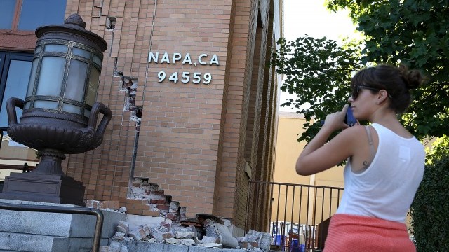
"caption": "A passerby stops to take a picture of damage to the Napa post office. (Justin Sullivan/Getty Images)",
"description": "A passerby stops to take a picture of damage to the Napa post office. (Justin Sullivan/Getty Images)",
"title": "454081604-640x431",
"credit": null,
"status": "inherit",
"isLoading": false,
"fetchFailed": false
},
"science_20760": {
"type": "attachments",
"id": "science_20760",
"meta": {
"index": "attachments_1716263798",
"site": "science",
"id": "20760",
"found": true
},
"parent": 20756,
"imgSizes": {
"kqedFullSize": {
"file": "https://ww2.kqed.org/app/uploads/sites/35/2014/08/bird-kill-kenneth-Herdy-FLAP-2009.jpg",
"width": 618,
"height": 269
}
},
"publishDate": 1408643776,
"modified": 1408643776,
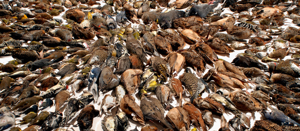
"caption": "Birds collected after colliding with buildings in Toronto 2009. (Kenneth Herdy/FLAP Canada)",
"description": "Bird window collisions",
"title": "bird-kill-kenneth-Herdy-FLAP-2009",
"credit": null,
"status": "inherit",
"isLoading": false,
"fetchFailed": false
},
"news_127089": {
"type": "attachments",
"id": "news_127089",
"meta": {
"index": "attachments_1716263798",
"site": "news",
"id": "127089",
"found": true
},
"parent": 127029,
"imgSizes": {
"kqedFullSize": {
"file": "https://ww2.kqed.org/app/uploads/sites/10/2014/02/12527233845_4dfc14b9e2_k.jpg",
"width": 1531,
"height": 1027
}
},
"publishDate": 1392942399,
"modified": 1392942399,
"caption": "(Dan Brekke/KQED)",
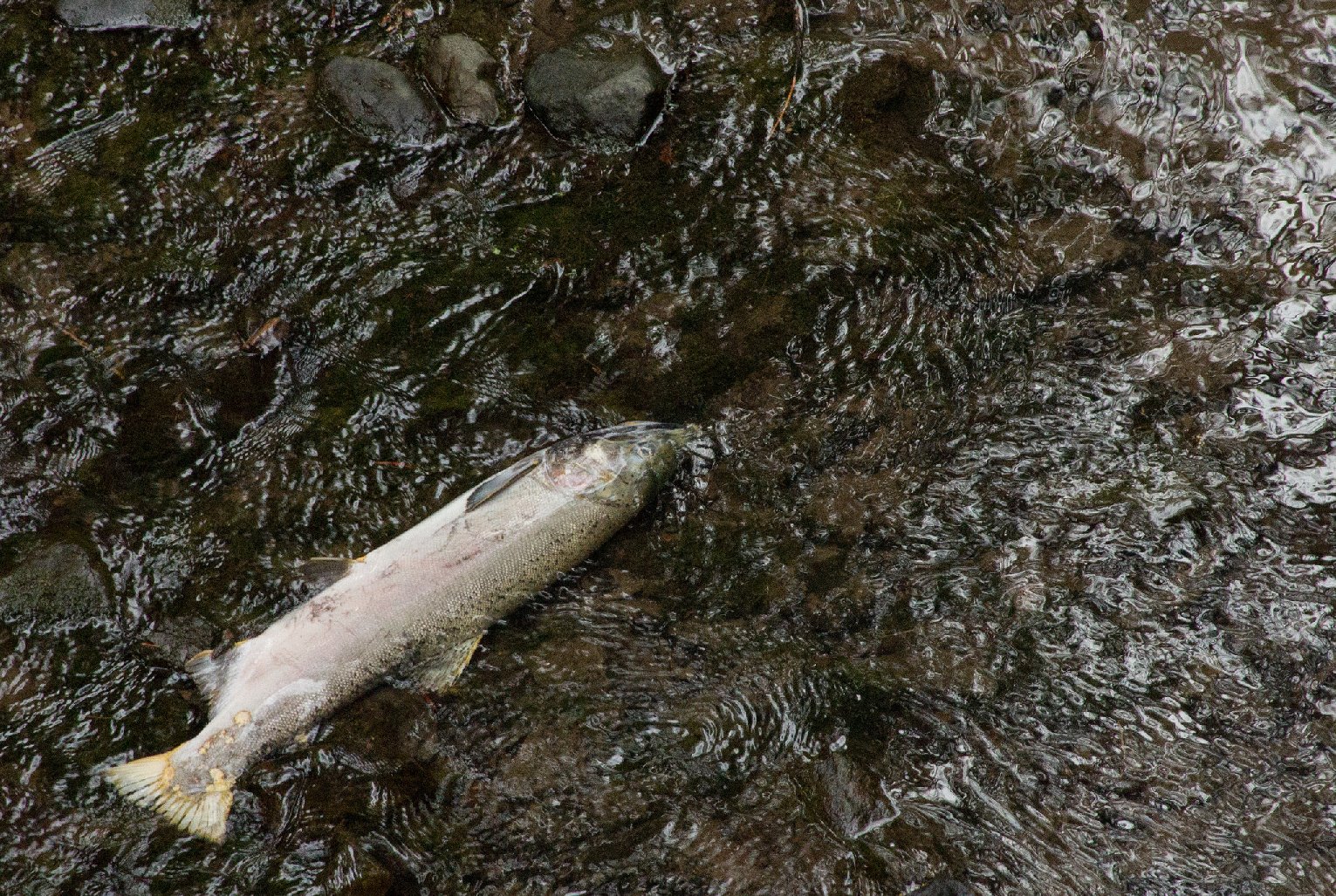
"description": "A female coho salmon, dead after spawning on Marin County's Lagunitas Creek. (Dan Brekke/KQED)",
"title": "Coho Salmon-Lagunitas Creek",
"credit": null,
"status": "inherit",
"isLoading": false,
"fetchFailed": false
},
"science_20784": {
"type": "attachments",
"id": "science_20784",
"meta": {
"index": "attachments_1716263798",
"site": "science",
"id": "20784",
"found": true
},
"parent": 20771,
"imgSizes": {
"kqedFullSize": {
"file": "https://ww2.kqed.org/app/uploads/sites/35/2014/08/RS4110_aqueduct20120131-scr1.jpg",
"width": 640,
"height": 360
}
},
"publishDate": 1408650023,
"modified": 1408650023,
"caption": "With less water weighing California down, parts of the land are rising, says a new study. (David McNew/Getty Images)",
"description": "With less water weighing California down, parts of the land are rising, says a new study. (David McNew/Getty Images)",
"title": "RS4110_aqueduct20120131-scr",
"credit": null,
"status": "inherit",
"isLoading": false,
"fetchFailed": false
},
"news_145235": {
"type": "attachments",
"id": "news_145235",
"meta": {
"index": "attachments_1716263798",
"site": "news",
"id": "145235",
"found": true
},
"parent": 145123,
"imgSizes": {
"kqedFullSize": {
"file": "https://ww2.kqed.org/app/uploads/sites/10/2014/08/happycampfire.jpeg",
"width": 2600,
"height": 1740
}
},
"publishDate": 1408571915,
"modified": 1408571915,
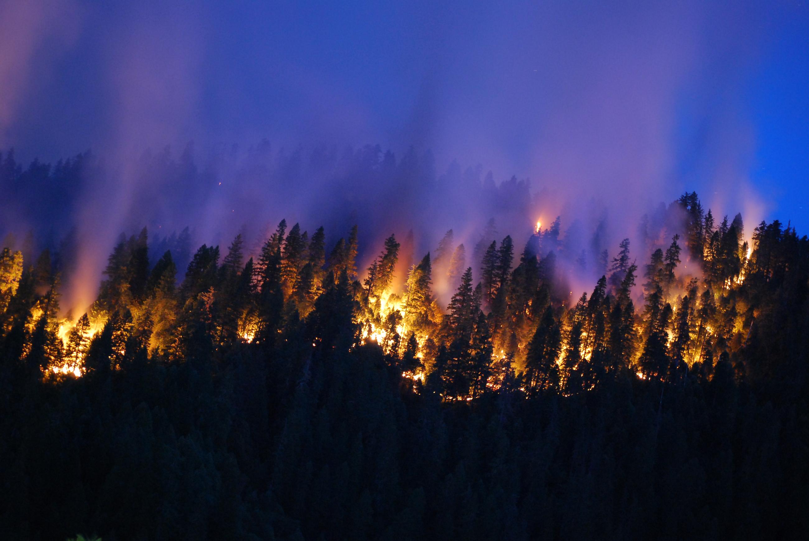
"caption": "A night view of the Happy Camp Complex fire, burning in Klamath National Forest east of Crescent City. (U.S. Forest Service)",
"description": "A night view of the Happy Camp Complex fire, burning in Klamath National Forest east of Crescent City. (U.S. Forest Service)",
"title": "Happy Camp Complex-Wildfire",
"credit": null,
"status": "inherit",
"isLoading": false,
"fetchFailed": false
}
},
"audioPlayerReducer": {
"postId": "stream_live",
"isPaused": true,
"isPlaying": false,
"pfsActive": false,
"pledgeModalIsOpen": true,
"playerDrawerIsOpen": false,
"liveAudioPlayStartedAt": 0,
"liveAudioPlayContext": ""
},
"authorsReducer": {
"lisapickoffwhite-2": {
"type": "authors",
"id": "199",
"meta": {
"index": "authors_1716337520",
"id": "199",
"found": true
},
"name": "Lisa Pickoff-White",
"firstName": "Lisa",
"lastName": "Pickoff-White",
"slug": "lisapickoffwhite-2",
"email": "lpickoffwhite@kqed.org",
"display_author_email": false,
"staff_mastheads": [
"news"
],
"title": "Data Journalist, Senior Producer",
"bio": "Lisa Pickoff-White is KQED's data reporter. Lisa specializes in simplifying complex topics and bringing them to life through compelling visuals, including photography and data visualizations. She previously has worked at the Center for Investigative Reporting and other national outlets. Her work has been honored with awards from the Online News Association, Investigative Reporters and Editors, the Society of Professional Journalists and SXSW Interactive. \u003cstrong> \u003c/strong>",
"avatar": "https://secure.gravatar.com/avatar/5513c5f3967df792aa65bee2501e84d6?s=600&d=blank&r=g",
"twitter": "pickoffwhite",
"facebook": null,
"instagram": null,
"linkedin": null,
"sites": [
{
"site": "",
"roles": [
"editor"
]
},
{
"site": "arts",
"roles": []
},
{
"site": "news",
"roles": [
"administrator"
]
},
{
"site": "about",
"roles": [
"editor"
]
},
{
"site": "stateofhealth",
"roles": [
"administrator"
]
},
{
"site": "science",
"roles": [
"editor"
]
},
{
"site": "quest",
"roles": [
"editor"
]
},
{
"site": "forum",
"roles": [
"editor"
]
}
],
"headData": {
"title": "Lisa Pickoff-White | KQED",
"description": "Data Journalist, Senior Producer",
"ogImgSrc": "https://secure.gravatar.com/avatar/5513c5f3967df792aa65bee2501e84d6?s=600&d=blank&r=g",
"twImgSrc": "https://secure.gravatar.com/avatar/5513c5f3967df792aa65bee2501e84d6?s=600&d=blank&r=g"
},
"isLoading": false,
"link": "/author/lisapickoffwhite-2"
},
"andrea-kissack": {
"type": "authors",
"id": "212",
"meta": {
"index": "authors_1716337520",
"id": "212",
"found": true
},
"name": "Andrea Kissack",
"firstName": "Andrea",
"lastName": "Kissack",
"slug": "andrea-kissack",
"email": "akissack@kqed.org",
"display_author_email": false,
"staff_mastheads": [],
"title": "KQED Contributor",
"bio": "Andrea has nearly three decades of experience working as a reporter, anchor, producer and editor for public radio, large market television news and CBS radio. In her current role as KQED’s Sr. Science Editor, Andrea helps lead a talented team covering science, technology, health and the environment for broadcast and digital platforms. Most recently she helped KQED launch a new, multimedia initiative covering the intersection of technology, health and medical science. She has earned a number of accolades for her work including awards from the Radio and Television News Directors Association, the National Academy of Television Arts and Sciences and the Associated Press. Her work can be seen, and heard, on a number of networks, Including NPR, PBS, CBS and the BBC.",
"avatar": "https://secure.gravatar.com/avatar/3eae7a251f0aee43b3c0137a636cb386?s=600&d=blank&r=g",
"twitter": "andreakissack",
"facebook": null,
"instagram": null,
"linkedin": null,
"sites": [
{
"site": "news",
"roles": [
"subscriber"
]
},
{
"site": "stateofhealth",
"roles": [
"subscriber"
]
},
{
"site": "science",
"roles": []
},
{
"site": "quest",
"roles": [
"add_users",
"create_users",
"edit_files",
"edit_users",
"level_10",
"level_8",
"level_9",
"promote_users",
"view_cimy_extra_fields",
"subscriber"
]
}
],
"headData": {
"title": "Andrea Kissack | KQED",
"description": "KQED Contributor",
"ogImgSrc": "https://secure.gravatar.com/avatar/3eae7a251f0aee43b3c0137a636cb386?s=600&d=blank&r=g",
"twImgSrc": "https://secure.gravatar.com/avatar/3eae7a251f0aee43b3c0137a636cb386?s=600&d=blank&r=g"
},
"isLoading": false,
"link": "/author/andrea-kissack"
},
"danbrekke": {
"type": "authors",
"id": "222",
"meta": {
"index": "authors_1716337520",
"id": "222",
"found": true
},
"name": "Dan Brekke",
"firstName": "Dan",
"lastName": "Brekke",
"slug": "danbrekke",
"email": "dbrekke@kqed.org",
"display_author_email": true,
"staff_mastheads": [
"news",
"science"
],
"title": "KQED Editor and Reporter",
"bio": "Dan Brekke is a reporter and editor for KQED News, responsible for coverage of topics ranging from California water issues to the Bay Area's transportation challenges. In a newsroom career that began in Chicago in 1972, Dan has worked for \u003cem>The San Francisco Examiner,\u003c/em> Wired and TechTV and has been published in The New York Times, The New York Times Magazine, Business 2.0, Salon and elsewhere.\r\n\r\nSince joining KQED in 2007, Dan has reported, edited and produced both radio and online features and breaking news pieces. He has shared as both editor and reporter in four Society of Professional Journalists Norcal Excellence in Journalism awards and one Edward R. Murrow regional award. He was chosen for a spring 2017 residency at the Mesa Refuge to advance his research on California salmon.\r\n\r\nEmail Dan at: \u003ca href=\"mailto:dbrekke@kqed.org\">dbrekke@kqed.org\u003c/a>\r\n\r\n\u003cstrong>Twitter:\u003c/strong> \u003ca href=\"https://twitter.com/danbrekke\" rel=\"noopener noreferrer\">twitter.com/danbrekke\u003c/a>\r\n\u003cstrong>Facebook:\u003c/strong> \u003ca href=\"https://www.facebook.com/danbrekke\" rel=\"noopener noreferrer\">www.facebook.com/danbrekke\u003c/a>\r\n\u003cstrong>LinkedIn:\u003c/strong> \u003ca href=\"https://www.linkedin.com/in/danbrekke\" rel=\"noopener noreferrer\">www.linkedin.com/in/danbrekke\u003c/a>",
"avatar": "https://secure.gravatar.com/avatar/8f1f0d2a978fb3b23426c922c7e2af558fa36905b49c4ce76a97dc3c72d27226?s=600&d=mm&r=g",
"twitter": "danbrekke",
"bluesky": null,
"facebook": null,
"instagram": "https://www.instagram.com/dan.brekke/",
"linkedin": "https://www.linkedin.com/in/danbrekke/",
"sites": [
{
"site": "news",
"roles": [
"administrator",
"create_posts"
]
},
{
"site": "stateofhealth",
"roles": [
"editor"
]
},
{
"site": "science",
"roles": [
"editor"
]
},
{
"site": "quest",
"roles": [
"contributor"
]
},
{
"site": "food",
"roles": [
"contributor"
]
},
{
"site": "forum",
"roles": [
"contributor"
]
},
{
"site": "elections",
"roles": [
"editor"
]
},
{
"site": "liveblog",
"roles": [
"editor"
]
}
],
"headData": {
"title": "Dan Brekke | KQED",
"description": "KQED Editor and Reporter",
"ogImgSrc": "https://secure.gravatar.com/avatar/8f1f0d2a978fb3b23426c922c7e2af558fa36905b49c4ce76a97dc3c72d27226?s=600&d=mm&r=g",
"twImgSrc": "https://secure.gravatar.com/avatar/8f1f0d2a978fb3b23426c922c7e2af558fa36905b49c4ce76a97dc3c72d27226?s=600&d=mm&r=g"
},
"isLoading": false,
"link": "/author/danbrekke"
},
"jeremyraff": {
"type": "authors",
"id": "230",
"meta": {
"index": "authors_1716337520",
"id": "230",
"found": true
},
"name": "Jeremy Raff",
"firstName": "Jeremy",
"lastName": "Raff",
"slug": "jeremyraff",
"email": "jeremyraff@gmail.com",
"display_author_email": false,
"staff_mastheads": [],
"title": null,
"bio": "Jeremy Raff is a multimedia producer interested in migration, rural change, and health disparities. He produces KQED's community health series\u003ca href=\"http://blogs.kqed.org/stateofhealth/series/vital-signs/\" target=\"_blank\" rel=\"noopener\"> Vital Signs\u003c/a>. Reach him at jraff@kqed.org",
"avatar": "https://secure.gravatar.com/avatar/1444299e18b67b815fbbdc87a85e7dff?s=600&d=blank&r=g",
"twitter": null,
"facebook": null,
"instagram": null,
"linkedin": null,
"sites": [
{
"site": "news",
"roles": [
"subscriber"
]
},
{
"site": "stateofhealth",
"roles": [
"subscriber"
]
}
],
"headData": {
"title": "Jeremy Raff | KQED",
"description": null,
"ogImgSrc": "https://secure.gravatar.com/avatar/1444299e18b67b815fbbdc87a85e7dff?s=600&d=blank&r=g",
"twImgSrc": "https://secure.gravatar.com/avatar/1444299e18b67b815fbbdc87a85e7dff?s=600&d=blank&r=g"
},
"isLoading": false,
"link": "/author/jeremyraff"
},
"kqed": {
"type": "authors",
"id": "236",
"meta": {
"index": "authors_1716337520",
"id": "236",
"found": true
},
"name": "KQED News Staff",
"firstName": "KQED News Staff",
"lastName": null,
"slug": "kqed",
"email": "faq@kqed.org",
"display_author_email": false,
"staff_mastheads": [],
"title": null,
"bio": null,
"avatar": "https://secure.gravatar.com/avatar/ef0e801a68c4c54afa9180db14084167?s=600&d=blank&r=g",
"twitter": null,
"facebook": null,
"instagram": null,
"linkedin": null,
"sites": [
{
"site": "arts",
"roles": [
"contributor"
]
},
{
"site": "news",
"roles": [
"editor"
]
},
{
"site": "futureofyou",
"roles": [
"author"
]
}
],
"headData": {
"title": "KQED News Staff | KQED",
"description": null,
"ogImgSrc": "https://secure.gravatar.com/avatar/ef0e801a68c4c54afa9180db14084167?s=600&d=blank&r=g",
"twImgSrc": "https://secure.gravatar.com/avatar/ef0e801a68c4c54afa9180db14084167?s=600&d=blank&r=g"
},
"isLoading": false,
"link": "/author/kqed"
},
"laurensommer": {
"type": "authors",
"id": "239",
"meta": {
"index": "authors_1716337520",
"id": "239",
"found": true
},
"name": "Lauren Sommer",
"firstName": "Lauren",
"lastName": "Sommer",
"slug": "laurensommer",
"email": "lsommer@kqed.org",
"display_author_email": false,
"staff_mastheads": [],
"title": "KQED Contributor",
"bio": "Lauren is a radio reporter formerly covering environment, water, and energy for KQED Science. As part of her day job, she has scaled Sierra Nevada peaks, run from charging elephant seals, and desperately tried to get her sea legs - all in pursuit of good radio. Her work has appeared on Marketplace, Living on Earth, Science Friday and NPR's Morning Edition and All Things Considered. You can find her on Twitter at \u003ca href=\"https://twitter.com/lesommer\">@lesommer\u003c/a>.",
"avatar": "https://secure.gravatar.com/avatar/33aa3772bb86c6ad45b8aca6a238bbdf?s=600&d=blank&r=g",
"twitter": null,
"facebook": null,
"instagram": null,
"linkedin": null,
"sites": [
{
"site": "news",
"roles": [
"author"
]
},
{
"site": "science",
"roles": [
"editor",
"manage_content_types",
"manage_taxonomies"
]
},
{
"site": "quest",
"roles": [
"editor"
]
}
],
"headData": {
"title": "Lauren Sommer | KQED",
"description": "KQED Contributor",
"ogImgSrc": "https://secure.gravatar.com/avatar/33aa3772bb86c6ad45b8aca6a238bbdf?s=600&d=blank&r=g",
"twImgSrc": "https://secure.gravatar.com/avatar/33aa3772bb86c6ad45b8aca6a238bbdf?s=600&d=blank&r=g"
},
"isLoading": false,
"link": "/author/laurensommer"
},
"sasha-khokha": {
"type": "authors",
"id": "254",
"meta": {
"index": "authors_1716337520",
"id": "254",
"found": true
},
"name": "Sasha Khokha",
"firstName": "Sasha",
"lastName": "Khokha",
"slug": "sasha-khokha",
"email": "skhokha@kqed.org",
"display_author_email": true,
"staff_mastheads": [
"news"
],
"title": "Host, The California Report Magazine",
"bio": "Sasha Khokha is the host of \u003cem>The California Report's \u003c/em> weekly magazine program, which takes listeners on sound-rich excursions to meet the people that make the Golden State unique -- through audio documentaries and long-form stories. As \u003cem>The California Report's\u003c/em> Central Valley Bureau Chief based in Fresno for nearly a dozen years, Sasha brought the lives and concerns of rural Californians to listeners around the state. Her reporting helped expose the hidden price immigrant women janitors and farmworkers may pay to keep their jobs: sexual assault at work. It inspired two new California laws to protect them from sexual harassment. She was a key member of the reporting team for the Frontline film \u003cem>Rape on the Night Shift, \u003c/em>which was nominated for two national Emmys. Sasha has also won a national Edward R. Murrow and a national PRNDI award for investigative reporting, as well as multiple prizes from the Society for Professional Journalists. Sasha is a proud alum of the UC Berkeley Graduate School of Journalism and Brown University and a member of the South Asian Journalists Association.",
"avatar": "https://secure.gravatar.com/avatar/e4b5e1541aaeea2aa356aa1fb2a68950?s=600&d=blank&r=g",
"twitter": "KQEDSashaKhokha",
"facebook": null,
"instagram": null,
"linkedin": null,
"sites": [
{
"site": "news",
"roles": [
"editor"
]
},
{
"site": "stateofhealth",
"roles": [
"author"
]
},
{
"site": "science",
"roles": [
"author"
]
},
{
"site": "quest",
"roles": [
"subscriber"
]
}
],
"headData": {
"title": "Sasha Khokha | KQED",
"description": "Host, The California Report Magazine",
"ogImgSrc": "https://secure.gravatar.com/avatar/e4b5e1541aaeea2aa356aa1fb2a68950?s=600&d=blank&r=g",
"twImgSrc": "https://secure.gravatar.com/avatar/e4b5e1541aaeea2aa356aa1fb2a68950?s=600&d=blank&r=g"
},
"isLoading": false,
"link": "/author/sasha-khokha"
},
"scottshafer": {
"type": "authors",
"id": "255",
"meta": {
"index": "authors_1716337520",
"id": "255",
"found": true
},
"name": "Scott Shafer",
"firstName": "Scott",
"lastName": "Shafer",
"slug": "scottshafer",
"email": "sshafer@kqed.org",
"display_author_email": false,
"staff_mastheads": [
"news"
],
"title": "KQED Contributor",
"bio": "Scott Shafer is a senior editor with the KQED Politics and Government desk. He is co-host of Political Breakdown, the award-winning radio show and podcast with a personal take on the world of politics. Scott came to KQED in 1998 to host the statewide\u003cem> California Report\u003c/em>. Prior to that he had extended stints in politics and government\u003cem>.\u003c/em> He uses that inside experience at KQED in his, reporting, hosting and analysis for the politics desk. Scott collaborated \u003cem>Political Breakdown a\u003c/em>nd on \u003cem>The Political Mind of Jerry Brown, \u003c/em>an eight-part series about the life and extraordinary political career of the former governor. For fun, he plays water polo with the San Francisco Tsunami.",
"avatar": "https://secure.gravatar.com/avatar/a62ebae45b79d7aed1a39a0e3bf68104?s=600&d=blank&r=g",
"twitter": "scottshafer",
"bluesky": null,
"facebook": null,
"instagram": null,
"linkedin": null,
"sites": [
{
"site": "news",
"roles": [
"editor"
]
},
{
"site": "stateofhealth",
"roles": [
"author"
]
},
{
"site": "science",
"roles": [
"author"
]
},
{
"site": "forum",
"roles": [
"subscriber"
]
},
{
"site": "liveblog",
"roles": [
"author"
]
}
],
"headData": {
"title": "Scott Shafer | KQED",
"description": "KQED Contributor",
"ogImgSrc": "https://secure.gravatar.com/avatar/a62ebae45b79d7aed1a39a0e3bf68104?s=600&d=blank&r=g",
"twImgSrc": "https://secure.gravatar.com/avatar/a62ebae45b79d7aed1a39a0e3bf68104?s=600&d=blank&r=g"
},
"isLoading": false,
"link": "/author/scottshafer"
},
"sschilling": {
"type": "authors",
"id": "1565",
"meta": {
"index": "authors_1716337520",
"id": "1565",
"found": true
},
"name": "Sally Schilling",
"firstName": "Sally",
"lastName": "Schilling",
"slug": "sschilling",
"email": "sschilling@KQED.org",
"display_author_email": false,
"staff_mastheads": [],
"title": null,
"bio": "KQED Science intern Sally Schilling brings environmental conflicts to life by finding the people most affected by them. She’s recently told the stories of park rangers on the hunt for redwood burl poachers, and the accidental activists in Pittsburg who are fighting a proposed crude oil facility being built in their backyards. Sally is currently studying video journalism and investigative reporting at the UC Berkeley Graduate School of Journalism. She grew up on an organic farm near Davis, Ca.",
"avatar": "https://secure.gravatar.com/avatar/de4c082ea10bfe43a4bc1996b14a3886?s=600&d=blank&r=g",
"twitter": null,
"facebook": null,
"instagram": null,
"linkedin": null,
"sites": [
{
"site": "news",
"roles": [
"author"
]
},
{
"site": "science",
"roles": [
"editor"
]
}
],
"headData": {
"title": "Sally Schilling | KQED",
"description": null,
"ogImgSrc": "https://secure.gravatar.com/avatar/de4c082ea10bfe43a4bc1996b14a3886?s=600&d=blank&r=g",
"twImgSrc": "https://secure.gravatar.com/avatar/de4c082ea10bfe43a4bc1996b14a3886?s=600&d=blank&r=g"
},
"isLoading": false,
"link": "/author/sschilling"
},
"kqedscience": {
"type": "authors",
"id": "6387",
"meta": {
"index": "authors_1716337520",
"id": "6387",
"found": true
},
"name": "KQED Science",
"firstName": "KQED",
"lastName": "Science",
"slug": "kqedscience",
"email": "kqedscience@gmail.com",
"display_author_email": false,
"staff_mastheads": [],
"title": null,
"bio": "KQED Science brings you award-winning science and environment coverage from the Bay Area and beyond by the flagship Northern California PBS and NPR affiliate.",
"avatar": "https://secure.gravatar.com/avatar/5a295ff49cf82a8c0f30937d3f788b2f?s=600&d=blank&r=g",
"twitter": null,
"facebook": null,
"instagram": null,
"linkedin": null,
"sites": [
{
"site": "science",
"roles": [
"contributor"
]
},
{
"site": "quest",
"roles": [
"editor"
]
},
{
"site": "food",
"roles": [
"contributor"
]
}
],
"headData": {
"title": "KQED Science | KQED",
"description": null,
"ogImgSrc": "https://secure.gravatar.com/avatar/5a295ff49cf82a8c0f30937d3f788b2f?s=600&d=blank&r=g",
"twImgSrc": "https://secure.gravatar.com/avatar/5a295ff49cf82a8c0f30937d3f788b2f?s=600&d=blank&r=g"
},
"isLoading": false,
"link": "/author/kqedscience"
}
},
"pagesReducer": {
"news_category_environment": {
"type": "terms",
"id": "news_19906",
"meta": {
"index": "terms_1716263798",
"site": "news",
"id": "19906",
"score": 12.137343
},
"featImg": null,
"name": "Environment",
"description": null,
"taxonomy": "category",
"headData": {
"twImgId": null,
"twTitle": null,
"ogTitle": null,
"ogImgId": null,
"twDescription": null,
"description": null,
"title": "Environment Archives | KQED News",
"ogDescription": null
},
"ttid": 19923,
"slug": "environment",
"isLoading": false,
"title": "Environment",
"pageMeta": {
"site": "news",
"WpPageTemplate": "page-topic-editorial",
"currentPage": 258
},
"blocks": [
{
"blockName": "kqed/post-list",
"attrs": {
"layout": "cardArticle2",
"query": "posts/news?category=environment",
"seeMore": false,
"paginated": true,
"page": 258
}
},
{
"blockName": "kqed/ad"
}
]
}
},
"pfsSessionReducer": {},
"postsReducer": {
"stream_live": {
"type": "live",
"id": "stream_live",
"audioUrl": "https://streams.kqed.org/kqedradio",
"title": "Live Stream",
"excerpt": "Live Stream information currently unavailable.",
"link": "/radio",
"featImg": "",
"label": {
"name": "KQED Live",
"link": "/"
}
},
"stream_kqedNewscast": {
"type": "posts",
"id": "stream_kqedNewscast",
"audioUrl": "https://www.kqed.org/.stream/anon/radio/RDnews/newscast.mp3?_=1",
"title": "KQED Newscast",
"featImg": "",
"label": {
"name": "88.5 FM",
"link": "/"
}
},
"science_21054": {
"type": "posts",
"id": "science_21054",
"meta": {
"index": "posts_1716263798",
"site": "science",
"id": "21054",
"score": null,
"sort": [
1409179574000
]
},
"parent": 0,
"labelTerm": {
"site": "science"
},
"blocks": [],
"publishDate": 1409179574,
"format": "aside",
"title": "Feds Will Allow Logging in Some Areas Burned by Rim Fire",
"headTitle": "Feds Will Allow Logging in Some Areas Burned by Rim Fire | KQED",
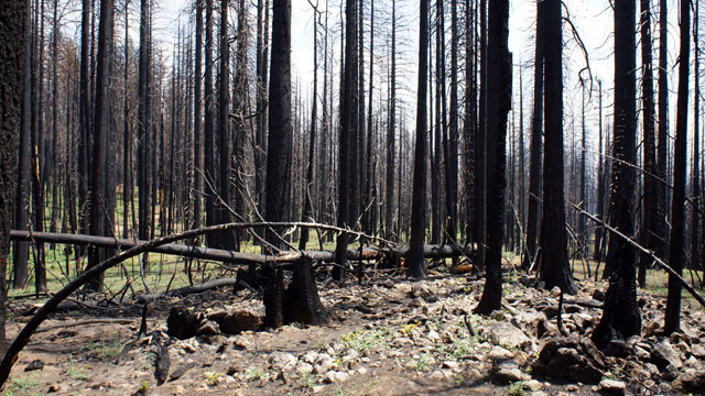
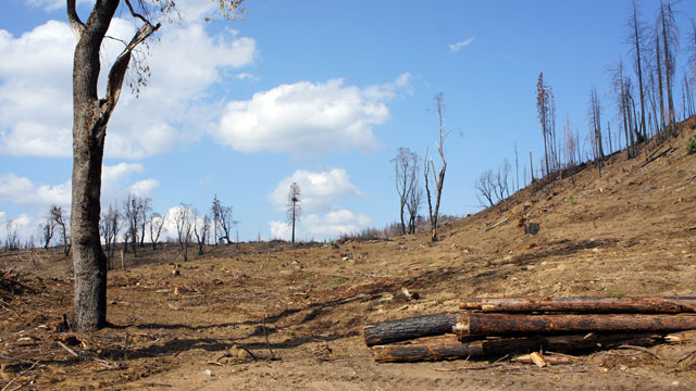
"content": "\u003cp>\u003cstrong>By Scott Smith\u003cbr>\nAssociated Press\u003c/strong>\u003c/p>\n\u003cfigure id=\"attachment_20857\" class=\"wp-caption aligncenter\" style=\"max-width: 1280px\">\u003ca href=\"http://ww2.kqed.org/science/wp-content/uploads/sites/35/2014/08/DSC01451-1280.jpg\">\u003cimg loading=\"lazy\" decoding=\"async\" src=\"http://ww2.kqed.org/science/wp-content/uploads/sites/35/2014/08/DSC01451-1280.jpg\" alt=\"Trees killed in the Rim Fire will likely stay standing for only a decade or so. (Lauren Sommer/KQED)\" width=\"1280\" height=\"720\" class=\"size-full wp-image-20857\">\u003c/a>\u003cfigcaption class=\"wp-caption-text\">Trees killed in the Rim Fire will likely stay standing for only a decade or so. (Lauren Sommer/KQED)\u003c/figcaption>\u003c/figure>\n\u003cp>A U.S. Forest Service decision released Wednesday will allow loggers to remove dead trees from 52 square miles of forests blackened last year in a massive central California wildfire, a move \u003ca href=\"http://ww2.kqed.org/science/2014/08/26/after-record-breaking-rim-fire-log-trees-or-leave-them/\">contested by environmentalists\u003c/a>.\u003c/p>\n\u003cp>The highly awaited decision came amid a standoff between environmentalists and supporters of the timber industry over what to do with the trees that died in the massive Rim Fire, which started Aug. 17, 2013, and burned more than 400 square miles of the Stanislaus National Forest, Yosemite National Park’s backcountry and private timber land. It threatened thousands of structures, destroyed 11 homes and cost more than $125 million to fight.\u003c/p>\n\u003cp>[contextly_sidebar id=”iwbOUnWfKI5grtExHT8wNPm0jkdfFeqB”]\u003c/p>\n\u003cp>Environmentalists had argued against logging the land, saying the blackened trees and new growth beneath them create vital habitat for dwindling birds such as spotted owls and black-backed woodpeckers.\u003c/p>\n\u003cp>[ad fullwidth]\u003c/p>\n\u003cp>“This is an ecological travesty,” said Chad Hanson, a forest ecologist and founder of the John Muir Project, an environmentalist group. “It’s basically an extinction plan for the California spotted owl.”\u003c/p>\n\u003cp>Supporters of the timber industry said logging would pay for replanting and restoring the forest. Taking out dead trees will also allow the public to use the land, they say, and eliminate a new fire hazard caused by the falling trees.\u003c/p>\n\u003cp>Susan Skalski, supervisor of the Stanislaus National Forest, is expected to sign the logging decision on Thursday, making it final.\u003c/p>\n\u003cp>Federal prosecutors \u003ca href=\"http://ww2.kqed.org/news/2014/08/07/tuolumne-county-resident-indicted-for-starting-rim-fire-in-yosemite/\">accuse bow hunter Keith Matthew Emerald\u003c/a>, 32, of starting the massive blaze when he lost control of an illegal campfire and had to be rescued by helicopter. A grand jury on Aug. 7 returned a four-count indictment against Emerald, who lives in the foothill community of Columbia.\u003c/p>\n\u003cp>\u003c/p>\n\u003cp>Emerald, who has pleaded not guilty, was released from jail after posting a $60,000 bond.\u003c/p>\n\u003cfigure id=\"attachment_20667\" class=\"wp-caption aligncenter\" style=\"max-width: 640px\">\u003cimg loading=\"lazy\" decoding=\"async\" src=\"http://ww2.kqed.org/science/wp-content/uploads/sites/35/2014/08/Rimfiregraphic-e1408148390108.jpeg\" alt=\"(David Pierce/KQED)\" width=\"640\" height=\"816\" class=\"size-full wp-image-20667\">\u003cfigcaption class=\"wp-caption-text\">(David Pierce/KQED)\u003c/figcaption>\u003c/figure>\n\n",
"stats": {
"hasVideo": false,
"hasChartOrMap": false,
"hasAudio": false,
"hasPolis": false,
"wordCount": 336,
"hasGoogleForm": false,
"hasGallery": false,
"hasHearkenModule": false,
"iframeSrcs": [],
"paragraphCount": 12
},
"modified": 1704933063,
"excerpt": "A U.S. Forest Service decision will allow loggers to remove dead trees from 52 square miles of forests blackened last year in a massive central California wildfire, a move contested by environmentalists.",
"headData": {
"twImgId": "",
"twTitle": "",
"ogTitle": "",
"ogImgId": "",
"twDescription": "",
"description": "A U.S. Forest Service decision will allow loggers to remove dead trees from 52 square miles of forests blackened last year in a massive central California wildfire, a move contested by environmentalists.",
"title": "Feds Will Allow Logging in Some Areas Burned by Rim Fire | KQED",
"ogDescription": "",
"schema": {
"@context": "https://schema.org",
"@type": "Article",
"headline": "Feds Will Allow Logging in Some Areas Burned by Rim Fire",
"datePublished": "2014-08-27T15:46:14-07:00",
"dateModified": "2024-01-10T16:31:03-08:00",
"image": "https://cdn.kqed.org/wp-content/uploads/2020/02/KQED-OG-Image@1x.png"
}
},
"guestAuthors": [],
"slug": "feds-will-allow-logging-in-some-areas-burned-by-rim-fire",
"status": "publish",
"sticky": false,
"path": "/science/21054/feds-will-allow-logging-in-some-areas-burned-by-rim-fire",
"audioTrackLength": null,
"parsedContent": [
{
"type": "contentString",
"content": "\u003cdiv class=\"post-body\">\u003cp>\u003cp>\u003cstrong>By Scott Smith\u003cbr>\nAssociated Press\u003c/strong>\u003c/p>\n\u003cfigure id=\"attachment_20857\" class=\"wp-caption aligncenter\" style=\"max-width: 1280px\">\u003ca href=\"http://ww2.kqed.org/science/wp-content/uploads/sites/35/2014/08/DSC01451-1280.jpg\">\u003cimg loading=\"lazy\" decoding=\"async\" src=\"http://ww2.kqed.org/science/wp-content/uploads/sites/35/2014/08/DSC01451-1280.jpg\" alt=\"Trees killed in the Rim Fire will likely stay standing for only a decade or so. (Lauren Sommer/KQED)\" width=\"1280\" height=\"720\" class=\"size-full wp-image-20857\">\u003c/a>\u003cfigcaption class=\"wp-caption-text\">Trees killed in the Rim Fire will likely stay standing for only a decade or so. (Lauren Sommer/KQED)\u003c/figcaption>\u003c/figure>\n\u003cp>A U.S. Forest Service decision released Wednesday will allow loggers to remove dead trees from 52 square miles of forests blackened last year in a massive central California wildfire, a move \u003ca href=\"http://ww2.kqed.org/science/2014/08/26/after-record-breaking-rim-fire-log-trees-or-leave-them/\">contested by environmentalists\u003c/a>.\u003c/p>\n\u003cp>The highly awaited decision came amid a standoff between environmentalists and supporters of the timber industry over what to do with the trees that died in the massive Rim Fire, which started Aug. 17, 2013, and burned more than 400 square miles of the Stanislaus National Forest, Yosemite National Park’s backcountry and private timber land. It threatened thousands of structures, destroyed 11 homes and cost more than $125 million to fight.\u003c/p>\n\u003cp>\u003c/p>\u003cp>\u003c/p>\u003cp>\u003c/p>\n\u003cp>Environmentalists had argued against logging the land, saying the blackened trees and new growth beneath them create vital habitat for dwindling birds such as spotted owls and black-backed woodpeckers.\u003c/p>\n\u003cp>\u003c/p>\u003c/div>",
"attributes": {
"named": {},
"numeric": []
}
},
{
"type": "component",
"content": "",
"name": "ad",
"attributes": {
"named": {
"label": "fullwidth"
},
"numeric": [
"fullwidth"
]
}
},
{
"type": "contentString",
"content": "\u003cdiv class=\"post-body\">\u003cp>\u003c/p>\n\u003cp>“This is an ecological travesty,” said Chad Hanson, a forest ecologist and founder of the John Muir Project, an environmentalist group. “It’s basically an extinction plan for the California spotted owl.”\u003c/p>\n\u003cp>Supporters of the timber industry said logging would pay for replanting and restoring the forest. Taking out dead trees will also allow the public to use the land, they say, and eliminate a new fire hazard caused by the falling trees.\u003c/p>\n\u003cp>Susan Skalski, supervisor of the Stanislaus National Forest, is expected to sign the logging decision on Thursday, making it final.\u003c/p>\n\u003cp>Federal prosecutors \u003ca href=\"http://ww2.kqed.org/news/2014/08/07/tuolumne-county-resident-indicted-for-starting-rim-fire-in-yosemite/\">accuse bow hunter Keith Matthew Emerald\u003c/a>, 32, of starting the massive blaze when he lost control of an illegal campfire and had to be rescued by helicopter. A grand jury on Aug. 7 returned a four-count indictment against Emerald, who lives in the foothill community of Columbia.\u003c/p>\n\u003cp>\u003c/p>\n\u003cp>Emerald, who has pleaded not guilty, was released from jail after posting a $60,000 bond.\u003c/p>\n\u003cfigure id=\"attachment_20667\" class=\"wp-caption aligncenter\" style=\"max-width: 640px\">\u003cimg loading=\"lazy\" decoding=\"async\" src=\"http://ww2.kqed.org/science/wp-content/uploads/sites/35/2014/08/Rimfiregraphic-e1408148390108.jpeg\" alt=\"(David Pierce/KQED)\" width=\"640\" height=\"816\" class=\"size-full wp-image-20667\">\u003cfigcaption class=\"wp-caption-text\">(David Pierce/KQED)\u003c/figcaption>\u003c/figure>\n\n\u003c/div>\u003c/p>",
"attributes": {
"named": {},
"numeric": []
}
}
],
"link": "/science/21054/feds-will-allow-logging-in-some-areas-burned-by-rim-fire",
"authors": [
"6387"
],
"categories": [
"science_35",
"science_40"
],
"tags": [
"science_607"
],
"featImg": "science_21058",
"label": "science"
},
"news_145564": {
"type": "posts",
"id": "news_145564",
"meta": {
"index": "posts_1716263798",
"site": "news",
"id": "145564",
"score": null,
"sort": [
1409166025000
]
},
"parent": 0,
"labelTerm": {
"site": "news",
"term": 6944
},
"blocks": [],
"publishDate": 1409166025,
"format": "aside",
"disqusTitle": "A Reporter in the San Joaquin Valley Finds Fertile Ground for Storytelling",
"title": "A Reporter in the San Joaquin Valley Finds Fertile Ground for Storytelling",
"headTitle": "News Fix | KQED News",
"content": "\u003cfigure id=\"attachment_145960\" class=\"wp-caption aligncenter\" style=\"max-width: 640px\">\u003ca href=\"http://ww2.kqed.org/news/wp-content/uploads/sites/10/2014/08/RS11642_P1030890.jpg\">\u003cimg class=\"size-medium wp-image-145960\" src=\"http://ww2.kqed.org/news/wp-content/uploads/sites/10/2014/08/RS11642_P1030890-640x480.jpg\" alt=\"KQED's Sasha Khokha, on assignment in the San Joaquin Valley. (Suzie Racho/KQED)\" width=\"640\" height=\"480\">\u003c/a>\u003cfigcaption class=\"wp-caption-text\">KQED's Sasha Khokha, on assignment in the San Joaquin Valley. (Suzie Racho/KQED)\u003c/figcaption>\u003c/figure>\n\u003cp>\u003cem>Editor's note: KQED's \u003cstrong>The California Report \u003c/strong>took a road trip earlier this month \u003ca href=\"http://www.californiareport.org/archive/R201408221630\" target=\"_blank\">to explore the Central Valley\u003c/a>. Here, Sasha Khokha, our Central Valley bureau chief, reflects on covering a vast and vastly complex region that few people slow down to see. \u003c/em>\u003c/p>\n\u003cp>\u003cspan style=\"font-size: 4.6875em;float: left;line-height: 0.733em;padding: 0.05em 0.1em 0 0;font-family: times, serif, georgia\">I\u003c/span> have a friend from Berkeley who calls the San Joaquin Valley \"The Great Nothing,\" and I think that's the way most Californians see the place where I live and work. There's little to see here, the thinking goes, except endless farmland fading into a hot, stinky haze. Coming over the Tehachapis from L.A. or the Altamont Pass from the Bay Area, most of those whizzing past on I-5 or Highway 99 view the valley as something to endure on their way to somewhere else.\u003c/p>\n\u003cp>Sure, there's a grain of truth to that caricature. It is hot in the valley (except when it's cold and foggy in the winter). The valley is farm country (some of the most productive in the world). The air is bad (some of the worst in the nation). But, like every simplistic picture, the image most people have of the valley misses just about all of its character and complexity.\u003c/p>\n\u003caside class=\"pullquote alignleft\">The challenges of translating the 'other California' to audiences across the Golden State.\u003c/aside>\n\u003cp>When \u003cem>The California Report\u003c/em> opened a Central Valley Bureau in Fresno more than a dozen years ago, it was because KQED recognized how important this region was becoming to the entire state. It's home to some of the fastest-growing cities in California. It's at the center of many key policy debates, from immigration to poverty and hunger, to water and high-speed rail. It's a place where farming has created great wealth, while workers in the fields may not know how they'll pay tomorrow's grocery bill or next month's rent. And it’s a place where a reporter can’t just parachute in. You have to call this place home to really understand its complexities — which is what I’ve done for the last decade.\u003c/p>\n\u003cp>The valley’s towns are sometimes no more than a few homes clustered around a crossroads. People here are often excluded from policy debates in Washington, in Sacramento or even in their own communities. I've talked to farmers who worry about surviving the drought, and community members worried about pesticide exposure. I’ve talked with parents worried because their teenage children play sports on days when air quality is at emergency levels and women farmworkers who pay a chilling price to get and keep their jobs, risking sexual assault in the fields.\u003c/p>\n\u003cp>[ad fullwidth]\u003c/p>\n\u003cp>My job is to translate this “other California” to audiences across the Golden State. To try and get listeners brushing their teeth in San Francisco, or stuck in traffic in San Diego, to care about people like Gladys Colunga -- a farmworker mom with six kids \u003ca href=\"http://vimeo.com/104048048\" target=\"_blank\">whose well has gone dry in the drought.\u003c/a> When she flushed the toilet one day, dirt came up. She can’t do dishes or laundry or afford a new well, which costs tens of thousands of dollars.\u003c/p>\n\u003caside class=\"left long\">\n\u003ch3>More from the Central Valley:\u003c/h3>\n\u003cul>\n\u003cli>\u003ca href=\"http://ww2.kqed.org/news/2014/08/22/california-central-valley-drought-water-wells/\">California’s Central Valley: ‘More Than Just Farmers on Tractors’ [Video]\u003c/a>\u003c/li>\n\u003cli>\u003ca href=\"http://ww2.kqed.org/news/2014/08/22/communal-project-in-fresno-dakota-eco-garden\">Communal Project in Fresno Has Found a Different Way to Treat the Homeless [Video]\u003c/a>\u003c/li>\n\u003cli>\u003ca href=\"http://ww2.kqed.org/news/2014/08/21/at-89-worlds-oldest-square-dance-caller-keeps-the-central-valley-dancing/\" target=\"_blank\">World’s Oldest Square Dance Caller Keeps Central Valley Dancing [Video]\u003c/a>\u003c/li>\n\u003c/ul>\n\u003c/aside>\n\u003cp>“We’re like the lost little community out here,” she told me. “They’re not treating us like we’re part of California.”\u003c/p>\n\u003cp>But the valley is rich in many other ways.\u003c/p>\n\u003cp>Nearly 90 languages are spoken in Fresno, a place where you can find African-Americans, Latinos and Armenians all enjoying noodles at a local Lao restaurant. Fresno’s poetry scene has produced a national poet laureate and several National Book Award winners. And the San Joaquin Valley has a special backyard: the central Sierra, with three national parks --Yosemite, Sequoia and Kings Canyon -- full of glittering alpine lakes and pristine wilderness.\u003c/p>\n\u003cp>It’s a part of California where many young families can still afford to by a house. Where there’s rarely a long commute and where the produce at farmers markets is phenomenal. Where people are friendly and actually strike up a conversations on the street.\u003c/p>\n\u003cp>\u003c/p>\n\u003cp>Sure, I can’t see foreign movies at the local multiplex like I did when I lived in the Bay Area, but I can work with a group of dedicated volunteers to put on a monthly screening at the historic theater down the street. My kids might not have access to world-class museums, but they’ll grow up with kids from all walks of life and are learning compassion, empathy and the value of diversity. And they can make it to Yosemite in an hour.\u003c/p>\n\n",
"disqusIdentifier": "145564 http://ww2.kqed.org/news/?p=145564",
"disqusUrl": "https://ww2.kqed.org/news/2014/08/27/a-reporter-in-the-san-joaquin-valley-finds-fertile-ground-for-storytelling/",
"stats": {
"hasVideo": false,
"hasChartOrMap": false,
"hasAudio": false,
"hasPolis": false,
"wordCount": 843,
"hasGoogleForm": false,
"hasGallery": false,
"hasHearkenModule": false,
"iframeSrcs": [],
"paragraphCount": 13
},
"modified": 1409175665,
"excerpt": "A glimpse of the complexity many miss as they hurry through the valley on their way somewhere else.",
"headData": {
"twImgId": "",
"twTitle": "",
"ogTitle": "",
"ogImgId": "",
"twDescription": "",
"description": "A glimpse of the complexity many miss as they hurry through the valley on their way somewhere else.",
"title": "A Reporter in the San Joaquin Valley Finds Fertile Ground for Storytelling | KQED",
"ogDescription": "",
"schema": {
"@context": "https://schema.org",
"@type": "NewsArticle",
"headline": "A Reporter in the San Joaquin Valley Finds Fertile Ground for Storytelling",
"datePublished": "2014-08-27T12:00:25-07:00",
"dateModified": "2014-08-27T14:41:05-07:00",
"image": "https://cdn.kqed.org/wp-content/uploads/2020/02/KQED-OG-Image@1x.png",
"isAccessibleForFree": "True",
"publisher": {
"@type": "NewsMediaOrganization",
"@id": "https://www.kqed.org/#organization",
"name": "KQED",
"logo": "https://cdn.kqed.org/wp-content/uploads/2020/02/KQED-OG-Image@1x.png",
"url": "https://www.kqed.org",
"sameAs": [
"https://www.facebook.com/KQED",
"https://twitter.com/KQED",
"https://www.instagram.com/kqed/",
"https://www.tiktok.com/@kqedofficial",
"https://www.linkedin.com/company/kqed",
"https://www.youtube.com/channel/UCeC0IOo7i1P_61zVUWbJ4nw"
]
}
}
},
"guestAuthors": [],
"slug": "a-reporter-in-the-san-joaquin-valley-finds-fertile-ground-for-storytelling",
"status": "publish",
"path": "/news/145564/a-reporter-in-the-san-joaquin-valley-finds-fertile-ground-for-storytelling",
"audioTrackLength": null,
"parsedContent": [
{
"type": "contentString",
"content": "\u003cdiv class=\"post-body\">\u003cp>\u003cfigure id=\"attachment_145960\" class=\"wp-caption aligncenter\" style=\"max-width: 640px\">\u003ca href=\"http://ww2.kqed.org/news/wp-content/uploads/sites/10/2014/08/RS11642_P1030890.jpg\">\u003cimg class=\"size-medium wp-image-145960\" src=\"http://ww2.kqed.org/news/wp-content/uploads/sites/10/2014/08/RS11642_P1030890-640x480.jpg\" alt=\"KQED's Sasha Khokha, on assignment in the San Joaquin Valley. (Suzie Racho/KQED)\" width=\"640\" height=\"480\">\u003c/a>\u003cfigcaption class=\"wp-caption-text\">KQED's Sasha Khokha, on assignment in the San Joaquin Valley. (Suzie Racho/KQED)\u003c/figcaption>\u003c/figure>\n\u003cp>\u003cem>Editor's note: KQED's \u003cstrong>The California Report \u003c/strong>took a road trip earlier this month \u003ca href=\"http://www.californiareport.org/archive/R201408221630\" target=\"_blank\">to explore the Central Valley\u003c/a>. Here, Sasha Khokha, our Central Valley bureau chief, reflects on covering a vast and vastly complex region that few people slow down to see. \u003c/em>\u003c/p>\n\u003cp>\u003cspan style=\"font-size: 4.6875em;float: left;line-height: 0.733em;padding: 0.05em 0.1em 0 0;font-family: times, serif, georgia\">I\u003c/span> have a friend from Berkeley who calls the San Joaquin Valley \"The Great Nothing,\" and I think that's the way most Californians see the place where I live and work. There's little to see here, the thinking goes, except endless farmland fading into a hot, stinky haze. Coming over the Tehachapis from L.A. or the Altamont Pass from the Bay Area, most of those whizzing past on I-5 or Highway 99 view the valley as something to endure on their way to somewhere else.\u003c/p>\n\u003cp>Sure, there's a grain of truth to that caricature. It is hot in the valley (except when it's cold and foggy in the winter). The valley is farm country (some of the most productive in the world). The air is bad (some of the worst in the nation). But, like every simplistic picture, the image most people have of the valley misses just about all of its character and complexity.\u003c/p>\n\u003caside class=\"pullquote alignleft\">The challenges of translating the 'other California' to audiences across the Golden State.\u003c/aside>\n\u003cp>When \u003cem>The California Report\u003c/em> opened a Central Valley Bureau in Fresno more than a dozen years ago, it was because KQED recognized how important this region was becoming to the entire state. It's home to some of the fastest-growing cities in California. It's at the center of many key policy debates, from immigration to poverty and hunger, to water and high-speed rail. It's a place where farming has created great wealth, while workers in the fields may not know how they'll pay tomorrow's grocery bill or next month's rent. And it’s a place where a reporter can’t just parachute in. You have to call this place home to really understand its complexities — which is what I’ve done for the last decade.\u003c/p>\n\u003cp>The valley’s towns are sometimes no more than a few homes clustered around a crossroads. People here are often excluded from policy debates in Washington, in Sacramento or even in their own communities. I've talked to farmers who worry about surviving the drought, and community members worried about pesticide exposure. I’ve talked with parents worried because their teenage children play sports on days when air quality is at emergency levels and women farmworkers who pay a chilling price to get and keep their jobs, risking sexual assault in the fields.\u003c/p>\n\u003cp>\u003c/p>\u003c/div>",
"attributes": {
"named": {},
"numeric": []
}
},
{
"type": "component",
"content": "",
"name": "ad",
"attributes": {
"named": {
"label": "fullwidth"
},
"numeric": [
"fullwidth"
]
}
},
{
"type": "contentString",
"content": "\u003cdiv class=\"post-body\">\u003cp>\u003c/p>\n\u003cp>My job is to translate this “other California” to audiences across the Golden State. To try and get listeners brushing their teeth in San Francisco, or stuck in traffic in San Diego, to care about people like Gladys Colunga -- a farmworker mom with six kids \u003ca href=\"http://vimeo.com/104048048\" target=\"_blank\">whose well has gone dry in the drought.\u003c/a> When she flushed the toilet one day, dirt came up. She can’t do dishes or laundry or afford a new well, which costs tens of thousands of dollars.\u003c/p>\n\u003caside class=\"left long\">\n\u003ch3>More from the Central Valley:\u003c/h3>\n\u003cul>\n\u003cli>\u003ca href=\"http://ww2.kqed.org/news/2014/08/22/california-central-valley-drought-water-wells/\">California’s Central Valley: ‘More Than Just Farmers on Tractors’ [Video]\u003c/a>\u003c/li>\n\u003cli>\u003ca href=\"http://ww2.kqed.org/news/2014/08/22/communal-project-in-fresno-dakota-eco-garden\">Communal Project in Fresno Has Found a Different Way to Treat the Homeless [Video]\u003c/a>\u003c/li>\n\u003cli>\u003ca href=\"http://ww2.kqed.org/news/2014/08/21/at-89-worlds-oldest-square-dance-caller-keeps-the-central-valley-dancing/\" target=\"_blank\">World’s Oldest Square Dance Caller Keeps Central Valley Dancing [Video]\u003c/a>\u003c/li>\n\u003c/ul>\n\u003c/aside>\n\u003cp>“We’re like the lost little community out here,” she told me. “They’re not treating us like we’re part of California.”\u003c/p>\n\u003cp>But the valley is rich in many other ways.\u003c/p>\n\u003cp>Nearly 90 languages are spoken in Fresno, a place where you can find African-Americans, Latinos and Armenians all enjoying noodles at a local Lao restaurant. Fresno’s poetry scene has produced a national poet laureate and several National Book Award winners. And the San Joaquin Valley has a special backyard: the central Sierra, with three national parks --Yosemite, Sequoia and Kings Canyon -- full of glittering alpine lakes and pristine wilderness.\u003c/p>\n\u003cp>It’s a part of California where many young families can still afford to by a house. Where there’s rarely a long commute and where the produce at farmers markets is phenomenal. Where people are friendly and actually strike up a conversations on the street.\u003c/p>\n\u003cp>\u003c/p>\n\u003cp>Sure, I can’t see foreign movies at the local multiplex like I did when I lived in the Bay Area, but I can work with a group of dedicated volunteers to put on a monthly screening at the historic theater down the street. My kids might not have access to world-class museums, but they’ll grow up with kids from all walks of life and are learning compassion, empathy and the value of diversity. And they can make it to Yosemite in an hour.\u003c/p>\n\n\u003c/div>\u003c/p>",
"attributes": {
"named": {},
"numeric": []
}
}
],
"link": "/news/145564/a-reporter-in-the-san-joaquin-valley-finds-fertile-ground-for-storytelling",
"authors": [
"254"
],
"programs": [
"news_6944"
],
"categories": [
"news_1758",
"news_19906"
],
"tags": [
"news_17601",
"news_37",
"news_312"
],
"featImg": "news_145960",
"label": "news_6944"
},
"news_145601": {
"type": "posts",
"id": "news_145601",
"meta": {
"index": "posts_1716263798",
"site": "news",
"id": "145601",
"score": null,
"sort": [
1409164254000
]
},
"guestAuthors": [],
"slug": "quake-rolls-through-bay-area",
"title": "South Napa Earthquake: City Says There's Over $300 Million in Damages",
"publishDate": 1409164254,
"format": "aside",
"headTitle": "South Napa Earthquake: City Says There’s Over $300 Million in Damages | KQED",
"labelTerm": {
"term": 6944,
"site": "news"
},
"content": "\u003cfigure id=\"attachment_145917\" class=\"wp-caption aligncenter\" style=\"max-width: 640px\">\u003ca href=\"http://ww2.kqed.org/news/wp-content/uploads/sites/10/2014/08/IMG_4794.jpg\">\u003cimg loading=\"lazy\" decoding=\"async\" class=\"size-medium wp-image-145917\" src=\"http://ww2.kqed.org/news/wp-content/uploads/sites/10/2014/08/IMG_4794-640x480.jpg\" alt=\"Workers begin process of dismantling the bell tower of Vallejo's First Baptist Church. (Craig Miller/KQED)\" width=\"640\" height=\"480\">\u003c/a>\u003cfigcaption class=\"wp-caption-text\">Workers begin process of dismantling the bell tower of Vallejo’s First Baptist Church. (Craig Miller/KQED)\u003c/figcaption>\u003c/figure>\n\u003caside class=\"alignright\">\n\u003ch3>South Napa Quake: The Facts\u003c/h3>\n\u003cul>\n\u003cli>\u003cstrong>A 6.0-magnitude earthquake\u003c/strong> with an epicenter at the southern edge of Napa struck at 3:20 a.m on Sunday, Aug. 24, 2014. The quake was the strongest to strike the Bay Area since the 6.9 Loma Prieta quake of Oct. 17, 1989.\u003c/li>\n\u003cli>\u003cstrong>A series of aftershocks\u003c/strong> shook the earthquake zone early Tuesday, the strongest a 3.9 shake felt at 5:33 a.m. Tuesday. The U.S. Geological Survey revised its estimate Monday of the chances for a strong, damaging aftershock in the next seven days. Sunday, the agency put that chance at 54 percent. Monday, that figure was revised to 25 percent.\u003c/li>\n\u003cli>\u003cstrong>The U.S. Geological Survey\u003c/strong> link to seismic details on the quake: \u003ca href=\"http://earthquake.usgs.gov/earthquakes/eventpage/nc72282711#summary\" target=\"_blank\" rel=\"noopener\">Napa-North Bay Earthquake\u003c/a>\u003c/li>\n\u003cli>\u003cstrong>Napa’s Queen of the Valley Hospital \u003c/strong>reports treating 209 people between the time the earthquake struck at 3:20 a.m. and 11 p.m. Sunday. The hospital says a total of 17 people were admitted, most in fair to serious condition. One person remains in critical condition. Vallejo reported 49 injuries, with two people hospitalized.\u003c/li>\n\u003cli>\u003cstrong>Napa and Vallejo\u003c/strong> are still assessing damage to structures. On Tuesday, Napa announced it has red-tagged 113 buildings as unsafe to enter because of extensive damage; another 500 have been yellow-tagged as unfit for occupancy until repairs are made. Vallejo officials red-tagged 10 buildings and yellow-tagged about 40 others.\u003c/li>\n\u003cli>\u003cstrong>The Napa Fire Department \u003c/strong> reported Monday it responded to 50 fires after the quake, including one in a mobile home park that destroyed four units and damaged several others. Fire officials said an initial lack of water due to water main breaks led to some of the destruction.\u003c/li>\n\u003cli>\u003cstrong>Napa’s water system\u003c/strong> is still under repair. There were 83 water line breaks, and 59 have been repaired.\u003c/li>\n\u003cli>\u003cstrong>Napa Valley Unified School District\u003c/strong> campuses resumed classes on Wednesday Aug. 27, with the exception of Stonebridge School.\u003c/li>\n\u003cli>\u003cstrong>PG&E has all\u003c/strong> but completed the job of restoring power to the tens of thousands of customers who were in the dark immediately after the temblor. Monday morning, the utility reported \u003ca href=\"http://www.pge.com/en/myhome/alerts/morealerts.page?WT.ac=ContactUs_Alerts_Earthquake\" target=\"_blank\" rel=\"noopener\">fewer than 100 customers\u003c/a> without power.\u003c/li>\n\u003c/ul>\n\u003c/aside>\n\u003cp>\u003cstrong>Update, 11 a.m. Wednesday:\u003c/strong> City officials now estimate that the earthquake caused $300 million in damage to homes and commercial properties. The city has waived all inspection and permit fees for people who have suffered earthquake damage. About 800 people have called for an inspection, and there are 60 building inspectors.\u003c/p>\n\u003cp>\u003cstrong>Update, 3 p.m. Tuesday:\u003c/strong> Napa officials say the list of badly damaged buildings in the city has grown dramatically as inspectors continue the long, slow process of assessing structures in the wake of Sunday’s earthquake.\u003c/p>\n\u003cp>The city said at a Tuesday afternoon press conference that it expects to have red-tagged 120 structures by the end of the day. That means they’re unsafe to enter pending further assessment or repairs. Another 500 have been yellow-tagged, meaning that while premises may be entered, they’re unfit for occupancy. (Here’s \u003ca href=\"http://bit.ly/1lsdLpf\" target=\"_blank\" rel=\"noopener\">the city’s map of red-tagged properties\u003c/a>.)\u003c/p>\n\u003cp>KQED’s Mina Kim asked City Manager Mike Parness how many of the tagged buildings are residences. Parness said he was unsure about that number and was also unable to say how many residents might have been displaced because their homes are at least temporarily uninhabitable.\u003c/p>\n\u003cp>The city says it has a backlog of 800 calls for inspections. Officials are triaging the most serious situations and say that inspectors are responding within a day or two of calls. Less serious damage could take a week to two weeks to inspect.\u003c/p>\n\u003cp>[ad fullwidth]\u003c/p>\n\u003cp>\u003cstrong>Update, 8:20 a.m. Tuesday:\u003c/strong> Scores of small aftershocks have followed the Sunday morning temblor, including an attention-getting cluster of quakes early Tuesday. The U.S. Geological Survey reports the strongest of those was a 3.9-magnitude shake at 5:33 a.m. centered just south of Napa. That was followed by shocks of 2.7, 1.9, 2.8 and 3.0 over the next 72 minutes. We haven’t heard any reports of damage following the series of small quakes.\u003c/p>\n\u003cp>In Vallejo, demolition crews took down a portion of an unstable bell tower at the First Baptist Church. The tower was deemed dangerous after an inspection Monday and surrounding streets, including Sonoma Boulevard (Highway 29) were closed until the hazard was removed.\u003c/p>\n\u003cp>\u003cstrong>Update, 5:15 p.m. Monday:\u003c/strong> Continuing fallout from Sunday’s South Napa Earthquake: Officials in Vallejo have closed a two-block stretch of one of the city’s principal streets because of concerns that a church bell tower could collapse, and Napa’s school district announced that schools will remain closed Tuesday and possibly beyond.\u003c/p>\n\u003cp>KQED’s Craig Miller reports that Vallejo’s First Baptist Church, at the corner of Carolina Street and Sonoma Boulevard, has been red-tagged. Among the church’s structural concerns: that the bell tower has been weakened to the point where it might collapse. This fear has prompted officials to close Sonoma Boulevard, which is also Highway 29, for two blocks on either side of the church. The closure also affects Lincoln Elementary School, immediately across the street from First Baptist.\u003c/p>\n\u003cp>Dave Kleinschmidt, Vallejo’s public works director, said the city hoped to partially demolish the tower late Monday or Tuesday morning and that Sonoma Boulevard will remain closed until that job is done. First Baptist is one of 10 buildings in the city that have been red-tagged, or declared unsafe for occupation, at least for the time being. Another 34 buildings have been yellow-tagged, deemed safe to enter but not to stay in.\u003c/p>\n\u003cp>Napa officials \u003ca href=\"http://www.cityofnapa.org/index.php?option=com_content&view=article&id=1835:red-tagged-structures-list-as-of-245pm-aug-25&catid=1:latest\" target=\"_blank\" rel=\"noopener\">updated the number of buildings red-tagged there\u003c/a> to 64. Among the buildings shut down is the city’s historic courthouse building, and county officials announced today that the building will be closed indefinitely as it undergoes structural analysis.\u003c/p>\n\u003cp>Several other major public buildings, including the Napa County Administration Building, were closed Monday.\u003c/p>\n\u003cp>The \u003ca href=\"http://www.nvusd.k12.ca.us/cms/page_view?d=x&piid=&vpid=1286954361698\" target=\"_blank\" rel=\"noopener\">Napa Valley Unified School District announced\u003c/a> schools across the city will remain closed Tuesday as staff cleans up after the quake. The district will make a decision Tuesday about whether the closure will be extended.\u003c/p>\n\u003cp>\u003cstrong>Update, 10:55 a.m. Monday:\u003c/strong> KQED reporter Mina Kim says that hardhats and orange vests are the order of the day in downtown Napa as the city begins the process of recovering from Sunday morning’s 6.0 earthquake.\u003c/p>\n\u003cp>“There’s a lot of activity downtown,” Kim says. “All the street closures in the area are still in effect. Damaged buildings still have police tape around them. There are more bricks in the street today because crews are taking down damaged facades and they’re starting to clear them.”\u003c/p>\n\u003cp>David Gadlin, manager of the Lucero Olive Oil store in downtown Napa, started work at 5:30 a.m. Monday to finish cleaning up so the business could open on schedule at 10 a.m.\u003c/p>\n\u003cp>The Lucero store was widely pictured as one of the businesses damaged in the quake, with olive oil and balsamic vinegar flowing and seeping under the store’s front entrance. Today there’s a pile of kitty litter near the front door, used to soak up Sunday’s oozing mess.\u003c/p>\n\u003cp>“It took a lot of paper towels, rags and cat litter to pick up the oil,” Gadlin says. “And now we’re making sure we get rid of all the cat litter and all the stickiness, and I’m sure we’ll be finding it in strange places for weeks to come.”\u003c/p>\n\u003cp>Gadlin says about 500 bottles of olive oil and balsamic vinegar were smashed when thrown from shelves during the quake. He estimates the retail value of the lost inventory at about $10,000.\u003c/p>\n\u003cp>“It could be a lot worse,” he says. “Nobody got hurt. It happened in the middle of the night, and we got lucky.”\u003c/p>\n\u003cp>Among the bigger postquake disruptions in Napa today:\u003c/p>\n\u003cp>The Napa Valley Unified School District, with schools in Napa and Yountville, has shut down for the day so staff can clean up classrooms. The county administration building, its interior a shambles after the quake, is also closed.\u003c/p>\n\u003cp>Officials in Vallejo are also assessing buildings along a Tennessee Street commercial strip and on Mare Island, where \u003ca href=\"http://www.timesheraldonline.com/breaking_news/ci_26399058/captains-row-chimneys-kod-by-quake\" target=\"_blank\" rel=\"noopener\">several historic buildings were closed \u003c/a>for postquake inspections. Officials estimated Monday that structures in the city sustained about $5 million in damage.\u003c/p>\n\u003cp>[contextly_sidebar id=”or0HqTKDYdS53huDi2AUft9LEgOslbzv”]\u003c/p>\n\u003cp>\u003cstrong>9:35 p.m. Sunday: \u003c/strong>\u003ca href=\"http://www.cityofnapa.org/\" target=\"_blank\" rel=\"noopener\">Napa officials are advising residents\u003c/a> who lost water service completely for any period of time after today’s earthquake to use bottled water, boil their water before drinking or get water from the station set up by the city on Pearl Street one block west of Main or at the Las Flores Center on Linda Vista Avenue. Officials say water is safe for bathing and other household uses.\u003c/p>\n\u003cp>\u003cstrong>5:30 p.m.:\u003c/strong> 7,600 residents in Napa County are still without power, while full power has been restored to Sonoma County. Napa City Manager Mike Parness said that PG&E informed him that full power would be restored to Napa residents 1 p.m. Monday at the latest.\u003c/p>\n\u003cp>According to Napa Community Development Director Rick Tooker, 33 buildings have been red-tagged, or deemed unsafe, while an unknown number of buildings have been yellow-tagged (“owners should be going in only to clean the premises.”) The 33 buildings deemed unsafe are a combination of older unreinforced masonry and newer constructions, some of which have had recent retrofit work done, according to Tooker.\u003c/p>\n\u003cp>Napa Public Works Director Jacques Larochelle said that 60 properties in the city are currently without water, but that all repairs to restore water to the properties (a mix of commercial and residential) are expected to be completed by Wednesday or Thursday of this week.\u003c/p>\n\u003cp>\u003cstrong>4:50 p.m.:\u003c/strong> Walt Mickens, CEO of Napa’s Queen of the Valley Hospital, just reported that the facility has treated 172 people since the quake struck at 3:20 a.m. and that patients continue to arrive with quake-related injuries.\u003c/p>\n\u003cp>Of those 172 people, 159 were treated and released with injuries such as lacerations and bruises; 13 patients were admitted, including seven with what he called “orthopedic conditions” — broken bones — five with respiratory or cardiac conditions, and one person whose condition was not related to the quake.\u003c/p>\n\u003cp>\u003cstrong>3:55 p.m:\u003c/strong> According to California Governor’s Office of Emergency Services Director Mark Ghilarducci, 90-100 homes in total have been red-tagged at this point.\u003c/p>\n\u003cp>Briefing the media after assessing damage to the region, Ghilarducci said O.E.S. has received reports that shaking was felt as far north as Ukiah and as far south as Salinas. “While the damage was bad, it’s not as bad as it could’ve been.”\u003c/p>\n\u003cp>According to California State Geologist John Parrish, there have been roughly 50 to 60 aftershocks since Sunday morning’s quake, the strongest being 3.6. While geologists don’t expect another large earthquake, aftershocks are expected to continue with decreasing magnitude and importance for several weeks.\u003c/p>\n\u003cp>“This is a reminder that we live in earthquake country. None of us are immune to this,” Parrish said, while urging residents in and around Napa to replenish earthquake supply kits and be cautious about what structures you enter.\u003c/p>\n\u003cp>Parrish also explained that the geology around the epicenter, consisting predominantly of soft muds, helped reduce the scope and scale of the damage by reducing shaking at ground level.\u003c/p>\n\u003cp>\u003cstrong>2:45 p.m.:\u003c/strong> Residents of Vallejo were also hit hard by this morning’s earthquake. Congressman Mike Thompson told KQED that 41 buildings had been red-tagged, deemed unfit for habitation. There have also been 16 water main breaks. The Mare Island Maritime Museum and old officers’ mansions have all sustained damage and lost their chimneys. The U.S. Forest Service building also had a major water main break.\u003c/p>\n\u003cp>“They’ve had a considerable damage. Especially down in the Tenneessee Street area and over on Mare Island,” said Thompson.\u003c/p>\n\u003cp>\u003cstrong>1:53 p.m.:\u003c/strong> About 16 buildings in Napa City have been red-tagged, said city officials. Historic buildings have also sustained damage. Four mobile homes were destroyed after a fire at the Napa Valley Mobile Home Park in north Napa. Two other fires in residential areas were extinguished by Napa fire crews.\u003c/p>\n\u003cp>More than 100 people have called about natural gas leaks, said Napa Fire Chief Mike Randolph. If you smell gas, \u003ca href=\"http://www.pge.com/en/myhome/outages/gas/index.page\" target=\"_blank\" rel=\"noopener\">call PG&E at 1-800-PGE-5000\u003c/a>. If you have shut off your gas service, do not turn it back on.\u003c/p>\n\u003cp>About 17,000 PG&E customers are still without power, most of them in the city of Napa. When the earthquake hit, about 70,000 homes lost power in Napa, Sonoma and Vallejo.\u003c/p>\n\u003cp>All public schools in the city of Napa and the Justin Siena Catholic High School are closed on Monday. Napa Valley Unified District teachers still need to report. Sonoma State University will be open.\u003c/p>\n\u003cp>Officials report that several Napa County services will be unavailable on Monday, according to county officials. Damage to the county building at 900 Coombs St. is too extensive to open to the public.\u003c/p>\n\u003cp>Neither assessor, recorder-county clerk nor Election services will be available to the public tomorrow, according to John Tuteur, county clerk.\u003c/p>\n\u003cp>“We are working with the Board of Supervisors, Information Technology and Public Works to restore services at an alternate location as quickly as possible,” Tuteur said.\u003c/p>\n\u003cp>\u003cstrong>12:30 p.m.:\u003c/strong> About 120 patients have been treated for earthquake-related injuries, said Queen of the Valley President Walt Mickens. Fewer than 10 were admitted, and three are still in critical condition.\u003c/p>\n\u003cp>“The majority of injuries are non-life threatening: lacerations, cuts, abrasions, bumps and bruises. One patient has multiple fractures. One heart attack. A handful are being admitted to the hospital. Most are treated and released,” Mickens said.\u003c/p>\n\u003cp>However, Mickens warned residents to be careful, saying that many of the new injuries stem from cleanup efforts.\u003c/p>\n\u003cp>About 60 water lines are currently down, said Director of Public Works Jacques LaRochelle at a city press conference.\u003c/p>\n\u003cp>How big was the earthquake? Although the shaking lasted a long time, its intensity was much lower than the Loma Prieta Earthquake.\u003c/p>\n\u003cfigure id=\"attachment_145755\" class=\"wp-caption aligncenter\" style=\"max-width: 640px\">\u003ca href=\"http://ww2.kqed.org/news/wp-content/uploads/sites/10/2014/08/Eeathquake-map-Aug-24th.jpeg\">\u003cimg loading=\"lazy\" decoding=\"async\" class=\"size-full wp-image-145755\" src=\"http://ww2.kqed.org/news/wp-content/uploads/sites/10/2014/08/Eeathquake-map-Aug-24th.jpeg\" alt=\"(David Pierce/KQED)\" width=\"640\" height=\"528\">\u003c/a>\u003cfigcaption class=\"wp-caption-text\">(David Pierce/KQED)\u003c/figcaption>\u003c/figure>\n\u003cp>\u003cstrong>10:25 a.m.:\u003c/strong> A one-line message from the California Highway Patrol gives the all-clear for motorists headed to major sporting events today: “CHP – GOLDEN GATE: EARTHQUAKE UPDATE: All bridges/roads in CHP jurisdiction safe for travel. Access to Sonoma Raceway/Levi Stadium open.”\u003c/p>\n\u003cp>Here’s a link to the CHP’s detailed summary of post-quake road conditions in the region: \u003ca href=\"http://local.nixle.com/alert/5255570/\" target=\"_blank\" rel=\"noopener\">Earthquake Update (via Nixle)\u003c/a>\u003c/p>\n\u003cp>Thanks to KQED’s Sarah Baughn for the heads-up on that.\u003c/p>\n\u003cp>\u003cstrong>10:15 a.m.: \u003c/strong>A clarification on the earthquake magnitude: The U.S. Geological Survey is, as of this very moment, calling \u003ca href=\"http://earthquake.usgs.gov/earthquakes/eventpage/nc72282711#summary\" target=\"_blank\" rel=\"noopener\">the South Napa Earthquake a 6.0-magnitude event.\u003c/a> A couple hours ago, the USGS had moved the magnitude up to a 6.1 shake. Before that, it was rated at 6.0. And immediately after it happened, it was rated a 5.9. This obviously makes it hard to choose a number to put in a blog post, but we’re going to go with what’s current from the USGS. So back to 6.0 we go until the agency recalculates again. (We understand from listening to USGS scientist David Oppenheimer earlier this morning that there were some “rounding” issues in rating this quake.) And: We apologize for any discrepancies in the numbers we’ve displayed to this point.\u003c/p>\n\u003cp>\u003cstrong>9:45 a.m.: \u003c/strong>The transit impact of the South Napa earthquake, as reported by Bay City News:\u003c/p>\n\u003cblockquote>\u003cp>Amtrak’s Capitol Corridor train service has been temporarily suspended this morning between Sacramento and San Jose while crews inspect the tracks for damage following the earthquake early this morning near American Canyon.\u003c/p>\n\u003cp>ACE special train service between Stockton and San Jose for this afternoon’s San Francisco 49ers football game at Levi’s Stadium in Santa Clara has also been canceled because of safety concerns following the quake.\u003c/p>\n\u003cp>Caltrain officials said they expect to run service to the football game but said there are delays this morning because of track and bridge inspections.\u003c/p>\n\u003cp>BART had pre-planned delays because of track maintenance on its Pittsburg-Bay Point line but has not reported any other disruptions this morning as a result of the quake.\u003c/p>\u003c/blockquote>\n\u003cp>\u003cstrong>Update, 9:20 a.m.:\u003c/strong> Napa city officials are briefing the media on the impact of the earthquake in the city.\u003c/p>\n\u003cp>Jack LaRochelle, Napa’s public works director, said the most urgent issue is damage to the city’s water system. He said there are about 30 significant water main breaks, most in the Browns Valley area on the city’s west side. He said the city’s water plants are fine and are tapping a second source of water, from Lake Hennessey, northeast of the city.\u003c/p>\n\u003cp>He had no immediate estimate of the number of buildings that have been or will be red-tagged because of earthquake damage.\u003c/p>\n\u003cp>City officials said they have gotten about 100 reports of gas leaks from residents and that PG&E crews have been responding.\u003c/p>\n\u003cp>\u003cstrong>Update, 9:10 a.m.: \u003c/strong>To summarize:\u003c/p>\n\u003cul>\n\u003cli>A 6.0-magnitude earthquake epicentered at the southern edge of Napa struck at 3:20 a.m. The quake is the strongest to strike the Bay Area since the Loma Prieta quake of Oct. 17, 1989.\u003c/li>\n\u003cli>The U.S. Geological Survey link to seismic details on the quake: \u003ca href=\"http://earthquake.usgs.gov/earthquakes/eventpage/nc72282711#summary\" target=\"_blank\" rel=\"noopener\">Napa-North Bay Earthquake\u003c/a>\u003c/li>\n\u003cli>So far, 87 injuries have been reported in Napa. Three people were critically injured.\u003c/li>\n\u003cli>Widespread damage is reported in the city of Napa ranging from burst water mains to the collapse of commercial building facades in downtown Napa to extensive exterior and interior damage of single-story homes in the surrounding area.\u003c/li>\n\u003cli>Several major fires started after the quake, including one in a mobile home park.\u003c/li>\n\u003cli>PG&E reports tens of thousands of homes have been without power in Napa and Sonoma counties and Vallejo in Solano County.\u003c/li>\n\u003cli>The California Highway Patrol and Caltrans are assessing damage to roads in the North Bay. Numerous pictures of buckled roads have appeared on Twitter. A major interchange at the Vallejo end of Highway 37 has been closed because of roadway damage, though Highway 37 remains open.\u003c/li>\n\u003cli>\u003ca href=\"http://www.ncedc.org/recenteqs/QuakeAddons/NC72282711.html\" target=\"_blank\" rel=\"noopener\">Geologists say\u003c/a> the chance of a magnitude 5 aftershock in the next seven days is 54 percent. The chances of a quake larger than the main shock in the next week is 5 to 10 percent. More than a dozen aftershocks followed the Sunday quake, the strongest a 3.6 shake at 5:47 a.m.\u003c/li>\n\u003c/ul>\n\u003cp>\u003cstrong>Update 8:30 a.m.:\u003c/strong> Here’s a quick list of quake impacts from the city of Napa:\u003c/p>\n\u003cul>\n\u003cli>\u003cstrong>INJURIES:\u003c/strong> 87 patients have been treated or are being treated at Queen of the Valley Hospital. There are three critically injured persons, 2 adults and one child.\u003cbr>\nFour mobile homes destroyed and two others damaged by fire on Orchard Avenue in north Napa.\u003c/li>\n\u003cli>\u003cstrong>GAS LINES: \u003c/strong>Crews are responding to reported gas line breaks in a variety of locations.\u003c/li>\n\u003cli>\u003cstrong>WATER MAINS: \u003c/strong>There are approximately 30 water main leaks. Both water treatment plants running, no damage. Some areas have no water due to main breaks and some areas no or low pressure. Water remains safe to drink.\u003c/li>\n\u003cli>City crews are assessing infrastructure damage and damage to homes and other buildings.\u003cbr>\n\u003cstrong>Historic Buildings damaged\u003c/strong>:\u003cbr>\n• Sam Kee Laundry\u003cbr>\n• Goodman Library\u003cbr>\n• Napa County Courthouse\u003cbr>\nAt least two commercial buildings in the downtown area are also severely damaged.\u003c/li>\n\u003cli>\u003cstrong>SHELTERS:\u003c/strong> The Red Cross evacuation center has been set up in the Napa High School gym.\u003c/li>\n\u003cli>Drop boxes for debris will be placed at all public schools.\u003c/li>\n\u003c/ul>\n\u003cp>\u003cstrong>Update: 8:15 a.m.: \u003c/strong> From the Associated Press accounts of the quake:\u003c/p>\n\u003cblockquote>\u003cp>California Gov. Jerry Brown said in a statement this morning the impact of the earthquake is being felt throughout the region.\u003c/p>\n\u003cp>“My Office of Emergency Services has been on full activation since early this morning and is working close with state and local emergency managers, first responders and transportation officials to respond to impacts to residents and critical infrastructure,” he said. “These safety officials are doing all they can to help residents and those living in affected areas should follow their guidance and instruction.”\u003c/p>\u003c/blockquote>\n\u003cp>And again from AP, a Napa emergency responder:\u003c/p>\n\u003cblockquote>\u003cp>“There’s collapses, fires,” said Napa Fire Capt. Doug Bridewell, standing in front of large pieces of masonry that broke loose from a turn of the century office building where a fire had just been extinguished. “That’s the worst shaking I’ve ever been in.”\u003c/p>\n\u003cp>Bridewell, who said he had to climb over fallen furniture in his own home to check on his family before reporting to duty, said he was starting to see more reports of injuries.\u003c/p>\n\u003cp>The shaking emptied cabinets in homes and store shelves, set off car alarms and had residents of neighboring Sonoma County running out of their houses and talking about damage inside their homes. Officials say widespread power outages have been reported in the area.\u003c/p>\u003c/blockquote>\n\u003cp>\u003cstrong>Update, 7:50 a.m.:\u003c/strong> Again, by way of KCBS: Queen of the Valley Hospital is reporting having treated 87 people injured in this morning’s earthquake. Three of those injuries are reportedly critical — a child hit by falling masonry and two adults with undescribed injuries. The rest of the injuries have been minor, including lacerations caused by flying glass.\u003c/p>\n\u003cp>\u003cstrong>Update, 6:10 a.m.:\u003c/strong> By way of an interview on KCBS: David Oppenheimer of U.S. Geological Survey is saying that this morning’s earthquake occurred on the West Napa Fault, and the agency has named the event the South Napa Earthquake.\u003c/p>\n\u003cp>Meantime, reports of damage continue to come in from downtown Napa. In the area that suffered the most severe damage, building facades have collapsed and chunks of buildings continue to fall in the streets.\u003c/p>\n\u003cp>The San Francisco Chronicle reports: “Napa Fire Capt. Steve Becker said there were “numerous” injuries reported across Napa, but details were not immediately available.”\u003c/p>\n\u003cp>\u003cstrong>Update, 6 a.m.:\u003c/strong> \u003ca href=\"http://www.pressdemocrat.com/news/2575107-181/60-quake-rocks-northern-california\" target=\"_blank\" rel=\"noopener\">An account by way of the Santa Rosa Press-Democrat \u003c/a>of one major fire in Napa:\u003c/p>\n\u003cblockquote>\u003cp>A fire ripped through more than 10 units at Napa Valley Mobile Home Park, off Orchard Avenue. Four homes in the complex were a total loss, with up to eight additional units suffering minor to moderate damage, Napa Fire Capt. Steve Becker. No injuries were reported, but dozens of residents were evacuated to the complex’s clubhouse.\u003c/p>\n\u003cp>The damage at the mobile home park appeared to be the worst in the Napa area, Becker said. The cause was under investigation, but appeared to be linked to gas line ruptures, he said.\u003c/p>\n\u003cp>Resident Andre Van Derheyden said he and his wife were jolted awake by the quake.\u003c/p>\n\u003cp>“It blew us out of bed,” he said.\u003c/p>\n\u003cp>By the time the couple were able to gather their dog and get outside, the mobile home next door was on fire, he said. The resident, a woman, was able to escape, but her home was a total loss.\u003c/p>\n\u003cp>“Thank heaven we are fine, but I feel so bad for my neighbor,” said Van Derheyden.\u003c/p>\u003c/blockquote>\n\u003cp>\u003cstrong>Update, 5:50 a.m.: \u003c/strong>To summarize:\u003c/p>\n\u003cul>\n\u003cli>A 6.0-magnitude earthquake epicentered at the southern edge of Napa struck at 3:20 a.m. The 6.0 quake is the strongest to strike the Bay Area since the Loma Prieta quake of Oct. 17, 1989.\u003c/li>\n\u003cli>The U.S. Geological Survey link to seismic details on the quake: \u003ca href=\"http://earthquake.usgs.gov/earthquakes/eventpage/nc72282711#summary\" target=\"_blank\" rel=\"noopener\">Napa-North Bay Earthquake\u003c/a>\u003c/li>\n\u003cli>Injuries have been reported in Napa, but there are no authoritative reports yet as to the number or severity.\u003c/li>\n\u003cli>Damage is reported in the city of Napa ranging from the collapse of commercial building facades in downtown Napa to extensive exterior and interior damage of single-story homes in the surrounding area.\u003c/li>\n\u003cli>Witnesses are reporting two major fires at the northern end of Napa, one possibly in a mobile home park.\u003c/li>\n\u003cli>PG&E reports thousands of homes are without power in Napa and Sonoma counties and Vallejo in Solano County.\u003c/li>\n\u003cli>The California Highway Patrol and Caltrans are assessing damage to roads in the North Bay. Numerous pictures of buckled roads have appeared on Twitter. A major interchange at the Vallejo end of Highway 37 has been closed because of roadway damage, though Highway 37 remains open.\u003c/li>\n\u003cli>\u003ca href=\"http://www.ncedc.org/recenteqs/QuakeAddons/NC72282711.html\" target=\"_blank\" rel=\"noopener\">Geologists say\u003c/a> the chance of a magnitude 5 aftershock in the next seven days is 54 percent. The chances of a quake larger than the main shock in the next week is 5 to 10 percent. Two small aftershocks have been recorded so far: a 2.5-magnitude shake at 5:01 a.m. and a 3.6 shake at 5:47 a.m.\u003c/li>\n\u003c/ul>\n\u003cp>\u003cstrong>Update 5:05 a.m.: \u003c/strong>KQED’s Craig Miller checks in from the Mare Island Bridge on Highway 37:\u003c/p>\n\u003cblockquote>\u003cp>I talked to a guy from Caltrans who says he is the bridge supervisor. He said he wasn’t aware of any bridge closure, though he said there was damage to Sonoma Boulevard [nearby in the city of Vallejo] where pavement had buckled. There are emergency vehicles on the bridge, but I can also see traffic moving across it.\u003c/p>\u003c/blockquote>\n\u003cp>KCBS is carrying a witness account from Rob Downey, a Napa business owner, who reports severe damage to several historic buildings in downtown. He said damage seemed to be concentrated near in a quadrant bounded by Main, Second, Third and Brown streets.\u003c/p>\n\u003cp>\u003cstrong>Update 4:55 a.m. \u003c/strong>More details from KQED’s Craig Miller in Vallejo: He’s been at the scene of a single commercial block of Tennessee Street near intersection of Broadway where there’s significant damage:\u003c/p>\n\u003cblockquote>\u003cp>There are at least seven storefronts, including a Chase Bank, with windows blown out. In some cases, glass had blown out into the middle of the street. This was a block with about seven different businesses, including a music story, a bridal store and a jewelry store. You can see that part of the ceiling or roof is coming down in the music store. It’s really kind of bizarre — here’s one block in Vallejo with all this damage, and then when you look across the street everything is fine.\u003c/p>\u003c/blockquote>\n\u003cp>Craig’s on his way to check on the situation at the Mare Island Bridge in Highway 37, which has been reported closed because of possible quake damage.\u003c/p>\n\u003cp>\u003cstrong>Update 4:35 a.m.:\u003c/strong> From all the reports we’ve heard over the last hour-plus, it’s apparent that the worst of the damage from this morning’s quake is focused in the city of Napa and surrounding communities.\u003c/p>\n\u003cp>Unconfirmed reports — unconfirmed — relayed by KCBS say there’s been some road and possible bridge damage on Highway 12 in Napa and Highway 37 in Vallejo.\u003c/p>\n\u003cp>KCBS reporter Curtis Kim went on the air with a report that the California Highway Patrol was closing one of the Highway 37 bridges in Vallejo. We’re not sure from the report which bridge it is.\u003c/p>\n\u003cp>\u003cstrong>Update, 4:25 a.m.:\u003c/strong> KQED’s Craig Miller is touring the streets of Vallejo and says there are signs of emergency response in the areas he’s seen — damage to some building and sirens.\u003c/p>\n\u003cp>\u003cem>From KQED’s Scott Shafer: \u003c/em>Cheri Hansen of the Napa County Sheriff’s office says: “Everything’s upside down here. Things have flown out of the cabinets. My computer flew off the desk. We have power because we have a generator.”\u003c/p>\n\u003cp>\u003cstrong>Update, 4:08 a.m.:\u003c/strong> KQED reporter Mina Kim lives in Napa, near the epicenter of this morning’s earthquake. She said she experienced violent shaking. In her words, “Everything came down” from the walls. “Our refrigerator moved across the kitchen. All the shelves came down.” She said she and her husband turned off their gas and are assessing the damage. She also reported a fire is visible in the distance, though she’s not sure what’s burning.\u003c/p>\n\u003cp>Todd Smoot, a KCBS editor, came on the air to report a major power outage in large parts of the Sonoma Valley.\u003c/p>\n\u003cp>By way of KQED’s Scott Shafer, who just got off the phone with the U.S. Geological Survey, here are a few more details on where and when the quake struck from Frank Baldwin, a USGS geophysicist in Golden, Colorado:\u003c/p>\n\u003cp>“It was felt over a wide area. It’s a shallow quake and we haven’t heard any reports of damage, although it has the potential for damage.\u003c/p>\n\u003cp>It’s about 6 miles deep and usually when you have a shallow quake it generates more surface waves, which are felt more predominantly throughout the region.\u003c/p>\n\u003cp>The fault line has not been determined yet, but we’ll be looking at that over the next hours or days by the Northern California seismic network.”\u003c/p>\n\u003cp>\u003cstrong>Updated 3:45 a.m.:\u003c/strong> The U.S. Geological Survey has recorded an earthquake that rolled through the Bay Area at 3:20 a.m. and 44 seconds.\u003c/p>\n\u003cp>\u003ca href=\"http://earthquake.usgs.gov/earthquakes/eventpage/nc72282711#summary\">USGS data shows\u003c/a> the quake was a 6.0 quake that struck between Napa and the community of American Canyon. That’s the approximate location of the Rogers Creek Fault in the North Bay. The USGS reported the depth of the epicenter as 10.8 kilometers, relatively shallow.\u003c/p>\n\u003cp>This was an unusually long earthquake compared with most recent shakes in the Bay Area, lasting at least 10 seconds, with many callers to KCBS in the immediate aftermath saying they felt movement for as long as 20 seconds. In Berkeley, where this account is being written, the quake was a continuous side-to-side shaking as opposed to a strong, abrupt shock.\u003c/p>\n\u003cp>The U.S.G.S. “Did You Feel It” page showed the quake was felt across the Bay Area from Sonoma through Santa Cruz County. So far, we have no reports of damage.\u003c/p>\n\u003cp>[ad floatright]\u003c/p>\n\u003cp>More coming.\u003c/p>\n\n",
"blocks": [],
"excerpt": "As postquake structural assessments continue, Napa officials say 120 buildings have been red-tagged. ",
"status": "publish",
"parent": 0,
"modified": 1721150233,
"stats": {
"hasAudio": false,
"hasVideo": false,
"hasChartOrMap": false,
"iframeSrcs": [],
"hasGoogleForm": false,
"hasGallery": false,
"hasHearkenModule": false,
"hasPolis": false,
"paragraphCount": 107,
"wordCount": 5171
},
"headData": {
"title": "South Napa Earthquake: City Says There's Over $300 Million in Damages | KQED",
"description": "As postquake structural assessments continue, Napa officials say 120 buildings have been red-tagged. ",
"ogTitle": "",
"ogDescription": "",
"ogImgId": "",
"twTitle": "",
"twDescription": "",
"twImgId": "",
"schema": {
"@context": "https://schema.org",
"@type": "NewsArticle",
"headline": "South Napa Earthquake: City Says There's Over $300 Million in Damages",
"datePublished": "2014-08-27T11:30:54-07:00",
"dateModified": "2024-07-16T10:17:13-07:00",
"image": "https://cdn.kqed.org/wp-content/uploads/2020/02/KQED-OG-Image@1x.png",
"isAccessibleForFree": "True",
"publisher": {
"@type": "NewsMediaOrganization",
"@id": "https://www.kqed.org/#organization",
"name": "KQED",
"logo": "https://cdn.kqed.org/wp-content/uploads/2020/02/KQED-OG-Image@1x.png",
"url": "https://www.kqed.org",
"sameAs": [
"https://www.facebook.com/KQED",
"https://twitter.com/KQED",
"https://www.instagram.com/kqed/",
"https://www.tiktok.com/@kqedofficial",
"https://www.linkedin.com/company/kqed",
"https://www.youtube.com/channel/UCeC0IOo7i1P_61zVUWbJ4nw"
]
}
}
},
"sticky": false,
"customPermalink": "2014/08/24/quake-rolls-through-bay-area/",
"path": "/news/145601/quake-rolls-through-bay-area",
"audioTrackLength": null,
"parsedContent": [
{
"type": "contentString",
"content": "\u003cdiv class=\"post-body\">\u003cp>\u003cfigure id=\"attachment_145917\" class=\"wp-caption aligncenter\" style=\"max-width: 640px\">\u003ca href=\"http://ww2.kqed.org/news/wp-content/uploads/sites/10/2014/08/IMG_4794.jpg\">\u003cimg loading=\"lazy\" decoding=\"async\" class=\"size-medium wp-image-145917\" src=\"http://ww2.kqed.org/news/wp-content/uploads/sites/10/2014/08/IMG_4794-640x480.jpg\" alt=\"Workers begin process of dismantling the bell tower of Vallejo's First Baptist Church. (Craig Miller/KQED)\" width=\"640\" height=\"480\">\u003c/a>\u003cfigcaption class=\"wp-caption-text\">Workers begin process of dismantling the bell tower of Vallejo’s First Baptist Church. (Craig Miller/KQED)\u003c/figcaption>\u003c/figure>\n\u003caside class=\"alignright\">\n\u003ch3>South Napa Quake: The Facts\u003c/h3>\n\u003cul>\n\u003cli>\u003cstrong>A 6.0-magnitude earthquake\u003c/strong> with an epicenter at the southern edge of Napa struck at 3:20 a.m on Sunday, Aug. 24, 2014. The quake was the strongest to strike the Bay Area since the 6.9 Loma Prieta quake of Oct. 17, 1989.\u003c/li>\n\u003cli>\u003cstrong>A series of aftershocks\u003c/strong> shook the earthquake zone early Tuesday, the strongest a 3.9 shake felt at 5:33 a.m. Tuesday. The U.S. Geological Survey revised its estimate Monday of the chances for a strong, damaging aftershock in the next seven days. Sunday, the agency put that chance at 54 percent. Monday, that figure was revised to 25 percent.\u003c/li>\n\u003cli>\u003cstrong>The U.S. Geological Survey\u003c/strong> link to seismic details on the quake: \u003ca href=\"http://earthquake.usgs.gov/earthquakes/eventpage/nc72282711#summary\" target=\"_blank\" rel=\"noopener\">Napa-North Bay Earthquake\u003c/a>\u003c/li>\n\u003cli>\u003cstrong>Napa’s Queen of the Valley Hospital \u003c/strong>reports treating 209 people between the time the earthquake struck at 3:20 a.m. and 11 p.m. Sunday. The hospital says a total of 17 people were admitted, most in fair to serious condition. One person remains in critical condition. Vallejo reported 49 injuries, with two people hospitalized.\u003c/li>\n\u003cli>\u003cstrong>Napa and Vallejo\u003c/strong> are still assessing damage to structures. On Tuesday, Napa announced it has red-tagged 113 buildings as unsafe to enter because of extensive damage; another 500 have been yellow-tagged as unfit for occupancy until repairs are made. Vallejo officials red-tagged 10 buildings and yellow-tagged about 40 others.\u003c/li>\n\u003cli>\u003cstrong>The Napa Fire Department \u003c/strong> reported Monday it responded to 50 fires after the quake, including one in a mobile home park that destroyed four units and damaged several others. Fire officials said an initial lack of water due to water main breaks led to some of the destruction.\u003c/li>\n\u003cli>\u003cstrong>Napa’s water system\u003c/strong> is still under repair. There were 83 water line breaks, and 59 have been repaired.\u003c/li>\n\u003cli>\u003cstrong>Napa Valley Unified School District\u003c/strong> campuses resumed classes on Wednesday Aug. 27, with the exception of Stonebridge School.\u003c/li>\n\u003cli>\u003cstrong>PG&E has all\u003c/strong> but completed the job of restoring power to the tens of thousands of customers who were in the dark immediately after the temblor. Monday morning, the utility reported \u003ca href=\"http://www.pge.com/en/myhome/alerts/morealerts.page?WT.ac=ContactUs_Alerts_Earthquake\" target=\"_blank\" rel=\"noopener\">fewer than 100 customers\u003c/a> without power.\u003c/li>\n\u003c/ul>\n\u003c/aside>\n\u003cp>\u003cstrong>Update, 11 a.m. Wednesday:\u003c/strong> City officials now estimate that the earthquake caused $300 million in damage to homes and commercial properties. The city has waived all inspection and permit fees for people who have suffered earthquake damage. About 800 people have called for an inspection, and there are 60 building inspectors.\u003c/p>\n\u003cp>\u003cstrong>Update, 3 p.m. Tuesday:\u003c/strong> Napa officials say the list of badly damaged buildings in the city has grown dramatically as inspectors continue the long, slow process of assessing structures in the wake of Sunday’s earthquake.\u003c/p>\n\u003cp>The city said at a Tuesday afternoon press conference that it expects to have red-tagged 120 structures by the end of the day. That means they’re unsafe to enter pending further assessment or repairs. Another 500 have been yellow-tagged, meaning that while premises may be entered, they’re unfit for occupancy. (Here’s \u003ca href=\"http://bit.ly/1lsdLpf\" target=\"_blank\" rel=\"noopener\">the city’s map of red-tagged properties\u003c/a>.)\u003c/p>\n\u003cp>KQED’s Mina Kim asked City Manager Mike Parness how many of the tagged buildings are residences. Parness said he was unsure about that number and was also unable to say how many residents might have been displaced because their homes are at least temporarily uninhabitable.\u003c/p>\n\u003cp>The city says it has a backlog of 800 calls for inspections. Officials are triaging the most serious situations and say that inspectors are responding within a day or two of calls. Less serious damage could take a week to two weeks to inspect.\u003c/p>\n\u003cp>\u003c/p>\u003c/div>",
"attributes": {
"named": {},
"numeric": []
}
},
{
"type": "component",
"content": "",
"name": "ad",
"attributes": {
"named": {
"label": "fullwidth"
},
"numeric": [
"fullwidth"
]
}
},
{
"type": "contentString",
"content": "\u003cdiv class=\"post-body\">\u003cp>\u003c/p>\n\u003cp>\u003cstrong>Update, 8:20 a.m. Tuesday:\u003c/strong> Scores of small aftershocks have followed the Sunday morning temblor, including an attention-getting cluster of quakes early Tuesday. The U.S. Geological Survey reports the strongest of those was a 3.9-magnitude shake at 5:33 a.m. centered just south of Napa. That was followed by shocks of 2.7, 1.9, 2.8 and 3.0 over the next 72 minutes. We haven’t heard any reports of damage following the series of small quakes.\u003c/p>\n\u003cp>In Vallejo, demolition crews took down a portion of an unstable bell tower at the First Baptist Church. The tower was deemed dangerous after an inspection Monday and surrounding streets, including Sonoma Boulevard (Highway 29) were closed until the hazard was removed.\u003c/p>\n\u003cp>\u003cstrong>Update, 5:15 p.m. Monday:\u003c/strong> Continuing fallout from Sunday’s South Napa Earthquake: Officials in Vallejo have closed a two-block stretch of one of the city’s principal streets because of concerns that a church bell tower could collapse, and Napa’s school district announced that schools will remain closed Tuesday and possibly beyond.\u003c/p>\n\u003cp>KQED’s Craig Miller reports that Vallejo’s First Baptist Church, at the corner of Carolina Street and Sonoma Boulevard, has been red-tagged. Among the church’s structural concerns: that the bell tower has been weakened to the point where it might collapse. This fear has prompted officials to close Sonoma Boulevard, which is also Highway 29, for two blocks on either side of the church. The closure also affects Lincoln Elementary School, immediately across the street from First Baptist.\u003c/p>\n\u003cp>Dave Kleinschmidt, Vallejo’s public works director, said the city hoped to partially demolish the tower late Monday or Tuesday morning and that Sonoma Boulevard will remain closed until that job is done. First Baptist is one of 10 buildings in the city that have been red-tagged, or declared unsafe for occupation, at least for the time being. Another 34 buildings have been yellow-tagged, deemed safe to enter but not to stay in.\u003c/p>\n\u003cp>Napa officials \u003ca href=\"http://www.cityofnapa.org/index.php?option=com_content&view=article&id=1835:red-tagged-structures-list-as-of-245pm-aug-25&catid=1:latest\" target=\"_blank\" rel=\"noopener\">updated the number of buildings red-tagged there\u003c/a> to 64. Among the buildings shut down is the city’s historic courthouse building, and county officials announced today that the building will be closed indefinitely as it undergoes structural analysis.\u003c/p>\n\u003cp>Several other major public buildings, including the Napa County Administration Building, were closed Monday.\u003c/p>\n\u003cp>The \u003ca href=\"http://www.nvusd.k12.ca.us/cms/page_view?d=x&piid=&vpid=1286954361698\" target=\"_blank\" rel=\"noopener\">Napa Valley Unified School District announced\u003c/a> schools across the city will remain closed Tuesday as staff cleans up after the quake. The district will make a decision Tuesday about whether the closure will be extended.\u003c/p>\n\u003cp>\u003cstrong>Update, 10:55 a.m. Monday:\u003c/strong> KQED reporter Mina Kim says that hardhats and orange vests are the order of the day in downtown Napa as the city begins the process of recovering from Sunday morning’s 6.0 earthquake.\u003c/p>\n\u003cp>“There’s a lot of activity downtown,” Kim says. “All the street closures in the area are still in effect. Damaged buildings still have police tape around them. There are more bricks in the street today because crews are taking down damaged facades and they’re starting to clear them.”\u003c/p>\n\u003cp>David Gadlin, manager of the Lucero Olive Oil store in downtown Napa, started work at 5:30 a.m. Monday to finish cleaning up so the business could open on schedule at 10 a.m.\u003c/p>\n\u003cp>The Lucero store was widely pictured as one of the businesses damaged in the quake, with olive oil and balsamic vinegar flowing and seeping under the store’s front entrance. Today there’s a pile of kitty litter near the front door, used to soak up Sunday’s oozing mess.\u003c/p>\n\u003cp>“It took a lot of paper towels, rags and cat litter to pick up the oil,” Gadlin says. “And now we’re making sure we get rid of all the cat litter and all the stickiness, and I’m sure we’ll be finding it in strange places for weeks to come.”\u003c/p>\n\u003cp>Gadlin says about 500 bottles of olive oil and balsamic vinegar were smashed when thrown from shelves during the quake. He estimates the retail value of the lost inventory at about $10,000.\u003c/p>\n\u003cp>“It could be a lot worse,” he says. “Nobody got hurt. It happened in the middle of the night, and we got lucky.”\u003c/p>\n\u003cp>Among the bigger postquake disruptions in Napa today:\u003c/p>\n\u003cp>The Napa Valley Unified School District, with schools in Napa and Yountville, has shut down for the day so staff can clean up classrooms. The county administration building, its interior a shambles after the quake, is also closed.\u003c/p>\n\u003cp>Officials in Vallejo are also assessing buildings along a Tennessee Street commercial strip and on Mare Island, where \u003ca href=\"http://www.timesheraldonline.com/breaking_news/ci_26399058/captains-row-chimneys-kod-by-quake\" target=\"_blank\" rel=\"noopener\">several historic buildings were closed \u003c/a>for postquake inspections. Officials estimated Monday that structures in the city sustained about $5 million in damage.\u003c/p>\n\u003cp>\u003c/p>\u003cp>\u003c/p>\u003cp>\u003c/p>\n\u003cp>\u003cstrong>9:35 p.m. Sunday: \u003c/strong>\u003ca href=\"http://www.cityofnapa.org/\" target=\"_blank\" rel=\"noopener\">Napa officials are advising residents\u003c/a> who lost water service completely for any period of time after today’s earthquake to use bottled water, boil their water before drinking or get water from the station set up by the city on Pearl Street one block west of Main or at the Las Flores Center on Linda Vista Avenue. Officials say water is safe for bathing and other household uses.\u003c/p>\n\u003cp>\u003cstrong>5:30 p.m.:\u003c/strong> 7,600 residents in Napa County are still without power, while full power has been restored to Sonoma County. Napa City Manager Mike Parness said that PG&E informed him that full power would be restored to Napa residents 1 p.m. Monday at the latest.\u003c/p>\n\u003cp>According to Napa Community Development Director Rick Tooker, 33 buildings have been red-tagged, or deemed unsafe, while an unknown number of buildings have been yellow-tagged (“owners should be going in only to clean the premises.”) The 33 buildings deemed unsafe are a combination of older unreinforced masonry and newer constructions, some of which have had recent retrofit work done, according to Tooker.\u003c/p>\n\u003cp>Napa Public Works Director Jacques Larochelle said that 60 properties in the city are currently without water, but that all repairs to restore water to the properties (a mix of commercial and residential) are expected to be completed by Wednesday or Thursday of this week.\u003c/p>\n\u003cp>\u003cstrong>4:50 p.m.:\u003c/strong> Walt Mickens, CEO of Napa’s Queen of the Valley Hospital, just reported that the facility has treated 172 people since the quake struck at 3:20 a.m. and that patients continue to arrive with quake-related injuries.\u003c/p>\n\u003cp>Of those 172 people, 159 were treated and released with injuries such as lacerations and bruises; 13 patients were admitted, including seven with what he called “orthopedic conditions” — broken bones — five with respiratory or cardiac conditions, and one person whose condition was not related to the quake.\u003c/p>\n\u003cp>\u003cstrong>3:55 p.m:\u003c/strong> According to California Governor’s Office of Emergency Services Director Mark Ghilarducci, 90-100 homes in total have been red-tagged at this point.\u003c/p>\n\u003cp>Briefing the media after assessing damage to the region, Ghilarducci said O.E.S. has received reports that shaking was felt as far north as Ukiah and as far south as Salinas. “While the damage was bad, it’s not as bad as it could’ve been.”\u003c/p>\n\u003cp>According to California State Geologist John Parrish, there have been roughly 50 to 60 aftershocks since Sunday morning’s quake, the strongest being 3.6. While geologists don’t expect another large earthquake, aftershocks are expected to continue with decreasing magnitude and importance for several weeks.\u003c/p>\n\u003cp>“This is a reminder that we live in earthquake country. None of us are immune to this,” Parrish said, while urging residents in and around Napa to replenish earthquake supply kits and be cautious about what structures you enter.\u003c/p>\n\u003cp>Parrish also explained that the geology around the epicenter, consisting predominantly of soft muds, helped reduce the scope and scale of the damage by reducing shaking at ground level.\u003c/p>\n\u003cp>\u003cstrong>2:45 p.m.:\u003c/strong> Residents of Vallejo were also hit hard by this morning’s earthquake. Congressman Mike Thompson told KQED that 41 buildings had been red-tagged, deemed unfit for habitation. There have also been 16 water main breaks. The Mare Island Maritime Museum and old officers’ mansions have all sustained damage and lost their chimneys. The U.S. Forest Service building also had a major water main break.\u003c/p>\n\u003cp>“They’ve had a considerable damage. Especially down in the Tenneessee Street area and over on Mare Island,” said Thompson.\u003c/p>\n\u003cp>\u003cstrong>1:53 p.m.:\u003c/strong> About 16 buildings in Napa City have been red-tagged, said city officials. Historic buildings have also sustained damage. Four mobile homes were destroyed after a fire at the Napa Valley Mobile Home Park in north Napa. Two other fires in residential areas were extinguished by Napa fire crews.\u003c/p>\n\u003cp>More than 100 people have called about natural gas leaks, said Napa Fire Chief Mike Randolph. If you smell gas, \u003ca href=\"http://www.pge.com/en/myhome/outages/gas/index.page\" target=\"_blank\" rel=\"noopener\">call PG&E at 1-800-PGE-5000\u003c/a>. If you have shut off your gas service, do not turn it back on.\u003c/p>\n\u003cp>About 17,000 PG&E customers are still without power, most of them in the city of Napa. When the earthquake hit, about 70,000 homes lost power in Napa, Sonoma and Vallejo.\u003c/p>\n\u003cp>All public schools in the city of Napa and the Justin Siena Catholic High School are closed on Monday. Napa Valley Unified District teachers still need to report. Sonoma State University will be open.\u003c/p>\n\u003cp>Officials report that several Napa County services will be unavailable on Monday, according to county officials. Damage to the county building at 900 Coombs St. is too extensive to open to the public.\u003c/p>\n\u003cp>Neither assessor, recorder-county clerk nor Election services will be available to the public tomorrow, according to John Tuteur, county clerk.\u003c/p>\n\u003cp>“We are working with the Board of Supervisors, Information Technology and Public Works to restore services at an alternate location as quickly as possible,” Tuteur said.\u003c/p>\n\u003cp>\u003cstrong>12:30 p.m.:\u003c/strong> About 120 patients have been treated for earthquake-related injuries, said Queen of the Valley President Walt Mickens. Fewer than 10 were admitted, and three are still in critical condition.\u003c/p>\n\u003cp>“The majority of injuries are non-life threatening: lacerations, cuts, abrasions, bumps and bruises. One patient has multiple fractures. One heart attack. A handful are being admitted to the hospital. Most are treated and released,” Mickens said.\u003c/p>\n\u003cp>However, Mickens warned residents to be careful, saying that many of the new injuries stem from cleanup efforts.\u003c/p>\n\u003cp>About 60 water lines are currently down, said Director of Public Works Jacques LaRochelle at a city press conference.\u003c/p>\n\u003cp>How big was the earthquake? Although the shaking lasted a long time, its intensity was much lower than the Loma Prieta Earthquake.\u003c/p>\n\u003cfigure id=\"attachment_145755\" class=\"wp-caption aligncenter\" style=\"max-width: 640px\">\u003ca href=\"http://ww2.kqed.org/news/wp-content/uploads/sites/10/2014/08/Eeathquake-map-Aug-24th.jpeg\">\u003cimg loading=\"lazy\" decoding=\"async\" class=\"size-full wp-image-145755\" src=\"http://ww2.kqed.org/news/wp-content/uploads/sites/10/2014/08/Eeathquake-map-Aug-24th.jpeg\" alt=\"(David Pierce/KQED)\" width=\"640\" height=\"528\">\u003c/a>\u003cfigcaption class=\"wp-caption-text\">(David Pierce/KQED)\u003c/figcaption>\u003c/figure>\n\u003cp>\u003cstrong>10:25 a.m.:\u003c/strong> A one-line message from the California Highway Patrol gives the all-clear for motorists headed to major sporting events today: “CHP – GOLDEN GATE: EARTHQUAKE UPDATE: All bridges/roads in CHP jurisdiction safe for travel. Access to Sonoma Raceway/Levi Stadium open.”\u003c/p>\n\u003cp>Here’s a link to the CHP’s detailed summary of post-quake road conditions in the region: \u003ca href=\"http://local.nixle.com/alert/5255570/\" target=\"_blank\" rel=\"noopener\">Earthquake Update (via Nixle)\u003c/a>\u003c/p>\n\u003cp>Thanks to KQED’s Sarah Baughn for the heads-up on that.\u003c/p>\n\u003cp>\u003cstrong>10:15 a.m.: \u003c/strong>A clarification on the earthquake magnitude: The U.S. Geological Survey is, as of this very moment, calling \u003ca href=\"http://earthquake.usgs.gov/earthquakes/eventpage/nc72282711#summary\" target=\"_blank\" rel=\"noopener\">the South Napa Earthquake a 6.0-magnitude event.\u003c/a> A couple hours ago, the USGS had moved the magnitude up to a 6.1 shake. Before that, it was rated at 6.0. And immediately after it happened, it was rated a 5.9. This obviously makes it hard to choose a number to put in a blog post, but we’re going to go with what’s current from the USGS. So back to 6.0 we go until the agency recalculates again. (We understand from listening to USGS scientist David Oppenheimer earlier this morning that there were some “rounding” issues in rating this quake.) And: We apologize for any discrepancies in the numbers we’ve displayed to this point.\u003c/p>\n\u003cp>\u003cstrong>9:45 a.m.: \u003c/strong>The transit impact of the South Napa earthquake, as reported by Bay City News:\u003c/p>\n\u003cblockquote>\u003cp>Amtrak’s Capitol Corridor train service has been temporarily suspended this morning between Sacramento and San Jose while crews inspect the tracks for damage following the earthquake early this morning near American Canyon.\u003c/p>\n\u003cp>ACE special train service between Stockton and San Jose for this afternoon’s San Francisco 49ers football game at Levi’s Stadium in Santa Clara has also been canceled because of safety concerns following the quake.\u003c/p>\n\u003cp>Caltrain officials said they expect to run service to the football game but said there are delays this morning because of track and bridge inspections.\u003c/p>\n\u003cp>BART had pre-planned delays because of track maintenance on its Pittsburg-Bay Point line but has not reported any other disruptions this morning as a result of the quake.\u003c/p>\u003c/blockquote>\n\u003cp>\u003cstrong>Update, 9:20 a.m.:\u003c/strong> Napa city officials are briefing the media on the impact of the earthquake in the city.\u003c/p>\n\u003cp>Jack LaRochelle, Napa’s public works director, said the most urgent issue is damage to the city’s water system. He said there are about 30 significant water main breaks, most in the Browns Valley area on the city’s west side. He said the city’s water plants are fine and are tapping a second source of water, from Lake Hennessey, northeast of the city.\u003c/p>\n\u003cp>He had no immediate estimate of the number of buildings that have been or will be red-tagged because of earthquake damage.\u003c/p>\n\u003cp>City officials said they have gotten about 100 reports of gas leaks from residents and that PG&E crews have been responding.\u003c/p>\n\u003cp>\u003cstrong>Update, 9:10 a.m.: \u003c/strong>To summarize:\u003c/p>\n\u003cul>\n\u003cli>A 6.0-magnitude earthquake epicentered at the southern edge of Napa struck at 3:20 a.m. The quake is the strongest to strike the Bay Area since the Loma Prieta quake of Oct. 17, 1989.\u003c/li>\n\u003cli>The U.S. Geological Survey link to seismic details on the quake: \u003ca href=\"http://earthquake.usgs.gov/earthquakes/eventpage/nc72282711#summary\" target=\"_blank\" rel=\"noopener\">Napa-North Bay Earthquake\u003c/a>\u003c/li>\n\u003cli>So far, 87 injuries have been reported in Napa. Three people were critically injured.\u003c/li>\n\u003cli>Widespread damage is reported in the city of Napa ranging from burst water mains to the collapse of commercial building facades in downtown Napa to extensive exterior and interior damage of single-story homes in the surrounding area.\u003c/li>\n\u003cli>Several major fires started after the quake, including one in a mobile home park.\u003c/li>\n\u003cli>PG&E reports tens of thousands of homes have been without power in Napa and Sonoma counties and Vallejo in Solano County.\u003c/li>\n\u003cli>The California Highway Patrol and Caltrans are assessing damage to roads in the North Bay. Numerous pictures of buckled roads have appeared on Twitter. A major interchange at the Vallejo end of Highway 37 has been closed because of roadway damage, though Highway 37 remains open.\u003c/li>\n\u003cli>\u003ca href=\"http://www.ncedc.org/recenteqs/QuakeAddons/NC72282711.html\" target=\"_blank\" rel=\"noopener\">Geologists say\u003c/a> the chance of a magnitude 5 aftershock in the next seven days is 54 percent. The chances of a quake larger than the main shock in the next week is 5 to 10 percent. More than a dozen aftershocks followed the Sunday quake, the strongest a 3.6 shake at 5:47 a.m.\u003c/li>\n\u003c/ul>\n\u003cp>\u003cstrong>Update 8:30 a.m.:\u003c/strong> Here’s a quick list of quake impacts from the city of Napa:\u003c/p>\n\u003cul>\n\u003cli>\u003cstrong>INJURIES:\u003c/strong> 87 patients have been treated or are being treated at Queen of the Valley Hospital. There are three critically injured persons, 2 adults and one child.\u003cbr>\nFour mobile homes destroyed and two others damaged by fire on Orchard Avenue in north Napa.\u003c/li>\n\u003cli>\u003cstrong>GAS LINES: \u003c/strong>Crews are responding to reported gas line breaks in a variety of locations.\u003c/li>\n\u003cli>\u003cstrong>WATER MAINS: \u003c/strong>There are approximately 30 water main leaks. Both water treatment plants running, no damage. Some areas have no water due to main breaks and some areas no or low pressure. Water remains safe to drink.\u003c/li>\n\u003cli>City crews are assessing infrastructure damage and damage to homes and other buildings.\u003cbr>\n\u003cstrong>Historic Buildings damaged\u003c/strong>:\u003cbr>\n• Sam Kee Laundry\u003cbr>\n• Goodman Library\u003cbr>\n• Napa County Courthouse\u003cbr>\nAt least two commercial buildings in the downtown area are also severely damaged.\u003c/li>\n\u003cli>\u003cstrong>SHELTERS:\u003c/strong> The Red Cross evacuation center has been set up in the Napa High School gym.\u003c/li>\n\u003cli>Drop boxes for debris will be placed at all public schools.\u003c/li>\n\u003c/ul>\n\u003cp>\u003cstrong>Update: 8:15 a.m.: \u003c/strong> From the Associated Press accounts of the quake:\u003c/p>\n\u003cblockquote>\u003cp>California Gov. Jerry Brown said in a statement this morning the impact of the earthquake is being felt throughout the region.\u003c/p>\n\u003cp>“My Office of Emergency Services has been on full activation since early this morning and is working close with state and local emergency managers, first responders and transportation officials to respond to impacts to residents and critical infrastructure,” he said. “These safety officials are doing all they can to help residents and those living in affected areas should follow their guidance and instruction.”\u003c/p>\u003c/blockquote>\n\u003cp>And again from AP, a Napa emergency responder:\u003c/p>\n\u003cblockquote>\u003cp>“There’s collapses, fires,” said Napa Fire Capt. Doug Bridewell, standing in front of large pieces of masonry that broke loose from a turn of the century office building where a fire had just been extinguished. “That’s the worst shaking I’ve ever been in.”\u003c/p>\n\u003cp>Bridewell, who said he had to climb over fallen furniture in his own home to check on his family before reporting to duty, said he was starting to see more reports of injuries.\u003c/p>\n\u003cp>The shaking emptied cabinets in homes and store shelves, set off car alarms and had residents of neighboring Sonoma County running out of their houses and talking about damage inside their homes. Officials say widespread power outages have been reported in the area.\u003c/p>\u003c/blockquote>\n\u003cp>\u003cstrong>Update, 7:50 a.m.:\u003c/strong> Again, by way of KCBS: Queen of the Valley Hospital is reporting having treated 87 people injured in this morning’s earthquake. Three of those injuries are reportedly critical — a child hit by falling masonry and two adults with undescribed injuries. The rest of the injuries have been minor, including lacerations caused by flying glass.\u003c/p>\n\u003cp>\u003cstrong>Update, 6:10 a.m.:\u003c/strong> By way of an interview on KCBS: David Oppenheimer of U.S. Geological Survey is saying that this morning’s earthquake occurred on the West Napa Fault, and the agency has named the event the South Napa Earthquake.\u003c/p>\n\u003cp>Meantime, reports of damage continue to come in from downtown Napa. In the area that suffered the most severe damage, building facades have collapsed and chunks of buildings continue to fall in the streets.\u003c/p>\n\u003cp>The San Francisco Chronicle reports: “Napa Fire Capt. Steve Becker said there were “numerous” injuries reported across Napa, but details were not immediately available.”\u003c/p>\n\u003cp>\u003cstrong>Update, 6 a.m.:\u003c/strong> \u003ca href=\"http://www.pressdemocrat.com/news/2575107-181/60-quake-rocks-northern-california\" target=\"_blank\" rel=\"noopener\">An account by way of the Santa Rosa Press-Democrat \u003c/a>of one major fire in Napa:\u003c/p>\n\u003cblockquote>\u003cp>A fire ripped through more than 10 units at Napa Valley Mobile Home Park, off Orchard Avenue. Four homes in the complex were a total loss, with up to eight additional units suffering minor to moderate damage, Napa Fire Capt. Steve Becker. No injuries were reported, but dozens of residents were evacuated to the complex’s clubhouse.\u003c/p>\n\u003cp>The damage at the mobile home park appeared to be the worst in the Napa area, Becker said. The cause was under investigation, but appeared to be linked to gas line ruptures, he said.\u003c/p>\n\u003cp>Resident Andre Van Derheyden said he and his wife were jolted awake by the quake.\u003c/p>\n\u003cp>“It blew us out of bed,” he said.\u003c/p>\n\u003cp>By the time the couple were able to gather their dog and get outside, the mobile home next door was on fire, he said. The resident, a woman, was able to escape, but her home was a total loss.\u003c/p>\n\u003cp>“Thank heaven we are fine, but I feel so bad for my neighbor,” said Van Derheyden.\u003c/p>\u003c/blockquote>\n\u003cp>\u003cstrong>Update, 5:50 a.m.: \u003c/strong>To summarize:\u003c/p>\n\u003cul>\n\u003cli>A 6.0-magnitude earthquake epicentered at the southern edge of Napa struck at 3:20 a.m. The 6.0 quake is the strongest to strike the Bay Area since the Loma Prieta quake of Oct. 17, 1989.\u003c/li>\n\u003cli>The U.S. Geological Survey link to seismic details on the quake: \u003ca href=\"http://earthquake.usgs.gov/earthquakes/eventpage/nc72282711#summary\" target=\"_blank\" rel=\"noopener\">Napa-North Bay Earthquake\u003c/a>\u003c/li>\n\u003cli>Injuries have been reported in Napa, but there are no authoritative reports yet as to the number or severity.\u003c/li>\n\u003cli>Damage is reported in the city of Napa ranging from the collapse of commercial building facades in downtown Napa to extensive exterior and interior damage of single-story homes in the surrounding area.\u003c/li>\n\u003cli>Witnesses are reporting two major fires at the northern end of Napa, one possibly in a mobile home park.\u003c/li>\n\u003cli>PG&E reports thousands of homes are without power in Napa and Sonoma counties and Vallejo in Solano County.\u003c/li>\n\u003cli>The California Highway Patrol and Caltrans are assessing damage to roads in the North Bay. Numerous pictures of buckled roads have appeared on Twitter. A major interchange at the Vallejo end of Highway 37 has been closed because of roadway damage, though Highway 37 remains open.\u003c/li>\n\u003cli>\u003ca href=\"http://www.ncedc.org/recenteqs/QuakeAddons/NC72282711.html\" target=\"_blank\" rel=\"noopener\">Geologists say\u003c/a> the chance of a magnitude 5 aftershock in the next seven days is 54 percent. The chances of a quake larger than the main shock in the next week is 5 to 10 percent. Two small aftershocks have been recorded so far: a 2.5-magnitude shake at 5:01 a.m. and a 3.6 shake at 5:47 a.m.\u003c/li>\n\u003c/ul>\n\u003cp>\u003cstrong>Update 5:05 a.m.: \u003c/strong>KQED’s Craig Miller checks in from the Mare Island Bridge on Highway 37:\u003c/p>\n\u003cblockquote>\u003cp>I talked to a guy from Caltrans who says he is the bridge supervisor. He said he wasn’t aware of any bridge closure, though he said there was damage to Sonoma Boulevard [nearby in the city of Vallejo] where pavement had buckled. There are emergency vehicles on the bridge, but I can also see traffic moving across it.\u003c/p>\u003c/blockquote>\n\u003cp>KCBS is carrying a witness account from Rob Downey, a Napa business owner, who reports severe damage to several historic buildings in downtown. He said damage seemed to be concentrated near in a quadrant bounded by Main, Second, Third and Brown streets.\u003c/p>\n\u003cp>\u003cstrong>Update 4:55 a.m. \u003c/strong>More details from KQED’s Craig Miller in Vallejo: He’s been at the scene of a single commercial block of Tennessee Street near intersection of Broadway where there’s significant damage:\u003c/p>\n\u003cblockquote>\u003cp>There are at least seven storefronts, including a Chase Bank, with windows blown out. In some cases, glass had blown out into the middle of the street. This was a block with about seven different businesses, including a music story, a bridal store and a jewelry store. You can see that part of the ceiling or roof is coming down in the music store. It’s really kind of bizarre — here’s one block in Vallejo with all this damage, and then when you look across the street everything is fine.\u003c/p>\u003c/blockquote>\n\u003cp>Craig’s on his way to check on the situation at the Mare Island Bridge in Highway 37, which has been reported closed because of possible quake damage.\u003c/p>\n\u003cp>\u003cstrong>Update 4:35 a.m.:\u003c/strong> From all the reports we’ve heard over the last hour-plus, it’s apparent that the worst of the damage from this morning’s quake is focused in the city of Napa and surrounding communities.\u003c/p>\n\u003cp>Unconfirmed reports — unconfirmed — relayed by KCBS say there’s been some road and possible bridge damage on Highway 12 in Napa and Highway 37 in Vallejo.\u003c/p>\n\u003cp>KCBS reporter Curtis Kim went on the air with a report that the California Highway Patrol was closing one of the Highway 37 bridges in Vallejo. We’re not sure from the report which bridge it is.\u003c/p>\n\u003cp>\u003cstrong>Update, 4:25 a.m.:\u003c/strong> KQED’s Craig Miller is touring the streets of Vallejo and says there are signs of emergency response in the areas he’s seen — damage to some building and sirens.\u003c/p>\n\u003cp>\u003cem>From KQED’s Scott Shafer: \u003c/em>Cheri Hansen of the Napa County Sheriff’s office says: “Everything’s upside down here. Things have flown out of the cabinets. My computer flew off the desk. We have power because we have a generator.”\u003c/p>\n\u003cp>\u003cstrong>Update, 4:08 a.m.:\u003c/strong> KQED reporter Mina Kim lives in Napa, near the epicenter of this morning’s earthquake. She said she experienced violent shaking. In her words, “Everything came down” from the walls. “Our refrigerator moved across the kitchen. All the shelves came down.” She said she and her husband turned off their gas and are assessing the damage. She also reported a fire is visible in the distance, though she’s not sure what’s burning.\u003c/p>\n\u003cp>Todd Smoot, a KCBS editor, came on the air to report a major power outage in large parts of the Sonoma Valley.\u003c/p>\n\u003cp>By way of KQED’s Scott Shafer, who just got off the phone with the U.S. Geological Survey, here are a few more details on where and when the quake struck from Frank Baldwin, a USGS geophysicist in Golden, Colorado:\u003c/p>\n\u003cp>“It was felt over a wide area. It’s a shallow quake and we haven’t heard any reports of damage, although it has the potential for damage.\u003c/p>\n\u003cp>It’s about 6 miles deep and usually when you have a shallow quake it generates more surface waves, which are felt more predominantly throughout the region.\u003c/p>\n\u003cp>The fault line has not been determined yet, but we’ll be looking at that over the next hours or days by the Northern California seismic network.”\u003c/p>\n\u003cp>\u003cstrong>Updated 3:45 a.m.:\u003c/strong> The U.S. Geological Survey has recorded an earthquake that rolled through the Bay Area at 3:20 a.m. and 44 seconds.\u003c/p>\n\u003cp>\u003ca href=\"http://earthquake.usgs.gov/earthquakes/eventpage/nc72282711#summary\">USGS data shows\u003c/a> the quake was a 6.0 quake that struck between Napa and the community of American Canyon. That’s the approximate location of the Rogers Creek Fault in the North Bay. The USGS reported the depth of the epicenter as 10.8 kilometers, relatively shallow.\u003c/p>\n\u003cp>This was an unusually long earthquake compared with most recent shakes in the Bay Area, lasting at least 10 seconds, with many callers to KCBS in the immediate aftermath saying they felt movement for as long as 20 seconds. In Berkeley, where this account is being written, the quake was a continuous side-to-side shaking as opposed to a strong, abrupt shock.\u003c/p>\n\u003cp>The U.S.G.S. “Did You Feel It” page showed the quake was felt across the Bay Area from Sonoma through Santa Cruz County. So far, we have no reports of damage.\u003c/p>\n\u003cp>\u003c/p>\u003c/div>",
"attributes": {
"named": {},
"numeric": []
}
},
{
"type": "component",
"content": "",
"name": "ad",
"attributes": {
"named": {
"label": "floatright"
},
"numeric": [
"floatright"
]
}
},
{
"type": "contentString",
"content": "\u003cdiv class=\"post-body\">\u003cp>\u003c/p>\n\u003cp>More coming.\u003c/p>\n\n\u003c/div>\u003c/p>",
"attributes": {
"named": {},
"numeric": []
}
}
],
"link": "/news/145601/quake-rolls-through-bay-area",
"authors": [
"222",
"199",
"236"
],
"programs": [
"news_6944"
],
"categories": [
"news_1758",
"news_19906",
"news_8",
"news_356"
],
"tags": [
"news_2520",
"news_6864",
"news_273",
"news_6863"
],
"featImg": "news_145917",
"label": "news_6944"
},
"news_145486": {
"type": "posts",
"id": "news_145486",
"meta": {
"index": "posts_1716263798",
"site": "news",
"id": "145486",
"score": null,
"sort": [
1409068857000
]
},
"parent": 0,
"labelTerm": {
"site": "news",
"term": 6944
},
"blocks": [],
"publishDate": 1409068857,
"format": "aside",
"disqusTitle": "California Drought Portrait: Our Shrinking Reservoirs",
"title": "California Drought Portrait: Our Shrinking Reservoirs",
"headTitle": "News Fix | KQED News",
"content": "\u003cp>It's no surprise, really: \u003ca href=\"http://cdec.water.ca.gov/cgi-progs/reservoirs/RES\" target=\"_blank\">Water levels in California's reservoirs\u003c/a> continue to drop as the thirsty state waits for the first sign of fall rains. Still, it's startling to see the evidence of how far the reservoirs have fallen. Last week, Getty Images photographer Justin Sullivan took an aerial tour of some of the reservoirs, including Lake Oroville. That's the biggest reservoir in the State Water Project and the second-largest in the state after Lake Shasta.\u003c/p>\n\u003cp>[contextly_sidebar id=\"bXo41LyPVlLKfG5OT5GfDQ0MtKi3R4Vl\"]\u003c/p>\n\u003cp>Take a look at some before and after views of the lake, below, comparing it in July 2011, after a wet winter and copious spring runoff, with the way it looks now.\u003c/p>\n\u003cp>Just to be clear, the water hasn't been dropping continuously during the past three drier-than-normal years. For instance, as recently as April 2013, Lake Oroville was roughly 90 percent full. In late May 2013, Folsom Lake, pictured last in this series of images, was about 75 percent full. Both reservoirs fell to low levels during the dry, dry fall of 2013, then recovered a little during late-season rains. And then -- much lower than normal in the spring after a season with scarce mountain snow and very little runoff -- the plunge to today's levels began.\u003c/p>\n\u003cp>Click the arrows on each image below to see the difference.\u003c/p>\n\u003cp>[ad fullwidth]\u003c/p>\n\u003cp>In 2011, water levels were high near the Enterprise Bridge over Lake Oroville. Now the lake is at 32 percent of capacity.\u003c/p>\n\u003cp>\n\u003c!-- iframe plugin v.4.3 wordpress.org/plugins/iframe/ -->\u003cbr>\n\u003ciframe src=\"http://projects1.kqed.org/imageslider/enterprisebridge.html\" width=\"640\" height=\"425\" frameborder=\"no\" scrolling=\"no\" class=\"iframe-class\">\u003c/iframe>\n\u003c/p>\n\u003cp>There’s less room for boats at Bidwell Marina on Lake Oroville.\u003c/p>\n\u003cp>\n\u003c!-- iframe plugin v.4.3 wordpress.org/plugins/iframe/ -->\u003cbr>\n\u003ciframe src=\"http://projects1.kqed.org/imageslider/bidwellmarina.html\" width=\"640\" height=\"425\" frameborder=\"no\" scrolling=\"no\" class=\"iframe-class\">\u003c/iframe>\n\u003c/p>\n\u003cp>These views are of the Oroville Dam.\u003c/p>\n\u003cp>\n\u003c!-- iframe plugin v.4.3 wordpress.org/plugins/iframe/ -->\u003cbr>\n\u003ciframe src=\"http://projects1.kqed.org/imageslider/orovilledam.html\" width=\"640\" height=\"425\" frameborder=\"no\" scrolling=\"no\" class=\"iframe-class\">\u003c/iframe>\n\u003c/p>\n\u003cp>Folsom Lake is currently at 40 percent of its total capacity of 977,000 acre feet.\u003c/p>\n\u003cp>\u003c/p>\n\u003cp>\n\u003c!-- iframe plugin v.4.3 wordpress.org/plugins/iframe/ -->\u003cbr>\n\u003ciframe src=\"http://projects1.kqed.org/imageslider/folsomlake.html\" width=\"640\" height=\"425\" frameborder=\"no\" scrolling=\"no\" class=\"iframe-class\">\u003c/iframe>\u003c/p>\n\n",
"disqusIdentifier": "145486 http://ww2.kqed.org/news/?p=145486",
"disqusUrl": "https://ww2.kqed.org/news/2014/08/26/seeing-the-california-drought-then-and-now-pictures/",
"stats": {
"hasVideo": false,
"hasChartOrMap": false,
"hasAudio": false,
"hasPolis": false,
"wordCount": 285,
"hasGoogleForm": false,
"hasGallery": false,
"hasHearkenModule": false,
"iframeSrcs": [],
"paragraphCount": 15
},
"modified": 1420835076,
"excerpt": "Logically, it's not a surprise that lake levels are dropping. But it's still a shock to see the reality.",
"headData": {
"twImgId": "",
"twTitle": "",
"ogTitle": "",
"ogImgId": "",
"twDescription": "",
"description": "Logically, it's not a surprise that lake levels are dropping. But it's still a shock to see the reality.",
"title": "California Drought Portrait: Our Shrinking Reservoirs | KQED",
"ogDescription": "",
"schema": {
"@context": "https://schema.org",
"@type": "NewsArticle",
"headline": "California Drought Portrait: Our Shrinking Reservoirs",
"datePublished": "2014-08-26T09:00:57-07:00",
"dateModified": "2015-01-09T12:24:36-08:00",
"image": "https://cdn.kqed.org/wp-content/uploads/2020/02/KQED-OG-Image@1x.png",
"isAccessibleForFree": "True",
"publisher": {
"@type": "NewsMediaOrganization",
"@id": "https://www.kqed.org/#organization",
"name": "KQED",
"logo": "https://cdn.kqed.org/wp-content/uploads/2020/02/KQED-OG-Image@1x.png",
"url": "https://www.kqed.org",
"sameAs": [
"https://www.facebook.com/KQED",
"https://twitter.com/KQED",
"https://www.instagram.com/kqed/",
"https://www.tiktok.com/@kqedofficial",
"https://www.linkedin.com/company/kqed",
"https://www.youtube.com/channel/UCeC0IOo7i1P_61zVUWbJ4nw"
]
}
}
},
"guestAuthors": [],
"slug": "seeing-the-california-drought-then-and-now-pictures",
"status": "publish",
"customPermalink": "2014/08/25/california-drought-lake-oroville-folsom/",
"path": "/news/145486/seeing-the-california-drought-then-and-now-pictures",
"audioTrackLength": null,
"parsedContent": [
{
"type": "contentString",
"content": "\u003cdiv class=\"post-body\">\u003cp>\u003cp>It's no surprise, really: \u003ca href=\"http://cdec.water.ca.gov/cgi-progs/reservoirs/RES\" target=\"_blank\">Water levels in California's reservoirs\u003c/a> continue to drop as the thirsty state waits for the first sign of fall rains. Still, it's startling to see the evidence of how far the reservoirs have fallen. Last week, Getty Images photographer Justin Sullivan took an aerial tour of some of the reservoirs, including Lake Oroville. That's the biggest reservoir in the State Water Project and the second-largest in the state after Lake Shasta.\u003c/p>\n\u003cp>\u003c/p>\u003cp>\u003c/p>\u003cp>\u003c/p>\n\u003cp>Take a look at some before and after views of the lake, below, comparing it in July 2011, after a wet winter and copious spring runoff, with the way it looks now.\u003c/p>\n\u003cp>Just to be clear, the water hasn't been dropping continuously during the past three drier-than-normal years. For instance, as recently as April 2013, Lake Oroville was roughly 90 percent full. In late May 2013, Folsom Lake, pictured last in this series of images, was about 75 percent full. Both reservoirs fell to low levels during the dry, dry fall of 2013, then recovered a little during late-season rains. And then -- much lower than normal in the spring after a season with scarce mountain snow and very little runoff -- the plunge to today's levels began.\u003c/p>\n\u003cp>Click the arrows on each image below to see the difference.\u003c/p>\n\u003cp>\u003c/p>\u003c/div>",
"attributes": {
"named": {},
"numeric": []
}
},
{
"type": "component",
"content": "",
"name": "ad",
"attributes": {
"named": {
"label": "fullwidth"
},
"numeric": [
"fullwidth"
]
}
},
{
"type": "contentString",
"content": "\u003cdiv class=\"post-body\">\u003cp>\u003c/p>\n\u003cp>In 2011, water levels were high near the Enterprise Bridge over Lake Oroville. Now the lake is at 32 percent of capacity.\u003c/p>\n\u003cp>\n\u003c!-- iframe plugin v.4.3 wordpress.org/plugins/iframe/ -->\u003cbr>\n\u003ciframe src=\"http://projects1.kqed.org/imageslider/enterprisebridge.html\" width=\"640\" height=\"425\" frameborder=\"no\" scrolling=\"no\" class=\"iframe-class\">\u003c/iframe>\n\u003c/p>\n\u003cp>There’s less room for boats at Bidwell Marina on Lake Oroville.\u003c/p>\n\u003cp>\n\u003c!-- iframe plugin v.4.3 wordpress.org/plugins/iframe/ -->\u003cbr>\n\u003ciframe src=\"http://projects1.kqed.org/imageslider/bidwellmarina.html\" width=\"640\" height=\"425\" frameborder=\"no\" scrolling=\"no\" class=\"iframe-class\">\u003c/iframe>\n\u003c/p>\n\u003cp>These views are of the Oroville Dam.\u003c/p>\n\u003cp>\n\u003c!-- iframe plugin v.4.3 wordpress.org/plugins/iframe/ -->\u003cbr>\n\u003ciframe src=\"http://projects1.kqed.org/imageslider/orovilledam.html\" width=\"640\" height=\"425\" frameborder=\"no\" scrolling=\"no\" class=\"iframe-class\">\u003c/iframe>\n\u003c/p>\n\u003cp>Folsom Lake is currently at 40 percent of its total capacity of 977,000 acre feet.\u003c/p>\n\u003cp>\u003c/p>\n\u003cp>\n\u003c!-- iframe plugin v.4.3 wordpress.org/plugins/iframe/ -->\u003cbr>\n\u003ciframe src=\"http://projects1.kqed.org/imageslider/folsomlake.html\" width=\"640\" height=\"425\" frameborder=\"no\" scrolling=\"no\" class=\"iframe-class\">\u003c/iframe>\u003c/p>\n\n\u003c/div>\u003c/p>",
"attributes": {
"named": {},
"numeric": []
}
}
],
"link": "/news/145486/seeing-the-california-drought-then-and-now-pictures",
"authors": [
"222",
"199"
],
"programs": [
"news_6944"
],
"categories": [
"news_19906",
"news_356"
],
"tags": [
"news_17601",
"news_483"
],
"featImg": "news_145545",
"label": "news_6944"
},
"science_20847": {
"type": "posts",
"id": "science_20847",
"meta": {
"index": "posts_1716263798",
"site": "science",
"id": "20847",
"score": null,
"sort": [
1409059849000
]
},
"parent": 0,
"labelTerm": {
"site": "science"
},
"blocks": [],
"publishDate": 1409059849,
"format": "aside",
"title": "After Record-Breaking Rim Fire, Log Trees or Leave Them?",
"headTitle": "After Record-Breaking Rim Fire, Log Trees or Leave Them? | KQED",
"content": "\u003cfigure id=\"attachment_20853\" class=\"wp-caption alignleft\" style=\"max-width: 640px\">\u003ca href=\"http://ww2.kqed.org/science/wp-content/uploads/sites/35/2014/08/logging5-1024x612.jpg\">\u003cimg loading=\"lazy\" decoding=\"async\" class=\"wp-image-20853\" src=\"http://ww2.kqed.org/science/wp-content/uploads/sites/35/2014/08/logging5-1024x612.jpg\" alt=\"Burned trees from Sierra Pacific Industries' private land wait at the company's saw mill. (Lauren Sommer/KQED)\" width=\"640\" height=\"383\">\u003c/a>\u003cfigcaption class=\"wp-caption-text\">Burned trees from Sierra Pacific Industries’ private land wait at the company’s saw mill. (Lauren Sommer/KQED)\u003c/figcaption>\u003c/figure>\n\u003cp>Last year’s record-breaking Rim Fire left thousands of acres of dead trees around Yosemite National Park. What to do about those trees has sparked a fierce debate.\u003c/p>\n\u003cp>Later this week, the U.S. Forest Service will release plans to allow logging companies to harvest some of the dead trees. Some environmental groups say it would destroy important wildlife habitat.\u003c/p>\n\u003cp>On several thousand acres, the decision has already been made. Sierra Pacific Industries, the second largest lumber company in the country, had crews harvesting trees on the company’s private land within weeks of the Rim Fire.\u003c/p>\n\u003cp>“You can see here from some of these logs, if you look beyond the bark, inside the wood looks pretty good,” says Mark Luster of Sierra Pacific Industries, pointing to stacks of hundreds of burned logs at the company’s saw mill in Sonora, California.\u003c/p>\n\u003cp>About 90 percent of the wood is still usable and will become everything from two-by-fours to number two pencils.\u003c/p>\n\u003cp>[ad fullwidth]\u003c/p>\n\u003cp>Sierra Pacific Industries is hoping to move onto logging Forest Service land next. Opening it up would provide an economic boost to the region, Luster says.\u003c/p>\n\u003cp>“It makes sense to create jobs here in California, get our wood here and create jobs for Californians,” he says.\u003c/p>\n\u003cp>California’s timber industry has shrunk dramatically over the decades, while the market for wood has not.\u003c/p>\n\u003cp>“Currently California imports about 80 percent of wood that consumers use,” Luster says. “It comes from other states and countries.”\u003c/p>\n\u003cfigure id=\"attachment_20857\" class=\"wp-caption alignleft\" style=\"max-width: 640px\">\u003ca href=\"http://ww2.kqed.org/science/wp-content/uploads/sites/35/2014/08/DSC01451-1280-1024x576.jpg\">\u003cimg loading=\"lazy\" decoding=\"async\" class=\"wp-image-20857\" src=\"http://ww2.kqed.org/science/wp-content/uploads/sites/35/2014/08/DSC01451-1280-1024x576.jpg\" alt=\"Trees killed in the Rim Fire will likely stay standing for only a decade or so. (Lauren Sommer/KQED)\" width=\"640\" height=\"360\">\u003c/a>\u003cfigcaption class=\"wp-caption-text\">Trees killed in the Rim Fire will likely stay standing for only a decade or so. (Lauren Sommer/KQED)\u003c/figcaption>\u003c/figure>\n\u003cp>The Forest Service has other motivations for the plan.\u003c/p>\n\u003cp>“If all the standing dead is left, it’s that intensity of that next fire that comes through,” says Maria Benech, who is working on the Forest Service’s plans for salvage logging, as it’s known.\u003c/p>\n\u003cp>Benech is walking through part of the Stanislaus National Forest that saw some of the worst of the Rim Fire. She says most of the dead trees will only stand for a decade or so.\u003c/p>\n\u003cp>“Picture all those logs lying on top of each other, jack-strawed with that vegetation coming back through,” she says.\u003c/p>\n\u003cp>Once they’re on the ground, there’s a risk of making the next fire more intense, damaging the soil and slowing forest recovery.\u003c/p>\n\u003cp>To deal with the fuel load, the Forest Service has made a preliminary proposal to open up about 44,000 acres for logging companies; that’s about a third of agency’s burned land.\u003c/p>\n\u003cp>Not all the trees will be taken. Benech points to several trees with orange paint on their bark. “Those are leave trees, so those are the trees that will stay,” she says.\u003c/p>\n\u003cp>\u003cstrong>Impacts On Wildlife\u003c/strong>\u003c/p>\n\u003cp>Some animals like dead trees. Wildlife like black-backed woodpeckers moves in to eat insects, and California spotted owls hunt in the bare forest. So the Forest Service is requiring that four to six dead trees be left on each acre.\u003c/p>\n\u003cp>\u003c!-- iframe plugin v.4.3 wordpress.org/plugins/iframe/ -->\u003cbr>\n\u003ciframe loading=\"lazy\" src=\"http://projects1.kqed.org/imageslider/loggingslider.html\" width=\"640\" height=\"860\" frameborder=\"no\" scrolling=\"no\" class=\"iframe-class\">\u003c/iframe>\u003c/p>\n\u003cp>That number isn’t enough for some environmental groups.\u003c/p>\n\u003cp>“Humans, when they look at a burned forest, they think it’s devastation,” says Justin Augustine, an attorney with the Center for Biological Diversity, a non-profit group. “But just the opposite happens out there in the forest.” His group doesn’t want to see the forest touched.\u003c/p>\n\u003cp>“The more severe a fire is, the better that area is going to be for black-backed woodpeckers,” he says. “And right now there’s a significant deficit of that kind of habitat.”\u003c/p>\n\u003cp>The Forest Service says it’s trying to balance both sides. Some areas won’t be logged, but others will. Other environmental groups are aiming for some kind of middle-ground resolution.\u003c/p>\n\u003cp>[contextly_sidebar id=”IcBukGmFw50R5V8sb3m8Yd6R9vf3kHXc”]\u003c/p>\n\u003cp>“It’s frustrating to see that the Rim Fire is the battleground between the environmentalists and those who want logging,” says John Buckley, director of the Central Sierra Environmental Resource Center.\u003c/p>\n\u003cp>Buckley says the Rim Fire was so massive that both sides can get what they want.\u003c/p>\n\u003cp>“You can create a mosaic of un-salvaged areas where there’s lots of dead trees and salvaged areas where most of the dead trees have been removed,” he says.\u003c/p>\n\u003cp>It’s possible that many areas won’t be logged no matter what the Forest Service proposes. Logging companies only have about a year to do the work, because beetles are already damaging the dead trees, making them less valuable.\u003c/p>\n\u003cp>“The local timber industry only has so much mill capacity,” Buckley says. “There are only so many logging trucks and pieces of equipment. And the time frame is so short.”\u003c/p>\n\u003cp>\u003cstrong>An Opportunity For Forestry Researchers\u003c/strong>\u003c/p>\n\u003cfigure id=\"attachment_20863\" class=\"wp-caption alignleft\" style=\"max-width: 640px\">\u003ca href=\"http://ww2.kqed.org/science/wp-content/uploads/sites/35/2014/08/DSC01488-1024x576.jpg\">\u003cimg loading=\"lazy\" decoding=\"async\" class=\"wp-image-20863\" src=\"http://ww2.kqed.org/science/wp-content/uploads/sites/35/2014/08/DSC01488-1024x576.jpg\" alt=\"Sierra Pacific Industries began clearing its private land within weeks after the Rim Fire burned through. \" width=\"640\" height=\"360\">\u003c/a>\u003cfigcaption class=\"wp-caption-text\">Sierra Pacific Industries began clearing its private land within weeks after the Rim Fire burned through. (Lauren Sommer/KQED)\u003c/figcaption>\u003c/figure>\n\u003cp>For many scientists, the size of the Rim Fire also provides an opportunity to study the effects of salvage logging.\u003c/p>\n\u003cp>“It’s surprising that, although salvage logging has been controversial, there’s not all that much scientific research in places where we’ve had frequent fire,” says Malcolm North, a scientist with the Forest Service.\u003c/p>\n\u003cp>More studies on the ecological benefits of dead trees have been done in the Pacific Northwest, where fire is less frequent. Less is known about Sierra Nevada forests.\u003c/p>\n\u003cp>North says further study could help answer questions about how many dead trees should be left on a landscape. Four to six per acre may not be enough.\u003c/p>\n\u003cp>“It’s probably a little bit on the low end,” he says. “Whether it’s sufficient to provide habitat for species, particularly like the black-backed woodpeckers, we just don’t have the answer to that yet.”\u003c/p>\n\u003cp>What scientists do know, he says, is that the area will burn again and dead trees will provide more fuel. “It may burn up all the trees that are regrowing.” Downed trees could also make it difficult for larger wildlife like deer to migrate through the area.\u003c/p>\n\u003cp>North and other ecologists are setting up study plots in the Rim Fire burn area and are hoping learn more about wildlife responds to both logged and unlogged areas.\u003c/p>\n\u003cp>[ad floatright]\u003c/p>\n\u003cp>The Forest Service will release final plans about how much logging will be opened up after the Rim Fire by the end of this week.\u003c/p>\n\n",
"stats": {
"hasVideo": false,
"hasChartOrMap": true,
"hasAudio": false,
"hasPolis": false,
"wordCount": 1139,
"hasGoogleForm": false,
"hasGallery": false,
"hasHearkenModule": false,
"iframeSrcs": [
"http://projects1.kqed.org/imageslider/loggingslider.html"
],
"paragraphCount": 40
},
"modified": 1704933074,
"excerpt": "Later this week, the U.S. Forest Service will release plans to allow logging companies to harvest some of the dead trees. Some environmental groups say it would destroy important wildlife habitat.",
"headData": {
"twImgId": "",
"twTitle": "",
"ogTitle": "",
"ogImgId": "",
"twDescription": "",
"description": "Later this week, the U.S. Forest Service will release plans to allow logging companies to harvest some of the dead trees. Some environmental groups say it would destroy important wildlife habitat.",
"title": "After Record-Breaking Rim Fire, Log Trees or Leave Them? | KQED",
"ogDescription": "",
"schema": {
"@context": "https://schema.org",
"@type": "Article",
"headline": "After Record-Breaking Rim Fire, Log Trees or Leave Them?",
"datePublished": "2014-08-26T06:30:49-07:00",
"dateModified": "2024-01-10T16:31:14-08:00",
"image": "https://cdn.kqed.org/wp-content/uploads/2020/02/KQED-OG-Image@1x.png"
}
},
"guestAuthors": [],
"slug": "after-record-breaking-rim-fire-log-trees-or-leave-them",
"status": "publish",
"sticky": false,
"path": "/science/20847/after-record-breaking-rim-fire-log-trees-or-leave-them",
"audioTrackLength": null,
"parsedContent": [
{
"type": "contentString",
"content": "\u003cdiv class=\"post-body\">\u003cp>\u003cfigure id=\"attachment_20853\" class=\"wp-caption alignleft\" style=\"max-width: 640px\">\u003ca href=\"http://ww2.kqed.org/science/wp-content/uploads/sites/35/2014/08/logging5-1024x612.jpg\">\u003cimg loading=\"lazy\" decoding=\"async\" class=\"wp-image-20853\" src=\"http://ww2.kqed.org/science/wp-content/uploads/sites/35/2014/08/logging5-1024x612.jpg\" alt=\"Burned trees from Sierra Pacific Industries' private land wait at the company's saw mill. (Lauren Sommer/KQED)\" width=\"640\" height=\"383\">\u003c/a>\u003cfigcaption class=\"wp-caption-text\">Burned trees from Sierra Pacific Industries’ private land wait at the company’s saw mill. (Lauren Sommer/KQED)\u003c/figcaption>\u003c/figure>\n\u003cp>Last year’s record-breaking Rim Fire left thousands of acres of dead trees around Yosemite National Park. What to do about those trees has sparked a fierce debate.\u003c/p>\n\u003cp>Later this week, the U.S. Forest Service will release plans to allow logging companies to harvest some of the dead trees. Some environmental groups say it would destroy important wildlife habitat.\u003c/p>\n\u003cp>On several thousand acres, the decision has already been made. Sierra Pacific Industries, the second largest lumber company in the country, had crews harvesting trees on the company’s private land within weeks of the Rim Fire.\u003c/p>\n\u003cp>“You can see here from some of these logs, if you look beyond the bark, inside the wood looks pretty good,” says Mark Luster of Sierra Pacific Industries, pointing to stacks of hundreds of burned logs at the company’s saw mill in Sonora, California.\u003c/p>\n\u003cp>About 90 percent of the wood is still usable and will become everything from two-by-fours to number two pencils.\u003c/p>\n\u003cp>\u003c/p>\u003c/div>",
"attributes": {
"named": {},
"numeric": []
}
},
{
"type": "component",
"content": "",
"name": "ad",
"attributes": {
"named": {
"label": "fullwidth"
},
"numeric": [
"fullwidth"
]
}
},
{
"type": "contentString",
"content": "\u003cdiv class=\"post-body\">\u003cp>\u003c/p>\n\u003cp>Sierra Pacific Industries is hoping to move onto logging Forest Service land next. Opening it up would provide an economic boost to the region, Luster says.\u003c/p>\n\u003cp>“It makes sense to create jobs here in California, get our wood here and create jobs for Californians,” he says.\u003c/p>\n\u003cp>California’s timber industry has shrunk dramatically over the decades, while the market for wood has not.\u003c/p>\n\u003cp>“Currently California imports about 80 percent of wood that consumers use,” Luster says. “It comes from other states and countries.”\u003c/p>\n\u003cfigure id=\"attachment_20857\" class=\"wp-caption alignleft\" style=\"max-width: 640px\">\u003ca href=\"http://ww2.kqed.org/science/wp-content/uploads/sites/35/2014/08/DSC01451-1280-1024x576.jpg\">\u003cimg loading=\"lazy\" decoding=\"async\" class=\"wp-image-20857\" src=\"http://ww2.kqed.org/science/wp-content/uploads/sites/35/2014/08/DSC01451-1280-1024x576.jpg\" alt=\"Trees killed in the Rim Fire will likely stay standing for only a decade or so. (Lauren Sommer/KQED)\" width=\"640\" height=\"360\">\u003c/a>\u003cfigcaption class=\"wp-caption-text\">Trees killed in the Rim Fire will likely stay standing for only a decade or so. (Lauren Sommer/KQED)\u003c/figcaption>\u003c/figure>\n\u003cp>The Forest Service has other motivations for the plan.\u003c/p>\n\u003cp>“If all the standing dead is left, it’s that intensity of that next fire that comes through,” says Maria Benech, who is working on the Forest Service’s plans for salvage logging, as it’s known.\u003c/p>\n\u003cp>Benech is walking through part of the Stanislaus National Forest that saw some of the worst of the Rim Fire. She says most of the dead trees will only stand for a decade or so.\u003c/p>\n\u003cp>“Picture all those logs lying on top of each other, jack-strawed with that vegetation coming back through,” she says.\u003c/p>\n\u003cp>Once they’re on the ground, there’s a risk of making the next fire more intense, damaging the soil and slowing forest recovery.\u003c/p>\n\u003cp>To deal with the fuel load, the Forest Service has made a preliminary proposal to open up about 44,000 acres for logging companies; that’s about a third of agency’s burned land.\u003c/p>\n\u003cp>Not all the trees will be taken. Benech points to several trees with orange paint on their bark. “Those are leave trees, so those are the trees that will stay,” she says.\u003c/p>\n\u003cp>\u003cstrong>Impacts On Wildlife\u003c/strong>\u003c/p>\n\u003cp>Some animals like dead trees. Wildlife like black-backed woodpeckers moves in to eat insects, and California spotted owls hunt in the bare forest. So the Forest Service is requiring that four to six dead trees be left on each acre.\u003c/p>\n\u003cp>\u003c!-- iframe plugin v.4.3 wordpress.org/plugins/iframe/ -->\u003cbr>\n\u003ciframe loading=\"lazy\" src=\"http://projects1.kqed.org/imageslider/loggingslider.html\" width=\"640\" height=\"860\" frameborder=\"no\" scrolling=\"no\" class=\"iframe-class\">\u003c/iframe>\u003c/p>\n\u003cp>That number isn’t enough for some environmental groups.\u003c/p>\n\u003cp>“Humans, when they look at a burned forest, they think it’s devastation,” says Justin Augustine, an attorney with the Center for Biological Diversity, a non-profit group. “But just the opposite happens out there in the forest.” His group doesn’t want to see the forest touched.\u003c/p>\n\u003cp>“The more severe a fire is, the better that area is going to be for black-backed woodpeckers,” he says. “And right now there’s a significant deficit of that kind of habitat.”\u003c/p>\n\u003cp>The Forest Service says it’s trying to balance both sides. Some areas won’t be logged, but others will. Other environmental groups are aiming for some kind of middle-ground resolution.\u003c/p>\n\u003cp>\u003c/p>\u003cp>\u003c/p>\u003cp>\u003c/p>\n\u003cp>“It’s frustrating to see that the Rim Fire is the battleground between the environmentalists and those who want logging,” says John Buckley, director of the Central Sierra Environmental Resource Center.\u003c/p>\n\u003cp>Buckley says the Rim Fire was so massive that both sides can get what they want.\u003c/p>\n\u003cp>“You can create a mosaic of un-salvaged areas where there’s lots of dead trees and salvaged areas where most of the dead trees have been removed,” he says.\u003c/p>\n\u003cp>It’s possible that many areas won’t be logged no matter what the Forest Service proposes. Logging companies only have about a year to do the work, because beetles are already damaging the dead trees, making them less valuable.\u003c/p>\n\u003cp>“The local timber industry only has so much mill capacity,” Buckley says. “There are only so many logging trucks and pieces of equipment. And the time frame is so short.”\u003c/p>\n\u003cp>\u003cstrong>An Opportunity For Forestry Researchers\u003c/strong>\u003c/p>\n\u003cfigure id=\"attachment_20863\" class=\"wp-caption alignleft\" style=\"max-width: 640px\">\u003ca href=\"http://ww2.kqed.org/science/wp-content/uploads/sites/35/2014/08/DSC01488-1024x576.jpg\">\u003cimg loading=\"lazy\" decoding=\"async\" class=\"wp-image-20863\" src=\"http://ww2.kqed.org/science/wp-content/uploads/sites/35/2014/08/DSC01488-1024x576.jpg\" alt=\"Sierra Pacific Industries began clearing its private land within weeks after the Rim Fire burned through. \" width=\"640\" height=\"360\">\u003c/a>\u003cfigcaption class=\"wp-caption-text\">Sierra Pacific Industries began clearing its private land within weeks after the Rim Fire burned through. (Lauren Sommer/KQED)\u003c/figcaption>\u003c/figure>\n\u003cp>For many scientists, the size of the Rim Fire also provides an opportunity to study the effects of salvage logging.\u003c/p>\n\u003cp>“It’s surprising that, although salvage logging has been controversial, there’s not all that much scientific research in places where we’ve had frequent fire,” says Malcolm North, a scientist with the Forest Service.\u003c/p>\n\u003cp>More studies on the ecological benefits of dead trees have been done in the Pacific Northwest, where fire is less frequent. Less is known about Sierra Nevada forests.\u003c/p>\n\u003cp>North says further study could help answer questions about how many dead trees should be left on a landscape. Four to six per acre may not be enough.\u003c/p>\n\u003cp>“It’s probably a little bit on the low end,” he says. “Whether it’s sufficient to provide habitat for species, particularly like the black-backed woodpeckers, we just don’t have the answer to that yet.”\u003c/p>\n\u003cp>What scientists do know, he says, is that the area will burn again and dead trees will provide more fuel. “It may burn up all the trees that are regrowing.” Downed trees could also make it difficult for larger wildlife like deer to migrate through the area.\u003c/p>\n\u003cp>North and other ecologists are setting up study plots in the Rim Fire burn area and are hoping learn more about wildlife responds to both logged and unlogged areas.\u003c/p>\n\u003cp>\u003c/p>\u003c/div>",
"attributes": {
"named": {},
"numeric": []
}
},
{
"type": "component",
"content": "",
"name": "ad",
"attributes": {
"named": {
"label": "floatright"
},
"numeric": [
"floatright"
]
}
},
{
"type": "contentString",
"content": "\u003cdiv class=\"post-body\">\u003cp>\u003c/p>\n\u003cp>The Forest Service will release final plans about how much logging will be opened up after the Rim Fire by the end of this week.\u003c/p>\n\n\u003c/div>\u003c/p>",
"attributes": {
"named": {},
"numeric": []
}
}
],
"link": "/science/20847/after-record-breaking-rim-fire-log-trees-or-leave-them",
"authors": [
"239"
],
"categories": [
"science_35",
"science_40",
"science_43"
],
"tags": [
"science_762",
"science_763",
"science_64",
"science_607",
"science_113",
"science_804"
],
"featImg": "science_20879",
"label": "science"
},
"news_145441": {
"type": "posts",
"id": "news_145441",
"meta": {
"index": "posts_1716263798",
"site": "news",
"id": "145441",
"score": null,
"sort": [
1409003422000
]
},
"parent": 0,
"labelTerm": {
"site": "news",
"term": 6944
},
"blocks": [],
"publishDate": 1409003422,
"format": "aside",
"disqusTitle": "California’s Central Valley: 'More Than Just Farmers on Tractors' [Video]",
"title": "California’s Central Valley: 'More Than Just Farmers on Tractors' [Video]",
"headTitle": "News Fix | KQED News",
"content": "\u003caside class=\"aligncenter\">[vimeo 104048048 w=640 h=360]\u003c/aside>\n\u003cp>As we all know by now, California is in a serious state of drought. Some parts of the state are getting hit harder than others. The Central Valley is one of them.\u003c/p>\n\u003cp>We wanted to show what this long dry year has meant for one of the country’s richest farming areas. So, producer Suzie Racho and I headed down Highway 99 to meet up with \u003cem>\u003ca href=\"http://www.californiareport.org\" target=\"_blank\">The California Report’s\u003c/a>\u003c/em> Central Valley bureau chief, Sasha Khokha, who’s based in Fresno.\u003c/p>\n\u003cp>Our first stop was a cattle auction in the Tulare County town of Visalia. Agriculture is king here. Tulare County just passed Fresno as the top farm county in the nation. There are more cows than people in this county. Dairy alone is a $2 billion industry. But add in citrus, almonds, walnuts, pistachios and cotton, and the total is nearly $8 billion.\u003c/p>\n\u003cfigure id=\"attachment_145450\" class=\"wp-caption alignleft\" style=\"max-width: 369px\">\u003ca href=\"http://ww2.kqed.org/news/wp-content/uploads/sites/10/2014/08/almonds-small.jpg\">\u003cimg class=\"wp-image-145450\" src=\"http://ww2.kqed.org/news/wp-content/uploads/sites/10/2014/08/almonds-small.jpg\" alt=\"Dominic Pitigliano walks in an almond orchard during harvest season. (Jeremy Raff/KQED)\" width=\"369\" height=\"208\">\u003c/a>\u003cfigcaption class=\"wp-caption-text\">Dominic Pitigliano walks in an almond orchard during harvest season. (Jeremy Raff/KQED)\u003c/figcaption>\u003c/figure>\n\u003cp>Almonds are particularly lucrative and Dominic Pitigliano is one of the larger growers in Tulare County. We met him in an almond orchard in Woodville. As we spoke, a large harvesting machine moved along the rows, gripping each trunk one a time and shaking it until the almonds rained down. You could easily think there was an earthquake.\u003c/p>\n\u003cp>Pitigliano is 33 years old — that’s young for a Central Valley farmer. He owns about 1,000 acres of almonds.\u003c/p>\n\u003cp>[ad fullwidth]\u003c/p>\n\u003cp>“It’s been a hard year with the drought and no water allocation,” he tells us. “We’ve had a lot of diseases in the trees because of the lack of water.”\u003c/p>\n\u003cp>To keep these trees alive, growers like Pitigliano are drilling down for water -- in some cases hundreds of feet below the surface. It’s like putting a huge straw in the ground.\u003c/p>\n\u003caside class=\"pullquote alignleft\">'I mean, we can live without a TV, we can live without cellphones, but we can’t live without water.'\u003ccite>—Gladys Colunga\u003c/cite>\u003c/aside>\n\u003cp>“It’s not a race to the bottom because everybody doesn’t wanna see the valley dry up,\" Pitligano says. “Then again you don’t want to lose everything you’ve put your heart and soul into your whole life just disappear because you sat on your hands.”\u003c/p>\n\u003cp>While Pitigliano and other \u003ca href=\"http://blogs.kqed.org/science/2014/07/15/californias-drought-is-hurting-farmers-more-than-food-consumers/\" target=\"_blank\">farmers are worried sick about the drought\u003c/a>, we saw lots of orchards with acres of newly planted small trees. Pitliagno told us young almond and citrus trees use less water.\u003c/p>\n\u003cp>“So people have a wide range of tree ages,” he says. “They rip out high-using trees and plant young trees.” As for his own orchards, Pitliagno says, “I’m hedging my bets that in three years it’s going to be back to normal and I’ll be able to grow my crops again.”\u003c/p>\n\u003cp>Farmers here are \u003ca href=\"http://blogs.kqed.org/science/2014/06/02/drought-drives-drilling-frenzy-for-groundwater-in-california/\" target=\"_blank\">drilling lots of new wells\u003c/a> to keep the farms going during the drought. All that groundwater pumping is affecting everyone -- on the farm or off.\u003c/p>\n\u003cp>Gladys Colunga lives in the Tulare County farmworker town of Monson. It’s surrounded by orchards and vineyards.\u003c/p>\n\u003cfigure id=\"attachment_145488\" class=\"wp-caption alignright\" style=\"max-width: 380px\">\u003ca href=\"http://ww2.kqed.org/news/wp-content/uploads/sites/10/2014/08/field-reporting.jpg\">\u003cimg class=\" wp-image-145488\" src=\"http://ww2.kqed.org/news/wp-content/uploads/sites/10/2014/08/field-reporting.jpg\" alt=\"Sasha Khokha (left) and Scott Shafer (right) interview Dominic Pitigliano (center) at an almond orchard in Tulare County. (Suzie Racho/KQED)\" width=\"380\" height=\"214\">\u003c/a>\u003cfigcaption class=\"wp-caption-text\">Sasha Khokha (left) and Scott Shafer (right) interview Dominic Pitigliano (center) at an almond orchard in Tulare County. (Suzie Racho/KQED)\u003c/figcaption>\u003c/figure>\n\u003cp>“My husband came home one day from work, he took a perfectly good shower, and then I went to use the restroom. And when I flushed the toilet, nothing but dirt came out,” she recalls.\u003c/p>\n\u003cp>Her husband works the fields and his hours were cut this summer because of the drought, so the family has less money. On top of that, their well went dry.\u003c/p>\n\u003cp>The Colungas have six kids.\u003c/p>\n\u003cp>That’s a lot of laundry to do with no water. So they’re hauling water from neighbors and friends in barrels in the back of their pickup, and then scooping it into buckets to wash dishes.\u003c/p>\n\u003cp>They’re also trying to save enough water to run the swamp cooler that provides relief from the triple-digit heat.\u003c/p>\n\u003cp>“What’s upsetting is that just down the road there are orchards behind us drowning in water,” Colunga says.\u003c/p>\n\u003cp>“I understand that they need to get their crops as well, but then we’re a family, we have children and we need that water. I mean, we can live without a TV, we can live without cellphones, but we can’t live without water. We have the right to have that basic thing. It’s water.”\u003c/p>\n\u003cfigure id=\"attachment_145451\" class=\"wp-caption alignleft\" style=\"max-width: 325px\">\u003ca href=\"http://ww2.kqed.org/news/wp-content/uploads/sites/10/2014/08/gladys-small.jpg\">\u003cimg class=\"size-full wp-image-145451\" src=\"http://ww2.kqed.org/news/wp-content/uploads/sites/10/2014/08/gladys-small.jpg\" alt=\"Gladys Colunga gathers water from buckets outside of her home in Monson.(Jeremy Raff/KQED)\" width=\"325\" height=\"183\">\u003c/a>\u003cfigcaption class=\"wp-caption-text\">Gladys Colunga gathers water from buckets outside her home in Monson.(Jeremy Raff/KQED)\u003c/figcaption>\u003c/figure>\n\u003cp>Sasha and I told Tulare County Supervisor Allen Ishida about the conversation we had with Gladys Colunga. We asked what he would say to people like her who can’t afford to drill their own wells, even though they own their property.\u003c/p>\n\u003cp>“The county does not have funds to help her,” Ishida says. “It’s the individual’s responsibility to take charge of the situation they’re in.”\u003c/p>\n\u003cp>His point: The government can’t use public funds to help private well owners. So families like Gladys Colunga’s are pretty much out of luck.\u003c/p>\n\u003cp>The long-term solution for communities like Monson may be to hook into a nearby town’s water system. But meanwhile, groundwater levels are dropping -- fast. Tulare County is issuing a record number of permits for people who want to drill wells, and Ishida says he knows that’s having an impact on the drinking water wells for nearby residents.\u003c/p>\n\u003cp>“At this point in time, it’s a property right that you have,” Ishida notes. “You can drill a well and take the water that you need without any regulations by us or the state of California.”\u003c/p>\n\u003cp>Ishida is also a citrus farmer. We met him in one of his neighbor’s orange groves that had been abandoned due to the drought. It looked like a forest of thousands of brown dead trees with shriveled-up oranges.\u003c/p>\n\u003caside class=\"left long\">\n\u003ch3>More from the Central Valley:\u003c/h3>\n\u003cul>\n\u003cli>\u003ca href=\"http://ww2.kqed.org/news/2014/08/21/at-89-worlds-oldest-square-dance-caller-keeps-the-central-valley-dancing/\" target=\"_blank\">World’s Oldest Square Dance Caller Keeps Central Valley Dancing [Video]\u003c/a>\u003c/li>\n\u003cli>\u003ca href=\"http://ww2.kqed.org/news/2014/08/22/communal-project-in-fresno-dakota-eco-garden\">Communal Project in Fresno Has Found a Different Way to Treat the Homeless [Video]\u003c/a>\u003c/li>\n\u003cli>\u003ca href=\"http://ww2.kqed.org/news/2014/08/27/a-reporter-in-the-san-joaquin-valley-finds-fertile-ground-for-storytelling/\">A Reporter in the San Joaquin Valley Finds Fertile Ground for Storytelling\u003c/a>\u003c/li>\n\u003c/ul>\n\u003c/aside>\n\u003cp>“I just hope someone doesn’t start a fire in here,” Ishida says. “I mean, all it takes is a match, and 40 acres are going to go up in flames.”\u003c/p>\n\u003cp>Ishida’s neighbors aren’t doing well because they have no groundwater. But his own orchards are OK. He bought river water from water contractors — at 10 times the normal price.\u003c/p>\n\u003cp>Water is like liquid gold in the Central Valley these days. And Ishida says he’s not sure he can afford that again next year. Still, he’s hopeful. “You need to be optimistic, no matter what business you’re in.”\u003c/p>\n\u003cp>It’s not just folks living here who have a lot at stake.\u003c/p>\n\u003cp>“People need to remember, this is not just the San Joaquin Valley,” Ishida warns. “This is happening throughout the state of California. We could have 100,000 wells or more go out by October throughout the state. I mean it’s everywhere.”\u003c/p>\n\u003cfigure id=\"attachment_145453\" class=\"wp-caption alignright\" style=\"max-width: 396px\">\u003ca href=\"http://ww2.kqed.org/news/wp-content/uploads/sites/10/2014/08/mike-clark.jpg\">\u003cimg class=\" wp-image-145453\" src=\"http://ww2.kqed.org/news/wp-content/uploads/sites/10/2014/08/mike-clark.jpg\" alt=\"Mike Clark, President of the Poplar Community Services District, in front of Poplar well. (Annabelle Beecher/KQED)\" width=\"396\" height=\"223\">\u003c/a>\u003cfigcaption class=\"wp-caption-text\">Mike Clark, president of the Poplar Community Services District, in front of Poplar's main well. (Annabelle Beecher/KQED)\u003c/figcaption>\u003c/figure>\n\u003cp>That’s exactly what worries people like Mike Clark. He runs the water system for the town of Poplar, which has a population of 2,500.\u003c/p>\n\u003cp>“It’s not going to do any good if all these towns dry up and we don’t have any water,” Clark says. “(Then) you’ve got nobody to work the fields, because they don’t live here anymore. So it’s kind of a double-edged blade.”\u003c/p>\n\u003cp>The average income in Poplar is about $13,000 per individual, he says. “I got residents that live in Poplar, if I raise the water rate by $5, they gotta go one day without eating.”\u003c/p>\n\u003cp>The town’s main well is straining to pull enough water this summer. Sometimes they’ve had to turn on \u003ca href=\"http://www.californiareport.org/archive/R201005140850/a\" target=\"_blank\">a backup well contaminated with nitrates\u003c/a>. Residents are being warned that the water’s not safe to drink or cook with — especially for babies and pregnant women.\u003c/p>\n\u003cp>To Mike Clark and others in towns like Poplar, it can seem like farmers are using as much water as they want.\u003c/p>\n\u003cfigure id=\"attachment_145491\" class=\"wp-caption alignleft\" style=\"max-width: 283px\">\u003ca href=\"http://ww2.kqed.org/news/wp-content/uploads/sites/10/2014/08/sasha.jpg\">\u003cimg class=\" wp-image-145491\" src=\"http://ww2.kqed.org/news/wp-content/uploads/sites/10/2014/08/sasha.jpg\" alt=\"Allen Ishida is a third-generation citrus farmer and is a Tulare County Supervisor. He shows Scott Shafer and Sasha Khokha his neighbor's farm in Lindsay, which has let 40 acres of oranges go. (Suzie Racho/KQED)\" width=\"283\" height=\"339\">\u003c/a>\u003cfigcaption class=\"wp-caption-text\">Allen Ishida is a third-generation citrus farmer and a Tulare County supervisor. He shows Scott Shafer and Sasha Khokha his neighbor's farm in Lindsay, which has let 40 acres of oranges go. (Suzie Racho/KQED)\u003c/figcaption>\u003c/figure>\n\u003cp>“They can waste water all they want and nobody’s sayin’ nothin’,” Clark says.\u003c/p>\n\u003cp>The drought is starting to pit neighbor against neighbor — those with water and those without it. But the idea that farmers get too much of the water doesn’t sit well with growers here, including Dominic Pitigliano. He says critics aren’t seeing the whole picture.\u003c/p>\n\u003cp>“Did they grow the dinner they had last night?,” he asks. “They probably haven’t. Most people, they go to the store, buy everything they need for dinner that night, so they’re happy. So it’s hard for them to look at us bad when they’re taking advantage of everything we’ve given them.”\u003c/p>\n\u003cp>The drought is top of mind here — you hear it on talk radio, in cafes and restaurants. But one thing we heard repeatedly during our road trip is that the Central Valley is about much more than farmers on tractors.\u003c/p>\n\u003cp>[ad floatright]\u003c/p>\n\u003cp>To begin to grasp the complexity of life here, you have to do what we did. Get off the highway and meet some folks!\u003c/p>\n\n",
"disqusIdentifier": "145441 http://ww2.kqed.org/news/?p=145441",
"disqusUrl": "https://ww2.kqed.org/news/2014/08/25/californias-central-valley-more-than-just-farmers-on-tractors/",
"stats": {
"hasVideo": true,
"hasChartOrMap": false,
"hasAudio": false,
"hasPolis": false,
"wordCount": 1715,
"hasGoogleForm": false,
"hasGallery": false,
"hasHearkenModule": false,
"iframeSrcs": [],
"paragraphCount": 42
},
"modified": 1418173782,
"excerpt": "Two 'California Report' producers get off Highway 99 and meet some Central Valley residents.",
"headData": {
"twImgId": "",
"twTitle": "",
"ogTitle": "",
"ogImgId": "",
"twDescription": "",
"description": "Two 'California Report' producers get off Highway 99 and meet some Central Valley residents.",
"title": "California’s Central Valley: 'More Than Just Farmers on Tractors' [Video] | KQED",
"ogDescription": "",
"schema": {
"@context": "https://schema.org",
"@type": "NewsArticle",
"headline": "California’s Central Valley: 'More Than Just Farmers on Tractors' [Video]",
"datePublished": "2014-08-25T14:50:22-07:00",
"dateModified": "2014-12-09T17:09:42-08:00",
"image": "https://cdn.kqed.org/wp-content/uploads/2020/02/KQED-OG-Image@1x.png",
"isAccessibleForFree": "True",
"publisher": {
"@type": "NewsMediaOrganization",
"@id": "https://www.kqed.org/#organization",
"name": "KQED",
"logo": "https://cdn.kqed.org/wp-content/uploads/2020/02/KQED-OG-Image@1x.png",
"url": "https://www.kqed.org",
"sameAs": [
"https://www.facebook.com/KQED",
"https://twitter.com/KQED",
"https://www.instagram.com/kqed/",
"https://www.tiktok.com/@kqedofficial",
"https://www.linkedin.com/company/kqed",
"https://www.youtube.com/channel/UCeC0IOo7i1P_61zVUWbJ4nw"
]
}
}
},
"guestAuthors": [],
"slug": "californias-central-valley-more-than-just-farmers-on-tractors",
"status": "publish",
"customPermalink": "2014/08/22/california-central-valley-drought-water-wells/",
"path": "/news/145441/californias-central-valley-more-than-just-farmers-on-tractors",
"audioTrackLength": null,
"parsedContent": [
{
"type": "contentString",
"content": "\u003cdiv class=\"post-body\">\u003cp>\u003caside class=\"aligncenter\">\u003c/p>\u003c/div>",
"attributes": {
"named": {},
"numeric": []
}
},
{
"type": "component",
"content": "",
"name": "vimeo",
"attributes": {
"named": {
"w": "640",
"h": "360",
"label": "104048048"
},
"numeric": [
"104048048"
]
}
},
{
"type": "contentString",
"content": "\u003cdiv class=\"post-body\">\u003cp>\u003c/aside>\n\u003cp>As we all know by now, California is in a serious state of drought. Some parts of the state are getting hit harder than others. The Central Valley is one of them.\u003c/p>\n\u003cp>We wanted to show what this long dry year has meant for one of the country’s richest farming areas. So, producer Suzie Racho and I headed down Highway 99 to meet up with \u003cem>\u003ca href=\"http://www.californiareport.org\" target=\"_blank\">The California Report’s\u003c/a>\u003c/em> Central Valley bureau chief, Sasha Khokha, who’s based in Fresno.\u003c/p>\n\u003cp>Our first stop was a cattle auction in the Tulare County town of Visalia. Agriculture is king here. Tulare County just passed Fresno as the top farm county in the nation. There are more cows than people in this county. Dairy alone is a $2 billion industry. But add in citrus, almonds, walnuts, pistachios and cotton, and the total is nearly $8 billion.\u003c/p>\n\u003cfigure id=\"attachment_145450\" class=\"wp-caption alignleft\" style=\"max-width: 369px\">\u003ca href=\"http://ww2.kqed.org/news/wp-content/uploads/sites/10/2014/08/almonds-small.jpg\">\u003cimg class=\"wp-image-145450\" src=\"http://ww2.kqed.org/news/wp-content/uploads/sites/10/2014/08/almonds-small.jpg\" alt=\"Dominic Pitigliano walks in an almond orchard during harvest season. (Jeremy Raff/KQED)\" width=\"369\" height=\"208\">\u003c/a>\u003cfigcaption class=\"wp-caption-text\">Dominic Pitigliano walks in an almond orchard during harvest season. (Jeremy Raff/KQED)\u003c/figcaption>\u003c/figure>\n\u003cp>Almonds are particularly lucrative and Dominic Pitigliano is one of the larger growers in Tulare County. We met him in an almond orchard in Woodville. As we spoke, a large harvesting machine moved along the rows, gripping each trunk one a time and shaking it until the almonds rained down. You could easily think there was an earthquake.\u003c/p>\n\u003cp>Pitigliano is 33 years old — that’s young for a Central Valley farmer. He owns about 1,000 acres of almonds.\u003c/p>\n\u003cp>\u003c/p>\u003c/div>",
"attributes": {
"named": {},
"numeric": []
}
},
{
"type": "component",
"content": "",
"name": "ad",
"attributes": {
"named": {
"label": "fullwidth"
},
"numeric": [
"fullwidth"
]
}
},
{
"type": "contentString",
"content": "\u003cdiv class=\"post-body\">\u003cp>\u003c/p>\n\u003cp>“It’s been a hard year with the drought and no water allocation,” he tells us. “We’ve had a lot of diseases in the trees because of the lack of water.”\u003c/p>\n\u003cp>To keep these trees alive, growers like Pitigliano are drilling down for water -- in some cases hundreds of feet below the surface. It’s like putting a huge straw in the ground.\u003c/p>\n\u003caside class=\"pullquote alignleft\">'I mean, we can live without a TV, we can live without cellphones, but we can’t live without water.'\u003ccite>—Gladys Colunga\u003c/cite>\u003c/aside>\n\u003cp>“It’s not a race to the bottom because everybody doesn’t wanna see the valley dry up,\" Pitligano says. “Then again you don’t want to lose everything you’ve put your heart and soul into your whole life just disappear because you sat on your hands.”\u003c/p>\n\u003cp>While Pitigliano and other \u003ca href=\"http://blogs.kqed.org/science/2014/07/15/californias-drought-is-hurting-farmers-more-than-food-consumers/\" target=\"_blank\">farmers are worried sick about the drought\u003c/a>, we saw lots of orchards with acres of newly planted small trees. Pitliagno told us young almond and citrus trees use less water.\u003c/p>\n\u003cp>“So people have a wide range of tree ages,” he says. “They rip out high-using trees and plant young trees.” As for his own orchards, Pitliagno says, “I’m hedging my bets that in three years it’s going to be back to normal and I’ll be able to grow my crops again.”\u003c/p>\n\u003cp>Farmers here are \u003ca href=\"http://blogs.kqed.org/science/2014/06/02/drought-drives-drilling-frenzy-for-groundwater-in-california/\" target=\"_blank\">drilling lots of new wells\u003c/a> to keep the farms going during the drought. All that groundwater pumping is affecting everyone -- on the farm or off.\u003c/p>\n\u003cp>Gladys Colunga lives in the Tulare County farmworker town of Monson. It’s surrounded by orchards and vineyards.\u003c/p>\n\u003cfigure id=\"attachment_145488\" class=\"wp-caption alignright\" style=\"max-width: 380px\">\u003ca href=\"http://ww2.kqed.org/news/wp-content/uploads/sites/10/2014/08/field-reporting.jpg\">\u003cimg class=\" wp-image-145488\" src=\"http://ww2.kqed.org/news/wp-content/uploads/sites/10/2014/08/field-reporting.jpg\" alt=\"Sasha Khokha (left) and Scott Shafer (right) interview Dominic Pitigliano (center) at an almond orchard in Tulare County. (Suzie Racho/KQED)\" width=\"380\" height=\"214\">\u003c/a>\u003cfigcaption class=\"wp-caption-text\">Sasha Khokha (left) and Scott Shafer (right) interview Dominic Pitigliano (center) at an almond orchard in Tulare County. (Suzie Racho/KQED)\u003c/figcaption>\u003c/figure>\n\u003cp>“My husband came home one day from work, he took a perfectly good shower, and then I went to use the restroom. And when I flushed the toilet, nothing but dirt came out,” she recalls.\u003c/p>\n\u003cp>Her husband works the fields and his hours were cut this summer because of the drought, so the family has less money. On top of that, their well went dry.\u003c/p>\n\u003cp>The Colungas have six kids.\u003c/p>\n\u003cp>That’s a lot of laundry to do with no water. So they’re hauling water from neighbors and friends in barrels in the back of their pickup, and then scooping it into buckets to wash dishes.\u003c/p>\n\u003cp>They’re also trying to save enough water to run the swamp cooler that provides relief from the triple-digit heat.\u003c/p>\n\u003cp>“What’s upsetting is that just down the road there are orchards behind us drowning in water,” Colunga says.\u003c/p>\n\u003cp>“I understand that they need to get their crops as well, but then we’re a family, we have children and we need that water. I mean, we can live without a TV, we can live without cellphones, but we can’t live without water. We have the right to have that basic thing. It’s water.”\u003c/p>\n\u003cfigure id=\"attachment_145451\" class=\"wp-caption alignleft\" style=\"max-width: 325px\">\u003ca href=\"http://ww2.kqed.org/news/wp-content/uploads/sites/10/2014/08/gladys-small.jpg\">\u003cimg class=\"size-full wp-image-145451\" src=\"http://ww2.kqed.org/news/wp-content/uploads/sites/10/2014/08/gladys-small.jpg\" alt=\"Gladys Colunga gathers water from buckets outside of her home in Monson.(Jeremy Raff/KQED)\" width=\"325\" height=\"183\">\u003c/a>\u003cfigcaption class=\"wp-caption-text\">Gladys Colunga gathers water from buckets outside her home in Monson.(Jeremy Raff/KQED)\u003c/figcaption>\u003c/figure>\n\u003cp>Sasha and I told Tulare County Supervisor Allen Ishida about the conversation we had with Gladys Colunga. We asked what he would say to people like her who can’t afford to drill their own wells, even though they own their property.\u003c/p>\n\u003cp>“The county does not have funds to help her,” Ishida says. “It’s the individual’s responsibility to take charge of the situation they’re in.”\u003c/p>\n\u003cp>His point: The government can’t use public funds to help private well owners. So families like Gladys Colunga’s are pretty much out of luck.\u003c/p>\n\u003cp>The long-term solution for communities like Monson may be to hook into a nearby town’s water system. But meanwhile, groundwater levels are dropping -- fast. Tulare County is issuing a record number of permits for people who want to drill wells, and Ishida says he knows that’s having an impact on the drinking water wells for nearby residents.\u003c/p>\n\u003cp>“At this point in time, it’s a property right that you have,” Ishida notes. “You can drill a well and take the water that you need without any regulations by us or the state of California.”\u003c/p>\n\u003cp>Ishida is also a citrus farmer. We met him in one of his neighbor’s orange groves that had been abandoned due to the drought. It looked like a forest of thousands of brown dead trees with shriveled-up oranges.\u003c/p>\n\u003caside class=\"left long\">\n\u003ch3>More from the Central Valley:\u003c/h3>\n\u003cul>\n\u003cli>\u003ca href=\"http://ww2.kqed.org/news/2014/08/21/at-89-worlds-oldest-square-dance-caller-keeps-the-central-valley-dancing/\" target=\"_blank\">World’s Oldest Square Dance Caller Keeps Central Valley Dancing [Video]\u003c/a>\u003c/li>\n\u003cli>\u003ca href=\"http://ww2.kqed.org/news/2014/08/22/communal-project-in-fresno-dakota-eco-garden\">Communal Project in Fresno Has Found a Different Way to Treat the Homeless [Video]\u003c/a>\u003c/li>\n\u003cli>\u003ca href=\"http://ww2.kqed.org/news/2014/08/27/a-reporter-in-the-san-joaquin-valley-finds-fertile-ground-for-storytelling/\">A Reporter in the San Joaquin Valley Finds Fertile Ground for Storytelling\u003c/a>\u003c/li>\n\u003c/ul>\n\u003c/aside>\n\u003cp>“I just hope someone doesn’t start a fire in here,” Ishida says. “I mean, all it takes is a match, and 40 acres are going to go up in flames.”\u003c/p>\n\u003cp>Ishida’s neighbors aren’t doing well because they have no groundwater. But his own orchards are OK. He bought river water from water contractors — at 10 times the normal price.\u003c/p>\n\u003cp>Water is like liquid gold in the Central Valley these days. And Ishida says he’s not sure he can afford that again next year. Still, he’s hopeful. “You need to be optimistic, no matter what business you’re in.”\u003c/p>\n\u003cp>It’s not just folks living here who have a lot at stake.\u003c/p>\n\u003cp>“People need to remember, this is not just the San Joaquin Valley,” Ishida warns. “This is happening throughout the state of California. We could have 100,000 wells or more go out by October throughout the state. I mean it’s everywhere.”\u003c/p>\n\u003cfigure id=\"attachment_145453\" class=\"wp-caption alignright\" style=\"max-width: 396px\">\u003ca href=\"http://ww2.kqed.org/news/wp-content/uploads/sites/10/2014/08/mike-clark.jpg\">\u003cimg class=\" wp-image-145453\" src=\"http://ww2.kqed.org/news/wp-content/uploads/sites/10/2014/08/mike-clark.jpg\" alt=\"Mike Clark, President of the Poplar Community Services District, in front of Poplar well. (Annabelle Beecher/KQED)\" width=\"396\" height=\"223\">\u003c/a>\u003cfigcaption class=\"wp-caption-text\">Mike Clark, president of the Poplar Community Services District, in front of Poplar's main well. (Annabelle Beecher/KQED)\u003c/figcaption>\u003c/figure>\n\u003cp>That’s exactly what worries people like Mike Clark. He runs the water system for the town of Poplar, which has a population of 2,500.\u003c/p>\n\u003cp>“It’s not going to do any good if all these towns dry up and we don’t have any water,” Clark says. “(Then) you’ve got nobody to work the fields, because they don’t live here anymore. So it’s kind of a double-edged blade.”\u003c/p>\n\u003cp>The average income in Poplar is about $13,000 per individual, he says. “I got residents that live in Poplar, if I raise the water rate by $5, they gotta go one day without eating.”\u003c/p>\n\u003cp>The town’s main well is straining to pull enough water this summer. Sometimes they’ve had to turn on \u003ca href=\"http://www.californiareport.org/archive/R201005140850/a\" target=\"_blank\">a backup well contaminated with nitrates\u003c/a>. Residents are being warned that the water’s not safe to drink or cook with — especially for babies and pregnant women.\u003c/p>\n\u003cp>To Mike Clark and others in towns like Poplar, it can seem like farmers are using as much water as they want.\u003c/p>\n\u003cfigure id=\"attachment_145491\" class=\"wp-caption alignleft\" style=\"max-width: 283px\">\u003ca href=\"http://ww2.kqed.org/news/wp-content/uploads/sites/10/2014/08/sasha.jpg\">\u003cimg class=\" wp-image-145491\" src=\"http://ww2.kqed.org/news/wp-content/uploads/sites/10/2014/08/sasha.jpg\" alt=\"Allen Ishida is a third-generation citrus farmer and is a Tulare County Supervisor. He shows Scott Shafer and Sasha Khokha his neighbor's farm in Lindsay, which has let 40 acres of oranges go. (Suzie Racho/KQED)\" width=\"283\" height=\"339\">\u003c/a>\u003cfigcaption class=\"wp-caption-text\">Allen Ishida is a third-generation citrus farmer and a Tulare County supervisor. He shows Scott Shafer and Sasha Khokha his neighbor's farm in Lindsay, which has let 40 acres of oranges go. (Suzie Racho/KQED)\u003c/figcaption>\u003c/figure>\n\u003cp>“They can waste water all they want and nobody’s sayin’ nothin’,” Clark says.\u003c/p>\n\u003cp>The drought is starting to pit neighbor against neighbor — those with water and those without it. But the idea that farmers get too much of the water doesn’t sit well with growers here, including Dominic Pitigliano. He says critics aren’t seeing the whole picture.\u003c/p>\n\u003cp>“Did they grow the dinner they had last night?,” he asks. “They probably haven’t. Most people, they go to the store, buy everything they need for dinner that night, so they’re happy. So it’s hard for them to look at us bad when they’re taking advantage of everything we’ve given them.”\u003c/p>\n\u003cp>The drought is top of mind here — you hear it on talk radio, in cafes and restaurants. But one thing we heard repeatedly during our road trip is that the Central Valley is about much more than farmers on tractors.\u003c/p>\n\u003cp>\u003c/p>\u003c/div>",
"attributes": {
"named": {},
"numeric": []
}
},
{
"type": "component",
"content": "",
"name": "ad",
"attributes": {
"named": {
"label": "floatright"
},
"numeric": [
"floatright"
]
}
},
{
"type": "contentString",
"content": "\u003cdiv class=\"post-body\">\u003cp>\u003c/p>\n\u003cp>To begin to grasp the complexity of life here, you have to do what we did. Get off the highway and meet some folks!\u003c/p>\n\n\u003c/div>\u003c/p>",
"attributes": {
"named": {},
"numeric": []
}
}
],
"link": "/news/145441/californias-central-valley-more-than-just-farmers-on-tractors",
"authors": [
"255",
"230"
],
"programs": [
"news_6944"
],
"categories": [
"news_19906",
"news_8"
],
"tags": [
"news_311",
"news_17601",
"news_150",
"news_483"
],
"featImg": "news_145450",
"label": "news_6944"
},
"news_145826": {
"type": "posts",
"id": "news_145826",
"meta": {
"index": "posts_1716263798",
"site": "news",
"id": "145826",
"score": null,
"sort": [
1409003124000
]
},
"parent": 0,
"labelTerm": {
"site": "news",
"term": 6944
},
"blocks": [],
"publishDate": 1409003124,
"format": "aside",
"disqusTitle": "California Wildfire Roundup: Blaze Burns Close to Weaverville",
"title": "California Wildfire Roundup: Blaze Burns Close to Weaverville",
"headTitle": "News Fix | KQED News",
"content": "\u003cfigure id=\"attachment_145827\" class=\"wp-caption aligncenter\" style=\"max-width: 640px\">\u003ca href=\"http://ww2.kqed.org/news/wp-content/uploads/sites/10/2014/08/oregonfire.jpg\">\u003cimg class=\"size-medium wp-image-145827\" src=\"http://ww2.kqed.org/news/wp-content/uploads/sites/10/2014/08/oregonfire-640x480.jpg\" alt=\"The Oregon Fire, sparked by a boat trailer that broke away from a truck on Highway 299 just outside Weaverville. (Chris Woodward via Twitter)\" width=\"640\" height=\"480\">\u003c/a>\u003cfigcaption class=\"wp-caption-text\">The Oregon Fire, sparked by a boat trailer that broke away from a truck on Highway 299 just outside Weaverville. (\u003ca href=\"https://twitter.com/CWoodwardPhotog\" target=\"_blank\">Chris Woodward\u003c/a> via Twitter)\u003c/figcaption>\u003c/figure>\n\u003cp>Cal Fire crews are hurrying to throw containment lines around a fire burning on the outskirts of the town of Weaverville, in Trinity County northwest of Redding.\u003c/p>\n\u003cp>The Oregon Fire broke out Sunday afternoon after a boat trailer became unhitched on Highway 299 just west of town. The trailer threw sparks into roadside brush before it crashed on the edge of the road, igniting a brush fire that quickly burned across about 650 acres.\u003c/p>\n\u003cp>Trinity County sheriff's officials ordered the evacuation of about 200 homes on the edge of Weaverville, a Gold Rush-era town with about 3,600 residents. Those evacuation orders were lifted Monday as the blaze burned away from the settlement and a force of more than 800 firefighters made progress building control lines.\u003c/p>\n\u003cp>The fire was reported 25 percent contained at midday Monday.\u003c/p>\n\u003cp>Farther north, firefighters are still contending with two major blazes that have been spreading in the Klamath National Forest for weeks.\u003c/p>\n\u003cp>[ad fullwidth]\u003c/p>\n\u003cp>The 35,385-acre Whites Fire \u003ca href=\"http://inciweb.nwcg.gov/incident/article/4035/24099/\" target=\"_blank\">is 49 percent contained \u003c/a>with evacuation orders still in place in several communities. The Whites Fire is part of \u003ca href=\"http://inciweb.nwcg.gov/incident/4035/\" target=\"_blank\">a group of lightning-sparked fires\u003c/a> that started about 40 miles west of Mount Shasta on July 31.\u003c/p>\n\u003cp>\u003c/p>\n\u003cp>A second group of lightning-caused fires, the \u003ca href=\"http://inciweb.nwcg.gov/incident/4078/\" target=\"_blank\">Happy Camp Complex\u003c/a>, has grown to more than 22,000 acres since igniting on Aug. 11. The biggest of the blazes is the Frying Pan Fire, burning south of the Klamath River about 45 miles east of Crescent City. The Frying Pan blaze, which has consumed nearly 20,000 acres, is 10 percent contained. Another fire in the complex, the Faulkstein, has burned 1,900 acres with no containment.\u003c/p>\n\n",
"disqusIdentifier": "145826 http://ww2.kqed.org/news/?p=145826",
"disqusUrl": "https://ww2.kqed.org/news/2014/08/25/california-wildfire-roundup-blaze-burns-close-to-weaverville/",
"stats": {
"hasVideo": false,
"hasChartOrMap": false,
"hasAudio": false,
"hasPolis": false,
"wordCount": 305,
"hasGoogleForm": false,
"hasGallery": false,
"hasHearkenModule": false,
"iframeSrcs": [],
"paragraphCount": 9
},
"modified": 1435174605,
"excerpt": "Homes briefly evacuated as fire sparked by highway accident spreads near Gold Rush-era town.",
"headData": {
"twImgId": "",
"twTitle": "",
"ogTitle": "",
"ogImgId": "",
"twDescription": "",
"description": "Homes briefly evacuated as fire sparked by highway accident spreads near Gold Rush-era town.",
"title": "California Wildfire Roundup: Blaze Burns Close to Weaverville | KQED",
"ogDescription": "",
"schema": {
"@context": "https://schema.org",
"@type": "NewsArticle",
"headline": "California Wildfire Roundup: Blaze Burns Close to Weaverville",
"datePublished": "2014-08-25T14:45:24-07:00",
"dateModified": "2015-06-24T12:36:45-07:00",
"image": "https://cdn.kqed.org/wp-content/uploads/2020/02/KQED-OG-Image@1x.png",
"isAccessibleForFree": "True",
"publisher": {
"@type": "NewsMediaOrganization",
"@id": "https://www.kqed.org/#organization",
"name": "KQED",
"logo": "https://cdn.kqed.org/wp-content/uploads/2020/02/KQED-OG-Image@1x.png",
"url": "https://www.kqed.org",
"sameAs": [
"https://www.facebook.com/KQED",
"https://twitter.com/KQED",
"https://www.instagram.com/kqed/",
"https://www.tiktok.com/@kqedofficial",
"https://www.linkedin.com/company/kqed",
"https://www.youtube.com/channel/UCeC0IOo7i1P_61zVUWbJ4nw"
]
}
}
},
"guestAuthors": [],
"slug": "california-wildfire-roundup-blaze-burns-close-to-weaverville",
"status": "publish",
"path": "/news/145826/california-wildfire-roundup-blaze-burns-close-to-weaverville",
"audioTrackLength": null,
"parsedContent": [
{
"type": "contentString",
"content": "\u003cdiv class=\"post-body\">\u003cp>\u003cfigure id=\"attachment_145827\" class=\"wp-caption aligncenter\" style=\"max-width: 640px\">\u003ca href=\"http://ww2.kqed.org/news/wp-content/uploads/sites/10/2014/08/oregonfire.jpg\">\u003cimg class=\"size-medium wp-image-145827\" src=\"http://ww2.kqed.org/news/wp-content/uploads/sites/10/2014/08/oregonfire-640x480.jpg\" alt=\"The Oregon Fire, sparked by a boat trailer that broke away from a truck on Highway 299 just outside Weaverville. (Chris Woodward via Twitter)\" width=\"640\" height=\"480\">\u003c/a>\u003cfigcaption class=\"wp-caption-text\">The Oregon Fire, sparked by a boat trailer that broke away from a truck on Highway 299 just outside Weaverville. (\u003ca href=\"https://twitter.com/CWoodwardPhotog\" target=\"_blank\">Chris Woodward\u003c/a> via Twitter)\u003c/figcaption>\u003c/figure>\n\u003cp>Cal Fire crews are hurrying to throw containment lines around a fire burning on the outskirts of the town of Weaverville, in Trinity County northwest of Redding.\u003c/p>\n\u003cp>The Oregon Fire broke out Sunday afternoon after a boat trailer became unhitched on Highway 299 just west of town. The trailer threw sparks into roadside brush before it crashed on the edge of the road, igniting a brush fire that quickly burned across about 650 acres.\u003c/p>\n\u003cp>Trinity County sheriff's officials ordered the evacuation of about 200 homes on the edge of Weaverville, a Gold Rush-era town with about 3,600 residents. Those evacuation orders were lifted Monday as the blaze burned away from the settlement and a force of more than 800 firefighters made progress building control lines.\u003c/p>\n\u003cp>The fire was reported 25 percent contained at midday Monday.\u003c/p>\n\u003cp>Farther north, firefighters are still contending with two major blazes that have been spreading in the Klamath National Forest for weeks.\u003c/p>\n\u003cp>\u003c/p>\u003c/div>",
"attributes": {
"named": {},
"numeric": []
}
},
{
"type": "component",
"content": "",
"name": "ad",
"attributes": {
"named": {
"label": "fullwidth"
},
"numeric": [
"fullwidth"
]
}
},
{
"type": "contentString",
"content": "\u003cdiv class=\"post-body\">\u003cp>\u003c/p>\n\u003cp>The 35,385-acre Whites Fire \u003ca href=\"http://inciweb.nwcg.gov/incident/article/4035/24099/\" target=\"_blank\">is 49 percent contained \u003c/a>with evacuation orders still in place in several communities. The Whites Fire is part of \u003ca href=\"http://inciweb.nwcg.gov/incident/4035/\" target=\"_blank\">a group of lightning-sparked fires\u003c/a> that started about 40 miles west of Mount Shasta on July 31.\u003c/p>\n\u003cp>\u003c/p>\n\u003cp>A second group of lightning-caused fires, the \u003ca href=\"http://inciweb.nwcg.gov/incident/4078/\" target=\"_blank\">Happy Camp Complex\u003c/a>, has grown to more than 22,000 acres since igniting on Aug. 11. The biggest of the blazes is the Frying Pan Fire, burning south of the Klamath River about 45 miles east of Crescent City. The Frying Pan blaze, which has consumed nearly 20,000 acres, is 10 percent contained. Another fire in the complex, the Faulkstein, has burned 1,900 acres with no containment.\u003c/p>\n\n\u003c/div>\u003c/p>",
"attributes": {
"named": {},
"numeric": []
}
}
],
"link": "/news/145826/california-wildfire-roundup-blaze-burns-close-to-weaverville",
"authors": [
"222"
],
"programs": [
"news_6944"
],
"categories": [
"news_19906",
"news_356"
],
"tags": [
"news_6895",
"news_6826",
"news_4463"
],
"featImg": "news_145827",
"label": "news_6944"
},
"science_20956": {
"type": "posts",
"id": "science_20956",
"meta": {
"index": "posts_1716263798",
"site": "science",
"id": "20956",
"score": null,
"sort": [
1408973409000
]
},
"parent": 0,
"labelTerm": {
"site": "science"
},
"blocks": [],
"publishDate": 1408973409,
"format": "aside",
"title": "South Napa Quake: What Scientists Know So Far",
"headTitle": "South Napa Quake: What Scientists Know So Far | KQED",
"content": "\u003cp>http://www.kqed.org/.stream/anon/radio/science/2014/08/20140825science.mp3\u003cbr>\n\u003cbr>\nThe \u003ca href=\"http://ww2.kqed.org/news/2014/08/24/quake-rolls-through-bay-area/\">6.0-magnitude earthquake\u003c/a> that shook Napa and surrounding communities on Sunday was the largest to hit the Bay Area in 25 years. More than 100 people were treated for injuries at Queen of the Valley Hospital, streets buckled and wine bottles flew from store shelves. \u003c/p>\n\u003cfigure id=\"attachment_20983\" class=\"wp-caption aligncenter\" style=\"max-width: 640px\">\u003ca href=\"http://ww2.kqed.org/science/wp-content/uploads/sites/35/2014/08/454081604-640x431-e1408937362954.jpg\">\u003cimg loading=\"lazy\" decoding=\"async\" src=\"http://ww2.kqed.org/science/wp-content/uploads/sites/35/2014/08/454081604-640x431-e1408937362954.jpg\" alt=\"A passerby stops to take a picture of damage to the Napa post office. (Justin Sullivan/Getty Images)\" width=\"640\" height=\"360\" class=\"size-full wp-image-20983\">\u003c/a>\u003cfigcaption class=\"wp-caption-text\">A passerby stops to take a picture of damage to the Napa post office. (Justin Sullivan/Getty Images)\u003c/figcaption>\u003c/figure>\n\u003cp>The USGS has issued an advisory that another strong temblor could happen in the area of the South Napa Earthquake in the next few days, but the chances of that are diminishing quickly. Meanwhile, scientists are still trying to find out more about the fault where Sunday’s earthquake occurred. They are focusing on the small West Napa Fault. \u003c/p>\n\u003cp>\u003cstrong>KQED Senior Science Editor spoke with Brad Aagaard, geophysicist with USGS based in Menlo Park. He explained what experts know so far.\u003c/strong>\u003c/p>\n\u003cp>Brad Aagaard: The West Napa Fault is a fault that is mapped primarily directly west of the city of Napa, along the edge of the foothills. And as you go further south into the region of the magnitude 6.0 earthquake of Sunday morning, it’s expected at the surface to become much less. We don’t yet know whether this earthquake occurred on the West Napa Fault or just in its vicinity on a smaller structure.\u003c/p>\n\u003cp>\u003cstrong>Andrea Kissack: So you’re not even sure you know what fault line this is on yet?\u003c/strong>\u003c/p>\n\u003cp>[ad fullwidth]\u003c/p>\n\u003cp>That’s correct.\u003c/p>\n\u003cp>\u003cstrong>Do you know what other faults it could be connected to yet, or do you need to know what fault line it is first?\u003c/strong>\u003c/p>\n\u003cp>There is the Franklin Fault which is mapped in this vicinity, but this also could be on an un-mapped fault that is a smaller structure that is yet to be recognized.\u003c/p>\n\u003cp>\u003cstrong>Are there other dormant, little-known faults in the area and does this quake change the way you’re looking at these less known faults?\u003c/strong>\u003c/p>\n\u003cp>Throughout the San Francisco Bay Area we are in the middle of the San Andreas Fault system. So even the Hayward Rogers Creek Fault on the east side of the bay is really considered part of the San Andreas Fault System, and there are a lot of smaller structures that link these faults together. \u003c/p>\n\u003cp>We can make magnitude-6.0 earthquakes on any of these smaller structures but we would not expect a magnitude-7.0 earthquake on these smaller structures. We would expect those on our primary faults such as the San Andreas Fault and the Hayward Rogers Creek Fault.\u003c/p>\n\u003cp>\u003cstrong>What kind of quake was this? Can you tell me more about the mechanics of it?\u003c/strong>\u003c/p>\n\u003cp>Throughout the Bay Area most of our faults are strike-slip faults, where one side of the fault moves laterally relative to the other side, and this is a result of our plate boundary here along the San Andreas Fault System with the Pacific plate moving to the North relative to the North American plate. With that plate motion being accommodated with one plate sliding past another that’s why most faults are accommodating that lateral motion. [contextly_sidebar id=”LdoY9ftd3tEmjEqctgGGaaV35p3SP5aC”]\u003c/p>\n\u003cp>Sunday’s magnitude-6.0 earthquake accommodated this side swept motion and even the alignment of the fault is very consistent with the orientation of the plate boundary.\u003c/p>\n\u003cp>\u003cstrong>The USGS characterized this as a violent shaking quake but reports from near the epicenter really varied. Some people in American Canyon described only a moderate shaking. Why would there be such disparities?\u003c/strong>\u003c/p>\n\u003cp>The level of shaking is really controlled by the local ground conditions and precisely where you are relative to where the earthquake is. Locations closer to sediments — central parts of the river valleys — where the material is softer, so it tends to amplify the shaking. If you’re out in the hills, especially if you’re on hard bedrock, you tend to have more rigid material underneath you so that’s going to cause a different, lower amplitude of shaking. Also in this particular earthquake, because it was a strike-slip the energy tends to be focused along the fault. So if you’re even just a few miles perpendicular to the fault you can have very different shaking than you are if you’re aligned with the fault.\u003c/p>\n\u003cfigure id=\"attachment_20995\" class=\"wp-caption aligncenter\" style=\"max-width: 625px\">\u003cimg loading=\"lazy\" decoding=\"async\" src=\"http://ww2.kqed.org/science/wp-content/uploads/sites/35/2014/08/quakecomparison.jpg\" alt=\"(David Pierce/KQED)\" width=\"625\" height=\"528\" class=\"size-full wp-image-20995\">\u003cfigcaption class=\"wp-caption-text\">(David Pierce/KQED)\u003c/figcaption>\u003c/figure>\n\u003cp>\u003cstrong>This is the largest quake to hit the Bay Area in 25 years, how much stronger was the Loma Prieta quake and what were the similarities and differences between these two?\u003c/strong>\u003c/p>\n\u003cp>So the Loma Prieta earthquake was a magnitude-6.9 event and even though it occurred down in the Santa Cruz mountains, closer to Santa Cruz, it did cause damage in San Francisco and Oakland and it was the Oakland area where most of the loss of life was so that sort of gives you the difference in scale between a magnitude 6.9, which releases 30 times more energy than a magnitude-6.0 earthquake. We’re seeing most of the damage of this magnitude-6.0 earthquake concentrated within about 10 kilometers or six miles of where the earthquake occurred, and this is sort of consistent with a smaller size event compared to the size event of the Loma Prieta size.\u003c/p>\n\u003cp>\u003cstrong>There is an early warning system being piloted in California. How did it measure up in this quake?\u003c/strong>\u003c/p>\n\u003cp>\u003c/p>\n\u003cp>The \u003ca href=\"http://ww2.kqed.org/science/2014/08/24/uc-berkeley-early-warning-system-predicted-south-napa-earthquake/\">early warning system worked\u003c/a> in this case. The prototype would have provided ten seconds of warning in the San Francisco area and that few seconds of warning is very important for people to be able to take action such as do drop, cover and hold on before the strong shaking hits them. If you’re closer to the earthquake you have less warning and so it’s a reminder that people need to be prepared to immediately take action, do a drop cover and hold on when they feel an earthquake.\u003c/p>\n\n",
"stats": {
"hasVideo": false,
"hasChartOrMap": false,
"hasAudio": true,
"hasPolis": false,
"wordCount": 1008,
"hasGoogleForm": false,
"hasGallery": false,
"hasHearkenModule": false,
"iframeSrcs": [],
"paragraphCount": 21
},
"modified": 1704933084,
"excerpt": "Scientists are still trying to find out more about the fault where Sunday’s earthquake occurred. They are focusing on the small West Napa Fault. ",
"headData": {
"twImgId": "",
"twTitle": "",
"ogTitle": "",
"ogImgId": "",
"twDescription": "",
"description": "Scientists are still trying to find out more about the fault where Sunday’s earthquake occurred. They are focusing on the small West Napa Fault. ",
"title": "South Napa Quake: What Scientists Know So Far | KQED",
"ogDescription": "",
"schema": {
"@context": "https://schema.org",
"@type": "Article",
"headline": "South Napa Quake: What Scientists Know So Far",
"datePublished": "2014-08-25T06:30:09-07:00",
"dateModified": "2024-01-10T16:31:24-08:00",
"image": "https://cdn.kqed.org/wp-content/uploads/2020/02/KQED-OG-Image@1x.png"
}
},
"guestAuthors": [],
"slug": "south-napa-quake-what-scientists-know-so-far",
"status": "publish",
"sticky": false,
"path": "/science/20956/south-napa-quake-what-scientists-know-so-far",
"audioUrl": "http://www.kqed.org/.stream/anon/radio/science/2014/08/20140825science.mp3",
"audioDuration": null,
"audioTrackLength": null,
"parsedContent": [
{
"type": "contentString",
"content": "\u003cdiv class=\"post-body\">\u003cp>\u003cp>http://www.kqed.org/.stream/anon/radio/science/2014/08/20140825science.mp3\u003cbr>\n\u003cbr>\nThe \u003ca href=\"http://ww2.kqed.org/news/2014/08/24/quake-rolls-through-bay-area/\">6.0-magnitude earthquake\u003c/a> that shook Napa and surrounding communities on Sunday was the largest to hit the Bay Area in 25 years. More than 100 people were treated for injuries at Queen of the Valley Hospital, streets buckled and wine bottles flew from store shelves. \u003c/p>\n\u003cfigure id=\"attachment_20983\" class=\"wp-caption aligncenter\" style=\"max-width: 640px\">\u003ca href=\"http://ww2.kqed.org/science/wp-content/uploads/sites/35/2014/08/454081604-640x431-e1408937362954.jpg\">\u003cimg loading=\"lazy\" decoding=\"async\" src=\"http://ww2.kqed.org/science/wp-content/uploads/sites/35/2014/08/454081604-640x431-e1408937362954.jpg\" alt=\"A passerby stops to take a picture of damage to the Napa post office. (Justin Sullivan/Getty Images)\" width=\"640\" height=\"360\" class=\"size-full wp-image-20983\">\u003c/a>\u003cfigcaption class=\"wp-caption-text\">A passerby stops to take a picture of damage to the Napa post office. (Justin Sullivan/Getty Images)\u003c/figcaption>\u003c/figure>\n\u003cp>The USGS has issued an advisory that another strong temblor could happen in the area of the South Napa Earthquake in the next few days, but the chances of that are diminishing quickly. Meanwhile, scientists are still trying to find out more about the fault where Sunday’s earthquake occurred. They are focusing on the small West Napa Fault. \u003c/p>\n\u003cp>\u003cstrong>KQED Senior Science Editor spoke with Brad Aagaard, geophysicist with USGS based in Menlo Park. He explained what experts know so far.\u003c/strong>\u003c/p>\n\u003cp>Brad Aagaard: The West Napa Fault is a fault that is mapped primarily directly west of the city of Napa, along the edge of the foothills. And as you go further south into the region of the magnitude 6.0 earthquake of Sunday morning, it’s expected at the surface to become much less. We don’t yet know whether this earthquake occurred on the West Napa Fault or just in its vicinity on a smaller structure.\u003c/p>\n\u003cp>\u003cstrong>Andrea Kissack: So you’re not even sure you know what fault line this is on yet?\u003c/strong>\u003c/p>\n\u003cp>\u003c/p>\u003c/div>",
"attributes": {
"named": {},
"numeric": []
}
},
{
"type": "component",
"content": "",
"name": "ad",
"attributes": {
"named": {
"label": "fullwidth"
},
"numeric": [
"fullwidth"
]
}
},
{
"type": "contentString",
"content": "\u003cdiv class=\"post-body\">\u003cp>\u003c/p>\n\u003cp>That’s correct.\u003c/p>\n\u003cp>\u003cstrong>Do you know what other faults it could be connected to yet, or do you need to know what fault line it is first?\u003c/strong>\u003c/p>\n\u003cp>There is the Franklin Fault which is mapped in this vicinity, but this also could be on an un-mapped fault that is a smaller structure that is yet to be recognized.\u003c/p>\n\u003cp>\u003cstrong>Are there other dormant, little-known faults in the area and does this quake change the way you’re looking at these less known faults?\u003c/strong>\u003c/p>\n\u003cp>Throughout the San Francisco Bay Area we are in the middle of the San Andreas Fault system. So even the Hayward Rogers Creek Fault on the east side of the bay is really considered part of the San Andreas Fault System, and there are a lot of smaller structures that link these faults together. \u003c/p>\n\u003cp>We can make magnitude-6.0 earthquakes on any of these smaller structures but we would not expect a magnitude-7.0 earthquake on these smaller structures. We would expect those on our primary faults such as the San Andreas Fault and the Hayward Rogers Creek Fault.\u003c/p>\n\u003cp>\u003cstrong>What kind of quake was this? Can you tell me more about the mechanics of it?\u003c/strong>\u003c/p>\n\u003cp>Throughout the Bay Area most of our faults are strike-slip faults, where one side of the fault moves laterally relative to the other side, and this is a result of our plate boundary here along the San Andreas Fault System with the Pacific plate moving to the North relative to the North American plate. With that plate motion being accommodated with one plate sliding past another that’s why most faults are accommodating that lateral motion. \u003c/p>\u003cp>\u003c/p>\u003cp>\u003c/p>\n\u003cp>Sunday’s magnitude-6.0 earthquake accommodated this side swept motion and even the alignment of the fault is very consistent with the orientation of the plate boundary.\u003c/p>\n\u003cp>\u003cstrong>The USGS characterized this as a violent shaking quake but reports from near the epicenter really varied. Some people in American Canyon described only a moderate shaking. Why would there be such disparities?\u003c/strong>\u003c/p>\n\u003cp>The level of shaking is really controlled by the local ground conditions and precisely where you are relative to where the earthquake is. Locations closer to sediments — central parts of the river valleys — where the material is softer, so it tends to amplify the shaking. If you’re out in the hills, especially if you’re on hard bedrock, you tend to have more rigid material underneath you so that’s going to cause a different, lower amplitude of shaking. Also in this particular earthquake, because it was a strike-slip the energy tends to be focused along the fault. So if you’re even just a few miles perpendicular to the fault you can have very different shaking than you are if you’re aligned with the fault.\u003c/p>\n\u003cfigure id=\"attachment_20995\" class=\"wp-caption aligncenter\" style=\"max-width: 625px\">\u003cimg loading=\"lazy\" decoding=\"async\" src=\"http://ww2.kqed.org/science/wp-content/uploads/sites/35/2014/08/quakecomparison.jpg\" alt=\"(David Pierce/KQED)\" width=\"625\" height=\"528\" class=\"size-full wp-image-20995\">\u003cfigcaption class=\"wp-caption-text\">(David Pierce/KQED)\u003c/figcaption>\u003c/figure>\n\u003cp>\u003cstrong>This is the largest quake to hit the Bay Area in 25 years, how much stronger was the Loma Prieta quake and what were the similarities and differences between these two?\u003c/strong>\u003c/p>\n\u003cp>So the Loma Prieta earthquake was a magnitude-6.9 event and even though it occurred down in the Santa Cruz mountains, closer to Santa Cruz, it did cause damage in San Francisco and Oakland and it was the Oakland area where most of the loss of life was so that sort of gives you the difference in scale between a magnitude 6.9, which releases 30 times more energy than a magnitude-6.0 earthquake. We’re seeing most of the damage of this magnitude-6.0 earthquake concentrated within about 10 kilometers or six miles of where the earthquake occurred, and this is sort of consistent with a smaller size event compared to the size event of the Loma Prieta size.\u003c/p>\n\u003cp>\u003cstrong>There is an early warning system being piloted in California. How did it measure up in this quake?\u003c/strong>\u003c/p>\n\u003cp>\u003c/p>\n\u003cp>The \u003ca href=\"http://ww2.kqed.org/science/2014/08/24/uc-berkeley-early-warning-system-predicted-south-napa-earthquake/\">early warning system worked\u003c/a> in this case. The prototype would have provided ten seconds of warning in the San Francisco area and that few seconds of warning is very important for people to be able to take action such as do drop, cover and hold on before the strong shaking hits them. If you’re closer to the earthquake you have less warning and so it’s a reminder that people need to be prepared to immediately take action, do a drop cover and hold on when they feel an earthquake.\u003c/p>\n\n\u003c/div>\u003c/p>",
"attributes": {
"named": {},
"numeric": []
}
}
],
"link": "/science/20956/south-napa-quake-what-scientists-know-so-far",
"authors": [
"212"
],
"categories": [
"science_38",
"science_40"
],
"tags": [
"science_257",
"science_64",
"science_1842",
"science_1841",
"science_838"
],
"featImg": "science_20983",
"label": "science"
},
"science_20756": {
"type": "posts",
"id": "science_20756",
"meta": {
"index": "posts_1716263798",
"site": "science",
"id": "20756",
"score": null,
"sort": [
1408719620000
]
},
"guestAuthors": [],
"slug": "san-francisco-wants-to-know-is-your-living-room-window-killing-migratory-birds",
"title": "San Francisco Wants to Know: Is Your Living Room Window Killing Migratory Birds?",
"publishDate": 1408719620,
"format": "aside",
"headTitle": "San Francisco Wants to Know: Is Your Living Room Window Killing Migratory Birds? | KQED",
"labelTerm": {
"site": "science"
},
"content": "\u003cfigure id=\"attachment_20760\" class=\"wp-caption aligncenter\" style=\"max-width: 618px\">\u003ca href=\"http://ww2.kqed.org/science/wp-content/uploads/sites/35/2014/08/bird-kill-kenneth-Herdy-FLAP-2009.jpg\">\u003cimg loading=\"lazy\" decoding=\"async\" class=\"wp-image-20760 size-full\" src=\"http://ww2.kqed.org/science/wp-content/uploads/sites/35/2014/08/bird-kill-kenneth-Herdy-FLAP-2009.jpg\" alt=\"Birds collected after colliding with buildings in Toronto 2009. (Kenneth Herdy/FLAP Canada)\" width=\"618\" height=\"269\">\u003c/a>\u003cfigcaption class=\"wp-caption-text\">Birds collected after colliding with buildings in Toronto 2009. (Kenneth Herdy/FLAP Canada)\u003c/figcaption>\u003c/figure>\n\u003cp>Tourists aren’t the only out-of-towners that flock to the city by the bay. Each year, more than 250 species of birds stop in San Francisco during their fall and spring migrations, said Judith Pynn of the \u003ca href=\"http://goldengateaudubon.org/\">Golden Gate Audubon Society\u003c/a>. But birds passing through the big city on the Pacific Flyway can be thrown off by unfamiliar terrain, particularly windows.\u003c/p>\n\u003cp>They either don’t see the glass, or see a reflection and try to fly through it. “They may mistake it for a habitat [or] may see their own reflection and think it’s a rival and try to attack,” said Pynn, a resident of the Outer Sunset in San Francisco. She said a bird flew into a window in her home a few months ago. Pynn suspects that the window’s reflection of a nearby tree may have lured the bird to its death. “It’s a real hazard,” she said.\u003c/p>\n\u003cfigure id=\"attachment_20793\" class=\"wp-caption alignright\" style=\"max-width: 203px\">\u003ca href=\"http://ww2.kqed.org/science/wp-content/uploads/sites/35/2014/08/Pacific_map.jpg\">\u003cimg loading=\"lazy\" decoding=\"async\" class=\"wp-image-20793 size-full\" src=\"http://ww2.kqed.org/science/wp-content/uploads/sites/35/2014/08/Pacific_map.jpg\" alt=\"Hundreds of species of birds fly through San Francisco on the Pacific Flyway migration corridor. (U.S. Fish and Wildlife Service) \" width=\"203\" height=\"374\">\u003c/a>\u003cfigcaption class=\"wp-caption-text\">Hundreds of species of migrant birds fly through San Francisco on the Pacific Flyway migration corridor. (US Fish and Wildlife Service)\u003c/figcaption>\u003c/figure>\n\u003cp>According to the National Bird Conservatory, between 100 million and one billion birds die each year from colliding with glass windows of commercial or residential buildings.\u003c/p>\n\u003cp>In 2011, San Francisco passed the \u003ca href=\"http://www.sf-planning.org/ftp/files/publications_reports/bird_safe_bldgs/Standards%20for%20Bird%20Safe%20Buildings%20-%2011-30-11.pdf\">first standards\u003c/a> in the country aimed at reducing the hazards of commercial buildings by requiring window film or lighting adjustments. Now, the San Francisco Planning Department is enlisting the help of volunteers like Pynn to measure the damage caused by residential windows.\u003c/p>\n\u003cp>Once a week during the fall, Pynn will walk around the perimeter of her home in search of dead or injured birds. If she finds anything, she’ll report it to the Planning Department.\u003c/p>\n\u003cp>[ad fullwidth]\u003c/p>\n\u003cp>“We’re hoping to get people excited and involved and be able to collect some really great data,” said Andrew Perry with the San Francisco Planning Department’s \u003ca href=\"http://www.sf-planning.org/index.aspx?page=2506#media\">Bird-Safe Buildings Project\u003c/a>. “Citizen science is a very powerful tool.” He added that participants don’t need to be hardcore birders. Residents can take pictures of birds and upload them to the web for someone else to identify.\u003c/p>\n\u003cp>The city already has anecdotal evidence of residential bird collisions, Perry said, but this project will be the most extensive study of residential collisions on the West Coast.\u003c/p>\n\u003cp>“The city sending a clear message that it takes bird-safe buildings seriously, and it’s not just about commercial property owners,” said Cindy Margulis, Executive Director of the Golden Gate Audubon Society. This study will better inform the city’s policymakers on the hazards of residential windows, she said. “We need more science.”\u003c/p>\n\u003cp>The citywide project will be ongoing, and participants are being asked to commit to monitoring for at least one migration period. Residents who live near parks are of particular interest to the study, as birds are more likely to be concentrated in those areas. This fall’s migration period began August 15 and runs through November.\u003c/p>\n\u003cp>\u003c/p>\n\u003cp>Those interested in monitoring their own homes can email Andrew Perry with the San Francisco Planning Department: andrew.perry@sfgov.org\u003c/p>\n\n",
"blocks": [],
"excerpt": "Between 100 million and one billion birds die each year from colliding with glass windows of commercial or residential buildings. San Francisco is launching a program to track the damage caused by windows in homes. ",
"status": "publish",
"parent": 0,
"modified": 1721106665,
"stats": {
"hasAudio": false,
"hasVideo": false,
"hasChartOrMap": false,
"iframeSrcs": [],
"hasGoogleForm": false,
"hasGallery": false,
"hasHearkenModule": false,
"hasPolis": false,
"paragraphCount": 12,
"wordCount": 562
},
"headData": {
"title": "San Francisco Wants to Know: Is Your Living Room Window Killing Migratory Birds? | KQED",
"description": "Between 100 million and one billion birds die each year from colliding with glass windows of commercial or residential buildings. San Francisco is launching a program to track the damage caused by windows in homes. ",
"ogTitle": "",
"ogDescription": "",
"ogImgId": "",
"twTitle": "",
"twDescription": "",
"twImgId": "",
"schema": {
"@context": "https://schema.org",
"@type": "Article",
"headline": "San Francisco Wants to Know: Is Your Living Room Window Killing Migratory Birds?",
"datePublished": "2014-08-22T08:00:20-07:00",
"dateModified": "2024-07-15T22:11:05-07:00",
"image": "https://cdn.kqed.org/wp-content/uploads/2020/02/KQED-OG-Image@1x.png"
}
},
"sticky": false,
"path": "/science/20756/san-francisco-wants-to-know-is-your-living-room-window-killing-migratory-birds",
"audioTrackLength": null,
"parsedContent": [
{
"type": "contentString",
"content": "\u003cdiv class=\"post-body\">\u003cp>\u003cfigure id=\"attachment_20760\" class=\"wp-caption aligncenter\" style=\"max-width: 618px\">\u003ca href=\"http://ww2.kqed.org/science/wp-content/uploads/sites/35/2014/08/bird-kill-kenneth-Herdy-FLAP-2009.jpg\">\u003cimg loading=\"lazy\" decoding=\"async\" class=\"wp-image-20760 size-full\" src=\"http://ww2.kqed.org/science/wp-content/uploads/sites/35/2014/08/bird-kill-kenneth-Herdy-FLAP-2009.jpg\" alt=\"Birds collected after colliding with buildings in Toronto 2009. (Kenneth Herdy/FLAP Canada)\" width=\"618\" height=\"269\">\u003c/a>\u003cfigcaption class=\"wp-caption-text\">Birds collected after colliding with buildings in Toronto 2009. (Kenneth Herdy/FLAP Canada)\u003c/figcaption>\u003c/figure>\n\u003cp>Tourists aren’t the only out-of-towners that flock to the city by the bay. Each year, more than 250 species of birds stop in San Francisco during their fall and spring migrations, said Judith Pynn of the \u003ca href=\"http://goldengateaudubon.org/\">Golden Gate Audubon Society\u003c/a>. But birds passing through the big city on the Pacific Flyway can be thrown off by unfamiliar terrain, particularly windows.\u003c/p>\n\u003cp>They either don’t see the glass, or see a reflection and try to fly through it. “They may mistake it for a habitat [or] may see their own reflection and think it’s a rival and try to attack,” said Pynn, a resident of the Outer Sunset in San Francisco. She said a bird flew into a window in her home a few months ago. Pynn suspects that the window’s reflection of a nearby tree may have lured the bird to its death. “It’s a real hazard,” she said.\u003c/p>\n\u003cfigure id=\"attachment_20793\" class=\"wp-caption alignright\" style=\"max-width: 203px\">\u003ca href=\"http://ww2.kqed.org/science/wp-content/uploads/sites/35/2014/08/Pacific_map.jpg\">\u003cimg loading=\"lazy\" decoding=\"async\" class=\"wp-image-20793 size-full\" src=\"http://ww2.kqed.org/science/wp-content/uploads/sites/35/2014/08/Pacific_map.jpg\" alt=\"Hundreds of species of birds fly through San Francisco on the Pacific Flyway migration corridor. (U.S. Fish and Wildlife Service) \" width=\"203\" height=\"374\">\u003c/a>\u003cfigcaption class=\"wp-caption-text\">Hundreds of species of migrant birds fly through San Francisco on the Pacific Flyway migration corridor. (US Fish and Wildlife Service)\u003c/figcaption>\u003c/figure>\n\u003cp>According to the National Bird Conservatory, between 100 million and one billion birds die each year from colliding with glass windows of commercial or residential buildings.\u003c/p>\n\u003cp>In 2011, San Francisco passed the \u003ca href=\"http://www.sf-planning.org/ftp/files/publications_reports/bird_safe_bldgs/Standards%20for%20Bird%20Safe%20Buildings%20-%2011-30-11.pdf\">first standards\u003c/a> in the country aimed at reducing the hazards of commercial buildings by requiring window film or lighting adjustments. Now, the San Francisco Planning Department is enlisting the help of volunteers like Pynn to measure the damage caused by residential windows.\u003c/p>\n\u003cp>Once a week during the fall, Pynn will walk around the perimeter of her home in search of dead or injured birds. If she finds anything, she’ll report it to the Planning Department.\u003c/p>\n\u003cp>\u003c/p>\u003c/div>",
"attributes": {
"named": {},
"numeric": []
}
},
{
"type": "component",
"content": "",
"name": "ad",
"attributes": {
"named": {
"label": "fullwidth"
},
"numeric": [
"fullwidth"
]
}
},
{
"type": "contentString",
"content": "\u003cdiv class=\"post-body\">\u003cp>\u003c/p>\n\u003cp>“We’re hoping to get people excited and involved and be able to collect some really great data,” said Andrew Perry with the San Francisco Planning Department’s \u003ca href=\"http://www.sf-planning.org/index.aspx?page=2506#media\">Bird-Safe Buildings Project\u003c/a>. “Citizen science is a very powerful tool.” He added that participants don’t need to be hardcore birders. Residents can take pictures of birds and upload them to the web for someone else to identify.\u003c/p>\n\u003cp>The city already has anecdotal evidence of residential bird collisions, Perry said, but this project will be the most extensive study of residential collisions on the West Coast.\u003c/p>\n\u003cp>“The city sending a clear message that it takes bird-safe buildings seriously, and it’s not just about commercial property owners,” said Cindy Margulis, Executive Director of the Golden Gate Audubon Society. This study will better inform the city’s policymakers on the hazards of residential windows, she said. “We need more science.”\u003c/p>\n\u003cp>The citywide project will be ongoing, and participants are being asked to commit to monitoring for at least one migration period. Residents who live near parks are of particular interest to the study, as birds are more likely to be concentrated in those areas. This fall’s migration period began August 15 and runs through November.\u003c/p>\n\u003cp>\u003c/p>\n\u003cp>Those interested in monitoring their own homes can email Andrew Perry with the San Francisco Planning Department: andrew.perry@sfgov.org\u003c/p>\n\n\u003c/div>\u003c/p>",
"attributes": {
"named": {},
"numeric": []
}
}
],
"link": "/science/20756/san-francisco-wants-to-know-is-your-living-room-window-killing-migratory-birds",
"authors": [
"1565"
],
"categories": [
"science_30",
"science_35",
"science_40"
],
"featImg": "science_20760",
"label": "science"
},
"news_145543": {
"type": "posts",
"id": "news_145543",
"meta": {
"index": "posts_1716263798",
"site": "news",
"id": "145543",
"score": null,
"sort": [
1408756810000
]
},
"guestAuthors": [],
"slug": "feds-to-release-water-for-klamath-and-trinity-salmon-farm-districts-protest",
"title": "Feds to Release Water for Klamath and Trinity Salmon; Farm Districts Protest",
"publishDate": 1408756810,
"format": "aside",
"headTitle": "Feds to Release Water for Klamath and Trinity Salmon; Farm Districts Protest | KQED",
"labelTerm": {
"term": 6944,
"site": "news"
},
"content": "\u003cfigure id=\"attachment_127089\" class=\"wp-caption aligncenter\" style=\"max-width: 640px\">\u003ca href=\"http://ww2.kqed.org/news/wp-content/uploads/sites/10/2014/02/12527233845_4dfc14b9e2_k.jpg\">\u003cimg loading=\"lazy\" decoding=\"async\" src=\"http://ww2.kqed.org/news/wp-content/uploads/sites/10/2014/02/12527233845_4dfc14b9e2_k-640x429.jpg\" alt=\"(Dan Brekke/KQED)\" width=\"640\" height=\"429\" class=\"size-medium wp-image-127089\">\u003c/a>\u003cfigcaption class=\"wp-caption-text\">(Dan Brekke/KQED)\u003c/figcaption>\u003c/figure>\n\u003cp>The U.S. Bureau of Reclamation announced Friday that it will release water over the next several weeks to aid chinook salmon on the Klamath and Trinity rivers — a move that native tribes on the river have lobbied for to prevent a repeat of a catastrophic die-off that killed tens of thousands of fish headed upstream to spawn in 2002.\u003c/p>\n\u003cp>The tribes welcomed the bureau’s decision, which involves releasing about 25,000 acre-feet of water into the Trinity River from Lewiston Dam, northwest of Redding starting Saturday morning and continuing through Sept. 14. \u003c/p>\n\u003cp>But the Westlands Water District and the San Luis & Delta-Mendota Water Authority, which serve thousands of farms in the San Joaquin Valley, immediately announced they will seek a temporary restraining order to stop the releases. The federal court in Fresno that will hear that motion notified the agencies that no action is likely before Tuesday evening. \u003c/p>\n\u003cp>As recently as three weeks ago, the bureau said it would not consider emergency water releases unless scientists saw signs that a die-off, caused by pathogens that thrive in warm, slow-moving water, was under way. But the agency signaled last week it might reconsider after members of the Hoopa Valley and Yurok tribes had an impromptu meeting in Redding with Interior Secretary Sally Jewell. The tribes, along with environmental and fishing groups, argued that low flows and warm water on the river have created perfect conditions for a die-off of chinook salmon.\u003c/p>\n\u003cp>“For them to turn around and release the flows in this emergency situation is certainly a win for the fish,” said Robert Franklin, senior hydrologist with Hoopa Valley Tribal Fisheries, after the bureau announced its decision. He added that the planned release should be effective in heading off a deadly complex of maladies, especially a condition called gill rot and a parasite known as Ich (for \u003ca href=\"http://edis.ifas.ufl.edu/fa006\" target=\"_blank\" rel=\"noopener\">Ichthyophthirius multifiliis\u003c/a>) that can kill salmon. \u003c/p>\n\u003cp>[ad fullwidth]\u003c/p>\n\u003cp>Franklin said the last-minute nature of the bureau’s decision showed the need for better advance planning in times of drought.\u003c/p>\n\u003cp>“The tribe has been on this since February, writing Secretary Jewell about the coming problem as the drought became very, very apparent,” Franklin said. “… So we’re wanting very much to have our eyes on the strategic planning and have something in place that keeps us from having to hurry up and do this with very little time.”\u003c/p>\n\u003cp>\u003ca href=\"http://www.sldmwa.org/statement-82214-reclamation-announces-dump-water-thousands-stand-line-food-handouts/\" target=\"_blank\" rel=\"noopener\">But in a statement\u003c/a>, Dan Nelson, the executive director of the San Luis & Delta-Mendota Water Authority, blasted the water releases.\u003c/p>\n\u003cp>“Today, United States Bureau of Reclamation announced it will dump precious Central Valley Project water while the people of our valley suffer from well-documented and widely reported social and economic destruction as a result of government policies compounded by the drought,” Nelson said.\u003c/p>\n\u003cp>And he questioned whether the releases are necessary to save migrating fish.\u003c/p>\n\u003cp>“The number of returning salmon is still well below the established level of concern. In fact, reports from field biologists, fishing guides and fishermen along the lower Klamath all indicate that the prevalent fish in the river is steelhead, not chinook salmon. There are no reports of any disease outbreak, which was the requisite condition for change Reclamation established just weeks ago. The only condition that has changed is the increase in volume in the voices of a few special interests.”\u003c/p>\n\u003cp>In announcing the releases, David Murillo, the bureau’s mid-Pacific regional director, said conditions on the lower Klamath are “unprecedented” and require the agency to take emergency action. \u003c/p>\n\u003cp>“This decision was made based on science and after consultation with tribes, water and power users, federal and state fish regulatory agencies, and others,” Murillo said in a statement. \u003c/p>\n\u003cp>\u003c/p>\n\u003cp>The Hoopa Valley and Yurok tribes have a unique role in questions surrounding the Klamath-Trinity salmon fishery. The tribes \u003ca href=\"http://www.triplicate.com/News/Local-News/The-right-to-fish\" target=\"_blank\" rel=\"noopener\">enjoy federally protected fishing rights\u003c/a> to salmon and steelhead in the rivers and some of their tributaries, a status confirmed by \u003ca href=\"http://www.fws.gov/arcata/fisheries/reports/tamwg/meeting15_march06/Fishing%20Rights%20of%20the%20Yurok%20and%20Hoopa%20Valley%20Tribes%20October%205,%201993%20%20Solicitor.pdf\" target=\"_blank\" rel=\"noopener\">an Interior Department legal opinion in 1993\u003c/a>. \u003c/p>\n\n",
"blocks": [],
"excerpt": "Decision made to protect migrating chinook. Valley water agencies decry 'dumping' of scarce supply. ",
"status": "publish",
"parent": 0,
"modified": 1721150219,
"stats": {
"hasAudio": false,
"hasVideo": false,
"hasChartOrMap": false,
"iframeSrcs": [],
"hasGoogleForm": false,
"hasGallery": false,
"hasHearkenModule": false,
"hasPolis": false,
"paragraphCount": 16,
"wordCount": 691
},
"headData": {
"title": "Feds to Release Water for Klamath and Trinity Salmon; Farm Districts Protest | KQED",
"description": "Decision made to protect migrating chinook. Valley water agencies decry 'dumping' of scarce supply. ",
"ogTitle": "",
"ogDescription": "",
"ogImgId": "",
"twTitle": "",
"twDescription": "",
"twImgId": "",
"schema": {
"@context": "https://schema.org",
"@type": "NewsArticle",
"headline": "Feds to Release Water for Klamath and Trinity Salmon; Farm Districts Protest",
"datePublished": "2014-08-22T18:20:10-07:00",
"dateModified": "2024-07-16T10:16:59-07:00",
"image": "https://cdn.kqed.org/wp-content/uploads/2020/02/KQED-OG-Image@1x.png",
"isAccessibleForFree": "True",
"publisher": {
"@type": "NewsMediaOrganization",
"@id": "https://www.kqed.org/#organization",
"name": "KQED",
"logo": "https://cdn.kqed.org/wp-content/uploads/2020/02/KQED-OG-Image@1x.png",
"url": "https://www.kqed.org",
"sameAs": [
"https://www.facebook.com/KQED",
"https://twitter.com/KQED",
"https://www.instagram.com/kqed/",
"https://www.tiktok.com/@kqedofficial",
"https://www.linkedin.com/company/kqed",
"https://www.youtube.com/channel/UCeC0IOo7i1P_61zVUWbJ4nw"
]
}
}
},
"sticky": false,
"customPermalink": "2014/08/22/klamath-trinity-salmon-die-off-bureau-of-reclamation-water-releases/",
"path": "/news/145543/feds-to-release-water-for-klamath-and-trinity-salmon-farm-districts-protest",
"audioTrackLength": null,
"parsedContent": [
{
"type": "contentString",
"content": "\u003cdiv class=\"post-body\">\u003cp>\u003cfigure id=\"attachment_127089\" class=\"wp-caption aligncenter\" style=\"max-width: 640px\">\u003ca href=\"http://ww2.kqed.org/news/wp-content/uploads/sites/10/2014/02/12527233845_4dfc14b9e2_k.jpg\">\u003cimg loading=\"lazy\" decoding=\"async\" src=\"http://ww2.kqed.org/news/wp-content/uploads/sites/10/2014/02/12527233845_4dfc14b9e2_k-640x429.jpg\" alt=\"(Dan Brekke/KQED)\" width=\"640\" height=\"429\" class=\"size-medium wp-image-127089\">\u003c/a>\u003cfigcaption class=\"wp-caption-text\">(Dan Brekke/KQED)\u003c/figcaption>\u003c/figure>\n\u003cp>The U.S. Bureau of Reclamation announced Friday that it will release water over the next several weeks to aid chinook salmon on the Klamath and Trinity rivers — a move that native tribes on the river have lobbied for to prevent a repeat of a catastrophic die-off that killed tens of thousands of fish headed upstream to spawn in 2002.\u003c/p>\n\u003cp>The tribes welcomed the bureau’s decision, which involves releasing about 25,000 acre-feet of water into the Trinity River from Lewiston Dam, northwest of Redding starting Saturday morning and continuing through Sept. 14. \u003c/p>\n\u003cp>But the Westlands Water District and the San Luis & Delta-Mendota Water Authority, which serve thousands of farms in the San Joaquin Valley, immediately announced they will seek a temporary restraining order to stop the releases. The federal court in Fresno that will hear that motion notified the agencies that no action is likely before Tuesday evening. \u003c/p>\n\u003cp>As recently as three weeks ago, the bureau said it would not consider emergency water releases unless scientists saw signs that a die-off, caused by pathogens that thrive in warm, slow-moving water, was under way. But the agency signaled last week it might reconsider after members of the Hoopa Valley and Yurok tribes had an impromptu meeting in Redding with Interior Secretary Sally Jewell. The tribes, along with environmental and fishing groups, argued that low flows and warm water on the river have created perfect conditions for a die-off of chinook salmon.\u003c/p>\n\u003cp>“For them to turn around and release the flows in this emergency situation is certainly a win for the fish,” said Robert Franklin, senior hydrologist with Hoopa Valley Tribal Fisheries, after the bureau announced its decision. He added that the planned release should be effective in heading off a deadly complex of maladies, especially a condition called gill rot and a parasite known as Ich (for \u003ca href=\"http://edis.ifas.ufl.edu/fa006\" target=\"_blank\" rel=\"noopener\">Ichthyophthirius multifiliis\u003c/a>) that can kill salmon. \u003c/p>\n\u003cp>\u003c/p>\u003c/div>",
"attributes": {
"named": {},
"numeric": []
}
},
{
"type": "component",
"content": "",
"name": "ad",
"attributes": {
"named": {
"label": "fullwidth"
},
"numeric": [
"fullwidth"
]
}
},
{
"type": "contentString",
"content": "\u003cdiv class=\"post-body\">\u003cp>\u003c/p>\n\u003cp>Franklin said the last-minute nature of the bureau’s decision showed the need for better advance planning in times of drought.\u003c/p>\n\u003cp>“The tribe has been on this since February, writing Secretary Jewell about the coming problem as the drought became very, very apparent,” Franklin said. “… So we’re wanting very much to have our eyes on the strategic planning and have something in place that keeps us from having to hurry up and do this with very little time.”\u003c/p>\n\u003cp>\u003ca href=\"http://www.sldmwa.org/statement-82214-reclamation-announces-dump-water-thousands-stand-line-food-handouts/\" target=\"_blank\" rel=\"noopener\">But in a statement\u003c/a>, Dan Nelson, the executive director of the San Luis & Delta-Mendota Water Authority, blasted the water releases.\u003c/p>\n\u003cp>“Today, United States Bureau of Reclamation announced it will dump precious Central Valley Project water while the people of our valley suffer from well-documented and widely reported social and economic destruction as a result of government policies compounded by the drought,” Nelson said.\u003c/p>\n\u003cp>And he questioned whether the releases are necessary to save migrating fish.\u003c/p>\n\u003cp>“The number of returning salmon is still well below the established level of concern. In fact, reports from field biologists, fishing guides and fishermen along the lower Klamath all indicate that the prevalent fish in the river is steelhead, not chinook salmon. There are no reports of any disease outbreak, which was the requisite condition for change Reclamation established just weeks ago. The only condition that has changed is the increase in volume in the voices of a few special interests.”\u003c/p>\n\u003cp>In announcing the releases, David Murillo, the bureau’s mid-Pacific regional director, said conditions on the lower Klamath are “unprecedented” and require the agency to take emergency action. \u003c/p>\n\u003cp>“This decision was made based on science and after consultation with tribes, water and power users, federal and state fish regulatory agencies, and others,” Murillo said in a statement. \u003c/p>\n\u003cp>\u003c/p>\n\u003cp>The Hoopa Valley and Yurok tribes have a unique role in questions surrounding the Klamath-Trinity salmon fishery. The tribes \u003ca href=\"http://www.triplicate.com/News/Local-News/The-right-to-fish\" target=\"_blank\" rel=\"noopener\">enjoy federally protected fishing rights\u003c/a> to salmon and steelhead in the rivers and some of their tributaries, a status confirmed by \u003ca href=\"http://www.fws.gov/arcata/fisheries/reports/tamwg/meeting15_march06/Fishing%20Rights%20of%20the%20Yurok%20and%20Hoopa%20Valley%20Tribes%20October%205,%201993%20%20Solicitor.pdf\" target=\"_blank\" rel=\"noopener\">an Interior Department legal opinion in 1993\u003c/a>. \u003c/p>\n\n\u003c/div>\u003c/p>",
"attributes": {
"named": {},
"numeric": []
}
}
],
"link": "/news/145543/feds-to-release-water-for-klamath-and-trinity-salmon-farm-districts-protest",
"authors": [
"222"
],
"programs": [
"news_6944"
],
"categories": [
"news_19906",
"news_356"
],
"tags": [
"news_31711",
"news_6801",
"news_3531",
"news_6802"
],
"featImg": "news_127089",
"label": "news_6944"
},
"science_20771": {
"type": "posts",
"id": "science_20771",
"meta": {
"index": "posts_1716263798",
"site": "science",
"id": "20771",
"score": null,
"sort": [
1408649856000
]
},
"parent": 0,
"labelTerm": {
"site": "science",
"term": 1151
},
"blocks": [],
"publishDate": 1408649856,
"format": "aside",
"title": "Epic Drought in West Is Literally Moving Mountains",
"headTitle": "Epic Drought in West Is Literally Moving Mountains | KQED",
"content": "\u003cp>\u003cstrong>By Bobby Magill\u003cbr>\n\u003ca href=\"http://www.climatecentral.org/news/epic-drought-in-west-is-moving-mountains-17924\">Climate Central\u003c/a>\u003c/strong>\u003c/p>\n\u003cp>Climate change is driving the Greenland Ice Sheet to melt, which \u003ca href=\"http://www.climatecentral.org/news/new-greenland-ice-melt-fuels-sea-level-rise-concerns-17187\">is contributing\u003c/a> to \u003ca href=\"http://sealevel.climatecentral.org\">sea level rise\u003c/a>. But imagine that the same amount of water melting from Greenland each year is being lost in California and the rest of the West because of the \u003ca href=\"http://www.climatecentral.org/news/ongoing-coverage-of-historic-drought-in-us\">epic drought\u003c/a> there.\u003c/p>\n\u003cp>What happens? The land in the West begins to rise.\u003c/p>\n\u003cfigure id=\"attachment_20778\" class=\"wp-caption aligncenter\" style=\"max-width: 850px\">\u003ca href=\"http://ww2.kqed.org/science/wp-content/uploads/sites/35/2014/08/RS4110_aqueduct20120131-scr.jpg\">\u003cimg loading=\"lazy\" decoding=\"async\" src=\"http://ww2.kqed.org/science/wp-content/uploads/sites/35/2014/08/RS4110_aqueduct20120131-scr.jpg\" alt=\"With less water weighing California down, parts of the land are rising, says a new study. (David McNew/Getty Images)\" width=\"850\" height=\"567\" class=\"size-full wp-image-20778\">\u003c/a>\u003cfigcaption class=\"wp-caption-text\">With less water weighing California down, parts of the land are rising, says a new study. (David McNew/Getty Images)\u003c/figcaption>\u003c/figure>\n\u003cp>In fact, some parts of California’s mountains have been uplifted as much as 15 millimeters (about 0.6 inches) in the past 18 months because the massive amount of water lost in the drought is no longer weighing down the land, causing it to rise a bit like an uncoiled spring, a \u003ca href=\"https://scripps.ucsd.edu/news/severe-drought-causing-western-us-rise?hash=1c60e2ada1b6a93c03fb0e26e6f83dd4\">new study\u003c/a> shows.\u003c/p>\n\u003cp>For the first time, scientists are now able to measure how much surface and groundwater is lost during droughts by measuring how much the land rises as it dries. Those are the conclusions of the new study published Aug. 21 in the journal Science by researchers at the Scripps Institution of Oceanography at the the University of California, San Diego.\u003c/p>\n\u003cp>[ad fullwidth]\u003c/p>\n\u003cp>The drought that is devastating California and much of the West has dried the region so much that 240 gigatons worth of surface and groundwater have been lost, roughly the equivalent to a 3.9-inch layer of water over the entire West, or the annual loss of mass from the Greenland Ice Sheet, according to the study.\u003c/p>\n\u003cp>While some of California’s mountains have risen by about 0.6 inches since early 2013, the West overall has risen by an average of about 0.157 inches.\u003c/p>\n\u003cp>“Groundwater is a load on the Earth’s crust,” said Klaus Jacob, a seismologist at Columbia University’s Lamont-Doherty Earth Observatory in Palisades, N.Y., who is unaffiliated with the study. “A load compresses the crust elastically, hence it subsides. When you take that load away (by the drought) the crust decompresses and the surface rises. From the amount of rising, one can estimate the amount of the water deficit.”\u003c/p>\n\u003cp>The drought-related uplifting was discovered when researchers were analyzing data from GPS stations within the National Science Foundation’s \u003ca href=\"http://pbo.unavco.org\">Plate Boundary Observatory\u003c/a>. One researcher noticed that all of the GPS stations moved upward since 2003, coinciding with the timing of the current drought.\u003c/p>\n\u003cp>But most of the movement occurred since last year as the West’s drought has become more and more extreme, said Duncan Agnew, a professor at the Institute of Geophysics and Planetary Physics at the Scripps Institution of Oceanography at UC-San Diego, and a study co-author.\u003c/p>\n\u003cp>“The implications of this have yet to play out,” Agnew said. “What we’ve shown is that there is a measurement technique we can use to get a total water loss — water loss in places where we have no direct measurements.”\u003c/p>\n\u003cp>He said such uplifting likely occurs in every drought, but it has never been observed before because scientists did not have the tools to detect the uplifting until now.\u003c/p>\n\u003cp>[contextly_sidebar id=”uGC1QJcQHnqwBdUMz5Xv82QK3pkdj5VE”]\u003c/p>\n\u003cp>“That’s why this study is interesting,” Agnew said. “We can use this set of tools, which were installed for a different purpose in order to monitor water changes.”\u003c/p>\n\u003cp>He said the uplifting likely has no significant effect on earthquake potential in California and elsewhere even though loss of ground and surface water has added stress to major faults in the region.\u003c/p>\n\u003cp>“The total amount of stress that’s been added in the last 18 months from drought is the same amount of stress that’s added every week because of plate techtonics,” he said.\u003c/p>\n\u003cp>Jacob said the study shows that the changes in the elevation of the landscape and the stress on faults are so small the effect will be extremely minor.\u003c/p>\n\u003cp>But, Jacob said, the significance of the study is that it shows a new way for scientists to estimate total water loss during times of drought, which would be more difficult to estimate without being able to detect how much the land is being uplifted in dry years.\u003c/p>\n\u003cp>\u003c/p>\n\u003cp>\u003ca href=\"http://www.climatecentral.org/\">Climate Central\u003c/a> \u003cem>is an independent organization that researches and reports on climate change.\u003c/em>\u003c/p>\n\n",
"stats": {
"hasVideo": false,
"hasChartOrMap": false,
"hasAudio": false,
"hasPolis": false,
"wordCount": 732,
"hasGoogleForm": false,
"hasGallery": false,
"hasHearkenModule": false,
"iframeSrcs": [],
"paragraphCount": 21
},
"modified": 1704933112,
"excerpt": "Some parts of California’s mountains have been uplifted by as much as half an inch in the past 18 months because the massive amount of water lost in the drought is no longer weighing down the land, causing it to rise a bit like an uncoiled spring.",
"headData": {
"twImgId": "",
"twTitle": "",
"ogTitle": "",
"ogImgId": "",
"twDescription": "",
"description": "Some parts of California’s mountains have been uplifted by as much as half an inch in the past 18 months because the massive amount of water lost in the drought is no longer weighing down the land, causing it to rise a bit like an uncoiled spring.",
"title": "Epic Drought in West Is Literally Moving Mountains | KQED",
"ogDescription": "",
"schema": {
"@context": "https://schema.org",
"@type": "Article",
"headline": "Epic Drought in West Is Literally Moving Mountains",
"datePublished": "2014-08-21T12:37:36-07:00",
"dateModified": "2024-01-10T16:31:52-08:00",
"image": "https://cdn.kqed.org/wp-content/uploads/2020/02/KQED-OG-Image@1x.png"
}
},
"guestAuthors": [],
"slug": "epic-drought-in-west-is-literally-moving-mountains",
"status": "publish",
"sticky": false,
"path": "/science/20771/epic-drought-in-west-is-literally-moving-mountains",
"audioTrackLength": null,
"parsedContent": [
{
"type": "contentString",
"content": "\u003cdiv class=\"post-body\">\u003cp>\u003cp>\u003cstrong>By Bobby Magill\u003cbr>\n\u003ca href=\"http://www.climatecentral.org/news/epic-drought-in-west-is-moving-mountains-17924\">Climate Central\u003c/a>\u003c/strong>\u003c/p>\n\u003cp>Climate change is driving the Greenland Ice Sheet to melt, which \u003ca href=\"http://www.climatecentral.org/news/new-greenland-ice-melt-fuels-sea-level-rise-concerns-17187\">is contributing\u003c/a> to \u003ca href=\"http://sealevel.climatecentral.org\">sea level rise\u003c/a>. But imagine that the same amount of water melting from Greenland each year is being lost in California and the rest of the West because of the \u003ca href=\"http://www.climatecentral.org/news/ongoing-coverage-of-historic-drought-in-us\">epic drought\u003c/a> there.\u003c/p>\n\u003cp>What happens? The land in the West begins to rise.\u003c/p>\n\u003cfigure id=\"attachment_20778\" class=\"wp-caption aligncenter\" style=\"max-width: 850px\">\u003ca href=\"http://ww2.kqed.org/science/wp-content/uploads/sites/35/2014/08/RS4110_aqueduct20120131-scr.jpg\">\u003cimg loading=\"lazy\" decoding=\"async\" src=\"http://ww2.kqed.org/science/wp-content/uploads/sites/35/2014/08/RS4110_aqueduct20120131-scr.jpg\" alt=\"With less water weighing California down, parts of the land are rising, says a new study. (David McNew/Getty Images)\" width=\"850\" height=\"567\" class=\"size-full wp-image-20778\">\u003c/a>\u003cfigcaption class=\"wp-caption-text\">With less water weighing California down, parts of the land are rising, says a new study. (David McNew/Getty Images)\u003c/figcaption>\u003c/figure>\n\u003cp>In fact, some parts of California’s mountains have been uplifted as much as 15 millimeters (about 0.6 inches) in the past 18 months because the massive amount of water lost in the drought is no longer weighing down the land, causing it to rise a bit like an uncoiled spring, a \u003ca href=\"https://scripps.ucsd.edu/news/severe-drought-causing-western-us-rise?hash=1c60e2ada1b6a93c03fb0e26e6f83dd4\">new study\u003c/a> shows.\u003c/p>\n\u003cp>For the first time, scientists are now able to measure how much surface and groundwater is lost during droughts by measuring how much the land rises as it dries. Those are the conclusions of the new study published Aug. 21 in the journal Science by researchers at the Scripps Institution of Oceanography at the the University of California, San Diego.\u003c/p>\n\u003cp>\u003c/p>\u003c/div>",
"attributes": {
"named": {},
"numeric": []
}
},
{
"type": "component",
"content": "",
"name": "ad",
"attributes": {
"named": {
"label": "fullwidth"
},
"numeric": [
"fullwidth"
]
}
},
{
"type": "contentString",
"content": "\u003cdiv class=\"post-body\">\u003cp>\u003c/p>\n\u003cp>The drought that is devastating California and much of the West has dried the region so much that 240 gigatons worth of surface and groundwater have been lost, roughly the equivalent to a 3.9-inch layer of water over the entire West, or the annual loss of mass from the Greenland Ice Sheet, according to the study.\u003c/p>\n\u003cp>While some of California’s mountains have risen by about 0.6 inches since early 2013, the West overall has risen by an average of about 0.157 inches.\u003c/p>\n\u003cp>“Groundwater is a load on the Earth’s crust,” said Klaus Jacob, a seismologist at Columbia University’s Lamont-Doherty Earth Observatory in Palisades, N.Y., who is unaffiliated with the study. “A load compresses the crust elastically, hence it subsides. When you take that load away (by the drought) the crust decompresses and the surface rises. From the amount of rising, one can estimate the amount of the water deficit.”\u003c/p>\n\u003cp>The drought-related uplifting was discovered when researchers were analyzing data from GPS stations within the National Science Foundation’s \u003ca href=\"http://pbo.unavco.org\">Plate Boundary Observatory\u003c/a>. One researcher noticed that all of the GPS stations moved upward since 2003, coinciding with the timing of the current drought.\u003c/p>\n\u003cp>But most of the movement occurred since last year as the West’s drought has become more and more extreme, said Duncan Agnew, a professor at the Institute of Geophysics and Planetary Physics at the Scripps Institution of Oceanography at UC-San Diego, and a study co-author.\u003c/p>\n\u003cp>“The implications of this have yet to play out,” Agnew said. “What we’ve shown is that there is a measurement technique we can use to get a total water loss — water loss in places where we have no direct measurements.”\u003c/p>\n\u003cp>He said such uplifting likely occurs in every drought, but it has never been observed before because scientists did not have the tools to detect the uplifting until now.\u003c/p>\n\u003cp>\u003c/p>\u003cp>\u003c/p>\u003cp>\u003c/p>\n\u003cp>“That’s why this study is interesting,” Agnew said. “We can use this set of tools, which were installed for a different purpose in order to monitor water changes.”\u003c/p>\n\u003cp>He said the uplifting likely has no significant effect on earthquake potential in California and elsewhere even though loss of ground and surface water has added stress to major faults in the region.\u003c/p>\n\u003cp>“The total amount of stress that’s been added in the last 18 months from drought is the same amount of stress that’s added every week because of plate techtonics,” he said.\u003c/p>\n\u003cp>Jacob said the study shows that the changes in the elevation of the landscape and the stress on faults are so small the effect will be extremely minor.\u003c/p>\n\u003cp>But, Jacob said, the significance of the study is that it shows a new way for scientists to estimate total water loss during times of drought, which would be more difficult to estimate without being able to detect how much the land is being uplifted in dry years.\u003c/p>\n\u003cp>\u003c/p>\n\u003cp>\u003ca href=\"http://www.climatecentral.org/\">Climate Central\u003c/a> \u003cem>is an independent organization that researches and reports on climate change.\u003c/em>\u003c/p>\n\n\u003c/div>\u003c/p>",
"attributes": {
"named": {},
"numeric": []
}
}
],
"link": "/science/20771/epic-drought-in-west-is-literally-moving-mountains",
"authors": [
"6387"
],
"series": [
"science_1151"
],
"categories": [
"science_38",
"science_40",
"science_98"
],
"tags": [
"science_1678",
"science_572",
"science_64",
"science_490"
],
"featImg": "science_20784",
"label": "science_1151"
},
"news_145123": {
"type": "posts",
"id": "news_145123",
"meta": {
"index": "posts_1716263798",
"site": "news",
"id": "145123",
"score": null,
"sort": [
1408572043000
]
},
"parent": 0,
"labelTerm": {
"site": "news",
"term": 6944
},
"blocks": [],
"publishDate": 1408572043,
"format": "aside",
"disqusTitle": "California Wildfires: Oakhurst Threat Eases, North State Battle Continues",
"title": "California Wildfires: Oakhurst Threat Eases, North State Battle Continues",
"headTitle": "News Fix | KQED News",
"content": "\u003cfigure id=\"attachment_145235\" class=\"wp-caption aligncenter\" style=\"max-width: 640px\">\u003ca href=\"http://ww2.kqed.org/news/wp-content/uploads/sites/10/2014/08/happycampfire.jpeg\">\u003cimg class=\"size-medium wp-image-145235\" src=\"http://ww2.kqed.org/news/wp-content/uploads/sites/10/2014/08/happycampfire-640x428.jpeg\" alt=\"A night view of the Happy Camp Complex fire, burning in Klamath National Forest east of Crescent City. (U.S. Forest Service)\" width=\"640\" height=\"428\">\u003c/a>\u003cfigcaption class=\"wp-caption-text\">A night view of the Happy Camp Complex fire, burning in Klamath National Forest east of Crescent City. (U.S. Forest Service)\u003c/figcaption>\u003c/figure>\n\u003cp>\u003cstrong>Update, 3 p.m. Wednesday:\u003c/strong> Firefighting officials say they're making progress toward containing two fires that have threatened communities in the southern Sierra this week.\u003c/p>\n\u003cp>Cal Fire says the Junction Fire outside Oakhurst, which forced the evacuation of hundreds of homes on Monday, is now 40 percent contained. The fire has burned 612 acres and destroyed eight structures.\u003c/p>\n\u003cp>Federal and Kern County officials say the Way Fire, near Lake Isabella in the mountains northeast of Bakersfield, has grown to nearly 3,400 acres (from 3,200 Tuesday) and is 15 percent contained. The fire destroyed or seriously damaged eight homes and 10 outbuildings.\u003c/p>\n\u003cp>Far to the north, firefighters are still struggling to gain containment of a pair of lightning-sparked fires that have broken out since late July.\u003c/p>\n\u003cp>The Whites Fire is part of a group of fires that started about 40 miles west of Mount Shasta on July 31. Four of the so-called \u003ca href=\"http://inciweb.nwcg.gov/incident/4035/\" target=\"_blank\">July Complex fires\u003c/a> in the Klamath National Forest are under control or nearly completely contained. But the 30,500-acre Whites Fire is just 25 percent contained. Residents have been ordered from their homes in seven remote communities, including Sawyers Bar, Eddy Gulch and Little North Fork.\u003c/p>\n\u003cp>[ad fullwidth]\u003c/p>\n\u003cp>A second group of lightning-caused fires, the \u003ca href=\"http://inciweb.nwcg.gov/incident/4078/\" target=\"_blank\">Happy Camp Complex\u003c/a>, has burned about 9,800 acres since igniting on Aug. 11. The biggest of the blazes is the Frying Pan Fire, burning south of the Klamath River about 45 miles east of Crescent City. The Frying Pan blaze, which has consumed 8,100 acres, is 10 percent contained. Another fire in the complex, the Falkstein, has burned 1,300 acres with no containment.\u003c/p>\n\u003cp>Elsewhere, firefighters have gained nearly complete containment on a series of fires, most caused by lightning, that broke out in late July across Northern California. Those include the \u003ca href=\"http://inciweb.nwcg.gov/incident/4037/\" target=\"_blank\">Eiler\u003c/a> and \u003ca href=\"http://inciweb.nwcg.gov/incident/4022/\" target=\"_blank\">Bald\u003c/a> fires, which burned a total of about 72,000 acres between Mount Lassen and the town of Burney.\u003c/p>\n\u003cp>\u003cstrong>Update, Tuesday 5:45 p.m.: \u003c/strong>Cal Fire has revised the estimate on the size of the \u003ca href=\"http://cdfdata.fire.ca.gov/incidents/incidents_details_info?incident_id=1037\" target=\"_blank\">Junction Fire\u003c/a> just outside Oakhurst from 1,200 acres to 612 acres. It credits \"more accurate mapping\" of the fire for the revision and says the fire is about 30 percent contained. The blaze has destroyed eight structures.\u003c/p>\n\u003cp>The Madera County Sheriff's Office reported that evacuation orders have been lifted for some areas and that Highway 41, the southern route into Yosemite National Park and a major commercial thoroughfare for the Oakhurst area, has been reopened.\u003c/p>\n\u003cp>To the south, the acreage estimate has not changed on the \u003ca href=\"http://inciweb.nwcg.gov/incident/4086/\" target=\"_blank\">Way Fire\u003c/a> burning near Lake Isabella. The blaze covered about 3,200 acres as of early Tuesday. As many as a dozen structures have been reported burned.\u003c/p>\n\u003cp>There's no estimate of containment on the Way Fire yet. The several hundred firefighters who were first to respond were assigned mostly to protect homes as the fire burned toward the community of Wofford Heights.\u003c/p>\n\u003cp>\u003cstrong>Update, Tuesday 7:35 a.m.:\u003c/strong> Madera County officials and Cal Fire say the status of the Junction Fire, burning on the outskirts of Oakhurst, remains largely unchanged this morning. Still 1,200 acres burned. Still no containment. Eight structures destroyed and hundreds of others threatened. Highway 41, the southern route into Yosemite National Park, remains closed.\u003c/p>\n\u003cp>Further south, meantime, in the Kern County foothills northeast of Bakersfield, the \u003ca href=\"http://inciweb.nwcg.gov/incident/4086/\" target=\"_blank\">Way Fire\u003c/a> near the community of Wofford Heights has burned 3,000 acres and an undetermined number of homes.\u003c/p>\n\u003cp>The fire began as a small brush fire early Monday afternoon but quickly blew up into a major blaze. There was no estimate of containment early Tuesday.\u003c/p>\n\u003cp>\u003cstrong>Original post (11 p.m. Monday):\u003c/strong> A fast-moving wildfire at the southern gateway to Yosemite National Park is threatening hundreds of homes near the town of Oakhurst and briefly sparked fears of a massive propane blast Monday afternoon.\u003c/p>\n\u003cp>The Madera County Sheriff's Office reported Monday evening that the Junction Fire, centered near the intersection of Highways 41 and 49 outside Oakhurst, has burned 1,200 acres with no containment. About 500 homes are immediately threatened, officials say, and about 1,500 residences have been ordered evacuated. Shelters have been set up in the community of Coarsegold, south of Oakhurst. The cause of the fire, which started early Monday afternoon, is undetermined.\u003c/p>\n\u003cp>The blaze forced the closure of Highway 41 into the national park. The main alternate for travelers from the south and west is Highway 140 by way of Merced and Mariposa.\u003c/p>\n\u003cp>The fire comes nearly exactly a year after the outbreak of the catastrophic Rim Fire west of Yosemite, a blaze that burned 257,000 acres, and three weeks after the El Portal and Dark Hole fires, which burned a total of about 5,000 acres, forced evacuations on the park's western border.\u003c/p>\n\u003cp>Madera County sheriff's officials say the Junction Fire had burned eight structures. At one point, the blaze threatened a propane supplier. \u003ca href=\"http://www.mercedsunstar.com/2014/08/18/3801470/brushfire-breaks-out-near-oakhurst.html\" target=\"_blank\">According to the Merced Sun-Star\u003c/a>:\u003c/p>\n\u003cblockquote>\u003cp>The fire briefly threatened a pair of massive propane tanks at Suburban Propane along Highway 41 when the company's building was ignited by a spot fire. Fire crews ordered most people to move back a quarter-mile from the business, and firefighters were ready to abandon the fight if flames got too close to the tanks themselves.\u003c/p>\n\u003cp>\"The tanks are going to do what they are going to do and it's going to be bad,\" one fire official was heard saying on a radio.\u003c/p>\n\u003cp>In the end, the tanks were spared. Other structures were not so lucky.\u003c/p>\u003c/blockquote>\n\u003cp>The Sun-Star also offers some fire history for Oakhurst, a tourist center about 30 miles south of Yosemite Valley via Highway 41.\u003c/p>\n\u003cblockquote>\u003cp>Wildfires have been a worry for Oakhurst residents since 1961, when the Harlow fire, stoked by winds, roared across more than 42,000 acres around the town in a little over two days. It has long been regarded as one of the fastest-moving fires on record.\u003c/p>\n\u003cp>Only a wind change spared the town, which had far fewer residents and homes than it has today.\u003c/p>\n\u003cp>Rhonda Salisbury, Yosemite Sierra Visitors Bureau marketing director, said Oakhurst hasn't seen a fire that significant in more than 50 years.\u003c/p>\n\u003cp>\"We're all ready to get out our hoses,\" she said. \"We love this town and community and these firefighters have had such a hard time in the last couple years. We want to do what we can to help, but there's not a lot of water and it's hot and dry.\"\u003c/p>\u003c/blockquote>\n\u003cp>[ad floatright]\u003c/p>\n\u003cp>During the day Monday, a DC-10 jumbo jet, retrofitted to serve as an aerial tanker, dropped fire retardant on the blaze. About 500 firefighters were on the lines as of late Monday night.\u003c/p>\n\n",
"disqusIdentifier": "145123 http://ww2.kqed.org/news/?p=145123",
"disqusUrl": "https://ww2.kqed.org/news/2014/08/20/145123/",
"stats": {
"hasVideo": false,
"hasChartOrMap": false,
"hasAudio": false,
"hasPolis": false,
"wordCount": 1157,
"hasGoogleForm": false,
"hasGallery": false,
"hasHearkenModule": false,
"iframeSrcs": [],
"paragraphCount": 30
},
"modified": 1435174666,
"excerpt": "Fast-moving fire near southern gateway to Yosemite threatens hundreds of homes and prompts evacuations. ",
"headData": {
"twImgId": "",
"twTitle": "",
"ogTitle": "",
"ogImgId": "",
"twDescription": "",
"description": "Fast-moving fire near southern gateway to Yosemite threatens hundreds of homes and prompts evacuations. ",
"title": "California Wildfires: Oakhurst Threat Eases, North State Battle Continues | KQED",
"ogDescription": "",
"schema": {
"@context": "https://schema.org",
"@type": "NewsArticle",
"headline": "California Wildfires: Oakhurst Threat Eases, North State Battle Continues",
"datePublished": "2014-08-20T15:00:43-07:00",
"dateModified": "2015-06-24T12:37:46-07:00",
"image": "https://cdn.kqed.org/wp-content/uploads/2020/02/KQED-OG-Image@1x.png",
"isAccessibleForFree": "True",
"publisher": {
"@type": "NewsMediaOrganization",
"@id": "https://www.kqed.org/#organization",
"name": "KQED",
"logo": "https://cdn.kqed.org/wp-content/uploads/2020/02/KQED-OG-Image@1x.png",
"url": "https://www.kqed.org",
"sameAs": [
"https://www.facebook.com/KQED",
"https://twitter.com/KQED",
"https://www.instagram.com/kqed/",
"https://www.tiktok.com/@kqedofficial",
"https://www.linkedin.com/company/kqed",
"https://www.youtube.com/channel/UCeC0IOo7i1P_61zVUWbJ4nw"
]
}
}
},
"guestAuthors": [],
"slug": "145123",
"status": "publish",
"customPermalink": "2014/08/18/junction-fire-oakhurst-yosemite-highways-41-49/",
"path": "/news/145123/145123",
"audioTrackLength": null,
"parsedContent": [
{
"type": "contentString",
"content": "\u003cdiv class=\"post-body\">\u003cp>\u003cfigure id=\"attachment_145235\" class=\"wp-caption aligncenter\" style=\"max-width: 640px\">\u003ca href=\"http://ww2.kqed.org/news/wp-content/uploads/sites/10/2014/08/happycampfire.jpeg\">\u003cimg class=\"size-medium wp-image-145235\" src=\"http://ww2.kqed.org/news/wp-content/uploads/sites/10/2014/08/happycampfire-640x428.jpeg\" alt=\"A night view of the Happy Camp Complex fire, burning in Klamath National Forest east of Crescent City. (U.S. Forest Service)\" width=\"640\" height=\"428\">\u003c/a>\u003cfigcaption class=\"wp-caption-text\">A night view of the Happy Camp Complex fire, burning in Klamath National Forest east of Crescent City. (U.S. Forest Service)\u003c/figcaption>\u003c/figure>\n\u003cp>\u003cstrong>Update, 3 p.m. Wednesday:\u003c/strong> Firefighting officials say they're making progress toward containing two fires that have threatened communities in the southern Sierra this week.\u003c/p>\n\u003cp>Cal Fire says the Junction Fire outside Oakhurst, which forced the evacuation of hundreds of homes on Monday, is now 40 percent contained. The fire has burned 612 acres and destroyed eight structures.\u003c/p>\n\u003cp>Federal and Kern County officials say the Way Fire, near Lake Isabella in the mountains northeast of Bakersfield, has grown to nearly 3,400 acres (from 3,200 Tuesday) and is 15 percent contained. The fire destroyed or seriously damaged eight homes and 10 outbuildings.\u003c/p>\n\u003cp>Far to the north, firefighters are still struggling to gain containment of a pair of lightning-sparked fires that have broken out since late July.\u003c/p>\n\u003cp>The Whites Fire is part of a group of fires that started about 40 miles west of Mount Shasta on July 31. Four of the so-called \u003ca href=\"http://inciweb.nwcg.gov/incident/4035/\" target=\"_blank\">July Complex fires\u003c/a> in the Klamath National Forest are under control or nearly completely contained. But the 30,500-acre Whites Fire is just 25 percent contained. Residents have been ordered from their homes in seven remote communities, including Sawyers Bar, Eddy Gulch and Little North Fork.\u003c/p>\n\u003cp>\u003c/p>\u003c/div>",
"attributes": {
"named": {},
"numeric": []
}
},
{
"type": "component",
"content": "",
"name": "ad",
"attributes": {
"named": {
"label": "fullwidth"
},
"numeric": [
"fullwidth"
]
}
},
{
"type": "contentString",
"content": "\u003cdiv class=\"post-body\">\u003cp>\u003c/p>\n\u003cp>A second group of lightning-caused fires, the \u003ca href=\"http://inciweb.nwcg.gov/incident/4078/\" target=\"_blank\">Happy Camp Complex\u003c/a>, has burned about 9,800 acres since igniting on Aug. 11. The biggest of the blazes is the Frying Pan Fire, burning south of the Klamath River about 45 miles east of Crescent City. The Frying Pan blaze, which has consumed 8,100 acres, is 10 percent contained. Another fire in the complex, the Falkstein, has burned 1,300 acres with no containment.\u003c/p>\n\u003cp>Elsewhere, firefighters have gained nearly complete containment on a series of fires, most caused by lightning, that broke out in late July across Northern California. Those include the \u003ca href=\"http://inciweb.nwcg.gov/incident/4037/\" target=\"_blank\">Eiler\u003c/a> and \u003ca href=\"http://inciweb.nwcg.gov/incident/4022/\" target=\"_blank\">Bald\u003c/a> fires, which burned a total of about 72,000 acres between Mount Lassen and the town of Burney.\u003c/p>\n\u003cp>\u003cstrong>Update, Tuesday 5:45 p.m.: \u003c/strong>Cal Fire has revised the estimate on the size of the \u003ca href=\"http://cdfdata.fire.ca.gov/incidents/incidents_details_info?incident_id=1037\" target=\"_blank\">Junction Fire\u003c/a> just outside Oakhurst from 1,200 acres to 612 acres. It credits \"more accurate mapping\" of the fire for the revision and says the fire is about 30 percent contained. The blaze has destroyed eight structures.\u003c/p>\n\u003cp>The Madera County Sheriff's Office reported that evacuation orders have been lifted for some areas and that Highway 41, the southern route into Yosemite National Park and a major commercial thoroughfare for the Oakhurst area, has been reopened.\u003c/p>\n\u003cp>To the south, the acreage estimate has not changed on the \u003ca href=\"http://inciweb.nwcg.gov/incident/4086/\" target=\"_blank\">Way Fire\u003c/a> burning near Lake Isabella. The blaze covered about 3,200 acres as of early Tuesday. As many as a dozen structures have been reported burned.\u003c/p>\n\u003cp>There's no estimate of containment on the Way Fire yet. The several hundred firefighters who were first to respond were assigned mostly to protect homes as the fire burned toward the community of Wofford Heights.\u003c/p>\n\u003cp>\u003cstrong>Update, Tuesday 7:35 a.m.:\u003c/strong> Madera County officials and Cal Fire say the status of the Junction Fire, burning on the outskirts of Oakhurst, remains largely unchanged this morning. Still 1,200 acres burned. Still no containment. Eight structures destroyed and hundreds of others threatened. Highway 41, the southern route into Yosemite National Park, remains closed.\u003c/p>\n\u003cp>Further south, meantime, in the Kern County foothills northeast of Bakersfield, the \u003ca href=\"http://inciweb.nwcg.gov/incident/4086/\" target=\"_blank\">Way Fire\u003c/a> near the community of Wofford Heights has burned 3,000 acres and an undetermined number of homes.\u003c/p>\n\u003cp>The fire began as a small brush fire early Monday afternoon but quickly blew up into a major blaze. There was no estimate of containment early Tuesday.\u003c/p>\n\u003cp>\u003cstrong>Original post (11 p.m. Monday):\u003c/strong> A fast-moving wildfire at the southern gateway to Yosemite National Park is threatening hundreds of homes near the town of Oakhurst and briefly sparked fears of a massive propane blast Monday afternoon.\u003c/p>\n\u003cp>The Madera County Sheriff's Office reported Monday evening that the Junction Fire, centered near the intersection of Highways 41 and 49 outside Oakhurst, has burned 1,200 acres with no containment. About 500 homes are immediately threatened, officials say, and about 1,500 residences have been ordered evacuated. Shelters have been set up in the community of Coarsegold, south of Oakhurst. The cause of the fire, which started early Monday afternoon, is undetermined.\u003c/p>\n\u003cp>The blaze forced the closure of Highway 41 into the national park. The main alternate for travelers from the south and west is Highway 140 by way of Merced and Mariposa.\u003c/p>\n\u003cp>The fire comes nearly exactly a year after the outbreak of the catastrophic Rim Fire west of Yosemite, a blaze that burned 257,000 acres, and three weeks after the El Portal and Dark Hole fires, which burned a total of about 5,000 acres, forced evacuations on the park's western border.\u003c/p>\n\u003cp>Madera County sheriff's officials say the Junction Fire had burned eight structures. At one point, the blaze threatened a propane supplier. \u003ca href=\"http://www.mercedsunstar.com/2014/08/18/3801470/brushfire-breaks-out-near-oakhurst.html\" target=\"_blank\">According to the Merced Sun-Star\u003c/a>:\u003c/p>\n\u003cblockquote>\u003cp>The fire briefly threatened a pair of massive propane tanks at Suburban Propane along Highway 41 when the company's building was ignited by a spot fire. Fire crews ordered most people to move back a quarter-mile from the business, and firefighters were ready to abandon the fight if flames got too close to the tanks themselves.\u003c/p>\n\u003cp>\"The tanks are going to do what they are going to do and it's going to be bad,\" one fire official was heard saying on a radio.\u003c/p>\n\u003cp>In the end, the tanks were spared. Other structures were not so lucky.\u003c/p>\u003c/blockquote>\n\u003cp>The Sun-Star also offers some fire history for Oakhurst, a tourist center about 30 miles south of Yosemite Valley via Highway 41.\u003c/p>\n\u003cblockquote>\u003cp>Wildfires have been a worry for Oakhurst residents since 1961, when the Harlow fire, stoked by winds, roared across more than 42,000 acres around the town in a little over two days. It has long been regarded as one of the fastest-moving fires on record.\u003c/p>\n\u003cp>Only a wind change spared the town, which had far fewer residents and homes than it has today.\u003c/p>\n\u003cp>Rhonda Salisbury, Yosemite Sierra Visitors Bureau marketing director, said Oakhurst hasn't seen a fire that significant in more than 50 years.\u003c/p>\n\u003cp>\"We're all ready to get out our hoses,\" she said. \"We love this town and community and these firefighters have had such a hard time in the last couple years. We want to do what we can to help, but there's not a lot of water and it's hot and dry.\"\u003c/p>\u003c/blockquote>\n\u003cp>\u003c/p>\u003c/div>",
"attributes": {
"named": {},
"numeric": []
}
},
{
"type": "component",
"content": "",
"name": "ad",
"attributes": {
"named": {
"label": "floatright"
},
"numeric": [
"floatright"
]
}
},
{
"type": "contentString",
"content": "\u003cdiv class=\"post-body\">\u003cp>\u003c/p>\n\u003cp>During the day Monday, a DC-10 jumbo jet, retrofitted to serve as an aerial tanker, dropped fire retardant on the blaze. About 500 firefighters were on the lines as of late Monday night.\u003c/p>\n\n\u003c/div>\u003c/p>",
"attributes": {
"named": {},
"numeric": []
}
}
],
"link": "/news/145123/145123",
"authors": [
"222"
],
"programs": [
"news_6944"
],
"categories": [
"news_19906",
"news_356"
],
"tags": [
"news_6895",
"news_6826",
"news_2410",
"news_4463",
"news_4746"
],
"featImg": "news_145235",
"label": "news_6944"
}
},
"podcastsReducer": {
"isFetching": false,
"fetchFailed": false,
"hasFetched": false,
"podcasts": {}
},
"radioProgramsReducer": {
"isFetching": false,
"fetchFailed": false,
"hasFetched": false,
"radioPrograms": {}
},
"radioSearchSegmentsReducer": {},
"programsReducer": {
"all-things-considered": {
"id": "all-things-considered",
"title": "All Things Considered",
"info": "Every weekday, \u003cem>All Things Considered\u003c/em> hosts Robert Siegel, Audie Cornish, Ari Shapiro, and Kelly McEvers present the program's trademark mix of news, interviews, commentaries, reviews, and offbeat features. Michel Martin hosts on the weekends.",
"airtime": "MON-FRI 1pm-2pm, 4:30pm-6:30pm\u003cbr />SAT-SUN 5pm-6pm",
"imageSrc": "https://cdn.kqed.org/wp-content/uploads/2024/04/All-Things-Considered-Podcast-Tile-360x360-1.jpg",
"officialWebsiteLink": "https://www.npr.org/programs/all-things-considered/",
"meta": {
"site": "news",
"source": "npr"
},
"link": "/radio/program/all-things-considered"
},
"american-suburb-podcast": {
"id": "american-suburb-podcast",
"title": "American Suburb: The Podcast",
"tagline": "The flip side of gentrification, told through one town",
"info": "Gentrification is changing cities across America, forcing people from neighborhoods they have long called home. Call them the displaced. Now those priced out of the Bay Area are looking for a better life in an unlikely place. American Suburb follows this migration to one California town along the Delta, 45 miles from San Francisco. But is this once sleepy suburb ready for them?",
"imageSrc": "https://cdn.kqed.org/wp-content/uploads/2024/04/American-Suburb-Podcast-Tile-703x703-1.jpg",
"officialWebsiteLink": "/news/series/american-suburb-podcast",
"meta": {
"site": "news",
"source": "kqed",
"order": 19
},
"link": "/news/series/american-suburb-podcast/",
"subscribe": {
"npr": "https://rpb3r.app.goo.gl/RBrW",
"apple": "https://itunes.apple.com/WebObjects/MZStore.woa/wa/viewPodcast?mt=2&id=1287748328",
"tuneIn": "https://tunein.com/radio/American-Suburb-p1086805/",
"rss": "https://ww2.kqed.org/news/series/american-suburb-podcast/feed/podcast",
"google": "https://podcasts.google.com/feed/aHR0cHM6Ly9mZWVkcy5tZWdhcGhvbmUuZm0vS1FJTkMzMDExODgxNjA5"
}
},
"baycurious": {
"id": "baycurious",
"title": "Bay Curious",
"tagline": "Exploring the Bay Area, one question at a time",
"info": "KQED’s new podcast, Bay Curious, gets to the bottom of the mysteries — both profound and peculiar — that give the Bay Area its unique identity. And we’ll do it with your help! You ask the questions. You decide what Bay Curious investigates. And you join us on the journey to find the answers.",
"imageSrc": "https://cdn.kqed.org/wp-content/uploads/2024/04/Bay-Curious-Podcast-Tile-703x703-1.jpg",
"imageAlt": "KQED Bay Curious",
"officialWebsiteLink": "/news/series/baycurious",
"meta": {
"site": "news",
"source": "kqed",
"order": 3
},
"link": "/podcasts/baycurious",
"subscribe": {
"apple": "https://podcasts.apple.com/us/podcast/bay-curious/id1172473406",
"npr": "https://www.npr.org/podcasts/500557090/bay-curious",
"rss": "https://ww2.kqed.org/news/category/bay-curious-podcast/feed/podcast",
"amazon": "https://music.amazon.com/podcasts/9a90d476-aa04-455d-9a4c-0871ed6216d4/bay-curious",
"stitcher": "https://www.stitcher.com/podcast/kqed/bay-curious",
"spotify": "https://open.spotify.com/show/6O76IdmhixfijmhTZLIJ8k"
}
},
"bbc-world-service": {
"id": "bbc-world-service",
"title": "BBC World Service",
"info": "The day's top stories from BBC News compiled twice daily in the week, once at weekends.",
"airtime": "MON-FRI 9pm-10pm, TUE-FRI 1am-2am",
"imageSrc": "https://cdn.kqed.org/wp-content/uploads/2024/04/BBC-World-Service-Podcast-Tile-360x360-1.jpg",
"officialWebsiteLink": "https://www.bbc.co.uk/sounds/play/live:bbc_world_service",
"meta": {
"site": "news",
"source": "BBC World Service"
},
"link": "/radio/program/bbc-world-service",
"subscribe": {
"apple": "https://itunes.apple.com/us/podcast/global-news-podcast/id135067274?mt=2",
"tuneIn": "https://tunein.com/radio/BBC-World-Service-p455581/",
"rss": "https://podcasts.files.bbci.co.uk/p02nq0gn.rss"
}
},
"californiareport": {
"id": "californiareport",
"title": "The California Report",
"tagline": "California, day by day",
"info": "KQED’s statewide radio news program providing daily coverage of issues, trends and public policy decisions.",
"imageSrc": "https://cdn.kqed.org/wp-content/uploads/2024/04/The-California-Report-Podcast-Tile-703x703-1.jpg",
"imageAlt": "KQED The California Report",
"officialWebsiteLink": "/californiareport",
"meta": {
"site": "news",
"source": "kqed",
"order": 8
},
"link": "/californiareport",
"subscribe": {
"apple": "https://podcasts.apple.com/us/podcast/kqeds-the-california-report/id79681292",
"amazon": "https://music.amazon.com/podcasts/26099305-72af-4542-9dde-ac1807fe36d5/kqed-s-the-california-report",
"npr": "https://www.npr.org/podcasts/432285393/the-california-report",
"stitcher": "https://www.stitcher.com/podcast/kqedfm-kqeds-the-california-report-podcast-8838",
"rss": "https://ww2.kqed.org/news/tag/tcram/feed/podcast"
}
},
"californiareportmagazine": {
"id": "californiareportmagazine",
"title": "The California Report Magazine",
"tagline": "Your state, your stories",
"info": "Every week, The California Report Magazine takes you on a road trip for the ears: to visit the places and meet the people who make California unique. The in-depth storytelling podcast from the California Report.",
"airtime": "FRI 4:30pm-5pm, 6:30pm-7pm, 11pm-11:30pm",
"imageSrc": "https://cdn.kqed.org/wp-content/uploads/2024/04/The-California-Report-Magazine-Podcast-Tile-703x703-1.jpg",
"imageAlt": "KQED The California Report Magazine",
"officialWebsiteLink": "/californiareportmagazine",
"meta": {
"site": "news",
"source": "kqed",
"order": 10
},
"link": "/californiareportmagazine",
"subscribe": {
"apple": "https://podcasts.apple.com/us/podcast/the-california-report-magazine/id1314750545",
"google": "https://podcasts.google.com/feed/aHR0cHM6Ly9mZWVkcy5tZWdhcGhvbmUuZm0vS1FJTkM3NjkwNjk1OTAz",
"npr": "https://www.npr.org/podcasts/564733126/the-california-report-magazine",
"stitcher": "https://www.stitcher.com/podcast/kqed/the-california-report-magazine",
"rss": "https://ww2.kqed.org/news/tag/tcrmag/feed/podcast"
}
},
"city-arts": {
"id": "city-arts",
"title": "City Arts & Lectures",
"info": "A one-hour radio program to hear celebrated writers, artists and thinkers address contemporary ideas and values, often discussing the creative process. Please note: tapes or transcripts are not available",
"imageSrc": "https://ww2.kqed.org/radio/wp-content/uploads/sites/50/2018/05/cityartsandlecture-300x300.jpg",
"officialWebsiteLink": "https://www.cityarts.net/",
"airtime": "SUN 1pm-2pm, TUE 10pm, WED 1am",
"meta": {
"site": "news",
"source": "City Arts & Lectures"
},
"link": "https://www.cityarts.net",
"subscribe": {
"tuneIn": "https://tunein.com/radio/City-Arts-and-Lectures-p692/",
"rss": "https://www.cityarts.net/feed/"
}
},
"closealltabs": {
"id": "closealltabs",
"title": "Close All Tabs",
"tagline": "Your irreverent guide to the trends redefining our world",
"info": "Close All Tabs breaks down how digital culture shapes our world through thoughtful insights and irreverent humor.",
"imageSrc": "https://cdn.kqed.org/wp-content/uploads/2025/02/CAT_2_Tile-scaled.jpg",
"imageAlt": "KQED Close All Tabs",
"officialWebsiteLink": "/podcasts/closealltabs",
"meta": {
"site": "news",
"source": "kqed",
"order": 1
},
"link": "/podcasts/closealltabs",
"subscribe": {
"apple": "https://podcasts.apple.com/us/podcast/close-all-tabs/id214663465",
"rss": "https://feeds.megaphone.fm/KQINC6993880386",
"amazon": "https://music.amazon.com/podcasts/92d9d4ac-67a3-4eed-b10a-fb45d45b1ef2/close-all-tabs",
"spotify": "https://open.spotify.com/show/6LAJFHnGK1pYXYzv6SIol6?si=deb0cae19813417c"
}
},
"code-switch-life-kit": {
"id": "code-switch-life-kit",
"title": "Code Switch / Life Kit",
"info": "\u003cem>Code Switch\u003c/em>, which listeners will hear in the first part of the hour, has fearless and much-needed conversations about race. Hosted by journalists of color, the show tackles the subject of race head-on, exploring how it impacts every part of society — from politics and pop culture to history, sports and more.\u003cbr />\u003cbr />\u003cem>Life Kit\u003c/em>, which will be in the second part of the hour, guides you through spaces and feelings no one prepares you for — from finances to mental health, from workplace microaggressions to imposter syndrome, from relationships to parenting. The show features experts with real world experience and shares their knowledge. Because everyone needs a little help being human.\u003cbr />\u003cbr />\u003ca href=\"https://www.npr.org/podcasts/510312/codeswitch\">\u003cem>Code Switch\u003c/em> offical site and podcast\u003c/a>\u003cbr />\u003ca href=\"https://www.npr.org/lifekit\">\u003cem>Life Kit\u003c/em> offical site and podcast\u003c/a>\u003cbr />",
"airtime": "SUN 9pm-10pm",
"imageSrc": "https://cdn.kqed.org/wp-content/uploads/2024/04/Code-Switch-Life-Kit-Podcast-Tile-360x360-1.jpg",
"meta": {
"site": "radio",
"source": "npr"
},
"link": "/radio/program/code-switch-life-kit",
"subscribe": {
"apple": "https://podcasts.apple.com/podcast/1112190608?mt=2&at=11l79Y&ct=nprdirectory",
"google": "https://podcasts.google.com/feed/aHR0cHM6Ly93d3cubnByLm9yZy9yc3MvcG9kY2FzdC5waHA_aWQ9NTEwMzEy",
"spotify": "https://open.spotify.com/show/3bExJ9JQpkwNhoHvaIIuyV",
"rss": "https://feeds.npr.org/510312/podcast.xml"
}
},
"commonwealth-club": {
"id": "commonwealth-club",
"title": "Commonwealth Club of California Podcast",
"info": "The Commonwealth Club of California is the nation's oldest and largest public affairs forum. As a non-partisan forum, The Club brings to the public airwaves diverse viewpoints on important topics. The Club's weekly radio broadcast - the oldest in the U.S., dating back to 1924 - is carried across the nation on public radio stations and is now podcasting. Our website archive features audio of our recent programs, as well as selected speeches from our long and distinguished history. This podcast feed is usually updated twice a week and is always un-edited.",
"airtime": "THU 10pm, FRI 1am",
"imageSrc": "https://cdn.kqed.org/wp-content/uploads/2024/04/Commonwealth-Club-Podcast-Tile-360x360-1.jpg",
"officialWebsiteLink": "https://www.commonwealthclub.org/podcasts",
"meta": {
"site": "news",
"source": "Commonwealth Club of California"
},
"link": "/radio/program/commonwealth-club",
"subscribe": {
"apple": "https://itunes.apple.com/us/podcast/commonwealth-club-of-california-podcast/id976334034?mt=2",
"google": "https://podcasts.google.com/feed/aHR0cDovL3d3dy5jb21tb253ZWFsdGhjbHViLm9yZy9hdWRpby9wb2RjYXN0L3dlZWtseS54bWw",
"tuneIn": "https://tunein.com/radio/Commonwealth-Club-of-California-p1060/"
}
},
"forum": {
"id": "forum",
"title": "Forum",
"tagline": "The conversation starts here",
"info": "KQED’s live call-in program discussing local, state, national and international issues, as well as in-depth interviews.",
"airtime": "MON-FRI 9am-11am, 10pm-11pm",
"imageSrc": "https://cdn.kqed.org/wp-content/uploads/2024/04/Forum-Podcast-Tile-703x703-1.jpg",
"imageAlt": "KQED Forum with Mina Kim and Alexis Madrigal",
"officialWebsiteLink": "/forum",
"meta": {
"site": "news",
"source": "kqed",
"order": 9
},
"link": "/forum",
"subscribe": {
"apple": "https://podcasts.apple.com/us/podcast/kqeds-forum/id73329719",
"google": "https://podcasts.google.com/feed/aHR0cHM6Ly9mZWVkcy5tZWdhcGhvbmUuZm0vS1FJTkM5NTU3MzgxNjMz",
"npr": "https://www.npr.org/podcasts/432307980/forum",
"stitcher": "https://www.stitcher.com/podcast/kqedfm-kqeds-forum-podcast",
"rss": "https://feeds.megaphone.fm/KQINC9557381633"
}
},
"freakonomics-radio": {
"id": "freakonomics-radio",
"title": "Freakonomics Radio",
"info": "Freakonomics Radio is a one-hour award-winning podcast and public-radio project hosted by Stephen Dubner, with co-author Steve Levitt as a regular guest. It is produced in partnership with WNYC.",
"imageSrc": "https://ww2.kqed.org/news/wp-content/uploads/sites/10/2018/05/freakonomicsRadio.png",
"officialWebsiteLink": "http://freakonomics.com/",
"airtime": "SUN 1am-2am, SAT 3pm-4pm",
"meta": {
"site": "radio",
"source": "WNYC"
},
"link": "/radio/program/freakonomics-radio",
"subscribe": {
"npr": "https://rpb3r.app.goo.gl/4s8b",
"apple": "https://itunes.apple.com/us/podcast/freakonomics-radio/id354668519",
"tuneIn": "https://tunein.com/podcasts/WNYC-Podcasts/Freakonomics-Radio-p272293/",
"rss": "https://feeds.feedburner.com/freakonomicsradio"
}
},
"fresh-air": {
"id": "fresh-air",
"title": "Fresh Air",
"info": "Hosted by Terry Gross, \u003cem>Fresh Air from WHYY\u003c/em> is the Peabody Award-winning weekday magazine of contemporary arts and issues. One of public radio's most popular programs, Fresh Air features intimate conversations with today's biggest luminaries.",
"airtime": "MON-FRI 7pm-8pm",
"imageSrc": "https://cdn.kqed.org/wp-content/uploads/2024/04/Fresh-Air-Podcast-Tile-360x360-1.jpg",
"officialWebsiteLink": "https://www.npr.org/programs/fresh-air/",
"meta": {
"site": "radio",
"source": "npr"
},
"link": "/radio/program/fresh-air",
"subscribe": {
"npr": "https://rpb3r.app.goo.gl/4s8b",
"apple": "https://itunes.apple.com/WebObjects/MZStore.woa/wa/viewPodcast?s=143441&mt=2&id=214089682&at=11l79Y&ct=nprdirectory",
"tuneIn": "https://tunein.com/radio/Fresh-Air-p17/",
"rss": "https://feeds.npr.org/381444908/podcast.xml"
}
},
"here-and-now": {
"id": "here-and-now",
"title": "Here & Now",
"info": "A live production of NPR and WBUR Boston, in collaboration with stations across the country, Here & Now reflects the fluid world of news as it's happening in the middle of the day, with timely, in-depth news, interviews and conversation. Hosted by Robin Young, Jeremy Hobson and Tonya Mosley.",
"airtime": "MON-THU 11am-12pm",
"imageSrc": "https://cdn.kqed.org/wp-content/uploads/2024/04/Here-And-Now-Podcast-Tile-360x360-1.jpg",
"officialWebsiteLink": "http://www.wbur.org/hereandnow",
"meta": {
"site": "news",
"source": "npr"
},
"link": "/radio/program/here-and-now",
"subsdcribe": {
"apple": "https://itunes.apple.com/WebObjects/MZStore.woa/wa/viewPodcast?mt=2&id=426698661",
"tuneIn": "https://tunein.com/radio/Here--Now-p211/",
"rss": "https://feeds.npr.org/510051/podcast.xml"
}
},
"hidden-brain": {
"id": "hidden-brain",
"title": "Hidden Brain",
"info": "Shankar Vedantam uses science and storytelling to reveal the unconscious patterns that drive human behavior, shape our choices and direct our relationships.",
"imageSrc": "https://ww2.kqed.org/radio/wp-content/uploads/sites/50/2018/05/hiddenbrain.jpg",
"officialWebsiteLink": "https://www.npr.org/series/423302056/hidden-brain",
"airtime": "SUN 7pm-8pm",
"meta": {
"site": "news",
"source": "NPR"
},
"link": "/radio/program/hidden-brain",
"subscribe": {
"apple": "https://itunes.apple.com/us/podcast/hidden-brain/id1028908750?mt=2",
"tuneIn": "https://tunein.com/podcasts/Science-Podcasts/Hidden-Brain-p787503/",
"rss": "https://feeds.npr.org/510308/podcast.xml"
}
},
"how-i-built-this": {
"id": "how-i-built-this",
"title": "How I Built This with Guy Raz",
"info": "Guy Raz dives into the stories behind some of the world's best known companies. How I Built This weaves a narrative journey about innovators, entrepreneurs and idealists—and the movements they built.",
"imageSrc": "https://ww2.kqed.org/news/wp-content/uploads/sites/10/2018/05/howIBuiltThis.png",
"officialWebsiteLink": "https://www.npr.org/podcasts/510313/how-i-built-this",
"airtime": "SUN 7:30pm-8pm",
"meta": {
"site": "news",
"source": "npr"
},
"link": "/radio/program/how-i-built-this",
"subscribe": {
"npr": "https://rpb3r.app.goo.gl/3zxy",
"apple": "https://itunes.apple.com/us/podcast/how-i-built-this-with-guy-raz/id1150510297?mt=2",
"tuneIn": "https://tunein.com/podcasts/Arts--Culture-Podcasts/How-I-Built-This-p910896/",
"rss": "https://feeds.npr.org/510313/podcast.xml"
}
},
"hyphenacion": {
"id": "hyphenacion",
"title": "Hyphenación",
"tagline": "Where conversation and cultura meet",
"info": "What kind of no sabo word is Hyphenación? For us, it’s about living within a hyphenation. Like being a third-gen Mexican-American from the Texas border now living that Bay Area Chicano life. Like Xorje! Each week we bring together a couple of hyphenated Latinos to talk all about personal life choices: family, careers, relationships, belonging … everything is on the table. ",
"imageSrc": "https://cdn.kqed.org/wp-content/uploads/2025/03/Hyphenacion_FinalAssets_PodcastTile.png",
"imageAlt": "KQED Hyphenación",
"officialWebsiteLink": "/podcasts/hyphenacion",
"meta": {
"site": "news",
"source": "kqed",
"order": 15
},
"link": "/podcasts/hyphenacion",
"subscribe": {
"apple": "https://podcasts.apple.com/us/podcast/hyphenaci%C3%B3n/id1191591838",
"spotify": "https://open.spotify.com/show/2p3Fifq96nw9BPcmFdIq0o?si=39209f7b25774f38",
"youtube": "https://www.youtube.com/c/kqedarts",
"amazon": "https://music.amazon.com/podcasts/6c3dd23c-93fb-4aab-97ba-1725fa6315f1/hyphenaci%C3%B3n",
"rss": "https://feeds.megaphone.fm/KQINC2275451163"
}
},
"jerrybrown": {
"id": "jerrybrown",
"title": "The Political Mind of Jerry Brown",
"tagline": "Lessons from a lifetime in politics",
"info": "The Political Mind of Jerry Brown brings listeners the wisdom of the former Governor, Mayor, and presidential candidate. Scott Shafer interviewed Brown for more than 40 hours, covering the former governor's life and half-century in the political game – and Brown has some lessons he'd like to share. ",
"imageSrc": "https://cdn.kqed.org/wp-content/uploads/2024/04/The-Political-Mind-of-Jerry-Brown-Podcast-Tile-703x703-1.jpg",
"imageAlt": "KQED The Political Mind of Jerry Brown",
"officialWebsiteLink": "/podcasts/jerrybrown",
"meta": {
"site": "news",
"source": "kqed",
"order": 18
},
"link": "/podcasts/jerrybrown",
"subscribe": {
"npr": "https://www.npr.org/podcasts/790253322/the-political-mind-of-jerry-brown",
"apple": "https://itunes.apple.com/us/podcast/id1492194549",
"rss": "https://ww2.kqed.org/news/series/jerrybrown/feed/podcast/",
"tuneIn": "http://tun.in/pjGcK",
"stitcher": "https://www.stitcher.com/podcast/kqed/the-political-mind-of-jerry-brown",
"spotify": "https://open.spotify.com/show/54C1dmuyFyKMFttY6X2j6r?si=K8SgRCoISNK6ZbjpXrX5-w",
"amazon": "https://music.amazon.com/podcasts/44420f75-3b0e-4301-ab3b-16da6b09e543/the-political-mind-of-jerry-brown"
}
},
"latino-usa": {
"id": "latino-usa",
"title": "Latino USA",
"airtime": "MON 1am-2am, SUN 6pm-7pm",
"info": "Latino USA, the radio journal of news and culture, is the only national, English-language radio program produced from a Latino perspective.",
"imageSrc": "https://ww2.kqed.org/radio/wp-content/uploads/sites/50/2018/04/latinoUsa.jpg",
"officialWebsiteLink": "http://latinousa.org/",
"meta": {
"site": "news",
"source": "npr"
},
"link": "/radio/program/latino-usa",
"subscribe": {
"npr": "https://rpb3r.app.goo.gl/xtTd",
"apple": "https://itunes.apple.com/WebObjects/MZStore.woa/wa/viewPodcast?s=143441&mt=2&id=79681317&at=11l79Y&ct=nprdirectory",
"tuneIn": "https://tunein.com/radio/Latino-USA-p621/",
"rss": "https://feeds.npr.org/510016/podcast.xml"
}
},
"marketplace": {
"id": "marketplace",
"title": "Marketplace",
"info": "Our flagship program, helmed by Kai Ryssdal, examines what the day in money delivered, through stories, conversations, newsworthy numbers and more. Updated Monday through Friday at about 3:30 p.m. PT.",
"airtime": "MON-FRI 4pm-4:30pm, MON-WED 6:30pm-7pm",
"imageSrc": "https://cdn.kqed.org/wp-content/uploads/2024/04/Marketplace-Podcast-Tile-360x360-1.jpg",
"officialWebsiteLink": "https://www.marketplace.org/",
"meta": {
"site": "news",
"source": "American Public Media"
},
"link": "/radio/program/marketplace",
"subscribe": {
"apple": "https://itunes.apple.com/WebObjects/MZStore.woa/wa/viewPodcast?s=143441&mt=2&id=201853034&at=11l79Y&ct=nprdirectory",
"tuneIn": "https://tunein.com/radio/APM-Marketplace-p88/",
"rss": "https://feeds.publicradio.org/public_feeds/marketplace-pm/rss/rss"
}
},
"masters-of-scale": {
"id": "masters-of-scale",
"title": "Masters of Scale",
"info": "Masters of Scale is an original podcast in which LinkedIn co-founder and Greylock Partner Reid Hoffman sets out to describe and prove theories that explain how great entrepreneurs take their companies from zero to a gazillion in ingenious fashion.",
"airtime": "Every other Wednesday June 12 through October 16 at 8pm (repeats Thursdays at 2am)",
"imageSrc": "https://cdn.kqed.org/wp-content/uploads/2024/04/Masters-of-Scale-Podcast-Tile-360x360-1.jpg",
"officialWebsiteLink": "https://mastersofscale.com/",
"meta": {
"site": "radio",
"source": "WaitWhat"
},
"link": "/radio/program/masters-of-scale",
"subscribe": {
"apple": "http://mastersofscale.app.link/",
"rss": "https://rss.art19.com/masters-of-scale"
}
},
"mindshift": {
"id": "mindshift",
"title": "MindShift",
"tagline": "A podcast about the future of learning and how we raise our kids",
"info": "The MindShift podcast explores the innovations in education that are shaping how kids learn. Hosts Ki Sung and Katrina Schwartz introduce listeners to educators, researchers, parents and students who are developing effective ways to improve how kids learn. We cover topics like how fed-up administrators are developing surprising tactics to deal with classroom disruptions; how listening to podcasts are helping kids develop reading skills; the consequences of overparenting; and why interdisciplinary learning can engage students on all ends of the traditional achievement spectrum. This podcast is part of the MindShift education site, a division of KQED News. KQED is an NPR/PBS member station based in San Francisco. You can also visit the MindShift website for episodes and supplemental blog posts or tweet us \u003ca href=\"https://twitter.com/MindShiftKQED\">@MindShiftKQED\u003c/a> or visit us at \u003ca href=\"/mindshift\">MindShift.KQED.org\u003c/a>",
"imageSrc": "https://cdn.kqed.org/wp-content/uploads/2024/04/Mindshift-Podcast-Tile-703x703-1.jpg",
"imageAlt": "KQED MindShift: How We Will Learn",
"officialWebsiteLink": "/mindshift/",
"meta": {
"site": "news",
"source": "kqed",
"order": 12
},
"link": "/podcasts/mindshift",
"subscribe": {
"apple": "https://podcasts.apple.com/us/podcast/mindshift-podcast/id1078765985",
"google": "https://podcasts.google.com/feed/aHR0cHM6Ly9mZWVkcy5tZWdhcGhvbmUuZm0vS1FJTkM1NzY0NjAwNDI5",
"npr": "https://www.npr.org/podcasts/464615685/mind-shift-podcast",
"stitcher": "https://www.stitcher.com/podcast/kqed/stories-teachers-share",
"spotify": "https://open.spotify.com/show/0MxSpNYZKNprFLCl7eEtyx"
}
},
"morning-edition": {
"id": "morning-edition",
"title": "Morning Edition",
"info": "\u003cem>Morning Edition\u003c/em> takes listeners around the country and the world with multi-faceted stories and commentaries every weekday. Hosts Steve Inskeep, David Greene and Rachel Martin bring you the latest breaking news and features to prepare you for the day.",
"airtime": "MON-FRI 3am-9am",
"imageSrc": "https://cdn.kqed.org/wp-content/uploads/2024/04/Morning-Edition-Podcast-Tile-360x360-1.jpg",
"officialWebsiteLink": "https://www.npr.org/programs/morning-edition/",
"meta": {
"site": "news",
"source": "npr"
},
"link": "/radio/program/morning-edition"
},
"onourwatch": {
"id": "onourwatch",
"title": "On Our Watch",
"tagline": "Deeply-reported investigative journalism",
"info": "For decades, the process for how police police themselves has been inconsistent – if not opaque. In some states, like California, these proceedings were completely hidden. After a new police transparency law unsealed scores of internal affairs files, our reporters set out to examine these cases and the shadow world of police discipline. On Our Watch brings listeners into the rooms where officers are questioned and witnesses are interrogated to find out who this system is really protecting. Is it the officers, or the public they've sworn to serve?",
"imageSrc": "https://cdn.kqed.org/wp-content/uploads/2024/04/On-Our-Watch-Podcast-Tile-703x703-1.jpg",
"imageAlt": "On Our Watch from NPR and KQED",
"officialWebsiteLink": "/podcasts/onourwatch",
"meta": {
"site": "news",
"source": "kqed",
"order": 11
},
"link": "/podcasts/onourwatch",
"subscribe": {
"apple": "https://podcasts.apple.com/podcast/id1567098962",
"google": "https://podcasts.google.com/feed/aHR0cHM6Ly9mZWVkcy5ucHIub3JnLzUxMDM2MC9wb2RjYXN0LnhtbD9zYz1nb29nbGVwb2RjYXN0cw",
"npr": "https://rpb3r.app.goo.gl/onourwatch",
"spotify": "https://open.spotify.com/show/0OLWoyizopu6tY1XiuX70x",
"tuneIn": "https://tunein.com/radio/On-Our-Watch-p1436229/",
"stitcher": "https://www.stitcher.com/show/on-our-watch",
"rss": "https://feeds.npr.org/510360/podcast.xml"
}
},
"on-the-media": {
"id": "on-the-media",
"title": "On The Media",
"info": "Our weekly podcast explores how the media 'sausage' is made, casts an incisive eye on fluctuations in the marketplace of ideas, and examines threats to the freedom of information and expression in America and abroad. For one hour a week, the show tries to lift the veil from the process of \"making media,\" especially news media, because it's through that lens that we see the world and the world sees us",
"airtime": "SUN 2pm-3pm, MON 12am-1am",
"imageSrc": "https://ww2.kqed.org/radio/wp-content/uploads/sites/50/2018/04/onTheMedia.png",
"officialWebsiteLink": "https://www.wnycstudios.org/shows/otm",
"meta": {
"site": "news",
"source": "wnyc"
},
"link": "/radio/program/on-the-media",
"subscribe": {
"apple": "https://itunes.apple.com/us/podcast/on-the-media/id73330715?mt=2",
"tuneIn": "https://tunein.com/radio/On-the-Media-p69/",
"rss": "http://feeds.wnyc.org/onthemedia"
}
},
"pbs-newshour": {
"id": "pbs-newshour",
"title": "PBS NewsHour",
"info": "Analysis, background reports and updates from the PBS NewsHour putting today's news in context.",
"airtime": "MON-FRI 3pm-4pm",
"imageSrc": "https://cdn.kqed.org/wp-content/uploads/2024/04/PBS-News-Hour-Podcast-Tile-360x360-1.jpg",
"officialWebsiteLink": "https://www.pbs.org/newshour/",
"meta": {
"site": "news",
"source": "pbs"
},
"link": "/radio/program/pbs-newshour",
"subscribe": {
"apple": "https://itunes.apple.com/us/podcast/pbs-newshour-full-show/id394432287?mt=2",
"tuneIn": "https://tunein.com/radio/PBS-NewsHour---Full-Show-p425698/",
"rss": "https://www.pbs.org/newshour/feeds/rss/podcasts/show"
}
},
"perspectives": {
"id": "perspectives",
"title": "Perspectives",
"tagline": "KQED's series of daily listener commentaries since 1991",
"info": "KQED's series of daily listener commentaries since 1991.",
"imageSrc": "https://cdn.kqed.org/wp-content/uploads/2025/01/Perspectives_Tile_Final.jpg",
"imageAlt": "KQED Perspectives",
"officialWebsiteLink": "/perspectives/",
"meta": {
"site": "radio",
"source": "kqed",
"order": 14
},
"link": "/perspectives",
"subscribe": {
"apple": "https://podcasts.apple.com/us/podcast/id73801135",
"npr": "https://www.npr.org/podcasts/432309616/perspectives",
"rss": "https://ww2.kqed.org/perspectives/category/perspectives/feed/",
"google": "https://podcasts.google.com/feed/aHR0cHM6Ly93dzIua3FlZC5vcmcvcGVyc3BlY3RpdmVzL2NhdGVnb3J5L3BlcnNwZWN0aXZlcy9mZWVkLw"
}
},
"planet-money": {
"id": "planet-money",
"title": "Planet Money",
"info": "The economy explained. Imagine you could call up a friend and say, Meet me at the bar and tell me what's going on with the economy. Now imagine that's actually a fun evening.",
"airtime": "SUN 3pm-4pm",
"imageSrc": "https://ww2.kqed.org/radio/wp-content/uploads/sites/50/2018/04/planetmoney.jpg",
"officialWebsiteLink": "https://www.npr.org/sections/money/",
"meta": {
"site": "news",
"source": "npr"
},
"link": "/radio/program/planet-money",
"subscribe": {
"npr": "https://rpb3r.app.goo.gl/M4f5",
"apple": "https://itunes.apple.com/us/podcast/planet-money/id290783428?mt=2",
"tuneIn": "https://tunein.com/podcasts/Business--Economics-Podcasts/Planet-Money-p164680/",
"rss": "https://feeds.npr.org/510289/podcast.xml"
}
},
"politicalbreakdown": {
"id": "politicalbreakdown",
"title": "Political Breakdown",
"tagline": "Politics from a personal perspective",
"info": "Political Breakdown is a new series that explores the political intersection of California and the nation. Each week hosts Scott Shafer and Marisa Lagos are joined with a new special guest to unpack politics -- with personality — and offer an insider’s glimpse at how politics happens.",
"airtime": "THU 6:30pm-7pm",
"imageSrc": "https://cdn.kqed.org/wp-content/uploads/2024/04/Political-Breakdown-2024-Podcast-Tile-703x703-1.jpg",
"imageAlt": "KQED Political Breakdown",
"officialWebsiteLink": "/podcasts/politicalbreakdown",
"meta": {
"site": "radio",
"source": "kqed",
"order": 5
},
"link": "/podcasts/politicalbreakdown",
"subscribe": {
"apple": "https://podcasts.apple.com/us/podcast/political-breakdown/id1327641087",
"amazon": "https://music.amazon.com/podcasts/e0c2d153-ad36-4c8d-901d-f1da6a724824/political-breakdown",
"npr": "https://www.npr.org/podcasts/572155894/political-breakdown",
"stitcher": "https://www.stitcher.com/podcast/kqed/political-breakdown",
"spotify": "https://open.spotify.com/show/07RVyIjIdk2WDuVehvBMoN",
"rss": "https://ww2.kqed.org/news/tag/political-breakdown/feed/podcast"
}
},
"possible": {
"id": "possible",
"title": "Possible",
"info": "Possible is hosted by entrepreneur Reid Hoffman and writer Aria Finger. Together in Possible, Hoffman and Finger lead enlightening discussions about building a brighter collective future. The show features interviews with visionary guests like Trevor Noah, Sam Altman and Janette Sadik-Khan. Possible paints an optimistic portrait of the world we can create through science, policy, business, art and our shared humanity. It asks: What if everything goes right for once? How can we get there? Each episode also includes a short fiction story generated by advanced AI GPT-4, serving as a thought-provoking springboard to speculate how humanity could leverage technology for good.",
"airtime": "SUN 2pm",
"imageSrc": "https://cdn.kqed.org/wp-content/uploads/2024/04/Possible-Podcast-Tile-360x360-1.jpg",
"officialWebsiteLink": "https://www.possible.fm/",
"meta": {
"site": "news",
"source": "Possible"
},
"link": "/radio/program/possible",
"subscribe": {
"apple": "https://podcasts.apple.com/us/podcast/possible/id1677184070",
"spotify": "https://open.spotify.com/show/730YpdUSNlMyPQwNnyjp4k"
}
},
"pri-the-world": {
"id": "pri-the-world",
"title": "PRI's The World: Latest Edition",
"info": "Each weekday, host Marco Werman and his team of producers bring you the world's most interesting stories in an hour of radio that reminds us just how small our planet really is.",
"airtime": "MON-FRI 2pm-3pm",
"imageSrc": "https://cdn.kqed.org/wp-content/uploads/2024/04/The-World-Podcast-Tile-360x360-1.jpg",
"officialWebsiteLink": "https://www.pri.org/programs/the-world",
"meta": {
"site": "news",
"source": "PRI"
},
"link": "/radio/program/pri-the-world",
"subscribe": {
"apple": "https://itunes.apple.com/us/podcast/pris-the-world-latest-edition/id278196007?mt=2",
"tuneIn": "https://tunein.com/podcasts/News--Politics-Podcasts/PRIs-The-World-p24/",
"rss": "http://feeds.feedburner.com/pri/theworld"
}
},
"radiolab": {
"id": "radiolab",
"title": "Radiolab",
"info": "A two-time Peabody Award-winner, Radiolab is an investigation told through sounds and stories, and centered around one big idea. In the Radiolab world, information sounds like music and science and culture collide. Hosted by Jad Abumrad and Robert Krulwich, the show is designed for listeners who demand skepticism, but appreciate wonder. WNYC Studios is the producer of other leading podcasts including Freakonomics Radio, Death, Sex & Money, On the Media and many more.",
"airtime": "SUN 12am-1am, SAT 2pm-3pm",
"imageSrc": "https://ww2.kqed.org/radio/wp-content/uploads/sites/50/2018/04/radiolab1400.png",
"officialWebsiteLink": "https://www.wnycstudios.org/shows/radiolab/",
"meta": {
"site": "science",
"source": "WNYC"
},
"link": "/radio/program/radiolab",
"subscribe": {
"apple": "https://itunes.apple.com/us/podcast/radiolab/id152249110?mt=2",
"tuneIn": "https://tunein.com/radio/RadioLab-p68032/",
"rss": "https://feeds.wnyc.org/radiolab"
}
},
"reveal": {
"id": "reveal",
"title": "Reveal",
"info": "Created by The Center for Investigative Reporting and PRX, Reveal is public radios first one-hour weekly radio show and podcast dedicated to investigative reporting. Credible, fact based and without a partisan agenda, Reveal combines the power and artistry of driveway moment storytelling with data-rich reporting on critically important issues. The result is stories that inform and inspire, arming our listeners with information to right injustices, hold the powerful accountable and improve lives.Reveal is hosted by Al Letson and showcases the award-winning work of CIR and newsrooms large and small across the nation. In a radio and podcast market crowded with choices, Reveal focuses on important and often surprising stories that illuminate the world for our listeners.",
"airtime": "SAT 4pm-5pm",
"imageSrc": "https://ww2.kqed.org/radio/wp-content/uploads/sites/50/2018/04/reveal300px.png",
"officialWebsiteLink": "https://www.revealnews.org/episodes/",
"meta": {
"site": "news",
"source": "npr"
},
"link": "/radio/program/reveal",
"subscribe": {
"apple": "https://itunes.apple.com/us/podcast/reveal/id886009669",
"tuneIn": "https://tunein.com/radio/Reveal-p679597/",
"rss": "http://feeds.revealradio.org/revealpodcast"
}
},
"rightnowish": {
"id": "rightnowish",
"title": "Rightnowish",
"tagline": "Art is where you find it",
"info": "Rightnowish digs into life in the Bay Area right now… ish. Journalist Pendarvis Harshaw takes us to galleries painted on the sides of liquor stores in West Oakland. We'll dance in warehouses in the Bayview, make smoothies with kids in South Berkeley, and listen to classical music in a 1984 Cutlass Supreme in Richmond. Every week, Pen talks to movers and shakers about how the Bay Area shapes what they create, and how they shape the place we call home.",
"imageSrc": "https://cdn.kqed.org/wp-content/uploads/2024/04/Rightnowish-Podcast-Tile-500x500-1.jpg",
"imageAlt": "KQED Rightnowish with Pendarvis Harshaw",
"officialWebsiteLink": "/podcasts/rightnowish",
"meta": {
"site": "arts",
"source": "kqed",
"order": 16
},
"link": "/podcasts/rightnowish",
"subscribe": {
"npr": "https://www.npr.org/podcasts/721590300/rightnowish",
"rss": "https://ww2.kqed.org/arts/programs/rightnowish/feed/podcast",
"apple": "https://podcasts.apple.com/us/podcast/rightnowish/id1482187648",
"stitcher": "https://www.stitcher.com/podcast/kqed/rightnowish",
"google": "https://podcasts.google.com/feed/aHR0cHM6Ly9mZWVkcy5tZWdhcGhvbmUuZm0vS1FJTkMxMjU5MTY3NDc4",
"spotify": "https://open.spotify.com/show/7kEJuafTzTVan7B78ttz1I"
}
},
"science-friday": {
"id": "science-friday",
"title": "Science Friday",
"info": "Science Friday is a weekly science talk show, broadcast live over public radio stations nationwide. Each week, the show focuses on science topics that are in the news and tries to bring an educated, balanced discussion to bear on the scientific issues at hand. Panels of expert guests join host Ira Flatow, a veteran science journalist, to discuss science and to take questions from listeners during the call-in portion of the program.",
"airtime": "FRI 11am-1pm",
"imageSrc": "https://cdn.kqed.org/wp-content/uploads/2024/04/Science-Friday-Podcast-Tile-360x360-1.jpg",
"officialWebsiteLink": "https://www.wnycstudios.org/shows/science-friday",
"meta": {
"site": "news",
"source": "npr"
},
"link": "/radio/program/science-friday",
"subscribe": {
"apple": "https://itunes.apple.com/WebObjects/MZStore.woa/wa/viewPodcast?s=143441&mt=2&id=73329284&at=11l79Y&ct=nprdirectory",
"tuneIn": "https://tunein.com/radio/Science-Friday-p394/",
"rss": "http://feeds.wnyc.org/science-friday"
}
},
"snap-judgment": {
"id": "snap-judgment",
"title": "Snap Judgment",
"tagline": "Real stories with killer beats",
"info": "The Snap Judgment radio show and podcast mixes real stories with killer beats to produce cinematic, dramatic radio. Snap's musical brand of storytelling dares listeners to see the world through the eyes of another. This is storytelling... with a BEAT!! Snap first aired on public radio stations nationwide in July 2010. Today, Snap Judgment airs on over 450 public radio stations and is brought to the airwaves by KQED & PRX.",
"airtime": "SAT 1pm-2pm, 9pm-10pm",
"imageSrc": "https://cdn.kqed.org/wp-content/uploads/2024/05/Snap-Judgment-Podcast-Tile-703x703-1.jpg",
"imageAlt": "KQED Snap Judgment",
"officialWebsiteLink": "https://snapjudgment.org",
"meta": {
"site": "arts",
"source": "kqed",
"order": 4
},
"link": "https://snapjudgment.org",
"subscribe": {
"apple": "https://podcasts.apple.com/us/podcast/snap-judgment/id283657561",
"npr": "https://www.npr.org/podcasts/449018144/snap-judgment",
"stitcher": "https://www.pandora.com/podcast/snap-judgment/PC:241?source=stitcher-sunset",
"spotify": "https://open.spotify.com/show/3Cct7ZWmxHNAtLgBTqjC5v",
"rss": "https://snap.feed.snapjudgment.org/"
}
},
"soldout": {
"id": "soldout",
"title": "SOLD OUT: Rethinking Housing in America",
"tagline": "A new future for housing",
"info": "Sold Out: Rethinking Housing in America",
"imageSrc": "https://cdn.kqed.org/wp-content/uploads/2024/04/Sold-Out-Podcast-Tile-703x703-1.jpg",
"imageAlt": "KQED Sold Out: Rethinking Housing in America",
"officialWebsiteLink": "/podcasts/soldout",
"meta": {
"site": "news",
"source": "kqed",
"order": 13
},
"link": "/podcasts/soldout",
"subscribe": {
"npr": "https://www.npr.org/podcasts/911586047/s-o-l-d-o-u-t-a-new-future-for-housing",
"apple": "https://podcasts.apple.com/us/podcast/introducing-sold-out-rethinking-housing-in-america/id1531354937",
"rss": "https://feeds.megaphone.fm/soldout",
"spotify": "https://open.spotify.com/show/38dTBSk2ISFoPiyYNoKn1X",
"stitcher": "https://www.stitcher.com/podcast/kqed/sold-out-rethinking-housing-in-america",
"tunein": "https://tunein.com/radio/SOLD-OUT-Rethinking-Housing-in-America-p1365871/"
}
},
"spooked": {
"id": "spooked",
"title": "Spooked",
"tagline": "True-life supernatural stories",
"info": "",
"imageSrc": "https://cdn.kqed.org/wp-content/uploads/2024/10/Spooked-Podcast-Tile-703x703-1.jpg",
"imageAlt": "KQED Spooked",
"officialWebsiteLink": "https://spookedpodcast.org/",
"meta": {
"site": "news",
"source": "kqed",
"order": 7
},
"link": "https://spookedpodcast.org/",
"subscribe": {
"apple": "https://podcasts.apple.com/us/podcast/spooked/id1279361017",
"npr": "https://www.npr.org/podcasts/549547848/snap-judgment-presents-spooked",
"spotify": "https://open.spotify.com/show/76571Rfl3m7PLJQZKQIGCT",
"rss": "https://feeds.simplecast.com/TBotaapn"
}
},
"tech-nation": {
"id": "tech-nation",
"title": "Tech Nation Radio Podcast",
"info": "Tech Nation is a weekly public radio program, hosted by Dr. Moira Gunn. Founded in 1993, it has grown from a simple interview show to a multi-faceted production, featuring conversations with noted technology and science leaders, and a weekly science and technology-related commentary.",
"airtime": "FRI 10pm",
"imageSrc": "https://cdn.kqed.org/wp-content/uploads/2024/04/Tech-Nation-Radio-Podcast-Tile-360x360-1.jpg",
"officialWebsiteLink": "http://technation.podomatic.com/",
"meta": {
"site": "science",
"source": "Tech Nation Media"
},
"link": "/radio/program/tech-nation",
"subscribe": {
"rss": "https://technation.podomatic.com/rss2.xml"
}
},
"ted-radio-hour": {
"id": "ted-radio-hour",
"title": "TED Radio Hour",
"info": "The TED Radio Hour is a journey through fascinating ideas, astonishing inventions, fresh approaches to old problems, and new ways to think and create.",
"airtime": "SUN 3pm-4pm, SAT 10pm-11pm",
"imageSrc": "https://ww2.kqed.org/radio/wp-content/uploads/sites/50/2018/04/tedRadioHour.jpg",
"officialWebsiteLink": "https://www.npr.org/programs/ted-radio-hour/?showDate=2018-06-22",
"meta": {
"site": "news",
"source": "npr"
},
"link": "/radio/program/ted-radio-hour",
"subscribe": {
"npr": "https://rpb3r.app.goo.gl/8vsS",
"apple": "https://itunes.apple.com/WebObjects/MZStore.woa/wa/viewPodcast?s=143441&mt=2&id=523121474&at=11l79Y&ct=nprdirectory",
"tuneIn": "https://tunein.com/radio/TED-Radio-Hour-p418021/",
"rss": "https://feeds.npr.org/510298/podcast.xml"
}
},
"thebay": {
"id": "thebay",
"title": "The Bay",
"tagline": "Local news to keep you rooted",
"info": "Host Devin Katayama walks you through the biggest story of the day with reporters and newsmakers.",
"imageSrc": "https://cdn.kqed.org/wp-content/uploads/2024/04/The-Bay-Podcast-Tile-703x703-1.jpg",
"imageAlt": "KQED The Bay",
"officialWebsiteLink": "/podcasts/thebay",
"meta": {
"site": "radio",
"source": "kqed",
"order": 2
},
"link": "/podcasts/thebay",
"subscribe": {
"apple": "https://podcasts.apple.com/us/podcast/the-bay/id1350043452",
"amazon": "https://music.amazon.com/podcasts/d800ea4c-7a2c-42f2-b861-edaf78a5db0b/the-bay",
"npr": "https://www.npr.org/podcasts/586725995/the-bay",
"stitcher": "https://www.stitcher.com/podcast/kqed/the-bay",
"spotify": "https://open.spotify.com/show/4BIKBKIujizLHlIlBNaAqQ",
"rss": "https://feeds.megaphone.fm/KQINC8259786327"
}
},
"thelatest": {
"id": "thelatest",
"title": "The Latest",
"tagline": "Trusted local news in real time",
"info": "",
"imageSrc": "https://cdn.kqed.org/wp-content/uploads/2025/05/The-Latest-2025-Podcast-Tile-703x703-1.jpg",
"imageAlt": "KQED The Latest",
"officialWebsiteLink": "/thelatest",
"meta": {
"site": "news",
"source": "kqed",
"order": 6
},
"link": "/thelatest",
"subscribe": {
"apple": "https://podcasts.apple.com/us/podcast/the-latest-from-kqed/id1197721799",
"npr": "https://www.npr.org/podcasts/1257949365/the-latest-from-k-q-e-d",
"spotify": "https://open.spotify.com/show/5KIIXMgM9GTi5AepwOYvIZ?si=bd3053fec7244dba",
"rss": "https://feeds.megaphone.fm/KQINC9137121918"
}
},
"theleap": {
"id": "theleap",
"title": "The Leap",
"tagline": "What if you closed your eyes, and jumped?",
"info": "Stories about people making dramatic, risky changes, told by award-winning public radio reporter Judy Campbell.",
"imageSrc": "https://cdn.kqed.org/wp-content/uploads/2024/04/The-Leap-Podcast-Tile-703x703-1.jpg",
"imageAlt": "KQED The Leap",
"officialWebsiteLink": "/podcasts/theleap",
"meta": {
"site": "news",
"source": "kqed",
"order": 17
},
"link": "/podcasts/theleap",
"subscribe": {
"apple": "https://podcasts.apple.com/us/podcast/the-leap/id1046668171",
"npr": "https://www.npr.org/podcasts/447248267/the-leap",
"stitcher": "https://www.stitcher.com/podcast/kqed/the-leap",
"spotify": "https://open.spotify.com/show/3sSlVHHzU0ytLwuGs1SD1U",
"rss": "https://ww2.kqed.org/news/programs/the-leap/feed/podcast"
}
},
"the-moth-radio-hour": {
"id": "the-moth-radio-hour",
"title": "The Moth Radio Hour",
"info": "Since its launch in 1997, The Moth has presented thousands of true stories, told live and without notes, to standing-room-only crowds worldwide. Moth storytellers stand alone, under a spotlight, with only a microphone and a roomful of strangers. The storyteller and the audience embark on a high-wire act of shared experience which is both terrifying and exhilarating. Since 2008, The Moth podcast has featured many of our favorite stories told live on Moth stages around the country. For information on all of our programs and live events, visit themoth.org.",
"airtime": "SAT 8pm-9pm and SUN 11am-12pm",
"imageSrc": "https://ww2.kqed.org/radio/wp-content/uploads/sites/50/2018/04/theMoth.jpg",
"officialWebsiteLink": "https://themoth.org/",
"meta": {
"site": "arts",
"source": "prx"
},
"link": "/radio/program/the-moth-radio-hour",
"subscribe": {
"apple": "https://itunes.apple.com/us/podcast/the-moth-podcast/id275699983?mt=2",
"tuneIn": "https://tunein.com/radio/The-Moth-p273888/",
"rss": "http://feeds.themoth.org/themothpodcast"
}
},
"the-new-yorker-radio-hour": {
"id": "the-new-yorker-radio-hour",
"title": "The New Yorker Radio Hour",
"info": "The New Yorker Radio Hour is a weekly program presented by the magazine's editor, David Remnick, and produced by WNYC Studios and The New Yorker. Each episode features a diverse mix of interviews, profiles, storytelling, and an occasional burst of humor inspired by the magazine, and shaped by its writers, artists, and editors. This isn't a radio version of a magazine, but something all its own, reflecting the rich possibilities of audio storytelling and conversation. Theme music for the show was composed and performed by Merrill Garbus of tUnE-YArDs.",
"airtime": "SAT 10am-11am",
"imageSrc": "https://cdn.kqed.org/wp-content/uploads/2024/04/The-New-Yorker-Podcast-Tile-360x360-1.jpg",
"officialWebsiteLink": "https://www.wnycstudios.org/shows/tnyradiohour",
"meta": {
"site": "arts",
"source": "WNYC"
},
"link": "/radio/program/the-new-yorker-radio-hour",
"subscribe": {
"apple": "https://itunes.apple.com/us/podcast/id1050430296",
"tuneIn": "https://tunein.com/podcasts/WNYC-Podcasts/New-Yorker-Radio-Hour-p803804/",
"rss": "https://feeds.feedburner.com/newyorkerradiohour"
}
},
"the-sam-sanders-show": {
"id": "the-sam-sanders-show",
"title": "The Sam Sanders Show",
"info": "One of public radio's most dynamic voices, Sam Sanders helped launch The NPR Politics Podcast and hosted NPR's hit show It's Been A Minute. Now, the award-winning host returns with something brand new, The Sam Sanders Show. Every week, Sam Sanders and friends dig into the culture that shapes our lives: what's driving the biggest trends, how artists really think, and even the memes you can't stop scrolling past. Sam is beloved for his way of unpacking the world and bringing you up close to fresh currents and engaging conversations. The Sam Sanders Show is smart, funny and always a good time.",
"airtime": "FRI 12-1pm AND SAT 11am-12pm",
"imageSrc": "https://cdn.kqed.org/wp-content/uploads/2025/11/The-Sam-Sanders-Show-Podcast-Tile-400x400-1.jpg",
"officialWebsiteLink": "https://www.kcrw.com/shows/the-sam-sanders-show/latest",
"meta": {
"site": "arts",
"source": "KCRW"
},
"link": "https://www.kcrw.com/shows/the-sam-sanders-show/latest",
"subscribe": {
"rss": "https://feed.cdnstream1.com/zjb/feed/download/ac/28/59/ac28594c-e1d0-4231-8728-61865cdc80e8.xml"
}
},
"the-splendid-table": {
"id": "the-splendid-table",
"title": "The Splendid Table",
"info": "\u003cem>The Splendid Table\u003c/em> hosts our nation's conversations about cooking, sustainability and food culture.",
"imageSrc": "https://cdn.kqed.org/wp-content/uploads/2024/04/The-Splendid-Table-Podcast-Tile-360x360-1.jpg",
"officialWebsiteLink": "https://www.splendidtable.org/",
"airtime": "SUN 10-11 pm",
"meta": {
"site": "radio",
"source": "npr"
},
"link": "/radio/program/the-splendid-table"
},
"this-american-life": {
"id": "this-american-life",
"title": "This American Life",
"info": "This American Life is a weekly public radio show, heard by 2.2 million people on more than 500 stations. Another 2.5 million people download the weekly podcast. It is hosted by Ira Glass, produced in collaboration with Chicago Public Media, delivered to stations by PRX The Public Radio Exchange, and has won all of the major broadcasting awards.",
"airtime": "SAT 12pm-1pm, 7pm-8pm",
"imageSrc": "https://ww2.kqed.org/radio/wp-content/uploads/sites/50/2018/04/thisAmericanLife.png",
"officialWebsiteLink": "https://www.thisamericanlife.org/",
"meta": {
"site": "news",
"source": "wbez"
},
"link": "/radio/program/this-american-life",
"subscribe": {
"apple": "https://itunes.apple.com/WebObjects/MZStore.woa/wa/viewPodcast?s=143441&mt=2&id=201671138&at=11l79Y&ct=nprdirectory",
"rss": "https://www.thisamericanlife.org/podcast/rss.xml"
}
},
"tinydeskradio": {
"id": "tinydeskradio",
"title": "Tiny Desk Radio",
"info": "We're bringing the best of Tiny Desk to the airwaves, only on public radio.",
"airtime": "SUN 8pm and SAT 9pm",
"imageSrc": "https://cdn.kqed.org/wp-content/uploads/2025/04/300x300-For-Member-Station-Logo-Tiny-Desk-Radio-@2x.png",
"officialWebsiteLink": "https://www.npr.org/series/g-s1-52030/tiny-desk-radio",
"meta": {
"site": "news",
"source": "npr"
},
"link": "/radio/program/tinydeskradio",
"subscribe": {
"rss": "https://feeds.npr.org/g-s1-52030/rss.xml"
}
},
"wait-wait-dont-tell-me": {
"id": "wait-wait-dont-tell-me",
"title": "Wait Wait... Don't Tell Me!",
"info": "Peter Sagal and Bill Kurtis host the weekly NPR News quiz show alongside some of the best and brightest news and entertainment personalities.",
"airtime": "SUN 10am-11am, SAT 11am-12pm, SAT 6pm-7pm",
"imageSrc": "https://cdn.kqed.org/wp-content/uploads/2024/04/Wait-Wait-Podcast-Tile-300x300-1.jpg",
"officialWebsiteLink": "https://www.npr.org/programs/wait-wait-dont-tell-me/",
"meta": {
"site": "news",
"source": "npr"
},
"link": "/radio/program/wait-wait-dont-tell-me",
"subscribe": {
"npr": "https://rpb3r.app.goo.gl/Xogv",
"apple": "https://itunes.apple.com/WebObjects/MZStore.woa/wa/viewPodcast?s=143441&mt=2&id=121493804&at=11l79Y&ct=nprdirectory",
"tuneIn": "https://tunein.com/radio/Wait-Wait-Dont-Tell-Me-p46/",
"rss": "https://feeds.npr.org/344098539/podcast.xml"
}
},
"weekend-edition-saturday": {
"id": "weekend-edition-saturday",
"title": "Weekend Edition Saturday",
"info": "Weekend Edition Saturday wraps up the week's news and offers a mix of analysis and features on a wide range of topics, including arts, sports, entertainment, and human interest stories. The two-hour program is hosted by NPR's Peabody Award-winning Scott Simon.",
"airtime": "SAT 5am-10am",
"imageSrc": "https://cdn.kqed.org/wp-content/uploads/2024/04/Weekend-Edition-Podcast-Tile-360x360-1.jpg",
"officialWebsiteLink": "https://www.npr.org/programs/weekend-edition-saturday/",
"meta": {
"site": "news",
"source": "npr"
},
"link": "/radio/program/weekend-edition-saturday"
},
"weekend-edition-sunday": {
"id": "weekend-edition-sunday",
"title": "Weekend Edition Sunday",
"info": "Weekend Edition Sunday features interviews with newsmakers, artists, scientists, politicians, musicians, writers, theologians and historians. The program has covered news events from Nelson Mandela's 1990 release from a South African prison to the capture of Saddam Hussein.",
"airtime": "SUN 5am-10am",
"imageSrc": "https://cdn.kqed.org/wp-content/uploads/2024/04/Weekend-Edition-Podcast-Tile-360x360-1.jpg",
"officialWebsiteLink": "https://www.npr.org/programs/weekend-edition-sunday/",
"meta": {
"site": "news",
"source": "npr"
},
"link": "/radio/program/weekend-edition-sunday"
}
},
"racesReducer": {},
"racesGenElectionReducer": {},
"racesGenElection2026Reducer": {},
"radioSchedulesReducer": {},
"listsReducer": {
"posts/news?category=environment": {
"isFetching": false,
"latestQuery": {
"from": 3084,
"size": 12
},
"vitalsOnly": false,
"totalRequested": 12,
"isLoading": false,
"isLoadingMore": true,
"total": {
"value": 3976,
"relation": "eq"
},
"items": [
"science_21054",
"news_145564",
"news_145601",
"news_145486",
"science_20847",
"news_145441",
"news_145826",
"science_20956",
"science_20756",
"news_145543",
"science_20771",
"news_145123"
],
"complete": true
}
},
"recallGuideReducer": {
"intros": {},
"policy": {},
"candidates": {}
},
"savedArticleReducer": {
"articles": [],
"status": {}
},
"newslettersReducer": {
"isFetching": false,
"fetchFailed": false,
"hasFetched": false,
"newsletters": {},
"isSubscribing": false,
"isUnsubscribing": false,
"subscribedNewsletters": {}
},
"termsReducer": {
"about": {
"name": "About",
"type": "terms",
"id": "about",
"slug": "about",
"link": "/about",
"taxonomy": "site"
},
"arts": {
"name": "Arts & Culture",
"grouping": [
"arts",
"pop",
"trulyca"
],
"description": "KQED Arts provides daily in-depth coverage of the Bay Area's music, art, film, performing arts, literature and arts news, as well as cultural commentary and criticism.",
"type": "terms",
"id": "arts",
"slug": "arts",
"link": "/arts",
"taxonomy": "site"
},
"artschool": {
"name": "Art School",
"parent": "arts",
"type": "terms",
"id": "artschool",
"slug": "artschool",
"link": "/artschool",
"taxonomy": "site"
},
"bayareabites": {
"name": "KQED food",
"grouping": [
"food",
"bayareabites",
"checkplease"
],
"parent": "food",
"type": "terms",
"id": "bayareabites",
"slug": "bayareabites",
"link": "/food",
"taxonomy": "site"
},
"bayareahiphop": {
"name": "Bay Area Hiphop",
"type": "terms",
"id": "bayareahiphop",
"slug": "bayareahiphop",
"link": "/bayareahiphop",
"taxonomy": "site"
},
"campaign21": {
"name": "Campaign 21",
"type": "terms",
"id": "campaign21",
"slug": "campaign21",
"link": "/campaign21",
"taxonomy": "site"
},
"careers": {
"name": "Careers",
"type": "terms",
"id": "careers",
"slug": "careers",
"link": "/careers",
"taxonomy": "site"
},
"checkplease": {
"name": "KQED food",
"grouping": [
"food",
"bayareabites",
"checkplease"
],
"parent": "food",
"type": "terms",
"id": "checkplease",
"slug": "checkplease",
"link": "/food",
"taxonomy": "site"
},
"education": {
"name": "Education",
"grouping": [
"education"
],
"type": "terms",
"id": "education",
"slug": "education",
"link": "/education",
"taxonomy": "site"
},
"elections": {
"name": "Elections",
"type": "terms",
"id": "elections",
"slug": "elections",
"link": "/elections",
"taxonomy": "site"
},
"events": {
"name": "Events",
"type": "terms",
"id": "events",
"slug": "events",
"link": "/events",
"taxonomy": "site"
},
"event": {
"name": "Event",
"alias": "events",
"type": "terms",
"id": "event",
"slug": "event",
"link": "/event",
"taxonomy": "site"
},
"filmschoolshorts": {
"name": "Film School Shorts",
"type": "terms",
"id": "filmschoolshorts",
"slug": "filmschoolshorts",
"link": "/filmschoolshorts",
"taxonomy": "site"
},
"food": {
"name": "KQED food",
"grouping": [
"food",
"bayareabites",
"checkplease"
],
"type": "terms",
"id": "food",
"slug": "food",
"link": "/food",
"taxonomy": "site"
},
"forum": {
"name": "Forum",
"relatedContentQuery": "posts/forum?",
"parent": "news",
"type": "terms",
"id": "forum",
"slug": "forum",
"link": "/forum",
"taxonomy": "site"
},
"futureofyou": {
"name": "Future of You",
"grouping": [
"science",
"futureofyou"
],
"parent": "science",
"type": "terms",
"id": "futureofyou",
"slug": "futureofyou",
"link": "/futureofyou",
"taxonomy": "site"
},
"jpepinheart": {
"name": "KQED food",
"relatedContentQuery": "posts/food,bayareabites,checkplease",
"parent": "food",
"type": "terms",
"id": "jpepinheart",
"slug": "jpepinheart",
"link": "/food",
"taxonomy": "site"
},
"liveblog": {
"name": "Live Blog",
"type": "terms",
"id": "liveblog",
"slug": "liveblog",
"link": "/liveblog",
"taxonomy": "site"
},
"livetv": {
"name": "Live TV",
"parent": "tv",
"type": "terms",
"id": "livetv",
"slug": "livetv",
"link": "/livetv",
"taxonomy": "site"
},
"lowdown": {
"name": "The Lowdown",
"relatedContentQuery": "posts/lowdown?",
"parent": "news",
"type": "terms",
"id": "lowdown",
"slug": "lowdown",
"link": "/lowdown",
"taxonomy": "site"
},
"mindshift": {
"name": "Mindshift",
"parent": "news",
"description": "MindShift explores the future of education by highlighting the innovative – and sometimes counterintuitive – ways educators and parents are helping all children succeed.",
"type": "terms",
"id": "mindshift",
"slug": "mindshift",
"link": "/mindshift",
"taxonomy": "site"
},
"news": {
"name": "News",
"grouping": [
"news",
"forum"
],
"type": "terms",
"id": "news",
"slug": "news",
"link": "/news",
"taxonomy": "site"
},
"newsletters": {
"name": "newsletters",
"type": "terms",
"id": "newsletters",
"slug": "newsletters",
"link": "/newsletters",
"taxonomy": "site"
},
"perspectives": {
"name": "Perspectives",
"parent": "radio",
"type": "terms",
"id": "perspectives",
"slug": "perspectives",
"link": "/perspectives",
"taxonomy": "site"
},
"podcasts": {
"name": "Podcasts",
"type": "terms",
"id": "podcasts",
"slug": "podcasts",
"link": "/podcasts",
"taxonomy": "site"
},
"pop": {
"name": "Pop",
"parent": "arts",
"type": "terms",
"id": "pop",
"slug": "pop",
"link": "/pop",
"taxonomy": "site"
},
"pressroom": {
"name": "Pressroom",
"type": "terms",
"id": "pressroom",
"slug": "pressroom",
"link": "/pressroom",
"taxonomy": "site"
},
"quest": {
"name": "Quest",
"parent": "science",
"type": "terms",
"id": "quest",
"slug": "quest",
"link": "/quest",
"taxonomy": "site"
},
"radio": {
"name": "Radio",
"grouping": [
"forum",
"perspectives"
],
"description": "Listen to KQED Public Radio – home of Forum and The California Report – on 88.5 FM in San Francisco, 89.3 FM in Sacramento, 88.3 FM in Santa Rosa and 88.1 FM in Martinez.",
"type": "terms",
"id": "radio",
"slug": "radio",
"link": "/radio",
"taxonomy": "site"
},
"root": {
"name": "KQED",
"image": "https://ww2.kqed.org/app/uploads/2020/02/KQED-OG-Image@1x.png",
"imageWidth": 1200,
"imageHeight": 630,
"headData": {
"title": "KQED | News, Radio, Podcasts, TV | Public Media for Northern California",
"description": "KQED provides public radio, television, and independent reporting on issues that matter to the Bay Area. We’re the NPR and PBS member station for Northern California."
},
"type": "terms",
"id": "root",
"slug": "root",
"link": "/root",
"taxonomy": "site"
},
"science": {
"name": "Science",
"grouping": [
"science",
"futureofyou"
],
"description": "KQED Science brings you award-winning science and environment coverage from the Bay Area and beyond.",
"type": "terms",
"id": "science",
"slug": "science",
"link": "/science",
"taxonomy": "site"
},
"stateofhealth": {
"name": "State of Health",
"parent": "science",
"type": "terms",
"id": "stateofhealth",
"slug": "stateofhealth",
"link": "/stateofhealth",
"taxonomy": "site"
},
"support": {
"name": "Support",
"type": "terms",
"id": "support",
"slug": "support",
"link": "/support",
"taxonomy": "site"
},
"thedolist": {
"name": "The Do List",
"parent": "arts",
"type": "terms",
"id": "thedolist",
"slug": "thedolist",
"link": "/thedolist",
"taxonomy": "site"
},
"trulyca": {
"name": "Truly CA",
"grouping": [
"arts",
"pop",
"trulyca"
],
"parent": "arts",
"type": "terms",
"id": "trulyca",
"slug": "trulyca",
"link": "/trulyca",
"taxonomy": "site"
},
"tv": {
"name": "TV",
"type": "terms",
"id": "tv",
"slug": "tv",
"link": "/tv",
"taxonomy": "site"
},
"voterguide": {
"name": "Voter Guide",
"parent": "elections",
"alias": "elections",
"type": "terms",
"id": "voterguide",
"slug": "voterguide",
"link": "/voterguide",
"taxonomy": "site"
},
"guiaelectoral": {
"name": "Guia Electoral",
"parent": "elections",
"alias": "elections",
"type": "terms",
"id": "guiaelectoral",
"slug": "guiaelectoral",
"link": "/guiaelectoral",
"taxonomy": "site"
},
"news_category_environment": {
"isLoading": true
},
"news_19906": {
"type": "terms",
"id": "news_19906",
"meta": {
"index": "terms_1716263798",
"site": "news",
"id": "19906",
"found": true
},
"relationships": {},
"featImg": null,
"name": "Environment",
"description": null,
"taxonomy": "category",
"headData": {
"twImgId": null,
"twTitle": null,
"ogTitle": null,
"ogImgId": null,
"twDescription": null,
"description": null,
"title": "Environment Archives | KQED News",
"ogDescription": null
},
"ttid": 19923,
"slug": "environment",
"isLoading": false,
"link": "/news/category/environment"
},
"science_35": {
"type": "terms",
"id": "science_35",
"meta": {
"index": "terms_1716263798",
"site": "science",
"id": "35",
"found": true
},
"relationships": {},
"featImg": null,
"name": "Environment",
"description": null,
"taxonomy": "category",
"headData": {
"twImgId": null,
"twTitle": null,
"ogTitle": null,
"ogImgId": null,
"twDescription": null,
"description": null,
"title": "Environment Archives | KQED Science",
"ogDescription": null
},
"ttid": 37,
"slug": "environment",
"isLoading": false,
"link": "/science/category/environment"
},
"science_40": {
"type": "terms",
"id": "science_40",
"meta": {
"index": "terms_1716263798",
"site": "science",
"id": "40",
"found": true
},
"relationships": {},
"featImg": null,
"name": "News",
"description": null,
"taxonomy": "category",
"headData": {
"twImgId": null,
"twTitle": null,
"ogTitle": null,
"ogImgId": null,
"twDescription": null,
"description": null,
"title": "News Archives | KQED Science",
"ogDescription": null
},
"ttid": 42,
"slug": "news",
"isLoading": false,
"link": "/science/category/news"
},
"science_607": {
"type": "terms",
"id": "science_607",
"meta": {
"index": "terms_1716263798",
"site": "science",
"id": "607",
"found": true
},
"relationships": {},
"featImg": null,
"name": "Rim Fire",
"description": null,
"taxonomy": "tag",
"headData": {
"twImgId": null,
"twTitle": null,
"ogTitle": null,
"ogImgId": null,
"twDescription": null,
"description": null,
"title": "Rim Fire Archives | KQED Science",
"ogDescription": null
},
"ttid": 613,
"slug": "rim-fire",
"isLoading": false,
"link": "/science/tag/rim-fire"
},
"news_6944": {
"type": "terms",
"id": "news_6944",
"meta": {
"index": "terms_1716263798",
"site": "news",
"id": "6944",
"found": true
},
"relationships": {},
"featImg": "https://ww2.kqed.org/app/uploads/sites/10/2014/10/News-Fix-Logo-Web-Banners-04.png",
"name": "News Fix",
"description": null,
"taxonomy": "program",
"headData": {
"twImgId": null,
"twTitle": null,
"ogTitle": null,
"ogImgId": null,
"twDescription": null,
"description": "The News Fix is a daily news podcast from KQED that breaks down the latest headlines and provides in-depth analysis of the stories that matter to the Bay Area.",
"title": "News Fix - Daily Dose of Bay Area News | KQED",
"ogDescription": null
},
"ttid": 6968,
"slug": "news-fix",
"isLoading": false,
"link": "/news/program/news-fix"
},
"news_1758": {
"type": "terms",
"id": "news_1758",
"meta": {
"index": "terms_1716263798",
"site": "news",
"id": "1758",
"found": true
},
"relationships": {},
"featImg": null,
"name": "Economy",
"description": null,
"taxonomy": "category",
"headData": {
"twImgId": null,
"twTitle": null,
"ogTitle": null,
"ogImgId": null,
"twDescription": null,
"description": "Full coverage of the economy",
"title": "Economy Archives | KQED News",
"ogDescription": null
},
"ttid": 2648,
"slug": "economy",
"isLoading": false,
"link": "/news/category/economy"
},
"news_17601": {
"type": "terms",
"id": "news_17601",
"meta": {
"index": "terms_1716263798",
"site": "news",
"id": "17601",
"found": true
},
"relationships": {},
"featImg": null,
"name": "Drought",
"description": null,
"taxonomy": "tag",
"headData": {
"twImgId": null,
"twTitle": null,
"ogTitle": null,
"ogImgId": null,
"twDescription": null,
"description": null,
"title": "Drought Archives | KQED News",
"ogDescription": null
},
"ttid": 17635,
"slug": "drought",
"isLoading": false,
"link": "/news/tag/drought"
},
"news_37": {
"type": "terms",
"id": "news_37",
"meta": {
"index": "terms_1716263798",
"site": "news",
"id": "37",
"found": true
},
"relationships": {},
"featImg": null,
"name": "Fresno",
"description": null,
"taxonomy": "tag",
"headData": {
"twImgId": null,
"twTitle": null,
"ogTitle": null,
"ogImgId": null,
"twDescription": null,
"description": null,
"title": "Fresno Archives | KQED News",
"ogDescription": null
},
"ttid": 37,
"slug": "fresno",
"isLoading": false,
"link": "/news/tag/fresno"
},
"news_312": {
"type": "terms",
"id": "news_312",
"meta": {
"index": "terms_1716263798",
"site": "news",
"id": "312",
"found": true
},
"relationships": {},
"featImg": null,
"name": "San Joaquin Valley",
"description": null,
"taxonomy": "tag",
"headData": {
"twImgId": null,
"twTitle": null,
"ogTitle": null,
"ogImgId": null,
"twDescription": null,
"description": null,
"title": "San Joaquin Valley Archives | KQED News",
"ogDescription": null
},
"ttid": 320,
"slug": "san-joaquin-valley",
"isLoading": false,
"link": "/news/tag/san-joaquin-valley"
},
"news_8": {
"type": "terms",
"id": "news_8",
"meta": {
"index": "terms_1716263798",
"site": "news",
"id": "8",
"found": true
},
"relationships": {},
"featImg": null,
"name": "News",
"description": null,
"taxonomy": "category",
"headData": {
"twImgId": null,
"twTitle": null,
"ogTitle": null,
"ogImgId": null,
"twDescription": null,
"description": null,
"title": "News Archives | KQED News",
"ogDescription": null
},
"ttid": 8,
"slug": "news",
"isLoading": false,
"link": "/news/category/news"
},
"news_356": {
"type": "terms",
"id": "news_356",
"meta": {
"index": "terms_1716263798",
"site": "news",
"id": "356",
"found": true
},
"relationships": {},
"featImg": null,
"name": "Science",
"description": null,
"taxonomy": "category",
"headData": {
"twImgId": null,
"twTitle": null,
"ogTitle": null,
"ogImgId": null,
"twDescription": null,
"description": null,
"title": "Science Archives | KQED News",
"ogDescription": null
},
"ttid": 364,
"slug": "science",
"isLoading": false,
"link": "/news/category/science"
},
"news_2520": {
"type": "terms",
"id": "news_2520",
"meta": {
"index": "terms_1716263798",
"site": "news",
"id": "2520",
"found": true
},
"relationships": {},
"featImg": null,
"name": "Napa",
"description": null,
"taxonomy": "tag",
"headData": {
"twImgId": null,
"twTitle": null,
"ogTitle": null,
"ogImgId": null,
"twDescription": null,
"description": null,
"title": "Napa Archives | KQED News",
"ogDescription": null
},
"ttid": 2535,
"slug": "napa",
"isLoading": false,
"link": "/news/tag/napa"
},
"news_6864": {
"type": "terms",
"id": "news_6864",
"meta": {
"index": "terms_1716263798",
"site": "news",
"id": "6864",
"found": true
},
"relationships": {},
"featImg": null,
"name": "South Napa Earthquake",
"description": null,
"taxonomy": "tag",
"headData": {
"twImgId": null,
"twTitle": null,
"ogTitle": null,
"ogImgId": null,
"twDescription": null,
"description": null,
"title": "South Napa Earthquake Archives | KQED News",
"ogDescription": null
},
"ttid": 6888,
"slug": "south-napa-earthquake",
"isLoading": false,
"link": "/news/tag/south-napa-earthquake"
},
"news_273": {
"type": "terms",
"id": "news_273",
"meta": {
"index": "terms_1716263798",
"site": "news",
"id": "273",
"found": true
},
"relationships": {},
"featImg": null,
"name": "Vallejo",
"description": null,
"taxonomy": "tag",
"headData": {
"twImgId": null,
"twTitle": null,
"ogTitle": null,
"ogImgId": null,
"twDescription": null,
"description": null,
"title": "Vallejo Archives | KQED News",
"ogDescription": null
},
"ttid": 281,
"slug": "vallejo",
"isLoading": false,
"link": "/news/tag/vallejo"
},
"news_6863": {
"type": "terms",
"id": "news_6863",
"meta": {
"index": "terms_1716263798",
"site": "news",
"id": "6863",
"found": true
},
"relationships": {},
"name": "West Napa Fault",
"slug": "west-napa-fault",
"taxonomy": "tag",
"description": null,
"featImg": null,
"headData": {
"title": "West Napa Fault | KQED News",
"description": null,
"ogTitle": null,
"ogDescription": null,
"ogImgId": null,
"twTitle": null,
"twDescription": null,
"twImgId": null,
"metaRobotsNoIndex": "noindex"
},
"ttid": 6887,
"isLoading": false,
"link": "/news/tag/west-napa-fault"
},
"news_483": {
"type": "terms",
"id": "news_483",
"meta": {
"index": "terms_1716263798",
"site": "news",
"id": "483",
"found": true
},
"relationships": {},
"featImg": null,
"name": "water",
"description": null,
"taxonomy": "tag",
"headData": {
"twImgId": null,
"twTitle": null,
"ogTitle": null,
"ogImgId": null,
"twDescription": null,
"description": null,
"title": "water Archives | KQED News",
"ogDescription": null
},
"ttid": 492,
"slug": "water-2",
"isLoading": false,
"link": "/news/tag/water-2"
},
"science_43": {
"type": "terms",
"id": "science_43",
"meta": {
"index": "terms_1716263798",
"site": "science",
"id": "43",
"found": true
},
"relationships": {},
"featImg": null,
"name": "Radio",
"description": null,
"taxonomy": "category",
"headData": {
"twImgId": null,
"twTitle": null,
"ogTitle": null,
"ogImgId": null,
"twDescription": null,
"description": null,
"title": "Radio Archives | KQED Science",
"ogDescription": null
},
"ttid": 45,
"slug": "radio",
"isLoading": false,
"link": "/science/category/radio"
},
"science_762": {
"type": "terms",
"id": "science_762",
"meta": {
"index": "terms_1716263798",
"site": "science",
"id": "762",
"found": true
},
"relationships": {},
"featImg": null,
"name": "forest",
"description": null,
"taxonomy": "tag",
"headData": {
"twImgId": null,
"twTitle": null,
"ogTitle": null,
"ogImgId": null,
"twDescription": null,
"description": null,
"title": "forest Archives | KQED Science",
"ogDescription": null
},
"ttid": 769,
"slug": "forest",
"isLoading": false,
"link": "/science/tag/forest"
},
"science_763": {
"type": "terms",
"id": "science_763",
"meta": {
"index": "terms_1716263798",
"site": "science",
"id": "763",
"found": true
},
"relationships": {},
"featImg": null,
"name": "forest service",
"description": null,
"taxonomy": "tag",
"headData": {
"twImgId": null,
"twTitle": null,
"ogTitle": null,
"ogImgId": null,
"twDescription": null,
"description": null,
"title": "forest service Archives | KQED Science",
"ogDescription": null
},
"ttid": 770,
"slug": "forest-service",
"isLoading": false,
"link": "/science/tag/forest-service"
},
"science_64": {
"type": "terms",
"id": "science_64",
"meta": {
"index": "terms_1716263798",
"site": "science",
"id": "64",
"found": true
},
"relationships": {},
"featImg": null,
"name": "full-image",
"description": null,
"taxonomy": "tag",
"headData": {
"twImgId": null,
"twTitle": null,
"ogTitle": null,
"ogImgId": null,
"twDescription": null,
"description": null,
"title": "full-image Archives | KQED Science",
"ogDescription": null
},
"ttid": 67,
"slug": "full-image",
"isLoading": false,
"link": "/science/tag/full-image"
},
"science_113": {
"type": "terms",
"id": "science_113",
"meta": {
"index": "terms_1716263798",
"site": "science",
"id": "113",
"found": true
},
"relationships": {},
"featImg": null,
"name": "wildfire",
"description": null,
"taxonomy": "tag",
"headData": {
"twImgId": null,
"twTitle": null,
"ogTitle": null,
"ogImgId": null,
"twDescription": null,
"description": null,
"title": "wildfire Archives | KQED Science",
"ogDescription": null
},
"ttid": 117,
"slug": "wildfire",
"isLoading": false,
"link": "/science/tag/wildfire"
},
"science_804": {
"type": "terms",
"id": "science_804",
"meta": {
"index": "terms_1716263798",
"site": "science",
"id": "804",
"found": true
},
"relationships": {},
"featImg": null,
"name": "wildlife",
"description": null,
"taxonomy": "tag",
"headData": {
"twImgId": null,
"twTitle": null,
"ogTitle": null,
"ogImgId": null,
"twDescription": null,
"description": null,
"title": "wildlife Archives | KQED Science",
"ogDescription": null
},
"ttid": 811,
"slug": "wildlife",
"isLoading": false,
"link": "/science/tag/wildlife"
},
"news_311": {
"type": "terms",
"id": "news_311",
"meta": {
"index": "terms_1716263798",
"site": "news",
"id": "311",
"found": true
},
"relationships": {},
"featImg": null,
"name": "Central Valley",
"description": null,
"taxonomy": "tag",
"headData": {
"twImgId": null,
"twTitle": null,
"ogTitle": null,
"ogImgId": null,
"twDescription": null,
"description": null,
"title": "Central Valley Archives | KQED News",
"ogDescription": null
},
"ttid": 319,
"slug": "central-valley",
"isLoading": false,
"link": "/news/tag/central-valley"
},
"news_150": {
"type": "terms",
"id": "news_150",
"meta": {
"index": "terms_1716263798",
"site": "news",
"id": "150",
"found": true
},
"relationships": {},
"featImg": null,
"name": "video",
"description": null,
"taxonomy": "tag",
"headData": {
"twImgId": null,
"twTitle": null,
"ogTitle": null,
"ogImgId": null,
"twDescription": null,
"description": null,
"title": "video Archives | KQED News",
"ogDescription": null
},
"ttid": 157,
"slug": "video",
"isLoading": false,
"link": "/news/tag/video"
},
"news_6895": {
"type": "terms",
"id": "news_6895",
"meta": {
"index": "terms_1716263798",
"site": "news",
"id": "6895",
"found": true
},
"relationships": {},
"name": "Happy Camp Complex Fire",
"slug": "happy-camp-complex-fire",
"taxonomy": "tag",
"description": null,
"featImg": null,
"headData": {
"title": "Happy Camp Complex Fire | KQED News",
"description": null,
"ogTitle": null,
"ogDescription": null,
"ogImgId": null,
"twTitle": null,
"twDescription": null,
"twImgId": null,
"metaRobotsNoIndex": "noindex"
},
"ttid": 6919,
"isLoading": false,
"link": "/news/tag/happy-camp-complex-fire"
},
"news_6826": {
"type": "terms",
"id": "news_6826",
"meta": {
"index": "terms_1716263798",
"site": "news",
"id": "6826",
"found": true
},
"relationships": {},
"name": "Klamath National Forest",
"slug": "klamath-national-forest",
"taxonomy": "tag",
"description": null,
"featImg": null,
"headData": {
"title": "Klamath National Forest | KQED News",
"description": null,
"ogTitle": null,
"ogDescription": null,
"ogImgId": null,
"twTitle": null,
"twDescription": null,
"twImgId": null,
"metaRobotsNoIndex": "noindex"
},
"ttid": 6850,
"isLoading": false,
"link": "/news/tag/klamath-national-forest"
},
"news_4463": {
"type": "terms",
"id": "news_4463",
"meta": {
"index": "terms_1716263798",
"site": "news",
"id": "4463",
"found": true
},
"relationships": {},
"featImg": null,
"name": "wildfires",
"description": null,
"taxonomy": "tag",
"headData": {
"twImgId": null,
"twTitle": null,
"ogTitle": null,
"ogImgId": null,
"twDescription": null,
"description": null,
"title": "wildfires Archives | KQED News",
"ogDescription": null
},
"ttid": 4482,
"slug": "wildfires",
"isLoading": false,
"link": "/news/tag/wildfires"
},
"science_38": {
"type": "terms",
"id": "science_38",
"meta": {
"index": "terms_1716263798",
"site": "science",
"id": "38",
"found": true
},
"relationships": {},
"featImg": null,
"name": "Geology",
"description": null,
"taxonomy": "category",
"headData": {
"twImgId": null,
"twTitle": null,
"ogTitle": null,
"ogImgId": null,
"twDescription": null,
"description": null,
"title": "Geology Archives | KQED Science",
"ogDescription": null
},
"ttid": 40,
"slug": "geology",
"isLoading": false,
"link": "/science/category/geology"
},
"science_257": {
"type": "terms",
"id": "science_257",
"meta": {
"index": "terms_1716263798",
"site": "science",
"id": "257",
"found": true
},
"relationships": {},
"featImg": null,
"name": "earthquake",
"description": null,
"taxonomy": "tag",
"headData": {
"twImgId": null,
"twTitle": null,
"ogTitle": null,
"ogImgId": null,
"twDescription": null,
"description": null,
"title": "earthquake Archives | KQED Science",
"ogDescription": null
},
"ttid": 261,
"slug": "earthquake",
"isLoading": false,
"link": "/science/tag/earthquake"
},
"science_1842": {
"type": "terms",
"id": "science_1842",
"meta": {
"index": "terms_1716263798",
"site": "science",
"id": "1842",
"found": true
},
"relationships": {},
"featImg": null,
"name": "loma prieta earthquake",
"description": null,
"taxonomy": "tag",
"headData": {
"twImgId": null,
"twTitle": null,
"ogTitle": null,
"ogImgId": null,
"twDescription": null,
"description": null,
"title": "loma prieta earthquake Archives | KQED Science",
"ogDescription": null
},
"ttid": 1853,
"slug": "loma-prieta-earthquake",
"isLoading": false,
"link": "/science/tag/loma-prieta-earthquake"
},
"science_1841": {
"type": "terms",
"id": "science_1841",
"meta": {
"index": "terms_1716263798",
"site": "science",
"id": "1841",
"found": true
},
"relationships": {},
"featImg": null,
"name": "south napa earthquake",
"description": null,
"taxonomy": "tag",
"headData": {
"twImgId": null,
"twTitle": null,
"ogTitle": null,
"ogImgId": null,
"twDescription": null,
"description": null,
"title": "south napa earthquake Archives | KQED Science",
"ogDescription": null
},
"ttid": 1852,
"slug": "south-napa-earthquake",
"isLoading": false,
"link": "/science/tag/south-napa-earthquake"
},
"science_838": {
"type": "terms",
"id": "science_838",
"meta": {
"index": "terms_1716263798",
"site": "science",
"id": "838",
"found": true
},
"relationships": {},
"featImg": null,
"name": "USGS",
"description": null,
"taxonomy": "tag",
"headData": {
"twImgId": null,
"twTitle": null,
"ogTitle": null,
"ogImgId": null,
"twDescription": null,
"description": null,
"title": "USGS Archives | KQED Science",
"ogDescription": null
},
"ttid": 844,
"slug": "usgs-2",
"isLoading": false,
"link": "/science/tag/usgs-2"
},
"science_30": {
"type": "terms",
"id": "science_30",
"meta": {
"index": "terms_1716263798",
"site": "science",
"id": "30",
"found": true
},
"relationships": {},
"featImg": null,
"name": "Biology",
"description": null,
"taxonomy": "category",
"headData": {
"twImgId": null,
"twTitle": null,
"ogTitle": null,
"ogImgId": null,
"twDescription": null,
"description": null,
"title": "Biology Archives | KQED Science",
"ogDescription": null
},
"ttid": 32,
"slug": "biology",
"isLoading": false,
"link": "/science/category/biology"
},
"news_31711": {
"type": "terms",
"id": "news_31711",
"meta": {
"index": "terms_1716263798",
"site": "news",
"id": "31711",
"found": true
},
"relationships": {},
"name": "#water",
"slug": "water",
"taxonomy": "tag",
"description": null,
"featImg": null,
"headData": {
"title": "#water | KQED News",
"description": null,
"ogTitle": null,
"ogDescription": null,
"ogImgId": null,
"twTitle": null,
"twDescription": null,
"twImgId": null
},
"ttid": 31728,
"isLoading": false,
"link": "/news/tag/water"
},
"news_6801": {
"type": "terms",
"id": "news_6801",
"meta": {
"index": "terms_1716263798",
"site": "news",
"id": "6801",
"found": true
},
"relationships": {},
"featImg": null,
"name": "Klamath River",
"description": null,
"taxonomy": "tag",
"headData": {
"twImgId": null,
"twTitle": null,
"ogTitle": null,
"ogImgId": null,
"twDescription": null,
"description": null,
"title": "Klamath River Archives | KQED News",
"ogDescription": null
},
"ttid": 6825,
"slug": "klamath-river",
"isLoading": false,
"link": "/news/tag/klamath-river"
},
"news_3531": {
"type": "terms",
"id": "news_3531",
"meta": {
"index": "terms_1716263798",
"site": "news",
"id": "3531",
"found": true
},
"relationships": {},
"featImg": null,
"name": "salmon",
"description": null,
"taxonomy": "tag",
"headData": {
"twImgId": null,
"twTitle": null,
"ogTitle": null,
"ogImgId": null,
"twDescription": null,
"description": null,
"title": "salmon Archives | KQED News",
"ogDescription": null
},
"ttid": 3549,
"slug": "salmon",
"isLoading": false,
"link": "/news/tag/salmon"
},
"news_6802": {
"type": "terms",
"id": "news_6802",
"meta": {
"index": "terms_1716263798",
"site": "news",
"id": "6802",
"found": true
},
"relationships": {},
"name": "Trinity River",
"slug": "trinity-river",
"taxonomy": "tag",
"description": null,
"featImg": null,
"headData": {
"title": "Trinity River | KQED News",
"description": null,
"ogTitle": null,
"ogDescription": null,
"ogImgId": null,
"twTitle": null,
"twDescription": null,
"twImgId": null,
"metaRobotsNoIndex": "noindex"
},
"ttid": 6826,
"isLoading": false,
"link": "/news/tag/trinity-river"
},
"science_1151": {
"type": "terms",
"id": "science_1151",
"meta": {
"index": "terms_1716263798",
"site": "science",
"id": "1151",
"found": true
},
"relationships": {},
"featImg": null,
"name": "Drought Watch",
"description": "\u003cem>What California's reservoirs look like right now (From KQED's \u003ca href=\"http://ww2.kqed.org/lowdown/\">The Lowdown\u003c/a>)\u003c/em>\r\n\r\n[iframe src=\"http://kroodsma.com/KQED/water-supply-master/public/map.html\" width=\"640\" height=\"720\" frameborder=\"0\" scrolling=\"no\"]\r\n\r\n\u003cem>We’re collecting all of our California drought coverage here, starting with the current state of the drought, then providing the \u003ca href=\"#background\">background\u003c/a> and rounding up \u003ca href=\"#river\">all the stories\u003c/a> we’ve produced.\u003c/em>\r\n\r\n\u003cstrong>Relief at Last\r\n\u003c/strong>\r\n\r\nIn early April, after more than five years of the most withering drought on record, California Governor Jerry Brown finally lifted the emergency drought order he issued in January of 2014. By that time, the record-setting winter of 2016-17 had removed all doubt that the drought was over, though concerns over depleted groundwater levels still remain. According to the \u003ca href=\"http://droughtmonitor.unl.edu/\" target=\"_blank\">U.S. Drought Monitor\u003c/a>, less than 10 percent of California remains in “moderate drought” — compared to nearly 100 percent of the state a year ago.\r\n\r\n[http_redir]",
"taxonomy": "series",
"headData": {
"twImgId": null,
"twTitle": null,
"ogTitle": null,
"ogImgId": null,
"twDescription": null,
"description": "What California's reservoirs look like right now (From KQED's The Lowdown) [iframe src=\"http://kroodsma.com/KQED/water-supply-master/public/map.html\" width=\"640\" height=\"720\" frameborder=\"0\" scrolling=\"no\"] We’re collecting all of our California drought coverage here, starting with the current state of the drought, then providing the background and rounding up all the stories we’ve produced. Relief at Last In early April, after more than five years of the most withering drought on record, California Governor Jerry Brown finally lifted the emergency drought order he issued in January of 2014. By that time, the record-setting winter of 2016-17 had removed all doubt that the drought was over, though concerns over depleted groundwater levels still remain. According to the U.S. Drought Monitor, less than 10 percent of California remains in “moderate drought” — compared to nearly 100 percent of the state a year ago. [http_redir]",
"title": "Drought Watch Archives | KQED Science",
"ogDescription": null
},
"ttid": 1160,
"slug": "california-drought-watch",
"isLoading": false,
"link": "/science/series/california-drought-watch"
},
"science_98": {
"type": "terms",
"id": "science_98",
"meta": {
"index": "terms_1716263798",
"site": "science",
"id": "98",
"found": true
},
"relationships": {},
"featImg": null,
"name": "Water",
"description": null,
"taxonomy": "category",
"headData": {
"twImgId": null,
"twTitle": null,
"ogTitle": null,
"ogImgId": null,
"twDescription": null,
"description": null,
"title": "Water Archives | KQED Science",
"ogDescription": null
},
"ttid": 102,
"slug": "water",
"isLoading": false,
"link": "/science/category/water"
},
"science_1678": {
"type": "terms",
"id": "science_1678",
"meta": {
"index": "terms_1716263798",
"site": "science",
"id": "1678",
"found": true
},
"relationships": {},
"featImg": null,
"name": "climate central",
"description": null,
"taxonomy": "tag",
"headData": {
"twImgId": null,
"twTitle": null,
"ogTitle": null,
"ogImgId": null,
"twDescription": null,
"description": null,
"title": "climate central Archives | KQED Science",
"ogDescription": null
},
"ttid": 1687,
"slug": "climate-central",
"isLoading": false,
"link": "/science/tag/climate-central"
},
"science_572": {
"type": "terms",
"id": "science_572",
"meta": {
"index": "terms_1716263798",
"site": "science",
"id": "572",
"found": true
},
"relationships": {},
"featImg": null,
"name": "drought",
"description": null,
"taxonomy": "tag",
"headData": {
"twImgId": null,
"twTitle": null,
"ogTitle": null,
"ogImgId": null,
"twDescription": null,
"description": null,
"title": "drought Archives | KQED Science",
"ogDescription": null
},
"ttid": 578,
"slug": "drought",
"isLoading": false,
"link": "/science/tag/drought"
},
"science_490": {
"type": "terms",
"id": "science_490",
"meta": {
"index": "terms_1716263798",
"site": "science",
"id": "490",
"found": true
},
"relationships": {},
"featImg": null,
"name": "groundwater",
"description": null,
"taxonomy": "tag",
"headData": {
"twImgId": null,
"twTitle": null,
"ogTitle": null,
"ogImgId": null,
"twDescription": null,
"description": null,
"title": "groundwater Archives | KQED Science",
"ogDescription": null
},
"ttid": 496,
"slug": "groundwater",
"isLoading": false,
"link": "/science/tag/groundwater"
},
"news_2410": {
"type": "terms",
"id": "news_2410",
"meta": {
"index": "terms_1716263798",
"site": "news",
"id": "2410",
"found": true
},
"relationships": {},
"featImg": null,
"name": "Madera County",
"description": null,
"taxonomy": "tag",
"headData": {
"twImgId": null,
"twTitle": null,
"ogTitle": null,
"ogImgId": null,
"twDescription": null,
"description": null,
"title": "Madera County Archives | KQED News",
"ogDescription": null
},
"ttid": 2425,
"slug": "madera-county",
"isLoading": false,
"link": "/news/tag/madera-county"
},
"news_4746": {
"type": "terms",
"id": "news_4746",
"meta": {
"index": "terms_1716263798",
"site": "news",
"id": "4746",
"found": true
},
"relationships": {},
"featImg": null,
"name": "Yosemite National Park",
"description": null,
"taxonomy": "tag",
"headData": {
"twImgId": null,
"twTitle": null,
"ogTitle": null,
"ogImgId": null,
"twDescription": null,
"description": null,
"title": "Yosemite National Park Archives | KQED News",
"ogDescription": null
},
"ttid": 4765,
"slug": "yosemite-national-park",
"isLoading": false,
"link": "/news/tag/yosemite-national-park"
}
},
"userPermissionsReducer": {
"wpLoggedIn": false
},
"eventsReducer": {},
"fssReducer": {},
"tvDailyScheduleReducer": {},
"tvWeeklyScheduleReducer": {},
"tvPrimetimeScheduleReducer": {},
"tvMonthlyScheduleReducer": {},
"userAccountReducer": {
"user": {
"email": null,
"emailStatus": "EMAIL_UNVALIDATED",
"loggedStatus": "LOGGED_OUT",
"loggingChecked": false,
"articles": [],
"firstName": null,
"lastName": null,
"phoneNumber": null,
"fetchingMembership": false,
"membershipError": false,
"memberships": [
{
"id": null,
"startDate": null,
"firstName": null,
"lastName": null,
"familyNumber": null,
"memberNumber": null,
"memberSince": null,
"expirationDate": null,
"pfsEligible": false,
"isSustaining": false,
"membershipLevel": "Prospect",
"membershipStatus": "Non Member",
"lastGiftDate": null,
"renewalDate": null,
"lastDonationAmount": null
}
]
},
"authModal": {
"isOpen": false,
"view": "LANDING_VIEW"
},
"error": null
},
"youthMediaReducer": {},
"checkPleaseReducer": {
"filterData": {
"region": {
"key": "Restaurant Region",
"filters": [
"Any Region"
]
},
"cuisine": {
"key": "Restaurant Cuisine",
"filters": [
"Any Cuisine"
]
}
},
"restaurantDataById": {},
"restaurantIdsSorted": [],
"error": null
},
"userAgentReducer": {
"userAgent": "Mozilla/5.0 AppleWebKit/537.36 (KHTML, like Gecko; compatible; ClaudeBot/1.0; +claudebot@anthropic.com)",
"isBot": true
},
"requestOutcomesReducer": {
"notFound": []
}
}