window.__IS_SSR__=true
window.__INITIAL_STATE__={
"attachmentsReducer": {
"audio_0": {
"type": "attachments",
"id": "audio_0",
"imgSizes": {
"kqedFullSize": {
"file": "https://ww2.kqed.org/news/wp-content/themes/KQED-unified/img/audio_bgs/background0.jpg"
}
}
},
"audio_1": {
"type": "attachments",
"id": "audio_1",
"imgSizes": {
"kqedFullSize": {
"file": "https://ww2.kqed.org/news/wp-content/themes/KQED-unified/img/audio_bgs/background1.jpg"
}
}
},
"audio_2": {
"type": "attachments",
"id": "audio_2",
"imgSizes": {
"kqedFullSize": {
"file": "https://ww2.kqed.org/news/wp-content/themes/KQED-unified/img/audio_bgs/background2.jpg"
}
}
},
"audio_3": {
"type": "attachments",
"id": "audio_3",
"imgSizes": {
"kqedFullSize": {
"file": "https://ww2.kqed.org/news/wp-content/themes/KQED-unified/img/audio_bgs/background3.jpg"
}
}
},
"audio_4": {
"type": "attachments",
"id": "audio_4",
"imgSizes": {
"kqedFullSize": {
"file": "https://ww2.kqed.org/news/wp-content/themes/KQED-unified/img/audio_bgs/background4.jpg"
}
}
},
"placeholder": {
"type": "attachments",
"id": "placeholder",
"imgSizes": {
"thumbnail": {
"file": "https://cdn.kqed.org/wp-content/uploads/2024/12/KQED-Default-Image-816638274-2000x1333-1-160x107.jpg",
"width": 160,
"height": 107,
"mimeType": "image/jpeg"
},
"medium": {
"file": "https://cdn.kqed.org/wp-content/uploads/2024/12/KQED-Default-Image-816638274-2000x1333-1-800x533.jpg",
"width": 800,
"height": 533,
"mimeType": "image/jpeg"
},
"medium_large": {
"file": "https://cdn.kqed.org/wp-content/uploads/2024/12/KQED-Default-Image-816638274-2000x1333-1-768x512.jpg",
"width": 768,
"height": 512,
"mimeType": "image/jpeg"
},
"large": {
"file": "https://cdn.kqed.org/wp-content/uploads/2024/12/KQED-Default-Image-816638274-2000x1333-1-1020x680.jpg",
"width": 1020,
"height": 680,
"mimeType": "image/jpeg"
},
"1536x1536": {
"file": "https://cdn.kqed.org/wp-content/uploads/2024/12/KQED-Default-Image-816638274-2000x1333-1-1536x1024.jpg",
"width": 1536,
"height": 1024,
"mimeType": "image/jpeg"
},
"fd-lrg": {
"file": "https://cdn.kqed.org/wp-content/uploads/2024/12/KQED-Default-Image-816638274-2000x1333-1-1536x1024.jpg",
"width": 1536,
"height": 1024,
"mimeType": "image/jpeg"
},
"fd-med": {
"file": "https://cdn.kqed.org/wp-content/uploads/2024/12/KQED-Default-Image-816638274-2000x1333-1-1020x680.jpg",
"width": 1020,
"height": 680,
"mimeType": "image/jpeg"
},
"fd-sm": {
"file": "https://cdn.kqed.org/wp-content/uploads/2024/12/KQED-Default-Image-816638274-2000x1333-1-800x533.jpg",
"width": 800,
"height": 533,
"mimeType": "image/jpeg"
},
"post-thumbnail": {
"file": "https://cdn.kqed.org/wp-content/uploads/2024/12/KQED-Default-Image-816638274-2000x1333-1-672x372.jpg",
"width": 672,
"height": 372,
"mimeType": "image/jpeg"
},
"twentyfourteen-full-width": {
"file": "https://cdn.kqed.org/wp-content/uploads/2024/12/KQED-Default-Image-816638274-2000x1333-1-1038x576.jpg",
"width": 1038,
"height": 576,
"mimeType": "image/jpeg"
},
"xxsmall": {
"file": "https://cdn.kqed.org/wp-content/uploads/2024/12/KQED-Default-Image-816638274-2000x1333-1-160x107.jpg",
"width": 160,
"height": 107,
"mimeType": "image/jpeg"
},
"xsmall": {
"file": "https://cdn.kqed.org/wp-content/uploads/2024/12/KQED-Default-Image-816638274-2000x1333-1-672x372.jpg",
"width": 672,
"height": 372,
"mimeType": "image/jpeg"
},
"small": {
"file": "https://cdn.kqed.org/wp-content/uploads/2024/12/KQED-Default-Image-816638274-2000x1333-1-672x372.jpg",
"width": 672,
"height": 372,
"mimeType": "image/jpeg"
},
"xlarge": {
"file": "https://cdn.kqed.org/wp-content/uploads/2024/12/KQED-Default-Image-816638274-2000x1333-1-1020x680.jpg",
"width": 1020,
"height": 680,
"mimeType": "image/jpeg"
},
"full-width": {
"file": "https://cdn.kqed.org/wp-content/uploads/2024/12/KQED-Default-Image-816638274-2000x1333-1-1920x1280.jpg",
"width": 1920,
"height": 1280,
"mimeType": "image/jpeg"
},
"guest-author-32": {
"file": "https://cdn.kqed.org/wp-content/uploads/2025/01/KQED-Default-Image-816638274-1333x1333-1-160x160.jpg",
"width": 32,
"height": 32,
"mimeType": "image/jpeg"
},
"guest-author-50": {
"file": "https://cdn.kqed.org/wp-content/uploads/2025/01/KQED-Default-Image-816638274-1333x1333-1-160x160.jpg",
"width": 50,
"height": 50,
"mimeType": "image/jpeg"
},
"guest-author-64": {
"file": "https://cdn.kqed.org/wp-content/uploads/2025/01/KQED-Default-Image-816638274-1333x1333-1-160x160.jpg",
"width": 64,
"height": 64,
"mimeType": "image/jpeg"
},
"guest-author-96": {
"file": "https://cdn.kqed.org/wp-content/uploads/2025/01/KQED-Default-Image-816638274-1333x1333-1-160x160.jpg",
"width": 96,
"height": 96,
"mimeType": "image/jpeg"
},
"guest-author-128": {
"file": "https://cdn.kqed.org/wp-content/uploads/2025/01/KQED-Default-Image-816638274-1333x1333-1-160x160.jpg",
"width": 128,
"height": 128,
"mimeType": "image/jpeg"
},
"detail": {
"file": "https://cdn.kqed.org/wp-content/uploads/2025/01/KQED-Default-Image-816638274-1333x1333-1-160x160.jpg",
"width": 160,
"height": 160,
"mimeType": "image/jpeg"
},
"kqedFullSize": {
"file": "https://cdn.kqed.org/wp-content/uploads/2024/12/KQED-Default-Image-816638274-2000x1333-1.jpg",
"width": 2000,
"height": 1333
}
}
},
"science_1940895": {
"type": "attachments",
"id": "science_1940895",
"meta": {
"index": "attachments_1716263798",
"site": "science",
"id": "1940895",
"found": true
},
"parent": 1940744,
"imgSizes": {
"twentyfourteen-full-width": {
"file": "https://ww2.kqed.org/app/uploads/sites/35/2019/04/monterey-bay-1038x576.jpg",
"width": 1038,
"mimeType": "image/jpeg",
"height": 576
},
"thumbnail": {
"file": "https://ww2.kqed.org/app/uploads/sites/35/2019/04/monterey-bay-160x104.jpg",
"width": 160,
"mimeType": "image/jpeg",
"height": 104
},
"post-thumbnail": {
"file": "https://ww2.kqed.org/app/uploads/sites/35/2019/04/monterey-bay-672x372.jpg",
"width": 672,
"mimeType": "image/jpeg",
"height": 372
},
"kqedFullSize": {
"file": "https://ww2.kqed.org/app/uploads/sites/35/2019/04/monterey-bay-e1556566389389.jpg",
"width": 1920,
"height": 1253
},
"large": {
"file": "https://ww2.kqed.org/app/uploads/sites/35/2019/04/monterey-bay-1020x665.jpg",
"width": 1020,
"mimeType": "image/jpeg",
"height": 665
},
"complete_open_graph": {
"file": "https://ww2.kqed.org/app/uploads/sites/35/2019/04/monterey-bay-1200x783.jpg",
"width": 1200,
"mimeType": "image/jpeg",
"height": 783
},
"full-width": {
"file": "https://ww2.kqed.org/app/uploads/sites/35/2019/04/monterey-bay-1920x1253.jpg",
"width": 1920,
"mimeType": "image/jpeg",
"height": 1253
},
"medium": {
"file": "https://ww2.kqed.org/app/uploads/sites/35/2019/04/monterey-bay-800x522.jpg",
"width": 800,
"mimeType": "image/jpeg",
"height": 522
},
"medium_large": {
"file": "https://ww2.kqed.org/app/uploads/sites/35/2019/04/monterey-bay-768x501.jpg",
"width": 768,
"mimeType": "image/jpeg",
"height": 501
}
},
"publishDate": 1556566355,
"modified": 1556566440,
"caption": "Monterey Bay, California, September, 2018.",
"description": null,
"title": "US-ENVIRONMENT-BOAT",
"credit": "EVA HAMBACH/AFP/Getty Images",
"status": "inherit",
"isLoading": false,
"fetchFailed": false
},
"science_1940725": {
"type": "attachments",
"id": "science_1940725",
"meta": {
"index": "attachments_1716263798",
"site": "science",
"id": "1940725",
"found": true
},
"parent": 1940697,
"imgSizes": {
"twentyfourteen-full-width": {
"file": "https://ww2.kqed.org/app/uploads/sites/35/2029/04/nighmare-1038x576.jpeg",
"width": 1038,
"mimeType": "image/jpeg",
"height": 576
},
"thumbnail": {
"file": "https://ww2.kqed.org/app/uploads/sites/35/2029/04/nighmare-160x130.jpeg",
"width": 160,
"mimeType": "image/jpeg",
"height": 130
},
"post-thumbnail": {
"file": "https://ww2.kqed.org/app/uploads/sites/35/2029/04/nighmare-672x372.jpeg",
"width": 672,
"mimeType": "image/jpeg",
"height": 372
},
"kqedFullSize": {
"file": "https://ww2.kqed.org/app/uploads/sites/35/2029/04/nighmare.jpeg",
"width": 1200,
"height": 972
},
"large": {
"file": "https://ww2.kqed.org/app/uploads/sites/35/2029/04/nighmare-1020x826.jpeg",
"width": 1020,
"mimeType": "image/jpeg",
"height": 826
},
"complete_open_graph": {
"file": "https://ww2.kqed.org/app/uploads/sites/35/2029/04/nighmare-1200x972.jpeg",
"width": 1200,
"mimeType": "image/jpeg",
"height": 972
},
"medium": {
"file": "https://ww2.kqed.org/app/uploads/sites/35/2029/04/nighmare-800x648.jpeg",
"width": 800,
"mimeType": "image/jpeg",
"height": 648
},
"medium_large": {
"file": "https://ww2.kqed.org/app/uploads/sites/35/2029/04/nighmare-768x622.jpeg",
"width": 768,
"mimeType": "image/jpeg",
"height": 622
}
},
"publishDate": 1556212098,
"modified": 1556212483,
"caption": "'The Nightmare,' by Henry Fuseli, 1781. ",
"description": null,
"title": "nighmare",
"credit": "Detroit Institute of Arts",
"status": "inherit",
"isLoading": false,
"fetchFailed": false
},
"science_1940830": {
"type": "attachments",
"id": "science_1940830",
"meta": {
"index": "attachments_1716263798",
"site": "science",
"id": "1940830",
"found": true
},
"parent": 1940714,
"imgSizes": {
"thumbnail": {
"file": "https://ww2.kqed.org/app/uploads/sites/35/2019/04/Johanna-Mendoza-and-Bethan-Lamb-2-160x92.jpg",
"width": 160,
"mimeType": "image/jpeg",
"height": 92
},
"kqedFullSize": {
"file": "https://ww2.kqed.org/app/uploads/sites/35/2019/04/Johanna-Mendoza-and-Bethan-Lamb-2.jpg",
"width": 640,
"height": 366
}
},
"publishDate": 1556315060,
"modified": 1556317941,
"caption": null,
"description": null,
"title": "Johanna Mendoza and Bethan Lamb",
"credit": "Courtesy Johanna Mendoza",
"status": "inherit",
"isLoading": false,
"fetchFailed": false
},
"science_1940787": {
"type": "attachments",
"id": "science_1940787",
"meta": {
"index": "attachments_1716263798",
"site": "science",
"id": "1940787",
"found": true
},
"parent": 1940775,
"imgSizes": {
"twentyfourteen-full-width": {
"file": "https://ww2.kqed.org/app/uploads/sites/35/2019/04/chimpanzee-1038x576.jpg",
"width": 1038,
"mimeType": "image/jpeg",
"height": 576
},
"thumbnail": {
"file": "https://ww2.kqed.org/app/uploads/sites/35/2019/04/chimpanzee-160x117.jpg",
"width": 160,
"mimeType": "image/jpeg",
"height": 117
},
"post-thumbnail": {
"file": "https://ww2.kqed.org/app/uploads/sites/35/2019/04/chimpanzee-672x372.jpg",
"width": 672,
"mimeType": "image/jpeg",
"height": 372
},
"kqedFullSize": {
"file": "https://ww2.kqed.org/app/uploads/sites/35/2019/04/chimpanzee-e1556301673133.jpg",
"width": 1920,
"height": 1402
},
"large": {
"file": "https://ww2.kqed.org/app/uploads/sites/35/2019/04/chimpanzee-1020x745.jpg",
"width": 1020,
"mimeType": "image/jpeg",
"height": 745
},
"complete_open_graph": {
"file": "https://ww2.kqed.org/app/uploads/sites/35/2019/04/chimpanzee-1200x876.jpg",
"width": 1200,
"mimeType": "image/jpeg",
"height": 876
},
"full-width": {
"file": "https://ww2.kqed.org/app/uploads/sites/35/2019/04/chimpanzee-1920x1402.jpg",
"width": 1920,
"mimeType": "image/jpeg",
"height": 1402
},
"medium": {
"file": "https://ww2.kqed.org/app/uploads/sites/35/2019/04/chimpanzee-800x584.jpg",
"width": 800,
"mimeType": "image/jpeg",
"height": 584
},
"medium_large": {
"file": "https://ww2.kqed.org/app/uploads/sites/35/2019/04/chimpanzee-768x561.jpg",
"width": 768,
"mimeType": "image/jpeg",
"height": 561
}
},
"publishDate": 1556301657,
"modified": 1556301710,
"caption": null,
"description": null,
"title": "chimpanzee face .",
"credit": "Photo from iStock",
"status": "inherit",
"isLoading": false,
"fetchFailed": false
},
"science_1919610": {
"type": "attachments",
"id": "science_1919610",
"meta": {
"index": "attachments_1716263798",
"site": "science",
"id": "1919610",
"found": true
},
"parent": 1919605,
"imgSizes": {
"small": {
"file": "https://ww2.kqed.org/app/uploads/sites/35/2018/02/IMG_1001-520x393.jpg",
"width": 520,
"mimeType": "image/jpeg",
"height": 393
},
"twentyfourteen-full-width": {
"file": "https://ww2.kqed.org/app/uploads/sites/35/2018/02/IMG_1001-1038x576.jpg",
"width": 1038,
"mimeType": "image/jpeg",
"height": 576
},
"thumbnail": {
"file": "https://ww2.kqed.org/app/uploads/sites/35/2018/02/IMG_1001-160x121.jpg",
"width": 160,
"mimeType": "image/jpeg",
"height": 121
},
"fd-sm": {
"file": "https://ww2.kqed.org/app/uploads/sites/35/2018/02/IMG_1001-960x726.jpg",
"width": 960,
"mimeType": "image/jpeg",
"height": 726
},
"post-thumbnail": {
"file": "https://ww2.kqed.org/app/uploads/sites/35/2018/02/IMG_1001-672x372.jpg",
"width": 672,
"mimeType": "image/jpeg",
"height": 372
},
"xsmall": {
"file": "https://ww2.kqed.org/app/uploads/sites/35/2018/02/IMG_1001-375x284.jpg",
"width": 375,
"mimeType": "image/jpeg",
"height": 284
},
"kqedFullSize": {
"file": "https://ww2.kqed.org/app/uploads/sites/35/2018/02/IMG_1001-e1556230014898.jpg",
"width": 1920,
"height": 1452
},
"large": {
"file": "https://ww2.kqed.org/app/uploads/sites/35/2018/02/IMG_1001-1020x771.jpg",
"width": 1020,
"mimeType": "image/jpeg",
"height": 771
},
"xlarge": {
"file": "https://ww2.kqed.org/app/uploads/sites/35/2018/02/IMG_1001-1180x892.jpg",
"width": 1180,
"mimeType": "image/jpeg",
"height": 892
},
"guest-author-50": {
"file": "https://ww2.kqed.org/app/uploads/sites/35/2018/02/IMG_1001-50x50.jpg",
"width": 50,
"mimeType": "image/jpeg",
"height": 50
},
"guest-author-96": {
"file": "https://ww2.kqed.org/app/uploads/sites/35/2018/02/IMG_1001-96x96.jpg",
"width": 96,
"mimeType": "image/jpeg",
"height": 96
},
"medium": {
"file": "https://ww2.kqed.org/app/uploads/sites/35/2018/02/IMG_1001-800x605.jpg",
"width": 800,
"mimeType": "image/jpeg",
"height": 605
},
"guest-author-64": {
"file": "https://ww2.kqed.org/app/uploads/sites/35/2018/02/IMG_1001-64x64.jpg",
"width": 64,
"mimeType": "image/jpeg",
"height": 64
},
"guest-author-32": {
"file": "https://ww2.kqed.org/app/uploads/sites/35/2018/02/IMG_1001-32x32.jpg",
"width": 32,
"mimeType": "image/jpeg",
"height": 32
},
"fd-lrg": {
"file": "https://ww2.kqed.org/app/uploads/sites/35/2018/02/IMG_1001-1920x1452.jpg",
"width": 1920,
"mimeType": "image/jpeg",
"height": 1452
},
"fd-med": {
"file": "https://ww2.kqed.org/app/uploads/sites/35/2018/02/IMG_1001-1180x892.jpg",
"width": 1180,
"mimeType": "image/jpeg",
"height": 892
},
"full-width": {
"file": "https://ww2.kqed.org/app/uploads/sites/35/2018/02/IMG_1001-1920x1452.jpg",
"width": 1920,
"mimeType": "image/jpeg",
"height": 1452
},
"detail": {
"file": "https://ww2.kqed.org/app/uploads/sites/35/2018/02/IMG_1001-150x150.jpg",
"width": 150,
"mimeType": "image/jpeg",
"height": 150
},
"medium_large": {
"file": "https://ww2.kqed.org/app/uploads/sites/35/2018/02/IMG_1001-768x581.jpg",
"width": 768,
"mimeType": "image/jpeg",
"height": 581
},
"guest-author-128": {
"file": "https://ww2.kqed.org/app/uploads/sites/35/2018/02/IMG_1001-128x128.jpg",
"width": 128,
"mimeType": "image/jpeg",
"height": 128
},
"xxsmall": {
"file": "https://ww2.kqed.org/app/uploads/sites/35/2018/02/IMG_1001-240x181.jpg",
"width": 240,
"mimeType": "image/jpeg",
"height": 181
}
},
"publishDate": 1518043751,
"modified": 1556230007,
"caption": "Protesters at a 2018 rally on the Santa Cruz coast to oppose offshore drilling.",
"description": "Protestors rally on the Santa Cruz coast to oppose offshore drilling.",
"title": "IMG_1001",
"credit": "Jenny Park/Resource Media",
"status": "inherit",
"isLoading": false,
"fetchFailed": false
},
"science_1934501": {
"type": "attachments",
"id": "science_1934501",
"meta": {
"index": "attachments_1716263798",
"site": "science",
"id": "1934501",
"found": true
},
"parent": 1934487,
"imgSizes": {
"small": {
"file": "https://ww2.kqed.org/app/uploads/sites/35/2018/11/Image-from-iOS-520x390.jpg",
"width": 520,
"mimeType": "image/jpeg",
"height": 390
},
"twentyfourteen-full-width": {
"file": "https://ww2.kqed.org/app/uploads/sites/35/2018/11/Image-from-iOS-1038x576.jpg",
"width": 1038,
"mimeType": "image/jpeg",
"height": 576
},
"thumbnail": {
"file": "https://ww2.kqed.org/app/uploads/sites/35/2018/11/Image-from-iOS-160x120.jpg",
"width": 160,
"mimeType": "image/jpeg",
"height": 120
},
"fd-sm": {
"file": "https://ww2.kqed.org/app/uploads/sites/35/2018/11/Image-from-iOS-960x720.jpg",
"width": 960,
"mimeType": "image/jpeg",
"height": 720
},
"post-thumbnail": {
"file": "https://ww2.kqed.org/app/uploads/sites/35/2018/11/Image-from-iOS-672x372.jpg",
"width": 672,
"mimeType": "image/jpeg",
"height": 372
},
"xsmall": {
"file": "https://ww2.kqed.org/app/uploads/sites/35/2018/11/Image-from-iOS-375x281.jpg",
"width": 375,
"mimeType": "image/jpeg",
"height": 281
},
"kqedFullSize": {
"file": "https://ww2.kqed.org/app/uploads/sites/35/2018/11/Image-from-iOS-e1556145524872.jpg",
"width": 1920,
"height": 1440
},
"large": {
"file": "https://ww2.kqed.org/app/uploads/sites/35/2018/11/Image-from-iOS-1020x765.jpg",
"width": 1020,
"mimeType": "image/jpeg",
"height": 765
},
"xlarge": {
"file": "https://ww2.kqed.org/app/uploads/sites/35/2018/11/Image-from-iOS-1180x885.jpg",
"width": 1180,
"mimeType": "image/jpeg",
"height": 885
},
"complete_open_graph": {
"file": "https://ww2.kqed.org/app/uploads/sites/35/2018/11/Image-from-iOS-1200x900.jpg",
"width": 1200,
"mimeType": "image/jpeg",
"height": 900
},
"guest-author-50": {
"file": "https://ww2.kqed.org/app/uploads/sites/35/2018/11/Image-from-iOS-50x50.jpg",
"width": 50,
"mimeType": "image/jpeg",
"height": 50
},
"guest-author-96": {
"file": "https://ww2.kqed.org/app/uploads/sites/35/2018/11/Image-from-iOS-96x96.jpg",
"width": 96,
"mimeType": "image/jpeg",
"height": 96
},
"medium": {
"file": "https://ww2.kqed.org/app/uploads/sites/35/2018/11/Image-from-iOS-800x600.jpg",
"width": 800,
"mimeType": "image/jpeg",
"height": 600
},
"guest-author-64": {
"file": "https://ww2.kqed.org/app/uploads/sites/35/2018/11/Image-from-iOS-64x64.jpg",
"width": 64,
"mimeType": "image/jpeg",
"height": 64
},
"guest-author-32": {
"file": "https://ww2.kqed.org/app/uploads/sites/35/2018/11/Image-from-iOS-32x32.jpg",
"width": 32,
"mimeType": "image/jpeg",
"height": 32
},
"fd-lrg": {
"file": "https://ww2.kqed.org/app/uploads/sites/35/2018/11/Image-from-iOS-1920x1440.jpg",
"width": 1920,
"mimeType": "image/jpeg",
"height": 1440
},
"fd-med": {
"file": "https://ww2.kqed.org/app/uploads/sites/35/2018/11/Image-from-iOS-1180x885.jpg",
"width": 1180,
"mimeType": "image/jpeg",
"height": 885
},
"full-width": {
"file": "https://ww2.kqed.org/app/uploads/sites/35/2018/11/Image-from-iOS-1920x1440.jpg",
"width": 1920,
"mimeType": "image/jpeg",
"height": 1440
},
"detail": {
"file": "https://ww2.kqed.org/app/uploads/sites/35/2018/11/Image-from-iOS-150x150.jpg",
"width": 150,
"mimeType": "image/jpeg",
"height": 150
},
"medium_large": {
"file": "https://ww2.kqed.org/app/uploads/sites/35/2018/11/Image-from-iOS-768x576.jpg",
"width": 768,
"mimeType": "image/jpeg",
"height": 576
},
"guest-author-128": {
"file": "https://ww2.kqed.org/app/uploads/sites/35/2018/11/Image-from-iOS-128x128.jpg",
"width": 128,
"mimeType": "image/jpeg",
"height": 128
},
"xxsmall": {
"file": "https://ww2.kqed.org/app/uploads/sites/35/2018/11/Image-from-iOS-240x180.jpg",
"width": 240,
"mimeType": "image/jpeg",
"height": 180
}
},
"publishDate": 1542410927,
"modified": 1556128779,
"caption": "Smoke from the Carr Fire obscures the view of the Golden Gate Bridge, November, 2018. ",
"description": "Smoke obscures the view of the Golden Gate Bridge. Air quality is so bad in the Bay Area this week it's attracted international attention.",
"title": "Image from iOS",
"credit": "Olivia Allen-Price/KQED",
"status": "inherit",
"isLoading": false,
"fetchFailed": false
},
"science_1940649": {
"type": "attachments",
"id": "science_1940649",
"meta": {
"index": "attachments_1716263798",
"site": "science",
"id": "1940649",
"found": true
},
"parent": 1940646,
"imgSizes": {
"twentyfourteen-full-width": {
"file": "https://ww2.kqed.org/app/uploads/sites/35/2019/04/Elizabeth-Holmes-court-1038x576.jpg",
"width": 1038,
"mimeType": "image/jpeg",
"height": 576
},
"thumbnail": {
"file": "https://ww2.kqed.org/app/uploads/sites/35/2019/04/Elizabeth-Holmes-court-160x106.jpg",
"width": 160,
"mimeType": "image/jpeg",
"height": 106
},
"post-thumbnail": {
"file": "https://ww2.kqed.org/app/uploads/sites/35/2019/04/Elizabeth-Holmes-court-672x372.jpg",
"width": 672,
"mimeType": "image/jpeg",
"height": 372
},
"kqedFullSize": {
"file": "https://ww2.kqed.org/app/uploads/sites/35/2019/04/Elizabeth-Holmes-court-e1555977470631.jpg",
"width": 1920,
"height": 1273
},
"large": {
"file": "https://ww2.kqed.org/app/uploads/sites/35/2019/04/Elizabeth-Holmes-court-1020x676.jpg",
"width": 1020,
"mimeType": "image/jpeg",
"height": 676
},
"complete_open_graph": {
"file": "https://ww2.kqed.org/app/uploads/sites/35/2019/04/Elizabeth-Holmes-court-1200x796.jpg",
"width": 1200,
"mimeType": "image/jpeg",
"height": 796
},
"full-width": {
"file": "https://ww2.kqed.org/app/uploads/sites/35/2019/04/Elizabeth-Holmes-court-1920x1273.jpg",
"width": 1920,
"mimeType": "image/jpeg",
"height": 1273
},
"medium": {
"file": "https://ww2.kqed.org/app/uploads/sites/35/2019/04/Elizabeth-Holmes-court-800x530.jpg",
"width": 800,
"mimeType": "image/jpeg",
"height": 530
},
"medium_large": {
"file": "https://ww2.kqed.org/app/uploads/sites/35/2019/04/Elizabeth-Holmes-court-768x509.jpg",
"width": 768,
"mimeType": "image/jpeg",
"height": 509
}
},
"publishDate": 1555977454,
"modified": 1555977525,
"caption": "Former Theranos founder and CEO Elizabeth Holmes arrives at the Robert F. Peckham U.S. Federal Court on April 22, 2019 in San Jose, ",
"description": null,
"title": "Theranos Founder Elizabeth Holmes Appears In Court For Status Hearing",
"credit": "Justin Sullivan/Getty Images",
"status": "inherit",
"isLoading": false,
"fetchFailed": false
},
"science_1940563": {
"type": "attachments",
"id": "science_1940563",
"meta": {
"index": "attachments_1716263798",
"site": "science",
"id": "1940563",
"found": true
},
"parent": 1940561,
"imgSizes": {
"twentyfourteen-full-width": {
"file": "https://ww2.kqed.org/app/uploads/sites/35/2019/04/jose-robles1-1038x576.jpg",
"width": 1038,
"mimeType": "image/jpeg",
"height": 576
},
"thumbnail": {
"file": "https://ww2.kqed.org/app/uploads/sites/35/2019/04/jose-robles1-160x100.jpg",
"width": 160,
"mimeType": "image/jpeg",
"height": 100
},
"post-thumbnail": {
"file": "https://ww2.kqed.org/app/uploads/sites/35/2019/04/jose-robles1-672x372.jpg",
"width": 672,
"mimeType": "image/jpeg",
"height": 372
},
"kqedFullSize": {
"file": "https://ww2.kqed.org/app/uploads/sites/35/2019/04/jose-robles1.jpg",
"width": 1920,
"height": 1200
},
"large": {
"file": "https://ww2.kqed.org/app/uploads/sites/35/2019/04/jose-robles1-1020x638.jpg",
"width": 1020,
"mimeType": "image/jpeg",
"height": 638
},
"complete_open_graph": {
"file": "https://ww2.kqed.org/app/uploads/sites/35/2019/04/jose-robles1-1200x750.jpg",
"width": 1200,
"mimeType": "image/jpeg",
"height": 750
},
"full-width": {
"file": "https://ww2.kqed.org/app/uploads/sites/35/2019/04/jose-robles1-1920x1200.jpg",
"width": 1920,
"mimeType": "image/jpeg",
"height": 1200
},
"medium": {
"file": "https://ww2.kqed.org/app/uploads/sites/35/2019/04/jose-robles1-800x500.jpg",
"width": 800,
"mimeType": "image/jpeg",
"height": 500
},
"medium_large": {
"file": "https://ww2.kqed.org/app/uploads/sites/35/2019/04/jose-robles1-768x480.jpg",
"width": 768,
"mimeType": "image/jpeg",
"height": 480
}
},
"publishDate": 1555712884,
"modified": 1555888828,
"caption": "Jose Robles spreads mulch and compost under his almond trees with help from a California climate change grant.",
"description": null,
"title": "jose-robles1",
"credit": "Lauren Sommer/KQED",
"status": "inherit",
"isLoading": false,
"fetchFailed": false
},
"science_1940537": {
"type": "attachments",
"id": "science_1940537",
"meta": {
"index": "attachments_1716263798",
"site": "science",
"id": "1940537",
"found": true
},
"parent": 1940454,
"imgSizes": {
"thumbnail": {
"file": "https://ww2.kqed.org/app/uploads/sites/35/2029/04/Jared-Blumenfeld3-160x128.jpg",
"width": 160,
"mimeType": "image/jpeg",
"height": 128
},
"post-thumbnail": {
"file": "https://ww2.kqed.org/app/uploads/sites/35/2029/04/Jared-Blumenfeld3-672x372.jpg",
"width": 672,
"mimeType": "image/jpeg",
"height": 372
},
"kqedFullSize": {
"file": "https://ww2.kqed.org/app/uploads/sites/35/2029/04/Jared-Blumenfeld3.jpg",
"width": 690,
"height": 550
}
},
"publishDate": 1555692778,
"modified": 1555692813,
"caption": "Jared Blumenfeld at Sonoma Land Trust event in 2015.",
"description": null,
"title": "Jared-Blumenfeld3",
"credit": " (Sonoma Land Trust)",
"status": "inherit",
"isLoading": false,
"fetchFailed": false
},
"science_1940481": {
"type": "attachments",
"id": "science_1940481",
"meta": {
"index": "attachments_1716263798",
"site": "science",
"id": "1940481",
"found": true
},
"parent": 1940480,
"imgSizes": {
"twentyfourteen-full-width": {
"file": "https://ww2.kqed.org/app/uploads/sites/35/2019/04/pigbrain_wide-20e088c72a322d884295394910cd5f8079fd1f95-1038x576.jpg",
"width": 1038,
"mimeType": "image/jpeg",
"height": 576
},
"thumbnail": {
"file": "https://ww2.kqed.org/app/uploads/sites/35/2019/04/pigbrain_wide-20e088c72a322d884295394910cd5f8079fd1f95-160x90.jpg",
"width": 160,
"mimeType": "image/jpeg",
"height": 90
},
"post-thumbnail": {
"file": "https://ww2.kqed.org/app/uploads/sites/35/2019/04/pigbrain_wide-20e088c72a322d884295394910cd5f8079fd1f95-672x372.jpg",
"width": 672,
"mimeType": "image/jpeg",
"height": 372
},
"kqedFullSize": {
"file": "https://ww2.kqed.org/app/uploads/sites/35/2019/04/pigbrain_wide-20e088c72a322d884295394910cd5f8079fd1f95-e1555603414331.jpg",
"width": 1920,
"height": 1080
},
"large": {
"file": "https://ww2.kqed.org/app/uploads/sites/35/2019/04/pigbrain_wide-20e088c72a322d884295394910cd5f8079fd1f95-1020x574.jpg",
"width": 1020,
"mimeType": "image/jpeg",
"height": 574
},
"complete_open_graph": {
"file": "https://ww2.kqed.org/app/uploads/sites/35/2019/04/pigbrain_wide-20e088c72a322d884295394910cd5f8079fd1f95-1200x675.jpg",
"width": 1200,
"mimeType": "image/jpeg",
"height": 675
},
"full-width": {
"file": "https://ww2.kqed.org/app/uploads/sites/35/2019/04/pigbrain_wide-20e088c72a322d884295394910cd5f8079fd1f95-1920x1080.jpg",
"width": 1920,
"mimeType": "image/jpeg",
"height": 1080
},
"medium": {
"file": "https://ww2.kqed.org/app/uploads/sites/35/2019/04/pigbrain_wide-20e088c72a322d884295394910cd5f8079fd1f95-800x450.jpg",
"width": 800,
"mimeType": "image/jpeg",
"height": 450
},
"medium_large": {
"file": "https://ww2.kqed.org/app/uploads/sites/35/2019/04/pigbrain_wide-20e088c72a322d884295394910cd5f8079fd1f95-768x432.jpg",
"width": 768,
"mimeType": "image/jpeg",
"height": 432
}
},
"publishDate": 1555603303,
"modified": 1555609749,
"caption": "The image on the left shows the brains of pigs that were untreated for 10 hours after death, with neurons appearing as green, astrocytes as red and cell nuclei as blue. The image on the right shows cells in the same area of brains that, four hours after death, were hooked up to a system that the Yale University researchers call BrainEx.",
"description": "The image on the left shows the brains of pigs that were untreated for 10 hours after death, with neurons appearing as green, astrocytes as red and cell nuclei as blue. The image on the right shows cells in the same area of brains that, four hours after death, were hooked up to a system that the Yale University researchers call Brain\u003cem>Ex\u003c/em>.",
"title": "The image on the left shows the brains of pigs that were untreated for 10 hours after death, with neurons appearing as green, astrocytes as red and cell nuclei as blue. The image on the right shows cells in the same area of brains that, four hours after death, were hooked up to a system that the Yale University researchers call BrainEx.",
"credit": "Stefano G. Daniele and Zvonimir Vrselja, Sestan Laboratory, Yale School of Medicine",
"status": "inherit",
"isLoading": false,
"fetchFailed": false
},
"science_11062": {
"type": "attachments",
"id": "science_11062",
"meta": {
"index": "attachments_1716263798",
"site": "science",
"id": "11062",
"found": true
},
"parent": 11045,
"imgSizes": {
"kqedFullSize": {
"file": "https://ww2.kqed.org/app/uploads/sites/35/2013/11/RS3844_OilPumps_20120711b-scr.jpg",
"width": 640,
"height": 360
}
},
"publishDate": 1384553992,
"modified": 1555541481,
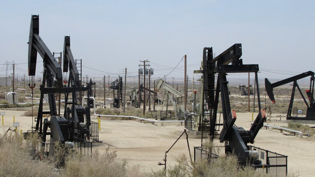
"caption": "Oil wells in Kern County, where much of California's fracking has taken place. ",
"description": null,
"title": "RS3844_OilPumps_20120711b-scr",
"credit": "Craig Miller/KQED",
"status": "inherit",
"isLoading": false,
"fetchFailed": false
},
"science_1940360": {
"type": "attachments",
"id": "science_1940360",
"meta": {
"index": "attachments_1716263798",
"site": "science",
"id": "1940360",
"found": true
},
"parent": 1940355,
"imgSizes": {
"twentyfourteen-full-width": {
"file": "https://ww2.kqed.org/app/uploads/sites/35/2029/04/ExtinctionRebellion_003-1038x576.jpg",
"width": 1038,
"mimeType": "image/jpeg",
"height": 576
},
"thumbnail": {
"file": "https://ww2.kqed.org/app/uploads/sites/35/2029/04/ExtinctionRebellion_003-160x113.jpg",
"width": 160,
"mimeType": "image/jpeg",
"height": 113
},
"post-thumbnail": {
"file": "https://ww2.kqed.org/app/uploads/sites/35/2029/04/ExtinctionRebellion_003-672x372.jpg",
"width": 672,
"mimeType": "image/jpeg",
"height": 372
},
"kqedFullSize": {
"file": "https://ww2.kqed.org/app/uploads/sites/35/2029/04/ExtinctionRebellion_003.jpg",
"width": 1920,
"height": 1359
},
"large": {
"file": "https://ww2.kqed.org/app/uploads/sites/35/2029/04/ExtinctionRebellion_003-1020x722.jpg",
"width": 1020,
"mimeType": "image/jpeg",
"height": 722
},
"complete_open_graph": {
"file": "https://ww2.kqed.org/app/uploads/sites/35/2029/04/ExtinctionRebellion_003-1200x849.jpg",
"width": 1200,
"mimeType": "image/jpeg",
"height": 849
},
"full-width": {
"file": "https://ww2.kqed.org/app/uploads/sites/35/2029/04/ExtinctionRebellion_003-1920x1359.jpg",
"width": 1920,
"mimeType": "image/jpeg",
"height": 1359
},
"medium": {
"file": "https://ww2.kqed.org/app/uploads/sites/35/2029/04/ExtinctionRebellion_003-800x566.jpg",
"width": 800,
"mimeType": "image/jpeg",
"height": 566
},
"medium_large": {
"file": "https://ww2.kqed.org/app/uploads/sites/35/2029/04/ExtinctionRebellion_003-768x544.jpg",
"width": 768,
"mimeType": "image/jpeg",
"height": 544
}
},
"publishDate": 1555442177,
"modified": 1555519132,
"caption": "International High School of San Francisco student Baxter Bhansali, age 15, joined fellow students and the Extinction Rebellion political group to participate in a youth climate event in San Francisco, Friday, April 15, 2019.",
"description": null,
"title": "ExtinctionRebellion_003",
"credit": null,
"status": "inherit",
"isLoading": false,
"fetchFailed": false
}
},
"audioPlayerReducer": {
"postId": "stream_live",
"isPaused": true,
"isPlaying": false,
"pfsActive": false,
"pledgeModalIsOpen": true,
"playerDrawerIsOpen": false,
"liveAudioPlayStartedAt": 0,
"liveAudioPlayContext": ""
},
"authorsReducer": {
"byline_science_1940697": {
"type": "authors",
"id": "byline_science_1940697",
"meta": {
"override": true
},
"slug": "byline_science_1940697",
"name": "\u003cstrong>Nayeli Peña, Evelyn Mendoza and Yvette Villicaña\u003cbr>Richmond High School\u003c/strong>",
"isLoading": false
},
"byline_science_1940714": {
"type": "authors",
"id": "byline_science_1940714",
"meta": {
"override": true
},
"slug": "byline_science_1940714",
"name": "\u003cstrong>Johanna Mendoza\u003c/strong>",
"isLoading": false
},
"byline_science_1940775": {
"type": "authors",
"id": "byline_science_1940775",
"meta": {
"override": true
},
"slug": "byline_science_1940775",
"name": "Jeffrey Brown and Leah Nagy",
"isLoading": false
},
"byline_science_1940755": {
"type": "authors",
"id": "byline_science_1940755",
"meta": {
"override": true
},
"slug": "byline_science_1940755",
"name": "Nathan Rott\u003c/br>NPR",
"isLoading": false
},
"byline_science_1940646": {
"type": "authors",
"id": "byline_science_1940646",
"meta": {
"override": true
},
"slug": "byline_science_1940646",
"name": "Rebecca Robbins\u003cbr />STAT",
"isLoading": false
},
"byline_science_1940480": {
"type": "authors",
"id": "byline_science_1940480",
"meta": {
"override": true
},
"slug": "byline_science_1940480",
"name": "Nell Greenfieldboyce\u003cbr />NPR",
"isLoading": false
},
"byline_science_1940250": {
"type": "authors",
"id": "byline_science_1940250",
"meta": {
"override": true
},
"slug": "byline_science_1940250",
"name": "Julie Cart\u003cbr />CALMatters",
"isLoading": false
},
"byline_science_1940355": {
"type": "authors",
"id": "byline_science_1940355",
"meta": {
"override": true
},
"slug": "byline_science_1940355",
"name": "Lindsey Moore",
"isLoading": false
},
"laurensommer": {
"type": "authors",
"id": "239",
"meta": {
"index": "authors_1716337520",
"id": "239",
"found": true
},
"name": "Lauren Sommer",
"firstName": "Lauren",
"lastName": "Sommer",
"slug": "laurensommer",
"email": "lsommer@kqed.org",
"display_author_email": false,
"staff_mastheads": [],
"title": "KQED Contributor",
"bio": "Lauren is a radio reporter formerly covering environment, water, and energy for KQED Science. As part of her day job, she has scaled Sierra Nevada peaks, run from charging elephant seals, and desperately tried to get her sea legs - all in pursuit of good radio. Her work has appeared on Marketplace, Living on Earth, Science Friday and NPR's Morning Edition and All Things Considered. You can find her on Twitter at \u003ca href=\"https://twitter.com/lesommer\">@lesommer\u003c/a>.",
"avatar": "https://secure.gravatar.com/avatar/33aa3772bb86c6ad45b8aca6a238bbdf?s=600&d=blank&r=g",
"twitter": null,
"facebook": null,
"instagram": null,
"linkedin": null,
"sites": [
{
"site": "news",
"roles": [
"author"
]
},
{
"site": "science",
"roles": [
"editor",
"manage_content_types",
"manage_taxonomies"
]
},
{
"site": "quest",
"roles": [
"editor"
]
}
],
"headData": {
"title": "Lauren Sommer | KQED",
"description": "KQED Contributor",
"ogImgSrc": "https://secure.gravatar.com/avatar/33aa3772bb86c6ad45b8aca6a238bbdf?s=600&d=blank&r=g",
"twImgSrc": "https://secure.gravatar.com/avatar/33aa3772bb86c6ad45b8aca6a238bbdf?s=600&d=blank&r=g"
},
"isLoading": false,
"link": "/author/laurensommer"
},
"kqedscience": {
"type": "authors",
"id": "6387",
"meta": {
"index": "authors_1716337520",
"id": "6387",
"found": true
},
"name": "KQED Science",
"firstName": "KQED",
"lastName": "Science",
"slug": "kqedscience",
"email": "kqedscience@gmail.com",
"display_author_email": false,
"staff_mastheads": [],
"title": null,
"bio": "KQED Science brings you award-winning science and environment coverage from the Bay Area and beyond by the flagship Northern California PBS and NPR affiliate.",
"avatar": "https://secure.gravatar.com/avatar/5a295ff49cf82a8c0f30937d3f788b2f?s=600&d=blank&r=g",
"twitter": null,
"facebook": null,
"instagram": null,
"linkedin": null,
"sites": [
{
"site": "science",
"roles": [
"contributor"
]
},
{
"site": "quest",
"roles": [
"editor"
]
},
{
"site": "food",
"roles": [
"contributor"
]
}
],
"headData": {
"title": "KQED Science | KQED",
"description": null,
"ogImgSrc": "https://secure.gravatar.com/avatar/5a295ff49cf82a8c0f30937d3f788b2f?s=600&d=blank&r=g",
"twImgSrc": "https://secure.gravatar.com/avatar/5a295ff49cf82a8c0f30937d3f788b2f?s=600&d=blank&r=g"
},
"isLoading": false,
"link": "/author/kqedscience"
},
"hhagemann": {
"type": "authors",
"id": "11578",
"meta": {
"index": "authors_1716337520",
"id": "11578",
"found": true
},
"name": "Hannah Hagemann",
"firstName": "Hannah",
"lastName": "Hagemann",
"slug": "hhagemann",
"email": "hhagemann@KQED.org",
"display_author_email": false,
"staff_mastheads": [],
"title": "KQED Contributor",
"bio": null,
"avatar": "https://secure.gravatar.com/avatar/c3af389deff545c719141a87524965d8?s=600&d=blank&r=g",
"twitter": null,
"facebook": null,
"instagram": null,
"linkedin": null,
"sites": [
{
"site": "news",
"roles": [
"author"
]
},
{
"site": "science",
"roles": [
"editor"
]
}
],
"headData": {
"title": "Hannah Hagemann | KQED",
"description": "KQED Contributor",
"ogImgSrc": "https://secure.gravatar.com/avatar/c3af389deff545c719141a87524965d8?s=600&d=blank&r=g",
"twImgSrc": "https://secure.gravatar.com/avatar/c3af389deff545c719141a87524965d8?s=600&d=blank&r=g"
},
"isLoading": false,
"link": "/author/hhagemann"
}
},
"pagesReducer": {
"science_category_news": {
"type": "terms",
"id": "science_40",
"meta": {
"index": "terms_1716263798",
"site": "science",
"id": "40",
"score": 10.814219
},
"featImg": null,
"name": "News",
"description": null,
"taxonomy": "category",
"headData": {
"twImgId": null,
"twTitle": null,
"ogTitle": null,
"ogImgId": null,
"twDescription": null,
"description": null,
"title": "News Archives | KQED Science",
"ogDescription": null
},
"ttid": 42,
"slug": "news",
"isLoading": false,
"title": "News",
"pageMeta": {
"site": "science",
"WpPageTemplate": "page-topic-editorial",
"currentPage": 140
},
"blocks": [
{
"blockName": "kqed/post-list",
"attrs": {
"layout": "cardArticle2",
"query": "posts/science?category=news",
"seeMore": false,
"paginated": true,
"page": 140
}
},
{
"blockName": "kqed/ad"
}
]
}
},
"pfsSessionReducer": {},
"postsReducer": {
"stream_live": {
"type": "live",
"id": "stream_live",
"audioUrl": "https://streams.kqed.org/kqedradio",
"title": "Live Stream",
"excerpt": "Live Stream information currently unavailable.",
"link": "/radio",
"featImg": "",
"label": {
"name": "KQED Live",
"link": "/"
}
},
"stream_kqedNewscast": {
"type": "posts",
"id": "stream_kqedNewscast",
"audioUrl": "https://www.kqed.org/.stream/anon/radio/RDnews/newscast.mp3?_=1",
"title": "KQED Newscast",
"featImg": "",
"label": {
"name": "88.5 FM",
"link": "/"
}
},
"science_1940744": {
"type": "posts",
"id": "science_1940744",
"meta": {
"index": "posts_1716263798",
"site": "science",
"id": "1940744",
"score": null,
"sort": [
1556566445000
]
},
"parent": 0,
"labelTerm": {
"site": "science"
},
"blocks": [],
"publishDate": 1556566445,
"format": "standard",
"title": "Threat to Sea Life as Greenhouse Gases Drift Offshore",
"headTitle": "Threat to Sea Life as Greenhouse Gases Drift Offshore | KQED",
"content": "\u003cp>Winds carrying greenhouse gases like carbon dioxide can travel up to 60 miles offshore, adding significantly more carbon dioxide into the ocean than previously estimated, according to new \u003ca href=\"https://journals.plos.org/plosone/article?id=10.1371/journal.pone.0214403\" target=\"_blank\" rel=\"noopener\">research\u003c/a> from the Monterey Bay Aquarium Research Institute.\u003c/p>\n\u003cp>Emissions from tailpipes and factories could be adding roughly 25 million metric tons of carbon dioxide per year into oceans worldwide\u003c/p>\n\u003cp>When carbon dioxide dissolves into seawater it makes oceans more acidic, and more uninhabitable for species like crabs and coral.\u003c/p>\n\u003cp>The extra carbon dioxide that the researchers measured means “more of a threat to some of the sea life that inhabits the ocean,” says Francisco Chavez, the study’s lead author.\u003c/p>\n\u003cp>It’s been widely understood that ships are heavyweight polluters in bays and oceans. But until now, the impact that land-based pollution has on waterways hasn’t been investigated.\u003c/p>\n\u003cp>[ad fullwidth]\u003c/p>\n\u003cp>That’s in part because the way researchers tracked carbon dioxide emissions in the past was on boats — Francisco Chavez said when researchers would document higher-than-expected carbon dioxide levels, it was assumed it was coming from the ships doing the measurements.\u003c/p>\n\u003cp>“Most of the measurements we make of carbon dioxide have been from ships,” Chavez said, “The higher carbon dioxide levels are often discounted because of the fact that ships are actually producers of CO2 just like our automobiles are.”\u003c/p>\n\u003cp>To solve that problem, Chavez and his team used robotic boats to track the amount of carbon dioxide blowing into the Monterey Bay and the Pacific, eliminating any stray emissions coming from boats.\u003c/p>\n\u003cp>They observed land-based carbon dioxide emissions drifting up to 100 kilometers, or 60 miles, off the coast.\u003c/p>\n\u003cp>“That’s a brand new piece of information,” says NOAA chemical oceanographer Richard Feely, who was not involved with the study. “That suggests we need to be monitoring the coastal region, not just in Monterey Bay but in other places as well.”\u003c/p>\n\u003cp>Feely suspects wherever there are sprawling cities and industry close to the coast, greenhouse gases are blowing over far distances into the ocean.\u003c/p>\n\u003cp>What’s more, the Monterey Bay Aquarium Research Institute team believes other pollutants such as heavy metals, sulfur dioxide and nitrogen gases might also be traveling out to sea.\u003c/p>\n\u003cp> \u003c/p>\n\u003cp> \u003c/p>\n\u003cp> \u003c/p>\n\u003cp> \u003c/p>\n\u003cp> \u003c/p>\n\u003cp> \u003c/p>\n\u003cp> \u003c/p>\n\u003cp> \u003c/p>\n\u003cp> \u003c/p>\n\u003cp> \u003c/p>\n\u003cp>\u003c/p>\n\u003cp> \u003c/p>\n\n",
"stats": {
"hasVideo": false,
"hasChartOrMap": false,
"hasAudio": false,
"hasPolis": false,
"wordCount": 398,
"hasGoogleForm": false,
"hasGallery": false,
"hasHearkenModule": false,
"iframeSrcs": [],
"paragraphCount": 14
},
"modified": 1704848713,
"excerpt": "Winds carrying greenhouse gases like carbon dioxide can travel up to 60 miles offshore, adding significantly more carbon dioxide into the ocean than previously estimated.",
"headData": {
"twImgId": "",
"twTitle": "",
"ogTitle": "",
"ogImgId": "",
"twDescription": "",
"description": "Winds carrying greenhouse gases like carbon dioxide can travel up to 60 miles offshore, adding significantly more carbon dioxide into the ocean than previously estimated.",
"title": "Threat to Sea Life as Greenhouse Gases Drift Offshore | KQED",
"ogDescription": "",
"schema": {
"@context": "https://schema.org",
"@type": "Article",
"headline": "Threat to Sea Life as Greenhouse Gases Drift Offshore",
"datePublished": "2019-04-29T12:34:05-07:00",
"dateModified": "2024-01-09T17:05:13-08:00",
"image": "https://cdn.kqed.org/wp-content/uploads/2020/02/KQED-OG-Image@1x.png"
}
},
"guestAuthors": [],
"slug": "threat-to-sea-life-as-greenhouse-gases-drift-offshore",
"status": "publish",
"sticky": false,
"path": "/science/1940744/threat-to-sea-life-as-greenhouse-gases-drift-offshore",
"audioTrackLength": null,
"parsedContent": [
{
"type": "contentString",
"content": "\u003cdiv class=\"post-body\">\u003cp>\u003cp>Winds carrying greenhouse gases like carbon dioxide can travel up to 60 miles offshore, adding significantly more carbon dioxide into the ocean than previously estimated, according to new \u003ca href=\"https://journals.plos.org/plosone/article?id=10.1371/journal.pone.0214403\" target=\"_blank\" rel=\"noopener\">research\u003c/a> from the Monterey Bay Aquarium Research Institute.\u003c/p>\n\u003cp>Emissions from tailpipes and factories could be adding roughly 25 million metric tons of carbon dioxide per year into oceans worldwide\u003c/p>\n\u003cp>When carbon dioxide dissolves into seawater it makes oceans more acidic, and more uninhabitable for species like crabs and coral.\u003c/p>\n\u003cp>The extra carbon dioxide that the researchers measured means “more of a threat to some of the sea life that inhabits the ocean,” says Francisco Chavez, the study’s lead author.\u003c/p>\n\u003cp>It’s been widely understood that ships are heavyweight polluters in bays and oceans. But until now, the impact that land-based pollution has on waterways hasn’t been investigated.\u003c/p>\n\u003cp>\u003c/p>\u003c/div>",
"attributes": {
"named": {},
"numeric": []
}
},
{
"type": "component",
"content": "",
"name": "ad",
"attributes": {
"named": {
"label": "fullwidth"
},
"numeric": [
"fullwidth"
]
}
},
{
"type": "contentString",
"content": "\u003cdiv class=\"post-body\">\u003cp>\u003c/p>\n\u003cp>That’s in part because the way researchers tracked carbon dioxide emissions in the past was on boats — Francisco Chavez said when researchers would document higher-than-expected carbon dioxide levels, it was assumed it was coming from the ships doing the measurements.\u003c/p>\n\u003cp>“Most of the measurements we make of carbon dioxide have been from ships,” Chavez said, “The higher carbon dioxide levels are often discounted because of the fact that ships are actually producers of CO2 just like our automobiles are.”\u003c/p>\n\u003cp>To solve that problem, Chavez and his team used robotic boats to track the amount of carbon dioxide blowing into the Monterey Bay and the Pacific, eliminating any stray emissions coming from boats.\u003c/p>\n\u003cp>They observed land-based carbon dioxide emissions drifting up to 100 kilometers, or 60 miles, off the coast.\u003c/p>\n\u003cp>“That’s a brand new piece of information,” says NOAA chemical oceanographer Richard Feely, who was not involved with the study. “That suggests we need to be monitoring the coastal region, not just in Monterey Bay but in other places as well.”\u003c/p>\n\u003cp>Feely suspects wherever there are sprawling cities and industry close to the coast, greenhouse gases are blowing over far distances into the ocean.\u003c/p>\n\u003cp>What’s more, the Monterey Bay Aquarium Research Institute team believes other pollutants such as heavy metals, sulfur dioxide and nitrogen gases might also be traveling out to sea.\u003c/p>\n\u003cp> \u003c/p>\n\u003cp> \u003c/p>\n\u003cp> \u003c/p>\n\u003cp> \u003c/p>\n\u003cp> \u003c/p>\n\u003cp> \u003c/p>\n\u003cp> \u003c/p>\n\u003cp> \u003c/p>\n\u003cp> \u003c/p>\n\u003cp> \u003c/p>\n\u003cp>\u003c/p>\n\u003cp> \u003c/p>\n\n\u003c/div>\u003c/p>",
"attributes": {
"named": {},
"numeric": []
}
}
],
"link": "/science/1940744/threat-to-sea-life-as-greenhouse-gases-drift-offshore",
"authors": [
"11578"
],
"categories": [
"science_31",
"science_40"
],
"tags": [
"science_194",
"science_3840",
"science_3370",
"science_3834"
],
"featImg": "science_1940895",
"label": "science"
},
"science_1940697": {
"type": "posts",
"id": "science_1940697",
"meta": {
"index": "posts_1716263798",
"site": "science",
"id": "1940697",
"score": null,
"sort": [
1556541014000
]
},
"parent": 0,
"labelTerm": {},
"blocks": [],
"publishDate": 1556541014,
"format": "audio",
"title": "Ever Wake Up Frozen in the Middle of the Night, With a Shadowy Figure in the Room?",
"headTitle": "Ever Wake Up Frozen in the Middle of the Night, With a Shadowy Figure in the Room? | KQED",
"content": "\u003cp>\u003cem>Editor’s note: The following story was produced by Richmond High School students for \u003ca href=\"https://ww2.kqed.org/education/2018/04/18/youth-takeover-of-kqed-news-starts-april-23/\" target=\"_blank\" rel=\"noopener\">\u003cspan style=\"font-weight: 400\">Youth Takeover\u003c/span>\u003c/a> week at KQED.\u003c/em>\u003c/p>\n\u003cp>Imagine you’re asleep and you suddenly open your eyes. You try to reposition yourself, but something’s wrong. Your body won’t move, and it’s as if something is holding you down. You hear scratching in the corner of the room, then see a pitch-black figure. You think it’s just your mind playing tricks, until the figure starts moving, slowly. It’s getting closer. You shut your eyes, but you can hear it shuffling toward you.\u003c/p>\n\u003cp>This is what sleep paralysis is like.\u003c/p>\n\u003cp>\u003cspan style=\"font-weight: 400\">Sleep paralysis usually occurs when you’re, well, asleep, says Allen Jenkins, a psychology teacher at Richmond High School.\u003c/span>\u003c/p>\n\u003cp>\u003cspan style=\"font-weight: 400\">“Your brain is telling you to go to sleep and to not move, because when you walk around in your sleep, that’s not good,” he said. “But some people have a problem with that not turning off. So when they wake up, they still can’t move.” \u003c/span>\u003c/p>\n\u003cp>[ad fullwidth]\u003c/p>\n\u003cp>\u003cspan style=\"font-weight: 400\">People undergoing sleep paralysis might also feel pressure on their chest, a sense of dread and difficulty taking a breath. Some people also report experiencing hallucinations, like a shadowy figure in the darkness. \u003c/span>\u003c/p>\n\u003cp>\u003cspan style=\"font-weight: 400\">Even if a person experiences stimulation that doesn’t come from their environment, it can still happen within their brain. \u003c/span>\u003c/p>\n\u003cp>\u003cspan style=\"font-weight: 400\">“Everything you experience is perception. Your processing in your brain can be overactive,” Jenkins said. \u003c/span>\u003cspan style=\"font-weight: 400\">“You can think of it like dreaming when you’re wide awake. It seems real to you, but it just doesn’t happen to be occurring.” \u003c/span>\u003c/p>\n\u003cp>\u003cspan style=\"font-weight: 400\">Leslie Saechao, a student at Richmond High School, has experienced sleep paralysis. “I felt like I saw something in the dark. It was like a figure,” she said.\u003c/span>\u003c/p>\n\u003cfigure id=\"attachment_1940747\" class=\"wp-caption alignright\" style=\"max-width: 756px\">\u003cimg loading=\"lazy\" decoding=\"async\" class=\"wp-image-1940747 size-full\" src=\"https://ww2.kqed.org/science/wp-content/uploads/sites/35/2029/04/sleep-paralysis.jpeg\" alt=\"\" width=\"756\" height=\"933\" srcset=\"https://cdn.kqed.org/wp-content/uploads/sites/35/2029/04/sleep-paralysis.jpeg 1512w, https://cdn.kqed.org/wp-content/uploads/sites/35/2029/04/sleep-paralysis-160x197.jpeg 160w, https://cdn.kqed.org/wp-content/uploads/sites/35/2029/04/sleep-paralysis-800x987.jpeg 800w, https://cdn.kqed.org/wp-content/uploads/sites/35/2029/04/sleep-paralysis-768x948.jpeg 768w, https://cdn.kqed.org/wp-content/uploads/sites/35/2029/04/sleep-paralysis-1020x1259.jpeg 1020w, https://cdn.kqed.org/wp-content/uploads/sites/35/2029/04/sleep-paralysis-972x1200.jpeg 972w\" sizes=\"(max-width: 756px) 100vw, 756px\">\u003cfigcaption class=\"wp-caption-text\">Nayeli Pena, Yvette Villicana and Evelyn Mendoza, Richmond High School students.\u003c/figcaption>\u003c/figure>\n\u003cp>Saechao recalls lying in bed awake past midnight, feeling “paralyzed,” and seeing a blurry figure.\u003c/p>\n\u003cp>The incident has made her “paranoid” about sleeping, so she covers her face at night.\u003c/p>\n\u003cp>“I sleep next to the wall so I won’t see anything,” she said.\u003c/p>\n\u003cp>Sleep paralysis can occur as you fall asleep or as you wake up. It goes away by itself after a few seconds or a few minutes. People who experience this are usually in their teens, 20s and 30s.\u003c/p>\n\u003cp>Researchers believe sleep paralysis happens when someone’s sleep cycle is disrupted, and especially when they’re in a dream state. This occurs in the rapid eye movement or REM stage of sleep, and can be caused by anxiety and stress.\u003c/p>\n\u003cp>Yvette Villicaña first experienced sleep paralysis when she was in middle school.\u003c/p>\n\u003cp>“It’s not as overwhelming for me as other people, because I don’t see shadowy figures,” she said. “I try to move, but sometimes I can’t. And after some time, it does go away. I used to think I was the only \u003cspan style=\"font-weight: 400\">one who experienced this.”\u003c/span>\u003c/p>\n\u003cp>\u003cspan style=\"font-weight: 400\"> After working on this story for KQED’s “\u003ca href=\"https://ww2.kqed.org/education/2018/04/18/youth-takeover-of-kqed-news-starts-april-23/\">Youth Takeover\u003c/a>,” Villicaña says it’s good to know she’s not alone, but it’s tough to realize other people have more traumatic experiences because of their hallucinations.\u003c/span>\u003c/p>\n\u003cp>Sleep paralysis is harmless by itself but can lead to insomnia or narcolepsy, a more serious condition that causes uncontrollable sleepiness during the day.\u003c/p>\n\u003cp>\u003c/p>\n\u003cp>\u003cspan style=\"font-weight: 400\">You can try to stop sleep paralysis by avoiding naps and not sleeping on your back, because it makes you feel vulnerable. Consult a mental health professional for stress or anxiety. And if it doesn’t go away, seek help from a sleep specialist. \u003c/span>\u003c/p>\n\n",
"stats": {
"hasVideo": false,
"hasChartOrMap": false,
"hasAudio": false,
"hasPolis": false,
"wordCount": 653,
"hasGoogleForm": false,
"hasGallery": false,
"hasHearkenModule": false,
"iframeSrcs": [],
"paragraphCount": 21
},
"modified": 1704848716,
"excerpt": "You wake up in the middle of the night and see a pitch-black figure. It must be your mind playing tricks. But then the figure starts moving toward you, and you feel frozen. What's going on, here? ",
"headData": {
"twImgId": "",
"twTitle": "",
"ogTitle": "",
"ogImgId": "",
"twDescription": "",
"description": "You wake up in the middle of the night and see a pitch-black figure. It must be your mind playing tricks. But then the figure starts moving toward you, and you feel frozen. What's going on, here? ",
"title": "Ever Wake Up Frozen in the Middle of the Night, With a Shadowy Figure in the Room? | KQED",
"ogDescription": "",
"schema": {
"@context": "https://schema.org",
"@type": "Article",
"headline": "Ever Wake Up Frozen in the Middle of the Night, With a Shadowy Figure in the Room?",
"datePublished": "2019-04-29T05:30:14-07:00",
"dateModified": "2024-01-09T17:05:16-08:00",
"image": "https://cdn.kqed.org/wp-content/uploads/2020/02/KQED-OG-Image@1x.png"
}
},
"guestAuthors": [],
"slug": "ever-wake-up-frozen-in-the-middle-of-the-night-with-a-shadowy-figure-in-the-room-thats-sleep-paralysis",
"status": "publish",
"audioUrl": "https://www.kqed.org/.stream/anon/radio/science/2019/04/YTOSleepParalysis.mp3",
"nprByline": "\u003cstrong>Nayeli Peña, Evelyn Mendoza and Yvette Villicaña\u003cbr>Richmond High School\u003c/strong>",
"sticky": false,
"audioTrackLength": 286,
"source": "KQED Youth Takeover",
"path": "/science/1940697/ever-wake-up-frozen-in-the-middle-of-the-night-with-a-shadowy-figure-in-the-room-thats-sleep-paralysis",
"parsedContent": [
{
"type": "contentString",
"content": "\u003cdiv class=\"post-body\">\u003cp>\u003cp>\u003cem>Editor’s note: The following story was produced by Richmond High School students for \u003ca href=\"https://ww2.kqed.org/education/2018/04/18/youth-takeover-of-kqed-news-starts-april-23/\" target=\"_blank\" rel=\"noopener\">\u003cspan style=\"font-weight: 400\">Youth Takeover\u003c/span>\u003c/a> week at KQED.\u003c/em>\u003c/p>\n\u003cp>Imagine you’re asleep and you suddenly open your eyes. You try to reposition yourself, but something’s wrong. Your body won’t move, and it’s as if something is holding you down. You hear scratching in the corner of the room, then see a pitch-black figure. You think it’s just your mind playing tricks, until the figure starts moving, slowly. It’s getting closer. You shut your eyes, but you can hear it shuffling toward you.\u003c/p>\n\u003cp>This is what sleep paralysis is like.\u003c/p>\n\u003cp>\u003cspan style=\"font-weight: 400\">Sleep paralysis usually occurs when you’re, well, asleep, says Allen Jenkins, a psychology teacher at Richmond High School.\u003c/span>\u003c/p>\n\u003cp>\u003cspan style=\"font-weight: 400\">“Your brain is telling you to go to sleep and to not move, because when you walk around in your sleep, that’s not good,” he said. “But some people have a problem with that not turning off. So when they wake up, they still can’t move.” \u003c/span>\u003c/p>\n\u003cp>\u003c/p>\u003c/div>",
"attributes": {
"named": {},
"numeric": []
}
},
{
"type": "component",
"content": "",
"name": "ad",
"attributes": {
"named": {
"label": "fullwidth"
},
"numeric": [
"fullwidth"
]
}
},
{
"type": "contentString",
"content": "\u003cdiv class=\"post-body\">\u003cp>\u003c/p>\n\u003cp>\u003cspan style=\"font-weight: 400\">People undergoing sleep paralysis might also feel pressure on their chest, a sense of dread and difficulty taking a breath. Some people also report experiencing hallucinations, like a shadowy figure in the darkness. \u003c/span>\u003c/p>\n\u003cp>\u003cspan style=\"font-weight: 400\">Even if a person experiences stimulation that doesn’t come from their environment, it can still happen within their brain. \u003c/span>\u003c/p>\n\u003cp>\u003cspan style=\"font-weight: 400\">“Everything you experience is perception. Your processing in your brain can be overactive,” Jenkins said. \u003c/span>\u003cspan style=\"font-weight: 400\">“You can think of it like dreaming when you’re wide awake. It seems real to you, but it just doesn’t happen to be occurring.” \u003c/span>\u003c/p>\n\u003cp>\u003cspan style=\"font-weight: 400\">Leslie Saechao, a student at Richmond High School, has experienced sleep paralysis. “I felt like I saw something in the dark. It was like a figure,” she said.\u003c/span>\u003c/p>\n\u003cfigure id=\"attachment_1940747\" class=\"wp-caption alignright\" style=\"max-width: 756px\">\u003cimg loading=\"lazy\" decoding=\"async\" class=\"wp-image-1940747 size-full\" src=\"https://ww2.kqed.org/science/wp-content/uploads/sites/35/2029/04/sleep-paralysis.jpeg\" alt=\"\" width=\"756\" height=\"933\" srcset=\"https://cdn.kqed.org/wp-content/uploads/sites/35/2029/04/sleep-paralysis.jpeg 1512w, https://cdn.kqed.org/wp-content/uploads/sites/35/2029/04/sleep-paralysis-160x197.jpeg 160w, https://cdn.kqed.org/wp-content/uploads/sites/35/2029/04/sleep-paralysis-800x987.jpeg 800w, https://cdn.kqed.org/wp-content/uploads/sites/35/2029/04/sleep-paralysis-768x948.jpeg 768w, https://cdn.kqed.org/wp-content/uploads/sites/35/2029/04/sleep-paralysis-1020x1259.jpeg 1020w, https://cdn.kqed.org/wp-content/uploads/sites/35/2029/04/sleep-paralysis-972x1200.jpeg 972w\" sizes=\"(max-width: 756px) 100vw, 756px\">\u003cfigcaption class=\"wp-caption-text\">Nayeli Pena, Yvette Villicana and Evelyn Mendoza, Richmond High School students.\u003c/figcaption>\u003c/figure>\n\u003cp>Saechao recalls lying in bed awake past midnight, feeling “paralyzed,” and seeing a blurry figure.\u003c/p>\n\u003cp>The incident has made her “paranoid” about sleeping, so she covers her face at night.\u003c/p>\n\u003cp>“I sleep next to the wall so I won’t see anything,” she said.\u003c/p>\n\u003cp>Sleep paralysis can occur as you fall asleep or as you wake up. It goes away by itself after a few seconds or a few minutes. People who experience this are usually in their teens, 20s and 30s.\u003c/p>\n\u003cp>Researchers believe sleep paralysis happens when someone’s sleep cycle is disrupted, and especially when they’re in a dream state. This occurs in the rapid eye movement or REM stage of sleep, and can be caused by anxiety and stress.\u003c/p>\n\u003cp>Yvette Villicaña first experienced sleep paralysis when she was in middle school.\u003c/p>\n\u003cp>“It’s not as overwhelming for me as other people, because I don’t see shadowy figures,” she said. “I try to move, but sometimes I can’t. And after some time, it does go away. I used to think I was the only \u003cspan style=\"font-weight: 400\">one who experienced this.”\u003c/span>\u003c/p>\n\u003cp>\u003cspan style=\"font-weight: 400\"> After working on this story for KQED’s “\u003ca href=\"https://ww2.kqed.org/education/2018/04/18/youth-takeover-of-kqed-news-starts-april-23/\">Youth Takeover\u003c/a>,” Villicaña says it’s good to know she’s not alone, but it’s tough to realize other people have more traumatic experiences because of their hallucinations.\u003c/span>\u003c/p>\n\u003cp>Sleep paralysis is harmless by itself but can lead to insomnia or narcolepsy, a more serious condition that causes uncontrollable sleepiness during the day.\u003c/p>\n\u003cp>\u003c/p>\n\u003cp>\u003cspan style=\"font-weight: 400\">You can try to stop sleep paralysis by avoiding naps and not sleeping on your back, because it makes you feel vulnerable. Consult a mental health professional for stress or anxiety. And if it doesn’t go away, seek help from a sleep specialist. \u003c/span>\u003c/p>\n\n\u003c/div>\u003c/p>",
"attributes": {
"named": {},
"numeric": []
}
}
],
"link": "/science/1940697/ever-wake-up-frozen-in-the-middle-of-the-night-with-a-shadowy-figure-in-the-room-thats-sleep-paralysis",
"authors": [
"byline_science_1940697"
],
"categories": [
"science_3890",
"science_40"
],
"tags": [
"science_3370",
"science_3833",
"science_3834"
],
"featImg": "science_1940725",
"label": "source_science_1940697"
},
"science_1940714": {
"type": "posts",
"id": "science_1940714",
"meta": {
"index": "posts_1716263798",
"site": "science",
"id": "1940714",
"score": null,
"sort": [
1556539228000
]
},
"parent": 0,
"labelTerm": {},
"blocks": [],
"publishDate": 1556539228,
"format": "standard",
"title": "Commentary: Teens Need Information and Guidance About Sex",
"headTitle": "Commentary: Teens Need Information and Guidance About Sex | KQED",
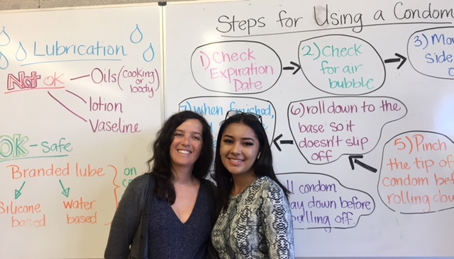
"content": "\u003cp>\u003ci>Editor’s note: The following story was produced by an Ygnacio Valley High School student for \u003c/i>\u003ca href=\"https://ww2.kqed.org/education/2018/04/18/youth-takeover-of-kqed-news-starts-april-23/\" target=\"_blank\" rel=\"noopener\">\u003ci>\u003cspan style=\"font-weight: 400\">Youth Takeover\u003c/span>\u003c/i>\u003c/a> week at KQED.\u003c/p>\n\u003cp>As a teenage girl, I know the feeling of not being able to bring up teen pregnancy or talk about sex-related conversations with my parents. For many, the subject is awkward and uncomfortable.\u003c/p>\n\u003cp>This was the case for me, until this year.\u003c/p>\n\u003cp>Before coming to Ygnacio Valley High School, I was never really educated about sex and how to make educated decisions regarding contraception methods. And yet, my parents expect me not to get pregnant.\u003c/p>\n\u003cp>While I am not worried about getting pregnant, something I have observed is that when it happens, the young woman is usually shamed.\u003c/p>\n\u003cp>Our parents should learn how to normalize sex-related conversations. For example, my friend was having unprotected sex. When I asked her why, she said it was because she’s only 14 and doesn’t think she is able to get pregnant. If she had taken a class or had an adult in her life she could talk to, I think she would make educated decisions.\u003c/p>\n\u003cp>These days teens learn misguided or fictional information on social media, websites, even TV. Most teenagers I know use the pull-out method, not knowing they can still get pregnant or end up with a sexually transmitted infection.\u003c/p>\n\u003cp>Here at Ygnacio Valley High School, I applaud Ms. Lamb’s healthy living class, in which she teaches about safe sex, contraception, consent, sexuality, and sexually transmitted illnesses. As a teenage girl, I wish society would normalize teen sex, so that adults and teens would be able to talk about it with less awkwardness. It would make a huge impact on teen pregnancies. And it helps the boys, too, not just the girls. \u003cspan style=\"font-weight: 400\">From talking with my girlfriends, we’ve realized some teenage boys don’t even know how to put on a condom, so sometimes they say they don’t want to use it. \u003c/span>\u003c/p>\n\u003cp>\u003cspan style=\"font-weight: 400\">My friends and I don’t always have someone to talk with about how to handle a situation like that. Every teen should have at least one individual who can help them through these confusing years. \u003c/span>\u003c/p>\n\u003cp>[ad fullwidth]\u003c/p>\n\u003cp>\u003c/p>\n",
"stats": {
"hasVideo": false,
"hasChartOrMap": false,
"hasAudio": false,
"hasPolis": false,
"wordCount": 376,
"hasGoogleForm": false,
"hasGallery": false,
"hasHearkenModule": false,
"iframeSrcs": [],
"paragraphCount": 11
},
"modified": 1704848718,
"excerpt": "As a teenage girl, I know the feeling of not being able to bring up teen pregnancy or talk about sex-related conversations with my parents. The subject is awkward and uncomfortable for many. This was the case for me, until this year.",
"headData": {
"twImgId": "",
"twTitle": "",
"ogTitle": "",
"ogImgId": "",
"twDescription": "",
"description": "As a teenage girl, I know the feeling of not being able to bring up teen pregnancy or talk about sex-related conversations with my parents. The subject is awkward and uncomfortable for many. This was the case for me, until this year.",
"title": "Commentary: Teens Need Information and Guidance About Sex | KQED",
"ogDescription": "",
"schema": {
"@context": "https://schema.org",
"@type": "Article",
"headline": "Commentary: Teens Need Information and Guidance About Sex",
"datePublished": "2019-04-29T05:00:28-07:00",
"dateModified": "2024-01-09T17:05:18-08:00",
"image": "https://cdn.kqed.org/wp-content/uploads/2020/02/KQED-OG-Image@1x.png"
}
},
"guestAuthors": [],
"slug": "commentary-teens-need-information-and-guidance-on-sex",
"status": "publish",
"templateType": "standard",
"audioUrl": "https://www.kqed.org/.stream/anon/radio/science/2019/04/YTOSexEd.mp3",
"nprByline": "\u003cstrong>Johanna Mendoza\u003c/strong>",
"featuredImageType": "standard",
"sticky": false,
"audioTrackLength": 165,
"source": "Youth Takeover",
"path": "/science/1940714/commentary-teens-need-information-and-guidance-on-sex",
"parsedContent": [
{
"type": "contentString",
"content": "\u003cdiv class=\"post-body\">\u003cp>\u003cp>\u003ci>Editor’s note: The following story was produced by an Ygnacio Valley High School student for \u003c/i>\u003ca href=\"https://ww2.kqed.org/education/2018/04/18/youth-takeover-of-kqed-news-starts-april-23/\" target=\"_blank\" rel=\"noopener\">\u003ci>\u003cspan style=\"font-weight: 400\">Youth Takeover\u003c/span>\u003c/i>\u003c/a> week at KQED.\u003c/p>\n\u003cp>As a teenage girl, I know the feeling of not being able to bring up teen pregnancy or talk about sex-related conversations with my parents. For many, the subject is awkward and uncomfortable.\u003c/p>\n\u003cp>This was the case for me, until this year.\u003c/p>\n\u003cp>Before coming to Ygnacio Valley High School, I was never really educated about sex and how to make educated decisions regarding contraception methods. And yet, my parents expect me not to get pregnant.\u003c/p>\n\u003cp>While I am not worried about getting pregnant, something I have observed is that when it happens, the young woman is usually shamed.\u003c/p>\n\u003cp>Our parents should learn how to normalize sex-related conversations. For example, my friend was having unprotected sex. When I asked her why, she said it was because she’s only 14 and doesn’t think she is able to get pregnant. If she had taken a class or had an adult in her life she could talk to, I think she would make educated decisions.\u003c/p>\n\u003cp>These days teens learn misguided or fictional information on social media, websites, even TV. Most teenagers I know use the pull-out method, not knowing they can still get pregnant or end up with a sexually transmitted infection.\u003c/p>\n\u003cp>Here at Ygnacio Valley High School, I applaud Ms. Lamb’s healthy living class, in which she teaches about safe sex, contraception, consent, sexuality, and sexually transmitted illnesses. As a teenage girl, I wish society would normalize teen sex, so that adults and teens would be able to talk about it with less awkwardness. It would make a huge impact on teen pregnancies. And it helps the boys, too, not just the girls. \u003cspan style=\"font-weight: 400\">From talking with my girlfriends, we’ve realized some teenage boys don’t even know how to put on a condom, so sometimes they say they don’t want to use it. \u003c/span>\u003c/p>\n\u003cp>\u003cspan style=\"font-weight: 400\">My friends and I don’t always have someone to talk with about how to handle a situation like that. Every teen should have at least one individual who can help them through these confusing years. \u003c/span>\u003c/p>\n\u003cp>\u003c/p>\u003c/div>",
"attributes": {
"named": {},
"numeric": []
}
},
{
"type": "component",
"content": "",
"name": "ad",
"attributes": {
"named": {
"label": "fullwidth"
},
"numeric": [
"fullwidth"
]
}
},
{
"type": "contentString",
"content": "\u003cdiv class=\"post-body\">\u003cp>\u003c/p>\n\u003cp>\u003c/p>\n\u003c/div>\u003c/p>",
"attributes": {
"named": {},
"numeric": []
}
}
],
"link": "/science/1940714/commentary-teens-need-information-and-guidance-on-sex",
"authors": [
"byline_science_1940714"
],
"categories": [
"science_39",
"science_40"
],
"tags": [
"science_3833",
"science_3834"
],
"featImg": "science_1940830",
"label": "source_science_1940714"
},
"science_1940775": {
"type": "posts",
"id": "science_1940775",
"meta": {
"index": "posts_1716263798",
"site": "science",
"id": "1940775",
"score": null,
"sort": [
1556301788000
]
},
"parent": 0,
"labelTerm": {},
"blocks": [],
"publishDate": 1556301788,
"format": "video",
"title": "Do Chimpanzees Have the Same Emotions as Humans?",
"headTitle": "Do Chimpanzees Have the Same Emotions as Humans? | KQED",
"content": "\u003cp>What can humans learn about ourselves from studying chimpanzees? Primatologist Frans de Waal has spent almost three decades studying the behavior and intelligence of chimpanzees. Now, he’s focused on their emotional lives–and he’s found primates and people aren’t so different in how they react to circumstances and each other. Jeffrey Brown talks to de Waal about the implications of his findings.\u003c/p>\n\u003cp>\u003cstrong>Judy Woodruff:\u003c/strong>\u003c/p>\n\u003cp>You often hear about studies of animal intelligence and behavior. But tonight, we explore a different question — what can we learn about ourselves from studying the inner lives of chimpanzees?\u003c/p>\n\u003cp>Jeffrey Brown talked to primatologist Frans de Waal about his new book exploring the emotions of primates.\u003c/p>\n\u003cp>\u003cstrong>Frans de Waal:\u003c/strong>\u003c/p>\n\u003cp>You see the rain face? I always see disgust in their faces when it rains.\u003c/p>\n\u003cp>[ad fullwidth]\u003c/p>\n\u003cp>\u003cstrong>Jeffrey Brown:\u003c/strong>\u003c/p>\n\u003cp>Call it the “rain face” — a look of disgust, in the midst of a downpour. It’s an expression of emotional life in animals as well as people, according to primatologist Frans de Waal.\u003c/p>\n\u003cp>So, they’re venturing out, huh?\u003c/p>\n\u003cp>\u003cstrong>Frans de Waal:\u003c/strong>\u003c/p>\n\u003cp>Yes.\u003c/p>\n\u003cp>\u003cstrong>Jeffrey Brown:\u003c/strong>\u003c/p>\n\u003cp>In the mud, in the rain.\u003c/p>\n\u003cp>\u003cstrong>Frans de Waal:\u003c/strong>\u003c/p>\n\u003cp>Well, it is because of food —\u003c/p>\n\u003cp>\u003cstrong>Jeffrey Brown:\u003c/strong>\u003c/p>\n\u003cp>We all had our “rain faces” on during a recent wet visit to the Yerkes National Primate Research Center, part of Emory University, outside Atlanta, Georgia, where de Waal has worked for nearly three decades.\u003c/p>\n\u003cp>\u003cstrong>Frans de Waal:\u003c/strong>\u003c/p>\n\u003cp>They don’t like to get their hands wet, you know? You see that?\u003c/p>\n\u003cp>\u003cstrong>Jeffrey Brown:\u003c/strong>\u003c/p>\n\u003cp>And helped change the way we think about animals and humans.\u003c/p>\n\u003cp>So, you don’t buy the idea that we could say disgust is only a human emotion?\u003c/p>\n\u003cp>\u003cstrong>Frans de Waal:\u003c/strong>\u003c/p>\n\u003cp>No. I’m not sure that there are any uniquely human emotions. We may have a wider applicability of these emotions, and they may be more sophisticated, but they are not fundamentally different. I haven’t seen anything of a fundamental difference in the emotions.\u003c/p>\n\u003cp>I have known many alpha males in life, chimpanzee alpha males.\u003c/p>\n\u003cp>\u003cstrong>Jeffrey Brown:\u003c/strong>\u003c/p>\n\u003cp>De Waal is renowned for his work on animal intelligence — experiments that show the ability to use tools, plan, cooperate, and more. He’s author of a dozen books, the last titled, “Are We Smart Enough to Know How Smart Animals Are?”\u003c/p>\n\u003cp>Now, he’s focused on their emotional life.\u003c/p>\n\u003cp>\u003cstrong>Frans de Waal:\u003c/strong>\u003c/p>\n\u003cp>All my work has always dealt with emotions, even though I’m trained as a biologist not to talk explicitly about emotions.\u003c/p>\n\u003cp>\u003cstrong>Jeffrey Brown:\u003c/strong>\u003c/p>\n\u003cp>Whoa, whoa, whoa, why?\u003c/p>\n\u003cp>\u003cstrong>Frans de Waal:\u003c/strong>\u003c/p>\n\u003cp>Well, I was trained by my professors that emotions were taboo as a topic. You could talk about the “motivation” of animals and the “attention to things,” but the “emotions” was a sort of taboo topic.\u003c/p>\n\u003cp>\u003cstrong>Jeffrey Brown:\u003c/strong>\u003c/p>\n\u003cp>The change in thinking over the last two decades is reflected in de Waal’s new book “Mama’s Last Hug.”\u003c/p>\n\u003cp>Mama was an elderly chimp, nearing death. In 2016, Jan van Hooff, a mentor of de Waals who’d spent years studying and bonding with Mama, came to pay a final visit. Mama locks her old friend in her arms — a rare, physical display of affection between the species.\u003c/p>\n\u003cp>\u003cstrong>Frans de Waal:\u003c/strong>\u003c/p>\n\u003cp>It is almost as if she’s calming him down. I think seeing Jan, who was my professor so I know him very well, I think he must have hesitated, because we never go into a cage with a chimp. It’s dangerous. It’s just not done.\u003c/p>\n\u003cp>So to go in there, he must have been a bit nervous. And it’s almost as if she has sensed that and she calmed him down, instead of him calming her down.\u003c/p>\n\u003cp>\u003cstrong>Jeffrey Brown:\u003c/strong>\u003c/p>\n\u003cp>What’s going on here? De Waal cautions against speaking of Mama’s feelings — which he defines as her internal subjective state. But it is possible, he believes, to observe behavior expressing emotions, such as fear, amusement, and empathy.\u003c/p>\n\u003cp>\u003cstrong>Frans de Waal:\u003c/strong>\u003c/p>\n\u003cp>The human studies of empathy started with children, where scientists would ask a family member in the home to cry, and then they would see how very young children respond to them. And very young children who can barely walk, they walk up to this person and touch them and stroke them and try to calm them down.\u003c/p>\n\u003cp>And when I heard about that, I said, well, if that is empathy, then I have plenty of empathy in my chimps, because the chimps do this all the time. Someone has lost the fight, has been screaming, sits in a corner. Other chimps come over and embrace them and kiss them and calm them down and groom them.\u003c/p>\n\u003cp>\u003cstrong>Jeffrey Brown:\u003c/strong>\u003c/p>\n\u003cp>In an experiment de Waal often shows audiences, a capuchin monkey is fed cucumbers and seems perfectly happy — until seeing a neighbor getting sweet grapes.\u003c/p>\n\u003cp>\u003cstrong>Frans de Waal:\u003c/strong>\u003c/p>\n\u003cp>People laugh because they — they laugh because they suddenly recognize themselves in the behavior of animals.\u003c/p>\n\u003cp>\u003cstrong>Jeffrey Brown:\u003c/strong>\u003c/p>\n\u003cp>Yes.\u003c/p>\n\u003cp>\u003cstrong>Frans de Waal:\u003c/strong>\u003c/p>\n\u003cp>And they’re sort of nervous about that I think.\u003c/p>\n\u003cp>\u003cstrong>Jeffrey Brown:\u003c/strong>\u003c/p>\n\u003cp>Monkey number one now emphatically rejects the lesser treat.\u003c/p>\n\u003cp>\u003cstrong>Frans de Waal:\u003c/strong>\u003c/p>\n\u003cp>Later with chimpanzees, we find even more complicated. In chimpanzees, we find that the one who gets more may also object to it, not just the one who gets less. So we reached the conclusion that the sense of fairness of humans and the sense of fairness of chimpanzees is maybe not that different.\u003c/p>\n\u003cp>\u003cstrong>Jeffrey Brown:\u003c/strong>\u003c/p>\n\u003cp>From his office overlooking the chimps’ habitat at Yerkes, de Waal has spent years observing personalities. He knows all the individual ticks of each chimp patterns.\u003c/p>\n\u003cp>What happens after a fight? When does one chimp step in to help another? What lures them outside on a rainy day — or causes them to retreat?\u003c/p>\n\u003cp>I asked de Waal what we remain unable to know about the inner life of chimps and other animals.\u003c/p>\n\u003cp>\u003cstrong>Frans de Waal:\u003c/strong>\u003c/p>\n\u003cp>One of the most difficult ones is consciousness, and that relates to the issue of feeling.\u003c/p>\n\u003cp>\u003cstrong>Jeffrey Brown:\u003c/strong>\u003c/p>\n\u003cp>Right.\u003c/p>\n\u003cp>Frans de Waal:\u003cstrong>\u003c/strong>\u003c/p>\n\u003cp>So, is it possible that an animal shows all these emotional signs in the face and then in the body and in the behavior without associated feelings, without a conscious sort of being conscious of the emotions?\u003c/p>\n\u003cp>I think it’s very unlikely. I think that animals like chimpanzees and dolphins and so on, they must have a level of consciousness. But how do we demonstrate that? That is a big puzzle for science.\u003c/p>\n\u003cp>\u003cstrong>Jeffrey Brown:\u003c/strong>\u003c/p>\n\u003cp>Are there inevitable ethical issues, as we learn more about how closely we are related in our emotional life with animals?\u003c/p>\n\u003cp>\u003cstrong>Frans de Waal:\u003c/strong>\u003c/p>\n\u003cp>It has obvious moral implications. I think if you — if animals are machines without feelings and nothing, we can do whatever we want with them. If they’re not machines — the point I’m making, and many other scientists are making nowadays, we have to be more careful. We cannot go on treating animals the way we do, if we have this new view of animals. And so, my work is contributing to this change in moral perspective.\u003c/p>\n\u003cp>[ad floatright]\u003c/p>\n",
"stats": {
"hasVideo": false,
"hasChartOrMap": false,
"hasAudio": false,
"hasPolis": false,
"wordCount": 1240,
"hasGoogleForm": false,
"hasGallery": false,
"hasHearkenModule": false,
"iframeSrcs": [],
"paragraphCount": 74
},
"modified": 1704848720,
"excerpt": "'I'm not sure that there are any uniquely human emotions,' says primatologist Frans de Waal. Watch the video from PBS NewsHour.",
"headData": {
"twImgId": "",
"twTitle": "",
"ogTitle": "",
"ogImgId": "",
"twDescription": "",
"description": "'I'm not sure that there are any uniquely human emotions,' says primatologist Frans de Waal. Watch the video from PBS NewsHour.",
"title": "Do Chimpanzees Have the Same Emotions as Humans? | KQED",
"ogDescription": "",
"schema": {
"@context": "https://schema.org",
"@type": "Article",
"headline": "Do Chimpanzees Have the Same Emotions as Humans?",
"datePublished": "2019-04-26T11:03:08-07:00",
"dateModified": "2024-01-09T17:05:20-08:00",
"image": "https://cdn.kqed.org/wp-content/uploads/2020/02/KQED-OG-Image@1x.png"
}
},
"guestAuthors": [],
"slug": "do-chimpanzees-have-the-same-emotions-as-humans",
"status": "publish",
"videoEmbed": "https://www.youtube.com/watch?v=KcQklVXcJY0",
"nprByline": "Jeffrey Brown and Leah Nagy",
"sticky": false,
"source": "PBS NewsHour",
"path": "/science/1940775/do-chimpanzees-have-the-same-emotions-as-humans",
"audioTrackLength": null,
"parsedContent": [
{
"type": "contentString",
"content": "\u003cdiv class=\"post-body\">\u003cp>\u003cp>What can humans learn about ourselves from studying chimpanzees? Primatologist Frans de Waal has spent almost three decades studying the behavior and intelligence of chimpanzees. Now, he’s focused on their emotional lives–and he’s found primates and people aren’t so different in how they react to circumstances and each other. Jeffrey Brown talks to de Waal about the implications of his findings.\u003c/p>\n\u003cp>\u003cstrong>Judy Woodruff:\u003c/strong>\u003c/p>\n\u003cp>You often hear about studies of animal intelligence and behavior. But tonight, we explore a different question — what can we learn about ourselves from studying the inner lives of chimpanzees?\u003c/p>\n\u003cp>Jeffrey Brown talked to primatologist Frans de Waal about his new book exploring the emotions of primates.\u003c/p>\n\u003cp>\u003cstrong>Frans de Waal:\u003c/strong>\u003c/p>\n\u003cp>You see the rain face? I always see disgust in their faces when it rains.\u003c/p>\n\u003cp>\u003c/p>\u003c/div>",
"attributes": {
"named": {},
"numeric": []
}
},
{
"type": "component",
"content": "",
"name": "ad",
"attributes": {
"named": {
"label": "fullwidth"
},
"numeric": [
"fullwidth"
]
}
},
{
"type": "contentString",
"content": "\u003cdiv class=\"post-body\">\u003cp>\u003c/p>\n\u003cp>\u003cstrong>Jeffrey Brown:\u003c/strong>\u003c/p>\n\u003cp>Call it the “rain face” — a look of disgust, in the midst of a downpour. It’s an expression of emotional life in animals as well as people, according to primatologist Frans de Waal.\u003c/p>\n\u003cp>So, they’re venturing out, huh?\u003c/p>\n\u003cp>\u003cstrong>Frans de Waal:\u003c/strong>\u003c/p>\n\u003cp>Yes.\u003c/p>\n\u003cp>\u003cstrong>Jeffrey Brown:\u003c/strong>\u003c/p>\n\u003cp>In the mud, in the rain.\u003c/p>\n\u003cp>\u003cstrong>Frans de Waal:\u003c/strong>\u003c/p>\n\u003cp>Well, it is because of food —\u003c/p>\n\u003cp>\u003cstrong>Jeffrey Brown:\u003c/strong>\u003c/p>\n\u003cp>We all had our “rain faces” on during a recent wet visit to the Yerkes National Primate Research Center, part of Emory University, outside Atlanta, Georgia, where de Waal has worked for nearly three decades.\u003c/p>\n\u003cp>\u003cstrong>Frans de Waal:\u003c/strong>\u003c/p>\n\u003cp>They don’t like to get their hands wet, you know? You see that?\u003c/p>\n\u003cp>\u003cstrong>Jeffrey Brown:\u003c/strong>\u003c/p>\n\u003cp>And helped change the way we think about animals and humans.\u003c/p>\n\u003cp>So, you don’t buy the idea that we could say disgust is only a human emotion?\u003c/p>\n\u003cp>\u003cstrong>Frans de Waal:\u003c/strong>\u003c/p>\n\u003cp>No. I’m not sure that there are any uniquely human emotions. We may have a wider applicability of these emotions, and they may be more sophisticated, but they are not fundamentally different. I haven’t seen anything of a fundamental difference in the emotions.\u003c/p>\n\u003cp>I have known many alpha males in life, chimpanzee alpha males.\u003c/p>\n\u003cp>\u003cstrong>Jeffrey Brown:\u003c/strong>\u003c/p>\n\u003cp>De Waal is renowned for his work on animal intelligence — experiments that show the ability to use tools, plan, cooperate, and more. He’s author of a dozen books, the last titled, “Are We Smart Enough to Know How Smart Animals Are?”\u003c/p>\n\u003cp>Now, he’s focused on their emotional life.\u003c/p>\n\u003cp>\u003cstrong>Frans de Waal:\u003c/strong>\u003c/p>\n\u003cp>All my work has always dealt with emotions, even though I’m trained as a biologist not to talk explicitly about emotions.\u003c/p>\n\u003cp>\u003cstrong>Jeffrey Brown:\u003c/strong>\u003c/p>\n\u003cp>Whoa, whoa, whoa, why?\u003c/p>\n\u003cp>\u003cstrong>Frans de Waal:\u003c/strong>\u003c/p>\n\u003cp>Well, I was trained by my professors that emotions were taboo as a topic. You could talk about the “motivation” of animals and the “attention to things,” but the “emotions” was a sort of taboo topic.\u003c/p>\n\u003cp>\u003cstrong>Jeffrey Brown:\u003c/strong>\u003c/p>\n\u003cp>The change in thinking over the last two decades is reflected in de Waal’s new book “Mama’s Last Hug.”\u003c/p>\n\u003cp>Mama was an elderly chimp, nearing death. In 2016, Jan van Hooff, a mentor of de Waals who’d spent years studying and bonding with Mama, came to pay a final visit. Mama locks her old friend in her arms — a rare, physical display of affection between the species.\u003c/p>\n\u003cp>\u003cstrong>Frans de Waal:\u003c/strong>\u003c/p>\n\u003cp>It is almost as if she’s calming him down. I think seeing Jan, who was my professor so I know him very well, I think he must have hesitated, because we never go into a cage with a chimp. It’s dangerous. It’s just not done.\u003c/p>\n\u003cp>So to go in there, he must have been a bit nervous. And it’s almost as if she has sensed that and she calmed him down, instead of him calming her down.\u003c/p>\n\u003cp>\u003cstrong>Jeffrey Brown:\u003c/strong>\u003c/p>\n\u003cp>What’s going on here? De Waal cautions against speaking of Mama’s feelings — which he defines as her internal subjective state. But it is possible, he believes, to observe behavior expressing emotions, such as fear, amusement, and empathy.\u003c/p>\n\u003cp>\u003cstrong>Frans de Waal:\u003c/strong>\u003c/p>\n\u003cp>The human studies of empathy started with children, where scientists would ask a family member in the home to cry, and then they would see how very young children respond to them. And very young children who can barely walk, they walk up to this person and touch them and stroke them and try to calm them down.\u003c/p>\n\u003cp>And when I heard about that, I said, well, if that is empathy, then I have plenty of empathy in my chimps, because the chimps do this all the time. Someone has lost the fight, has been screaming, sits in a corner. Other chimps come over and embrace them and kiss them and calm them down and groom them.\u003c/p>\n\u003cp>\u003cstrong>Jeffrey Brown:\u003c/strong>\u003c/p>\n\u003cp>In an experiment de Waal often shows audiences, a capuchin monkey is fed cucumbers and seems perfectly happy — until seeing a neighbor getting sweet grapes.\u003c/p>\n\u003cp>\u003cstrong>Frans de Waal:\u003c/strong>\u003c/p>\n\u003cp>People laugh because they — they laugh because they suddenly recognize themselves in the behavior of animals.\u003c/p>\n\u003cp>\u003cstrong>Jeffrey Brown:\u003c/strong>\u003c/p>\n\u003cp>Yes.\u003c/p>\n\u003cp>\u003cstrong>Frans de Waal:\u003c/strong>\u003c/p>\n\u003cp>And they’re sort of nervous about that I think.\u003c/p>\n\u003cp>\u003cstrong>Jeffrey Brown:\u003c/strong>\u003c/p>\n\u003cp>Monkey number one now emphatically rejects the lesser treat.\u003c/p>\n\u003cp>\u003cstrong>Frans de Waal:\u003c/strong>\u003c/p>\n\u003cp>Later with chimpanzees, we find even more complicated. In chimpanzees, we find that the one who gets more may also object to it, not just the one who gets less. So we reached the conclusion that the sense of fairness of humans and the sense of fairness of chimpanzees is maybe not that different.\u003c/p>\n\u003cp>\u003cstrong>Jeffrey Brown:\u003c/strong>\u003c/p>\n\u003cp>From his office overlooking the chimps’ habitat at Yerkes, de Waal has spent years observing personalities. He knows all the individual ticks of each chimp patterns.\u003c/p>\n\u003cp>What happens after a fight? When does one chimp step in to help another? What lures them outside on a rainy day — or causes them to retreat?\u003c/p>\n\u003cp>I asked de Waal what we remain unable to know about the inner life of chimps and other animals.\u003c/p>\n\u003cp>\u003cstrong>Frans de Waal:\u003c/strong>\u003c/p>\n\u003cp>One of the most difficult ones is consciousness, and that relates to the issue of feeling.\u003c/p>\n\u003cp>\u003cstrong>Jeffrey Brown:\u003c/strong>\u003c/p>\n\u003cp>Right.\u003c/p>\n\u003cp>Frans de Waal:\u003cstrong>\u003c/strong>\u003c/p>\n\u003cp>So, is it possible that an animal shows all these emotional signs in the face and then in the body and in the behavior without associated feelings, without a conscious sort of being conscious of the emotions?\u003c/p>\n\u003cp>I think it’s very unlikely. I think that animals like chimpanzees and dolphins and so on, they must have a level of consciousness. But how do we demonstrate that? That is a big puzzle for science.\u003c/p>\n\u003cp>\u003cstrong>Jeffrey Brown:\u003c/strong>\u003c/p>\n\u003cp>Are there inevitable ethical issues, as we learn more about how closely we are related in our emotional life with animals?\u003c/p>\n\u003cp>\u003cstrong>Frans de Waal:\u003c/strong>\u003c/p>\n\u003cp>It has obvious moral implications. I think if you — if animals are machines without feelings and nothing, we can do whatever we want with them. If they’re not machines — the point I’m making, and many other scientists are making nowadays, we have to be more careful. We cannot go on treating animals the way we do, if we have this new view of animals. And so, my work is contributing to this change in moral perspective.\u003c/p>\n\u003cp>\u003c/p>\u003c/div>",
"attributes": {
"named": {},
"numeric": []
}
},
{
"type": "component",
"content": "",
"name": "ad",
"attributes": {
"named": {
"label": "floatright"
},
"numeric": [
"floatright"
]
}
},
{
"type": "contentString",
"content": "\u003cdiv class=\"post-body\">\u003cp>\u003c/p>\n\u003c/div>\u003c/p>",
"attributes": {
"named": {},
"numeric": []
}
}
],
"link": "/science/1940775/do-chimpanzees-have-the-same-emotions-as-humans",
"authors": [
"byline_science_1940775"
],
"categories": [
"science_2874",
"science_40"
],
"tags": [
"science_3370",
"science_3838"
],
"featImg": "science_1940787",
"label": "source_science_1940775"
},
"science_1940755": {
"type": "posts",
"id": "science_1940755",
"meta": {
"index": "posts_1716263798",
"site": "science",
"id": "1940755",
"score": null,
"sort": [
1556229885000
]
},
"parent": 0,
"labelTerm": {},
"blocks": [],
"publishDate": 1556229885,
"format": "standard",
"title": "U.S. Interior Secretary Says Offshore Drilling Plan Now on Hold",
"headTitle": "U.S. Interior Secretary Says Offshore Drilling Plan Now on Hold | KQED",
"content": "\u003cp>The Trump administration is postponing controversial plans to greatly expand oil and gas drilling off of the nation’s coasts, following a recent setback in court and months of pushback from coastal communities.\u003c/p>\n\u003cp>Last month, a federal judge in Alaska ruled that President Trump \u003ca href=\"https://www.alaskapublic.org/2019/03/29/judge-blocks-trump-administration-move-to-undo-obama-ban-on-arctic-oil-leasing/\">exceeded his authority \u003c/a>when he signed an executive order to lift an Obama-era ban on oil and gas drilling in parts of the Arctic and Atlantic oceans.\u003c/p>\n\u003cp>The decision immediately reinstated those protections, and was a major blow to the administration’s efforts to boost oil and gas development across the country.\u003c/p>\n\u003cp>While the Trump administration is expected to appeal the decision, a resolution could be a long way off. That makes it uncertain where new oil leases may eventually be allowed.\u003c/p>\n\u003cp>In an interview with The Wall Street Journal, \u003ca href=\"https://www.wsj.com/articles/trumps-offshore-oil-drilling-plan-sidelined-indefinitely-11556208950\">published Thursday\u003c/a>, newly confirmed Interior Secretary David Bernhardt said that his agency may wait for the court process to play out before moving forward with plans to open up more than 90 percent of all federal waters to offshore oil and gas leasing.\u003c/p>\n\u003cp>[ad fullwidth]\u003c/p>\n\u003cp>“By the time the court rules, that may be discombobulating to our plan,” Bernhardt told the newspaper.\u003c/p>\n\u003cp>Last year, the Trump administration said it would move to allow offshore oil and gas leasing in \u003ca href=\"https://www.npr.org/sections/thetwo-way/2018/01/04/575441542/trump-administration-opens-door-to-dramatic-expansion-of-offshore-energy-leases\">nearly all of the nation’s coastal waters\u003c/a>. The proposal was met with instant criticism from environmental groups and governors’ offices along the East and West coasts.\u003c/p>\n\u003cp>Even some Republican lawmakers \u003ca href=\"https://www.npr.org/2018/01/11/577279652/other-states-ask-for-offshore-drilling-exemption-like-floridas\">joined in the backlash\u003c/a>.\u003c/p>\n\u003cp>All had been waiting months for a new version of the plan, which had been expected anytime\u003cstrong>.\u003c/strong> But during his confirmation hearing last month, Bernhardt told lawmakers that the plan was still in its beginning stages.\u003c/p>\n\u003cp>His interview with The Wall Street Journal was his first since being confirmed as the nation’s top land steward, and appeared to put the proposal on indefinite hold.\u003c/p>\n\u003cp>“Given the recent court decision, the Department is simply evaluating all of its options to determine the best pathway to accomplish the mission entrusted to it by the President,” Interior spokeswoman Molly Block confirmed in an email.\u003c/p>\n\u003cp>The plan’s critics are celebrating the delay.\u003c/p>\n\u003cp>“This decision is the result of constant pressure from coastal communities, environmental groups, and elected official who made it abundantly clear that offshore oil and gas drilling is dangerous, unwanted, and a threat to our economy and way of life,” said Virginia Democratic Congressman Joe Cunningham in a statement.\u003c/p>\n\u003cp>\u003c/p>\n\u003cp>Jacqueline Savitz, chief policy officer at Oceana, an ocean conservation group, says that she is encouraged by the move, “but until the Trump plan is final, the President is positioned to open up our coasts at a moment’s notice.”\u003c/p>\n\u003cdiv class=\"fullattribution\">Copyright 2019 NPR. To see more, visit https://www.npr.org.\u003cimg decoding=\"async\" src=\"https://www.google-analytics.com/__utm.gif?utmac=UA-5828686-4&utmdt=Trump+Administration+Puts+Offshore+Drilling+Plan+On+Hold+After+Setback+In+Court&utme=8(APIKey)9(MDAxOTAwOTE4MDEyMTkxMDAzNjczZDljZA004)\">\u003c/div>\n\n",
"stats": {
"hasVideo": false,
"hasChartOrMap": false,
"hasAudio": false,
"hasPolis": false,
"wordCount": 474,
"hasGoogleForm": false,
"hasGallery": false,
"hasHearkenModule": false,
"iframeSrcs": [],
"paragraphCount": 16
},
"modified": 1704848721,
"excerpt": "In an interview with The Wall Street Journal, David Bernhardt said the Trump administration is delaying efforts to boost offshore oil and gas drilling in the wake of a recent court setback. The plans have been controversial, even in Republican-held states. ",
"headData": {
"twImgId": "",
"twTitle": "",
"ogTitle": "",
"ogImgId": "",
"twDescription": "",
"description": "In an interview with The Wall Street Journal, David Bernhardt said the Trump administration is delaying efforts to boost offshore oil and gas drilling in the wake of a recent court setback. The plans have been controversial, even in Republican-held states. ",
"title": "U.S. Interior Secretary Says Offshore Drilling Plan Now on Hold | KQED",
"ogDescription": "",
"schema": {
"@context": "https://schema.org",
"@type": "Article",
"headline": "U.S. Interior Secretary Says Offshore Drilling Plan Now on Hold",
"datePublished": "2019-04-25T15:04:45-07:00",
"dateModified": "2024-01-09T17:05:21-08:00",
"image": "https://cdn.kqed.org/wp-content/uploads/2020/02/KQED-OG-Image@1x.png"
}
},
"guestAuthors": [],
"slug": "u-s-interior-secretary-says-plans-for-offshore-drilling-are-now-on-hold",
"status": "publish",
"nprApiLink": "http://api.npr.org/query?id=717214683&apiKey=MDAxOTAwOTE4MDEyMTkxMDAzNjczZDljZA004",
"nprByline": "Nathan Rott\u003c/br>NPR",
"nprStoryDate": "Thu, 25 Apr 2019 17:16:57 -0400",
"nprLastModifiedDate": "Thu, 25 Apr 2019 17:38:33 -0400",
"sticky": false,
"nprHtmlLink": "https://www.npr.org/2019/04/25/717214683/trump-administration-puts-offshore-drilling-plan-on-hold-after-setback-in-court?ft=nprml&f=717214683",
"nprImageAgency": "AP",
"nprImageCredit": "Chris Carlson",
"source": "NPR",
"nprStoryId": "717214683",
"nprRetrievedStory": "1",
"nprPubDate": "Thu, 25 Apr 2019 17:38:00 -0400",
"path": "/science/1940755/u-s-interior-secretary-says-plans-for-offshore-drilling-are-now-on-hold",
"audioTrackLength": null,
"parsedContent": [
{
"type": "contentString",
"content": "\u003cdiv class=\"post-body\">\u003cp>\u003cp>The Trump administration is postponing controversial plans to greatly expand oil and gas drilling off of the nation’s coasts, following a recent setback in court and months of pushback from coastal communities.\u003c/p>\n\u003cp>Last month, a federal judge in Alaska ruled that President Trump \u003ca href=\"https://www.alaskapublic.org/2019/03/29/judge-blocks-trump-administration-move-to-undo-obama-ban-on-arctic-oil-leasing/\">exceeded his authority \u003c/a>when he signed an executive order to lift an Obama-era ban on oil and gas drilling in parts of the Arctic and Atlantic oceans.\u003c/p>\n\u003cp>The decision immediately reinstated those protections, and was a major blow to the administration’s efforts to boost oil and gas development across the country.\u003c/p>\n\u003cp>While the Trump administration is expected to appeal the decision, a resolution could be a long way off. That makes it uncertain where new oil leases may eventually be allowed.\u003c/p>\n\u003cp>In an interview with The Wall Street Journal, \u003ca href=\"https://www.wsj.com/articles/trumps-offshore-oil-drilling-plan-sidelined-indefinitely-11556208950\">published Thursday\u003c/a>, newly confirmed Interior Secretary David Bernhardt said that his agency may wait for the court process to play out before moving forward with plans to open up more than 90 percent of all federal waters to offshore oil and gas leasing.\u003c/p>\n\u003cp>\u003c/p>\u003c/div>",
"attributes": {
"named": {},
"numeric": []
}
},
{
"type": "component",
"content": "",
"name": "ad",
"attributes": {
"named": {
"label": "fullwidth"
},
"numeric": [
"fullwidth"
]
}
},
{
"type": "contentString",
"content": "\u003cdiv class=\"post-body\">\u003cp>\u003c/p>\n\u003cp>“By the time the court rules, that may be discombobulating to our plan,” Bernhardt told the newspaper.\u003c/p>\n\u003cp>Last year, the Trump administration said it would move to allow offshore oil and gas leasing in \u003ca href=\"https://www.npr.org/sections/thetwo-way/2018/01/04/575441542/trump-administration-opens-door-to-dramatic-expansion-of-offshore-energy-leases\">nearly all of the nation’s coastal waters\u003c/a>. The proposal was met with instant criticism from environmental groups and governors’ offices along the East and West coasts.\u003c/p>\n\u003cp>Even some Republican lawmakers \u003ca href=\"https://www.npr.org/2018/01/11/577279652/other-states-ask-for-offshore-drilling-exemption-like-floridas\">joined in the backlash\u003c/a>.\u003c/p>\n\u003cp>All had been waiting months for a new version of the plan, which had been expected anytime\u003cstrong>.\u003c/strong> But during his confirmation hearing last month, Bernhardt told lawmakers that the plan was still in its beginning stages.\u003c/p>\n\u003cp>His interview with The Wall Street Journal was his first since being confirmed as the nation’s top land steward, and appeared to put the proposal on indefinite hold.\u003c/p>\n\u003cp>“Given the recent court decision, the Department is simply evaluating all of its options to determine the best pathway to accomplish the mission entrusted to it by the President,” Interior spokeswoman Molly Block confirmed in an email.\u003c/p>\n\u003cp>The plan’s critics are celebrating the delay.\u003c/p>\n\u003cp>“This decision is the result of constant pressure from coastal communities, environmental groups, and elected official who made it abundantly clear that offshore oil and gas drilling is dangerous, unwanted, and a threat to our economy and way of life,” said Virginia Democratic Congressman Joe Cunningham in a statement.\u003c/p>\n\u003cp>\u003c/p>\n\u003cp>Jacqueline Savitz, chief policy officer at Oceana, an ocean conservation group, says that she is encouraged by the move, “but until the Trump plan is final, the President is positioned to open up our coasts at a moment’s notice.”\u003c/p>\n\u003cdiv class=\"fullattribution\">Copyright 2019 NPR. To see more, visit https://www.npr.org.\u003cimg decoding=\"async\" src=\"https://www.google-analytics.com/__utm.gif?utmac=UA-5828686-4&utmdt=Trump+Administration+Puts+Offshore+Drilling+Plan+On+Hold+After+Setback+In+Court&utme=8(APIKey)9(MDAxOTAwOTE4MDEyMTkxMDAzNjczZDljZA004)\">\u003c/div>\n\n\u003c/div>\u003c/p>",
"attributes": {
"named": {},
"numeric": []
}
}
],
"link": "/science/1940755/u-s-interior-secretary-says-plans-for-offshore-drilling-are-now-on-hold",
"authors": [
"byline_science_1940755"
],
"categories": [
"science_33",
"science_35",
"science_40"
],
"tags": [
"science_3370",
"science_3838",
"science_1264"
],
"featImg": "science_1919610",
"label": "source_science_1940755"
},
"science_1940677": {
"type": "posts",
"id": "science_1940677",
"meta": {
"index": "posts_1716263798",
"site": "science",
"id": "1940677",
"score": null,
"sort": [
1556129508000
]
},
"parent": 0,
"labelTerm": {
"site": "science"
},
"blocks": [],
"publishDate": 1556129508,
"format": "standard",
"title": "Bay Area Air Quality Takes a Hit in Latest Report",
"headTitle": "Bay Area Air Quality Takes a Hit in Latest Report | KQED",
"content": "\u003cp>Hotter temperatures, devastating wildfires and more traffic were some of the factors that worsened Bay Area air quality from 2015 to 2017, according to the American Lung Association’s annual State of the Air \u003ca href=\"https://www.lung.org/our-initiatives/healthy-air/sota/\" target=\"_blank\" rel=\"noopener\">report\u003c/a>.\u003c/p>\n\u003cp>For the first time in the report’s 20-year history, no Bay Area counties received an “A” grade for daily particle pollution, a measure of how much harmful exhaust, dust and ash are in the air. The Bay Area as a whole, in fact, was ranked in the 10 worst U.S. metropolitan areas for ozone, short-term particle and annual particle pollution.\u003c/p>\n\u003cp>Alameda, Contra Costa, Marin, Napa and Santa Clara counties all earned Fs in the day-to-day particulate pollution category. Over the three-year period, those counties each experienced more than nine unhealthy air days. San Francisco and San Mateo counties weren’t far off, earning a D, defined as one week or more of unhealthy air conditions.\u003c/p>\n\u003cp>Sonoma County, frequently a straight-A area, fell to a C for particle pollution in the current report. Increasingly destructive wildfires such as the Tubbs, Valley and Nuns fires had a major impact on the county’s air quality, as well as on the air all over the Bay Area, the ALA said.\u003c/p>\n\u003cp>Experts who weighed in on the report suspect another reason for the worsening air might be more “super-commuters” — drivers with long commutes, who spend more time on the road to get to and from work.\u003c/p>\n\u003cp>[ad fullwidth]\u003c/p>\n\u003cp>“Part of the problem in the Bay Area is affordable housing,” said Dr. John Balmes, a professor of environmental medicine at UCSF. “The people who have to drive the furthest and therefore create the most transportation-related pollution are the workers who can’t afford to live in San Francisco and, increasingly, Oakland.”\u003c/p>\n\u003cp>The good news is that over the last two decades, pollution, especially ozone, has \u003ca href=\"https://www.lung.org/local-content/california/documents/state-of-the-air/2016/sota-2016_ca_greater-bay-area-trends.pdf\" target=\"_blank\" rel=\"noopener\">decreased considerably. \u003c/a>Ozone is the main component in “smog.”\u003c/p>\n\u003cp>But as the climate changes, Bay Area residents can probably expect the grade deflation on these annual report cards to continue. Next year, for instance, the assessment will take into account the pollution generated by the Carr Fire, which had a \u003ca href=\"https://www.kqed.org/science/tag/air-quality\" target=\"_blank\" rel=\"noopener\">disastrous effect\u003c/a> on Bay Area air quality.\u003c/p>\n\u003cp>\u003c/p>\n\u003cp>\u003cem>Jon Brooks contributed to this report.\u003c/em>\u003c/p>\n\n",
"stats": {
"hasVideo": false,
"hasChartOrMap": false,
"hasAudio": false,
"hasPolis": false,
"wordCount": 396,
"hasGoogleForm": false,
"hasGallery": false,
"hasHearkenModule": false,
"iframeSrcs": [],
"paragraphCount": 11
},
"modified": 1704848724,
"excerpt": "The American Lung Association's annual State of the Air report found the Bay Area ranked in the 10-worst metropolitan areas for ozone and particle pollution. One reason is climate change, which is driving temperatures higher and making wildfires more intense.",
"headData": {
"twImgId": "",
"twTitle": "",
"ogTitle": "",
"ogImgId": "",
"twDescription": "",
"description": "The American Lung Association's annual State of the Air report found the Bay Area ranked in the 10-worst metropolitan areas for ozone and particle pollution. One reason is climate change, which is driving temperatures higher and making wildfires more intense.",
"title": "Bay Area Air Quality Takes a Hit in Latest Report | KQED",
"ogDescription": "",
"schema": {
"@context": "https://schema.org",
"@type": "Article",
"headline": "Bay Area Air Quality Takes a Hit in Latest Report",
"datePublished": "2019-04-24T11:11:48-07:00",
"dateModified": "2024-01-09T17:05:24-08:00",
"image": "https://cdn.kqed.org/wp-content/uploads/2020/02/KQED-OG-Image@1x.png"
}
},
"guestAuthors": [],
"slug": "heres-how-the-bay-area-did-in-latest-annual-air-report",
"status": "publish",
"sticky": false,
"path": "/science/1940677/heres-how-the-bay-area-did-in-latest-annual-air-report",
"audioTrackLength": null,
"parsedContent": [
{
"type": "contentString",
"content": "\u003cdiv class=\"post-body\">\u003cp>\u003cp>Hotter temperatures, devastating wildfires and more traffic were some of the factors that worsened Bay Area air quality from 2015 to 2017, according to the American Lung Association’s annual State of the Air \u003ca href=\"https://www.lung.org/our-initiatives/healthy-air/sota/\" target=\"_blank\" rel=\"noopener\">report\u003c/a>.\u003c/p>\n\u003cp>For the first time in the report’s 20-year history, no Bay Area counties received an “A” grade for daily particle pollution, a measure of how much harmful exhaust, dust and ash are in the air. The Bay Area as a whole, in fact, was ranked in the 10 worst U.S. metropolitan areas for ozone, short-term particle and annual particle pollution.\u003c/p>\n\u003cp>Alameda, Contra Costa, Marin, Napa and Santa Clara counties all earned Fs in the day-to-day particulate pollution category. Over the three-year period, those counties each experienced more than nine unhealthy air days. San Francisco and San Mateo counties weren’t far off, earning a D, defined as one week or more of unhealthy air conditions.\u003c/p>\n\u003cp>Sonoma County, frequently a straight-A area, fell to a C for particle pollution in the current report. Increasingly destructive wildfires such as the Tubbs, Valley and Nuns fires had a major impact on the county’s air quality, as well as on the air all over the Bay Area, the ALA said.\u003c/p>\n\u003cp>Experts who weighed in on the report suspect another reason for the worsening air might be more “super-commuters” — drivers with long commutes, who spend more time on the road to get to and from work.\u003c/p>\n\u003cp>\u003c/p>\u003c/div>",
"attributes": {
"named": {},
"numeric": []
}
},
{
"type": "component",
"content": "",
"name": "ad",
"attributes": {
"named": {
"label": "fullwidth"
},
"numeric": [
"fullwidth"
]
}
},
{
"type": "contentString",
"content": "\u003cdiv class=\"post-body\">\u003cp>\u003c/p>\n\u003cp>“Part of the problem in the Bay Area is affordable housing,” said Dr. John Balmes, a professor of environmental medicine at UCSF. “The people who have to drive the furthest and therefore create the most transportation-related pollution are the workers who can’t afford to live in San Francisco and, increasingly, Oakland.”\u003c/p>\n\u003cp>The good news is that over the last two decades, pollution, especially ozone, has \u003ca href=\"https://www.lung.org/local-content/california/documents/state-of-the-air/2016/sota-2016_ca_greater-bay-area-trends.pdf\" target=\"_blank\" rel=\"noopener\">decreased considerably. \u003c/a>Ozone is the main component in “smog.”\u003c/p>\n\u003cp>But as the climate changes, Bay Area residents can probably expect the grade deflation on these annual report cards to continue. Next year, for instance, the assessment will take into account the pollution generated by the Carr Fire, which had a \u003ca href=\"https://www.kqed.org/science/tag/air-quality\" target=\"_blank\" rel=\"noopener\">disastrous effect\u003c/a> on Bay Area air quality.\u003c/p>\n\u003cp>\u003c/p>\n\u003cp>\u003cem>Jon Brooks contributed to this report.\u003c/em>\u003c/p>\n\n\u003c/div>\u003c/p>",
"attributes": {
"named": {},
"numeric": []
}
}
],
"link": "/science/1940677/heres-how-the-bay-area-did-in-latest-annual-air-report",
"authors": [
"11578"
],
"categories": [
"science_35",
"science_40"
],
"tags": [
"science_524",
"science_3840",
"science_3370",
"science_3834"
],
"featImg": "science_1934501",
"label": "science"
},
"science_1940646": {
"type": "posts",
"id": "science_1940646",
"meta": {
"index": "posts_1716263798",
"site": "science",
"id": "1940646",
"score": null,
"sort": [
1555977567000
]
},
"parent": 0,
"labelTerm": {
"site": "science"
},
"blocks": [],
"publishDate": 1555977567,
"format": "standard",
"title": "Elizabeth Holmes Appears in Court But Still No Trial Date in Theranos Fraud Case",
"headTitle": "Elizabeth Holmes Appears in Court But Still No Trial Date in Theranos Fraud Case | KQED",
"content": "\u003cp>A federal court on Monday heard arguments over when to start the trial of former Theranos CEO Elizabeth Holmes and her former No. 2 Sunny Balwani, who are accused of defrauding investors, patients, and doctors in a blood-testing scandal that has rocked the business world and captivated the public imagination.\u003c/p>\n\u003cp>A judge proposed a trial start date of July 8, multiple news organizations reported from a status conference in federal court in San Jose on Monday. But the trial will likely start later than that, perhaps even next year. The next status conference for the case is scheduled for July 1. Whenever it happens, the trial is certain to draw attention far beyond the world of health care.\u003c/p>\n\u003cp>Holmes and Balwani are charged with two counts of conspiracy to commit wire fraud and nine counts of wire fraud. They each face a maximum of 20 years in prison and up to $2.7 million in fines, a figure that doesn’t include any cash the government might demand as restitution for the alleged fraud. Holmes and Balwani have each pleaded not guilty.\u003c/p>\n\u003cp>According to prosecutors, the former couple presided over a yearslong fraudulent scheme, lying about the capabilities of their blood-testing technology while making grand projections about future profits.\u003c/p>\n\u003cp>Last year, Holmes and Theranos settled similar fraud charges brought by the Securities and Exchange Commission. Balwani has contested the SEC charges.\u003c/p>\n\u003cp>[ad fullwidth]\u003c/p>\n\u003cp>Holmes stepped down from the company in June, and Theranos shut down in September.\u003c/p>\n\u003cp>The impending trial is the latest twist in a saga that began when Holmes dropped out of Stanford as a 19-year-old sophomore to found Theranos. Her company soared to a $9 billion valuation, the largest of any venture-backed health care firm, on the promise that it could diagnose scores of diseases with only the blood from a pin prick. But the story came unstuck in 2015 with a series of damning revelations in The Wall Street Journal, setting in motion a series of lawsuits, layoffs, and regulatory crackdowns that would eventually doom the company.\u003c/p>\n\u003cp>The saga has since become the subject of a book, a podcast, and competing documentaries.\u003c/p>\n\u003cp>It’s not clear yet what strategy Holmes’s lawyers will deploy to defend her in the upcoming trial. But a motion they filed last week suggests that it could involve jabbing at John Carreyrou, the Wall Street Journal reporter who broke the story of wrongdoing at Theranos and whose reporting spurred a series of regulatory investigations.\u003c/p>\n\u003cp>“The jury should be aware that an outside actor, eager to break a story (and portray the story as a work of investigative journalism), was exerting influence on the regulatory process in a way that appears to have warped the agencies’ focus on the company and possibly biased the agencies’ findings against it,” Holmes’s lawyers wrote in their motion. In an apparent effort to bolster that defense, Holmes’s lawyers are also seeking records documenting Carreyrou’s communications with the Food and Drug Administration and the Centers for Medicare and Medicaid Services.\u003c/p>\n\u003cp>\u003c/p>\n\u003cp>\u003cem>\u003cspan style=\"font-weight: 400;\">This \u003ca href=\"https://www.statnews.com/2019/04/22/criminal-trial-for-ex-theranos-ceo-elizabeth-holmes-may-start-this-summer/\" target=\"_blank\" rel=\"noopener\">story\u003c/a> was originally published by \u003ca href=\"https://www.statnews.com/\" target=\"_blank\" rel=\"noopener\">STAT\u003c/a>, an online publication of Boston Globe Media that covers health, medicine, and scientific discovery. \u003c/span>\u003c/em>\u003c/p>\n\n",
"stats": {
"hasVideo": false,
"hasChartOrMap": false,
"hasAudio": false,
"hasPolis": false,
"wordCount": 542,
"hasGoogleForm": false,
"hasGallery": false,
"hasHearkenModule": false,
"iframeSrcs": [],
"paragraphCount": 13
},
"modified": 1704848727,
"excerpt": "Holmes and Sunny Balwani, the president of the now-defunct blood-testing company, could get 20 years in prison if found guilty. But the trial may not even begin this year.",
"headData": {
"twImgId": "",
"twTitle": "",
"ogTitle": "",
"ogImgId": "",
"twDescription": "",
"description": "Holmes and Sunny Balwani, the president of the now-defunct blood-testing company, could get 20 years in prison if found guilty. But the trial may not even begin this year.",
"title": "Elizabeth Holmes Appears in Court But Still No Trial Date in Theranos Fraud Case | KQED",
"ogDescription": "",
"schema": {
"@context": "https://schema.org",
"@type": "Article",
"headline": "Elizabeth Holmes Appears in Court But Still No Trial Date in Theranos Fraud Case",
"datePublished": "2019-04-22T16:59:27-07:00",
"dateModified": "2024-01-09T17:05:27-08:00",
"image": "https://cdn.kqed.org/wp-content/uploads/2020/02/KQED-OG-Image@1x.png"
}
},
"guestAuthors": [],
"slug": "elizabeth-holmes-appears-in-court-but-still-no-trial-date-in-theranos-fraud-case",
"status": "publish",
"nprByline": "Rebecca Robbins\u003cbr />STAT",
"sticky": false,
"path": "/science/1940646/elizabeth-holmes-appears-in-court-but-still-no-trial-date-in-theranos-fraud-case",
"audioTrackLength": null,
"parsedContent": [
{
"type": "contentString",
"content": "\u003cdiv class=\"post-body\">\u003cp>\u003cp>A federal court on Monday heard arguments over when to start the trial of former Theranos CEO Elizabeth Holmes and her former No. 2 Sunny Balwani, who are accused of defrauding investors, patients, and doctors in a blood-testing scandal that has rocked the business world and captivated the public imagination.\u003c/p>\n\u003cp>A judge proposed a trial start date of July 8, multiple news organizations reported from a status conference in federal court in San Jose on Monday. But the trial will likely start later than that, perhaps even next year. The next status conference for the case is scheduled for July 1. Whenever it happens, the trial is certain to draw attention far beyond the world of health care.\u003c/p>\n\u003cp>Holmes and Balwani are charged with two counts of conspiracy to commit wire fraud and nine counts of wire fraud. They each face a maximum of 20 years in prison and up to $2.7 million in fines, a figure that doesn’t include any cash the government might demand as restitution for the alleged fraud. Holmes and Balwani have each pleaded not guilty.\u003c/p>\n\u003cp>According to prosecutors, the former couple presided over a yearslong fraudulent scheme, lying about the capabilities of their blood-testing technology while making grand projections about future profits.\u003c/p>\n\u003cp>Last year, Holmes and Theranos settled similar fraud charges brought by the Securities and Exchange Commission. Balwani has contested the SEC charges.\u003c/p>\n\u003cp>\u003c/p>\u003c/div>",
"attributes": {
"named": {},
"numeric": []
}
},
{
"type": "component",
"content": "",
"name": "ad",
"attributes": {
"named": {
"label": "fullwidth"
},
"numeric": [
"fullwidth"
]
}
},
{
"type": "contentString",
"content": "\u003cdiv class=\"post-body\">\u003cp>\u003c/p>\n\u003cp>Holmes stepped down from the company in June, and Theranos shut down in September.\u003c/p>\n\u003cp>The impending trial is the latest twist in a saga that began when Holmes dropped out of Stanford as a 19-year-old sophomore to found Theranos. Her company soared to a $9 billion valuation, the largest of any venture-backed health care firm, on the promise that it could diagnose scores of diseases with only the blood from a pin prick. But the story came unstuck in 2015 with a series of damning revelations in The Wall Street Journal, setting in motion a series of lawsuits, layoffs, and regulatory crackdowns that would eventually doom the company.\u003c/p>\n\u003cp>The saga has since become the subject of a book, a podcast, and competing documentaries.\u003c/p>\n\u003cp>It’s not clear yet what strategy Holmes’s lawyers will deploy to defend her in the upcoming trial. But a motion they filed last week suggests that it could involve jabbing at John Carreyrou, the Wall Street Journal reporter who broke the story of wrongdoing at Theranos and whose reporting spurred a series of regulatory investigations.\u003c/p>\n\u003cp>“The jury should be aware that an outside actor, eager to break a story (and portray the story as a work of investigative journalism), was exerting influence on the regulatory process in a way that appears to have warped the agencies’ focus on the company and possibly biased the agencies’ findings against it,” Holmes’s lawyers wrote in their motion. In an apparent effort to bolster that defense, Holmes’s lawyers are also seeking records documenting Carreyrou’s communications with the Food and Drug Administration and the Centers for Medicare and Medicaid Services.\u003c/p>\n\u003cp>\u003c/p>\n\u003cp>\u003cem>\u003cspan style=\"font-weight: 400;\">This \u003ca href=\"https://www.statnews.com/2019/04/22/criminal-trial-for-ex-theranos-ceo-elizabeth-holmes-may-start-this-summer/\" target=\"_blank\" rel=\"noopener\">story\u003c/a> was originally published by \u003ca href=\"https://www.statnews.com/\" target=\"_blank\" rel=\"noopener\">STAT\u003c/a>, an online publication of Boston Globe Media that covers health, medicine, and scientific discovery. \u003c/span>\u003c/em>\u003c/p>\n\n\u003c/div>\u003c/p>",
"attributes": {
"named": {},
"numeric": []
}
}
],
"link": "/science/1940646/elizabeth-holmes-appears-in-court-but-still-no-trial-date-in-theranos-fraud-case",
"authors": [
"byline_science_1940646"
],
"categories": [
"science_3890",
"science_40"
],
"tags": [
"science_3838",
"science_3245"
],
"featImg": "science_1940649",
"label": "science"
},
"science_1940561": {
"type": "posts",
"id": "science_1940561",
"meta": {
"index": "posts_1716263798",
"site": "science",
"id": "1940561",
"score": null,
"sort": [
1555916509000
]
},
"guestAuthors": [],
"slug": "california-has-farmers-growing-weeds-why-to-capture-carbon",
"title": "California Has Farmers Growing Weeds. Why? To Capture Carbon",
"publishDate": 1555916509,
"format": "audio",
"headTitle": "California Has Farmers Growing Weeds. Why? To Capture Carbon | KQED",
"labelTerm": {},
"content": "\u003cp>California’s climate change efforts can be spotted all over the Bay Area in the growing number of electric cars and solar panels. But now, California is enlisting people from a more conservative part of the state — even if they don’t think climate change is much of a concern.\u003c/p>\n\u003cp>California’s farmers are receiving millions of dollars to pull carbon out of the atmosphere, something the state says is crucial for meeting its ambitious climate goals.\u003c/p>\n\u003cp>[pullquote size=\"small\" align=\"right\" citation=\"Jeanne Merrill, California Climate & Agriculture Network\"]‘Some [farmers] are willing to say that it’s climate change. Others are unsure. But I think many know that things are changing and they need different tools.’[/pullquote]The state is paying them to grow plants, which absorb carbon and help move it into the soil where it can be stored long-term. That makes California home to some of the first official “carbon farmers” in the country.\u003c/p>\n\u003cp>For some, like almond grower Jose Robles of Modesto, climate change was an afterthought, if that. That’s something they talk about in Sacramento, he says, not where he lives and works.\u003c/p>\n\u003cp>But in December, the ground under Robles’ almond trees was a carpet of green, full of mustard plant and clover. It’s not a common sight in the Central Valley. After all, most farmers hate weeds.\u003c/p>\n\u003cp>“Everybody wants to have the orchards nice and clean,” Robles says, laughing.\u003c/p>\n\u003cp>His neighbors really don’t understand it.\u003c/p>\n\u003cp>“I’ve heard them say, ‘We’re in the business of growing almonds, not in the business of growing weeds,’” he says, laughing.\u003c/p>\n\u003cp>[ad fullwidth]\u003c/p>\n\u003cp>\u003cstrong>Adapting to Drought\u003c/strong>\u003c/p>\n\u003cp>Robles got the idea a few years ago, during California’s severe drought, when he had to cut back on watering his trees.\u003c/p>\n\u003cp>“We had no water,” he says. “It made us look at things different.”\u003c/p>\n\u003cp>Robles knew that richer earth with more microorganisms holds moisture longer, but there wasn’t a lot of organic matter in his orchard to build the soil up. Like most farmers, he sprayed herbicides to kill weeds.\u003c/p>\n\u003cfigure id=\"attachment_1940565\" class=\"wp-caption aligncenter\" style=\"max-width: 800px\">\u003cimg loading=\"lazy\" decoding=\"async\" class=\"size-medium wp-image-1940565\" src=\"https://ww2.kqed.org/science/wp-content/uploads/sites/35/2019/04/field1-800x450.jpg\" alt=\"\" width=\"800\" height=\"450\" srcset=\"https://cdn.kqed.org/wp-content/uploads/sites/35/2019/04/field1-800x450.jpg 800w, https://cdn.kqed.org/wp-content/uploads/sites/35/2019/04/field1-160x90.jpg 160w, https://cdn.kqed.org/wp-content/uploads/sites/35/2019/04/field1-768x432.jpg 768w, https://cdn.kqed.org/wp-content/uploads/sites/35/2019/04/field1-1020x574.jpg 1020w, https://cdn.kqed.org/wp-content/uploads/sites/35/2019/04/field1-1200x675.jpg 1200w, https://cdn.kqed.org/wp-content/uploads/sites/35/2019/04/field1.jpg 1864w\" sizes=\"(max-width: 800px) 100vw, 800px\">\u003cfigcaption class=\"wp-caption-text\">A field at Russell Ranch at UC Davis, where carbon storage techniques are studied. \u003ccite>(Lauren Sommer/KQED)\u003c/cite>\u003c/figcaption>\u003c/figure>\n\u003cp>So he decided to grow organic matter specifically to feed his soil. He planted species that most people commonly see as weeds, but when sown on purpose, are known as a “cover crop.”\u003c/p>\n\u003cp>Once they get a few feet tall, he mows them and lets them decompose, along with some extra compost and mulch. A $21,000 grant from California helps cover his extra costs and labor.\u003c/p>\n\u003cp>It can be tricky, because almonds are harvested from the ground after they’re shaken off the trees. Having mulch or weed remnants on the ground would interfere with that, so Robles has to make sure the organic matter breaks down before harvest begins.\u003c/p>\n\u003cp>He’s already seen a difference.\u003c/p>\n\u003cp>“The trees, they don’t stress as much, because they hold the moisture a lot longer,” Robles says.\u003c/p>\n\u003cp>\u003cstrong>Absorbing Carbon Emissions\u003c/strong>\u003c/p>\n\u003cp>Though climate change didn’t really factor into Robles’ decision, his grant comes from a program designed to be part of the state’s climate change strategy. California’s \u003ca href=\"https://www.cdfa.ca.gov/oefi/healthysoils/\" target=\"_blank\" rel=\"noopener\">Healthy Soils initiative\u003c/a> is now in its third year.\u003c/p>\n\u003cp>Farms and forests could absorb as much as 20 percent of California’s current level of emissions, says a \u003ca href=\"https://www.arb.ca.gov/cc/natandworkinglands/draft-nwl-ip-040419.pdf\" target=\"_blank\" rel=\"noopener\">state report\u003c/a>.\u003c/p>\n\u003cp>“I think there’s great potential for agriculture to play a really important role,” says Kate Scow, professor of soil microbial ecology at UC Davis, of the state’s climate goals. She’s standing in a large wheat field at Russell Ranch, seven miles west of the campus, where the university plants crops to study sustainable agriculture.\u003c/p>\n\u003cp>“Soil is alive,” she says. “There’s farmers that know that.”\u003c/p>\n\u003cp>To show me, Scow starts enthusiastically digging in the dirt.\u003c/p>\n\u003cp>“All right, see, we’re starting to hit the mineral soil.”\u003c/p>\n\u003cp>This is where the carbon is stored. Plants soak up the carbon dioxide in the air to build their leaves and stems. Their roots pump carbon down into the earth. Then, when the plant dies, its organic matter gets broken down by microbes and fungi. That’s how carbon from the air gets into the soil.\u003c/p>\n\u003cp>“The deeper you can get it in the soil, especially below the plow layer, the more stable and secure it’s going to be,” she says.\u003c/p>\n\u003cp>That’s key to prevent the carbon from being released back into the air, and is how agriculture could play a part in the state’s climate effort.\u003c/p>\n\u003cp>“We have very ambitious climate goals, and without natural and working lands, California simply won’t get there,” says Jeanne Merrill, with the California Climate & Agriculture Network, a coalition of ag groups working on climate policy.\u003c/p>\n\u003cp>Before leaving office, Gov. Jerry Brown set a goal for California to be carbon neutral by 2045. That will likely mean not just reducing carbon emissions from cars and buildings, but absorbing carbon already in the air.\u003c/p>\n\u003cp>Merrill says California’s farmers are already on the frontlines of facing climate impacts, like more extreme weather.\u003c/p>\n\u003cp>“Some are willing to say that it’s climate change,” she says. “Others are unsure. But I think many know that things are changing and they need different tools.”\u003c/p>\n\u003cp>Farmers are interested in the climate programs, Merrill says, if only because it can help them weather extended droughts.\u003c/p>\n\u003cp>Hundreds have signed up. But state climate officials say the Healthy Soils program \u003ca href=\"https://www.arb.ca.gov/cc/natandworkinglands/draft-nwl-ip-040419.pdf\" target=\"_blank\" rel=\"noopener\">needs to be five times larger\u003c/a>. That means the state Legislature will have to boost its $15 million budget, and Gov. Gavin Newsom has requested more money for the program. (\u003cstrong>Update May 9, 2019\u003c/strong>: In the May revise of the state budget, Newsom has proposed $28 million for Healthy Soils, an increase of $10 million over his original proposal.)\u003c/p>\n\u003cp>Merrill says that would send a signal that California’s climate efforts will take the entire state, not just coastal cities.\u003c/p>\n\u003cp>“It’s bridging that coastal-Valley divide,” she says. “It’s saying that we need that Valley base pretty significantly.”\u003c/p>\n\u003cp>[ad floatright]\u003c/p>\n",
"blocks": [],
"excerpt": "California farmers are receiving millions of dollars to pull carbon out of the atmosphere, making the state home to some of the first official 'carbon farmers' in the country.",
"status": "publish",
"parent": 0,
"modified": 1727135589,
"stats": {
"hasAudio": false,
"hasVideo": false,
"hasChartOrMap": false,
"iframeSrcs": [],
"hasGoogleForm": false,
"hasGallery": false,
"hasHearkenModule": false,
"hasPolis": false,
"paragraphCount": 37,
"wordCount": 1092
},
"headData": {
"title": "California Has Farmers Growing Weeds. Why? To Capture Carbon | KQED",
"description": "California farmers are receiving millions of dollars to pull carbon out of the atmosphere, making the state home to some of the first official 'carbon farmers' in the country.",
"ogTitle": "",
"ogDescription": "",
"ogImgId": "",
"twTitle": "",
"twDescription": "",
"twImgId": "",
"schema": {
"@context": "https://schema.org",
"@type": "Article",
"headline": "California Has Farmers Growing Weeds. Why? To Capture Carbon",
"datePublished": "2019-04-22T00:01:49-07:00",
"dateModified": "2024-09-23T16:53:09-07:00",
"image": "https://cdn.kqed.org/wp-content/uploads/2020/02/KQED-OG-Image@1x.png"
}
},
"source": "Climate",
"audioUrl": "https://www.kqed.org/.stream/anon/radio/RDnews/2019/04/SommerCarbonFarmers.mp3",
"sticky": false,
"audioTrackLength": 277,
"path": "/science/1940561/california-has-farmers-growing-weeds-why-to-capture-carbon",
"audioDuration": 277000,
"parsedContent": [
{
"type": "contentString",
"content": "\u003cdiv class=\"post-body\">\u003cp>\u003cp>California’s climate change efforts can be spotted all over the Bay Area in the growing number of electric cars and solar panels. But now, California is enlisting people from a more conservative part of the state — even if they don’t think climate change is much of a concern.\u003c/p>\n\u003cp>California’s farmers are receiving millions of dollars to pull carbon out of the atmosphere, something the state says is crucial for meeting its ambitious climate goals.\u003c/p>\n\u003cp>\u003c/p>\u003c/div>",
"attributes": {
"named": {},
"numeric": []
}
},
{
"type": "component",
"content": "‘Some [farmers] are willing to say that it’s climate change. Others are unsure. But I think many know that things are changing and they need different tools.’",
"name": "pullquote",
"attributes": {
"named": {
"size": "small",
"align": "right",
"citation": "Jeanne Merrill, California Climate & Agriculture Network",
"label": ""
},
"numeric": []
}
},
{
"type": "contentString",
"content": "\u003cdiv class=\"post-body\">\u003cp>The state is paying them to grow plants, which absorb carbon and help move it into the soil where it can be stored long-term. That makes California home to some of the first official “carbon farmers” in the country.\u003c/p>\n\u003cp>For some, like almond grower Jose Robles of Modesto, climate change was an afterthought, if that. That’s something they talk about in Sacramento, he says, not where he lives and works.\u003c/p>\n\u003cp>But in December, the ground under Robles’ almond trees was a carpet of green, full of mustard plant and clover. It’s not a common sight in the Central Valley. After all, most farmers hate weeds.\u003c/p>\n\u003cp>“Everybody wants to have the orchards nice and clean,” Robles says, laughing.\u003c/p>\n\u003cp>His neighbors really don’t understand it.\u003c/p>\n\u003cp>“I’ve heard them say, ‘We’re in the business of growing almonds, not in the business of growing weeds,’” he says, laughing.\u003c/p>\n\u003cp>\u003c/p>\u003c/div>",
"attributes": {
"named": {},
"numeric": []
}
},
{
"type": "component",
"content": "",
"name": "ad",
"attributes": {
"named": {
"label": "fullwidth"
},
"numeric": [
"fullwidth"
]
}
},
{
"type": "contentString",
"content": "\u003cdiv class=\"post-body\">\u003cp>\u003c/p>\n\u003cp>\u003cstrong>Adapting to Drought\u003c/strong>\u003c/p>\n\u003cp>Robles got the idea a few years ago, during California’s severe drought, when he had to cut back on watering his trees.\u003c/p>\n\u003cp>“We had no water,” he says. “It made us look at things different.”\u003c/p>\n\u003cp>Robles knew that richer earth with more microorganisms holds moisture longer, but there wasn’t a lot of organic matter in his orchard to build the soil up. Like most farmers, he sprayed herbicides to kill weeds.\u003c/p>\n\u003cfigure id=\"attachment_1940565\" class=\"wp-caption aligncenter\" style=\"max-width: 800px\">\u003cimg loading=\"lazy\" decoding=\"async\" class=\"size-medium wp-image-1940565\" src=\"https://ww2.kqed.org/science/wp-content/uploads/sites/35/2019/04/field1-800x450.jpg\" alt=\"\" width=\"800\" height=\"450\" srcset=\"https://cdn.kqed.org/wp-content/uploads/sites/35/2019/04/field1-800x450.jpg 800w, https://cdn.kqed.org/wp-content/uploads/sites/35/2019/04/field1-160x90.jpg 160w, https://cdn.kqed.org/wp-content/uploads/sites/35/2019/04/field1-768x432.jpg 768w, https://cdn.kqed.org/wp-content/uploads/sites/35/2019/04/field1-1020x574.jpg 1020w, https://cdn.kqed.org/wp-content/uploads/sites/35/2019/04/field1-1200x675.jpg 1200w, https://cdn.kqed.org/wp-content/uploads/sites/35/2019/04/field1.jpg 1864w\" sizes=\"(max-width: 800px) 100vw, 800px\">\u003cfigcaption class=\"wp-caption-text\">A field at Russell Ranch at UC Davis, where carbon storage techniques are studied. \u003ccite>(Lauren Sommer/KQED)\u003c/cite>\u003c/figcaption>\u003c/figure>\n\u003cp>So he decided to grow organic matter specifically to feed his soil. He planted species that most people commonly see as weeds, but when sown on purpose, are known as a “cover crop.”\u003c/p>\n\u003cp>Once they get a few feet tall, he mows them and lets them decompose, along with some extra compost and mulch. A $21,000 grant from California helps cover his extra costs and labor.\u003c/p>\n\u003cp>It can be tricky, because almonds are harvested from the ground after they’re shaken off the trees. Having mulch or weed remnants on the ground would interfere with that, so Robles has to make sure the organic matter breaks down before harvest begins.\u003c/p>\n\u003cp>He’s already seen a difference.\u003c/p>\n\u003cp>“The trees, they don’t stress as much, because they hold the moisture a lot longer,” Robles says.\u003c/p>\n\u003cp>\u003cstrong>Absorbing Carbon Emissions\u003c/strong>\u003c/p>\n\u003cp>Though climate change didn’t really factor into Robles’ decision, his grant comes from a program designed to be part of the state’s climate change strategy. California’s \u003ca href=\"https://www.cdfa.ca.gov/oefi/healthysoils/\" target=\"_blank\" rel=\"noopener\">Healthy Soils initiative\u003c/a> is now in its third year.\u003c/p>\n\u003cp>Farms and forests could absorb as much as 20 percent of California’s current level of emissions, says a \u003ca href=\"https://www.arb.ca.gov/cc/natandworkinglands/draft-nwl-ip-040419.pdf\" target=\"_blank\" rel=\"noopener\">state report\u003c/a>.\u003c/p>\n\u003cp>“I think there’s great potential for agriculture to play a really important role,” says Kate Scow, professor of soil microbial ecology at UC Davis, of the state’s climate goals. She’s standing in a large wheat field at Russell Ranch, seven miles west of the campus, where the university plants crops to study sustainable agriculture.\u003c/p>\n\u003cp>“Soil is alive,” she says. “There’s farmers that know that.”\u003c/p>\n\u003cp>To show me, Scow starts enthusiastically digging in the dirt.\u003c/p>\n\u003cp>“All right, see, we’re starting to hit the mineral soil.”\u003c/p>\n\u003cp>This is where the carbon is stored. Plants soak up the carbon dioxide in the air to build their leaves and stems. Their roots pump carbon down into the earth. Then, when the plant dies, its organic matter gets broken down by microbes and fungi. That’s how carbon from the air gets into the soil.\u003c/p>\n\u003cp>“The deeper you can get it in the soil, especially below the plow layer, the more stable and secure it’s going to be,” she says.\u003c/p>\n\u003cp>That’s key to prevent the carbon from being released back into the air, and is how agriculture could play a part in the state’s climate effort.\u003c/p>\n\u003cp>“We have very ambitious climate goals, and without natural and working lands, California simply won’t get there,” says Jeanne Merrill, with the California Climate & Agriculture Network, a coalition of ag groups working on climate policy.\u003c/p>\n\u003cp>Before leaving office, Gov. Jerry Brown set a goal for California to be carbon neutral by 2045. That will likely mean not just reducing carbon emissions from cars and buildings, but absorbing carbon already in the air.\u003c/p>\n\u003cp>Merrill says California’s farmers are already on the frontlines of facing climate impacts, like more extreme weather.\u003c/p>\n\u003cp>“Some are willing to say that it’s climate change,” she says. “Others are unsure. But I think many know that things are changing and they need different tools.”\u003c/p>\n\u003cp>Farmers are interested in the climate programs, Merrill says, if only because it can help them weather extended droughts.\u003c/p>\n\u003cp>Hundreds have signed up. But state climate officials say the Healthy Soils program \u003ca href=\"https://www.arb.ca.gov/cc/natandworkinglands/draft-nwl-ip-040419.pdf\" target=\"_blank\" rel=\"noopener\">needs to be five times larger\u003c/a>. That means the state Legislature will have to boost its $15 million budget, and Gov. Gavin Newsom has requested more money for the program. (\u003cstrong>Update May 9, 2019\u003c/strong>: In the May revise of the state budget, Newsom has proposed $28 million for Healthy Soils, an increase of $10 million over his original proposal.)\u003c/p>\n\u003cp>Merrill says that would send a signal that California’s climate efforts will take the entire state, not just coastal cities.\u003c/p>\n\u003cp>“It’s bridging that coastal-Valley divide,” she says. “It’s saying that we need that Valley base pretty significantly.”\u003c/p>\n\u003cp>\u003c/p>\u003c/div>",
"attributes": {
"named": {},
"numeric": []
}
},
{
"type": "component",
"content": "",
"name": "ad",
"attributes": {
"named": {
"label": "floatright"
},
"numeric": [
"floatright"
]
}
},
{
"type": "contentString",
"content": "\u003cdiv class=\"post-body\">\u003cp>\u003c/p>\n\u003c/div>\u003c/p>",
"attributes": {
"named": {},
"numeric": []
}
}
],
"link": "/science/1940561/california-has-farmers-growing-weeds-why-to-capture-carbon",
"authors": [
"239"
],
"programs": [
"science_5376"
],
"categories": [
"science_31",
"science_40",
"science_5141",
"science_43",
"science_3423",
"science_98"
],
"tags": [
"science_392",
"science_194",
"science_4203",
"science_1452",
"science_3370",
"science_3833",
"science_3830"
],
"featImg": "science_1940563",
"label": "source_science_1940561"
},
"science_1940454": {
"type": "posts",
"id": "science_1940454",
"meta": {
"index": "posts_1716263798",
"site": "science",
"id": "1940454",
"score": null,
"sort": [
1555699807000
]
},
"parent": 0,
"labelTerm": {},
"blocks": [],
"publishDate": 1555699807,
"format": "standard",
"title": "California's New Enviro Chief Talks Alternative Pesticides, Recycling Reform and Trump ‘Upside-Down Days'",
"headTitle": "California’s New Enviro Chief Talks Alternative Pesticides, Recycling Reform and Trump ‘Upside-Down Days’ | KQED",
"content": "\u003cp>In a wide-ranging interview with KQED, California’s newly confirmed top environmental regulator says ensuring safe, affordable drinking water for all Californians is one of his top priorities; China’s rejection of previously accepted waste materials is a “crisis” that requires reforming the recycling process; and that the same innovation the state has brought to addressing climate change needs to be applied to developing alternative, safer pesticides.\u003c/p>\n\u003cp>And he also had a thing or two to say about the Trump adminisration.\u003c/p>\n\u003cp>\u003cstrong>Jared Blumenfeld, \u003c/strong>California’s new secretary for environmental protection, has a long environmental resume. Earlier in his career he worked for the National Resources Defense Council, headed San Francisco’s Department of the Environment, and was the \u003ca href=\"https://www.epa.gov/aboutepa/epa-region-9-pacific-southwest\" target=\"_blank\" rel=\"noopener\">Pacific Southwest\u003c/a> regional administrator for the federal EPA under President Obama. Blumenfeld spoke this week with KQED Science’s Craig Miller. The following excerpts from the interview have been edited for length and clarity.\u003c/p>\n\u003cp>\u003cstrong>Craig Miller: What are your top priorities right now?\u003c/strong>\u003c/p>\n\u003cp>Jared Blumenfeld: A million Californians don’t have access to safe and affordable drinking water. It’s shocking. That’s partly because of pollution from things like pesticides, all the way through naturally occurring arsenic and even things like uranium. So we’re working very hard with the Legislature to make sure we get the money needed to start addressing this in a systematic way.\u003c/p>\n\u003cp>Obviously climate change remains a very, very singular and large focus of this administration. Whether it’s drought or forest fire, it’s not some far-off projection of what might happen in the future; we’re facing the consequences of climate change right now. And so I think how we build communities that are resilient to fires, and how we think about rising sea levels is something top of mind for this governor, [though we’re also] spending as much time looking at how to continue reducing greenhouse gas emissions, how to increase the sale of electric vehicles, how to make sure we get more renewable energy.\u003c/p>\n\u003cp>[ad fullwidth]\u003c/p>\n\u003cp>\u003cstrong>The state has a very ambitious goal of getting to carbon neutrality by 2045. \u003ca href=\"https://www.kqed.org/science/1931644/jerry-brown-has-directed-california-to-go-carbon-neutral-by-2045-is-that-even-possible\" target=\"_blank\" rel=\"noopener\">Is that doable\u003c/a>? \u003c/strong>\u003c/p>\n\u003cp>It has to be doable. Not only have we set very ambitious targets and goals, but we have incredible professionals across the board that are working to implement these strategies up and down the state. So the mechanics of making sure that our climate goals become reality are really powerful, and \u003ca href=\"https://www.arb.ca.gov/cc/capandtrade/capandtrade.htm\" target=\"_blank\" rel=\"noopener\">carbon trade\u003c/a> would be an example of that.\u003c/p>\n\u003cp>California’s ability to regulate the auto manufacturers for tailpipe emissions is the kind of things that really sets California apart, and as the governor recently said, we’re kind of implementing the \u003ca href=\"https://www.congress.gov/bill/116th-congress/house-resolution/109/text\" target=\"_blank\" rel=\"noopener\">Green New Deal\u003c/a> already. There’s a huge upside for our businesses when you look at the number of solar installers, when you look at the number of folks who are doing conservation, and even, in the San Francisco Bay, people who are doing things like wetland restoration.\u003c/p>\n\u003cp>\u003cstrong>What’s the biggest obstacle?\u003c/strong>\u003c/p>\n\u003cp>Unfortunately the biggest obstacle we have is in Washington, D.C., because I think California has set a marker that has threatened many industries that don’t want to transform. So the Trump administration is pushing back very hard, rolling back environmental standards left, right and center.\u003c/p>\n\u003cp>One particular \u003ca href=\"https://www.kqed.org/science/1933612/california-escalates-battle-with-trump-epa-over-clean-car-rules\" target=\"_blank\" rel=\"noopener\">concern\u003c/a> relates to the \u003ca href=\"https://www.kqed.org/science/1927865/trump-epa-ready-to-throw-down-gauntlet-on-calif-auto-emissions\" target=\"_blank\" rel=\"noopener\">clean car rule\u003c/a>. In the Obama Administration, there was a goal to get 54 miles to the gallon [by 2025]. The Trump Administration said we should just freeze it at around 2020 levels. That would have a huge impact on California reaching its \u003ca href=\"https://www.arb.ca.gov/cc/pillars/pillars.htm\" target=\"_blank\" rel=\"noopener\">2030 climate goals\u003c/a>. Most of our greenhouse gas emissions — as well as air pollution, we can’t forget — comes from automobiles and trucks.\u003c/p>\n\u003cp>\u003cstrong>Do you now consider yourself a soldier in the so-called resistance against your old organization, the federal EPA?\u003c/strong>\u003c/p>\n\u003cp>You know, the U.S. Environmental Protection Agency was created by President Nixon. CalEPA was signed into law by Republican Pete Wilson. The \u003ca href=\"http://opr.ca.gov/ceqa/\" target=\"_blank\" rel=\"noopener\">California Environmental Quality Act\u003c/a> was signed into law by Gov. Reagan. So, this is an important bipartisan issue, and we’ve got in this kind of crazy binary that Democrats care about the environment and Republicans don’t. That’s simply not true, when I go around the state and talk to people of all political persuasions.\u003c/p>\n\u003cp>Everyone cares if their kids have asthma, everyone cares if the air isn’t clean enough to breathe. Just this last summer, wildfires aside, L.A. had 80 days when they did not meet the federal Clean Air Act standards. So it’s a concern to everyone and yet it’s been overly politicized. Our goal is to find areas of collaboration and cooperation where they exist, but at the same time if our standards and our environmental protections are attacked, we’re going to \u003ca href=\"https://www.kqed.org/science/1933612/california-escalates-battle-with-trump-epa-over-clean-car-rules\" target=\"_blank\" rel=\"noopener\">defend\u003c/a> them.\u003c/p>\n\u003cp>When the Trump Administration comes in and makes a mockery of the laws that we have and says today’s Upside Down Day, it’s kind of absurd. I think the thing that reassures me the most is that most of the things the Trump Administration has done on the environment that are kind of re-imagining what the law actually says get overturned by the courts pretty quickly.\u003c/p>\n\u003cp>\u003cstrong>In terms of recycling, China has said, basically, they \u003ca href=\"https://www.vox.com/the-goods/2019/4/2/18290956/recycling-crisis-china-plastic-operation-national-sword\" target=\"_blank\" rel=\"noopener\">don’t want all the stuff\u003c/a> we’ve been shipping from our blue bins. What does that do to California’s recycling program?\u003c/strong>\u003c/p>\n\u003cp>San Francisco has the highest recycling rate of any city in the nation. But some of that recycling was built on the back of sending exports to China that really weren’t that recyclable; the law in California is a bit odd in that it says anything that’s exported can be counted as recycled, even if we don’t know what happens to it.\u003c/p>\n\u003cp>So this [action by China] is helping us clean up our act. It is a real crisis, because the financial model that we had of sending stuff to China that we then hoped would be recycled has come to an end, and it means that we need cleaner recycled products.\u003c/p>\n\u003cp>One of the issues is that they will still take paper or metal or plastic if the recycled material is clean, but what they’re finding is the paper actually includes glass, which makes it unrecyclable, or the metal contains plastic. They’re saying no more of this.\u003c/p>\n\u003cp>Also, we did a really poor job of is buying products that have recycled content in them. We’re really good at saying, yeah, let’s put all that stuff in the blue bin; we’re much less good at saying let’s make sure that water bottle or piece of paper has a high recycled content, which then would allow us to have a market for it.\u003c/p>\n\u003cp>We’re working closely with different legislators and talking about ideas on packaging and minimum recycled content.\u003c/p>\n\u003cp>\u003cstrong>We recently saw the \u003ca href=\"https://www.kqed.org/news/11718616/californias-top-pesticide-regulator-resigns-without-offering-explanation\" target=\"_blank\" rel=\"noopener\">resignation\u003c/a> of the state’s top pesticide regulator. Does that signal a change in direction for an agency that’s come under fire for being too lax?\u003c/strong>\u003c/p>\n\u003cp>I think a lot of people in our cities forget just how important agriculture is to the state, how many crops are grown and consumed all over the country. I spend a lot of time in the Central Valley and the farmers I meet care deeply about the environment. They’re out getting their hands dirty every day, and on climate change, they’re really the first responders, seeing the seasons change and different pests coming.\u003c/p>\n\u003cp>So pesticides need to be managed properly because farmworkers and communities around them are really impacted by some very toxic chemicals.\u003c/p>\n\u003cp>For the Department of Pesticide Regulation, we’re getting to a stage where we understand we need to invest more in healthier alternatives. We can’t simply be in the process of just hearing that the pesticide that we thought was safe is actually harming communities, harming pollinators.\u003c/p>\n\u003cp>I think in the same way that we have being innovators in everything from recycling to climate change, we haven’t been with pesticides. This is an area we’re going to spend time looking at.\u003c/p>\n\u003cp>\u003cstrong>So you’re saying DPR needs to take a more aggressive stance?\u003c/strong>\u003c/p>\n\u003cp>It’s less about an aggressive stance and it’s more about changing the frame that we look at pesticides, saying what alternatives exist? How long does it take for an alternative to get through the system? It can take 10 years for a pesticide to get approved, and communities and farmers can’t wait that long. How do we work with farmers and environmental justice communities to get less harmful solutions quicker to the table?\u003c/p>\n\u003cp>[ad floatright]\u003c/p>\n",
"stats": {
"hasVideo": false,
"hasChartOrMap": false,
"hasAudio": false,
"hasPolis": false,
"wordCount": 1521,
"hasGoogleForm": false,
"hasGallery": false,
"hasHearkenModule": false,
"iframeSrcs": [],
"paragraphCount": 31
},
"modified": 1704848731,
"excerpt": "In a wide-ranging interview, Jared Blumenfeld said safe drinking water is one of his top priorities, China's rejection of previously accepted waste materials is a \"crisis,\" and alternative, safer pesticides need to be developed.",
"headData": {
"twImgId": "",
"twTitle": "",
"ogTitle": "",
"ogImgId": "",
"twDescription": "",
"description": "In a wide-ranging interview, Jared Blumenfeld said safe drinking water is one of his top priorities, China's rejection of previously accepted waste materials is a "crisis," and alternative, safer pesticides need to be developed.",
"title": "California's New Enviro Chief Talks Alternative Pesticides, Recycling Reform and Trump ‘Upside-Down Days' | KQED",
"ogDescription": "",
"schema": {
"@context": "https://schema.org",
"@type": "Article",
"headline": "California's New Enviro Chief Talks Alternative Pesticides, Recycling Reform and Trump ‘Upside-Down Days'",
"datePublished": "2019-04-19T11:50:07-07:00",
"dateModified": "2024-01-09T17:05:31-08:00",
"image": "https://cdn.kqed.org/wp-content/uploads/2020/02/KQED-OG-Image@1x.png"
}
},
"guestAuthors": [],
"slug": "californias-new-environmental-chief-talks-alternative-pesticides-recycling-reform-and-trumps-upside-down-days",
"status": "publish",
"sticky": false,
"source": "Environment",
"path": "/science/1940454/californias-new-environmental-chief-talks-alternative-pesticides-recycling-reform-and-trumps-upside-down-days",
"audioTrackLength": null,
"parsedContent": [
{
"type": "contentString",
"content": "\u003cdiv class=\"post-body\">\u003cp>\u003cp>In a wide-ranging interview with KQED, California’s newly confirmed top environmental regulator says ensuring safe, affordable drinking water for all Californians is one of his top priorities; China’s rejection of previously accepted waste materials is a “crisis” that requires reforming the recycling process; and that the same innovation the state has brought to addressing climate change needs to be applied to developing alternative, safer pesticides.\u003c/p>\n\u003cp>And he also had a thing or two to say about the Trump adminisration.\u003c/p>\n\u003cp>\u003cstrong>Jared Blumenfeld, \u003c/strong>California’s new secretary for environmental protection, has a long environmental resume. Earlier in his career he worked for the National Resources Defense Council, headed San Francisco’s Department of the Environment, and was the \u003ca href=\"https://www.epa.gov/aboutepa/epa-region-9-pacific-southwest\" target=\"_blank\" rel=\"noopener\">Pacific Southwest\u003c/a> regional administrator for the federal EPA under President Obama. Blumenfeld spoke this week with KQED Science’s Craig Miller. The following excerpts from the interview have been edited for length and clarity.\u003c/p>\n\u003cp>\u003cstrong>Craig Miller: What are your top priorities right now?\u003c/strong>\u003c/p>\n\u003cp>Jared Blumenfeld: A million Californians don’t have access to safe and affordable drinking water. It’s shocking. That’s partly because of pollution from things like pesticides, all the way through naturally occurring arsenic and even things like uranium. So we’re working very hard with the Legislature to make sure we get the money needed to start addressing this in a systematic way.\u003c/p>\n\u003cp>Obviously climate change remains a very, very singular and large focus of this administration. Whether it’s drought or forest fire, it’s not some far-off projection of what might happen in the future; we’re facing the consequences of climate change right now. And so I think how we build communities that are resilient to fires, and how we think about rising sea levels is something top of mind for this governor, [though we’re also] spending as much time looking at how to continue reducing greenhouse gas emissions, how to increase the sale of electric vehicles, how to make sure we get more renewable energy.\u003c/p>\n\u003cp>\u003c/p>\u003c/div>",
"attributes": {
"named": {},
"numeric": []
}
},
{
"type": "component",
"content": "",
"name": "ad",
"attributes": {
"named": {
"label": "fullwidth"
},
"numeric": [
"fullwidth"
]
}
},
{
"type": "contentString",
"content": "\u003cdiv class=\"post-body\">\u003cp>\u003c/p>\n\u003cp>\u003cstrong>The state has a very ambitious goal of getting to carbon neutrality by 2045. \u003ca href=\"https://www.kqed.org/science/1931644/jerry-brown-has-directed-california-to-go-carbon-neutral-by-2045-is-that-even-possible\" target=\"_blank\" rel=\"noopener\">Is that doable\u003c/a>? \u003c/strong>\u003c/p>\n\u003cp>It has to be doable. Not only have we set very ambitious targets and goals, but we have incredible professionals across the board that are working to implement these strategies up and down the state. So the mechanics of making sure that our climate goals become reality are really powerful, and \u003ca href=\"https://www.arb.ca.gov/cc/capandtrade/capandtrade.htm\" target=\"_blank\" rel=\"noopener\">carbon trade\u003c/a> would be an example of that.\u003c/p>\n\u003cp>California’s ability to regulate the auto manufacturers for tailpipe emissions is the kind of things that really sets California apart, and as the governor recently said, we’re kind of implementing the \u003ca href=\"https://www.congress.gov/bill/116th-congress/house-resolution/109/text\" target=\"_blank\" rel=\"noopener\">Green New Deal\u003c/a> already. There’s a huge upside for our businesses when you look at the number of solar installers, when you look at the number of folks who are doing conservation, and even, in the San Francisco Bay, people who are doing things like wetland restoration.\u003c/p>\n\u003cp>\u003cstrong>What’s the biggest obstacle?\u003c/strong>\u003c/p>\n\u003cp>Unfortunately the biggest obstacle we have is in Washington, D.C., because I think California has set a marker that has threatened many industries that don’t want to transform. So the Trump administration is pushing back very hard, rolling back environmental standards left, right and center.\u003c/p>\n\u003cp>One particular \u003ca href=\"https://www.kqed.org/science/1933612/california-escalates-battle-with-trump-epa-over-clean-car-rules\" target=\"_blank\" rel=\"noopener\">concern\u003c/a> relates to the \u003ca href=\"https://www.kqed.org/science/1927865/trump-epa-ready-to-throw-down-gauntlet-on-calif-auto-emissions\" target=\"_blank\" rel=\"noopener\">clean car rule\u003c/a>. In the Obama Administration, there was a goal to get 54 miles to the gallon [by 2025]. The Trump Administration said we should just freeze it at around 2020 levels. That would have a huge impact on California reaching its \u003ca href=\"https://www.arb.ca.gov/cc/pillars/pillars.htm\" target=\"_blank\" rel=\"noopener\">2030 climate goals\u003c/a>. Most of our greenhouse gas emissions — as well as air pollution, we can’t forget — comes from automobiles and trucks.\u003c/p>\n\u003cp>\u003cstrong>Do you now consider yourself a soldier in the so-called resistance against your old organization, the federal EPA?\u003c/strong>\u003c/p>\n\u003cp>You know, the U.S. Environmental Protection Agency was created by President Nixon. CalEPA was signed into law by Republican Pete Wilson. The \u003ca href=\"http://opr.ca.gov/ceqa/\" target=\"_blank\" rel=\"noopener\">California Environmental Quality Act\u003c/a> was signed into law by Gov. Reagan. So, this is an important bipartisan issue, and we’ve got in this kind of crazy binary that Democrats care about the environment and Republicans don’t. That’s simply not true, when I go around the state and talk to people of all political persuasions.\u003c/p>\n\u003cp>Everyone cares if their kids have asthma, everyone cares if the air isn’t clean enough to breathe. Just this last summer, wildfires aside, L.A. had 80 days when they did not meet the federal Clean Air Act standards. So it’s a concern to everyone and yet it’s been overly politicized. Our goal is to find areas of collaboration and cooperation where they exist, but at the same time if our standards and our environmental protections are attacked, we’re going to \u003ca href=\"https://www.kqed.org/science/1933612/california-escalates-battle-with-trump-epa-over-clean-car-rules\" target=\"_blank\" rel=\"noopener\">defend\u003c/a> them.\u003c/p>\n\u003cp>When the Trump Administration comes in and makes a mockery of the laws that we have and says today’s Upside Down Day, it’s kind of absurd. I think the thing that reassures me the most is that most of the things the Trump Administration has done on the environment that are kind of re-imagining what the law actually says get overturned by the courts pretty quickly.\u003c/p>\n\u003cp>\u003cstrong>In terms of recycling, China has said, basically, they \u003ca href=\"https://www.vox.com/the-goods/2019/4/2/18290956/recycling-crisis-china-plastic-operation-national-sword\" target=\"_blank\" rel=\"noopener\">don’t want all the stuff\u003c/a> we’ve been shipping from our blue bins. What does that do to California’s recycling program?\u003c/strong>\u003c/p>\n\u003cp>San Francisco has the highest recycling rate of any city in the nation. But some of that recycling was built on the back of sending exports to China that really weren’t that recyclable; the law in California is a bit odd in that it says anything that’s exported can be counted as recycled, even if we don’t know what happens to it.\u003c/p>\n\u003cp>So this [action by China] is helping us clean up our act. It is a real crisis, because the financial model that we had of sending stuff to China that we then hoped would be recycled has come to an end, and it means that we need cleaner recycled products.\u003c/p>\n\u003cp>One of the issues is that they will still take paper or metal or plastic if the recycled material is clean, but what they’re finding is the paper actually includes glass, which makes it unrecyclable, or the metal contains plastic. They’re saying no more of this.\u003c/p>\n\u003cp>Also, we did a really poor job of is buying products that have recycled content in them. We’re really good at saying, yeah, let’s put all that stuff in the blue bin; we’re much less good at saying let’s make sure that water bottle or piece of paper has a high recycled content, which then would allow us to have a market for it.\u003c/p>\n\u003cp>We’re working closely with different legislators and talking about ideas on packaging and minimum recycled content.\u003c/p>\n\u003cp>\u003cstrong>We recently saw the \u003ca href=\"https://www.kqed.org/news/11718616/californias-top-pesticide-regulator-resigns-without-offering-explanation\" target=\"_blank\" rel=\"noopener\">resignation\u003c/a> of the state’s top pesticide regulator. Does that signal a change in direction for an agency that’s come under fire for being too lax?\u003c/strong>\u003c/p>\n\u003cp>I think a lot of people in our cities forget just how important agriculture is to the state, how many crops are grown and consumed all over the country. I spend a lot of time in the Central Valley and the farmers I meet care deeply about the environment. They’re out getting their hands dirty every day, and on climate change, they’re really the first responders, seeing the seasons change and different pests coming.\u003c/p>\n\u003cp>So pesticides need to be managed properly because farmworkers and communities around them are really impacted by some very toxic chemicals.\u003c/p>\n\u003cp>For the Department of Pesticide Regulation, we’re getting to a stage where we understand we need to invest more in healthier alternatives. We can’t simply be in the process of just hearing that the pesticide that we thought was safe is actually harming communities, harming pollinators.\u003c/p>\n\u003cp>I think in the same way that we have being innovators in everything from recycling to climate change, we haven’t been with pesticides. This is an area we’re going to spend time looking at.\u003c/p>\n\u003cp>\u003cstrong>So you’re saying DPR needs to take a more aggressive stance?\u003c/strong>\u003c/p>\n\u003cp>It’s less about an aggressive stance and it’s more about changing the frame that we look at pesticides, saying what alternatives exist? How long does it take for an alternative to get through the system? It can take 10 years for a pesticide to get approved, and communities and farmers can’t wait that long. How do we work with farmers and environmental justice communities to get less harmful solutions quicker to the table?\u003c/p>\n\u003cp>\u003c/p>\u003c/div>",
"attributes": {
"named": {},
"numeric": []
}
},
{
"type": "component",
"content": "",
"name": "ad",
"attributes": {
"named": {
"label": "floatright"
},
"numeric": [
"floatright"
]
}
},
{
"type": "contentString",
"content": "\u003cdiv class=\"post-body\">\u003cp>\u003c/p>\n\u003c/div>\u003c/p>",
"attributes": {
"named": {},
"numeric": []
}
}
],
"link": "/science/1940454/californias-new-environmental-chief-talks-alternative-pesticides-recycling-reform-and-trumps-upside-down-days",
"authors": [
"6387"
],
"categories": [
"science_35",
"science_40"
],
"tags": [
"science_3841",
"science_3370"
],
"featImg": "science_1940537",
"label": "source_science_1940454"
},
"science_1940480": {
"type": "posts",
"id": "science_1940480",
"meta": {
"index": "posts_1716263798",
"site": "science",
"id": "1940480",
"score": null,
"sort": [
1555604147000
]
},
"parent": 0,
"labelTerm": {},
"blocks": [],
"publishDate": 1555604147,
"format": "standard",
"title": "'Mind-Blowing' Ethical Issues Arise as Brains of Dead Pigs Are Partially Revived",
"headTitle": "‘Mind-Blowing’ Ethical Issues Arise as Brains of Dead Pigs Are Partially Revived | KQED",
"content": "\u003cp>The brains of dead pigs have been somewhat revived by scientists hours after the animals were killed in a slaughterhouse.\u003c/p>\n\u003cp>The Yale University research team is careful to say that none of the brains regained the kind of organized electrical activity associated with consciousness or awareness. Still, the experiment \u003ca href=\"https://www.nature.com/articles/s41586-019-1099-1\" target=\"_blank\" rel=\"noopener\">described\u003c/a> Wednesday in the journal \u003cem>Nature \u003c/em>showed that a surprising amount of cellular function was either preserved or restored.\u003c/p>\n\u003cp>[pullquote]Implications of the study have staggered ethicists contemplating how the research should move forward and how it fits into the understanding of what separates the living from the dead.[/pullquote]The implications of this study have staggered ethicists, as they contemplate how this research should move forward and how it fits into the current understanding of what separates the living from the dead.\u003c/p>\n\u003cp>“It was mind-blowing,” says \u003ca href=\"https://law.duke.edu/fac/farahany/\" target=\"_blank\" rel=\"noopener\">Nita Farahany\u003c/a>, who studies the ethics of emerging technologies at Duke Law School. “My initial reaction was pretty shocked. It’s a groundbreaking discovery, but it also really fundamentally changes a lot of what the existing beliefs are in neuroscience about the irreversible loss of brain function once there is deprivation of oxygen to the brain.”\u003c/p>\n\u003cp>The brain is extremely sensitive to a lack of oxygen and shuts down quickly. But researchers have long known that viable cells can be removed from post-mortem brains hours after death, says \u003ca href=\"https://medicine.yale.edu/lab/sestan/\" target=\"_blank\" rel=\"noopener\">Nenad Sestan\u003c/a>, a neuroscientist at the Yale School of Medicine in New Haven, Conn.\u003c/p>\n\u003cp>Such cells can be studied in a lab dish, Sestan says, “but the problem is, once you do that, you are losing the 3D organization of the brain.”\u003c/p>\n\u003cp>[ad fullwidth]\u003c/p>\n\u003cp>He and some colleagues wondered whether it might be possible to study brain cells while leaving them in an intact organ. Doing so meant somehow supplying them with oxygen, nutrients and various other cell-protective chemicals.\u003c/p>\n\u003cp>The scientists have spent the past six years developing a technique to do that, testing their methods on around 300 pig heads they obtained from a local pork processing center.\u003c/p>\n\u003cp>“This really was a shot-in-the-dark project,” says team member Stefano Daniele. “We had no preconceived notion of whether or not this could work.”\u003c/p>\n\u003cp>After deciding on the final version of their technology, which they call Brain\u003cem>Ex\u003c/em>, they did a detailed study using 32 pig heads. Daniele says that while at the slaughterhouse, he and fellow researcher \u003ca href=\"https://medicine.yale.edu/intranet/facultybydept/zvonimir_vrselja.profile\" target=\"_blank\" rel=\"noopener\">Zvonimir Vrselja\u003c/a> flushed the brains to clear out residual blood and to cool down the tissue.\u003c/p>\n\u003cp>Back at the lab, they removed the brains from the pigs’ heads and placed the isolated brains in an experimental chamber. The researchers hooked key blood vessels up to a device that pumped in a specially formulated chemical cocktail for six hours, starting about four hours after the pigs had been killed.\u003c/p>\n\u003cp>These brains ended up looking dramatically different from pig brains that were left alone to deteriorate. “We found that tissue and cellular structure is preserved and cell death is reduced. In addition, some molecular and cellular functions were restored,” Sestan says. “This is not a living brain, but it is a cellularly active brain.”\u003c/p>\n\u003cp>The researchers’ approach offers a new way to study brain diseases or injuries in the lab and to explore the basic biology of the brain. “We could actually answer questions that we can’t now,” Vrselja says.\u003c/p>\n\u003cp>“This is a real breakthrough for brain research. It’s a new tool that bridges the gap between basic neuroscience and clinical research,” agrees \u003ca href=\"https://www.braininitiative.nih.gov/about/contact-us\" target=\"_blank\" rel=\"noopener\">Andrea Beckel-Mitchener\u003c/a> of the National Institute of Mental Health who works with the BRAIN Initiative. The \u003ca href=\"https://www.braininitiative.nih.gov/\" target=\"_blank\" rel=\"noopener\">BRAIN Initiative\u003c/a>, which started in 2013 to accelerate neuroscience research, provided funding for the work.\u003c/p>\n\u003cp>The researchers emphasize that the goal was definitely not to restore consciousness in these pig brains. “It was something that the researchers were actively worried about,” says \u003ca href=\"https://bioethics.yale.edu/people/our-primary-team/stephen-latham\">Stephen Latham\u003c/a>, a Yale bioethicist who worked with the team.\u003c/p>\n\u003cp>The scientists constantly monitored the pig brains’ electrical activity, Latham says. If they had seen any evidence that signals associated with consciousness had emerged, they would have used anesthesia and cooling to shut that down immediately.\u003c/p>\n\u003cp>“And the reason is that they didn’t want to do an experiment that raises the ethical questions that would be raised if consciousness were being evoked in this brain,” Latham says, “without first getting some kind of serious ethical guidance.”\u003c/p>\n\u003cp>The special solution pumped into the brains included the anti-seizure drug lamotrigine, which is known to block or dampen neuronal activity. That’s because “the researchers thought that brain cells might be better preserved and their function might be better restored if they were not active,” Latham says.\u003c/p>\n\u003cp>But tests done on single cells taken from the pig brains, which involved washing off the solution, showed that individual cells were capable of electrochemical responses. So it’s unclear whether the team would have seen global electrical activity linked to consciousness in the pig brains if the neuronal-activity blocker had been left out of the treatment or if the blocker had been removed after cells had partly revived.\u003c/p>\n\u003cp>“That’s a very important question, and one that we have discussed at length,” Daniele says. “We cannot speak with any scientific certainty to that point since we did not run those experiments.”\u003c/p>\n\u003cp>The potential ethical questions raised by this research range from how to protect animal welfare to how it might affect organ donation from people declared brain-dead.\u003c/p>\n\u003cp>“The science is so new that we all need to work together to think proactively about its ethical implications so that we can responsibly shape how this science moves forward,” says \u003ca href=\"https://www.ninds.nih.gov/node/15093\" target=\"_blank\" rel=\"noopener\">Khara Ramos\u003c/a>, director of the neuroethics program at the National Institute of Neurological Disorders and Stroke.\u003c/p>\n\u003cp>A few years ago, the Yale researchers consulted with a neuroethics working group convened by the National Institutes of Health’s BRAIN Initiative. That’s how Farahany learned of the research. She says these results need to be replicated in other labs to see whether they hold up.\u003c/p>\n\u003cp>But if they do, the findings challenge a lot of assumptions that underlie legal and ethical controls on experiments.\u003c/p>\n\u003cp>“If it’s a dead animal, it’s not subject to any research protections because you wouldn’t expect that it would suffer from any pain or distress or need to be thought about in terms of humane care,” Farahany says. But if that animal’s brain can be even partially revived, she asks, then “what do we need to do immediately, today, in order to ensure that there’s adequate protections in place for animal research subjects?”\u003c/p>\n\u003cp>What’s more, she adds, “immediately people are going to recognize the potential of this research. If, in fact, it is possible to restore cellular activity to brain tissue that we thought was irreversibly lost in the past, of course people are going to want to apply this eventually in humans.”\u003c/p>\n\u003cp>While there are protections in place for human research subjects, that’s not so much the case for dead human tissue, says \u003ca href=\"https://clinicalcenter.nih.gov/meet-our-doctors/cgrady.html\" target=\"_blank\" rel=\"noopener\">Christine Grady\u003c/a>, chief of the department of bioethics at the NIH Clinical Center.\u003c/p>\n\u003cp>“Once a human dies and their tissue is in a laboratory, there are many fewer restrictions on what can be done,” Grady says. “It is interesting to think about this issue in light of this experiment.”\u003c/p>\n\u003cp>In a commentary that accompanied the research paper in \u003cem>Nature\u003c/em>, Farahany and her colleagues \u003ca href=\"https://law.stanford.edu/directory/henry-t-greely/\" target=\"_blank\" rel=\"noopener\">Henry Greely\u003c/a> and \u003ca href=\"https://psychandneuro.duke.edu/people/charlie-giattino\" target=\"_blank\" rel=\"noopener\">Charles Giattino\u003c/a> say the work reminds them of a line from the 1987 movie \u003cem>The Princess Bride\u003c/em>: “There’s a big difference between mostly dead and all dead. Mostly dead is slightly alive.”\u003c/p>\n\u003cp>Research like this could complicate the effort to secure organs for transplant from people who have been declared brain-dead, according to another commentary written by Case Western Reserve University bioethicists \u003ca href=\"https://case.edu/medicine/bioethics/about/faculty-staff/stuart-youngner\" target=\"_blank\" rel=\"noopener\">Stuart Youngner\u003c/a> and \u003ca href=\"https://case.edu/medicine/bioethics/about/faculty-staff/insoo-hyun\" target=\"_blank\" rel=\"noopener\">Insoo Hyun\u003c/a>.\u003c/p>\n\u003cp>If people who are declared brain-dead could become candidates for attempts at brain resuscitation, they write, “it could become harder for physicians or family members to be convinced that further medical intervention is futile.”\u003c/p>\n\u003cdiv class=\"fullattribution\">Copyright 2019 NPR. To see more, visit https://www.npr.org.\u003cimg decoding=\"async\" src=\"https://www.google-analytics.com/__utm.gif?utmac=UA-5828686-4&utmdt=Scientists+Restore+Some+Function+In+The+Brains+Of+Dead+Pigs&utme=8(APIKey)9(MDAxOTAwOTE4MDEyMTkxMDAzNjczZDljZA004)\">\u003c/div>\n\u003cp>[ad floatright]\u003c/p>\n",
"stats": {
"hasVideo": false,
"hasChartOrMap": false,
"hasAudio": false,
"hasPolis": false,
"wordCount": 1417,
"hasGoogleForm": false,
"hasGallery": false,
"hasHearkenModule": false,
"iframeSrcs": [],
"paragraphCount": 33
},
"modified": 1704848732,
"excerpt": "The cells regained a startling amount of function, but the brains didn't have activity linked with consciousness. Ethicists see challenges to assumptions about the irreversible nature of brain death.",
"headData": {
"twImgId": "",
"twTitle": "",
"ogTitle": "",
"ogImgId": "",
"twDescription": "",
"description": "The cells regained a startling amount of function, but the brains didn't have activity linked with consciousness. Ethicists see challenges to assumptions about the irreversible nature of brain death.",
"title": "'Mind-Blowing' Ethical Issues Arise as Brains of Dead Pigs Are Partially Revived | KQED",
"ogDescription": "",
"schema": {
"@context": "https://schema.org",
"@type": "Article",
"headline": "'Mind-Blowing' Ethical Issues Arise as Brains of Dead Pigs Are Partially Revived",
"datePublished": "2019-04-18T09:15:47-07:00",
"dateModified": "2024-01-09T17:05:32-08:00",
"image": "https://cdn.kqed.org/wp-content/uploads/2020/02/KQED-OG-Image@1x.png"
}
},
"guestAuthors": [],
"slug": "mind-blowing-ethical-issues-as-brains-of-dead-pigs-are-partially-revived",
"status": "publish",
"nprApiLink": "http://api.npr.org/query?id=714289322&apiKey=MDAxOTAwOTE4MDEyMTkxMDAzNjczZDljZA004",
"nprStoryDate": "Wed, 17 Apr 2019 13:01:00 -0400",
"nprLastModifiedDate": "Wed, 17 Apr 2019 20:22:15 -0400",
"nprHtmlLink": "https://www.npr.org/sections/health-shots/2019/04/17/714289322/scientists-restore-some-function-in-the-brains-of-dead-pigs?ft=nprml&f=714289322",
"nprAudio": "https://ondemand.npr.org/anon.npr-mp3/npr/atc/2019/04/20190417_atc_scientists_restore_some_function_in_the_brains_of_dead_pigs.mp3?orgId=1&topicId=1128&d=222&p=2&story=714289322&ft=nprml&f=714289322",
"nprImageAgency": "Stefano G. Daniele and Zvonimir Vrselja, Sestan Laboratory, Yale School of Medicine",
"source": "NPR",
"nprAudioM3u": "http://api.npr.org/m3u/1714413456-168322.m3u?orgId=1&topicId=1128&d=222&p=2&story=714289322&ft=nprml&f=714289322",
"nprStoryId": "714289322",
"nprByline": "Nell Greenfieldboyce\u003cbr />NPR",
"sticky": false,
"audioTrackLength": 223,
"nprRetrievedStory": "1",
"nprPubDate": "Wed, 17 Apr 2019 19:49:00 -0400",
"path": "/science/1940480/mind-blowing-ethical-issues-as-brains-of-dead-pigs-are-partially-revived",
"audioUrl": "https://ondemand.npr.org/anon.npr-mp3/npr/atc/2019/04/20190417_atc_scientists_restore_some_function_in_the_brains_of_dead_pigs.mp3?orgId=1&topicId=1128&d=222&p=2&story=714289322&ft=nprml&f=714289322",
"parsedContent": [
{
"type": "contentString",
"content": "\u003cdiv class=\"post-body\">\u003cp>\u003cp>The brains of dead pigs have been somewhat revived by scientists hours after the animals were killed in a slaughterhouse.\u003c/p>\n\u003cp>The Yale University research team is careful to say that none of the brains regained the kind of organized electrical activity associated with consciousness or awareness. Still, the experiment \u003ca href=\"https://www.nature.com/articles/s41586-019-1099-1\" target=\"_blank\" rel=\"noopener\">described\u003c/a> Wednesday in the journal \u003cem>Nature \u003c/em>showed that a surprising amount of cellular function was either preserved or restored.\u003c/p>\n\u003cp>\u003c/p>\u003c/div>",
"attributes": {
"named": {},
"numeric": []
}
},
{
"type": "component",
"content": "Implications of the study have staggered ethicists contemplating how the research should move forward and how it fits into the understanding of what separates the living from the dead.",
"name": "pullquote",
"attributes": {
"named": {
"label": ""
},
"numeric": []
}
},
{
"type": "contentString",
"content": "\u003cdiv class=\"post-body\">\u003cp>The implications of this study have staggered ethicists, as they contemplate how this research should move forward and how it fits into the current understanding of what separates the living from the dead.\u003c/p>\n\u003cp>“It was mind-blowing,” says \u003ca href=\"https://law.duke.edu/fac/farahany/\" target=\"_blank\" rel=\"noopener\">Nita Farahany\u003c/a>, who studies the ethics of emerging technologies at Duke Law School. “My initial reaction was pretty shocked. It’s a groundbreaking discovery, but it also really fundamentally changes a lot of what the existing beliefs are in neuroscience about the irreversible loss of brain function once there is deprivation of oxygen to the brain.”\u003c/p>\n\u003cp>The brain is extremely sensitive to a lack of oxygen and shuts down quickly. But researchers have long known that viable cells can be removed from post-mortem brains hours after death, says \u003ca href=\"https://medicine.yale.edu/lab/sestan/\" target=\"_blank\" rel=\"noopener\">Nenad Sestan\u003c/a>, a neuroscientist at the Yale School of Medicine in New Haven, Conn.\u003c/p>\n\u003cp>Such cells can be studied in a lab dish, Sestan says, “but the problem is, once you do that, you are losing the 3D organization of the brain.”\u003c/p>\n\u003cp>\u003c/p>\u003c/div>",
"attributes": {
"named": {},
"numeric": []
}
},
{
"type": "component",
"content": "",
"name": "ad",
"attributes": {
"named": {
"label": "fullwidth"
},
"numeric": [
"fullwidth"
]
}
},
{
"type": "contentString",
"content": "\u003cdiv class=\"post-body\">\u003cp>\u003c/p>\n\u003cp>He and some colleagues wondered whether it might be possible to study brain cells while leaving them in an intact organ. Doing so meant somehow supplying them with oxygen, nutrients and various other cell-protective chemicals.\u003c/p>\n\u003cp>The scientists have spent the past six years developing a technique to do that, testing their methods on around 300 pig heads they obtained from a local pork processing center.\u003c/p>\n\u003cp>“This really was a shot-in-the-dark project,” says team member Stefano Daniele. “We had no preconceived notion of whether or not this could work.”\u003c/p>\n\u003cp>After deciding on the final version of their technology, which they call Brain\u003cem>Ex\u003c/em>, they did a detailed study using 32 pig heads. Daniele says that while at the slaughterhouse, he and fellow researcher \u003ca href=\"https://medicine.yale.edu/intranet/facultybydept/zvonimir_vrselja.profile\" target=\"_blank\" rel=\"noopener\">Zvonimir Vrselja\u003c/a> flushed the brains to clear out residual blood and to cool down the tissue.\u003c/p>\n\u003cp>Back at the lab, they removed the brains from the pigs’ heads and placed the isolated brains in an experimental chamber. The researchers hooked key blood vessels up to a device that pumped in a specially formulated chemical cocktail for six hours, starting about four hours after the pigs had been killed.\u003c/p>\n\u003cp>These brains ended up looking dramatically different from pig brains that were left alone to deteriorate. “We found that tissue and cellular structure is preserved and cell death is reduced. In addition, some molecular and cellular functions were restored,” Sestan says. “This is not a living brain, but it is a cellularly active brain.”\u003c/p>\n\u003cp>The researchers’ approach offers a new way to study brain diseases or injuries in the lab and to explore the basic biology of the brain. “We could actually answer questions that we can’t now,” Vrselja says.\u003c/p>\n\u003cp>“This is a real breakthrough for brain research. It’s a new tool that bridges the gap between basic neuroscience and clinical research,” agrees \u003ca href=\"https://www.braininitiative.nih.gov/about/contact-us\" target=\"_blank\" rel=\"noopener\">Andrea Beckel-Mitchener\u003c/a> of the National Institute of Mental Health who works with the BRAIN Initiative. The \u003ca href=\"https://www.braininitiative.nih.gov/\" target=\"_blank\" rel=\"noopener\">BRAIN Initiative\u003c/a>, which started in 2013 to accelerate neuroscience research, provided funding for the work.\u003c/p>\n\u003cp>The researchers emphasize that the goal was definitely not to restore consciousness in these pig brains. “It was something that the researchers were actively worried about,” says \u003ca href=\"https://bioethics.yale.edu/people/our-primary-team/stephen-latham\">Stephen Latham\u003c/a>, a Yale bioethicist who worked with the team.\u003c/p>\n\u003cp>The scientists constantly monitored the pig brains’ electrical activity, Latham says. If they had seen any evidence that signals associated with consciousness had emerged, they would have used anesthesia and cooling to shut that down immediately.\u003c/p>\n\u003cp>“And the reason is that they didn’t want to do an experiment that raises the ethical questions that would be raised if consciousness were being evoked in this brain,” Latham says, “without first getting some kind of serious ethical guidance.”\u003c/p>\n\u003cp>The special solution pumped into the brains included the anti-seizure drug lamotrigine, which is known to block or dampen neuronal activity. That’s because “the researchers thought that brain cells might be better preserved and their function might be better restored if they were not active,” Latham says.\u003c/p>\n\u003cp>But tests done on single cells taken from the pig brains, which involved washing off the solution, showed that individual cells were capable of electrochemical responses. So it’s unclear whether the team would have seen global electrical activity linked to consciousness in the pig brains if the neuronal-activity blocker had been left out of the treatment or if the blocker had been removed after cells had partly revived.\u003c/p>\n\u003cp>“That’s a very important question, and one that we have discussed at length,” Daniele says. “We cannot speak with any scientific certainty to that point since we did not run those experiments.”\u003c/p>\n\u003cp>The potential ethical questions raised by this research range from how to protect animal welfare to how it might affect organ donation from people declared brain-dead.\u003c/p>\n\u003cp>“The science is so new that we all need to work together to think proactively about its ethical implications so that we can responsibly shape how this science moves forward,” says \u003ca href=\"https://www.ninds.nih.gov/node/15093\" target=\"_blank\" rel=\"noopener\">Khara Ramos\u003c/a>, director of the neuroethics program at the National Institute of Neurological Disorders and Stroke.\u003c/p>\n\u003cp>A few years ago, the Yale researchers consulted with a neuroethics working group convened by the National Institutes of Health’s BRAIN Initiative. That’s how Farahany learned of the research. She says these results need to be replicated in other labs to see whether they hold up.\u003c/p>\n\u003cp>But if they do, the findings challenge a lot of assumptions that underlie legal and ethical controls on experiments.\u003c/p>\n\u003cp>“If it’s a dead animal, it’s not subject to any research protections because you wouldn’t expect that it would suffer from any pain or distress or need to be thought about in terms of humane care,” Farahany says. But if that animal’s brain can be even partially revived, she asks, then “what do we need to do immediately, today, in order to ensure that there’s adequate protections in place for animal research subjects?”\u003c/p>\n\u003cp>What’s more, she adds, “immediately people are going to recognize the potential of this research. If, in fact, it is possible to restore cellular activity to brain tissue that we thought was irreversibly lost in the past, of course people are going to want to apply this eventually in humans.”\u003c/p>\n\u003cp>While there are protections in place for human research subjects, that’s not so much the case for dead human tissue, says \u003ca href=\"https://clinicalcenter.nih.gov/meet-our-doctors/cgrady.html\" target=\"_blank\" rel=\"noopener\">Christine Grady\u003c/a>, chief of the department of bioethics at the NIH Clinical Center.\u003c/p>\n\u003cp>“Once a human dies and their tissue is in a laboratory, there are many fewer restrictions on what can be done,” Grady says. “It is interesting to think about this issue in light of this experiment.”\u003c/p>\n\u003cp>In a commentary that accompanied the research paper in \u003cem>Nature\u003c/em>, Farahany and her colleagues \u003ca href=\"https://law.stanford.edu/directory/henry-t-greely/\" target=\"_blank\" rel=\"noopener\">Henry Greely\u003c/a> and \u003ca href=\"https://psychandneuro.duke.edu/people/charlie-giattino\" target=\"_blank\" rel=\"noopener\">Charles Giattino\u003c/a> say the work reminds them of a line from the 1987 movie \u003cem>The Princess Bride\u003c/em>: “There’s a big difference between mostly dead and all dead. Mostly dead is slightly alive.”\u003c/p>\n\u003cp>Research like this could complicate the effort to secure organs for transplant from people who have been declared brain-dead, according to another commentary written by Case Western Reserve University bioethicists \u003ca href=\"https://case.edu/medicine/bioethics/about/faculty-staff/stuart-youngner\" target=\"_blank\" rel=\"noopener\">Stuart Youngner\u003c/a> and \u003ca href=\"https://case.edu/medicine/bioethics/about/faculty-staff/insoo-hyun\" target=\"_blank\" rel=\"noopener\">Insoo Hyun\u003c/a>.\u003c/p>\n\u003cp>If people who are declared brain-dead could become candidates for attempts at brain resuscitation, they write, “it could become harder for physicians or family members to be convinced that further medical intervention is futile.”\u003c/p>\n\u003cdiv class=\"fullattribution\">Copyright 2019 NPR. To see more, visit https://www.npr.org.\u003cimg decoding=\"async\" src=\"https://www.google-analytics.com/__utm.gif?utmac=UA-5828686-4&utmdt=Scientists+Restore+Some+Function+In+The+Brains+Of+Dead+Pigs&utme=8(APIKey)9(MDAxOTAwOTE4MDEyMTkxMDAzNjczZDljZA004)\">\u003c/div>\n\u003cp>\u003c/p>\u003c/div>",
"attributes": {
"named": {},
"numeric": []
}
},
{
"type": "component",
"content": "",
"name": "ad",
"attributes": {
"named": {
"label": "floatright"
},
"numeric": [
"floatright"
]
}
},
{
"type": "contentString",
"content": "\u003cdiv class=\"post-body\">\u003cp>\u003c/p>\n\u003c/div>\u003c/p>",
"attributes": {
"named": {},
"numeric": []
}
}
],
"link": "/science/1940480/mind-blowing-ethical-issues-as-brains-of-dead-pigs-are-partially-revived",
"authors": [
"byline_science_1940480"
],
"categories": [
"science_3890",
"science_40"
],
"tags": [
"science_3838"
],
"featImg": "science_1940481",
"label": "source_science_1940480"
},
"science_1940250": {
"type": "posts",
"id": "science_1940250",
"meta": {
"index": "posts_1716263798",
"site": "science",
"id": "1940250",
"score": null,
"sort": [
1555542616000
]
},
"parent": 0,
"labelTerm": {
"site": "science"
},
"blocks": [],
"publishDate": 1555542616,
"format": "standard",
"title": "Both Sides of California Fracking Debate Await Newsom's Next Move",
"headTitle": "Both Sides of California Fracking Debate Await Newsom’s Next Move | KQED",
"content": "\u003cp>California has been deeply involved with the oil and gas business since the first wooden derricks were erected in sleepy Kern County in the 19th century. But these days California is flush with laws, regulations and goals that will likely cause the state to eventually sever its long relationship with fossil fuels.\u003c/p>\n\u003cp>One of the flashpoints in that still-evolving association is hydraulic fracturing—or fracking—the controversial high-pressure pumping of chemicals and water into underground rock to crack it open and release oil. Former Gov. Jerry Brown declined to ban fracking despite intense pressure from anti-oil activists but signed into law a requirement that all chemicals used in the process be disclosed.\u003c/p>\n\u003cp>Gov. Gavin Newsom, while campaigning for his new job, said he supported a ban. As lieutenant governor and a member of the State Lands Commission, Newsom signed a letter last year to the Trump administration, pushing back against a federal intent to reopen drilling off California’s coast. The commission said it would not approve permits for new pipelines or facilities that enabled offshore oil production.\u003c/p>\n\u003cp>“The fossil fuel era is ending, and California is not interested in the boom-or-bust oil economy,” the letter said.\u003c/p>\n\u003cp>Should the governor want to do away with fracking, he could issue an emergency order placing a moratorium on it. But the public hasn’t heard from Newsom on the issue as he has laid out his initial priorities, and his staff did not answer questions from CALmatters about his current leanings. He has made priorities of environmental justice, public health and other issues critical to the Central Valley, which is also the hub of California’s oil industry.\u003c/p>\n\u003cp>[ad fullwidth]\u003c/p>\n\u003cp>Only about 20% of California’s oil is produced from fracked wells, according to the state. Still, opposition remains intense, with activists arguing that fracking endangers drinking water supplies, air quality and public health and imperils our oceans.\u003c/p>\n\u003cp>Dozens of California counties and cities seem to agree, having passed ordinances banning the procedure, even where there is no oil drilling. And fracking has become a proxy for environmentalists’ push to ramp down new oil production, which has been declining in California for the last four years.\u003c/p>\n\u003cp>Assemblyman Al Muratsuchi said he would support a fracking ban but preferred to come at the issue more broadly, with legislation to address “all oil and gas development that [threatens] the health of children and families or our national monuments and other protected lands.” A Democrat from Torrance, he wants to bar any new construction of oil infrastructure on state land.\u003c/p>\n\u003cp>In a separate proposal, he would require that other new oil development, which could include fracking, be sited at least a half-mile from child care facilities, hospitals and residences.\u003c/p>\n\u003cp>\u003cscript id=\"infogram_0_1d754c82-efa5-4bc2-8882-3eb50ba5773e\" title=\"fracking\" src=\"https://e.infogram.com/js/dist/embed.js?rCT\" type=\"text/javascript\">\u003c/script>\u003c/p>\n\u003cp>“I continue to believe … that the evidence is clear about the potential harmful impacts of fracking,” the legislator said.\u003c/p>\n\u003cp>Other pending bills would subject the oil industry to more regulation, including a severance tax.\u003c/p>\n\u003cp>To the oil and gas industry, fracking bans are a thinly veiled assault on fossil fuels that could cripple California’s economy, throw thousands out of work and drive up the cost of gas at the pump.\u003c/p>\n\u003cp>“It would be irresponsible to ban hydraulic fracturing and other safe well-stimulation techniques in California,” said Catherine Reheis-Boyd, president of the Western States Petroleum Association, an industry group. “Californians consume all of the oil we produce under the strictest environmental protections on the planet.”\u003c/p>\n\u003cp>Modern fracking has been practiced in oil fields since the 1940s, but it burst into the national spotlight in the last decade when companies began unlocking troves of natural gas in underground shale. The technique for restarting decades-old wells has brought new life to the aging oil fields around Bakersfield.\u003c/p>\n\u003cp>Fracking created a boom that made the United States the world’s biggest oil producer. The procedure is exempted from the federal Safe Drinking Water Act, which otherwise requires myriad testing and safety measures.\u003c/p>\n\u003cp>In some parts of the country, evidence has emerged that waste fluids from fracking have contaminated drinking water, and swarms of earthquakes from fracking and other high-pressure injections—frackquakes—have bedeviled Oklahoma.\u003c/p>\n\u003cp>But California’s unique geology—fracking occurs at shallower depths and probes a different type of strata—means the state has not experienced such problems on the same scale. And fracking in California requires much less water than in other states.\u003c/p>\n\u003cp>Gabe Garcia runs the Bakersfield office of the federal Bureau of Land Management and oversees the U.S. government’s oil holdings in California, leasing about 200,000 acres for energy development. The Trump administration rescinded Obama-era federal fracking regulations; Garcia said that operators on federal leases in California get permits from the state and abide by California’s rules.\u003c/p>\n\u003cp>Garcia said the persistent intense criticism of fracking is unfounded. “A lot of it comes from people who are not experts in the field,” Garcia said. “They make their determinations based on what’s going on elsewhere in the country.”\u003c/p>\n\u003cp>California’s relatively strict fracking regulations, set in 2013, call for more scientific study of fracking and related practices and more careful permitting of well operations, in addition to requiring disclosure of chemicals. Even with that reporting requirement, public health officials say they have difficulty gauging the potential impact of fracking’s chemical stews.\u003c/p>\n\u003cp>The most comprehensive analysis of fracking in the state was conducted by the California Council on Science and Technology in 2015, as part of an examination of well-stimulation techniques. One of the report’s conclusions was that scientists were unable to determine fracking’s full effects on human health, the environment or groundwater because they don’t fully understand all the chemicals used or how they interact with one another.\u003c/p>\n\u003cp>“Operators have unrestricted use of many hazardous … chemicals in hydraulic fracturing,” the report found. Some of the same chemicals are used in other oilfield procedures as well.\u003c/p>\n\u003cp>“In terms of understanding the hazards and risk to human health and the environment, we have not gotten much further in our understanding of chemicals used in oil and gas in California,” added Seth Shonkoff, a public health scientist and one of the report’s lead authors.\u003c/p>\n\u003cp>New state rules took effect this month governing a routine and, to some, more troubling category of operations that includes high-pressure injections of steam or acid to rework or stimulate oil production or during maintenance. Those practices, according to Shonkoff and others, use more dangerous chemicals than routine hydraulic fracking, are more polluting and merit more attention from groups focused on fracking.\u003c/p>\n\u003cp>Parties on all sides of the issue say they have had discussions with Newsom’s staff since he took office. Leaders of the anti-drilling Leave It In The Ground campaign, who dogged Brown, and other groups are arguing that a fracking ban should be part of California’s overall strategy to reduce carbon emissions and improve public health.\u003c/p>\n\u003cp>“There are big-picture things, like stop approving new fossil-fuel projects and phase out oil and gas production,” said Kassie Siegel, a senior attorney at the environmental group Center for Biological Diversity. She said weaning California off fossil fuels should include retraining and re-employment of oil workers.\u003c/p>\n\u003cp>The powerful State Building and Construction Trades Council also has weighed in, swarming legislators in the Capitol this week, airing their concerns about job loss if California’s lawmakers “over-regulate” the oil industry.\u003c/p>\n\u003cp>All sides are waiting for a clear message to emerge, but they won’t wait forever.\u003c/p>\n\u003cp>[ad floatright]\u003c/p>\n\u003cp>“I remain optimistic,” Siegel said, “that the Newsom administration will start protecting Californians instead of oil companies.”\u003c/p>\n\n",
"stats": {
"hasVideo": false,
"hasChartOrMap": false,
"hasAudio": false,
"hasPolis": false,
"wordCount": 1332,
"hasGoogleForm": false,
"hasGallery": false,
"hasHearkenModule": false,
"iframeSrcs": [],
"paragraphCount": 32
},
"modified": 1704848734,
"excerpt": "During his campaign, Gov. Gavin Newsom said he supported a ban on fracking, the controversial oil extraction technique that pumps chemicals and water into underground rock. But since taking office and laying out his initial priorities, Newsom's been silent on the issue.",
"headData": {
"twImgId": "",
"twTitle": "",
"ogTitle": "",
"ogImgId": "",
"twDescription": "",
"description": "During his campaign, Gov. Gavin Newsom said he supported a ban on fracking, the controversial oil extraction technique that pumps chemicals and water into underground rock. But since taking office and laying out his initial priorities, Newsom's been silent on the issue.",
"title": "Both Sides of California Fracking Debate Await Newsom's Next Move | KQED",
"ogDescription": "",
"schema": {
"@context": "https://schema.org",
"@type": "Article",
"headline": "Both Sides of California Fracking Debate Await Newsom's Next Move",
"datePublished": "2019-04-17T16:10:16-07:00",
"dateModified": "2024-01-09T17:05:34-08:00",
"image": "https://cdn.kqed.org/wp-content/uploads/2020/02/KQED-OG-Image@1x.png"
}
},
"guestAuthors": [],
"slug": "both-sides-of-debate-on-california-fracking-ban-await-newsoms-next-move",
"status": "publish",
"sourceUrl": "CALMatters",
"nprByline": "Julie Cart\u003cbr />CALMatters",
"sticky": false,
"path": "/science/1940250/both-sides-of-debate-on-california-fracking-ban-await-newsoms-next-move",
"audioTrackLength": null,
"parsedContent": [
{
"type": "contentString",
"content": "\u003cdiv class=\"post-body\">\u003cp>\u003cp>California has been deeply involved with the oil and gas business since the first wooden derricks were erected in sleepy Kern County in the 19th century. But these days California is flush with laws, regulations and goals that will likely cause the state to eventually sever its long relationship with fossil fuels.\u003c/p>\n\u003cp>One of the flashpoints in that still-evolving association is hydraulic fracturing—or fracking—the controversial high-pressure pumping of chemicals and water into underground rock to crack it open and release oil. Former Gov. Jerry Brown declined to ban fracking despite intense pressure from anti-oil activists but signed into law a requirement that all chemicals used in the process be disclosed.\u003c/p>\n\u003cp>Gov. Gavin Newsom, while campaigning for his new job, said he supported a ban. As lieutenant governor and a member of the State Lands Commission, Newsom signed a letter last year to the Trump administration, pushing back against a federal intent to reopen drilling off California’s coast. The commission said it would not approve permits for new pipelines or facilities that enabled offshore oil production.\u003c/p>\n\u003cp>“The fossil fuel era is ending, and California is not interested in the boom-or-bust oil economy,” the letter said.\u003c/p>\n\u003cp>Should the governor want to do away with fracking, he could issue an emergency order placing a moratorium on it. But the public hasn’t heard from Newsom on the issue as he has laid out his initial priorities, and his staff did not answer questions from CALmatters about his current leanings. He has made priorities of environmental justice, public health and other issues critical to the Central Valley, which is also the hub of California’s oil industry.\u003c/p>\n\u003cp>\u003c/p>\u003c/div>",
"attributes": {
"named": {},
"numeric": []
}
},
{
"type": "component",
"content": "",
"name": "ad",
"attributes": {
"named": {
"label": "fullwidth"
},
"numeric": [
"fullwidth"
]
}
},
{
"type": "contentString",
"content": "\u003cdiv class=\"post-body\">\u003cp>\u003c/p>\n\u003cp>Only about 20% of California’s oil is produced from fracked wells, according to the state. Still, opposition remains intense, with activists arguing that fracking endangers drinking water supplies, air quality and public health and imperils our oceans.\u003c/p>\n\u003cp>Dozens of California counties and cities seem to agree, having passed ordinances banning the procedure, even where there is no oil drilling. And fracking has become a proxy for environmentalists’ push to ramp down new oil production, which has been declining in California for the last four years.\u003c/p>\n\u003cp>Assemblyman Al Muratsuchi said he would support a fracking ban but preferred to come at the issue more broadly, with legislation to address “all oil and gas development that [threatens] the health of children and families or our national monuments and other protected lands.” A Democrat from Torrance, he wants to bar any new construction of oil infrastructure on state land.\u003c/p>\n\u003cp>In a separate proposal, he would require that other new oil development, which could include fracking, be sited at least a half-mile from child care facilities, hospitals and residences.\u003c/p>\n\u003cp>\u003cscript id=\"infogram_0_1d754c82-efa5-4bc2-8882-3eb50ba5773e\" title=\"fracking\" src=\"https://e.infogram.com/js/dist/embed.js?rCT\" type=\"text/javascript\">\u003c/script>\u003c/p>\n\u003cp>“I continue to believe … that the evidence is clear about the potential harmful impacts of fracking,” the legislator said.\u003c/p>\n\u003cp>Other pending bills would subject the oil industry to more regulation, including a severance tax.\u003c/p>\n\u003cp>To the oil and gas industry, fracking bans are a thinly veiled assault on fossil fuels that could cripple California’s economy, throw thousands out of work and drive up the cost of gas at the pump.\u003c/p>\n\u003cp>“It would be irresponsible to ban hydraulic fracturing and other safe well-stimulation techniques in California,” said Catherine Reheis-Boyd, president of the Western States Petroleum Association, an industry group. “Californians consume all of the oil we produce under the strictest environmental protections on the planet.”\u003c/p>\n\u003cp>Modern fracking has been practiced in oil fields since the 1940s, but it burst into the national spotlight in the last decade when companies began unlocking troves of natural gas in underground shale. The technique for restarting decades-old wells has brought new life to the aging oil fields around Bakersfield.\u003c/p>\n\u003cp>Fracking created a boom that made the United States the world’s biggest oil producer. The procedure is exempted from the federal Safe Drinking Water Act, which otherwise requires myriad testing and safety measures.\u003c/p>\n\u003cp>In some parts of the country, evidence has emerged that waste fluids from fracking have contaminated drinking water, and swarms of earthquakes from fracking and other high-pressure injections—frackquakes—have bedeviled Oklahoma.\u003c/p>\n\u003cp>But California’s unique geology—fracking occurs at shallower depths and probes a different type of strata—means the state has not experienced such problems on the same scale. And fracking in California requires much less water than in other states.\u003c/p>\n\u003cp>Gabe Garcia runs the Bakersfield office of the federal Bureau of Land Management and oversees the U.S. government’s oil holdings in California, leasing about 200,000 acres for energy development. The Trump administration rescinded Obama-era federal fracking regulations; Garcia said that operators on federal leases in California get permits from the state and abide by California’s rules.\u003c/p>\n\u003cp>Garcia said the persistent intense criticism of fracking is unfounded. “A lot of it comes from people who are not experts in the field,” Garcia said. “They make their determinations based on what’s going on elsewhere in the country.”\u003c/p>\n\u003cp>California’s relatively strict fracking regulations, set in 2013, call for more scientific study of fracking and related practices and more careful permitting of well operations, in addition to requiring disclosure of chemicals. Even with that reporting requirement, public health officials say they have difficulty gauging the potential impact of fracking’s chemical stews.\u003c/p>\n\u003cp>The most comprehensive analysis of fracking in the state was conducted by the California Council on Science and Technology in 2015, as part of an examination of well-stimulation techniques. One of the report’s conclusions was that scientists were unable to determine fracking’s full effects on human health, the environment or groundwater because they don’t fully understand all the chemicals used or how they interact with one another.\u003c/p>\n\u003cp>“Operators have unrestricted use of many hazardous … chemicals in hydraulic fracturing,” the report found. Some of the same chemicals are used in other oilfield procedures as well.\u003c/p>\n\u003cp>“In terms of understanding the hazards and risk to human health and the environment, we have not gotten much further in our understanding of chemicals used in oil and gas in California,” added Seth Shonkoff, a public health scientist and one of the report’s lead authors.\u003c/p>\n\u003cp>New state rules took effect this month governing a routine and, to some, more troubling category of operations that includes high-pressure injections of steam or acid to rework or stimulate oil production or during maintenance. Those practices, according to Shonkoff and others, use more dangerous chemicals than routine hydraulic fracking, are more polluting and merit more attention from groups focused on fracking.\u003c/p>\n\u003cp>Parties on all sides of the issue say they have had discussions with Newsom’s staff since he took office. Leaders of the anti-drilling Leave It In The Ground campaign, who dogged Brown, and other groups are arguing that a fracking ban should be part of California’s overall strategy to reduce carbon emissions and improve public health.\u003c/p>\n\u003cp>“There are big-picture things, like stop approving new fossil-fuel projects and phase out oil and gas production,” said Kassie Siegel, a senior attorney at the environmental group Center for Biological Diversity. She said weaning California off fossil fuels should include retraining and re-employment of oil workers.\u003c/p>\n\u003cp>The powerful State Building and Construction Trades Council also has weighed in, swarming legislators in the Capitol this week, airing their concerns about job loss if California’s lawmakers “over-regulate” the oil industry.\u003c/p>\n\u003cp>All sides are waiting for a clear message to emerge, but they won’t wait forever.\u003c/p>\n\u003cp>\u003c/p>\u003c/div>",
"attributes": {
"named": {},
"numeric": []
}
},
{
"type": "component",
"content": "",
"name": "ad",
"attributes": {
"named": {
"label": "floatright"
},
"numeric": [
"floatright"
]
}
},
{
"type": "contentString",
"content": "\u003cdiv class=\"post-body\">\u003cp>\u003c/p>\n\u003cp>“I remain optimistic,” Siegel said, “that the Newsom administration will start protecting Californians instead of oil companies.”\u003c/p>\n\n\u003c/div>\u003c/p>",
"attributes": {
"named": {},
"numeric": []
}
}
],
"link": "/science/1940250/both-sides-of-debate-on-california-fracking-ban-await-newsoms-next-move",
"authors": [
"byline_science_1940250"
],
"categories": [
"science_31",
"science_33",
"science_35",
"science_40"
],
"tags": [
"science_3370",
"science_429",
"science_3838"
],
"featImg": "science_11062",
"label": "science"
},
"science_1940355": {
"type": "posts",
"id": "science_1940355",
"meta": {
"index": "posts_1716263798",
"site": "science",
"id": "1940355",
"score": null,
"sort": [
1555519175000
]
},
"parent": 0,
"labelTerm": {},
"blocks": [],
"publishDate": 1555519175,
"format": "aside",
"title": "Photo Essay: Teens Are Really Worried About the Climate, and They'd Like Adults to Do Something About It",
"headTitle": "Photo Essay: Teens Are Really Worried About the Climate, and They’d Like Adults to Do Something About It | KQED",
"content": "\u003cp>The climate change protest group known as \u003ca href=\"https://rebellion.earth/\" target=\"_blank\" rel=\"noopener\">Extinction Rebellion\u003c/a> continues to shut down London in a third day of action demanding government officials treat climate change as an emergency.\u003c/p>\n\u003cp>Authorities have arrested \u003ca href=\"https://edition.cnn.com/uk/live-news/london-climate-change-protests-gbr-intl/index.html\" target=\"_blank\" rel=\"noopener\">some 300 people\u003c/a>; protesters have shut down 55 bus routes, affecting half a million London residents.\u003c/p>\n\u003cp>Among the protests that took place internationally on Monday was a Bay Area \u003ca href=\"https://www.facebook.com/ExtinctionRebellionSF/\" target=\"_blank\" rel=\"noopener\">demonstration\u003c/a> at United Nations Plaza in San Francisco. On the heels of last month’s \u003ca href=\"https://www.kqed.org/science/1939172/bay-area-students-say-theyre-not-gonna-take-it-anymore-when-it-comes-to-climate-change\" target=\"_blank\" rel=\"noopener\">student walkout\u003c/a> to protest the lack of action on the climate, we talked to some of the young people who showed up to register their dismay at what’s \u003cem>not\u003c/em> happening to solve what scientists agree is becoming an environmental catastrophe. We asked them two questions:\u003c/p>\n\u003cp>How worried are they about climate change? And what do they want adults to do about it?\u003c/p>\n\u003cp>\u003cstrong>Nadja Goldberg, 15, Ruth Asawa San Francisco School of the Arts\u003c/strong>\u003c/p>\n\u003cp>\u003cimg loading=\"lazy\" decoding=\"async\" class=\"size-full wp-image-1940362\" src=\"https://ww2.kqed.org/science/wp-content/uploads/sites/35/2029/04/ExtinctionRebellion_005.jpg\" alt=\"\" width=\"1920\" height=\"1367\" srcset=\"https://cdn.kqed.org/wp-content/uploads/sites/35/2029/04/ExtinctionRebellion_005.jpg 1920w, https://cdn.kqed.org/wp-content/uploads/sites/35/2029/04/ExtinctionRebellion_005-160x114.jpg 160w, https://cdn.kqed.org/wp-content/uploads/sites/35/2029/04/ExtinctionRebellion_005-800x570.jpg 800w, https://cdn.kqed.org/wp-content/uploads/sites/35/2029/04/ExtinctionRebellion_005-768x547.jpg 768w, https://cdn.kqed.org/wp-content/uploads/sites/35/2029/04/ExtinctionRebellion_005-1020x726.jpg 1020w, https://cdn.kqed.org/wp-content/uploads/sites/35/2029/04/ExtinctionRebellion_005-1200x854.jpg 1200w\" sizes=\"(max-width: 1920px) 100vw, 1920px\">\u003cbr>\n“I’m terrified of the future impacts climate change will have, which is more forest fires and drought. I am part of a group called Youth vs. Apocalypse, and I think it’s really true that the effects of climate change are similar to that of an apocalypse. I think since the Green New Deal came out, the conversation on climate change has become much more frequent, and [it] lays out a clear plan to address climate change. So that makes me really excited. A lot of people tell me: ‘It’s up to you guys to save us,’ but I think its up to everyone, not just young people.”\u003c/p>\n\u003cp>\u003cstrong>Baxter Bhansali, 15, International High School of San Francisco\u003c/strong>\u003c/p>\n\u003cp>\u003cimg loading=\"lazy\" decoding=\"async\" class=\"size-full wp-image-1940360\" src=\"https://ww2.kqed.org/science/wp-content/uploads/sites/35/2029/04/ExtinctionRebellion_003.jpg\" alt=\"\" width=\"1920\" height=\"1359\" srcset=\"https://cdn.kqed.org/wp-content/uploads/sites/35/2029/04/ExtinctionRebellion_003.jpg 1920w, https://cdn.kqed.org/wp-content/uploads/sites/35/2029/04/ExtinctionRebellion_003-160x113.jpg 160w, https://cdn.kqed.org/wp-content/uploads/sites/35/2029/04/ExtinctionRebellion_003-800x566.jpg 800w, https://cdn.kqed.org/wp-content/uploads/sites/35/2029/04/ExtinctionRebellion_003-768x544.jpg 768w, https://cdn.kqed.org/wp-content/uploads/sites/35/2029/04/ExtinctionRebellion_003-1020x722.jpg 1020w, https://cdn.kqed.org/wp-content/uploads/sites/35/2029/04/ExtinctionRebellion_003-1200x849.jpg 1200w\" sizes=\"(max-width: 1920px) 100vw, 1920px\">\u003c/p>\n\u003cp>“I’m 15 and when I grow up, we are going to have to deal with the effects of this. I’m going to be alive in 2050; I’m going to be alive in 11 years, when the U.N. reports that that’s the point of no return. I want to have food. I don’t want agriculture to be impossible. Also the fact that just as a human being I have empathy for other people — with rising temperatures there’s going to be refugees, and people losing their homes, and losing their lives, and I don’t want that to happen. They should pass laws like the Green New Deal or other laws that disincentivize the use of carbon fuels and fossil fuels and things that produce a lot of carbon emissions.”\u003c/p>\n\u003cp>\u003cstrong>Hallie Evans, 15, Arroyo High School in San Lorenzo; Mariah Lazalde, 14, MetWest High School in Oakland\u003c/strong>\u003c/p>\n\u003cp>\u003cimg loading=\"lazy\" decoding=\"async\" class=\"size-full wp-image-1940363\" src=\"https://ww2.kqed.org/science/wp-content/uploads/sites/35/2029/04/ExtinctionRebellion_006.jpg\" alt=\"\" width=\"1920\" height=\"1361\" srcset=\"https://cdn.kqed.org/wp-content/uploads/sites/35/2029/04/ExtinctionRebellion_006.jpg 1920w, https://cdn.kqed.org/wp-content/uploads/sites/35/2029/04/ExtinctionRebellion_006-160x113.jpg 160w, https://cdn.kqed.org/wp-content/uploads/sites/35/2029/04/ExtinctionRebellion_006-800x567.jpg 800w, https://cdn.kqed.org/wp-content/uploads/sites/35/2029/04/ExtinctionRebellion_006-768x544.jpg 768w, https://cdn.kqed.org/wp-content/uploads/sites/35/2029/04/ExtinctionRebellion_006-1020x723.jpg 1020w, https://cdn.kqed.org/wp-content/uploads/sites/35/2029/04/ExtinctionRebellion_006-1200x851.jpg 1200w\" sizes=\"(max-width: 1920px) 100vw, 1920px\">\u003c/p>\n\u003cp>“Reading (that) the scientists have these theories of what will happen if we don’t fix climate change within the 10-year range, it worries me a lot. There’s a lot of people trying to participate in fixing the problem, but there’s not really things being done. Yes, I’m young, but I feel like adults,in a way\u003cstrong>,\u003c/strong> could do a little bit more than I can as a 15-year-old, and I feel like they can use their power in a way to help us.” – \u003cem>Hallie Evans\u003c/em>\u003c/p>\n\u003cp>‘When I first found out about climate change was in school, and I started reading these articles saying that we only have a timespan of 10 years to fix this problem, and I feel like there’s not anything being done. None of our elected officials are doing anything. Yes, we are putting pressure on [them], but they are not doing anything; they are ignoring us. Our adults basically made this happen, because I wasn’t here 14 years ago … .” \u003cem>-Mariah Lazalde\u003c/em>\u003c/p>\n\u003cp>\u003cstrong>Charlie Kushelevsky, 16, International High School of San Francisco\u003c/strong>\u003c/p>\n\u003cp>\u003cimg loading=\"lazy\" decoding=\"async\" class=\"size-full wp-image-1940361\" src=\"https://ww2.kqed.org/science/wp-content/uploads/sites/35/2029/04/ExtinctionRebellion_004.jpg\" alt=\"\" width=\"1920\" height=\"1402\" srcset=\"https://cdn.kqed.org/wp-content/uploads/sites/35/2029/04/ExtinctionRebellion_004.jpg 1920w, https://cdn.kqed.org/wp-content/uploads/sites/35/2029/04/ExtinctionRebellion_004-160x117.jpg 160w, https://cdn.kqed.org/wp-content/uploads/sites/35/2029/04/ExtinctionRebellion_004-800x584.jpg 800w, https://cdn.kqed.org/wp-content/uploads/sites/35/2029/04/ExtinctionRebellion_004-768x561.jpg 768w, https://cdn.kqed.org/wp-content/uploads/sites/35/2029/04/ExtinctionRebellion_004-1020x745.jpg 1020w, https://cdn.kqed.org/wp-content/uploads/sites/35/2029/04/ExtinctionRebellion_004-1200x876.jpg 1200w\" sizes=\"(max-width: 1920px) 100vw, 1920px\">\u003c/p>\n\u003cp>“There’s no force stopping it right now in the level that’s needed. Something needs to be done. More legislation needs to be passed that limits carbon emissions in general, and there needs to be a general consensus of recognition of climate change and the damage of fossil fuels.”\u003c/p>\n\u003cp>\u003cstrong>Efrem Blitz, 15, El Cerrito High School\u003c/strong>\u003c/p>\n\u003cp>\u003cimg loading=\"lazy\" decoding=\"async\" class=\"size-full wp-image-1940364\" src=\"https://ww2.kqed.org/science/wp-content/uploads/sites/35/2029/04/ExtinctionRebellion_007-qut.jpg\" alt=\"\" width=\"1920\" height=\"1336\" srcset=\"https://cdn.kqed.org/wp-content/uploads/sites/35/2029/04/ExtinctionRebellion_007-qut.jpg 1920w, https://cdn.kqed.org/wp-content/uploads/sites/35/2029/04/ExtinctionRebellion_007-qut-160x111.jpg 160w, https://cdn.kqed.org/wp-content/uploads/sites/35/2029/04/ExtinctionRebellion_007-qut-800x557.jpg 800w, https://cdn.kqed.org/wp-content/uploads/sites/35/2029/04/ExtinctionRebellion_007-qut-768x534.jpg 768w, https://cdn.kqed.org/wp-content/uploads/sites/35/2029/04/ExtinctionRebellion_007-qut-1020x710.jpg 1020w, https://cdn.kqed.org/wp-content/uploads/sites/35/2029/04/ExtinctionRebellion_007-qut-1200x835.jpg 1200w\" sizes=\"(max-width: 1920px) 100vw, 1920px\">\u003c/p>\n\u003cp>“It’s risking all of our futures as well as the animals in the world. It’s said we have 12 years before we cause permanent damage to the environment, and a lot of scientists said that we already have and we are already past that point. If the government doesn’t want to admit that change is urgent, then we are going to be here marching and protesting all day.”\u003c/p>\n\u003cp>\u003cem>All photos by Lindsey Moore. Jon Brooks and Kat Snow contributed to this post.\u003c/em>\u003c/p>\n\u003cp>[ad fullwidth]\u003c/p>\n\u003cp>\u003c/p>\n",
"stats": {
"hasVideo": false,
"hasChartOrMap": false,
"hasAudio": false,
"hasPolis": false,
"wordCount": 795,
"hasGoogleForm": false,
"hasGallery": false,
"hasHearkenModule": false,
"iframeSrcs": [],
"paragraphCount": 22
},
"modified": 1704848736,
"excerpt": "Bay Area teenagers take part in the growing protest against the lack of action to address climate change. ",
"headData": {
"twImgId": "",
"twTitle": "",
"ogTitle": "",
"ogImgId": "",
"twDescription": "",
"description": "Bay Area teenagers take part in the growing protest against the lack of action to address climate change. ",
"title": "Photo Essay: Teens Are Really Worried About the Climate, and They'd Like Adults to Do Something About It | KQED",
"ogDescription": "",
"schema": {
"@context": "https://schema.org",
"@type": "Article",
"headline": "Photo Essay: Teens Are Really Worried About the Climate, and They'd Like Adults to Do Something About It",
"datePublished": "2019-04-17T09:39:35-07:00",
"dateModified": "2024-01-09T17:05:36-08:00",
"image": "https://cdn.kqed.org/wp-content/uploads/2020/02/KQED-OG-Image@1x.png"
}
},
"guestAuthors": [],
"slug": "photos-teens-are-really-worried-about-the-climate-and-theyd-like-adults-to-do-something-about-it",
"status": "publish",
"nprByline": "Lindsey Moore",
"sticky": false,
"source": "Climate Change",
"path": "/science/1940355/photos-teens-are-really-worried-about-the-climate-and-theyd-like-adults-to-do-something-about-it",
"audioTrackLength": null,
"parsedContent": [
{
"type": "contentString",
"content": "\u003cdiv class=\"post-body\">\u003cp>\u003cp>The climate change protest group known as \u003ca href=\"https://rebellion.earth/\" target=\"_blank\" rel=\"noopener\">Extinction Rebellion\u003c/a> continues to shut down London in a third day of action demanding government officials treat climate change as an emergency.\u003c/p>\n\u003cp>Authorities have arrested \u003ca href=\"https://edition.cnn.com/uk/live-news/london-climate-change-protests-gbr-intl/index.html\" target=\"_blank\" rel=\"noopener\">some 300 people\u003c/a>; protesters have shut down 55 bus routes, affecting half a million London residents.\u003c/p>\n\u003cp>Among the protests that took place internationally on Monday was a Bay Area \u003ca href=\"https://www.facebook.com/ExtinctionRebellionSF/\" target=\"_blank\" rel=\"noopener\">demonstration\u003c/a> at United Nations Plaza in San Francisco. On the heels of last month’s \u003ca href=\"https://www.kqed.org/science/1939172/bay-area-students-say-theyre-not-gonna-take-it-anymore-when-it-comes-to-climate-change\" target=\"_blank\" rel=\"noopener\">student walkout\u003c/a> to protest the lack of action on the climate, we talked to some of the young people who showed up to register their dismay at what’s \u003cem>not\u003c/em> happening to solve what scientists agree is becoming an environmental catastrophe. We asked them two questions:\u003c/p>\n\u003cp>How worried are they about climate change? And what do they want adults to do about it?\u003c/p>\n\u003cp>\u003cstrong>Nadja Goldberg, 15, Ruth Asawa San Francisco School of the Arts\u003c/strong>\u003c/p>\n\u003cp>\u003cimg loading=\"lazy\" decoding=\"async\" class=\"size-full wp-image-1940362\" src=\"https://ww2.kqed.org/science/wp-content/uploads/sites/35/2029/04/ExtinctionRebellion_005.jpg\" alt=\"\" width=\"1920\" height=\"1367\" srcset=\"https://cdn.kqed.org/wp-content/uploads/sites/35/2029/04/ExtinctionRebellion_005.jpg 1920w, https://cdn.kqed.org/wp-content/uploads/sites/35/2029/04/ExtinctionRebellion_005-160x114.jpg 160w, https://cdn.kqed.org/wp-content/uploads/sites/35/2029/04/ExtinctionRebellion_005-800x570.jpg 800w, https://cdn.kqed.org/wp-content/uploads/sites/35/2029/04/ExtinctionRebellion_005-768x547.jpg 768w, https://cdn.kqed.org/wp-content/uploads/sites/35/2029/04/ExtinctionRebellion_005-1020x726.jpg 1020w, https://cdn.kqed.org/wp-content/uploads/sites/35/2029/04/ExtinctionRebellion_005-1200x854.jpg 1200w\" sizes=\"(max-width: 1920px) 100vw, 1920px\">\u003cbr>\n“I’m terrified of the future impacts climate change will have, which is more forest fires and drought. I am part of a group called Youth vs. Apocalypse, and I think it’s really true that the effects of climate change are similar to that of an apocalypse. I think since the Green New Deal came out, the conversation on climate change has become much more frequent, and [it] lays out a clear plan to address climate change. So that makes me really excited. A lot of people tell me: ‘It’s up to you guys to save us,’ but I think its up to everyone, not just young people.”\u003c/p>\n\u003cp>\u003cstrong>Baxter Bhansali, 15, International High School of San Francisco\u003c/strong>\u003c/p>\n\u003cp>\u003cimg loading=\"lazy\" decoding=\"async\" class=\"size-full wp-image-1940360\" src=\"https://ww2.kqed.org/science/wp-content/uploads/sites/35/2029/04/ExtinctionRebellion_003.jpg\" alt=\"\" width=\"1920\" height=\"1359\" srcset=\"https://cdn.kqed.org/wp-content/uploads/sites/35/2029/04/ExtinctionRebellion_003.jpg 1920w, https://cdn.kqed.org/wp-content/uploads/sites/35/2029/04/ExtinctionRebellion_003-160x113.jpg 160w, https://cdn.kqed.org/wp-content/uploads/sites/35/2029/04/ExtinctionRebellion_003-800x566.jpg 800w, https://cdn.kqed.org/wp-content/uploads/sites/35/2029/04/ExtinctionRebellion_003-768x544.jpg 768w, https://cdn.kqed.org/wp-content/uploads/sites/35/2029/04/ExtinctionRebellion_003-1020x722.jpg 1020w, https://cdn.kqed.org/wp-content/uploads/sites/35/2029/04/ExtinctionRebellion_003-1200x849.jpg 1200w\" sizes=\"(max-width: 1920px) 100vw, 1920px\">\u003c/p>\n\u003cp>“I’m 15 and when I grow up, we are going to have to deal with the effects of this. I’m going to be alive in 2050; I’m going to be alive in 11 years, when the U.N. reports that that’s the point of no return. I want to have food. I don’t want agriculture to be impossible. Also the fact that just as a human being I have empathy for other people — with rising temperatures there’s going to be refugees, and people losing their homes, and losing their lives, and I don’t want that to happen. They should pass laws like the Green New Deal or other laws that disincentivize the use of carbon fuels and fossil fuels and things that produce a lot of carbon emissions.”\u003c/p>\n\u003cp>\u003cstrong>Hallie Evans, 15, Arroyo High School in San Lorenzo; Mariah Lazalde, 14, MetWest High School in Oakland\u003c/strong>\u003c/p>\n\u003cp>\u003cimg loading=\"lazy\" decoding=\"async\" class=\"size-full wp-image-1940363\" src=\"https://ww2.kqed.org/science/wp-content/uploads/sites/35/2029/04/ExtinctionRebellion_006.jpg\" alt=\"\" width=\"1920\" height=\"1361\" srcset=\"https://cdn.kqed.org/wp-content/uploads/sites/35/2029/04/ExtinctionRebellion_006.jpg 1920w, https://cdn.kqed.org/wp-content/uploads/sites/35/2029/04/ExtinctionRebellion_006-160x113.jpg 160w, https://cdn.kqed.org/wp-content/uploads/sites/35/2029/04/ExtinctionRebellion_006-800x567.jpg 800w, https://cdn.kqed.org/wp-content/uploads/sites/35/2029/04/ExtinctionRebellion_006-768x544.jpg 768w, https://cdn.kqed.org/wp-content/uploads/sites/35/2029/04/ExtinctionRebellion_006-1020x723.jpg 1020w, https://cdn.kqed.org/wp-content/uploads/sites/35/2029/04/ExtinctionRebellion_006-1200x851.jpg 1200w\" sizes=\"(max-width: 1920px) 100vw, 1920px\">\u003c/p>\n\u003cp>“Reading (that) the scientists have these theories of what will happen if we don’t fix climate change within the 10-year range, it worries me a lot. There’s a lot of people trying to participate in fixing the problem, but there’s not really things being done. Yes, I’m young, but I feel like adults,in a way\u003cstrong>,\u003c/strong> could do a little bit more than I can as a 15-year-old, and I feel like they can use their power in a way to help us.” – \u003cem>Hallie Evans\u003c/em>\u003c/p>\n\u003cp>‘When I first found out about climate change was in school, and I started reading these articles saying that we only have a timespan of 10 years to fix this problem, and I feel like there’s not anything being done. None of our elected officials are doing anything. Yes, we are putting pressure on [them], but they are not doing anything; they are ignoring us. Our adults basically made this happen, because I wasn’t here 14 years ago … .” \u003cem>-Mariah Lazalde\u003c/em>\u003c/p>\n\u003cp>\u003cstrong>Charlie Kushelevsky, 16, International High School of San Francisco\u003c/strong>\u003c/p>\n\u003cp>\u003cimg loading=\"lazy\" decoding=\"async\" class=\"size-full wp-image-1940361\" src=\"https://ww2.kqed.org/science/wp-content/uploads/sites/35/2029/04/ExtinctionRebellion_004.jpg\" alt=\"\" width=\"1920\" height=\"1402\" srcset=\"https://cdn.kqed.org/wp-content/uploads/sites/35/2029/04/ExtinctionRebellion_004.jpg 1920w, https://cdn.kqed.org/wp-content/uploads/sites/35/2029/04/ExtinctionRebellion_004-160x117.jpg 160w, https://cdn.kqed.org/wp-content/uploads/sites/35/2029/04/ExtinctionRebellion_004-800x584.jpg 800w, https://cdn.kqed.org/wp-content/uploads/sites/35/2029/04/ExtinctionRebellion_004-768x561.jpg 768w, https://cdn.kqed.org/wp-content/uploads/sites/35/2029/04/ExtinctionRebellion_004-1020x745.jpg 1020w, https://cdn.kqed.org/wp-content/uploads/sites/35/2029/04/ExtinctionRebellion_004-1200x876.jpg 1200w\" sizes=\"(max-width: 1920px) 100vw, 1920px\">\u003c/p>\n\u003cp>“There’s no force stopping it right now in the level that’s needed. Something needs to be done. More legislation needs to be passed that limits carbon emissions in general, and there needs to be a general consensus of recognition of climate change and the damage of fossil fuels.”\u003c/p>\n\u003cp>\u003cstrong>Efrem Blitz, 15, El Cerrito High School\u003c/strong>\u003c/p>\n\u003cp>\u003cimg loading=\"lazy\" decoding=\"async\" class=\"size-full wp-image-1940364\" src=\"https://ww2.kqed.org/science/wp-content/uploads/sites/35/2029/04/ExtinctionRebellion_007-qut.jpg\" alt=\"\" width=\"1920\" height=\"1336\" srcset=\"https://cdn.kqed.org/wp-content/uploads/sites/35/2029/04/ExtinctionRebellion_007-qut.jpg 1920w, https://cdn.kqed.org/wp-content/uploads/sites/35/2029/04/ExtinctionRebellion_007-qut-160x111.jpg 160w, https://cdn.kqed.org/wp-content/uploads/sites/35/2029/04/ExtinctionRebellion_007-qut-800x557.jpg 800w, https://cdn.kqed.org/wp-content/uploads/sites/35/2029/04/ExtinctionRebellion_007-qut-768x534.jpg 768w, https://cdn.kqed.org/wp-content/uploads/sites/35/2029/04/ExtinctionRebellion_007-qut-1020x710.jpg 1020w, https://cdn.kqed.org/wp-content/uploads/sites/35/2029/04/ExtinctionRebellion_007-qut-1200x835.jpg 1200w\" sizes=\"(max-width: 1920px) 100vw, 1920px\">\u003c/p>\n\u003cp>“It’s risking all of our futures as well as the animals in the world. It’s said we have 12 years before we cause permanent damage to the environment, and a lot of scientists said that we already have and we are already past that point. If the government doesn’t want to admit that change is urgent, then we are going to be here marching and protesting all day.”\u003c/p>\n\u003cp>\u003cem>All photos by Lindsey Moore. Jon Brooks and Kat Snow contributed to this post.\u003c/em>\u003c/p>\n\u003cp>\u003c/p>\u003c/div>",
"attributes": {
"named": {},
"numeric": []
}
},
{
"type": "component",
"content": "",
"name": "ad",
"attributes": {
"named": {
"label": "fullwidth"
},
"numeric": [
"fullwidth"
]
}
},
{
"type": "contentString",
"content": "\u003cdiv class=\"post-body\">\u003cp>\u003c/p>\n\u003cp>\u003c/p>\n\u003c/div>\u003c/p>",
"attributes": {
"named": {},
"numeric": []
}
}
],
"link": "/science/1940355/photos-teens-are-really-worried-about-the-climate-and-theyd-like-adults-to-do-something-about-it",
"authors": [
"byline_science_1940355"
],
"categories": [
"science_31",
"science_40"
],
"tags": [
"science_194",
"science_3370"
],
"featImg": "science_1940360",
"label": "source_science_1940355"
}
},
"podcastsReducer": {
"isFetching": false,
"fetchFailed": false,
"hasFetched": false,
"podcasts": {}
},
"radioProgramsReducer": {
"isFetching": false,
"fetchFailed": false,
"hasFetched": false,
"radioPrograms": {}
},
"radioSearchSegmentsReducer": {},
"programsReducer": {
"all-things-considered": {
"id": "all-things-considered",
"title": "All Things Considered",
"info": "Every weekday, \u003cem>All Things Considered\u003c/em> hosts Robert Siegel, Audie Cornish, Ari Shapiro, and Kelly McEvers present the program's trademark mix of news, interviews, commentaries, reviews, and offbeat features. Michel Martin hosts on the weekends.",
"airtime": "MON-FRI 1pm-2pm, 4:30pm-6:30pm\u003cbr />SAT-SUN 5pm-6pm",
"imageSrc": "https://cdn.kqed.org/wp-content/uploads/2024/04/All-Things-Considered-Podcast-Tile-360x360-1.jpg",
"officialWebsiteLink": "https://www.npr.org/programs/all-things-considered/",
"meta": {
"site": "news",
"source": "npr"
},
"link": "/radio/program/all-things-considered"
},
"american-suburb-podcast": {
"id": "american-suburb-podcast",
"title": "American Suburb: The Podcast",
"tagline": "The flip side of gentrification, told through one town",
"info": "Gentrification is changing cities across America, forcing people from neighborhoods they have long called home. Call them the displaced. Now those priced out of the Bay Area are looking for a better life in an unlikely place. American Suburb follows this migration to one California town along the Delta, 45 miles from San Francisco. But is this once sleepy suburb ready for them?",
"imageSrc": "https://cdn.kqed.org/wp-content/uploads/2024/04/American-Suburb-Podcast-Tile-703x703-1.jpg",
"officialWebsiteLink": "/news/series/american-suburb-podcast",
"meta": {
"site": "news",
"source": "kqed",
"order": 19
},
"link": "/news/series/american-suburb-podcast/",
"subscribe": {
"npr": "https://rpb3r.app.goo.gl/RBrW",
"apple": "https://itunes.apple.com/WebObjects/MZStore.woa/wa/viewPodcast?mt=2&id=1287748328",
"tuneIn": "https://tunein.com/radio/American-Suburb-p1086805/",
"rss": "https://ww2.kqed.org/news/series/american-suburb-podcast/feed/podcast",
"google": "https://podcasts.google.com/feed/aHR0cHM6Ly9mZWVkcy5tZWdhcGhvbmUuZm0vS1FJTkMzMDExODgxNjA5"
}
},
"baycurious": {
"id": "baycurious",
"title": "Bay Curious",
"tagline": "Exploring the Bay Area, one question at a time",
"info": "KQED’s new podcast, Bay Curious, gets to the bottom of the mysteries — both profound and peculiar — that give the Bay Area its unique identity. And we’ll do it with your help! You ask the questions. You decide what Bay Curious investigates. And you join us on the journey to find the answers.",
"imageSrc": "https://cdn.kqed.org/wp-content/uploads/2024/04/Bay-Curious-Podcast-Tile-703x703-1.jpg",
"imageAlt": "KQED Bay Curious",
"officialWebsiteLink": "/news/series/baycurious",
"meta": {
"site": "news",
"source": "kqed",
"order": 3
},
"link": "/podcasts/baycurious",
"subscribe": {
"apple": "https://podcasts.apple.com/us/podcast/bay-curious/id1172473406",
"npr": "https://www.npr.org/podcasts/500557090/bay-curious",
"rss": "https://ww2.kqed.org/news/category/bay-curious-podcast/feed/podcast",
"amazon": "https://music.amazon.com/podcasts/9a90d476-aa04-455d-9a4c-0871ed6216d4/bay-curious",
"stitcher": "https://www.stitcher.com/podcast/kqed/bay-curious",
"spotify": "https://open.spotify.com/show/6O76IdmhixfijmhTZLIJ8k"
}
},
"bbc-world-service": {
"id": "bbc-world-service",
"title": "BBC World Service",
"info": "The day's top stories from BBC News compiled twice daily in the week, once at weekends.",
"airtime": "MON-FRI 9pm-10pm, TUE-FRI 1am-2am",
"imageSrc": "https://cdn.kqed.org/wp-content/uploads/2024/04/BBC-World-Service-Podcast-Tile-360x360-1.jpg",
"officialWebsiteLink": "https://www.bbc.co.uk/sounds/play/live:bbc_world_service",
"meta": {
"site": "news",
"source": "BBC World Service"
},
"link": "/radio/program/bbc-world-service",
"subscribe": {
"apple": "https://itunes.apple.com/us/podcast/global-news-podcast/id135067274?mt=2",
"tuneIn": "https://tunein.com/radio/BBC-World-Service-p455581/",
"rss": "https://podcasts.files.bbci.co.uk/p02nq0gn.rss"
}
},
"californiareport": {
"id": "californiareport",
"title": "The California Report",
"tagline": "California, day by day",
"info": "KQED’s statewide radio news program providing daily coverage of issues, trends and public policy decisions.",
"imageSrc": "https://cdn.kqed.org/wp-content/uploads/2024/04/The-California-Report-Podcast-Tile-703x703-1.jpg",
"imageAlt": "KQED The California Report",
"officialWebsiteLink": "/californiareport",
"meta": {
"site": "news",
"source": "kqed",
"order": 8
},
"link": "/californiareport",
"subscribe": {
"apple": "https://podcasts.apple.com/us/podcast/kqeds-the-california-report/id79681292",
"amazon": "https://music.amazon.com/podcasts/26099305-72af-4542-9dde-ac1807fe36d5/kqed-s-the-california-report",
"npr": "https://www.npr.org/podcasts/432285393/the-california-report",
"stitcher": "https://www.stitcher.com/podcast/kqedfm-kqeds-the-california-report-podcast-8838",
"rss": "https://ww2.kqed.org/news/tag/tcram/feed/podcast"
}
},
"californiareportmagazine": {
"id": "californiareportmagazine",
"title": "The California Report Magazine",
"tagline": "Your state, your stories",
"info": "Every week, The California Report Magazine takes you on a road trip for the ears: to visit the places and meet the people who make California unique. The in-depth storytelling podcast from the California Report.",
"airtime": "FRI 4:30pm-5pm, 6:30pm-7pm, 11pm-11:30pm",
"imageSrc": "https://cdn.kqed.org/wp-content/uploads/2024/04/The-California-Report-Magazine-Podcast-Tile-703x703-1.jpg",
"imageAlt": "KQED The California Report Magazine",
"officialWebsiteLink": "/californiareportmagazine",
"meta": {
"site": "news",
"source": "kqed",
"order": 10
},
"link": "/californiareportmagazine",
"subscribe": {
"apple": "https://podcasts.apple.com/us/podcast/the-california-report-magazine/id1314750545",
"google": "https://podcasts.google.com/feed/aHR0cHM6Ly9mZWVkcy5tZWdhcGhvbmUuZm0vS1FJTkM3NjkwNjk1OTAz",
"npr": "https://www.npr.org/podcasts/564733126/the-california-report-magazine",
"stitcher": "https://www.stitcher.com/podcast/kqed/the-california-report-magazine",
"rss": "https://ww2.kqed.org/news/tag/tcrmag/feed/podcast"
}
},
"city-arts": {
"id": "city-arts",
"title": "City Arts & Lectures",
"info": "A one-hour radio program to hear celebrated writers, artists and thinkers address contemporary ideas and values, often discussing the creative process. Please note: tapes or transcripts are not available",
"imageSrc": "https://ww2.kqed.org/radio/wp-content/uploads/sites/50/2018/05/cityartsandlecture-300x300.jpg",
"officialWebsiteLink": "https://www.cityarts.net/",
"airtime": "SUN 1pm-2pm, TUE 10pm, WED 1am",
"meta": {
"site": "news",
"source": "City Arts & Lectures"
},
"link": "https://www.cityarts.net",
"subscribe": {
"tuneIn": "https://tunein.com/radio/City-Arts-and-Lectures-p692/",
"rss": "https://www.cityarts.net/feed/"
}
},
"closealltabs": {
"id": "closealltabs",
"title": "Close All Tabs",
"tagline": "Your irreverent guide to the trends redefining our world",
"info": "Close All Tabs breaks down how digital culture shapes our world through thoughtful insights and irreverent humor.",
"imageSrc": "https://cdn.kqed.org/wp-content/uploads/2025/02/CAT_2_Tile-scaled.jpg",
"imageAlt": "KQED Close All Tabs",
"officialWebsiteLink": "/podcasts/closealltabs",
"meta": {
"site": "news",
"source": "kqed",
"order": 1
},
"link": "/podcasts/closealltabs",
"subscribe": {
"apple": "https://podcasts.apple.com/us/podcast/close-all-tabs/id214663465",
"rss": "https://feeds.megaphone.fm/KQINC6993880386",
"amazon": "https://music.amazon.com/podcasts/92d9d4ac-67a3-4eed-b10a-fb45d45b1ef2/close-all-tabs",
"spotify": "https://open.spotify.com/show/6LAJFHnGK1pYXYzv6SIol6?si=deb0cae19813417c"
}
},
"code-switch-life-kit": {
"id": "code-switch-life-kit",
"title": "Code Switch / Life Kit",
"info": "\u003cem>Code Switch\u003c/em>, which listeners will hear in the first part of the hour, has fearless and much-needed conversations about race. Hosted by journalists of color, the show tackles the subject of race head-on, exploring how it impacts every part of society — from politics and pop culture to history, sports and more.\u003cbr />\u003cbr />\u003cem>Life Kit\u003c/em>, which will be in the second part of the hour, guides you through spaces and feelings no one prepares you for — from finances to mental health, from workplace microaggressions to imposter syndrome, from relationships to parenting. The show features experts with real world experience and shares their knowledge. Because everyone needs a little help being human.\u003cbr />\u003cbr />\u003ca href=\"https://www.npr.org/podcasts/510312/codeswitch\">\u003cem>Code Switch\u003c/em> offical site and podcast\u003c/a>\u003cbr />\u003ca href=\"https://www.npr.org/lifekit\">\u003cem>Life Kit\u003c/em> offical site and podcast\u003c/a>\u003cbr />",
"airtime": "SUN 9pm-10pm",
"imageSrc": "https://cdn.kqed.org/wp-content/uploads/2024/04/Code-Switch-Life-Kit-Podcast-Tile-360x360-1.jpg",
"meta": {
"site": "radio",
"source": "npr"
},
"link": "/radio/program/code-switch-life-kit",
"subscribe": {
"apple": "https://podcasts.apple.com/podcast/1112190608?mt=2&at=11l79Y&ct=nprdirectory",
"google": "https://podcasts.google.com/feed/aHR0cHM6Ly93d3cubnByLm9yZy9yc3MvcG9kY2FzdC5waHA_aWQ9NTEwMzEy",
"spotify": "https://open.spotify.com/show/3bExJ9JQpkwNhoHvaIIuyV",
"rss": "https://feeds.npr.org/510312/podcast.xml"
}
},
"commonwealth-club": {
"id": "commonwealth-club",
"title": "Commonwealth Club of California Podcast",
"info": "The Commonwealth Club of California is the nation's oldest and largest public affairs forum. As a non-partisan forum, The Club brings to the public airwaves diverse viewpoints on important topics. The Club's weekly radio broadcast - the oldest in the U.S., dating back to 1924 - is carried across the nation on public radio stations and is now podcasting. Our website archive features audio of our recent programs, as well as selected speeches from our long and distinguished history. This podcast feed is usually updated twice a week and is always un-edited.",
"airtime": "THU 10pm, FRI 1am",
"imageSrc": "https://cdn.kqed.org/wp-content/uploads/2024/04/Commonwealth-Club-Podcast-Tile-360x360-1.jpg",
"officialWebsiteLink": "https://www.commonwealthclub.org/podcasts",
"meta": {
"site": "news",
"source": "Commonwealth Club of California"
},
"link": "/radio/program/commonwealth-club",
"subscribe": {
"apple": "https://itunes.apple.com/us/podcast/commonwealth-club-of-california-podcast/id976334034?mt=2",
"google": "https://podcasts.google.com/feed/aHR0cDovL3d3dy5jb21tb253ZWFsdGhjbHViLm9yZy9hdWRpby9wb2RjYXN0L3dlZWtseS54bWw",
"tuneIn": "https://tunein.com/radio/Commonwealth-Club-of-California-p1060/"
}
},
"forum": {
"id": "forum",
"title": "Forum",
"tagline": "The conversation starts here",
"info": "KQED’s live call-in program discussing local, state, national and international issues, as well as in-depth interviews.",
"airtime": "MON-FRI 9am-11am, 10pm-11pm",
"imageSrc": "https://cdn.kqed.org/wp-content/uploads/2024/04/Forum-Podcast-Tile-703x703-1.jpg",
"imageAlt": "KQED Forum with Mina Kim and Alexis Madrigal",
"officialWebsiteLink": "/forum",
"meta": {
"site": "news",
"source": "kqed",
"order": 9
},
"link": "/forum",
"subscribe": {
"apple": "https://podcasts.apple.com/us/podcast/kqeds-forum/id73329719",
"google": "https://podcasts.google.com/feed/aHR0cHM6Ly9mZWVkcy5tZWdhcGhvbmUuZm0vS1FJTkM5NTU3MzgxNjMz",
"npr": "https://www.npr.org/podcasts/432307980/forum",
"stitcher": "https://www.stitcher.com/podcast/kqedfm-kqeds-forum-podcast",
"rss": "https://feeds.megaphone.fm/KQINC9557381633"
}
},
"freakonomics-radio": {
"id": "freakonomics-radio",
"title": "Freakonomics Radio",
"info": "Freakonomics Radio is a one-hour award-winning podcast and public-radio project hosted by Stephen Dubner, with co-author Steve Levitt as a regular guest. It is produced in partnership with WNYC.",
"imageSrc": "https://ww2.kqed.org/news/wp-content/uploads/sites/10/2018/05/freakonomicsRadio.png",
"officialWebsiteLink": "http://freakonomics.com/",
"airtime": "SUN 1am-2am, SAT 3pm-4pm",
"meta": {
"site": "radio",
"source": "WNYC"
},
"link": "/radio/program/freakonomics-radio",
"subscribe": {
"npr": "https://rpb3r.app.goo.gl/4s8b",
"apple": "https://itunes.apple.com/us/podcast/freakonomics-radio/id354668519",
"tuneIn": "https://tunein.com/podcasts/WNYC-Podcasts/Freakonomics-Radio-p272293/",
"rss": "https://feeds.feedburner.com/freakonomicsradio"
}
},
"fresh-air": {
"id": "fresh-air",
"title": "Fresh Air",
"info": "Hosted by Terry Gross, \u003cem>Fresh Air from WHYY\u003c/em> is the Peabody Award-winning weekday magazine of contemporary arts and issues. One of public radio's most popular programs, Fresh Air features intimate conversations with today's biggest luminaries.",
"airtime": "MON-FRI 7pm-8pm",
"imageSrc": "https://cdn.kqed.org/wp-content/uploads/2024/04/Fresh-Air-Podcast-Tile-360x360-1.jpg",
"officialWebsiteLink": "https://www.npr.org/programs/fresh-air/",
"meta": {
"site": "radio",
"source": "npr"
},
"link": "/radio/program/fresh-air",
"subscribe": {
"npr": "https://rpb3r.app.goo.gl/4s8b",
"apple": "https://itunes.apple.com/WebObjects/MZStore.woa/wa/viewPodcast?s=143441&mt=2&id=214089682&at=11l79Y&ct=nprdirectory",
"tuneIn": "https://tunein.com/radio/Fresh-Air-p17/",
"rss": "https://feeds.npr.org/381444908/podcast.xml"
}
},
"here-and-now": {
"id": "here-and-now",
"title": "Here & Now",
"info": "A live production of NPR and WBUR Boston, in collaboration with stations across the country, Here & Now reflects the fluid world of news as it's happening in the middle of the day, with timely, in-depth news, interviews and conversation. Hosted by Robin Young, Jeremy Hobson and Tonya Mosley.",
"airtime": "MON-THU 11am-12pm",
"imageSrc": "https://cdn.kqed.org/wp-content/uploads/2024/04/Here-And-Now-Podcast-Tile-360x360-1.jpg",
"officialWebsiteLink": "http://www.wbur.org/hereandnow",
"meta": {
"site": "news",
"source": "npr"
},
"link": "/radio/program/here-and-now",
"subsdcribe": {
"apple": "https://itunes.apple.com/WebObjects/MZStore.woa/wa/viewPodcast?mt=2&id=426698661",
"tuneIn": "https://tunein.com/radio/Here--Now-p211/",
"rss": "https://feeds.npr.org/510051/podcast.xml"
}
},
"hidden-brain": {
"id": "hidden-brain",
"title": "Hidden Brain",
"info": "Shankar Vedantam uses science and storytelling to reveal the unconscious patterns that drive human behavior, shape our choices and direct our relationships.",
"imageSrc": "https://ww2.kqed.org/radio/wp-content/uploads/sites/50/2018/05/hiddenbrain.jpg",
"officialWebsiteLink": "https://www.npr.org/series/423302056/hidden-brain",
"airtime": "SUN 7pm-8pm",
"meta": {
"site": "news",
"source": "NPR"
},
"link": "/radio/program/hidden-brain",
"subscribe": {
"apple": "https://itunes.apple.com/us/podcast/hidden-brain/id1028908750?mt=2",
"tuneIn": "https://tunein.com/podcasts/Science-Podcasts/Hidden-Brain-p787503/",
"rss": "https://feeds.npr.org/510308/podcast.xml"
}
},
"how-i-built-this": {
"id": "how-i-built-this",
"title": "How I Built This with Guy Raz",
"info": "Guy Raz dives into the stories behind some of the world's best known companies. How I Built This weaves a narrative journey about innovators, entrepreneurs and idealists—and the movements they built.",
"imageSrc": "https://ww2.kqed.org/news/wp-content/uploads/sites/10/2018/05/howIBuiltThis.png",
"officialWebsiteLink": "https://www.npr.org/podcasts/510313/how-i-built-this",
"airtime": "SUN 7:30pm-8pm",
"meta": {
"site": "news",
"source": "npr"
},
"link": "/radio/program/how-i-built-this",
"subscribe": {
"npr": "https://rpb3r.app.goo.gl/3zxy",
"apple": "https://itunes.apple.com/us/podcast/how-i-built-this-with-guy-raz/id1150510297?mt=2",
"tuneIn": "https://tunein.com/podcasts/Arts--Culture-Podcasts/How-I-Built-This-p910896/",
"rss": "https://feeds.npr.org/510313/podcast.xml"
}
},
"hyphenacion": {
"id": "hyphenacion",
"title": "Hyphenación",
"tagline": "Where conversation and cultura meet",
"info": "What kind of no sabo word is Hyphenación? For us, it’s about living within a hyphenation. Like being a third-gen Mexican-American from the Texas border now living that Bay Area Chicano life. Like Xorje! Each week we bring together a couple of hyphenated Latinos to talk all about personal life choices: family, careers, relationships, belonging … everything is on the table. ",
"imageSrc": "https://cdn.kqed.org/wp-content/uploads/2025/03/Hyphenacion_FinalAssets_PodcastTile.png",
"imageAlt": "KQED Hyphenación",
"officialWebsiteLink": "/podcasts/hyphenacion",
"meta": {
"site": "news",
"source": "kqed",
"order": 15
},
"link": "/podcasts/hyphenacion",
"subscribe": {
"apple": "https://podcasts.apple.com/us/podcast/hyphenaci%C3%B3n/id1191591838",
"spotify": "https://open.spotify.com/show/2p3Fifq96nw9BPcmFdIq0o?si=39209f7b25774f38",
"youtube": "https://www.youtube.com/c/kqedarts",
"amazon": "https://music.amazon.com/podcasts/6c3dd23c-93fb-4aab-97ba-1725fa6315f1/hyphenaci%C3%B3n",
"rss": "https://feeds.megaphone.fm/KQINC2275451163"
}
},
"jerrybrown": {
"id": "jerrybrown",
"title": "The Political Mind of Jerry Brown",
"tagline": "Lessons from a lifetime in politics",
"info": "The Political Mind of Jerry Brown brings listeners the wisdom of the former Governor, Mayor, and presidential candidate. Scott Shafer interviewed Brown for more than 40 hours, covering the former governor's life and half-century in the political game – and Brown has some lessons he'd like to share. ",
"imageSrc": "https://cdn.kqed.org/wp-content/uploads/2024/04/The-Political-Mind-of-Jerry-Brown-Podcast-Tile-703x703-1.jpg",
"imageAlt": "KQED The Political Mind of Jerry Brown",
"officialWebsiteLink": "/podcasts/jerrybrown",
"meta": {
"site": "news",
"source": "kqed",
"order": 18
},
"link": "/podcasts/jerrybrown",
"subscribe": {
"npr": "https://www.npr.org/podcasts/790253322/the-political-mind-of-jerry-brown",
"apple": "https://itunes.apple.com/us/podcast/id1492194549",
"rss": "https://ww2.kqed.org/news/series/jerrybrown/feed/podcast/",
"tuneIn": "http://tun.in/pjGcK",
"stitcher": "https://www.stitcher.com/podcast/kqed/the-political-mind-of-jerry-brown",
"spotify": "https://open.spotify.com/show/54C1dmuyFyKMFttY6X2j6r?si=K8SgRCoISNK6ZbjpXrX5-w",
"amazon": "https://music.amazon.com/podcasts/44420f75-3b0e-4301-ab3b-16da6b09e543/the-political-mind-of-jerry-brown"
}
},
"latino-usa": {
"id": "latino-usa",
"title": "Latino USA",
"airtime": "MON 1am-2am, SUN 6pm-7pm",
"info": "Latino USA, the radio journal of news and culture, is the only national, English-language radio program produced from a Latino perspective.",
"imageSrc": "https://ww2.kqed.org/radio/wp-content/uploads/sites/50/2018/04/latinoUsa.jpg",
"officialWebsiteLink": "http://latinousa.org/",
"meta": {
"site": "news",
"source": "npr"
},
"link": "/radio/program/latino-usa",
"subscribe": {
"npr": "https://rpb3r.app.goo.gl/xtTd",
"apple": "https://itunes.apple.com/WebObjects/MZStore.woa/wa/viewPodcast?s=143441&mt=2&id=79681317&at=11l79Y&ct=nprdirectory",
"tuneIn": "https://tunein.com/radio/Latino-USA-p621/",
"rss": "https://feeds.npr.org/510016/podcast.xml"
}
},
"marketplace": {
"id": "marketplace",
"title": "Marketplace",
"info": "Our flagship program, helmed by Kai Ryssdal, examines what the day in money delivered, through stories, conversations, newsworthy numbers and more. Updated Monday through Friday at about 3:30 p.m. PT.",
"airtime": "MON-FRI 4pm-4:30pm, MON-WED 6:30pm-7pm",
"imageSrc": "https://cdn.kqed.org/wp-content/uploads/2024/04/Marketplace-Podcast-Tile-360x360-1.jpg",
"officialWebsiteLink": "https://www.marketplace.org/",
"meta": {
"site": "news",
"source": "American Public Media"
},
"link": "/radio/program/marketplace",
"subscribe": {
"apple": "https://itunes.apple.com/WebObjects/MZStore.woa/wa/viewPodcast?s=143441&mt=2&id=201853034&at=11l79Y&ct=nprdirectory",
"tuneIn": "https://tunein.com/radio/APM-Marketplace-p88/",
"rss": "https://feeds.publicradio.org/public_feeds/marketplace-pm/rss/rss"
}
},
"masters-of-scale": {
"id": "masters-of-scale",
"title": "Masters of Scale",
"info": "Masters of Scale is an original podcast in which LinkedIn co-founder and Greylock Partner Reid Hoffman sets out to describe and prove theories that explain how great entrepreneurs take their companies from zero to a gazillion in ingenious fashion.",
"airtime": "Every other Wednesday June 12 through October 16 at 8pm (repeats Thursdays at 2am)",
"imageSrc": "https://cdn.kqed.org/wp-content/uploads/2024/04/Masters-of-Scale-Podcast-Tile-360x360-1.jpg",
"officialWebsiteLink": "https://mastersofscale.com/",
"meta": {
"site": "radio",
"source": "WaitWhat"
},
"link": "/radio/program/masters-of-scale",
"subscribe": {
"apple": "http://mastersofscale.app.link/",
"rss": "https://rss.art19.com/masters-of-scale"
}
},
"mindshift": {
"id": "mindshift",
"title": "MindShift",
"tagline": "A podcast about the future of learning and how we raise our kids",
"info": "The MindShift podcast explores the innovations in education that are shaping how kids learn. Hosts Ki Sung and Katrina Schwartz introduce listeners to educators, researchers, parents and students who are developing effective ways to improve how kids learn. We cover topics like how fed-up administrators are developing surprising tactics to deal with classroom disruptions; how listening to podcasts are helping kids develop reading skills; the consequences of overparenting; and why interdisciplinary learning can engage students on all ends of the traditional achievement spectrum. This podcast is part of the MindShift education site, a division of KQED News. KQED is an NPR/PBS member station based in San Francisco. You can also visit the MindShift website for episodes and supplemental blog posts or tweet us \u003ca href=\"https://twitter.com/MindShiftKQED\">@MindShiftKQED\u003c/a> or visit us at \u003ca href=\"/mindshift\">MindShift.KQED.org\u003c/a>",
"imageSrc": "https://cdn.kqed.org/wp-content/uploads/2024/04/Mindshift-Podcast-Tile-703x703-1.jpg",
"imageAlt": "KQED MindShift: How We Will Learn",
"officialWebsiteLink": "/mindshift/",
"meta": {
"site": "news",
"source": "kqed",
"order": 12
},
"link": "/podcasts/mindshift",
"subscribe": {
"apple": "https://podcasts.apple.com/us/podcast/mindshift-podcast/id1078765985",
"google": "https://podcasts.google.com/feed/aHR0cHM6Ly9mZWVkcy5tZWdhcGhvbmUuZm0vS1FJTkM1NzY0NjAwNDI5",
"npr": "https://www.npr.org/podcasts/464615685/mind-shift-podcast",
"stitcher": "https://www.stitcher.com/podcast/kqed/stories-teachers-share",
"spotify": "https://open.spotify.com/show/0MxSpNYZKNprFLCl7eEtyx"
}
},
"morning-edition": {
"id": "morning-edition",
"title": "Morning Edition",
"info": "\u003cem>Morning Edition\u003c/em> takes listeners around the country and the world with multi-faceted stories and commentaries every weekday. Hosts Steve Inskeep, David Greene and Rachel Martin bring you the latest breaking news and features to prepare you for the day.",
"airtime": "MON-FRI 3am-9am",
"imageSrc": "https://cdn.kqed.org/wp-content/uploads/2024/04/Morning-Edition-Podcast-Tile-360x360-1.jpg",
"officialWebsiteLink": "https://www.npr.org/programs/morning-edition/",
"meta": {
"site": "news",
"source": "npr"
},
"link": "/radio/program/morning-edition"
},
"onourwatch": {
"id": "onourwatch",
"title": "On Our Watch",
"tagline": "Deeply-reported investigative journalism",
"info": "For decades, the process for how police police themselves has been inconsistent – if not opaque. In some states, like California, these proceedings were completely hidden. After a new police transparency law unsealed scores of internal affairs files, our reporters set out to examine these cases and the shadow world of police discipline. On Our Watch brings listeners into the rooms where officers are questioned and witnesses are interrogated to find out who this system is really protecting. Is it the officers, or the public they've sworn to serve?",
"imageSrc": "https://cdn.kqed.org/wp-content/uploads/2024/04/On-Our-Watch-Podcast-Tile-703x703-1.jpg",
"imageAlt": "On Our Watch from NPR and KQED",
"officialWebsiteLink": "/podcasts/onourwatch",
"meta": {
"site": "news",
"source": "kqed",
"order": 11
},
"link": "/podcasts/onourwatch",
"subscribe": {
"apple": "https://podcasts.apple.com/podcast/id1567098962",
"google": "https://podcasts.google.com/feed/aHR0cHM6Ly9mZWVkcy5ucHIub3JnLzUxMDM2MC9wb2RjYXN0LnhtbD9zYz1nb29nbGVwb2RjYXN0cw",
"npr": "https://rpb3r.app.goo.gl/onourwatch",
"spotify": "https://open.spotify.com/show/0OLWoyizopu6tY1XiuX70x",
"tuneIn": "https://tunein.com/radio/On-Our-Watch-p1436229/",
"stitcher": "https://www.stitcher.com/show/on-our-watch",
"rss": "https://feeds.npr.org/510360/podcast.xml"
}
},
"on-the-media": {
"id": "on-the-media",
"title": "On The Media",
"info": "Our weekly podcast explores how the media 'sausage' is made, casts an incisive eye on fluctuations in the marketplace of ideas, and examines threats to the freedom of information and expression in America and abroad. For one hour a week, the show tries to lift the veil from the process of \"making media,\" especially news media, because it's through that lens that we see the world and the world sees us",
"airtime": "SUN 2pm-3pm, MON 12am-1am",
"imageSrc": "https://ww2.kqed.org/radio/wp-content/uploads/sites/50/2018/04/onTheMedia.png",
"officialWebsiteLink": "https://www.wnycstudios.org/shows/otm",
"meta": {
"site": "news",
"source": "wnyc"
},
"link": "/radio/program/on-the-media",
"subscribe": {
"apple": "https://itunes.apple.com/us/podcast/on-the-media/id73330715?mt=2",
"tuneIn": "https://tunein.com/radio/On-the-Media-p69/",
"rss": "http://feeds.wnyc.org/onthemedia"
}
},
"pbs-newshour": {
"id": "pbs-newshour",
"title": "PBS NewsHour",
"info": "Analysis, background reports and updates from the PBS NewsHour putting today's news in context.",
"airtime": "MON-FRI 3pm-4pm",
"imageSrc": "https://cdn.kqed.org/wp-content/uploads/2024/04/PBS-News-Hour-Podcast-Tile-360x360-1.jpg",
"officialWebsiteLink": "https://www.pbs.org/newshour/",
"meta": {
"site": "news",
"source": "pbs"
},
"link": "/radio/program/pbs-newshour",
"subscribe": {
"apple": "https://itunes.apple.com/us/podcast/pbs-newshour-full-show/id394432287?mt=2",
"tuneIn": "https://tunein.com/radio/PBS-NewsHour---Full-Show-p425698/",
"rss": "https://www.pbs.org/newshour/feeds/rss/podcasts/show"
}
},
"perspectives": {
"id": "perspectives",
"title": "Perspectives",
"tagline": "KQED's series of daily listener commentaries since 1991",
"info": "KQED's series of daily listener commentaries since 1991.",
"imageSrc": "https://cdn.kqed.org/wp-content/uploads/2025/01/Perspectives_Tile_Final.jpg",
"imageAlt": "KQED Perspectives",
"officialWebsiteLink": "/perspectives/",
"meta": {
"site": "radio",
"source": "kqed",
"order": 14
},
"link": "/perspectives",
"subscribe": {
"apple": "https://podcasts.apple.com/us/podcast/id73801135",
"npr": "https://www.npr.org/podcasts/432309616/perspectives",
"rss": "https://ww2.kqed.org/perspectives/category/perspectives/feed/",
"google": "https://podcasts.google.com/feed/aHR0cHM6Ly93dzIua3FlZC5vcmcvcGVyc3BlY3RpdmVzL2NhdGVnb3J5L3BlcnNwZWN0aXZlcy9mZWVkLw"
}
},
"planet-money": {
"id": "planet-money",
"title": "Planet Money",
"info": "The economy explained. Imagine you could call up a friend and say, Meet me at the bar and tell me what's going on with the economy. Now imagine that's actually a fun evening.",
"airtime": "SUN 3pm-4pm",
"imageSrc": "https://ww2.kqed.org/radio/wp-content/uploads/sites/50/2018/04/planetmoney.jpg",
"officialWebsiteLink": "https://www.npr.org/sections/money/",
"meta": {
"site": "news",
"source": "npr"
},
"link": "/radio/program/planet-money",
"subscribe": {
"npr": "https://rpb3r.app.goo.gl/M4f5",
"apple": "https://itunes.apple.com/us/podcast/planet-money/id290783428?mt=2",
"tuneIn": "https://tunein.com/podcasts/Business--Economics-Podcasts/Planet-Money-p164680/",
"rss": "https://feeds.npr.org/510289/podcast.xml"
}
},
"politicalbreakdown": {
"id": "politicalbreakdown",
"title": "Political Breakdown",
"tagline": "Politics from a personal perspective",
"info": "Political Breakdown is a new series that explores the political intersection of California and the nation. Each week hosts Scott Shafer and Marisa Lagos are joined with a new special guest to unpack politics -- with personality — and offer an insider’s glimpse at how politics happens.",
"airtime": "THU 6:30pm-7pm",
"imageSrc": "https://cdn.kqed.org/wp-content/uploads/2024/04/Political-Breakdown-2024-Podcast-Tile-703x703-1.jpg",
"imageAlt": "KQED Political Breakdown",
"officialWebsiteLink": "/podcasts/politicalbreakdown",
"meta": {
"site": "radio",
"source": "kqed",
"order": 5
},
"link": "/podcasts/politicalbreakdown",
"subscribe": {
"apple": "https://podcasts.apple.com/us/podcast/political-breakdown/id1327641087",
"amazon": "https://music.amazon.com/podcasts/e0c2d153-ad36-4c8d-901d-f1da6a724824/political-breakdown",
"npr": "https://www.npr.org/podcasts/572155894/political-breakdown",
"stitcher": "https://www.stitcher.com/podcast/kqed/political-breakdown",
"spotify": "https://open.spotify.com/show/07RVyIjIdk2WDuVehvBMoN",
"rss": "https://ww2.kqed.org/news/tag/political-breakdown/feed/podcast"
}
},
"possible": {
"id": "possible",
"title": "Possible",
"info": "Possible is hosted by entrepreneur Reid Hoffman and writer Aria Finger. Together in Possible, Hoffman and Finger lead enlightening discussions about building a brighter collective future. The show features interviews with visionary guests like Trevor Noah, Sam Altman and Janette Sadik-Khan. Possible paints an optimistic portrait of the world we can create through science, policy, business, art and our shared humanity. It asks: What if everything goes right for once? How can we get there? Each episode also includes a short fiction story generated by advanced AI GPT-4, serving as a thought-provoking springboard to speculate how humanity could leverage technology for good.",
"airtime": "SUN 2pm",
"imageSrc": "https://cdn.kqed.org/wp-content/uploads/2024/04/Possible-Podcast-Tile-360x360-1.jpg",
"officialWebsiteLink": "https://www.possible.fm/",
"meta": {
"site": "news",
"source": "Possible"
},
"link": "/radio/program/possible",
"subscribe": {
"apple": "https://podcasts.apple.com/us/podcast/possible/id1677184070",
"spotify": "https://open.spotify.com/show/730YpdUSNlMyPQwNnyjp4k"
}
},
"pri-the-world": {
"id": "pri-the-world",
"title": "PRI's The World: Latest Edition",
"info": "Each weekday, host Marco Werman and his team of producers bring you the world's most interesting stories in an hour of radio that reminds us just how small our planet really is.",
"airtime": "MON-FRI 2pm-3pm",
"imageSrc": "https://cdn.kqed.org/wp-content/uploads/2024/04/The-World-Podcast-Tile-360x360-1.jpg",
"officialWebsiteLink": "https://www.pri.org/programs/the-world",
"meta": {
"site": "news",
"source": "PRI"
},
"link": "/radio/program/pri-the-world",
"subscribe": {
"apple": "https://itunes.apple.com/us/podcast/pris-the-world-latest-edition/id278196007?mt=2",
"tuneIn": "https://tunein.com/podcasts/News--Politics-Podcasts/PRIs-The-World-p24/",
"rss": "http://feeds.feedburner.com/pri/theworld"
}
},
"radiolab": {
"id": "radiolab",
"title": "Radiolab",
"info": "A two-time Peabody Award-winner, Radiolab is an investigation told through sounds and stories, and centered around one big idea. In the Radiolab world, information sounds like music and science and culture collide. Hosted by Jad Abumrad and Robert Krulwich, the show is designed for listeners who demand skepticism, but appreciate wonder. WNYC Studios is the producer of other leading podcasts including Freakonomics Radio, Death, Sex & Money, On the Media and many more.",
"airtime": "SUN 12am-1am, SAT 2pm-3pm",
"imageSrc": "https://ww2.kqed.org/radio/wp-content/uploads/sites/50/2018/04/radiolab1400.png",
"officialWebsiteLink": "https://www.wnycstudios.org/shows/radiolab/",
"meta": {
"site": "science",
"source": "WNYC"
},
"link": "/radio/program/radiolab",
"subscribe": {
"apple": "https://itunes.apple.com/us/podcast/radiolab/id152249110?mt=2",
"tuneIn": "https://tunein.com/radio/RadioLab-p68032/",
"rss": "https://feeds.wnyc.org/radiolab"
}
},
"reveal": {
"id": "reveal",
"title": "Reveal",
"info": "Created by The Center for Investigative Reporting and PRX, Reveal is public radios first one-hour weekly radio show and podcast dedicated to investigative reporting. Credible, fact based and without a partisan agenda, Reveal combines the power and artistry of driveway moment storytelling with data-rich reporting on critically important issues. The result is stories that inform and inspire, arming our listeners with information to right injustices, hold the powerful accountable and improve lives.Reveal is hosted by Al Letson and showcases the award-winning work of CIR and newsrooms large and small across the nation. In a radio and podcast market crowded with choices, Reveal focuses on important and often surprising stories that illuminate the world for our listeners.",
"airtime": "SAT 4pm-5pm",
"imageSrc": "https://ww2.kqed.org/radio/wp-content/uploads/sites/50/2018/04/reveal300px.png",
"officialWebsiteLink": "https://www.revealnews.org/episodes/",
"meta": {
"site": "news",
"source": "npr"
},
"link": "/radio/program/reveal",
"subscribe": {
"apple": "https://itunes.apple.com/us/podcast/reveal/id886009669",
"tuneIn": "https://tunein.com/radio/Reveal-p679597/",
"rss": "http://feeds.revealradio.org/revealpodcast"
}
},
"rightnowish": {
"id": "rightnowish",
"title": "Rightnowish",
"tagline": "Art is where you find it",
"info": "Rightnowish digs into life in the Bay Area right now… ish. Journalist Pendarvis Harshaw takes us to galleries painted on the sides of liquor stores in West Oakland. We'll dance in warehouses in the Bayview, make smoothies with kids in South Berkeley, and listen to classical music in a 1984 Cutlass Supreme in Richmond. Every week, Pen talks to movers and shakers about how the Bay Area shapes what they create, and how they shape the place we call home.",
"imageSrc": "https://cdn.kqed.org/wp-content/uploads/2024/04/Rightnowish-Podcast-Tile-500x500-1.jpg",
"imageAlt": "KQED Rightnowish with Pendarvis Harshaw",
"officialWebsiteLink": "/podcasts/rightnowish",
"meta": {
"site": "arts",
"source": "kqed",
"order": 16
},
"link": "/podcasts/rightnowish",
"subscribe": {
"npr": "https://www.npr.org/podcasts/721590300/rightnowish",
"rss": "https://ww2.kqed.org/arts/programs/rightnowish/feed/podcast",
"apple": "https://podcasts.apple.com/us/podcast/rightnowish/id1482187648",
"stitcher": "https://www.stitcher.com/podcast/kqed/rightnowish",
"google": "https://podcasts.google.com/feed/aHR0cHM6Ly9mZWVkcy5tZWdhcGhvbmUuZm0vS1FJTkMxMjU5MTY3NDc4",
"spotify": "https://open.spotify.com/show/7kEJuafTzTVan7B78ttz1I"
}
},
"science-friday": {
"id": "science-friday",
"title": "Science Friday",
"info": "Science Friday is a weekly science talk show, broadcast live over public radio stations nationwide. Each week, the show focuses on science topics that are in the news and tries to bring an educated, balanced discussion to bear on the scientific issues at hand. Panels of expert guests join host Ira Flatow, a veteran science journalist, to discuss science and to take questions from listeners during the call-in portion of the program.",
"airtime": "FRI 11am-1pm",
"imageSrc": "https://cdn.kqed.org/wp-content/uploads/2024/04/Science-Friday-Podcast-Tile-360x360-1.jpg",
"officialWebsiteLink": "https://www.wnycstudios.org/shows/science-friday",
"meta": {
"site": "news",
"source": "npr"
},
"link": "/radio/program/science-friday",
"subscribe": {
"apple": "https://itunes.apple.com/WebObjects/MZStore.woa/wa/viewPodcast?s=143441&mt=2&id=73329284&at=11l79Y&ct=nprdirectory",
"tuneIn": "https://tunein.com/radio/Science-Friday-p394/",
"rss": "http://feeds.wnyc.org/science-friday"
}
},
"snap-judgment": {
"id": "snap-judgment",
"title": "Snap Judgment",
"tagline": "Real stories with killer beats",
"info": "The Snap Judgment radio show and podcast mixes real stories with killer beats to produce cinematic, dramatic radio. Snap's musical brand of storytelling dares listeners to see the world through the eyes of another. This is storytelling... with a BEAT!! Snap first aired on public radio stations nationwide in July 2010. Today, Snap Judgment airs on over 450 public radio stations and is brought to the airwaves by KQED & PRX.",
"airtime": "SAT 1pm-2pm, 9pm-10pm",
"imageSrc": "https://cdn.kqed.org/wp-content/uploads/2024/05/Snap-Judgment-Podcast-Tile-703x703-1.jpg",
"imageAlt": "KQED Snap Judgment",
"officialWebsiteLink": "https://snapjudgment.org",
"meta": {
"site": "arts",
"source": "kqed",
"order": 4
},
"link": "https://snapjudgment.org",
"subscribe": {
"apple": "https://podcasts.apple.com/us/podcast/snap-judgment/id283657561",
"npr": "https://www.npr.org/podcasts/449018144/snap-judgment",
"stitcher": "https://www.pandora.com/podcast/snap-judgment/PC:241?source=stitcher-sunset",
"spotify": "https://open.spotify.com/show/3Cct7ZWmxHNAtLgBTqjC5v",
"rss": "https://snap.feed.snapjudgment.org/"
}
},
"soldout": {
"id": "soldout",
"title": "SOLD OUT: Rethinking Housing in America",
"tagline": "A new future for housing",
"info": "Sold Out: Rethinking Housing in America",
"imageSrc": "https://cdn.kqed.org/wp-content/uploads/2024/04/Sold-Out-Podcast-Tile-703x703-1.jpg",
"imageAlt": "KQED Sold Out: Rethinking Housing in America",
"officialWebsiteLink": "/podcasts/soldout",
"meta": {
"site": "news",
"source": "kqed",
"order": 13
},
"link": "/podcasts/soldout",
"subscribe": {
"npr": "https://www.npr.org/podcasts/911586047/s-o-l-d-o-u-t-a-new-future-for-housing",
"apple": "https://podcasts.apple.com/us/podcast/introducing-sold-out-rethinking-housing-in-america/id1531354937",
"rss": "https://feeds.megaphone.fm/soldout",
"spotify": "https://open.spotify.com/show/38dTBSk2ISFoPiyYNoKn1X",
"stitcher": "https://www.stitcher.com/podcast/kqed/sold-out-rethinking-housing-in-america",
"tunein": "https://tunein.com/radio/SOLD-OUT-Rethinking-Housing-in-America-p1365871/"
}
},
"spooked": {
"id": "spooked",
"title": "Spooked",
"tagline": "True-life supernatural stories",
"info": "",
"imageSrc": "https://cdn.kqed.org/wp-content/uploads/2024/10/Spooked-Podcast-Tile-703x703-1.jpg",
"imageAlt": "KQED Spooked",
"officialWebsiteLink": "https://spookedpodcast.org/",
"meta": {
"site": "news",
"source": "kqed",
"order": 7
},
"link": "https://spookedpodcast.org/",
"subscribe": {
"apple": "https://podcasts.apple.com/us/podcast/spooked/id1279361017",
"npr": "https://www.npr.org/podcasts/549547848/snap-judgment-presents-spooked",
"spotify": "https://open.spotify.com/show/76571Rfl3m7PLJQZKQIGCT",
"rss": "https://feeds.simplecast.com/TBotaapn"
}
},
"tech-nation": {
"id": "tech-nation",
"title": "Tech Nation Radio Podcast",
"info": "Tech Nation is a weekly public radio program, hosted by Dr. Moira Gunn. Founded in 1993, it has grown from a simple interview show to a multi-faceted production, featuring conversations with noted technology and science leaders, and a weekly science and technology-related commentary.",
"airtime": "FRI 10pm",
"imageSrc": "https://cdn.kqed.org/wp-content/uploads/2024/04/Tech-Nation-Radio-Podcast-Tile-360x360-1.jpg",
"officialWebsiteLink": "http://technation.podomatic.com/",
"meta": {
"site": "science",
"source": "Tech Nation Media"
},
"link": "/radio/program/tech-nation",
"subscribe": {
"rss": "https://technation.podomatic.com/rss2.xml"
}
},
"ted-radio-hour": {
"id": "ted-radio-hour",
"title": "TED Radio Hour",
"info": "The TED Radio Hour is a journey through fascinating ideas, astonishing inventions, fresh approaches to old problems, and new ways to think and create.",
"airtime": "SUN 3pm-4pm, SAT 10pm-11pm",
"imageSrc": "https://ww2.kqed.org/radio/wp-content/uploads/sites/50/2018/04/tedRadioHour.jpg",
"officialWebsiteLink": "https://www.npr.org/programs/ted-radio-hour/?showDate=2018-06-22",
"meta": {
"site": "news",
"source": "npr"
},
"link": "/radio/program/ted-radio-hour",
"subscribe": {
"npr": "https://rpb3r.app.goo.gl/8vsS",
"apple": "https://itunes.apple.com/WebObjects/MZStore.woa/wa/viewPodcast?s=143441&mt=2&id=523121474&at=11l79Y&ct=nprdirectory",
"tuneIn": "https://tunein.com/radio/TED-Radio-Hour-p418021/",
"rss": "https://feeds.npr.org/510298/podcast.xml"
}
},
"thebay": {
"id": "thebay",
"title": "The Bay",
"tagline": "Local news to keep you rooted",
"info": "Host Devin Katayama walks you through the biggest story of the day with reporters and newsmakers.",
"imageSrc": "https://cdn.kqed.org/wp-content/uploads/2024/04/The-Bay-Podcast-Tile-703x703-1.jpg",
"imageAlt": "KQED The Bay",
"officialWebsiteLink": "/podcasts/thebay",
"meta": {
"site": "radio",
"source": "kqed",
"order": 2
},
"link": "/podcasts/thebay",
"subscribe": {
"apple": "https://podcasts.apple.com/us/podcast/the-bay/id1350043452",
"amazon": "https://music.amazon.com/podcasts/d800ea4c-7a2c-42f2-b861-edaf78a5db0b/the-bay",
"npr": "https://www.npr.org/podcasts/586725995/the-bay",
"stitcher": "https://www.stitcher.com/podcast/kqed/the-bay",
"spotify": "https://open.spotify.com/show/4BIKBKIujizLHlIlBNaAqQ",
"rss": "https://feeds.megaphone.fm/KQINC8259786327"
}
},
"thelatest": {
"id": "thelatest",
"title": "The Latest",
"tagline": "Trusted local news in real time",
"info": "",
"imageSrc": "https://cdn.kqed.org/wp-content/uploads/2025/05/The-Latest-2025-Podcast-Tile-703x703-1.jpg",
"imageAlt": "KQED The Latest",
"officialWebsiteLink": "/thelatest",
"meta": {
"site": "news",
"source": "kqed",
"order": 6
},
"link": "/thelatest",
"subscribe": {
"apple": "https://podcasts.apple.com/us/podcast/the-latest-from-kqed/id1197721799",
"npr": "https://www.npr.org/podcasts/1257949365/the-latest-from-k-q-e-d",
"spotify": "https://open.spotify.com/show/5KIIXMgM9GTi5AepwOYvIZ?si=bd3053fec7244dba",
"rss": "https://feeds.megaphone.fm/KQINC9137121918"
}
},
"theleap": {
"id": "theleap",
"title": "The Leap",
"tagline": "What if you closed your eyes, and jumped?",
"info": "Stories about people making dramatic, risky changes, told by award-winning public radio reporter Judy Campbell.",
"imageSrc": "https://cdn.kqed.org/wp-content/uploads/2024/04/The-Leap-Podcast-Tile-703x703-1.jpg",
"imageAlt": "KQED The Leap",
"officialWebsiteLink": "/podcasts/theleap",
"meta": {
"site": "news",
"source": "kqed",
"order": 17
},
"link": "/podcasts/theleap",
"subscribe": {
"apple": "https://podcasts.apple.com/us/podcast/the-leap/id1046668171",
"npr": "https://www.npr.org/podcasts/447248267/the-leap",
"stitcher": "https://www.stitcher.com/podcast/kqed/the-leap",
"spotify": "https://open.spotify.com/show/3sSlVHHzU0ytLwuGs1SD1U",
"rss": "https://ww2.kqed.org/news/programs/the-leap/feed/podcast"
}
},
"the-moth-radio-hour": {
"id": "the-moth-radio-hour",
"title": "The Moth Radio Hour",
"info": "Since its launch in 1997, The Moth has presented thousands of true stories, told live and without notes, to standing-room-only crowds worldwide. Moth storytellers stand alone, under a spotlight, with only a microphone and a roomful of strangers. The storyteller and the audience embark on a high-wire act of shared experience which is both terrifying and exhilarating. Since 2008, The Moth podcast has featured many of our favorite stories told live on Moth stages around the country. For information on all of our programs and live events, visit themoth.org.",
"airtime": "SAT 8pm-9pm and SUN 11am-12pm",
"imageSrc": "https://ww2.kqed.org/radio/wp-content/uploads/sites/50/2018/04/theMoth.jpg",
"officialWebsiteLink": "https://themoth.org/",
"meta": {
"site": "arts",
"source": "prx"
},
"link": "/radio/program/the-moth-radio-hour",
"subscribe": {
"apple": "https://itunes.apple.com/us/podcast/the-moth-podcast/id275699983?mt=2",
"tuneIn": "https://tunein.com/radio/The-Moth-p273888/",
"rss": "http://feeds.themoth.org/themothpodcast"
}
},
"the-new-yorker-radio-hour": {
"id": "the-new-yorker-radio-hour",
"title": "The New Yorker Radio Hour",
"info": "The New Yorker Radio Hour is a weekly program presented by the magazine's editor, David Remnick, and produced by WNYC Studios and The New Yorker. Each episode features a diverse mix of interviews, profiles, storytelling, and an occasional burst of humor inspired by the magazine, and shaped by its writers, artists, and editors. This isn't a radio version of a magazine, but something all its own, reflecting the rich possibilities of audio storytelling and conversation. Theme music for the show was composed and performed by Merrill Garbus of tUnE-YArDs.",
"airtime": "SAT 10am-11am",
"imageSrc": "https://cdn.kqed.org/wp-content/uploads/2024/04/The-New-Yorker-Podcast-Tile-360x360-1.jpg",
"officialWebsiteLink": "https://www.wnycstudios.org/shows/tnyradiohour",
"meta": {
"site": "arts",
"source": "WNYC"
},
"link": "/radio/program/the-new-yorker-radio-hour",
"subscribe": {
"apple": "https://itunes.apple.com/us/podcast/id1050430296",
"tuneIn": "https://tunein.com/podcasts/WNYC-Podcasts/New-Yorker-Radio-Hour-p803804/",
"rss": "https://feeds.feedburner.com/newyorkerradiohour"
}
},
"the-sam-sanders-show": {
"id": "the-sam-sanders-show",
"title": "The Sam Sanders Show",
"info": "One of public radio's most dynamic voices, Sam Sanders helped launch The NPR Politics Podcast and hosted NPR's hit show It's Been A Minute. Now, the award-winning host returns with something brand new, The Sam Sanders Show. Every week, Sam Sanders and friends dig into the culture that shapes our lives: what's driving the biggest trends, how artists really think, and even the memes you can't stop scrolling past. Sam is beloved for his way of unpacking the world and bringing you up close to fresh currents and engaging conversations. The Sam Sanders Show is smart, funny and always a good time.",
"airtime": "FRI 12-1pm AND SAT 11am-12pm",
"imageSrc": "https://cdn.kqed.org/wp-content/uploads/2025/11/The-Sam-Sanders-Show-Podcast-Tile-400x400-1.jpg",
"officialWebsiteLink": "https://www.kcrw.com/shows/the-sam-sanders-show/latest",
"meta": {
"site": "arts",
"source": "KCRW"
},
"link": "https://www.kcrw.com/shows/the-sam-sanders-show/latest",
"subscribe": {
"rss": "https://feed.cdnstream1.com/zjb/feed/download/ac/28/59/ac28594c-e1d0-4231-8728-61865cdc80e8.xml"
}
},
"the-splendid-table": {
"id": "the-splendid-table",
"title": "The Splendid Table",
"info": "\u003cem>The Splendid Table\u003c/em> hosts our nation's conversations about cooking, sustainability and food culture.",
"imageSrc": "https://cdn.kqed.org/wp-content/uploads/2024/04/The-Splendid-Table-Podcast-Tile-360x360-1.jpg",
"officialWebsiteLink": "https://www.splendidtable.org/",
"airtime": "SUN 10-11 pm",
"meta": {
"site": "radio",
"source": "npr"
},
"link": "/radio/program/the-splendid-table"
},
"this-american-life": {
"id": "this-american-life",
"title": "This American Life",
"info": "This American Life is a weekly public radio show, heard by 2.2 million people on more than 500 stations. Another 2.5 million people download the weekly podcast. It is hosted by Ira Glass, produced in collaboration with Chicago Public Media, delivered to stations by PRX The Public Radio Exchange, and has won all of the major broadcasting awards.",
"airtime": "SAT 12pm-1pm, 7pm-8pm",
"imageSrc": "https://ww2.kqed.org/radio/wp-content/uploads/sites/50/2018/04/thisAmericanLife.png",
"officialWebsiteLink": "https://www.thisamericanlife.org/",
"meta": {
"site": "news",
"source": "wbez"
},
"link": "/radio/program/this-american-life",
"subscribe": {
"apple": "https://itunes.apple.com/WebObjects/MZStore.woa/wa/viewPodcast?s=143441&mt=2&id=201671138&at=11l79Y&ct=nprdirectory",
"rss": "https://www.thisamericanlife.org/podcast/rss.xml"
}
},
"tinydeskradio": {
"id": "tinydeskradio",
"title": "Tiny Desk Radio",
"info": "We're bringing the best of Tiny Desk to the airwaves, only on public radio.",
"airtime": "SUN 8pm and SAT 9pm",
"imageSrc": "https://cdn.kqed.org/wp-content/uploads/2025/04/300x300-For-Member-Station-Logo-Tiny-Desk-Radio-@2x.png",
"officialWebsiteLink": "https://www.npr.org/series/g-s1-52030/tiny-desk-radio",
"meta": {
"site": "news",
"source": "npr"
},
"link": "/radio/program/tinydeskradio",
"subscribe": {
"rss": "https://feeds.npr.org/g-s1-52030/rss.xml"
}
},
"wait-wait-dont-tell-me": {
"id": "wait-wait-dont-tell-me",
"title": "Wait Wait... Don't Tell Me!",
"info": "Peter Sagal and Bill Kurtis host the weekly NPR News quiz show alongside some of the best and brightest news and entertainment personalities.",
"airtime": "SUN 10am-11am, SAT 11am-12pm, SAT 6pm-7pm",
"imageSrc": "https://cdn.kqed.org/wp-content/uploads/2024/04/Wait-Wait-Podcast-Tile-300x300-1.jpg",
"officialWebsiteLink": "https://www.npr.org/programs/wait-wait-dont-tell-me/",
"meta": {
"site": "news",
"source": "npr"
},
"link": "/radio/program/wait-wait-dont-tell-me",
"subscribe": {
"npr": "https://rpb3r.app.goo.gl/Xogv",
"apple": "https://itunes.apple.com/WebObjects/MZStore.woa/wa/viewPodcast?s=143441&mt=2&id=121493804&at=11l79Y&ct=nprdirectory",
"tuneIn": "https://tunein.com/radio/Wait-Wait-Dont-Tell-Me-p46/",
"rss": "https://feeds.npr.org/344098539/podcast.xml"
}
},
"weekend-edition-saturday": {
"id": "weekend-edition-saturday",
"title": "Weekend Edition Saturday",
"info": "Weekend Edition Saturday wraps up the week's news and offers a mix of analysis and features on a wide range of topics, including arts, sports, entertainment, and human interest stories. The two-hour program is hosted by NPR's Peabody Award-winning Scott Simon.",
"airtime": "SAT 5am-10am",
"imageSrc": "https://cdn.kqed.org/wp-content/uploads/2024/04/Weekend-Edition-Podcast-Tile-360x360-1.jpg",
"officialWebsiteLink": "https://www.npr.org/programs/weekend-edition-saturday/",
"meta": {
"site": "news",
"source": "npr"
},
"link": "/radio/program/weekend-edition-saturday"
},
"weekend-edition-sunday": {
"id": "weekend-edition-sunday",
"title": "Weekend Edition Sunday",
"info": "Weekend Edition Sunday features interviews with newsmakers, artists, scientists, politicians, musicians, writers, theologians and historians. The program has covered news events from Nelson Mandela's 1990 release from a South African prison to the capture of Saddam Hussein.",
"airtime": "SUN 5am-10am",
"imageSrc": "https://cdn.kqed.org/wp-content/uploads/2024/04/Weekend-Edition-Podcast-Tile-360x360-1.jpg",
"officialWebsiteLink": "https://www.npr.org/programs/weekend-edition-sunday/",
"meta": {
"site": "news",
"source": "npr"
},
"link": "/radio/program/weekend-edition-sunday"
}
},
"racesReducer": {},
"racesGenElectionReducer": {},
"racesGenElection2026Reducer": {},
"racesGenElection2026PresidentialReducer": {},
"radioSchedulesReducer": {},
"listsReducer": {
"posts/science?category=news": {
"isFetching": false,
"latestQuery": {
"from": 1668,
"size": 12
},
"vitalsOnly": false,
"totalRequested": 12,
"isLoading": false,
"isLoadingMore": true,
"total": {
"value": 3381,
"relation": "eq"
},
"items": [
"science_1940744",
"science_1940697",
"science_1940714",
"science_1940775",
"science_1940755",
"science_1940677",
"science_1940646",
"science_1940561",
"science_1940454",
"science_1940480",
"science_1940250",
"science_1940355"
],
"complete": true
}
},
"recallGuideReducer": {
"intros": {},
"policy": {},
"candidates": {}
},
"savedArticleReducer": {
"articles": [],
"status": {}
},
"newslettersReducer": {
"isFetching": false,
"fetchFailed": false,
"hasFetched": false,
"newsletters": {},
"isSubscribing": false,
"isUnsubscribing": false,
"subscribedNewsletters": {}
},
"termsReducer": {
"about": {
"name": "About",
"type": "terms",
"id": "about",
"slug": "about",
"link": "/about",
"taxonomy": "site"
},
"arts": {
"name": "Arts & Culture",
"grouping": [
"arts",
"pop",
"trulyca"
],
"description": "KQED Arts provides daily in-depth coverage of the Bay Area's music, art, film, performing arts, literature and arts news, as well as cultural commentary and criticism.",
"type": "terms",
"id": "arts",
"slug": "arts",
"link": "/arts",
"taxonomy": "site"
},
"artschool": {
"name": "Art School",
"parent": "arts",
"type": "terms",
"id": "artschool",
"slug": "artschool",
"link": "/artschool",
"taxonomy": "site"
},
"bayareabites": {
"name": "KQED food",
"grouping": [
"food",
"bayareabites",
"checkplease"
],
"parent": "food",
"type": "terms",
"id": "bayareabites",
"slug": "bayareabites",
"link": "/food",
"taxonomy": "site"
},
"bayareahiphop": {
"name": "Bay Area Hiphop",
"type": "terms",
"id": "bayareahiphop",
"slug": "bayareahiphop",
"link": "/bayareahiphop",
"taxonomy": "site"
},
"campaign21": {
"name": "Campaign 21",
"type": "terms",
"id": "campaign21",
"slug": "campaign21",
"link": "/campaign21",
"taxonomy": "site"
},
"careers": {
"name": "Careers",
"type": "terms",
"id": "careers",
"slug": "careers",
"link": "/careers",
"taxonomy": "site"
},
"checkplease": {
"name": "KQED food",
"grouping": [
"food",
"bayareabites",
"checkplease"
],
"parent": "food",
"type": "terms",
"id": "checkplease",
"slug": "checkplease",
"link": "/food",
"taxonomy": "site"
},
"education": {
"name": "Education",
"grouping": [
"education"
],
"type": "terms",
"id": "education",
"slug": "education",
"link": "/education",
"taxonomy": "site"
},
"elections": {
"name": "Elections",
"type": "terms",
"id": "elections",
"slug": "elections",
"link": "/elections",
"taxonomy": "site"
},
"events": {
"name": "Events",
"type": "terms",
"id": "events",
"slug": "events",
"link": "/events",
"taxonomy": "site"
},
"event": {
"name": "Event",
"alias": "events",
"type": "terms",
"id": "event",
"slug": "event",
"link": "/event",
"taxonomy": "site"
},
"filmschoolshorts": {
"name": "Film School Shorts",
"type": "terms",
"id": "filmschoolshorts",
"slug": "filmschoolshorts",
"link": "/filmschoolshorts",
"taxonomy": "site"
},
"food": {
"name": "KQED food",
"grouping": [
"food",
"bayareabites",
"checkplease"
],
"type": "terms",
"id": "food",
"slug": "food",
"link": "/food",
"taxonomy": "site"
},
"forum": {
"name": "Forum",
"relatedContentQuery": "posts/forum?",
"parent": "news",
"type": "terms",
"id": "forum",
"slug": "forum",
"link": "/forum",
"taxonomy": "site"
},
"futureofyou": {
"name": "Future of You",
"grouping": [
"science",
"futureofyou"
],
"parent": "science",
"type": "terms",
"id": "futureofyou",
"slug": "futureofyou",
"link": "/futureofyou",
"taxonomy": "site"
},
"jpepinheart": {
"name": "KQED food",
"relatedContentQuery": "posts/food,bayareabites,checkplease",
"parent": "food",
"type": "terms",
"id": "jpepinheart",
"slug": "jpepinheart",
"link": "/food",
"taxonomy": "site"
},
"liveblog": {
"name": "Live Blog",
"type": "terms",
"id": "liveblog",
"slug": "liveblog",
"link": "/liveblog",
"taxonomy": "site"
},
"livetv": {
"name": "Live TV",
"parent": "tv",
"type": "terms",
"id": "livetv",
"slug": "livetv",
"link": "/livetv",
"taxonomy": "site"
},
"lowdown": {
"name": "The Lowdown",
"relatedContentQuery": "posts/lowdown?",
"parent": "news",
"type": "terms",
"id": "lowdown",
"slug": "lowdown",
"link": "/lowdown",
"taxonomy": "site"
},
"mindshift": {
"name": "Mindshift",
"parent": "news",
"description": "MindShift explores the future of education by highlighting the innovative – and sometimes counterintuitive – ways educators and parents are helping all children succeed.",
"type": "terms",
"id": "mindshift",
"slug": "mindshift",
"link": "/mindshift",
"taxonomy": "site"
},
"news": {
"name": "News",
"grouping": [
"news",
"forum"
],
"type": "terms",
"id": "news",
"slug": "news",
"link": "/news",
"taxonomy": "site"
},
"newsletters": {
"name": "newsletters",
"type": "terms",
"id": "newsletters",
"slug": "newsletters",
"link": "/newsletters",
"taxonomy": "site"
},
"perspectives": {
"name": "Perspectives",
"parent": "radio",
"type": "terms",
"id": "perspectives",
"slug": "perspectives",
"link": "/perspectives",
"taxonomy": "site"
},
"podcasts": {
"name": "Podcasts",
"type": "terms",
"id": "podcasts",
"slug": "podcasts",
"link": "/podcasts",
"taxonomy": "site"
},
"pop": {
"name": "Pop",
"parent": "arts",
"type": "terms",
"id": "pop",
"slug": "pop",
"link": "/pop",
"taxonomy": "site"
},
"pressroom": {
"name": "Pressroom",
"type": "terms",
"id": "pressroom",
"slug": "pressroom",
"link": "/pressroom",
"taxonomy": "site"
},
"quest": {
"name": "Quest",
"parent": "science",
"type": "terms",
"id": "quest",
"slug": "quest",
"link": "/quest",
"taxonomy": "site"
},
"radio": {
"name": "Radio",
"grouping": [
"forum",
"perspectives"
],
"description": "Listen to KQED Public Radio – home of Forum and The California Report – on 88.5 FM in San Francisco, 89.3 FM in Sacramento, 88.3 FM in Santa Rosa and 88.1 FM in Martinez.",
"type": "terms",
"id": "radio",
"slug": "radio",
"link": "/radio",
"taxonomy": "site"
},
"root": {
"name": "KQED",
"image": "https://ww2.kqed.org/app/uploads/2020/02/KQED-OG-Image@1x.png",
"imageWidth": 1200,
"imageHeight": 630,
"headData": {
"title": "KQED | News, Radio, Podcasts, TV | Public Media for Northern California",
"description": "KQED provides public radio, television, and independent reporting on issues that matter to the Bay Area. We’re the NPR and PBS member station for Northern California."
},
"type": "terms",
"id": "root",
"slug": "root",
"link": "/root",
"taxonomy": "site"
},
"science": {
"name": "Science",
"grouping": [
"science",
"futureofyou"
],
"description": "KQED Science brings you award-winning science and environment coverage from the Bay Area and beyond.",
"type": "terms",
"id": "science",
"slug": "science",
"link": "/science",
"taxonomy": "site"
},
"stateofhealth": {
"name": "State of Health",
"parent": "science",
"type": "terms",
"id": "stateofhealth",
"slug": "stateofhealth",
"link": "/stateofhealth",
"taxonomy": "site"
},
"support": {
"name": "Support",
"type": "terms",
"id": "support",
"slug": "support",
"link": "/support",
"taxonomy": "site"
},
"thedolist": {
"name": "The Do List",
"parent": "arts",
"type": "terms",
"id": "thedolist",
"slug": "thedolist",
"link": "/thedolist",
"taxonomy": "site"
},
"trulyca": {
"name": "Truly CA",
"grouping": [
"arts",
"pop",
"trulyca"
],
"parent": "arts",
"type": "terms",
"id": "trulyca",
"slug": "trulyca",
"link": "/trulyca",
"taxonomy": "site"
},
"tv": {
"name": "TV",
"type": "terms",
"id": "tv",
"slug": "tv",
"link": "/tv",
"taxonomy": "site"
},
"voterguide": {
"name": "Voter Guide",
"parent": "elections",
"alias": "elections",
"type": "terms",
"id": "voterguide",
"slug": "voterguide",
"link": "/voterguide",
"taxonomy": "site"
},
"guiaelectoral": {
"name": "Guia Electoral",
"parent": "elections",
"alias": "elections",
"type": "terms",
"id": "guiaelectoral",
"slug": "guiaelectoral",
"link": "/guiaelectoral",
"taxonomy": "site"
},
"science_category_news": {
"isLoading": true
},
"science_40": {
"type": "terms",
"id": "science_40",
"meta": {
"index": "terms_1716263798",
"site": "science",
"id": "40",
"found": true
},
"relationships": {},
"featImg": null,
"name": "News",
"description": null,
"taxonomy": "category",
"headData": {
"twImgId": null,
"twTitle": null,
"ogTitle": null,
"ogImgId": null,
"twDescription": null,
"description": null,
"title": "News Archives | KQED Science",
"ogDescription": null
},
"ttid": 42,
"slug": "news",
"isLoading": false,
"link": "/science/category/news"
},
"source_science_1940697": {
"type": "terms",
"id": "source_science_1940697",
"meta": {
"override": true
},
"name": "KQED Youth Takeover",
"isLoading": false
},
"source_science_1940714": {
"type": "terms",
"id": "source_science_1940714",
"meta": {
"override": true
},
"name": "Youth Takeover",
"isLoading": false
},
"source_science_1940775": {
"type": "terms",
"id": "source_science_1940775",
"meta": {
"override": true
},
"name": "PBS NewsHour",
"isLoading": false
},
"source_science_1940755": {
"type": "terms",
"id": "source_science_1940755",
"meta": {
"override": true
},
"name": "NPR",
"isLoading": false
},
"source_science_1940561": {
"type": "terms",
"id": "source_science_1940561",
"meta": {
"override": true
},
"name": "Climate",
"isLoading": false
},
"source_science_1940454": {
"type": "terms",
"id": "source_science_1940454",
"meta": {
"override": true
},
"name": "Environment",
"isLoading": false
},
"source_science_1940480": {
"type": "terms",
"id": "source_science_1940480",
"meta": {
"override": true
},
"name": "NPR",
"isLoading": false
},
"source_science_1940355": {
"type": "terms",
"id": "source_science_1940355",
"meta": {
"override": true
},
"name": "Climate Change",
"isLoading": false
},
"science_31": {
"type": "terms",
"id": "science_31",
"meta": {
"index": "terms_1716263798",
"site": "science",
"id": "31",
"found": true
},
"relationships": {},
"featImg": null,
"name": "Climate",
"description": null,
"taxonomy": "category",
"headData": {
"twImgId": null,
"twTitle": null,
"ogTitle": null,
"ogImgId": null,
"twDescription": null,
"description": null,
"title": "Climate Archives | KQED Science",
"ogDescription": null
},
"ttid": 33,
"slug": "climate",
"isLoading": false,
"link": "/science/category/climate"
},
"science_194": {
"type": "terms",
"id": "science_194",
"meta": {
"index": "terms_1716263798",
"site": "science",
"id": "194",
"found": true
},
"relationships": {},
"featImg": null,
"name": "climate change",
"description": null,
"taxonomy": "tag",
"headData": {
"twImgId": null,
"twTitle": null,
"ogTitle": null,
"ogImgId": null,
"twDescription": null,
"description": null,
"title": "climate change Archives | KQED Science",
"ogDescription": null
},
"ttid": 198,
"slug": "climate-change",
"isLoading": false,
"link": "/science/tag/climate-change"
},
"science_3840": {
"type": "terms",
"id": "science_3840",
"meta": {
"index": "terms_1716263798",
"site": "science",
"id": "3840",
"found": true
},
"relationships": {},
"featImg": null,
"name": "daily",
"description": null,
"taxonomy": "tag",
"headData": {
"twImgId": null,
"twTitle": null,
"ogTitle": null,
"ogImgId": null,
"twDescription": null,
"description": null,
"title": "daily Archives | KQED Science",
"ogDescription": null
},
"ttid": 3840,
"slug": "daily",
"isLoading": false,
"link": "/science/tag/daily"
},
"science_3370": {
"type": "terms",
"id": "science_3370",
"meta": {
"index": "terms_1716263798",
"site": "science",
"id": "3370",
"found": true
},
"relationships": {},
"featImg": null,
"name": "featured",
"description": null,
"taxonomy": "tag",
"headData": {
"twImgId": null,
"twTitle": null,
"ogTitle": null,
"ogImgId": null,
"twDescription": null,
"description": null,
"title": "featured Archives | KQED Science",
"ogDescription": null
},
"ttid": 3370,
"slug": "featured",
"isLoading": false,
"link": "/science/tag/featured"
},
"science_3834": {
"type": "terms",
"id": "science_3834",
"meta": {
"index": "terms_1716263798",
"site": "science",
"id": "3834",
"found": true
},
"relationships": {},
"featImg": null,
"name": "Freelance",
"description": null,
"taxonomy": "tag",
"headData": {
"twImgId": null,
"twTitle": null,
"ogTitle": null,
"ogImgId": null,
"twDescription": null,
"description": null,
"title": "Freelance Archives | KQED Science",
"ogDescription": null
},
"ttid": 3834,
"slug": "freelance",
"isLoading": false,
"link": "/science/tag/freelance"
},
"science_3890": {
"type": "terms",
"id": "science_3890",
"meta": {
"index": "terms_1716263798",
"site": "science",
"id": "3890",
"found": true
},
"relationships": {},
"featImg": null,
"name": "Medical Science",
"description": null,
"taxonomy": "category",
"headData": {
"twImgId": null,
"twTitle": null,
"ogTitle": null,
"ogImgId": null,
"twDescription": null,
"description": null,
"title": "Medical Science Archives | KQED Science",
"ogDescription": null
},
"ttid": 3890,
"slug": "medical-science",
"isLoading": false,
"link": "/science/category/medical-science"
},
"science_3833": {
"type": "terms",
"id": "science_3833",
"meta": {
"index": "terms_1716263798",
"site": "science",
"id": "3833",
"found": true
},
"relationships": {},
"featImg": null,
"name": "FeatureRadio",
"description": null,
"taxonomy": "tag",
"headData": {
"twImgId": null,
"twTitle": null,
"ogTitle": null,
"ogImgId": null,
"twDescription": null,
"description": null,
"title": "FeatureRadio Archives | KQED Science",
"ogDescription": null
},
"ttid": 3833,
"slug": "featureradio",
"isLoading": false,
"link": "/science/tag/featureradio"
},
"science_39": {
"type": "terms",
"id": "science_39",
"meta": {
"index": "terms_1716263798",
"site": "science",
"id": "39",
"found": true
},
"relationships": {},
"featImg": null,
"name": "Health",
"description": null,
"taxonomy": "category",
"headData": {
"twImgId": null,
"twTitle": null,
"ogTitle": null,
"ogImgId": null,
"twDescription": null,
"description": null,
"title": "Health Archives | KQED Science",
"ogDescription": null
},
"ttid": 41,
"slug": "health",
"isLoading": false,
"link": "/science/category/health"
},
"science_2874": {
"type": "terms",
"id": "science_2874",
"meta": {
"index": "terms_1716263798",
"site": "science",
"id": "2874",
"found": true
},
"relationships": {},
"featImg": null,
"name": "Animals",
"description": null,
"taxonomy": "category",
"headData": {
"twImgId": null,
"twTitle": null,
"ogTitle": null,
"ogImgId": null,
"twDescription": null,
"description": null,
"title": "Animals Archives | KQED Science",
"ogDescription": null
},
"ttid": 2874,
"slug": "animals",
"isLoading": false,
"link": "/science/category/animals"
},
"science_3838": {
"type": "terms",
"id": "science_3838",
"meta": {
"index": "terms_1716263798",
"site": "science",
"id": "3838",
"found": true
},
"relationships": {},
"featImg": null,
"name": "ingest",
"description": null,
"taxonomy": "tag",
"headData": {
"twImgId": null,
"twTitle": null,
"ogTitle": null,
"ogImgId": null,
"twDescription": null,
"description": null,
"title": "ingest Archives | KQED Science",
"ogDescription": null
},
"ttid": 3838,
"slug": "ingest",
"isLoading": false,
"link": "/science/tag/ingest"
},
"science_33": {
"type": "terms",
"id": "science_33",
"meta": {
"index": "terms_1716263798",
"site": "science",
"id": "33",
"found": true
},
"relationships": {},
"featImg": null,
"name": "Energy",
"description": null,
"taxonomy": "category",
"headData": {
"twImgId": null,
"twTitle": null,
"ogTitle": null,
"ogImgId": null,
"twDescription": null,
"description": null,
"title": "Energy Archives | KQED Science",
"ogDescription": null
},
"ttid": 35,
"slug": "energy",
"isLoading": false,
"link": "/science/category/energy"
},
"science_35": {
"type": "terms",
"id": "science_35",
"meta": {
"index": "terms_1716263798",
"site": "science",
"id": "35",
"found": true
},
"relationships": {},
"featImg": null,
"name": "Environment",
"description": null,
"taxonomy": "category",
"headData": {
"twImgId": null,
"twTitle": null,
"ogTitle": null,
"ogImgId": null,
"twDescription": null,
"description": null,
"title": "Environment Archives | KQED Science",
"ogDescription": null
},
"ttid": 37,
"slug": "environment",
"isLoading": false,
"link": "/science/category/environment"
},
"science_1264": {
"type": "terms",
"id": "science_1264",
"meta": {
"index": "terms_1716263798",
"site": "science",
"id": "1264",
"found": true
},
"relationships": {},
"featImg": null,
"name": "offshore drilling",
"description": null,
"taxonomy": "tag",
"headData": {
"twImgId": null,
"twTitle": null,
"ogTitle": null,
"ogImgId": null,
"twDescription": null,
"description": null,
"title": "offshore drilling Archives | KQED Science",
"ogDescription": null
},
"ttid": 1273,
"slug": "offshore-drilling",
"isLoading": false,
"link": "/science/tag/offshore-drilling"
},
"science_524": {
"type": "terms",
"id": "science_524",
"meta": {
"index": "terms_1716263798",
"site": "science",
"id": "524",
"found": true
},
"relationships": {},
"featImg": null,
"name": "air quality",
"description": null,
"taxonomy": "tag",
"headData": {
"twImgId": null,
"twTitle": null,
"ogTitle": null,
"ogImgId": null,
"twDescription": null,
"description": null,
"title": "air quality Archives | KQED Science",
"ogDescription": null
},
"ttid": 530,
"slug": "air-quality",
"isLoading": false,
"link": "/science/tag/air-quality"
},
"science_3245": {
"type": "terms",
"id": "science_3245",
"meta": {
"index": "terms_1716263798",
"site": "science",
"id": "3245",
"found": true
},
"relationships": {},
"featImg": null,
"name": "Theranos",
"description": null,
"taxonomy": "tag",
"headData": {
"twImgId": null,
"twTitle": null,
"ogTitle": null,
"ogImgId": null,
"twDescription": null,
"description": null,
"title": "Theranos Archives | KQED Science",
"ogDescription": null
},
"ttid": 3245,
"slug": "theranos",
"isLoading": false,
"link": "/science/tag/theranos"
},
"science_5376": {
"type": "terms",
"id": "science_5376",
"meta": {
"index": "terms_1716263798",
"site": "science",
"id": "5376",
"found": true
},
"relationships": {},
"name": "Science Podcast",
"slug": "science-podcast",
"taxonomy": "program",
"description": null,
"featImg": null,
"headData": {
"title": "Science Podcast | KQED Science",
"description": null,
"ogTitle": null,
"ogDescription": null,
"ogImgId": null,
"twTitle": null,
"twDescription": null,
"twImgId": null
},
"ttid": 5376,
"isLoading": false,
"link": "/science/program/science-podcast"
},
"science_5141": {
"type": "terms",
"id": "science_5141",
"meta": {
"index": "terms_1716263798",
"site": "science",
"id": "5141",
"found": true
},
"relationships": {},
"featImg": null,
"name": "Podcast",
"description": null,
"taxonomy": "category",
"headData": {
"twImgId": null,
"twTitle": null,
"ogTitle": null,
"ogImgId": null,
"twDescription": null,
"description": null,
"title": "Podcast Archives | KQED Science",
"ogDescription": null
},
"ttid": 5141,
"slug": "podcast",
"isLoading": false,
"link": "/science/category/podcast"
},
"science_43": {
"type": "terms",
"id": "science_43",
"meta": {
"index": "terms_1716263798",
"site": "science",
"id": "43",
"found": true
},
"relationships": {},
"featImg": null,
"name": "Radio",
"description": null,
"taxonomy": "category",
"headData": {
"twImgId": null,
"twTitle": null,
"ogTitle": null,
"ogImgId": null,
"twDescription": null,
"description": null,
"title": "Radio Archives | KQED Science",
"ogDescription": null
},
"ttid": 45,
"slug": "radio",
"isLoading": false,
"link": "/science/category/radio"
},
"science_3423": {
"type": "terms",
"id": "science_3423",
"meta": {
"index": "terms_1716263798",
"site": "science",
"id": "3423",
"found": true
},
"relationships": {},
"featImg": null,
"name": "Science Podcast",
"description": null,
"taxonomy": "category",
"headData": {
"twImgId": null,
"twTitle": null,
"socialTitle": "Bay Area Science: Stories & Insights with KQED's Science Podcasts",
"ogTitle": null,
"ogImgId": null,
"twDescription": null,
"description": "Our captivating podcasts take you on a journey through the Bay Area's vibrant scientific landscape. Discover groundbreaking research & hear expert insights.",
"title": "Bay Area Science: Stories & Insights with KQED's Science Podcasts",
"ogDescription": null
},
"ttid": 3423,
"slug": "science-podcast",
"isLoading": false,
"link": "/science/category/science-podcast"
},
"science_98": {
"type": "terms",
"id": "science_98",
"meta": {
"index": "terms_1716263798",
"site": "science",
"id": "98",
"found": true
},
"relationships": {},
"featImg": null,
"name": "Water",
"description": null,
"taxonomy": "category",
"headData": {
"twImgId": null,
"twTitle": null,
"ogTitle": null,
"ogImgId": null,
"twDescription": null,
"description": null,
"title": "Water Archives | KQED Science",
"ogDescription": null
},
"ttid": 102,
"slug": "water",
"isLoading": false,
"link": "/science/category/water"
},
"science_392": {
"type": "terms",
"id": "science_392",
"meta": {
"index": "terms_1716263798",
"site": "science",
"id": "392",
"found": true
},
"relationships": {},
"featImg": null,
"name": "agriculture",
"description": null,
"taxonomy": "tag",
"headData": {
"twImgId": null,
"twTitle": null,
"ogTitle": null,
"ogImgId": null,
"twDescription": null,
"description": null,
"title": "agriculture Archives | KQED Science",
"ogDescription": null
},
"ttid": 398,
"slug": "agriculture",
"isLoading": false,
"link": "/science/tag/agriculture"
},
"science_4203": {
"type": "terms",
"id": "science_4203",
"meta": {
"index": "terms_1716263798",
"site": "science",
"id": "4203",
"found": true
},
"relationships": {},
"featImg": null,
"name": "Covering Climate Now",
"description": null,
"taxonomy": "tag",
"headData": {
"twImgId": null,
"twTitle": null,
"ogTitle": null,
"ogImgId": null,
"twDescription": null,
"description": null,
"title": "Covering Climate Now Archives | KQED Science",
"ogDescription": null
},
"ttid": 4203,
"slug": "covering-climate-now",
"isLoading": false,
"link": "/science/tag/covering-climate-now"
},
"science_1452": {
"type": "terms",
"id": "science_1452",
"meta": {
"index": "terms_1716263798",
"site": "science",
"id": "1452",
"found": true
},
"relationships": {},
"featImg": null,
"name": "farming",
"description": null,
"taxonomy": "tag",
"headData": {
"twImgId": null,
"twTitle": null,
"ogTitle": null,
"ogImgId": null,
"twDescription": null,
"description": null,
"title": "farming Archives | KQED Science",
"ogDescription": null
},
"ttid": 1461,
"slug": "farming",
"isLoading": false,
"link": "/science/tag/farming"
},
"science_3830": {
"type": "terms",
"id": "science_3830",
"meta": {
"index": "terms_1716263798",
"site": "science",
"id": "3830",
"found": true
},
"relationships": {},
"featImg": null,
"name": "Staff",
"description": null,
"taxonomy": "tag",
"headData": {
"twImgId": null,
"twTitle": null,
"ogTitle": null,
"ogImgId": null,
"twDescription": null,
"description": null,
"title": "Staff Archives | KQED Science",
"ogDescription": null
},
"ttid": 3830,
"slug": "staff",
"isLoading": false,
"link": "/science/tag/staff"
},
"science_3841": {
"type": "terms",
"id": "science_3841",
"meta": {
"index": "terms_1716263798",
"site": "science",
"id": "3841",
"found": true
},
"relationships": {},
"featImg": null,
"name": "2way",
"description": null,
"taxonomy": "tag",
"headData": {
"twImgId": null,
"twTitle": null,
"ogTitle": null,
"ogImgId": null,
"twDescription": null,
"description": null,
"title": "2way Archives | KQED Science",
"ogDescription": null
},
"ttid": 3841,
"slug": "2way",
"isLoading": false,
"link": "/science/tag/2way"
},
"science_429": {
"type": "terms",
"id": "science_429",
"meta": {
"index": "terms_1716263798",
"site": "science",
"id": "429",
"found": true
},
"relationships": {},
"featImg": null,
"name": "fracking",
"description": null,
"taxonomy": "tag",
"headData": {
"twImgId": null,
"twTitle": null,
"ogTitle": null,
"ogImgId": null,
"twDescription": null,
"description": null,
"title": "fracking Archives | KQED Science",
"ogDescription": null
},
"ttid": 435,
"slug": "fracking",
"isLoading": false,
"link": "/science/tag/fracking"
}
},
"userPermissionsReducer": {
"wpLoggedIn": false
},
"eventsReducer": {},
"fssReducer": {},
"tvDailyScheduleReducer": {},
"tvWeeklyScheduleReducer": {},
"tvPrimetimeScheduleReducer": {},
"tvMonthlyScheduleReducer": {},
"userAccountReducer": {
"user": {
"email": null,
"emailStatus": "EMAIL_UNVALIDATED",
"loggedStatus": "LOGGED_OUT",
"loggingChecked": false,
"articles": [],
"firstName": null,
"lastName": null,
"phoneNumber": null,
"fetchingMembership": false,
"membershipError": false,
"memberships": [
{
"id": null,
"startDate": null,
"firstName": null,
"lastName": null,
"familyNumber": null,
"memberNumber": null,
"memberSince": null,
"expirationDate": null,
"pfsEligible": false,
"isSustaining": false,
"membershipLevel": "Prospect",
"membershipStatus": "Non Member",
"lastGiftDate": null,
"renewalDate": null,
"lastDonationAmount": null
}
]
},
"authModal": {
"isOpen": false,
"view": "LANDING_VIEW"
},
"error": null
},
"youthMediaReducer": {},
"checkPleaseReducer": {
"filterData": {
"region": {
"key": "Restaurant Region",
"filters": [
"Any Region"
]
},
"cuisine": {
"key": "Restaurant Cuisine",
"filters": [
"Any Cuisine"
]
}
},
"restaurantDataById": {},
"restaurantIdsSorted": [],
"error": null
},
"userAgentReducer": {
"userAgent": "Mozilla/5.0 AppleWebKit/537.36 (KHTML, like Gecko; compatible; ClaudeBot/1.0; +claudebot@anthropic.com)",
"isBot": true
},
"requestOutcomesReducer": {
"notFound": []
}
}