window.__IS_SSR__=true
window.__INITIAL_STATE__={
"attachmentsReducer": {
"audio_0": {
"type": "attachments",
"id": "audio_0",
"imgSizes": {
"kqedFullSize": {
"file": "https://ww2.kqed.org/news/wp-content/themes/KQED-unified/img/audio_bgs/background0.jpg"
}
}
},
"audio_1": {
"type": "attachments",
"id": "audio_1",
"imgSizes": {
"kqedFullSize": {
"file": "https://ww2.kqed.org/news/wp-content/themes/KQED-unified/img/audio_bgs/background1.jpg"
}
}
},
"audio_2": {
"type": "attachments",
"id": "audio_2",
"imgSizes": {
"kqedFullSize": {
"file": "https://ww2.kqed.org/news/wp-content/themes/KQED-unified/img/audio_bgs/background2.jpg"
}
}
},
"audio_3": {
"type": "attachments",
"id": "audio_3",
"imgSizes": {
"kqedFullSize": {
"file": "https://ww2.kqed.org/news/wp-content/themes/KQED-unified/img/audio_bgs/background3.jpg"
}
}
},
"audio_4": {
"type": "attachments",
"id": "audio_4",
"imgSizes": {
"kqedFullSize": {
"file": "https://ww2.kqed.org/news/wp-content/themes/KQED-unified/img/audio_bgs/background4.jpg"
}
}
},
"placeholder": {
"type": "attachments",
"id": "placeholder",
"imgSizes": {
"thumbnail": {
"file": "https://cdn.kqed.org/wp-content/uploads/2024/12/KQED-Default-Image-816638274-2000x1333-1-160x107.jpg",
"width": 160,
"height": 107,
"mimeType": "image/jpeg"
},
"medium": {
"file": "https://cdn.kqed.org/wp-content/uploads/2024/12/KQED-Default-Image-816638274-2000x1333-1-800x533.jpg",
"width": 800,
"height": 533,
"mimeType": "image/jpeg"
},
"medium_large": {
"file": "https://cdn.kqed.org/wp-content/uploads/2024/12/KQED-Default-Image-816638274-2000x1333-1-768x512.jpg",
"width": 768,
"height": 512,
"mimeType": "image/jpeg"
},
"large": {
"file": "https://cdn.kqed.org/wp-content/uploads/2024/12/KQED-Default-Image-816638274-2000x1333-1-1020x680.jpg",
"width": 1020,
"height": 680,
"mimeType": "image/jpeg"
},
"1536x1536": {
"file": "https://cdn.kqed.org/wp-content/uploads/2024/12/KQED-Default-Image-816638274-2000x1333-1-1536x1024.jpg",
"width": 1536,
"height": 1024,
"mimeType": "image/jpeg"
},
"fd-lrg": {
"file": "https://cdn.kqed.org/wp-content/uploads/2024/12/KQED-Default-Image-816638274-2000x1333-1-1536x1024.jpg",
"width": 1536,
"height": 1024,
"mimeType": "image/jpeg"
},
"fd-med": {
"file": "https://cdn.kqed.org/wp-content/uploads/2024/12/KQED-Default-Image-816638274-2000x1333-1-1020x680.jpg",
"width": 1020,
"height": 680,
"mimeType": "image/jpeg"
},
"fd-sm": {
"file": "https://cdn.kqed.org/wp-content/uploads/2024/12/KQED-Default-Image-816638274-2000x1333-1-800x533.jpg",
"width": 800,
"height": 533,
"mimeType": "image/jpeg"
},
"post-thumbnail": {
"file": "https://cdn.kqed.org/wp-content/uploads/2024/12/KQED-Default-Image-816638274-2000x1333-1-672x372.jpg",
"width": 672,
"height": 372,
"mimeType": "image/jpeg"
},
"twentyfourteen-full-width": {
"file": "https://cdn.kqed.org/wp-content/uploads/2024/12/KQED-Default-Image-816638274-2000x1333-1-1038x576.jpg",
"width": 1038,
"height": 576,
"mimeType": "image/jpeg"
},
"xxsmall": {
"file": "https://cdn.kqed.org/wp-content/uploads/2024/12/KQED-Default-Image-816638274-2000x1333-1-160x107.jpg",
"width": 160,
"height": 107,
"mimeType": "image/jpeg"
},
"xsmall": {
"file": "https://cdn.kqed.org/wp-content/uploads/2024/12/KQED-Default-Image-816638274-2000x1333-1-672x372.jpg",
"width": 672,
"height": 372,
"mimeType": "image/jpeg"
},
"small": {
"file": "https://cdn.kqed.org/wp-content/uploads/2024/12/KQED-Default-Image-816638274-2000x1333-1-672x372.jpg",
"width": 672,
"height": 372,
"mimeType": "image/jpeg"
},
"xlarge": {
"file": "https://cdn.kqed.org/wp-content/uploads/2024/12/KQED-Default-Image-816638274-2000x1333-1-1020x680.jpg",
"width": 1020,
"height": 680,
"mimeType": "image/jpeg"
},
"full-width": {
"file": "https://cdn.kqed.org/wp-content/uploads/2024/12/KQED-Default-Image-816638274-2000x1333-1-1920x1280.jpg",
"width": 1920,
"height": 1280,
"mimeType": "image/jpeg"
},
"guest-author-32": {
"file": "https://cdn.kqed.org/wp-content/uploads/2025/01/KQED-Default-Image-816638274-1333x1333-1-160x160.jpg",
"width": 32,
"height": 32,
"mimeType": "image/jpeg"
},
"guest-author-50": {
"file": "https://cdn.kqed.org/wp-content/uploads/2025/01/KQED-Default-Image-816638274-1333x1333-1-160x160.jpg",
"width": 50,
"height": 50,
"mimeType": "image/jpeg"
},
"guest-author-64": {
"file": "https://cdn.kqed.org/wp-content/uploads/2025/01/KQED-Default-Image-816638274-1333x1333-1-160x160.jpg",
"width": 64,
"height": 64,
"mimeType": "image/jpeg"
},
"guest-author-96": {
"file": "https://cdn.kqed.org/wp-content/uploads/2025/01/KQED-Default-Image-816638274-1333x1333-1-160x160.jpg",
"width": 96,
"height": 96,
"mimeType": "image/jpeg"
},
"guest-author-128": {
"file": "https://cdn.kqed.org/wp-content/uploads/2025/01/KQED-Default-Image-816638274-1333x1333-1-160x160.jpg",
"width": 128,
"height": 128,
"mimeType": "image/jpeg"
},
"detail": {
"file": "https://cdn.kqed.org/wp-content/uploads/2025/01/KQED-Default-Image-816638274-1333x1333-1-160x160.jpg",
"width": 160,
"height": 160,
"mimeType": "image/jpeg"
},
"kqedFullSize": {
"file": "https://cdn.kqed.org/wp-content/uploads/2024/12/KQED-Default-Image-816638274-2000x1333-1.jpg",
"width": 2000,
"height": 1333
}
}
},
"science_641915": {
"type": "attachments",
"id": "science_641915",
"meta": {
"index": "attachments_1716263798",
"site": "science",
"id": "641915",
"found": true
},
"parent": 641271,
"imgSizes": {
"twentyfourteen-full-width": {
"file": "https://ww2.kqed.org/app/uploads/sites/35/2016/04/EarthquakeApparentIntensity_2-846x576.jpg",
"width": 846,
"mimeType": "image/jpeg",
"height": 576
},
"thumbnail": {
"file": "https://ww2.kqed.org/app/uploads/sites/35/2016/04/EarthquakeApparentIntensity_2-e1460761989306-400x268.jpg",
"width": 400,
"mimeType": "image/jpeg",
"height": 268
},
"post-thumbnail": {
"file": "https://ww2.kqed.org/app/uploads/sites/35/2016/04/EarthquakeApparentIntensity_2-e1460761989306-672x372.jpg",
"width": 672,
"mimeType": "image/jpeg",
"height": 372
},
"kqedFullSize": {
"file": "https://ww2.kqed.org/app/uploads/sites/35/2016/04/EarthquakeApparentIntensity_2-e1460761989306.jpg",
"width": 770,
"height": 516
},
"guest-author-96": {
"file": "https://ww2.kqed.org/app/uploads/sites/35/2016/04/EarthquakeApparentIntensity_2-e1460761989306-96x96.jpg",
"width": 96,
"mimeType": "image/jpeg",
"height": 96
},
"medium": {
"file": "https://ww2.kqed.org/app/uploads/sites/35/2016/04/EarthquakeApparentIntensity_2-800x1079.jpg",
"width": 800,
"mimeType": "image/jpeg",
"height": 1079
},
"guest-author-64": {
"file": "https://ww2.kqed.org/app/uploads/sites/35/2016/04/EarthquakeApparentIntensity_2-e1460761989306-64x64.jpg",
"width": 64,
"mimeType": "image/jpeg",
"height": 64
},
"detail": {
"file": "https://ww2.kqed.org/app/uploads/sites/35/2016/04/EarthquakeApparentIntensity_2-e1460761989306-75x75.jpg",
"width": 75,
"mimeType": "image/jpeg",
"height": 75
},
"guest-author-32": {
"file": "https://ww2.kqed.org/app/uploads/sites/35/2016/04/EarthquakeApparentIntensity_2-e1460761989306-32x32.jpg",
"width": 32,
"mimeType": "image/jpeg",
"height": 32
},
"medium_large": {
"file": "https://ww2.kqed.org/app/uploads/sites/35/2016/04/EarthquakeApparentIntensity_2-e1460761989306-768x515.jpg",
"width": 768,
"mimeType": "image/jpeg",
"height": 515
},
"guest-author-128": {
"file": "https://ww2.kqed.org/app/uploads/sites/35/2016/04/EarthquakeApparentIntensity_2-e1460761989306-128x128.jpg",
"width": 128,
"mimeType": "image/jpeg",
"height": 128
}
},
"publishDate": 1460761923,
"modified": 1460762065,
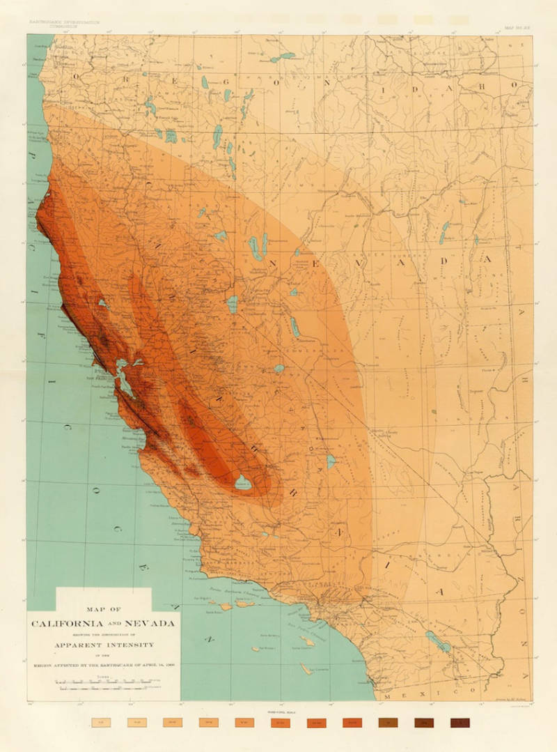
"caption": "Andrew Lawson produced detailed maps of shake intensity from the 1906 San Francisco Earthquake.",
"description": null,
"title": "EarthquakeApparentIntensity_2",
"credit": "David Rumsey Map Collection",
"status": "inherit",
"isLoading": false,
"fetchFailed": false
},
"science_626282": {
"type": "attachments",
"id": "science_626282",
"meta": {
"index": "attachments_1716263798",
"site": "science",
"id": "626282",
"found": true
},
"parent": 626281,
"imgSizes": {
"twentyfourteen-full-width": {
"file": "https://ww2.kqed.org/app/uploads/sites/35/2016/04/gettyimages-488635541_custom-248405883b1e59b9dff8233332ad60173ce7d9b6-1038x576.jpg",
"width": 1038,
"mimeType": "image/jpeg",
"height": 576
},
"thumbnail": {
"file": "https://ww2.kqed.org/app/uploads/sites/35/2016/04/gettyimages-488635541_custom-248405883b1e59b9dff8233332ad60173ce7d9b6-400x225.jpg",
"width": 400,
"mimeType": "image/jpeg",
"height": 225
},
"fd-sm": {
"file": "https://ww2.kqed.org/app/uploads/sites/35/2016/04/gettyimages-488635541_custom-248405883b1e59b9dff8233332ad60173ce7d9b6-960x539.jpg",
"width": 960,
"mimeType": "image/jpeg",
"height": 539
},
"post-thumbnail": {
"file": "https://ww2.kqed.org/app/uploads/sites/35/2016/04/gettyimages-488635541_custom-248405883b1e59b9dff8233332ad60173ce7d9b6-672x372.jpg",
"width": 672,
"mimeType": "image/jpeg",
"height": 372
},
"kqedFullSize": {
"file": "https://ww2.kqed.org/app/uploads/sites/35/2016/04/gettyimages-488635541_custom-248405883b1e59b9dff8233332ad60173ce7d9b6.jpg",
"width": 5578,
"height": 3133
},
"large": {
"file": "https://ww2.kqed.org/app/uploads/sites/35/2016/04/gettyimages-488635541_custom-248405883b1e59b9dff8233332ad60173ce7d9b6-1440x809.jpg",
"width": 1440,
"mimeType": "image/jpeg",
"height": 809
},
"guest-author-96": {
"file": "https://ww2.kqed.org/app/uploads/sites/35/2016/04/gettyimages-488635541_custom-248405883b1e59b9dff8233332ad60173ce7d9b6-96x96.jpg",
"width": 96,
"mimeType": "image/jpeg",
"height": 96
},
"medium": {
"file": "https://ww2.kqed.org/app/uploads/sites/35/2016/04/gettyimages-488635541_custom-248405883b1e59b9dff8233332ad60173ce7d9b6-800x449.jpg",
"width": 800,
"mimeType": "image/jpeg",
"height": 449
},
"guest-author-64": {
"file": "https://ww2.kqed.org/app/uploads/sites/35/2016/04/gettyimages-488635541_custom-248405883b1e59b9dff8233332ad60173ce7d9b6-64x64.jpg",
"width": 64,
"mimeType": "image/jpeg",
"height": 64
},
"guest-author-32": {
"file": "https://ww2.kqed.org/app/uploads/sites/35/2016/04/gettyimages-488635541_custom-248405883b1e59b9dff8233332ad60173ce7d9b6-32x32.jpg",
"width": 32,
"mimeType": "image/jpeg",
"height": 32
},
"fd-lrg": {
"file": "https://ww2.kqed.org/app/uploads/sites/35/2016/04/gettyimages-488635541_custom-248405883b1e59b9dff8233332ad60173ce7d9b6-1920x1078.jpg",
"width": 1920,
"mimeType": "image/jpeg",
"height": 1078
},
"fd-med": {
"file": "https://ww2.kqed.org/app/uploads/sites/35/2016/04/gettyimages-488635541_custom-248405883b1e59b9dff8233332ad60173ce7d9b6-1180x663.jpg",
"width": 1180,
"mimeType": "image/jpeg",
"height": 663
},
"detail": {
"file": "https://ww2.kqed.org/app/uploads/sites/35/2016/04/gettyimages-488635541_custom-248405883b1e59b9dff8233332ad60173ce7d9b6-75x75.jpg",
"width": 75,
"mimeType": "image/jpeg",
"height": 75
},
"medium_large": {
"file": "https://ww2.kqed.org/app/uploads/sites/35/2016/04/gettyimages-488635541_custom-248405883b1e59b9dff8233332ad60173ce7d9b6-768x431.jpg",
"width": 768,
"mimeType": "image/jpeg",
"height": 431
},
"guest-author-128": {
"file": "https://ww2.kqed.org/app/uploads/sites/35/2016/04/gettyimages-488635541_custom-248405883b1e59b9dff8233332ad60173ce7d9b6-128x128.jpg",
"width": 128,
"mimeType": "image/jpeg",
"height": 128
}
},
"publishDate": 1460137919,
"modified": 1460137919,
"caption": null,
"description": "Artwork of an asteroid hitting Earth.",
"title": "Artwork of an asteroid hitting Earth.",
"credit": null,
"status": "inherit",
"isLoading": false,
"fetchFailed": false
},
"science_607287": {
"type": "attachments",
"id": "science_607287",
"meta": {
"index": "attachments_1716263798",
"site": "science",
"id": "607287",
"found": true
},
"parent": 607020,
"imgSizes": {
"twentyfourteen-full-width": {
"file": "https://ww2.kqed.org/app/uploads/sites/35/2016/03/OKquakedamage-1038x576.jpg",
"width": 1038,
"mimeType": "image/jpeg",
"height": 576
},
"thumbnail": {
"file": "https://ww2.kqed.org/app/uploads/sites/35/2016/03/OKquakedamage-400x225.jpg",
"width": 400,
"mimeType": "image/jpeg",
"height": 225
},
"fd-sm": {
"file": "https://ww2.kqed.org/app/uploads/sites/35/2016/03/OKquakedamage-960x540.jpg",
"width": 960,
"mimeType": "image/jpeg",
"height": 540
},
"post-thumbnail": {
"file": "https://ww2.kqed.org/app/uploads/sites/35/2016/03/OKquakedamage-672x372.jpg",
"width": 672,
"mimeType": "image/jpeg",
"height": 372
},
"kqedFullSize": {
"file": "https://ww2.kqed.org/app/uploads/sites/35/2016/03/OKquakedamage.jpg",
"width": 1200,
"height": 675
},
"guest-author-96": {
"file": "https://ww2.kqed.org/app/uploads/sites/35/2016/03/OKquakedamage-96x96.jpg",
"width": 96,
"mimeType": "image/jpeg",
"height": 96
},
"medium": {
"file": "https://ww2.kqed.org/app/uploads/sites/35/2016/03/OKquakedamage-800x450.jpg",
"width": 800,
"mimeType": "image/jpeg",
"height": 450
},
"guest-author-64": {
"file": "https://ww2.kqed.org/app/uploads/sites/35/2016/03/OKquakedamage-64x64.jpg",
"width": 64,
"mimeType": "image/jpeg",
"height": 64
},
"guest-author-32": {
"file": "https://ww2.kqed.org/app/uploads/sites/35/2016/03/OKquakedamage-32x32.jpg",
"width": 32,
"mimeType": "image/jpeg",
"height": 32
},
"fd-med": {
"file": "https://ww2.kqed.org/app/uploads/sites/35/2016/03/OKquakedamage-1180x664.jpg",
"width": 1180,
"mimeType": "image/jpeg",
"height": 664
},
"detail": {
"file": "https://ww2.kqed.org/app/uploads/sites/35/2016/03/OKquakedamage-75x75.jpg",
"width": 75,
"mimeType": "image/jpeg",
"height": 75
},
"medium_large": {
"file": "https://ww2.kqed.org/app/uploads/sites/35/2016/03/OKquakedamage-768x432.jpg",
"width": 768,
"mimeType": "image/jpeg",
"height": 432
},
"guest-author-128": {
"file": "https://ww2.kqed.org/app/uploads/sites/35/2016/03/OKquakedamage-128x128.jpg",
"width": 128,
"mimeType": "image/jpeg",
"height": 128
}
},
"publishDate": 1459369519,
"modified": 1459380956,
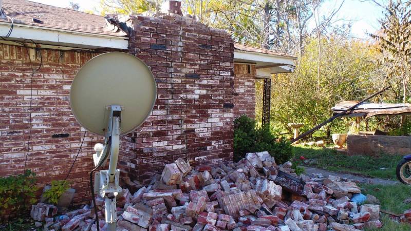
"caption": "This home in central Oklahoma was damaged by a magnitude 5.6 earthquake on November 6, 2011. A new one-year forecast offers a warning to residents living where quakes are induced by oilfield practices.",
"description": null,
"title": "OKquakedamage",
"credit": "Brian Sherrod/U.S. Geological Survey",
"status": "inherit",
"isLoading": false,
"fetchFailed": false
},
"science_581814": {
"type": "attachments",
"id": "science_581814",
"meta": {
"index": "attachments_1716263798",
"site": "science",
"id": "581814",
"found": true
},
"parent": 581813,
"imgSizes": {
"twentyfourteen-full-width": {
"file": "https://ww2.kqed.org/app/uploads/sites/35/2016/03/pluto-1038x576.jpg",
"width": 1038,
"mimeType": "image/jpeg",
"height": 576
},
"thumbnail": {
"file": "https://ww2.kqed.org/app/uploads/sites/35/2016/03/pluto-400x225.jpg",
"width": 400,
"mimeType": "image/jpeg",
"height": 225
},
"fd-sm": {
"file": "https://ww2.kqed.org/app/uploads/sites/35/2016/03/pluto-960x540.jpg",
"width": 960,
"mimeType": "image/jpeg",
"height": 540
},
"post-thumbnail": {
"file": "https://ww2.kqed.org/app/uploads/sites/35/2016/03/pluto-672x372.jpg",
"width": 672,
"mimeType": "image/jpeg",
"height": 372
},
"kqedFullSize": {
"file": "https://ww2.kqed.org/app/uploads/sites/35/2016/03/pluto.jpg",
"width": 1180,
"height": 664
},
"guest-author-96": {
"file": "https://ww2.kqed.org/app/uploads/sites/35/2016/03/pluto-96x96.jpg",
"width": 96,
"mimeType": "image/jpeg",
"height": 96
},
"medium": {
"file": "https://ww2.kqed.org/app/uploads/sites/35/2016/03/pluto-800x450.jpg",
"width": 800,
"mimeType": "image/jpeg",
"height": 450
},
"guest-author-64": {
"file": "https://ww2.kqed.org/app/uploads/sites/35/2016/03/pluto-64x64.jpg",
"width": 64,
"mimeType": "image/jpeg",
"height": 64
},
"guest-author-32": {
"file": "https://ww2.kqed.org/app/uploads/sites/35/2016/03/pluto-32x32.jpg",
"width": 32,
"mimeType": "image/jpeg",
"height": 32
},
"fd-med": {
"file": "https://ww2.kqed.org/app/uploads/sites/35/2016/03/pluto-1180x664.jpg",
"width": 1180,
"mimeType": "image/jpeg",
"height": 664
},
"detail": {
"file": "https://ww2.kqed.org/app/uploads/sites/35/2016/03/pluto-75x75.jpg",
"width": 75,
"mimeType": "image/jpeg",
"height": 75
},
"medium_large": {
"file": "https://ww2.kqed.org/app/uploads/sites/35/2016/03/pluto-768x432.jpg",
"width": 768,
"mimeType": "image/jpeg",
"height": 432
},
"guest-author-128": {
"file": "https://ww2.kqed.org/app/uploads/sites/35/2016/03/pluto-128x128.jpg",
"width": 128,
"mimeType": "image/jpeg",
"height": 128
}
},
"publishDate": 1458150069,
"modified": 1458176470,
"caption": "A panorama of Pluto displays some of the great variety found on the surface of this remote world. The bright Sputnik Planum is a region of glaciers made mostly of solid nitrogen. Mountains of water ice surround it, and more float within it like icebergs. Heavily cratered Cthulhu Regio, bottom, owes its color (exaggerated in this false-color image) to organic crud created by space radiation. Extensional cracks like the one at far left hint at deeper tectonics.",
"description": null,
"title": "pluto",
"credit": "ASA/JHUAPL/SwRI",
"status": "inherit",
"isLoading": false,
"fetchFailed": false
},
"science_534705": {
"type": "attachments",
"id": "science_534705",
"meta": {
"index": "attachments_1716263798",
"site": "science",
"id": "534705",
"found": true
},
"parent": 534704,
"imgSizes": {
"thumbnail": {
"file": "https://ww2.kqed.org/app/uploads/sites/35/2016/02/tejonoilfield-400x225.jpg",
"width": 400,
"mimeType": "image/jpeg",
"height": 225
},
"fd-sm": {
"file": "https://ww2.kqed.org/app/uploads/sites/35/2016/02/tejonoilfield-960x540.jpg",
"width": 960,
"mimeType": "image/jpeg",
"height": 540
},
"post-thumbnail": {
"file": "https://ww2.kqed.org/app/uploads/sites/35/2016/02/tejonoilfield-672x372.jpg",
"width": 672,
"mimeType": "image/jpeg",
"height": 372
},
"kqedFullSize": {
"file": "https://ww2.kqed.org/app/uploads/sites/35/2016/02/tejonoilfield.jpg",
"width": 1000,
"height": 562
},
"guest-author-96": {
"file": "https://ww2.kqed.org/app/uploads/sites/35/2016/02/tejonoilfield-96x96.jpg",
"width": 96,
"mimeType": "image/jpeg",
"height": 96
},
"medium": {
"file": "https://ww2.kqed.org/app/uploads/sites/35/2016/02/tejonoilfield-800x450.jpg",
"width": 800,
"mimeType": "image/jpeg",
"height": 450
},
"guest-author-64": {
"file": "https://ww2.kqed.org/app/uploads/sites/35/2016/02/tejonoilfield-64x64.jpg",
"width": 64,
"mimeType": "image/jpeg",
"height": 64
},
"detail": {
"file": "https://ww2.kqed.org/app/uploads/sites/35/2016/02/tejonoilfield-75x75.jpg",
"width": 75,
"mimeType": "image/jpeg",
"height": 75
},
"guest-author-32": {
"file": "https://ww2.kqed.org/app/uploads/sites/35/2016/02/tejonoilfield-32x32.jpg",
"width": 32,
"mimeType": "image/jpeg",
"height": 32
},
"medium_large": {
"file": "https://ww2.kqed.org/app/uploads/sites/35/2016/02/tejonoilfield-768x432.jpg",
"width": 768,
"mimeType": "image/jpeg",
"height": 432
},
"guest-author-128": {
"file": "https://ww2.kqed.org/app/uploads/sites/35/2016/02/tejonoilfield-128x128.jpg",
"width": 128,
"mimeType": "image/jpeg",
"height": 128
}
},
"publishDate": 1455734014,
"modified": 1455823538,
"caption": "The Tejon Oil Field, at the southernmost end of the Great Valley, was the site of an earthquake swarm apparently triggered by wastewater injection in September 2005.",
"description": null,
"title": "tejonoilfield",
"credit": "\u003ca href=\"https://www.flickr.com/photos/whsieh78/\">Wayne Hsieh\u003c/a>/\u003ca href=\"https://creativecommons.org/licenses/by-nc/2.0/\">Flickr\u003c/a>",
"status": "inherit",
"isLoading": false,
"fetchFailed": false
},
"science_524199": {
"type": "attachments",
"id": "science_524199",
"meta": {
"index": "attachments_1716263798",
"site": "science",
"id": "524199",
"found": true
},
"parent": 522299,
"imgSizes": {
"twentyfourteen-full-width": {
"file": "https://ww2.kqed.org/app/uploads/sites/35/2016/02/MyShake_scrgrab_featured-1038x576.png",
"width": 1038,
"mimeType": "image/png",
"height": 576
},
"thumbnail": {
"file": "https://ww2.kqed.org/app/uploads/sites/35/2016/02/MyShake_scrgrab_featured-400x232.png",
"width": 400,
"mimeType": "image/png",
"height": 232
},
"fd-sm": {
"file": "https://ww2.kqed.org/app/uploads/sites/35/2016/02/MyShake_scrgrab_featured-960x556.png",
"width": 960,
"mimeType": "image/png",
"height": 556
},
"post-thumbnail": {
"file": "https://ww2.kqed.org/app/uploads/sites/35/2016/02/MyShake_scrgrab_featured-672x372.png",
"width": 672,
"mimeType": "image/png",
"height": 372
},
"kqedFullSize": {
"file": "https://ww2.kqed.org/app/uploads/sites/35/2016/02/MyShake_scrgrab_featured.png",
"width": 1373,
"height": 795
},
"guest-author-96": {
"file": "https://ww2.kqed.org/app/uploads/sites/35/2016/02/MyShake_scrgrab_featured-96x96.png",
"width": 96,
"mimeType": "image/png",
"height": 96
},
"medium": {
"file": "https://ww2.kqed.org/app/uploads/sites/35/2016/02/MyShake_scrgrab_featured-800x463.png",
"width": 800,
"mimeType": "image/png",
"height": 463
},
"guest-author-64": {
"file": "https://ww2.kqed.org/app/uploads/sites/35/2016/02/MyShake_scrgrab_featured-64x64.png",
"width": 64,
"mimeType": "image/png",
"height": 64
},
"guest-author-32": {
"file": "https://ww2.kqed.org/app/uploads/sites/35/2016/02/MyShake_scrgrab_featured-32x32.png",
"width": 32,
"mimeType": "image/png",
"height": 32
},
"fd-med": {
"file": "https://ww2.kqed.org/app/uploads/sites/35/2016/02/MyShake_scrgrab_featured-1180x683.png",
"width": 1180,
"mimeType": "image/png",
"height": 683
},
"detail": {
"file": "https://ww2.kqed.org/app/uploads/sites/35/2016/02/MyShake_scrgrab_featured-75x75.png",
"width": 75,
"mimeType": "image/png",
"height": 75
},
"medium_large": {
"file": "https://ww2.kqed.org/app/uploads/sites/35/2016/02/MyShake_scrgrab_featured-768x445.png",
"width": 768,
"mimeType": "image/png",
"height": 445
},
"guest-author-128": {
"file": "https://ww2.kqed.org/app/uploads/sites/35/2016/02/MyShake_scrgrab_featured-128x128.png",
"width": 128,
"mimeType": "image/png",
"height": 128
}
},
"publishDate": 1455225773,
"modified": 1455229100,
"caption": "U.C. Berkeley's MyShake app could be the first step toward earthquake warnings on your phone.",
"description": "U.C. Berkeley's MyShake app could be the first step toward earthquake warnings on your phone.",
"title": "MyShake_scrgrab_featured",
"credit": "Berkeley Seismological Laboratory",
"status": "inherit",
"isLoading": false,
"fetchFailed": false
},
"science_508044": {
"type": "attachments",
"id": "science_508044",
"meta": {
"index": "attachments_1716263798",
"site": "science",
"id": "508044",
"found": true
},
"parent": 508042,
"imgSizes": {
"twentyfourteen-full-width": {
"file": "https://ww2.kqed.org/app/uploads/sites/35/2016/02/christchurch-nightclub-1024x576.jpg",
"width": 1024,
"mimeType": "image/jpeg",
"height": 576
},
"thumbnail": {
"file": "https://ww2.kqed.org/app/uploads/sites/35/2016/02/christchurch-nightclub-400x225.jpg",
"width": 400,
"mimeType": "image/jpeg",
"height": 225
},
"fd-sm": {
"file": "https://ww2.kqed.org/app/uploads/sites/35/2016/02/christchurch-nightclub-960x540.jpg",
"width": 960,
"mimeType": "image/jpeg",
"height": 540
},
"post-thumbnail": {
"file": "https://ww2.kqed.org/app/uploads/sites/35/2016/02/christchurch-nightclub-672x372.jpg",
"width": 672,
"mimeType": "image/jpeg",
"height": 372
},
"kqedFullSize": {
"file": "https://ww2.kqed.org/app/uploads/sites/35/2016/02/christchurch-nightclub.jpg",
"width": 1024,
"height": 576
},
"guest-author-96": {
"file": "https://ww2.kqed.org/app/uploads/sites/35/2016/02/christchurch-nightclub-96x96.jpg",
"width": 96,
"mimeType": "image/jpeg",
"height": 96
},
"medium": {
"file": "https://ww2.kqed.org/app/uploads/sites/35/2016/02/christchurch-nightclub-800x450.jpg",
"width": 800,
"mimeType": "image/jpeg",
"height": 450
},
"guest-author-64": {
"file": "https://ww2.kqed.org/app/uploads/sites/35/2016/02/christchurch-nightclub-64x64.jpg",
"width": 64,
"mimeType": "image/jpeg",
"height": 64
},
"detail": {
"file": "https://ww2.kqed.org/app/uploads/sites/35/2016/02/christchurch-nightclub-75x75.jpg",
"width": 75,
"mimeType": "image/jpeg",
"height": 75
},
"guest-author-32": {
"file": "https://ww2.kqed.org/app/uploads/sites/35/2016/02/christchurch-nightclub-32x32.jpg",
"width": 32,
"mimeType": "image/jpeg",
"height": 32
},
"medium_large": {
"file": "https://ww2.kqed.org/app/uploads/sites/35/2016/02/christchurch-nightclub-768x432.jpg",
"width": 768,
"mimeType": "image/jpeg",
"height": 432
},
"guest-author-128": {
"file": "https://ww2.kqed.org/app/uploads/sites/35/2016/02/christchurch-nightclub-128x128.jpg",
"width": 128,
"mimeType": "image/jpeg",
"height": 128
}
},
"publishDate": 1454525430,
"modified": 1454525482,
"caption": "A nightclub in Christchurch, New Zealand lies in rubble after the earthquake of February 22, 2011.",
"description": null,
"title": "christchurch-nightclub",
"credit": "Martin Luff/Flickr",
"status": "inherit",
"isLoading": false,
"fetchFailed": false
},
"science_503977": {
"type": "attachments",
"id": "science_503977",
"meta": {
"index": "attachments_1716263798",
"site": "science",
"id": "503977",
"found": true
},
"parent": 499218,
"imgSizes": {
"twentyfourteen-full-width": {
"file": "https://ww2.kqed.org/app/uploads/sites/35/2016/02/830878235_3f060c0717_o-1038x576.jpg",
"width": 1038,
"mimeType": "image/jpeg",
"height": 576
},
"thumbnail": {
"file": "https://ww2.kqed.org/app/uploads/sites/35/2016/02/830878235_3f060c0717_o-400x266.jpg",
"width": 400,
"mimeType": "image/jpeg",
"height": 266
},
"fd-sm": {
"file": "https://ww2.kqed.org/app/uploads/sites/35/2016/02/830878235_3f060c0717_o-960x638.jpg",
"width": 960,
"mimeType": "image/jpeg",
"height": 638
},
"post-thumbnail": {
"file": "https://ww2.kqed.org/app/uploads/sites/35/2016/02/830878235_3f060c0717_o-672x372.jpg",
"width": 672,
"mimeType": "image/jpeg",
"height": 372
},
"kqedFullSize": {
"file": "https://ww2.kqed.org/app/uploads/sites/35/2016/02/830878235_3f060c0717_o.jpg",
"width": 1280,
"height": 851
},
"guest-author-96": {
"file": "https://ww2.kqed.org/app/uploads/sites/35/2016/02/830878235_3f060c0717_o-96x96.jpg",
"width": 96,
"mimeType": "image/jpeg",
"height": 96
},
"medium": {
"file": "https://ww2.kqed.org/app/uploads/sites/35/2016/02/830878235_3f060c0717_o-800x532.jpg",
"width": 800,
"mimeType": "image/jpeg",
"height": 532
},
"guest-author-64": {
"file": "https://ww2.kqed.org/app/uploads/sites/35/2016/02/830878235_3f060c0717_o-64x64.jpg",
"width": 64,
"mimeType": "image/jpeg",
"height": 64
},
"guest-author-32": {
"file": "https://ww2.kqed.org/app/uploads/sites/35/2016/02/830878235_3f060c0717_o-32x32.jpg",
"width": 32,
"mimeType": "image/jpeg",
"height": 32
},
"fd-med": {
"file": "https://ww2.kqed.org/app/uploads/sites/35/2016/02/830878235_3f060c0717_o-1180x785.jpg",
"width": 1180,
"mimeType": "image/jpeg",
"height": 785
},
"detail": {
"file": "https://ww2.kqed.org/app/uploads/sites/35/2016/02/830878235_3f060c0717_o-75x75.jpg",
"width": 75,
"mimeType": "image/jpeg",
"height": 75
},
"medium_large": {
"file": "https://ww2.kqed.org/app/uploads/sites/35/2016/02/830878235_3f060c0717_o-768x511.jpg",
"width": 768,
"mimeType": "image/jpeg",
"height": 511
},
"guest-author-128": {
"file": "https://ww2.kqed.org/app/uploads/sites/35/2016/02/830878235_3f060c0717_o-128x128.jpg",
"width": 128,
"mimeType": "image/jpeg",
"height": 128
}
},
"publishDate": 1454337571,
"modified": 1454337715,
"caption": "A 2006 landslide in Mill Valley left this large scar The area turned into a fast-moving debris flow, sending tons of mud and earth downhill. ",
"description": null,
"title": "landslide",
"credit": "KQED/Quest",
"status": "inherit",
"isLoading": false,
"fetchFailed": false
},
"science_482757": {
"type": "attachments",
"id": "science_482757",
"meta": {
"index": "attachments_1716263798",
"site": "science",
"id": "482757",
"found": true
},
"parent": 482756,
"imgSizes": {
"twentyfourteen-full-width": {
"file": "https://ww2.kqed.org/app/uploads/sites/35/2016/01/John-Nishizawa_Takiishi-1000x576.jpg",
"width": 1000,
"mimeType": "image/jpeg",
"height": 576
},
"thumbnail": {
"file": "https://ww2.kqed.org/app/uploads/sites/35/2016/01/John-Nishizawa_Takiishi-400x320.jpg",
"width": 400,
"mimeType": "image/jpeg",
"height": 320
},
"fd-sm": {
"file": "https://ww2.kqed.org/app/uploads/sites/35/2016/01/John-Nishizawa_Takiishi-960x768.jpg",
"width": 960,
"mimeType": "image/jpeg",
"height": 768
},
"post-thumbnail": {
"file": "https://ww2.kqed.org/app/uploads/sites/35/2016/01/John-Nishizawa_Takiishi-672x372.jpg",
"width": 672,
"mimeType": "image/jpeg",
"height": 372
},
"kqedFullSize": {
"file": "https://ww2.kqed.org/app/uploads/sites/35/2016/01/John-Nishizawa_Takiishi.jpg",
"width": 1000,
"height": 800
},
"guest-author-96": {
"file": "https://ww2.kqed.org/app/uploads/sites/35/2016/01/John-Nishizawa_Takiishi-96x96.jpg",
"width": 96,
"mimeType": "image/jpeg",
"height": 96
},
"medium": {
"file": "https://ww2.kqed.org/app/uploads/sites/35/2016/01/John-Nishizawa_Takiishi-800x640.jpg",
"width": 800,
"mimeType": "image/jpeg",
"height": 640
},
"guest-author-64": {
"file": "https://ww2.kqed.org/app/uploads/sites/35/2016/01/John-Nishizawa_Takiishi-64x64.jpg",
"width": 64,
"mimeType": "image/jpeg",
"height": 64
},
"detail": {
"file": "https://ww2.kqed.org/app/uploads/sites/35/2016/01/John-Nishizawa_Takiishi-75x75.jpg",
"width": 75,
"mimeType": "image/jpeg",
"height": 75
},
"guest-author-32": {
"file": "https://ww2.kqed.org/app/uploads/sites/35/2016/01/John-Nishizawa_Takiishi-32x32.jpg",
"width": 32,
"mimeType": "image/jpeg",
"height": 32
},
"medium_large": {
"file": "https://ww2.kqed.org/app/uploads/sites/35/2016/01/John-Nishizawa_Takiishi-768x614.jpg",
"width": 768,
"mimeType": "image/jpeg",
"height": 614
},
"guest-author-128": {
"file": "https://ww2.kqed.org/app/uploads/sites/35/2016/01/John-Nishizawa_Takiishi-128x128.jpg",
"width": 128,
"mimeType": "image/jpeg",
"height": 128
}
},
"publishDate": 1453315425,
"modified": 1453330637,
"caption": "This taiishi, or waterfall stone, was collected in the Klamath River by John Nishizawa, who prepared it and carved its daiza, or wooden stand. Its geological name, I decided, is argillite.",
"description": null,
"title": "John Nishizawa_Takiishi",
"credit": "OMCA/John Nishizawa",
"status": "inherit",
"isLoading": false,
"fetchFailed": false
},
"science_466607": {
"type": "attachments",
"id": "science_466607",
"meta": {
"index": "attachments_1716263798",
"site": "science",
"id": "466607",
"found": true
},
"parent": 466518,
"imgSizes": {
"twentyfourteen-full-width": {
"file": "https://ww2.kqed.org/app/uploads/sites/35/2016/01/Wyoming-rocks-e1452554382152-1038x576.jpg",
"width": 1038,
"mimeType": "image/jpeg",
"height": 576
},
"thumbnail": {
"file": "https://ww2.kqed.org/app/uploads/sites/35/2016/01/Wyoming-rocks-e1452554382152-400x213.jpg",
"width": 400,
"mimeType": "image/jpeg",
"height": 213
},
"fd-sm": {
"file": "https://ww2.kqed.org/app/uploads/sites/35/2016/01/Wyoming-rocks-e1452554382152-960x512.jpg",
"width": 960,
"mimeType": "image/jpeg",
"height": 512
},
"post-thumbnail": {
"file": "https://ww2.kqed.org/app/uploads/sites/35/2016/01/Wyoming-rocks-e1452554382152-672x372.jpg",
"width": 672,
"mimeType": "image/jpeg",
"height": 372
},
"kqedFullSize": {
"file": "https://ww2.kqed.org/app/uploads/sites/35/2016/01/Wyoming-rocks-e1452554382152.jpg",
"width": 1305,
"height": 696
},
"guest-author-96": {
"file": "https://ww2.kqed.org/app/uploads/sites/35/2016/01/Wyoming-rocks-e1452554382152-96x96.jpg",
"width": 96,
"mimeType": "image/jpeg",
"height": 96
},
"medium": {
"file": "https://ww2.kqed.org/app/uploads/sites/35/2016/01/Wyoming-rocks-e1452554382152-800x427.jpg",
"width": 800,
"mimeType": "image/jpeg",
"height": 427
},
"guest-author-64": {
"file": "https://ww2.kqed.org/app/uploads/sites/35/2016/01/Wyoming-rocks-e1452554382152-64x64.jpg",
"width": 64,
"mimeType": "image/jpeg",
"height": 64
},
"guest-author-32": {
"file": "https://ww2.kqed.org/app/uploads/sites/35/2016/01/Wyoming-rocks-e1452554382152-32x32.jpg",
"width": 32,
"mimeType": "image/jpeg",
"height": 32
},
"fd-med": {
"file": "https://ww2.kqed.org/app/uploads/sites/35/2016/01/Wyoming-rocks-e1452554382152-1180x629.jpg",
"width": 1180,
"mimeType": "image/jpeg",
"height": 629
},
"detail": {
"file": "https://ww2.kqed.org/app/uploads/sites/35/2016/01/Wyoming-rocks-e1452554382152-75x75.jpg",
"width": 75,
"mimeType": "image/jpeg",
"height": 75
},
"medium_large": {
"file": "https://ww2.kqed.org/app/uploads/sites/35/2016/01/Wyoming-rocks-e1452554382152-768x410.jpg",
"width": 768,
"mimeType": "image/jpeg",
"height": 410
},
"guest-author-128": {
"file": "https://ww2.kqed.org/app/uploads/sites/35/2016/01/Wyoming-rocks-e1452554382152-128x128.jpg",
"width": 128,
"mimeType": "image/jpeg",
"height": 128
}
},
"publishDate": 1452554061,
"modified": 1452554335,
"caption": "A central Wyoming rock formation, east of the sample site in Wyoming's Wind River Range.",
"description": null,
"title": "Wyoming rocks",
"credit": "AJ Schroetlin/flickr",
"status": "inherit",
"isLoading": false,
"fetchFailed": false
},
"science_456483": {
"type": "attachments",
"id": "science_456483",
"meta": {
"index": "attachments_1716263798",
"site": "science",
"id": "456483",
"found": true
},
"parent": 456477,
"imgSizes": {
"thumbnail": {
"file": "https://ww2.kqed.org/app/uploads/sites/35/2016/01/geositesbanner-400x225.jpg",
"width": 400,
"mimeType": "image/jpeg",
"height": 225
},
"post-thumbnail": {
"file": "https://ww2.kqed.org/app/uploads/sites/35/2016/01/geositesbanner-672x372.jpg",
"width": 672,
"mimeType": "image/jpeg",
"height": 372
},
"kqedFullSize": {
"file": "https://ww2.kqed.org/app/uploads/sites/35/2016/01/geositesbanner.jpg",
"width": 800,
"height": 450
},
"guest-author-96": {
"file": "https://ww2.kqed.org/app/uploads/sites/35/2016/01/geositesbanner-96x96.jpg",
"width": 96,
"mimeType": "image/jpeg",
"height": 96
},
"medium": {
"file": "https://ww2.kqed.org/app/uploads/sites/35/2016/01/geositesbanner-800x450.jpg",
"width": 800,
"mimeType": "image/jpeg",
"height": 450
},
"guest-author-64": {
"file": "https://ww2.kqed.org/app/uploads/sites/35/2016/01/geositesbanner-64x64.jpg",
"width": 64,
"mimeType": "image/jpeg",
"height": 64
},
"detail": {
"file": "https://ww2.kqed.org/app/uploads/sites/35/2016/01/geositesbanner-75x75.jpg",
"width": 75,
"mimeType": "image/jpeg",
"height": 75
},
"guest-author-32": {
"file": "https://ww2.kqed.org/app/uploads/sites/35/2016/01/geositesbanner-32x32.jpg",
"width": 32,
"mimeType": "image/jpeg",
"height": 32
},
"medium_large": {
"file": "https://ww2.kqed.org/app/uploads/sites/35/2016/01/geositesbanner-768x432.jpg",
"width": 768,
"mimeType": "image/jpeg",
"height": 432
},
"guest-author-128": {
"file": "https://ww2.kqed.org/app/uploads/sites/35/2016/01/geositesbanner-128x128.jpg",
"width": 128,
"mimeType": "image/jpeg",
"height": 128
}
},
"publishDate": 1452106067,
"modified": 1452106095,
"caption": "The Coyote Hills are a place to explore Bay Area geology in a setting that's both convenient and breathtaking.",
"description": null,
"title": "geositesbanner",
"credit": "Andrew Alden/KQED",
"status": "inherit",
"isLoading": false,
"fetchFailed": false
},
"science_430986": {
"type": "attachments",
"id": "science_430986",
"meta": {
"index": "attachments_1716263798",
"site": "science",
"id": "430986",
"found": true
},
"parent": 430896,
"imgSizes": {
"thumbnail": {
"file": "https://ww2.kqed.org/app/uploads/sites/35/2015/12/3464380533_cf7661c458_o-400x247.jpg",
"width": 400,
"mimeType": "image/jpeg",
"height": 247
},
"post-thumbnail": {
"file": "https://ww2.kqed.org/app/uploads/sites/35/2015/12/3464380533_cf7661c458_o-672x372.jpg",
"width": 672,
"mimeType": "image/jpeg",
"height": 372
},
"kqedFullSize": {
"file": "https://ww2.kqed.org/app/uploads/sites/35/2015/12/3464380533_cf7661c458_o.jpg",
"width": 800,
"height": 494
},
"guest-author-96": {
"file": "https://ww2.kqed.org/app/uploads/sites/35/2015/12/3464380533_cf7661c458_o-96x96.jpg",
"width": 96,
"mimeType": "image/jpeg",
"height": 96
},
"medium": {
"file": "https://ww2.kqed.org/app/uploads/sites/35/2015/12/3464380533_cf7661c458_o-800x494.jpg",
"width": 800,
"mimeType": "image/jpeg",
"height": 494
},
"guest-author-64": {
"file": "https://ww2.kqed.org/app/uploads/sites/35/2015/12/3464380533_cf7661c458_o-64x64.jpg",
"width": 64,
"mimeType": "image/jpeg",
"height": 64
},
"detail": {
"file": "https://ww2.kqed.org/app/uploads/sites/35/2015/12/3464380533_cf7661c458_o-75x75.jpg",
"width": 75,
"mimeType": "image/jpeg",
"height": 75
},
"guest-author-32": {
"file": "https://ww2.kqed.org/app/uploads/sites/35/2015/12/3464380533_cf7661c458_o-32x32.jpg",
"width": 32,
"mimeType": "image/jpeg",
"height": 32
},
"medium_large": {
"file": "https://ww2.kqed.org/app/uploads/sites/35/2015/12/3464380533_cf7661c458_o-768x474.jpg",
"width": 768,
"mimeType": "image/jpeg",
"height": 474
},
"guest-author-128": {
"file": "https://ww2.kqed.org/app/uploads/sites/35/2015/12/3464380533_cf7661c458_o-128x128.jpg",
"width": 128,
"mimeType": "image/jpeg",
"height": 128
}
},
"publishDate": 1450899408,
"modified": 1450900385,
"caption": "The John Muir Wilderness in the Sierra Nevada stands in for planet Earth.",
"description": "Earth in all its aspects was prominent on KQED Science this year. The John Muir Wilderness in the Sierra Nevada stands in for our planet.",
"title": "Earth",
"credit": "\u003ca href=\"https://www.flickr.com/photos/agrinberg/3464380533/in/photolist-6h8RCR-e5kvuY-7Vrue4-7icRw2-9cZYPY-sdJgLw-72bcJo-aqazvX-7NRkz1-qrZBgv-9fq1G6-o1Xxj7-6yPust-ahLS8A-b4m5xV-bPrqaT-5XTyyJ-9f5z3a-6PoLj-8zmozo-rYgtFy-6KARJ1-bfmrez-9f8HtJ-8ZcbzT-4BQ3pz-6t851k-adBGkR-6TB3Lh-7WnLYU-9trGAF-e89jGp-ceLYvE-6Pmm5H-oFQvmp-9iHZVd-9y17bV-6Vufi4-ednNL3-rYRx8W-9pa7R9-6azCE2-jq8ouH-7179o-edj86W-kM1QQY-ch8suW-cFb9Am-njaPqF-binsBK\" target=\"_blank\">Alan Grinberg/Flickr\u003c/a>",
"status": "inherit",
"isLoading": false,
"fetchFailed": false
}
},
"audioPlayerReducer": {
"postId": "stream_live",
"isPaused": true,
"isPlaying": false,
"pfsActive": false,
"pledgeModalIsOpen": true,
"playerDrawerIsOpen": false,
"liveAudioPlayStartedAt": 0,
"liveAudioPlayContext": ""
},
"authorsReducer": {
"byline_science_626281": {
"type": "authors",
"id": "byline_science_626281",
"meta": {
"override": true
},
"slug": "byline_science_626281",
"name": "Bill Chappell\u003c/br>NPR",
"isLoading": false
},
"byline_science_499218": {
"type": "authors",
"id": "byline_science_499218",
"meta": {
"override": true
},
"slug": "byline_science_499218",
"name": "Danielle Venton",
"isLoading": false
},
"cmiller": {
"type": "authors",
"id": "221",
"meta": {
"index": "authors_1716337520",
"id": "221",
"found": true
},
"name": "Craig Miller",
"firstName": "Craig",
"lastName": "Miller",
"slug": "cmiller",
"email": "craig@voxterra.net",
"display_author_email": false,
"staff_mastheads": [
"science"
],
"title": "Editor Emeritus, Science",
"bio": "Craig is a former KQED Science editor, specializing in weather, climate, water & energy issues, with a little seismology thrown in just to shake things up. Prior to that, he launched and led the station's award-winning multimedia project, Climate Watch. Craig is also an accomplished writer/producer of television documentaries, with a focus on natural resource issues.",
"avatar": "https://secure.gravatar.com/avatar/b91661df645e001a9cafe0861fa685f9?s=600&d=blank&r=g",
"twitter": "voxterra",
"facebook": null,
"instagram": null,
"linkedin": null,
"sites": [
{
"site": "news",
"roles": [
"author"
]
},
{
"site": "futureofyou",
"roles": [
"editor"
]
},
{
"site": "stateofhealth",
"roles": [
"author"
]
},
{
"site": "science",
"roles": [
"editor"
]
},
{
"site": "quest",
"roles": [
"editor"
]
}
],
"headData": {
"title": "Craig Miller | KQED",
"description": "Editor Emeritus, Science",
"ogImgSrc": "https://secure.gravatar.com/avatar/b91661df645e001a9cafe0861fa685f9?s=600&d=blank&r=g",
"twImgSrc": "https://secure.gravatar.com/avatar/b91661df645e001a9cafe0861fa685f9?s=600&d=blank&r=g"
},
"isLoading": false,
"link": "/author/cmiller"
},
"lindseyhoshaw": {
"type": "authors",
"id": "5432",
"meta": {
"index": "authors_1716337520",
"id": "5432",
"found": true
},
"name": "Lindsey Hoshaw",
"firstName": "Lindsey",
"lastName": "Hoshaw",
"slug": "lindseyhoshaw",
"email": "lhoshaw@kqed.org",
"display_author_email": false,
"staff_mastheads": [],
"title": "KQED Contributor",
"bio": "Lindsey Hoshaw is a former interactive producer for KQED Science. Before joining KQED, Lindsey was a science correspondent for The New York Times, The Boston Globe, Forbes and Scientific American. On Twitter @lindseyhoshaw",
"avatar": "https://secure.gravatar.com/avatar/274b07694c998eaa8f26cfabaa941186?s=600&d=mm&r=g",
"twitter": "lindseyhoshaw",
"facebook": "lindsey.hoshaw.9",
"instagram": null,
"linkedin": null,
"sites": [
{
"site": "arts",
"roles": [
"author"
]
},
{
"site": "news",
"roles": [
"subscriber"
]
},
{
"site": "futureofyou",
"roles": [
"editor"
]
},
{
"site": "bayareabites",
"roles": [
"contributor"
]
},
{
"site": "stateofhealth",
"roles": [
"author"
]
},
{
"site": "science",
"roles": [
"edit_theme_options",
"subscriber"
]
},
{
"site": "quest",
"roles": [
"edit_post_subscriptions",
"edit_usergroups",
"unfiltered_html",
"unfiltered_upload",
"leadcoordinator",
"editor"
]
},
{
"site": "food",
"roles": []
}
],
"headData": {
"title": "Lindsey Hoshaw | KQED",
"description": "KQED Contributor",
"ogImgSrc": "https://secure.gravatar.com/avatar/274b07694c998eaa8f26cfabaa941186?s=600&d=mm&r=g",
"twImgSrc": "https://secure.gravatar.com/avatar/274b07694c998eaa8f26cfabaa941186?s=600&d=mm&r=g"
},
"isLoading": false,
"link": "/author/lindseyhoshaw"
},
"andrew-alden": {
"type": "authors",
"id": "6228",
"meta": {
"index": "authors_1716337520",
"id": "6228",
"found": true
},
"name": "Andrew Alden",
"firstName": "Andrew",
"lastName": "Alden",
"slug": "andrew-alden",
"email": "alden@andrew-alden.com",
"display_author_email": false,
"staff_mastheads": [],
"title": null,
"bio": "Andrew Alden earned his geology degree at the University of New Hampshire and moved back to the Bay Area to work at the U.S. Geological Survey for six years. He has \u003ca href=\"http://geology.about.com/\">written on geology for About.com\u003c/a> since its founding in 1997. In 2007, he started the Oakland Geology blog, which won recognition as \"Best of the East Bay\" from the \u003ci>East Bay Express\u003c/i> in 2010. In writing about geology in the Bay Area and surroundings, he hopes to share some of the useful and pleasurable insights that geologists give us—not just facts about the deep past, but an attitude that might be called the \u003ci>deep present\u003c/i>.\r\n\r\nRead his \u003ca href=\"http://science.kqed.org/quest/author/andrew-alden/\">previous contributions\u003c/a> to \u003ca href=\"http://http://science.kqed.org/quest/\">QUEST\u003c/a>, a project dedicated to exploring the Science of Sustainability.",
"avatar": "https://secure.gravatar.com/avatar/9eaa0afc32f98c5fc7ce634437334a64?s=600&d=blank&r=g",
"twitter": null,
"facebook": null,
"instagram": null,
"linkedin": null,
"sites": [
{
"site": "science",
"roles": [
"author"
]
},
{
"site": "quest",
"roles": [
"subscriber"
]
}
],
"headData": {
"title": "Andrew Alden | KQED",
"description": null,
"ogImgSrc": "https://secure.gravatar.com/avatar/9eaa0afc32f98c5fc7ce634437334a64?s=600&d=blank&r=g",
"twImgSrc": "https://secure.gravatar.com/avatar/9eaa0afc32f98c5fc7ce634437334a64?s=600&d=blank&r=g"
},
"isLoading": false,
"link": "/author/andrew-alden"
}
},
"pagesReducer": {
"science_category_geology": {
"type": "terms",
"id": "science_38",
"meta": {
"index": "terms_1716263798",
"site": "science",
"id": "38",
"score": 13.559036
},
"featImg": null,
"name": "Geology",
"description": null,
"taxonomy": "category",
"headData": {
"twImgId": null,
"twTitle": null,
"ogTitle": null,
"ogImgId": null,
"twDescription": null,
"description": null,
"title": "Geology Archives | KQED Science",
"ogDescription": null
},
"ttid": 40,
"slug": "geology",
"isLoading": false,
"title": "Geology",
"pageMeta": {
"site": "science",
"WpPageTemplate": "page-topic-editorial",
"currentPage": 6
},
"blocks": [
{
"blockName": "kqed/post-list",
"attrs": {
"layout": "cardArticle2",
"query": "posts/science?category=geology",
"seeMore": false,
"paginated": true,
"page": 6
}
},
{
"blockName": "kqed/ad"
}
]
}
},
"pfsSessionReducer": {},
"postsReducer": {
"stream_live": {
"type": "live",
"id": "stream_live",
"audioUrl": "https://hls.kqed.org/hls/kqed_app/playlist.m3u8",
"title": "Live Stream",
"excerpt": "Live Stream information currently unavailable.",
"link": "/radio",
"featImg": "",
"label": {
"name": "KQED Live",
"link": "/"
}
},
"stream_kqedNewscast": {
"type": "posts",
"id": "stream_kqedNewscast",
"audioUrl": "https://www.kqed.org/.stream/anon/radio/RDnews/newscast.mp3?_=1",
"title": "KQED Newscast",
"featImg": "",
"label": {
"name": "88.5 FM",
"link": "/"
}
},
"science_641271": {
"type": "posts",
"id": "science_641271",
"meta": {
"index": "posts_1716263798",
"site": "science",
"id": "641271",
"score": null,
"sort": [
1460941231000
]
},
"parent": 0,
"labelTerm": {
"site": "science"
},
"blocks": [],
"publishDate": 1460941231,
"format": "standard",
"title": "Earthquake Science at the Threshold: 1906 Was a Game Changer",
"headTitle": "Earthquake Science at the Threshold: 1906 Was a Game Changer | KQED",
"content": "\u003cp>Scientists still debate the magnitude of the 1906 earthquake that leveled much of San Francisco and surrounds, 110 years ago today. Long referred to as magnitude 8 or greater (using the now retired Richter scale), more recent analyses peg it at 7.9 or even 7.7.\u003c/p>\n\u003cp>Suffice it to say that the Great San Francisco Earthquake (actually centered off of present-day Daly City) deserved to be called “the big one.” The rip along the San Andreas fault stretched for 296 miles. By comparison, the 2014 South Napa Earthquake was a 7-mile hiccup.\u003c/p>\n\u003caside class=\"pullquote alignright\">‘At the time of the 1906 earthquake, we didn’t understand that earthquakes occurred on faults.’\u003ccite>Richard Allen, UC Berkeley\u003c/cite>\u003c/aside>\n\u003cp>The 1906 quake forever changed the Bay Area’s landscape and culture — but that “slip” of the San Andreas fault was also a game changer in the \u003ca href=\"http://ww2.kqed.org/quest/2016/04/15/exploring-earthquakes/\">field of earthquake science\u003c/a>.\u003c/p>\n\u003cp>“At the time of the 1906 earthquake, we didn’t understand that earthquakes occurred on faults,” marvels Richard Allen, who directs the seismological lab at UC Berkeley.\u003c/p>\n\u003cp>“It seems unbelievable that we wouldn’t understand that at that time but we didn’t.”\u003c/p>\n\u003cp>[ad fullwidth]\u003c/p>\n\u003cp>The 1600-page report that followed, two years in the making and spearheaded by geologist Andrew Lawson, was a treasure trove of data that Allen says is still used by modern seismologists. (Excerpts and some \u003ca href=\"http://www.slate.com/blogs/the_vault/2014/04/18/san_francisco_earthquake_maps_of_the_geographical_distribution_of_its_intensity.html\">fascinating graphics\u003c/a> from the Lawson report appear in a 2014 look-back from Slate’s historical blog, The Vault.)\u003c/p>\n\u003cp>Recent years have seen accelerating advances in the science, including a major breakthrough: the development of earthquake warning systems.\u003c/p>\n\u003cp>Starved of funding and caught up in debates over its design, California’s statewide ShakeAlert system has just advanced from testing into the pilot phase, lagging warning systems that are already fully deployed in Japan and Mexico. ShakeAlert sends warnings to the personal computers of subscribers by sounding an alarm klaxon and by giving a countdown to the shaking with its estimated intensity.\u003c/p>\n\u003cfigure id=\"attachment_641614\" class=\"wp-caption alignright\" style=\"max-width: 528px\">\u003cimg loading=\"lazy\" decoding=\"async\" class=\"wp-image-641614 size-full\" src=\"http://ww2.kqed.org/science/wp-content/uploads/sites/35/2016/04/RS11864_454093346-sfi.jpg\" alt=\"The 1906 San Francisco quake released more than 1,000 times the energy of the 6.0 Napa quake in 2014.\" width=\"528\" height=\"360\" srcset=\"https://cdn.kqed.org/wp-content/uploads/sites/35/2016/04/RS11864_454093346-sfi.jpg 528w, https://cdn.kqed.org/wp-content/uploads/sites/35/2016/04/RS11864_454093346-sfi-400x273.jpg 400w\" sizes=\"(max-width: 528px) 100vw, 528px\">\u003cfigcaption class=\"wp-caption-text\">The 1906 San Francisco quake released more than 1,000 times the energy of the 6.0 Napa quake in 2014, the aftermath of which is pictured above. \u003ccite>(Justin Sullivan/Getty Images)\u003c/cite>\u003c/figcaption>\u003c/figure>\n\u003cp>It’s based on the network of in-ground sensors known as the \u003ca href=\"http://www.cisn.org/\">California Integrated Seismic Network\u003c/a>, which detects deep underground rumblings in fault zones. Currently the senors are clustered near major metropolitan areas. Scientists aim to double the number of sensors to improve the accuracy of the system. But adding stations is costly and time-consuming. With relatively scant funding, it’s been slow going.\u003c/p>\n\u003cp>Scientists recently gave the system a boost by launching the \u003ca href=\"http://myshake.berkeley.edu/\">“MyShake” network\u003c/a>, a crowdsourcing approach harnessing the technology in cell phones.\u003c/p>\n\u003cp>Globally, more than 100,000 people have downloaded the app (which is only available for Android phones) and registered with the network, including about 12,000 users in California. So far, the smartphone network is only gathering earthquake data—almost overwhelming the Berkeley seismological lab’s ability to sift through it.\u003c/p>\n\u003cp>“It’s crazy,” says Jennifer Strauss, the lab’s external relations lead. “There’s a lot of data coming in.”\u003c/p>\n\u003cp>The plan is that eventually, that data will be instantly turned around into actual quake warnings on your phone, seconds before the shaking starts.\u003c/p>\n\u003cp>[youtube https://www.youtube.com/watch?v=vUkL4V3bOcA]\u003c/p>\n\u003cp>“I’m really hopeful that five years from now, everyone will have earthquake early warning,” says Allen. “I think that’s a realistic goal. I would like it to be sooner. If the funding comes in faster it’ll be sooner.\u003c/p>\n\u003cp>Allen says money is the biggest obstacle. The federal government recently kicked in two rounds of funding that will help. Building out the system and keeping it running will cost tens of millions of dollars. The original state law authorizing the system contained no funding.\u003c/p>\n\u003cp>As for the next “holy grail” of seismic science—actually predicting when individual earthquakes will occur—most scientists agree that is still decades away.\u003c/p>\n\u003cp>[soundcloud url=”https://api.soundcloud.com/tracks/259707350″ params=”color=ff5500&auto_play=false&hide_related=false&show_comments=true&show_user=true&show_reposts=false” width=”100%” height=”166″ iframe=”true” /]\u003c/p>\n\u003cp>\u003c/p>\n\u003cp>\u003cem>Explore earthquake basics with \u003ca href=\"http://ww2.kqed.org/quest/2016/04/15/exploring-earthquakes/\">new explainers from KQED\u003c/a> and the California Academy of Sciences.\u003c/em>\u003c/p>\n\n",
"stats": {
"hasVideo": true,
"hasChartOrMap": false,
"hasAudio": false,
"hasPolis": false,
"wordCount": 755,
"hasGoogleForm": false,
"hasGallery": false,
"hasHearkenModule": false,
"iframeSrcs": [],
"paragraphCount": 21
},
"modified": 1704930306,
"excerpt": "The Great San Francisco Earthquake of 1906 set seismic science on the path that led to today's advances.",
"headData": {
"twImgId": "",
"twTitle": "",
"ogTitle": "",
"ogImgId": "",
"twDescription": "",
"description": "The Great San Francisco Earthquake of 1906 set seismic science on the path that led to today's advances.",
"title": "Earthquake Science at the Threshold: 1906 Was a Game Changer | KQED",
"ogDescription": "",
"schema": {
"@context": "https://schema.org",
"@type": "Article",
"headline": "Earthquake Science at the Threshold: 1906 Was a Game Changer",
"datePublished": "2016-04-17T18:00:31-07:00",
"dateModified": "2024-01-10T15:45:06-08:00",
"image": "https://cdn.kqed.org/wp-content/uploads/2020/02/KQED-OG-Image@1x.png"
}
},
"guestAuthors": [],
"slug": "earthquake-science-at-the-threshold-1906-was-a-game-changer",
"status": "publish",
"sticky": false,
"path": "/science/641271/earthquake-science-at-the-threshold-1906-was-a-game-changer",
"audioTrackLength": null,
"parsedContent": [
{
"type": "contentString",
"content": "\u003cdiv class=\"post-body\">\u003cp>\u003cp>Scientists still debate the magnitude of the 1906 earthquake that leveled much of San Francisco and surrounds, 110 years ago today. Long referred to as magnitude 8 or greater (using the now retired Richter scale), more recent analyses peg it at 7.9 or even 7.7.\u003c/p>\n\u003cp>Suffice it to say that the Great San Francisco Earthquake (actually centered off of present-day Daly City) deserved to be called “the big one.” The rip along the San Andreas fault stretched for 296 miles. By comparison, the 2014 South Napa Earthquake was a 7-mile hiccup.\u003c/p>\n\u003caside class=\"pullquote alignright\">‘At the time of the 1906 earthquake, we didn’t understand that earthquakes occurred on faults.’\u003ccite>Richard Allen, UC Berkeley\u003c/cite>\u003c/aside>\n\u003cp>The 1906 quake forever changed the Bay Area’s landscape and culture — but that “slip” of the San Andreas fault was also a game changer in the \u003ca href=\"http://ww2.kqed.org/quest/2016/04/15/exploring-earthquakes/\">field of earthquake science\u003c/a>.\u003c/p>\n\u003cp>“At the time of the 1906 earthquake, we didn’t understand that earthquakes occurred on faults,” marvels Richard Allen, who directs the seismological lab at UC Berkeley.\u003c/p>\n\u003cp>“It seems unbelievable that we wouldn’t understand that at that time but we didn’t.”\u003c/p>\n\u003cp>\u003c/p>\u003c/div>",
"attributes": {
"named": {},
"numeric": []
}
},
{
"type": "component",
"content": "",
"name": "ad",
"attributes": {
"named": {
"label": "fullwidth"
},
"numeric": [
"fullwidth"
]
}
},
{
"type": "contentString",
"content": "\u003cdiv class=\"post-body\">\u003cp>\u003c/p>\n\u003cp>The 1600-page report that followed, two years in the making and spearheaded by geologist Andrew Lawson, was a treasure trove of data that Allen says is still used by modern seismologists. (Excerpts and some \u003ca href=\"http://www.slate.com/blogs/the_vault/2014/04/18/san_francisco_earthquake_maps_of_the_geographical_distribution_of_its_intensity.html\">fascinating graphics\u003c/a> from the Lawson report appear in a 2014 look-back from Slate’s historical blog, The Vault.)\u003c/p>\n\u003cp>Recent years have seen accelerating advances in the science, including a major breakthrough: the development of earthquake warning systems.\u003c/p>\n\u003cp>Starved of funding and caught up in debates over its design, California’s statewide ShakeAlert system has just advanced from testing into the pilot phase, lagging warning systems that are already fully deployed in Japan and Mexico. ShakeAlert sends warnings to the personal computers of subscribers by sounding an alarm klaxon and by giving a countdown to the shaking with its estimated intensity.\u003c/p>\n\u003cfigure id=\"attachment_641614\" class=\"wp-caption alignright\" style=\"max-width: 528px\">\u003cimg loading=\"lazy\" decoding=\"async\" class=\"wp-image-641614 size-full\" src=\"http://ww2.kqed.org/science/wp-content/uploads/sites/35/2016/04/RS11864_454093346-sfi.jpg\" alt=\"The 1906 San Francisco quake released more than 1,000 times the energy of the 6.0 Napa quake in 2014.\" width=\"528\" height=\"360\" srcset=\"https://cdn.kqed.org/wp-content/uploads/sites/35/2016/04/RS11864_454093346-sfi.jpg 528w, https://cdn.kqed.org/wp-content/uploads/sites/35/2016/04/RS11864_454093346-sfi-400x273.jpg 400w\" sizes=\"(max-width: 528px) 100vw, 528px\">\u003cfigcaption class=\"wp-caption-text\">The 1906 San Francisco quake released more than 1,000 times the energy of the 6.0 Napa quake in 2014, the aftermath of which is pictured above. \u003ccite>(Justin Sullivan/Getty Images)\u003c/cite>\u003c/figcaption>\u003c/figure>\n\u003cp>It’s based on the network of in-ground sensors known as the \u003ca href=\"http://www.cisn.org/\">California Integrated Seismic Network\u003c/a>, which detects deep underground rumblings in fault zones. Currently the senors are clustered near major metropolitan areas. Scientists aim to double the number of sensors to improve the accuracy of the system. But adding stations is costly and time-consuming. With relatively scant funding, it’s been slow going.\u003c/p>\n\u003cp>Scientists recently gave the system a boost by launching the \u003ca href=\"http://myshake.berkeley.edu/\">“MyShake” network\u003c/a>, a crowdsourcing approach harnessing the technology in cell phones.\u003c/p>\n\u003cp>Globally, more than 100,000 people have downloaded the app (which is only available for Android phones) and registered with the network, including about 12,000 users in California. So far, the smartphone network is only gathering earthquake data—almost overwhelming the Berkeley seismological lab’s ability to sift through it.\u003c/p>\n\u003cp>“It’s crazy,” says Jennifer Strauss, the lab’s external relations lead. “There’s a lot of data coming in.”\u003c/p>\n\u003cp>The plan is that eventually, that data will be instantly turned around into actual quake warnings on your phone, seconds before the shaking starts.\u003c/p>\n\u003cp>\u003c/p>\u003cp>\u003cspan class='utils-parseShortcode-shortcodes-__youtubeShortcode__embedYoutube'>\n \u003cspan class='utils-parseShortcode-shortcodes-__youtubeShortcode__embedYoutubeInside'>\n \u003ciframe\n loading='lazy'\n class='utils-parseShortcode-shortcodes-__youtubeShortcode__youtubePlayer'\n type='text/html'\n src='//www.youtube.com/embed/vUkL4V3bOcA'\n title='//www.youtube.com/embed/vUkL4V3bOcA'\n allowfullscreen='true'\n style='border:0;'>\u003c/iframe>\n \u003c/span>\n \u003c/span>\u003c/p>\u003cp>\u003c/p>\n\u003cp>“I’m really hopeful that five years from now, everyone will have earthquake early warning,” says Allen. “I think that’s a realistic goal. I would like it to be sooner. If the funding comes in faster it’ll be sooner.\u003c/p>\n\u003cp>Allen says money is the biggest obstacle. The federal government recently kicked in two rounds of funding that will help. Building out the system and keeping it running will cost tens of millions of dollars. The original state law authorizing the system contained no funding.\u003c/p>\n\u003cp>As for the next “holy grail” of seismic science—actually predicting when individual earthquakes will occur—most scientists agree that is still decades away.\u003c/p>\n\u003cp>\u003c/p>\u003cp>\u003cdiv class='utils-parseShortcode-shortcodes-__shortcodes__shortcodeWrapper'>\n \u003ciframe width='”100%”' height='”166″'\n scrolling='no' frameborder='no'\n src='https://w.soundcloud.com/player/?url=”https://api.soundcloud.com/tracks/259707350″&visual=true&”color=ff5500&auto_play=false&hide_related=false&show_comments=true&show_user=true&show_reposts=false”'\n title='”https://api.soundcloud.com/tracks/259707350″'>\n \u003c/iframe>\n \u003c/div>\u003c/p>\u003cp>\u003c/p>\n\u003cp>\u003c/p>\n\u003cp>\u003cem>Explore earthquake basics with \u003ca href=\"http://ww2.kqed.org/quest/2016/04/15/exploring-earthquakes/\">new explainers from KQED\u003c/a> and the California Academy of Sciences.\u003c/em>\u003c/p>\n\n\u003c/div>\u003c/p>",
"attributes": {
"named": {},
"numeric": []
}
}
],
"link": "/science/641271/earthquake-science-at-the-threshold-1906-was-a-game-changer",
"authors": [
"221"
],
"categories": [
"science_38",
"science_40",
"science_42",
"science_43"
],
"tags": [
"science_427",
"science_550"
],
"featImg": "science_641915",
"label": "science"
},
"science_626281": {
"type": "posts",
"id": "science_626281",
"meta": {
"index": "posts_1716263798",
"site": "science",
"id": "626281",
"score": null,
"sort": [
1460138269000
]
},
"parent": 0,
"labelTerm": {},
"blocks": [],
"publishDate": 1460138269,
"format": "standard",
"title": "Scientists Set to Drill Into Extinction-Event Crater in Mexico",
"headTitle": "Scientists Set to Drill Into Extinction-Event Crater in Mexico | KQED",
"content": "\u003cp>A research team is now working to put a massive drill into the the Gulf of Mexico’s seafloor, with the goal of peeling back 65 million years of history. Their goal: to secure a nearly mile-deep core sample from the Chicxulub crater that’s commonly linked to the end of the dinosaur era.\u003c/p>\n\u003cp>“There’s a lot of questions about mass extinction events, including all the extinction or kill mechanisms out there,” says one of the research team’s leaders, Sean Gulick of the University of Texas, Austin.\u003c/p>\n\u003cp>If Gulick and his colleagues are successful, their work could bring insights into a range of topics, from prehistoric biology and planetary geology to Earth’s current era of climate change.\u003c/p>\n\u003cp>The impact of a miles-wide asteroid and the end of the Cretaceous period were catastrophic to life on Earth, erasing more than 70 percent of the planet’s species, according to the most recent estimations. When it hit our planet, the impact must have looked something like an exclamation point, packing enough velocity and mass to make deep-seated rocks and other materials behave like water splashing in a pond after a stone is thrown into it.\u003c/p>\n\u003cp>Using core samples, the scientists will explore Chicxulub’s well-preserved peak ring — the rough circle of hills that’s commonly seen rising above flat impact craters on Earth and other planets.\u003c/p>\n\u003cp>[ad fullwidth]\u003c/p>\n\u003cp>“In that section,” Gulick says, “the big excitement is, ‘How did life come back at ground zero?’ Was it the specialists that came back first, the generalists? Is there any clue to what organisms repopulated first, as opposed to what the environmental consequences were for the ocean?”\u003c/p>\n\u003cp>To drill into the seafloor, a 137-foot craft called the Liftboat Myrtle is now using its tripod of 6-foot-wide legs to position itself over an offshore site that’s about 25 kilometers from Progreso, Mexico. Workers on the Myrtle are preparing to “spud in” — start drilling — in earnest, with the first usable samples arriving next week.\u003c/p>\n\u003cfigure id=\"attachment_626286\" class=\"wp-caption aligncenter\" style=\"max-width: 800px\">\u003cimg loading=\"lazy\" decoding=\"async\" src=\"http://ww2.kqed.org/science/wp-content/uploads/sites/35/2016/04/yucatan-nasa.jpg\" alt=\"The Chicxulub crater from the impact that's widely believed to have caused the Cretaceous-Tertiary Extinction 65.5 million years ago is visible here in a shaded relief image of Mexico's Yucatan Peninsula. \" width=\"800\" height=\"450\" class=\"size-full wp-image-626286\" srcset=\"https://cdn.kqed.org/wp-content/uploads/sites/35/2016/04/yucatan-nasa.jpg 800w, https://cdn.kqed.org/wp-content/uploads/sites/35/2016/04/yucatan-nasa-400x225.jpg 400w, https://cdn.kqed.org/wp-content/uploads/sites/35/2016/04/yucatan-nasa-768x432.jpg 768w\" sizes=\"(max-width: 800px) 100vw, 800px\">\u003cfigcaption class=\"wp-caption-text\">The Chicxulub crater from the impact that’s widely believed to have caused the Cretaceous-Tertiary Extinction 65.5 million years ago is visible here in a shaded relief image of Mexico’s Yucatan Peninsula.\u003cbr> \u003ccite>(SRTM Team NASA/JPL/NIMA)\u003c/cite>\u003c/figcaption>\u003c/figure>\n\u003cp>The project will run for around six weeks, involving an international team of researchers led by the University of Texas and Imperial College London. The team is backed by the \u003ca href=\"http://www.eso.ecord.org/expeditions/364/364.php\">European Consortium for Ocean Research Drilling\u003c/a>, part of the International Ocean Discovery Program.\u003c/p>\n\u003cp>The plan is to drill down 1,500 meters, or nearly 5,000 feet, through the seafloor. To be more efficient — an important aspect of a research project costing around $10 million — the team won’t collect a core for the first 500 meters.\u003c/p>\n\u003cp>Opening a window that spans more than 10 million years of tumultuous changes on Earth, the project will begin by focusing on a more recent geologic period that shares some similarities with current conditions on Earth: the Paleocene-Eocene Thermal Maximum, the last time the planet had a sharp elevation in CO2 levels.\u003c/p>\n\u003cp>Part of what they hope to figure out, Gulick says, is why the Paleocene-Eocene Thermal Maximum didn’t trigger much of a mass extinction event.\u003c/p>\n\u003cp>“Most things just didn’t worry about the high CO2 time, and kind of made it through,” he says. “However, if you look today, at our current increasing CO2 values, already it’s looking like we have a pretty big extinction event in the making. Is that something to do with vulnerability? Is that something to do with the specific kill mechanisms? We should understand this better, given that we’re kind of in the middle of an experiment, ourselves.”\u003c/p>\n\u003cp>The samples will be analyzed for the potential presence of “extremophiles” — exotic organisms that might have thrived in the heat and chemical fluids.\u003c/p>\n\u003cp>“To find those, we look for their DNA,” Gulick says. “So we want to grab these samples as quickly as they come to the surface and freeze them at minus-80 degrees Celsius” to preserve them.\u003c/p>\n\u003cp>At the time of the meteor strike, the area was covered by water. Today, about half of the resulting crater is on the northwest corner of the Yucatan, in an area about 100 miles west of Cancun. Millions of years after it was formed, the crater is still easily visible in a topographic image that NASA created back in 2000. Its diameter has been estimated at more than 110 miles.\u003c/p>\n\u003cp>“This thing would have effectively punched a hole through the atmosphere,” Gulick says of the asteroid that smacked into Earth. “It would’ve blown so much material vertically up into the vapor plume that some of it reaches escape velocity and completely encircles the Earth and rains back down again. Some it probably stays in the atmosphere. So there’s quite a range of effects.”\u003c/p>\n\u003cp>“It went everywhere on the entire planet,” Gulick adds, saying that today, “If you find the end of Cretaceous rocks, beginning of the Paleogene rocks, anywhere on the planet, you will find parts of the meteor and parts of the basement rocks from the Yucatan in that layer.”\u003c/p>\n\u003cp>Those basement rocks — granite and other materials — are also believed to be what helps form the peak ring. The impact would have brought them up to the surface from a depth of as much as 10 or 15 kilometers, Gulick says.\u003c/p>\n\u003cp>Another element of the Chicxulub strike, he adds, is that the impact hit “a really bad place,” in terms of the debris it generated.\u003c/p>\n\u003cp>“It hit a spot where it was full of limestone and evaporites, including things that were rich in sulfur,” Gulick says. “That was a particularly bad spot to have hit in terms of chemical effects. You know, putting a bunch of sulfate aerosols into the upper atmosphere is an incredibly effective way to block sunlight — in addition to the dust. And putting sulfate aerosols in the lower atmosphere makes acid rain. So, if we’d hit a different place, it might not have been as bad. It’s really hard to say.”\u003c/p>\n\u003cp>When the team drills into the peak ring, they expect to find everything from airfall materials to deposits from a tsunami triggered by the impact. They’ll explore what makes up the peak ring, which earlier seismic studies have shown to be fairly low-density.\u003c/p>\n\u003cp>By looking beneath Earth’s surface for signs of how a cataclysmic event reshaped life on our planet, the researchers are also hoping to learn more about how other planets have been shaped by projectile impacts.\u003c/p>\n\u003cp>“In addition to being interesting from an extinction element,” Gulick says, “it’s also interesting because it’s a well-preserved, very large crater that we can access without leaving the planet. It’s equivalent to studying the really big craters with peak rings, for instance, on the moon, on Mercury, on Mars — but obviously at a fraction of the cost.”\u003c/p>\n\u003cp>To some people — particularly fans of speculative fiction — the idea of drilling into a crater that brought about the end of days for 70 percent of the Earth’s species might sound like a risky proposition, one that raises specters of deadly alien material. I asked Gulick what he says to those folks.\u003c/p>\n\u003cp>[ad floatright]\u003c/p>\n\u003cp>“I guess I immediately wonder what in the world they think we would find that is of concern,” he says. “Time is on our side here. This is 65-and-a-half million years ago. That’s a long time. You know, it’s not still hot, for instance.” \u003c/p>\n\u003cdiv class=\"fullattribution\">Copyright 2016 NPR. To see more, visit http://www.npr.org/.\u003cimg decoding=\"async\" src=\"http://www.google-analytics.com/__utm.gif?utmac=UA-5828686-4&utmdt=Scientists+Set+To+Drill+Into+Extinction-Event+Crater+In+Mexico&utme=8(APIKey)9(MDAxOTAwOTE4MDEyMTkxMDAzNjczZDljZA004)\">\u003c/div>\n\n",
"stats": {
"hasVideo": false,
"hasChartOrMap": false,
"hasAudio": false,
"hasPolis": false,
"wordCount": 1363,
"hasGoogleForm": false,
"hasGallery": false,
"hasHearkenModule": false,
"iframeSrcs": [],
"paragraphCount": 27
},
"modified": 1704930380,
"excerpt": "After a meteor punched a huge crater into the Earth 65.5 million years ago, 70 percent of the planet's species went extinct. Today, pieces of that meteor are found all over the world.",
"headData": {
"twImgId": "",
"twTitle": "",
"ogTitle": "",
"ogImgId": "",
"twDescription": "",
"description": "After a meteor punched a huge crater into the Earth 65.5 million years ago, 70 percent of the planet's species went extinct. Today, pieces of that meteor are found all over the world.",
"title": "Scientists Set to Drill Into Extinction-Event Crater in Mexico | KQED",
"ogDescription": "",
"schema": {
"@context": "https://schema.org",
"@type": "Article",
"headline": "Scientists Set to Drill Into Extinction-Event Crater in Mexico",
"datePublished": "2016-04-08T10:57:49-07:00",
"dateModified": "2024-01-10T15:46:20-08:00",
"image": "https://cdn.kqed.org/wp-content/uploads/2020/02/KQED-OG-Image@1x.png"
}
},
"guestAuthors": [],
"slug": "scientists-set-to-drill-into-extinction-event-crater-in-mexico",
"status": "publish",
"nprApiLink": "http://api.npr.org/query?id=473386620&apiKey=MDAxOTAwOTE4MDEyMTkxMDAzNjczZDljZA004",
"nprByline": "Bill Chappell\u003c/br>NPR",
"nprStoryDate": "Fri, 08 Apr 2016 11:58:00 -0400",
"nprLastModifiedDate": "Fri, 08 Apr 2016 12:56:36 -0400",
"sticky": false,
"nprHtmlLink": "http://www.npr.org/sections/thetwo-way/2016/04/08/473386620/scientists-set-to-drill-into-extinction-event-crater-in-mexico?ft=nprml&f=473386620",
"nprImageAgency": "Getty Images/Science Photo Library RF",
"nprImageCredit": " Andrzej Wojcicki",
"source": "NPR",
"nprStoryId": "473386620",
"nprRetrievedStory": "1",
"nprPubDate": "Fri, 08 Apr 2016 12:56:00 -0400",
"path": "/science/626281/scientists-set-to-drill-into-extinction-event-crater-in-mexico",
"audioTrackLength": null,
"parsedContent": [
{
"type": "contentString",
"content": "\u003cdiv class=\"post-body\">\u003cp>\u003cp>A research team is now working to put a massive drill into the the Gulf of Mexico’s seafloor, with the goal of peeling back 65 million years of history. Their goal: to secure a nearly mile-deep core sample from the Chicxulub crater that’s commonly linked to the end of the dinosaur era.\u003c/p>\n\u003cp>“There’s a lot of questions about mass extinction events, including all the extinction or kill mechanisms out there,” says one of the research team’s leaders, Sean Gulick of the University of Texas, Austin.\u003c/p>\n\u003cp>If Gulick and his colleagues are successful, their work could bring insights into a range of topics, from prehistoric biology and planetary geology to Earth’s current era of climate change.\u003c/p>\n\u003cp>The impact of a miles-wide asteroid and the end of the Cretaceous period were catastrophic to life on Earth, erasing more than 70 percent of the planet’s species, according to the most recent estimations. When it hit our planet, the impact must have looked something like an exclamation point, packing enough velocity and mass to make deep-seated rocks and other materials behave like water splashing in a pond after a stone is thrown into it.\u003c/p>\n\u003cp>Using core samples, the scientists will explore Chicxulub’s well-preserved peak ring — the rough circle of hills that’s commonly seen rising above flat impact craters on Earth and other planets.\u003c/p>\n\u003cp>\u003c/p>\u003c/div>",
"attributes": {
"named": {},
"numeric": []
}
},
{
"type": "component",
"content": "",
"name": "ad",
"attributes": {
"named": {
"label": "fullwidth"
},
"numeric": [
"fullwidth"
]
}
},
{
"type": "contentString",
"content": "\u003cdiv class=\"post-body\">\u003cp>\u003c/p>\n\u003cp>“In that section,” Gulick says, “the big excitement is, ‘How did life come back at ground zero?’ Was it the specialists that came back first, the generalists? Is there any clue to what organisms repopulated first, as opposed to what the environmental consequences were for the ocean?”\u003c/p>\n\u003cp>To drill into the seafloor, a 137-foot craft called the Liftboat Myrtle is now using its tripod of 6-foot-wide legs to position itself over an offshore site that’s about 25 kilometers from Progreso, Mexico. Workers on the Myrtle are preparing to “spud in” — start drilling — in earnest, with the first usable samples arriving next week.\u003c/p>\n\u003cfigure id=\"attachment_626286\" class=\"wp-caption aligncenter\" style=\"max-width: 800px\">\u003cimg loading=\"lazy\" decoding=\"async\" src=\"http://ww2.kqed.org/science/wp-content/uploads/sites/35/2016/04/yucatan-nasa.jpg\" alt=\"The Chicxulub crater from the impact that's widely believed to have caused the Cretaceous-Tertiary Extinction 65.5 million years ago is visible here in a shaded relief image of Mexico's Yucatan Peninsula. \" width=\"800\" height=\"450\" class=\"size-full wp-image-626286\" srcset=\"https://cdn.kqed.org/wp-content/uploads/sites/35/2016/04/yucatan-nasa.jpg 800w, https://cdn.kqed.org/wp-content/uploads/sites/35/2016/04/yucatan-nasa-400x225.jpg 400w, https://cdn.kqed.org/wp-content/uploads/sites/35/2016/04/yucatan-nasa-768x432.jpg 768w\" sizes=\"(max-width: 800px) 100vw, 800px\">\u003cfigcaption class=\"wp-caption-text\">The Chicxulub crater from the impact that’s widely believed to have caused the Cretaceous-Tertiary Extinction 65.5 million years ago is visible here in a shaded relief image of Mexico’s Yucatan Peninsula.\u003cbr> \u003ccite>(SRTM Team NASA/JPL/NIMA)\u003c/cite>\u003c/figcaption>\u003c/figure>\n\u003cp>The project will run for around six weeks, involving an international team of researchers led by the University of Texas and Imperial College London. The team is backed by the \u003ca href=\"http://www.eso.ecord.org/expeditions/364/364.php\">European Consortium for Ocean Research Drilling\u003c/a>, part of the International Ocean Discovery Program.\u003c/p>\n\u003cp>The plan is to drill down 1,500 meters, or nearly 5,000 feet, through the seafloor. To be more efficient — an important aspect of a research project costing around $10 million — the team won’t collect a core for the first 500 meters.\u003c/p>\n\u003cp>Opening a window that spans more than 10 million years of tumultuous changes on Earth, the project will begin by focusing on a more recent geologic period that shares some similarities with current conditions on Earth: the Paleocene-Eocene Thermal Maximum, the last time the planet had a sharp elevation in CO2 levels.\u003c/p>\n\u003cp>Part of what they hope to figure out, Gulick says, is why the Paleocene-Eocene Thermal Maximum didn’t trigger much of a mass extinction event.\u003c/p>\n\u003cp>“Most things just didn’t worry about the high CO2 time, and kind of made it through,” he says. “However, if you look today, at our current increasing CO2 values, already it’s looking like we have a pretty big extinction event in the making. Is that something to do with vulnerability? Is that something to do with the specific kill mechanisms? We should understand this better, given that we’re kind of in the middle of an experiment, ourselves.”\u003c/p>\n\u003cp>The samples will be analyzed for the potential presence of “extremophiles” — exotic organisms that might have thrived in the heat and chemical fluids.\u003c/p>\n\u003cp>“To find those, we look for their DNA,” Gulick says. “So we want to grab these samples as quickly as they come to the surface and freeze them at minus-80 degrees Celsius” to preserve them.\u003c/p>\n\u003cp>At the time of the meteor strike, the area was covered by water. Today, about half of the resulting crater is on the northwest corner of the Yucatan, in an area about 100 miles west of Cancun. Millions of years after it was formed, the crater is still easily visible in a topographic image that NASA created back in 2000. Its diameter has been estimated at more than 110 miles.\u003c/p>\n\u003cp>“This thing would have effectively punched a hole through the atmosphere,” Gulick says of the asteroid that smacked into Earth. “It would’ve blown so much material vertically up into the vapor plume that some of it reaches escape velocity and completely encircles the Earth and rains back down again. Some it probably stays in the atmosphere. So there’s quite a range of effects.”\u003c/p>\n\u003cp>“It went everywhere on the entire planet,” Gulick adds, saying that today, “If you find the end of Cretaceous rocks, beginning of the Paleogene rocks, anywhere on the planet, you will find parts of the meteor and parts of the basement rocks from the Yucatan in that layer.”\u003c/p>\n\u003cp>Those basement rocks — granite and other materials — are also believed to be what helps form the peak ring. The impact would have brought them up to the surface from a depth of as much as 10 or 15 kilometers, Gulick says.\u003c/p>\n\u003cp>Another element of the Chicxulub strike, he adds, is that the impact hit “a really bad place,” in terms of the debris it generated.\u003c/p>\n\u003cp>“It hit a spot where it was full of limestone and evaporites, including things that were rich in sulfur,” Gulick says. “That was a particularly bad spot to have hit in terms of chemical effects. You know, putting a bunch of sulfate aerosols into the upper atmosphere is an incredibly effective way to block sunlight — in addition to the dust. And putting sulfate aerosols in the lower atmosphere makes acid rain. So, if we’d hit a different place, it might not have been as bad. It’s really hard to say.”\u003c/p>\n\u003cp>When the team drills into the peak ring, they expect to find everything from airfall materials to deposits from a tsunami triggered by the impact. They’ll explore what makes up the peak ring, which earlier seismic studies have shown to be fairly low-density.\u003c/p>\n\u003cp>By looking beneath Earth’s surface for signs of how a cataclysmic event reshaped life on our planet, the researchers are also hoping to learn more about how other planets have been shaped by projectile impacts.\u003c/p>\n\u003cp>“In addition to being interesting from an extinction element,” Gulick says, “it’s also interesting because it’s a well-preserved, very large crater that we can access without leaving the planet. It’s equivalent to studying the really big craters with peak rings, for instance, on the moon, on Mercury, on Mars — but obviously at a fraction of the cost.”\u003c/p>\n\u003cp>To some people — particularly fans of speculative fiction — the idea of drilling into a crater that brought about the end of days for 70 percent of the Earth’s species might sound like a risky proposition, one that raises specters of deadly alien material. I asked Gulick what he says to those folks.\u003c/p>\n\u003cp>\u003c/p>\u003c/div>",
"attributes": {
"named": {},
"numeric": []
}
},
{
"type": "component",
"content": "",
"name": "ad",
"attributes": {
"named": {
"label": "floatright"
},
"numeric": [
"floatright"
]
}
},
{
"type": "contentString",
"content": "\u003cdiv class=\"post-body\">\u003cp>\u003c/p>\n\u003cp>“I guess I immediately wonder what in the world they think we would find that is of concern,” he says. “Time is on our side here. This is 65-and-a-half million years ago. That’s a long time. You know, it’s not still hot, for instance.” \u003c/p>\n\u003cdiv class=\"fullattribution\">Copyright 2016 NPR. To see more, visit http://www.npr.org/.\u003cimg decoding=\"async\" src=\"http://www.google-analytics.com/__utm.gif?utmac=UA-5828686-4&utmdt=Scientists+Set+To+Drill+Into+Extinction-Event+Crater+In+Mexico&utme=8(APIKey)9(MDAxOTAwOTE4MDEyMTkxMDAzNjczZDljZA004)\">\u003c/div>\n\n\u003c/div>\u003c/p>",
"attributes": {
"named": {},
"numeric": []
}
}
],
"link": "/science/626281/scientists-set-to-drill-into-extinction-event-crater-in-mexico",
"authors": [
"byline_science_626281"
],
"categories": [
"science_28",
"science_89",
"science_35",
"science_38",
"science_40"
],
"featImg": "science_626282",
"label": "source_science_626281"
},
"science_607020": {
"type": "posts",
"id": "science_607020",
"meta": {
"index": "posts_1716263798",
"site": "science",
"id": "607020",
"score": null,
"sort": [
1459407683000
]
},
"parent": 0,
"labelTerm": {
"site": "science"
},
"blocks": [],
"publishDate": 1459407683,
"format": "standard",
"title": "Oil Production Puts Millions of Americans at Risk From Earthquakes",
"headTitle": "Oil Production Puts Millions of Americans at Risk From Earthquakes | KQED",
"content": "\u003cp>California has naturally shaky ground and because of that, the government has been mapping and quantifying our earthquake risk for many years.\u003c/p>\n\u003cp>Now an unusual \u003ca href=\"https://pubs.er.usgs.gov/publication/ofr20161035\" target=\"_blank\" rel=\"noopener\">earthquake forecast\u003c/a> by federal scientists warns that nearly 8 million Americans in the central and eastern states face potentially damaging earthquakes caused by oil production.\u003c/p>\n\u003cp>Natural earthquakes in the central and eastern states are rare and small. But over the last 10 years a boom in oil and gas drilling has resulted in unnatural — geologists call them “induced” — earthquakes in places not used to them.\u003c/p>\n\u003cp>Mark Petersen of the U.S. Geological Survey, lead scientist for the new forecast, says citizens in states like Oklahoma, Texas and Arkansas have reported about 1,500 cases of earthquake damage, ranging from fallen objects to cracked walls and foundations.\u003c/p>\n\u003cp>Scientists now know why induced quakes are \u003ca href=\"http://earthquake.usgs.gov/research/induced/\" target=\"_blank\" rel=\"noopener\">strongly linked to oil production\u003c/a>. Getting oil out of rock generates a lot of wastewater. Oil companies dispose of that wastewater by injecting it into very deep rocks, where the changes in underground pressure may wake up long-dormant geological faults. These faults then find themselves able to release their ancient stresses in earthquakes.\u003c/p>\n\u003cp>[ad fullwidth]\u003c/p>\n\u003cp>This combination of deep wastewater injection and old, susceptible faults is not common. The great majority of deep injection wells cause no trouble. And the ones that do, we’re learning, quickly stop misbehaving once the pumping stops.\u003c/p>\n\u003cfigure id=\"attachment_607538\" class=\"wp-caption aligncenter\" style=\"max-width: 1848px\">\u003ca href=\"http://ww2.kqed.org/science/wp-content/uploads/sites/35/2016/03/Quake-map-e1459381804728.jpg\" rel=\"attachment wp-att-607538\">\u003cimg loading=\"lazy\" decoding=\"async\" src=\"http://ww2.kqed.org/science/wp-content/uploads/sites/35/2016/03/Quake-map-e1459381804728.jpg\" alt=\"USGS map displaying 21 areas where scientists have observed rapid changes in seismicity that are associated with wastewater injection. The map also shows natural and induced earthquakes with a magnitude greater than or equal to 2.5.\" width=\"1848\" height=\"1375\" class=\"size-full wp-image-607538\" srcset=\"https://cdn.kqed.org/wp-content/uploads/sites/35/2016/03/Quake-map-e1459381804728.jpg 1848w, https://cdn.kqed.org/wp-content/uploads/sites/35/2016/03/Quake-map-e1459381804728-400x298.jpg 400w, https://cdn.kqed.org/wp-content/uploads/sites/35/2016/03/Quake-map-e1459381804728-800x595.jpg 800w, https://cdn.kqed.org/wp-content/uploads/sites/35/2016/03/Quake-map-e1459381804728-768x571.jpg 768w, https://cdn.kqed.org/wp-content/uploads/sites/35/2016/03/Quake-map-e1459381804728-1440x1071.jpg 1440w, https://cdn.kqed.org/wp-content/uploads/sites/35/2016/03/Quake-map-e1459381804728-1180x878.jpg 1180w, https://cdn.kqed.org/wp-content/uploads/sites/35/2016/03/Quake-map-e1459381804728-960x714.jpg 960w\" sizes=\"(max-width: 1848px) 100vw, 1848px\">\u003c/a>\u003cfigcaption class=\"wp-caption-text\">USGS map displaying 21 areas where scientists have observed rapid changes in seismicity that are associated with wastewater injection. The map also shows natural and induced earthquakes with a magnitude greater than or equal to 2.5. \u003ccite>(U.S. Geological Survey)\u003c/cite>\u003c/figcaption>\u003c/figure>\n\u003cp>But the U.S. Geological Survey has been cautious about what to tell people. Earthquake control — the ability to stop induced earthquakes by cutting back on pumping — changes traditional thinking in the earthquake science community.\u003c/p>\n\u003cp>Scientists usually present earthquake forecasts in terms that structural engineers and building officials can understand and apply when they design and build structures. And natural earthquakes occur on time scales measured in decades and centuries. So a one-year forecast is of little use to building specialists.\u003c/p>\n\u003cp>The new one-year forecast, Peterson says, “is mostly an awareness thing. We don’t know how people are going to use this model.”\u003c/p>\n\u003cp>But for public awareness, a yearly estimate may actually help reduce alarm because induced earthquakes respond quickly to changes in pumping. Once state regulators \u003ca href=\"http://earthquakes.ok.gov/\" target=\"_blank\" rel=\"noopener\">order pumping cutbacks\u003c/a>, the hazard shown in a short-term forecast will probably be gone in another year’s version.\u003c/p>\n\u003cp>The forecast for 2016 is based on well-understood earthquake behavior — the places where earthquakes are occurring now are where they will tend to occur in coming months.\u003c/p>\n\u003cp>Eager to reach the general public, Petersen’s team translated the forecast into more familiar terms — the odds that people will experience damaging shaking during the rest of 2016. The resulting map shows that residents of central Oklahoma have a greater than 10 percent chance of earthquake damage this year. (It also shows the well-known New Madrid region, where natural earthquakes are expected.)\u003c/p>\n\u003cfigure id=\"attachment_607022\" class=\"wp-caption alignnone\" style=\"max-width: 1236px\">\u003cimg loading=\"lazy\" decoding=\"async\" class=\"size-full wp-image-607022\" src=\"http://ww2.kqed.org/science/wp-content/uploads/sites/35/2016/03/CEUS-chance-of-damage.png\" alt=\"Chance of quake damage in 2016, central and eastern U.S.\" width=\"1236\" height=\"859\" srcset=\"https://cdn.kqed.org/wp-content/uploads/sites/35/2016/03/CEUS-chance-of-damage.png 1236w, https://cdn.kqed.org/wp-content/uploads/sites/35/2016/03/CEUS-chance-of-damage-400x278.png 400w, https://cdn.kqed.org/wp-content/uploads/sites/35/2016/03/CEUS-chance-of-damage-800x556.png 800w, https://cdn.kqed.org/wp-content/uploads/sites/35/2016/03/CEUS-chance-of-damage-768x534.png 768w, https://cdn.kqed.org/wp-content/uploads/sites/35/2016/03/CEUS-chance-of-damage-1180x820.png 1180w, https://cdn.kqed.org/wp-content/uploads/sites/35/2016/03/CEUS-chance-of-damage-960x667.png 960w\" sizes=\"(max-width: 1236px) 100vw, 1236px\">\u003cfigcaption class=\"wp-caption-text\">Final map showing the chance of earthquake damage during 2016 in the central and eastern United States. The western states are shown for comparison. Only the New Madrid region is noticeably prone to natural earthquakes. All the other areas of higher risk reflect the odds of induced earthquakes. \u003ccite>(U.S. Geological Survey)\u003c/cite>\u003c/figcaption>\u003c/figure>\n\u003cp>Petersen wants people to know that the hazard of induced earthquakes is definite, but limited. \u003c/p>\n\u003cp>“There’s a chance that you can sustain some damage,” he says. “It’s not real likely.”\u003c/p>\n\u003cp>The map of western states shows only natural earthquakes, and is shown for comparison with the central and eastern states. The region between Gilroy and Pinnacles National Park, marked in dark colors, is not an oil-producing region; instead, the San Andreas fault has been active here in recent months, producing numerous small natural quakes. The odds say that more of them, not necessarily big ones, will continue. There appear to be \u003ca href=\"http://ww2.kqed.org/science/2016/02/18/how-oil-and-gas-production-triggers-earthquakes-in-california/\">few induced earthquakes\u003c/a> in California.\u003c/p>\n\u003cp>\u003c/p>\n\u003cp>Petersen hopes that next year’s forecast will be different, thanks to steps the affected states are taking. And maybe our midwestern friends and relatives can pick up tips from California on how to \u003ca href=\"https://www.ready.gov/earthquakes\" target=\"_blank\" rel=\"noopener\">deal with earthquakes\u003c/a>.\u003c/p>\n\n",
"stats": {
"hasVideo": false,
"hasChartOrMap": false,
"hasAudio": false,
"hasPolis": false,
"wordCount": 734,
"hasGoogleForm": false,
"hasGallery": false,
"hasHearkenModule": false,
"iframeSrcs": [],
"paragraphCount": 18
},
"modified": 1704930418,
"excerpt": "An unusual one-year forecast of Midwestern earthquakes may arm local governments with useful information for reducing risk. ",
"headData": {
"twImgId": "",
"twTitle": "",
"ogTitle": "",
"ogImgId": "",
"twDescription": "",
"description": "An unusual one-year forecast of Midwestern earthquakes may arm local governments with useful information for reducing risk. ",
"title": "Oil Production Puts Millions of Americans at Risk From Earthquakes | KQED",
"ogDescription": "",
"schema": {
"@context": "https://schema.org",
"@type": "Article",
"headline": "Oil Production Puts Millions of Americans at Risk From Earthquakes",
"datePublished": "2016-03-31T00:01:23-07:00",
"dateModified": "2024-01-10T15:46:58-08:00",
"image": "https://cdn.kqed.org/wp-content/uploads/2020/02/KQED-OG-Image@1x.png"
}
},
"guestAuthors": [],
"slug": "oil-production-puts-millions-of-americans-at-risk-from-earthquakes",
"status": "publish",
"sticky": false,
"path": "/science/607020/oil-production-puts-millions-of-americans-at-risk-from-earthquakes",
"audioTrackLength": null,
"parsedContent": [
{
"type": "contentString",
"content": "\u003cdiv class=\"post-body\">\u003cp>\u003cp>California has naturally shaky ground and because of that, the government has been mapping and quantifying our earthquake risk for many years.\u003c/p>\n\u003cp>Now an unusual \u003ca href=\"https://pubs.er.usgs.gov/publication/ofr20161035\" target=\"_blank\" rel=\"noopener\">earthquake forecast\u003c/a> by federal scientists warns that nearly 8 million Americans in the central and eastern states face potentially damaging earthquakes caused by oil production.\u003c/p>\n\u003cp>Natural earthquakes in the central and eastern states are rare and small. But over the last 10 years a boom in oil and gas drilling has resulted in unnatural — geologists call them “induced” — earthquakes in places not used to them.\u003c/p>\n\u003cp>Mark Petersen of the U.S. Geological Survey, lead scientist for the new forecast, says citizens in states like Oklahoma, Texas and Arkansas have reported about 1,500 cases of earthquake damage, ranging from fallen objects to cracked walls and foundations.\u003c/p>\n\u003cp>Scientists now know why induced quakes are \u003ca href=\"http://earthquake.usgs.gov/research/induced/\" target=\"_blank\" rel=\"noopener\">strongly linked to oil production\u003c/a>. Getting oil out of rock generates a lot of wastewater. Oil companies dispose of that wastewater by injecting it into very deep rocks, where the changes in underground pressure may wake up long-dormant geological faults. These faults then find themselves able to release their ancient stresses in earthquakes.\u003c/p>\n\u003cp>\u003c/p>\u003c/div>",
"attributes": {
"named": {},
"numeric": []
}
},
{
"type": "component",
"content": "",
"name": "ad",
"attributes": {
"named": {
"label": "fullwidth"
},
"numeric": [
"fullwidth"
]
}
},
{
"type": "contentString",
"content": "\u003cdiv class=\"post-body\">\u003cp>\u003c/p>\n\u003cp>This combination of deep wastewater injection and old, susceptible faults is not common. The great majority of deep injection wells cause no trouble. And the ones that do, we’re learning, quickly stop misbehaving once the pumping stops.\u003c/p>\n\u003cfigure id=\"attachment_607538\" class=\"wp-caption aligncenter\" style=\"max-width: 1848px\">\u003ca href=\"http://ww2.kqed.org/science/wp-content/uploads/sites/35/2016/03/Quake-map-e1459381804728.jpg\" rel=\"attachment wp-att-607538\">\u003cimg loading=\"lazy\" decoding=\"async\" src=\"http://ww2.kqed.org/science/wp-content/uploads/sites/35/2016/03/Quake-map-e1459381804728.jpg\" alt=\"USGS map displaying 21 areas where scientists have observed rapid changes in seismicity that are associated with wastewater injection. The map also shows natural and induced earthquakes with a magnitude greater than or equal to 2.5.\" width=\"1848\" height=\"1375\" class=\"size-full wp-image-607538\" srcset=\"https://cdn.kqed.org/wp-content/uploads/sites/35/2016/03/Quake-map-e1459381804728.jpg 1848w, https://cdn.kqed.org/wp-content/uploads/sites/35/2016/03/Quake-map-e1459381804728-400x298.jpg 400w, https://cdn.kqed.org/wp-content/uploads/sites/35/2016/03/Quake-map-e1459381804728-800x595.jpg 800w, https://cdn.kqed.org/wp-content/uploads/sites/35/2016/03/Quake-map-e1459381804728-768x571.jpg 768w, https://cdn.kqed.org/wp-content/uploads/sites/35/2016/03/Quake-map-e1459381804728-1440x1071.jpg 1440w, https://cdn.kqed.org/wp-content/uploads/sites/35/2016/03/Quake-map-e1459381804728-1180x878.jpg 1180w, https://cdn.kqed.org/wp-content/uploads/sites/35/2016/03/Quake-map-e1459381804728-960x714.jpg 960w\" sizes=\"(max-width: 1848px) 100vw, 1848px\">\u003c/a>\u003cfigcaption class=\"wp-caption-text\">USGS map displaying 21 areas where scientists have observed rapid changes in seismicity that are associated with wastewater injection. The map also shows natural and induced earthquakes with a magnitude greater than or equal to 2.5. \u003ccite>(U.S. Geological Survey)\u003c/cite>\u003c/figcaption>\u003c/figure>\n\u003cp>But the U.S. Geological Survey has been cautious about what to tell people. Earthquake control — the ability to stop induced earthquakes by cutting back on pumping — changes traditional thinking in the earthquake science community.\u003c/p>\n\u003cp>Scientists usually present earthquake forecasts in terms that structural engineers and building officials can understand and apply when they design and build structures. And natural earthquakes occur on time scales measured in decades and centuries. So a one-year forecast is of little use to building specialists.\u003c/p>\n\u003cp>The new one-year forecast, Peterson says, “is mostly an awareness thing. We don’t know how people are going to use this model.”\u003c/p>\n\u003cp>But for public awareness, a yearly estimate may actually help reduce alarm because induced earthquakes respond quickly to changes in pumping. Once state regulators \u003ca href=\"http://earthquakes.ok.gov/\" target=\"_blank\" rel=\"noopener\">order pumping cutbacks\u003c/a>, the hazard shown in a short-term forecast will probably be gone in another year’s version.\u003c/p>\n\u003cp>The forecast for 2016 is based on well-understood earthquake behavior — the places where earthquakes are occurring now are where they will tend to occur in coming months.\u003c/p>\n\u003cp>Eager to reach the general public, Petersen’s team translated the forecast into more familiar terms — the odds that people will experience damaging shaking during the rest of 2016. The resulting map shows that residents of central Oklahoma have a greater than 10 percent chance of earthquake damage this year. (It also shows the well-known New Madrid region, where natural earthquakes are expected.)\u003c/p>\n\u003cfigure id=\"attachment_607022\" class=\"wp-caption alignnone\" style=\"max-width: 1236px\">\u003cimg loading=\"lazy\" decoding=\"async\" class=\"size-full wp-image-607022\" src=\"http://ww2.kqed.org/science/wp-content/uploads/sites/35/2016/03/CEUS-chance-of-damage.png\" alt=\"Chance of quake damage in 2016, central and eastern U.S.\" width=\"1236\" height=\"859\" srcset=\"https://cdn.kqed.org/wp-content/uploads/sites/35/2016/03/CEUS-chance-of-damage.png 1236w, https://cdn.kqed.org/wp-content/uploads/sites/35/2016/03/CEUS-chance-of-damage-400x278.png 400w, https://cdn.kqed.org/wp-content/uploads/sites/35/2016/03/CEUS-chance-of-damage-800x556.png 800w, https://cdn.kqed.org/wp-content/uploads/sites/35/2016/03/CEUS-chance-of-damage-768x534.png 768w, https://cdn.kqed.org/wp-content/uploads/sites/35/2016/03/CEUS-chance-of-damage-1180x820.png 1180w, https://cdn.kqed.org/wp-content/uploads/sites/35/2016/03/CEUS-chance-of-damage-960x667.png 960w\" sizes=\"(max-width: 1236px) 100vw, 1236px\">\u003cfigcaption class=\"wp-caption-text\">Final map showing the chance of earthquake damage during 2016 in the central and eastern United States. The western states are shown for comparison. Only the New Madrid region is noticeably prone to natural earthquakes. All the other areas of higher risk reflect the odds of induced earthquakes. \u003ccite>(U.S. Geological Survey)\u003c/cite>\u003c/figcaption>\u003c/figure>\n\u003cp>Petersen wants people to know that the hazard of induced earthquakes is definite, but limited. \u003c/p>\n\u003cp>“There’s a chance that you can sustain some damage,” he says. “It’s not real likely.”\u003c/p>\n\u003cp>The map of western states shows only natural earthquakes, and is shown for comparison with the central and eastern states. The region between Gilroy and Pinnacles National Park, marked in dark colors, is not an oil-producing region; instead, the San Andreas fault has been active here in recent months, producing numerous small natural quakes. The odds say that more of them, not necessarily big ones, will continue. There appear to be \u003ca href=\"http://ww2.kqed.org/science/2016/02/18/how-oil-and-gas-production-triggers-earthquakes-in-california/\">few induced earthquakes\u003c/a> in California.\u003c/p>\n\u003cp>\u003c/p>\n\u003cp>Petersen hopes that next year’s forecast will be different, thanks to steps the affected states are taking. And maybe our midwestern friends and relatives can pick up tips from California on how to \u003ca href=\"https://www.ready.gov/earthquakes\" target=\"_blank\" rel=\"noopener\">deal with earthquakes\u003c/a>.\u003c/p>\n\n\u003c/div>\u003c/p>",
"attributes": {
"named": {},
"numeric": []
}
}
],
"link": "/science/607020/oil-production-puts-millions-of-americans-at-risk-from-earthquakes",
"authors": [
"6228"
],
"categories": [
"science_33",
"science_38"
],
"tags": [
"science_257",
"science_838"
],
"featImg": "science_607287",
"label": "science"
},
"science_581813": {
"type": "posts",
"id": "science_581813",
"meta": {
"index": "posts_1716263798",
"site": "science",
"id": "581813",
"score": null,
"sort": [
1458237659000
]
},
"parent": 0,
"labelTerm": {
"site": "science"
},
"blocks": [],
"publishDate": 1458237659,
"format": "standard",
"title": "Pluto's Geology: A New World Shimmers Into View",
"headTitle": "Pluto’s Geology: A New World Shimmers Into View | KQED",
"content": "\u003cp>Last summer, the \u003ca href=\"https://www.nasa.gov/mission_pages/newhorizons/main/index.html\">New Horizons\u003c/a> spacecraft had everyone talking as it swept past Pluto, sending back tantalizing images of its surface. Now the mission’s scientists have published a lot of material from their research. Five papers in the journal \u003ca href=\"http://www.sciencemag.org/\">Science\u003c/a> answer questions we’ve been holding onto about Pluto and its large satellite Charon (the name rhymes with “Sharon”) since then. \u003c/p>\n\u003cp>Questions like: What are they like? What are they made of?\u003c/p>\n\u003cp>Pluto’s neighborhood is pretty strange. First of all, conditions are extremely cold. The sun is so far away, it looks like an ordinary bright star. Temperatures are minus 370 degrees Fahrenheit in full sunlight.\u003c/p>\n\u003cp>Everything out there is frozen solid, even things that are gases on Earth. Instead of Earth-type rocks made of silicon compounds, the rocks we see on Pluto and Charon are made of ices — frozen water, nitrogen, methane and carbon monoxide. Yet in important ways, rocks and ices on Pluto act like rocks and ice on Earth.\u003c/p>\n\u003cfigure id=\"attachment_581815\" class=\"wp-caption aligncenter\" style=\"max-width: 448px\">\u003cimg loading=\"lazy\" decoding=\"async\" class=\"size-full wp-image-581815\" src=\"http://ww2.kqed.org/science/wp-content/uploads/sites/35/2016/03/plutoglobe.jpg\" alt=\"Pluto image\" width=\"448\" height=\"448\" srcset=\"https://cdn.kqed.org/wp-content/uploads/sites/35/2016/03/plutoglobe.jpg 448w, https://cdn.kqed.org/wp-content/uploads/sites/35/2016/03/plutoglobe-400x400.jpg 400w, https://cdn.kqed.org/wp-content/uploads/sites/35/2016/03/plutoglobe-32x32.jpg 32w, https://cdn.kqed.org/wp-content/uploads/sites/35/2016/03/plutoglobe-64x64.jpg 64w, https://cdn.kqed.org/wp-content/uploads/sites/35/2016/03/plutoglobe-96x96.jpg 96w, https://cdn.kqed.org/wp-content/uploads/sites/35/2016/03/plutoglobe-128x128.jpg 128w, https://cdn.kqed.org/wp-content/uploads/sites/35/2016/03/plutoglobe-75x75.jpg 75w\" sizes=\"(max-width: 448px) 100vw, 448px\">\u003cfigcaption class=\"wp-caption-text\">Pluto’s true colors are exaggerated in this false-color rendition, especially the deep reds of Cthulhu Regio. \u003ccite>(ASA/JHUAPL/SwRI)\u003c/cite>\u003c/figcaption>\u003c/figure>\n\u003cp>Take water ice. On Earth, water ice is soft enough to flow in the form of glaciers, but at Pluto’s temperatures it’s as rigid and brittle as stone. Pluto’s other three ices, together referred to as volatile ices, are softer, like glacier ice on Earth. The three volatile ices mix easily with each other, but they also can be naturally separated since they evaporate and condense at slightly different temperatures.\u003c/p>\n\u003cp>[ad fullwidth]\u003c/p>\n\u003cp>During the long seasons as Pluto-Charon circles the Sun once in 248 years, these volatile ices evaporate during summer. That thin breath of vapor makes up the atmospheres of Pluto and Charon. The vapors circulate and then condense as frost during winter. Over billions of years, this slow cycle has gently sculpted the icy landscapes into a great variety of forms.\u003c/p>\n\u003cfigure id=\"attachment_581816\" class=\"wp-caption aligncenter\" style=\"max-width: 800px\">\u003cimg loading=\"lazy\" decoding=\"async\" class=\"size-medium wp-image-581816\" src=\"http://ww2.kqed.org/science/wp-content/uploads/sites/35/2016/03/plutobladedterrain-800x600.png\" alt=\"Bladed terrain on Pluto\" width=\"800\" height=\"600\" srcset=\"https://cdn.kqed.org/wp-content/uploads/sites/35/2016/03/plutobladedterrain.png 800w, https://cdn.kqed.org/wp-content/uploads/sites/35/2016/03/plutobladedterrain-400x300.png 400w, https://cdn.kqed.org/wp-content/uploads/sites/35/2016/03/plutobladedterrain-768x576.png 768w\" sizes=\"(max-width: 800px) 100vw, 800px\">\u003cfigcaption class=\"wp-caption-text\">“Bladed terrain” in the Tartarus Dorsa region of Pluto appears to have formed in methane ice by some long-continued etching process. Similar erosional features in Earth rocks may give us clues about this terrain — or vice versa. \u003ccite>(ASA/JHUAPL/SwRI)\u003c/cite>\u003c/figcaption>\u003c/figure>\n\u003cp>The big bright heart-shaped feature on Pluto, informally named Sputnik Planum, turns out to be a low-lying basin full of volatile ices. The ices slowly stir and circulate, erasing impact craters there within a few million years — about as fast as craters are wiped out on Earth’s rocky crust. In that respect, Pluto is one of the most active places we know. Yet other areas on Pluto are heavily cratered and appear to have surfaces as old as the solar system itself.\u003c/p>\n\u003cfigure id=\"attachment_581817\" class=\"wp-caption aligncenter\" style=\"max-width: 800px\">\u003cimg loading=\"lazy\" decoding=\"async\" class=\"size-medium wp-image-581817\" src=\"http://ww2.kqed.org/science/wp-content/uploads/sites/35/2016/03/pluto-sputnikplanum-800x600.gif\" alt=\"Surface of Sputnik Planum\" width=\"800\" height=\"600\" srcset=\"https://cdn.kqed.org/wp-content/uploads/sites/35/2016/03/pluto-sputnikplanum-800x600.gif 800w, https://cdn.kqed.org/wp-content/uploads/sites/35/2016/03/pluto-sputnikplanum-400x300.gif 400w, https://cdn.kqed.org/wp-content/uploads/sites/35/2016/03/pluto-sputnikplanum-768x576.gif 768w\" sizes=\"(max-width: 800px) 100vw, 800px\">\u003cfigcaption class=\"wp-caption-text\">This detailed image of the glaciers in Pluto’s Sputnik Planum, about 50 miles in width, shows thousands of pits in its surface of nitrogen ice as well as larger circulation patterns. “Islands” are interpreted as floating bergs of water ice, or perhaps the tips of ice mountains. \u003ccite>(ASA/JHUAPL/SwRI)\u003c/cite>\u003c/figcaption>\u003c/figure>\n\u003cp>Both Pluto and Charon also have evidence of deeper activity. Pluto has some canyons that appear to have formed by stretching from below. Charon is far more dramatic, with a ring of great cracks around its equator. The working theory is that when Charon was younger and warmer, it had an original interior of liquid water that slowly froze. Because water, uniquely among common substances, expands as it freezes, the results might look like what we see today on Charon.\u003c/p>\n\u003cp>Pluto and Charon are also colorful, ranging from the blue of nitrogen ice to the reds and browns found in Charon’s great north-polar basin, Mordor Macula, and Pluto’s ancient Cthulhu Regio. The reddish material appears to be a thin crust of organic crud, chemicals called tholins that are made from methane ice by space radiation.\u003c/p>\n\u003cfigure id=\"attachment_581818\" class=\"wp-caption aligncenter\" style=\"max-width: 448px\">\u003cimg loading=\"lazy\" decoding=\"async\" class=\"size-full wp-image-581818\" src=\"http://ww2.kqed.org/science/wp-content/uploads/sites/35/2016/03/charonglobe.jpg\" alt=\"Charon\" width=\"448\" height=\"448\" srcset=\"https://cdn.kqed.org/wp-content/uploads/sites/35/2016/03/charonglobe.jpg 448w, https://cdn.kqed.org/wp-content/uploads/sites/35/2016/03/charonglobe-400x400.jpg 400w, https://cdn.kqed.org/wp-content/uploads/sites/35/2016/03/charonglobe-32x32.jpg 32w, https://cdn.kqed.org/wp-content/uploads/sites/35/2016/03/charonglobe-64x64.jpg 64w, https://cdn.kqed.org/wp-content/uploads/sites/35/2016/03/charonglobe-96x96.jpg 96w, https://cdn.kqed.org/wp-content/uploads/sites/35/2016/03/charonglobe-128x128.jpg 128w, https://cdn.kqed.org/wp-content/uploads/sites/35/2016/03/charonglobe-75x75.jpg 75w\" sizes=\"(max-width: 448px) 100vw, 448px\">\u003cfigcaption class=\"wp-caption-text\">Heavily cratered Charon is marked by Mordor Macula, a deep polar basin paved with red tholins, and an equatorial belt of immense cracks possibly caused by freezing of its deep mantle of water ice. \u003ccite>(ASA/JHUAPL/SwRI)\u003c/cite>\u003c/figcaption>\u003c/figure>\n\u003cp>As we all know, Pluto is no longer officially called a \u003ca href=\"https://en.wikipedia.org/wiki/Planet\">planet\u003c/a>. Speaking as a geologist, I don’t like this, because Pluto exhibits the basic \u003ca href=\"http://geology.about.com/od/planets/a/planetnuts.htm\">geologic behavior of a proper planet\u003c/a> — it’s round, it’s differentiated inside, and it’s active. \u003c/p>\n\u003cp>Nevertheless, the astronomers decided 10 years ago that Pluto is not planetary enough. It’s too small for its gravity to have cleared all the cosmic debris from around it, and it has neighbors in that part of space that are the same size and even larger. So Pluto is a dwarf planet. But the authors of the Science papers have done better by calling Pluto and Charon “worlds.”\u003c/p>\n\u003cp>Studying a world like Pluto takes the wide-ranging skills of a large team of scientists. They may find analogies for something on Pluto existing on Earth’s glaciers, in various parts of Mars, or on any number of the icy moons of the outer planets. The pitted terrain on Sputnik Planum’s glaciers, for instance, looks a lot like the “Swiss cheese features” seen on the carbon-dioxide ice caps of Mars.\u003c/p>\n\u003cp>The promise of exploring these analogies is that what we learn on Pluto may shed new light on other worlds, even our own.\u003c/p>\n\u003cp>\u003c/p>\n\u003cp>The work uncovers holes in our knowledge — for instance, we know very little about the mechanical behavior of solid nitrogen or methane ice. But now that we know this knowledge matters, we can do some decent experiments. Thus a project like New Horizons not only challenges researchers to find new ideas, but also sends them back to obscure basics that are suddenly world-changing matters.\u003c/p>\n\n",
"stats": {
"hasVideo": false,
"hasChartOrMap": false,
"hasAudio": false,
"hasPolis": false,
"wordCount": 981,
"hasGoogleForm": false,
"hasGallery": false,
"hasHearkenModule": false,
"iframeSrcs": [],
"paragraphCount": 16
},
"modified": 1704930472,
"excerpt": "A set of papers in the journal Science reveal a variety of strange and splendid things about the outer worlds Pluto and Charon.",
"headData": {
"twImgId": "",
"twTitle": "",
"ogTitle": "",
"ogImgId": "",
"twDescription": "",
"description": "A set of papers in the journal Science reveal a variety of strange and splendid things about the outer worlds Pluto and Charon.",
"title": "Pluto's Geology: A New World Shimmers Into View | KQED",
"ogDescription": "",
"schema": {
"@context": "https://schema.org",
"@type": "Article",
"headline": "Pluto's Geology: A New World Shimmers Into View",
"datePublished": "2016-03-17T11:00:59-07:00",
"dateModified": "2024-01-10T15:47:52-08:00",
"image": "https://cdn.kqed.org/wp-content/uploads/2020/02/KQED-OG-Image@1x.png"
}
},
"guestAuthors": [],
"slug": "plutos-geology-a-new-world-swims-into-our-ken",
"status": "publish",
"sticky": false,
"path": "/science/581813/plutos-geology-a-new-world-swims-into-our-ken",
"audioTrackLength": null,
"parsedContent": [
{
"type": "contentString",
"content": "\u003cdiv class=\"post-body\">\u003cp>\u003cp>Last summer, the \u003ca href=\"https://www.nasa.gov/mission_pages/newhorizons/main/index.html\">New Horizons\u003c/a> spacecraft had everyone talking as it swept past Pluto, sending back tantalizing images of its surface. Now the mission’s scientists have published a lot of material from their research. Five papers in the journal \u003ca href=\"http://www.sciencemag.org/\">Science\u003c/a> answer questions we’ve been holding onto about Pluto and its large satellite Charon (the name rhymes with “Sharon”) since then. \u003c/p>\n\u003cp>Questions like: What are they like? What are they made of?\u003c/p>\n\u003cp>Pluto’s neighborhood is pretty strange. First of all, conditions are extremely cold. The sun is so far away, it looks like an ordinary bright star. Temperatures are minus 370 degrees Fahrenheit in full sunlight.\u003c/p>\n\u003cp>Everything out there is frozen solid, even things that are gases on Earth. Instead of Earth-type rocks made of silicon compounds, the rocks we see on Pluto and Charon are made of ices — frozen water, nitrogen, methane and carbon monoxide. Yet in important ways, rocks and ices on Pluto act like rocks and ice on Earth.\u003c/p>\n\u003cfigure id=\"attachment_581815\" class=\"wp-caption aligncenter\" style=\"max-width: 448px\">\u003cimg loading=\"lazy\" decoding=\"async\" class=\"size-full wp-image-581815\" src=\"http://ww2.kqed.org/science/wp-content/uploads/sites/35/2016/03/plutoglobe.jpg\" alt=\"Pluto image\" width=\"448\" height=\"448\" srcset=\"https://cdn.kqed.org/wp-content/uploads/sites/35/2016/03/plutoglobe.jpg 448w, https://cdn.kqed.org/wp-content/uploads/sites/35/2016/03/plutoglobe-400x400.jpg 400w, https://cdn.kqed.org/wp-content/uploads/sites/35/2016/03/plutoglobe-32x32.jpg 32w, https://cdn.kqed.org/wp-content/uploads/sites/35/2016/03/plutoglobe-64x64.jpg 64w, https://cdn.kqed.org/wp-content/uploads/sites/35/2016/03/plutoglobe-96x96.jpg 96w, https://cdn.kqed.org/wp-content/uploads/sites/35/2016/03/plutoglobe-128x128.jpg 128w, https://cdn.kqed.org/wp-content/uploads/sites/35/2016/03/plutoglobe-75x75.jpg 75w\" sizes=\"(max-width: 448px) 100vw, 448px\">\u003cfigcaption class=\"wp-caption-text\">Pluto’s true colors are exaggerated in this false-color rendition, especially the deep reds of Cthulhu Regio. \u003ccite>(ASA/JHUAPL/SwRI)\u003c/cite>\u003c/figcaption>\u003c/figure>\n\u003cp>Take water ice. On Earth, water ice is soft enough to flow in the form of glaciers, but at Pluto’s temperatures it’s as rigid and brittle as stone. Pluto’s other three ices, together referred to as volatile ices, are softer, like glacier ice on Earth. The three volatile ices mix easily with each other, but they also can be naturally separated since they evaporate and condense at slightly different temperatures.\u003c/p>\n\u003cp>\u003c/p>\u003c/div>",
"attributes": {
"named": {},
"numeric": []
}
},
{
"type": "component",
"content": "",
"name": "ad",
"attributes": {
"named": {
"label": "fullwidth"
},
"numeric": [
"fullwidth"
]
}
},
{
"type": "contentString",
"content": "\u003cdiv class=\"post-body\">\u003cp>\u003c/p>\n\u003cp>During the long seasons as Pluto-Charon circles the Sun once in 248 years, these volatile ices evaporate during summer. That thin breath of vapor makes up the atmospheres of Pluto and Charon. The vapors circulate and then condense as frost during winter. Over billions of years, this slow cycle has gently sculpted the icy landscapes into a great variety of forms.\u003c/p>\n\u003cfigure id=\"attachment_581816\" class=\"wp-caption aligncenter\" style=\"max-width: 800px\">\u003cimg loading=\"lazy\" decoding=\"async\" class=\"size-medium wp-image-581816\" src=\"http://ww2.kqed.org/science/wp-content/uploads/sites/35/2016/03/plutobladedterrain-800x600.png\" alt=\"Bladed terrain on Pluto\" width=\"800\" height=\"600\" srcset=\"https://cdn.kqed.org/wp-content/uploads/sites/35/2016/03/plutobladedterrain.png 800w, https://cdn.kqed.org/wp-content/uploads/sites/35/2016/03/plutobladedterrain-400x300.png 400w, https://cdn.kqed.org/wp-content/uploads/sites/35/2016/03/plutobladedterrain-768x576.png 768w\" sizes=\"(max-width: 800px) 100vw, 800px\">\u003cfigcaption class=\"wp-caption-text\">“Bladed terrain” in the Tartarus Dorsa region of Pluto appears to have formed in methane ice by some long-continued etching process. Similar erosional features in Earth rocks may give us clues about this terrain — or vice versa. \u003ccite>(ASA/JHUAPL/SwRI)\u003c/cite>\u003c/figcaption>\u003c/figure>\n\u003cp>The big bright heart-shaped feature on Pluto, informally named Sputnik Planum, turns out to be a low-lying basin full of volatile ices. The ices slowly stir and circulate, erasing impact craters there within a few million years — about as fast as craters are wiped out on Earth’s rocky crust. In that respect, Pluto is one of the most active places we know. Yet other areas on Pluto are heavily cratered and appear to have surfaces as old as the solar system itself.\u003c/p>\n\u003cfigure id=\"attachment_581817\" class=\"wp-caption aligncenter\" style=\"max-width: 800px\">\u003cimg loading=\"lazy\" decoding=\"async\" class=\"size-medium wp-image-581817\" src=\"http://ww2.kqed.org/science/wp-content/uploads/sites/35/2016/03/pluto-sputnikplanum-800x600.gif\" alt=\"Surface of Sputnik Planum\" width=\"800\" height=\"600\" srcset=\"https://cdn.kqed.org/wp-content/uploads/sites/35/2016/03/pluto-sputnikplanum-800x600.gif 800w, https://cdn.kqed.org/wp-content/uploads/sites/35/2016/03/pluto-sputnikplanum-400x300.gif 400w, https://cdn.kqed.org/wp-content/uploads/sites/35/2016/03/pluto-sputnikplanum-768x576.gif 768w\" sizes=\"(max-width: 800px) 100vw, 800px\">\u003cfigcaption class=\"wp-caption-text\">This detailed image of the glaciers in Pluto’s Sputnik Planum, about 50 miles in width, shows thousands of pits in its surface of nitrogen ice as well as larger circulation patterns. “Islands” are interpreted as floating bergs of water ice, or perhaps the tips of ice mountains. \u003ccite>(ASA/JHUAPL/SwRI)\u003c/cite>\u003c/figcaption>\u003c/figure>\n\u003cp>Both Pluto and Charon also have evidence of deeper activity. Pluto has some canyons that appear to have formed by stretching from below. Charon is far more dramatic, with a ring of great cracks around its equator. The working theory is that when Charon was younger and warmer, it had an original interior of liquid water that slowly froze. Because water, uniquely among common substances, expands as it freezes, the results might look like what we see today on Charon.\u003c/p>\n\u003cp>Pluto and Charon are also colorful, ranging from the blue of nitrogen ice to the reds and browns found in Charon’s great north-polar basin, Mordor Macula, and Pluto’s ancient Cthulhu Regio. The reddish material appears to be a thin crust of organic crud, chemicals called tholins that are made from methane ice by space radiation.\u003c/p>\n\u003cfigure id=\"attachment_581818\" class=\"wp-caption aligncenter\" style=\"max-width: 448px\">\u003cimg loading=\"lazy\" decoding=\"async\" class=\"size-full wp-image-581818\" src=\"http://ww2.kqed.org/science/wp-content/uploads/sites/35/2016/03/charonglobe.jpg\" alt=\"Charon\" width=\"448\" height=\"448\" srcset=\"https://cdn.kqed.org/wp-content/uploads/sites/35/2016/03/charonglobe.jpg 448w, https://cdn.kqed.org/wp-content/uploads/sites/35/2016/03/charonglobe-400x400.jpg 400w, https://cdn.kqed.org/wp-content/uploads/sites/35/2016/03/charonglobe-32x32.jpg 32w, https://cdn.kqed.org/wp-content/uploads/sites/35/2016/03/charonglobe-64x64.jpg 64w, https://cdn.kqed.org/wp-content/uploads/sites/35/2016/03/charonglobe-96x96.jpg 96w, https://cdn.kqed.org/wp-content/uploads/sites/35/2016/03/charonglobe-128x128.jpg 128w, https://cdn.kqed.org/wp-content/uploads/sites/35/2016/03/charonglobe-75x75.jpg 75w\" sizes=\"(max-width: 448px) 100vw, 448px\">\u003cfigcaption class=\"wp-caption-text\">Heavily cratered Charon is marked by Mordor Macula, a deep polar basin paved with red tholins, and an equatorial belt of immense cracks possibly caused by freezing of its deep mantle of water ice. \u003ccite>(ASA/JHUAPL/SwRI)\u003c/cite>\u003c/figcaption>\u003c/figure>\n\u003cp>As we all know, Pluto is no longer officially called a \u003ca href=\"https://en.wikipedia.org/wiki/Planet\">planet\u003c/a>. Speaking as a geologist, I don’t like this, because Pluto exhibits the basic \u003ca href=\"http://geology.about.com/od/planets/a/planetnuts.htm\">geologic behavior of a proper planet\u003c/a> — it’s round, it’s differentiated inside, and it’s active. \u003c/p>\n\u003cp>Nevertheless, the astronomers decided 10 years ago that Pluto is not planetary enough. It’s too small for its gravity to have cleared all the cosmic debris from around it, and it has neighbors in that part of space that are the same size and even larger. So Pluto is a dwarf planet. But the authors of the Science papers have done better by calling Pluto and Charon “worlds.”\u003c/p>\n\u003cp>Studying a world like Pluto takes the wide-ranging skills of a large team of scientists. They may find analogies for something on Pluto existing on Earth’s glaciers, in various parts of Mars, or on any number of the icy moons of the outer planets. The pitted terrain on Sputnik Planum’s glaciers, for instance, looks a lot like the “Swiss cheese features” seen on the carbon-dioxide ice caps of Mars.\u003c/p>\n\u003cp>The promise of exploring these analogies is that what we learn on Pluto may shed new light on other worlds, even our own.\u003c/p>\n\u003cp>\u003c/p>\n\u003cp>The work uncovers holes in our knowledge — for instance, we know very little about the mechanical behavior of solid nitrogen or methane ice. But now that we know this knowledge matters, we can do some decent experiments. Thus a project like New Horizons not only challenges researchers to find new ideas, but also sends them back to obscure basics that are suddenly world-changing matters.\u003c/p>\n\n\u003c/div>\u003c/p>",
"attributes": {
"named": {},
"numeric": []
}
}
],
"link": "/science/581813/plutos-geology-a-new-world-swims-into-our-ken",
"authors": [
"6228"
],
"categories": [
"science_28",
"science_38"
],
"tags": [
"science_1310",
"science_218",
"science_2172",
"science_5191"
],
"featImg": "science_581814",
"label": "science"
},
"science_534704": {
"type": "posts",
"id": "science_534704",
"meta": {
"index": "posts_1716263798",
"site": "science",
"id": "534704",
"score": null,
"sort": [
1455807625000
]
},
"parent": 0,
"labelTerm": {
"site": "science",
"term": 1022
},
"blocks": [],
"publishDate": 1455807625,
"format": "standard",
"title": "How Oil and Gas Production Triggers Earthquakes in California",
"headTitle": "How Oil and Gas Production Triggers Earthquakes in California | KQED",
"content": "\u003cp>California has already lost its distinction as the nation’s seismic hotspot.\u003c/p>\n\u003cp>Recently Oklahoma unseated the Golden State as Earthquake Central — but it won on a technicality. Oklahoma, a place where natural quakes are rare, is plagued by artificial earthquakes caused by oilfield activities.\u003c/p>\n\u003cp>Now research suggests that California, once thought to be free of this kind of “frackquake,” has been having them for years.\u003c/p>\n\u003cp>Oklahoma literally has hundreds of earthquakes each year, large enough to feel, triggered by \u003ca href=\"http://ww2.kqed.org/science/2014/07/03/oklahoma-study-offers-better-insight-into-industrial-earthquakes/\">pumping oilfield wastewater into deep disposal wells\u003c/a>. Last week \u003ca href=\"http://www.tulsaworld.com/earthquakes/oklahoma-rattled-by-state-s-third-largest-earthquake-recorded-near/article_64a0daf2-16fc-5478-a3ca-12f2220d9736.html\">a damaging magnitude 5.1 shaker near Fairview\u003c/a> was the third-largest earthquake in Oklahoma’s history. Everyone assumes it was a triggered quake, and \u003ca href=\"http://www.tulsaworld.com/earthquakes/regulators-seek-largest-reduction-yet-in-wastewater-disposal-volume-after/article_c39c7edf-445e-5e88-afc1-2acfa31ed18f.html\">state regulators have ordered disposal well operators to cut back\u003c/a>.\u003c/p>\n\u003cp>California is a huge oil-producing state with as many deep disposal wells as Oklahoma. Why aren’t we having the same problems? UC Santa Cruz researcher \u003ca href=\"http://pmc.ucsc.edu/~tgoebel/\">Thomas Goebel\u003c/a> suggests that, in fact, we do have induced earthquakes here. \u003ca href=\"http://onlinelibrary.wiley.com/wol1/doi/10.1002/2015GL066948/abstract\">His latest paper\u003c/a>, in the journal \u003ca href=\"http://agupubs.onlinelibrary.wiley.com/agu/journal/10.1002/%28ISSN%291944-8007/\">Geophysical Research Letters\u003c/a>, is a detailed study of an \u003ca href=\"http://ww2.kqed.org/science/2013/10/10/the-science-of-californias-seismic-pests-or-earthquake-swarms/\">earthquake swarm\u003c/a> that occurred beneath the Tejon Oil Field south of Bakersfield on September 22, 2005.\u003c/p>\n\u003cfigure id=\"attachment_535179\" class=\"wp-caption alignright\" style=\"max-width: 7348px\">\u003cimg loading=\"lazy\" decoding=\"async\" class=\"size-full wp-image-535179\" src=\"http://ww2.kqed.org/science/wp-content/uploads/sites/35/2016/02/Zoback_Than_ok-eq-final.jpg\" alt=\"Deep injection of oilfield wastewater into rock known as the Arbuckle formation has triggered multiple earthquakes in Oklahoma.\" width=\"7348\" height=\"7868\" srcset=\"https://cdn.kqed.org/wp-content/uploads/sites/35/2016/02/Zoback_Than_ok-eq-final.jpg 7348w, https://cdn.kqed.org/wp-content/uploads/sites/35/2016/02/Zoback_Than_ok-eq-final-400x428.jpg 400w, https://cdn.kqed.org/wp-content/uploads/sites/35/2016/02/Zoback_Than_ok-eq-final-800x857.jpg 800w, https://cdn.kqed.org/wp-content/uploads/sites/35/2016/02/Zoback_Than_ok-eq-final-768x822.jpg 768w, https://cdn.kqed.org/wp-content/uploads/sites/35/2016/02/Zoback_Than_ok-eq-final-1440x1542.jpg 1440w, https://cdn.kqed.org/wp-content/uploads/sites/35/2016/02/Zoback_Than_ok-eq-final-1920x2056.jpg 1920w, https://cdn.kqed.org/wp-content/uploads/sites/35/2016/02/Zoback_Than_ok-eq-final-1180x1264.jpg 1180w, https://cdn.kqed.org/wp-content/uploads/sites/35/2016/02/Zoback_Than_ok-eq-final-960x1028.jpg 960w\" sizes=\"(max-width: 7348px) 100vw, 7348px\">\u003cfigcaption class=\"wp-caption-text\">Deep injection of oilfield wastewater into a layer known as the Arbuckle formation has triggered multiple earthquakes in Oklahoma. \u003ccite>(Steven Than/Stanford University)\u003c/cite>\u003c/figcaption>\u003c/figure>\n\u003cp>Disposal wells pump waste fluids — salty water from oil reservoirs, mostly — into deeply buried beds of rock that have lots of pore space. Most of these thousands of wells cause no problems.\u003c/p>\n\u003cp>[ad fullwidth]\u003c/p>\n\u003cp>Think of a group of people boarding a train car that’s already full of passengers — they cause a “pressure wave” that pushes people back down the aisles until everyone has a place. If there’s a pile of luggage in the way, tempers might start to flare.\u003c/p>\n\u003cp>Likewise, the high-pressure wastewater spreading out from the well can sometimes lubricate ancient faults, allowing them to relieve some of their old pent-up stress as “induced earthquakes.” (Hence the term, “frackquake” is a bit of a misnomer, as it’s not the fracking process itself but re-injection of drilling wastewater that causes tremors.)\u003c/p>\n\u003cp>We know all this because Oklahoma is in a part of the country that historically has been pretty quiet, seismically speaking, so quake data is less likely to be muddled by natural events. Evidence from its booming oil industry, involving thousands of earthquakes and about 10,000 disposal wells, has shown scientists how induced earthquakes work.\u003c/p>\n\u003cfigure id=\"attachment_534706\" class=\"wp-caption alignnone\" style=\"max-width: 600px\">\u003cimg loading=\"lazy\" decoding=\"async\" class=\"size-full wp-image-534706\" src=\"http://ww2.kqed.org/science/wp-content/uploads/sites/35/2016/02/bakersfield-pumpjacks.jpg\" alt=\"Maricopa pumpjacks\" width=\"600\" height=\"413\" srcset=\"https://cdn.kqed.org/wp-content/uploads/sites/35/2016/02/bakersfield-pumpjacks.jpg 600w, https://cdn.kqed.org/wp-content/uploads/sites/35/2016/02/bakersfield-pumpjacks-400x275.jpg 400w\" sizes=\"(max-width: 600px) 100vw, 600px\">\u003cfigcaption class=\"wp-caption-text\">Pumpjacks south of Maricopa are in the Sunset Oil Field. Petroleum basins in the San Joaquin Valley and the Los Angeles region may be prone to occasional “frackquakes” from wastewater disposal wells. \u003ccite>(Andrew Alden/KQED)\u003c/cite>\u003c/figcaption>\u003c/figure>\n\u003cp>In quake-rich California nobody pays much attention to an extra shock or two. But last year, when Goebel \u003ca href=\"http://onlinelibrary.wiley.com/doi/10.1002/2015JB011895/abstract\">ran some statistical tests on the earthquake record here\u003c/a>, he found several earthquake clusters that coincided with high-volume wastewater pumping. The odds that these coincidences were random were less than 1 in 25.\u003c/p>\n\u003cp>Goebel zeroed in on the so-called \u003ca href=\"http://www.scsn.org/index.php/earthquakes/speqrep/20050921-m4-7-mettler/\">Mettler earthquake cluster\u003c/a> of September 2005, which produced three shocks larger than magnitude 4. The cluster was very close to the White Wolf fault, which was responsible for \u003ca href=\"http://scedc.caltech.edu/significant/kern1952.html\">one of California’s largest earthquakes on July 21, 1952\u003c/a>. Five months earlier, a big new disposal well had opened up in the Tejon Oil Field about five miles away.\u003c/p>\n\u003cp>Gathering more evidence from newly refined earthquake catalogs and well injection data kept by the state, Goebel traced the effect of the new well in the months before the swarm. During that time a trail of small quakes led from the well toward the White Wolf fault, along the trace of another small fault named the Tejon fault.\u003c/p>\n\u003cp>When the quake activity reached the White Wolf fault, the Mettler cluster occurred, including three shocks between magnitude 4.3 and 4.6. After the swarm, Goebel saw seismic activity continue on the Tejon fault as more pumping went on.\u003c/p>\n\u003cp>Goebel’s next step was to gather the best information he could find on the rock layers in the area, then run a computer simulation of how wastewater injection would behave in them. The results were a decent match to the record: the pumping would raise the underground pressure by about 1.5 pounds per square inch, enough to push a fault to failure, and the timing was right too.\u003c/p>\n\u003cp>This was cutting-edge scientific work that relied on excellent seismic records, an area with well-known geology, and earthquakes of appreciable size. Goebel concludes that earthquakes caused by wastewater injection probably have a “marginal” effect in California.\u003c/p>\n\u003cp>\u003c/p>\n\u003cp>“However, considering the numerous active faults in California,” he adds, “the seismogenic consequences of even a few induced cases can be devastating.”\u003c/p>\n\n",
"stats": {
"hasVideo": false,
"hasChartOrMap": false,
"hasAudio": false,
"hasPolis": false,
"wordCount": 819,
"hasGoogleForm": false,
"hasGallery": false,
"hasHearkenModule": false,
"iframeSrcs": [],
"paragraphCount": 18
},
"modified": 1704930620,
"excerpt": "Once thought safe from Oklahoma-style triggered earthquakes, California may have them too, hidden in our seismic noise.",
"headData": {
"twImgId": "",
"twTitle": "",
"ogTitle": "",
"ogImgId": "",
"twDescription": "",
"description": "Once thought safe from Oklahoma-style triggered earthquakes, California may have them too, hidden in our seismic noise.",
"title": "How Oil and Gas Production Triggers Earthquakes in California | KQED",
"ogDescription": "",
"schema": {
"@context": "https://schema.org",
"@type": "Article",
"headline": "How Oil and Gas Production Triggers Earthquakes in California",
"datePublished": "2016-02-18T07:00:25-08:00",
"dateModified": "2024-01-10T15:50:20-08:00",
"image": "https://cdn.kqed.org/wp-content/uploads/2020/02/KQED-OG-Image@1x.png"
}
},
"guestAuthors": [],
"slug": "how-oil-and-gas-production-triggers-earthquakes-in-california",
"status": "publish",
"sticky": false,
"path": "/science/534704/how-oil-and-gas-production-triggers-earthquakes-in-california",
"audioTrackLength": null,
"parsedContent": [
{
"type": "contentString",
"content": "\u003cdiv class=\"post-body\">\u003cp>\u003cp>California has already lost its distinction as the nation’s seismic hotspot.\u003c/p>\n\u003cp>Recently Oklahoma unseated the Golden State as Earthquake Central — but it won on a technicality. Oklahoma, a place where natural quakes are rare, is plagued by artificial earthquakes caused by oilfield activities.\u003c/p>\n\u003cp>Now research suggests that California, once thought to be free of this kind of “frackquake,” has been having them for years.\u003c/p>\n\u003cp>Oklahoma literally has hundreds of earthquakes each year, large enough to feel, triggered by \u003ca href=\"http://ww2.kqed.org/science/2014/07/03/oklahoma-study-offers-better-insight-into-industrial-earthquakes/\">pumping oilfield wastewater into deep disposal wells\u003c/a>. Last week \u003ca href=\"http://www.tulsaworld.com/earthquakes/oklahoma-rattled-by-state-s-third-largest-earthquake-recorded-near/article_64a0daf2-16fc-5478-a3ca-12f2220d9736.html\">a damaging magnitude 5.1 shaker near Fairview\u003c/a> was the third-largest earthquake in Oklahoma’s history. Everyone assumes it was a triggered quake, and \u003ca href=\"http://www.tulsaworld.com/earthquakes/regulators-seek-largest-reduction-yet-in-wastewater-disposal-volume-after/article_c39c7edf-445e-5e88-afc1-2acfa31ed18f.html\">state regulators have ordered disposal well operators to cut back\u003c/a>.\u003c/p>\n\u003cp>California is a huge oil-producing state with as many deep disposal wells as Oklahoma. Why aren’t we having the same problems? UC Santa Cruz researcher \u003ca href=\"http://pmc.ucsc.edu/~tgoebel/\">Thomas Goebel\u003c/a> suggests that, in fact, we do have induced earthquakes here. \u003ca href=\"http://onlinelibrary.wiley.com/wol1/doi/10.1002/2015GL066948/abstract\">His latest paper\u003c/a>, in the journal \u003ca href=\"http://agupubs.onlinelibrary.wiley.com/agu/journal/10.1002/%28ISSN%291944-8007/\">Geophysical Research Letters\u003c/a>, is a detailed study of an \u003ca href=\"http://ww2.kqed.org/science/2013/10/10/the-science-of-californias-seismic-pests-or-earthquake-swarms/\">earthquake swarm\u003c/a> that occurred beneath the Tejon Oil Field south of Bakersfield on September 22, 2005.\u003c/p>\n\u003cfigure id=\"attachment_535179\" class=\"wp-caption alignright\" style=\"max-width: 7348px\">\u003cimg loading=\"lazy\" decoding=\"async\" class=\"size-full wp-image-535179\" src=\"http://ww2.kqed.org/science/wp-content/uploads/sites/35/2016/02/Zoback_Than_ok-eq-final.jpg\" alt=\"Deep injection of oilfield wastewater into rock known as the Arbuckle formation has triggered multiple earthquakes in Oklahoma.\" width=\"7348\" height=\"7868\" srcset=\"https://cdn.kqed.org/wp-content/uploads/sites/35/2016/02/Zoback_Than_ok-eq-final.jpg 7348w, https://cdn.kqed.org/wp-content/uploads/sites/35/2016/02/Zoback_Than_ok-eq-final-400x428.jpg 400w, https://cdn.kqed.org/wp-content/uploads/sites/35/2016/02/Zoback_Than_ok-eq-final-800x857.jpg 800w, https://cdn.kqed.org/wp-content/uploads/sites/35/2016/02/Zoback_Than_ok-eq-final-768x822.jpg 768w, https://cdn.kqed.org/wp-content/uploads/sites/35/2016/02/Zoback_Than_ok-eq-final-1440x1542.jpg 1440w, https://cdn.kqed.org/wp-content/uploads/sites/35/2016/02/Zoback_Than_ok-eq-final-1920x2056.jpg 1920w, https://cdn.kqed.org/wp-content/uploads/sites/35/2016/02/Zoback_Than_ok-eq-final-1180x1264.jpg 1180w, https://cdn.kqed.org/wp-content/uploads/sites/35/2016/02/Zoback_Than_ok-eq-final-960x1028.jpg 960w\" sizes=\"(max-width: 7348px) 100vw, 7348px\">\u003cfigcaption class=\"wp-caption-text\">Deep injection of oilfield wastewater into a layer known as the Arbuckle formation has triggered multiple earthquakes in Oklahoma. \u003ccite>(Steven Than/Stanford University)\u003c/cite>\u003c/figcaption>\u003c/figure>\n\u003cp>Disposal wells pump waste fluids — salty water from oil reservoirs, mostly — into deeply buried beds of rock that have lots of pore space. Most of these thousands of wells cause no problems.\u003c/p>\n\u003cp>\u003c/p>\u003c/div>",
"attributes": {
"named": {},
"numeric": []
}
},
{
"type": "component",
"content": "",
"name": "ad",
"attributes": {
"named": {
"label": "fullwidth"
},
"numeric": [
"fullwidth"
]
}
},
{
"type": "contentString",
"content": "\u003cdiv class=\"post-body\">\u003cp>\u003c/p>\n\u003cp>Think of a group of people boarding a train car that’s already full of passengers — they cause a “pressure wave” that pushes people back down the aisles until everyone has a place. If there’s a pile of luggage in the way, tempers might start to flare.\u003c/p>\n\u003cp>Likewise, the high-pressure wastewater spreading out from the well can sometimes lubricate ancient faults, allowing them to relieve some of their old pent-up stress as “induced earthquakes.” (Hence the term, “frackquake” is a bit of a misnomer, as it’s not the fracking process itself but re-injection of drilling wastewater that causes tremors.)\u003c/p>\n\u003cp>We know all this because Oklahoma is in a part of the country that historically has been pretty quiet, seismically speaking, so quake data is less likely to be muddled by natural events. Evidence from its booming oil industry, involving thousands of earthquakes and about 10,000 disposal wells, has shown scientists how induced earthquakes work.\u003c/p>\n\u003cfigure id=\"attachment_534706\" class=\"wp-caption alignnone\" style=\"max-width: 600px\">\u003cimg loading=\"lazy\" decoding=\"async\" class=\"size-full wp-image-534706\" src=\"http://ww2.kqed.org/science/wp-content/uploads/sites/35/2016/02/bakersfield-pumpjacks.jpg\" alt=\"Maricopa pumpjacks\" width=\"600\" height=\"413\" srcset=\"https://cdn.kqed.org/wp-content/uploads/sites/35/2016/02/bakersfield-pumpjacks.jpg 600w, https://cdn.kqed.org/wp-content/uploads/sites/35/2016/02/bakersfield-pumpjacks-400x275.jpg 400w\" sizes=\"(max-width: 600px) 100vw, 600px\">\u003cfigcaption class=\"wp-caption-text\">Pumpjacks south of Maricopa are in the Sunset Oil Field. Petroleum basins in the San Joaquin Valley and the Los Angeles region may be prone to occasional “frackquakes” from wastewater disposal wells. \u003ccite>(Andrew Alden/KQED)\u003c/cite>\u003c/figcaption>\u003c/figure>\n\u003cp>In quake-rich California nobody pays much attention to an extra shock or two. But last year, when Goebel \u003ca href=\"http://onlinelibrary.wiley.com/doi/10.1002/2015JB011895/abstract\">ran some statistical tests on the earthquake record here\u003c/a>, he found several earthquake clusters that coincided with high-volume wastewater pumping. The odds that these coincidences were random were less than 1 in 25.\u003c/p>\n\u003cp>Goebel zeroed in on the so-called \u003ca href=\"http://www.scsn.org/index.php/earthquakes/speqrep/20050921-m4-7-mettler/\">Mettler earthquake cluster\u003c/a> of September 2005, which produced three shocks larger than magnitude 4. The cluster was very close to the White Wolf fault, which was responsible for \u003ca href=\"http://scedc.caltech.edu/significant/kern1952.html\">one of California’s largest earthquakes on July 21, 1952\u003c/a>. Five months earlier, a big new disposal well had opened up in the Tejon Oil Field about five miles away.\u003c/p>\n\u003cp>Gathering more evidence from newly refined earthquake catalogs and well injection data kept by the state, Goebel traced the effect of the new well in the months before the swarm. During that time a trail of small quakes led from the well toward the White Wolf fault, along the trace of another small fault named the Tejon fault.\u003c/p>\n\u003cp>When the quake activity reached the White Wolf fault, the Mettler cluster occurred, including three shocks between magnitude 4.3 and 4.6. After the swarm, Goebel saw seismic activity continue on the Tejon fault as more pumping went on.\u003c/p>\n\u003cp>Goebel’s next step was to gather the best information he could find on the rock layers in the area, then run a computer simulation of how wastewater injection would behave in them. The results were a decent match to the record: the pumping would raise the underground pressure by about 1.5 pounds per square inch, enough to push a fault to failure, and the timing was right too.\u003c/p>\n\u003cp>This was cutting-edge scientific work that relied on excellent seismic records, an area with well-known geology, and earthquakes of appreciable size. Goebel concludes that earthquakes caused by wastewater injection probably have a “marginal” effect in California.\u003c/p>\n\u003cp>\u003c/p>\n\u003cp>“However, considering the numerous active faults in California,” he adds, “the seismogenic consequences of even a few induced cases can be devastating.”\u003c/p>\n\n\u003c/div>\u003c/p>",
"attributes": {
"named": {},
"numeric": []
}
}
],
"link": "/science/534704/how-oil-and-gas-production-triggers-earthquakes-in-california",
"authors": [
"6228"
],
"series": [
"science_1022"
],
"categories": [
"science_38"
],
"tags": [
"science_1712"
],
"featImg": "science_534705",
"label": "science_1022"
},
"science_522299": {
"type": "posts",
"id": "science_522299",
"meta": {
"index": "posts_1716263798",
"site": "science",
"id": "522299",
"score": null,
"sort": [
1455303656000
]
},
"parent": 0,
"labelTerm": {
"site": "science"
},
"blocks": [],
"publishDate": 1455303656,
"format": "standard",
"title": "Earthquake Warnings on Your Phone: There's (Almost) an App for That",
"headTitle": "Earthquake Warnings on Your Phone: There’s (Almost) an App for That | KQED",
"content": "\u003cp>Having an earthquake warning system on everybody’s cell phone is sort of the holy grail of seismic civil defense. It appears that we’re halfway there.\u003c/p>\n\u003cp>On Friday, scientists at U.C. Berkeley unveiled \u003ca href=\"http://myshake.berkeley.edu/\">MyShake\u003c/a>, an app that makes smartphones an extension of the seismic detection and reporting network that’s already in place.\u003c/p>\n\u003cp>“The idea of MyShake is to use phones to record the earthquake as well as push out information about it,” says Richard Allen, who directs the U.C. Berkeley Seismological Lab.\u003c/p>\n\u003cp>At first glance, the idea would appear to \u003ca href=\"http://ww2.kqed.org/science/2015/08/23/dude-wheres-my-earthquake-warning-system/\">leapfrog current efforts\u003c/a> to test a workable warning system for earthquakes in California, but the app doesn’t yet turn that information around to provide personal warnings prior to the shaking.\u003c/p>\n\u003caside class=\"pullquote alignright\">‘This is a citizen science research project at this point.’\u003ccite>Richard Allen, U.C. Berkeley\u003c/cite>\u003c/aside>\n\u003cp>“This is a citizen science research project at this point,” cautions Allen. “We still have to put this out on many phones, we have to test the algorithms we have, and see how good it is at actually detecting the earthquakes and then estimating the locations.”\u003c/p>\n\u003cp>[ad fullwidth]\u003c/p>\n\u003cp>The app takes advantage of accelerometers already built into every phone, the gadgets that sense movement and direction. The algorithm, developed by grad student Qingkai Kong, is designed to distinguish between earth movement and, say, dancing to techno music with the phone in your back pocket, and can pick up initial vibrations from a magnitude 5 or greater quake.\u003c/p>\n\u003cp>[youtube https://www.youtube.com/watch?v=i-UH6oEx5JI&w=853&h=480]Meanwhile, the phones will add a potentially dense layer of sensors to the \u003ca href=\"http://www.cisn.org/\">existing statewide network\u003c/a>, which Allen describes as “high-quality” but relatively sparse. The current network has about 400 highly sensitive sensing stations, most clustered near heavily populated areas. By contrast there are something like 16 million cell phones roaming around California in people’s pockets and purses.\u003c/p>\n\u003cp>“Cell phones are never going to replace that traditional network,” says Allen, “but we think that cell phones can contribute to it here in California.” Eventually, he says a phone-based warning system could save lives in countries with no other warning networks in place.\u003c/p>\n\u003cp>“Generally when we push out warnings, we want them to go over every media that we can come up with,” says Allen. “Phones are clearly are a very a important one; people have phones with them all the time, night and day.”\u003c/p>\n\u003cp>Given how long it often takes to make a simple phone connection on a crowded cellular network, it’s hard to imagine that phones could be a useful warning device when fractions of seconds count. But Allen says the lab’s testing has shown that warnings could be turned around and dispatched in “a few tenths of a second.”\u003c/p>\n\u003cfigure id=\"attachment_524201\" class=\"wp-caption alignright\" style=\"max-width: 474px\">\u003cimg loading=\"lazy\" decoding=\"async\" class=\"wp-image-524201 size-full\" src=\"http://ww2.kqed.org/science/wp-content/uploads/sites/35/2016/02/ShakeAlert_Napa.png\" alt=\"California's current warning system, ShakeAlert, is still in the testing phase and has been hobbled by funding gaps. \" width=\"474\" height=\"323\" srcset=\"https://cdn.kqed.org/wp-content/uploads/sites/35/2016/02/ShakeAlert_Napa.png 474w, https://cdn.kqed.org/wp-content/uploads/sites/35/2016/02/ShakeAlert_Napa-400x273.png 400w\" sizes=\"(max-width: 474px) 100vw, 474px\">\u003cfigcaption class=\"wp-caption-text\">California’s current warning system, ShakeAlert, is still in the testing phase and has been hobbled by funding gaps. \u003ccite>(Berkeley Seismological Laboratory)\u003c/cite>\u003c/figcaption>\u003c/figure>\n\u003cp>For users relatively close to a temblor’s epicenter, seconds is typically all the warning they get with current technology. When a magnitude 6 quake shook the Napa Valley in August 2014, people testing the PC-based \u003ca href=\"http://www.shakealert.org/\">ShakeAlert system\u003c/a> in Berkeley got about eight seconds’ warning to duck and cover.\u003c/p>\n\u003cp>“In the future we hope that MyShake — the phone recordings — could contribute to ShakeAlert, but we have research to do before we get to that point,” says Allen. For researchers to know the true potential of the phone-based system, Allen says thousands of people will need to download the app.\u003c/p>\n\u003cp>“The more people who download, the more quickly we’ll get to the point where we could use it,” he urges.\u003c/p>\n\u003cp>\u003c/p>\n\u003cp>One impediment to that: MyShake is launching with only the Android version for now. Allen says the intent is to follow with an app for Apple iPhones but he can’t say how soon that will happen — that an iOS version requires a whole separate development project.\u003c/p>\n\n",
"stats": {
"hasVideo": true,
"hasChartOrMap": false,
"hasAudio": false,
"hasPolis": false,
"wordCount": 700,
"hasGoogleForm": false,
"hasGallery": false,
"hasHearkenModule": false,
"iframeSrcs": [],
"paragraphCount": 16
},
"modified": 1704930633,
"excerpt": "At least we're getting closer. A new phone-driven citizen science project may be the first step.",
"headData": {
"twImgId": "",
"twTitle": "",
"ogTitle": "",
"ogImgId": "",
"twDescription": "",
"description": "At least we're getting closer. A new phone-driven citizen science project may be the first step.",
"title": "Earthquake Warnings on Your Phone: There's (Almost) an App for That | KQED",
"ogDescription": "",
"schema": {
"@context": "https://schema.org",
"@type": "Article",
"headline": "Earthquake Warnings on Your Phone: There's (Almost) an App for That",
"datePublished": "2016-02-12T11:00:56-08:00",
"dateModified": "2024-01-10T15:50:33-08:00",
"image": "https://cdn.kqed.org/wp-content/uploads/2020/02/KQED-OG-Image@1x.png"
}
},
"guestAuthors": [],
"slug": "earthquake-warnings-on-your-phone-theres-almost-an-app-for-that",
"status": "publish",
"sticky": false,
"path": "/science/522299/earthquake-warnings-on-your-phone-theres-almost-an-app-for-that",
"audioTrackLength": null,
"parsedContent": [
{
"type": "contentString",
"content": "\u003cdiv class=\"post-body\">\u003cp>\u003cp>Having an earthquake warning system on everybody’s cell phone is sort of the holy grail of seismic civil defense. It appears that we’re halfway there.\u003c/p>\n\u003cp>On Friday, scientists at U.C. Berkeley unveiled \u003ca href=\"http://myshake.berkeley.edu/\">MyShake\u003c/a>, an app that makes smartphones an extension of the seismic detection and reporting network that’s already in place.\u003c/p>\n\u003cp>“The idea of MyShake is to use phones to record the earthquake as well as push out information about it,” says Richard Allen, who directs the U.C. Berkeley Seismological Lab.\u003c/p>\n\u003cp>At first glance, the idea would appear to \u003ca href=\"http://ww2.kqed.org/science/2015/08/23/dude-wheres-my-earthquake-warning-system/\">leapfrog current efforts\u003c/a> to test a workable warning system for earthquakes in California, but the app doesn’t yet turn that information around to provide personal warnings prior to the shaking.\u003c/p>\n\u003caside class=\"pullquote alignright\">‘This is a citizen science research project at this point.’\u003ccite>Richard Allen, U.C. Berkeley\u003c/cite>\u003c/aside>\n\u003cp>“This is a citizen science research project at this point,” cautions Allen. “We still have to put this out on many phones, we have to test the algorithms we have, and see how good it is at actually detecting the earthquakes and then estimating the locations.”\u003c/p>\n\u003cp>\u003c/p>\u003c/div>",
"attributes": {
"named": {},
"numeric": []
}
},
{
"type": "component",
"content": "",
"name": "ad",
"attributes": {
"named": {
"label": "fullwidth"
},
"numeric": [
"fullwidth"
]
}
},
{
"type": "contentString",
"content": "\u003cdiv class=\"post-body\">\u003cp>\u003c/p>\n\u003cp>The app takes advantage of accelerometers already built into every phone, the gadgets that sense movement and direction. The algorithm, developed by grad student Qingkai Kong, is designed to distinguish between earth movement and, say, dancing to techno music with the phone in your back pocket, and can pick up initial vibrations from a magnitude 5 or greater quake.\u003c/p>\n\u003cp>\u003c/p>\u003cp>\u003cspan class='utils-parseShortcode-shortcodes-__youtubeShortcode__embedYoutube'>\n \u003cspan class='utils-parseShortcode-shortcodes-__youtubeShortcode__embedYoutubeInside'>\n \u003ciframe\n loading='lazy'\n class='utils-parseShortcode-shortcodes-__youtubeShortcode__youtubePlayer'\n type='text/html'\n src='//www.youtube.com/embed/i-UH6oEx5JI'\n title='//www.youtube.com/embed/i-UH6oEx5JI'\n allowfullscreen='true'\n style='border:0;'>\u003c/iframe>\n \u003c/span>\n \u003c/span>\u003c/p>\u003cp>Meanwhile, the phones will add a potentially dense layer of sensors to the \u003ca href=\"http://www.cisn.org/\">existing statewide network\u003c/a>, which Allen describes as “high-quality” but relatively sparse. The current network has about 400 highly sensitive sensing stations, most clustered near heavily populated areas. By contrast there are something like 16 million cell phones roaming around California in people’s pockets and purses.\u003c/p>\n\u003cp>“Cell phones are never going to replace that traditional network,” says Allen, “but we think that cell phones can contribute to it here in California.” Eventually, he says a phone-based warning system could save lives in countries with no other warning networks in place.\u003c/p>\n\u003cp>“Generally when we push out warnings, we want them to go over every media that we can come up with,” says Allen. “Phones are clearly are a very a important one; people have phones with them all the time, night and day.”\u003c/p>\n\u003cp>Given how long it often takes to make a simple phone connection on a crowded cellular network, it’s hard to imagine that phones could be a useful warning device when fractions of seconds count. But Allen says the lab’s testing has shown that warnings could be turned around and dispatched in “a few tenths of a second.”\u003c/p>\n\u003cfigure id=\"attachment_524201\" class=\"wp-caption alignright\" style=\"max-width: 474px\">\u003cimg loading=\"lazy\" decoding=\"async\" class=\"wp-image-524201 size-full\" src=\"http://ww2.kqed.org/science/wp-content/uploads/sites/35/2016/02/ShakeAlert_Napa.png\" alt=\"California's current warning system, ShakeAlert, is still in the testing phase and has been hobbled by funding gaps. \" width=\"474\" height=\"323\" srcset=\"https://cdn.kqed.org/wp-content/uploads/sites/35/2016/02/ShakeAlert_Napa.png 474w, https://cdn.kqed.org/wp-content/uploads/sites/35/2016/02/ShakeAlert_Napa-400x273.png 400w\" sizes=\"(max-width: 474px) 100vw, 474px\">\u003cfigcaption class=\"wp-caption-text\">California’s current warning system, ShakeAlert, is still in the testing phase and has been hobbled by funding gaps. \u003ccite>(Berkeley Seismological Laboratory)\u003c/cite>\u003c/figcaption>\u003c/figure>\n\u003cp>For users relatively close to a temblor’s epicenter, seconds is typically all the warning they get with current technology. When a magnitude 6 quake shook the Napa Valley in August 2014, people testing the PC-based \u003ca href=\"http://www.shakealert.org/\">ShakeAlert system\u003c/a> in Berkeley got about eight seconds’ warning to duck and cover.\u003c/p>\n\u003cp>“In the future we hope that MyShake — the phone recordings — could contribute to ShakeAlert, but we have research to do before we get to that point,” says Allen. For researchers to know the true potential of the phone-based system, Allen says thousands of people will need to download the app.\u003c/p>\n\u003cp>“The more people who download, the more quickly we’ll get to the point where we could use it,” he urges.\u003c/p>\n\u003cp>\u003c/p>\n\u003cp>One impediment to that: MyShake is launching with only the Android version for now. Allen says the intent is to follow with an app for Apple iPhones but he can’t say how soon that will happen — that an iOS version requires a whole separate development project.\u003c/p>\n\n\u003c/div>\u003c/p>",
"attributes": {
"named": {},
"numeric": []
}
}
],
"link": "/science/522299/earthquake-warnings-on-your-phone-theres-almost-an-app-for-that",
"authors": [
"221"
],
"categories": [
"science_89",
"science_38",
"science_40"
],
"featImg": "science_524199",
"label": "science"
},
"science_508042": {
"type": "posts",
"id": "science_508042",
"meta": {
"index": "posts_1716263798",
"site": "science",
"id": "508042",
"score": null,
"sort": [
1454594401000
]
},
"parent": 0,
"labelTerm": {
"site": "science"
},
"blocks": [],
"publishDate": 1454594401,
"format": "standard",
"title": "President Calls for Earthquake Early Warning",
"headTitle": "President Calls for Earthquake Early Warning | KQED",
"content": "\u003cp>On Tuesday the White House brought top experts together in a science summit to \u003ca href=\"https://www.whitehouse.gov/the-press-office/2016/02/02/fact-sheet-obama-administration-announces-steps-increase-nations\" target=\"_blank\" rel=\"noopener\">mark fresh progress\u003c/a> in California’s — and the nation’s — earthquake preparedness.\u003c/p>\n\u003cp>At the top of the agenda: the rollout of an early-warning app, new funding announcements and a Presidential order, all aimed at ensuring that key services like transportation and federal agencies not only survive an earthquake, but can function in the aftermath. The concept is called “resilience.”\u003c/p>\n\u003cp>“More than 74 million Americans in 39 states are at direct physical risk of shaking,” presidential science advisor John Holdren told the White House Earthquake Resilience Summit. “Three-quarters of that risk is in California.”\u003c/p>\n\u003cp>California scientists and disaster specialists have pushed for earthquake resilience for decades. They’ve long desired an automatic early-warning system that can detect large, distant quakes and can \u003ca href=\"https://youtu.be/vUkL4V3bOcA\">broadcast messages\u003c/a> that the ground is about to shake. But without concerted support, a loose coalition of agencies, universities and foundations has had to leverage grants and bootstrap the \u003ca href=\"http://www.shakealert.org/\">ShakeAlert\u003c/a> system into existence. It’s been in experimental beta status in California since 2012.\u003c/p>\n\u003cfigure id=\"attachment_508043\" class=\"wp-caption alignnone\" style=\"max-width: 800px\">\u003cimg loading=\"lazy\" decoding=\"async\" class=\"size-medium wp-image-508043\" src=\"http://ww2.kqed.org/science/wp-content/uploads/sites/35/2016/02/kaiser-seismic-800x600.jpg\" alt=\"Earthquake-resistant building\" width=\"800\" height=\"600\" srcset=\"https://cdn.kqed.org/wp-content/uploads/sites/35/2016/02/kaiser-seismic.jpg 800w, https://cdn.kqed.org/wp-content/uploads/sites/35/2016/02/kaiser-seismic-400x300.jpg 400w, https://cdn.kqed.org/wp-content/uploads/sites/35/2016/02/kaiser-seismic-768x576.jpg 768w\" sizes=\"(max-width: 800px) 100vw, 800px\">\u003cfigcaption class=\"wp-caption-text\">California hospitals must be built extra-strong to remain functional after a major earthquake. This is the framework for Kaiser Permanente’s new hospital in Oakland. \u003ccite>(Andrew Alden/KQED)\u003c/cite>\u003c/figcaption>\u003c/figure>\n\u003cp>On February 1, ShakeAlert rolled out its “\u003ca href=\"http://www.shakealert.org/shakealert-production-prototype/\">production prototype\u003c/a>” in California, serving beta-testers that include BART and PG&E as well as scientists. The goal is to ready the prototype for an eventual public rollout, supported by a network of earthquake sensors and a system of instant alerts.\u003c/p>\n\u003cp>[ad fullwidth]\u003c/p>\n\u003cp>Several other nations, including Mexico and Japan, have had effective early-warning systems in place for years.\u003c/p>\n\u003cp>“We are not first to this party,” Interior Secretary Sally Jewell told the summit. Recently, Congress not only accepted President Obama’s proposal to fund an early warning system, but put $8.2 million into the project.\u003c/p>\n\u003cp>The White House summit announced several new infusions of money from non-federal sources, aimed at getting Oregon and Washington ready to participate in ShakeAlert. The Gordon and Betty Moore Foundation, a key supporter of the program, \u003ca href=\"https://www.moore.org/newsroom/press-releases/2016/02/02/%243.6m-awarded-from-the-gordon-and-betty-moore-foundation-to-advance-a-west-coast-earthquake-early-warning-system\">is giving $3.6 million\u003c/a> in three new research grants:\u003c/p>\n\u003cul>\n\u003cli>A UC Berkeley project aims to harness smartphone sensors into a \u003ca href=\"http://myshake.berkeley.edu/\">crowdsourced seismic network\u003c/a>, which can supplement existing earthquake sensors in this country or form a free-standing warning system in developing countries.\u003c/li>\n\u003cli>A Caltech project will program software to assess earthquake signals in a “human-like decision-making process,” improving on existing tools like its \u003ca href=\"http://www.eew.caltech.edu/research/vs.html\">Virtual Seismologist\u003c/a>.\u003c/li>\n\u003cli>The University of Washington will get funds to study placing an underwater network of earthquake and tsunami sensors on the Pacific Ocean floor. The instruments would help monitor the massive Cascadia fault zone, described in riveting detail last year in the New Yorker article “\u003ca href=\"http://www.newyorker.com/magazine/2015/07/20/the-really-big-one\">The Really Big One\u003c/a>.”\u003c/li>\n\u003c/ul>\n\u003cp>Finally, the President signed an \u003ca href=\"https://www.whitehouse.gov/the-press-office/2016/02/02/executive-order-establishing-federal-earthquake-risk-management-standard\">executive order\u003c/a> to ensure that all buildings “owned, leased, financed, or regulated” by federal agencies can survive an earthquake.\u003c/p>\n\u003cp>[contextly_sidebar id=”BXloD8SCWT1Qw4a7AoSkPJpaQC85BZod”]This order is an important advance in two respects. First, while local governments regulate earthquake safety in most structures, they do not handle state and federal buildings, so the order ensures that federal buildings, at least, will meet high standards. Thus, it’s a big deal for cities like Oakland, San Jose and San Francisco.\u003c/p>\n\u003cp>The order also improves upon current building codes in a significant way. Right now, codes aim to prevent a structure from collapsing, not to ensure that it will stay functional. But the Presidential order encourages agencies to go beyond existing codes and standards to ensure that new and existing federal buildings are earthquake-resilient, fully capable of continuing to perform their essential functions after earthquakes.\u003c/p>\n\u003cp>Seismologist Lucy Jones underscored why it’s important to exceed the minimum. She told the summit that in New Zealand, the Christchurch earthquake of 2010 made only two buildings collapse outright, but eventually some 1800 buildings had to be demolished. Although no lives were lost at the time, the economic devastation was severe and long-lasting.\u003c/p>\n\u003cp>This new emphasis on resilience, rather than simply avoiding collapse, is the next wave in earthquake preparedness. Hospitals, water and power lines and other pieces of infrastructure already must meet the higher standard.\u003c/p>\n\u003cp>BART Director John McPartland told the summit that the transit system has invested $1 billion in seismic upgrades and is an active partner in testing ShakeAlert. Without a few seconds’ warning to slow moving trains, derailments would be catastrophic — with injuries overwhelming hospitals and first responders stuck in place, “we’d be pretty much up the creek.” But a functioning BART would be able “to carry people a thousand at a time” when the roads are blocked.\u003c/p>\n\u003cp>\u003c/p>\n\u003cp>That’s what resilience means.\u003c/p>\n\n",
"stats": {
"hasVideo": false,
"hasChartOrMap": false,
"hasAudio": false,
"hasPolis": false,
"wordCount": 824,
"hasGoogleForm": false,
"hasGallery": false,
"hasHearkenModule": false,
"iframeSrcs": [],
"paragraphCount": 17
},
"modified": 1704930687,
"excerpt": "Lifesaving apps and stronger buildings are being pushed forward by all means possible by the White House.",
"headData": {
"twImgId": "",
"twTitle": "",
"ogTitle": "",
"ogImgId": "",
"twDescription": "",
"description": "Lifesaving apps and stronger buildings are being pushed forward by all means possible by the White House.",
"title": "President Calls for Earthquake Early Warning | KQED",
"ogDescription": "",
"schema": {
"@context": "https://schema.org",
"@type": "Article",
"headline": "President Calls for Earthquake Early Warning",
"datePublished": "2016-02-04T06:00:01-08:00",
"dateModified": "2024-01-10T15:51:27-08:00",
"image": "https://cdn.kqed.org/wp-content/uploads/2020/02/KQED-OG-Image@1x.png"
}
},
"guestAuthors": [],
"slug": "president-calls-for-earthquake-early-warning",
"status": "publish",
"sticky": false,
"path": "/science/508042/president-calls-for-earthquake-early-warning",
"audioTrackLength": null,
"parsedContent": [
{
"type": "contentString",
"content": "\u003cdiv class=\"post-body\">\u003cp>\u003cp>On Tuesday the White House brought top experts together in a science summit to \u003ca href=\"https://www.whitehouse.gov/the-press-office/2016/02/02/fact-sheet-obama-administration-announces-steps-increase-nations\" target=\"_blank\" rel=\"noopener\">mark fresh progress\u003c/a> in California’s — and the nation’s — earthquake preparedness.\u003c/p>\n\u003cp>At the top of the agenda: the rollout of an early-warning app, new funding announcements and a Presidential order, all aimed at ensuring that key services like transportation and federal agencies not only survive an earthquake, but can function in the aftermath. The concept is called “resilience.”\u003c/p>\n\u003cp>“More than 74 million Americans in 39 states are at direct physical risk of shaking,” presidential science advisor John Holdren told the White House Earthquake Resilience Summit. “Three-quarters of that risk is in California.”\u003c/p>\n\u003cp>California scientists and disaster specialists have pushed for earthquake resilience for decades. They’ve long desired an automatic early-warning system that can detect large, distant quakes and can \u003ca href=\"https://youtu.be/vUkL4V3bOcA\">broadcast messages\u003c/a> that the ground is about to shake. But without concerted support, a loose coalition of agencies, universities and foundations has had to leverage grants and bootstrap the \u003ca href=\"http://www.shakealert.org/\">ShakeAlert\u003c/a> system into existence. It’s been in experimental beta status in California since 2012.\u003c/p>\n\u003cfigure id=\"attachment_508043\" class=\"wp-caption alignnone\" style=\"max-width: 800px\">\u003cimg loading=\"lazy\" decoding=\"async\" class=\"size-medium wp-image-508043\" src=\"http://ww2.kqed.org/science/wp-content/uploads/sites/35/2016/02/kaiser-seismic-800x600.jpg\" alt=\"Earthquake-resistant building\" width=\"800\" height=\"600\" srcset=\"https://cdn.kqed.org/wp-content/uploads/sites/35/2016/02/kaiser-seismic.jpg 800w, https://cdn.kqed.org/wp-content/uploads/sites/35/2016/02/kaiser-seismic-400x300.jpg 400w, https://cdn.kqed.org/wp-content/uploads/sites/35/2016/02/kaiser-seismic-768x576.jpg 768w\" sizes=\"(max-width: 800px) 100vw, 800px\">\u003cfigcaption class=\"wp-caption-text\">California hospitals must be built extra-strong to remain functional after a major earthquake. This is the framework for Kaiser Permanente’s new hospital in Oakland. \u003ccite>(Andrew Alden/KQED)\u003c/cite>\u003c/figcaption>\u003c/figure>\n\u003cp>On February 1, ShakeAlert rolled out its “\u003ca href=\"http://www.shakealert.org/shakealert-production-prototype/\">production prototype\u003c/a>” in California, serving beta-testers that include BART and PG&E as well as scientists. The goal is to ready the prototype for an eventual public rollout, supported by a network of earthquake sensors and a system of instant alerts.\u003c/p>\n\u003cp>\u003c/p>\u003c/div>",
"attributes": {
"named": {},
"numeric": []
}
},
{
"type": "component",
"content": "",
"name": "ad",
"attributes": {
"named": {
"label": "fullwidth"
},
"numeric": [
"fullwidth"
]
}
},
{
"type": "contentString",
"content": "\u003cdiv class=\"post-body\">\u003cp>\u003c/p>\n\u003cp>Several other nations, including Mexico and Japan, have had effective early-warning systems in place for years.\u003c/p>\n\u003cp>“We are not first to this party,” Interior Secretary Sally Jewell told the summit. Recently, Congress not only accepted President Obama’s proposal to fund an early warning system, but put $8.2 million into the project.\u003c/p>\n\u003cp>The White House summit announced several new infusions of money from non-federal sources, aimed at getting Oregon and Washington ready to participate in ShakeAlert. The Gordon and Betty Moore Foundation, a key supporter of the program, \u003ca href=\"https://www.moore.org/newsroom/press-releases/2016/02/02/%243.6m-awarded-from-the-gordon-and-betty-moore-foundation-to-advance-a-west-coast-earthquake-early-warning-system\">is giving $3.6 million\u003c/a> in three new research grants:\u003c/p>\n\u003cul>\n\u003cli>A UC Berkeley project aims to harness smartphone sensors into a \u003ca href=\"http://myshake.berkeley.edu/\">crowdsourced seismic network\u003c/a>, which can supplement existing earthquake sensors in this country or form a free-standing warning system in developing countries.\u003c/li>\n\u003cli>A Caltech project will program software to assess earthquake signals in a “human-like decision-making process,” improving on existing tools like its \u003ca href=\"http://www.eew.caltech.edu/research/vs.html\">Virtual Seismologist\u003c/a>.\u003c/li>\n\u003cli>The University of Washington will get funds to study placing an underwater network of earthquake and tsunami sensors on the Pacific Ocean floor. The instruments would help monitor the massive Cascadia fault zone, described in riveting detail last year in the New Yorker article “\u003ca href=\"http://www.newyorker.com/magazine/2015/07/20/the-really-big-one\">The Really Big One\u003c/a>.”\u003c/li>\n\u003c/ul>\n\u003cp>Finally, the President signed an \u003ca href=\"https://www.whitehouse.gov/the-press-office/2016/02/02/executive-order-establishing-federal-earthquake-risk-management-standard\">executive order\u003c/a> to ensure that all buildings “owned, leased, financed, or regulated” by federal agencies can survive an earthquake.\u003c/p>\n\u003cp>\u003c/p>\u003cp>\u003c/p>\u003cp>This order is an important advance in two respects. First, while local governments regulate earthquake safety in most structures, they do not handle state and federal buildings, so the order ensures that federal buildings, at least, will meet high standards. Thus, it’s a big deal for cities like Oakland, San Jose and San Francisco.\u003c/p>\n\u003cp>The order also improves upon current building codes in a significant way. Right now, codes aim to prevent a structure from collapsing, not to ensure that it will stay functional. But the Presidential order encourages agencies to go beyond existing codes and standards to ensure that new and existing federal buildings are earthquake-resilient, fully capable of continuing to perform their essential functions after earthquakes.\u003c/p>\n\u003cp>Seismologist Lucy Jones underscored why it’s important to exceed the minimum. She told the summit that in New Zealand, the Christchurch earthquake of 2010 made only two buildings collapse outright, but eventually some 1800 buildings had to be demolished. Although no lives were lost at the time, the economic devastation was severe and long-lasting.\u003c/p>\n\u003cp>This new emphasis on resilience, rather than simply avoiding collapse, is the next wave in earthquake preparedness. Hospitals, water and power lines and other pieces of infrastructure already must meet the higher standard.\u003c/p>\n\u003cp>BART Director John McPartland told the summit that the transit system has invested $1 billion in seismic upgrades and is an active partner in testing ShakeAlert. Without a few seconds’ warning to slow moving trains, derailments would be catastrophic — with injuries overwhelming hospitals and first responders stuck in place, “we’d be pretty much up the creek.” But a functioning BART would be able “to carry people a thousand at a time” when the roads are blocked.\u003c/p>\n\u003cp>\u003c/p>\n\u003cp>That’s what resilience means.\u003c/p>\n\n\u003c/div>\u003c/p>",
"attributes": {
"named": {},
"numeric": []
}
}
],
"link": "/science/508042/president-calls-for-earthquake-early-warning",
"authors": [
"6228"
],
"categories": [
"science_37",
"science_38"
],
"tags": [
"science_1888",
"science_427",
"science_2677"
],
"featImg": "science_508044",
"label": "science"
},
"science_499218": {
"type": "posts",
"id": "science_499218",
"meta": {
"index": "posts_1716263798",
"site": "science",
"id": "499218",
"score": null,
"sort": [
1454337917000
]
},
"parent": 0,
"labelTerm": {},
"blocks": [],
"publishDate": 1454337917,
"format": "standard",
"title": "Bay Area Landslide Risk Goes Up as Rains Pour Down",
"headTitle": "Bay Area Landslide Risk Goes Up as Rains Pour Down | KQED",
"content": "\u003cp>\u003cstrong>Listen to the Story:\u003c/strong>\u003cbr>\nhttp://www.kqed.org/.stream/anon/radio//2016/01/WEBLandslideRiskVenton.mp3\u003c/p>\n\u003cp>The winter rains have brought sweet relief to California after four years of punishing drought. But as one El Nino-fueled storm follows another, the heavy precipitation can cause its own set of hazards. That includes the potential for landslides. \u003c/p>\n\u003cp>“How bad this year will be for landslides all depends upon how intense the rains will be,” says Brian Collins, a researcher at the U. S. Geological Survey in Menlo Park. “The water has been pretty constant so there is a danger.” \u003c/p>\n\u003cp>During most years, many small landslides affect the Bay Area. Catastrophic slides, causing loss of property and life, aren’t common, but they do happen. \u003c/p>\n\u003cp>\u003cstrong>The Night the Mountain Fell at Love Creek \u003c/strong>\u003c/p>\n\u003cp>[ad fullwidth]\u003c/p>\n\u003cp>In early January of 1982, a \u003ca href=\"http://www.santacruzsentinel.com/article/ZZ/20120106/NEWS/120108207\" target=\"_blank\" rel=\"noopener\">heavy storm slammed\u003c/a> into the Santa Cruz mountains. Though it was not an El Niño year, the storm dropped 20 inches of rain in just 32 hours—nearly half the area’s annual rainfall.\u003c/p>\n\u003cp>At the time, Stephen Sanders was a fire captain for the Ben Lomond Volunteer Fire Department. On January 5, the morning after the storm, Sanders was at the fire station when an elderly couple walked in. They’d had to pick their way through debris to get there and were worried about their neighbors living further up the mountain along Love Creek.\u003c/p>\n\u003cp>“So the Chief sent myself and my brother and another gentlemen up here, ‘Hey, go up there, find out what’s going on.’”\u003c/p>\n\u003cp>Recently, Sanders and I revisited the gully where, shortly after midnight on Jan. 5, a huge swath of hillside, about a quarter of a mile across, had broken away. A punishing river of mud, rocks and debris smothered the trees, houses and land below.\u003c/p>\n\u003cp>“We got here about 8 o’clock in the morning, after the sun came out, just like this,” Sanders recalls, standing at the site. “And it was just all—just boulders and clay, mud, and you’re sliding all over. It was terrible.”\u003c/p>\n\u003cp>Hundreds of people volunteered to search the rubble by hand for bodies. The National Guard came out to help. In the end, 10 people died. Longtime Ben Lomond residents don’t talk about it much.\u003c/p>\n\u003cp>“It’s very tough for us. These were our friends and neighbors,” Sanders says. “I knew everybody up here. We all did.”\u003c/p>\n\u003cp>The county designated it a hazardous area, and other homes there were torn down. There’s not much left but rubble and twisted metal.\u003c/p>\n\u003cp>\u003cstrong>Landslides Are Hard to Predict\u003c/strong>\u003c/p>\n\u003cp>Unlike other catastrophes–like floods or fires–people hardly ever evacuate for landslides. That’s because they are very difficult to predict. Scientists don’t have the tools to know where they’ll strike. \u003c/p>\n\u003cfigure id=\"attachment_499381\" class=\"wp-caption aligncenter\" style=\"max-width: 1730px\">\u003ca href=\"http://ww2.kqed.org/science/wp-content/uploads/sites/35/2016/01/LandslideMap_V06_160129.jpg\" rel=\"attachment wp-att-499381\">\u003cimg loading=\"lazy\" decoding=\"async\" src=\"http://ww2.kqed.org/science/wp-content/uploads/sites/35/2016/01/LandslideMap_V06_160129.jpg\" alt=\"Mountainous areas, even though they have steep slopes, require more rain to trigger a landslide risk because they've got a soil structure that's been absorbing rain effectively for centuries.\" width=\"1730\" height=\"1780\" class=\"size-full wp-image-499381\" srcset=\"https://cdn.kqed.org/wp-content/uploads/sites/35/2016/01/LandslideMap_V06_160129.jpg 1730w, https://cdn.kqed.org/wp-content/uploads/sites/35/2016/01/LandslideMap_V06_160129-400x412.jpg 400w, https://cdn.kqed.org/wp-content/uploads/sites/35/2016/01/LandslideMap_V06_160129-800x823.jpg 800w, https://cdn.kqed.org/wp-content/uploads/sites/35/2016/01/LandslideMap_V06_160129-768x790.jpg 768w, https://cdn.kqed.org/wp-content/uploads/sites/35/2016/01/LandslideMap_V06_160129-1440x1482.jpg 1440w, https://cdn.kqed.org/wp-content/uploads/sites/35/2016/01/LandslideMap_V06_160129-1180x1214.jpg 1180w, https://cdn.kqed.org/wp-content/uploads/sites/35/2016/01/LandslideMap_V06_160129-960x988.jpg 960w, https://cdn.kqed.org/wp-content/uploads/sites/35/2016/01/LandslideMap_V06_160129-32x32.jpg 32w\" sizes=\"(max-width: 1730px) 100vw, 1730px\">\u003c/a>\u003cfigcaption class=\"wp-caption-text\">Mountainous areas, even though they have steep slopes, require more rain to trigger a landslide risk because they’ve got a soil structure that’s been absorbing rain effectively for centuries. \u003ccite>(Teodros Hailye/KQED)\u003c/cite>\u003c/figcaption>\u003c/figure>\n\u003cp>A lot of factors contribute to the potential for a landslide, things like the steepness of the slope, the construction of the soil, how wet it is, and how loose or tightly packed. These conditions change dramatically from one location to another and from one day to another. \u003c/p>\n\u003cp>But there is one thing scientists know for certain raises the risk a landslide will happen: intense rainfall on saturated ground.\u003c/p>\n\u003cp>“That’s why we’re measuring the soil moisture,” says Collins of the USGS.\u003c/p>\n\u003cp>The agency monitors soil moisture in the Bay Area to get a sense of how saturated the region is, but it’s a new area of research and they only have sensors at four sites. If the project goes well, more could be installed in the future, but for now it’s a broad look.\u003c/p>\n\u003cp>“We’ll probably be able to predict the timing a little bit better than the exact location,” says Collins, “You can’t step on a location and say, ‘This is the next one to go,’ mainly because of variability in the soil.”\u003c/p>\n\u003cp>Variability not just in the type of soil, but in whether it’s had a chance to dry out between storms. If it has, a heavy rainfall isn’t as hazardous. \u003c/p>\n\u003cp>Right now, Collins says their sensors show soil moisture levels that are high and staying high.\u003c/p>\n\u003cp>“There hasn’t really been too many drying out periods in between storms; we’re getting storms every couple of days,” he says. “The next part of the equation is, will there be a storm with high enough rainfall intensities to actually do something?” \u003c/p>\n\u003cp>\u003c/p>\n\u003cp>Since the risk of landslides is related to how much rain falls in a 24-hour period, people wanting to prepare can check the National Weather Service \u003ca href=\"http://www.wrh.noaa.gov/mtr/\" target=\"_blank\" rel=\"noopener\">hazard warnings\u003c/a> for detailed information on major storms and other weather events. Experts also recommend having an emergency plan for yourself and your family. \u003c/p>\n\n",
"stats": {
"hasVideo": false,
"hasChartOrMap": false,
"hasAudio": true,
"hasPolis": false,
"wordCount": 878,
"hasGoogleForm": false,
"hasGallery": false,
"hasHearkenModule": false,
"iframeSrcs": [],
"paragraphCount": 26
},
"modified": 1704930700,
"excerpt": "Many conditions affect whether a landslide happens, but the most significant risk factor is heavy rain on saturated ground.",
"headData": {
"twImgId": "",
"twTitle": "",
"ogTitle": "",
"ogImgId": "",
"twDescription": "",
"description": "Many conditions affect whether a landslide happens, but the most significant risk factor is heavy rain on saturated ground.",
"title": "Bay Area Landslide Risk Goes Up as Rains Pour Down | KQED",
"ogDescription": "",
"schema": {
"@context": "https://schema.org",
"@type": "Article",
"headline": "Bay Area Landslide Risk Goes Up as Rains Pour Down",
"datePublished": "2016-02-01T06:45:17-08:00",
"dateModified": "2024-01-10T15:51:40-08:00",
"image": "https://cdn.kqed.org/wp-content/uploads/2020/02/KQED-OG-Image@1x.png"
}
},
"guestAuthors": [],
"slug": "bay-area-landslide-risk-goes-up-as-rains-pour-down",
"status": "publish",
"nprByline": "Danielle Venton",
"sticky": false,
"source": "Geology",
"path": "/science/499218/bay-area-landslide-risk-goes-up-as-rains-pour-down",
"audioUrl": "http://www.kqed.org/.stream/anon/radio//2016/01/WEBLandslideRiskVenton.mp3",
"audioDuration": null,
"audioTrackLength": null,
"parsedContent": [
{
"type": "contentString",
"content": "\u003cdiv class=\"post-body\">\u003cp>\u003cp>\u003cstrong>Listen to the Story:\u003c/strong>\u003cbr>\u003c/p>\u003c/div>",
"attributes": {
"named": {},
"numeric": []
}
},
{
"type": "component",
"content": "",
"name": "audioLink",
"attributes": {
"named": {
"src": "http://www.kqed.org/.stream/anon/radio//2016/01/WEBLandslideRiskVenton.mp3"
},
"numeric": []
}
},
{
"type": "contentString",
"content": "\u003cdiv class=\"post-body\">\u003cp>\u003cp>The winter rains have brought sweet relief to California after four years of punishing drought. But as one El Nino-fueled storm follows another, the heavy precipitation can cause its own set of hazards. That includes the potential for landslides. \u003c/p>\n\u003cp>“How bad this year will be for landslides all depends upon how intense the rains will be,” says Brian Collins, a researcher at the U. S. Geological Survey in Menlo Park. “The water has been pretty constant so there is a danger.” \u003c/p>\n\u003cp>During most years, many small landslides affect the Bay Area. Catastrophic slides, causing loss of property and life, aren’t common, but they do happen. \u003c/p>\n\u003cp>\u003cstrong>The Night the Mountain Fell at Love Creek \u003c/strong>\u003c/p>\n\u003cp>\u003c/p>\u003c/div>",
"attributes": {
"named": {},
"numeric": []
}
},
{
"type": "component",
"content": "",
"name": "ad",
"attributes": {
"named": {
"label": "fullwidth"
},
"numeric": [
"fullwidth"
]
}
},
{
"type": "contentString",
"content": "\u003cdiv class=\"post-body\">\u003cp>\u003c/p>\n\u003cp>In early January of 1982, a \u003ca href=\"http://www.santacruzsentinel.com/article/ZZ/20120106/NEWS/120108207\" target=\"_blank\" rel=\"noopener\">heavy storm slammed\u003c/a> into the Santa Cruz mountains. Though it was not an El Niño year, the storm dropped 20 inches of rain in just 32 hours—nearly half the area’s annual rainfall.\u003c/p>\n\u003cp>At the time, Stephen Sanders was a fire captain for the Ben Lomond Volunteer Fire Department. On January 5, the morning after the storm, Sanders was at the fire station when an elderly couple walked in. They’d had to pick their way through debris to get there and were worried about their neighbors living further up the mountain along Love Creek.\u003c/p>\n\u003cp>“So the Chief sent myself and my brother and another gentlemen up here, ‘Hey, go up there, find out what’s going on.’”\u003c/p>\n\u003cp>Recently, Sanders and I revisited the gully where, shortly after midnight on Jan. 5, a huge swath of hillside, about a quarter of a mile across, had broken away. A punishing river of mud, rocks and debris smothered the trees, houses and land below.\u003c/p>\n\u003cp>“We got here about 8 o’clock in the morning, after the sun came out, just like this,” Sanders recalls, standing at the site. “And it was just all—just boulders and clay, mud, and you’re sliding all over. It was terrible.”\u003c/p>\n\u003cp>Hundreds of people volunteered to search the rubble by hand for bodies. The National Guard came out to help. In the end, 10 people died. Longtime Ben Lomond residents don’t talk about it much.\u003c/p>\n\u003cp>“It’s very tough for us. These were our friends and neighbors,” Sanders says. “I knew everybody up here. We all did.”\u003c/p>\n\u003cp>The county designated it a hazardous area, and other homes there were torn down. There’s not much left but rubble and twisted metal.\u003c/p>\n\u003cp>\u003cstrong>Landslides Are Hard to Predict\u003c/strong>\u003c/p>\n\u003cp>Unlike other catastrophes–like floods or fires–people hardly ever evacuate for landslides. That’s because they are very difficult to predict. Scientists don’t have the tools to know where they’ll strike. \u003c/p>\n\u003cfigure id=\"attachment_499381\" class=\"wp-caption aligncenter\" style=\"max-width: 1730px\">\u003ca href=\"http://ww2.kqed.org/science/wp-content/uploads/sites/35/2016/01/LandslideMap_V06_160129.jpg\" rel=\"attachment wp-att-499381\">\u003cimg loading=\"lazy\" decoding=\"async\" src=\"http://ww2.kqed.org/science/wp-content/uploads/sites/35/2016/01/LandslideMap_V06_160129.jpg\" alt=\"Mountainous areas, even though they have steep slopes, require more rain to trigger a landslide risk because they've got a soil structure that's been absorbing rain effectively for centuries.\" width=\"1730\" height=\"1780\" class=\"size-full wp-image-499381\" srcset=\"https://cdn.kqed.org/wp-content/uploads/sites/35/2016/01/LandslideMap_V06_160129.jpg 1730w, https://cdn.kqed.org/wp-content/uploads/sites/35/2016/01/LandslideMap_V06_160129-400x412.jpg 400w, https://cdn.kqed.org/wp-content/uploads/sites/35/2016/01/LandslideMap_V06_160129-800x823.jpg 800w, https://cdn.kqed.org/wp-content/uploads/sites/35/2016/01/LandslideMap_V06_160129-768x790.jpg 768w, https://cdn.kqed.org/wp-content/uploads/sites/35/2016/01/LandslideMap_V06_160129-1440x1482.jpg 1440w, https://cdn.kqed.org/wp-content/uploads/sites/35/2016/01/LandslideMap_V06_160129-1180x1214.jpg 1180w, https://cdn.kqed.org/wp-content/uploads/sites/35/2016/01/LandslideMap_V06_160129-960x988.jpg 960w, https://cdn.kqed.org/wp-content/uploads/sites/35/2016/01/LandslideMap_V06_160129-32x32.jpg 32w\" sizes=\"(max-width: 1730px) 100vw, 1730px\">\u003c/a>\u003cfigcaption class=\"wp-caption-text\">Mountainous areas, even though they have steep slopes, require more rain to trigger a landslide risk because they’ve got a soil structure that’s been absorbing rain effectively for centuries. \u003ccite>(Teodros Hailye/KQED)\u003c/cite>\u003c/figcaption>\u003c/figure>\n\u003cp>A lot of factors contribute to the potential for a landslide, things like the steepness of the slope, the construction of the soil, how wet it is, and how loose or tightly packed. These conditions change dramatically from one location to another and from one day to another. \u003c/p>\n\u003cp>But there is one thing scientists know for certain raises the risk a landslide will happen: intense rainfall on saturated ground.\u003c/p>\n\u003cp>“That’s why we’re measuring the soil moisture,” says Collins of the USGS.\u003c/p>\n\u003cp>The agency monitors soil moisture in the Bay Area to get a sense of how saturated the region is, but it’s a new area of research and they only have sensors at four sites. If the project goes well, more could be installed in the future, but for now it’s a broad look.\u003c/p>\n\u003cp>“We’ll probably be able to predict the timing a little bit better than the exact location,” says Collins, “You can’t step on a location and say, ‘This is the next one to go,’ mainly because of variability in the soil.”\u003c/p>\n\u003cp>Variability not just in the type of soil, but in whether it’s had a chance to dry out between storms. If it has, a heavy rainfall isn’t as hazardous. \u003c/p>\n\u003cp>Right now, Collins says their sensors show soil moisture levels that are high and staying high.\u003c/p>\n\u003cp>“There hasn’t really been too many drying out periods in between storms; we’re getting storms every couple of days,” he says. “The next part of the equation is, will there be a storm with high enough rainfall intensities to actually do something?” \u003c/p>\n\u003cp>\u003c/p>\n\u003cp>Since the risk of landslides is related to how much rain falls in a 24-hour period, people wanting to prepare can check the National Weather Service \u003ca href=\"http://www.wrh.noaa.gov/mtr/\" target=\"_blank\" rel=\"noopener\">hazard warnings\u003c/a> for detailed information on major storms and other weather events. Experts also recommend having an emergency plan for yourself and your family. \u003c/p>\n\n\u003c/div>\u003c/p>",
"attributes": {
"named": {},
"numeric": []
}
}
],
"link": "/science/499218/bay-area-landslide-risk-goes-up-as-rains-pour-down",
"authors": [
"byline_science_499218"
],
"categories": [
"science_46",
"science_31",
"science_38",
"science_43"
],
"tags": [
"science_371"
],
"featImg": "science_503977",
"label": "source_science_499218"
},
"science_482756": {
"type": "posts",
"id": "science_482756",
"meta": {
"index": "posts_1716263798",
"site": "science",
"id": "482756",
"score": null,
"sort": [
1453384853000
]
},
"parent": 0,
"labelTerm": {
"site": "science"
},
"blocks": [],
"publishDate": 1453384853,
"format": "standard",
"title": "Oakland Museum's 'Unearthed' Showcases Sublime Stones",
"headTitle": "Oakland Museum’s ‘Unearthed’ Showcases Sublime Stones | KQED",
"content": "\u003cp>The Oakland Museum of California’s current mash-up exhibit called “\u003ca href=\"http://museumca.org/exhibit/unearthed-found-made\" target=\"_blank\" rel=\"noopener\">Unearthed: Found + Made\u003c/a>” explores the art inherent in geology — or is it the other way around? Together in one room, artificial rocks made by a cutting-edge artist hang out with naturally sculpted stones that were selected following the principles of an ancient traditional art form.\u003c/p>\n\u003cp>The traditional art, based on natural rocks, is called \u003ca href=\"https://en.wikipedia.org/wiki/Suiseki\" target=\"_blank\" rel=\"noopener\">suiseki\u003c/a>. It’s a practice akin to bonsai, imported from Japan. Where the bonsai artist cultivates miniaturized trees, the practitioner of suiseki (“water stone” in Japanese) selects naturally shaped stones that suggest a landscape. The effect in the viewer is a sublime sense of the large and universal embodied in the small and individual.\u003c/p>\n\u003cp>Paired with these natural stones are works by \u003ca href=\"https://www.vielmetter.com/artists/jedediah-caesar/selected-works.html\" target=\"_blank\" rel=\"noopener\">Jedediah Caesar\u003c/a>. Caesar creates art from found objects that he immerses in resin and then uses as the raw material for sculptures, wall hangings and other forms. Cut in slices and hung on the gallery wall, this composite material resembles the polished stone of a futuristic building. It’s beautiful in a Mad Max way, as if someone who only read about rocks decided to make some.\u003c/p>\n\u003cfigure id=\"attachment_482761\" class=\"wp-caption alignnone\" style=\"max-width: 800px\">\u003cimg loading=\"lazy\" decoding=\"async\" class=\"size-medium wp-image-482761\" src=\"http://ww2.kqed.org/science/wp-content/uploads/sites/35/2016/01/20151215_UNEARTHED_JA_008-800x557.jpg\" alt=\"Green(gre-y?) prologue: 5 by Jedediah Caesar\" width=\"800\" height=\"557\" srcset=\"https://cdn.kqed.org/wp-content/uploads/sites/35/2016/01/20151215_UNEARTHED_JA_008-800x557.jpg 800w, https://cdn.kqed.org/wp-content/uploads/sites/35/2016/01/20151215_UNEARTHED_JA_008-400x279.jpg 400w, https://cdn.kqed.org/wp-content/uploads/sites/35/2016/01/20151215_UNEARTHED_JA_008-768x535.jpg 768w, https://cdn.kqed.org/wp-content/uploads/sites/35/2016/01/20151215_UNEARTHED_JA_008-1440x1003.jpg 1440w, https://cdn.kqed.org/wp-content/uploads/sites/35/2016/01/20151215_UNEARTHED_JA_008-1180x822.jpg 1180w, https://cdn.kqed.org/wp-content/uploads/sites/35/2016/01/20151215_UNEARTHED_JA_008-960x669.jpg 960w, https://cdn.kqed.org/wp-content/uploads/sites/35/2016/01/20151215_UNEARTHED_JA_008.jpg 1500w\" sizes=\"(max-width: 800px) 100vw, 800px\">\u003cfigcaption class=\"wp-caption-text\">Jedediah Caesar’s “Green(gre-y?) prologue: 5,” on exhibit at the Oakland Museum of California, consists of collected objects cast in epoxy resin. \u003ccite>(OMCA/Johnna Arnold)\u003c/cite>\u003c/figcaption>\u003c/figure>\n\u003cp>Suiseki dates back more than 1,000 years in Japan and less than a century in California, but our state has recently become a hotbed of activity. “Unearthed,” running through April 24, is the museum’s first show of this material, contributed by members of the \u003ca href=\"https://www.facebook.com/CaliforniaSuisekiSociety/\">California Suiseki Society\u003c/a> and \u003ca href=\"https://sfsuisekikai.wordpress.com/\">San Francisco Suiseki Kai\u003c/a>.\u003c/p>\n\u003cp>Like people, stones acquire character from experience. This geological analogy with living things is part of what makes suiseki tantalizing. Practicing suiseki is not so much creation as it is curation or recognition, as if one were to collect the figures we see in clouds. Nature is the sculptor and the stones are portraits — but we decide what they’re portraits of. \u003c/p>\n\u003cp>[ad fullwidth]\u003c/p>\n\u003cp>The art of suiseki consists in collecting the right stones, gently adding a hand-rubbed patina to their surfaces, and mounting them for display on a custom-carved wooden stand. They gleam in the museum’s lighting like petrified Rembrandts.\u003c/p>\n\u003cp>Because I write a lot about rocks, including suiseki, I was asked to be a consultant for this show. The task I undertook was to examine each stone, as if I were a geologist in the field, and describe it in terms of its rock type. This was so the museum could put the right word on the specimen’s label, the way the Mona Lisa is decribed as “oil on poplar.”\u003c/p>\n\u003cfigure id=\"attachment_482759\" class=\"wp-caption aligncenter\" style=\"max-width: 1200px\">\u003ca href=\"http://ww2.kqed.org/science/wp-content/uploads/sites/35/2016/01/Mas-Nakajima_Fuji-san.jpg\" rel=\"attachment wp-att-482759\">\u003cimg loading=\"lazy\" decoding=\"async\" src=\"http://ww2.kqed.org/science/wp-content/uploads/sites/35/2016/01/Mas-Nakajima_Fuji-san.jpg\" alt=\"Mountain stone suiseki\" width=\"1200\" height=\"676\" class=\"size-full wp-image-482759\" srcset=\"https://cdn.kqed.org/wp-content/uploads/sites/35/2016/01/Mas-Nakajima_Fuji-san.jpg 1200w, https://cdn.kqed.org/wp-content/uploads/sites/35/2016/01/Mas-Nakajima_Fuji-san-400x225.jpg 400w, https://cdn.kqed.org/wp-content/uploads/sites/35/2016/01/Mas-Nakajima_Fuji-san-800x451.jpg 800w, https://cdn.kqed.org/wp-content/uploads/sites/35/2016/01/Mas-Nakajima_Fuji-san-768x433.jpg 768w, https://cdn.kqed.org/wp-content/uploads/sites/35/2016/01/Mas-Nakajima_Fuji-san-1180x665.jpg 1180w, https://cdn.kqed.org/wp-content/uploads/sites/35/2016/01/Mas-Nakajima_Fuji-san-960x541.jpg 960w\" sizes=\"(max-width: 1200px) 100vw, 1200px\">\u003c/a>\u003cfigcaption class=\"wp-caption-text\">“Fuji-san” is a “mountain stone” suiseki collected in California by Mas Nakajima. Calling it “brecciated serpentine” as a geologist would doesn’t do it justice. \u003ccite>(OMCA/Mas Nakajima)\u003c/cite>\u003c/figcaption>\u003c/figure>\n\u003cp>Not allowed to chip, scratch or even touch the suiseki, I did my best. Truth be told, lots of rocks are impossible to pigeonhole. Unlike the names we give the different species of living things, the names geologists assign to rocks are arbitrary labels imposed upon a continuum. Most suiseki seem to be metamorphic rocks — rocks that started out as sediment or as lava, then were transmogrified by heat and pressure and underground fluids.\u003c/p>\n\u003cp>California’s best specimens come from the Franciscan Complex, the Sierra Foothills and the Mojave Desert. Here the rocks have undergone metamorphism, giving them complex internal structure. After that, they are carved by wind, rain and rivers.\u003c/p>\n\u003cp>One very common feature of our suiseki stones is that they’ve been gently broken into sharp pieces, like a cracker in your fingers, and then healed. Geologists call this process brecciation and name the resulting rock breccia (BRET-cha). That’s what I did too.\u003c/p>\n\u003cfigure id=\"attachment_482760\" class=\"wp-caption alignnone\" style=\"max-width: 800px\">\u003cimg loading=\"lazy\" decoding=\"async\" class=\"size-medium wp-image-482760\" src=\"http://ww2.kqed.org/science/wp-content/uploads/sites/35/2016/01/Robert-Gould_untitled-800x533.jpg\" alt=\"Suiseki by Robert Gould\" width=\"800\" height=\"533\" srcset=\"https://cdn.kqed.org/wp-content/uploads/sites/35/2016/01/Robert-Gould_untitled-800x533.jpg 800w, https://cdn.kqed.org/wp-content/uploads/sites/35/2016/01/Robert-Gould_untitled-400x267.jpg 400w, https://cdn.kqed.org/wp-content/uploads/sites/35/2016/01/Robert-Gould_untitled-768x512.jpg 768w, https://cdn.kqed.org/wp-content/uploads/sites/35/2016/01/Robert-Gould_untitled-1440x960.jpg 1440w, https://cdn.kqed.org/wp-content/uploads/sites/35/2016/01/Robert-Gould_untitled-1920x1280.jpg 1920w, https://cdn.kqed.org/wp-content/uploads/sites/35/2016/01/Robert-Gould_untitled-1180x787.jpg 1180w, https://cdn.kqed.org/wp-content/uploads/sites/35/2016/01/Robert-Gould_untitled-960x640.jpg 960w\" sizes=\"(max-width: 800px) 100vw, 800px\">\u003cfigcaption class=\"wp-caption-text\">This untitled suiseki stone was collected by Robert Gould at Black Butte Lake. I could only call it breccia. \u003ccite>(OMCA/Robert Gould)\u003c/cite>\u003c/figcaption>\u003c/figure>\n\u003cp>It was a confounding experience that heightened my usual response to suiseki. If suiseki is superimposing human ideas upon unthinking nature, what is geology? The geologist considers truth a kind of beauty, but what kind of truth is beauty?\u003c/p>\n\u003cp>And that’s just the suiseki part of the exhibit. Like water over stone, Caesar’s intriguing modern experiments play off the luster and sublimity of the ancient practice. Or is it the other way around? \u003c/p>\n\u003cp>\u003c/p>\n\u003cp>The exhibit’s opening statement keeps things simple and maybe we should too: “Extraordinary beauty can be found in the ordinary. The artworks here come from the ground.”\u003c/p>\n\n",
"stats": {
"hasVideo": false,
"hasChartOrMap": false,
"hasAudio": false,
"hasPolis": false,
"wordCount": 799,
"hasGoogleForm": false,
"hasGallery": false,
"hasHearkenModule": false,
"iframeSrcs": [],
"paragraphCount": 15
},
"modified": 1704930754,
"excerpt": "An art exhibit explores the sculpture inherent in rocks and the rocks inherent in sculpture.",
"headData": {
"twImgId": "",
"twTitle": "",
"ogTitle": "",
"ogImgId": "",
"twDescription": "",
"description": "An art exhibit explores the sculpture inherent in rocks and the rocks inherent in sculpture.",
"title": "Oakland Museum's 'Unearthed' Showcases Sublime Stones | KQED",
"ogDescription": "",
"schema": {
"@context": "https://schema.org",
"@type": "Article",
"headline": "Oakland Museum's 'Unearthed' Showcases Sublime Stones",
"datePublished": "2016-01-21T06:00:53-08:00",
"dateModified": "2024-01-10T15:52:34-08:00",
"image": "https://cdn.kqed.org/wp-content/uploads/2020/02/KQED-OG-Image@1x.png"
}
},
"guestAuthors": [],
"slug": "oakland-museums-unearthed-showcases-sublime-stones",
"status": "publish",
"sticky": false,
"path": "/science/482756/oakland-museums-unearthed-showcases-sublime-stones",
"audioTrackLength": null,
"parsedContent": [
{
"type": "contentString",
"content": "\u003cdiv class=\"post-body\">\u003cp>\u003cp>The Oakland Museum of California’s current mash-up exhibit called “\u003ca href=\"http://museumca.org/exhibit/unearthed-found-made\" target=\"_blank\" rel=\"noopener\">Unearthed: Found + Made\u003c/a>” explores the art inherent in geology — or is it the other way around? Together in one room, artificial rocks made by a cutting-edge artist hang out with naturally sculpted stones that were selected following the principles of an ancient traditional art form.\u003c/p>\n\u003cp>The traditional art, based on natural rocks, is called \u003ca href=\"https://en.wikipedia.org/wiki/Suiseki\" target=\"_blank\" rel=\"noopener\">suiseki\u003c/a>. It’s a practice akin to bonsai, imported from Japan. Where the bonsai artist cultivates miniaturized trees, the practitioner of suiseki (“water stone” in Japanese) selects naturally shaped stones that suggest a landscape. The effect in the viewer is a sublime sense of the large and universal embodied in the small and individual.\u003c/p>\n\u003cp>Paired with these natural stones are works by \u003ca href=\"https://www.vielmetter.com/artists/jedediah-caesar/selected-works.html\" target=\"_blank\" rel=\"noopener\">Jedediah Caesar\u003c/a>. Caesar creates art from found objects that he immerses in resin and then uses as the raw material for sculptures, wall hangings and other forms. Cut in slices and hung on the gallery wall, this composite material resembles the polished stone of a futuristic building. It’s beautiful in a Mad Max way, as if someone who only read about rocks decided to make some.\u003c/p>\n\u003cfigure id=\"attachment_482761\" class=\"wp-caption alignnone\" style=\"max-width: 800px\">\u003cimg loading=\"lazy\" decoding=\"async\" class=\"size-medium wp-image-482761\" src=\"http://ww2.kqed.org/science/wp-content/uploads/sites/35/2016/01/20151215_UNEARTHED_JA_008-800x557.jpg\" alt=\"Green(gre-y?) prologue: 5 by Jedediah Caesar\" width=\"800\" height=\"557\" srcset=\"https://cdn.kqed.org/wp-content/uploads/sites/35/2016/01/20151215_UNEARTHED_JA_008-800x557.jpg 800w, https://cdn.kqed.org/wp-content/uploads/sites/35/2016/01/20151215_UNEARTHED_JA_008-400x279.jpg 400w, https://cdn.kqed.org/wp-content/uploads/sites/35/2016/01/20151215_UNEARTHED_JA_008-768x535.jpg 768w, https://cdn.kqed.org/wp-content/uploads/sites/35/2016/01/20151215_UNEARTHED_JA_008-1440x1003.jpg 1440w, https://cdn.kqed.org/wp-content/uploads/sites/35/2016/01/20151215_UNEARTHED_JA_008-1180x822.jpg 1180w, https://cdn.kqed.org/wp-content/uploads/sites/35/2016/01/20151215_UNEARTHED_JA_008-960x669.jpg 960w, https://cdn.kqed.org/wp-content/uploads/sites/35/2016/01/20151215_UNEARTHED_JA_008.jpg 1500w\" sizes=\"(max-width: 800px) 100vw, 800px\">\u003cfigcaption class=\"wp-caption-text\">Jedediah Caesar’s “Green(gre-y?) prologue: 5,” on exhibit at the Oakland Museum of California, consists of collected objects cast in epoxy resin. \u003ccite>(OMCA/Johnna Arnold)\u003c/cite>\u003c/figcaption>\u003c/figure>\n\u003cp>Suiseki dates back more than 1,000 years in Japan and less than a century in California, but our state has recently become a hotbed of activity. “Unearthed,” running through April 24, is the museum’s first show of this material, contributed by members of the \u003ca href=\"https://www.facebook.com/CaliforniaSuisekiSociety/\">California Suiseki Society\u003c/a> and \u003ca href=\"https://sfsuisekikai.wordpress.com/\">San Francisco Suiseki Kai\u003c/a>.\u003c/p>\n\u003cp>Like people, stones acquire character from experience. This geological analogy with living things is part of what makes suiseki tantalizing. Practicing suiseki is not so much creation as it is curation or recognition, as if one were to collect the figures we see in clouds. Nature is the sculptor and the stones are portraits — but we decide what they’re portraits of. \u003c/p>\n\u003cp>\u003c/p>\u003c/div>",
"attributes": {
"named": {},
"numeric": []
}
},
{
"type": "component",
"content": "",
"name": "ad",
"attributes": {
"named": {
"label": "fullwidth"
},
"numeric": [
"fullwidth"
]
}
},
{
"type": "contentString",
"content": "\u003cdiv class=\"post-body\">\u003cp>\u003c/p>\n\u003cp>The art of suiseki consists in collecting the right stones, gently adding a hand-rubbed patina to their surfaces, and mounting them for display on a custom-carved wooden stand. They gleam in the museum’s lighting like petrified Rembrandts.\u003c/p>\n\u003cp>Because I write a lot about rocks, including suiseki, I was asked to be a consultant for this show. The task I undertook was to examine each stone, as if I were a geologist in the field, and describe it in terms of its rock type. This was so the museum could put the right word on the specimen’s label, the way the Mona Lisa is decribed as “oil on poplar.”\u003c/p>\n\u003cfigure id=\"attachment_482759\" class=\"wp-caption aligncenter\" style=\"max-width: 1200px\">\u003ca href=\"http://ww2.kqed.org/science/wp-content/uploads/sites/35/2016/01/Mas-Nakajima_Fuji-san.jpg\" rel=\"attachment wp-att-482759\">\u003cimg loading=\"lazy\" decoding=\"async\" src=\"http://ww2.kqed.org/science/wp-content/uploads/sites/35/2016/01/Mas-Nakajima_Fuji-san.jpg\" alt=\"Mountain stone suiseki\" width=\"1200\" height=\"676\" class=\"size-full wp-image-482759\" srcset=\"https://cdn.kqed.org/wp-content/uploads/sites/35/2016/01/Mas-Nakajima_Fuji-san.jpg 1200w, https://cdn.kqed.org/wp-content/uploads/sites/35/2016/01/Mas-Nakajima_Fuji-san-400x225.jpg 400w, https://cdn.kqed.org/wp-content/uploads/sites/35/2016/01/Mas-Nakajima_Fuji-san-800x451.jpg 800w, https://cdn.kqed.org/wp-content/uploads/sites/35/2016/01/Mas-Nakajima_Fuji-san-768x433.jpg 768w, https://cdn.kqed.org/wp-content/uploads/sites/35/2016/01/Mas-Nakajima_Fuji-san-1180x665.jpg 1180w, https://cdn.kqed.org/wp-content/uploads/sites/35/2016/01/Mas-Nakajima_Fuji-san-960x541.jpg 960w\" sizes=\"(max-width: 1200px) 100vw, 1200px\">\u003c/a>\u003cfigcaption class=\"wp-caption-text\">“Fuji-san” is a “mountain stone” suiseki collected in California by Mas Nakajima. Calling it “brecciated serpentine” as a geologist would doesn’t do it justice. \u003ccite>(OMCA/Mas Nakajima)\u003c/cite>\u003c/figcaption>\u003c/figure>\n\u003cp>Not allowed to chip, scratch or even touch the suiseki, I did my best. Truth be told, lots of rocks are impossible to pigeonhole. Unlike the names we give the different species of living things, the names geologists assign to rocks are arbitrary labels imposed upon a continuum. Most suiseki seem to be metamorphic rocks — rocks that started out as sediment or as lava, then were transmogrified by heat and pressure and underground fluids.\u003c/p>\n\u003cp>California’s best specimens come from the Franciscan Complex, the Sierra Foothills and the Mojave Desert. Here the rocks have undergone metamorphism, giving them complex internal structure. After that, they are carved by wind, rain and rivers.\u003c/p>\n\u003cp>One very common feature of our suiseki stones is that they’ve been gently broken into sharp pieces, like a cracker in your fingers, and then healed. Geologists call this process brecciation and name the resulting rock breccia (BRET-cha). That’s what I did too.\u003c/p>\n\u003cfigure id=\"attachment_482760\" class=\"wp-caption alignnone\" style=\"max-width: 800px\">\u003cimg loading=\"lazy\" decoding=\"async\" class=\"size-medium wp-image-482760\" src=\"http://ww2.kqed.org/science/wp-content/uploads/sites/35/2016/01/Robert-Gould_untitled-800x533.jpg\" alt=\"Suiseki by Robert Gould\" width=\"800\" height=\"533\" srcset=\"https://cdn.kqed.org/wp-content/uploads/sites/35/2016/01/Robert-Gould_untitled-800x533.jpg 800w, https://cdn.kqed.org/wp-content/uploads/sites/35/2016/01/Robert-Gould_untitled-400x267.jpg 400w, https://cdn.kqed.org/wp-content/uploads/sites/35/2016/01/Robert-Gould_untitled-768x512.jpg 768w, https://cdn.kqed.org/wp-content/uploads/sites/35/2016/01/Robert-Gould_untitled-1440x960.jpg 1440w, https://cdn.kqed.org/wp-content/uploads/sites/35/2016/01/Robert-Gould_untitled-1920x1280.jpg 1920w, https://cdn.kqed.org/wp-content/uploads/sites/35/2016/01/Robert-Gould_untitled-1180x787.jpg 1180w, https://cdn.kqed.org/wp-content/uploads/sites/35/2016/01/Robert-Gould_untitled-960x640.jpg 960w\" sizes=\"(max-width: 800px) 100vw, 800px\">\u003cfigcaption class=\"wp-caption-text\">This untitled suiseki stone was collected by Robert Gould at Black Butte Lake. I could only call it breccia. \u003ccite>(OMCA/Robert Gould)\u003c/cite>\u003c/figcaption>\u003c/figure>\n\u003cp>It was a confounding experience that heightened my usual response to suiseki. If suiseki is superimposing human ideas upon unthinking nature, what is geology? The geologist considers truth a kind of beauty, but what kind of truth is beauty?\u003c/p>\n\u003cp>And that’s just the suiseki part of the exhibit. Like water over stone, Caesar’s intriguing modern experiments play off the luster and sublimity of the ancient practice. Or is it the other way around? \u003c/p>\n\u003cp>\u003c/p>\n\u003cp>The exhibit’s opening statement keeps things simple and maybe we should too: “Extraordinary beauty can be found in the ordinary. The artworks here come from the ground.”\u003c/p>\n\n\u003c/div>\u003c/p>",
"attributes": {
"named": {},
"numeric": []
}
}
],
"link": "/science/482756/oakland-museums-unearthed-showcases-sublime-stones",
"authors": [
"6228"
],
"categories": [
"science_37",
"science_38"
],
"tags": [
"science_5197"
],
"featImg": "science_482757",
"label": "science"
},
"science_466518": {
"type": "posts",
"id": "science_466518",
"meta": {
"index": "posts_1716263798",
"site": "science",
"id": "466518",
"score": null,
"sort": [
1452562907000
]
},
"parent": 0,
"labelTerm": {
"site": "science"
},
"blocks": [],
"publishDate": 1452562907,
"format": "standard",
"title": "Surprise! 'Tree Rings' Not Limited to Trees—Rocks Have Them Too",
"headTitle": "Surprise! ‘Tree Rings’ Not Limited to Trees—Rocks Have Them Too | KQED",
"content": "\u003cp>Hundred-year-old trees are impressive, but thousand-year-old rocks may be more significant when looking for long-term climate clues.\u003c/p>\n\u003cp>On Monday, \u003ca href=\"http://phys.org/journals/proceedings-of-the-national-academy-of-sciences/\" target=\"_blank\" rel=\"noopener\">UC Berkeley soil scientists published evidence\u003c/a> of growth rings on rocks similar to rings on trees.\u003c/p>\n\u003cp>The scientists specifically evaluated soil that formed thin rings around gravel and pebbles. The deposits were so thin, in fact, that some were no more than 3 millimeters thick.\u003c/p>\n\u003cp>These carbonates in soil covering the rocks act as temperature and rain indicators.\u003c/p>\n\u003cp>“There is a mineral that accumulates steadily and creates some of the most detailed information to date on the Earth’s past climates,” says senior author \u003ca href=\"http://nature.berkeley.edu/~earthy/\" target=\"_blank\" rel=\"noopener\">Ronald Amundson\u003c/a>, a UC Berkeley professor of environmental science, policy and management.\u003c/p>\n\u003cfigure id=\"attachment_466796\" class=\"wp-caption alignright\" style=\"max-width: 450px\">\u003cimg loading=\"lazy\" decoding=\"async\" class=\"size-full wp-image-466796\" src=\"http://ww2.kqed.org/science/wp-content/uploads/sites/35/2016/01/Rocks_rings.jpg\" alt=\"Magnified photograph of a cross-section through a 3 mm-thick rock soil deposit from Wyoming.\" width=\"450\" height=\"516\" srcset=\"https://cdn.kqed.org/wp-content/uploads/sites/35/2016/01/Rocks_rings.jpg 450w, https://cdn.kqed.org/wp-content/uploads/sites/35/2016/01/Rocks_rings-400x459.jpg 400w\" sizes=\"(max-width: 450px) 100vw, 450px\">\u003cfigcaption class=\"wp-caption-text\">Magnified photograph of a cross-section through a 3 mm-thick rock soil deposit from Wyoming. \u003ccite>(Eric Oerter/UC Berkeley)\u003c/cite>\u003c/figcaption>\u003c/figure>\n\u003cp>This detailed information covers 120,000 years in North America and includes glacial and interglacial periods during the Pleistocene Epoch.\u003c/p>\n\u003cp>[ad fullwidth]\u003c/p>\n\u003cp>This history, capturing environmental conditions thousands of years ago, is important for understanding climate change.\u003c/p>\n\u003cp>To predict how temperatures will change in the future, scientists often look backward, to see how the climate fluctuated in the past.\u003c/p>\n\u003cp>“The information will be useful to improve the accuracy of climate models by providing known conditions to calibrate them to,” says study lead author Erik Oerter.\u003c/p>\n\u003cp>It’s also useful because these samples are easier and less costly to obtain than Antarctic ice cores or ocean floor sediments.\u003c/p>\n\u003cp>And although the rocks were collected in \u003ca href=\"https://www.google.com/maps/place/Wind+River+Range,+Wyoming+82513/@43.1835341,-109.6613877,15z/data=!3m1!4b1!4m2!3m1!1s0x8757f965fb70b0a1:0x30f57181f6e643aa\" target=\"_blank\" rel=\"noopener\">Western Wyoming\u003c/a>, these types of soil deposits are found in drylands worldwide, making them extremely accessible.\u003c/p>\n\u003cp>To date the samples, the researchers used uranium isotopes.\u003c/p>\n\u003cp>Oxygen and carbon isotopes found in the deposits revealed clues about the rain temperature and soil respiration when the mineral was formed.\u003c/p>\n\u003cp>Warm rain resulted in higher levels of oxygen 18. Carbon isotopes, specifically the ratio of carbon 13 and carbon 12, reflected levels of soil respiration.\u003c/p>\n\u003cp>Uranium isotopes were also used to calculate how much rain the soil received. So the isotopes act like a “paleo rain gauge,” according to Oerter.\u003c/p>\n\u003cp>His team discovered that around 70,000 to 55,000 years ago, rain patterns in North America shifted.\u003c/p>\n\u003cp>They changed from a west-to-east flow from the north Pacific to a south-to-north flow from the Gulf of Mexico.\u003c/p>\n\u003cp>This meant wetter summers and drier winters in Central America, the opposite of what was typical.\u003c/p>\n\u003cp>\u003c/p>\n\u003cp>Oerter says this is a new geologic finding and can, “fill in key gaps in the paleoclimate record.”\u003c/p>\n\n",
"stats": {
"hasVideo": false,
"hasChartOrMap": false,
"hasAudio": false,
"hasPolis": false,
"wordCount": 464,
"hasGoogleForm": false,
"hasGallery": false,
"hasHearkenModule": false,
"iframeSrcs": [],
"paragraphCount": 21
},
"modified": 1704930804,
"excerpt": "Rocks with rings like trees reveal a wealth of information about past climate conditions dating back to the Pleistocene.",
"headData": {
"twImgId": "",
"twTitle": "",
"ogTitle": "",
"ogImgId": "",
"twDescription": "",
"description": "Rocks with rings like trees reveal a wealth of information about past climate conditions dating back to the Pleistocene.",
"title": "Surprise! 'Tree Rings' Not Limited to Trees—Rocks Have Them Too | KQED",
"ogDescription": "",
"schema": {
"@context": "https://schema.org",
"@type": "Article",
"headline": "Surprise! 'Tree Rings' Not Limited to Trees—Rocks Have Them Too",
"datePublished": "2016-01-11T17:41:47-08:00",
"dateModified": "2024-01-10T15:53:24-08:00",
"image": "https://cdn.kqed.org/wp-content/uploads/2020/02/KQED-OG-Image@1x.png"
}
},
"guestAuthors": [],
"slug": "surprise-tree-rings-not-limited-to-trees-rocks-have-them-too",
"status": "publish",
"sticky": false,
"path": "/science/466518/surprise-tree-rings-not-limited-to-trees-rocks-have-them-too",
"audioTrackLength": null,
"parsedContent": [
{
"type": "contentString",
"content": "\u003cdiv class=\"post-body\">\u003cp>\u003cp>Hundred-year-old trees are impressive, but thousand-year-old rocks may be more significant when looking for long-term climate clues.\u003c/p>\n\u003cp>On Monday, \u003ca href=\"http://phys.org/journals/proceedings-of-the-national-academy-of-sciences/\" target=\"_blank\" rel=\"noopener\">UC Berkeley soil scientists published evidence\u003c/a> of growth rings on rocks similar to rings on trees.\u003c/p>\n\u003cp>The scientists specifically evaluated soil that formed thin rings around gravel and pebbles. The deposits were so thin, in fact, that some were no more than 3 millimeters thick.\u003c/p>\n\u003cp>These carbonates in soil covering the rocks act as temperature and rain indicators.\u003c/p>\n\u003cp>“There is a mineral that accumulates steadily and creates some of the most detailed information to date on the Earth’s past climates,” says senior author \u003ca href=\"http://nature.berkeley.edu/~earthy/\" target=\"_blank\" rel=\"noopener\">Ronald Amundson\u003c/a>, a UC Berkeley professor of environmental science, policy and management.\u003c/p>\n\u003cfigure id=\"attachment_466796\" class=\"wp-caption alignright\" style=\"max-width: 450px\">\u003cimg loading=\"lazy\" decoding=\"async\" class=\"size-full wp-image-466796\" src=\"http://ww2.kqed.org/science/wp-content/uploads/sites/35/2016/01/Rocks_rings.jpg\" alt=\"Magnified photograph of a cross-section through a 3 mm-thick rock soil deposit from Wyoming.\" width=\"450\" height=\"516\" srcset=\"https://cdn.kqed.org/wp-content/uploads/sites/35/2016/01/Rocks_rings.jpg 450w, https://cdn.kqed.org/wp-content/uploads/sites/35/2016/01/Rocks_rings-400x459.jpg 400w\" sizes=\"(max-width: 450px) 100vw, 450px\">\u003cfigcaption class=\"wp-caption-text\">Magnified photograph of a cross-section through a 3 mm-thick rock soil deposit from Wyoming. \u003ccite>(Eric Oerter/UC Berkeley)\u003c/cite>\u003c/figcaption>\u003c/figure>\n\u003cp>This detailed information covers 120,000 years in North America and includes glacial and interglacial periods during the Pleistocene Epoch.\u003c/p>\n\u003cp>\u003c/p>\u003c/div>",
"attributes": {
"named": {},
"numeric": []
}
},
{
"type": "component",
"content": "",
"name": "ad",
"attributes": {
"named": {
"label": "fullwidth"
},
"numeric": [
"fullwidth"
]
}
},
{
"type": "contentString",
"content": "\u003cdiv class=\"post-body\">\u003cp>\u003c/p>\n\u003cp>This history, capturing environmental conditions thousands of years ago, is important for understanding climate change.\u003c/p>\n\u003cp>To predict how temperatures will change in the future, scientists often look backward, to see how the climate fluctuated in the past.\u003c/p>\n\u003cp>“The information will be useful to improve the accuracy of climate models by providing known conditions to calibrate them to,” says study lead author Erik Oerter.\u003c/p>\n\u003cp>It’s also useful because these samples are easier and less costly to obtain than Antarctic ice cores or ocean floor sediments.\u003c/p>\n\u003cp>And although the rocks were collected in \u003ca href=\"https://www.google.com/maps/place/Wind+River+Range,+Wyoming+82513/@43.1835341,-109.6613877,15z/data=!3m1!4b1!4m2!3m1!1s0x8757f965fb70b0a1:0x30f57181f6e643aa\" target=\"_blank\" rel=\"noopener\">Western Wyoming\u003c/a>, these types of soil deposits are found in drylands worldwide, making them extremely accessible.\u003c/p>\n\u003cp>To date the samples, the researchers used uranium isotopes.\u003c/p>\n\u003cp>Oxygen and carbon isotopes found in the deposits revealed clues about the rain temperature and soil respiration when the mineral was formed.\u003c/p>\n\u003cp>Warm rain resulted in higher levels of oxygen 18. Carbon isotopes, specifically the ratio of carbon 13 and carbon 12, reflected levels of soil respiration.\u003c/p>\n\u003cp>Uranium isotopes were also used to calculate how much rain the soil received. So the isotopes act like a “paleo rain gauge,” according to Oerter.\u003c/p>\n\u003cp>His team discovered that around 70,000 to 55,000 years ago, rain patterns in North America shifted.\u003c/p>\n\u003cp>They changed from a west-to-east flow from the north Pacific to a south-to-north flow from the Gulf of Mexico.\u003c/p>\n\u003cp>This meant wetter summers and drier winters in Central America, the opposite of what was typical.\u003c/p>\n\u003cp>\u003c/p>\n\u003cp>Oerter says this is a new geologic finding and can, “fill in key gaps in the paleoclimate record.”\u003c/p>\n\n\u003c/div>\u003c/p>",
"attributes": {
"named": {},
"numeric": []
}
}
],
"link": "/science/466518/surprise-tree-rings-not-limited-to-trees-rocks-have-them-too",
"authors": [
"5432"
],
"categories": [
"science_35",
"science_38",
"science_40"
],
"tags": [
"science_182",
"science_190"
],
"featImg": "science_466607",
"label": "science"
},
"science_456477": {
"type": "posts",
"id": "science_456477",
"meta": {
"index": "posts_1716263798",
"site": "science",
"id": "456477",
"score": null,
"sort": [
1452193965000
]
},
"parent": 0,
"labelTerm": {
"site": "science"
},
"blocks": [],
"publishDate": 1452193965,
"format": "standard",
"title": "Want to Get Outside in 2016? These Fossils, Rocks, and Faultlines are Waiting for You",
"headTitle": "Want to Get Outside in 2016? These Fossils, Rocks, and Faultlines are Waiting for You | KQED",
"content": "\u003cp>Your New Year’s resolution was to get outdoors more often. You know why: the experience is good not just for the muscles, but for the brain as well — both the senses and the intellect.\u003c/p>\n\u003cp>Don’t go to a gym and trudge on a machine. Why count so many steps? Instead, pick a park or local fire road and take your cue from what geologists do: pay attention, follow hunches, let yourself wonder, notice everything, and cover a lot of ground. Even walking on the street beats the treadmill trance.\u003c/p>\n\u003cp>Everyone knows the destination sites — like Muir Woods — are so crowded no one wants to go there any more. Instead, may I suggest some outings where you can discover the Bay Area’s geological wealth. They’re not too remote, yet not too tame either.\u003c/p>\n\u003cp>\u003cstrong>Cool Rocks\u003c/strong>\u003c/p>\n\u003cp>Perhaps you think of rocks as an acquired taste. But considering the glee with which young kids interact with rocks and how the schools ignore geology, I have to say that for most adults, rocks are probably a \u003ci>re-acquired\u003c/i> taste. Most of the following destinations feature the distinctive stones of our textbook Franciscan Complex. \u003c/p>\n\u003cul>\n\u003cli>\u003ca href=\"http://www.marin.edu/~jim/ring/ggfieldtrip/index.html#baker\">Baker Beach, San Francisco\u003c/a>\u003c/li>\n\u003cli>\u003ca href=\"http://ww2.kqed.org/quest/2011/04/07/geological-outings-around-the-bay-alum-rock-park/\">Alum Rock Park, San Jose\u003c/a>\u003c/li>\n\u003cli>\u003ca href=\"https://oaklandgeology.wordpress.com/?s=knowland+park\">Knowland Park, Oakland\u003c/a>\u003c/li>\n\u003cli>\u003ca href=\"http://ww2.kqed.org/quest/2011/04/21/geological-outings-around-the-bay-marin-headlands/\">Marin Headlands\u003c/a>\u003c/li>\n\u003cli>\u003ca href=\"http://www.ebparks.org/parks/coyote_hills\">Coyote Hills, Fremont\u003c/a>\u003c/li>\n\u003c/ul>\n\u003cfigure id=\"attachment_456482\" class=\"wp-caption alignnone\" style=\"max-width: 672px\">\u003cimg loading=\"lazy\" decoding=\"async\" src=\"http://ww2.kqed.org/science/wp-content/uploads/sites/35/2016/01/coyotecrag.jpg\" alt=\"Chert crag, Coyote Hills\" width=\"672\" height=\"448\" class=\"size-full wp-image-456482\" srcset=\"https://cdn.kqed.org/wp-content/uploads/sites/35/2016/01/coyotecrag.jpg 672w, https://cdn.kqed.org/wp-content/uploads/sites/35/2016/01/coyotecrag-400x267.jpg 400w\" sizes=\"(max-width: 672px) 100vw, 672px\">\u003cfigcaption class=\"wp-caption-text\">Colorful, intricate Franciscan chert forms the backbone of the Coyote Hills. \u003ccite>(Andrew Alden/KQED)\u003c/cite>\u003c/figcaption>\u003c/figure>\n\u003cp>\u003cstrong>Fossils\u003c/strong>\u003c/p>\n\u003cp>[ad fullwidth]\u003c/p>\n\u003cp>Not every place in the Bay Area has fossils — in fact, relatively few places have them. And most of those localities are for \u003ca href=\"http://ww2.kqed.org/quest/2011/11/17/fossil-collecting-in-the-bay-area/\">\u003ci>observing\u003c/i> rather than collecting them\u003c/a>. Here’s where you can observe to your heart’s (and brain’s) content.\u003c/p>\n\u003cul>\n\u003cli>\u003ca href=\"http://www.petrifiedforest.org/\">Petrified Forest, Calistoga\u003c/a> \u003c/li>\n\u003cli>\u003ca href=\"http://www.walnut-creek.org/Home/Components/FacilityDirectory/FacilityDirectory/10/35\">Shell Ridge, Walnut Creek\u003c/a>\u003c/li>\n\u003cli>\u003ca href=\"http://www.thatsmypark.org/cp-parks-beaches/seacliff-state-beach-3/\">The beach cliffs of Santa Cruz\u003c/a>\u003c/li>\n\u003c/ul>\n\u003cfigure id=\"attachment_456481\" class=\"wp-caption alignnone\" style=\"max-width: 600px\">\u003cimg loading=\"lazy\" decoding=\"async\" src=\"http://ww2.kqed.org/science/wp-content/uploads/sites/35/2016/01/SCruz-coldseeps.jpg\" alt=\"Fossil cold seeps, Santa Cruz\" width=\"600\" height=\"500\" class=\"size-full wp-image-456481\" srcset=\"https://cdn.kqed.org/wp-content/uploads/sites/35/2016/01/SCruz-coldseeps.jpg 600w, https://cdn.kqed.org/wp-content/uploads/sites/35/2016/01/SCruz-coldseeps-400x333.jpg 400w\" sizes=\"(max-width: 600px) 100vw, 600px\">\u003cfigcaption class=\"wp-caption-text\">Fossilized seafloor seeps are some of the specialties found along the Santa Cruz shoreline. \u003ccite>(Andrew Alden/KQED)\u003c/cite>\u003c/figcaption>\u003c/figure>\n\u003cp>\u003cstrong>Faults\u003c/strong>\u003c/p>\n\u003cp>Rocks are full of cracks, but only some of those qualify as faults. Faults are cracks where the two sides have moved with respect to each other. The biggest faults shape our landscape as profoundly as the bay, the mountains and the rivers. \u003c/p>\n\u003cul>\n\u003cli>\n\u003ca href=\"http://ww2.kqed.org/quest/2011/05/05/geological-outings-around-the-bay-a-visit-to-the-hayward-fault/\">Hayward fault, Hayward\u003c/a>\u003c/li>\n\u003cli>\u003ca href=\"http://ww2.kqed.org/quest/2012/11/15/geological-outings-around-the-bay-los-trancos-open-space/\">San Andreas fault, San Mateo County\u003c/a>\u003c/li>\n\u003cli>\u003ca href=\"http://www.nps.gov/pore/planyourvisit/visitorcenters.htm#CP_JUMP_63132\">San Andreas fault, Marin County\u003c/a>\u003c/li>\n\u003cli>\u003ca href=\"http://ww2.kqed.org/quest/2011/07/07/geological-outings-around-the-bay-the-great-slickenside-of-corona-heights/\">Corona fault, San Francisco\u003c/a>\u003c/li>\n\u003c/ul>\n\u003cfigure id=\"attachment_456480\" class=\"wp-caption alignnone\" style=\"max-width: 600px\">\u003cimg loading=\"lazy\" decoding=\"async\" src=\"http://ww2.kqed.org/science/wp-content/uploads/sites/35/2016/01/coronafault.jpg\" alt=\"Corona fault slickensides\" width=\"600\" height=\"500\" class=\"size-full wp-image-456480\" srcset=\"https://cdn.kqed.org/wp-content/uploads/sites/35/2016/01/coronafault.jpg 600w, https://cdn.kqed.org/wp-content/uploads/sites/35/2016/01/coronafault-400x333.jpg 400w\" sizes=\"(max-width: 600px) 100vw, 600px\">\u003cfigcaption class=\"wp-caption-text\">The grooved and polished face of the Corona fault was beautifully exposed by quarrying. \u003ccite>(Andrew Alden/KQED)\u003c/cite>\u003c/figcaption>\u003c/figure>\n\u003cp>\u003cstrong>Mines and Quarries\u003c/strong>\u003c/p>\n\u003cp>In the old days, many ores and commodities came from local sources. Although those pits are mined out now, the holes in the ground left behind are still interesting. These ones are geologically notable.\u003c/p>\n\u003cul>\n\u003cli>\u003ca href=\"http://www.ebparks.org/parks/black_diamond\">Black Diamond Mines Regional Preserve, Antioch\u003c/a> \u003c/li>\n\u003cli>\u003ca href=\"http://ww2.kqed.org/quest/2012/03/15/geological-outings-around-the-bay-new-almaden/\">New Almaden, San Jose\u003c/a>\u003c/li>\n\u003cli>\u003ca href=\"http://www.ebparks.org/parks/sibley.htm\">Sibley Volcanic Regional Preserve, Oakland\u003c/a>\u003c/li>\n\u003cli>\u003ca href=\"http://ww2.kqed.org/quest/2011/08/11/what-happens-to-old-quarries/\">More quarries\u003c/a>\u003c/li>\n\u003c/ul>\n\u003cfigure id=\"attachment_456478\" class=\"wp-caption alignnone\" style=\"max-width: 600px\">\u003cimg loading=\"lazy\" decoding=\"async\" src=\"http://ww2.kqed.org/science/wp-content/uploads/sites/35/2016/01/sibley.jpg\" alt=\"Sibley Volcanic Preserve\" width=\"600\" height=\"500\" class=\"size-full wp-image-456478\" srcset=\"https://cdn.kqed.org/wp-content/uploads/sites/35/2016/01/sibley.jpg 600w, https://cdn.kqed.org/wp-content/uploads/sites/35/2016/01/sibley-400x333.jpg 400w\" sizes=\"(max-width: 600px) 100vw, 600px\">\u003cfigcaption class=\"wp-caption-text\">Sibley Volcanic Preserve features at least four labyrinths as well as the cross section of a small volcano. \u003ccite>(Andrew Alden/KQED)\u003c/cite>\u003c/figcaption>\u003c/figure>\n\u003cp>\u003cstrong>Landscapes and Views\u003c/strong>\u003c/p>\n\u003cp>\u003c/p>\n\u003cp>Our fine mountains are made of interesting rocks, of course, but I think their greatest feature is the views they offer from their sides and tops. These four peaks, signposts of the Bay Area, are the most rewarding.\u003c/p>\n\u003cul>\n\u003cli>\n\u003ca href=\"http://ww2.kqed.org/quest/2013/01/24/geological-outings-around-the-bay-san-bruno-mountain/\">San Bruno Mountain\u003c/a>\u003c/li>\n\u003cli>\u003ca href=\"http://www.mdia.org/\">Mount Diablo\u003c/a>\u003c/li>\n\u003cli>\u003ca href=\"http://www.parks.ca.gov/?page_id=471\">Mount Tamalpais\u003c/a> \u003c/li>\n\u003cli>\u003ca href=\"http://www.ebparks.org/parks/mission\">Mission Peak\u003c/a>\u003c/li>\n\u003c/ul>\n\n",
"stats": {
"hasVideo": false,
"hasChartOrMap": false,
"hasAudio": false,
"hasPolis": false,
"wordCount": 514,
"hasGoogleForm": false,
"hasGallery": false,
"hasHearkenModule": false,
"iframeSrcs": [],
"paragraphCount": 15
},
"modified": 1704930820,
"excerpt": "Here's how to explore Bay Area geology in settings that are both convenient and breathtaking.",
"headData": {
"twImgId": "",
"twTitle": "",
"ogTitle": "",
"ogImgId": "",
"twDescription": "",
"description": "Here's how to explore Bay Area geology in settings that are both convenient and breathtaking.",
"title": "Want to Get Outside in 2016? These Fossils, Rocks, and Faultlines are Waiting for You | KQED",
"ogDescription": "",
"schema": {
"@context": "https://schema.org",
"@type": "Article",
"headline": "Want to Get Outside in 2016? These Fossils, Rocks, and Faultlines are Waiting for You",
"datePublished": "2016-01-07T11:12:45-08:00",
"dateModified": "2024-01-10T15:53:40-08:00",
"image": "https://cdn.kqed.org/wp-content/uploads/2020/02/KQED-OG-Image@1x.png"
}
},
"guestAuthors": [],
"slug": "want-to-get-outside-in-2016-these-fossils-rocks-and-faultlines-are-waiting-for-you",
"status": "publish",
"sticky": false,
"path": "/science/456477/want-to-get-outside-in-2016-these-fossils-rocks-and-faultlines-are-waiting-for-you",
"audioTrackLength": null,
"parsedContent": [
{
"type": "contentString",
"content": "\u003cdiv class=\"post-body\">\u003cp>\u003cp>Your New Year’s resolution was to get outdoors more often. You know why: the experience is good not just for the muscles, but for the brain as well — both the senses and the intellect.\u003c/p>\n\u003cp>Don’t go to a gym and trudge on a machine. Why count so many steps? Instead, pick a park or local fire road and take your cue from what geologists do: pay attention, follow hunches, let yourself wonder, notice everything, and cover a lot of ground. Even walking on the street beats the treadmill trance.\u003c/p>\n\u003cp>Everyone knows the destination sites — like Muir Woods — are so crowded no one wants to go there any more. Instead, may I suggest some outings where you can discover the Bay Area’s geological wealth. They’re not too remote, yet not too tame either.\u003c/p>\n\u003cp>\u003cstrong>Cool Rocks\u003c/strong>\u003c/p>\n\u003cp>Perhaps you think of rocks as an acquired taste. But considering the glee with which young kids interact with rocks and how the schools ignore geology, I have to say that for most adults, rocks are probably a \u003ci>re-acquired\u003c/i> taste. Most of the following destinations feature the distinctive stones of our textbook Franciscan Complex. \u003c/p>\n\u003cul>\n\u003cli>\u003ca href=\"http://www.marin.edu/~jim/ring/ggfieldtrip/index.html#baker\">Baker Beach, San Francisco\u003c/a>\u003c/li>\n\u003cli>\u003ca href=\"http://ww2.kqed.org/quest/2011/04/07/geological-outings-around-the-bay-alum-rock-park/\">Alum Rock Park, San Jose\u003c/a>\u003c/li>\n\u003cli>\u003ca href=\"https://oaklandgeology.wordpress.com/?s=knowland+park\">Knowland Park, Oakland\u003c/a>\u003c/li>\n\u003cli>\u003ca href=\"http://ww2.kqed.org/quest/2011/04/21/geological-outings-around-the-bay-marin-headlands/\">Marin Headlands\u003c/a>\u003c/li>\n\u003cli>\u003ca href=\"http://www.ebparks.org/parks/coyote_hills\">Coyote Hills, Fremont\u003c/a>\u003c/li>\n\u003c/ul>\n\u003cfigure id=\"attachment_456482\" class=\"wp-caption alignnone\" style=\"max-width: 672px\">\u003cimg loading=\"lazy\" decoding=\"async\" src=\"http://ww2.kqed.org/science/wp-content/uploads/sites/35/2016/01/coyotecrag.jpg\" alt=\"Chert crag, Coyote Hills\" width=\"672\" height=\"448\" class=\"size-full wp-image-456482\" srcset=\"https://cdn.kqed.org/wp-content/uploads/sites/35/2016/01/coyotecrag.jpg 672w, https://cdn.kqed.org/wp-content/uploads/sites/35/2016/01/coyotecrag-400x267.jpg 400w\" sizes=\"(max-width: 672px) 100vw, 672px\">\u003cfigcaption class=\"wp-caption-text\">Colorful, intricate Franciscan chert forms the backbone of the Coyote Hills. \u003ccite>(Andrew Alden/KQED)\u003c/cite>\u003c/figcaption>\u003c/figure>\n\u003cp>\u003cstrong>Fossils\u003c/strong>\u003c/p>\n\u003cp>\u003c/p>\u003c/div>",
"attributes": {
"named": {},
"numeric": []
}
},
{
"type": "component",
"content": "",
"name": "ad",
"attributes": {
"named": {
"label": "fullwidth"
},
"numeric": [
"fullwidth"
]
}
},
{
"type": "contentString",
"content": "\u003cdiv class=\"post-body\">\u003cp>\u003c/p>\n\u003cp>Not every place in the Bay Area has fossils — in fact, relatively few places have them. And most of those localities are for \u003ca href=\"http://ww2.kqed.org/quest/2011/11/17/fossil-collecting-in-the-bay-area/\">\u003ci>observing\u003c/i> rather than collecting them\u003c/a>. Here’s where you can observe to your heart’s (and brain’s) content.\u003c/p>\n\u003cul>\n\u003cli>\u003ca href=\"http://www.petrifiedforest.org/\">Petrified Forest, Calistoga\u003c/a> \u003c/li>\n\u003cli>\u003ca href=\"http://www.walnut-creek.org/Home/Components/FacilityDirectory/FacilityDirectory/10/35\">Shell Ridge, Walnut Creek\u003c/a>\u003c/li>\n\u003cli>\u003ca href=\"http://www.thatsmypark.org/cp-parks-beaches/seacliff-state-beach-3/\">The beach cliffs of Santa Cruz\u003c/a>\u003c/li>\n\u003c/ul>\n\u003cfigure id=\"attachment_456481\" class=\"wp-caption alignnone\" style=\"max-width: 600px\">\u003cimg loading=\"lazy\" decoding=\"async\" src=\"http://ww2.kqed.org/science/wp-content/uploads/sites/35/2016/01/SCruz-coldseeps.jpg\" alt=\"Fossil cold seeps, Santa Cruz\" width=\"600\" height=\"500\" class=\"size-full wp-image-456481\" srcset=\"https://cdn.kqed.org/wp-content/uploads/sites/35/2016/01/SCruz-coldseeps.jpg 600w, https://cdn.kqed.org/wp-content/uploads/sites/35/2016/01/SCruz-coldseeps-400x333.jpg 400w\" sizes=\"(max-width: 600px) 100vw, 600px\">\u003cfigcaption class=\"wp-caption-text\">Fossilized seafloor seeps are some of the specialties found along the Santa Cruz shoreline. \u003ccite>(Andrew Alden/KQED)\u003c/cite>\u003c/figcaption>\u003c/figure>\n\u003cp>\u003cstrong>Faults\u003c/strong>\u003c/p>\n\u003cp>Rocks are full of cracks, but only some of those qualify as faults. Faults are cracks where the two sides have moved with respect to each other. The biggest faults shape our landscape as profoundly as the bay, the mountains and the rivers. \u003c/p>\n\u003cul>\n\u003cli>\n\u003ca href=\"http://ww2.kqed.org/quest/2011/05/05/geological-outings-around-the-bay-a-visit-to-the-hayward-fault/\">Hayward fault, Hayward\u003c/a>\u003c/li>\n\u003cli>\u003ca href=\"http://ww2.kqed.org/quest/2012/11/15/geological-outings-around-the-bay-los-trancos-open-space/\">San Andreas fault, San Mateo County\u003c/a>\u003c/li>\n\u003cli>\u003ca href=\"http://www.nps.gov/pore/planyourvisit/visitorcenters.htm#CP_JUMP_63132\">San Andreas fault, Marin County\u003c/a>\u003c/li>\n\u003cli>\u003ca href=\"http://ww2.kqed.org/quest/2011/07/07/geological-outings-around-the-bay-the-great-slickenside-of-corona-heights/\">Corona fault, San Francisco\u003c/a>\u003c/li>\n\u003c/ul>\n\u003cfigure id=\"attachment_456480\" class=\"wp-caption alignnone\" style=\"max-width: 600px\">\u003cimg loading=\"lazy\" decoding=\"async\" src=\"http://ww2.kqed.org/science/wp-content/uploads/sites/35/2016/01/coronafault.jpg\" alt=\"Corona fault slickensides\" width=\"600\" height=\"500\" class=\"size-full wp-image-456480\" srcset=\"https://cdn.kqed.org/wp-content/uploads/sites/35/2016/01/coronafault.jpg 600w, https://cdn.kqed.org/wp-content/uploads/sites/35/2016/01/coronafault-400x333.jpg 400w\" sizes=\"(max-width: 600px) 100vw, 600px\">\u003cfigcaption class=\"wp-caption-text\">The grooved and polished face of the Corona fault was beautifully exposed by quarrying. \u003ccite>(Andrew Alden/KQED)\u003c/cite>\u003c/figcaption>\u003c/figure>\n\u003cp>\u003cstrong>Mines and Quarries\u003c/strong>\u003c/p>\n\u003cp>In the old days, many ores and commodities came from local sources. Although those pits are mined out now, the holes in the ground left behind are still interesting. These ones are geologically notable.\u003c/p>\n\u003cul>\n\u003cli>\u003ca href=\"http://www.ebparks.org/parks/black_diamond\">Black Diamond Mines Regional Preserve, Antioch\u003c/a> \u003c/li>\n\u003cli>\u003ca href=\"http://ww2.kqed.org/quest/2012/03/15/geological-outings-around-the-bay-new-almaden/\">New Almaden, San Jose\u003c/a>\u003c/li>\n\u003cli>\u003ca href=\"http://www.ebparks.org/parks/sibley.htm\">Sibley Volcanic Regional Preserve, Oakland\u003c/a>\u003c/li>\n\u003cli>\u003ca href=\"http://ww2.kqed.org/quest/2011/08/11/what-happens-to-old-quarries/\">More quarries\u003c/a>\u003c/li>\n\u003c/ul>\n\u003cfigure id=\"attachment_456478\" class=\"wp-caption alignnone\" style=\"max-width: 600px\">\u003cimg loading=\"lazy\" decoding=\"async\" src=\"http://ww2.kqed.org/science/wp-content/uploads/sites/35/2016/01/sibley.jpg\" alt=\"Sibley Volcanic Preserve\" width=\"600\" height=\"500\" class=\"size-full wp-image-456478\" srcset=\"https://cdn.kqed.org/wp-content/uploads/sites/35/2016/01/sibley.jpg 600w, https://cdn.kqed.org/wp-content/uploads/sites/35/2016/01/sibley-400x333.jpg 400w\" sizes=\"(max-width: 600px) 100vw, 600px\">\u003cfigcaption class=\"wp-caption-text\">Sibley Volcanic Preserve features at least four labyrinths as well as the cross section of a small volcano. \u003ccite>(Andrew Alden/KQED)\u003c/cite>\u003c/figcaption>\u003c/figure>\n\u003cp>\u003cstrong>Landscapes and Views\u003c/strong>\u003c/p>\n\u003cp>\u003c/p>\n\u003cp>Our fine mountains are made of interesting rocks, of course, but I think their greatest feature is the views they offer from their sides and tops. These four peaks, signposts of the Bay Area, are the most rewarding.\u003c/p>\n\u003cul>\n\u003cli>\n\u003ca href=\"http://ww2.kqed.org/quest/2013/01/24/geological-outings-around-the-bay-san-bruno-mountain/\">San Bruno Mountain\u003c/a>\u003c/li>\n\u003cli>\u003ca href=\"http://www.mdia.org/\">Mount Diablo\u003c/a>\u003c/li>\n\u003cli>\u003ca href=\"http://www.parks.ca.gov/?page_id=471\">Mount Tamalpais\u003c/a> \u003c/li>\n\u003cli>\u003ca href=\"http://www.ebparks.org/parks/mission\">Mission Peak\u003c/a>\u003c/li>\n\u003c/ul>\n\n\u003c/div>\u003c/p>",
"attributes": {
"named": {},
"numeric": []
}
}
],
"link": "/science/456477/want-to-get-outside-in-2016-these-fossils-rocks-and-faultlines-are-waiting-for-you",
"authors": [
"6228"
],
"categories": [
"science_38"
],
"tags": [
"science_1942",
"science_257",
"science_454"
],
"featImg": "science_456483",
"label": "science"
},
"science_430896": {
"type": "posts",
"id": "science_430896",
"meta": {
"index": "posts_1716263798",
"site": "science",
"id": "430896",
"score": null,
"sort": [
1450965644000
]
},
"parent": 0,
"labelTerm": {
"site": "science"
},
"blocks": [],
"publishDate": 1450965644,
"format": "standard",
"title": "Earth in the Year 2015: Can You Ace the KQED Science Quiz?",
"headTitle": "Earth in the Year 2015: Can You Ace the KQED Science Quiz? | KQED",
"content": "\u003cp>From planetology to paleontology, 2015 was full of news in the Earth sciences. Ace this 20-question quiz and you’ll have plenty of planetary tidbits from KQED Science to quick-turn an awkward conversation at your holiday table. Who doesn’t need that?\u003c/p>\n\u003col>\n\u003cli>It’s the ultimate selfie: NASA launched this satellite that hovers between Earth and the Sun, taking snapshots of the whole planet about 15 times a day. Do you know its name?\u003c/li>\n\u003cli>Scientists reported that the ash from some volcanoes contains abundant spherules — glassy droplets as fine as powder — that don’t arise from the splashing and explosions of lava. What makes them instead?\u003c/li>\n\u003cli>Sediments in the bottom of a rare sinkhole show that a very large tsunami, triggered by a magnitude-9 quake in Alaska, struck this state about 500 years ago. What state is that?\u003c/li>\n\u003cli>A study showed that the coral-sand islands of the Maldives are maintained by the activity of parrotfish. What do the fish do?\u003c/li>\n\u003cli>Researchers found that parts of Mars contain hydrated minerals, as well as dark streaks in the ground that appear during the Martian summer. What did they conclude?\u003c/li>\n\u003cli>Last month, the level of carbon dioxide in the atmosphere rose above a round number and will not go back below it in the foreseeable future. What is that number?\u003c/li>\n\u003cfigure id=\"attachment_29853\" class=\"wp-caption aligncenter\" style=\"max-width: 800px\">\u003cimg loading=\"lazy\" decoding=\"async\" class=\"size-full wp-image-29853\" src=\"http://ww2.kqed.org/science/wp-content/uploads/sites/35/2015/04/Daisy-parrotfish-wikimedia.jpg\" alt=\"Daisy Parrotfish in the Maldives\" width=\"800\" height=\"450\">\u003cfigcaption class=\"wp-caption-text\">Species like the daisy parrotfish \u003ci>Chlorurus sordidus\u003c/i>, are a crucial link in the natural chain that builds dry land in the Maldives archipelago. \u003ccite>(Julien Bidet/Wikimedia)\u003c/cite>\u003c/figcaption>\u003c/figure>\n\u003cli>Two groups of scientists called for research programs to study the invisible ecosystems of microscopic organisms found everywhere we look. What’s the name for those ecosystems?\u003c/li>\n\u003cli>Early this year a spacecraft named MESSENGER ended several years of planetary observations by crashing into its target. What is that planet?\u003c/li>\n\u003cli>NASA’s New Horizons spacecraft sent back images of high mountain ranges, plus what look like volcanoes and glaciers, on a place it took more than 9 years to reach. What is that distant world?\u003c/li>\n\u003cli>A fossil study proposed that the ancient soft-bodied creatures called Ediacarans went extinct when newly evolved animals ruined their habitat. What scientist first proposed this kind of extinction?\u003c/li>\n\u003cli>In December, NOAA reported that the previous month was the warmest November ever recorded. How many record-breaking months in a row did that make?\u003c/li>\n\u003cli>A new National Monument was established in northern California that displays signs of dramatic geologic activity including the clash of tectonic plates, volcanic eruptions and the wrenching of modern earthquake faults. Do you know its name?\u003c/li>\n\u003cli>True or false? A strong El Niño has been active since early summer.\u003c/li>\n\u003cfigure id=\"attachment_104383\" class=\"wp-caption alignnone\" style=\"max-width: 800px\">\u003cimg loading=\"lazy\" decoding=\"async\" class=\"size-medium wp-image-104383\" src=\"http://ww2.kqed.org/science/wp-content/uploads/sites/35/2015/07/Wendiceratops_live-800x656.jpg\" alt=\"Head of Wendiceratops\" width=\"800\" height=\"656\" srcset=\"https://cdn.kqed.org/wp-content/uploads/sites/35/2015/07/Wendiceratops_live-800x656.jpg 800w, https://cdn.kqed.org/wp-content/uploads/sites/35/2015/07/Wendiceratops_live-400x328.jpg 400w, https://cdn.kqed.org/wp-content/uploads/sites/35/2015/07/Wendiceratops_live-960x787.jpg 960w, https://cdn.kqed.org/wp-content/uploads/sites/35/2015/07/Wendiceratops_live.jpg 1000w\" sizes=\"(max-width: 800px) 100vw, 800px\">\u003cfigcaption class=\"wp-caption-text\">\u003ci>Wendiceratops pinhornensis\u003c/i>, as reconstructed by scientific illustrator \u003ca href=\"http://www.ddufault.com/paleo.html\">Danielle Dufault\u003c/a> for the Royal Ontario Museum \u003ccite>(Danielle Dufault/PLOS)\u003c/cite>\u003c/figcaption>\u003c/figure>\n\u003cli>Fossils of a three-horned dinosaur with a flamboyant bony frill behind its head were found in a Canadian park and assigned the name \u003ci>Wendiceratops pinhornensis\u003c/i>. Why that name?\u003c/li>\n\u003cli>After an earthquake rips the ground, you can walk around the fresh geological evidence taking snapshots, and scientists can turn those images into an accurate 3D model. What’s the name of that technique?\u003c/li>\n\u003cli>A widely used record of the Sun’s historical activity was revised, erasing an apparent increase in solar energy that some researchers used to argue against greenhouse warming. What is that record?\u003c/li>\n\u003cli>Researchers showed that the Hayward fault is closely connected to a neighboring fault, making it more likely than previously thought that both can rupture together in an earthquake the size of 1906’s Big One. What’s the second fault?\u003c/li>\n\u003cli>Clever observations by a spacecraft peeking through dense clouds yielded conclusive evidence of volcanoes caught in the act of erupting. What planet was this?\u003c/li>\n\u003cli>After 100 years of guessing, a fossil study of stegosaurs — those big dinosaurs with the rows of bony plates down their backs — found a way to tell the males and females apart. What is it?\u003c/li>\n\u003cli>The U.S. Geological Survey updated its long-term earthquake forecast this year. Which Bay Area earthquake fault is considered most likely to cause a major quake over the next few decades?\u003c/li>\n\u003cp>\u003cb>Here are the answers, each linked to its KQED Science story.\u003c/b>\u003c/p>\n\u003col>\n\u003cli>\u003ca href=\"http://ww2.kqed.org/news/2015/10/20/nasas-new-snapshots-of-earth-from-a-satellite-far-far-away\" target=\"_blank\" rel=\"noopener\">The “selfie satellite” is DSCOVR\u003c/a>, or Deep Space Climate Observatory.\u003c/li>\n\u003cli>\u003ca href=\"http://ww2.kqed.org/science/2015/03/05/volcanoes-and-lightning-make-tiny-glass-balls-together/\" target=\"_blank\" rel=\"noopener\">The new variety of spherule is made\u003c/a> when lightning lashes the ash-filled clouds above erupting volcanoes.\u003c/li>\n\u003cfigure id=\"attachment_27883\" class=\"wp-caption alignnone\" style=\"max-width: 800px\">\u003cimg loading=\"lazy\" decoding=\"async\" class=\"size-full wp-image-27883\" src=\"http://ww2.kqed.org/science/wp-content/uploads/sites/35/2015/03/galunggung-lightning-usgs.jpg\" alt=\"Volcanic lightning can melt ash into tiny spheres of glass\" width=\"800\" height=\"450\">\u003cfigcaption class=\"wp-caption-text\">Volcanic lightning lashes the eruption cloud over Galunggung, in Indonesia, in this 1984 photo. This discharge of energy creates abundant tiny spheres of melted rock that mix with the ash as it settles earthward and enters the geologic cycle. \u003ccite>(U.S. Geological Survey)\u003c/cite>\u003c/figcaption>\u003c/figure>\n\u003cli>\u003ca href=\"http://ww2.kqed.org/science/2015/03/09/ancient-sinkhole-could-presage-mega-tsunami-for-hawaii/\" target=\"_blank\" rel=\"noopener\">Hawaii is the state\u003c/a>, and the Makauwahi sinkhole in Kauai has the evidence.\u003c/li>\n\u003cli>\u003ca href=\"http://ww2.kqed.org/science/2015/05/01/fish-help-build-coral-reef-islands/\" target=\"_blank\" rel=\"noopener\">The parrotfish manufacture sand for the Maldives islands\u003c/a> by crunching on large corals and pooping out the grit.\u003c/li>\n\u003cli>\u003ca href=\"http://ww2.kqed.org/science/2015/09/28/reports-nasa-to-announce-water-flows-on-mars-watch-live/\" target=\"_blank\" rel=\"noopener\">NASA scientists announced\u003c/a> they had “the strongest evidence yet that liquid water flows intermittently on present-day Mars.”\u003c/li>\n\u003cli>\u003ca href=\"http://ww2.kqed.org/science/2015/11/19/co2-earth-passes-into-uncharted-territory/\" target=\"_blank\" rel=\"noopener\">In mid-November the CO\u003csub>2\u003c/sub> level\u003c/a> at the standard observatory in Hawaii exceeded 400 parts per million, for good.\u003c/li>\n\u003cli>\u003ca href=\"http://ww2.kqed.org/science/2015/11/05/whats-left-to-discover-about-microbes-pretty-much-everything/\" target=\"_blank\" rel=\"noopener\">These worlds of microbes\u003c/a>, found in soils, our skins and our digestive tracts, are called microbiomes.\u003c/li>\n\u003cli>\u003ca href=\"http://ww2.kqed.org/science/2015/04/03/nasas-messenger-spacecraft-preparing-its-farewell-message-from-mercury/\" target=\"_blank\" rel=\"noopener\">The planet was Mercury\u003c/a>, the one nearest to the Sun.\u003c/li>\n\u003cli>\u003ca href=\"http://ww2.kqed.org/science/2015/11/27/ice-volcanoes-on-pluto-whats-next/\" target=\"_blank\" rel=\"noopener\">New Horizons found volcanoes of ice water\u003c/a> and glaciers of solid nitrogen on the dwarf planet Pluto.\u003c/li>\n\u003cfigure id=\"attachment_281380\" class=\"wp-caption alignnone\" style=\"max-width: 800px\">\u003cimg loading=\"lazy\" decoding=\"async\" class=\"size-medium wp-image-281380\" src=\"http://ww2.kqed.org/science/wp-content/uploads/sites/35/2015/09/P_COLOR2_enhanced_release-800x800.jpg\" alt=\"New Horizons' high-resolution color-enhanced portrait of Pluto exaggerated colors showing variations in surface composition and terrain.\" width=\"800\" height=\"800\" srcset=\"https://cdn.kqed.org/wp-content/uploads/sites/35/2015/09/P_COLOR2_enhanced_release-800x800.jpg 800w, https://cdn.kqed.org/wp-content/uploads/sites/35/2015/09/P_COLOR2_enhanced_release-400x400.jpg 400w, https://cdn.kqed.org/wp-content/uploads/sites/35/2015/09/P_COLOR2_enhanced_release-960x960.jpg 960w, https://cdn.kqed.org/wp-content/uploads/sites/35/2015/09/P_COLOR2_enhanced_release-32x32.jpg 32w, https://cdn.kqed.org/wp-content/uploads/sites/35/2015/09/P_COLOR2_enhanced_release-64x64.jpg 64w, https://cdn.kqed.org/wp-content/uploads/sites/35/2015/09/P_COLOR2_enhanced_release-96x96.jpg 96w, https://cdn.kqed.org/wp-content/uploads/sites/35/2015/09/P_COLOR2_enhanced_release-128x128.jpg 128w, https://cdn.kqed.org/wp-content/uploads/sites/35/2015/09/P_COLOR2_enhanced_release-75x75.jpg 75w, https://cdn.kqed.org/wp-content/uploads/sites/35/2015/09/P_COLOR2_enhanced_release.jpg 1000w\" sizes=\"(max-width: 800px) 100vw, 800px\">\u003cfigcaption class=\"wp-caption-text\">New Horizons’ high-resolution color-enhanced portrait of Pluto, exaggerated colors showing variations in surface composition and terrain. \u003ccite>(NASA/Johns Hopkins University Applied Physics Laboratory/Southwest Research Institute)\u003c/cite>\u003c/figcaption>\u003c/figure>\n\u003cli>\u003ca href=\"http://ww2.kqed.org/science/2015/09/11/mass-extinctions-the-case-of-the-vanishing-ediacarans/\" target=\"_blank\" rel=\"noopener\">Unlike other mass extinctions\u003c/a>, which had catastrophic causes, the Ediacaran mass extinction is the first example ever found of “biotic replacement,” the mechanism proposed in 1859 by Charles Darwin.\u003c/li>\n\u003cli>\u003ca href=\"http://ww2.kqed.org/science/2015/12/17/november-was-record-warm-month-for-globe-extending-streak/\" target=\"_blank\" rel=\"noopener\">In 2015, November was the seventh month in a row\u003c/a> that was the warmest on record.\u003c/li>\n\u003cli>\u003ca href=\"http://ww2.kqed.org/science/2015/07/16/geologic-highlights-of-californias-new-national-monument/\" target=\"_blank\" rel=\"noopener\">The new park, in the heart of the Coast Range\u003c/a>, is Berryessa Snow Mountain National Monument, although lots of California parklands feature this kind of geology.\u003c/li>\n\u003cli>\u003ca href=\"http://ww2.kqed.org/science/2015/06/11/burn-after-reading-big-el-nino-building-could-be-major-rainmaker-this-fall/\" target=\"_blank\" rel=\"noopener\">It’s true; El Niño is a tropical weather pattern\u003c/a> that was strong back in June, in the tropics, but it’s barely starting to affect California now in late December.\u003c/li>\n\u003cli>\u003ca href=\"http://ww2.kqed.org/science/2015/07/09/wendys-ceratops-a-new-face-in-the-dinosaur-line/\" target=\"_blank\" rel=\"noopener\">\u003ci>Wendiceratops pinhornensis\u003c/i>, an early relative of \u003ci>Triceratops\u003c/i>\u003c/a>, was named in honor of amateur fossil hunter Wendy Sloboda and the Pinhorn Provincial Grazing Reserve, where its bones were dug up.\u003c/li>\n\u003cli>\u003ca href=\"http://ww2.kqed.org/science/2015/03/19/after-an-earthquake-use-your-phone-camera-for-science/\" target=\"_blank\" rel=\"noopener\">The surprisingly effective image-stitching technique\u003c/a>, stereoscopic viewing on steroids, is called “Structure from Motion,” or SfM.\u003c/li>\n\u003cfigure id=\"attachment_28390\" class=\"wp-caption aligncenter\" style=\"max-width: 600px\">\u003ca href=\"http://ww2.kqed.org/science/wp-content/uploads/sites/35/2015/03/vofstereo.jpg\" rel=\"attachment wp-att-28390\">\u003cimg loading=\"lazy\" decoding=\"async\" class=\"size-full wp-image-28390\" src=\"http://ww2.kqed.org/science/wp-content/uploads/sites/35/2015/03/vofstereo.jpg\" alt=\"Stereo image from Valley of Fire, Nevada\" width=\"600\" height=\"400\">\u003c/a>\u003cfigcaption class=\"wp-caption-text\">Stereo image of a scene from Nevada’s Valley of Fire State Park. To view it, carefully cross your eyes until the two images fuse in a 3D picture. \u003ccite>(Andrew Alden/KQED)\u003c/cite>\u003c/figcaption>\u003c/figure>\n\u003cli>\u003ca href=\"http://ww2.kqed.org/science/2015/08/14/its-official-dont-blame-the-sun-for-climate-change/\" target=\"_blank\" rel=\"noopener\">The historical record of solar activity\u003c/a> is based on a quantity called the sunspot number.\u003c/li>\n\u003cli>\u003ca href=\"http://ww2.kqed.org/science/2015/05/28/two-faults-could-make-one-big-earthquake/\" target=\"_blank\" rel=\"noopener\">The Hayward fault could form a megafault with its southern neighbor\u003c/a> that runs from San Jose past Gilroy — the Calaveras fault.\u003c/li>\n\u003cli>\u003ca href=\"http://ww2.kqed.org/science/2015/06/25/active-volcanoes-spotted-on-venus/\" target=\"_blank\" rel=\"noopener\">The evidence of fresh pools of red-hot lava\u003c/a> was seen through the thick atmosphere of Venus.\u003c/li>\n\u003cli>\u003ca href=\"http://ww2.kqed.org/science/2015/04/23/stegosaurus-male-or-female-the-answer-is-in-the-plates/\" target=\"_blank\" rel=\"noopener\">Stegosaurs appear to have had differently shaped spinal plates\u003c/a> in males and females.\u003c/li>\n\u003cli>\u003ca href=\"http://ww2.kqed.org/news/2015/03/10/new-earthquake-forecast-less-frequent-moderate-quakes\" target=\"_blank\" rel=\"noopener\">The Hayward fault is given one-in-seven odds\u003c/a> of a massive rupture between now and 2045.\u003c/li>\n\u003c/ol>\n\u003c/ol>\u003cp>[ad fullwidth]\u003c/p>\u003cp>[ad floatright]\u003c/p>\n",
"stats": {
"hasVideo": false,
"hasChartOrMap": false,
"hasAudio": false,
"hasPolis": false,
"wordCount": 1195,
"hasGoogleForm": false,
"hasGallery": false,
"hasHearkenModule": false,
"iframeSrcs": [],
"paragraphCount": 4
},
"modified": 1704930883,
"excerpt": "Test your knowledge of planets, earthquakes, fossils and more in this year's big Earth science news.",
"headData": {
"twImgId": "",
"twTitle": "",
"ogTitle": "",
"ogImgId": "",
"twDescription": "",
"description": "Test your knowledge of planets, earthquakes, fossils and more in this year's big Earth science news.",
"title": "Earth in the Year 2015: Can You Ace the KQED Science Quiz? | KQED",
"ogDescription": "",
"schema": {
"@context": "https://schema.org",
"@type": "Article",
"headline": "Earth in the Year 2015: Can You Ace the KQED Science Quiz?",
"datePublished": "2015-12-24T06:00:44-08:00",
"dateModified": "2024-01-10T15:54:43-08:00",
"image": "https://cdn.kqed.org/wp-content/uploads/2020/02/KQED-OG-Image@1x.png"
}
},
"guestAuthors": [],
"slug": "earth-in-the-year-2015-can-you-ace-the-kqed-science-quiz",
"status": "publish",
"sticky": false,
"path": "/science/430896/earth-in-the-year-2015-can-you-ace-the-kqed-science-quiz",
"audioTrackLength": null,
"parsedContent": [
{
"type": "contentString",
"content": "\u003cdiv class=\"post-body\">\u003cp>\u003cp>From planetology to paleontology, 2015 was full of news in the Earth sciences. Ace this 20-question quiz and you’ll have plenty of planetary tidbits from KQED Science to quick-turn an awkward conversation at your holiday table. Who doesn’t need that?\u003c/p>\n\u003col>\n\u003cli>It’s the ultimate selfie: NASA launched this satellite that hovers between Earth and the Sun, taking snapshots of the whole planet about 15 times a day. Do you know its name?\u003c/li>\n\u003cli>Scientists reported that the ash from some volcanoes contains abundant spherules — glassy droplets as fine as powder — that don’t arise from the splashing and explosions of lava. What makes them instead?\u003c/li>\n\u003cli>Sediments in the bottom of a rare sinkhole show that a very large tsunami, triggered by a magnitude-9 quake in Alaska, struck this state about 500 years ago. What state is that?\u003c/li>\n\u003cli>A study showed that the coral-sand islands of the Maldives are maintained by the activity of parrotfish. What do the fish do?\u003c/li>\n\u003cli>Researchers found that parts of Mars contain hydrated minerals, as well as dark streaks in the ground that appear during the Martian summer. What did they conclude?\u003c/li>\n\u003cli>Last month, the level of carbon dioxide in the atmosphere rose above a round number and will not go back below it in the foreseeable future. What is that number?\u003c/li>\n\u003cfigure id=\"attachment_29853\" class=\"wp-caption aligncenter\" style=\"max-width: 800px\">\u003cimg loading=\"lazy\" decoding=\"async\" class=\"size-full wp-image-29853\" src=\"http://ww2.kqed.org/science/wp-content/uploads/sites/35/2015/04/Daisy-parrotfish-wikimedia.jpg\" alt=\"Daisy Parrotfish in the Maldives\" width=\"800\" height=\"450\">\u003cfigcaption class=\"wp-caption-text\">Species like the daisy parrotfish \u003ci>Chlorurus sordidus\u003c/i>, are a crucial link in the natural chain that builds dry land in the Maldives archipelago. \u003ccite>(Julien Bidet/Wikimedia)\u003c/cite>\u003c/figcaption>\u003c/figure>\n\u003cli>Two groups of scientists called for research programs to study the invisible ecosystems of microscopic organisms found everywhere we look. What’s the name for those ecosystems?\u003c/li>\n\u003cli>Early this year a spacecraft named MESSENGER ended several years of planetary observations by crashing into its target. What is that planet?\u003c/li>\n\u003cli>NASA’s New Horizons spacecraft sent back images of high mountain ranges, plus what look like volcanoes and glaciers, on a place it took more than 9 years to reach. What is that distant world?\u003c/li>\n\u003cli>A fossil study proposed that the ancient soft-bodied creatures called Ediacarans went extinct when newly evolved animals ruined their habitat. What scientist first proposed this kind of extinction?\u003c/li>\n\u003cli>In December, NOAA reported that the previous month was the warmest November ever recorded. How many record-breaking months in a row did that make?\u003c/li>\n\u003cli>A new National Monument was established in northern California that displays signs of dramatic geologic activity including the clash of tectonic plates, volcanic eruptions and the wrenching of modern earthquake faults. Do you know its name?\u003c/li>\n\u003cli>True or false? A strong El Niño has been active since early summer.\u003c/li>\n\u003cfigure id=\"attachment_104383\" class=\"wp-caption alignnone\" style=\"max-width: 800px\">\u003cimg loading=\"lazy\" decoding=\"async\" class=\"size-medium wp-image-104383\" src=\"http://ww2.kqed.org/science/wp-content/uploads/sites/35/2015/07/Wendiceratops_live-800x656.jpg\" alt=\"Head of Wendiceratops\" width=\"800\" height=\"656\" srcset=\"https://cdn.kqed.org/wp-content/uploads/sites/35/2015/07/Wendiceratops_live-800x656.jpg 800w, https://cdn.kqed.org/wp-content/uploads/sites/35/2015/07/Wendiceratops_live-400x328.jpg 400w, https://cdn.kqed.org/wp-content/uploads/sites/35/2015/07/Wendiceratops_live-960x787.jpg 960w, https://cdn.kqed.org/wp-content/uploads/sites/35/2015/07/Wendiceratops_live.jpg 1000w\" sizes=\"(max-width: 800px) 100vw, 800px\">\u003cfigcaption class=\"wp-caption-text\">\u003ci>Wendiceratops pinhornensis\u003c/i>, as reconstructed by scientific illustrator \u003ca href=\"http://www.ddufault.com/paleo.html\">Danielle Dufault\u003c/a> for the Royal Ontario Museum \u003ccite>(Danielle Dufault/PLOS)\u003c/cite>\u003c/figcaption>\u003c/figure>\n\u003cli>Fossils of a three-horned dinosaur with a flamboyant bony frill behind its head were found in a Canadian park and assigned the name \u003ci>Wendiceratops pinhornensis\u003c/i>. Why that name?\u003c/li>\n\u003cli>After an earthquake rips the ground, you can walk around the fresh geological evidence taking snapshots, and scientists can turn those images into an accurate 3D model. What’s the name of that technique?\u003c/li>\n\u003cli>A widely used record of the Sun’s historical activity was revised, erasing an apparent increase in solar energy that some researchers used to argue against greenhouse warming. What is that record?\u003c/li>\n\u003cli>Researchers showed that the Hayward fault is closely connected to a neighboring fault, making it more likely than previously thought that both can rupture together in an earthquake the size of 1906’s Big One. What’s the second fault?\u003c/li>\n\u003cli>Clever observations by a spacecraft peeking through dense clouds yielded conclusive evidence of volcanoes caught in the act of erupting. What planet was this?\u003c/li>\n\u003cli>After 100 years of guessing, a fossil study of stegosaurs — those big dinosaurs with the rows of bony plates down their backs — found a way to tell the males and females apart. What is it?\u003c/li>\n\u003cli>The U.S. Geological Survey updated its long-term earthquake forecast this year. Which Bay Area earthquake fault is considered most likely to cause a major quake over the next few decades?\u003c/li>\n\u003cp>\u003cb>Here are the answers, each linked to its KQED Science story.\u003c/b>\u003c/p>\n\u003col>\n\u003cli>\u003ca href=\"http://ww2.kqed.org/news/2015/10/20/nasas-new-snapshots-of-earth-from-a-satellite-far-far-away\" target=\"_blank\" rel=\"noopener\">The “selfie satellite” is DSCOVR\u003c/a>, or Deep Space Climate Observatory.\u003c/li>\n\u003cli>\u003ca href=\"http://ww2.kqed.org/science/2015/03/05/volcanoes-and-lightning-make-tiny-glass-balls-together/\" target=\"_blank\" rel=\"noopener\">The new variety of spherule is made\u003c/a> when lightning lashes the ash-filled clouds above erupting volcanoes.\u003c/li>\n\u003cfigure id=\"attachment_27883\" class=\"wp-caption alignnone\" style=\"max-width: 800px\">\u003cimg loading=\"lazy\" decoding=\"async\" class=\"size-full wp-image-27883\" src=\"http://ww2.kqed.org/science/wp-content/uploads/sites/35/2015/03/galunggung-lightning-usgs.jpg\" alt=\"Volcanic lightning can melt ash into tiny spheres of glass\" width=\"800\" height=\"450\">\u003cfigcaption class=\"wp-caption-text\">Volcanic lightning lashes the eruption cloud over Galunggung, in Indonesia, in this 1984 photo. This discharge of energy creates abundant tiny spheres of melted rock that mix with the ash as it settles earthward and enters the geologic cycle. \u003ccite>(U.S. Geological Survey)\u003c/cite>\u003c/figcaption>\u003c/figure>\n\u003cli>\u003ca href=\"http://ww2.kqed.org/science/2015/03/09/ancient-sinkhole-could-presage-mega-tsunami-for-hawaii/\" target=\"_blank\" rel=\"noopener\">Hawaii is the state\u003c/a>, and the Makauwahi sinkhole in Kauai has the evidence.\u003c/li>\n\u003cli>\u003ca href=\"http://ww2.kqed.org/science/2015/05/01/fish-help-build-coral-reef-islands/\" target=\"_blank\" rel=\"noopener\">The parrotfish manufacture sand for the Maldives islands\u003c/a> by crunching on large corals and pooping out the grit.\u003c/li>\n\u003cli>\u003ca href=\"http://ww2.kqed.org/science/2015/09/28/reports-nasa-to-announce-water-flows-on-mars-watch-live/\" target=\"_blank\" rel=\"noopener\">NASA scientists announced\u003c/a> they had “the strongest evidence yet that liquid water flows intermittently on present-day Mars.”\u003c/li>\n\u003cli>\u003ca href=\"http://ww2.kqed.org/science/2015/11/19/co2-earth-passes-into-uncharted-territory/\" target=\"_blank\" rel=\"noopener\">In mid-November the CO\u003csub>2\u003c/sub> level\u003c/a> at the standard observatory in Hawaii exceeded 400 parts per million, for good.\u003c/li>\n\u003cli>\u003ca href=\"http://ww2.kqed.org/science/2015/11/05/whats-left-to-discover-about-microbes-pretty-much-everything/\" target=\"_blank\" rel=\"noopener\">These worlds of microbes\u003c/a>, found in soils, our skins and our digestive tracts, are called microbiomes.\u003c/li>\n\u003cli>\u003ca href=\"http://ww2.kqed.org/science/2015/04/03/nasas-messenger-spacecraft-preparing-its-farewell-message-from-mercury/\" target=\"_blank\" rel=\"noopener\">The planet was Mercury\u003c/a>, the one nearest to the Sun.\u003c/li>\n\u003cli>\u003ca href=\"http://ww2.kqed.org/science/2015/11/27/ice-volcanoes-on-pluto-whats-next/\" target=\"_blank\" rel=\"noopener\">New Horizons found volcanoes of ice water\u003c/a> and glaciers of solid nitrogen on the dwarf planet Pluto.\u003c/li>\n\u003cfigure id=\"attachment_281380\" class=\"wp-caption alignnone\" style=\"max-width: 800px\">\u003cimg loading=\"lazy\" decoding=\"async\" class=\"size-medium wp-image-281380\" src=\"http://ww2.kqed.org/science/wp-content/uploads/sites/35/2015/09/P_COLOR2_enhanced_release-800x800.jpg\" alt=\"New Horizons' high-resolution color-enhanced portrait of Pluto exaggerated colors showing variations in surface composition and terrain.\" width=\"800\" height=\"800\" srcset=\"https://cdn.kqed.org/wp-content/uploads/sites/35/2015/09/P_COLOR2_enhanced_release-800x800.jpg 800w, https://cdn.kqed.org/wp-content/uploads/sites/35/2015/09/P_COLOR2_enhanced_release-400x400.jpg 400w, https://cdn.kqed.org/wp-content/uploads/sites/35/2015/09/P_COLOR2_enhanced_release-960x960.jpg 960w, https://cdn.kqed.org/wp-content/uploads/sites/35/2015/09/P_COLOR2_enhanced_release-32x32.jpg 32w, https://cdn.kqed.org/wp-content/uploads/sites/35/2015/09/P_COLOR2_enhanced_release-64x64.jpg 64w, https://cdn.kqed.org/wp-content/uploads/sites/35/2015/09/P_COLOR2_enhanced_release-96x96.jpg 96w, https://cdn.kqed.org/wp-content/uploads/sites/35/2015/09/P_COLOR2_enhanced_release-128x128.jpg 128w, https://cdn.kqed.org/wp-content/uploads/sites/35/2015/09/P_COLOR2_enhanced_release-75x75.jpg 75w, https://cdn.kqed.org/wp-content/uploads/sites/35/2015/09/P_COLOR2_enhanced_release.jpg 1000w\" sizes=\"(max-width: 800px) 100vw, 800px\">\u003cfigcaption class=\"wp-caption-text\">New Horizons’ high-resolution color-enhanced portrait of Pluto, exaggerated colors showing variations in surface composition and terrain. \u003ccite>(NASA/Johns Hopkins University Applied Physics Laboratory/Southwest Research Institute)\u003c/cite>\u003c/figcaption>\u003c/figure>\n\u003cli>\u003ca href=\"http://ww2.kqed.org/science/2015/09/11/mass-extinctions-the-case-of-the-vanishing-ediacarans/\" target=\"_blank\" rel=\"noopener\">Unlike other mass extinctions\u003c/a>, which had catastrophic causes, the Ediacaran mass extinction is the first example ever found of “biotic replacement,” the mechanism proposed in 1859 by Charles Darwin.\u003c/li>\n\u003cli>\u003ca href=\"http://ww2.kqed.org/science/2015/12/17/november-was-record-warm-month-for-globe-extending-streak/\" target=\"_blank\" rel=\"noopener\">In 2015, November was the seventh month in a row\u003c/a> that was the warmest on record.\u003c/li>\n\u003cli>\u003ca href=\"http://ww2.kqed.org/science/2015/07/16/geologic-highlights-of-californias-new-national-monument/\" target=\"_blank\" rel=\"noopener\">The new park, in the heart of the Coast Range\u003c/a>, is Berryessa Snow Mountain National Monument, although lots of California parklands feature this kind of geology.\u003c/li>\n\u003cli>\u003ca href=\"http://ww2.kqed.org/science/2015/06/11/burn-after-reading-big-el-nino-building-could-be-major-rainmaker-this-fall/\" target=\"_blank\" rel=\"noopener\">It’s true; El Niño is a tropical weather pattern\u003c/a> that was strong back in June, in the tropics, but it’s barely starting to affect California now in late December.\u003c/li>\n\u003cli>\u003ca href=\"http://ww2.kqed.org/science/2015/07/09/wendys-ceratops-a-new-face-in-the-dinosaur-line/\" target=\"_blank\" rel=\"noopener\">\u003ci>Wendiceratops pinhornensis\u003c/i>, an early relative of \u003ci>Triceratops\u003c/i>\u003c/a>, was named in honor of amateur fossil hunter Wendy Sloboda and the Pinhorn Provincial Grazing Reserve, where its bones were dug up.\u003c/li>\n\u003cli>\u003ca href=\"http://ww2.kqed.org/science/2015/03/19/after-an-earthquake-use-your-phone-camera-for-science/\" target=\"_blank\" rel=\"noopener\">The surprisingly effective image-stitching technique\u003c/a>, stereoscopic viewing on steroids, is called “Structure from Motion,” or SfM.\u003c/li>\n\u003cfigure id=\"attachment_28390\" class=\"wp-caption aligncenter\" style=\"max-width: 600px\">\u003ca href=\"http://ww2.kqed.org/science/wp-content/uploads/sites/35/2015/03/vofstereo.jpg\" rel=\"attachment wp-att-28390\">\u003cimg loading=\"lazy\" decoding=\"async\" class=\"size-full wp-image-28390\" src=\"http://ww2.kqed.org/science/wp-content/uploads/sites/35/2015/03/vofstereo.jpg\" alt=\"Stereo image from Valley of Fire, Nevada\" width=\"600\" height=\"400\">\u003c/a>\u003cfigcaption class=\"wp-caption-text\">Stereo image of a scene from Nevada’s Valley of Fire State Park. To view it, carefully cross your eyes until the two images fuse in a 3D picture. \u003ccite>(Andrew Alden/KQED)\u003c/cite>\u003c/figcaption>\u003c/figure>\n\u003cli>\u003ca href=\"http://ww2.kqed.org/science/2015/08/14/its-official-dont-blame-the-sun-for-climate-change/\" target=\"_blank\" rel=\"noopener\">The historical record of solar activity\u003c/a> is based on a quantity called the sunspot number.\u003c/li>\n\u003cli>\u003ca href=\"http://ww2.kqed.org/science/2015/05/28/two-faults-could-make-one-big-earthquake/\" target=\"_blank\" rel=\"noopener\">The Hayward fault could form a megafault with its southern neighbor\u003c/a> that runs from San Jose past Gilroy — the Calaveras fault.\u003c/li>\n\u003cli>\u003ca href=\"http://ww2.kqed.org/science/2015/06/25/active-volcanoes-spotted-on-venus/\" target=\"_blank\" rel=\"noopener\">The evidence of fresh pools of red-hot lava\u003c/a> was seen through the thick atmosphere of Venus.\u003c/li>\n\u003cli>\u003ca href=\"http://ww2.kqed.org/science/2015/04/23/stegosaurus-male-or-female-the-answer-is-in-the-plates/\" target=\"_blank\" rel=\"noopener\">Stegosaurs appear to have had differently shaped spinal plates\u003c/a> in males and females.\u003c/li>\n\u003cli>\u003ca href=\"http://ww2.kqed.org/news/2015/03/10/new-earthquake-forecast-less-frequent-moderate-quakes\" target=\"_blank\" rel=\"noopener\">The Hayward fault is given one-in-seven odds\u003c/a> of a massive rupture between now and 2045.\u003c/li>\n\u003c/ol>\n\u003c/ol>\u003cp>\u003c/p>\u003c/div>",
"attributes": {
"named": {},
"numeric": []
}
},
{
"type": "component",
"content": "",
"name": "ad",
"attributes": {
"named": {
"label": "fullwidth"
},
"numeric": [
"fullwidth"
]
}
},
{
"type": "contentString",
"content": "\u003cdiv class=\"post-body\">\u003cp>\u003c/p>\u003cp>\u003c/p>\u003c/div>",
"attributes": {
"named": {},
"numeric": []
}
},
{
"type": "component",
"content": "",
"name": "ad",
"attributes": {
"named": {
"label": "floatright"
},
"numeric": [
"floatright"
]
}
},
{
"type": "contentString",
"content": "\u003cdiv class=\"post-body\">\u003cp>\u003c/p>\n\u003c/div>\u003c/p>",
"attributes": {
"named": {},
"numeric": []
}
}
],
"link": "/science/430896/earth-in-the-year-2015-can-you-ace-the-kqed-science-quiz",
"authors": [
"6228"
],
"categories": [
"science_28",
"science_31",
"science_38",
"science_40"
],
"tags": [
"science_427",
"science_349",
"science_218",
"science_5191"
],
"featImg": "science_430986",
"label": "science"
}
},
"podcastsReducer": {
"isFetching": false,
"fetchFailed": false,
"hasFetched": false,
"podcasts": {}
},
"radioProgramsReducer": {
"isFetching": false,
"fetchFailed": false,
"hasFetched": false,
"radioPrograms": {}
},
"radioSearchSegmentsReducer": {},
"programsReducer": {
"all-things-considered": {
"id": "all-things-considered",
"title": "All Things Considered",
"info": "Every weekday, \u003cem>All Things Considered\u003c/em> hosts Robert Siegel, Audie Cornish, Ari Shapiro, and Kelly McEvers present the program's trademark mix of news, interviews, commentaries, reviews, and offbeat features. Michel Martin hosts on the weekends.",
"airtime": "MON-FRI 1pm-2pm, 4:30pm-6:30pm\u003cbr />SAT-SUN 5pm-6pm",
"imageSrc": "https://cdn.kqed.org/wp-content/uploads/2024/04/All-Things-Considered-Podcast-Tile-360x360-1.jpg",
"officialWebsiteLink": "https://www.npr.org/programs/all-things-considered/",
"meta": {
"site": "news",
"source": "npr"
},
"link": "/radio/program/all-things-considered"
},
"american-suburb-podcast": {
"id": "american-suburb-podcast",
"title": "American Suburb: The Podcast",
"tagline": "The flip side of gentrification, told through one town",
"info": "Gentrification is changing cities across America, forcing people from neighborhoods they have long called home. Call them the displaced. Now those priced out of the Bay Area are looking for a better life in an unlikely place. American Suburb follows this migration to one California town along the Delta, 45 miles from San Francisco. But is this once sleepy suburb ready for them?",
"imageSrc": "https://cdn.kqed.org/wp-content/uploads/2024/04/American-Suburb-Podcast-Tile-703x703-1.jpg",
"officialWebsiteLink": "/news/series/american-suburb-podcast",
"meta": {
"site": "news",
"source": "kqed",
"order": 19
},
"link": "/news/series/american-suburb-podcast/",
"subscribe": {
"npr": "https://rpb3r.app.goo.gl/RBrW",
"apple": "https://itunes.apple.com/WebObjects/MZStore.woa/wa/viewPodcast?mt=2&id=1287748328",
"tuneIn": "https://tunein.com/radio/American-Suburb-p1086805/",
"rss": "https://ww2.kqed.org/news/series/american-suburb-podcast/feed/podcast",
"google": "https://podcasts.google.com/feed/aHR0cHM6Ly9mZWVkcy5tZWdhcGhvbmUuZm0vS1FJTkMzMDExODgxNjA5"
}
},
"baycurious": {
"id": "baycurious",
"title": "Bay Curious",
"tagline": "Exploring the Bay Area, one question at a time",
"info": "KQED’s new podcast, Bay Curious, gets to the bottom of the mysteries — both profound and peculiar — that give the Bay Area its unique identity. And we’ll do it with your help! You ask the questions. You decide what Bay Curious investigates. And you join us on the journey to find the answers.",
"imageSrc": "https://cdn.kqed.org/wp-content/uploads/2024/04/Bay-Curious-Podcast-Tile-703x703-1.jpg",
"imageAlt": "KQED Bay Curious",
"officialWebsiteLink": "/news/series/baycurious",
"meta": {
"site": "news",
"source": "kqed",
"order": 3
},
"link": "/podcasts/baycurious",
"subscribe": {
"apple": "https://podcasts.apple.com/us/podcast/bay-curious/id1172473406",
"npr": "https://www.npr.org/podcasts/500557090/bay-curious",
"rss": "https://ww2.kqed.org/news/category/bay-curious-podcast/feed/podcast",
"amazon": "https://music.amazon.com/podcasts/9a90d476-aa04-455d-9a4c-0871ed6216d4/bay-curious",
"stitcher": "https://www.stitcher.com/podcast/kqed/bay-curious",
"spotify": "https://open.spotify.com/show/6O76IdmhixfijmhTZLIJ8k"
}
},
"bbc-world-service": {
"id": "bbc-world-service",
"title": "BBC World Service",
"info": "The day's top stories from BBC News compiled twice daily in the week, once at weekends.",
"airtime": "MON-FRI 9pm-10pm, TUE-FRI 1am-2am",
"imageSrc": "https://cdn.kqed.org/wp-content/uploads/2024/04/BBC-World-Service-Podcast-Tile-360x360-1.jpg",
"officialWebsiteLink": "https://www.bbc.co.uk/sounds/play/live:bbc_world_service",
"meta": {
"site": "news",
"source": "BBC World Service"
},
"link": "/radio/program/bbc-world-service",
"subscribe": {
"apple": "https://itunes.apple.com/us/podcast/global-news-podcast/id135067274?mt=2",
"tuneIn": "https://tunein.com/radio/BBC-World-Service-p455581/",
"rss": "https://podcasts.files.bbci.co.uk/p02nq0gn.rss"
}
},
"californiareport": {
"id": "californiareport",
"title": "The California Report",
"tagline": "California, day by day",
"info": "KQED’s statewide radio news program providing daily coverage of issues, trends and public policy decisions.",
"imageSrc": "https://cdn.kqed.org/wp-content/uploads/2024/04/The-California-Report-Podcast-Tile-703x703-1.jpg",
"imageAlt": "KQED The California Report",
"officialWebsiteLink": "/californiareport",
"meta": {
"site": "news",
"source": "kqed",
"order": 8
},
"link": "/californiareport",
"subscribe": {
"apple": "https://podcasts.apple.com/us/podcast/kqeds-the-california-report/id79681292",
"amazon": "https://music.amazon.com/podcasts/26099305-72af-4542-9dde-ac1807fe36d5/kqed-s-the-california-report",
"npr": "https://www.npr.org/podcasts/432285393/the-california-report",
"stitcher": "https://www.stitcher.com/podcast/kqedfm-kqeds-the-california-report-podcast-8838",
"rss": "https://ww2.kqed.org/news/tag/tcram/feed/podcast"
}
},
"californiareportmagazine": {
"id": "californiareportmagazine",
"title": "The California Report Magazine",
"tagline": "Your state, your stories",
"info": "Every week, The California Report Magazine takes you on a road trip for the ears: to visit the places and meet the people who make California unique. The in-depth storytelling podcast from the California Report.",
"airtime": "FRI 4:30pm-5pm, 6:30pm-7pm, 11pm-11:30pm",
"imageSrc": "https://cdn.kqed.org/wp-content/uploads/2024/04/The-California-Report-Magazine-Podcast-Tile-703x703-1.jpg",
"imageAlt": "KQED The California Report Magazine",
"officialWebsiteLink": "/californiareportmagazine",
"meta": {
"site": "news",
"source": "kqed",
"order": 10
},
"link": "/californiareportmagazine",
"subscribe": {
"apple": "https://podcasts.apple.com/us/podcast/the-california-report-magazine/id1314750545",
"google": "https://podcasts.google.com/feed/aHR0cHM6Ly9mZWVkcy5tZWdhcGhvbmUuZm0vS1FJTkM3NjkwNjk1OTAz",
"npr": "https://www.npr.org/podcasts/564733126/the-california-report-magazine",
"stitcher": "https://www.stitcher.com/podcast/kqed/the-california-report-magazine",
"rss": "https://ww2.kqed.org/news/tag/tcrmag/feed/podcast"
}
},
"city-arts": {
"id": "city-arts",
"title": "City Arts & Lectures",
"info": "A one-hour radio program to hear celebrated writers, artists and thinkers address contemporary ideas and values, often discussing the creative process. Please note: tapes or transcripts are not available",
"imageSrc": "https://ww2.kqed.org/radio/wp-content/uploads/sites/50/2018/05/cityartsandlecture-300x300.jpg",
"officialWebsiteLink": "https://www.cityarts.net/",
"airtime": "SUN 1pm-2pm, TUE 10pm, WED 1am",
"meta": {
"site": "news",
"source": "City Arts & Lectures"
},
"link": "https://www.cityarts.net",
"subscribe": {
"tuneIn": "https://tunein.com/radio/City-Arts-and-Lectures-p692/",
"rss": "https://www.cityarts.net/feed/"
}
},
"closealltabs": {
"id": "closealltabs",
"title": "Close All Tabs",
"tagline": "Your irreverent guide to the trends redefining our world",
"info": "Close All Tabs breaks down how digital culture shapes our world through thoughtful insights and irreverent humor.",
"imageSrc": "https://cdn.kqed.org/wp-content/uploads/2025/02/CAT_2_Tile-scaled.jpg",
"imageAlt": "KQED Close All Tabs",
"officialWebsiteLink": "/podcasts/closealltabs",
"meta": {
"site": "news",
"source": "kqed",
"order": 1
},
"link": "/podcasts/closealltabs",
"subscribe": {
"apple": "https://podcasts.apple.com/us/podcast/close-all-tabs/id214663465",
"rss": "https://feeds.megaphone.fm/KQINC6993880386",
"amazon": "https://music.amazon.com/podcasts/92d9d4ac-67a3-4eed-b10a-fb45d45b1ef2/close-all-tabs",
"spotify": "https://open.spotify.com/show/6LAJFHnGK1pYXYzv6SIol6?si=deb0cae19813417c"
}
},
"code-switch-life-kit": {
"id": "code-switch-life-kit",
"title": "Code Switch / Life Kit",
"info": "\u003cem>Code Switch\u003c/em>, which listeners will hear in the first part of the hour, has fearless and much-needed conversations about race. Hosted by journalists of color, the show tackles the subject of race head-on, exploring how it impacts every part of society — from politics and pop culture to history, sports and more.\u003cbr />\u003cbr />\u003cem>Life Kit\u003c/em>, which will be in the second part of the hour, guides you through spaces and feelings no one prepares you for — from finances to mental health, from workplace microaggressions to imposter syndrome, from relationships to parenting. The show features experts with real world experience and shares their knowledge. Because everyone needs a little help being human.\u003cbr />\u003cbr />\u003ca href=\"https://www.npr.org/podcasts/510312/codeswitch\">\u003cem>Code Switch\u003c/em> offical site and podcast\u003c/a>\u003cbr />\u003ca href=\"https://www.npr.org/lifekit\">\u003cem>Life Kit\u003c/em> offical site and podcast\u003c/a>\u003cbr />",
"airtime": "SUN 9pm-10pm",
"imageSrc": "https://cdn.kqed.org/wp-content/uploads/2024/04/Code-Switch-Life-Kit-Podcast-Tile-360x360-1.jpg",
"meta": {
"site": "radio",
"source": "npr"
},
"link": "/radio/program/code-switch-life-kit",
"subscribe": {
"apple": "https://podcasts.apple.com/podcast/1112190608?mt=2&at=11l79Y&ct=nprdirectory",
"google": "https://podcasts.google.com/feed/aHR0cHM6Ly93d3cubnByLm9yZy9yc3MvcG9kY2FzdC5waHA_aWQ9NTEwMzEy",
"spotify": "https://open.spotify.com/show/3bExJ9JQpkwNhoHvaIIuyV",
"rss": "https://feeds.npr.org/510312/podcast.xml"
}
},
"commonwealth-club": {
"id": "commonwealth-club",
"title": "Commonwealth Club of California Podcast",
"info": "The Commonwealth Club of California is the nation's oldest and largest public affairs forum. As a non-partisan forum, The Club brings to the public airwaves diverse viewpoints on important topics. The Club's weekly radio broadcast - the oldest in the U.S., dating back to 1924 - is carried across the nation on public radio stations and is now podcasting. Our website archive features audio of our recent programs, as well as selected speeches from our long and distinguished history. This podcast feed is usually updated twice a week and is always un-edited.",
"airtime": "THU 10pm, FRI 1am",
"imageSrc": "https://cdn.kqed.org/wp-content/uploads/2024/04/Commonwealth-Club-Podcast-Tile-360x360-1.jpg",
"officialWebsiteLink": "https://www.commonwealthclub.org/podcasts",
"meta": {
"site": "news",
"source": "Commonwealth Club of California"
},
"link": "/radio/program/commonwealth-club",
"subscribe": {
"apple": "https://itunes.apple.com/us/podcast/commonwealth-club-of-california-podcast/id976334034?mt=2",
"google": "https://podcasts.google.com/feed/aHR0cDovL3d3dy5jb21tb253ZWFsdGhjbHViLm9yZy9hdWRpby9wb2RjYXN0L3dlZWtseS54bWw",
"tuneIn": "https://tunein.com/radio/Commonwealth-Club-of-California-p1060/"
}
},
"forum": {
"id": "forum",
"title": "Forum",
"tagline": "The conversation starts here",
"info": "KQED’s live call-in program discussing local, state, national and international issues, as well as in-depth interviews.",
"airtime": "MON-FRI 9am-11am, 10pm-11pm",
"imageSrc": "https://cdn.kqed.org/wp-content/uploads/2024/04/Forum-Podcast-Tile-703x703-1.jpg",
"imageAlt": "KQED Forum with Mina Kim and Alexis Madrigal",
"officialWebsiteLink": "/forum",
"meta": {
"site": "news",
"source": "kqed",
"order": 9
},
"link": "/forum",
"subscribe": {
"apple": "https://podcasts.apple.com/us/podcast/kqeds-forum/id73329719",
"google": "https://podcasts.google.com/feed/aHR0cHM6Ly9mZWVkcy5tZWdhcGhvbmUuZm0vS1FJTkM5NTU3MzgxNjMz",
"npr": "https://www.npr.org/podcasts/432307980/forum",
"stitcher": "https://www.stitcher.com/podcast/kqedfm-kqeds-forum-podcast",
"rss": "https://feeds.megaphone.fm/KQINC9557381633"
}
},
"freakonomics-radio": {
"id": "freakonomics-radio",
"title": "Freakonomics Radio",
"info": "Freakonomics Radio is a one-hour award-winning podcast and public-radio project hosted by Stephen Dubner, with co-author Steve Levitt as a regular guest. It is produced in partnership with WNYC.",
"imageSrc": "https://ww2.kqed.org/news/wp-content/uploads/sites/10/2018/05/freakonomicsRadio.png",
"officialWebsiteLink": "http://freakonomics.com/",
"airtime": "SUN 1am-2am, SAT 3pm-4pm",
"meta": {
"site": "radio",
"source": "WNYC"
},
"link": "/radio/program/freakonomics-radio",
"subscribe": {
"npr": "https://rpb3r.app.goo.gl/4s8b",
"apple": "https://itunes.apple.com/us/podcast/freakonomics-radio/id354668519",
"tuneIn": "https://tunein.com/podcasts/WNYC-Podcasts/Freakonomics-Radio-p272293/",
"rss": "https://feeds.feedburner.com/freakonomicsradio"
}
},
"fresh-air": {
"id": "fresh-air",
"title": "Fresh Air",
"info": "Hosted by Terry Gross, \u003cem>Fresh Air from WHYY\u003c/em> is the Peabody Award-winning weekday magazine of contemporary arts and issues. One of public radio's most popular programs, Fresh Air features intimate conversations with today's biggest luminaries.",
"airtime": "MON-FRI 7pm-8pm",
"imageSrc": "https://cdn.kqed.org/wp-content/uploads/2024/04/Fresh-Air-Podcast-Tile-360x360-1.jpg",
"officialWebsiteLink": "https://www.npr.org/programs/fresh-air/",
"meta": {
"site": "radio",
"source": "npr"
},
"link": "/radio/program/fresh-air",
"subscribe": {
"npr": "https://rpb3r.app.goo.gl/4s8b",
"apple": "https://itunes.apple.com/WebObjects/MZStore.woa/wa/viewPodcast?s=143441&mt=2&id=214089682&at=11l79Y&ct=nprdirectory",
"tuneIn": "https://tunein.com/radio/Fresh-Air-p17/",
"rss": "https://feeds.npr.org/381444908/podcast.xml"
}
},
"here-and-now": {
"id": "here-and-now",
"title": "Here & Now",
"info": "A live production of NPR and WBUR Boston, in collaboration with stations across the country, Here & Now reflects the fluid world of news as it's happening in the middle of the day, with timely, in-depth news, interviews and conversation. Hosted by Robin Young, Jeremy Hobson and Tonya Mosley.",
"airtime": "MON-THU 11am-12pm",
"imageSrc": "https://cdn.kqed.org/wp-content/uploads/2024/04/Here-And-Now-Podcast-Tile-360x360-1.jpg",
"officialWebsiteLink": "http://www.wbur.org/hereandnow",
"meta": {
"site": "news",
"source": "npr"
},
"link": "/radio/program/here-and-now",
"subsdcribe": {
"apple": "https://itunes.apple.com/WebObjects/MZStore.woa/wa/viewPodcast?mt=2&id=426698661",
"tuneIn": "https://tunein.com/radio/Here--Now-p211/",
"rss": "https://feeds.npr.org/510051/podcast.xml"
}
},
"hidden-brain": {
"id": "hidden-brain",
"title": "Hidden Brain",
"info": "Shankar Vedantam uses science and storytelling to reveal the unconscious patterns that drive human behavior, shape our choices and direct our relationships.",
"imageSrc": "https://ww2.kqed.org/radio/wp-content/uploads/sites/50/2018/05/hiddenbrain.jpg",
"officialWebsiteLink": "https://www.npr.org/series/423302056/hidden-brain",
"airtime": "SUN 7pm-8pm",
"meta": {
"site": "news",
"source": "NPR"
},
"link": "/radio/program/hidden-brain",
"subscribe": {
"apple": "https://itunes.apple.com/us/podcast/hidden-brain/id1028908750?mt=2",
"tuneIn": "https://tunein.com/podcasts/Science-Podcasts/Hidden-Brain-p787503/",
"rss": "https://feeds.npr.org/510308/podcast.xml"
}
},
"how-i-built-this": {
"id": "how-i-built-this",
"title": "How I Built This with Guy Raz",
"info": "Guy Raz dives into the stories behind some of the world's best known companies. How I Built This weaves a narrative journey about innovators, entrepreneurs and idealists—and the movements they built.",
"imageSrc": "https://ww2.kqed.org/news/wp-content/uploads/sites/10/2018/05/howIBuiltThis.png",
"officialWebsiteLink": "https://www.npr.org/podcasts/510313/how-i-built-this",
"airtime": "SUN 7:30pm-8pm",
"meta": {
"site": "news",
"source": "npr"
},
"link": "/radio/program/how-i-built-this",
"subscribe": {
"npr": "https://rpb3r.app.goo.gl/3zxy",
"apple": "https://itunes.apple.com/us/podcast/how-i-built-this-with-guy-raz/id1150510297?mt=2",
"tuneIn": "https://tunein.com/podcasts/Arts--Culture-Podcasts/How-I-Built-This-p910896/",
"rss": "https://feeds.npr.org/510313/podcast.xml"
}
},
"hyphenacion": {
"id": "hyphenacion",
"title": "Hyphenación",
"tagline": "Where conversation and cultura meet",
"info": "What kind of no sabo word is Hyphenación? For us, it’s about living within a hyphenation. Like being a third-gen Mexican-American from the Texas border now living that Bay Area Chicano life. Like Xorje! Each week we bring together a couple of hyphenated Latinos to talk all about personal life choices: family, careers, relationships, belonging … everything is on the table. ",
"imageSrc": "https://cdn.kqed.org/wp-content/uploads/2025/03/Hyphenacion_FinalAssets_PodcastTile.png",
"imageAlt": "KQED Hyphenación",
"officialWebsiteLink": "/podcasts/hyphenacion",
"meta": {
"site": "news",
"source": "kqed",
"order": 15
},
"link": "/podcasts/hyphenacion",
"subscribe": {
"apple": "https://podcasts.apple.com/us/podcast/hyphenaci%C3%B3n/id1191591838",
"spotify": "https://open.spotify.com/show/2p3Fifq96nw9BPcmFdIq0o?si=39209f7b25774f38",
"youtube": "https://www.youtube.com/c/kqedarts",
"amazon": "https://music.amazon.com/podcasts/6c3dd23c-93fb-4aab-97ba-1725fa6315f1/hyphenaci%C3%B3n",
"rss": "https://feeds.megaphone.fm/KQINC2275451163"
}
},
"jerrybrown": {
"id": "jerrybrown",
"title": "The Political Mind of Jerry Brown",
"tagline": "Lessons from a lifetime in politics",
"info": "The Political Mind of Jerry Brown brings listeners the wisdom of the former Governor, Mayor, and presidential candidate. Scott Shafer interviewed Brown for more than 40 hours, covering the former governor's life and half-century in the political game – and Brown has some lessons he'd like to share. ",
"imageSrc": "https://cdn.kqed.org/wp-content/uploads/2024/04/The-Political-Mind-of-Jerry-Brown-Podcast-Tile-703x703-1.jpg",
"imageAlt": "KQED The Political Mind of Jerry Brown",
"officialWebsiteLink": "/podcasts/jerrybrown",
"meta": {
"site": "news",
"source": "kqed",
"order": 18
},
"link": "/podcasts/jerrybrown",
"subscribe": {
"npr": "https://www.npr.org/podcasts/790253322/the-political-mind-of-jerry-brown",
"apple": "https://itunes.apple.com/us/podcast/id1492194549",
"rss": "https://ww2.kqed.org/news/series/jerrybrown/feed/podcast/",
"tuneIn": "http://tun.in/pjGcK",
"stitcher": "https://www.stitcher.com/podcast/kqed/the-political-mind-of-jerry-brown",
"spotify": "https://open.spotify.com/show/54C1dmuyFyKMFttY6X2j6r?si=K8SgRCoISNK6ZbjpXrX5-w",
"amazon": "https://music.amazon.com/podcasts/44420f75-3b0e-4301-ab3b-16da6b09e543/the-political-mind-of-jerry-brown"
}
},
"latino-usa": {
"id": "latino-usa",
"title": "Latino USA",
"airtime": "MON 1am-2am, SUN 6pm-7pm",
"info": "Latino USA, the radio journal of news and culture, is the only national, English-language radio program produced from a Latino perspective.",
"imageSrc": "https://ww2.kqed.org/radio/wp-content/uploads/sites/50/2018/04/latinoUsa.jpg",
"officialWebsiteLink": "http://latinousa.org/",
"meta": {
"site": "news",
"source": "npr"
},
"link": "/radio/program/latino-usa",
"subscribe": {
"npr": "https://rpb3r.app.goo.gl/xtTd",
"apple": "https://itunes.apple.com/WebObjects/MZStore.woa/wa/viewPodcast?s=143441&mt=2&id=79681317&at=11l79Y&ct=nprdirectory",
"tuneIn": "https://tunein.com/radio/Latino-USA-p621/",
"rss": "https://feeds.npr.org/510016/podcast.xml"
}
},
"marketplace": {
"id": "marketplace",
"title": "Marketplace",
"info": "Our flagship program, helmed by Kai Ryssdal, examines what the day in money delivered, through stories, conversations, newsworthy numbers and more. Updated Monday through Friday at about 3:30 p.m. PT.",
"airtime": "MON-FRI 4pm-4:30pm, MON-WED 6:30pm-7pm",
"imageSrc": "https://cdn.kqed.org/wp-content/uploads/2024/04/Marketplace-Podcast-Tile-360x360-1.jpg",
"officialWebsiteLink": "https://www.marketplace.org/",
"meta": {
"site": "news",
"source": "American Public Media"
},
"link": "/radio/program/marketplace",
"subscribe": {
"apple": "https://itunes.apple.com/WebObjects/MZStore.woa/wa/viewPodcast?s=143441&mt=2&id=201853034&at=11l79Y&ct=nprdirectory",
"tuneIn": "https://tunein.com/radio/APM-Marketplace-p88/",
"rss": "https://feeds.publicradio.org/public_feeds/marketplace-pm/rss/rss"
}
},
"masters-of-scale": {
"id": "masters-of-scale",
"title": "Masters of Scale",
"info": "Masters of Scale is an original podcast in which LinkedIn co-founder and Greylock Partner Reid Hoffman sets out to describe and prove theories that explain how great entrepreneurs take their companies from zero to a gazillion in ingenious fashion.",
"airtime": "Every other Wednesday June 12 through October 16 at 8pm (repeats Thursdays at 2am)",
"imageSrc": "https://cdn.kqed.org/wp-content/uploads/2024/04/Masters-of-Scale-Podcast-Tile-360x360-1.jpg",
"officialWebsiteLink": "https://mastersofscale.com/",
"meta": {
"site": "radio",
"source": "WaitWhat"
},
"link": "/radio/program/masters-of-scale",
"subscribe": {
"apple": "http://mastersofscale.app.link/",
"rss": "https://rss.art19.com/masters-of-scale"
}
},
"mindshift": {
"id": "mindshift",
"title": "MindShift",
"tagline": "A podcast about the future of learning and how we raise our kids",
"info": "The MindShift podcast explores the innovations in education that are shaping how kids learn. Hosts Ki Sung and Katrina Schwartz introduce listeners to educators, researchers, parents and students who are developing effective ways to improve how kids learn. We cover topics like how fed-up administrators are developing surprising tactics to deal with classroom disruptions; how listening to podcasts are helping kids develop reading skills; the consequences of overparenting; and why interdisciplinary learning can engage students on all ends of the traditional achievement spectrum. This podcast is part of the MindShift education site, a division of KQED News. KQED is an NPR/PBS member station based in San Francisco. You can also visit the MindShift website for episodes and supplemental blog posts or tweet us \u003ca href=\"https://twitter.com/MindShiftKQED\">@MindShiftKQED\u003c/a> or visit us at \u003ca href=\"/mindshift\">MindShift.KQED.org\u003c/a>",
"imageSrc": "https://cdn.kqed.org/wp-content/uploads/2024/04/Mindshift-Podcast-Tile-703x703-1.jpg",
"imageAlt": "KQED MindShift: How We Will Learn",
"officialWebsiteLink": "/mindshift/",
"meta": {
"site": "news",
"source": "kqed",
"order": 12
},
"link": "/podcasts/mindshift",
"subscribe": {
"apple": "https://podcasts.apple.com/us/podcast/mindshift-podcast/id1078765985",
"google": "https://podcasts.google.com/feed/aHR0cHM6Ly9mZWVkcy5tZWdhcGhvbmUuZm0vS1FJTkM1NzY0NjAwNDI5",
"npr": "https://www.npr.org/podcasts/464615685/mind-shift-podcast",
"stitcher": "https://www.stitcher.com/podcast/kqed/stories-teachers-share",
"spotify": "https://open.spotify.com/show/0MxSpNYZKNprFLCl7eEtyx"
}
},
"morning-edition": {
"id": "morning-edition",
"title": "Morning Edition",
"info": "\u003cem>Morning Edition\u003c/em> takes listeners around the country and the world with multi-faceted stories and commentaries every weekday. Hosts Steve Inskeep, David Greene and Rachel Martin bring you the latest breaking news and features to prepare you for the day.",
"airtime": "MON-FRI 3am-9am",
"imageSrc": "https://cdn.kqed.org/wp-content/uploads/2024/04/Morning-Edition-Podcast-Tile-360x360-1.jpg",
"officialWebsiteLink": "https://www.npr.org/programs/morning-edition/",
"meta": {
"site": "news",
"source": "npr"
},
"link": "/radio/program/morning-edition"
},
"onourwatch": {
"id": "onourwatch",
"title": "On Our Watch",
"tagline": "Deeply-reported investigative journalism",
"info": "For decades, the process for how police police themselves has been inconsistent – if not opaque. In some states, like California, these proceedings were completely hidden. After a new police transparency law unsealed scores of internal affairs files, our reporters set out to examine these cases and the shadow world of police discipline. On Our Watch brings listeners into the rooms where officers are questioned and witnesses are interrogated to find out who this system is really protecting. Is it the officers, or the public they've sworn to serve?",
"imageSrc": "https://cdn.kqed.org/wp-content/uploads/2024/04/On-Our-Watch-Podcast-Tile-703x703-1.jpg",
"imageAlt": "On Our Watch from NPR and KQED",
"officialWebsiteLink": "/podcasts/onourwatch",
"meta": {
"site": "news",
"source": "kqed",
"order": 11
},
"link": "/podcasts/onourwatch",
"subscribe": {
"apple": "https://podcasts.apple.com/podcast/id1567098962",
"google": "https://podcasts.google.com/feed/aHR0cHM6Ly9mZWVkcy5ucHIub3JnLzUxMDM2MC9wb2RjYXN0LnhtbD9zYz1nb29nbGVwb2RjYXN0cw",
"npr": "https://rpb3r.app.goo.gl/onourwatch",
"spotify": "https://open.spotify.com/show/0OLWoyizopu6tY1XiuX70x",
"tuneIn": "https://tunein.com/radio/On-Our-Watch-p1436229/",
"stitcher": "https://www.stitcher.com/show/on-our-watch",
"rss": "https://feeds.npr.org/510360/podcast.xml"
}
},
"on-the-media": {
"id": "on-the-media",
"title": "On The Media",
"info": "Our weekly podcast explores how the media 'sausage' is made, casts an incisive eye on fluctuations in the marketplace of ideas, and examines threats to the freedom of information and expression in America and abroad. For one hour a week, the show tries to lift the veil from the process of \"making media,\" especially news media, because it's through that lens that we see the world and the world sees us",
"airtime": "SUN 2pm-3pm, MON 12am-1am",
"imageSrc": "https://ww2.kqed.org/radio/wp-content/uploads/sites/50/2018/04/onTheMedia.png",
"officialWebsiteLink": "https://www.wnycstudios.org/shows/otm",
"meta": {
"site": "news",
"source": "wnyc"
},
"link": "/radio/program/on-the-media",
"subscribe": {
"apple": "https://itunes.apple.com/us/podcast/on-the-media/id73330715?mt=2",
"tuneIn": "https://tunein.com/radio/On-the-Media-p69/",
"rss": "http://feeds.wnyc.org/onthemedia"
}
},
"pbs-newshour": {
"id": "pbs-newshour",
"title": "PBS NewsHour",
"info": "Analysis, background reports and updates from the PBS NewsHour putting today's news in context.",
"airtime": "MON-FRI 3pm-4pm",
"imageSrc": "https://cdn.kqed.org/wp-content/uploads/2024/04/PBS-News-Hour-Podcast-Tile-360x360-1.jpg",
"officialWebsiteLink": "https://www.pbs.org/newshour/",
"meta": {
"site": "news",
"source": "pbs"
},
"link": "/radio/program/pbs-newshour",
"subscribe": {
"apple": "https://itunes.apple.com/us/podcast/pbs-newshour-full-show/id394432287?mt=2",
"tuneIn": "https://tunein.com/radio/PBS-NewsHour---Full-Show-p425698/",
"rss": "https://www.pbs.org/newshour/feeds/rss/podcasts/show"
}
},
"perspectives": {
"id": "perspectives",
"title": "Perspectives",
"tagline": "KQED's series of daily listener commentaries since 1991",
"info": "KQED's series of daily listener commentaries since 1991.",
"imageSrc": "https://cdn.kqed.org/wp-content/uploads/2025/01/Perspectives_Tile_Final.jpg",
"imageAlt": "KQED Perspectives",
"officialWebsiteLink": "/perspectives/",
"meta": {
"site": "radio",
"source": "kqed",
"order": 14
},
"link": "/perspectives",
"subscribe": {
"apple": "https://podcasts.apple.com/us/podcast/id73801135",
"npr": "https://www.npr.org/podcasts/432309616/perspectives",
"rss": "https://ww2.kqed.org/perspectives/category/perspectives/feed/",
"google": "https://podcasts.google.com/feed/aHR0cHM6Ly93dzIua3FlZC5vcmcvcGVyc3BlY3RpdmVzL2NhdGVnb3J5L3BlcnNwZWN0aXZlcy9mZWVkLw"
}
},
"planet-money": {
"id": "planet-money",
"title": "Planet Money",
"info": "The economy explained. Imagine you could call up a friend and say, Meet me at the bar and tell me what's going on with the economy. Now imagine that's actually a fun evening.",
"airtime": "SUN 3pm-4pm",
"imageSrc": "https://ww2.kqed.org/radio/wp-content/uploads/sites/50/2018/04/planetmoney.jpg",
"officialWebsiteLink": "https://www.npr.org/sections/money/",
"meta": {
"site": "news",
"source": "npr"
},
"link": "/radio/program/planet-money",
"subscribe": {
"npr": "https://rpb3r.app.goo.gl/M4f5",
"apple": "https://itunes.apple.com/us/podcast/planet-money/id290783428?mt=2",
"tuneIn": "https://tunein.com/podcasts/Business--Economics-Podcasts/Planet-Money-p164680/",
"rss": "https://feeds.npr.org/510289/podcast.xml"
}
},
"politicalbreakdown": {
"id": "politicalbreakdown",
"title": "Political Breakdown",
"tagline": "Politics from a personal perspective",
"info": "Political Breakdown is a new series that explores the political intersection of California and the nation. Each week hosts Scott Shafer and Marisa Lagos are joined with a new special guest to unpack politics -- with personality — and offer an insider’s glimpse at how politics happens.",
"airtime": "THU 6:30pm-7pm",
"imageSrc": "https://cdn.kqed.org/wp-content/uploads/2024/04/Political-Breakdown-2024-Podcast-Tile-703x703-1.jpg",
"imageAlt": "KQED Political Breakdown",
"officialWebsiteLink": "/podcasts/politicalbreakdown",
"meta": {
"site": "radio",
"source": "kqed",
"order": 5
},
"link": "/podcasts/politicalbreakdown",
"subscribe": {
"apple": "https://podcasts.apple.com/us/podcast/political-breakdown/id1327641087",
"amazon": "https://music.amazon.com/podcasts/e0c2d153-ad36-4c8d-901d-f1da6a724824/political-breakdown",
"npr": "https://www.npr.org/podcasts/572155894/political-breakdown",
"stitcher": "https://www.stitcher.com/podcast/kqed/political-breakdown",
"spotify": "https://open.spotify.com/show/07RVyIjIdk2WDuVehvBMoN",
"rss": "https://ww2.kqed.org/news/tag/political-breakdown/feed/podcast"
}
},
"possible": {
"id": "possible",
"title": "Possible",
"info": "Possible is hosted by entrepreneur Reid Hoffman and writer Aria Finger. Together in Possible, Hoffman and Finger lead enlightening discussions about building a brighter collective future. The show features interviews with visionary guests like Trevor Noah, Sam Altman and Janette Sadik-Khan. Possible paints an optimistic portrait of the world we can create through science, policy, business, art and our shared humanity. It asks: What if everything goes right for once? How can we get there? Each episode also includes a short fiction story generated by advanced AI GPT-4, serving as a thought-provoking springboard to speculate how humanity could leverage technology for good.",
"airtime": "SUN 2pm",
"imageSrc": "https://cdn.kqed.org/wp-content/uploads/2024/04/Possible-Podcast-Tile-360x360-1.jpg",
"officialWebsiteLink": "https://www.possible.fm/",
"meta": {
"site": "news",
"source": "Possible"
},
"link": "/radio/program/possible",
"subscribe": {
"apple": "https://podcasts.apple.com/us/podcast/possible/id1677184070",
"spotify": "https://open.spotify.com/show/730YpdUSNlMyPQwNnyjp4k"
}
},
"pri-the-world": {
"id": "pri-the-world",
"title": "PRI's The World: Latest Edition",
"info": "Each weekday, host Marco Werman and his team of producers bring you the world's most interesting stories in an hour of radio that reminds us just how small our planet really is.",
"airtime": "MON-FRI 2pm-3pm",
"imageSrc": "https://cdn.kqed.org/wp-content/uploads/2024/04/The-World-Podcast-Tile-360x360-1.jpg",
"officialWebsiteLink": "https://www.pri.org/programs/the-world",
"meta": {
"site": "news",
"source": "PRI"
},
"link": "/radio/program/pri-the-world",
"subscribe": {
"apple": "https://itunes.apple.com/us/podcast/pris-the-world-latest-edition/id278196007?mt=2",
"tuneIn": "https://tunein.com/podcasts/News--Politics-Podcasts/PRIs-The-World-p24/",
"rss": "http://feeds.feedburner.com/pri/theworld"
}
},
"radiolab": {
"id": "radiolab",
"title": "Radiolab",
"info": "A two-time Peabody Award-winner, Radiolab is an investigation told through sounds and stories, and centered around one big idea. In the Radiolab world, information sounds like music and science and culture collide. Hosted by Jad Abumrad and Robert Krulwich, the show is designed for listeners who demand skepticism, but appreciate wonder. WNYC Studios is the producer of other leading podcasts including Freakonomics Radio, Death, Sex & Money, On the Media and many more.",
"airtime": "SUN 12am-1am, SAT 2pm-3pm",
"imageSrc": "https://ww2.kqed.org/radio/wp-content/uploads/sites/50/2018/04/radiolab1400.png",
"officialWebsiteLink": "https://www.wnycstudios.org/shows/radiolab/",
"meta": {
"site": "science",
"source": "WNYC"
},
"link": "/radio/program/radiolab",
"subscribe": {
"apple": "https://itunes.apple.com/us/podcast/radiolab/id152249110?mt=2",
"tuneIn": "https://tunein.com/radio/RadioLab-p68032/",
"rss": "https://feeds.wnyc.org/radiolab"
}
},
"reveal": {
"id": "reveal",
"title": "Reveal",
"info": "Created by The Center for Investigative Reporting and PRX, Reveal is public radios first one-hour weekly radio show and podcast dedicated to investigative reporting. Credible, fact based and without a partisan agenda, Reveal combines the power and artistry of driveway moment storytelling with data-rich reporting on critically important issues. The result is stories that inform and inspire, arming our listeners with information to right injustices, hold the powerful accountable and improve lives.Reveal is hosted by Al Letson and showcases the award-winning work of CIR and newsrooms large and small across the nation. In a radio and podcast market crowded with choices, Reveal focuses on important and often surprising stories that illuminate the world for our listeners.",
"airtime": "SAT 4pm-5pm",
"imageSrc": "https://ww2.kqed.org/radio/wp-content/uploads/sites/50/2018/04/reveal300px.png",
"officialWebsiteLink": "https://www.revealnews.org/episodes/",
"meta": {
"site": "news",
"source": "npr"
},
"link": "/radio/program/reveal",
"subscribe": {
"apple": "https://itunes.apple.com/us/podcast/reveal/id886009669",
"tuneIn": "https://tunein.com/radio/Reveal-p679597/",
"rss": "http://feeds.revealradio.org/revealpodcast"
}
},
"rightnowish": {
"id": "rightnowish",
"title": "Rightnowish",
"tagline": "Art is where you find it",
"info": "Rightnowish digs into life in the Bay Area right now… ish. Journalist Pendarvis Harshaw takes us to galleries painted on the sides of liquor stores in West Oakland. We'll dance in warehouses in the Bayview, make smoothies with kids in South Berkeley, and listen to classical music in a 1984 Cutlass Supreme in Richmond. Every week, Pen talks to movers and shakers about how the Bay Area shapes what they create, and how they shape the place we call home.",
"imageSrc": "https://cdn.kqed.org/wp-content/uploads/2024/04/Rightnowish-Podcast-Tile-500x500-1.jpg",
"imageAlt": "KQED Rightnowish with Pendarvis Harshaw",
"officialWebsiteLink": "/podcasts/rightnowish",
"meta": {
"site": "arts",
"source": "kqed",
"order": 16
},
"link": "/podcasts/rightnowish",
"subscribe": {
"npr": "https://www.npr.org/podcasts/721590300/rightnowish",
"rss": "https://ww2.kqed.org/arts/programs/rightnowish/feed/podcast",
"apple": "https://podcasts.apple.com/us/podcast/rightnowish/id1482187648",
"stitcher": "https://www.stitcher.com/podcast/kqed/rightnowish",
"google": "https://podcasts.google.com/feed/aHR0cHM6Ly9mZWVkcy5tZWdhcGhvbmUuZm0vS1FJTkMxMjU5MTY3NDc4",
"spotify": "https://open.spotify.com/show/7kEJuafTzTVan7B78ttz1I"
}
},
"science-friday": {
"id": "science-friday",
"title": "Science Friday",
"info": "Science Friday is a weekly science talk show, broadcast live over public radio stations nationwide. Each week, the show focuses on science topics that are in the news and tries to bring an educated, balanced discussion to bear on the scientific issues at hand. Panels of expert guests join host Ira Flatow, a veteran science journalist, to discuss science and to take questions from listeners during the call-in portion of the program.",
"airtime": "FRI 11am-1pm",
"imageSrc": "https://cdn.kqed.org/wp-content/uploads/2024/04/Science-Friday-Podcast-Tile-360x360-1.jpg",
"officialWebsiteLink": "https://www.wnycstudios.org/shows/science-friday",
"meta": {
"site": "news",
"source": "npr"
},
"link": "/radio/program/science-friday",
"subscribe": {
"apple": "https://itunes.apple.com/WebObjects/MZStore.woa/wa/viewPodcast?s=143441&mt=2&id=73329284&at=11l79Y&ct=nprdirectory",
"tuneIn": "https://tunein.com/radio/Science-Friday-p394/",
"rss": "http://feeds.wnyc.org/science-friday"
}
},
"snap-judgment": {
"id": "snap-judgment",
"title": "Snap Judgment",
"tagline": "Real stories with killer beats",
"info": "The Snap Judgment radio show and podcast mixes real stories with killer beats to produce cinematic, dramatic radio. Snap's musical brand of storytelling dares listeners to see the world through the eyes of another. This is storytelling... with a BEAT!! Snap first aired on public radio stations nationwide in July 2010. Today, Snap Judgment airs on over 450 public radio stations and is brought to the airwaves by KQED & PRX.",
"airtime": "SAT 1pm-2pm, 9pm-10pm",
"imageSrc": "https://cdn.kqed.org/wp-content/uploads/2024/05/Snap-Judgment-Podcast-Tile-703x703-1.jpg",
"imageAlt": "KQED Snap Judgment",
"officialWebsiteLink": "https://snapjudgment.org",
"meta": {
"site": "arts",
"source": "kqed",
"order": 4
},
"link": "https://snapjudgment.org",
"subscribe": {
"apple": "https://podcasts.apple.com/us/podcast/snap-judgment/id283657561",
"npr": "https://www.npr.org/podcasts/449018144/snap-judgment",
"stitcher": "https://www.pandora.com/podcast/snap-judgment/PC:241?source=stitcher-sunset",
"spotify": "https://open.spotify.com/show/3Cct7ZWmxHNAtLgBTqjC5v",
"rss": "https://snap.feed.snapjudgment.org/"
}
},
"soldout": {
"id": "soldout",
"title": "SOLD OUT: Rethinking Housing in America",
"tagline": "A new future for housing",
"info": "Sold Out: Rethinking Housing in America",
"imageSrc": "https://cdn.kqed.org/wp-content/uploads/2024/04/Sold-Out-Podcast-Tile-703x703-1.jpg",
"imageAlt": "KQED Sold Out: Rethinking Housing in America",
"officialWebsiteLink": "/podcasts/soldout",
"meta": {
"site": "news",
"source": "kqed",
"order": 13
},
"link": "/podcasts/soldout",
"subscribe": {
"npr": "https://www.npr.org/podcasts/911586047/s-o-l-d-o-u-t-a-new-future-for-housing",
"apple": "https://podcasts.apple.com/us/podcast/introducing-sold-out-rethinking-housing-in-america/id1531354937",
"rss": "https://feeds.megaphone.fm/soldout",
"spotify": "https://open.spotify.com/show/38dTBSk2ISFoPiyYNoKn1X",
"stitcher": "https://www.stitcher.com/podcast/kqed/sold-out-rethinking-housing-in-america",
"tunein": "https://tunein.com/radio/SOLD-OUT-Rethinking-Housing-in-America-p1365871/"
}
},
"spooked": {
"id": "spooked",
"title": "Spooked",
"tagline": "True-life supernatural stories",
"info": "",
"imageSrc": "https://cdn.kqed.org/wp-content/uploads/2024/10/Spooked-Podcast-Tile-703x703-1.jpg",
"imageAlt": "KQED Spooked",
"officialWebsiteLink": "https://spookedpodcast.org/",
"meta": {
"site": "news",
"source": "kqed",
"order": 7
},
"link": "https://spookedpodcast.org/",
"subscribe": {
"apple": "https://podcasts.apple.com/us/podcast/spooked/id1279361017",
"npr": "https://www.npr.org/podcasts/549547848/snap-judgment-presents-spooked",
"spotify": "https://open.spotify.com/show/76571Rfl3m7PLJQZKQIGCT",
"rss": "https://feeds.simplecast.com/TBotaapn"
}
},
"tech-nation": {
"id": "tech-nation",
"title": "Tech Nation Radio Podcast",
"info": "Tech Nation is a weekly public radio program, hosted by Dr. Moira Gunn. Founded in 1993, it has grown from a simple interview show to a multi-faceted production, featuring conversations with noted technology and science leaders, and a weekly science and technology-related commentary.",
"airtime": "FRI 10pm",
"imageSrc": "https://cdn.kqed.org/wp-content/uploads/2024/04/Tech-Nation-Radio-Podcast-Tile-360x360-1.jpg",
"officialWebsiteLink": "http://technation.podomatic.com/",
"meta": {
"site": "science",
"source": "Tech Nation Media"
},
"link": "/radio/program/tech-nation",
"subscribe": {
"rss": "https://technation.podomatic.com/rss2.xml"
}
},
"ted-radio-hour": {
"id": "ted-radio-hour",
"title": "TED Radio Hour",
"info": "The TED Radio Hour is a journey through fascinating ideas, astonishing inventions, fresh approaches to old problems, and new ways to think and create.",
"airtime": "SUN 3pm-4pm, SAT 10pm-11pm",
"imageSrc": "https://ww2.kqed.org/radio/wp-content/uploads/sites/50/2018/04/tedRadioHour.jpg",
"officialWebsiteLink": "https://www.npr.org/programs/ted-radio-hour/?showDate=2018-06-22",
"meta": {
"site": "news",
"source": "npr"
},
"link": "/radio/program/ted-radio-hour",
"subscribe": {
"npr": "https://rpb3r.app.goo.gl/8vsS",
"apple": "https://itunes.apple.com/WebObjects/MZStore.woa/wa/viewPodcast?s=143441&mt=2&id=523121474&at=11l79Y&ct=nprdirectory",
"tuneIn": "https://tunein.com/radio/TED-Radio-Hour-p418021/",
"rss": "https://feeds.npr.org/510298/podcast.xml"
}
},
"thebay": {
"id": "thebay",
"title": "The Bay",
"tagline": "Local news to keep you rooted",
"info": "Host Devin Katayama walks you through the biggest story of the day with reporters and newsmakers.",
"imageSrc": "https://cdn.kqed.org/wp-content/uploads/2024/04/The-Bay-Podcast-Tile-703x703-1.jpg",
"imageAlt": "KQED The Bay",
"officialWebsiteLink": "/podcasts/thebay",
"meta": {
"site": "radio",
"source": "kqed",
"order": 2
},
"link": "/podcasts/thebay",
"subscribe": {
"apple": "https://podcasts.apple.com/us/podcast/the-bay/id1350043452",
"amazon": "https://music.amazon.com/podcasts/d800ea4c-7a2c-42f2-b861-edaf78a5db0b/the-bay",
"npr": "https://www.npr.org/podcasts/586725995/the-bay",
"stitcher": "https://www.stitcher.com/podcast/kqed/the-bay",
"spotify": "https://open.spotify.com/show/4BIKBKIujizLHlIlBNaAqQ",
"rss": "https://feeds.megaphone.fm/KQINC8259786327"
}
},
"thelatest": {
"id": "thelatest",
"title": "The Latest",
"tagline": "Trusted local news in real time",
"info": "",
"imageSrc": "https://cdn.kqed.org/wp-content/uploads/2025/05/The-Latest-2025-Podcast-Tile-703x703-1.jpg",
"imageAlt": "KQED The Latest",
"officialWebsiteLink": "/thelatest",
"meta": {
"site": "news",
"source": "kqed",
"order": 6
},
"link": "/thelatest",
"subscribe": {
"apple": "https://podcasts.apple.com/us/podcast/the-latest-from-kqed/id1197721799",
"npr": "https://www.npr.org/podcasts/1257949365/the-latest-from-k-q-e-d",
"spotify": "https://open.spotify.com/show/5KIIXMgM9GTi5AepwOYvIZ?si=bd3053fec7244dba",
"rss": "https://feeds.megaphone.fm/KQINC9137121918"
}
},
"theleap": {
"id": "theleap",
"title": "The Leap",
"tagline": "What if you closed your eyes, and jumped?",
"info": "Stories about people making dramatic, risky changes, told by award-winning public radio reporter Judy Campbell.",
"imageSrc": "https://cdn.kqed.org/wp-content/uploads/2024/04/The-Leap-Podcast-Tile-703x703-1.jpg",
"imageAlt": "KQED The Leap",
"officialWebsiteLink": "/podcasts/theleap",
"meta": {
"site": "news",
"source": "kqed",
"order": 17
},
"link": "/podcasts/theleap",
"subscribe": {
"apple": "https://podcasts.apple.com/us/podcast/the-leap/id1046668171",
"npr": "https://www.npr.org/podcasts/447248267/the-leap",
"stitcher": "https://www.stitcher.com/podcast/kqed/the-leap",
"spotify": "https://open.spotify.com/show/3sSlVHHzU0ytLwuGs1SD1U",
"rss": "https://ww2.kqed.org/news/programs/the-leap/feed/podcast"
}
},
"the-moth-radio-hour": {
"id": "the-moth-radio-hour",
"title": "The Moth Radio Hour",
"info": "Since its launch in 1997, The Moth has presented thousands of true stories, told live and without notes, to standing-room-only crowds worldwide. Moth storytellers stand alone, under a spotlight, with only a microphone and a roomful of strangers. The storyteller and the audience embark on a high-wire act of shared experience which is both terrifying and exhilarating. Since 2008, The Moth podcast has featured many of our favorite stories told live on Moth stages around the country. For information on all of our programs and live events, visit themoth.org.",
"airtime": "SAT 8pm-9pm and SUN 11am-12pm",
"imageSrc": "https://ww2.kqed.org/radio/wp-content/uploads/sites/50/2018/04/theMoth.jpg",
"officialWebsiteLink": "https://themoth.org/",
"meta": {
"site": "arts",
"source": "prx"
},
"link": "/radio/program/the-moth-radio-hour",
"subscribe": {
"apple": "https://itunes.apple.com/us/podcast/the-moth-podcast/id275699983?mt=2",
"tuneIn": "https://tunein.com/radio/The-Moth-p273888/",
"rss": "http://feeds.themoth.org/themothpodcast"
}
},
"the-new-yorker-radio-hour": {
"id": "the-new-yorker-radio-hour",
"title": "The New Yorker Radio Hour",
"info": "The New Yorker Radio Hour is a weekly program presented by the magazine's editor, David Remnick, and produced by WNYC Studios and The New Yorker. Each episode features a diverse mix of interviews, profiles, storytelling, and an occasional burst of humor inspired by the magazine, and shaped by its writers, artists, and editors. This isn't a radio version of a magazine, but something all its own, reflecting the rich possibilities of audio storytelling and conversation. Theme music for the show was composed and performed by Merrill Garbus of tUnE-YArDs.",
"airtime": "SAT 10am-11am",
"imageSrc": "https://cdn.kqed.org/wp-content/uploads/2024/04/The-New-Yorker-Podcast-Tile-360x360-1.jpg",
"officialWebsiteLink": "https://www.wnycstudios.org/shows/tnyradiohour",
"meta": {
"site": "arts",
"source": "WNYC"
},
"link": "/radio/program/the-new-yorker-radio-hour",
"subscribe": {
"apple": "https://itunes.apple.com/us/podcast/id1050430296",
"tuneIn": "https://tunein.com/podcasts/WNYC-Podcasts/New-Yorker-Radio-Hour-p803804/",
"rss": "https://feeds.feedburner.com/newyorkerradiohour"
}
},
"the-sam-sanders-show": {
"id": "the-sam-sanders-show",
"title": "The Sam Sanders Show",
"info": "One of public radio's most dynamic voices, Sam Sanders helped launch The NPR Politics Podcast and hosted NPR's hit show It's Been A Minute. Now, the award-winning host returns with something brand new, The Sam Sanders Show. Every week, Sam Sanders and friends dig into the culture that shapes our lives: what's driving the biggest trends, how artists really think, and even the memes you can't stop scrolling past. Sam is beloved for his way of unpacking the world and bringing you up close to fresh currents and engaging conversations. The Sam Sanders Show is smart, funny and always a good time.",
"airtime": "FRI 12-1pm AND SAT 11am-12pm",
"imageSrc": "https://cdn.kqed.org/wp-content/uploads/2025/11/The-Sam-Sanders-Show-Podcast-Tile-400x400-1.jpg",
"officialWebsiteLink": "https://www.kcrw.com/shows/the-sam-sanders-show/latest",
"meta": {
"site": "arts",
"source": "KCRW"
},
"link": "https://www.kcrw.com/shows/the-sam-sanders-show/latest",
"subscribe": {
"rss": "https://feed.cdnstream1.com/zjb/feed/download/ac/28/59/ac28594c-e1d0-4231-8728-61865cdc80e8.xml"
}
},
"the-splendid-table": {
"id": "the-splendid-table",
"title": "The Splendid Table",
"info": "\u003cem>The Splendid Table\u003c/em> hosts our nation's conversations about cooking, sustainability and food culture.",
"imageSrc": "https://cdn.kqed.org/wp-content/uploads/2024/04/The-Splendid-Table-Podcast-Tile-360x360-1.jpg",
"officialWebsiteLink": "https://www.splendidtable.org/",
"airtime": "SUN 10-11 pm",
"meta": {
"site": "radio",
"source": "npr"
},
"link": "/radio/program/the-splendid-table"
},
"this-american-life": {
"id": "this-american-life",
"title": "This American Life",
"info": "This American Life is a weekly public radio show, heard by 2.2 million people on more than 500 stations. Another 2.5 million people download the weekly podcast. It is hosted by Ira Glass, produced in collaboration with Chicago Public Media, delivered to stations by PRX The Public Radio Exchange, and has won all of the major broadcasting awards.",
"airtime": "SAT 12pm-1pm, 7pm-8pm",
"imageSrc": "https://ww2.kqed.org/radio/wp-content/uploads/sites/50/2018/04/thisAmericanLife.png",
"officialWebsiteLink": "https://www.thisamericanlife.org/",
"meta": {
"site": "news",
"source": "wbez"
},
"link": "/radio/program/this-american-life",
"subscribe": {
"apple": "https://itunes.apple.com/WebObjects/MZStore.woa/wa/viewPodcast?s=143441&mt=2&id=201671138&at=11l79Y&ct=nprdirectory",
"rss": "https://www.thisamericanlife.org/podcast/rss.xml"
}
},
"tinydeskradio": {
"id": "tinydeskradio",
"title": "Tiny Desk Radio",
"info": "We're bringing the best of Tiny Desk to the airwaves, only on public radio.",
"airtime": "SUN 8pm and SAT 9pm",
"imageSrc": "https://cdn.kqed.org/wp-content/uploads/2025/04/300x300-For-Member-Station-Logo-Tiny-Desk-Radio-@2x.png",
"officialWebsiteLink": "https://www.npr.org/series/g-s1-52030/tiny-desk-radio",
"meta": {
"site": "news",
"source": "npr"
},
"link": "/radio/program/tinydeskradio",
"subscribe": {
"rss": "https://feeds.npr.org/g-s1-52030/rss.xml"
}
},
"wait-wait-dont-tell-me": {
"id": "wait-wait-dont-tell-me",
"title": "Wait Wait... Don't Tell Me!",
"info": "Peter Sagal and Bill Kurtis host the weekly NPR News quiz show alongside some of the best and brightest news and entertainment personalities.",
"airtime": "SUN 10am-11am, SAT 11am-12pm, SAT 6pm-7pm",
"imageSrc": "https://cdn.kqed.org/wp-content/uploads/2024/04/Wait-Wait-Podcast-Tile-300x300-1.jpg",
"officialWebsiteLink": "https://www.npr.org/programs/wait-wait-dont-tell-me/",
"meta": {
"site": "news",
"source": "npr"
},
"link": "/radio/program/wait-wait-dont-tell-me",
"subscribe": {
"npr": "https://rpb3r.app.goo.gl/Xogv",
"apple": "https://itunes.apple.com/WebObjects/MZStore.woa/wa/viewPodcast?s=143441&mt=2&id=121493804&at=11l79Y&ct=nprdirectory",
"tuneIn": "https://tunein.com/radio/Wait-Wait-Dont-Tell-Me-p46/",
"rss": "https://feeds.npr.org/344098539/podcast.xml"
}
},
"weekend-edition-saturday": {
"id": "weekend-edition-saturday",
"title": "Weekend Edition Saturday",
"info": "Weekend Edition Saturday wraps up the week's news and offers a mix of analysis and features on a wide range of topics, including arts, sports, entertainment, and human interest stories. The two-hour program is hosted by NPR's Peabody Award-winning Scott Simon.",
"airtime": "SAT 5am-10am",
"imageSrc": "https://cdn.kqed.org/wp-content/uploads/2024/04/Weekend-Edition-Podcast-Tile-360x360-1.jpg",
"officialWebsiteLink": "https://www.npr.org/programs/weekend-edition-saturday/",
"meta": {
"site": "news",
"source": "npr"
},
"link": "/radio/program/weekend-edition-saturday"
},
"weekend-edition-sunday": {
"id": "weekend-edition-sunday",
"title": "Weekend Edition Sunday",
"info": "Weekend Edition Sunday features interviews with newsmakers, artists, scientists, politicians, musicians, writers, theologians and historians. The program has covered news events from Nelson Mandela's 1990 release from a South African prison to the capture of Saddam Hussein.",
"airtime": "SUN 5am-10am",
"imageSrc": "https://cdn.kqed.org/wp-content/uploads/2024/04/Weekend-Edition-Podcast-Tile-360x360-1.jpg",
"officialWebsiteLink": "https://www.npr.org/programs/weekend-edition-sunday/",
"meta": {
"site": "news",
"source": "npr"
},
"link": "/radio/program/weekend-edition-sunday"
}
},
"racesReducer": {},
"racesGenElectionReducer": {},
"racesGenElection2026Reducer": {},
"racesGeneralEl2026Reducer": {},
"radioSchedulesReducer": {},
"listsReducer": {
"posts/science?category=geology": {
"isFetching": false,
"latestQuery": {
"from": 60,
"size": 12
},
"vitalsOnly": false,
"totalRequested": 12,
"isLoading": false,
"isLoadingMore": true,
"total": {
"value": 311,
"relation": "eq"
},
"items": [
"science_641271",
"science_626281",
"science_607020",
"science_581813",
"science_534704",
"science_522299",
"science_508042",
"science_499218",
"science_482756",
"science_466518",
"science_456477",
"science_430896"
],
"complete": true
}
},
"recallGuideReducer": {
"intros": {},
"policy": {},
"candidates": {}
},
"savedArticleReducer": {
"articles": [],
"status": {}
},
"newslettersReducer": {
"isFetching": false,
"fetchFailed": false,
"hasFetched": false,
"newsletters": {},
"isSubscribing": false,
"isUnsubscribing": false,
"subscribedNewsletters": {}
},
"termsReducer": {
"about": {
"name": "About",
"type": "terms",
"id": "about",
"slug": "about",
"link": "/about",
"taxonomy": "site"
},
"arts": {
"name": "Arts & Culture",
"grouping": [
"arts",
"pop",
"trulyca"
],
"description": "KQED Arts provides daily in-depth coverage of the Bay Area's music, art, film, performing arts, literature and arts news, as well as cultural commentary and criticism.",
"type": "terms",
"id": "arts",
"slug": "arts",
"link": "/arts",
"taxonomy": "site"
},
"artschool": {
"name": "Art School",
"parent": "arts",
"type": "terms",
"id": "artschool",
"slug": "artschool",
"link": "/artschool",
"taxonomy": "site"
},
"bayareabites": {
"name": "KQED food",
"grouping": [
"food",
"bayareabites",
"checkplease"
],
"parent": "food",
"type": "terms",
"id": "bayareabites",
"slug": "bayareabites",
"link": "/food",
"taxonomy": "site"
},
"bayareahiphop": {
"name": "Bay Area Hiphop",
"type": "terms",
"id": "bayareahiphop",
"slug": "bayareahiphop",
"link": "/bayareahiphop",
"taxonomy": "site"
},
"campaign21": {
"name": "Campaign 21",
"type": "terms",
"id": "campaign21",
"slug": "campaign21",
"link": "/campaign21",
"taxonomy": "site"
},
"careers": {
"name": "Careers",
"type": "terms",
"id": "careers",
"slug": "careers",
"link": "/careers",
"taxonomy": "site"
},
"checkplease": {
"name": "KQED food",
"grouping": [
"food",
"bayareabites",
"checkplease"
],
"parent": "food",
"type": "terms",
"id": "checkplease",
"slug": "checkplease",
"link": "/food",
"taxonomy": "site"
},
"education": {
"name": "Education",
"grouping": [
"education"
],
"type": "terms",
"id": "education",
"slug": "education",
"link": "/education",
"taxonomy": "site"
},
"elections": {
"name": "Elections",
"type": "terms",
"id": "elections",
"slug": "elections",
"link": "/elections",
"taxonomy": "site"
},
"events": {
"name": "Events",
"type": "terms",
"id": "events",
"slug": "events",
"link": "/events",
"taxonomy": "site"
},
"event": {
"name": "Event",
"alias": "events",
"type": "terms",
"id": "event",
"slug": "event",
"link": "/event",
"taxonomy": "site"
},
"filmschoolshorts": {
"name": "Film School Shorts",
"type": "terms",
"id": "filmschoolshorts",
"slug": "filmschoolshorts",
"link": "/filmschoolshorts",
"taxonomy": "site"
},
"food": {
"name": "KQED food",
"grouping": [
"food",
"bayareabites",
"checkplease"
],
"type": "terms",
"id": "food",
"slug": "food",
"link": "/food",
"taxonomy": "site"
},
"forum": {
"name": "Forum",
"relatedContentQuery": "posts/forum?",
"parent": "news",
"type": "terms",
"id": "forum",
"slug": "forum",
"link": "/forum",
"taxonomy": "site"
},
"futureofyou": {
"name": "Future of You",
"grouping": [
"science",
"futureofyou"
],
"parent": "science",
"type": "terms",
"id": "futureofyou",
"slug": "futureofyou",
"link": "/futureofyou",
"taxonomy": "site"
},
"jpepinheart": {
"name": "KQED food",
"relatedContentQuery": "posts/food,bayareabites,checkplease",
"parent": "food",
"type": "terms",
"id": "jpepinheart",
"slug": "jpepinheart",
"link": "/food",
"taxonomy": "site"
},
"liveblog": {
"name": "Live Blog",
"type": "terms",
"id": "liveblog",
"slug": "liveblog",
"link": "/liveblog",
"taxonomy": "site"
},
"livetv": {
"name": "Live TV",
"parent": "tv",
"type": "terms",
"id": "livetv",
"slug": "livetv",
"link": "/livetv",
"taxonomy": "site"
},
"lowdown": {
"name": "The Lowdown",
"relatedContentQuery": "posts/lowdown?",
"parent": "news",
"type": "terms",
"id": "lowdown",
"slug": "lowdown",
"link": "/lowdown",
"taxonomy": "site"
},
"mindshift": {
"name": "Mindshift",
"parent": "news",
"description": "MindShift explores the future of education by highlighting the innovative – and sometimes counterintuitive – ways educators and parents are helping all children succeed.",
"type": "terms",
"id": "mindshift",
"slug": "mindshift",
"link": "/mindshift",
"taxonomy": "site"
},
"news": {
"name": "News",
"grouping": [
"news",
"forum"
],
"type": "terms",
"id": "news",
"slug": "news",
"link": "/news",
"taxonomy": "site"
},
"newsletters": {
"name": "newsletters",
"type": "terms",
"id": "newsletters",
"slug": "newsletters",
"link": "/newsletters",
"taxonomy": "site"
},
"perspectives": {
"name": "Perspectives",
"parent": "radio",
"type": "terms",
"id": "perspectives",
"slug": "perspectives",
"link": "/perspectives",
"taxonomy": "site"
},
"podcasts": {
"name": "Podcasts",
"type": "terms",
"id": "podcasts",
"slug": "podcasts",
"link": "/podcasts",
"taxonomy": "site"
},
"pop": {
"name": "Pop",
"parent": "arts",
"type": "terms",
"id": "pop",
"slug": "pop",
"link": "/pop",
"taxonomy": "site"
},
"pressroom": {
"name": "Pressroom",
"type": "terms",
"id": "pressroom",
"slug": "pressroom",
"link": "/pressroom",
"taxonomy": "site"
},
"quest": {
"name": "Quest",
"parent": "science",
"type": "terms",
"id": "quest",
"slug": "quest",
"link": "/quest",
"taxonomy": "site"
},
"radio": {
"name": "Radio",
"grouping": [
"forum",
"perspectives"
],
"description": "Listen to KQED Public Radio – home of Forum and The California Report – on 88.5 FM in San Francisco, 89.3 FM in Sacramento, 88.3 FM in Santa Rosa and 88.1 FM in Martinez.",
"type": "terms",
"id": "radio",
"slug": "radio",
"link": "/radio",
"taxonomy": "site"
},
"root": {
"name": "KQED",
"image": "https://ww2.kqed.org/app/uploads/2020/02/KQED-OG-Image@1x.png",
"imageWidth": 1200,
"imageHeight": 630,
"headData": {
"title": "KQED | News, Radio, Podcasts, TV | Public Media for Northern California",
"description": "KQED provides public radio, television, and independent reporting on issues that matter to the Bay Area. We’re the NPR and PBS member station for Northern California."
},
"type": "terms",
"id": "root",
"slug": "root",
"link": "/root",
"taxonomy": "site"
},
"science": {
"name": "Science",
"grouping": [
"science",
"futureofyou"
],
"description": "KQED Science brings you award-winning science and environment coverage from the Bay Area and beyond.",
"type": "terms",
"id": "science",
"slug": "science",
"link": "/science",
"taxonomy": "site"
},
"stateofhealth": {
"name": "State of Health",
"parent": "science",
"type": "terms",
"id": "stateofhealth",
"slug": "stateofhealth",
"link": "/stateofhealth",
"taxonomy": "site"
},
"support": {
"name": "Support",
"type": "terms",
"id": "support",
"slug": "support",
"link": "/support",
"taxonomy": "site"
},
"thedolist": {
"name": "The Do List",
"parent": "arts",
"type": "terms",
"id": "thedolist",
"slug": "thedolist",
"link": "/thedolist",
"taxonomy": "site"
},
"trulyca": {
"name": "Truly CA",
"grouping": [
"arts",
"pop",
"trulyca"
],
"parent": "arts",
"type": "terms",
"id": "trulyca",
"slug": "trulyca",
"link": "/trulyca",
"taxonomy": "site"
},
"tv": {
"name": "TV",
"type": "terms",
"id": "tv",
"slug": "tv",
"link": "/tv",
"taxonomy": "site"
},
"voterguide": {
"name": "Voter Guide",
"parent": "elections",
"alias": "elections",
"type": "terms",
"id": "voterguide",
"slug": "voterguide",
"link": "/voterguide",
"taxonomy": "site"
},
"guiaelectoral": {
"name": "Guia Electoral",
"parent": "elections",
"alias": "elections",
"type": "terms",
"id": "guiaelectoral",
"slug": "guiaelectoral",
"link": "/guiaelectoral",
"taxonomy": "site"
},
"science_category_geology": {
"isLoading": true
},
"science_38": {
"type": "terms",
"id": "science_38",
"meta": {
"index": "terms_1716263798",
"site": "science",
"id": "38",
"found": true
},
"relationships": {},
"featImg": null,
"name": "Geology",
"description": null,
"taxonomy": "category",
"headData": {
"twImgId": null,
"twTitle": null,
"ogTitle": null,
"ogImgId": null,
"twDescription": null,
"description": null,
"title": "Geology Archives | KQED Science",
"ogDescription": null
},
"ttid": 40,
"slug": "geology",
"isLoading": false,
"link": "/science/category/geology"
},
"source_science_626281": {
"type": "terms",
"id": "source_science_626281",
"meta": {
"override": true
},
"name": "NPR",
"isLoading": false
},
"source_science_499218": {
"type": "terms",
"id": "source_science_499218",
"meta": {
"override": true
},
"name": "Geology",
"isLoading": false
},
"science_40": {
"type": "terms",
"id": "science_40",
"meta": {
"index": "terms_1716263798",
"site": "science",
"id": "40",
"found": true
},
"relationships": {},
"featImg": null,
"name": "News",
"description": null,
"taxonomy": "category",
"headData": {
"twImgId": null,
"twTitle": null,
"ogTitle": null,
"ogImgId": null,
"twDescription": null,
"description": null,
"title": "News Archives | KQED Science",
"ogDescription": null
},
"ttid": 42,
"slug": "news",
"isLoading": false,
"link": "/science/category/news"
},
"science_42": {
"type": "terms",
"id": "science_42",
"meta": {
"index": "terms_1716263798",
"site": "science",
"id": "42",
"found": true
},
"relationships": {},
"featImg": null,
"name": "Physics",
"description": null,
"taxonomy": "category",
"headData": {
"twImgId": null,
"twTitle": null,
"ogTitle": null,
"ogImgId": null,
"twDescription": null,
"description": null,
"title": "Physics Archives | KQED Science",
"ogDescription": null
},
"ttid": 44,
"slug": "physics",
"isLoading": false,
"link": "/science/category/physics"
},
"science_43": {
"type": "terms",
"id": "science_43",
"meta": {
"index": "terms_1716263798",
"site": "science",
"id": "43",
"found": true
},
"relationships": {},
"featImg": null,
"name": "Radio",
"description": null,
"taxonomy": "category",
"headData": {
"twImgId": null,
"twTitle": null,
"ogTitle": null,
"ogImgId": null,
"twDescription": null,
"description": null,
"title": "Radio Archives | KQED Science",
"ogDescription": null
},
"ttid": 45,
"slug": "radio",
"isLoading": false,
"link": "/science/category/radio"
},
"science_427": {
"type": "terms",
"id": "science_427",
"meta": {
"index": "terms_1716263798",
"site": "science",
"id": "427",
"found": true
},
"relationships": {},
"featImg": null,
"name": "earthquakes",
"description": null,
"taxonomy": "tag",
"headData": {
"twImgId": null,
"twTitle": null,
"ogTitle": null,
"ogImgId": null,
"twDescription": null,
"description": null,
"title": "earthquakes Archives | KQED Science",
"ogDescription": null
},
"ttid": 433,
"slug": "earthquakes",
"isLoading": false,
"link": "/science/tag/earthquakes"
},
"science_550": {
"type": "terms",
"id": "science_550",
"meta": {
"index": "terms_1716263798",
"site": "science",
"id": "550",
"found": true
},
"relationships": {},
"featImg": null,
"name": "seismology",
"description": null,
"taxonomy": "tag",
"headData": {
"twImgId": null,
"twTitle": null,
"ogTitle": null,
"ogImgId": null,
"twDescription": null,
"description": null,
"title": "seismology Archives | KQED Science",
"ogDescription": null
},
"ttid": 556,
"slug": "seismology",
"isLoading": false,
"link": "/science/tag/seismology"
},
"science_28": {
"type": "terms",
"id": "science_28",
"meta": {
"index": "terms_1716263798",
"site": "science",
"id": "28",
"found": true
},
"relationships": {},
"featImg": null,
"name": "Astronomy",
"description": "Explore the universe with KQED Science! Dive into the latest astronomy news, discover celestial events, and unravel the mysteries of outer space.",
"taxonomy": "category",
"headData": {
"twImgId": null,
"twTitle": null,
"ogTitle": null,
"ogImgId": null,
"twDescription": null,
"description": "Explore the universe with KQED Science! Dive into the latest astronomy news, discover celestial events, and unravel the mysteries of outer space.",
"title": "Astronomy Articles | KQED Science",
"ogDescription": null
},
"ttid": 30,
"slug": "astronomy",
"isLoading": false,
"link": "/science/category/astronomy"
},
"science_89": {
"type": "terms",
"id": "science_89",
"meta": {
"index": "terms_1716263798",
"site": "science",
"id": "89",
"found": true
},
"relationships": {},
"featImg": null,
"name": "Engineering",
"description": null,
"taxonomy": "category",
"headData": {
"twImgId": null,
"twTitle": null,
"ogTitle": null,
"ogImgId": null,
"twDescription": null,
"description": null,
"title": "Engineering Archives | KQED Science",
"ogDescription": null
},
"ttid": 92,
"slug": "engineering",
"isLoading": false,
"link": "/science/category/engineering"
},
"science_35": {
"type": "terms",
"id": "science_35",
"meta": {
"index": "terms_1716263798",
"site": "science",
"id": "35",
"found": true
},
"relationships": {},
"featImg": null,
"name": "Environment",
"description": null,
"taxonomy": "category",
"headData": {
"twImgId": null,
"twTitle": null,
"ogTitle": null,
"ogImgId": null,
"twDescription": null,
"description": null,
"title": "Environment Archives | KQED Science",
"ogDescription": null
},
"ttid": 37,
"slug": "environment",
"isLoading": false,
"link": "/science/category/environment"
},
"science_33": {
"type": "terms",
"id": "science_33",
"meta": {
"index": "terms_1716263798",
"site": "science",
"id": "33",
"found": true
},
"relationships": {},
"featImg": null,
"name": "Energy",
"description": null,
"taxonomy": "category",
"headData": {
"twImgId": null,
"twTitle": null,
"ogTitle": null,
"ogImgId": null,
"twDescription": null,
"description": null,
"title": "Energy Archives | KQED Science",
"ogDescription": null
},
"ttid": 35,
"slug": "energy",
"isLoading": false,
"link": "/science/category/energy"
},
"science_257": {
"type": "terms",
"id": "science_257",
"meta": {
"index": "terms_1716263798",
"site": "science",
"id": "257",
"found": true
},
"relationships": {},
"featImg": null,
"name": "earthquake",
"description": null,
"taxonomy": "tag",
"headData": {
"twImgId": null,
"twTitle": null,
"ogTitle": null,
"ogImgId": null,
"twDescription": null,
"description": null,
"title": "earthquake Archives | KQED Science",
"ogDescription": null
},
"ttid": 261,
"slug": "earthquake",
"isLoading": false,
"link": "/science/tag/earthquake"
},
"science_838": {
"type": "terms",
"id": "science_838",
"meta": {
"index": "terms_1716263798",
"site": "science",
"id": "838",
"found": true
},
"relationships": {},
"featImg": null,
"name": "USGS",
"description": null,
"taxonomy": "tag",
"headData": {
"twImgId": null,
"twTitle": null,
"ogTitle": null,
"ogImgId": null,
"twDescription": null,
"description": null,
"title": "USGS Archives | KQED Science",
"ogDescription": null
},
"ttid": 844,
"slug": "usgs-2",
"isLoading": false,
"link": "/science/tag/usgs-2"
},
"science_1310": {
"type": "terms",
"id": "science_1310",
"meta": {
"index": "terms_1716263798",
"site": "science",
"id": "1310",
"found": true
},
"relationships": {},
"featImg": null,
"name": "dwarf planet",
"description": null,
"taxonomy": "tag",
"headData": {
"twImgId": null,
"twTitle": null,
"ogTitle": null,
"ogImgId": null,
"twDescription": null,
"description": null,
"title": "dwarf planet Archives | KQED Science",
"ogDescription": null
},
"ttid": 1319,
"slug": "dwarf-planet",
"isLoading": false,
"link": "/science/tag/dwarf-planet"
},
"science_218": {
"type": "terms",
"id": "science_218",
"meta": {
"index": "terms_1716263798",
"site": "science",
"id": "218",
"found": true
},
"relationships": {},
"featImg": null,
"name": "geology",
"description": null,
"taxonomy": "tag",
"headData": {
"twImgId": null,
"twTitle": null,
"ogTitle": null,
"ogImgId": null,
"twDescription": null,
"description": null,
"title": "geology Archives | KQED Science",
"ogDescription": null
},
"ttid": 222,
"slug": "geology-2",
"isLoading": false,
"link": "/science/tag/geology-2"
},
"science_2172": {
"type": "terms",
"id": "science_2172",
"meta": {
"index": "terms_1716263798",
"site": "science",
"id": "2172",
"found": true
},
"relationships": {},
"featImg": null,
"name": "new horizons",
"description": null,
"taxonomy": "tag",
"headData": {
"twImgId": null,
"twTitle": null,
"ogTitle": null,
"ogImgId": null,
"twDescription": null,
"description": null,
"title": "new horizons Archives | KQED Science",
"ogDescription": null
},
"ttid": 2183,
"slug": "new-horizons",
"isLoading": false,
"link": "/science/tag/new-horizons"
},
"science_5191": {
"type": "terms",
"id": "science_5191",
"meta": {
"index": "terms_1716263798",
"site": "science",
"id": "5191",
"found": true
},
"relationships": {},
"featImg": null,
"name": "Pluto",
"description": null,
"taxonomy": "tag",
"headData": {
"twImgId": null,
"twTitle": null,
"ogTitle": null,
"ogImgId": null,
"twDescription": null,
"description": null,
"title": "Pluto Archives | KQED Science",
"ogDescription": null
},
"ttid": 5191,
"slug": "pluto",
"isLoading": false,
"link": "/science/tag/pluto"
},
"science_1022": {
"type": "terms",
"id": "science_1022",
"meta": {
"index": "terms_1716263798",
"site": "science",
"id": "1022",
"found": true
},
"relationships": {},
"featImg": null,
"name": "Fracking in California",
"description": "[caption id=\"attachment_13657\" align=\"alignright\" width=\"351\"]\u003ca href=\"http://blogs.kqed.org/science/files/2014/01/Fracking-main.jpg\">\u003cimg class=\"size-full wp-image-13657\" src=\"https://ww2.kqed.org/science/files/2014/01/Fracking-main.jpg\" alt=\"Just over 2,000 wells have been fracked in California, according to industry data. (Craig Miller/KQED)\" width=\"351\" height=\"263\" />\u003c/a> Just over 2,000 wells have been fracked in California, according to industry data. (Craig Miller/KQED)[/caption]\r\n\r\nHydraulic fracturing, or fracking, has been used for more than 30 years in California, but it’s attracting attention and scrutiny because of renewed interest in the state’s large oil reserve, known as the \u003ca href=\"https://ww2.kqed.org/science/2014/05/21/californias-monterey-shale-bonanza-or-bust-nobody-really-knows/\">Monterey Shale\u003c/a>.\r\n\r\nIn California, fracking is done mainly for oil, while in other states with recent fracking booms, like Pennsylvania and Texas, it’s used largely for natural gas.\r\n\r\n\u003cstrong>What is it?\u003c/strong>\r\n\r\nFracking is just one phase of the process used to bring an oil or gas well into production. The technique is used to release oil from rocks deep underground. Water, mixed with sand and chemicals, is injected down the well bore at high pressure to create tiny fractures in the rock. \u003ca href=\"http://fracfocus.org/\">According to the oil industry\u003c/a>, more than 2,000 wells have been fracked in the state.\r\n\r\n\u003cstrong>Concerns\u003c/strong>\r\n\r\nEnvironmental groups have called for a moratorium on fracking until the state does a comprehensive review of potential impacts on both water and air quality. A chief concern is the chemicals used, some of which are carcinogens, and potential contamination of groundwater. Fracking also \u003ca href=\"http://blogs.kqed.org/science/audio/with-drought-new-scrutiny-over-frackings-water-use/\">uses large volumes of freshwater\u003c/a>. Industry sources say it uses less freshwater in California than is used in other states and no cases of groundwater contamination have been found.\r\n\r\n\u003cstrong>Where it Stands\r\n\u003c/strong>\r\n\r\nIn November 2013, state regulators \u003ca href=\"http://blogs.kqed.org/science/2013/11/15/what-californias-new-fracking-rules-would-do-and-not-do/\">released draft rules for fracking\u003c/a> that are now \u003ca href=\"http://blogs.kqed.org/science/2014/07/11/californias-new-fracking-regulations-delayed-half-a-year/\">expected to go into effect in July 2015\u003c/a>. They followed passage of \u003ca href=\"http://ww2.kqed.org/news/2013/09/11/110875/fracking-bill-caifornia-senate-vote\">SB 4\u003c/a>, a bill signed by Governor Jerry Brown, that spelled out what the regulations should cover.\r\n\r\nUnder the rules, oil and gas operators would be required to apply for a permit prior to fracking a well, and to provide written notice to nearby landowners. Operators would have to disclose what chemicals they use, but not the specific concentrations if they consider those a trade secret. State water regulators are also developing a groundwater monitoring program. The regulations are expected to be finalized by the end of 2014.",
"taxonomy": "series",
"headData": {
"twImgId": null,
"twTitle": null,
"ogTitle": null,
"ogImgId": null,
"twDescription": null,
"description": "[caption id=\"attachment_13657\" align=\"alignright\" width=\"351\"] Just over 2,000 wells have been fracked in California, according to industry data. (Craig Miller/KQED)[/caption] Hydraulic fracturing, or fracking, has been used for more than 30 years in California, but it’s attracting attention and scrutiny because of renewed interest in the state’s large oil reserve, known as the Monterey Shale. In California, fracking is done mainly for oil, while in other states with recent fracking booms, like Pennsylvania and Texas, it’s used largely for natural gas. What is it? Fracking is just one phase of the process used to bring an oil or gas well into production. The technique is used to release oil from rocks deep underground. Water, mixed with sand and chemicals, is injected down the well bore at high pressure to create tiny fractures in the rock. According to the oil industry, more than 2,000 wells have been fracked in the state. Concerns Environmental groups have called for a moratorium on fracking until the state does a comprehensive review of potential impacts on both water and air quality. A chief concern is the chemicals used, some of which are carcinogens, and potential contamination of groundwater. Fracking also uses large volumes of freshwater. Industry sources say it uses less freshwater in California than is used in other states and no cases of groundwater contamination have been found. Where it Stands In November 2013, state regulators released draft rules for fracking that are now expected to go into effect in July 2015. They followed passage of SB 4, a bill signed by Governor Jerry Brown, that spelled out what the regulations should cover. Under the rules, oil and gas operators would be required to apply for a permit prior to fracking a well, and to provide written notice to nearby landowners. Operators would have to disclose what chemicals they use, but not the specific concentrations if they consider those a trade secret. State water regulators are also developing a groundwater monitoring program. The regulations are expected to be finalized by the end of 2014.",
"title": "Fracking in California Archives | KQED Science",
"ogDescription": null
},
"ttid": 1030,
"slug": "fracking-california",
"isLoading": false,
"link": "/science/series/fracking-california"
},
"science_1712": {
"type": "terms",
"id": "science_1712",
"meta": {
"index": "terms_1716263798",
"site": "science",
"id": "1712",
"found": true
},
"relationships": {},
"featImg": null,
"name": "oil and gas production",
"description": null,
"taxonomy": "tag",
"headData": {
"twImgId": null,
"twTitle": null,
"ogTitle": null,
"ogImgId": null,
"twDescription": null,
"description": null,
"title": "oil and gas production Archives | KQED Science",
"ogDescription": null
},
"ttid": 1722,
"slug": "oil-and-gas-production",
"isLoading": false,
"link": "/science/tag/oil-and-gas-production"
},
"science_37": {
"type": "terms",
"id": "science_37",
"meta": {
"index": "terms_1716263798",
"site": "science",
"id": "37",
"found": true
},
"relationships": {},
"featImg": null,
"name": "Events",
"description": null,
"taxonomy": "category",
"headData": {
"twImgId": null,
"twTitle": null,
"ogTitle": null,
"ogImgId": null,
"twDescription": null,
"description": null,
"title": "Events Archives | KQED Science",
"ogDescription": null
},
"ttid": 39,
"slug": "events",
"isLoading": false,
"link": "/science/category/events"
},
"science_1888": {
"type": "terms",
"id": "science_1888",
"meta": {
"index": "terms_1716263798",
"site": "science",
"id": "1888",
"found": true
},
"relationships": {},
"featImg": null,
"name": "disaster preparedness",
"description": null,
"taxonomy": "tag",
"headData": {
"twImgId": null,
"twTitle": null,
"ogTitle": null,
"ogImgId": null,
"twDescription": null,
"description": null,
"title": "disaster preparedness Archives | KQED Science",
"ogDescription": null
},
"ttid": 1899,
"slug": "disaster-preparedness",
"isLoading": false,
"link": "/science/tag/disaster-preparedness"
},
"science_2677": {
"type": "terms",
"id": "science_2677",
"meta": {
"index": "terms_1716263798",
"site": "science",
"id": "2677",
"found": true
},
"relationships": {},
"featImg": null,
"name": "ShakeAlert",
"description": null,
"taxonomy": "tag",
"headData": {
"twImgId": null,
"twTitle": null,
"ogTitle": null,
"ogImgId": null,
"twDescription": null,
"description": null,
"title": "ShakeAlert Archives | KQED Science",
"ogDescription": null
},
"ttid": 2689,
"slug": "shakealert",
"isLoading": false,
"link": "/science/tag/shakealert"
},
"science_46": {
"type": "terms",
"id": "science_46",
"meta": {
"index": "terms_1716263798",
"site": "science",
"id": "46",
"found": true
},
"relationships": {},
"featImg": null,
"name": "Audio",
"description": null,
"taxonomy": "category",
"headData": {
"twImgId": null,
"twTitle": null,
"ogTitle": null,
"ogImgId": null,
"twDescription": null,
"description": null,
"title": "Audio Archives | KQED Science",
"ogDescription": null
},
"ttid": 48,
"slug": "audio",
"isLoading": false,
"link": "/science/category/audio"
},
"science_31": {
"type": "terms",
"id": "science_31",
"meta": {
"index": "terms_1716263798",
"site": "science",
"id": "31",
"found": true
},
"relationships": {},
"featImg": null,
"name": "Climate",
"description": null,
"taxonomy": "category",
"headData": {
"twImgId": null,
"twTitle": null,
"ogTitle": null,
"ogImgId": null,
"twDescription": null,
"description": null,
"title": "Climate Archives | KQED Science",
"ogDescription": null
},
"ttid": 33,
"slug": "climate",
"isLoading": false,
"link": "/science/category/climate"
},
"science_371": {
"type": "terms",
"id": "science_371",
"meta": {
"index": "terms_1716263798",
"site": "science",
"id": "371",
"found": true
},
"relationships": {},
"featImg": null,
"name": "el nino",
"description": null,
"taxonomy": "tag",
"headData": {
"twImgId": null,
"twTitle": null,
"ogTitle": null,
"ogImgId": null,
"twDescription": null,
"description": null,
"title": "el nino Archives | KQED Science",
"ogDescription": null
},
"ttid": 377,
"slug": "el-nino",
"isLoading": false,
"link": "/science/tag/el-nino"
},
"science_5197": {
"type": "terms",
"id": "science_5197",
"meta": {
"index": "terms_1716263798",
"site": "science",
"id": "5197",
"found": true
},
"relationships": {},
"featImg": null,
"name": "arts",
"description": null,
"taxonomy": "tag",
"headData": {
"twImgId": null,
"twTitle": null,
"ogTitle": null,
"ogImgId": null,
"twDescription": null,
"description": null,
"title": "arts Archives | KQED Science",
"ogDescription": null
},
"ttid": 5197,
"slug": "arts",
"isLoading": false,
"link": "/science/tag/arts"
},
"science_182": {
"type": "terms",
"id": "science_182",
"meta": {
"index": "terms_1716263798",
"site": "science",
"id": "182",
"found": true
},
"relationships": {},
"featImg": null,
"name": "climate",
"description": null,
"taxonomy": "tag",
"headData": {
"twImgId": null,
"twTitle": null,
"ogTitle": null,
"ogImgId": null,
"twDescription": null,
"description": null,
"title": "climate Archives | KQED Science",
"ogDescription": null
},
"ttid": 186,
"slug": "climate-2",
"isLoading": false,
"link": "/science/tag/climate-2"
},
"science_190": {
"type": "terms",
"id": "science_190",
"meta": {
"index": "terms_1716263798",
"site": "science",
"id": "190",
"found": true
},
"relationships": {},
"featImg": null,
"name": "UC Berkeley",
"description": null,
"taxonomy": "tag",
"headData": {
"twImgId": null,
"twTitle": null,
"ogTitle": null,
"ogImgId": null,
"twDescription": null,
"description": null,
"title": "UC Berkeley Archives | KQED Science",
"ogDescription": null
},
"ttid": 194,
"slug": "uc-berkeley",
"isLoading": false,
"link": "/science/tag/uc-berkeley"
},
"science_1942": {
"type": "terms",
"id": "science_1942",
"meta": {
"index": "terms_1716263798",
"site": "science",
"id": "1942",
"found": true
},
"relationships": {},
"featImg": null,
"name": "California State Parks",
"description": null,
"taxonomy": "tag",
"headData": {
"twImgId": null,
"twTitle": null,
"ogTitle": null,
"ogImgId": null,
"twDescription": null,
"description": null,
"title": "California State Parks Archives | KQED Science",
"ogDescription": null
},
"ttid": 1953,
"slug": "california-state-parks",
"isLoading": false,
"link": "/science/tag/california-state-parks"
},
"science_454": {
"type": "terms",
"id": "science_454",
"meta": {
"index": "terms_1716263798",
"site": "science",
"id": "454",
"found": true
},
"relationships": {},
"featImg": null,
"name": "east bay regional parks district",
"description": null,
"taxonomy": "tag",
"headData": {
"twImgId": null,
"twTitle": null,
"ogTitle": null,
"ogImgId": null,
"twDescription": null,
"description": null,
"title": "east bay regional parks district Archives | KQED Science",
"ogDescription": null
},
"ttid": 460,
"slug": "east-bay-regional-parks-district",
"isLoading": false,
"link": "/science/tag/east-bay-regional-parks-district"
},
"science_349": {
"type": "terms",
"id": "science_349",
"meta": {
"index": "terms_1716263798",
"site": "science",
"id": "349",
"found": true
},
"relationships": {},
"featImg": null,
"name": "fossils",
"description": null,
"taxonomy": "tag",
"headData": {
"twImgId": null,
"twTitle": null,
"ogTitle": null,
"ogImgId": null,
"twDescription": null,
"description": null,
"title": "fossils Archives | KQED Science",
"ogDescription": null
},
"ttid": 355,
"slug": "fossils",
"isLoading": false,
"link": "/science/tag/fossils"
}
},
"userPermissionsReducer": {
"wpLoggedIn": false
},
"eventsReducer": {},
"fssReducer": {},
"tvDailyScheduleReducer": {},
"tvWeeklyScheduleReducer": {},
"tvPrimetimeScheduleReducer": {},
"tvMonthlyScheduleReducer": {},
"userAccountReducer": {
"user": {
"email": null,
"emailStatus": "EMAIL_UNVALIDATED",
"loggedStatus": "LOGGED_OUT",
"loggingChecked": false,
"articles": [],
"firstName": null,
"lastName": null,
"phoneNumber": null,
"fetchingMembership": false,
"membershipError": false,
"memberships": [
{
"id": null,
"startDate": null,
"firstName": null,
"lastName": null,
"familyNumber": null,
"memberNumber": null,
"memberSince": null,
"expirationDate": null,
"pfsEligible": false,
"isSustaining": false,
"membershipLevel": "Prospect",
"membershipStatus": "Non Member",
"lastGiftDate": null,
"renewalDate": null,
"lastDonationAmount": null
}
]
},
"authModal": {
"isOpen": false,
"view": "LANDING_VIEW"
},
"error": null
},
"youthMediaReducer": {},
"checkPleaseReducer": {
"filterData": {
"region": {
"key": "Restaurant Region",
"filters": [
"Any Region"
]
},
"cuisine": {
"key": "Restaurant Cuisine",
"filters": [
"Any Cuisine"
]
}
},
"restaurantDataById": {},
"restaurantIdsSorted": [],
"error": null
},
"userAgentReducer": {
"userAgent": "Mozilla/5.0 AppleWebKit/537.36 (KHTML, like Gecko; compatible; ClaudeBot/1.0; +claudebot@anthropic.com)",
"isBot": true
},
"requestOutcomesReducer": {
"notFound": []
},
"navPromosReducer": {
"isFetching": false,
"fetchFailed": false,
"hasFetched": true,
"promos": {
"news": {
"name": "2026 Voter Guide",
"link": "/voterguide",
"imageURL": "https://cdn.kqed.org/wp-content/uploads/2026/10/Nav-News-Nov2026ElectionCoverage@2x-7bd4aad4.png",
"description": "Get informed in minutes with our Voter Guide for California’s November 3 election."
},
"podcasts-radio": {},
"video-tv": {},
"events": {},
"support": {}
}
}
}