window.__IS_SSR__=true
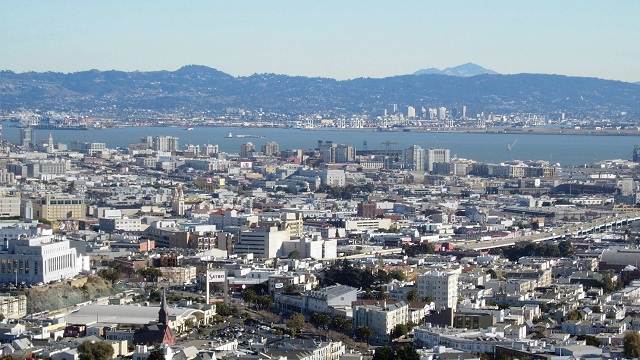
window.__INITIAL_STATE__={
"attachmentsReducer": {
"audio_0": {
"type": "attachments",
"id": "audio_0",
"imgSizes": {
"kqedFullSize": {
"file": "https://ww2.kqed.org/news/wp-content/themes/KQED-unified/img/audio_bgs/background0.jpg"
}
}
},
"audio_1": {
"type": "attachments",
"id": "audio_1",
"imgSizes": {
"kqedFullSize": {
"file": "https://ww2.kqed.org/news/wp-content/themes/KQED-unified/img/audio_bgs/background1.jpg"
}
}
},
"audio_2": {
"type": "attachments",
"id": "audio_2",
"imgSizes": {
"kqedFullSize": {
"file": "https://ww2.kqed.org/news/wp-content/themes/KQED-unified/img/audio_bgs/background2.jpg"
}
}
},
"audio_3": {
"type": "attachments",
"id": "audio_3",
"imgSizes": {
"kqedFullSize": {
"file": "https://ww2.kqed.org/news/wp-content/themes/KQED-unified/img/audio_bgs/background3.jpg"
}
}
},
"audio_4": {
"type": "attachments",
"id": "audio_4",
"imgSizes": {
"kqedFullSize": {
"file": "https://ww2.kqed.org/news/wp-content/themes/KQED-unified/img/audio_bgs/background4.jpg"
}
}
},
"placeholder": {
"type": "attachments",
"id": "placeholder",
"imgSizes": {
"thumbnail": {
"file": "https://cdn.kqed.org/wp-content/uploads/2024/12/KQED-Default-Image-816638274-2000x1333-1-160x107.jpg",
"width": 160,
"height": 107,
"mimeType": "image/jpeg"
},
"medium": {
"file": "https://cdn.kqed.org/wp-content/uploads/2024/12/KQED-Default-Image-816638274-2000x1333-1-800x533.jpg",
"width": 800,
"height": 533,
"mimeType": "image/jpeg"
},
"medium_large": {
"file": "https://cdn.kqed.org/wp-content/uploads/2024/12/KQED-Default-Image-816638274-2000x1333-1-768x512.jpg",
"width": 768,
"height": 512,
"mimeType": "image/jpeg"
},
"large": {
"file": "https://cdn.kqed.org/wp-content/uploads/2024/12/KQED-Default-Image-816638274-2000x1333-1-1020x680.jpg",
"width": 1020,
"height": 680,
"mimeType": "image/jpeg"
},
"1536x1536": {
"file": "https://cdn.kqed.org/wp-content/uploads/2024/12/KQED-Default-Image-816638274-2000x1333-1-1536x1024.jpg",
"width": 1536,
"height": 1024,
"mimeType": "image/jpeg"
},
"fd-lrg": {
"file": "https://cdn.kqed.org/wp-content/uploads/2024/12/KQED-Default-Image-816638274-2000x1333-1-1536x1024.jpg",
"width": 1536,
"height": 1024,
"mimeType": "image/jpeg"
},
"fd-med": {
"file": "https://cdn.kqed.org/wp-content/uploads/2024/12/KQED-Default-Image-816638274-2000x1333-1-1020x680.jpg",
"width": 1020,
"height": 680,
"mimeType": "image/jpeg"
},
"fd-sm": {
"file": "https://cdn.kqed.org/wp-content/uploads/2024/12/KQED-Default-Image-816638274-2000x1333-1-800x533.jpg",
"width": 800,
"height": 533,
"mimeType": "image/jpeg"
},
"post-thumbnail": {
"file": "https://cdn.kqed.org/wp-content/uploads/2024/12/KQED-Default-Image-816638274-2000x1333-1-672x372.jpg",
"width": 672,
"height": 372,
"mimeType": "image/jpeg"
},
"twentyfourteen-full-width": {
"file": "https://cdn.kqed.org/wp-content/uploads/2024/12/KQED-Default-Image-816638274-2000x1333-1-1038x576.jpg",
"width": 1038,
"height": 576,
"mimeType": "image/jpeg"
},
"xxsmall": {
"file": "https://cdn.kqed.org/wp-content/uploads/2024/12/KQED-Default-Image-816638274-2000x1333-1-160x107.jpg",
"width": 160,
"height": 107,
"mimeType": "image/jpeg"
},
"xsmall": {
"file": "https://cdn.kqed.org/wp-content/uploads/2024/12/KQED-Default-Image-816638274-2000x1333-1-672x372.jpg",
"width": 672,
"height": 372,
"mimeType": "image/jpeg"
},
"small": {
"file": "https://cdn.kqed.org/wp-content/uploads/2024/12/KQED-Default-Image-816638274-2000x1333-1-672x372.jpg",
"width": 672,
"height": 372,
"mimeType": "image/jpeg"
},
"xlarge": {
"file": "https://cdn.kqed.org/wp-content/uploads/2024/12/KQED-Default-Image-816638274-2000x1333-1-1020x680.jpg",
"width": 1020,
"height": 680,
"mimeType": "image/jpeg"
},
"full-width": {
"file": "https://cdn.kqed.org/wp-content/uploads/2024/12/KQED-Default-Image-816638274-2000x1333-1-1920x1280.jpg",
"width": 1920,
"height": 1280,
"mimeType": "image/jpeg"
},
"guest-author-32": {
"file": "https://cdn.kqed.org/wp-content/uploads/2025/01/KQED-Default-Image-816638274-1333x1333-1-160x160.jpg",
"width": 32,
"height": 32,
"mimeType": "image/jpeg"
},
"guest-author-50": {
"file": "https://cdn.kqed.org/wp-content/uploads/2025/01/KQED-Default-Image-816638274-1333x1333-1-160x160.jpg",
"width": 50,
"height": 50,
"mimeType": "image/jpeg"
},
"guest-author-64": {
"file": "https://cdn.kqed.org/wp-content/uploads/2025/01/KQED-Default-Image-816638274-1333x1333-1-160x160.jpg",
"width": 64,
"height": 64,
"mimeType": "image/jpeg"
},
"guest-author-96": {
"file": "https://cdn.kqed.org/wp-content/uploads/2025/01/KQED-Default-Image-816638274-1333x1333-1-160x160.jpg",
"width": 96,
"height": 96,
"mimeType": "image/jpeg"
},
"guest-author-128": {
"file": "https://cdn.kqed.org/wp-content/uploads/2025/01/KQED-Default-Image-816638274-1333x1333-1-160x160.jpg",
"width": 128,
"height": 128,
"mimeType": "image/jpeg"
},
"detail": {
"file": "https://cdn.kqed.org/wp-content/uploads/2025/01/KQED-Default-Image-816638274-1333x1333-1-160x160.jpg",
"width": 160,
"height": 160,
"mimeType": "image/jpeg"
},
"kqedFullSize": {
"file": "https://cdn.kqed.org/wp-content/uploads/2024/12/KQED-Default-Image-816638274-2000x1333-1.jpg",
"width": 2000,
"height": 1333
}
}
},
"science_11885": {
"type": "attachments",
"id": "science_11885",
"meta": {
"index": "attachments_1716263798",
"site": "science",
"id": "11885",
"found": true
},
"parent": 11880,
"imgSizes": {
"kqedFullSize": {
"file": "https://ww2.kqed.org/app/uploads/sites/35/2013/12/farm-canal.jpg",
"width": 640,
"height": 360
}
},
"publishDate": 1386637123,
"modified": 1386637123,
"caption": "Proposed water tunnels would supply three million acres of farmland and 25 million Californians. (Craig Miller/KQED)",
"description": "Proposed water tunnels would supply three million acres of farmland and 25 million Californians. (Craig Miller/KQED)",
"title": "farm-canal",
"credit": null,
"status": "inherit",
"isLoading": false,
"fetchFailed": false
},
"science_11782": {
"type": "attachments",
"id": "science_11782",
"meta": {
"index": "attachments_1716263798",
"site": "science",
"id": "11782",
"found": true
},
"parent": 11781,
"imgSizes": {
"kqedFullSize": {
"file": "https://ww2.kqed.org/app/uploads/sites/35/2013/12/oak-berk-ala-sfpan.jpg",
"width": 640,
"height": 360
}
},
"publishDate": 1386272430,
"modified": 1386272430,
"caption": "San Francisco, Berkeley, Oakland and Alameda make one geographic entity in this view from Corona Heights. Andrew Alden photo",
"description": null,
"title": "oak-berk-ala-sfpan",
"credit": null,
"status": "inherit",
"isLoading": false,
"fetchFailed": false
},
"science_11476": {
"type": "attachments",
"id": "science_11476",
"meta": {
"index": "attachments_1716263798",
"site": "science",
"id": "11476",
"found": true
},
"parent": 11472,
"imgSizes": {
"kqedFullSize": {
"file": "https://ww2.kqed.org/app/uploads/sites/35/2013/11/Sylmar-1971-house-e1385170660874.jpg",
"width": 640,
"height": 360
}
},
"publishDate": 1385167961,
"modified": 1385167961,
"caption": "Surface ruptures, known as surface faulting, from the Sylmar earthquake in 1971 damaged this home in San Fernando. (Photo: U.S. Geological Survey)",
"description": null,
"title": "Sylmar 1971 house",
"credit": null,
"status": "inherit",
"isLoading": false,
"fetchFailed": false
},
"science_11310": {
"type": "attachments",
"id": "science_11310",
"meta": {
"index": "attachments_1716263798",
"site": "science",
"id": "11310",
"found": true
},
"parent": 11309,
"imgSizes": {
"kqedFullSize": {
"file": "https://ww2.kqed.org/app/uploads/sites/35/2013/11/clathromorphum-compactum.jpg",
"width": 640,
"height": 360
}
},
"publishDate": 1385063033,
"modified": 1385063033,
"caption": "\u003ci>Clathromorphum compactum\u003c/i> records centuries of climatic data in its thin annual layers. Images courtesy Walter Adey, Smithsonian Institution",
"description": null,
"title": "clathromorphum-compactum",
"credit": null,
"status": "inherit",
"isLoading": false,
"fetchFailed": false
},
"science_10940": {
"type": "attachments",
"id": "science_10940",
"meta": {
"index": "attachments_1716263798",
"site": "science",
"id": "10940",
"found": true
},
"parent": 10939,
"imgSizes": {
"kqedFullSize": {
"file": "https://ww2.kqed.org/app/uploads/sites/35/2013/11/seismostaff.gif",
"width": 640,
"height": 360
}
},
"publishDate": 1384459199,
"modified": 1384459199,
"caption": "Graphic by Andrew Alden",
"description": null,
"title": "seismostaff",
"credit": null,
"status": "inherit",
"isLoading": false,
"fetchFailed": false
},
"science_10766": {
"type": "attachments",
"id": "science_10766",
"meta": {
"index": "attachments_1716263798",
"site": "science",
"id": "10766",
"found": true
},
"parent": 10765,
"imgSizes": {
"kqedFullSize": {
"file": "https://ww2.kqed.org/app/uploads/sites/35/2013/11/anticecore.jpg",
"width": 640,
"height": 360
}
},
"publishDate": 1383850742,
"modified": 1383850742,
"caption": "Michelle Koutnik of the University of Copenhagen's Center for Ice and Climate prepares an Antarctic ice core for transport to the lab. NASA photo by Lora Koenig",
"description": null,
"title": "anticecore",
"credit": null,
"status": "inherit",
"isLoading": false,
"fetchFailed": false
},
"science_10561": {
"type": "attachments",
"id": "science_10561",
"meta": {
"index": "attachments_1716263798",
"site": "science",
"id": "10561",
"found": true
},
"parent": 10292,
"imgSizes": {
"kqedFullSize": {
"file": "https://ww2.kqed.org/app/uploads/sites/35/2013/10/turoniantop.jpg",
"width": 640,
"height": 360
}
},
"publishDate": 1383242275,
"modified": 1383242275,
"caption": "The Turonian Stratotype Section near Pueblo, Colorado",
"description": null,
"title": "turoniantop",
"credit": null,
"status": "inherit",
"isLoading": false,
"fetchFailed": false
},
"science_10248": {
"type": "attachments",
"id": "science_10248",
"meta": {
"index": "attachments_1716263798",
"site": "science",
"id": "10248",
"found": true
},
"parent": 10245,
"imgSizes": {
"kqedFullSize": {
"file": "https://ww2.kqed.org/app/uploads/sites/35/2013/10/EQslidetop.jpg",
"width": 640,
"height": 360
}
},
"publishDate": 1382641000,
"modified": 1382641000,
"caption": null,
"description": null,
"title": "EQslidetop",
"credit": null,
"status": "inherit",
"isLoading": false,
"fetchFailed": false
},
"science_10085": {
"type": "attachments",
"id": "science_10085",
"meta": {
"index": "attachments_1716263798",
"site": "science",
"id": "10085",
"found": true
},
"parent": 10084,
"imgSizes": {
"kqedFullSize": {
"file": "https://ww2.kqed.org/app/uploads/sites/35/2013/10/lomaprieta24.jpg",
"width": 640,
"height": 360
}
},
"publishDate": 1382035607,
"modified": 1382035607,
"caption": "Here in the epicentral region of the Loma Prieta quake, there are almost no signs of the event 24 years later. But the human landscape still carries scars that should remind us to practice continual preparedness. Andrew Alden photo",
"description": null,
"title": "lomaprieta24",
"credit": null,
"status": "inherit",
"isLoading": false,
"fetchFailed": false
},
"science_10014": {
"type": "attachments",
"id": "science_10014",
"meta": {
"index": "attachments_1716263798",
"site": "science",
"id": "10014",
"found": true
},
"parent": 10002,
"imgSizes": {
"kqedFullSize": {
"file": "https://ww2.kqed.org/app/uploads/sites/35/2013/10/Tahoe_SandHarbor_7-11-13_0816_resized.jpg",
"width": 640,
"height": 360
}
},
"publishDate": 1381792347,
"modified": 1381792347,
"caption": "Visitors like these in Sand Harbor, Nevada, are some of the 3 million yearly tourists that fuel Lake Tahoe’s economy. (Arwen Curry/KQED)",
"description": null,
"title": "Tahoe_SandHarbor_7-11-13_0816_resized",
"credit": null,
"status": "inherit",
"isLoading": false,
"fetchFailed": false
},
"science_9846": {
"type": "attachments",
"id": "science_9846",
"meta": {
"index": "attachments_1716263798",
"site": "science",
"id": "9846",
"found": true
},
"parent": 9845,
"imgSizes": {
"kqedFullSize": {
"file": "https://ww2.kqed.org/app/uploads/sites/35/2013/10/saltonswarm.png",
"width": 640,
"height": 360
}
},
"publishDate": 1381429655,
"modified": 1381429655,
"caption": "Seismicity in the southern Salton Sea during the week (yellow dots) and day (orange dots) before October 9, from the \u003ca href=\"http://earthquake.usgs.gov/earthquakes/map/#\">U.S. Geological Survey earthquake viewer\u003c/a>",
"description": null,
"title": "saltonswarm",
"credit": null,
"status": "inherit",
"isLoading": false,
"fetchFailed": false
}
},
"audioPlayerReducer": {
"postId": "stream_live",
"isPaused": true,
"isPlaying": false,
"pfsActive": false,
"pledgeModalIsOpen": true,
"playerDrawerIsOpen": false,
"liveAudioPlayStartedAt": 0,
"liveAudioPlayContext": ""
},
"authorsReducer": {
"laurensommer": {
"type": "authors",
"id": "239",
"meta": {
"index": "authors_1716337520",
"id": "239",
"found": true
},
"name": "Lauren Sommer",
"firstName": "Lauren",
"lastName": "Sommer",
"slug": "laurensommer",
"email": "lsommer@kqed.org",
"display_author_email": false,
"staff_mastheads": [],
"title": "KQED Contributor",
"bio": "Lauren is a radio reporter formerly covering environment, water, and energy for KQED Science. As part of her day job, she has scaled Sierra Nevada peaks, run from charging elephant seals, and desperately tried to get her sea legs - all in pursuit of good radio. Her work has appeared on Marketplace, Living on Earth, Science Friday and NPR's Morning Edition and All Things Considered. You can find her on Twitter at \u003ca href=\"https://twitter.com/lesommer\">@lesommer\u003c/a>.",
"avatar": "https://secure.gravatar.com/avatar/33aa3772bb86c6ad45b8aca6a238bbdf?s=600&d=blank&r=g",
"twitter": null,
"facebook": null,
"instagram": null,
"linkedin": null,
"sites": [
{
"site": "news",
"roles": [
"author"
]
},
{
"site": "science",
"roles": [
"editor",
"manage_content_types",
"manage_taxonomies"
]
},
{
"site": "quest",
"roles": [
"editor"
]
}
],
"headData": {
"title": "Lauren Sommer | KQED",
"description": "KQED Contributor",
"ogImgSrc": "https://secure.gravatar.com/avatar/33aa3772bb86c6ad45b8aca6a238bbdf?s=600&d=blank&r=g",
"twImgSrc": "https://secure.gravatar.com/avatar/33aa3772bb86c6ad45b8aca6a238bbdf?s=600&d=blank&r=g"
},
"isLoading": false,
"link": "/author/laurensommer"
},
"sasha-khokha": {
"type": "authors",
"id": "254",
"meta": {
"index": "authors_1716337520",
"id": "254",
"found": true
},
"name": "Sasha Khokha",
"firstName": "Sasha",
"lastName": "Khokha",
"slug": "sasha-khokha",
"email": "skhokha@kqed.org",
"display_author_email": true,
"staff_mastheads": [
"news"
],
"title": "Host, The California Report Magazine",
"bio": "Sasha Khokha is the host of \u003cem>The California Report's \u003c/em> weekly magazine program, which takes listeners on sound-rich excursions to meet the people that make the Golden State unique -- through audio documentaries and long-form stories. As \u003cem>The California Report's\u003c/em> Central Valley Bureau Chief based in Fresno for nearly a dozen years, Sasha brought the lives and concerns of rural Californians to listeners around the state. Her reporting helped expose the hidden price immigrant women janitors and farmworkers may pay to keep their jobs: sexual assault at work. It inspired two new California laws to protect them from sexual harassment. She was a key member of the reporting team for the Frontline film \u003cem>Rape on the Night Shift, \u003c/em>which was nominated for two national Emmys. Sasha has also won a national Edward R. Murrow and a national PRNDI award for investigative reporting, as well as multiple prizes from the Society for Professional Journalists. Sasha is a proud alum of the UC Berkeley Graduate School of Journalism and Brown University and a member of the South Asian Journalists Association.",
"avatar": "https://secure.gravatar.com/avatar/e4b5e1541aaeea2aa356aa1fb2a68950?s=600&d=blank&r=g",
"twitter": "KQEDSashaKhokha",
"facebook": null,
"instagram": null,
"linkedin": null,
"sites": [
{
"site": "news",
"roles": [
"editor"
]
},
{
"site": "stateofhealth",
"roles": [
"author"
]
},
{
"site": "science",
"roles": [
"author"
]
},
{
"site": "quest",
"roles": [
"subscriber"
]
}
],
"headData": {
"title": "Sasha Khokha | KQED",
"description": "Host, The California Report Magazine",
"ogImgSrc": "https://secure.gravatar.com/avatar/e4b5e1541aaeea2aa356aa1fb2a68950?s=600&d=blank&r=g",
"twImgSrc": "https://secure.gravatar.com/avatar/e4b5e1541aaeea2aa356aa1fb2a68950?s=600&d=blank&r=g"
},
"isLoading": false,
"link": "/author/sasha-khokha"
},
"gabriela-quiros": {
"type": "authors",
"id": "6186",
"meta": {
"index": "authors_1716337520",
"id": "6186",
"found": true
},
"name": "Gabriela Quirós",
"firstName": "Gabriela",
"lastName": "Quirós",
"slug": "gabriela-quiros",
"email": "gquiros@kqed.org",
"display_author_email": false,
"staff_mastheads": [],
"title": "Supervising Producer",
"bio": "Gabriela Quirós is the \u003cstrong>supervising producer for KQED's web science video series \u003ca href=\"https://www.kqed.org/deeplook\">Deep Look\u003c/a>\u003c/strong>. She joined KQED as a TV producer when its science series QUEST started in 2006 and has covered everything from Alzheimer’s to bee die-offs to dark energy.\r\n\r\nShe won a 2022 AAAS Kavli Science Journalism Award with a team of her Deep Look colleagues. She has won six regional Emmys as a video producer and has shared eight more as the coordinating producer of Deep Look. The episode she produced about \u003ca href=\"https://www.kqed.org/science/728086/how-mosquitoes-use-six-needles-to-suck-your-blood\">How Mosquitoes Use Six Needles to Suck Your Blood\u003c/a> won a Webby \"People's Voice\" award. She has also earned awards from the Jackson Hole Wildlife Film Festival, the Society of Professional Journalists and the Society of Environmental Journalists.\r\n\r\nHer videos for KQED have also aired on NOVA scienceNOW and the PBS NewsHour, and appeared on NPR.org.\r\n\r\nAs an independent filmmaker, she produced and directed the hour-long documentary \u003ca href=\"http://lpbp.org/beautiful-sin-qa-with-producer-gabriela-quiros/\">\u003cem>Beautiful Sin\u003c/em>\u003c/a>, about the surprising story of how Costa Rica became the only country in the world to outlaw in vitro fertilization. The film aired in 2015 on public television stations throughout the U.S., and in Costa Rica.\r\n\r\nShe started her journalism career as a newspaper reporter in Costa Rica, where she grew up. She won the National Science Journalism Award there for a series of articles about organic agriculture, and developed a life-long interest in health reporting. She moved to the Bay Area in 1996 to study documentary filmmaking at the University of California, Berkeley, where she received master’s degrees in journalism and Latin American studies.",
"avatar": "https://secure.gravatar.com/avatar/6d82c20152affd1b434c31a904c40809?s=600&d=blank&r=g",
"twitter": "gabrielaquirosr",
"facebook": null,
"instagram": null,
"linkedin": null,
"sites": [
{
"site": "science",
"roles": []
},
{
"site": "quest",
"roles": [
"ef_view_calendar",
"ef_view_story_budget"
]
}
],
"headData": {
"title": "Gabriela Quirós | KQED",
"description": "Supervising Producer",
"ogImgSrc": "https://secure.gravatar.com/avatar/6d82c20152affd1b434c31a904c40809?s=600&d=blank&r=g",
"twImgSrc": "https://secure.gravatar.com/avatar/6d82c20152affd1b434c31a904c40809?s=600&d=blank&r=g"
},
"isLoading": false,
"link": "/author/gabriela-quiros"
},
"andrew-alden": {
"type": "authors",
"id": "6228",
"meta": {
"index": "authors_1716337520",
"id": "6228",
"found": true
},
"name": "Andrew Alden",
"firstName": "Andrew",
"lastName": "Alden",
"slug": "andrew-alden",
"email": "alden@andrew-alden.com",
"display_author_email": false,
"staff_mastheads": [],
"title": null,
"bio": "Andrew Alden earned his geology degree at the University of New Hampshire and moved back to the Bay Area to work at the U.S. Geological Survey for six years. He has \u003ca href=\"http://geology.about.com/\">written on geology for About.com\u003c/a> since its founding in 1997. In 2007, he started the Oakland Geology blog, which won recognition as \"Best of the East Bay\" from the \u003ci>East Bay Express\u003c/i> in 2010. In writing about geology in the Bay Area and surroundings, he hopes to share some of the useful and pleasurable insights that geologists give us—not just facts about the deep past, but an attitude that might be called the \u003ci>deep present\u003c/i>.\r\n\r\nRead his \u003ca href=\"http://science.kqed.org/quest/author/andrew-alden/\">previous contributions\u003c/a> to \u003ca href=\"http://http://science.kqed.org/quest/\">QUEST\u003c/a>, a project dedicated to exploring the Science of Sustainability.",
"avatar": "https://secure.gravatar.com/avatar/9eaa0afc32f98c5fc7ce634437334a64?s=600&d=blank&r=g",
"twitter": null,
"facebook": null,
"instagram": null,
"linkedin": null,
"sites": [
{
"site": "science",
"roles": [
"author"
]
},
{
"site": "quest",
"roles": [
"subscriber"
]
}
],
"headData": {
"title": "Andrew Alden | KQED",
"description": null,
"ogImgSrc": "https://secure.gravatar.com/avatar/9eaa0afc32f98c5fc7ce634437334a64?s=600&d=blank&r=g",
"twImgSrc": "https://secure.gravatar.com/avatar/9eaa0afc32f98c5fc7ce634437334a64?s=600&d=blank&r=g"
},
"isLoading": false,
"link": "/author/andrew-alden"
},
"stotten": {
"type": "authors",
"id": "6524",
"meta": {
"index": "authors_1716337520",
"id": "6524",
"found": true
},
"name": "Sanden Totten",
"firstName": "Sanden",
"lastName": "Totten",
"slug": "stotten",
"email": "stotten@kpcc.org",
"display_author_email": false,
"staff_mastheads": [],
"title": null,
"bio": "Sanden Totten is KPCC's Science Reporter. He covers everything from advances in medical technology to dinosaur fossils and space exploration. Before joining Southern California Public Radio, Sanden worked at Minnesota Public Radio, where he was co-creator of In \"The Loop,\" a program that made the audience part of the show. He was also part of the team behind the Public Insight Network, a crowd-sourcing project designed to bring unique perspectives to news.\r\n\r\nSanden is the winner of several honors, including the Radio and TV News Association’s Golden Mike for “best writing.” He was a 2011 Knight Science Journalism Fellow at MIT. He has a BA in Psychology and English from Oberlin College in Ohio, and also attended school in Japan and Sweden, and speaks both languages. He is a fan of fast music, comics and movies about time travel.",
"avatar": "https://secure.gravatar.com/avatar/2c96c1ba8edb98a44216993f3cb20029?s=600&d=blank&r=g",
"twitter": null,
"facebook": null,
"instagram": null,
"linkedin": null,
"sites": [
{
"site": "science",
"roles": [
"author"
]
}
],
"headData": {
"title": "Sanden Totten | KQED",
"description": null,
"ogImgSrc": "https://secure.gravatar.com/avatar/2c96c1ba8edb98a44216993f3cb20029?s=600&d=blank&r=g",
"twImgSrc": "https://secure.gravatar.com/avatar/2c96c1ba8edb98a44216993f3cb20029?s=600&d=blank&r=g"
},
"isLoading": false,
"link": "/author/stotten"
}
},
"pagesReducer": {
"science_category_geology": {
"type": "terms",
"id": "science_38",
"meta": {
"index": "terms_1716263798",
"site": "science",
"id": "38",
"score": 13.559036
},
"featImg": null,
"name": "Geology",
"description": null,
"taxonomy": "category",
"headData": {
"twImgId": null,
"twTitle": null,
"ogTitle": null,
"ogImgId": null,
"twDescription": null,
"description": null,
"title": "Geology Archives | KQED Science",
"ogDescription": null
},
"ttid": 40,
"slug": "geology",
"isLoading": false,
"title": "Geology",
"pageMeta": {
"site": "science",
"WpPageTemplate": "page-topic-editorial",
"currentPage": 17
},
"blocks": [
{
"blockName": "kqed/post-list",
"attrs": {
"layout": "cardArticle2",
"query": "posts/science?category=geology",
"seeMore": false,
"paginated": true,
"page": 17
}
},
{
"blockName": "kqed/ad"
}
]
}
},
"pfsSessionReducer": {},
"postsReducer": {
"stream_live": {
"type": "live",
"id": "stream_live",
"audioUrl": "https://hls.kqed.org/hls/kqed_app/playlist.m3u8",
"title": "Live Stream",
"excerpt": "Live Stream information currently unavailable.",
"link": "/radio",
"featImg": "",
"label": {
"name": "KQED Live",
"link": "/"
}
},
"stream_kqedNewscast": {
"type": "posts",
"id": "stream_kqedNewscast",
"audioUrl": "https://www.kqed.org/.stream/anon/radio/RDnews/newscast.mp3?_=1",
"title": "KQED Newscast",
"featImg": "",
"label": {
"name": "88.5 FM",
"link": "/"
}
},
"science_11880": {
"type": "posts",
"id": "science_11880",
"meta": {
"index": "posts_1716263798",
"site": "science",
"id": "11880",
"score": null,
"sort": [
1386638924000
]
},
"parent": 0,
"labelTerm": {
"site": "science",
"term": 87
},
"blocks": [],
"publishDate": 1386638924,
"format": "aside",
"title": "With California's Water Future at Stake, Delta Plan Inches Ahead",
"headTitle": "With California’s Water Future at Stake, Delta Plan Inches Ahead | KQED",
"content": "\u003cfigure id=\"attachment_11885\" class=\"wp-caption alignleft\" style=\"max-width: 288px\">\u003ca href=\"http://ww2.kqed.org/science/wp-content/uploads/sites/35/2013/12/farm-canal-288x162.jpg\">\u003cimg loading=\"lazy\" decoding=\"async\" class=\"size-medium wp-image-11885\" src=\"http://ww2.kqed.org/science/wp-content/uploads/sites/35/2013/12/farm-canal-288x162.jpg\" alt=\"Proposed water tunnels would supply three million acres of farmland and 25 million Californians.\" width=\"288\" height=\"162\">\u003c/a>\u003cfigcaption class=\"wp-caption-text\">A bend in the California Aqueduct, with orchards behind. Proposed water tunnels would supply three million acres of farmland and 25 million Californians. (Craig Miller/KQED)\u003c/figcaption>\u003c/figure>\n\u003cp>Seven years in the making, state officials on Monday unveiled the latest version of their ambitious plan for revitalizing the heart of California’s embattled water system and securing supplies for decades to come.\u003c/p>\n\u003cp>The \u003ca title=\"BDCP \" href=\"http://baydeltaconservationplan.com/News/KeyAnnouncements.aspx\">Bay Delta Conservation Plan\u003c/a> and its environmental review weigh in at 34,000 pages — that’s before public comments start pouring in next week for a 120-day feedback period.\u003c/p>\n\u003cp>At the core of the plan is Governor Brown’s proposal to build 35-mile twin tunnels underneath the sensitive Sacramento-San Joaquin River Delta, often referred to as the “switching yard” for California’s elaborate freshwater plumbing system.\u003c/p>\n\u003cp>Officials say the plan will achieve two “co-equal goals” – ensuring a reliable water supply for the state and restoring the Delta’s ecosystem, including populations of threatened Chinook salmon and Delta smelt.\u003c/p>\n\u003cp>But as more details of the plan emerge, meeting both of those goals looks increasingly challenging.\u003c/p>\n\u003cp>[ad fullwidth]\u003c/p>\n\u003cp>\u003cstrong>The Unavoidable Question: Freshwater Flows\u003c/strong>\u003c/p>\n\u003cp>The proposed tunnels are designed to address a chronic trouble spot in the Delta: the pumping facilities at the southern edge, which funnel water to Silicon Valley, Central Valley farms and Southern California cities. Biologists say the powerful pumps alter the natural water flows, harming juvenile salmon and Delta smelt.\u003c/p>\n\u003cp>To protect fish, federal wildlife agencies put rules in place that slow the pumps during sensitive times of year. Those restrictions, as well as occasional droughts, have cut water deliveries to districts south of the Delta.\u003c/p>\n\u003cp>The proposed tunnels would use state-of-the-art fish screens, though the south Delta pumps would still be in use about half the time.\u003c/p>\n\u003cp>\u003ca href=\"http://ww2.kqed.org/science/wp-content/uploads/sites/35/2013/12/tunnelmap.jpg\">\u003cimg loading=\"lazy\" decoding=\"async\" class=\"alignleft wp-image-11892\" src=\"http://ww2.kqed.org/science/wp-content/uploads/sites/35/2013/12/tunnelmap-826x1024.jpg\" alt=\"tunnelmap\" width=\"347\" height=\"430\">\u003c/a>While several environmental groups say that would be an improvement for endangered fish, the unresolved question is one that’s dogged the state for years: how much freshwater should be pumped out of the Delta and how much should be left in the ecosystem?\u003c/p>\n\u003cp>“If you’re a fish, you can’t get away from flow,” says Jon Rosenfield of \u003ca href=\"http://www.bay.org/\">The Bay Institute\u003c/a>. “We know that increasing flow into, through and out of the Delta will benefit all the fish species.”\u003c/p>\n\u003cp>Federal wildlife agencies stress that species like Delta smelt and longfin smelt rely on freshwater flowing out of the Delta and into San Francisco Bay, especially in the spring and fall. In some years, as much as half of that water is diverted by pumping operations.\u003c/p>\n\u003cp>Environmental groups say the tunnels may not leave enough freshwater in the ecosystem, something they say is crucial for Delta smelt and longfin smelt.\u003c/p>\n\u003cp>\u003cstrong>Two Freshwater Scenarios\u003c/strong>\u003c/p>\n\u003cp>Over the last 20 years, an average of 5.2 million acre-feet of water have been pumped out of the Delta each year (one acre-foot is about enough water for an average family for a year). Under the new plan, one scenario would allow 4.7 million acre-feet to be exported each year, leaving more water in the ecosystem. The other would allow 5.6 million acre-feet a year in exports.\u003c/p>\n\u003cp>The difference is likely to be crucial for state and federal wildlife agencies, which must evaluate the impact of the plan on endangered fish. Tunnel construction can’t move forward without permits from those agencies.\u003c/p>\n\u003caside class=\"pullquote alignleft\">The people who are being asked to pay for this project are looking at how much water will they get for their money\u003c/aside>\n\u003cp>“This is really about creating a reliable supply,” says Mark Cowin of the Department of Water Resources, the state agency crafting the plan. “It’s not about exporting more water to Southern California. It’s about improving the way that we move the existing amount of water that we move, in a way that’s beneficial for fish.”\u003c/p>\n\u003cp>\u003cstrong>Supply vs. Cost\u003c/strong>\u003c/p>\n\u003cp>Leaving more water in the ecosystem is a major sticking point for water districts that would be paying the tunnel construction costs, around $17 billion. Many say it will be challenging to get people to pay for a project that doesn’t guarantee their water supply.\u003c/p>\n\u003cp>“If we don’t come out of this planning process with a preferred alternative that provides more water than we’re getting today, I can’t imagine people making decisions to invest,” says Jason Peltier of the Fresno-based Westlands Water District, which relies on Delta water.\u003c/p>\n\u003cp>“The people who are being asked to pay for this project are looking at how much water will they get for their money,” says Jim Beck, general manager of Kern County Water Agency. \u003c/p>\n\u003cp>“When you see scenarios that reduce the yield of the project, that means the cost per unit goes up and that may push the project toward the range of being unaffordable from a business perspective,” he says.\u003c/p>\n\u003cp>“It’s a hard sell for those that would pay for the project,” acknowledges Mark Cowin of the Department of Water Resources. \u003c/p>\n\u003cp>“The case to be made is that if they don’t make this investment, they will see their water supply reliability plummet to drastic lower levels,” he says. The state estimates that without the plan, water exports would drop to 3.4 to 3.9 million acre-feet a year.\u003c/p>\n\u003cp>\u003cstrong>Habitat Restoration\u003c/strong>\u003c/p>\n\u003cp>[contextly_sidebar id=”866a899c7fb1c20da6755e965cb9dfdb”]\u003c/p>\n\u003cp>To help bring back endangered fish and offset the impact of the tunnels themselves, the state is proposing to restore more than 100,000 acres of habitat restoration, including 30,000 acres of aquatic habitat in the next 15 years as tunnel construction is underway.\u003c/p>\n\u003cp>The Delta was once a rich web of wetlands and tidal channels, but as California grew, land was converted into farms. About \u003ca href=\"http://science.kqed.org/quest/delta-map/\">97 percent of the Delta’s historic habitat is gone\u003c/a>.\u003c/p>\n\u003cp>If fish show a strong recovery, the plan allows more water to be diverted from the Delta. But according to biologists, the benefits of habitat restoration are highly uncertain.\u003c/p>\n\u003cp>“Restoring wetland habitat will do great things for migratory birds and may do great things for certain species,” says the Bay Institute’s Rosenfield. “But it’s very clear that it won’t have much of benefit for some of the endangered species, like longfin smelt or steelhead.”\u003c/p>\n\u003cp>The plan also faces opposition from Delta residents concerned about the impact of construction.\u003cbr>\n“We’re being asked to sacrifice family farms that have been in existence for 150 years,” says Barbara Barrigan-Parrilla of Restore the Delta. “We are absolutely determined to fight this every which way to stop the project for the benefit of California and to save the Delta.”\u003c/p>\n\u003cp>After reviewing public feedback, state officials hope to have a final draft of the plan by the end of 2014.\u003c/p>\n\u003cp>[ad floatright]\u003c/p>\n\u003cp>\u003c!-- iframe plugin v.4.3 wordpress.org/plugins/iframe/ -->\u003cbr>\n\u003ciframe loading=\"lazy\" src=\"https://w.soundcloud.com/player/?url=https%3A//api.soundcloud.com/tracks/124082049&color=ff6600&auto_play=false&show_artwork=true\" frameborder=\"no\" scrolling=\"no\" width=\"100%\" height=\"166\" class=\"iframe-class\">\u003c/iframe>\u003c/p>\n\n",
"stats": {
"hasVideo": false,
"hasChartOrMap": false,
"hasAudio": true,
"hasPolis": false,
"wordCount": 1180,
"hasGoogleForm": false,
"hasGallery": false,
"hasHearkenModule": false,
"iframeSrcs": [],
"paragraphCount": 35
},
"modified": 1704934573,
"excerpt": "California's $25 billion fix for the Sacramento-San Joaquin Delta depends on making wildlife groups and water users happy. With the latest release of the state's plan, it's looking harder to do both.",
"headData": {
"twImgId": "",
"twTitle": "",
"ogTitle": "",
"ogImgId": "",
"twDescription": "",
"description": "California's $25 billion fix for the Sacramento-San Joaquin Delta depends on making wildlife groups and water users happy. With the latest release of the state's plan, it's looking harder to do both.",
"title": "With California's Water Future at Stake, Delta Plan Inches Ahead | KQED",
"ogDescription": "",
"schema": {
"@context": "https://schema.org",
"@type": "Article",
"headline": "With California's Water Future at Stake, Delta Plan Inches Ahead",
"datePublished": "2013-12-09T17:28:44-08:00",
"dateModified": "2024-01-10T16:56:13-08:00",
"image": "https://cdn.kqed.org/wp-content/uploads/2020/02/KQED-OG-Image@1x.png"
}
},
"guestAuthors": [],
"slug": "delta-plan-environmental-review-debuts-californias-water-future-at-stake",
"status": "publish",
"sticky": false,
"path": "/science/11880/delta-plan-environmental-review-debuts-californias-water-future-at-stake",
"audioTrackLength": null,
"parsedContent": [
{
"type": "contentString",
"content": "\u003cdiv class=\"post-body\">\u003cp>\u003cfigure id=\"attachment_11885\" class=\"wp-caption alignleft\" style=\"max-width: 288px\">\u003ca href=\"http://ww2.kqed.org/science/wp-content/uploads/sites/35/2013/12/farm-canal-288x162.jpg\">\u003cimg loading=\"lazy\" decoding=\"async\" class=\"size-medium wp-image-11885\" src=\"http://ww2.kqed.org/science/wp-content/uploads/sites/35/2013/12/farm-canal-288x162.jpg\" alt=\"Proposed water tunnels would supply three million acres of farmland and 25 million Californians.\" width=\"288\" height=\"162\">\u003c/a>\u003cfigcaption class=\"wp-caption-text\">A bend in the California Aqueduct, with orchards behind. Proposed water tunnels would supply three million acres of farmland and 25 million Californians. (Craig Miller/KQED)\u003c/figcaption>\u003c/figure>\n\u003cp>Seven years in the making, state officials on Monday unveiled the latest version of their ambitious plan for revitalizing the heart of California’s embattled water system and securing supplies for decades to come.\u003c/p>\n\u003cp>The \u003ca title=\"BDCP \" href=\"http://baydeltaconservationplan.com/News/KeyAnnouncements.aspx\">Bay Delta Conservation Plan\u003c/a> and its environmental review weigh in at 34,000 pages — that’s before public comments start pouring in next week for a 120-day feedback period.\u003c/p>\n\u003cp>At the core of the plan is Governor Brown’s proposal to build 35-mile twin tunnels underneath the sensitive Sacramento-San Joaquin River Delta, often referred to as the “switching yard” for California’s elaborate freshwater plumbing system.\u003c/p>\n\u003cp>Officials say the plan will achieve two “co-equal goals” – ensuring a reliable water supply for the state and restoring the Delta’s ecosystem, including populations of threatened Chinook salmon and Delta smelt.\u003c/p>\n\u003cp>But as more details of the plan emerge, meeting both of those goals looks increasingly challenging.\u003c/p>\n\u003cp>\u003c/p>\u003c/div>",
"attributes": {
"named": {},
"numeric": []
}
},
{
"type": "component",
"content": "",
"name": "ad",
"attributes": {
"named": {
"label": "fullwidth"
},
"numeric": [
"fullwidth"
]
}
},
{
"type": "contentString",
"content": "\u003cdiv class=\"post-body\">\u003cp>\u003c/p>\n\u003cp>\u003cstrong>The Unavoidable Question: Freshwater Flows\u003c/strong>\u003c/p>\n\u003cp>The proposed tunnels are designed to address a chronic trouble spot in the Delta: the pumping facilities at the southern edge, which funnel water to Silicon Valley, Central Valley farms and Southern California cities. Biologists say the powerful pumps alter the natural water flows, harming juvenile salmon and Delta smelt.\u003c/p>\n\u003cp>To protect fish, federal wildlife agencies put rules in place that slow the pumps during sensitive times of year. Those restrictions, as well as occasional droughts, have cut water deliveries to districts south of the Delta.\u003c/p>\n\u003cp>The proposed tunnels would use state-of-the-art fish screens, though the south Delta pumps would still be in use about half the time.\u003c/p>\n\u003cp>\u003ca href=\"http://ww2.kqed.org/science/wp-content/uploads/sites/35/2013/12/tunnelmap.jpg\">\u003cimg loading=\"lazy\" decoding=\"async\" class=\"alignleft wp-image-11892\" src=\"http://ww2.kqed.org/science/wp-content/uploads/sites/35/2013/12/tunnelmap-826x1024.jpg\" alt=\"tunnelmap\" width=\"347\" height=\"430\">\u003c/a>While several environmental groups say that would be an improvement for endangered fish, the unresolved question is one that’s dogged the state for years: how much freshwater should be pumped out of the Delta and how much should be left in the ecosystem?\u003c/p>\n\u003cp>“If you’re a fish, you can’t get away from flow,” says Jon Rosenfield of \u003ca href=\"http://www.bay.org/\">The Bay Institute\u003c/a>. “We know that increasing flow into, through and out of the Delta will benefit all the fish species.”\u003c/p>\n\u003cp>Federal wildlife agencies stress that species like Delta smelt and longfin smelt rely on freshwater flowing out of the Delta and into San Francisco Bay, especially in the spring and fall. In some years, as much as half of that water is diverted by pumping operations.\u003c/p>\n\u003cp>Environmental groups say the tunnels may not leave enough freshwater in the ecosystem, something they say is crucial for Delta smelt and longfin smelt.\u003c/p>\n\u003cp>\u003cstrong>Two Freshwater Scenarios\u003c/strong>\u003c/p>\n\u003cp>Over the last 20 years, an average of 5.2 million acre-feet of water have been pumped out of the Delta each year (one acre-foot is about enough water for an average family for a year). Under the new plan, one scenario would allow 4.7 million acre-feet to be exported each year, leaving more water in the ecosystem. The other would allow 5.6 million acre-feet a year in exports.\u003c/p>\n\u003cp>The difference is likely to be crucial for state and federal wildlife agencies, which must evaluate the impact of the plan on endangered fish. Tunnel construction can’t move forward without permits from those agencies.\u003c/p>\n\u003caside class=\"pullquote alignleft\">The people who are being asked to pay for this project are looking at how much water will they get for their money\u003c/aside>\n\u003cp>“This is really about creating a reliable supply,” says Mark Cowin of the Department of Water Resources, the state agency crafting the plan. “It’s not about exporting more water to Southern California. It’s about improving the way that we move the existing amount of water that we move, in a way that’s beneficial for fish.”\u003c/p>\n\u003cp>\u003cstrong>Supply vs. Cost\u003c/strong>\u003c/p>\n\u003cp>Leaving more water in the ecosystem is a major sticking point for water districts that would be paying the tunnel construction costs, around $17 billion. Many say it will be challenging to get people to pay for a project that doesn’t guarantee their water supply.\u003c/p>\n\u003cp>“If we don’t come out of this planning process with a preferred alternative that provides more water than we’re getting today, I can’t imagine people making decisions to invest,” says Jason Peltier of the Fresno-based Westlands Water District, which relies on Delta water.\u003c/p>\n\u003cp>“The people who are being asked to pay for this project are looking at how much water will they get for their money,” says Jim Beck, general manager of Kern County Water Agency. \u003c/p>\n\u003cp>“When you see scenarios that reduce the yield of the project, that means the cost per unit goes up and that may push the project toward the range of being unaffordable from a business perspective,” he says.\u003c/p>\n\u003cp>“It’s a hard sell for those that would pay for the project,” acknowledges Mark Cowin of the Department of Water Resources. \u003c/p>\n\u003cp>“The case to be made is that if they don’t make this investment, they will see their water supply reliability plummet to drastic lower levels,” he says. The state estimates that without the plan, water exports would drop to 3.4 to 3.9 million acre-feet a year.\u003c/p>\n\u003cp>\u003cstrong>Habitat Restoration\u003c/strong>\u003c/p>\n\u003cp>\u003c/p>\u003cp>\u003c/p>\u003cp>\u003c/p>\n\u003cp>To help bring back endangered fish and offset the impact of the tunnels themselves, the state is proposing to restore more than 100,000 acres of habitat restoration, including 30,000 acres of aquatic habitat in the next 15 years as tunnel construction is underway.\u003c/p>\n\u003cp>The Delta was once a rich web of wetlands and tidal channels, but as California grew, land was converted into farms. About \u003ca href=\"http://science.kqed.org/quest/delta-map/\">97 percent of the Delta’s historic habitat is gone\u003c/a>.\u003c/p>\n\u003cp>If fish show a strong recovery, the plan allows more water to be diverted from the Delta. But according to biologists, the benefits of habitat restoration are highly uncertain.\u003c/p>\n\u003cp>“Restoring wetland habitat will do great things for migratory birds and may do great things for certain species,” says the Bay Institute’s Rosenfield. “But it’s very clear that it won’t have much of benefit for some of the endangered species, like longfin smelt or steelhead.”\u003c/p>\n\u003cp>The plan also faces opposition from Delta residents concerned about the impact of construction.\u003cbr>\n“We’re being asked to sacrifice family farms that have been in existence for 150 years,” says Barbara Barrigan-Parrilla of Restore the Delta. “We are absolutely determined to fight this every which way to stop the project for the benefit of California and to save the Delta.”\u003c/p>\n\u003cp>After reviewing public feedback, state officials hope to have a final draft of the plan by the end of 2014.\u003c/p>\n\u003cp>\u003c/p>\u003c/div>",
"attributes": {
"named": {},
"numeric": []
}
},
{
"type": "component",
"content": "",
"name": "ad",
"attributes": {
"named": {
"label": "floatright"
},
"numeric": [
"floatright"
]
}
},
{
"type": "contentString",
"content": "\u003cdiv class=\"post-body\">\u003cp>\u003c/p>\n\u003cp>\u003c!-- iframe plugin v.4.3 wordpress.org/plugins/iframe/ -->\u003cbr>\n\u003ciframe loading=\"lazy\" src=\"https://w.soundcloud.com/player/?url=https%3A//api.soundcloud.com/tracks/124082049&color=ff6600&auto_play=false&show_artwork=true\" frameborder=\"no\" scrolling=\"no\" width=\"100%\" height=\"166\" class=\"iframe-class\">\u003c/iframe>\u003c/p>\n\n\u003c/div>\u003c/p>",
"attributes": {
"named": {},
"numeric": []
}
}
],
"link": "/science/11880/delta-plan-environmental-review-debuts-californias-water-future-at-stake",
"authors": [
"239"
],
"series": [
"science_87"
],
"categories": [
"science_89",
"science_35",
"science_38",
"science_40",
"science_98"
],
"tags": [
"science_100",
"science_110"
],
"featImg": "science_11885",
"label": "science_87"
},
"science_11781": {
"type": "posts",
"id": "science_11781",
"meta": {
"index": "posts_1716263798",
"site": "science",
"id": "11781",
"score": null,
"sort": [
1386273849000
]
},
"parent": 0,
"labelTerm": {
"site": "science"
},
"blocks": [],
"publishDate": 1386273849,
"format": "aside",
"title": "Four Bay Area Cities Selected as Future Models of Resilience",
"headTitle": "Four Bay Area Cities Selected as Future Models of Resilience | KQED",
"content": "\u003cfigure id=\"attachment_11782\" class=\"wp-caption aligncenter\" style=\"max-width: 640px\">\u003ca href=\"http://ww2.kqed.org/science/wp-content/uploads/sites/35/2013/12/oak-berk-ala-sfpan.jpg\" rel=\"attachment wp-att-11782\">\u003cimg loading=\"lazy\" decoding=\"async\" class=\"size-full wp-image-11782\" src=\"http://ww2.kqed.org/science/wp-content/uploads/sites/35/2013/12/oak-berk-ala-sfpan.jpg\" alt=\"San Francisco, Berkeley, Oakland and Alameda\" width=\"640\" height=\"360\">\u003c/a>\u003cfigcaption class=\"wp-caption-text\">San Francisco, Berkeley, Oakland and Alameda make one geographic entity in this view from Corona Heights. Andrew Alden photo\u003c/figcaption>\u003c/figure>\n\u003cp>When you add up the challenges that humanity faces, the brunt of them falls on cities. Rising sea levels, flooding, earthquake/tsunamis, water supplies, transportation, power, jobs, governance—there’s no safety in numbers; instead, with numbers come vulnerability. Speaking as a geologist, I naturally ascribe all this to life on a dynamic planet.\u003c/p>\n\u003cp>Many experts have been urging cities to adopt resilience as a goal. Resilience is like robust good health in you or me, helping us avoid injury, cope with health threats, recover quickly and adapt to changes. Resilience is not defined by emergencies, it’s what we do between crises to get ready for them. Resilience is the coursework for which catastrophes are the final exams. \u003ca href=\"http://www.rockefellerfoundation.org/our-work/current-work/resilience\">As the Rockefeller Foundation puts it\u003c/a>, “Resilience is the capacity of individuals, communities and systems to survive, adapt, and grow in the face of stress and shocks, and even transform when conditions require it.”\u003c/p>\n\u003cp>When the Rockefeller Foundation turned 100 this year, the New York nonprofit decided to launch a $100 million project called 100 Resilient Cities. Applications opened in May, and \u003ca href=\"http://100resilientcities.rockefellerfoundation.org/cities\">the first 33 winning cities were announced on Tuesday\u003c/a>. The geological hazards they face include earthquakes, tsunamis, rising sea level, landslides, drought, flood, erosion and more. These in turn threaten the cities’ human and technological frameworks, on top of the intrinsic instabilities of growing population centers.\u003c/p>\n\u003cp>Of these first 33 cities, 11 are in the United States and 5 are in California. One is Los Angeles, of course. The other four are not just in the Bay Area, but have common borders: Alameda, Berkeley, Oakland and San Francisco. Instantly, the Bay Area has become a unique and high-stakes experiment. (The remaining six U.S. cities are Boulder, El Paso, Jacksonville, New Orleans, New York and Norfolk.)\u003c/p>\n\u003cp>A hundred million dollars across 100 cities gives each one a million dollars in support. In return, the cities “commit to developing or implementing a city-wide resilience plan” and hire a Chief Resilience Officer in the city government. Those two things should pretty much eat up the seed money. In addition, the cities will be offered “solutions to spur investments and financing for resilient infrastructure, information technology tools, and policy models for resilience-enabling laws and regulations.” Finally, the cities must collaborate with each other, presumably via some online forum.\u003c/p>\n\u003cp>[ad fullwidth]\u003c/p>\n\u003cp>Last month the foundation’s president, Judith Rodin, told a New York audience what success might look like, naming five key jobs for the city’s new mayor: (1) appoint a “Deputy Mayor for Economic Development and Resilience” to work resilience into every development, (2) get a bus rapid transit system working, (3) invest in new ideas and technology, (4) work the federal funding system more effectively and (5) start a municipal infrastructure bank to jump-start worthy projects. The threat to New York took shape this year as Hurricane Sandy, but those steps hold promise for our own regional threats.\u003c/p>\n\u003cp>The \u003ca href=\"http://100resilientcities.rockefellerfoundation.org/\">100 Resilient Cities website\u003c/a> has brief descriptions of the 33 winning cities, in which the four Bay Area winners come off like a synergetic superhero squad. Alameda, uniquely vulnerable to tsunamis, is cast as the eager test case. Berkeley, “a pioneering city, research center, and innovation hub,” has the brains. Oakland, “known for its ground-breaking community partnerships,” has the people power. San Francisco, with “a history of devastating earthquakes and fires,” is the can-do Big City.\u003c/p>\n\u003cp>All of these things are true of all four cities: vulnerable to tsunamis, prone to quake and fire, laden with brains and means, and as self-active and innovative as any place in America. All four cities lie between two major fault lines, rely on water and power from distant sources, and have large non-English-speaking populations. Together, this squad of cities could form a tight gang that outfights its weight, or whatever superhero metaphor you prefer. The experiment may also be the key to adding resilience in places similar to the Bay Area, an urban area without a dominant city.\u003c/p>\n\u003cp>\u003c/p>\n\u003cp>This could fizzle or this could boom. A single city officer with a resilience plan is not much by itself, just a spark. Everything depends on the city, government and citizens alike, nurturing that initial spark into something sustainable—a culture of resilience. A key variable that the gang-of-four cities will test is whether being neighbors will make a difference. Their Chief Resilience Officers will be able to collaborate every day, in person if they like, and so will their governments and citizens. Will that be our superpower? Stay tuned.\u003c/p>\n\n",
"stats": {
"hasVideo": false,
"hasChartOrMap": false,
"hasAudio": false,
"hasPolis": false,
"wordCount": 805,
"hasGoogleForm": false,
"hasGallery": false,
"hasHearkenModule": false,
"iframeSrcs": [],
"paragraphCount": 11
},
"modified": 1704934585,
"excerpt": "A $100 million effort to push the world's cities toward better disaster resistance is making a test case with a \"gang of four\" Resilient Cities: Alameda, Berkeley, Oakland and San Francisco.",
"headData": {
"twImgId": "",
"twTitle": "",
"ogTitle": "",
"ogImgId": "",
"twDescription": "",
"description": "A $100 million effort to push the world's cities toward better disaster resistance is making a test case with a "gang of four" Resilient Cities: Alameda, Berkeley, Oakland and San Francisco.",
"title": "Four Bay Area Cities Selected as Future Models of Resilience | KQED",
"ogDescription": "",
"schema": {
"@context": "https://schema.org",
"@type": "Article",
"headline": "Four Bay Area Cities Selected as Future Models of Resilience",
"datePublished": "2013-12-05T12:04:09-08:00",
"dateModified": "2024-01-10T16:56:25-08:00",
"image": "https://cdn.kqed.org/wp-content/uploads/2020/02/KQED-OG-Image@1x.png"
}
},
"guestAuthors": [],
"slug": "four-bay-area-cities-selected-as-future-models-of-resilience",
"status": "publish",
"sticky": false,
"WpOldSlug": "four-bay-area-cities-form-a-hotbed-of-resilience",
"path": "/science/11781/four-bay-area-cities-selected-as-future-models-of-resilience",
"audioTrackLength": null,
"parsedContent": [
{
"type": "contentString",
"content": "\u003cdiv class=\"post-body\">\u003cp>\u003cfigure id=\"attachment_11782\" class=\"wp-caption aligncenter\" style=\"max-width: 640px\">\u003ca href=\"http://ww2.kqed.org/science/wp-content/uploads/sites/35/2013/12/oak-berk-ala-sfpan.jpg\" rel=\"attachment wp-att-11782\">\u003cimg loading=\"lazy\" decoding=\"async\" class=\"size-full wp-image-11782\" src=\"http://ww2.kqed.org/science/wp-content/uploads/sites/35/2013/12/oak-berk-ala-sfpan.jpg\" alt=\"San Francisco, Berkeley, Oakland and Alameda\" width=\"640\" height=\"360\">\u003c/a>\u003cfigcaption class=\"wp-caption-text\">San Francisco, Berkeley, Oakland and Alameda make one geographic entity in this view from Corona Heights. Andrew Alden photo\u003c/figcaption>\u003c/figure>\n\u003cp>When you add up the challenges that humanity faces, the brunt of them falls on cities. Rising sea levels, flooding, earthquake/tsunamis, water supplies, transportation, power, jobs, governance—there’s no safety in numbers; instead, with numbers come vulnerability. Speaking as a geologist, I naturally ascribe all this to life on a dynamic planet.\u003c/p>\n\u003cp>Many experts have been urging cities to adopt resilience as a goal. Resilience is like robust good health in you or me, helping us avoid injury, cope with health threats, recover quickly and adapt to changes. Resilience is not defined by emergencies, it’s what we do between crises to get ready for them. Resilience is the coursework for which catastrophes are the final exams. \u003ca href=\"http://www.rockefellerfoundation.org/our-work/current-work/resilience\">As the Rockefeller Foundation puts it\u003c/a>, “Resilience is the capacity of individuals, communities and systems to survive, adapt, and grow in the face of stress and shocks, and even transform when conditions require it.”\u003c/p>\n\u003cp>When the Rockefeller Foundation turned 100 this year, the New York nonprofit decided to launch a $100 million project called 100 Resilient Cities. Applications opened in May, and \u003ca href=\"http://100resilientcities.rockefellerfoundation.org/cities\">the first 33 winning cities were announced on Tuesday\u003c/a>. The geological hazards they face include earthquakes, tsunamis, rising sea level, landslides, drought, flood, erosion and more. These in turn threaten the cities’ human and technological frameworks, on top of the intrinsic instabilities of growing population centers.\u003c/p>\n\u003cp>Of these first 33 cities, 11 are in the United States and 5 are in California. One is Los Angeles, of course. The other four are not just in the Bay Area, but have common borders: Alameda, Berkeley, Oakland and San Francisco. Instantly, the Bay Area has become a unique and high-stakes experiment. (The remaining six U.S. cities are Boulder, El Paso, Jacksonville, New Orleans, New York and Norfolk.)\u003c/p>\n\u003cp>A hundred million dollars across 100 cities gives each one a million dollars in support. In return, the cities “commit to developing or implementing a city-wide resilience plan” and hire a Chief Resilience Officer in the city government. Those two things should pretty much eat up the seed money. In addition, the cities will be offered “solutions to spur investments and financing for resilient infrastructure, information technology tools, and policy models for resilience-enabling laws and regulations.” Finally, the cities must collaborate with each other, presumably via some online forum.\u003c/p>\n\u003cp>\u003c/p>\u003c/div>",
"attributes": {
"named": {},
"numeric": []
}
},
{
"type": "component",
"content": "",
"name": "ad",
"attributes": {
"named": {
"label": "fullwidth"
},
"numeric": [
"fullwidth"
]
}
},
{
"type": "contentString",
"content": "\u003cdiv class=\"post-body\">\u003cp>\u003c/p>\n\u003cp>Last month the foundation’s president, Judith Rodin, told a New York audience what success might look like, naming five key jobs for the city’s new mayor: (1) appoint a “Deputy Mayor for Economic Development and Resilience” to work resilience into every development, (2) get a bus rapid transit system working, (3) invest in new ideas and technology, (4) work the federal funding system more effectively and (5) start a municipal infrastructure bank to jump-start worthy projects. The threat to New York took shape this year as Hurricane Sandy, but those steps hold promise for our own regional threats.\u003c/p>\n\u003cp>The \u003ca href=\"http://100resilientcities.rockefellerfoundation.org/\">100 Resilient Cities website\u003c/a> has brief descriptions of the 33 winning cities, in which the four Bay Area winners come off like a synergetic superhero squad. Alameda, uniquely vulnerable to tsunamis, is cast as the eager test case. Berkeley, “a pioneering city, research center, and innovation hub,” has the brains. Oakland, “known for its ground-breaking community partnerships,” has the people power. San Francisco, with “a history of devastating earthquakes and fires,” is the can-do Big City.\u003c/p>\n\u003cp>All of these things are true of all four cities: vulnerable to tsunamis, prone to quake and fire, laden with brains and means, and as self-active and innovative as any place in America. All four cities lie between two major fault lines, rely on water and power from distant sources, and have large non-English-speaking populations. Together, this squad of cities could form a tight gang that outfights its weight, or whatever superhero metaphor you prefer. The experiment may also be the key to adding resilience in places similar to the Bay Area, an urban area without a dominant city.\u003c/p>\n\u003cp>\u003c/p>\n\u003cp>This could fizzle or this could boom. A single city officer with a resilience plan is not much by itself, just a spark. Everything depends on the city, government and citizens alike, nurturing that initial spark into something sustainable—a culture of resilience. A key variable that the gang-of-four cities will test is whether being neighbors will make a difference. Their Chief Resilience Officers will be able to collaborate every day, in person if they like, and so will their governments and citizens. Will that be our superpower? Stay tuned.\u003c/p>\n\n\u003c/div>\u003c/p>",
"attributes": {
"named": {},
"numeric": []
}
}
],
"link": "/science/11781/four-bay-area-cities-selected-as-future-models-of-resilience",
"authors": [
"6228"
],
"categories": [
"science_31",
"science_38"
],
"tags": [
"science_1048",
"science_603",
"science_427",
"science_64",
"science_206"
],
"featImg": "science_11782",
"label": "science"
},
"science_11715": {
"type": "posts",
"id": "science_11715",
"meta": {
"index": "posts_1716263798",
"site": "science",
"id": "11715",
"score": null,
"sort": [
1386117571000
]
},
"parent": 0,
"labelTerm": {
"site": "science",
"term": 1022
},
"blocks": [],
"publishDate": 1386117571,
"format": "aside",
"title": "Mad About Mud: Debate Heats up Over Waste From Oil & Gas Wells",
"headTitle": "Mad About Mud: Debate Heats up Over Waste From Oil & Gas Wells | KQED",
"content": "\u003cfigure id=\"attachment_11722\" class=\"wp-caption aligncenter\" style=\"max-width: 640px\">\u003ca href=\"http://ww2.kqed.org/science/wp-content/uploads/sites/35/2013/12/drilling.jpg\">\u003cimg loading=\"lazy\" decoding=\"async\" class=\"size-full wp-image-11722\" src=\"http://ww2.kqed.org/science/wp-content/uploads/sites/35/2013/12/drilling.jpg\" alt=\"Gas well being drilled outside Sacramento. (Lauren Sommer/KQED)\" width=\"640\" height=\"360\">\u003c/a>\u003cfigcaption class=\"wp-caption-text\">Gas well being drilled outside Sacramento. (Lauren Sommer/KQED)\u003c/figcaption>\u003c/figure>\n\u003cp>The debate over hydraulic fracturing, or fracking, to extract oil and gas has largely focused on the chemicals injected underground and their potential impact on public health. Now environmental groups are turning their attention to the waste produced by simply drilling a well in the first place. Water regulators in the Central Valley, home to most of the state’s oil production, will consider the issue at a \u003ca href=\"http://www.waterboards.ca.gov/centralvalley/board_decisions/tentative_orders/1312/10_low_threat_gen_waiv/1_general_waiver_buff.pdf\">meeting Thursday\u003c/a>.\u003c/p>\n\u003cp>Drilling mud is the slick concoction used to cool and lubricate a drill bit, and it’s used for all kinds of wells, not just oil and gas. After a well is drilled, the mud and other wastes from drilling the well are often stored aside in unlined pits near the drilling site.\u003c/p>\n\u003cp>Five years ago, the Central Valley Regional Water Board included drilling muds in a broad waiver that exempted drillers from having to report and monitor those muds, saying they posed little threat to water quality. \u003ca href=\"http://www.waterboards.ca.gov/centralvalley/board_decisions/tentative_orders/1312/10_low_threat_gen_waiv/2a_general_waiver_stfrpt_strike.pdf\">Other exemptions\u003c/a> included swimming pool discharge and water from air conditioners.[contextly_sidebar id=”9f3d8e70ddfe05096a04256919fbf9ad”]\u003c/p>\n\u003cp>That waiver is now up for renewal, and environmentalists say when it comes to drilling muds, oil and gas companies should not get a free pass. Especially since the last time the Regional Water Quality Control Board looked at the health effects of drilling muds was back in 1981, before the fracking boom.\u003c/p>\n\u003cp>“The most obvious step is to take a time out and really update our understanding of drilling muds and the risk they pose, especially with the spread of new techniques like fracking,” said Hollin Kretzman, a staff attorney with the \u003ca href=\"http://www.biologicaldiversity.org/\">Center for Biological Diversity\u003c/a>. Kretzman says the waste generated from oil wells could contain harmful chemicals and contaminate groundwater.\u003c/p>\n\u003cp>[ad fullwidth]\u003c/p>\n\u003cp>No one’s opposing a study, said Tupper Hull, of the \u003ca href=\"https://www.wspa.org/\">Western States Petroleum Association\u003c/a>. “We have no problem with that,” he said. “But imposing additional regulations that make drilling more costly, more time consuming, energy production more costly for consumers, without evidence of harm, just doesn’t make sense.”\u003c/p>\n\u003cp>But after reviewing\u003ca href=\"http://www.waterboards.ca.gov/centralvalley/board_decisions/tentative_orders/1312/10_low_threat_gen_waiv/5_general_waiver_all_com.pdf\"> comments from several environmental groups\u003c/a>, the Water Board’s staff is recommending that regulators revoke the waiver for drilling wastes while they study potential health effects.\u003c/p>\n\u003cp>\u003c/p>\n\u003cp>Meanwhile, proposed fracking regulations would require the State Water Quality Control Board to put together a regional groundwater monitoring program for areas where well stimulation, like fracking, takes place. But those rules are largely concerned with chemicals injected into the ground, not drilling muds or the waste from simply digging a well.\u003c/p>\n\n",
"stats": {
"hasVideo": false,
"hasChartOrMap": false,
"hasAudio": false,
"hasPolis": false,
"wordCount": 439,
"hasGoogleForm": false,
"hasGallery": false,
"hasHearkenModule": false,
"iframeSrcs": [],
"paragraphCount": 10
},
"modified": 1704934594,
"excerpt": "Drilling mud is the slick concoction used to cool and lubricate a drill bit, and it’s used for all kinds of wells, including oil and gas. Environmental groups are turning their attention to drilling mud, which is currently exempted from water monitoring. ",
"headData": {
"twImgId": "",
"twTitle": "",
"ogTitle": "",
"ogImgId": "",
"twDescription": "",
"description": "Drilling mud is the slick concoction used to cool and lubricate a drill bit, and it’s used for all kinds of wells, including oil and gas. Environmental groups are turning their attention to drilling mud, which is currently exempted from water monitoring. ",
"title": "Mad About Mud: Debate Heats up Over Waste From Oil & Gas Wells | KQED",
"ogDescription": "",
"schema": {
"@context": "https://schema.org",
"@type": "Article",
"headline": "Mad About Mud: Debate Heats up Over Waste From Oil & Gas Wells",
"datePublished": "2013-12-03T16:39:31-08:00",
"dateModified": "2024-01-10T16:56:34-08:00",
"image": "https://cdn.kqed.org/wp-content/uploads/2020/02/KQED-OG-Image@1x.png"
}
},
"guestAuthors": [],
"slug": "mad-about-mud-debate-heats-up-over-waste-from-oil-gas-wells",
"status": "publish",
"sticky": false,
"path": "/science/11715/mad-about-mud-debate-heats-up-over-waste-from-oil-gas-wells",
"audioTrackLength": null,
"parsedContent": [
{
"type": "contentString",
"content": "\u003cdiv class=\"post-body\">\u003cp>\u003cfigure id=\"attachment_11722\" class=\"wp-caption aligncenter\" style=\"max-width: 640px\">\u003ca href=\"http://ww2.kqed.org/science/wp-content/uploads/sites/35/2013/12/drilling.jpg\">\u003cimg loading=\"lazy\" decoding=\"async\" class=\"size-full wp-image-11722\" src=\"http://ww2.kqed.org/science/wp-content/uploads/sites/35/2013/12/drilling.jpg\" alt=\"Gas well being drilled outside Sacramento. (Lauren Sommer/KQED)\" width=\"640\" height=\"360\">\u003c/a>\u003cfigcaption class=\"wp-caption-text\">Gas well being drilled outside Sacramento. (Lauren Sommer/KQED)\u003c/figcaption>\u003c/figure>\n\u003cp>The debate over hydraulic fracturing, or fracking, to extract oil and gas has largely focused on the chemicals injected underground and their potential impact on public health. Now environmental groups are turning their attention to the waste produced by simply drilling a well in the first place. Water regulators in the Central Valley, home to most of the state’s oil production, will consider the issue at a \u003ca href=\"http://www.waterboards.ca.gov/centralvalley/board_decisions/tentative_orders/1312/10_low_threat_gen_waiv/1_general_waiver_buff.pdf\">meeting Thursday\u003c/a>.\u003c/p>\n\u003cp>Drilling mud is the slick concoction used to cool and lubricate a drill bit, and it’s used for all kinds of wells, not just oil and gas. After a well is drilled, the mud and other wastes from drilling the well are often stored aside in unlined pits near the drilling site.\u003c/p>\n\u003cp>Five years ago, the Central Valley Regional Water Board included drilling muds in a broad waiver that exempted drillers from having to report and monitor those muds, saying they posed little threat to water quality. \u003ca href=\"http://www.waterboards.ca.gov/centralvalley/board_decisions/tentative_orders/1312/10_low_threat_gen_waiv/2a_general_waiver_stfrpt_strike.pdf\">Other exemptions\u003c/a> included swimming pool discharge and water from air conditioners.\u003c/p>\u003cp>\u003c/p>\u003cp>\u003c/p>\n\u003cp>That waiver is now up for renewal, and environmentalists say when it comes to drilling muds, oil and gas companies should not get a free pass. Especially since the last time the Regional Water Quality Control Board looked at the health effects of drilling muds was back in 1981, before the fracking boom.\u003c/p>\n\u003cp>“The most obvious step is to take a time out and really update our understanding of drilling muds and the risk they pose, especially with the spread of new techniques like fracking,” said Hollin Kretzman, a staff attorney with the \u003ca href=\"http://www.biologicaldiversity.org/\">Center for Biological Diversity\u003c/a>. Kretzman says the waste generated from oil wells could contain harmful chemicals and contaminate groundwater.\u003c/p>\n\u003cp>\u003c/p>\u003c/div>",
"attributes": {
"named": {},
"numeric": []
}
},
{
"type": "component",
"content": "",
"name": "ad",
"attributes": {
"named": {
"label": "fullwidth"
},
"numeric": [
"fullwidth"
]
}
},
{
"type": "contentString",
"content": "\u003cdiv class=\"post-body\">\u003cp>\u003c/p>\n\u003cp>No one’s opposing a study, said Tupper Hull, of the \u003ca href=\"https://www.wspa.org/\">Western States Petroleum Association\u003c/a>. “We have no problem with that,” he said. “But imposing additional regulations that make drilling more costly, more time consuming, energy production more costly for consumers, without evidence of harm, just doesn’t make sense.”\u003c/p>\n\u003cp>But after reviewing\u003ca href=\"http://www.waterboards.ca.gov/centralvalley/board_decisions/tentative_orders/1312/10_low_threat_gen_waiv/5_general_waiver_all_com.pdf\"> comments from several environmental groups\u003c/a>, the Water Board’s staff is recommending that regulators revoke the waiver for drilling wastes while they study potential health effects.\u003c/p>\n\u003cp>\u003c/p>\n\u003cp>Meanwhile, proposed fracking regulations would require the State Water Quality Control Board to put together a regional groundwater monitoring program for areas where well stimulation, like fracking, takes place. But those rules are largely concerned with chemicals injected into the ground, not drilling muds or the waste from simply digging a well.\u003c/p>\n\n\u003c/div>\u003c/p>",
"attributes": {
"named": {},
"numeric": []
}
}
],
"link": "/science/11715/mad-about-mud-debate-heats-up-over-waste-from-oil-gas-wells",
"authors": [
"254"
],
"series": [
"science_1022"
],
"categories": [
"science_33",
"science_89",
"science_35",
"science_38",
"science_40",
"science_98"
],
"tags": [
"science_686",
"science_490",
"science_1041",
"science_952",
"science_997"
],
"label": "science_1022"
},
"science_11472": {
"type": "posts",
"id": "science_11472",
"meta": {
"index": "posts_1716263798",
"site": "science",
"id": "11472",
"score": null,
"sort": [
1385172980000
]
},
"parent": 0,
"labelTerm": {
"site": "science"
},
"blocks": [],
"publishDate": 1385172980,
"format": "aside",
"title": "California Slow to Map Dangerous Earthquake Faults",
"headTitle": "California Slow to Map Dangerous Earthquake Faults | KQED",
"content": "\u003cfigure id=\"attachment_11476\" class=\"wp-caption aligncenter\" style=\"max-width: 640px\">\u003cimg loading=\"lazy\" decoding=\"async\" class=\"size-full wp-image-11476\" src=\"http://ww2.kqed.org/science/wp-content/uploads/sites/35/2013/11/Sylmar-1971-house-e1385170660874.jpg\" alt=\"Surface ruptures, known as surface faulting, from the Sylmar earthquake in 1971 damaged this home in San Fernando. (Photo: U.S. Geological Survey)\" width=\"640\" height=\"360\">\u003cfigcaption class=\"wp-caption-text\">Surface ruptures, known as surface faulting, from the Sylmar earthquake in 1971 damaged this home in San Fernando. (Photo: U.S. Geological Survey)\u003c/figcaption>\u003c/figure>\n\u003cp>\u003cstrong>By Sanden Totten, KPCC Science Reporter\u003c/strong>\u003c/p>\n\u003cp>How do you map something you can’t see? That’s the question state geologists face as they work to locate dangerous earthquake faults throughout California. During a quake, these deep fractures can cause what’s known as surface faulting, when a fault splits the ground above it, creating a visible crack in the earth or shoving one shelf of land under another. This happened in 1971 during the 6.6 magnitude \u003ca href=\"http://earthquake.usgs.gov/earthquakes/states/events/1971_02_09.php\" target=\"_blank\" rel=\"noopener\">Sylmar quake\u003c/a>in Southern California. Many buildings and roads sitting directly on the fault lines were torn in two.\u003c/p>\n\u003cfigure id=\"attachment_11479\" class=\"wp-caption alignright\" style=\"max-width: 368px\">\u003ca href=\"http://ww2.kqed.org/science/wp-content/uploads/sites/35/2013/11/scarping-at-hospital-1024x1005.jpg\" rel=\"attachment wp-att-11479\">\u003cimg loading=\"lazy\" decoding=\"async\" class=\" wp-image-11479 \" src=\"http://ww2.kqed.org/science/wp-content/uploads/sites/35/2013/11/scarping-at-hospital-1024x1005.jpg\" alt=\"Three massive stairwells at Olive View Hospital in San Fernando fell to the ground in the Sylmar quake. Ground under the hospital buckled with surface faulting. (U.S. Geological Survey)\" width=\"368\" height=\"362\">\u003c/a>\u003cfigcaption class=\"wp-caption-text\">Three massive stairwells at Olive View Hospital in San Fernando fell to the ground in the Sylmar quake. Ground under the hospital buckled with surface faulting. (U.S. Geological Survey)\u003c/figcaption>\u003c/figure>\n\u003cp>The year after Sylmar, state legislators in Sacramento passed the \u003ca href=\"http://www.consrv.ca.gov/cgs/codes/prc/Pages/chap-7-5.aspx#2621_6\" target=\"_blank\" rel=\"noopener\">Alquist-Priolo Act.\u003c/a> It requires the California Geological Survey to compile detailed maps of active faults and it bans developers from building directly on top of them. John Parrish is the head of the California Geological Survey, the state agency tasked with creating these \u003ca href=\"http://www.quake.ca.gov/gmaps/WH/regulatorymaps.htm\" target=\"_blank\" rel=\"noopener\">Alquist-Priolo Maps\u003c/a>. He says California has around 15,000 faults snaking across the state. “But if we said you can’t build near or on any fault that simply would stop California’s economy,” Parrish explained. For that reason, the Alquist-Priolo Act focuses only on what are called active faults: faults that shook sometime in the last 11,000 years. Once state geologists identify an active fault, the law requires them to create a rough map of where it’s located and put a 500-foot buffer zone around it. Any developer looking to build inside that zone must first dig a trench or bore holes in the ground to pin-point the exact location of the fracture, Parrish says. If they find evidence of the fault they must set their building back at least 50 feet from it.\u003c/p>\n\u003cp>\u003cstrong>Mapping a Fault\u003c/strong>\u003c/p>\n\u003cp>The California Geological Survey is currently mapping an active fault running under the bustling streets of Hollywood. USC Earth Sciences professor James Dolan knows that fault well; he mapped it for an academic research project in the 1990s. “The first step is to just look in great detail at the contours of the landscape,” Dolan said. Dolan says faults that rupture the surface often thrust one side of the land over the other, creating hills known as scarps. One is still visible from the last time the Hollywood Fault ruptured 7,000 years ago. It shows up as a sudden and steep hill just north of the iconic intersection at Hollywood Boulevard at Vine Street. When mapping faults like this and others, state geologists may begin with academic maps like one James Dolan created. But since their findings will carry legal weight, they do additional research as well, including hunting down old aerial photographs, construction records and borehole samples from academic and government archives.\u003c/p>\n\u003cfigure id=\"attachment_11475\" class=\"wp-caption alignleft\" style=\"max-width: 288px\">\u003ca href=\"http://ww2.kqed.org/science/wp-content/uploads/sites/35/2013/11/photo-11.jpg\" rel=\"attachment wp-att-11475\">\u003cimg loading=\"lazy\" decoding=\"async\" class=\" wp-image-11475 \" src=\"http://ww2.kqed.org/science/wp-content/uploads/sites/35/2013/11/photo-11.jpg\" alt=\"The map of California's 15,000 active fault lines covers a table in State Geologist John Parrish's office. (Sanden Totten/KPCC)\" width=\"288\" height=\"384\">\u003c/a>\u003cfigcaption class=\"wp-caption-text\">The map of California’s 15,000 active fault lines covers a table in State Geologist John Parrish’s office. (Sanden Totten/KPCC)\u003c/figcaption>\u003c/figure>\n\u003cp>So far, State Geologist John Parrish says his department has created 554 Alquist-Priolo zone maps. But since 2003, he says that work has nearly ground to a halt under budget constraints. Over the past decade, while the state had billions of dollars of budget deficits to close, legislators slashed the California Geological Survey’s budget. Parrish says during that period, the pot of money used for projects like mapping Alquist-Priolo zones was cut nearly in half. “In the last 10 years we probably produced a map or two per year,” Parrish said. “We’ve got about 300 to go. At this rate it will take us 300 years to do that.” Less money is no excuse, for Democratic Assemblyman Mike Gatto. “Every department of government could make that statement,” said Gatto, who represents the Burbank-Glendale area. He says the state’s Geological Survey should use the funds it has to make Alquist-Priolo maps a priority. “Do these government agencies have a duty to still perform what they are mandated to do with the resources that are available?” Gatto asked. “The answer is ‘yes.’” Both legislators and geologists agree that after the next major quake, funding for projects like this will no doubt spike. The problem is that by then the damage may already be done.\u003c/p>\n\u003cp>[ad fullwidth]\u003c/p>\u003cp>\u003c/p>\n",
"stats": {
"hasVideo": false,
"hasChartOrMap": false,
"hasAudio": false,
"hasPolis": false,
"wordCount": 790,
"hasGoogleForm": false,
"hasGallery": false,
"hasHearkenModule": false,
"iframeSrcs": [],
"paragraphCount": 8
},
"modified": 1704934646,
"excerpt": "After the massive destruction of the 1971 Sylmar earthquake, state lawmakers passed a law to prevent new buildings from being developed on top of active earthquake faults. But that requires knowing where they are. Mapping earthquake faults is both time-consuming and costly, and the state has a long way to go.",
"headData": {
"twImgId": "",
"twTitle": "",
"ogTitle": "",
"ogImgId": "",
"twDescription": "",
"description": "After the massive destruction of the 1971 Sylmar earthquake, state lawmakers passed a law to prevent new buildings from being developed on top of active earthquake faults. But that requires knowing where they are. Mapping earthquake faults is both time-consuming and costly, and the state has a long way to go.",
"title": "California Slow to Map Dangerous Earthquake Faults | KQED",
"ogDescription": "",
"schema": {
"@context": "https://schema.org",
"@type": "Article",
"headline": "California Slow to Map Dangerous Earthquake Faults",
"datePublished": "2013-11-22T18:16:20-08:00",
"dateModified": "2024-01-10T16:57:26-08:00",
"image": "https://cdn.kqed.org/wp-content/uploads/2020/02/KQED-OG-Image@1x.png"
}
},
"guestAuthors": [],
"slug": "california-slow-to-map-dangerous-earthquake-faults",
"status": "publish",
"audioUrl": "http://www.kqed.org/.stream/anon/radio/science/2013/11/20131125science.mp3",
"sticky": false,
"path": "/science/11472/california-slow-to-map-dangerous-earthquake-faults",
"audioTrackLength": null,
"parsedContent": [
{
"type": "contentString",
"content": "\u003cdiv class=\"post-body\">\u003cp>\u003cfigure id=\"attachment_11476\" class=\"wp-caption aligncenter\" style=\"max-width: 640px\">\u003cimg loading=\"lazy\" decoding=\"async\" class=\"size-full wp-image-11476\" src=\"http://ww2.kqed.org/science/wp-content/uploads/sites/35/2013/11/Sylmar-1971-house-e1385170660874.jpg\" alt=\"Surface ruptures, known as surface faulting, from the Sylmar earthquake in 1971 damaged this home in San Fernando. (Photo: U.S. Geological Survey)\" width=\"640\" height=\"360\">\u003cfigcaption class=\"wp-caption-text\">Surface ruptures, known as surface faulting, from the Sylmar earthquake in 1971 damaged this home in San Fernando. (Photo: U.S. Geological Survey)\u003c/figcaption>\u003c/figure>\n\u003cp>\u003cstrong>By Sanden Totten, KPCC Science Reporter\u003c/strong>\u003c/p>\n\u003cp>How do you map something you can’t see? That’s the question state geologists face as they work to locate dangerous earthquake faults throughout California. During a quake, these deep fractures can cause what’s known as surface faulting, when a fault splits the ground above it, creating a visible crack in the earth or shoving one shelf of land under another. This happened in 1971 during the 6.6 magnitude \u003ca href=\"http://earthquake.usgs.gov/earthquakes/states/events/1971_02_09.php\" target=\"_blank\" rel=\"noopener\">Sylmar quake\u003c/a>in Southern California. Many buildings and roads sitting directly on the fault lines were torn in two.\u003c/p>\n\u003cfigure id=\"attachment_11479\" class=\"wp-caption alignright\" style=\"max-width: 368px\">\u003ca href=\"http://ww2.kqed.org/science/wp-content/uploads/sites/35/2013/11/scarping-at-hospital-1024x1005.jpg\" rel=\"attachment wp-att-11479\">\u003cimg loading=\"lazy\" decoding=\"async\" class=\" wp-image-11479 \" src=\"http://ww2.kqed.org/science/wp-content/uploads/sites/35/2013/11/scarping-at-hospital-1024x1005.jpg\" alt=\"Three massive stairwells at Olive View Hospital in San Fernando fell to the ground in the Sylmar quake. Ground under the hospital buckled with surface faulting. (U.S. Geological Survey)\" width=\"368\" height=\"362\">\u003c/a>\u003cfigcaption class=\"wp-caption-text\">Three massive stairwells at Olive View Hospital in San Fernando fell to the ground in the Sylmar quake. Ground under the hospital buckled with surface faulting. (U.S. Geological Survey)\u003c/figcaption>\u003c/figure>\n\u003cp>The year after Sylmar, state legislators in Sacramento passed the \u003ca href=\"http://www.consrv.ca.gov/cgs/codes/prc/Pages/chap-7-5.aspx#2621_6\" target=\"_blank\" rel=\"noopener\">Alquist-Priolo Act.\u003c/a> It requires the California Geological Survey to compile detailed maps of active faults and it bans developers from building directly on top of them. John Parrish is the head of the California Geological Survey, the state agency tasked with creating these \u003ca href=\"http://www.quake.ca.gov/gmaps/WH/regulatorymaps.htm\" target=\"_blank\" rel=\"noopener\">Alquist-Priolo Maps\u003c/a>. He says California has around 15,000 faults snaking across the state. “But if we said you can’t build near or on any fault that simply would stop California’s economy,” Parrish explained. For that reason, the Alquist-Priolo Act focuses only on what are called active faults: faults that shook sometime in the last 11,000 years. Once state geologists identify an active fault, the law requires them to create a rough map of where it’s located and put a 500-foot buffer zone around it. Any developer looking to build inside that zone must first dig a trench or bore holes in the ground to pin-point the exact location of the fracture, Parrish says. If they find evidence of the fault they must set their building back at least 50 feet from it.\u003c/p>\n\u003cp>\u003cstrong>Mapping a Fault\u003c/strong>\u003c/p>\n\u003cp>The California Geological Survey is currently mapping an active fault running under the bustling streets of Hollywood. USC Earth Sciences professor James Dolan knows that fault well; he mapped it for an academic research project in the 1990s. “The first step is to just look in great detail at the contours of the landscape,” Dolan said. Dolan says faults that rupture the surface often thrust one side of the land over the other, creating hills known as scarps. One is still visible from the last time the Hollywood Fault ruptured 7,000 years ago. It shows up as a sudden and steep hill just north of the iconic intersection at Hollywood Boulevard at Vine Street. When mapping faults like this and others, state geologists may begin with academic maps like one James Dolan created. But since their findings will carry legal weight, they do additional research as well, including hunting down old aerial photographs, construction records and borehole samples from academic and government archives.\u003c/p>\n\u003cfigure id=\"attachment_11475\" class=\"wp-caption alignleft\" style=\"max-width: 288px\">\u003ca href=\"http://ww2.kqed.org/science/wp-content/uploads/sites/35/2013/11/photo-11.jpg\" rel=\"attachment wp-att-11475\">\u003cimg loading=\"lazy\" decoding=\"async\" class=\" wp-image-11475 \" src=\"http://ww2.kqed.org/science/wp-content/uploads/sites/35/2013/11/photo-11.jpg\" alt=\"The map of California's 15,000 active fault lines covers a table in State Geologist John Parrish's office. (Sanden Totten/KPCC)\" width=\"288\" height=\"384\">\u003c/a>\u003cfigcaption class=\"wp-caption-text\">The map of California’s 15,000 active fault lines covers a table in State Geologist John Parrish’s office. (Sanden Totten/KPCC)\u003c/figcaption>\u003c/figure>\n\u003cp>So far, State Geologist John Parrish says his department has created 554 Alquist-Priolo zone maps. But since 2003, he says that work has nearly ground to a halt under budget constraints. Over the past decade, while the state had billions of dollars of budget deficits to close, legislators slashed the California Geological Survey’s budget. Parrish says during that period, the pot of money used for projects like mapping Alquist-Priolo zones was cut nearly in half. “In the last 10 years we probably produced a map or two per year,” Parrish said. “We’ve got about 300 to go. At this rate it will take us 300 years to do that.” Less money is no excuse, for Democratic Assemblyman Mike Gatto. “Every department of government could make that statement,” said Gatto, who represents the Burbank-Glendale area. He says the state’s Geological Survey should use the funds it has to make Alquist-Priolo maps a priority. “Do these government agencies have a duty to still perform what they are mandated to do with the resources that are available?” Gatto asked. “The answer is ‘yes.’” Both legislators and geologists agree that after the next major quake, funding for projects like this will no doubt spike. The problem is that by then the damage may already be done.\u003c/p>\n\u003cp>\u003c/p>\u003c/div>",
"attributes": {
"named": {},
"numeric": []
}
},
{
"type": "component",
"content": "",
"name": "ad",
"attributes": {
"named": {
"label": "fullwidth"
},
"numeric": [
"fullwidth"
]
}
},
{
"type": "contentString",
"content": "\u003cdiv class=\"post-body\">\u003cp>\u003c/p>\u003cp>\u003c/p>\n\u003c/div>\u003c/p>",
"attributes": {
"named": {},
"numeric": []
}
}
],
"link": "/science/11472/california-slow-to-map-dangerous-earthquake-faults",
"authors": [
"6524"
],
"categories": [
"science_46",
"science_38",
"science_40",
"science_43"
],
"tags": [
"science_257"
],
"featImg": "science_11476",
"label": "science"
},
"science_11309": {
"type": "posts",
"id": "science_11309",
"meta": {
"index": "posts_1716263798",
"site": "science",
"id": "11309",
"score": null,
"sort": [
1385065351000
]
},
"parent": 0,
"labelTerm": {
"site": "science"
},
"blocks": [],
"publishDate": 1385065351,
"format": "aside",
"title": "Arctic Algae Offer New Insights on Prehistoric Climate Data",
"headTitle": "Arctic Algae Offer New Insights on Prehistoric Climate Data | KQED",
"content": "\u003cfigure id=\"attachment_11310\" class=\"wp-caption aligncenter\" style=\"max-width: 640px\">\u003ca href=\"http://ww2.kqed.org/science/wp-content/uploads/sites/35/2013/11/clathromorphum-compactum.jpg\" rel=\"attachment wp-att-11310\">\u003cimg loading=\"lazy\" decoding=\"async\" class=\"size-full wp-image-11310\" src=\"http://ww2.kqed.org/science/wp-content/uploads/sites/35/2013/11/clathromorphum-compactum.jpg\" alt=\"Clathromorphum compactum\" width=\"640\" height=\"360\">\u003c/a>\u003cfigcaption class=\"wp-caption-text\">\u003cem>Clathromorphum compactum\u003c/em> records centuries of climatic data in its thin annual layers. Images courtesy Walter Adey, Smithsonian Institution\u003c/figcaption>\u003c/figure>\n\u003cp>As scientists work on better climate models to help us deal with global warming, there are only two places to gather more data: the present and the past. The present crawls along at its usual pace, producing its daily trickle of information, but the past promises to yield buckets of data in the right archives. A new paper has opened up a long-needed archive for the high northern ocean, recorded in the annual “tree rings” of red coralline algae.\u003c/p>\n\u003cp>The tropical corals most of us are familar with are stony structures, built out of the dissolved minerals in seawater, that are occupied by colonies of tiny animals. But outside the tropics, coral-like structures are built by various species of algae—colonies of one-celled plants. The red coralline alga \u003cem>Clathromorphum compactum\u003c/em> lives on the cold shallow seafloors around the Arctic Ocean and slowly but steadily puts on annual layers as reliably as treetrunks.\u003c/p>\n\u003cp>\u003ca href=\"http://www.pnas.org/content/early/2013/11/13/1313775110.abstract\">A paper published this week in the \u003cem>Proceedings of the National Academy of Science\u003c/em>\u003c/a> reports a record of annual sea ice in northeastern Canada, based on \u003cem>C. compactum\u003c/em> layers, that goes back 646 years. This organism joins a select list of “climate proxy” species that include tropical corals, \u003ca href=\"http://www.ncdc.noaa.gov/data-access/paleoclimatology-data/datasets/coral-sclerosponge\">sclerosponges\u003c/a>, \u003ca href=\"http://www.sonic.net/bristlecone/intro.html\">bristlecones\u003c/a> and \u003ca href=\"http://ltrr.arizona.edu/\">other trees\u003c/a>. Along with annual-scale records from other climate proxies, including \u003ca href=\"http://science.kqed.org/quest/2012/10/18/a-new-radiocarbon-yardstick-from-japan/\">lake sediments\u003c/a> and ice from the \u003ca href=\"http://ww2.kqed.org/science/2013/11/07/where-should-we-look-for-the-worlds-oldest-ice/\">polar ice caps\u003c/a> and \u003ca href=\"http://science.kqed.org/quest/2013/04/04/a-new-rosetta-stone-tropical-ice-core/\">tropical glaciers\u003c/a>, we can splice together pictures of prehistoric climate that are accurate enough to use in detailed climate modeling.\u003c/p>\n\u003cp>Every climate proxy has its own quirks that can be turned into information. Tree rings vary with the species, the region, and the individual seasons of each year. Glacier ice captures dust from the air, and bubbles of the ancient air itself. In the case of \u003cem>C. compactum\u003c/em>, which lives at 20-meter depths all around the northern seas, the red alga grows at a rate that responds closely to water temperature. Not just the growth rate, but the chemistry of its mineral layer correlates with temperature—more magnesium enters the calcium-carbonate material during warmer weather. And then when sea ice forms, the alga shuts down entirely, thus its annual layers are also a sensitive indicator of the icy season.\u003c/p>\n\u003cp>While tree rings are usually wide enough to measure with calipers under a low-power microscope, the coralline algae layers are measured in microns. The paper’s authors used electron microscopic techniques to image the layers and analyze their chemistry. They also collected many specimens ranging from Maine to Arctic Bay, at the north end of Baffin Island, and painstakingly assembled a year-by-year record of ice cover in these waters.\u003c/p>\n\u003cfigure id=\"attachment_11311\" class=\"wp-caption aligncenter\" style=\"max-width: 500px\">\u003ca href=\"http://ww2.kqed.org/science/wp-content/uploads/sites/35/2013/11/algaelayers.gif\" rel=\"attachment wp-att-11311\">\u003cimg loading=\"lazy\" decoding=\"async\" class=\"size-full wp-image-11311\" src=\"http://ww2.kqed.org/science/wp-content/uploads/sites/35/2013/11/algaelayers.gif\" alt=\"annual layers in arctic algae\" width=\"500\" height=\"347\">\u003c/a>\u003cfigcaption class=\"wp-caption-text\">Annual layers in another coralline alga species. The dots are reproductive structures called conceptacles\u003c/figcaption>\u003c/figure>\n\u003cp>The ice record matches what we know and what we suspect from other sources. Notably, during the “little ice age” period from about 1450 to about 1850, thick and long-lasting sea ice corresponded with the spread of cultures based on seal hunting. Since 1850, the sea ice has undergone “a long-term decline distinctly steeper than at any time since the 14th century.” Throughout this time period, sea ice has been highly variable.\u003c/p>\n\u003cp>[ad fullwidth]\u003c/p>\n\u003cp>\u003c/p>\n\u003cp>Not so long ago, there was a lot of chatter each year about the fluctuations of the annual Antarctic ozone hole, and then the world took action against the chlorofluorocarbons that were eroding it. Since then the ozone hole has been recovering, gradually and with wide variations, without a lot of discussion. It’s worth remembering as we watch the Arctic sea ice today through satellite imagery. Instead of cheering or bemoaning the state of the ice every year, we would do better to keep our eye on the long-term trend—and long-term action.\u003c/p>\n\n",
"stats": {
"hasVideo": false,
"hasChartOrMap": false,
"hasAudio": false,
"hasPolis": false,
"wordCount": 658,
"hasGoogleForm": false,
"hasGallery": false,
"hasHearkenModule": false,
"iframeSrcs": [],
"paragraphCount": 9
},
"modified": 1704934657,
"excerpt": "The short list of climate proxy species gains a new member in the critical Arctic Ocean region, a crusty red alga named \u003ci>Clathromorphum compactum\u003c/i>.",
"headData": {
"twImgId": "",
"twTitle": "",
"ogTitle": "",
"ogImgId": "",
"twDescription": "",
"description": "The short list of climate proxy species gains a new member in the critical Arctic Ocean region, a crusty red alga named Clathromorphum compactum.",
"title": "Arctic Algae Offer New Insights on Prehistoric Climate Data | KQED",
"ogDescription": "",
"schema": {
"@context": "https://schema.org",
"@type": "Article",
"headline": "Arctic Algae Offer New Insights on Prehistoric Climate Data",
"datePublished": "2013-11-21T12:22:31-08:00",
"dateModified": "2024-01-10T16:57:37-08:00",
"image": "https://cdn.kqed.org/wp-content/uploads/2020/02/KQED-OG-Image@1x.png"
}
},
"guestAuthors": [],
"slug": "arctic-algae-offer-new-insights-on-prehistoric-climate-data",
"status": "publish",
"sticky": false,
"path": "/science/11309/arctic-algae-offer-new-insights-on-prehistoric-climate-data",
"audioTrackLength": null,
"parsedContent": [
{
"type": "contentString",
"content": "\u003cdiv class=\"post-body\">\u003cp>\u003cfigure id=\"attachment_11310\" class=\"wp-caption aligncenter\" style=\"max-width: 640px\">\u003ca href=\"http://ww2.kqed.org/science/wp-content/uploads/sites/35/2013/11/clathromorphum-compactum.jpg\" rel=\"attachment wp-att-11310\">\u003cimg loading=\"lazy\" decoding=\"async\" class=\"size-full wp-image-11310\" src=\"http://ww2.kqed.org/science/wp-content/uploads/sites/35/2013/11/clathromorphum-compactum.jpg\" alt=\"Clathromorphum compactum\" width=\"640\" height=\"360\">\u003c/a>\u003cfigcaption class=\"wp-caption-text\">\u003cem>Clathromorphum compactum\u003c/em> records centuries of climatic data in its thin annual layers. Images courtesy Walter Adey, Smithsonian Institution\u003c/figcaption>\u003c/figure>\n\u003cp>As scientists work on better climate models to help us deal with global warming, there are only two places to gather more data: the present and the past. The present crawls along at its usual pace, producing its daily trickle of information, but the past promises to yield buckets of data in the right archives. A new paper has opened up a long-needed archive for the high northern ocean, recorded in the annual “tree rings” of red coralline algae.\u003c/p>\n\u003cp>The tropical corals most of us are familar with are stony structures, built out of the dissolved minerals in seawater, that are occupied by colonies of tiny animals. But outside the tropics, coral-like structures are built by various species of algae—colonies of one-celled plants. The red coralline alga \u003cem>Clathromorphum compactum\u003c/em> lives on the cold shallow seafloors around the Arctic Ocean and slowly but steadily puts on annual layers as reliably as treetrunks.\u003c/p>\n\u003cp>\u003ca href=\"http://www.pnas.org/content/early/2013/11/13/1313775110.abstract\">A paper published this week in the \u003cem>Proceedings of the National Academy of Science\u003c/em>\u003c/a> reports a record of annual sea ice in northeastern Canada, based on \u003cem>C. compactum\u003c/em> layers, that goes back 646 years. This organism joins a select list of “climate proxy” species that include tropical corals, \u003ca href=\"http://www.ncdc.noaa.gov/data-access/paleoclimatology-data/datasets/coral-sclerosponge\">sclerosponges\u003c/a>, \u003ca href=\"http://www.sonic.net/bristlecone/intro.html\">bristlecones\u003c/a> and \u003ca href=\"http://ltrr.arizona.edu/\">other trees\u003c/a>. Along with annual-scale records from other climate proxies, including \u003ca href=\"http://science.kqed.org/quest/2012/10/18/a-new-radiocarbon-yardstick-from-japan/\">lake sediments\u003c/a> and ice from the \u003ca href=\"http://ww2.kqed.org/science/2013/11/07/where-should-we-look-for-the-worlds-oldest-ice/\">polar ice caps\u003c/a> and \u003ca href=\"http://science.kqed.org/quest/2013/04/04/a-new-rosetta-stone-tropical-ice-core/\">tropical glaciers\u003c/a>, we can splice together pictures of prehistoric climate that are accurate enough to use in detailed climate modeling.\u003c/p>\n\u003cp>Every climate proxy has its own quirks that can be turned into information. Tree rings vary with the species, the region, and the individual seasons of each year. Glacier ice captures dust from the air, and bubbles of the ancient air itself. In the case of \u003cem>C. compactum\u003c/em>, which lives at 20-meter depths all around the northern seas, the red alga grows at a rate that responds closely to water temperature. Not just the growth rate, but the chemistry of its mineral layer correlates with temperature—more magnesium enters the calcium-carbonate material during warmer weather. And then when sea ice forms, the alga shuts down entirely, thus its annual layers are also a sensitive indicator of the icy season.\u003c/p>\n\u003cp>While tree rings are usually wide enough to measure with calipers under a low-power microscope, the coralline algae layers are measured in microns. The paper’s authors used electron microscopic techniques to image the layers and analyze their chemistry. They also collected many specimens ranging from Maine to Arctic Bay, at the north end of Baffin Island, and painstakingly assembled a year-by-year record of ice cover in these waters.\u003c/p>\n\u003cfigure id=\"attachment_11311\" class=\"wp-caption aligncenter\" style=\"max-width: 500px\">\u003ca href=\"http://ww2.kqed.org/science/wp-content/uploads/sites/35/2013/11/algaelayers.gif\" rel=\"attachment wp-att-11311\">\u003cimg loading=\"lazy\" decoding=\"async\" class=\"size-full wp-image-11311\" src=\"http://ww2.kqed.org/science/wp-content/uploads/sites/35/2013/11/algaelayers.gif\" alt=\"annual layers in arctic algae\" width=\"500\" height=\"347\">\u003c/a>\u003cfigcaption class=\"wp-caption-text\">Annual layers in another coralline alga species. The dots are reproductive structures called conceptacles\u003c/figcaption>\u003c/figure>\n\u003cp>The ice record matches what we know and what we suspect from other sources. Notably, during the “little ice age” period from about 1450 to about 1850, thick and long-lasting sea ice corresponded with the spread of cultures based on seal hunting. Since 1850, the sea ice has undergone “a long-term decline distinctly steeper than at any time since the 14th century.” Throughout this time period, sea ice has been highly variable.\u003c/p>\n\u003cp>\u003c/p>\u003c/div>",
"attributes": {
"named": {},
"numeric": []
}
},
{
"type": "component",
"content": "",
"name": "ad",
"attributes": {
"named": {
"label": "fullwidth"
},
"numeric": [
"fullwidth"
]
}
},
{
"type": "contentString",
"content": "\u003cdiv class=\"post-body\">\u003cp>\u003c/p>\n\u003cp>\u003c/p>\n\u003cp>Not so long ago, there was a lot of chatter each year about the fluctuations of the annual Antarctic ozone hole, and then the world took action against the chlorofluorocarbons that were eroding it. Since then the ozone hole has been recovering, gradually and with wide variations, without a lot of discussion. It’s worth remembering as we watch the Arctic sea ice today through satellite imagery. Instead of cheering or bemoaning the state of the ice every year, we would do better to keep our eye on the long-term trend—and long-term action.\u003c/p>\n\n\u003c/div>\u003c/p>",
"attributes": {
"named": {},
"numeric": []
}
}
],
"link": "/science/11309/arctic-algae-offer-new-insights-on-prehistoric-climate-data",
"authors": [
"6228"
],
"categories": [
"science_31",
"science_35",
"science_38"
],
"tags": [
"science_323",
"science_1000",
"science_1003"
],
"featImg": "science_11310",
"label": "science"
},
"science_10939": {
"type": "posts",
"id": "science_10939",
"meta": {
"index": "posts_1716263798",
"site": "science",
"id": "10939",
"score": null,
"sort": [
1384474593000
]
},
"parent": 0,
"labelTerm": {
"site": "science"
},
"blocks": [],
"publishDate": 1384474593,
"format": "aside",
"title": "The Physics and Sounds of Seismicity, or Earthquake \"Music\"",
"headTitle": "The Physics and Sounds of Seismicity, or Earthquake “Music” | KQED",
"content": "\u003cfigure id=\"attachment_10940\" class=\"wp-caption aligncenter\" style=\"max-width: 640px\">\u003ca href=\"http://ww2.kqed.org/science/wp-content/uploads/sites/35/2013/11/seismostaff.gif\" rel=\"attachment wp-att-10940\">\u003cimg loading=\"lazy\" decoding=\"async\" class=\"size-full wp-image-10940\" src=\"http://ww2.kqed.org/science/wp-content/uploads/sites/35/2013/11/seismostaff.gif\" alt=\"seismogram and musical staff\" width=\"640\" height=\"360\">\u003c/a>\u003cfigcaption class=\"wp-caption-text\">Graphic by Andrew Alden\u003c/figcaption>\u003c/figure>\n\u003cp>Earthquakes are vibrations; we all know that. The little ones we get all the time in California occur in the form of high-frequency vibrations—sound—as much as the low-frequency vibrations we perceive as shaking. People typically describe them as being like the sound of a truck rumbling by or a large door slamming.\u003c/p>\n\u003cp>Large earthquakes are another matter. Although people report loud roaring sounds like rockets or jets flying nearby, the great majority of a large quake’s energy is at very low frequencies. That is, most of an earthquake’s vibrations are too slow for our ears to hear. Wouldn’t it be interesting to be able to hear those vibrations?\u003c/p>\n\u003cp>A number of scientific programmers have been playing with this idea, and the results are tantalizing. Probably the best way to introduce them is to point you to \u003ca href=\"http://www.sonifyer.org/sound/erdbewegung/progress/?id=38\">a page on sonifyer.org\u003c/a>, where two days’ worth of shocks and aftershocks of the giant Japan earthquake of March 15, 2011 are presented in a two-minute sound file. When sped up 1440 times, the earthquakes sound something like a group of guys pounding stuff in a junkyard with big rubber mallets, or monkeys trying to imitate a steel-drum band.\u003c/p>\n\u003cp>It’s interesting and entertaining stuff. A good place to play with a seismogram—the “written” record of an earthquake—is at the website of the Scripps Institution of Oceanography, near San Diego, where its SIO Visualization Center has a \u003ca href=\"http://www.siovizcenter.ucsd.edu/library/seismogram/seismogram.htm\">musical seismogram\u003c/a> app. A recording of many small earthquakes at Mount St. Helens can be played at four different speeds, and three different records are presented: horizontal ground motions, vertical ground motions, and infrasound. Slow playbacks sound like thunder and fast ones sound like jet noise, and all of them are based on the same signal. It makes you hear everyday noises differently. It makes you wonder about the underlying physics of a lot of different things in nature.\u003c/p>\n\u003cp>Scientifically, the jury is still out on how useful these things are. I think they’re good teaching tools. The U.S. Geological Survey’s \u003ca href=\"http://earthquake.usgs.gov/learn/listen/\">Listening to Earthquakes\u003c/a> pages are the best example. It presents many different seismograms from different events and explains how various factors affect them, such as distance from the quake, the type of rocks nearby and so on.\u003c/p>\n\u003cp>[ad fullwidth]\u003c/p>\n\u003cp>\u003c/p>\n\u003cp>The USGS scientist who created that site, Andy Michael, brings a sensitivity to musical sounds to his work in Menlo Park. In fact he’s famous in seismology circles for composing “\u003ca href=\"http://earthquake.usgs.gov/learn/music/\">Earthquake Quartet #1\u003c/a>,” a piece for voice, trombone, cello and seismograms. Give it a listen. “The sounds are rather percussive,” he notes, and why shouldn’t we have a little fun playing along with those junkyard pounders?\u003c/p>\n\n",
"stats": {
"hasVideo": false,
"hasChartOrMap": false,
"hasAudio": false,
"hasPolis": false,
"wordCount": 479,
"hasGoogleForm": false,
"hasGallery": false,
"hasHearkenModule": false,
"iframeSrcs": [],
"paragraphCount": 8
},
"modified": 1704934699,
"excerpt": "Listening to the sped-up vibrations of earthquakes offers a tantalizing glimpse of the deep physics behind seismicity as well as everyday sounds.",
"headData": {
"twImgId": "",
"twTitle": "",
"ogTitle": "",
"ogImgId": "",
"twDescription": "",
"description": "Listening to the sped-up vibrations of earthquakes offers a tantalizing glimpse of the deep physics behind seismicity as well as everyday sounds.",
"title": "The Physics and Sounds of Seismicity, or Earthquake \"Music\" | KQED",
"ogDescription": "",
"schema": {
"@context": "https://schema.org",
"@type": "Article",
"headline": "The Physics and Sounds of Seismicity, or Earthquake \"Music\"",
"datePublished": "2013-11-14T16:16:33-08:00",
"dateModified": "2024-01-10T16:58:19-08:00",
"image": "https://cdn.kqed.org/wp-content/uploads/2020/02/KQED-OG-Image@1x.png"
}
},
"guestAuthors": [],
"slug": "the-physics-and-sounds-of-seismicity-or-earthquake-music",
"status": "publish",
"sticky": false,
"path": "/science/10939/the-physics-and-sounds-of-seismicity-or-earthquake-music",
"audioTrackLength": null,
"parsedContent": [
{
"type": "contentString",
"content": "\u003cdiv class=\"post-body\">\u003cp>\u003cfigure id=\"attachment_10940\" class=\"wp-caption aligncenter\" style=\"max-width: 640px\">\u003ca href=\"http://ww2.kqed.org/science/wp-content/uploads/sites/35/2013/11/seismostaff.gif\" rel=\"attachment wp-att-10940\">\u003cimg loading=\"lazy\" decoding=\"async\" class=\"size-full wp-image-10940\" src=\"http://ww2.kqed.org/science/wp-content/uploads/sites/35/2013/11/seismostaff.gif\" alt=\"seismogram and musical staff\" width=\"640\" height=\"360\">\u003c/a>\u003cfigcaption class=\"wp-caption-text\">Graphic by Andrew Alden\u003c/figcaption>\u003c/figure>\n\u003cp>Earthquakes are vibrations; we all know that. The little ones we get all the time in California occur in the form of high-frequency vibrations—sound—as much as the low-frequency vibrations we perceive as shaking. People typically describe them as being like the sound of a truck rumbling by or a large door slamming.\u003c/p>\n\u003cp>Large earthquakes are another matter. Although people report loud roaring sounds like rockets or jets flying nearby, the great majority of a large quake’s energy is at very low frequencies. That is, most of an earthquake’s vibrations are too slow for our ears to hear. Wouldn’t it be interesting to be able to hear those vibrations?\u003c/p>\n\u003cp>A number of scientific programmers have been playing with this idea, and the results are tantalizing. Probably the best way to introduce them is to point you to \u003ca href=\"http://www.sonifyer.org/sound/erdbewegung/progress/?id=38\">a page on sonifyer.org\u003c/a>, where two days’ worth of shocks and aftershocks of the giant Japan earthquake of March 15, 2011 are presented in a two-minute sound file. When sped up 1440 times, the earthquakes sound something like a group of guys pounding stuff in a junkyard with big rubber mallets, or monkeys trying to imitate a steel-drum band.\u003c/p>\n\u003cp>It’s interesting and entertaining stuff. A good place to play with a seismogram—the “written” record of an earthquake—is at the website of the Scripps Institution of Oceanography, near San Diego, where its SIO Visualization Center has a \u003ca href=\"http://www.siovizcenter.ucsd.edu/library/seismogram/seismogram.htm\">musical seismogram\u003c/a> app. A recording of many small earthquakes at Mount St. Helens can be played at four different speeds, and three different records are presented: horizontal ground motions, vertical ground motions, and infrasound. Slow playbacks sound like thunder and fast ones sound like jet noise, and all of them are based on the same signal. It makes you hear everyday noises differently. It makes you wonder about the underlying physics of a lot of different things in nature.\u003c/p>\n\u003cp>Scientifically, the jury is still out on how useful these things are. I think they’re good teaching tools. The U.S. Geological Survey’s \u003ca href=\"http://earthquake.usgs.gov/learn/listen/\">Listening to Earthquakes\u003c/a> pages are the best example. It presents many different seismograms from different events and explains how various factors affect them, such as distance from the quake, the type of rocks nearby and so on.\u003c/p>\n\u003cp>\u003c/p>\u003c/div>",
"attributes": {
"named": {},
"numeric": []
}
},
{
"type": "component",
"content": "",
"name": "ad",
"attributes": {
"named": {
"label": "fullwidth"
},
"numeric": [
"fullwidth"
]
}
},
{
"type": "contentString",
"content": "\u003cdiv class=\"post-body\">\u003cp>\u003c/p>\n\u003cp>\u003c/p>\n\u003cp>The USGS scientist who created that site, Andy Michael, brings a sensitivity to musical sounds to his work in Menlo Park. In fact he’s famous in seismology circles for composing “\u003ca href=\"http://earthquake.usgs.gov/learn/music/\">Earthquake Quartet #1\u003c/a>,” a piece for voice, trombone, cello and seismograms. Give it a listen. “The sounds are rather percussive,” he notes, and why shouldn’t we have a little fun playing along with those junkyard pounders?\u003c/p>\n\n\u003c/div>\u003c/p>",
"attributes": {
"named": {},
"numeric": []
}
}
],
"link": "/science/10939/the-physics-and-sounds-of-seismicity-or-earthquake-music",
"authors": [
"6228"
],
"categories": [
"science_38"
],
"tags": [
"science_427",
"science_64",
"science_550",
"science_944"
],
"featImg": "science_10940",
"label": "science"
},
"science_10765": {
"type": "posts",
"id": "science_10765",
"meta": {
"index": "posts_1716263798",
"site": "science",
"id": "10765",
"score": null,
"sort": [
1383856324000
]
},
"guestAuthors": [],
"slug": "where-should-we-look-for-the-worlds-oldest-ice",
"title": "Where Should We Look for the World's Oldest Ice?",
"publishDate": 1383856324,
"format": "aside",
"headTitle": "Where Should We Look for the World’s Oldest Ice? | KQED",
"labelTerm": {
"site": "science"
},
"content": "\u003cfigure id=\"attachment_10766\" class=\"wp-caption aligncenter\" style=\"max-width: 640px\">\u003ca href=\"http://ww2.kqed.org/science/wp-content/uploads/sites/35/2013/11/anticecore.jpg\" rel=\"attachment wp-att-10766\">\u003cimg loading=\"lazy\" decoding=\"async\" class=\"size-full wp-image-10766\" src=\"http://ww2.kqed.org/science/wp-content/uploads/sites/35/2013/11/anticecore.jpg\" alt=\"scientist checks an ice core\" width=\"640\" height=\"360\">\u003c/a>\u003cfigcaption class=\"wp-caption-text\">Michelle Koutnik of the University of Copenhagen’s Center for Ice and Climate prepares an Antarctic ice core for transport to the lab. NASA photo by Lora Koenig\u003c/figcaption>\u003c/figure>\n\u003cp>A large team of Antarctic researchers has published instructions for locating the oldest available samples of the ancient atmosphere. If their thinking is correct, we ought to be able to retrieve air from Antarctica’s ice sheets that’s almost twice as old as what we have today.\u003c/p>\n\u003cp>Ancient ice is a crucially important source of information about global climates of the past. Although the ice itself is a valuable record of regional conditions, the real prize is the air bubbles preserved in it. Because the gases in the atmosphere are so well mixed by winds and weather, even a tiny sample is a faithful record of the whole world. Ice is the gold standard for researching ancient atmospheres. Today’s longest ice cores have given us a record that goes back about 800,000 years. The new paper, \u003ca href=\"http://www.clim-past.net/9/2489/2013/cp-9-2489-2013.html\">published this month in the open-access journal \u003cem>Climate of the Past\u003c/em>\u003c/a>, raises the possibility of ice as old as 1.5 million years and outlines how to locate it.\u003c/p>\n\u003cp>We have evidence of ancient climates from other sources: sediment layers on the seafloor preserve microscopic fossils, for instance. These can tell us something about ocean temperatures at different depths in the sea. Those sediment layers pile up essentially forever, too, much longer than ice lasts. But that evidence is always indirect.\u003c/p>\n\u003cp>Ice is best, but it is geologically perishable. Ice begins to flow as it reaches a thickness of a hundred meters or so. Even on a dead level, it spreads sideways, stretching its annual layers thinner and thinner. At greater thicknesses, ice sheets start to melt at the bottom because of geothermal heat from the Earth’s crust beneath. The oldest possible ice must lie in places with a delicate balance between accumulation and destruction, and that’s what the paper’s authors, led by Hubertus Fischer of the University of Bern, set out to calculate.\u003c/p>\n\u003cp>Fischer’s team already knew that sites where Antarctic ice is piled on a high bedrock plateau are best for minimizing flow of all kinds. These are known as domes. The 800,000-year ice core was drilled on Antarctica’s Dome C. But the team showed that Dome C’s very thick ice makes the bottom melt faster than a dome with thinner ice would, limiting the age of its ice. A dome with thinner ice might actually have a longer record. To help their search for older ice the scientists used the latest “hugely improved data set” showing Antarctica’s ice thickness, made using high-powered radar, which easily penetrates ice. Subtracting the ice thickness from the ice surface yielded the best map yet of Antarctica’s hidden bedrock surface.\u003c/p>\n\u003cfigure id=\"attachment_10767\" class=\"wp-caption aligncenter\" style=\"max-width: 600px\">\u003ca href=\"http://ww2.kqed.org/science/wp-content/uploads/sites/35/2013/11/antarctic-ice.png\" rel=\"attachment wp-att-10767\">\u003cimg loading=\"lazy\" decoding=\"async\" class=\"size-full wp-image-10767\" src=\"http://ww2.kqed.org/science/wp-content/uploads/sites/35/2013/11/antarctic-ice.png\" alt=\"Antarctic ice thickness and surface topography\" width=\"600\" height=\"322\">\u003c/a>\u003cfigcaption class=\"wp-caption-text\">Antarctic ice thickness (left) and derived surface topography (right), from Figure 8 of Fischer et al. (2013)\u003c/figcaption>\u003c/figure>\n\u003cp>The sweet spot would be a dome site where the ice is no more than 2.5 kilometers thick. The oldest decent ice would lie about 100 meters above bedrock, because ice flow smears and disrupts the bottom layers. The best sites should also not be windy, to avoid scouring of the ice and “wind glazing” (whereas such “blue ice” regions are superb for hunting meteorites in Antarctica). Fischer’s team ran their maps through their model to yield a map of likely prospects.\u003c/p>\n\u003cfigure id=\"attachment_10768\" class=\"wp-caption aligncenter\" style=\"max-width: 600px\">\u003ca href=\"http://ww2.kqed.org/science/wp-content/uploads/sites/35/2013/11/old-icemap.gif\" rel=\"attachment wp-att-10768\">\u003cimg loading=\"lazy\" decoding=\"async\" class=\"size-full wp-image-10768\" src=\"http://ww2.kqed.org/science/wp-content/uploads/sites/35/2013/11/old-icemap.gif\" alt=\"Targets for the oldest ice\" width=\"600\" height=\"488\">\u003c/a>\u003cfigcaption class=\"wp-caption-text\">From Figure 11 of Fischer et al. (2013). The dark outline between Domes A and C is subglacial Lake Vostok\u003c/figcaption>\u003c/figure>\n\u003cp>Domes A, C, and F look the most promising, but the details matter—there are buried mountain ranges and deep valleys, where the lowest ice would be roiled to uselessness. There is also the unknown degree of geothermal heating underneath different sites. When the search gets serious, detailed radar studies would pick out internal details of the ice. Fischer’s team recommends a strategy of drilling a lot of rapid, shallow holes before launching an expensive coring mission.\u003c/p>\n\u003cp>[ad fullwidth]\u003c/p>\n\u003cp>The paper is not an academic exercise, but part of efforts to plan a drilling campaign that would capture the oldest possible samples of Earth’s atmosphere. With the right international support—and that assumes no more government shutdowns like last month’s, which disrupted a whole year of American research in Antarctica—the goal could be reached in a decade.\u003c/p>\n\u003cp>\u003c/p>\n\u003cp>This news is not just cool; it’s important. In looking at the future, all we have to go on is the past and the present. Climate scientists use past and present data to build computer models of the global climate. These promise to give us useful pictures of how the world will respond to the atmospheric changes that humans are causing today. The better these models work, the more meaningful it will be when we use them to explore alternative futures.\u003c/p>\n\n",
"blocks": [],
"excerpt": "Ancient ice is an important source of information about global climates of the past. Although the ice itself is a valuable record, the real prize is the air bubbles preserved in it, some that could be as much as 1.5 million years old.",
"status": "publish",
"parent": 0,
"modified": 1725578312,
"stats": {
"hasAudio": false,
"hasVideo": false,
"hasChartOrMap": false,
"iframeSrcs": [],
"hasGoogleForm": false,
"hasGallery": false,
"hasHearkenModule": false,
"hasPolis": false,
"paragraphCount": 11,
"wordCount": 847
},
"headData": {
"title": "Where Should We Look for the World's Oldest Ice? | KQED",
"description": "Ancient ice is an important source of information about global climates of the past. Although the ice itself is a valuable record, the real prize is the air bubbles preserved in it, some that could be as much as 1.5 million years old.",
"ogTitle": "",
"ogDescription": "",
"ogImgId": "",
"twTitle": "",
"twDescription": "",
"twImgId": "",
"schema": {
"@context": "https://schema.org",
"@type": "Article",
"headline": "Where Should We Look for the World's Oldest Ice?",
"datePublished": "2013-11-07T12:32:04-08:00",
"dateModified": "2024-09-05T16:18:32-07:00",
"image": "https://cdn.kqed.org/wp-content/uploads/2020/02/KQED-OG-Image@1x.png"
}
},
"sticky": false,
"path": "/science/10765/where-should-we-look-for-the-worlds-oldest-ice",
"audioTrackLength": null,
"parsedContent": [
{
"type": "contentString",
"content": "\u003cdiv class=\"post-body\">\u003cp>\u003cfigure id=\"attachment_10766\" class=\"wp-caption aligncenter\" style=\"max-width: 640px\">\u003ca href=\"http://ww2.kqed.org/science/wp-content/uploads/sites/35/2013/11/anticecore.jpg\" rel=\"attachment wp-att-10766\">\u003cimg loading=\"lazy\" decoding=\"async\" class=\"size-full wp-image-10766\" src=\"http://ww2.kqed.org/science/wp-content/uploads/sites/35/2013/11/anticecore.jpg\" alt=\"scientist checks an ice core\" width=\"640\" height=\"360\">\u003c/a>\u003cfigcaption class=\"wp-caption-text\">Michelle Koutnik of the University of Copenhagen’s Center for Ice and Climate prepares an Antarctic ice core for transport to the lab. NASA photo by Lora Koenig\u003c/figcaption>\u003c/figure>\n\u003cp>A large team of Antarctic researchers has published instructions for locating the oldest available samples of the ancient atmosphere. If their thinking is correct, we ought to be able to retrieve air from Antarctica’s ice sheets that’s almost twice as old as what we have today.\u003c/p>\n\u003cp>Ancient ice is a crucially important source of information about global climates of the past. Although the ice itself is a valuable record of regional conditions, the real prize is the air bubbles preserved in it. Because the gases in the atmosphere are so well mixed by winds and weather, even a tiny sample is a faithful record of the whole world. Ice is the gold standard for researching ancient atmospheres. Today’s longest ice cores have given us a record that goes back about 800,000 years. The new paper, \u003ca href=\"http://www.clim-past.net/9/2489/2013/cp-9-2489-2013.html\">published this month in the open-access journal \u003cem>Climate of the Past\u003c/em>\u003c/a>, raises the possibility of ice as old as 1.5 million years and outlines how to locate it.\u003c/p>\n\u003cp>We have evidence of ancient climates from other sources: sediment layers on the seafloor preserve microscopic fossils, for instance. These can tell us something about ocean temperatures at different depths in the sea. Those sediment layers pile up essentially forever, too, much longer than ice lasts. But that evidence is always indirect.\u003c/p>\n\u003cp>Ice is best, but it is geologically perishable. Ice begins to flow as it reaches a thickness of a hundred meters or so. Even on a dead level, it spreads sideways, stretching its annual layers thinner and thinner. At greater thicknesses, ice sheets start to melt at the bottom because of geothermal heat from the Earth’s crust beneath. The oldest possible ice must lie in places with a delicate balance between accumulation and destruction, and that’s what the paper’s authors, led by Hubertus Fischer of the University of Bern, set out to calculate.\u003c/p>\n\u003cp>Fischer’s team already knew that sites where Antarctic ice is piled on a high bedrock plateau are best for minimizing flow of all kinds. These are known as domes. The 800,000-year ice core was drilled on Antarctica’s Dome C. But the team showed that Dome C’s very thick ice makes the bottom melt faster than a dome with thinner ice would, limiting the age of its ice. A dome with thinner ice might actually have a longer record. To help their search for older ice the scientists used the latest “hugely improved data set” showing Antarctica’s ice thickness, made using high-powered radar, which easily penetrates ice. Subtracting the ice thickness from the ice surface yielded the best map yet of Antarctica’s hidden bedrock surface.\u003c/p>\n\u003cfigure id=\"attachment_10767\" class=\"wp-caption aligncenter\" style=\"max-width: 600px\">\u003ca href=\"http://ww2.kqed.org/science/wp-content/uploads/sites/35/2013/11/antarctic-ice.png\" rel=\"attachment wp-att-10767\">\u003cimg loading=\"lazy\" decoding=\"async\" class=\"size-full wp-image-10767\" src=\"http://ww2.kqed.org/science/wp-content/uploads/sites/35/2013/11/antarctic-ice.png\" alt=\"Antarctic ice thickness and surface topography\" width=\"600\" height=\"322\">\u003c/a>\u003cfigcaption class=\"wp-caption-text\">Antarctic ice thickness (left) and derived surface topography (right), from Figure 8 of Fischer et al. (2013)\u003c/figcaption>\u003c/figure>\n\u003cp>The sweet spot would be a dome site where the ice is no more than 2.5 kilometers thick. The oldest decent ice would lie about 100 meters above bedrock, because ice flow smears and disrupts the bottom layers. The best sites should also not be windy, to avoid scouring of the ice and “wind glazing” (whereas such “blue ice” regions are superb for hunting meteorites in Antarctica). Fischer’s team ran their maps through their model to yield a map of likely prospects.\u003c/p>\n\u003cfigure id=\"attachment_10768\" class=\"wp-caption aligncenter\" style=\"max-width: 600px\">\u003ca href=\"http://ww2.kqed.org/science/wp-content/uploads/sites/35/2013/11/old-icemap.gif\" rel=\"attachment wp-att-10768\">\u003cimg loading=\"lazy\" decoding=\"async\" class=\"size-full wp-image-10768\" src=\"http://ww2.kqed.org/science/wp-content/uploads/sites/35/2013/11/old-icemap.gif\" alt=\"Targets for the oldest ice\" width=\"600\" height=\"488\">\u003c/a>\u003cfigcaption class=\"wp-caption-text\">From Figure 11 of Fischer et al. (2013). The dark outline between Domes A and C is subglacial Lake Vostok\u003c/figcaption>\u003c/figure>\n\u003cp>Domes A, C, and F look the most promising, but the details matter—there are buried mountain ranges and deep valleys, where the lowest ice would be roiled to uselessness. There is also the unknown degree of geothermal heating underneath different sites. When the search gets serious, detailed radar studies would pick out internal details of the ice. Fischer’s team recommends a strategy of drilling a lot of rapid, shallow holes before launching an expensive coring mission.\u003c/p>\n\u003cp>\u003c/p>\u003c/div>",
"attributes": {
"named": {},
"numeric": []
}
},
{
"type": "component",
"content": "",
"name": "ad",
"attributes": {
"named": {
"label": "fullwidth"
},
"numeric": [
"fullwidth"
]
}
},
{
"type": "contentString",
"content": "\u003cdiv class=\"post-body\">\u003cp>\u003c/p>\n\u003cp>The paper is not an academic exercise, but part of efforts to plan a drilling campaign that would capture the oldest possible samples of Earth’s atmosphere. With the right international support—and that assumes no more government shutdowns like last month’s, which disrupted a whole year of American research in Antarctica—the goal could be reached in a decade.\u003c/p>\n\u003cp>\u003c/p>\n\u003cp>This news is not just cool; it’s important. In looking at the future, all we have to go on is the past and the present. Climate scientists use past and present data to build computer models of the global climate. These promise to give us useful pictures of how the world will respond to the atmospheric changes that humans are causing today. The better these models work, the more meaningful it will be when we use them to explore alternative futures.\u003c/p>\n\n\u003c/div>\u003c/p>",
"attributes": {
"named": {},
"numeric": []
}
}
],
"link": "/science/10765/where-should-we-look-for-the-worlds-oldest-ice",
"authors": [
"6228"
],
"categories": [
"science_31",
"science_38"
],
"tags": [
"science_182",
"science_194",
"science_64"
],
"featImg": "science_10766",
"label": "science"
},
"science_10292": {
"type": "posts",
"id": "science_10292",
"meta": {
"index": "posts_1716263798",
"site": "science",
"id": "10292",
"score": null,
"sort": [
1383248293000
]
},
"parent": 0,
"labelTerm": {
"site": "science"
},
"blocks": [],
"publishDate": 1383248293,
"format": "aside",
"title": "A New \"Golden Spike\" Monument in Colorado Marks Geologic Time",
"headTitle": "A New “Golden Spike” Monument in Colorado Marks Geologic Time | KQED",
"content": "\u003cfigure id=\"attachment_10563\" class=\"wp-caption aligncenter\" style=\"max-width: 500px\">\u003ca href=\"http://ww2.kqed.org/science/wp-content/uploads/sites/35/2013/10/turonianGSSP.jpg\" rel=\"attachment wp-att-10563\">\u003cimg loading=\"lazy\" decoding=\"async\" src=\"http://ww2.kqed.org/science/wp-content/uploads/sites/35/2013/10/turonianGSSP.jpg\" alt=\"Turonian GSSP marker\" width=\"500\" height=\"429\" class=\"size-full wp-image-10563\">\u003c/a>\u003cfigcaption class=\"wp-caption-text\">Photo courtesy Brad Sageman\u003c/figcaption>\u003c/figure>\n\u003cp>For something that is supposed to keep track of 4 billion years of history, the geologic time scale is quite a fuzzy and slippery yardstick. After two centuries of careful research and argumentation, the world’s geologists have only recently adopted a system to literally nail down the different time periods taught in geology school. Last week that project took another slow step forward as a “golden spike” was officially driven into a precise spot on the ground near Pueblo, Colorado, a benchmark for the beginning of the Turonian Age.\u003c/p>\n\u003cp>The public knows a few things about the geologic past. They know that “the Jurassic” is part of the time of the dinosaurs, for instance. That’s a good starting point. The Jurassic Period began with Alexander von Humboldt in 1795, who recognized that the set of rocks neatly displayed in the Jura Mountains (between the Rhine and Rhone rivers) had their own distinctive set of fossils. Later on, workers took the Jura as a template for a particular period of ancient time that could be assigned a place in line, along with the Cambrian, Silurian and so forth in a chain of time units. There was always the promise that this work would add up to something definitive and seamless.\u003c/p>\n\u003cp>Putting all the world’s rocks in order is a task almost beyond metaphor. Students are told that deciphering the geologic record is like reassembling a book whose pages have been torn apart, crumpled, burned and scattered. It’s worse than that: it’s like assembling a dozen giant jigsaw puzzles from crumpled, burned pieces that have been mixed in a pile after throwing away half of them, including their original boxes with the pictures on top.\u003c/p>\n\u003cp>Geologists have done that job, most of it. The first geologic time units were based purely on oceanic fossils, which was fine as far as it went, but other rocks have fossils of land-dwellers and most rocks don’t have any fossils at all. Lava and granite and the rest of the igneous rocks were mostly left out until precise chemical methods based on isotopes were slowly perfected in the 20th century. With other rocks, their magnetic fields are the only information that can be used for dating. With still others, the only tool in the kit is dumb basic stratigraphy—the geometry of what rocks lie above and what below. Think of each of these sets of rocks as one of those jigsaw puzzles.\u003c/p>\n\u003cp>By a few decades ago, the rocks dated by all these different methods were well enough assembled that it paid to coordinate their stories more carefully, starting with the time scale itself. That’s when the International Commission on Stratigraphy set up the system of \u003ca href=\"http://www.stratigraphy.org/GSSP/index.html\">Global Stratotype Sections and Points\u003c/a>, or GSSPs. These are actual places where the exact boundary of a particular time unit is set down in stone, just as bronze benchmarks are cemented in various places for land surveying.\u003c/p>\n\u003cp>[ad fullwidth]\u003c/p>\n\u003cp>The sites for the GSSPs have to be carefully chosen, of course. The rocks must be well preserved and well exposed, with no gaps in time. They should display the specific fossils that define the pertinent time units. Ideally they should have a few layers of volcanic ash for producing isotopic dates to supplement the fossils. They need to be owned by the right sort of people who won’t bulldoze them out of existence. And they need to be easy for experts from around the world to visit and sample. This is the site that the experts found for the Turonian Age.\u003c/p>\n\u003cfigure id=\"attachment_10561\" class=\"wp-caption aligncenter\" style=\"max-width: 640px\">\u003ca href=\"http://ww2.kqed.org/science/wp-content/uploads/sites/35/2013/10/turoniantop.jpg\" rel=\"attachment wp-att-10561\">\u003cimg loading=\"lazy\" decoding=\"async\" class=\"size-full wp-image-10561\" src=\"http://ww2.kqed.org/science/wp-content/uploads/sites/35/2013/10/turoniantop.jpg\" alt=\"Turonian stratotype\" width=\"640\" height=\"360\">\u003c/a>\u003cfigcaption class=\"wp-caption-text\">The Turonian Stratotype Section near Pueblo, Colorado. Photos courtesy Bob Kay\u003c/figcaption>\u003c/figure>\n\u003cp>There are approximately a hundred small-scale geologic time units, called ages, that make up the larger units like the Jurassic Period (which contains 11 ages arranged in 3 epochs). The Turonian Age is one of the parts of the Late Cretaceous Epoch, which in turn is part of the Cretaceous Period—the last third of the Mesozoic Era (in the Phanerozoic Eon, if you must know). It was named in 1842 by the great paleontologist Alcide d’Orbigny for the Touraine region of France, but Colorado has a more complete set of Turonian rocks.\u003c/p>\n\u003cp>The newly marked Turonian GSSP is in a railroad cut north of Pueblo Reservoir at 38.2822°N, 104.7275°W, specifically at the base of Bed 86 of the Bridge Creek Member of the Greenhorn Limestone. A 12-page paper in the stratigraphic journal \u003cem>Episodes\u003c/em> describes it in excruciating detail.\u003c/p>\n\u003cfigure id=\"attachment_10562\" class=\"wp-caption aligncenter\" style=\"max-width: 500px\">\u003ca href=\"http://ww2.kqed.org/science/wp-content/uploads/sites/35/2013/10/turonianguys.jpg\" rel=\"attachment wp-att-10562\">\u003cimg loading=\"lazy\" decoding=\"async\" class=\"size-full wp-image-10562\" src=\"http://ww2.kqed.org/science/wp-content/uploads/sites/35/2013/10/turonianguys.jpg\" alt=\"Turonian GSSP dedication\" width=\"500\" height=\"345\">\u003c/a>\u003cfigcaption class=\"wp-caption-text\">Stratigraphic maniacs Ireneusz Walaszczyk (University of Warsaw) and Brad Sageman (Northwestern University) prepare to place the Turonian GSSP marker on October 25, 2013\u003c/figcaption>\u003c/figure>\n\u003cp>A metal marker and explanatory signage were \u003ca href=\"http://www.earth.northwestern.edu/news/stories/dedication-ceremony-for-signage-marking-the-gssp.html\">dedicated on October 25\u003c/a> by a crowd of geologists who were in the area for the annual meeting of the Geological Society of America’s annual meeting in Denver. It ought to last for a good long while. But even if it disappears, the published description is the true boundary and the marker is merely a convenience.\u003c/p>\n\u003cp>\u003c/p>\n\u003cp>The United States has six other GSSPs. \u003ca href=\"http://permian.stratigraphy.org/ann/end.asp?ID=183\">Three are in the Guadalupe Mountains of Texas\u003c/a>, marking the Roadian, Wordian and Capitanian ages of the Guadalupian Epoch in the Permian Period. One in Arrow Canyon, Nevada, marks the Bashkirian Age in the Early Pennsylvanian Epoch of the Carboniferous Period. One near Atoka, Oklahoma, marks the Katian Age of the Late Ordovician Epoch. And one on Drum Mountain, Utah, marks the Drumian Age, part of the Cambrian Period. Collect them all!\u003c/p>\n\n",
"stats": {
"hasVideo": false,
"hasChartOrMap": false,
"hasAudio": false,
"hasPolis": false,
"wordCount": 946,
"hasGoogleForm": false,
"hasGallery": false,
"hasHearkenModule": false,
"iframeSrcs": [],
"paragraphCount": 12
},
"modified": 1704934779,
"excerpt": "Slowly and painstakingly, geologists are turning the imaginary time scale of Earth's deep history into exact boundaries marked on the ground with metal disks.",
"headData": {
"twImgId": "",
"twTitle": "",
"ogTitle": "",
"ogImgId": "",
"twDescription": "",
"description": "Slowly and painstakingly, geologists are turning the imaginary time scale of Earth's deep history into exact boundaries marked on the ground with metal disks.",
"title": "A New \"Golden Spike\" Monument in Colorado Marks Geologic Time | KQED",
"ogDescription": "",
"schema": {
"@context": "https://schema.org",
"@type": "Article",
"headline": "A New \"Golden Spike\" Monument in Colorado Marks Geologic Time",
"datePublished": "2013-10-31T12:38:13-07:00",
"dateModified": "2024-01-10T16:59:39-08:00",
"image": "https://cdn.kqed.org/wp-content/uploads/2020/02/KQED-OG-Image@1x.png"
}
},
"guestAuthors": [],
"slug": "a-new-golden-spike-monument-in-colorado-marks-geologic-time",
"status": "publish",
"sticky": false,
"path": "/science/10292/a-new-golden-spike-monument-in-colorado-marks-geologic-time",
"audioTrackLength": null,
"parsedContent": [
{
"type": "contentString",
"content": "\u003cdiv class=\"post-body\">\u003cp>\u003cfigure id=\"attachment_10563\" class=\"wp-caption aligncenter\" style=\"max-width: 500px\">\u003ca href=\"http://ww2.kqed.org/science/wp-content/uploads/sites/35/2013/10/turonianGSSP.jpg\" rel=\"attachment wp-att-10563\">\u003cimg loading=\"lazy\" decoding=\"async\" src=\"http://ww2.kqed.org/science/wp-content/uploads/sites/35/2013/10/turonianGSSP.jpg\" alt=\"Turonian GSSP marker\" width=\"500\" height=\"429\" class=\"size-full wp-image-10563\">\u003c/a>\u003cfigcaption class=\"wp-caption-text\">Photo courtesy Brad Sageman\u003c/figcaption>\u003c/figure>\n\u003cp>For something that is supposed to keep track of 4 billion years of history, the geologic time scale is quite a fuzzy and slippery yardstick. After two centuries of careful research and argumentation, the world’s geologists have only recently adopted a system to literally nail down the different time periods taught in geology school. Last week that project took another slow step forward as a “golden spike” was officially driven into a precise spot on the ground near Pueblo, Colorado, a benchmark for the beginning of the Turonian Age.\u003c/p>\n\u003cp>The public knows a few things about the geologic past. They know that “the Jurassic” is part of the time of the dinosaurs, for instance. That’s a good starting point. The Jurassic Period began with Alexander von Humboldt in 1795, who recognized that the set of rocks neatly displayed in the Jura Mountains (between the Rhine and Rhone rivers) had their own distinctive set of fossils. Later on, workers took the Jura as a template for a particular period of ancient time that could be assigned a place in line, along with the Cambrian, Silurian and so forth in a chain of time units. There was always the promise that this work would add up to something definitive and seamless.\u003c/p>\n\u003cp>Putting all the world’s rocks in order is a task almost beyond metaphor. Students are told that deciphering the geologic record is like reassembling a book whose pages have been torn apart, crumpled, burned and scattered. It’s worse than that: it’s like assembling a dozen giant jigsaw puzzles from crumpled, burned pieces that have been mixed in a pile after throwing away half of them, including their original boxes with the pictures on top.\u003c/p>\n\u003cp>Geologists have done that job, most of it. The first geologic time units were based purely on oceanic fossils, which was fine as far as it went, but other rocks have fossils of land-dwellers and most rocks don’t have any fossils at all. Lava and granite and the rest of the igneous rocks were mostly left out until precise chemical methods based on isotopes were slowly perfected in the 20th century. With other rocks, their magnetic fields are the only information that can be used for dating. With still others, the only tool in the kit is dumb basic stratigraphy—the geometry of what rocks lie above and what below. Think of each of these sets of rocks as one of those jigsaw puzzles.\u003c/p>\n\u003cp>By a few decades ago, the rocks dated by all these different methods were well enough assembled that it paid to coordinate their stories more carefully, starting with the time scale itself. That’s when the International Commission on Stratigraphy set up the system of \u003ca href=\"http://www.stratigraphy.org/GSSP/index.html\">Global Stratotype Sections and Points\u003c/a>, or GSSPs. These are actual places where the exact boundary of a particular time unit is set down in stone, just as bronze benchmarks are cemented in various places for land surveying.\u003c/p>\n\u003cp>\u003c/p>\u003c/div>",
"attributes": {
"named": {},
"numeric": []
}
},
{
"type": "component",
"content": "",
"name": "ad",
"attributes": {
"named": {
"label": "fullwidth"
},
"numeric": [
"fullwidth"
]
}
},
{
"type": "contentString",
"content": "\u003cdiv class=\"post-body\">\u003cp>\u003c/p>\n\u003cp>The sites for the GSSPs have to be carefully chosen, of course. The rocks must be well preserved and well exposed, with no gaps in time. They should display the specific fossils that define the pertinent time units. Ideally they should have a few layers of volcanic ash for producing isotopic dates to supplement the fossils. They need to be owned by the right sort of people who won’t bulldoze them out of existence. And they need to be easy for experts from around the world to visit and sample. This is the site that the experts found for the Turonian Age.\u003c/p>\n\u003cfigure id=\"attachment_10561\" class=\"wp-caption aligncenter\" style=\"max-width: 640px\">\u003ca href=\"http://ww2.kqed.org/science/wp-content/uploads/sites/35/2013/10/turoniantop.jpg\" rel=\"attachment wp-att-10561\">\u003cimg loading=\"lazy\" decoding=\"async\" class=\"size-full wp-image-10561\" src=\"http://ww2.kqed.org/science/wp-content/uploads/sites/35/2013/10/turoniantop.jpg\" alt=\"Turonian stratotype\" width=\"640\" height=\"360\">\u003c/a>\u003cfigcaption class=\"wp-caption-text\">The Turonian Stratotype Section near Pueblo, Colorado. Photos courtesy Bob Kay\u003c/figcaption>\u003c/figure>\n\u003cp>There are approximately a hundred small-scale geologic time units, called ages, that make up the larger units like the Jurassic Period (which contains 11 ages arranged in 3 epochs). The Turonian Age is one of the parts of the Late Cretaceous Epoch, which in turn is part of the Cretaceous Period—the last third of the Mesozoic Era (in the Phanerozoic Eon, if you must know). It was named in 1842 by the great paleontologist Alcide d’Orbigny for the Touraine region of France, but Colorado has a more complete set of Turonian rocks.\u003c/p>\n\u003cp>The newly marked Turonian GSSP is in a railroad cut north of Pueblo Reservoir at 38.2822°N, 104.7275°W, specifically at the base of Bed 86 of the Bridge Creek Member of the Greenhorn Limestone. A 12-page paper in the stratigraphic journal \u003cem>Episodes\u003c/em> describes it in excruciating detail.\u003c/p>\n\u003cfigure id=\"attachment_10562\" class=\"wp-caption aligncenter\" style=\"max-width: 500px\">\u003ca href=\"http://ww2.kqed.org/science/wp-content/uploads/sites/35/2013/10/turonianguys.jpg\" rel=\"attachment wp-att-10562\">\u003cimg loading=\"lazy\" decoding=\"async\" class=\"size-full wp-image-10562\" src=\"http://ww2.kqed.org/science/wp-content/uploads/sites/35/2013/10/turonianguys.jpg\" alt=\"Turonian GSSP dedication\" width=\"500\" height=\"345\">\u003c/a>\u003cfigcaption class=\"wp-caption-text\">Stratigraphic maniacs Ireneusz Walaszczyk (University of Warsaw) and Brad Sageman (Northwestern University) prepare to place the Turonian GSSP marker on October 25, 2013\u003c/figcaption>\u003c/figure>\n\u003cp>A metal marker and explanatory signage were \u003ca href=\"http://www.earth.northwestern.edu/news/stories/dedication-ceremony-for-signage-marking-the-gssp.html\">dedicated on October 25\u003c/a> by a crowd of geologists who were in the area for the annual meeting of the Geological Society of America’s annual meeting in Denver. It ought to last for a good long while. But even if it disappears, the published description is the true boundary and the marker is merely a convenience.\u003c/p>\n\u003cp>\u003c/p>\n\u003cp>The United States has six other GSSPs. \u003ca href=\"http://permian.stratigraphy.org/ann/end.asp?ID=183\">Three are in the Guadalupe Mountains of Texas\u003c/a>, marking the Roadian, Wordian and Capitanian ages of the Guadalupian Epoch in the Permian Period. One in Arrow Canyon, Nevada, marks the Bashkirian Age in the Early Pennsylvanian Epoch of the Carboniferous Period. One near Atoka, Oklahoma, marks the Katian Age of the Late Ordovician Epoch. And one on Drum Mountain, Utah, marks the Drumian Age, part of the Cambrian Period. Collect them all!\u003c/p>\n\n\u003c/div>\u003c/p>",
"attributes": {
"named": {},
"numeric": []
}
}
],
"link": "/science/10292/a-new-golden-spike-monument-in-colorado-marks-geologic-time",
"authors": [
"6228"
],
"categories": [
"science_38"
],
"tags": [
"science_218"
],
"featImg": "science_10561",
"label": "science"
},
"science_10245": {
"type": "posts",
"id": "science_10245",
"meta": {
"index": "posts_1716263798",
"site": "science",
"id": "10245",
"score": null,
"sort": [
1382643624000
]
},
"parent": 0,
"labelTerm": {
"site": "science"
},
"blocks": [],
"publishDate": 1382643624,
"format": "aside",
"title": "Forecasting the Risk of Earthquake-Related Landslides",
"headTitle": "Forecasting the Risk of Earthquake-Related Landslides | KQED",
"content": "\u003cp>\u003ca href=\"http://ww2.kqed.org/science/wp-content/uploads/sites/35/2013/10/EQslidetop.jpg\">\u003cimg loading=\"lazy\" decoding=\"async\" class=\"aligncenter size-full wp-image-10248\" src=\"http://ww2.kqed.org/science/wp-content/uploads/sites/35/2013/10/EQslidetop.jpg\" alt=\"EQslidetop\" width=\"640\" height=\"360\">\u003c/a>\u003c/p>\n\u003cp>A newly published study shows that landslides triggered by seismic vibrations will be a major hazard of large earthquakes. The study offers better ways to model and forecast these landslides, offering foresight to the people who plan emergency quake response.\u003c/p>\n\u003cp>Earthquakes cause several distinct varieties of damage. Some of these are fairly well understood in theory, and experts can make useful scenarios for them. These include the “big four” of shaking damage to buildings, tsunamis, ground liquefaction, and fault motion. We can counter their respective threats by computer-tested structure designs, tsunami modeling and warnings, liquefaction hazard maps, and regulations keeping structures away from active faults.\u003c/p>\n\u003cp>Landslides are kind of a wild card, though. The typical urban landslide occurs when gravity overrules the strength of a hillslope, because heavy rainfall lubricates it or human activities disturb it (usually both at once). Common landslides can be fairly well assessed by geotechnical professionals, and geological agencies have been preparing maps of this general hazard for many years.\u003c/p>\n\u003cp>Earthquake landsliding is a different animal that typical methods can’t predict, and they can have devastating effects. For instance, the 2008 Wenchuan earthquake in China caused an estimated 60,000 landslides, which were responsible for tens of thousands of deaths. Few studies have made systematic surveys of landslides after earthquakes, so we don’t have good databases to work from—and those are only trustworthy for the specific geologic setting of their locations.\u003c/p>\n\u003cp>[ad fullwidth]\u003c/p>\n\u003cp>The new study in the \u003cem>Bulletin of the Seismological Society of America\u003c/em>, led by the University of Washington’s Kate Allstadt, tests a new method of simulating earthquake motions and the resulting landslides. Alstadt picked the Seattle region: it’s well mapped by geologists, intensively studied by seismologists, and widely prone to landslides given its rainy climate and mix of subsurface materials. Moreover, the city is cut by the Seattle Fault, which last ruptured around the year 900 and is capable of a magnitude-7 earthquake at shallow depths.\u003c/p>\n\u003cp>Allstadt’s team took detailed maps of the city’s rocks and topography and calculated the generic landslide risk of every 5-meter square. Then they subjected the resulting model to the most realistic synthetic magnitude-7 Seattle Fault earthquake they could devise. In effect, they built a quake generator capable of turning out a wide range of plausible earthquakes and a fine-scaled sim-Seattle to unleash them on. This kind of study pushes the limits of today’s computers, and the details of Allstadt’s method—the tradeoffs she made and the simplifications she chose—will be of lasting interest to specialists.\u003c/p>\n\u003cp>Allstadt’s team tested two levels of soil saturation: the unusually dry conditions during the magnitude 6.8 Nisqually earthquake of 2001 and a totally wet scenario. This made a huge difference in their results. In the dry scenario, their synthetic magnitude-7 earthquake caused almost 5000 landslides that endangered about 1000 buildings—and the runout zones, where the landslides \u003cem>went\u003c/em>, endangered twice as many more. For the wet scenario, 30,000 landslides put more than 16,000 buildings in peril. Here’s a sample of the resulting map, with downtown Seattle in the center.\u003c/p>\n\u003cfigure id=\"attachment_10247\" class=\"wp-caption aligncenter\" style=\"max-width: 640px\">\u003ca href=\"http://ww2.kqed.org/science/wp-content/uploads/sites/35/2013/10/seattleslidemid.png\" rel=\"attachment wp-att-10247\">\u003cimg loading=\"lazy\" decoding=\"async\" class=\"size-full wp-image-10247\" src=\"http://ww2.kqed.org/science/wp-content/uploads/sites/35/2013/10/seattleslidemid.png\" alt=\"Earthquake Landslide hazard map of Seattle\" width=\"640\" height=\"360\">\u003c/a>\u003cfigcaption class=\"wp-caption-text\">Seismic landslide hazard in the water-saturated scenario. From Allstadt et al., “A Scenario Study of Seismically Induced Landsliding in Seattle Using Broadband Synthetic Seismograms,” \u003cem>BSSA\u003c/em> December 2013\u003c/figcaption>\u003c/figure>\n\u003cp>A blowup of the downtown area shows the hazard to the interstate. The simulation documented threats to hundreds of kilometers of roads, pipelines and other infrastructure, especially in the runout areas.\u003c/p>\n\u003cfigure id=\"attachment_10246\" class=\"wp-caption aligncenter\" style=\"max-width: 600px\">\u003ca href=\"http://ww2.kqed.org/science/wp-content/uploads/sites/35/2013/10/seattleslidetop.png\" rel=\"attachment wp-att-10246\">\u003cimg loading=\"lazy\" decoding=\"async\" class=\"size-full wp-image-10246\" src=\"http://ww2.kqed.org/science/wp-content/uploads/sites/35/2013/10/seattleslidetop.png\" alt=\"Downtown Seattle Earthquake landslides\" width=\"600\" height=\"360\">\u003c/a>\u003cfigcaption class=\"wp-caption-text\">Interstate 5 runs past downtown Seattle. Its westernmost point is where the remarkable Freeway Park straddles the road. This scenario shows how landslides may add their own hazard to the shaking damages here.\u003c/figcaption>\u003c/figure>\n\u003cp>One-third of these landslides were outside areas that the city considered slide-prone. That’s a vivid testimony to what we have been overlooking for all this time: earthquake landslides are not the same thing as regular landslides.\u003c/p>\n\u003cp>\u003c/p>\n\u003cp>Allstadt’s methodology could be successfully applied to the Bay Area—I won’t say “easily,” because the prep work is immense and the computing resources are demanding, but the conceptual problem is just the same: heavily inhabited hillslopes, large earthquakes, well-mapped geology, lots of smart people and great coffee. A whole family of scenario earthquakes could be run to forecast likely landslide areas from an event of a given magnitude. Allstadt even suggests that landslide simulations could be run automatically after a major earthquake, using the fresh data not just to forecast the likely damage, but to nowcast it.\u003c/p>\n\n",
"stats": {
"hasVideo": false,
"hasChartOrMap": false,
"hasAudio": false,
"hasPolis": false,
"wordCount": 785,
"hasGoogleForm": false,
"hasGallery": false,
"hasHearkenModule": false,
"iframeSrcs": [],
"paragraphCount": 13
},
"modified": 1704934824,
"excerpt": "A newly published study from the University of Washington demonstrates how we can forecast landslides that will follow a major earthquake in the Bay Area.",
"headData": {
"twImgId": "",
"twTitle": "",
"ogTitle": "",
"ogImgId": "",
"twDescription": "",
"description": "A newly published study from the University of Washington demonstrates how we can forecast landslides that will follow a major earthquake in the Bay Area.",
"title": "Forecasting the Risk of Earthquake-Related Landslides | KQED",
"ogDescription": "",
"schema": {
"@context": "https://schema.org",
"@type": "Article",
"headline": "Forecasting the Risk of Earthquake-Related Landslides",
"datePublished": "2013-10-24T12:40:24-07:00",
"dateModified": "2024-01-10T17:00:24-08:00",
"image": "https://cdn.kqed.org/wp-content/uploads/2020/02/KQED-OG-Image@1x.png"
}
},
"guestAuthors": [],
"slug": "forecasting-the-risk-of-earthquake-related-landslides",
"status": "publish",
"sticky": false,
"path": "/science/10245/forecasting-the-risk-of-earthquake-related-landslides",
"audioTrackLength": null,
"parsedContent": [
{
"type": "contentString",
"content": "\u003cdiv class=\"post-body\">\u003cp>\u003cp>\u003ca href=\"http://ww2.kqed.org/science/wp-content/uploads/sites/35/2013/10/EQslidetop.jpg\">\u003cimg loading=\"lazy\" decoding=\"async\" class=\"aligncenter size-full wp-image-10248\" src=\"http://ww2.kqed.org/science/wp-content/uploads/sites/35/2013/10/EQslidetop.jpg\" alt=\"EQslidetop\" width=\"640\" height=\"360\">\u003c/a>\u003c/p>\n\u003cp>A newly published study shows that landslides triggered by seismic vibrations will be a major hazard of large earthquakes. The study offers better ways to model and forecast these landslides, offering foresight to the people who plan emergency quake response.\u003c/p>\n\u003cp>Earthquakes cause several distinct varieties of damage. Some of these are fairly well understood in theory, and experts can make useful scenarios for them. These include the “big four” of shaking damage to buildings, tsunamis, ground liquefaction, and fault motion. We can counter their respective threats by computer-tested structure designs, tsunami modeling and warnings, liquefaction hazard maps, and regulations keeping structures away from active faults.\u003c/p>\n\u003cp>Landslides are kind of a wild card, though. The typical urban landslide occurs when gravity overrules the strength of a hillslope, because heavy rainfall lubricates it or human activities disturb it (usually both at once). Common landslides can be fairly well assessed by geotechnical professionals, and geological agencies have been preparing maps of this general hazard for many years.\u003c/p>\n\u003cp>Earthquake landsliding is a different animal that typical methods can’t predict, and they can have devastating effects. For instance, the 2008 Wenchuan earthquake in China caused an estimated 60,000 landslides, which were responsible for tens of thousands of deaths. Few studies have made systematic surveys of landslides after earthquakes, so we don’t have good databases to work from—and those are only trustworthy for the specific geologic setting of their locations.\u003c/p>\n\u003cp>\u003c/p>\u003c/div>",
"attributes": {
"named": {},
"numeric": []
}
},
{
"type": "component",
"content": "",
"name": "ad",
"attributes": {
"named": {
"label": "fullwidth"
},
"numeric": [
"fullwidth"
]
}
},
{
"type": "contentString",
"content": "\u003cdiv class=\"post-body\">\u003cp>\u003c/p>\n\u003cp>The new study in the \u003cem>Bulletin of the Seismological Society of America\u003c/em>, led by the University of Washington’s Kate Allstadt, tests a new method of simulating earthquake motions and the resulting landslides. Alstadt picked the Seattle region: it’s well mapped by geologists, intensively studied by seismologists, and widely prone to landslides given its rainy climate and mix of subsurface materials. Moreover, the city is cut by the Seattle Fault, which last ruptured around the year 900 and is capable of a magnitude-7 earthquake at shallow depths.\u003c/p>\n\u003cp>Allstadt’s team took detailed maps of the city’s rocks and topography and calculated the generic landslide risk of every 5-meter square. Then they subjected the resulting model to the most realistic synthetic magnitude-7 Seattle Fault earthquake they could devise. In effect, they built a quake generator capable of turning out a wide range of plausible earthquakes and a fine-scaled sim-Seattle to unleash them on. This kind of study pushes the limits of today’s computers, and the details of Allstadt’s method—the tradeoffs she made and the simplifications she chose—will be of lasting interest to specialists.\u003c/p>\n\u003cp>Allstadt’s team tested two levels of soil saturation: the unusually dry conditions during the magnitude 6.8 Nisqually earthquake of 2001 and a totally wet scenario. This made a huge difference in their results. In the dry scenario, their synthetic magnitude-7 earthquake caused almost 5000 landslides that endangered about 1000 buildings—and the runout zones, where the landslides \u003cem>went\u003c/em>, endangered twice as many more. For the wet scenario, 30,000 landslides put more than 16,000 buildings in peril. Here’s a sample of the resulting map, with downtown Seattle in the center.\u003c/p>\n\u003cfigure id=\"attachment_10247\" class=\"wp-caption aligncenter\" style=\"max-width: 640px\">\u003ca href=\"http://ww2.kqed.org/science/wp-content/uploads/sites/35/2013/10/seattleslidemid.png\" rel=\"attachment wp-att-10247\">\u003cimg loading=\"lazy\" decoding=\"async\" class=\"size-full wp-image-10247\" src=\"http://ww2.kqed.org/science/wp-content/uploads/sites/35/2013/10/seattleslidemid.png\" alt=\"Earthquake Landslide hazard map of Seattle\" width=\"640\" height=\"360\">\u003c/a>\u003cfigcaption class=\"wp-caption-text\">Seismic landslide hazard in the water-saturated scenario. From Allstadt et al., “A Scenario Study of Seismically Induced Landsliding in Seattle Using Broadband Synthetic Seismograms,” \u003cem>BSSA\u003c/em> December 2013\u003c/figcaption>\u003c/figure>\n\u003cp>A blowup of the downtown area shows the hazard to the interstate. The simulation documented threats to hundreds of kilometers of roads, pipelines and other infrastructure, especially in the runout areas.\u003c/p>\n\u003cfigure id=\"attachment_10246\" class=\"wp-caption aligncenter\" style=\"max-width: 600px\">\u003ca href=\"http://ww2.kqed.org/science/wp-content/uploads/sites/35/2013/10/seattleslidetop.png\" rel=\"attachment wp-att-10246\">\u003cimg loading=\"lazy\" decoding=\"async\" class=\"size-full wp-image-10246\" src=\"http://ww2.kqed.org/science/wp-content/uploads/sites/35/2013/10/seattleslidetop.png\" alt=\"Downtown Seattle Earthquake landslides\" width=\"600\" height=\"360\">\u003c/a>\u003cfigcaption class=\"wp-caption-text\">Interstate 5 runs past downtown Seattle. Its westernmost point is where the remarkable Freeway Park straddles the road. This scenario shows how landslides may add their own hazard to the shaking damages here.\u003c/figcaption>\u003c/figure>\n\u003cp>One-third of these landslides were outside areas that the city considered slide-prone. That’s a vivid testimony to what we have been overlooking for all this time: earthquake landslides are not the same thing as regular landslides.\u003c/p>\n\u003cp>\u003c/p>\n\u003cp>Allstadt’s methodology could be successfully applied to the Bay Area—I won’t say “easily,” because the prep work is immense and the computing resources are demanding, but the conceptual problem is just the same: heavily inhabited hillslopes, large earthquakes, well-mapped geology, lots of smart people and great coffee. A whole family of scenario earthquakes could be run to forecast likely landslide areas from an event of a given magnitude. Allstadt even suggests that landslide simulations could be run automatically after a major earthquake, using the fresh data not just to forecast the likely damage, but to nowcast it.\u003c/p>\n\n\u003c/div>\u003c/p>",
"attributes": {
"named": {},
"numeric": []
}
}
],
"link": "/science/10245/forecasting-the-risk-of-earthquake-related-landslides",
"authors": [
"6228"
],
"categories": [
"science_38"
],
"tags": [
"science_427"
],
"featImg": "science_10248",
"label": "science"
},
"science_10084": {
"type": "posts",
"id": "science_10084",
"meta": {
"index": "posts_1716263798",
"site": "science",
"id": "10084",
"score": null,
"sort": [
1382044840000
]
},
"parent": 0,
"labelTerm": {
"site": "science"
},
"blocks": [],
"publishDate": 1382044840,
"format": "aside",
"title": "24 Years Later, The Legacy of Loma Prieta Lives On",
"headTitle": "24 Years Later, The Legacy of Loma Prieta Lives On | KQED",
"content": "\u003cfigure id=\"attachment_10085\" class=\"wp-caption aligncenter\" style=\"max-width: 640px\">\u003ca href=\"http://ww2.kqed.org/science/wp-content/uploads/sites/35/2013/10/lomaprieta24.jpg\" rel=\"attachment wp-att-10085\">\u003cimg loading=\"lazy\" decoding=\"async\" class=\"size-full wp-image-10085\" src=\"http://ww2.kqed.org/science/wp-content/uploads/sites/35/2013/10/lomaprieta24.jpg\" alt=\"Loma Prieta epicentral region\" width=\"640\" height=\"360\">\u003c/a>\u003cfigcaption class=\"wp-caption-text\">Here in the epicentral region of the Loma Prieta quake, there are almost no signs of the event 24 years later. But the human landscape still carries scars that should remind us to practice continual preparedness. Andrew Alden photo\u003c/figcaption>\u003c/figure>\n\u003cp>The new San Francisco-Oakland Bridge has opened to traffic, 24 years after the old bridge broke on October 17, 1989 at 5:04 p.m. With that, it might seem like a great weight has been lifted off our collective shoulders and we can put the Loma Prieta earthquake behind us. Can we finally say that the Loma Prieta earthquake is over? I would say no more than the 1906 San Francisco earthquake is over.\u003c/p>\n\u003cp>What kind of event is an earthquake, anyway? To us, it’s a great interruption, to be gotten over as quickly as possible. Earthquake victims long for closure, sometimes desperately. After 1906, the movers and shakers of San Francisco worked feverishly to erase the evidence, from deliberately underestimating the number of deaths to opposing updated building codes. The 1989 quake brought out an echo from that earlier time when the Marina district, with its homes built on rubble from 1906, suffered the worst damage in the city. The idea of a century ago that we had things under control was an illusion.\u003c/p>\n\u003cp>If we perform a strenuous philosophical exercise and imagine instead how nature might regard an earthquake, we probably would call earthquakes a step forward. They release stress and allow the landscape to proceed with its life-cycle as the tectonic plates progress in theirs. Earthquakes rejuvenate the landscape’s structure, maintaining our mountains and basins over geologic time. That Olympian glimpse of things is one of the comforts of science, but it doesn’t help the human situation any more than talk of remote ice-age cycles excuses the reality of global warming.\u003c/p>\n\u003cp>Science does tell us a few things about earthquakes, some more meaningful than others. The epicenter of the Loma Prieta earthquake is shown on the map of \u003ca href=\"http://www.parks.ca.gov/?page_id=666\">Forest of Nisene Marks State Park\u003c/a>. People go there to stand on the spot. But it has no physical meaning whatsoever; it’s merely the spot on the Earth’s surface that lies directly over the center of the deeply buried rupture. We look for definitions as eagerly as we hunt down that epicenter, even though they’re artificial things with an uncertain relation to reality.\u003c/p>\n\u003cp>When is an earthquake over? By seismological convention, it’s when the \u003ca href=\"http://geology.about.com/cs/eq_hazards/a/aa011898a.htm\">aftershocks\u003c/a> of the event decline to background level. The concept is based on arbitrary definitions, but there is mathematics that matches it (one of the ever-fresh joys of science). However, consider that many aftershocks have their own sets of aftershocks. Then consider things at a larger scale: What if even 1906-size quakes are part of a bigger cycle, aftershocks—or worse, foreshocks—of some colossally greater one? Seismologists didn’t think that way in the past, but history since 1989 has pushed open the door to that disquieting idea. The giant earthquakes in Sumatra in 2004 and Japan in 2011 were that kind of event, and \u003ca href=\"http://science.kqed.org/quest/2013/01/31/what-makes-californias-quake-warning-system-so-timely/\">some theorists have begun to argue\u003c/a> that the San Andreas fault, too, could rupture at a larger scale than we’ve witnessed in our short recorded history here.\u003c/p>\n\u003cp>[ad fullwidth]\u003c/p>\n\u003cp>If science can’t assure us that Loma Prieta is over, neither can the completion of the new Bay Bridge. After all, we still have vacant buildings, in downtown Oakland and elsewhere, left over from that day. We still have a steady stream of money going into retrofitting and strengthening infrastructure, like freeway overpasses and water mains and school buildings. Someday, we can imagine, everything will be finished, but \u003ca href=\"http://pubs.usgs.gov/fs/2008/3027/fs2008-3027.pdf\">the U.S. Geological Survey’s current estimate\u003c/a> is that Northern California has a 2-in-3 chance of another Loma Prieta–sized quake in the next 30 years.\u003c/p>\n\u003cp>For long-time residents, Loma Prieta will never end. Speaking for myself, a certain slant of light in October and postseason baseball, especially when it involves Bay Area teams, are sure-fire triggers of the memories. As I ride BART into the West Oakland station, I still get occasional flashbacks of the smoldering remains of the Cypress Structure \u003ca href=\"http://oaklandgeology.wordpress.com/2011/12/23/oakland-memorial-park-earthquake-park/\">where Mandela Parkway runs today\u003c/a>. Loma Prieta will linger in our collective memory for many years to come, and that’s a good thing. Life in California should be considered a permanent state of earthquake.\u003c/p>\n\u003cp>\u003c/p>\n\u003cp>Another ongoing legacy of Loma Prieta is a good one. In the weeks after the 1989 quake, the USGS’s Bill Bakun \u003ca href=\"http://psn.quake.net/info/telemtry.txt\">designed and deployed the first automatic earthquake alarm\u003c/a>. It was a set of seismometers near the epicenter, hooked up to a radio. When the seismometers detected a significant aftershock, the radio alerted demolition workers in Oakland, giving them a good 20 seconds to back away from the wreckage before the shaking arrived. In the generation since then, earthquake warning systems have been put into operation in Mexico, Japan, Turkey and elsewhere. Just last month, \u003ca href=\"http://leginfo.legislature.ca.gov/faces/billNavClient.xhtml?bill_id=201320140SB135\">a new law\u003c/a> went into effect committing California to “develop a comprehensive statewide earthquake early warning system.” Let’s hope it happens faster than 24 years.\u003c/p>\n\n",
"stats": {
"hasVideo": false,
"hasChartOrMap": false,
"hasAudio": false,
"hasPolis": false,
"wordCount": 885,
"hasGoogleForm": false,
"hasGallery": false,
"hasHearkenModule": false,
"iframeSrcs": [],
"paragraphCount": 10
},
"modified": 1704934865,
"excerpt": "Nature shows almost no signs of the Loma Prieta earthquake 24 years later. But the human landscape still carries scars that should remind us to practice continual preparedness.",
"headData": {
"twImgId": "",
"twTitle": "",
"ogTitle": "",
"ogImgId": "",
"twDescription": "",
"description": "Nature shows almost no signs of the Loma Prieta earthquake 24 years later. But the human landscape still carries scars that should remind us to practice continual preparedness.",
"title": "24 Years Later, The Legacy of Loma Prieta Lives On | KQED",
"ogDescription": "",
"schema": {
"@context": "https://schema.org",
"@type": "Article",
"headline": "24 Years Later, The Legacy of Loma Prieta Lives On",
"datePublished": "2013-10-17T14:20:40-07:00",
"dateModified": "2024-01-10T17:01:05-08:00",
"image": "https://cdn.kqed.org/wp-content/uploads/2020/02/KQED-OG-Image@1x.png"
}
},
"guestAuthors": [],
"slug": "24-years-later-the-legacy-of-loma-prieta-lives-on",
"status": "publish",
"sticky": false,
"path": "/science/10084/24-years-later-the-legacy-of-loma-prieta-lives-on",
"audioTrackLength": null,
"parsedContent": [
{
"type": "contentString",
"content": "\u003cdiv class=\"post-body\">\u003cp>\u003cfigure id=\"attachment_10085\" class=\"wp-caption aligncenter\" style=\"max-width: 640px\">\u003ca href=\"http://ww2.kqed.org/science/wp-content/uploads/sites/35/2013/10/lomaprieta24.jpg\" rel=\"attachment wp-att-10085\">\u003cimg loading=\"lazy\" decoding=\"async\" class=\"size-full wp-image-10085\" src=\"http://ww2.kqed.org/science/wp-content/uploads/sites/35/2013/10/lomaprieta24.jpg\" alt=\"Loma Prieta epicentral region\" width=\"640\" height=\"360\">\u003c/a>\u003cfigcaption class=\"wp-caption-text\">Here in the epicentral region of the Loma Prieta quake, there are almost no signs of the event 24 years later. But the human landscape still carries scars that should remind us to practice continual preparedness. Andrew Alden photo\u003c/figcaption>\u003c/figure>\n\u003cp>The new San Francisco-Oakland Bridge has opened to traffic, 24 years after the old bridge broke on October 17, 1989 at 5:04 p.m. With that, it might seem like a great weight has been lifted off our collective shoulders and we can put the Loma Prieta earthquake behind us. Can we finally say that the Loma Prieta earthquake is over? I would say no more than the 1906 San Francisco earthquake is over.\u003c/p>\n\u003cp>What kind of event is an earthquake, anyway? To us, it’s a great interruption, to be gotten over as quickly as possible. Earthquake victims long for closure, sometimes desperately. After 1906, the movers and shakers of San Francisco worked feverishly to erase the evidence, from deliberately underestimating the number of deaths to opposing updated building codes. The 1989 quake brought out an echo from that earlier time when the Marina district, with its homes built on rubble from 1906, suffered the worst damage in the city. The idea of a century ago that we had things under control was an illusion.\u003c/p>\n\u003cp>If we perform a strenuous philosophical exercise and imagine instead how nature might regard an earthquake, we probably would call earthquakes a step forward. They release stress and allow the landscape to proceed with its life-cycle as the tectonic plates progress in theirs. Earthquakes rejuvenate the landscape’s structure, maintaining our mountains and basins over geologic time. That Olympian glimpse of things is one of the comforts of science, but it doesn’t help the human situation any more than talk of remote ice-age cycles excuses the reality of global warming.\u003c/p>\n\u003cp>Science does tell us a few things about earthquakes, some more meaningful than others. The epicenter of the Loma Prieta earthquake is shown on the map of \u003ca href=\"http://www.parks.ca.gov/?page_id=666\">Forest of Nisene Marks State Park\u003c/a>. People go there to stand on the spot. But it has no physical meaning whatsoever; it’s merely the spot on the Earth’s surface that lies directly over the center of the deeply buried rupture. We look for definitions as eagerly as we hunt down that epicenter, even though they’re artificial things with an uncertain relation to reality.\u003c/p>\n\u003cp>When is an earthquake over? By seismological convention, it’s when the \u003ca href=\"http://geology.about.com/cs/eq_hazards/a/aa011898a.htm\">aftershocks\u003c/a> of the event decline to background level. The concept is based on arbitrary definitions, but there is mathematics that matches it (one of the ever-fresh joys of science). However, consider that many aftershocks have their own sets of aftershocks. Then consider things at a larger scale: What if even 1906-size quakes are part of a bigger cycle, aftershocks—or worse, foreshocks—of some colossally greater one? Seismologists didn’t think that way in the past, but history since 1989 has pushed open the door to that disquieting idea. The giant earthquakes in Sumatra in 2004 and Japan in 2011 were that kind of event, and \u003ca href=\"http://science.kqed.org/quest/2013/01/31/what-makes-californias-quake-warning-system-so-timely/\">some theorists have begun to argue\u003c/a> that the San Andreas fault, too, could rupture at a larger scale than we’ve witnessed in our short recorded history here.\u003c/p>\n\u003cp>\u003c/p>\u003c/div>",
"attributes": {
"named": {},
"numeric": []
}
},
{
"type": "component",
"content": "",
"name": "ad",
"attributes": {
"named": {
"label": "fullwidth"
},
"numeric": [
"fullwidth"
]
}
},
{
"type": "contentString",
"content": "\u003cdiv class=\"post-body\">\u003cp>\u003c/p>\n\u003cp>If science can’t assure us that Loma Prieta is over, neither can the completion of the new Bay Bridge. After all, we still have vacant buildings, in downtown Oakland and elsewhere, left over from that day. We still have a steady stream of money going into retrofitting and strengthening infrastructure, like freeway overpasses and water mains and school buildings. Someday, we can imagine, everything will be finished, but \u003ca href=\"http://pubs.usgs.gov/fs/2008/3027/fs2008-3027.pdf\">the U.S. Geological Survey’s current estimate\u003c/a> is that Northern California has a 2-in-3 chance of another Loma Prieta–sized quake in the next 30 years.\u003c/p>\n\u003cp>For long-time residents, Loma Prieta will never end. Speaking for myself, a certain slant of light in October and postseason baseball, especially when it involves Bay Area teams, are sure-fire triggers of the memories. As I ride BART into the West Oakland station, I still get occasional flashbacks of the smoldering remains of the Cypress Structure \u003ca href=\"http://oaklandgeology.wordpress.com/2011/12/23/oakland-memorial-park-earthquake-park/\">where Mandela Parkway runs today\u003c/a>. Loma Prieta will linger in our collective memory for many years to come, and that’s a good thing. Life in California should be considered a permanent state of earthquake.\u003c/p>\n\u003cp>\u003c/p>\n\u003cp>Another ongoing legacy of Loma Prieta is a good one. In the weeks after the 1989 quake, the USGS’s Bill Bakun \u003ca href=\"http://psn.quake.net/info/telemtry.txt\">designed and deployed the first automatic earthquake alarm\u003c/a>. It was a set of seismometers near the epicenter, hooked up to a radio. When the seismometers detected a significant aftershock, the radio alerted demolition workers in Oakland, giving them a good 20 seconds to back away from the wreckage before the shaking arrived. In the generation since then, earthquake warning systems have been put into operation in Mexico, Japan, Turkey and elsewhere. Just last month, \u003ca href=\"http://leginfo.legislature.ca.gov/faces/billNavClient.xhtml?bill_id=201320140SB135\">a new law\u003c/a> went into effect committing California to “develop a comprehensive statewide earthquake early warning system.” Let’s hope it happens faster than 24 years.\u003c/p>\n\n\u003c/div>\u003c/p>",
"attributes": {
"named": {},
"numeric": []
}
}
],
"link": "/science/10084/24-years-later-the-legacy-of-loma-prieta-lives-on",
"authors": [
"6228"
],
"categories": [
"science_38"
],
"tags": [
"science_427",
"science_550",
"science_838"
],
"featImg": "science_10085",
"label": "science"
},
"science_10002": {
"type": "posts",
"id": "science_10002",
"meta": {
"index": "posts_1716263798",
"site": "science",
"id": "10002",
"score": null,
"sort": [
1381793342000
]
},
"parent": 0,
"labelTerm": {
"site": "science"
},
"blocks": [],
"publishDate": 1381793342,
"format": "aside",
"title": "New Rules for Lake Tahoe Development Give Locals More Leverage",
"headTitle": "New Rules for Lake Tahoe Development Give Locals More Leverage | KQED",
"content": "\u003cp>California Governor Jerry Brown \u003ca title=\"Gov Brown - release\" href=\"http://gov.ca.gov/news.php?id=18267\">signed legislation\u003c/a> over the weekend that reaffirms the state’s commitment to working with Nevada to preserve Lake Tahoe. Nevada had threatened to quit the bi-state agency that has controlled development around the lake for more than 40 years.\u003c/p>\n\u003cp>The \u003ca title=\"TRPA - main\" href=\"http://www.trpa.org/\">Tahoe Regional Planning Agency\u003c/a> (TRPA), created by Congress in 1969, reined in rampant development that reduced the lake’s fabled clarity. TRPA determines everything from the number of private residences that can be built (only 130 per year), to the color they can be painted (browns and greens are preferred). Nevada had threatened to pull out of the partnership by 2015, arguing that rules were too stringent and TRPA unresponsive to the needs of developers and homeowners.\u003c/p>\n\u003cfigure id=\"attachment_10016\" class=\"wp-caption aligncenter\" style=\"max-width: 640px\">\u003ca href=\"http://ww2.kqed.org/science/wp-content/uploads/sites/35/2013/10/Tahoe_Casinos_7-12-13_0005_resized.jpg\">\u003cimg loading=\"lazy\" decoding=\"async\" src=\"http://ww2.kqed.org/science/wp-content/uploads/sites/35/2013/10/Tahoe_Casinos_7-12-13_0005_resized.jpg\" alt=\"Four big casinos in Stateline, Nevada, Harvey’s, Harrah’s, Horizon and MontBleu, are examples of the urban development that coexists with the lake’s natural beauty. (Arwen Curry/KQED)\" width=\"640\" height=\"360\" class=\"size-full wp-image-10016\">\u003c/a>\u003cfigcaption class=\"wp-caption-text\">Four big casinos in Stateline, Nevada, Harvey’s, Harrah’s, Horizon and MontBleu, are examples of the urban development that coexists with the lake’s natural beauty. (Arwen Curry/KQED)\u003c/figcaption>\u003c/figure>\n\u003cp>A \u003ca title=\"TRPA - release\" href=\"http://www.trpa.org/renewing-lake-tahoe-partnership-increases-protections/\">new regional plan\u003c/a> approved by TRPA in 2012 has helped address Nevada’s complaints. The plan gives more control to local governments, allows for higher density of buildings in city centers and encourages developers to buy old buildings in exchange for allowances to expand newer construction.\u003c/p>\n\u003cp>Old buildings lack modern systems to keep stormwater runoff out of the lake, and are a continuous source of the microscopic dirt particles that scientists have found reduce the lake’s clarity. New construction is required to have modern filtration systems that intercept the flow of sediment on its way to the lake. TRPA also hopes to encourage developers to tear down old buildings and restore them to meadows that can filter storm runoff before it reaches the lake.\u003c/p>\n\u003cfigure id=\"attachment_10018\" class=\"wp-caption aligncenter\" style=\"max-width: 640px\">\u003ca href=\"http://ww2.kqed.org/science/wp-content/uploads/sites/35/2013/10/Tahoe_Edgewood_7-12-13_0167_resized.jpg\">\u003cimg loading=\"lazy\" decoding=\"async\" src=\"http://ww2.kqed.org/science/wp-content/uploads/sites/35/2013/10/Tahoe_Edgewood_7-12-13_0167_resized.jpg\" alt=\"Regulators hope the new regional plan for Lake Tahoe will encourage property owners to tear out parking lots near the lake. Hard surfaces allow for dirt to run into the lake and cloud it up. This parking lot at the Edgewood golf course, in Stateline, Nevada, is already scheduled for removal. (Arwen Curry/KQED)\" width=\"640\" height=\"360\" class=\"size-full wp-image-10018\">\u003c/a>\u003cfigcaption class=\"wp-caption-text\">Regulators hope the new regional plan for Lake Tahoe will encourage property owners to tear out parking lots near the lake. Hard surfaces allow for dirt to run into the lake and cloud it up. This parking lot at the Edgewood golf course, in Stateline, Nevada, is already scheduled for removal. (Arwen Curry/KQED)\u003c/figcaption>\u003c/figure>\n\u003cp>But the Sierra Club is dubious about the TRPA’s claims and is \u003ca title=\"Lk Tahoe News - post\" href=\"http://www.laketahoenews.net/2013/06/partial-ruling-favors-trpa-in-regional-plan-lawsuit/\">suing the agency\u003c/a> over the new plan. The environmental group argues that delegating more control to local governments could lead to more construction, which would cause more sediment to flow into the lake.\u003c/p>\n\u003cp>[ad fullwidth]\u003c/p>\n\u003cp>“Local governments see development as providing the local tax base. And that’s their incentive,” said Laurel Ames of the Sierra Club. “And that’s why local governments should not be in charge of protecting the lake.”\u003c/p>\n\u003cp>Gov. Brown’s signing of SB 630 follows Nevada Governor Brian Sandoval’s approval of a companion law in June.\u003c/p>\n\u003cp>A new half-hour documentary by KQED Science explains the science involved in keeping the lake clear, and explores the region’s history and politics. \u003ca href=\"http://science.kqed.org/quest/video/lake-tahoe-can-we-save-it/\">Lake Tahoe: Can We Save It?\u003c/a> airs on KQED 9 this Wednesday (10/16), at 7:30 pm. Or watch it here:\u003c/p>\n\u003cp>\u003c/p>\n\u003cp>\u003c!-- iframe plugin v.4.3 wordpress.org/plugins/iframe/ -->\u003cbr>\n\u003ciframe loading=\"lazy\" width=\"512\" height=\"376\" src=\"http://video.pbs.org/viralplayer/2365096192\" frameborder=\"0\" marginwidth=\"0\" marginheight=\"0\" scrolling=\"no\" class=\"iframe-class\">\u003c/iframe>\u003c/p>\n\n",
"stats": {
"hasVideo": false,
"hasChartOrMap": false,
"hasAudio": false,
"hasPolis": false,
"wordCount": 501,
"hasGoogleForm": false,
"hasGallery": false,
"hasHearkenModule": false,
"iframeSrcs": [],
"paragraphCount": 11
},
"modified": 1704934887,
"excerpt": "California governor Jerry Brown signed legislation over the weekend that reaffirms the state’s commitment to working with Nevada to preserve Lake Tahoe. ",
"headData": {
"twImgId": "",
"twTitle": "",
"ogTitle": "",
"ogImgId": "",
"twDescription": "",
"description": "California governor Jerry Brown signed legislation over the weekend that reaffirms the state’s commitment to working with Nevada to preserve Lake Tahoe. ",
"title": "New Rules for Lake Tahoe Development Give Locals More Leverage | KQED",
"ogDescription": "",
"schema": {
"@context": "https://schema.org",
"@type": "Article",
"headline": "New Rules for Lake Tahoe Development Give Locals More Leverage",
"datePublished": "2013-10-14T16:29:02-07:00",
"dateModified": "2024-01-10T17:01:27-08:00",
"image": "https://cdn.kqed.org/wp-content/uploads/2020/02/KQED-OG-Image@1x.png"
}
},
"guestAuthors": [],
"slug": "new-rules-for-lake-tahoe-development-give-locals-more-leverage",
"status": "publish",
"sticky": false,
"path": "/science/10002/new-rules-for-lake-tahoe-development-give-locals-more-leverage",
"audioTrackLength": null,
"parsedContent": [
{
"type": "contentString",
"content": "\u003cdiv class=\"post-body\">\u003cp>\u003cp>California Governor Jerry Brown \u003ca title=\"Gov Brown - release\" href=\"http://gov.ca.gov/news.php?id=18267\">signed legislation\u003c/a> over the weekend that reaffirms the state’s commitment to working with Nevada to preserve Lake Tahoe. Nevada had threatened to quit the bi-state agency that has controlled development around the lake for more than 40 years.\u003c/p>\n\u003cp>The \u003ca title=\"TRPA - main\" href=\"http://www.trpa.org/\">Tahoe Regional Planning Agency\u003c/a> (TRPA), created by Congress in 1969, reined in rampant development that reduced the lake’s fabled clarity. TRPA determines everything from the number of private residences that can be built (only 130 per year), to the color they can be painted (browns and greens are preferred). Nevada had threatened to pull out of the partnership by 2015, arguing that rules were too stringent and TRPA unresponsive to the needs of developers and homeowners.\u003c/p>\n\u003cfigure id=\"attachment_10016\" class=\"wp-caption aligncenter\" style=\"max-width: 640px\">\u003ca href=\"http://ww2.kqed.org/science/wp-content/uploads/sites/35/2013/10/Tahoe_Casinos_7-12-13_0005_resized.jpg\">\u003cimg loading=\"lazy\" decoding=\"async\" src=\"http://ww2.kqed.org/science/wp-content/uploads/sites/35/2013/10/Tahoe_Casinos_7-12-13_0005_resized.jpg\" alt=\"Four big casinos in Stateline, Nevada, Harvey’s, Harrah’s, Horizon and MontBleu, are examples of the urban development that coexists with the lake’s natural beauty. (Arwen Curry/KQED)\" width=\"640\" height=\"360\" class=\"size-full wp-image-10016\">\u003c/a>\u003cfigcaption class=\"wp-caption-text\">Four big casinos in Stateline, Nevada, Harvey’s, Harrah’s, Horizon and MontBleu, are examples of the urban development that coexists with the lake’s natural beauty. (Arwen Curry/KQED)\u003c/figcaption>\u003c/figure>\n\u003cp>A \u003ca title=\"TRPA - release\" href=\"http://www.trpa.org/renewing-lake-tahoe-partnership-increases-protections/\">new regional plan\u003c/a> approved by TRPA in 2012 has helped address Nevada’s complaints. The plan gives more control to local governments, allows for higher density of buildings in city centers and encourages developers to buy old buildings in exchange for allowances to expand newer construction.\u003c/p>\n\u003cp>Old buildings lack modern systems to keep stormwater runoff out of the lake, and are a continuous source of the microscopic dirt particles that scientists have found reduce the lake’s clarity. New construction is required to have modern filtration systems that intercept the flow of sediment on its way to the lake. TRPA also hopes to encourage developers to tear down old buildings and restore them to meadows that can filter storm runoff before it reaches the lake.\u003c/p>\n\u003cfigure id=\"attachment_10018\" class=\"wp-caption aligncenter\" style=\"max-width: 640px\">\u003ca href=\"http://ww2.kqed.org/science/wp-content/uploads/sites/35/2013/10/Tahoe_Edgewood_7-12-13_0167_resized.jpg\">\u003cimg loading=\"lazy\" decoding=\"async\" src=\"http://ww2.kqed.org/science/wp-content/uploads/sites/35/2013/10/Tahoe_Edgewood_7-12-13_0167_resized.jpg\" alt=\"Regulators hope the new regional plan for Lake Tahoe will encourage property owners to tear out parking lots near the lake. Hard surfaces allow for dirt to run into the lake and cloud it up. This parking lot at the Edgewood golf course, in Stateline, Nevada, is already scheduled for removal. (Arwen Curry/KQED)\" width=\"640\" height=\"360\" class=\"size-full wp-image-10018\">\u003c/a>\u003cfigcaption class=\"wp-caption-text\">Regulators hope the new regional plan for Lake Tahoe will encourage property owners to tear out parking lots near the lake. Hard surfaces allow for dirt to run into the lake and cloud it up. This parking lot at the Edgewood golf course, in Stateline, Nevada, is already scheduled for removal. (Arwen Curry/KQED)\u003c/figcaption>\u003c/figure>\n\u003cp>But the Sierra Club is dubious about the TRPA’s claims and is \u003ca title=\"Lk Tahoe News - post\" href=\"http://www.laketahoenews.net/2013/06/partial-ruling-favors-trpa-in-regional-plan-lawsuit/\">suing the agency\u003c/a> over the new plan. The environmental group argues that delegating more control to local governments could lead to more construction, which would cause more sediment to flow into the lake.\u003c/p>\n\u003cp>\u003c/p>\u003c/div>",
"attributes": {
"named": {},
"numeric": []
}
},
{
"type": "component",
"content": "",
"name": "ad",
"attributes": {
"named": {
"label": "fullwidth"
},
"numeric": [
"fullwidth"
]
}
},
{
"type": "contentString",
"content": "\u003cdiv class=\"post-body\">\u003cp>\u003c/p>\n\u003cp>“Local governments see development as providing the local tax base. And that’s their incentive,” said Laurel Ames of the Sierra Club. “And that’s why local governments should not be in charge of protecting the lake.”\u003c/p>\n\u003cp>Gov. Brown’s signing of SB 630 follows Nevada Governor Brian Sandoval’s approval of a companion law in June.\u003c/p>\n\u003cp>A new half-hour documentary by KQED Science explains the science involved in keeping the lake clear, and explores the region’s history and politics. \u003ca href=\"http://science.kqed.org/quest/video/lake-tahoe-can-we-save-it/\">Lake Tahoe: Can We Save It?\u003c/a> airs on KQED 9 this Wednesday (10/16), at 7:30 pm. Or watch it here:\u003c/p>\n\u003cp>\u003c/p>\n\u003cp>\u003c!-- iframe plugin v.4.3 wordpress.org/plugins/iframe/ -->\u003cbr>\n\u003ciframe loading=\"lazy\" width=\"512\" height=\"376\" src=\"http://video.pbs.org/viralplayer/2365096192\" frameborder=\"0\" marginwidth=\"0\" marginheight=\"0\" scrolling=\"no\" class=\"iframe-class\">\u003c/iframe>\u003c/p>\n\n\u003c/div>\u003c/p>",
"attributes": {
"named": {},
"numeric": []
}
}
],
"link": "/science/10002/new-rules-for-lake-tahoe-development-give-locals-more-leverage",
"authors": [
"6186"
],
"categories": [
"science_29",
"science_89",
"science_35",
"science_38",
"science_40",
"science_98"
],
"tags": [
"science_5185"
],
"featImg": "science_10014",
"label": "science"
},
"science_9845": {
"type": "posts",
"id": "science_9845",
"meta": {
"index": "posts_1716263798",
"site": "science",
"id": "9845",
"score": null,
"sort": [
1381433150000
]
},
"parent": 0,
"labelTerm": {
"site": "science"
},
"blocks": [],
"publishDate": 1381433150,
"format": "aside",
"title": "The Science of California's Seismic Pests, or Earthquake \"Swarms\"",
"headTitle": "The Science of California’s Seismic Pests, or Earthquake “Swarms” | KQED",
"content": "\u003cp>Earlier this week, a cluster of dozens of little earthquakes occurred under the Salton Sea in southernmost California over the course of a couple of days. Most were too tiny to feel, and the largest—of magnitude 2.3—wasn’t big enough to be remarked upon. Specialists call this kind of thing an earthquake swarm, and while it seems like swarms ought to be telling us something, nobody yet has figured out what.\u003c/p>\n\u003cfigure id=\"attachment_9846\" class=\"wp-caption aligncenter\" style=\"max-width: 640px\">\u003ca href=\"http://ww2.kqed.org/science/wp-content/uploads/sites/35/2013/10/saltonswarm.png\" rel=\"attachment wp-att-9846\">\u003cimg loading=\"lazy\" decoding=\"async\" class=\"size-full wp-image-9846\" src=\"http://ww2.kqed.org/science/wp-content/uploads/sites/35/2013/10/saltonswarm.png\" alt=\"Salton Sea earthquake swarm\" width=\"640\" height=\"360\">\u003c/a>\u003cfigcaption class=\"wp-caption-text\">Seismicity in the southern Salton Sea during the week (yellow dots) and day (orange dots) before October 9, from the \u003ca href=\"http://earthquake.usgs.gov/earthquakes/map/#\">U.S. Geological Survey earthquake viewer\u003c/a>\u003c/figcaption>\u003c/figure>\n\u003cp>There are many kinds of movements going on in the deep earth, only some of which are earthquakes. (Others include \u003ca href=\"http://science.kqed.org/quest/2011/05/12/deep-jiggles-with-distant-triggers/\">tremor\u003c/a> and \u003ca href=\"http://ww2.kqed.org/science/2013/09/05/how-californias-warping-microplate-makes-its-faults-creep/\">creep\u003c/a> and something in between called slow earthquakes.) Among earthquakes proper, the biggest ones are better understood than the rest—they’re big ruptures, called mainshocks— followed by a host of aftershocks that are best thought of as the mainshock rupture settling down to a relaxed state. Mainshocks may have a few foreshocks as well. Think of foreshocks like the crackling of a tree limb before it breaks.\u003c/p>\n\u003cp>Small earthquakes often occur in bursts. One kind of burst is the familiar “mainshock-aftershock sequence”, like a skyrocket with a large explosion followed by lots of littler ones. Earthquake swarms are the other kind. They’re more like a set of random-sounding drumbeats that start up, go on for a while without reaching a climax and then taper off to a stop. They happen all over the world in all kinds of tectonic settings. Swarms can include quakes up to magnitude 6 or so, big enough to do serious damage. But most earthquake swarms are either unfelt or mildly disquieting at worst. (Actually, so are most mainshocks.)\u003c/p>\n\u003cp>Earthquake swarms were first noticed almost a century ago, and researchers were quick to associate them with volcanic regions, where movements of magma underground would be an obvious cause. As our earthquake records have grown, we’ve found swarms in all kinds of geologic settings. In a \u003ca href=\"http://dx.doi.org/10.1029/2005JB004034\">pair\u003c/a> of \u003ca href=\"http://earthweb.ess.washington.edu/vidale/Reprints/GRL/2006_Vidale_Boyle_GRL.pdf\">papers\u003c/a> in 2006, John Vidale studied hundreds of swarms in southern California and Japan and found that they occurred everywhere, not just near volcanoes. He and his colleagues found that the majority of earthquake bursts were a blend between pure mainshock-aftershock sequences and typical swarms. It comes as no surprise that Earth doesn’t give us many clean test cases.\u003c/p>\n\u003cp>Researchers have proposed two main mechanisms for earthquake swarms. One is that underground fluids under high pressure are cracking the rocks in small events. Like people in a crowded bus making room for a group of boarding passengers, the rocks respond to the migration of the fluids and their associated pressures. \u003ca href=\"http://onlinelibrary.wiley.com/doi/10.1002/2013EO410001/pdf\">A recent study in Italy\u003c/a> slightly favored that explanation for a swarm of over 5000 earthquakes that has been going on since 2010. This also makes sense for swarms that occur beneath volcanoes. In the Bay Area, we have a constant artificial earthquake swarm around \u003ca href=\"http://www.geysers.com/\" target=\"_blank\" rel=\"noopener\">The Geysers\u003c/a>, where a large geothermal power plant is constantly pumping water down onto superheated volcanic rocks and harvesting the steam to generate electricity.\u003c/p>\n\u003cp>[ad fullwidth]\u003c/p>\n\u003cp>The other explanation is that the swarms are a response to episodes of deep-seated creep (motion without ruptures) along major faults. A \u003ca href=\"http://onlinelibrary.wiley.com/doi/10.1111/j.1365-246X.2009.04214.x/abstract\">2009 paper by Emily Roland and Jeffrey McGuire\u003c/a> looked at the Salton Sea area, which has lots of earthquake swarms and the same kind of transform faults that characterize the whole San Andreas fault zone. They found that seismic activity spread along the surface of the faults at 100 to 1000 meters per hour, which matches the behavior of short-lived creep episodes. They also found that the ruptures were slower than regular earthquakes and produced a smaller drop in stress. They concluded that “these systematic properties could be used to improve real-time hazard estimates by detecting the existence of a swarm-like sequence relatively early in its evolution.” That would be a nice thing to know, especially if the work can be applied to Bay Area earthquake swarms on the Hayward fault.\u003c/p>\n\u003cp>\u003c/p>\n\u003cp>In earth science, it’s usually a good bet that when theorists offer two mechanisms for something, neither one will emerge as the single explanation. Instead, they’ll be complementary. The history of geology suggests that we eventually find, like that old TV ad said, “You’re both right!”\u003c/p>\n\n",
"stats": {
"hasVideo": false,
"hasChartOrMap": false,
"hasAudio": false,
"hasPolis": false,
"wordCount": 755,
"hasGoogleForm": false,
"hasGallery": false,
"hasHearkenModule": false,
"iframeSrcs": [],
"paragraphCount": 9
},
"modified": 1704934909,
"excerpt": "Scientists are creeping their way toward better understanding of earthquake swarms, those annoying and sometimes damaging seismic pests we get in California.",
"headData": {
"twImgId": "",
"twTitle": "",
"ogTitle": "",
"ogImgId": "",
"twDescription": "",
"description": "Scientists are creeping their way toward better understanding of earthquake swarms, those annoying and sometimes damaging seismic pests we get in California.",
"title": "The Science of California's Seismic Pests, or Earthquake \"Swarms\" | KQED",
"ogDescription": "",
"schema": {
"@context": "https://schema.org",
"@type": "Article",
"headline": "The Science of California's Seismic Pests, or Earthquake \"Swarms\"",
"datePublished": "2013-10-10T12:25:50-07:00",
"dateModified": "2024-01-10T17:01:49-08:00",
"image": "https://cdn.kqed.org/wp-content/uploads/2020/02/KQED-OG-Image@1x.png"
}
},
"guestAuthors": [],
"slug": "the-science-of-californias-seismic-pests-or-earthquake-swarms",
"status": "publish",
"sticky": false,
"path": "/science/9845/the-science-of-californias-seismic-pests-or-earthquake-swarms",
"audioTrackLength": null,
"parsedContent": [
{
"type": "contentString",
"content": "\u003cdiv class=\"post-body\">\u003cp>\u003cp>Earlier this week, a cluster of dozens of little earthquakes occurred under the Salton Sea in southernmost California over the course of a couple of days. Most were too tiny to feel, and the largest—of magnitude 2.3—wasn’t big enough to be remarked upon. Specialists call this kind of thing an earthquake swarm, and while it seems like swarms ought to be telling us something, nobody yet has figured out what.\u003c/p>\n\u003cfigure id=\"attachment_9846\" class=\"wp-caption aligncenter\" style=\"max-width: 640px\">\u003ca href=\"http://ww2.kqed.org/science/wp-content/uploads/sites/35/2013/10/saltonswarm.png\" rel=\"attachment wp-att-9846\">\u003cimg loading=\"lazy\" decoding=\"async\" class=\"size-full wp-image-9846\" src=\"http://ww2.kqed.org/science/wp-content/uploads/sites/35/2013/10/saltonswarm.png\" alt=\"Salton Sea earthquake swarm\" width=\"640\" height=\"360\">\u003c/a>\u003cfigcaption class=\"wp-caption-text\">Seismicity in the southern Salton Sea during the week (yellow dots) and day (orange dots) before October 9, from the \u003ca href=\"http://earthquake.usgs.gov/earthquakes/map/#\">U.S. Geological Survey earthquake viewer\u003c/a>\u003c/figcaption>\u003c/figure>\n\u003cp>There are many kinds of movements going on in the deep earth, only some of which are earthquakes. (Others include \u003ca href=\"http://science.kqed.org/quest/2011/05/12/deep-jiggles-with-distant-triggers/\">tremor\u003c/a> and \u003ca href=\"http://ww2.kqed.org/science/2013/09/05/how-californias-warping-microplate-makes-its-faults-creep/\">creep\u003c/a> and something in between called slow earthquakes.) Among earthquakes proper, the biggest ones are better understood than the rest—they’re big ruptures, called mainshocks— followed by a host of aftershocks that are best thought of as the mainshock rupture settling down to a relaxed state. Mainshocks may have a few foreshocks as well. Think of foreshocks like the crackling of a tree limb before it breaks.\u003c/p>\n\u003cp>Small earthquakes often occur in bursts. One kind of burst is the familiar “mainshock-aftershock sequence”, like a skyrocket with a large explosion followed by lots of littler ones. Earthquake swarms are the other kind. They’re more like a set of random-sounding drumbeats that start up, go on for a while without reaching a climax and then taper off to a stop. They happen all over the world in all kinds of tectonic settings. Swarms can include quakes up to magnitude 6 or so, big enough to do serious damage. But most earthquake swarms are either unfelt or mildly disquieting at worst. (Actually, so are most mainshocks.)\u003c/p>\n\u003cp>Earthquake swarms were first noticed almost a century ago, and researchers were quick to associate them with volcanic regions, where movements of magma underground would be an obvious cause. As our earthquake records have grown, we’ve found swarms in all kinds of geologic settings. In a \u003ca href=\"http://dx.doi.org/10.1029/2005JB004034\">pair\u003c/a> of \u003ca href=\"http://earthweb.ess.washington.edu/vidale/Reprints/GRL/2006_Vidale_Boyle_GRL.pdf\">papers\u003c/a> in 2006, John Vidale studied hundreds of swarms in southern California and Japan and found that they occurred everywhere, not just near volcanoes. He and his colleagues found that the majority of earthquake bursts were a blend between pure mainshock-aftershock sequences and typical swarms. It comes as no surprise that Earth doesn’t give us many clean test cases.\u003c/p>\n\u003cp>Researchers have proposed two main mechanisms for earthquake swarms. One is that underground fluids under high pressure are cracking the rocks in small events. Like people in a crowded bus making room for a group of boarding passengers, the rocks respond to the migration of the fluids and their associated pressures. \u003ca href=\"http://onlinelibrary.wiley.com/doi/10.1002/2013EO410001/pdf\">A recent study in Italy\u003c/a> slightly favored that explanation for a swarm of over 5000 earthquakes that has been going on since 2010. This also makes sense for swarms that occur beneath volcanoes. In the Bay Area, we have a constant artificial earthquake swarm around \u003ca href=\"http://www.geysers.com/\" target=\"_blank\" rel=\"noopener\">The Geysers\u003c/a>, where a large geothermal power plant is constantly pumping water down onto superheated volcanic rocks and harvesting the steam to generate electricity.\u003c/p>\n\u003cp>\u003c/p>\u003c/div>",
"attributes": {
"named": {},
"numeric": []
}
},
{
"type": "component",
"content": "",
"name": "ad",
"attributes": {
"named": {
"label": "fullwidth"
},
"numeric": [
"fullwidth"
]
}
},
{
"type": "contentString",
"content": "\u003cdiv class=\"post-body\">\u003cp>\u003c/p>\n\u003cp>The other explanation is that the swarms are a response to episodes of deep-seated creep (motion without ruptures) along major faults. A \u003ca href=\"http://onlinelibrary.wiley.com/doi/10.1111/j.1365-246X.2009.04214.x/abstract\">2009 paper by Emily Roland and Jeffrey McGuire\u003c/a> looked at the Salton Sea area, which has lots of earthquake swarms and the same kind of transform faults that characterize the whole San Andreas fault zone. They found that seismic activity spread along the surface of the faults at 100 to 1000 meters per hour, which matches the behavior of short-lived creep episodes. They also found that the ruptures were slower than regular earthquakes and produced a smaller drop in stress. They concluded that “these systematic properties could be used to improve real-time hazard estimates by detecting the existence of a swarm-like sequence relatively early in its evolution.” That would be a nice thing to know, especially if the work can be applied to Bay Area earthquake swarms on the Hayward fault.\u003c/p>\n\u003cp>\u003c/p>\n\u003cp>In earth science, it’s usually a good bet that when theorists offer two mechanisms for something, neither one will emerge as the single explanation. Instead, they’ll be complementary. The history of geology suggests that we eventually find, like that old TV ad said, “You’re both right!”\u003c/p>\n\n\u003c/div>\u003c/p>",
"attributes": {
"named": {},
"numeric": []
}
}
],
"link": "/science/9845/the-science-of-californias-seismic-pests-or-earthquake-swarms",
"authors": [
"6228"
],
"categories": [
"science_38"
],
"tags": [
"science_529",
"science_427",
"science_654",
"science_550"
],
"featImg": "science_9846",
"label": "science"
}
},
"podcastsReducer": {
"isFetching": false,
"fetchFailed": false,
"hasFetched": false,
"podcasts": {}
},
"radioProgramsReducer": {
"isFetching": false,
"fetchFailed": false,
"hasFetched": false,
"radioPrograms": {}
},
"radioSearchSegmentsReducer": {},
"programsReducer": {
"all-things-considered": {
"id": "all-things-considered",
"title": "All Things Considered",
"info": "Every weekday, \u003cem>All Things Considered\u003c/em> hosts Robert Siegel, Audie Cornish, Ari Shapiro, and Kelly McEvers present the program's trademark mix of news, interviews, commentaries, reviews, and offbeat features. Michel Martin hosts on the weekends.",
"airtime": "MON-FRI 1pm-2pm, 4:30pm-6:30pm\u003cbr />SAT-SUN 5pm-6pm",
"imageSrc": "https://cdn.kqed.org/wp-content/uploads/2024/04/All-Things-Considered-Podcast-Tile-360x360-1.jpg",
"officialWebsiteLink": "https://www.npr.org/programs/all-things-considered/",
"meta": {
"site": "news",
"source": "npr"
},
"link": "/radio/program/all-things-considered"
},
"american-suburb-podcast": {
"id": "american-suburb-podcast",
"title": "American Suburb: The Podcast",
"tagline": "The flip side of gentrification, told through one town",
"info": "Gentrification is changing cities across America, forcing people from neighborhoods they have long called home. Call them the displaced. Now those priced out of the Bay Area are looking for a better life in an unlikely place. American Suburb follows this migration to one California town along the Delta, 45 miles from San Francisco. But is this once sleepy suburb ready for them?",
"imageSrc": "https://cdn.kqed.org/wp-content/uploads/2024/04/American-Suburb-Podcast-Tile-703x703-1.jpg",
"officialWebsiteLink": "/news/series/american-suburb-podcast",
"meta": {
"site": "news",
"source": "kqed",
"order": 19
},
"link": "/news/series/american-suburb-podcast/",
"subscribe": {
"npr": "https://rpb3r.app.goo.gl/RBrW",
"apple": "https://itunes.apple.com/WebObjects/MZStore.woa/wa/viewPodcast?mt=2&id=1287748328",
"tuneIn": "https://tunein.com/radio/American-Suburb-p1086805/",
"rss": "https://ww2.kqed.org/news/series/american-suburb-podcast/feed/podcast",
"google": "https://podcasts.google.com/feed/aHR0cHM6Ly9mZWVkcy5tZWdhcGhvbmUuZm0vS1FJTkMzMDExODgxNjA5"
}
},
"baycurious": {
"id": "baycurious",
"title": "Bay Curious",
"tagline": "Exploring the Bay Area, one question at a time",
"info": "KQED’s new podcast, Bay Curious, gets to the bottom of the mysteries — both profound and peculiar — that give the Bay Area its unique identity. And we’ll do it with your help! You ask the questions. You decide what Bay Curious investigates. And you join us on the journey to find the answers.",
"imageSrc": "https://cdn.kqed.org/wp-content/uploads/2024/04/Bay-Curious-Podcast-Tile-703x703-1.jpg",
"imageAlt": "KQED Bay Curious",
"officialWebsiteLink": "/news/series/baycurious",
"meta": {
"site": "news",
"source": "kqed",
"order": 3
},
"link": "/podcasts/baycurious",
"subscribe": {
"apple": "https://podcasts.apple.com/us/podcast/bay-curious/id1172473406",
"npr": "https://www.npr.org/podcasts/500557090/bay-curious",
"rss": "https://ww2.kqed.org/news/category/bay-curious-podcast/feed/podcast",
"amazon": "https://music.amazon.com/podcasts/9a90d476-aa04-455d-9a4c-0871ed6216d4/bay-curious",
"stitcher": "https://www.stitcher.com/podcast/kqed/bay-curious",
"spotify": "https://open.spotify.com/show/6O76IdmhixfijmhTZLIJ8k"
}
},
"bbc-world-service": {
"id": "bbc-world-service",
"title": "BBC World Service",
"info": "The day's top stories from BBC News compiled twice daily in the week, once at weekends.",
"airtime": "MON-FRI 9pm-10pm, TUE-FRI 1am-2am",
"imageSrc": "https://cdn.kqed.org/wp-content/uploads/2024/04/BBC-World-Service-Podcast-Tile-360x360-1.jpg",
"officialWebsiteLink": "https://www.bbc.co.uk/sounds/play/live:bbc_world_service",
"meta": {
"site": "news",
"source": "BBC World Service"
},
"link": "/radio/program/bbc-world-service",
"subscribe": {
"apple": "https://itunes.apple.com/us/podcast/global-news-podcast/id135067274?mt=2",
"tuneIn": "https://tunein.com/radio/BBC-World-Service-p455581/",
"rss": "https://podcasts.files.bbci.co.uk/p02nq0gn.rss"
}
},
"californiareport": {
"id": "californiareport",
"title": "The California Report",
"tagline": "California, day by day",
"info": "KQED’s statewide radio news program providing daily coverage of issues, trends and public policy decisions.",
"imageSrc": "https://cdn.kqed.org/wp-content/uploads/2024/04/The-California-Report-Podcast-Tile-703x703-1.jpg",
"imageAlt": "KQED The California Report",
"officialWebsiteLink": "/californiareport",
"meta": {
"site": "news",
"source": "kqed",
"order": 8
},
"link": "/californiareport",
"subscribe": {
"apple": "https://podcasts.apple.com/us/podcast/kqeds-the-california-report/id79681292",
"amazon": "https://music.amazon.com/podcasts/26099305-72af-4542-9dde-ac1807fe36d5/kqed-s-the-california-report",
"npr": "https://www.npr.org/podcasts/432285393/the-california-report",
"stitcher": "https://www.stitcher.com/podcast/kqedfm-kqeds-the-california-report-podcast-8838",
"rss": "https://ww2.kqed.org/news/tag/tcram/feed/podcast"
}
},
"californiareportmagazine": {
"id": "californiareportmagazine",
"title": "The California Report Magazine",
"tagline": "Your state, your stories",
"info": "Every week, The California Report Magazine takes you on a road trip for the ears: to visit the places and meet the people who make California unique. The in-depth storytelling podcast from the California Report.",
"airtime": "FRI 4:30pm-5pm, 6:30pm-7pm, 11pm-11:30pm",
"imageSrc": "https://cdn.kqed.org/wp-content/uploads/2024/04/The-California-Report-Magazine-Podcast-Tile-703x703-1.jpg",
"imageAlt": "KQED The California Report Magazine",
"officialWebsiteLink": "/californiareportmagazine",
"meta": {
"site": "news",
"source": "kqed",
"order": 10
},
"link": "/californiareportmagazine",
"subscribe": {
"apple": "https://podcasts.apple.com/us/podcast/the-california-report-magazine/id1314750545",
"google": "https://podcasts.google.com/feed/aHR0cHM6Ly9mZWVkcy5tZWdhcGhvbmUuZm0vS1FJTkM3NjkwNjk1OTAz",
"npr": "https://www.npr.org/podcasts/564733126/the-california-report-magazine",
"stitcher": "https://www.stitcher.com/podcast/kqed/the-california-report-magazine",
"rss": "https://ww2.kqed.org/news/tag/tcrmag/feed/podcast"
}
},
"city-arts": {
"id": "city-arts",
"title": "City Arts & Lectures",
"info": "A one-hour radio program to hear celebrated writers, artists and thinkers address contemporary ideas and values, often discussing the creative process. Please note: tapes or transcripts are not available",
"imageSrc": "https://ww2.kqed.org/radio/wp-content/uploads/sites/50/2018/05/cityartsandlecture-300x300.jpg",
"officialWebsiteLink": "https://www.cityarts.net/",
"airtime": "SUN 1pm-2pm, TUE 10pm, WED 1am",
"meta": {
"site": "news",
"source": "City Arts & Lectures"
},
"link": "https://www.cityarts.net",
"subscribe": {
"tuneIn": "https://tunein.com/radio/City-Arts-and-Lectures-p692/",
"rss": "https://www.cityarts.net/feed/"
}
},
"closealltabs": {
"id": "closealltabs",
"title": "Close All Tabs",
"tagline": "Your irreverent guide to the trends redefining our world",
"info": "Close All Tabs breaks down how digital culture shapes our world through thoughtful insights and irreverent humor.",
"imageSrc": "https://cdn.kqed.org/wp-content/uploads/2025/02/CAT_2_Tile-scaled.jpg",
"imageAlt": "KQED Close All Tabs",
"officialWebsiteLink": "/podcasts/closealltabs",
"meta": {
"site": "news",
"source": "kqed",
"order": 1
},
"link": "/podcasts/closealltabs",
"subscribe": {
"apple": "https://podcasts.apple.com/us/podcast/close-all-tabs/id214663465",
"rss": "https://feeds.megaphone.fm/KQINC6993880386",
"amazon": "https://music.amazon.com/podcasts/92d9d4ac-67a3-4eed-b10a-fb45d45b1ef2/close-all-tabs",
"spotify": "https://open.spotify.com/show/6LAJFHnGK1pYXYzv6SIol6?si=deb0cae19813417c"
}
},
"code-switch-life-kit": {
"id": "code-switch-life-kit",
"title": "Code Switch / Life Kit",
"info": "\u003cem>Code Switch\u003c/em>, which listeners will hear in the first part of the hour, has fearless and much-needed conversations about race. Hosted by journalists of color, the show tackles the subject of race head-on, exploring how it impacts every part of society — from politics and pop culture to history, sports and more.\u003cbr />\u003cbr />\u003cem>Life Kit\u003c/em>, which will be in the second part of the hour, guides you through spaces and feelings no one prepares you for — from finances to mental health, from workplace microaggressions to imposter syndrome, from relationships to parenting. The show features experts with real world experience and shares their knowledge. Because everyone needs a little help being human.\u003cbr />\u003cbr />\u003ca href=\"https://www.npr.org/podcasts/510312/codeswitch\">\u003cem>Code Switch\u003c/em> offical site and podcast\u003c/a>\u003cbr />\u003ca href=\"https://www.npr.org/lifekit\">\u003cem>Life Kit\u003c/em> offical site and podcast\u003c/a>\u003cbr />",
"airtime": "SUN 9pm-10pm",
"imageSrc": "https://cdn.kqed.org/wp-content/uploads/2024/04/Code-Switch-Life-Kit-Podcast-Tile-360x360-1.jpg",
"meta": {
"site": "radio",
"source": "npr"
},
"link": "/radio/program/code-switch-life-kit",
"subscribe": {
"apple": "https://podcasts.apple.com/podcast/1112190608?mt=2&at=11l79Y&ct=nprdirectory",
"google": "https://podcasts.google.com/feed/aHR0cHM6Ly93d3cubnByLm9yZy9yc3MvcG9kY2FzdC5waHA_aWQ9NTEwMzEy",
"spotify": "https://open.spotify.com/show/3bExJ9JQpkwNhoHvaIIuyV",
"rss": "https://feeds.npr.org/510312/podcast.xml"
}
},
"commonwealth-club": {
"id": "commonwealth-club",
"title": "Commonwealth Club of California Podcast",
"info": "The Commonwealth Club of California is the nation's oldest and largest public affairs forum. As a non-partisan forum, The Club brings to the public airwaves diverse viewpoints on important topics. The Club's weekly radio broadcast - the oldest in the U.S., dating back to 1924 - is carried across the nation on public radio stations and is now podcasting. Our website archive features audio of our recent programs, as well as selected speeches from our long and distinguished history. This podcast feed is usually updated twice a week and is always un-edited.",
"airtime": "THU 10pm, FRI 1am",
"imageSrc": "https://cdn.kqed.org/wp-content/uploads/2024/04/Commonwealth-Club-Podcast-Tile-360x360-1.jpg",
"officialWebsiteLink": "https://www.commonwealthclub.org/podcasts",
"meta": {
"site": "news",
"source": "Commonwealth Club of California"
},
"link": "/radio/program/commonwealth-club",
"subscribe": {
"apple": "https://itunes.apple.com/us/podcast/commonwealth-club-of-california-podcast/id976334034?mt=2",
"google": "https://podcasts.google.com/feed/aHR0cDovL3d3dy5jb21tb253ZWFsdGhjbHViLm9yZy9hdWRpby9wb2RjYXN0L3dlZWtseS54bWw",
"tuneIn": "https://tunein.com/radio/Commonwealth-Club-of-California-p1060/"
}
},
"forum": {
"id": "forum",
"title": "Forum",
"tagline": "The conversation starts here",
"info": "KQED’s live call-in program discussing local, state, national and international issues, as well as in-depth interviews.",
"airtime": "MON-FRI 9am-11am, 10pm-11pm",
"imageSrc": "https://cdn.kqed.org/wp-content/uploads/2024/04/Forum-Podcast-Tile-703x703-1.jpg",
"imageAlt": "KQED Forum with Mina Kim and Alexis Madrigal",
"officialWebsiteLink": "/forum",
"meta": {
"site": "news",
"source": "kqed",
"order": 9
},
"link": "/forum",
"subscribe": {
"apple": "https://podcasts.apple.com/us/podcast/kqeds-forum/id73329719",
"google": "https://podcasts.google.com/feed/aHR0cHM6Ly9mZWVkcy5tZWdhcGhvbmUuZm0vS1FJTkM5NTU3MzgxNjMz",
"npr": "https://www.npr.org/podcasts/432307980/forum",
"stitcher": "https://www.stitcher.com/podcast/kqedfm-kqeds-forum-podcast",
"rss": "https://feeds.megaphone.fm/KQINC9557381633"
}
},
"freakonomics-radio": {
"id": "freakonomics-radio",
"title": "Freakonomics Radio",
"info": "Freakonomics Radio is a one-hour award-winning podcast and public-radio project hosted by Stephen Dubner, with co-author Steve Levitt as a regular guest. It is produced in partnership with WNYC.",
"imageSrc": "https://ww2.kqed.org/news/wp-content/uploads/sites/10/2018/05/freakonomicsRadio.png",
"officialWebsiteLink": "http://freakonomics.com/",
"airtime": "SUN 1am-2am, SAT 3pm-4pm",
"meta": {
"site": "radio",
"source": "WNYC"
},
"link": "/radio/program/freakonomics-radio",
"subscribe": {
"npr": "https://rpb3r.app.goo.gl/4s8b",
"apple": "https://itunes.apple.com/us/podcast/freakonomics-radio/id354668519",
"tuneIn": "https://tunein.com/podcasts/WNYC-Podcasts/Freakonomics-Radio-p272293/",
"rss": "https://feeds.feedburner.com/freakonomicsradio"
}
},
"fresh-air": {
"id": "fresh-air",
"title": "Fresh Air",
"info": "Hosted by Terry Gross, \u003cem>Fresh Air from WHYY\u003c/em> is the Peabody Award-winning weekday magazine of contemporary arts and issues. One of public radio's most popular programs, Fresh Air features intimate conversations with today's biggest luminaries.",
"airtime": "MON-FRI 7pm-8pm",
"imageSrc": "https://cdn.kqed.org/wp-content/uploads/2024/04/Fresh-Air-Podcast-Tile-360x360-1.jpg",
"officialWebsiteLink": "https://www.npr.org/programs/fresh-air/",
"meta": {
"site": "radio",
"source": "npr"
},
"link": "/radio/program/fresh-air",
"subscribe": {
"npr": "https://rpb3r.app.goo.gl/4s8b",
"apple": "https://itunes.apple.com/WebObjects/MZStore.woa/wa/viewPodcast?s=143441&mt=2&id=214089682&at=11l79Y&ct=nprdirectory",
"tuneIn": "https://tunein.com/radio/Fresh-Air-p17/",
"rss": "https://feeds.npr.org/381444908/podcast.xml"
}
},
"here-and-now": {
"id": "here-and-now",
"title": "Here & Now",
"info": "A live production of NPR and WBUR Boston, in collaboration with stations across the country, Here & Now reflects the fluid world of news as it's happening in the middle of the day, with timely, in-depth news, interviews and conversation. Hosted by Robin Young, Jeremy Hobson and Tonya Mosley.",
"airtime": "MON-THU 11am-12pm",
"imageSrc": "https://cdn.kqed.org/wp-content/uploads/2024/04/Here-And-Now-Podcast-Tile-360x360-1.jpg",
"officialWebsiteLink": "http://www.wbur.org/hereandnow",
"meta": {
"site": "news",
"source": "npr"
},
"link": "/radio/program/here-and-now",
"subsdcribe": {
"apple": "https://itunes.apple.com/WebObjects/MZStore.woa/wa/viewPodcast?mt=2&id=426698661",
"tuneIn": "https://tunein.com/radio/Here--Now-p211/",
"rss": "https://feeds.npr.org/510051/podcast.xml"
}
},
"hidden-brain": {
"id": "hidden-brain",
"title": "Hidden Brain",
"info": "Shankar Vedantam uses science and storytelling to reveal the unconscious patterns that drive human behavior, shape our choices and direct our relationships.",
"imageSrc": "https://ww2.kqed.org/radio/wp-content/uploads/sites/50/2018/05/hiddenbrain.jpg",
"officialWebsiteLink": "https://www.npr.org/series/423302056/hidden-brain",
"airtime": "SUN 7pm-8pm",
"meta": {
"site": "news",
"source": "NPR"
},
"link": "/radio/program/hidden-brain",
"subscribe": {
"apple": "https://itunes.apple.com/us/podcast/hidden-brain/id1028908750?mt=2",
"tuneIn": "https://tunein.com/podcasts/Science-Podcasts/Hidden-Brain-p787503/",
"rss": "https://feeds.npr.org/510308/podcast.xml"
}
},
"how-i-built-this": {
"id": "how-i-built-this",
"title": "How I Built This with Guy Raz",
"info": "Guy Raz dives into the stories behind some of the world's best known companies. How I Built This weaves a narrative journey about innovators, entrepreneurs and idealists—and the movements they built.",
"imageSrc": "https://ww2.kqed.org/news/wp-content/uploads/sites/10/2018/05/howIBuiltThis.png",
"officialWebsiteLink": "https://www.npr.org/podcasts/510313/how-i-built-this",
"airtime": "SUN 7:30pm-8pm",
"meta": {
"site": "news",
"source": "npr"
},
"link": "/radio/program/how-i-built-this",
"subscribe": {
"npr": "https://rpb3r.app.goo.gl/3zxy",
"apple": "https://itunes.apple.com/us/podcast/how-i-built-this-with-guy-raz/id1150510297?mt=2",
"tuneIn": "https://tunein.com/podcasts/Arts--Culture-Podcasts/How-I-Built-This-p910896/",
"rss": "https://feeds.npr.org/510313/podcast.xml"
}
},
"hyphenacion": {
"id": "hyphenacion",
"title": "Hyphenación",
"tagline": "Where conversation and cultura meet",
"info": "What kind of no sabo word is Hyphenación? For us, it’s about living within a hyphenation. Like being a third-gen Mexican-American from the Texas border now living that Bay Area Chicano life. Like Xorje! Each week we bring together a couple of hyphenated Latinos to talk all about personal life choices: family, careers, relationships, belonging … everything is on the table. ",
"imageSrc": "https://cdn.kqed.org/wp-content/uploads/2025/03/Hyphenacion_FinalAssets_PodcastTile.png",
"imageAlt": "KQED Hyphenación",
"officialWebsiteLink": "/podcasts/hyphenacion",
"meta": {
"site": "news",
"source": "kqed",
"order": 15
},
"link": "/podcasts/hyphenacion",
"subscribe": {
"apple": "https://podcasts.apple.com/us/podcast/hyphenaci%C3%B3n/id1191591838",
"spotify": "https://open.spotify.com/show/2p3Fifq96nw9BPcmFdIq0o?si=39209f7b25774f38",
"youtube": "https://www.youtube.com/c/kqedarts",
"amazon": "https://music.amazon.com/podcasts/6c3dd23c-93fb-4aab-97ba-1725fa6315f1/hyphenaci%C3%B3n",
"rss": "https://feeds.megaphone.fm/KQINC2275451163"
}
},
"jerrybrown": {
"id": "jerrybrown",
"title": "The Political Mind of Jerry Brown",
"tagline": "Lessons from a lifetime in politics",
"info": "The Political Mind of Jerry Brown brings listeners the wisdom of the former Governor, Mayor, and presidential candidate. Scott Shafer interviewed Brown for more than 40 hours, covering the former governor's life and half-century in the political game – and Brown has some lessons he'd like to share. ",
"imageSrc": "https://cdn.kqed.org/wp-content/uploads/2024/04/The-Political-Mind-of-Jerry-Brown-Podcast-Tile-703x703-1.jpg",
"imageAlt": "KQED The Political Mind of Jerry Brown",
"officialWebsiteLink": "/podcasts/jerrybrown",
"meta": {
"site": "news",
"source": "kqed",
"order": 18
},
"link": "/podcasts/jerrybrown",
"subscribe": {
"npr": "https://www.npr.org/podcasts/790253322/the-political-mind-of-jerry-brown",
"apple": "https://itunes.apple.com/us/podcast/id1492194549",
"rss": "https://ww2.kqed.org/news/series/jerrybrown/feed/podcast/",
"tuneIn": "http://tun.in/pjGcK",
"stitcher": "https://www.stitcher.com/podcast/kqed/the-political-mind-of-jerry-brown",
"spotify": "https://open.spotify.com/show/54C1dmuyFyKMFttY6X2j6r?si=K8SgRCoISNK6ZbjpXrX5-w",
"amazon": "https://music.amazon.com/podcasts/44420f75-3b0e-4301-ab3b-16da6b09e543/the-political-mind-of-jerry-brown"
}
},
"latino-usa": {
"id": "latino-usa",
"title": "Latino USA",
"airtime": "MON 1am-2am, SUN 6pm-7pm",
"info": "Latino USA, the radio journal of news and culture, is the only national, English-language radio program produced from a Latino perspective.",
"imageSrc": "https://ww2.kqed.org/radio/wp-content/uploads/sites/50/2018/04/latinoUsa.jpg",
"officialWebsiteLink": "http://latinousa.org/",
"meta": {
"site": "news",
"source": "npr"
},
"link": "/radio/program/latino-usa",
"subscribe": {
"npr": "https://rpb3r.app.goo.gl/xtTd",
"apple": "https://itunes.apple.com/WebObjects/MZStore.woa/wa/viewPodcast?s=143441&mt=2&id=79681317&at=11l79Y&ct=nprdirectory",
"tuneIn": "https://tunein.com/radio/Latino-USA-p621/",
"rss": "https://feeds.npr.org/510016/podcast.xml"
}
},
"marketplace": {
"id": "marketplace",
"title": "Marketplace",
"info": "Our flagship program, helmed by Kai Ryssdal, examines what the day in money delivered, through stories, conversations, newsworthy numbers and more. Updated Monday through Friday at about 3:30 p.m. PT.",
"airtime": "MON-FRI 4pm-4:30pm, MON-WED 6:30pm-7pm",
"imageSrc": "https://cdn.kqed.org/wp-content/uploads/2024/04/Marketplace-Podcast-Tile-360x360-1.jpg",
"officialWebsiteLink": "https://www.marketplace.org/",
"meta": {
"site": "news",
"source": "American Public Media"
},
"link": "/radio/program/marketplace",
"subscribe": {
"apple": "https://itunes.apple.com/WebObjects/MZStore.woa/wa/viewPodcast?s=143441&mt=2&id=201853034&at=11l79Y&ct=nprdirectory",
"tuneIn": "https://tunein.com/radio/APM-Marketplace-p88/",
"rss": "https://feeds.publicradio.org/public_feeds/marketplace-pm/rss/rss"
}
},
"masters-of-scale": {
"id": "masters-of-scale",
"title": "Masters of Scale",
"info": "Masters of Scale is an original podcast in which LinkedIn co-founder and Greylock Partner Reid Hoffman sets out to describe and prove theories that explain how great entrepreneurs take their companies from zero to a gazillion in ingenious fashion.",
"airtime": "Every other Wednesday June 12 through October 16 at 8pm (repeats Thursdays at 2am)",
"imageSrc": "https://cdn.kqed.org/wp-content/uploads/2024/04/Masters-of-Scale-Podcast-Tile-360x360-1.jpg",
"officialWebsiteLink": "https://mastersofscale.com/",
"meta": {
"site": "radio",
"source": "WaitWhat"
},
"link": "/radio/program/masters-of-scale",
"subscribe": {
"apple": "http://mastersofscale.app.link/",
"rss": "https://rss.art19.com/masters-of-scale"
}
},
"mindshift": {
"id": "mindshift",
"title": "MindShift",
"tagline": "A podcast about the future of learning and how we raise our kids",
"info": "The MindShift podcast explores the innovations in education that are shaping how kids learn. Hosts Ki Sung and Katrina Schwartz introduce listeners to educators, researchers, parents and students who are developing effective ways to improve how kids learn. We cover topics like how fed-up administrators are developing surprising tactics to deal with classroom disruptions; how listening to podcasts are helping kids develop reading skills; the consequences of overparenting; and why interdisciplinary learning can engage students on all ends of the traditional achievement spectrum. This podcast is part of the MindShift education site, a division of KQED News. KQED is an NPR/PBS member station based in San Francisco. You can also visit the MindShift website for episodes and supplemental blog posts or tweet us \u003ca href=\"https://twitter.com/MindShiftKQED\">@MindShiftKQED\u003c/a> or visit us at \u003ca href=\"/mindshift\">MindShift.KQED.org\u003c/a>",
"imageSrc": "https://cdn.kqed.org/wp-content/uploads/2024/04/Mindshift-Podcast-Tile-703x703-1.jpg",
"imageAlt": "KQED MindShift: How We Will Learn",
"officialWebsiteLink": "/mindshift/",
"meta": {
"site": "news",
"source": "kqed",
"order": 12
},
"link": "/podcasts/mindshift",
"subscribe": {
"apple": "https://podcasts.apple.com/us/podcast/mindshift-podcast/id1078765985",
"google": "https://podcasts.google.com/feed/aHR0cHM6Ly9mZWVkcy5tZWdhcGhvbmUuZm0vS1FJTkM1NzY0NjAwNDI5",
"npr": "https://www.npr.org/podcasts/464615685/mind-shift-podcast",
"stitcher": "https://www.stitcher.com/podcast/kqed/stories-teachers-share",
"spotify": "https://open.spotify.com/show/0MxSpNYZKNprFLCl7eEtyx"
}
},
"morning-edition": {
"id": "morning-edition",
"title": "Morning Edition",
"info": "\u003cem>Morning Edition\u003c/em> takes listeners around the country and the world with multi-faceted stories and commentaries every weekday. Hosts Steve Inskeep, David Greene and Rachel Martin bring you the latest breaking news and features to prepare you for the day.",
"airtime": "MON-FRI 3am-9am",
"imageSrc": "https://cdn.kqed.org/wp-content/uploads/2024/04/Morning-Edition-Podcast-Tile-360x360-1.jpg",
"officialWebsiteLink": "https://www.npr.org/programs/morning-edition/",
"meta": {
"site": "news",
"source": "npr"
},
"link": "/radio/program/morning-edition"
},
"onourwatch": {
"id": "onourwatch",
"title": "On Our Watch",
"tagline": "Deeply-reported investigative journalism",
"info": "For decades, the process for how police police themselves has been inconsistent – if not opaque. In some states, like California, these proceedings were completely hidden. After a new police transparency law unsealed scores of internal affairs files, our reporters set out to examine these cases and the shadow world of police discipline. On Our Watch brings listeners into the rooms where officers are questioned and witnesses are interrogated to find out who this system is really protecting. Is it the officers, or the public they've sworn to serve?",
"imageSrc": "https://cdn.kqed.org/wp-content/uploads/2024/04/On-Our-Watch-Podcast-Tile-703x703-1.jpg",
"imageAlt": "On Our Watch from NPR and KQED",
"officialWebsiteLink": "/podcasts/onourwatch",
"meta": {
"site": "news",
"source": "kqed",
"order": 11
},
"link": "/podcasts/onourwatch",
"subscribe": {
"apple": "https://podcasts.apple.com/podcast/id1567098962",
"google": "https://podcasts.google.com/feed/aHR0cHM6Ly9mZWVkcy5ucHIub3JnLzUxMDM2MC9wb2RjYXN0LnhtbD9zYz1nb29nbGVwb2RjYXN0cw",
"npr": "https://rpb3r.app.goo.gl/onourwatch",
"spotify": "https://open.spotify.com/show/0OLWoyizopu6tY1XiuX70x",
"tuneIn": "https://tunein.com/radio/On-Our-Watch-p1436229/",
"stitcher": "https://www.stitcher.com/show/on-our-watch",
"rss": "https://feeds.npr.org/510360/podcast.xml"
}
},
"on-the-media": {
"id": "on-the-media",
"title": "On The Media",
"info": "Our weekly podcast explores how the media 'sausage' is made, casts an incisive eye on fluctuations in the marketplace of ideas, and examines threats to the freedom of information and expression in America and abroad. For one hour a week, the show tries to lift the veil from the process of \"making media,\" especially news media, because it's through that lens that we see the world and the world sees us",
"airtime": "SUN 2pm-3pm, MON 12am-1am",
"imageSrc": "https://ww2.kqed.org/radio/wp-content/uploads/sites/50/2018/04/onTheMedia.png",
"officialWebsiteLink": "https://www.wnycstudios.org/shows/otm",
"meta": {
"site": "news",
"source": "wnyc"
},
"link": "/radio/program/on-the-media",
"subscribe": {
"apple": "https://itunes.apple.com/us/podcast/on-the-media/id73330715?mt=2",
"tuneIn": "https://tunein.com/radio/On-the-Media-p69/",
"rss": "http://feeds.wnyc.org/onthemedia"
}
},
"pbs-newshour": {
"id": "pbs-newshour",
"title": "PBS NewsHour",
"info": "Analysis, background reports and updates from the PBS NewsHour putting today's news in context.",
"airtime": "MON-FRI 3pm-4pm",
"imageSrc": "https://cdn.kqed.org/wp-content/uploads/2024/04/PBS-News-Hour-Podcast-Tile-360x360-1.jpg",
"officialWebsiteLink": "https://www.pbs.org/newshour/",
"meta": {
"site": "news",
"source": "pbs"
},
"link": "/radio/program/pbs-newshour",
"subscribe": {
"apple": "https://itunes.apple.com/us/podcast/pbs-newshour-full-show/id394432287?mt=2",
"tuneIn": "https://tunein.com/radio/PBS-NewsHour---Full-Show-p425698/",
"rss": "https://www.pbs.org/newshour/feeds/rss/podcasts/show"
}
},
"perspectives": {
"id": "perspectives",
"title": "Perspectives",
"tagline": "KQED's series of daily listener commentaries since 1991",
"info": "KQED's series of daily listener commentaries since 1991.",
"imageSrc": "https://cdn.kqed.org/wp-content/uploads/2025/01/Perspectives_Tile_Final.jpg",
"imageAlt": "KQED Perspectives",
"officialWebsiteLink": "/perspectives/",
"meta": {
"site": "radio",
"source": "kqed",
"order": 14
},
"link": "/perspectives",
"subscribe": {
"apple": "https://podcasts.apple.com/us/podcast/id73801135",
"npr": "https://www.npr.org/podcasts/432309616/perspectives",
"rss": "https://ww2.kqed.org/perspectives/category/perspectives/feed/",
"google": "https://podcasts.google.com/feed/aHR0cHM6Ly93dzIua3FlZC5vcmcvcGVyc3BlY3RpdmVzL2NhdGVnb3J5L3BlcnNwZWN0aXZlcy9mZWVkLw"
}
},
"planet-money": {
"id": "planet-money",
"title": "Planet Money",
"info": "The economy explained. Imagine you could call up a friend and say, Meet me at the bar and tell me what's going on with the economy. Now imagine that's actually a fun evening.",
"airtime": "SUN 3pm-4pm",
"imageSrc": "https://ww2.kqed.org/radio/wp-content/uploads/sites/50/2018/04/planetmoney.jpg",
"officialWebsiteLink": "https://www.npr.org/sections/money/",
"meta": {
"site": "news",
"source": "npr"
},
"link": "/radio/program/planet-money",
"subscribe": {
"npr": "https://rpb3r.app.goo.gl/M4f5",
"apple": "https://itunes.apple.com/us/podcast/planet-money/id290783428?mt=2",
"tuneIn": "https://tunein.com/podcasts/Business--Economics-Podcasts/Planet-Money-p164680/",
"rss": "https://feeds.npr.org/510289/podcast.xml"
}
},
"politicalbreakdown": {
"id": "politicalbreakdown",
"title": "Political Breakdown",
"tagline": "Politics from a personal perspective",
"info": "Political Breakdown is a new series that explores the political intersection of California and the nation. Each week hosts Scott Shafer and Marisa Lagos are joined with a new special guest to unpack politics -- with personality — and offer an insider’s glimpse at how politics happens.",
"airtime": "THU 6:30pm-7pm",
"imageSrc": "https://cdn.kqed.org/wp-content/uploads/2024/04/Political-Breakdown-2024-Podcast-Tile-703x703-1.jpg",
"imageAlt": "KQED Political Breakdown",
"officialWebsiteLink": "/podcasts/politicalbreakdown",
"meta": {
"site": "radio",
"source": "kqed",
"order": 5
},
"link": "/podcasts/politicalbreakdown",
"subscribe": {
"apple": "https://podcasts.apple.com/us/podcast/political-breakdown/id1327641087",
"amazon": "https://music.amazon.com/podcasts/e0c2d153-ad36-4c8d-901d-f1da6a724824/political-breakdown",
"npr": "https://www.npr.org/podcasts/572155894/political-breakdown",
"stitcher": "https://www.stitcher.com/podcast/kqed/political-breakdown",
"spotify": "https://open.spotify.com/show/07RVyIjIdk2WDuVehvBMoN",
"rss": "https://ww2.kqed.org/news/tag/political-breakdown/feed/podcast"
}
},
"possible": {
"id": "possible",
"title": "Possible",
"info": "Possible is hosted by entrepreneur Reid Hoffman and writer Aria Finger. Together in Possible, Hoffman and Finger lead enlightening discussions about building a brighter collective future. The show features interviews with visionary guests like Trevor Noah, Sam Altman and Janette Sadik-Khan. Possible paints an optimistic portrait of the world we can create through science, policy, business, art and our shared humanity. It asks: What if everything goes right for once? How can we get there? Each episode also includes a short fiction story generated by advanced AI GPT-4, serving as a thought-provoking springboard to speculate how humanity could leverage technology for good.",
"airtime": "SUN 2pm",
"imageSrc": "https://cdn.kqed.org/wp-content/uploads/2024/04/Possible-Podcast-Tile-360x360-1.jpg",
"officialWebsiteLink": "https://www.possible.fm/",
"meta": {
"site": "news",
"source": "Possible"
},
"link": "/radio/program/possible",
"subscribe": {
"apple": "https://podcasts.apple.com/us/podcast/possible/id1677184070",
"spotify": "https://open.spotify.com/show/730YpdUSNlMyPQwNnyjp4k"
}
},
"pri-the-world": {
"id": "pri-the-world",
"title": "PRI's The World: Latest Edition",
"info": "Each weekday, host Marco Werman and his team of producers bring you the world's most interesting stories in an hour of radio that reminds us just how small our planet really is.",
"airtime": "MON-FRI 2pm-3pm",
"imageSrc": "https://cdn.kqed.org/wp-content/uploads/2024/04/The-World-Podcast-Tile-360x360-1.jpg",
"officialWebsiteLink": "https://www.pri.org/programs/the-world",
"meta": {
"site": "news",
"source": "PRI"
},
"link": "/radio/program/pri-the-world",
"subscribe": {
"apple": "https://itunes.apple.com/us/podcast/pris-the-world-latest-edition/id278196007?mt=2",
"tuneIn": "https://tunein.com/podcasts/News--Politics-Podcasts/PRIs-The-World-p24/",
"rss": "http://feeds.feedburner.com/pri/theworld"
}
},
"radiolab": {
"id": "radiolab",
"title": "Radiolab",
"info": "A two-time Peabody Award-winner, Radiolab is an investigation told through sounds and stories, and centered around one big idea. In the Radiolab world, information sounds like music and science and culture collide. Hosted by Jad Abumrad and Robert Krulwich, the show is designed for listeners who demand skepticism, but appreciate wonder. WNYC Studios is the producer of other leading podcasts including Freakonomics Radio, Death, Sex & Money, On the Media and many more.",
"airtime": "SUN 12am-1am, SAT 2pm-3pm",
"imageSrc": "https://ww2.kqed.org/radio/wp-content/uploads/sites/50/2018/04/radiolab1400.png",
"officialWebsiteLink": "https://www.wnycstudios.org/shows/radiolab/",
"meta": {
"site": "science",
"source": "WNYC"
},
"link": "/radio/program/radiolab",
"subscribe": {
"apple": "https://itunes.apple.com/us/podcast/radiolab/id152249110?mt=2",
"tuneIn": "https://tunein.com/radio/RadioLab-p68032/",
"rss": "https://feeds.wnyc.org/radiolab"
}
},
"reveal": {
"id": "reveal",
"title": "Reveal",
"info": "Created by The Center for Investigative Reporting and PRX, Reveal is public radios first one-hour weekly radio show and podcast dedicated to investigative reporting. Credible, fact based and without a partisan agenda, Reveal combines the power and artistry of driveway moment storytelling with data-rich reporting on critically important issues. The result is stories that inform and inspire, arming our listeners with information to right injustices, hold the powerful accountable and improve lives.Reveal is hosted by Al Letson and showcases the award-winning work of CIR and newsrooms large and small across the nation. In a radio and podcast market crowded with choices, Reveal focuses on important and often surprising stories that illuminate the world for our listeners.",
"airtime": "SAT 4pm-5pm",
"imageSrc": "https://ww2.kqed.org/radio/wp-content/uploads/sites/50/2018/04/reveal300px.png",
"officialWebsiteLink": "https://www.revealnews.org/episodes/",
"meta": {
"site": "news",
"source": "npr"
},
"link": "/radio/program/reveal",
"subscribe": {
"apple": "https://itunes.apple.com/us/podcast/reveal/id886009669",
"tuneIn": "https://tunein.com/radio/Reveal-p679597/",
"rss": "http://feeds.revealradio.org/revealpodcast"
}
},
"rightnowish": {
"id": "rightnowish",
"title": "Rightnowish",
"tagline": "Art is where you find it",
"info": "Rightnowish digs into life in the Bay Area right now… ish. Journalist Pendarvis Harshaw takes us to galleries painted on the sides of liquor stores in West Oakland. We'll dance in warehouses in the Bayview, make smoothies with kids in South Berkeley, and listen to classical music in a 1984 Cutlass Supreme in Richmond. Every week, Pen talks to movers and shakers about how the Bay Area shapes what they create, and how they shape the place we call home.",
"imageSrc": "https://cdn.kqed.org/wp-content/uploads/2024/04/Rightnowish-Podcast-Tile-500x500-1.jpg",
"imageAlt": "KQED Rightnowish with Pendarvis Harshaw",
"officialWebsiteLink": "/podcasts/rightnowish",
"meta": {
"site": "arts",
"source": "kqed",
"order": 16
},
"link": "/podcasts/rightnowish",
"subscribe": {
"npr": "https://www.npr.org/podcasts/721590300/rightnowish",
"rss": "https://ww2.kqed.org/arts/programs/rightnowish/feed/podcast",
"apple": "https://podcasts.apple.com/us/podcast/rightnowish/id1482187648",
"stitcher": "https://www.stitcher.com/podcast/kqed/rightnowish",
"google": "https://podcasts.google.com/feed/aHR0cHM6Ly9mZWVkcy5tZWdhcGhvbmUuZm0vS1FJTkMxMjU5MTY3NDc4",
"spotify": "https://open.spotify.com/show/7kEJuafTzTVan7B78ttz1I"
}
},
"science-friday": {
"id": "science-friday",
"title": "Science Friday",
"info": "Science Friday is a weekly science talk show, broadcast live over public radio stations nationwide. Each week, the show focuses on science topics that are in the news and tries to bring an educated, balanced discussion to bear on the scientific issues at hand. Panels of expert guests join host Ira Flatow, a veteran science journalist, to discuss science and to take questions from listeners during the call-in portion of the program.",
"airtime": "FRI 11am-1pm",
"imageSrc": "https://cdn.kqed.org/wp-content/uploads/2024/04/Science-Friday-Podcast-Tile-360x360-1.jpg",
"officialWebsiteLink": "https://www.wnycstudios.org/shows/science-friday",
"meta": {
"site": "news",
"source": "npr"
},
"link": "/radio/program/science-friday",
"subscribe": {
"apple": "https://itunes.apple.com/WebObjects/MZStore.woa/wa/viewPodcast?s=143441&mt=2&id=73329284&at=11l79Y&ct=nprdirectory",
"tuneIn": "https://tunein.com/radio/Science-Friday-p394/",
"rss": "http://feeds.wnyc.org/science-friday"
}
},
"snap-judgment": {
"id": "snap-judgment",
"title": "Snap Judgment",
"tagline": "Real stories with killer beats",
"info": "The Snap Judgment radio show and podcast mixes real stories with killer beats to produce cinematic, dramatic radio. Snap's musical brand of storytelling dares listeners to see the world through the eyes of another. This is storytelling... with a BEAT!! Snap first aired on public radio stations nationwide in July 2010. Today, Snap Judgment airs on over 450 public radio stations and is brought to the airwaves by KQED & PRX.",
"airtime": "SAT 1pm-2pm, 9pm-10pm",
"imageSrc": "https://cdn.kqed.org/wp-content/uploads/2024/05/Snap-Judgment-Podcast-Tile-703x703-1.jpg",
"imageAlt": "KQED Snap Judgment",
"officialWebsiteLink": "https://snapjudgment.org",
"meta": {
"site": "arts",
"source": "kqed",
"order": 4
},
"link": "https://snapjudgment.org",
"subscribe": {
"apple": "https://podcasts.apple.com/us/podcast/snap-judgment/id283657561",
"npr": "https://www.npr.org/podcasts/449018144/snap-judgment",
"stitcher": "https://www.pandora.com/podcast/snap-judgment/PC:241?source=stitcher-sunset",
"spotify": "https://open.spotify.com/show/3Cct7ZWmxHNAtLgBTqjC5v",
"rss": "https://snap.feed.snapjudgment.org/"
}
},
"soldout": {
"id": "soldout",
"title": "SOLD OUT: Rethinking Housing in America",
"tagline": "A new future for housing",
"info": "Sold Out: Rethinking Housing in America",
"imageSrc": "https://cdn.kqed.org/wp-content/uploads/2024/04/Sold-Out-Podcast-Tile-703x703-1.jpg",
"imageAlt": "KQED Sold Out: Rethinking Housing in America",
"officialWebsiteLink": "/podcasts/soldout",
"meta": {
"site": "news",
"source": "kqed",
"order": 13
},
"link": "/podcasts/soldout",
"subscribe": {
"npr": "https://www.npr.org/podcasts/911586047/s-o-l-d-o-u-t-a-new-future-for-housing",
"apple": "https://podcasts.apple.com/us/podcast/introducing-sold-out-rethinking-housing-in-america/id1531354937",
"rss": "https://feeds.megaphone.fm/soldout",
"spotify": "https://open.spotify.com/show/38dTBSk2ISFoPiyYNoKn1X",
"stitcher": "https://www.stitcher.com/podcast/kqed/sold-out-rethinking-housing-in-america",
"tunein": "https://tunein.com/radio/SOLD-OUT-Rethinking-Housing-in-America-p1365871/"
}
},
"spooked": {
"id": "spooked",
"title": "Spooked",
"tagline": "True-life supernatural stories",
"info": "",
"imageSrc": "https://cdn.kqed.org/wp-content/uploads/2024/10/Spooked-Podcast-Tile-703x703-1.jpg",
"imageAlt": "KQED Spooked",
"officialWebsiteLink": "https://spookedpodcast.org/",
"meta": {
"site": "news",
"source": "kqed",
"order": 7
},
"link": "https://spookedpodcast.org/",
"subscribe": {
"apple": "https://podcasts.apple.com/us/podcast/spooked/id1279361017",
"npr": "https://www.npr.org/podcasts/549547848/snap-judgment-presents-spooked",
"spotify": "https://open.spotify.com/show/76571Rfl3m7PLJQZKQIGCT",
"rss": "https://feeds.simplecast.com/TBotaapn"
}
},
"tech-nation": {
"id": "tech-nation",
"title": "Tech Nation Radio Podcast",
"info": "Tech Nation is a weekly public radio program, hosted by Dr. Moira Gunn. Founded in 1993, it has grown from a simple interview show to a multi-faceted production, featuring conversations with noted technology and science leaders, and a weekly science and technology-related commentary.",
"airtime": "FRI 10pm",
"imageSrc": "https://cdn.kqed.org/wp-content/uploads/2024/04/Tech-Nation-Radio-Podcast-Tile-360x360-1.jpg",
"officialWebsiteLink": "http://technation.podomatic.com/",
"meta": {
"site": "science",
"source": "Tech Nation Media"
},
"link": "/radio/program/tech-nation",
"subscribe": {
"rss": "https://technation.podomatic.com/rss2.xml"
}
},
"ted-radio-hour": {
"id": "ted-radio-hour",
"title": "TED Radio Hour",
"info": "The TED Radio Hour is a journey through fascinating ideas, astonishing inventions, fresh approaches to old problems, and new ways to think and create.",
"airtime": "SUN 3pm-4pm, SAT 10pm-11pm",
"imageSrc": "https://ww2.kqed.org/radio/wp-content/uploads/sites/50/2018/04/tedRadioHour.jpg",
"officialWebsiteLink": "https://www.npr.org/programs/ted-radio-hour/?showDate=2018-06-22",
"meta": {
"site": "news",
"source": "npr"
},
"link": "/radio/program/ted-radio-hour",
"subscribe": {
"npr": "https://rpb3r.app.goo.gl/8vsS",
"apple": "https://itunes.apple.com/WebObjects/MZStore.woa/wa/viewPodcast?s=143441&mt=2&id=523121474&at=11l79Y&ct=nprdirectory",
"tuneIn": "https://tunein.com/radio/TED-Radio-Hour-p418021/",
"rss": "https://feeds.npr.org/510298/podcast.xml"
}
},
"thebay": {
"id": "thebay",
"title": "The Bay",
"tagline": "Local news to keep you rooted",
"info": "Host Devin Katayama walks you through the biggest story of the day with reporters and newsmakers.",
"imageSrc": "https://cdn.kqed.org/wp-content/uploads/2024/04/The-Bay-Podcast-Tile-703x703-1.jpg",
"imageAlt": "KQED The Bay",
"officialWebsiteLink": "/podcasts/thebay",
"meta": {
"site": "radio",
"source": "kqed",
"order": 2
},
"link": "/podcasts/thebay",
"subscribe": {
"apple": "https://podcasts.apple.com/us/podcast/the-bay/id1350043452",
"amazon": "https://music.amazon.com/podcasts/d800ea4c-7a2c-42f2-b861-edaf78a5db0b/the-bay",
"npr": "https://www.npr.org/podcasts/586725995/the-bay",
"stitcher": "https://www.stitcher.com/podcast/kqed/the-bay",
"spotify": "https://open.spotify.com/show/4BIKBKIujizLHlIlBNaAqQ",
"rss": "https://feeds.megaphone.fm/KQINC8259786327"
}
},
"thelatest": {
"id": "thelatest",
"title": "The Latest",
"tagline": "Trusted local news in real time",
"info": "",
"imageSrc": "https://cdn.kqed.org/wp-content/uploads/2025/05/The-Latest-2025-Podcast-Tile-703x703-1.jpg",
"imageAlt": "KQED The Latest",
"officialWebsiteLink": "/thelatest",
"meta": {
"site": "news",
"source": "kqed",
"order": 6
},
"link": "/thelatest",
"subscribe": {
"apple": "https://podcasts.apple.com/us/podcast/the-latest-from-kqed/id1197721799",
"npr": "https://www.npr.org/podcasts/1257949365/the-latest-from-k-q-e-d",
"spotify": "https://open.spotify.com/show/5KIIXMgM9GTi5AepwOYvIZ?si=bd3053fec7244dba",
"rss": "https://feeds.megaphone.fm/KQINC9137121918"
}
},
"theleap": {
"id": "theleap",
"title": "The Leap",
"tagline": "What if you closed your eyes, and jumped?",
"info": "Stories about people making dramatic, risky changes, told by award-winning public radio reporter Judy Campbell.",
"imageSrc": "https://cdn.kqed.org/wp-content/uploads/2024/04/The-Leap-Podcast-Tile-703x703-1.jpg",
"imageAlt": "KQED The Leap",
"officialWebsiteLink": "/podcasts/theleap",
"meta": {
"site": "news",
"source": "kqed",
"order": 17
},
"link": "/podcasts/theleap",
"subscribe": {
"apple": "https://podcasts.apple.com/us/podcast/the-leap/id1046668171",
"npr": "https://www.npr.org/podcasts/447248267/the-leap",
"stitcher": "https://www.stitcher.com/podcast/kqed/the-leap",
"spotify": "https://open.spotify.com/show/3sSlVHHzU0ytLwuGs1SD1U",
"rss": "https://ww2.kqed.org/news/programs/the-leap/feed/podcast"
}
},
"the-moth-radio-hour": {
"id": "the-moth-radio-hour",
"title": "The Moth Radio Hour",
"info": "Since its launch in 1997, The Moth has presented thousands of true stories, told live and without notes, to standing-room-only crowds worldwide. Moth storytellers stand alone, under a spotlight, with only a microphone and a roomful of strangers. The storyteller and the audience embark on a high-wire act of shared experience which is both terrifying and exhilarating. Since 2008, The Moth podcast has featured many of our favorite stories told live on Moth stages around the country. For information on all of our programs and live events, visit themoth.org.",
"airtime": "SAT 8pm-9pm and SUN 11am-12pm",
"imageSrc": "https://ww2.kqed.org/radio/wp-content/uploads/sites/50/2018/04/theMoth.jpg",
"officialWebsiteLink": "https://themoth.org/",
"meta": {
"site": "arts",
"source": "prx"
},
"link": "/radio/program/the-moth-radio-hour",
"subscribe": {
"apple": "https://itunes.apple.com/us/podcast/the-moth-podcast/id275699983?mt=2",
"tuneIn": "https://tunein.com/radio/The-Moth-p273888/",
"rss": "http://feeds.themoth.org/themothpodcast"
}
},
"the-new-yorker-radio-hour": {
"id": "the-new-yorker-radio-hour",
"title": "The New Yorker Radio Hour",
"info": "The New Yorker Radio Hour is a weekly program presented by the magazine's editor, David Remnick, and produced by WNYC Studios and The New Yorker. Each episode features a diverse mix of interviews, profiles, storytelling, and an occasional burst of humor inspired by the magazine, and shaped by its writers, artists, and editors. This isn't a radio version of a magazine, but something all its own, reflecting the rich possibilities of audio storytelling and conversation. Theme music for the show was composed and performed by Merrill Garbus of tUnE-YArDs.",
"airtime": "SAT 10am-11am",
"imageSrc": "https://cdn.kqed.org/wp-content/uploads/2024/04/The-New-Yorker-Podcast-Tile-360x360-1.jpg",
"officialWebsiteLink": "https://www.wnycstudios.org/shows/tnyradiohour",
"meta": {
"site": "arts",
"source": "WNYC"
},
"link": "/radio/program/the-new-yorker-radio-hour",
"subscribe": {
"apple": "https://itunes.apple.com/us/podcast/id1050430296",
"tuneIn": "https://tunein.com/podcasts/WNYC-Podcasts/New-Yorker-Radio-Hour-p803804/",
"rss": "https://feeds.feedburner.com/newyorkerradiohour"
}
},
"the-sam-sanders-show": {
"id": "the-sam-sanders-show",
"title": "The Sam Sanders Show",
"info": "One of public radio's most dynamic voices, Sam Sanders helped launch The NPR Politics Podcast and hosted NPR's hit show It's Been A Minute. Now, the award-winning host returns with something brand new, The Sam Sanders Show. Every week, Sam Sanders and friends dig into the culture that shapes our lives: what's driving the biggest trends, how artists really think, and even the memes you can't stop scrolling past. Sam is beloved for his way of unpacking the world and bringing you up close to fresh currents and engaging conversations. The Sam Sanders Show is smart, funny and always a good time.",
"airtime": "FRI 12-1pm AND SAT 11am-12pm",
"imageSrc": "https://cdn.kqed.org/wp-content/uploads/2025/11/The-Sam-Sanders-Show-Podcast-Tile-400x400-1.jpg",
"officialWebsiteLink": "https://www.kcrw.com/shows/the-sam-sanders-show/latest",
"meta": {
"site": "arts",
"source": "KCRW"
},
"link": "https://www.kcrw.com/shows/the-sam-sanders-show/latest",
"subscribe": {
"rss": "https://feed.cdnstream1.com/zjb/feed/download/ac/28/59/ac28594c-e1d0-4231-8728-61865cdc80e8.xml"
}
},
"the-splendid-table": {
"id": "the-splendid-table",
"title": "The Splendid Table",
"info": "\u003cem>The Splendid Table\u003c/em> hosts our nation's conversations about cooking, sustainability and food culture.",
"imageSrc": "https://cdn.kqed.org/wp-content/uploads/2024/04/The-Splendid-Table-Podcast-Tile-360x360-1.jpg",
"officialWebsiteLink": "https://www.splendidtable.org/",
"airtime": "SUN 10-11 pm",
"meta": {
"site": "radio",
"source": "npr"
},
"link": "/radio/program/the-splendid-table"
},
"this-american-life": {
"id": "this-american-life",
"title": "This American Life",
"info": "This American Life is a weekly public radio show, heard by 2.2 million people on more than 500 stations. Another 2.5 million people download the weekly podcast. It is hosted by Ira Glass, produced in collaboration with Chicago Public Media, delivered to stations by PRX The Public Radio Exchange, and has won all of the major broadcasting awards.",
"airtime": "SAT 12pm-1pm, 7pm-8pm",
"imageSrc": "https://ww2.kqed.org/radio/wp-content/uploads/sites/50/2018/04/thisAmericanLife.png",
"officialWebsiteLink": "https://www.thisamericanlife.org/",
"meta": {
"site": "news",
"source": "wbez"
},
"link": "/radio/program/this-american-life",
"subscribe": {
"apple": "https://itunes.apple.com/WebObjects/MZStore.woa/wa/viewPodcast?s=143441&mt=2&id=201671138&at=11l79Y&ct=nprdirectory",
"rss": "https://www.thisamericanlife.org/podcast/rss.xml"
}
},
"tinydeskradio": {
"id": "tinydeskradio",
"title": "Tiny Desk Radio",
"info": "We're bringing the best of Tiny Desk to the airwaves, only on public radio.",
"airtime": "SUN 8pm and SAT 9pm",
"imageSrc": "https://cdn.kqed.org/wp-content/uploads/2025/04/300x300-For-Member-Station-Logo-Tiny-Desk-Radio-@2x.png",
"officialWebsiteLink": "https://www.npr.org/series/g-s1-52030/tiny-desk-radio",
"meta": {
"site": "news",
"source": "npr"
},
"link": "/radio/program/tinydeskradio",
"subscribe": {
"rss": "https://feeds.npr.org/g-s1-52030/rss.xml"
}
},
"wait-wait-dont-tell-me": {
"id": "wait-wait-dont-tell-me",
"title": "Wait Wait... Don't Tell Me!",
"info": "Peter Sagal and Bill Kurtis host the weekly NPR News quiz show alongside some of the best and brightest news and entertainment personalities.",
"airtime": "SUN 10am-11am, SAT 11am-12pm, SAT 6pm-7pm",
"imageSrc": "https://cdn.kqed.org/wp-content/uploads/2024/04/Wait-Wait-Podcast-Tile-300x300-1.jpg",
"officialWebsiteLink": "https://www.npr.org/programs/wait-wait-dont-tell-me/",
"meta": {
"site": "news",
"source": "npr"
},
"link": "/radio/program/wait-wait-dont-tell-me",
"subscribe": {
"npr": "https://rpb3r.app.goo.gl/Xogv",
"apple": "https://itunes.apple.com/WebObjects/MZStore.woa/wa/viewPodcast?s=143441&mt=2&id=121493804&at=11l79Y&ct=nprdirectory",
"tuneIn": "https://tunein.com/radio/Wait-Wait-Dont-Tell-Me-p46/",
"rss": "https://feeds.npr.org/344098539/podcast.xml"
}
},
"weekend-edition-saturday": {
"id": "weekend-edition-saturday",
"title": "Weekend Edition Saturday",
"info": "Weekend Edition Saturday wraps up the week's news and offers a mix of analysis and features on a wide range of topics, including arts, sports, entertainment, and human interest stories. The two-hour program is hosted by NPR's Peabody Award-winning Scott Simon.",
"airtime": "SAT 5am-10am",
"imageSrc": "https://cdn.kqed.org/wp-content/uploads/2024/04/Weekend-Edition-Podcast-Tile-360x360-1.jpg",
"officialWebsiteLink": "https://www.npr.org/programs/weekend-edition-saturday/",
"meta": {
"site": "news",
"source": "npr"
},
"link": "/radio/program/weekend-edition-saturday"
},
"weekend-edition-sunday": {
"id": "weekend-edition-sunday",
"title": "Weekend Edition Sunday",
"info": "Weekend Edition Sunday features interviews with newsmakers, artists, scientists, politicians, musicians, writers, theologians and historians. The program has covered news events from Nelson Mandela's 1990 release from a South African prison to the capture of Saddam Hussein.",
"airtime": "SUN 5am-10am",
"imageSrc": "https://cdn.kqed.org/wp-content/uploads/2024/04/Weekend-Edition-Podcast-Tile-360x360-1.jpg",
"officialWebsiteLink": "https://www.npr.org/programs/weekend-edition-sunday/",
"meta": {
"site": "news",
"source": "npr"
},
"link": "/radio/program/weekend-edition-sunday"
}
},
"racesReducer": {},
"racesGenElectionReducer": {},
"racesGenElection2026Reducer": {},
"racesGeneralEl2026Reducer": {},
"radioSchedulesReducer": {},
"listsReducer": {
"posts/science?category=geology": {
"isFetching": false,
"latestQuery": {
"from": 192,
"size": 12
},
"vitalsOnly": false,
"totalRequested": 12,
"isLoading": false,
"isLoadingMore": true,
"total": {
"value": 311,
"relation": "eq"
},
"items": [
"science_11880",
"science_11781",
"science_11715",
"science_11472",
"science_11309",
"science_10939",
"science_10765",
"science_10292",
"science_10245",
"science_10084",
"science_10002",
"science_9845"
],
"complete": true
}
},
"recallGuideReducer": {
"intros": {},
"policy": {},
"candidates": {}
},
"savedArticleReducer": {
"articles": [],
"status": {}
},
"newslettersReducer": {
"isFetching": false,
"fetchFailed": false,
"hasFetched": false,
"newsletters": {},
"isSubscribing": false,
"isUnsubscribing": false,
"subscribedNewsletters": {}
},
"termsReducer": {
"about": {
"name": "About",
"type": "terms",
"id": "about",
"slug": "about",
"link": "/about",
"taxonomy": "site"
},
"arts": {
"name": "Arts & Culture",
"grouping": [
"arts",
"pop",
"trulyca"
],
"description": "KQED Arts provides daily in-depth coverage of the Bay Area's music, art, film, performing arts, literature and arts news, as well as cultural commentary and criticism.",
"type": "terms",
"id": "arts",
"slug": "arts",
"link": "/arts",
"taxonomy": "site"
},
"artschool": {
"name": "Art School",
"parent": "arts",
"type": "terms",
"id": "artschool",
"slug": "artschool",
"link": "/artschool",
"taxonomy": "site"
},
"bayareabites": {
"name": "KQED food",
"grouping": [
"food",
"bayareabites",
"checkplease"
],
"parent": "food",
"type": "terms",
"id": "bayareabites",
"slug": "bayareabites",
"link": "/food",
"taxonomy": "site"
},
"bayareahiphop": {
"name": "Bay Area Hiphop",
"type": "terms",
"id": "bayareahiphop",
"slug": "bayareahiphop",
"link": "/bayareahiphop",
"taxonomy": "site"
},
"campaign21": {
"name": "Campaign 21",
"type": "terms",
"id": "campaign21",
"slug": "campaign21",
"link": "/campaign21",
"taxonomy": "site"
},
"careers": {
"name": "Careers",
"type": "terms",
"id": "careers",
"slug": "careers",
"link": "/careers",
"taxonomy": "site"
},
"checkplease": {
"name": "KQED food",
"grouping": [
"food",
"bayareabites",
"checkplease"
],
"parent": "food",
"type": "terms",
"id": "checkplease",
"slug": "checkplease",
"link": "/food",
"taxonomy": "site"
},
"education": {
"name": "Education",
"grouping": [
"education"
],
"type": "terms",
"id": "education",
"slug": "education",
"link": "/education",
"taxonomy": "site"
},
"elections": {
"name": "Elections",
"type": "terms",
"id": "elections",
"slug": "elections",
"link": "/elections",
"taxonomy": "site"
},
"events": {
"name": "Events",
"type": "terms",
"id": "events",
"slug": "events",
"link": "/events",
"taxonomy": "site"
},
"event": {
"name": "Event",
"alias": "events",
"type": "terms",
"id": "event",
"slug": "event",
"link": "/event",
"taxonomy": "site"
},
"filmschoolshorts": {
"name": "Film School Shorts",
"type": "terms",
"id": "filmschoolshorts",
"slug": "filmschoolshorts",
"link": "/filmschoolshorts",
"taxonomy": "site"
},
"food": {
"name": "KQED food",
"grouping": [
"food",
"bayareabites",
"checkplease"
],
"type": "terms",
"id": "food",
"slug": "food",
"link": "/food",
"taxonomy": "site"
},
"forum": {
"name": "Forum",
"relatedContentQuery": "posts/forum?",
"parent": "news",
"type": "terms",
"id": "forum",
"slug": "forum",
"link": "/forum",
"taxonomy": "site"
},
"futureofyou": {
"name": "Future of You",
"grouping": [
"science",
"futureofyou"
],
"parent": "science",
"type": "terms",
"id": "futureofyou",
"slug": "futureofyou",
"link": "/futureofyou",
"taxonomy": "site"
},
"jpepinheart": {
"name": "KQED food",
"relatedContentQuery": "posts/food,bayareabites,checkplease",
"parent": "food",
"type": "terms",
"id": "jpepinheart",
"slug": "jpepinheart",
"link": "/food",
"taxonomy": "site"
},
"liveblog": {
"name": "Live Blog",
"type": "terms",
"id": "liveblog",
"slug": "liveblog",
"link": "/liveblog",
"taxonomy": "site"
},
"livetv": {
"name": "Live TV",
"parent": "tv",
"type": "terms",
"id": "livetv",
"slug": "livetv",
"link": "/livetv",
"taxonomy": "site"
},
"lowdown": {
"name": "The Lowdown",
"relatedContentQuery": "posts/lowdown?",
"parent": "news",
"type": "terms",
"id": "lowdown",
"slug": "lowdown",
"link": "/lowdown",
"taxonomy": "site"
},
"mindshift": {
"name": "Mindshift",
"parent": "news",
"description": "MindShift explores the future of education by highlighting the innovative – and sometimes counterintuitive – ways educators and parents are helping all children succeed.",
"type": "terms",
"id": "mindshift",
"slug": "mindshift",
"link": "/mindshift",
"taxonomy": "site"
},
"news": {
"name": "News",
"grouping": [
"news",
"forum"
],
"type": "terms",
"id": "news",
"slug": "news",
"link": "/news",
"taxonomy": "site"
},
"newsletters": {
"name": "newsletters",
"type": "terms",
"id": "newsletters",
"slug": "newsletters",
"link": "/newsletters",
"taxonomy": "site"
},
"perspectives": {
"name": "Perspectives",
"parent": "radio",
"type": "terms",
"id": "perspectives",
"slug": "perspectives",
"link": "/perspectives",
"taxonomy": "site"
},
"podcasts": {
"name": "Podcasts",
"type": "terms",
"id": "podcasts",
"slug": "podcasts",
"link": "/podcasts",
"taxonomy": "site"
},
"pop": {
"name": "Pop",
"parent": "arts",
"type": "terms",
"id": "pop",
"slug": "pop",
"link": "/pop",
"taxonomy": "site"
},
"pressroom": {
"name": "Pressroom",
"type": "terms",
"id": "pressroom",
"slug": "pressroom",
"link": "/pressroom",
"taxonomy": "site"
},
"quest": {
"name": "Quest",
"parent": "science",
"type": "terms",
"id": "quest",
"slug": "quest",
"link": "/quest",
"taxonomy": "site"
},
"radio": {
"name": "Radio",
"grouping": [
"forum",
"perspectives"
],
"description": "Listen to KQED Public Radio – home of Forum and The California Report – on 88.5 FM in San Francisco, 89.3 FM in Sacramento, 88.3 FM in Santa Rosa and 88.1 FM in Martinez.",
"type": "terms",
"id": "radio",
"slug": "radio",
"link": "/radio",
"taxonomy": "site"
},
"root": {
"name": "KQED",
"image": "https://ww2.kqed.org/app/uploads/2020/02/KQED-OG-Image@1x.png",
"imageWidth": 1200,
"imageHeight": 630,
"headData": {
"title": "KQED | News, Radio, Podcasts, TV | Public Media for Northern California",
"description": "KQED provides public radio, television, and independent reporting on issues that matter to the Bay Area. We’re the NPR and PBS member station for Northern California."
},
"type": "terms",
"id": "root",
"slug": "root",
"link": "/root",
"taxonomy": "site"
},
"science": {
"name": "Science",
"grouping": [
"science",
"futureofyou"
],
"description": "KQED Science brings you award-winning science and environment coverage from the Bay Area and beyond.",
"type": "terms",
"id": "science",
"slug": "science",
"link": "/science",
"taxonomy": "site"
},
"stateofhealth": {
"name": "State of Health",
"parent": "science",
"type": "terms",
"id": "stateofhealth",
"slug": "stateofhealth",
"link": "/stateofhealth",
"taxonomy": "site"
},
"support": {
"name": "Support",
"type": "terms",
"id": "support",
"slug": "support",
"link": "/support",
"taxonomy": "site"
},
"thedolist": {
"name": "The Do List",
"parent": "arts",
"type": "terms",
"id": "thedolist",
"slug": "thedolist",
"link": "/thedolist",
"taxonomy": "site"
},
"trulyca": {
"name": "Truly CA",
"grouping": [
"arts",
"pop",
"trulyca"
],
"parent": "arts",
"type": "terms",
"id": "trulyca",
"slug": "trulyca",
"link": "/trulyca",
"taxonomy": "site"
},
"tv": {
"name": "TV",
"type": "terms",
"id": "tv",
"slug": "tv",
"link": "/tv",
"taxonomy": "site"
},
"voterguide": {
"name": "Voter Guide",
"parent": "elections",
"alias": "elections",
"type": "terms",
"id": "voterguide",
"slug": "voterguide",
"link": "/voterguide",
"taxonomy": "site"
},
"guiaelectoral": {
"name": "Guia Electoral",
"parent": "elections",
"alias": "elections",
"type": "terms",
"id": "guiaelectoral",
"slug": "guiaelectoral",
"link": "/guiaelectoral",
"taxonomy": "site"
},
"science_category_geology": {
"isLoading": true
},
"science_38": {
"type": "terms",
"id": "science_38",
"meta": {
"index": "terms_1716263798",
"site": "science",
"id": "38",
"found": true
},
"relationships": {},
"featImg": null,
"name": "Geology",
"description": null,
"taxonomy": "category",
"headData": {
"twImgId": null,
"twTitle": null,
"ogTitle": null,
"ogImgId": null,
"twDescription": null,
"description": null,
"title": "Geology Archives | KQED Science",
"ogDescription": null
},
"ttid": 40,
"slug": "geology",
"isLoading": false,
"link": "/science/category/geology"
},
"science_87": {
"type": "terms",
"id": "science_87",
"meta": {
"index": "terms_1716263798",
"site": "science",
"id": "87",
"found": true
},
"relationships": {},
"featImg": null,
"name": "California's Sacramento-San Joaquin Delta",
"description": "\u003cp>[caption id=\"attachment_11894\" width=\"1180px\"]\u003cimg src=\"https://ww2.kqed.org/science/wp-content/uploads/sites/35/2013/12/deltadiablo.jpg\" alt=\"The Delta at sunset.\" align=\"none\" width=\"1180px\"/> The Delta at sunset. (\u003ca href=\"http://www.flickr.com/photos/artolog/315963076/\">Art Siegel/Flickr\u003c/a>)[/caption]\u003c/p>\r\n\r\n\r\n\u003cp>If you live in California, chances are that the Sacramento-San Joaquin Delta matters to you. It’s the hub for California’s water supply. Two-thirds of Californians get their water from the vast inland Delta, which lies east of San Francisco Bay, at the confluence of California's two largest rivers, the Sacramento and San Joaquin. The water reaches cities from Silicon Valley to San Diego, and supplies millions of acres of Central Valley farmland through sprawling infrastructure projects built over the past century.But the Delta’s natural ecosystem has declined and it's become ground zero for the state’s most contentious battles over water and endangered species.\u003c/p>\u003cstrong>The Problem\u003c/strong>\u003cp>The Delta is home to a number of threatened or endangered species, including Delta smelt and Chinook salmon. Biologists point to a number of reasons for their decline. After the gold rush, farms replaced what was once a rich network of tidal wetlands. About \u003ca href=\"http://science.kqed.org/quest/delta-map/\">95 percent of the Delta’s historic habitat\u003c/a> has been lost. Upstream dams have altered the rivers’ flow, and fish die when they’re drawn toward the large pumps that divert water to the Bay Area and Southern California.\u003c/p>\u003cstrong>The Latest\u003c/strong>\u003cp>To protect fish species, limits were placed on how much water could be pumped out of the Delta. Now, Governor Jerry Brown is proposing a $24.5 billion fix, known as the Bay Delta Conservation Plan. Two 35-mile water tunnels would cross the Delta, bypassing the ecosystem from below. More than 100,000 acres of habitat would be restored. The majority of the costs would be covered by the water users.Concerns remain about whether the plan would help the Delta’s ecosystem recover. Farmers and other residents in the Delta region fear permanent changes to their way of life. And water consumers south of the Delta are reluctant to pay for the project if it doesn’t include assurances that adequate volumes of water are delivered.\u003c/p> \r\n",
"taxonomy": "series",
"headData": {
"twImgId": null,
"twTitle": null,
"ogTitle": null,
"ogImgId": null,
"twDescription": null,
"description": "[caption id=\"attachment_11894\" width=\"1180px\"] The Delta at sunset. (Art Siegel/Flickr)[/caption] If you live in California, chances are that the Sacramento-San Joaquin Delta matters to you. It’s the hub for California’s water supply. Two-thirds of Californians get their water from the vast inland Delta, which lies east of San Francisco Bay, at the confluence of California's two largest rivers, the Sacramento and San Joaquin. The water reaches cities from Silicon Valley to San Diego, and supplies millions of acres of Central Valley farmland through sprawling infrastructure projects built over the past century.But the Delta’s natural ecosystem has declined and it's become ground zero for the state’s most contentious battles over water and endangered species.The ProblemThe Delta is home to a number of threatened or endangered species, including Delta smelt and Chinook salmon. Biologists point to a number of reasons for their decline. After the gold rush, farms replaced what was once a rich network of tidal wetlands. About 95 percent of the Delta’s historic habitat has been lost. Upstream dams have altered the rivers’ flow, and fish die when they’re drawn toward the large pumps that divert water to the Bay Area and Southern California.The LatestTo protect fish species, limits were placed on how much water could be pumped out of the Delta. Now, Governor Jerry Brown is proposing a $24.5 billion fix, known as the Bay Delta Conservation Plan. Two 35-mile water tunnels would cross the Delta, bypassing the ecosystem from below. More than 100,000 acres of habitat would be restored. The majority of the costs would be covered by the water users.Concerns remain about whether the plan would help the Delta’s ecosystem recover. Farmers and other residents in the Delta region fear permanent changes to their way of life. And water consumers south of the Delta are reluctant to pay for the project if it doesn’t include assurances that adequate volumes of water are delivered.",
"title": "California's Sacramento-San Joaquin Delta Archives | KQED Science",
"ogDescription": null
},
"ttid": 90,
"slug": "ca-delta",
"isLoading": false,
"link": "/science/series/ca-delta"
},
"science_89": {
"type": "terms",
"id": "science_89",
"meta": {
"index": "terms_1716263798",
"site": "science",
"id": "89",
"found": true
},
"relationships": {},
"featImg": null,
"name": "Engineering",
"description": null,
"taxonomy": "category",
"headData": {
"twImgId": null,
"twTitle": null,
"ogTitle": null,
"ogImgId": null,
"twDescription": null,
"description": null,
"title": "Engineering Archives | KQED Science",
"ogDescription": null
},
"ttid": 92,
"slug": "engineering",
"isLoading": false,
"link": "/science/category/engineering"
},
"science_35": {
"type": "terms",
"id": "science_35",
"meta": {
"index": "terms_1716263798",
"site": "science",
"id": "35",
"found": true
},
"relationships": {},
"featImg": null,
"name": "Environment",
"description": null,
"taxonomy": "category",
"headData": {
"twImgId": null,
"twTitle": null,
"ogTitle": null,
"ogImgId": null,
"twDescription": null,
"description": null,
"title": "Environment Archives | KQED Science",
"ogDescription": null
},
"ttid": 37,
"slug": "environment",
"isLoading": false,
"link": "/science/category/environment"
},
"science_40": {
"type": "terms",
"id": "science_40",
"meta": {
"index": "terms_1716263798",
"site": "science",
"id": "40",
"found": true
},
"relationships": {},
"featImg": null,
"name": "News",
"description": null,
"taxonomy": "category",
"headData": {
"twImgId": null,
"twTitle": null,
"ogTitle": null,
"ogImgId": null,
"twDescription": null,
"description": null,
"title": "News Archives | KQED Science",
"ogDescription": null
},
"ttid": 42,
"slug": "news",
"isLoading": false,
"link": "/science/category/news"
},
"science_98": {
"type": "terms",
"id": "science_98",
"meta": {
"index": "terms_1716263798",
"site": "science",
"id": "98",
"found": true
},
"relationships": {},
"featImg": null,
"name": "Water",
"description": null,
"taxonomy": "category",
"headData": {
"twImgId": null,
"twTitle": null,
"ogTitle": null,
"ogImgId": null,
"twDescription": null,
"description": null,
"title": "Water Archives | KQED Science",
"ogDescription": null
},
"ttid": 102,
"slug": "water",
"isLoading": false,
"link": "/science/category/water"
},
"science_100": {
"type": "terms",
"id": "science_100",
"meta": {
"index": "terms_1716263798",
"site": "science",
"id": "100",
"found": true
},
"relationships": {},
"featImg": null,
"name": "Sacramento-San Joaquin Delta",
"description": null,
"taxonomy": "tag",
"headData": {
"twImgId": null,
"twTitle": null,
"ogTitle": null,
"ogImgId": null,
"twDescription": null,
"description": null,
"title": "Sacramento-San Joaquin Delta Archives | KQED Science",
"ogDescription": null
},
"ttid": 104,
"slug": "sacramento-san-joaquin-delta",
"isLoading": false,
"link": "/science/tag/sacramento-san-joaquin-delta"
},
"science_110": {
"type": "terms",
"id": "science_110",
"meta": {
"index": "terms_1716263798",
"site": "science",
"id": "110",
"found": true
},
"relationships": {},
"featImg": null,
"name": "water supply",
"description": null,
"taxonomy": "tag",
"headData": {
"twImgId": null,
"twTitle": null,
"ogTitle": null,
"ogImgId": null,
"twDescription": null,
"description": null,
"title": "water supply Archives | KQED Science",
"ogDescription": null
},
"ttid": 114,
"slug": "water-supply",
"isLoading": false,
"link": "/science/tag/water-supply"
},
"science_31": {
"type": "terms",
"id": "science_31",
"meta": {
"index": "terms_1716263798",
"site": "science",
"id": "31",
"found": true
},
"relationships": {},
"featImg": null,
"name": "Climate",
"description": null,
"taxonomy": "category",
"headData": {
"twImgId": null,
"twTitle": null,
"ogTitle": null,
"ogImgId": null,
"twDescription": null,
"description": null,
"title": "Climate Archives | KQED Science",
"ogDescription": null
},
"ttid": 33,
"slug": "climate",
"isLoading": false,
"link": "/science/category/climate"
},
"science_1048": {
"type": "terms",
"id": "science_1048",
"meta": {
"index": "terms_1716263798",
"site": "science",
"id": "1048",
"found": true
},
"relationships": {},
"featImg": null,
"name": "cities",
"description": null,
"taxonomy": "tag",
"headData": {
"twImgId": null,
"twTitle": null,
"ogTitle": null,
"ogImgId": null,
"twDescription": null,
"description": null,
"title": "cities Archives | KQED Science",
"ogDescription": null
},
"ttid": 1056,
"slug": "cities",
"isLoading": false,
"link": "/science/tag/cities"
},
"science_603": {
"type": "terms",
"id": "science_603",
"meta": {
"index": "terms_1716263798",
"site": "science",
"id": "603",
"found": true
},
"relationships": {},
"featImg": null,
"name": "climate change impacts",
"description": null,
"taxonomy": "tag",
"headData": {
"twImgId": null,
"twTitle": null,
"ogTitle": null,
"ogImgId": null,
"twDescription": null,
"description": null,
"title": "climate change impacts Archives | KQED Science",
"ogDescription": null
},
"ttid": 609,
"slug": "climate-change-impacts",
"isLoading": false,
"link": "/science/tag/climate-change-impacts"
},
"science_427": {
"type": "terms",
"id": "science_427",
"meta": {
"index": "terms_1716263798",
"site": "science",
"id": "427",
"found": true
},
"relationships": {},
"featImg": null,
"name": "earthquakes",
"description": null,
"taxonomy": "tag",
"headData": {
"twImgId": null,
"twTitle": null,
"ogTitle": null,
"ogImgId": null,
"twDescription": null,
"description": null,
"title": "earthquakes Archives | KQED Science",
"ogDescription": null
},
"ttid": 433,
"slug": "earthquakes",
"isLoading": false,
"link": "/science/tag/earthquakes"
},
"science_64": {
"type": "terms",
"id": "science_64",
"meta": {
"index": "terms_1716263798",
"site": "science",
"id": "64",
"found": true
},
"relationships": {},
"featImg": null,
"name": "full-image",
"description": null,
"taxonomy": "tag",
"headData": {
"twImgId": null,
"twTitle": null,
"ogTitle": null,
"ogImgId": null,
"twDescription": null,
"description": null,
"title": "full-image Archives | KQED Science",
"ogDescription": null
},
"ttid": 67,
"slug": "full-image",
"isLoading": false,
"link": "/science/tag/full-image"
},
"science_206": {
"type": "terms",
"id": "science_206",
"meta": {
"index": "terms_1716263798",
"site": "science",
"id": "206",
"found": true
},
"relationships": {},
"featImg": null,
"name": "sea level rise",
"description": null,
"taxonomy": "tag",
"headData": {
"twImgId": null,
"twTitle": null,
"ogTitle": null,
"ogImgId": null,
"twDescription": null,
"description": null,
"title": "sea level rise Archives | KQED Science",
"ogDescription": null
},
"ttid": 210,
"slug": "sea-level-rise",
"isLoading": false,
"link": "/science/tag/sea-level-rise"
},
"science_1022": {
"type": "terms",
"id": "science_1022",
"meta": {
"index": "terms_1716263798",
"site": "science",
"id": "1022",
"found": true
},
"relationships": {},
"featImg": null,
"name": "Fracking in California",
"description": "[caption id=\"attachment_13657\" align=\"alignright\" width=\"351\"]\u003ca href=\"http://blogs.kqed.org/science/files/2014/01/Fracking-main.jpg\">\u003cimg class=\"size-full wp-image-13657\" src=\"https://ww2.kqed.org/science/files/2014/01/Fracking-main.jpg\" alt=\"Just over 2,000 wells have been fracked in California, according to industry data. (Craig Miller/KQED)\" width=\"351\" height=\"263\" />\u003c/a> Just over 2,000 wells have been fracked in California, according to industry data. (Craig Miller/KQED)[/caption]\r\n\r\nHydraulic fracturing, or fracking, has been used for more than 30 years in California, but it’s attracting attention and scrutiny because of renewed interest in the state’s large oil reserve, known as the \u003ca href=\"https://ww2.kqed.org/science/2014/05/21/californias-monterey-shale-bonanza-or-bust-nobody-really-knows/\">Monterey Shale\u003c/a>.\r\n\r\nIn California, fracking is done mainly for oil, while in other states with recent fracking booms, like Pennsylvania and Texas, it’s used largely for natural gas.\r\n\r\n\u003cstrong>What is it?\u003c/strong>\r\n\r\nFracking is just one phase of the process used to bring an oil or gas well into production. The technique is used to release oil from rocks deep underground. Water, mixed with sand and chemicals, is injected down the well bore at high pressure to create tiny fractures in the rock. \u003ca href=\"http://fracfocus.org/\">According to the oil industry\u003c/a>, more than 2,000 wells have been fracked in the state.\r\n\r\n\u003cstrong>Concerns\u003c/strong>\r\n\r\nEnvironmental groups have called for a moratorium on fracking until the state does a comprehensive review of potential impacts on both water and air quality. A chief concern is the chemicals used, some of which are carcinogens, and potential contamination of groundwater. Fracking also \u003ca href=\"http://blogs.kqed.org/science/audio/with-drought-new-scrutiny-over-frackings-water-use/\">uses large volumes of freshwater\u003c/a>. Industry sources say it uses less freshwater in California than is used in other states and no cases of groundwater contamination have been found.\r\n\r\n\u003cstrong>Where it Stands\r\n\u003c/strong>\r\n\r\nIn November 2013, state regulators \u003ca href=\"http://blogs.kqed.org/science/2013/11/15/what-californias-new-fracking-rules-would-do-and-not-do/\">released draft rules for fracking\u003c/a> that are now \u003ca href=\"http://blogs.kqed.org/science/2014/07/11/californias-new-fracking-regulations-delayed-half-a-year/\">expected to go into effect in July 2015\u003c/a>. They followed passage of \u003ca href=\"http://ww2.kqed.org/news/2013/09/11/110875/fracking-bill-caifornia-senate-vote\">SB 4\u003c/a>, a bill signed by Governor Jerry Brown, that spelled out what the regulations should cover.\r\n\r\nUnder the rules, oil and gas operators would be required to apply for a permit prior to fracking a well, and to provide written notice to nearby landowners. Operators would have to disclose what chemicals they use, but not the specific concentrations if they consider those a trade secret. State water regulators are also developing a groundwater monitoring program. The regulations are expected to be finalized by the end of 2014.",
"taxonomy": "series",
"headData": {
"twImgId": null,
"twTitle": null,
"ogTitle": null,
"ogImgId": null,
"twDescription": null,
"description": "[caption id=\"attachment_13657\" align=\"alignright\" width=\"351\"] Just over 2,000 wells have been fracked in California, according to industry data. (Craig Miller/KQED)[/caption] Hydraulic fracturing, or fracking, has been used for more than 30 years in California, but it’s attracting attention and scrutiny because of renewed interest in the state’s large oil reserve, known as the Monterey Shale. In California, fracking is done mainly for oil, while in other states with recent fracking booms, like Pennsylvania and Texas, it’s used largely for natural gas. What is it? Fracking is just one phase of the process used to bring an oil or gas well into production. The technique is used to release oil from rocks deep underground. Water, mixed with sand and chemicals, is injected down the well bore at high pressure to create tiny fractures in the rock. According to the oil industry, more than 2,000 wells have been fracked in the state. Concerns Environmental groups have called for a moratorium on fracking until the state does a comprehensive review of potential impacts on both water and air quality. A chief concern is the chemicals used, some of which are carcinogens, and potential contamination of groundwater. Fracking also uses large volumes of freshwater. Industry sources say it uses less freshwater in California than is used in other states and no cases of groundwater contamination have been found. Where it Stands In November 2013, state regulators released draft rules for fracking that are now expected to go into effect in July 2015. They followed passage of SB 4, a bill signed by Governor Jerry Brown, that spelled out what the regulations should cover. Under the rules, oil and gas operators would be required to apply for a permit prior to fracking a well, and to provide written notice to nearby landowners. Operators would have to disclose what chemicals they use, but not the specific concentrations if they consider those a trade secret. State water regulators are also developing a groundwater monitoring program. The regulations are expected to be finalized by the end of 2014.",
"title": "Fracking in California Archives | KQED Science",
"ogDescription": null
},
"ttid": 1030,
"slug": "fracking-california",
"isLoading": false,
"link": "/science/series/fracking-california"
},
"science_33": {
"type": "terms",
"id": "science_33",
"meta": {
"index": "terms_1716263798",
"site": "science",
"id": "33",
"found": true
},
"relationships": {},
"featImg": null,
"name": "Energy",
"description": null,
"taxonomy": "category",
"headData": {
"twImgId": null,
"twTitle": null,
"ogTitle": null,
"ogImgId": null,
"twDescription": null,
"description": null,
"title": "Energy Archives | KQED Science",
"ogDescription": null
},
"ttid": 35,
"slug": "energy",
"isLoading": false,
"link": "/science/category/energy"
},
"science_686": {
"type": "terms",
"id": "science_686",
"meta": {
"index": "terms_1716263798",
"site": "science",
"id": "686",
"found": true
},
"relationships": {},
"featImg": null,
"name": "central valley",
"description": null,
"taxonomy": "tag",
"headData": {
"twImgId": null,
"twTitle": null,
"ogTitle": null,
"ogImgId": null,
"twDescription": null,
"description": null,
"title": "central valley Archives | KQED Science",
"ogDescription": null
},
"ttid": 693,
"slug": "central-valley",
"isLoading": false,
"link": "/science/tag/central-valley"
},
"science_490": {
"type": "terms",
"id": "science_490",
"meta": {
"index": "terms_1716263798",
"site": "science",
"id": "490",
"found": true
},
"relationships": {},
"featImg": null,
"name": "groundwater",
"description": null,
"taxonomy": "tag",
"headData": {
"twImgId": null,
"twTitle": null,
"ogTitle": null,
"ogImgId": null,
"twDescription": null,
"description": null,
"title": "groundwater Archives | KQED Science",
"ogDescription": null
},
"ttid": 496,
"slug": "groundwater",
"isLoading": false,
"link": "/science/tag/groundwater"
},
"science_1041": {
"type": "terms",
"id": "science_1041",
"meta": {
"index": "terms_1716263798",
"site": "science",
"id": "1041",
"found": true
},
"relationships": {},
"featImg": null,
"name": "natural gas",
"description": null,
"taxonomy": "tag",
"headData": {
"twImgId": null,
"twTitle": null,
"ogTitle": null,
"ogImgId": null,
"twDescription": null,
"description": null,
"title": "natural gas Archives | KQED Science",
"ogDescription": null
},
"ttid": 1049,
"slug": "natural-gas",
"isLoading": false,
"link": "/science/tag/natural-gas"
},
"science_952": {
"type": "terms",
"id": "science_952",
"meta": {
"index": "terms_1716263798",
"site": "science",
"id": "952",
"found": true
},
"relationships": {},
"featImg": null,
"name": "oil",
"description": null,
"taxonomy": "tag",
"headData": {
"twImgId": null,
"twTitle": null,
"ogTitle": null,
"ogImgId": null,
"twDescription": null,
"description": null,
"title": "oil Archives | KQED Science",
"ogDescription": null
},
"ttid": 959,
"slug": "oil",
"isLoading": false,
"link": "/science/tag/oil"
},
"science_997": {
"type": "terms",
"id": "science_997",
"meta": {
"index": "terms_1716263798",
"site": "science",
"id": "997",
"found": true
},
"relationships": {},
"featImg": null,
"name": "water quality",
"description": null,
"taxonomy": "tag",
"headData": {
"twImgId": null,
"twTitle": null,
"ogTitle": null,
"ogImgId": null,
"twDescription": null,
"description": null,
"title": "water quality Archives | KQED Science",
"ogDescription": null
},
"ttid": 1005,
"slug": "water-quality",
"isLoading": false,
"link": "/science/tag/water-quality"
},
"science_46": {
"type": "terms",
"id": "science_46",
"meta": {
"index": "terms_1716263798",
"site": "science",
"id": "46",
"found": true
},
"relationships": {},
"featImg": null,
"name": "Audio",
"description": null,
"taxonomy": "category",
"headData": {
"twImgId": null,
"twTitle": null,
"ogTitle": null,
"ogImgId": null,
"twDescription": null,
"description": null,
"title": "Audio Archives | KQED Science",
"ogDescription": null
},
"ttid": 48,
"slug": "audio",
"isLoading": false,
"link": "/science/category/audio"
},
"science_43": {
"type": "terms",
"id": "science_43",
"meta": {
"index": "terms_1716263798",
"site": "science",
"id": "43",
"found": true
},
"relationships": {},
"featImg": null,
"name": "Radio",
"description": null,
"taxonomy": "category",
"headData": {
"twImgId": null,
"twTitle": null,
"ogTitle": null,
"ogImgId": null,
"twDescription": null,
"description": null,
"title": "Radio Archives | KQED Science",
"ogDescription": null
},
"ttid": 45,
"slug": "radio",
"isLoading": false,
"link": "/science/category/radio"
},
"science_257": {
"type": "terms",
"id": "science_257",
"meta": {
"index": "terms_1716263798",
"site": "science",
"id": "257",
"found": true
},
"relationships": {},
"featImg": null,
"name": "earthquake",
"description": null,
"taxonomy": "tag",
"headData": {
"twImgId": null,
"twTitle": null,
"ogTitle": null,
"ogImgId": null,
"twDescription": null,
"description": null,
"title": "earthquake Archives | KQED Science",
"ogDescription": null
},
"ttid": 261,
"slug": "earthquake",
"isLoading": false,
"link": "/science/tag/earthquake"
},
"science_323": {
"type": "terms",
"id": "science_323",
"meta": {
"index": "terms_1716263798",
"site": "science",
"id": "323",
"found": true
},
"relationships": {},
"featImg": null,
"name": "algae",
"description": null,
"taxonomy": "tag",
"headData": {
"twImgId": null,
"twTitle": null,
"ogTitle": null,
"ogImgId": null,
"twDescription": null,
"description": null,
"title": "algae Archives | KQED Science",
"ogDescription": null
},
"ttid": 329,
"slug": "algae",
"isLoading": false,
"link": "/science/tag/algae"
},
"science_1000": {
"type": "terms",
"id": "science_1000",
"meta": {
"index": "terms_1716263798",
"site": "science",
"id": "1000",
"found": true
},
"relationships": {},
"featImg": null,
"name": "climate modeling",
"description": null,
"taxonomy": "tag",
"headData": {
"twImgId": null,
"twTitle": null,
"ogTitle": null,
"ogImgId": null,
"twDescription": null,
"description": null,
"title": "climate modeling Archives | KQED Science",
"ogDescription": null
},
"ttid": 1008,
"slug": "climate-modeling",
"isLoading": false,
"link": "/science/tag/climate-modeling"
},
"science_1003": {
"type": "terms",
"id": "science_1003",
"meta": {
"index": "terms_1716263798",
"site": "science",
"id": "1003",
"found": true
},
"relationships": {},
"featImg": null,
"name": "coral",
"description": null,
"taxonomy": "tag",
"headData": {
"twImgId": null,
"twTitle": null,
"ogTitle": null,
"ogImgId": null,
"twDescription": null,
"description": null,
"title": "coral Archives | KQED Science",
"ogDescription": null
},
"ttid": 1011,
"slug": "coral",
"isLoading": false,
"link": "/science/tag/coral"
},
"science_550": {
"type": "terms",
"id": "science_550",
"meta": {
"index": "terms_1716263798",
"site": "science",
"id": "550",
"found": true
},
"relationships": {},
"featImg": null,
"name": "seismology",
"description": null,
"taxonomy": "tag",
"headData": {
"twImgId": null,
"twTitle": null,
"ogTitle": null,
"ogImgId": null,
"twDescription": null,
"description": null,
"title": "seismology Archives | KQED Science",
"ogDescription": null
},
"ttid": 556,
"slug": "seismology",
"isLoading": false,
"link": "/science/tag/seismology"
},
"science_944": {
"type": "terms",
"id": "science_944",
"meta": {
"index": "terms_1716263798",
"site": "science",
"id": "944",
"found": true
},
"relationships": {},
"featImg": null,
"name": "volcanoes",
"description": null,
"taxonomy": "tag",
"headData": {
"twImgId": null,
"twTitle": null,
"ogTitle": null,
"ogImgId": null,
"twDescription": null,
"description": null,
"title": "volcanoes Archives | KQED Science",
"ogDescription": null
},
"ttid": 951,
"slug": "volcanoes",
"isLoading": false,
"link": "/science/tag/volcanoes"
},
"science_182": {
"type": "terms",
"id": "science_182",
"meta": {
"index": "terms_1716263798",
"site": "science",
"id": "182",
"found": true
},
"relationships": {},
"featImg": null,
"name": "climate",
"description": null,
"taxonomy": "tag",
"headData": {
"twImgId": null,
"twTitle": null,
"ogTitle": null,
"ogImgId": null,
"twDescription": null,
"description": null,
"title": "climate Archives | KQED Science",
"ogDescription": null
},
"ttid": 186,
"slug": "climate-2",
"isLoading": false,
"link": "/science/tag/climate-2"
},
"science_194": {
"type": "terms",
"id": "science_194",
"meta": {
"index": "terms_1716263798",
"site": "science",
"id": "194",
"found": true
},
"relationships": {},
"featImg": null,
"name": "climate change",
"description": null,
"taxonomy": "tag",
"headData": {
"twImgId": null,
"twTitle": null,
"ogTitle": null,
"ogImgId": null,
"twDescription": null,
"description": null,
"title": "climate change Archives | KQED Science",
"ogDescription": null
},
"ttid": 198,
"slug": "climate-change",
"isLoading": false,
"link": "/science/tag/climate-change"
},
"science_218": {
"type": "terms",
"id": "science_218",
"meta": {
"index": "terms_1716263798",
"site": "science",
"id": "218",
"found": true
},
"relationships": {},
"featImg": null,
"name": "geology",
"description": null,
"taxonomy": "tag",
"headData": {
"twImgId": null,
"twTitle": null,
"ogTitle": null,
"ogImgId": null,
"twDescription": null,
"description": null,
"title": "geology Archives | KQED Science",
"ogDescription": null
},
"ttid": 222,
"slug": "geology-2",
"isLoading": false,
"link": "/science/tag/geology-2"
},
"science_838": {
"type": "terms",
"id": "science_838",
"meta": {
"index": "terms_1716263798",
"site": "science",
"id": "838",
"found": true
},
"relationships": {},
"featImg": null,
"name": "USGS",
"description": null,
"taxonomy": "tag",
"headData": {
"twImgId": null,
"twTitle": null,
"ogTitle": null,
"ogImgId": null,
"twDescription": null,
"description": null,
"title": "USGS Archives | KQED Science",
"ogDescription": null
},
"ttid": 844,
"slug": "usgs-2",
"isLoading": false,
"link": "/science/tag/usgs-2"
},
"science_29": {
"type": "terms",
"id": "science_29",
"meta": {
"index": "terms_1716263798",
"site": "science",
"id": "29",
"found": true
},
"relationships": {},
"featImg": null,
"name": "Chemistry",
"description": null,
"taxonomy": "category",
"headData": {
"twImgId": null,
"twTitle": null,
"ogTitle": null,
"ogImgId": null,
"twDescription": null,
"description": null,
"title": "Chemistry Archives | KQED Science",
"ogDescription": null
},
"ttid": 31,
"slug": "chemistry",
"isLoading": false,
"link": "/science/category/chemistry"
},
"science_5185": {
"type": "terms",
"id": "science_5185",
"meta": {
"index": "terms_1716263798",
"site": "science",
"id": "5185",
"found": true
},
"relationships": {},
"featImg": null,
"name": "Lake Tahoe",
"description": null,
"taxonomy": "tag",
"headData": {
"twImgId": null,
"twTitle": null,
"ogTitle": null,
"ogImgId": null,
"twDescription": null,
"description": null,
"title": "Lake Tahoe Archives | KQED Science",
"ogDescription": null
},
"ttid": 5185,
"slug": "lake-tahoe",
"isLoading": false,
"link": "/science/tag/lake-tahoe"
},
"science_529": {
"type": "terms",
"id": "science_529",
"meta": {
"index": "terms_1716263798",
"site": "science",
"id": "529",
"found": true
},
"relationships": {},
"featImg": null,
"name": "earthquake prediction",
"description": null,
"taxonomy": "tag",
"headData": {
"twImgId": null,
"twTitle": null,
"ogTitle": null,
"ogImgId": null,
"twDescription": null,
"description": null,
"title": "earthquake prediction Archives | KQED Science",
"ogDescription": null
},
"ttid": 535,
"slug": "earthquake-prediction",
"isLoading": false,
"link": "/science/tag/earthquake-prediction"
},
"science_654": {
"type": "terms",
"id": "science_654",
"meta": {
"index": "terms_1716263798",
"site": "science",
"id": "654",
"found": true
},
"relationships": {},
"featImg": null,
"name": "hayward fault",
"description": null,
"taxonomy": "tag",
"headData": {
"twImgId": null,
"twTitle": null,
"ogTitle": null,
"ogImgId": null,
"twDescription": null,
"description": null,
"title": "hayward fault Archives | KQED Science",
"ogDescription": null
},
"ttid": 660,
"slug": "hayward-fault",
"isLoading": false,
"link": "/science/tag/hayward-fault"
}
},
"userPermissionsReducer": {
"wpLoggedIn": false
},
"eventsReducer": {},
"fssReducer": {},
"tvDailyScheduleReducer": {},
"tvWeeklyScheduleReducer": {},
"tvPrimetimeScheduleReducer": {},
"tvMonthlyScheduleReducer": {},
"userAccountReducer": {
"user": {
"email": null,
"emailStatus": "EMAIL_UNVALIDATED",
"loggedStatus": "LOGGED_OUT",
"loggingChecked": false,
"articles": [],
"firstName": null,
"lastName": null,
"phoneNumber": null,
"fetchingMembership": false,
"membershipError": false,
"memberships": [
{
"id": null,
"startDate": null,
"firstName": null,
"lastName": null,
"familyNumber": null,
"memberNumber": null,
"memberSince": null,
"expirationDate": null,
"pfsEligible": false,
"isSustaining": false,
"membershipLevel": "Prospect",
"membershipStatus": "Non Member",
"lastGiftDate": null,
"renewalDate": null,
"lastDonationAmount": null
}
]
},
"authModal": {
"isOpen": false,
"view": "LANDING_VIEW"
},
"error": null
},
"youthMediaReducer": {},
"checkPleaseReducer": {
"filterData": {
"region": {
"key": "Restaurant Region",
"filters": [
"Any Region"
]
},
"cuisine": {
"key": "Restaurant Cuisine",
"filters": [
"Any Cuisine"
]
}
},
"restaurantDataById": {},
"restaurantIdsSorted": [],
"error": null
},
"userAgentReducer": {
"userAgent": "Mozilla/5.0 AppleWebKit/537.36 (KHTML, like Gecko; compatible; ClaudeBot/1.0; +claudebot@anthropic.com)",
"isBot": true
},
"requestOutcomesReducer": {
"notFound": []
},
"navPromosReducer": {
"isFetching": false,
"fetchFailed": false,
"hasFetched": true,
"promos": {
"news": {
"name": "2026 Voter Guide",
"link": "/voterguide",
"imageURL": "https://cdn.kqed.org/wp-content/uploads/2026/10/Nav-News-Nov2026ElectionCoverage@2x-7bd4aad4.png",
"description": "Get informed in minutes with our Voter Guide for California’s November 3 election."
},
"podcasts-radio": {},
"video-tv": {},
"events": {},
"support": {}
}
}
}