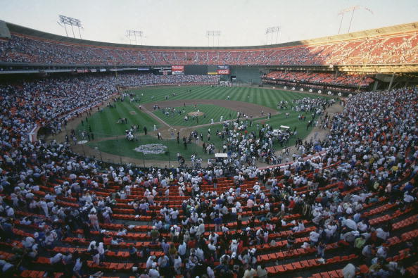
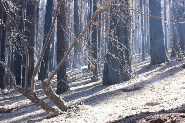
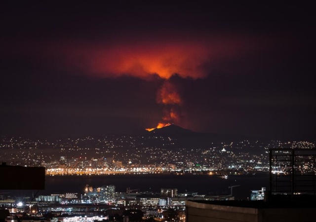
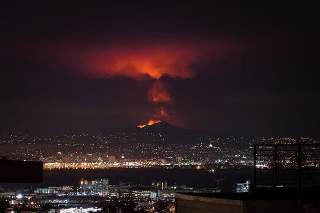
window.__IS_SSR__=true
window.__INITIAL_STATE__={
"attachmentsReducer": {
"audio_0": {
"type": "attachments",
"id": "audio_0",
"imgSizes": {
"kqedFullSize": {
"file": "https://ww2.kqed.org/news/wp-content/themes/KQED-unified/img/audio_bgs/background0.jpg"
}
}
},
"audio_1": {
"type": "attachments",
"id": "audio_1",
"imgSizes": {
"kqedFullSize": {
"file": "https://ww2.kqed.org/news/wp-content/themes/KQED-unified/img/audio_bgs/background1.jpg"
}
}
},
"audio_2": {
"type": "attachments",
"id": "audio_2",
"imgSizes": {
"kqedFullSize": {
"file": "https://ww2.kqed.org/news/wp-content/themes/KQED-unified/img/audio_bgs/background2.jpg"
}
}
},
"audio_3": {
"type": "attachments",
"id": "audio_3",
"imgSizes": {
"kqedFullSize": {
"file": "https://ww2.kqed.org/news/wp-content/themes/KQED-unified/img/audio_bgs/background3.jpg"
}
}
},
"audio_4": {
"type": "attachments",
"id": "audio_4",
"imgSizes": {
"kqedFullSize": {
"file": "https://ww2.kqed.org/news/wp-content/themes/KQED-unified/img/audio_bgs/background4.jpg"
}
}
},
"placeholder": {
"type": "attachments",
"id": "placeholder",
"imgSizes": {
"thumbnail": {
"file": "https://cdn.kqed.org/wp-content/uploads/2024/12/KQED-Default-Image-816638274-2000x1333-1-160x107.jpg",
"width": 160,
"height": 107,
"mimeType": "image/jpeg"
},
"medium": {
"file": "https://cdn.kqed.org/wp-content/uploads/2024/12/KQED-Default-Image-816638274-2000x1333-1-800x533.jpg",
"width": 800,
"height": 533,
"mimeType": "image/jpeg"
},
"medium_large": {
"file": "https://cdn.kqed.org/wp-content/uploads/2024/12/KQED-Default-Image-816638274-2000x1333-1-768x512.jpg",
"width": 768,
"height": 512,
"mimeType": "image/jpeg"
},
"large": {
"file": "https://cdn.kqed.org/wp-content/uploads/2024/12/KQED-Default-Image-816638274-2000x1333-1-1020x680.jpg",
"width": 1020,
"height": 680,
"mimeType": "image/jpeg"
},
"1536x1536": {
"file": "https://cdn.kqed.org/wp-content/uploads/2024/12/KQED-Default-Image-816638274-2000x1333-1-1536x1024.jpg",
"width": 1536,
"height": 1024,
"mimeType": "image/jpeg"
},
"fd-lrg": {
"file": "https://cdn.kqed.org/wp-content/uploads/2024/12/KQED-Default-Image-816638274-2000x1333-1-1536x1024.jpg",
"width": 1536,
"height": 1024,
"mimeType": "image/jpeg"
},
"fd-med": {
"file": "https://cdn.kqed.org/wp-content/uploads/2024/12/KQED-Default-Image-816638274-2000x1333-1-1020x680.jpg",
"width": 1020,
"height": 680,
"mimeType": "image/jpeg"
},
"fd-sm": {
"file": "https://cdn.kqed.org/wp-content/uploads/2024/12/KQED-Default-Image-816638274-2000x1333-1-800x533.jpg",
"width": 800,
"height": 533,
"mimeType": "image/jpeg"
},
"post-thumbnail": {
"file": "https://cdn.kqed.org/wp-content/uploads/2024/12/KQED-Default-Image-816638274-2000x1333-1-672x372.jpg",
"width": 672,
"height": 372,
"mimeType": "image/jpeg"
},
"twentyfourteen-full-width": {
"file": "https://cdn.kqed.org/wp-content/uploads/2024/12/KQED-Default-Image-816638274-2000x1333-1-1038x576.jpg",
"width": 1038,
"height": 576,
"mimeType": "image/jpeg"
},
"xxsmall": {
"file": "https://cdn.kqed.org/wp-content/uploads/2024/12/KQED-Default-Image-816638274-2000x1333-1-160x107.jpg",
"width": 160,
"height": 107,
"mimeType": "image/jpeg"
},
"xsmall": {
"file": "https://cdn.kqed.org/wp-content/uploads/2024/12/KQED-Default-Image-816638274-2000x1333-1-672x372.jpg",
"width": 672,
"height": 372,
"mimeType": "image/jpeg"
},
"small": {
"file": "https://cdn.kqed.org/wp-content/uploads/2024/12/KQED-Default-Image-816638274-2000x1333-1-672x372.jpg",
"width": 672,
"height": 372,
"mimeType": "image/jpeg"
},
"xlarge": {
"file": "https://cdn.kqed.org/wp-content/uploads/2024/12/KQED-Default-Image-816638274-2000x1333-1-1020x680.jpg",
"width": 1020,
"height": 680,
"mimeType": "image/jpeg"
},
"full-width": {
"file": "https://cdn.kqed.org/wp-content/uploads/2024/12/KQED-Default-Image-816638274-2000x1333-1-1920x1280.jpg",
"width": 1920,
"height": 1280,
"mimeType": "image/jpeg"
},
"guest-author-32": {
"file": "https://cdn.kqed.org/wp-content/uploads/2025/01/KQED-Default-Image-816638274-1333x1333-1-160x160.jpg",
"width": 32,
"height": 32,
"mimeType": "image/jpeg"
},
"guest-author-50": {
"file": "https://cdn.kqed.org/wp-content/uploads/2025/01/KQED-Default-Image-816638274-1333x1333-1-160x160.jpg",
"width": 50,
"height": 50,
"mimeType": "image/jpeg"
},
"guest-author-64": {
"file": "https://cdn.kqed.org/wp-content/uploads/2025/01/KQED-Default-Image-816638274-1333x1333-1-160x160.jpg",
"width": 64,
"height": 64,
"mimeType": "image/jpeg"
},
"guest-author-96": {
"file": "https://cdn.kqed.org/wp-content/uploads/2025/01/KQED-Default-Image-816638274-1333x1333-1-160x160.jpg",
"width": 96,
"height": 96,
"mimeType": "image/jpeg"
},
"guest-author-128": {
"file": "https://cdn.kqed.org/wp-content/uploads/2025/01/KQED-Default-Image-816638274-1333x1333-1-160x160.jpg",
"width": 128,
"height": 128,
"mimeType": "image/jpeg"
},
"detail": {
"file": "https://cdn.kqed.org/wp-content/uploads/2025/01/KQED-Default-Image-816638274-1333x1333-1-160x160.jpg",
"width": 160,
"height": 160,
"mimeType": "image/jpeg"
},
"kqedFullSize": {
"file": "https://cdn.kqed.org/wp-content/uploads/2024/12/KQED-Default-Image-816638274-2000x1333-1.jpg",
"width": 2000,
"height": 1333
}
}
},
"news_121487": {
"type": "attachments",
"id": "news_121487",
"meta": {
"index": "attachments_1716263798",
"site": "news",
"id": "121487",
"found": true
},
"parent": 121413,
"imgSizes": {
"kqedFullSize": {
"file": "https://ww2.kqed.org/app/uploads/sites/10/2013/12/103555068-1.jpg",
"width": 594,
"height": 395
}
},
"publishDate": 1387570484,
"modified": 1387570484,
"caption": "Players and fans evacuate Candlestick Park after Loma Prieta earthquake before Game 3 between San Francisco Giants and Oakland Athletics. (Richard Mackson/Getty Images)",
"description": "Players and fans evacuate Candlestick Park after Loma Prieta earthquake before Game 3 between San Francisco Giants and Oakland Athletics. (Richard Mackson/Getty Images)",
"title": "San Francisco Giants vs Oakland Athletics, 1989 World Series",
"credit": null,
"status": "inherit",
"isLoading": false,
"fetchFailed": false
},
"news_115822": {
"type": "attachments",
"id": "news_115822",
"meta": {
"index": "attachments_1716263798",
"site": "news",
"id": "115822",
"found": true
},
"parent": 115814,
"imgSizes": {
"kqedFullSize": {
"file": "https://ww2.kqed.org/app/uploads/sites/10/2013/10/rimfire-e1382487447179.jpg",
"width": 640,
"height": 260
}
},
"publishDate": 1382487423,
"modified": 1382487423,
"caption": "Before and after view of the confluence of the Clavey and Tuolumne rivers in the Rim Fire burn zone. ",
"description": null,
"title": "Rim Fire-Before After ",
"credit": null,
"status": "inherit",
"isLoading": false,
"fetchFailed": false
},
"news_113362": {
"type": "attachments",
"id": "news_113362",
"meta": {
"index": "attachments_1716263798",
"site": "news",
"id": "113362",
"found": true
},
"parent": 113361,
"imgSizes": {
"kqedFullSize": {
"file": "https://ww2.kqed.org/app/uploads/sites/10/2013/09/rimfire2-e1380571638819.jpeg",
"width": 641,
"height": 427
}
},
"publishDate": 1380571345,
"modified": 1380571345,
"caption": "Part of the immense swath of Sierra Nevada forest burned in the Rim Fire that broke out near Yosemite National Park in mid-August. (Mike McMillan/U.S. Forest Service) ",
"description": null,
"title": "Rim Fire aftermath ",
"credit": null,
"status": "inherit",
"isLoading": false,
"fetchFailed": false
},
"news_111182": {
"type": "attachments",
"id": "news_111182",
"meta": {
"index": "attachments_1716263798",
"site": "news",
"id": "111182",
"found": true
},
"parent": 111173,
"imgSizes": {
"kqedFullSize": {
"file": "https://ww2.kqed.org/app/uploads/sites/10/2013/09/Morgan-fire.jpg",
"width": 640,
"height": 450
}
},
"publishDate": 1379100849,
"modified": 1379100849,
"caption": null,
"description": null,
"title": "Morgan fire",
"credit": null,
"status": "inherit",
"isLoading": false,
"fetchFailed": false
},
"news_110598": {
"type": "attachments",
"id": "news_110598",
"meta": {
"index": "attachments_1716263798",
"site": "news",
"id": "110598",
"found": true
},
"parent": 110595,
"imgSizes": {
"kqedFullSize": {
"file": "https://ww2.kqed.org/app/uploads/sites/10/2013/09/RS6614_67715_87e1c720e23de9e685a85c9a82982e89_1b482184743ed40817a0d3f2b1e85bc8-hpf.jpg",
"width": 640,
"height": 427
}
},
"publishDate": 1378831319,
"modified": 1378831319,
"caption": "Mount Diablo burns in image taken Sunday evening, the first evening of the Morgan fire. (Photo courtesy of Karl Frankowski, @karlfrankowski)",
"description": null,
"title": "Morgan Fire ",
"credit": null,
"status": "inherit",
"isLoading": false,
"fetchFailed": false
},
"news_110423": {
"type": "attachments",
"id": "news_110423",
"meta": {
"index": "attachments_1716263798",
"site": "news",
"id": "110423",
"found": true
},
"parent": 110388,
"imgSizes": {
"kqedFullSize": {
"file": "https://ww2.kqed.org/app/uploads/sites/10/2013/09/MtDiablofire-e1378711145703.jpg",
"width": 640,
"height": 425
}
},
"publishDate": 1378710139,
"modified": 1378710139,
"caption": "Morgan Fire, burning east of Mount Diablo, as seen from Lafayette late Sunday night. At least 800 acres have burned southeast of the town of Clayton. (Susan Welty)",
"description": null,
"title": "Morgan Fire Sunday NIght",
"credit": null,
"status": "inherit",
"isLoading": false,
"fetchFailed": false
},
"news_110271": {
"type": "attachments",
"id": "news_110271",
"meta": {
"index": "attachments_1716263798",
"site": "news",
"id": "110271",
"found": true
},
"parent": 110265,
"imgSizes": {
"kqedFullSize": {
"file": "https://ww2.kqed.org/app/uploads/sites/10/2013/09/Lusty-lady.jpg",
"width": 640,
"height": 450
}
},
"publishDate": 1378503007,
"modified": 1378503007,
"caption": "The Lusty Lady. (Sara Bloomberg / KQED)",
"description": "The Lusty Lady. (Sara Bloomberg / KQED)",
"title": "Lusty lady",
"credit": null,
"status": "inherit",
"isLoading": false,
"fetchFailed": false
},
"news_110077": {
"type": "attachments",
"id": "news_110077",
"meta": {
"index": "attachments_1716263798",
"site": "news",
"id": "110077",
"found": true
},
"parent": 110064,
"imgSizes": {
"kqedFullSize": {
"file": "https://ww2.kqed.org/app/uploads/sites/10/2013/09/RS6398_photo-scr-e1378410856500.jpg",
"width": 640,
"height": 480
}
},
"publishDate": 1378410840,
"modified": 1378410840,
"caption": "The Bay Bridge's new eastern span. (Isabel Angell / KQED)",
"description": "The Bay Bridge's new eastern span. (Isabel Angell / KQED)",
"title": "RS6398_photo-scr",
"credit": null,
"status": "inherit",
"isLoading": false,
"fetchFailed": false
},
"news_109121": {
"type": "attachments",
"id": "news_109121",
"meta": {
"index": "attachments_1716263798",
"site": "news",
"id": "109121",
"found": true
},
"parent": 109110,
"imgSizes": {
"kqedFullSize": {
"file": "https://ww2.kqed.org/app/uploads/sites/10/2013/08/bike-share-1.jpg",
"width": 640,
"height": 449
}
},
"publishDate": 1377805480,
"modified": 1377805480,
"caption": null,
"description": null,
"title": "bike share (1)",
"credit": null,
"status": "inherit",
"isLoading": false,
"fetchFailed": false
},
"news_108421": {
"type": "attachments",
"id": "news_108421",
"meta": {
"index": "attachments_1716263798",
"site": "news",
"id": "108421",
"found": true
},
"parent": 108415,
"imgSizes": {
"kqedFullSize": {
"file": "https://ww2.kqed.org/app/uploads/sites/10/2013/08/rimfire.jpg",
"width": 640,
"height": 425
}
},
"publishDate": 1377538766,
"modified": 1377538766,
"caption": "The Rim Fire near Yosemite. (California National Guard/Flickr)",
"description": "The Rim Fire near Yosemite, Aug. 26 (California National Guard/Flickr)",
"title": "Rim Fire",
"credit": null,
"status": "inherit",
"isLoading": false,
"fetchFailed": false
},
"news_108334": {
"type": "attachments",
"id": "news_108334",
"meta": {
"index": "attachments_1716263798",
"site": "news",
"id": "108334",
"found": true
},
"parent": 108332,
"imgSizes": {
"kqedFullSize": {
"file": "https://ww2.kqed.org/app/uploads/sites/10/2013/08/RS6282_smokecloud082113-scr-e1377377704192.jpg",
"width": 640,
"height": 427
}
},
"publishDate": 1377368942,
"modified": 1377368942,
"caption": "Smoke from the Rim Fire rises above a ridge in Yosemite National Park on Wednesday, Aug. 21. The view is across an area of the park that burned several years ago. (Dan Brekke/KQED)",
"description": null,
"title": "Rim Fire",
"credit": null,
"status": "inherit",
"isLoading": false,
"fetchFailed": false
}
},
"audioPlayerReducer": {
"postId": "stream_live",
"isPaused": true,
"isPlaying": false,
"pfsActive": false,
"pledgeModalIsOpen": true,
"playerDrawerIsOpen": false,
"liveAudioPlayStartedAt": 0,
"liveAudioPlayContext": ""
},
"authorsReducer": {
"danbrekke": {
"type": "authors",
"id": "222",
"meta": {
"index": "authors_1716337520",
"id": "222",
"found": true
},
"name": "Dan Brekke",
"firstName": "Dan",
"lastName": "Brekke",
"slug": "danbrekke",
"email": "dbrekke@kqed.org",
"display_author_email": true,
"staff_mastheads": [
"news",
"science"
],
"title": "KQED Editor and Reporter",
"bio": "Dan Brekke is a reporter and editor for KQED News, responsible for coverage of topics ranging from California water issues to the Bay Area's transportation challenges. In a newsroom career that began in Chicago in 1972, Dan has worked for \u003cem>The San Francisco Examiner,\u003c/em> Wired and TechTV and has been published in The New York Times, The New York Times Magazine, Business 2.0, Salon and elsewhere.\r\n\r\nSince joining KQED in 2007, Dan has reported, edited and produced both radio and online features and breaking news pieces. He has shared as both editor and reporter in four Society of Professional Journalists Norcal Excellence in Journalism awards and one Edward R. Murrow regional award. He was chosen for a spring 2017 residency at the Mesa Refuge to advance his research on California salmon.\r\n\r\nEmail Dan at: \u003ca href=\"mailto:dbrekke@kqed.org\">dbrekke@kqed.org\u003c/a>\r\n\r\n\u003cstrong>Twitter:\u003c/strong> \u003ca href=\"https://twitter.com/danbrekke\" rel=\"noopener noreferrer\">twitter.com/danbrekke\u003c/a>\r\n\u003cstrong>Facebook:\u003c/strong> \u003ca href=\"https://www.facebook.com/danbrekke\" rel=\"noopener noreferrer\">www.facebook.com/danbrekke\u003c/a>\r\n\u003cstrong>LinkedIn:\u003c/strong> \u003ca href=\"https://www.linkedin.com/in/danbrekke\" rel=\"noopener noreferrer\">www.linkedin.com/in/danbrekke\u003c/a>",
"avatar": "https://secure.gravatar.com/avatar/c8126230345efca3f7aa89b1a402be45?s=600&d=mm&r=g",
"twitter": "danbrekke",
"facebook": null,
"instagram": "https://www.instagram.com/dan.brekke/",
"linkedin": "https://www.linkedin.com/in/danbrekke/",
"sites": [
{
"site": "news",
"roles": [
"administrator",
"create_posts"
]
},
{
"site": "stateofhealth",
"roles": [
"editor"
]
},
{
"site": "science",
"roles": [
"editor"
]
},
{
"site": "quest",
"roles": [
"contributor"
]
},
{
"site": "food",
"roles": [
"contributor"
]
},
{
"site": "forum",
"roles": [
"contributor"
]
},
{
"site": "liveblog",
"roles": [
"editor"
]
}
],
"headData": {
"title": "Dan Brekke | KQED",
"description": "KQED Editor and Reporter",
"ogImgSrc": "https://secure.gravatar.com/avatar/c8126230345efca3f7aa89b1a402be45?s=600&d=mm&r=g",
"twImgSrc": "https://secure.gravatar.com/avatar/c8126230345efca3f7aa89b1a402be45?s=600&d=mm&r=g"
},
"isLoading": false,
"link": "/author/danbrekke"
},
"joshuajohnson": {
"type": "authors",
"id": "233",
"meta": {
"index": "authors_1716337520",
"id": "233",
"found": true
},
"name": "Joshua Johnson",
"firstName": "Joshua",
"lastName": "Johnson",
"slug": "joshuajohnson",
"email": "jejohnson@kqed.org",
"display_author_email": false,
"staff_mastheads": [],
"title": null,
"bio": "Joshua Johnson is the creator and host of \u003cem>\u003ca href=\"http://www.truthbetoldshow.org\">Truth Be Told\u003c/a>,\u003c/em> a special series on race from KQED and PRI. Prior to creating the show, he served as the station's morning news anchor for five-and-half years.\r\n\r\nPrior to joining KQED, Joshua spent six years as an anchor/reporter for WLRN Miami Herald News. He's a native of South Florida, with degrees from the University of Miami. His reporting and newscasting have won awards from the Radio Television Digital News Association and from the National Association of Black Journalists. Joshua is also active in his union, SAG-AFTRA. He lives in San Francisco.",
"avatar": "https://secure.gravatar.com/avatar/2abea375594cdd54e4837846e3561fa4?s=600&d=blank&r=g",
"twitter": "@JEJohnson322",
"facebook": null,
"instagram": null,
"linkedin": null,
"sites": [
{
"site": "news",
"roles": [
"subscriber"
]
}
],
"headData": {
"title": "Joshua Johnson | KQED",
"description": null,
"ogImgSrc": "https://secure.gravatar.com/avatar/2abea375594cdd54e4837846e3561fa4?s=600&d=blank&r=g",
"twImgSrc": "https://secure.gravatar.com/avatar/2abea375594cdd54e4837846e3561fa4?s=600&d=blank&r=g"
},
"isLoading": false,
"link": "/author/joshuajohnson"
},
"katrinaschwartz": {
"type": "authors",
"id": "234",
"meta": {
"index": "authors_1716337520",
"id": "234",
"found": true
},
"name": "Katrina Schwartz",
"firstName": "Katrina",
"lastName": "Schwartz",
"slug": "katrinaschwartz",
"email": "kschwartz@kqed.org",
"display_author_email": false,
"staff_mastheads": [
"news"
],
"title": "Producer",
"bio": "Katrina Schwartz is a journalist based in San Francisco. She's worked at KPCC public radio in LA and has reported on air and online for KQED since 2010. She covered how teaching and learning is changing for MindShift between 2012 and 2020. She is the co-host of the MindShift podcast and now produces KQED's Bay Curious podcast.",
"avatar": "https://secure.gravatar.com/avatar/edb4ee79070447a018538c9aae6eeecf28786515b8a0c30e43b6b7dce5aa44c8?s=600&d=blank&r=g",
"twitter": "kschwart",
"bluesky": null,
"facebook": null,
"instagram": null,
"linkedin": null,
"sites": [
{
"site": "",
"roles": [
"editor"
]
},
{
"site": "news",
"roles": [
"editor"
]
},
{
"site": "mindshift",
"roles": [
"administrator"
]
},
{
"site": "stateofhealth",
"roles": [
"author"
]
},
{
"site": "science",
"roles": [
"editor"
]
}
],
"headData": {
"title": "Katrina Schwartz | KQED",
"description": "Producer",
"ogImgSrc": "https://secure.gravatar.com/avatar/edb4ee79070447a018538c9aae6eeecf28786515b8a0c30e43b6b7dce5aa44c8?s=600&d=blank&r=g",
"twImgSrc": "https://secure.gravatar.com/avatar/edb4ee79070447a018538c9aae6eeecf28786515b8a0c30e43b6b7dce5aa44c8?s=600&d=blank&r=g"
},
"isLoading": false,
"link": "/author/katrinaschwartz"
},
"kqed": {
"type": "authors",
"id": "236",
"meta": {
"index": "authors_1716337520",
"id": "236",
"found": true
},
"name": "KQED News Staff",
"firstName": "KQED News Staff",
"lastName": null,
"slug": "kqed",
"email": "faq@kqed.org",
"display_author_email": false,
"staff_mastheads": [],
"title": null,
"bio": null,
"avatar": "https://secure.gravatar.com/avatar/ef0e801a68c4c54afa9180db14084167?s=600&d=blank&r=g",
"twitter": null,
"facebook": null,
"instagram": null,
"linkedin": null,
"sites": [
{
"site": "arts",
"roles": [
"contributor"
]
},
{
"site": "news",
"roles": [
"editor"
]
},
{
"site": "futureofyou",
"roles": [
"author"
]
}
],
"headData": {
"title": "KQED News Staff | KQED",
"description": null,
"ogImgSrc": "https://secure.gravatar.com/avatar/ef0e801a68c4c54afa9180db14084167?s=600&d=blank&r=g",
"twImgSrc": "https://secure.gravatar.com/avatar/ef0e801a68c4c54afa9180db14084167?s=600&d=blank&r=g"
},
"isLoading": false,
"link": "/author/kqed"
},
"kqednewsstaffandwires": {
"type": "authors",
"id": "237",
"meta": {
"index": "authors_1716337520",
"id": "237",
"found": true
},
"name": "KQED News Staff and Wires",
"firstName": "KQED News Staff and Wires",
"lastName": null,
"slug": "kqednewsstaffandwires",
"email": "onlinenewsstaff@kqed.org",
"display_author_email": false,
"staff_mastheads": [],
"title": null,
"bio": null,
"avatar": "https://secure.gravatar.com/avatar/72295af8ebbfbd19a4948f5271285664?s=600&d=blank&r=g",
"twitter": null,
"facebook": null,
"instagram": null,
"linkedin": null,
"sites": [
{
"site": "arts",
"roles": [
"contributor"
]
},
{
"site": "news",
"roles": [
"contributor"
]
},
{
"site": "lowdown",
"roles": [
"author"
]
},
{
"site": "stateofhealth",
"roles": [
"contributor"
]
},
{
"site": "food",
"roles": [
"author"
]
}
],
"headData": {
"title": "KQED News Staff and Wires | KQED",
"description": null,
"ogImgSrc": "https://secure.gravatar.com/avatar/72295af8ebbfbd19a4948f5271285664?s=600&d=blank&r=g",
"twImgSrc": "https://secure.gravatar.com/avatar/72295af8ebbfbd19a4948f5271285664?s=600&d=blank&r=g"
},
"isLoading": false,
"link": "/author/kqednewsstaffandwires"
},
"scottshafer": {
"type": "authors",
"id": "255",
"meta": {
"index": "authors_1716337520",
"id": "255",
"found": true
},
"name": "Scott Shafer",
"firstName": "Scott",
"lastName": "Shafer",
"slug": "scottshafer",
"email": "sshafer@kqed.org",
"display_author_email": false,
"staff_mastheads": [
"news"
],
"title": "KQED Contributor",
"bio": "Scott Shafer is a senior editor with the KQED Politics and Government desk. He is co-host of Political Breakdown, the award-winning radio show and podcast with a personal take on the world of politics. Scott came to KQED in 1998 to host the statewide\u003cem> California Report\u003c/em>. Prior to that he had extended stints in politics and government\u003cem>.\u003c/em> He uses that inside experience at KQED in his, reporting, hosting and analysis for the politics desk. Scott collaborated \u003cem>Political Breakdown a\u003c/em>nd on \u003cem>The Political Mind of Jerry Brown, \u003c/em>an eight-part series about the life and extraordinary political career of the former governor. For fun, he plays water polo with the San Francisco Tsunami.",
"avatar": "https://secure.gravatar.com/avatar/a62ebae45b79d7aed1a39a0e3bf68104?s=600&d=blank&r=g",
"twitter": "scottshafer",
"bluesky": null,
"facebook": null,
"instagram": null,
"linkedin": null,
"sites": [
{
"site": "news",
"roles": [
"editor"
]
},
{
"site": "stateofhealth",
"roles": [
"author"
]
},
{
"site": "science",
"roles": [
"author"
]
},
{
"site": "forum",
"roles": [
"subscriber"
]
},
{
"site": "liveblog",
"roles": [
"author"
]
}
],
"headData": {
"title": "Scott Shafer | KQED",
"description": "KQED Contributor",
"ogImgSrc": "https://secure.gravatar.com/avatar/a62ebae45b79d7aed1a39a0e3bf68104?s=600&d=blank&r=g",
"twImgSrc": "https://secure.gravatar.com/avatar/a62ebae45b79d7aed1a39a0e3bf68104?s=600&d=blank&r=g"
},
"isLoading": false,
"link": "/author/scottshafer"
}
},
"pagesReducer": {
"news_tag_natural-disasters": {
"type": "terms",
"id": "news_881",
"meta": {
"index": "terms_1716263798",
"site": "news",
"id": "881",
"score": 10.403938
},
"featImg": null,
"name": "Natural Disasters",
"description": null,
"taxonomy": "tag",
"headData": {
"twImgId": null,
"twTitle": null,
"ogTitle": null,
"ogImgId": null,
"twDescription": null,
"description": null,
"title": "Natural Disasters Archives | KQED News",
"ogDescription": null
},
"ttid": 891,
"slug": "natural-disasters",
"isLoading": false,
"title": "Natural Disasters",
"pageMeta": {
"site": "news",
"WpPageTemplate": "page-topic-editorial",
"currentPage": 5
},
"blocks": [
{
"blockName": "kqed/post-list",
"attrs": {
"layout": "cardArticle2",
"query": "posts/news?tag=natural-disasters",
"seeMore": false,
"paginated": true,
"page": 5
}
},
{
"blockName": "kqed/ad"
}
]
}
},
"pfsSessionReducer": {},
"postsReducer": {
"stream_live": {
"type": "live",
"id": "stream_live",
"audioUrl": "https://streams.kqed.org/kqedradio",
"title": "Live Stream",
"excerpt": "Live Stream information currently unavailable.",
"link": "/radio",
"featImg": "",
"label": {
"name": "KQED Live",
"link": "/"
}
},
"stream_kqedNewscast": {
"type": "posts",
"id": "stream_kqedNewscast",
"audioUrl": "https://www.kqed.org/.stream/anon/radio/RDnews/newscast.mp3?_=1",
"title": "KQED Newscast",
"featImg": "",
"label": {
"name": "88.5 FM",
"link": "/"
}
},
"news_121413": {
"type": "posts",
"id": "news_121413",
"meta": {
"index": "posts_1716263798",
"site": "news",
"id": "121413",
"score": null,
"sort": [
1387568849000
]
},
"parent": 0,
"labelTerm": {
"site": "news",
"term": 6944
},
"blocks": [],
"publishDate": 1387568849,
"format": "aside",
"disqusTitle": "Inside Candlestick Park on the Night the Earth Shook ",
"title": "Inside Candlestick Park on the Night the Earth Shook ",
"headTitle": "News Fix | KQED News",
"content": "\u003cfigure id=\"attachment_121487\" class=\"wp-caption aligncenter\" style=\"max-width: 594px\">\u003cimg class=\"size-full wp-image-121487\" src=\"http://ww2.kqed.org/news/wp-content/uploads/sites/10/2013/12/103555068-1.jpg\" alt=\"Players and fans evacuate Candlestick Park after Loma Prieta earthquake before Game 3 between San Francisco Giants and Oakland Athletics. (Richard Mackson/Getty Images)\" width=\"594\" height=\"395\">\u003cfigcaption class=\"wp-caption-text\">Players and fans evacuate Candlestick Park after Loma Prieta earthquake before Game 3 between San Francisco Giants and Oakland Athletics. (Richard Mackson/Getty Images)\u003c/figcaption>\u003c/figure>\n\u003cp>I remember October 17th, 1989 as unusually warm.\u003c/p>\n\u003cp>Perfect ballgame weather, even at notoriously cold and windy Candlestick Park. I was a 31-year-old deputy press secretary to Mayor Art Agnos, who helped me score a ticket to Game 3 of the World Series.\u003c/p>\n\u003cp>Just before game time, a little after 5 pm, I was in line for a hot dog at the ‘Stick, standing next to San Francisco Chronicle reporter Mark Barabak (who now works for the L.A. Times) and a fan who was visiting from Maryland. The stadium started to shake and rumble and we instantly knew it was an earthquake.\u003c/p>\n\u003cp>The power went off, but I confidently told the Marylander “it’s probably about a 4.5 quake. Nothing to worry about.”\u003c/p>\n\u003cp>There was no panic – actually the shaker for the most part excited most people at the park. I stayed in line, got my hot dog and returned to my seat.\u003c/p>\n\u003cp>[ad fullwidth]\u003c/p>\n\u003cp>In that pre-smart phone era, news traveled slowly. As I enjoyed my hotdog, radios in the stands tuned to KCBS and KGO began reporting that the Bay Bridge had “collapsed.” I remember that was the word they used -- collapsed. That certainly got my attention.\u003c/p>\n\u003cp>A few minutes later, as a group of officials conferred on the diamond, a large black helicopter landed in the outfield. I saw my boss, Mayor Agnos, get into the helicopter. At that point, I figured I was in for a very long night.\u003c/p>\n\u003cp>The game was cancelled, and the fans calmly left Candlestick. I boarded a bus headed back to Civic Center. The 101 freeway was eerily empty. As the sun went down, it became clear that the city was without power. The Muni bus loaded with fans headed up S. Van Ness Avenue, where traffic signals were out and drivers were uncommonly courteous. \u003c/p>\n\u003caside class=\"pullquote alignleft\"> A few minutes later, a large black helicopter landed in the outfield. I saw my boss, Mayor Agnos, get into it. \u003c/aside>\n\u003cp>I went to City Hall, which was closed, then walked a few blocks to the City’s Emergency Command Center on Turk Street – which we quickly learned was cramped, out-dated and completely inadequate. Just like Candlestick Park.\u003c/p>\n\u003cp>With international media in town for the World Series, images of a couple burning buildings in the Marina sent the mistaken signal that the entire city was ablaze. While that wasn’t true, as I drove through the Marina with the mayor that night we saw stunning damage. Streets were deformed with asphalt buckled up into V-shaped peaks. Hundreds of homes were in some form of collapse. Who knew the whole neighborhood had been built on landfill?\u003c/p>\n\u003cfigure id=\"attachment_121475\" class=\"wp-caption alignleft\" style=\"max-width: 403px\">\u003ca href=\"http://ww2.kqed.org/news/2013/12/19/candlestick-park-loma-prieta-earthquake/agnos-et-al/\" rel=\"attachment wp-att-121475\">\u003cimg class=\" wp-image-121475 \" src=\"http://ww2.kqed.org/news/wp-content/uploads/sites/10/2013/12/agnos-et-al-640x410.jpeg\" alt=\"L to R: Scott Shafer, Mayor Art Agnos, Sen. Alan Cranston, state Sen. Milton Marks In 1989. (Courtesy of the City of San Francisco)\" width=\"403\" height=\"258\">\u003c/a>\u003cfigcaption class=\"wp-caption-text\">L to R: Scott Shafer, Mayor Art Agnos, U.S. Sen. Alan Cranston, State Sen. Milton Marks In 1989. (Courtesy: City of San Francisco)\u003c/figcaption>\u003c/figure>\n\u003cp>In the coming days there was great debate about whether to delay or cancel the World Series. (With the Giants down two games to none, it already seemed pretty hopeless.) Despite some frightening moments for fans in some of the stands, Candlestick had escaped with minor damage and the Series resumed. The A’s put the Giants out of their misery by winning the final two games to sweep the series.\u003c/p>\n\u003cp>Three weeks later, voters narrowly rejected a ballot measure to build a new Giants ballpark in Mission Bay – the site of AT&T Park, which voters approved a decade later.\u003c/p>\n\u003cp>As Candlestick awaits the wrecking ball (or whatever form of demolition it faces) next year, the city can take pride that despite the ‘Stick’s many, many shortcomings, its strength and durability prevented what could have been a horrific disaster that October evening in 1989.\u003c/p>\n\u003cp>\u003cem>\u003ca href=\"http://www.kqed.org/tv/programs/newsroom/\" target=\"_blank\">\u003cimg class=\"alignright\" src=\"http://ww2.kqed.org/news/wp-content/uploads/sites/10/2013/11/newsroom-115x65.jpg\" alt=\"newsroom-115x65\" width=\"115\" height=\"65\">\u003c/a>\u003cem> \u003c/em>\u003c/em>\u003c/p>\n\u003cp>\u003c/p>\n\u003cp>\u003cem>\u003cem>\u003cem>On tonight’s broadcast of \u003c/em>\u003c/em>\u003cem> \u003c/em>\u003ca href=\"http://www.kqed.org/tv/programs/newsroom/\" target=\"_blank\">KQED NEWSROOM\u003c/a>, viewers get an inside look at Candlestick Park and Scott Shafer sits down sports columnist Glenn Dickey to recount the stadium’s rich history. KQED NEWSROOM is a weekly news magazine program on television, radio and online. Watch Fridays at 8 p.m. on KQED Public Television 9, listen on Sundays at 6 p.m. on KQED Public Radio 88.5 FM and watch on demand \u003ca href=\"http://www.kqed.org/tv/programs/newsroom/\" target=\"_blank\">here\u003c/a>.\u003c/em>\u003c/p>\n\n",
"disqusIdentifier": "121413 http://ww2.kqed.org/news/?p=121413",
"disqusUrl": "https://ww2.kqed.org/news/2013/12/20/inside-candlestick-park-on-the-night-the-earth-shook/",
"stats": {
"hasVideo": false,
"hasChartOrMap": false,
"hasAudio": false,
"hasPolis": false,
"wordCount": 734,
"hasGoogleForm": false,
"hasGallery": false,
"hasHearkenModule": false,
"iframeSrcs": [],
"paragraphCount": 17
},
"modified": 1387575057,
"excerpt": "In that pre-smart phone era, news traveled slowly. Then we heard the Bay Bridge had collapsed.",
"headData": {
"twImgId": "",
"twTitle": "",
"ogTitle": "",
"ogImgId": "",
"twDescription": "",
"description": "In that pre-smart phone era, news traveled slowly. Then we heard the Bay Bridge had collapsed.",
"title": "Inside Candlestick Park on the Night the Earth Shook | KQED",
"ogDescription": "",
"schema": {
"@context": "https://schema.org",
"@type": "NewsArticle",
"headline": "Inside Candlestick Park on the Night the Earth Shook ",
"datePublished": "2013-12-20T11:47:29-08:00",
"dateModified": "2013-12-20T13:30:57-08:00",
"image": "https://cdn.kqed.org/wp-content/uploads/2020/02/KQED-OG-Image@1x.png",
"isAccessibleForFree": "True",
"publisher": {
"@type": "NewsMediaOrganization",
"@id": "https://www.kqed.org/#organization",
"name": "KQED",
"logo": "https://cdn.kqed.org/wp-content/uploads/2020/02/KQED-OG-Image@1x.png",
"url": "https://www.kqed.org",
"sameAs": [
"https://www.facebook.com/KQED",
"https://twitter.com/KQED",
"https://www.instagram.com/kqed/",
"https://www.tiktok.com/@kqedofficial",
"https://www.linkedin.com/company/kqed",
"https://www.youtube.com/channel/UCeC0IOo7i1P_61zVUWbJ4nw"
]
}
}
},
"guestAuthors": [],
"slug": "inside-candlestick-park-on-the-night-the-earth-shook",
"status": "publish",
"customPermalink": "2013/12/19/candlestick-park-loma-prieta-earthquake/",
"path": "/news/121413/inside-candlestick-park-on-the-night-the-earth-shook",
"audioTrackLength": null,
"parsedContent": [
{
"type": "contentString",
"content": "\u003cdiv class=\"post-body\">\u003cp>\u003cfigure id=\"attachment_121487\" class=\"wp-caption aligncenter\" style=\"max-width: 594px\">\u003cimg class=\"size-full wp-image-121487\" src=\"http://ww2.kqed.org/news/wp-content/uploads/sites/10/2013/12/103555068-1.jpg\" alt=\"Players and fans evacuate Candlestick Park after Loma Prieta earthquake before Game 3 between San Francisco Giants and Oakland Athletics. (Richard Mackson/Getty Images)\" width=\"594\" height=\"395\">\u003cfigcaption class=\"wp-caption-text\">Players and fans evacuate Candlestick Park after Loma Prieta earthquake before Game 3 between San Francisco Giants and Oakland Athletics. (Richard Mackson/Getty Images)\u003c/figcaption>\u003c/figure>\n\u003cp>I remember October 17th, 1989 as unusually warm.\u003c/p>\n\u003cp>Perfect ballgame weather, even at notoriously cold and windy Candlestick Park. I was a 31-year-old deputy press secretary to Mayor Art Agnos, who helped me score a ticket to Game 3 of the World Series.\u003c/p>\n\u003cp>Just before game time, a little after 5 pm, I was in line for a hot dog at the ‘Stick, standing next to San Francisco Chronicle reporter Mark Barabak (who now works for the L.A. Times) and a fan who was visiting from Maryland. The stadium started to shake and rumble and we instantly knew it was an earthquake.\u003c/p>\n\u003cp>The power went off, but I confidently told the Marylander “it’s probably about a 4.5 quake. Nothing to worry about.”\u003c/p>\n\u003cp>There was no panic – actually the shaker for the most part excited most people at the park. I stayed in line, got my hot dog and returned to my seat.\u003c/p>\n\u003cp>\u003c/p>\u003c/div>",
"attributes": {
"named": {},
"numeric": []
}
},
{
"type": "component",
"content": "",
"name": "ad",
"attributes": {
"named": {
"label": "fullwidth"
},
"numeric": [
"fullwidth"
]
}
},
{
"type": "contentString",
"content": "\u003cdiv class=\"post-body\">\u003cp>\u003c/p>\n\u003cp>In that pre-smart phone era, news traveled slowly. As I enjoyed my hotdog, radios in the stands tuned to KCBS and KGO began reporting that the Bay Bridge had “collapsed.” I remember that was the word they used -- collapsed. That certainly got my attention.\u003c/p>\n\u003cp>A few minutes later, as a group of officials conferred on the diamond, a large black helicopter landed in the outfield. I saw my boss, Mayor Agnos, get into the helicopter. At that point, I figured I was in for a very long night.\u003c/p>\n\u003cp>The game was cancelled, and the fans calmly left Candlestick. I boarded a bus headed back to Civic Center. The 101 freeway was eerily empty. As the sun went down, it became clear that the city was without power. The Muni bus loaded with fans headed up S. Van Ness Avenue, where traffic signals were out and drivers were uncommonly courteous. \u003c/p>\n\u003caside class=\"pullquote alignleft\"> A few minutes later, a large black helicopter landed in the outfield. I saw my boss, Mayor Agnos, get into it. \u003c/aside>\n\u003cp>I went to City Hall, which was closed, then walked a few blocks to the City’s Emergency Command Center on Turk Street – which we quickly learned was cramped, out-dated and completely inadequate. Just like Candlestick Park.\u003c/p>\n\u003cp>With international media in town for the World Series, images of a couple burning buildings in the Marina sent the mistaken signal that the entire city was ablaze. While that wasn’t true, as I drove through the Marina with the mayor that night we saw stunning damage. Streets were deformed with asphalt buckled up into V-shaped peaks. Hundreds of homes were in some form of collapse. Who knew the whole neighborhood had been built on landfill?\u003c/p>\n\u003cfigure id=\"attachment_121475\" class=\"wp-caption alignleft\" style=\"max-width: 403px\">\u003ca href=\"http://ww2.kqed.org/news/2013/12/19/candlestick-park-loma-prieta-earthquake/agnos-et-al/\" rel=\"attachment wp-att-121475\">\u003cimg class=\" wp-image-121475 \" src=\"http://ww2.kqed.org/news/wp-content/uploads/sites/10/2013/12/agnos-et-al-640x410.jpeg\" alt=\"L to R: Scott Shafer, Mayor Art Agnos, Sen. Alan Cranston, state Sen. Milton Marks In 1989. (Courtesy of the City of San Francisco)\" width=\"403\" height=\"258\">\u003c/a>\u003cfigcaption class=\"wp-caption-text\">L to R: Scott Shafer, Mayor Art Agnos, U.S. Sen. Alan Cranston, State Sen. Milton Marks In 1989. (Courtesy: City of San Francisco)\u003c/figcaption>\u003c/figure>\n\u003cp>In the coming days there was great debate about whether to delay or cancel the World Series. (With the Giants down two games to none, it already seemed pretty hopeless.) Despite some frightening moments for fans in some of the stands, Candlestick had escaped with minor damage and the Series resumed. The A’s put the Giants out of their misery by winning the final two games to sweep the series.\u003c/p>\n\u003cp>Three weeks later, voters narrowly rejected a ballot measure to build a new Giants ballpark in Mission Bay – the site of AT&T Park, which voters approved a decade later.\u003c/p>\n\u003cp>As Candlestick awaits the wrecking ball (or whatever form of demolition it faces) next year, the city can take pride that despite the ‘Stick’s many, many shortcomings, its strength and durability prevented what could have been a horrific disaster that October evening in 1989.\u003c/p>\n\u003cp>\u003cem>\u003ca href=\"http://www.kqed.org/tv/programs/newsroom/\" target=\"_blank\">\u003cimg class=\"alignright\" src=\"http://ww2.kqed.org/news/wp-content/uploads/sites/10/2013/11/newsroom-115x65.jpg\" alt=\"newsroom-115x65\" width=\"115\" height=\"65\">\u003c/a>\u003cem> \u003c/em>\u003c/em>\u003c/p>\n\u003cp>\u003c/p>\n\u003cp>\u003cem>\u003cem>\u003cem>On tonight’s broadcast of \u003c/em>\u003c/em>\u003cem> \u003c/em>\u003ca href=\"http://www.kqed.org/tv/programs/newsroom/\" target=\"_blank\">KQED NEWSROOM\u003c/a>, viewers get an inside look at Candlestick Park and Scott Shafer sits down sports columnist Glenn Dickey to recount the stadium’s rich history. KQED NEWSROOM is a weekly news magazine program on television, radio and online. Watch Fridays at 8 p.m. on KQED Public Television 9, listen on Sundays at 6 p.m. on KQED Public Radio 88.5 FM and watch on demand \u003ca href=\"http://www.kqed.org/tv/programs/newsroom/\" target=\"_blank\">here\u003c/a>.\u003c/em>\u003c/p>\n\n\u003c/div>\u003c/p>",
"attributes": {
"named": {},
"numeric": []
}
}
],
"link": "/news/121413/inside-candlestick-park-on-the-night-the-earth-shook",
"authors": [
"255"
],
"programs": [
"news_6944"
],
"categories": [
"news_19906",
"news_10"
],
"tags": [
"news_5378",
"news_1819",
"news_4677",
"news_881",
"news_38"
],
"featImg": "news_121487",
"label": "news_6944"
},
"news_115814": {
"type": "posts",
"id": "news_115814",
"meta": {
"index": "posts_1716263798",
"site": "news",
"id": "115814",
"score": null,
"sort": [
1382533209000
]
},
"parent": 0,
"labelTerm": {
"site": "news",
"term": 6944
},
"blocks": [],
"publishDate": 1382533209,
"format": "aside",
"title": "Rim Fire Aftermath: A Stark Look at a Seared Landscape",
"headTitle": "Rim Fire Aftermath: A Stark Look at a Seared Landscape | KQED",
"content": "\u003cfigure id=\"attachment_115822\" class=\"wp-caption aligncenter\" style=\"max-width: 640px\">\u003ca href=\"http://ww2.kqed.org/news/2013/10/22/115814/rimfire-2/\" rel=\"attachment wp-att-115822\">\u003cimg decoding=\"async\" loading=\"lazy\" class=\"size-full wp-image-115822\" src=\"http://ww2.kqed.org/news/wp-content/uploads/sites/10/2013/10/rimfire-e1382487447179.jpg\" alt=\"Before and after view of the confluence of the Clavey and Tuolumne rivers in the Rim Fire burn zone. \" width=\"640\" height=\"260\">\u003c/a>\u003cfigcaption class=\"wp-caption-text\">Before and after view of the confluence of the Clavey and Tuolumne rivers in the Rim Fire burn zone.\u003c/figcaption>\u003c/figure>\n\u003cp>What lessons can be learned from this summer’s historic Rim Fire, which burned for weeks in and to the west of Yosemite National Park? As Lauren Sommer of KQED Science \u003ca href=\"http://ww2.kqed.org/news/2013/09/30/rim-fire-forest-thinning\" target=\"_blank\" rel=\"noopener\">reported recently\u003c/a>, scientists are looking at more than 400 square miles of charred Sierra Nevada forest to find out.\u003c/p>\n\u003cp>The immediate reality of the fire’s aftermath is stark. Researchers at the \u003ca href=\"https://watershed.ucdavis.edu/\" target=\"_blank\" rel=\"noopener\">UC Davis Center for Watershed Sciences\u003c/a> have been exploring what they call “the apocalyptic terrain” left behind by the fire, \u003ca href=\"http://www.fire.ca.gov/communications/downloads/fact_sheets/20LACRES.pdf\" target=\"_blank\" rel=\"noopener\">the third-largest fire\u003c/a> in the state since modern record-keeping began in the 1930s. Here’s an audio slideshow that recounts a recent hike into the burn zone.\u003c/p>\n\u003cp>\u003c!--more-->\u003cbr>\nThis week, the center published \u003ca href=\"https://watershed.ucdavis.edu/experiments/rimfire/\" target=\"_blank\" rel=\"noopener\">beautiful before-and-after views\u003c/a> of one part of the Rim Fire landscape: the place where the Clavey River joins the Tuolumne. The center’s version — \u003ca href=\"https://watershed.ucdavis.edu/experiments/rimfire/\" target=\"_blank\" rel=\"noopener\">here it is again\u003c/a> — includes a nifty slider so you can seamlessly compare every aspect of the scene. Alas, the slider version is not embeddable, and your blogger lacks the coding chops to put it together here. But check out the center’s site. The separate before and after shots are below.\u003c/p>\n\u003cp>\u003cstrong>Before: \u003c/strong>\u003c/p>\n\u003cp>\u003ca href=\"http://ww2.kqed.org/news/2013/10/22/rim-fire-before-after-pictures/1b_bf/\" rel=\"attachment wp-att-115827\">\u003cimg decoding=\"async\" loading=\"lazy\" class=\"aligncenter size-full wp-image-115827\" src=\"http://ww2.kqed.org/news/wp-content/uploads/sites/10/2013/10/1b_bf.jpg\" alt=\"Rim Fire-Before \" width=\"537\" height=\"428\">\u003c/a>\u003c/p>\n\u003cp>[ad fullwidth]\u003c/p>\n\u003cp>\u003c/p>\n\u003cp>\u003cstrong>After:\u003c/strong>\u003cbr>\n\u003ca href=\"http://ww2.kqed.org/news/2013/10/22/rim-fire-before-after-pictures/1a_pf/\" rel=\"attachment wp-att-115828\">\u003cimg decoding=\"async\" loading=\"lazy\" class=\"aligncenter size-full wp-image-115828\" src=\"http://ww2.kqed.org/news/wp-content/uploads/sites/10/2013/10/1a_pf-e1382489768414.jpg\" alt=\"Rim Fire-After \" width=\"537\" height=\"431\">\u003c/a>\u003c/p>\n\n",
"stats": {
"hasVideo": false,
"hasChartOrMap": false,
"hasAudio": false,
"hasPolis": false,
"wordCount": 227,
"hasGoogleForm": false,
"hasGallery": false,
"hasHearkenModule": false,
"iframeSrcs": [],
"paragraphCount": 8
},
"modified": 1685487097,
"excerpt": "Some lessons of this summer's blaze will take years to be revealed. But the immediate impact is dramatic.",
"headData": {
"twImgId": "",
"twTitle": "",
"ogTitle": "",
"ogImgId": "",
"twDescription": "",
"description": "Some lessons of this summer's blaze will take years to be revealed. But the immediate impact is dramatic.",
"title": "Rim Fire Aftermath: A Stark Look at a Seared Landscape | KQED",
"ogDescription": "",
"schema": {
"@context": "https://schema.org",
"@type": "NewsArticle",
"headline": "Rim Fire Aftermath: A Stark Look at a Seared Landscape",
"datePublished": "2013-10-23T06:00:09-07:00",
"dateModified": "2023-05-30T15:51:37-07:00",
"image": "https://cdn.kqed.org/wp-content/uploads/2020/02/KQED-OG-Image@1x.png",
"isAccessibleForFree": "True",
"publisher": {
"@type": "NewsMediaOrganization",
"@id": "https://www.kqed.org/#organization",
"name": "KQED",
"logo": "https://cdn.kqed.org/wp-content/uploads/2020/02/KQED-OG-Image@1x.png",
"url": "https://www.kqed.org",
"sameAs": [
"https://www.facebook.com/KQED",
"https://twitter.com/KQED",
"https://www.instagram.com/kqed/",
"https://www.tiktok.com/@kqedofficial",
"https://www.linkedin.com/company/kqed",
"https://www.youtube.com/channel/UCeC0IOo7i1P_61zVUWbJ4nw"
]
}
}
},
"guestAuthors": [],
"slug": "rim-fire-aftermath-a-stark-look-at-a-seared-landscape",
"status": "publish",
"customPermalink": "2013/10/22/rim-fire-before-after-pictures/",
"templateType": "standard",
"excludeFromSiteSearch": "Include",
"featuredImageType": "standard",
"articleAge": "0",
"path": "/news/115814/rim-fire-aftermath-a-stark-look-at-a-seared-landscape",
"audioTrackLength": null,
"parsedContent": [
{
"type": "contentString",
"content": "\u003cdiv class=\"post-body\">\u003cp>\u003cfigure id=\"attachment_115822\" class=\"wp-caption aligncenter\" style=\"max-width: 640px\">\u003ca href=\"http://ww2.kqed.org/news/2013/10/22/115814/rimfire-2/\" rel=\"attachment wp-att-115822\">\u003cimg decoding=\"async\" loading=\"lazy\" class=\"size-full wp-image-115822\" src=\"http://ww2.kqed.org/news/wp-content/uploads/sites/10/2013/10/rimfire-e1382487447179.jpg\" alt=\"Before and after view of the confluence of the Clavey and Tuolumne rivers in the Rim Fire burn zone. \" width=\"640\" height=\"260\">\u003c/a>\u003cfigcaption class=\"wp-caption-text\">Before and after view of the confluence of the Clavey and Tuolumne rivers in the Rim Fire burn zone.\u003c/figcaption>\u003c/figure>\n\u003cp>What lessons can be learned from this summer’s historic Rim Fire, which burned for weeks in and to the west of Yosemite National Park? As Lauren Sommer of KQED Science \u003ca href=\"http://ww2.kqed.org/news/2013/09/30/rim-fire-forest-thinning\" target=\"_blank\" rel=\"noopener\">reported recently\u003c/a>, scientists are looking at more than 400 square miles of charred Sierra Nevada forest to find out.\u003c/p>\n\u003cp>The immediate reality of the fire’s aftermath is stark. Researchers at the \u003ca href=\"https://watershed.ucdavis.edu/\" target=\"_blank\" rel=\"noopener\">UC Davis Center for Watershed Sciences\u003c/a> have been exploring what they call “the apocalyptic terrain” left behind by the fire, \u003ca href=\"http://www.fire.ca.gov/communications/downloads/fact_sheets/20LACRES.pdf\" target=\"_blank\" rel=\"noopener\">the third-largest fire\u003c/a> in the state since modern record-keeping began in the 1930s. Here’s an audio slideshow that recounts a recent hike into the burn zone.\u003c/p>\n\u003cp>\u003c!--more-->\u003cbr>\nThis week, the center published \u003ca href=\"https://watershed.ucdavis.edu/experiments/rimfire/\" target=\"_blank\" rel=\"noopener\">beautiful before-and-after views\u003c/a> of one part of the Rim Fire landscape: the place where the Clavey River joins the Tuolumne. The center’s version — \u003ca href=\"https://watershed.ucdavis.edu/experiments/rimfire/\" target=\"_blank\" rel=\"noopener\">here it is again\u003c/a> — includes a nifty slider so you can seamlessly compare every aspect of the scene. Alas, the slider version is not embeddable, and your blogger lacks the coding chops to put it together here. But check out the center’s site. The separate before and after shots are below.\u003c/p>\n\u003cp>\u003cstrong>Before: \u003c/strong>\u003c/p>\n\u003cp>\u003ca href=\"http://ww2.kqed.org/news/2013/10/22/rim-fire-before-after-pictures/1b_bf/\" rel=\"attachment wp-att-115827\">\u003cimg decoding=\"async\" loading=\"lazy\" class=\"aligncenter size-full wp-image-115827\" src=\"http://ww2.kqed.org/news/wp-content/uploads/sites/10/2013/10/1b_bf.jpg\" alt=\"Rim Fire-Before \" width=\"537\" height=\"428\">\u003c/a>\u003c/p>\n\u003cp>\u003c/p>\u003c/div>",
"attributes": {
"named": {},
"numeric": []
}
},
{
"type": "component",
"content": "",
"name": "ad",
"attributes": {
"named": {
"label": "fullwidth"
},
"numeric": [
"fullwidth"
]
}
},
{
"type": "contentString",
"content": "\u003cdiv class=\"post-body\">\u003cp>\u003c/p>\n\u003cp>\u003c/p>\n\u003cp>\u003cstrong>After:\u003c/strong>\u003cbr>\n\u003ca href=\"http://ww2.kqed.org/news/2013/10/22/rim-fire-before-after-pictures/1a_pf/\" rel=\"attachment wp-att-115828\">\u003cimg decoding=\"async\" loading=\"lazy\" class=\"aligncenter size-full wp-image-115828\" src=\"http://ww2.kqed.org/news/wp-content/uploads/sites/10/2013/10/1a_pf-e1382489768414.jpg\" alt=\"Rim Fire-After \" width=\"537\" height=\"431\">\u003c/a>\u003c/p>\n\n\u003c/div>\u003c/p>",
"attributes": {
"named": {},
"numeric": []
}
}
],
"link": "/news/115814/rim-fire-aftermath-a-stark-look-at-a-seared-landscape",
"authors": [
"222"
],
"programs": [
"news_6944"
],
"categories": [
"news_356"
],
"tags": [
"news_787",
"news_881",
"news_4745",
"news_697"
],
"featImg": "news_115822",
"label": "news_6944"
},
"news_113361": {
"type": "posts",
"id": "news_113361",
"meta": {
"index": "posts_1716263798",
"site": "news",
"id": "113361",
"score": null,
"sort": [
1380573614000
]
},
"parent": 0,
"labelTerm": {
"site": "news",
"term": 6944
},
"blocks": [],
"publishDate": 1380573614,
"format": "aside",
"title": "Scientists, Land Managers Look for Lessons in Rim Fire",
"headTitle": "Scientists, Land Managers Look for Lessons in Rim Fire | KQED",
"content": "\u003cfigure id=\"attachment_113362\" class=\"wp-caption aligncenter\" style=\"max-width: 640px\">\u003ca href=\"http://ww2.kqed.org/news/2013/09/30/rim-fire-forest-thinning/rimfire2/\" rel=\"attachment wp-att-113362\">\u003cimg decoding=\"async\" loading=\"lazy\" class=\"size-large wp-image-113362\" src=\"http://ww2.kqed.org/news/wp-content/uploads/sites/10/2013/09/rimfire2-1024x682.jpeg\" alt=\"Part of the immense swath of Sierra Nevada forest burned in the Rim Fire that broke out near Yosemite National Park in mid-August. (Mike McMillan/U.S. Forest Service) \" width=\"640\" height=\"426\">\u003c/a>\u003cfigcaption class=\"wp-caption-text\">This is part of the immense swath of Sierra Nevada forest that burned in the Rim Fire, which broke out near Yosemite National Park in mid-August. (Mike McMillan/U.S. Forest Service)\u003c/figcaption>\u003c/figure>\n\u003cp>Scientists and land managers are combing the 400 square miles of woodland burned by the Rim Fire since mid-August to learn what they can about how to handle such massive blazes in the future—or how to prevent them from getting so big and intense in the first place.\u003c/p>\n\u003cp>KQED’s Lauren Sommer \u003ca href=\"http://blogs.kqed.org/science/audio/can-renewable-energy-reduce-californias-fire-risk/\" target=\"_blank\" rel=\"noopener\">reports\u003c/a> that one of the factors that made the Rim Fire so destructive is that Stanislaus National Forest, like most of the land managed by the U.S. Forest Service, has not been thinned out, either by fire or artificial means, in decades and decades. Here’s one scene that Sommer encountered during her reporting:\u003c/p>\n\u003caside class=\"pullquote alignleft\">An unthinned forest might be like a teenager’s bedroom. But the vacuum cleaner? That’s a lot different.\u003c/aside>\n\u003cblockquote>\u003cp>“The trees we see here today aren’t going to make it,” says Forest Service ecologist Carol Ewell, slogging through a foot of powdery white ash amid seemingly endless stands of blackened tree trunks.\u003c/p>\n\u003cp>The trees in this part of the Stanislaus National Forest are bare, with no pine needles and few branches remaining.\u003c/p>\n\u003cp>“We use the word, it was ‘torched,” Ewell says. “The fire went all the way up the crown.” About 40 percent of the vegetation in the fire burned at this kind of “high severity” and is unlikely to survive, according to Forest Service estimates.\u003c/p>\n\u003cp>Ewell and Stanislaus National Forest fire planner Shelly Crook are doing some “fire forensics,” cataloging the damage to assess how past fuel reduction projects fared in the blaze.\u003c/p>\n\u003cp>The dense trees in this stand, just 3 and 4 feet apart, remind Crook of a teenager’s bedroom.\u003c/p>\n\u003cp>“What happens if you let him go three years without cleaning their room,” she offers. “You know what the room is going to look like. So that’s what the forest is — and the vacuum cleaner out here is fire.”\u003c/p>\u003c/blockquote>\n\u003cp>So: How to clean up the forests without resorting to that vacuum cleaner? One suggestion is to more actively thin forests and to use the cut trees and other scrap for fuel to power biomass facilities that could supply local communities with electricity. But as Sommer reports, there are unresolved questions about the environmental and climate-change impacts of burning forest scraps for energy.\u003c/p>\n\u003cp>[ad fullwidth]\u003c/p>\u003cp>\u003c/p>\n",
"stats": {
"hasVideo": false,
"hasChartOrMap": false,
"hasAudio": false,
"hasPolis": false,
"wordCount": 436,
"hasGoogleForm": false,
"hasGallery": false,
"hasHearkenModule": false,
"iframeSrcs": [],
"paragraphCount": 11
},
"modified": 1685487150,
"excerpt": "The Rim Fire forces scientists and land managers to question how they handle Sierra forests. ",
"headData": {
"twImgId": "",
"twTitle": "",
"ogTitle": "",
"ogImgId": "",
"twDescription": "",
"description": "The Rim Fire forces scientists and land managers to question how they handle Sierra forests. ",
"title": "Scientists, Land Managers Look for Lessons in Rim Fire | KQED",
"ogDescription": "",
"schema": {
"@context": "https://schema.org",
"@type": "NewsArticle",
"headline": "Scientists, Land Managers Look for Lessons in Rim Fire",
"datePublished": "2013-09-30T13:40:14-07:00",
"dateModified": "2023-05-30T15:52:30-07:00",
"image": "https://cdn.kqed.org/wp-content/uploads/2020/02/KQED-OG-Image@1x.png",
"isAccessibleForFree": "True",
"publisher": {
"@type": "NewsMediaOrganization",
"@id": "https://www.kqed.org/#organization",
"name": "KQED",
"logo": "https://cdn.kqed.org/wp-content/uploads/2020/02/KQED-OG-Image@1x.png",
"url": "https://www.kqed.org",
"sameAs": [
"https://www.facebook.com/KQED",
"https://twitter.com/KQED",
"https://www.instagram.com/kqed/",
"https://www.tiktok.com/@kqedofficial",
"https://www.linkedin.com/company/kqed",
"https://www.youtube.com/channel/UCeC0IOo7i1P_61zVUWbJ4nw"
]
}
}
},
"guestAuthors": [],
"slug": "scientists-land-managers-look-for-lessons-in-rim-fire",
"status": "publish",
"customPermalink": "2013/09/30/rim-fire-forest-thinning/",
"templateType": "standard",
"excludeFromSiteSearch": "Include",
"featuredImageType": "standard",
"articleAge": "0",
"path": "/news/113361/scientists-land-managers-look-for-lessons-in-rim-fire",
"audioTrackLength": null,
"parsedContent": [
{
"type": "contentString",
"content": "\u003cdiv class=\"post-body\">\u003cp>\u003cfigure id=\"attachment_113362\" class=\"wp-caption aligncenter\" style=\"max-width: 640px\">\u003ca href=\"http://ww2.kqed.org/news/2013/09/30/rim-fire-forest-thinning/rimfire2/\" rel=\"attachment wp-att-113362\">\u003cimg decoding=\"async\" loading=\"lazy\" class=\"size-large wp-image-113362\" src=\"http://ww2.kqed.org/news/wp-content/uploads/sites/10/2013/09/rimfire2-1024x682.jpeg\" alt=\"Part of the immense swath of Sierra Nevada forest burned in the Rim Fire that broke out near Yosemite National Park in mid-August. (Mike McMillan/U.S. Forest Service) \" width=\"640\" height=\"426\">\u003c/a>\u003cfigcaption class=\"wp-caption-text\">This is part of the immense swath of Sierra Nevada forest that burned in the Rim Fire, which broke out near Yosemite National Park in mid-August. (Mike McMillan/U.S. Forest Service)\u003c/figcaption>\u003c/figure>\n\u003cp>Scientists and land managers are combing the 400 square miles of woodland burned by the Rim Fire since mid-August to learn what they can about how to handle such massive blazes in the future—or how to prevent them from getting so big and intense in the first place.\u003c/p>\n\u003cp>KQED’s Lauren Sommer \u003ca href=\"http://blogs.kqed.org/science/audio/can-renewable-energy-reduce-californias-fire-risk/\" target=\"_blank\" rel=\"noopener\">reports\u003c/a> that one of the factors that made the Rim Fire so destructive is that Stanislaus National Forest, like most of the land managed by the U.S. Forest Service, has not been thinned out, either by fire or artificial means, in decades and decades. Here’s one scene that Sommer encountered during her reporting:\u003c/p>\n\u003caside class=\"pullquote alignleft\">An unthinned forest might be like a teenager’s bedroom. But the vacuum cleaner? That’s a lot different.\u003c/aside>\n\u003cblockquote>\u003cp>“The trees we see here today aren’t going to make it,” says Forest Service ecologist Carol Ewell, slogging through a foot of powdery white ash amid seemingly endless stands of blackened tree trunks.\u003c/p>\n\u003cp>The trees in this part of the Stanislaus National Forest are bare, with no pine needles and few branches remaining.\u003c/p>\n\u003cp>“We use the word, it was ‘torched,” Ewell says. “The fire went all the way up the crown.” About 40 percent of the vegetation in the fire burned at this kind of “high severity” and is unlikely to survive, according to Forest Service estimates.\u003c/p>\n\u003cp>Ewell and Stanislaus National Forest fire planner Shelly Crook are doing some “fire forensics,” cataloging the damage to assess how past fuel reduction projects fared in the blaze.\u003c/p>\n\u003cp>The dense trees in this stand, just 3 and 4 feet apart, remind Crook of a teenager’s bedroom.\u003c/p>\n\u003cp>“What happens if you let him go three years without cleaning their room,” she offers. “You know what the room is going to look like. So that’s what the forest is — and the vacuum cleaner out here is fire.”\u003c/p>\u003c/blockquote>\n\u003cp>So: How to clean up the forests without resorting to that vacuum cleaner? One suggestion is to more actively thin forests and to use the cut trees and other scrap for fuel to power biomass facilities that could supply local communities with electricity. But as Sommer reports, there are unresolved questions about the environmental and climate-change impacts of burning forest scraps for energy.\u003c/p>\n\u003cp>\u003c/p>\u003c/div>",
"attributes": {
"named": {},
"numeric": []
}
},
{
"type": "component",
"content": "",
"name": "ad",
"attributes": {
"named": {
"label": "fullwidth"
},
"numeric": [
"fullwidth"
]
}
},
{
"type": "contentString",
"content": "\u003cdiv class=\"post-body\">\u003cp>\u003c/p>\u003cp>\u003c/p>\n\u003c/div>\u003c/p>",
"attributes": {
"named": {},
"numeric": []
}
}
],
"link": "/news/113361/scientists-land-managers-look-for-lessons-in-rim-fire",
"authors": [
"222"
],
"programs": [
"news_6944"
],
"categories": [
"news_356"
],
"tags": [
"news_787",
"news_881",
"news_4745"
],
"featImg": "news_113362",
"label": "news_6944"
},
"news_111408": {
"type": "posts",
"id": "news_111408",
"meta": {
"index": "posts_1716263798",
"site": "news",
"id": "111408",
"score": null,
"sort": [
1379365822000
]
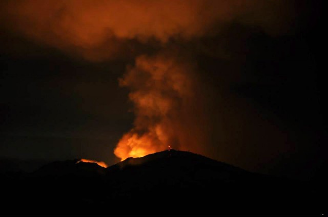
},
"parent": 0,
"labelTerm": {
"site": "news",
"term": 6944
},
"blocks": [],
"publishDate": 1379365822,
"format": "aside",
"disqusTitle": "Mount Diablo State Park Reopens After Fire ",
"title": "Mount Diablo State Park Reopens After Fire ",
"headTitle": "News Fix | KQED News",
"content": "\u003cfigure id=\"attachment_110423\" class=\"wp-caption aligncenter\" style=\"max-width: 640px\">\u003ca href=\"http://ww2.kqed.org/news/2013/09/08/fire-east-of-mount-diablo-morgan-territory/mtdiablofire/\" rel=\"attachment wp-att-110423\">\u003cimg src=\"http://ww2.kqed.org/news/wp-content/uploads/sites/10/2013/09/MtDiablofire-e1378711145703.jpg\" alt=\"Morgan Fire, burning east of Mount Diablo, as seen from Lafayette the first night of the fire. About 3,100 acres burned southeast of the town of Clayton. (Susan Welty)\" width=\"640\" height=\"425\" class=\"size-full wp-image-110423\">\u003c/a>\u003cfigcaption class=\"wp-caption-text\">Morgan Fire, burning east of Mount Diablo, as seen from Lafayette the first night of the fire. About 3,100 acres burned southeast of the town of Clayton. (Susan Welty)\u003c/figcaption>\u003c/figure>\n\u003cp>Mount Diablo State Park has reopened to visitors today after firefighters contained a blaze that charred more than 3,100 acres last week.\u003c/p>\n\u003cp>\tThe \u003ca href=\"http://cdfdata.fire.ca.gov/incidents/incidents_details_info?incident_id=908\" target=\"_blank\">Morgan Fire\u003c/a>, which started on Sunday, Sept. 8, near Morgan Territory Road southeast of Clayton, was declared 100 percent contained over the weekend.\u003c/p>\n\u003cp>\tThe blaze, reportedly started by target shooters, spread into the park and prompted its closure. About 75 homes were evacuated. More than 1,370 fire personnel from more than a dozen agencies responded during the course of the fire. Firefighters were aided by an air attack that at one point included a DC-10 jumbo jet.\u003c/p>\n\u003cp>\tToday the park and nearby roads are open with all trails accessible, Cal Fire Battalion Chief Brandon Leitzke said. \"You might run across some equipment and crews here and there,\" he said. About 100 crewmembers are still in the area today. There will be even fewer Tuesday, he said.\u003c/p>\n\u003cp>\tCrews are cleaning up debris from the blaze and working on rehabilitation efforts for the scorched land.\tPark visitors are advised to be cautious about activities that could spark a fire.\u003c/p>\n\u003cp>[ad fullwidth]\u003c/p>\n\u003cp>\u003c/p>\n\u003cp>\u003cstrong>Bay City News Service contributed to this report. \u003c/strong>\u003c/p>\n\n",
"disqusIdentifier": "111408 http://ww2.kqed.org/news/?p=111408",
"disqusUrl": "https://ww2.kqed.org/news/2013/09/16/mount-diablo-state-park-reopens-after-fire/",
"stats": {
"hasVideo": false,
"hasChartOrMap": false,
"hasAudio": false,
"hasPolis": false,
"wordCount": 223,
"hasGoogleForm": false,
"hasGallery": false,
"hasHearkenModule": false,
"iframeSrcs": [],
"paragraphCount": 8
},
"modified": 1398475549,
"excerpt": "Park reopens just a week after a brush fire raced through its drought-parched landscape.",
"headData": {
"twImgId": "",
"twTitle": "",
"ogTitle": "",
"ogImgId": "",
"twDescription": "",
"description": "Park reopens just a week after a brush fire raced through its drought-parched landscape.",
"title": "Mount Diablo State Park Reopens After Fire | KQED",
"ogDescription": "",
"schema": {
"@context": "https://schema.org",
"@type": "NewsArticle",
"headline": "Mount Diablo State Park Reopens After Fire ",
"datePublished": "2013-09-16T14:10:22-07:00",
"dateModified": "2014-04-25T18:25:49-07:00",
"image": "https://cdn.kqed.org/wp-content/uploads/2020/02/KQED-OG-Image@1x.png",
"isAccessibleForFree": "True",
"publisher": {
"@type": "NewsMediaOrganization",
"@id": "https://www.kqed.org/#organization",
"name": "KQED",
"logo": "https://cdn.kqed.org/wp-content/uploads/2020/02/KQED-OG-Image@1x.png",
"url": "https://www.kqed.org",
"sameAs": [
"https://www.facebook.com/KQED",
"https://twitter.com/KQED",
"https://www.instagram.com/kqed/",
"https://www.tiktok.com/@kqedofficial",
"https://www.linkedin.com/company/kqed",
"https://www.youtube.com/channel/UCeC0IOo7i1P_61zVUWbJ4nw"
]
}
}
},
"guestAuthors": [],
"slug": "mount-diablo-state-park-reopens-after-fire",
"status": "publish",
"path": "/news/111408/mount-diablo-state-park-reopens-after-fire",
"audioTrackLength": null,
"parsedContent": [
{
"type": "contentString",
"content": "\u003cdiv class=\"post-body\">\u003cp>\u003cfigure id=\"attachment_110423\" class=\"wp-caption aligncenter\" style=\"max-width: 640px\">\u003ca href=\"http://ww2.kqed.org/news/2013/09/08/fire-east-of-mount-diablo-morgan-territory/mtdiablofire/\" rel=\"attachment wp-att-110423\">\u003cimg src=\"http://ww2.kqed.org/news/wp-content/uploads/sites/10/2013/09/MtDiablofire-e1378711145703.jpg\" alt=\"Morgan Fire, burning east of Mount Diablo, as seen from Lafayette the first night of the fire. About 3,100 acres burned southeast of the town of Clayton. (Susan Welty)\" width=\"640\" height=\"425\" class=\"size-full wp-image-110423\">\u003c/a>\u003cfigcaption class=\"wp-caption-text\">Morgan Fire, burning east of Mount Diablo, as seen from Lafayette the first night of the fire. About 3,100 acres burned southeast of the town of Clayton. (Susan Welty)\u003c/figcaption>\u003c/figure>\n\u003cp>Mount Diablo State Park has reopened to visitors today after firefighters contained a blaze that charred more than 3,100 acres last week.\u003c/p>\n\u003cp>\tThe \u003ca href=\"http://cdfdata.fire.ca.gov/incidents/incidents_details_info?incident_id=908\" target=\"_blank\">Morgan Fire\u003c/a>, which started on Sunday, Sept. 8, near Morgan Territory Road southeast of Clayton, was declared 100 percent contained over the weekend.\u003c/p>\n\u003cp>\tThe blaze, reportedly started by target shooters, spread into the park and prompted its closure. About 75 homes were evacuated. More than 1,370 fire personnel from more than a dozen agencies responded during the course of the fire. Firefighters were aided by an air attack that at one point included a DC-10 jumbo jet.\u003c/p>\n\u003cp>\tToday the park and nearby roads are open with all trails accessible, Cal Fire Battalion Chief Brandon Leitzke said. \"You might run across some equipment and crews here and there,\" he said. About 100 crewmembers are still in the area today. There will be even fewer Tuesday, he said.\u003c/p>\n\u003cp>\tCrews are cleaning up debris from the blaze and working on rehabilitation efforts for the scorched land.\tPark visitors are advised to be cautious about activities that could spark a fire.\u003c/p>\n\u003cp>\u003c/p>\u003c/div>",
"attributes": {
"named": {},
"numeric": []
}
},
{
"type": "component",
"content": "",
"name": "ad",
"attributes": {
"named": {
"label": "fullwidth"
},
"numeric": [
"fullwidth"
]
}
},
{
"type": "contentString",
"content": "\u003cdiv class=\"post-body\">\u003cp>\u003c/p>\n\u003cp>\u003c/p>\n\u003cp>\u003cstrong>Bay City News Service contributed to this report. \u003c/strong>\u003c/p>\n\n\u003c/div>\u003c/p>",
"attributes": {
"named": {},
"numeric": []
}
}
],
"link": "/news/111408/mount-diablo-state-park-reopens-after-fire",
"authors": [
"222",
"237"
],
"programs": [
"news_6944"
],
"categories": [
"news_19906",
"news_8"
],
"tags": [
"news_212",
"news_787",
"news_4805",
"news_4794",
"news_881"
],
"featImg": "news_111182",
"label": "news_6944"
},
"news_110988": {
"type": "posts",
"id": "news_110988",
"meta": {
"index": "posts_1716263798",
"site": "news",
"id": "110988",
"score": null,
"sort": [
1379013175000
]
},
"parent": 0,
"labelTerm": {
"site": "news",
"term": 6944
},
"blocks": [],
"publishDate": 1379013175,
"format": "aside",
"disqusTitle": "Morgan Fire to be Contained Friday; Crews Demobilizing",
"title": "Morgan Fire to be Contained Friday; Crews Demobilizing",
"headTitle": "News Fix | KQED News",
"content": "\u003cfigure id=\"attachment_110423\" class=\"wp-caption alignnone\" style=\"max-width: 640px\">\u003ca href=\"http://ww2.kqed.org/news/2013/09/08/fire-east-of-mount-diablo-morgan-territory/mtdiablofire/\" rel=\"attachment wp-att-110423\">\u003cimg class=\"size-full wp-image-110423\" src=\"http://ww2.kqed.org/news/wp-content/uploads/sites/10/2013/09/MtDiablofire-e1378711145703.jpg\" alt=\"Morgan Fire, burning east of Mount Diablo, as seen from Lafayette late Sunday night. At least 800 acres have burned southeast of the town of Clayton. (Susan Welty)\" width=\"640\" height=\"425\">\u003c/a>\u003cfigcaption class=\"wp-caption-text\">Morgan Fire, burning east of Mount Diablo, as seen from Lafayette late Sunday night. At least 800 acres have burned southeast of the town of Clayton. (Susan Welty)\u003c/figcaption>\u003c/figure>\n\u003cp>\u003cstrong>Bay City News Service\u003c/strong>\u003c/p>\n\u003cp>On Sunday night and Monday, the \u003ca href=\"http://cdfdata.fire.ca.gov/incidents/incidents_details_info?incident_id=908\" target=\"_blank\">Morgan Fire\u003c/a> on Mount Diablo looked like it might run wild for days. But then the weather turned around, literally. Hot, dry conditions gave way to cooler, more humid weather, and the northeasterly wind that had driven the fire across more than 3,000 acres in its first 24 hours swung around to the west and southwest. The more than 1,400 firefighters brought in to combat the blaze quickly contained it.\u003c/p>\n\u003cp>Now, the fire is at 90 percent containment as of this morning, said Cal Fire spokesman Steve Kaufmann. Fire crews expect to have the blaze completely contained by Friday, and today a \"significant demobilization\" of fire crews is planned, he said.\u003c/p>\n\u003cp>The fire started off of Morgan Territory Road near Mount Diablo State Park, southeast of Clayton, shortly after 1 p.m. Sunday. Since then, more than 1,370 fire personnel from more than a dozen agencies have responded to the blaze.\u003c/p>\n\u003cp>Meanwhile, a body was \u003ca href=\"http://www.ktvu.com/news/news/disasters/body-found-inside-perimeter-clover-fire/nZtJ6/\">discovered\u003c/a> inside the perimeter of the \u003ca href=\"http://cdfdata.fire.ca.gov/incidents/incidents_details_info?incident_id=910\">Clover Fire\u003c/a> in Shasta County, which has consumed nearly 8,000 acres and is not expected to be contained until Sunday. The coroner's office identified the victim, whose body was found inside a house, as Brian Stanley Henry, 56. The causes of both the Morgan and Clover fires remain under investigation.\u003c!--more-->\u003c/p>\n\u003cp>[ad fullwidth]\u003c/p>\n\u003cp>Back on Mount Diablo, crews are focused on holding the perimeter around the blaze and ensuring that the winds that tend to blow through the area in the afternoon don't cause any flare-ups, Kaufmann said.\u003c/p>\n\u003cp>\"Because the humidity is so low, we just want to make sure everything is out before we leave the area,\" he said. \"We are being extra-cautious.\"\u003c/p>\n\u003cp>Since grasses, trees and other fuel in the area were already dried out, the fire was able to spread much more quickly than it would have during a year with more rainfall, he said.\u003c/p>\n\u003cp>Both in the Morgan Fire and in wildfires throughout the state, he said, \"We're seeing fire behavior that's super-extraordinary, because it's so dry and those fuel beds are so receptive to fire.\"\u003c/p>\n\u003cp>Even though the cause of the fire remains under investigation, Contra Costa County Fire Protection District Capt. Robert Marshall said fire investigators have ruled out natural causes, such as lightning strikes.\u003c/p>\n\u003cp>Instead, investigators are looking into causes related to human activity, which can range from discarded cigarette butts and unattended campfires to a dragging chain on a vehicle sparking flames, Marshall said.\u003c/p>\n\u003cp>\"There's a million different things that could happen,\" he said.\u003c/p>\n\u003cp>\u003c/p>\n\u003cp>Residents from about 100 houses that were threatened by the fire have been allowed to return home since evacuations were ordered Sunday.\u003c/p>\n\n",
"disqusIdentifier": "110988 http://ww2.kqed.org/news/?p=110988",
"disqusUrl": "https://ww2.kqed.org/news/2013/09/12/morgan-fire-to-be-completely-contained-friday-crews-demobilizing/",
"stats": {
"hasVideo": false,
"hasChartOrMap": false,
"hasAudio": false,
"hasPolis": false,
"wordCount": 497,
"hasGoogleForm": false,
"hasGallery": false,
"hasHearkenModule": false,
"iframeSrcs": [],
"paragraphCount": 15
},
"modified": 1398475551,
"excerpt": "All residents evacuated due to the blaze on Mount Diablo have now returned to their homes.",
"headData": {
"twImgId": "",
"twTitle": "",
"ogTitle": "",
"ogImgId": "",
"twDescription": "",
"description": "All residents evacuated due to the blaze on Mount Diablo have now returned to their homes.",
"title": "Morgan Fire to be Contained Friday; Crews Demobilizing | KQED",
"ogDescription": "",
"schema": {
"@context": "https://schema.org",
"@type": "NewsArticle",
"headline": "Morgan Fire to be Contained Friday; Crews Demobilizing",
"datePublished": "2013-09-12T12:12:55-07:00",
"dateModified": "2014-04-25T18:25:51-07:00",
"image": "https://cdn.kqed.org/wp-content/uploads/2020/02/KQED-OG-Image@1x.png",
"isAccessibleForFree": "True",
"publisher": {
"@type": "NewsMediaOrganization",
"@id": "https://www.kqed.org/#organization",
"name": "KQED",
"logo": "https://cdn.kqed.org/wp-content/uploads/2020/02/KQED-OG-Image@1x.png",
"url": "https://www.kqed.org",
"sameAs": [
"https://www.facebook.com/KQED",
"https://twitter.com/KQED",
"https://www.instagram.com/kqed/",
"https://www.tiktok.com/@kqedofficial",
"https://www.linkedin.com/company/kqed",
"https://www.youtube.com/channel/UCeC0IOo7i1P_61zVUWbJ4nw"
]
}
}
},
"guestAuthors": [],
"slug": "morgan-fire-to-be-completely-contained-friday-crews-demobilizing",
"status": "publish",
"customPermalink": "2013/09/12/morgan-fire/",
"path": "/news/110988/morgan-fire-to-be-completely-contained-friday-crews-demobilizing",
"audioTrackLength": null,
"parsedContent": [
{
"type": "contentString",
"content": "\u003cdiv class=\"post-body\">\u003cp>\u003cfigure id=\"attachment_110423\" class=\"wp-caption alignnone\" style=\"max-width: 640px\">\u003ca href=\"http://ww2.kqed.org/news/2013/09/08/fire-east-of-mount-diablo-morgan-territory/mtdiablofire/\" rel=\"attachment wp-att-110423\">\u003cimg class=\"size-full wp-image-110423\" src=\"http://ww2.kqed.org/news/wp-content/uploads/sites/10/2013/09/MtDiablofire-e1378711145703.jpg\" alt=\"Morgan Fire, burning east of Mount Diablo, as seen from Lafayette late Sunday night. At least 800 acres have burned southeast of the town of Clayton. (Susan Welty)\" width=\"640\" height=\"425\">\u003c/a>\u003cfigcaption class=\"wp-caption-text\">Morgan Fire, burning east of Mount Diablo, as seen from Lafayette late Sunday night. At least 800 acres have burned southeast of the town of Clayton. (Susan Welty)\u003c/figcaption>\u003c/figure>\n\u003cp>\u003cstrong>Bay City News Service\u003c/strong>\u003c/p>\n\u003cp>On Sunday night and Monday, the \u003ca href=\"http://cdfdata.fire.ca.gov/incidents/incidents_details_info?incident_id=908\" target=\"_blank\">Morgan Fire\u003c/a> on Mount Diablo looked like it might run wild for days. But then the weather turned around, literally. Hot, dry conditions gave way to cooler, more humid weather, and the northeasterly wind that had driven the fire across more than 3,000 acres in its first 24 hours swung around to the west and southwest. The more than 1,400 firefighters brought in to combat the blaze quickly contained it.\u003c/p>\n\u003cp>Now, the fire is at 90 percent containment as of this morning, said Cal Fire spokesman Steve Kaufmann. Fire crews expect to have the blaze completely contained by Friday, and today a \"significant demobilization\" of fire crews is planned, he said.\u003c/p>\n\u003cp>The fire started off of Morgan Territory Road near Mount Diablo State Park, southeast of Clayton, shortly after 1 p.m. Sunday. Since then, more than 1,370 fire personnel from more than a dozen agencies have responded to the blaze.\u003c/p>\n\u003cp>Meanwhile, a body was \u003ca href=\"http://www.ktvu.com/news/news/disasters/body-found-inside-perimeter-clover-fire/nZtJ6/\">discovered\u003c/a> inside the perimeter of the \u003ca href=\"http://cdfdata.fire.ca.gov/incidents/incidents_details_info?incident_id=910\">Clover Fire\u003c/a> in Shasta County, which has consumed nearly 8,000 acres and is not expected to be contained until Sunday. The coroner's office identified the victim, whose body was found inside a house, as Brian Stanley Henry, 56. The causes of both the Morgan and Clover fires remain under investigation.\u003c!--more-->\u003c/p>\n\u003cp>\u003c/p>\u003c/div>",
"attributes": {
"named": {},
"numeric": []
}
},
{
"type": "component",
"content": "",
"name": "ad",
"attributes": {
"named": {
"label": "fullwidth"
},
"numeric": [
"fullwidth"
]
}
},
{
"type": "contentString",
"content": "\u003cdiv class=\"post-body\">\u003cp>\u003c/p>\n\u003cp>Back on Mount Diablo, crews are focused on holding the perimeter around the blaze and ensuring that the winds that tend to blow through the area in the afternoon don't cause any flare-ups, Kaufmann said.\u003c/p>\n\u003cp>\"Because the humidity is so low, we just want to make sure everything is out before we leave the area,\" he said. \"We are being extra-cautious.\"\u003c/p>\n\u003cp>Since grasses, trees and other fuel in the area were already dried out, the fire was able to spread much more quickly than it would have during a year with more rainfall, he said.\u003c/p>\n\u003cp>Both in the Morgan Fire and in wildfires throughout the state, he said, \"We're seeing fire behavior that's super-extraordinary, because it's so dry and those fuel beds are so receptive to fire.\"\u003c/p>\n\u003cp>Even though the cause of the fire remains under investigation, Contra Costa County Fire Protection District Capt. Robert Marshall said fire investigators have ruled out natural causes, such as lightning strikes.\u003c/p>\n\u003cp>Instead, investigators are looking into causes related to human activity, which can range from discarded cigarette butts and unattended campfires to a dragging chain on a vehicle sparking flames, Marshall said.\u003c/p>\n\u003cp>\"There's a million different things that could happen,\" he said.\u003c/p>\n\u003cp>\u003c/p>\n\u003cp>Residents from about 100 houses that were threatened by the fire have been allowed to return home since evacuations were ordered Sunday.\u003c/p>\n\n\u003c/div>\u003c/p>",
"attributes": {
"named": {},
"numeric": []
}
}
],
"link": "/news/110988/morgan-fire-to-be-completely-contained-friday-crews-demobilizing",
"authors": [
"237"
],
"programs": [
"news_6944"
],
"categories": [
"news_19906",
"news_8"
],
"tags": [
"news_212",
"news_787",
"news_4805",
"news_4831",
"news_881"
],
"featImg": "news_110598",
"label": "news_6944"
},
"news_110595": {
"type": "posts",
"id": "news_110595",
"meta": {
"index": "posts_1716263798",
"site": "news",
"id": "110595",
"score": null,
"sort": [
1378918848000
]
},
"parent": 0,
"labelTerm": {
"site": "news",
"term": 6944
},
"blocks": [],
"publishDate": 1378918848,
"format": "aside",
"disqusTitle": "Morgan Fire Update: Acreage Shrinks, Containment Grows ",
"title": "Morgan Fire Update: Acreage Shrinks, Containment Grows ",
"headTitle": "News Fix | KQED News",
"content": "\u003cfigure id=\"attachment_110598\" class=\"wp-caption alignright\" style=\"max-width: 300px\">\u003ca href=\"http://ww2.kqed.org/news/2013/09/10/morgan-fire-update-weather-helps-crews-corral-mount-diablo-blaze/rs6614_67715_87e1c720e23de9e685a85c9a82982e89_1b482184743ed40817a0d3f2b1e85bc8-hpf/\" rel=\"attachment wp-att-110598\">\u003cimg class=\"size-medium wp-image-110598\" src=\"http://ww2.kqed.org/news/wp-content/uploads/sites/10/2013/09/RS6614_67715_87e1c720e23de9e685a85c9a82982e89_1b482184743ed40817a0d3f2b1e85bc8-hpf-300x200.jpg\" alt=\"Mount Diablo burns in image taken Sunday evening, the first evening of the Morgan fire. (Photo courtesy of Karl Frankowski, @karlfrankowski)\" width=\"300\" height=\"200\">\u003c/a>\u003cfigcaption class=\"wp-caption-text\">Mount Diablo burns in image taken Sunday evening, the first evening of the Morgan fire. (Photo courtesy of Karl Frankowski, @karlfrankowski)\u003c/figcaption>\u003c/figure>\n\u003cp>\u003cstrong>Update 10 a.m. Wednesday\u003c/strong>: \u003ca href=\"http://cdfdata.fire.ca.gov/incidents/incidents_details_info?incident_id=908\" target=\"_blank\">Cal Fire updated\u003c/a> its acreage and containment estimates this morning. The agency now says the fire has burned 3,133 acres (that's down from estimates of 3,700 acres Monday evening and 3,243 acres Tuesday) and is 70 percent contained.\u003c/p>\n\u003cp>\u003cstrong>Previous post (6 p.m. Tuesday): \u003c/strong>In a sign of the dramatic apparent progress made in the fight against the Morgan Fire east of Mount Diablo, Cal Fire says all evacuation orders have been lifted as of 6 p.m. tonight. About 100 residents of ranches and homes were ordered to leave Sunday evening as the fire advanced through the hilly terrain southeast of Clayton. Officials say the fire has burned across 3,243 acres, the same as reported early this morning. They report the fire is 60 percent contained compared to 45 percent this morning.\u003c/p>\n\u003cblockquote class=\"twitter-tweet\">\u003cp>\u003ca href=\"https://twitter.com/search?q=%23Morganfire&src=hash\">#Morganfire\u003c/a> [update] As of 6:00 pm tonight, all evacuation orders and the remaining road closure will be lifted on the Morgan Fire.\u003c/p>\n\u003cp>— CAL FIRE (@CAL_FIRE) \u003ca href=\"https://twitter.com/CAL_FIRE/statuses/377604961619562496\">September 11, 2013\u003c/a>\u003c/p>\u003c/blockquote>\n\u003cp>And here's another sign that things have changed on the fire front: a photo tweeted by CBS San Francisco reporter Cate Caguiran. You might ask yourself: Where's all the fire and smoke we saw yesterday? One possible factor: Shifting winds last night pushed the fire back into areas that burned Sunday night and early Monday.\u003c/p>\n\u003cblockquote class=\"twitter-tweet\">\u003cp>We're atop Mt. Diablo getting a look at the aftermath of \u003ca href=\"https://twitter.com/search?q=%23MorganFire&src=hash\">#MorganFire\u003c/a> Firefighters say most flames are out \u003ca href=\"https://twitter.com/CBSSF\">@CBSSF\u003c/a> \u003ca href=\"http://t.co/ietRS21tPH\">pic.twitter.com/ietRS21tPH\u003c/a>\u003c/p>\n\u003cp>— Cate Cauguiran (@CateCauguiran) \u003ca href=\"https://twitter.com/CateCauguiran/statuses/377517548029632513\">September 10, 2013\u003c/a>\u003c/p>\u003c/blockquote>\n\u003cp>\u003cstrong>Earlier post:\u003c/strong>\u003c/p>\n\u003cp>Cal Fire \u003ca href=\"http://cdfdata.fire.ca.gov/incidents/incidents_details_info?incident_id=908\" target=\"_blank\">is reporting \u003c/a>that crews have made significant progress overnight in containing the wildfire burning on and around Mount Diablo. Officials downsized their estimate of acreage burned to 3,243 acres and say the blaze, which started Sunday afternoon in an area of ranches and homes near Morgan Territory Road southeast of Clayton, is now 45 percent contained.\u003c/p>\n\u003cp>[ad fullwidth]\u003c/p>\n\u003cp>Cooler, more humid weather overnight aided firefighters, who are busy this morning building new containment lines on the northeastern and western edges of the blaze. Cal Fire says 11 helicopters will be working on the fire today.\u003c/p>\n\u003cp>But the challenge isn't over. Officials say they're diverting some resources from the Mount Diablo blaze to fight the \u003ca href=\"http://cdfdata.fire.ca.gov/incidents/incidents_details_info?incident_id=910\" target=\"_blank\">Clover Fire\u003c/a>, a 7,400-acre blaze near Redding (Shasta County). That fire started Monday afternoon. It has \u003ca href=\"http://www.redding.com/news/2013/sep/10/tuesday-clover-fire-update-20-structures-destroyed/\" target=\"_blank\">destroyed 80 structures\u003c/a> and threatens 300 more.\u003c/p>\n\u003cp>According to Cal Fire, the Clover Fire \"continues to move in a southwest direction and has potential to grow due to north winds and low humidity recovery. Structures in the area continue to be threatened and evacuations are in effect. Transmission and distribution power lines are at continued risk and the Clear Creek Water District Pump Station was damaged.\"\u003c/p>\n\u003cp>\u003c/p>\n\u003cp>The Clover Fire is reported to be about 40 percent contained.\u003c/p>\n\u003cblockquote class=\"twitter-tweet\">\u003cp>\u003ca href=\"https://twitter.com/search?q=%23MorganFire&src=hash\">#MorganFire\u003c/a> [update] SE of Clayton (Contra Costa County) is now 3,243 acres & 45% contained. \u003ca href=\"http://t.co/7NvIKq44z9\">http://t.co/7NvIKq44z9\u003c/a> …\u003c/p>\n\u003cp>— CAL FIRE (@CAL_FIRE) \u003ca href=\"https://twitter.com/CAL_FIRE/statuses/377431378100355072\">September 10, 2013\u003c/a>\u003c/p>\u003c/blockquote>\n\n",
"disqusIdentifier": "110595 http://ww2.kqed.org/news/?p=110595",
"disqusUrl": "https://ww2.kqed.org/news/2013/09/11/morgan-fire-update-weather-helps-crews-corral-mount-diablo-blaze/",
"stats": {
"hasVideo": false,
"hasChartOrMap": false,
"hasAudio": false,
"hasPolis": false,
"wordCount": 527,
"hasGoogleForm": false,
"hasGallery": false,
"hasHearkenModule": false,
"iframeSrcs": [],
"paragraphCount": 17
},
"modified": 1398475557,
"excerpt": "Cal Fire says the blaze is 70 percent contained. Cooler weather is helping tame the fire. ",
"headData": {
"twImgId": "",
"twTitle": "",
"ogTitle": "",
"ogImgId": "",
"twDescription": "",
"description": "Cal Fire says the blaze is 70 percent contained. Cooler weather is helping tame the fire. ",
"title": "Morgan Fire Update: Acreage Shrinks, Containment Grows | KQED",
"ogDescription": "",
"schema": {
"@context": "https://schema.org",
"@type": "NewsArticle",
"headline": "Morgan Fire Update: Acreage Shrinks, Containment Grows ",
"datePublished": "2013-09-11T10:00:48-07:00",
"dateModified": "2014-04-25T18:25:57-07:00",
"image": "https://cdn.kqed.org/wp-content/uploads/2020/02/KQED-OG-Image@1x.png",
"isAccessibleForFree": "True",
"publisher": {
"@type": "NewsMediaOrganization",
"@id": "https://www.kqed.org/#organization",
"name": "KQED",
"logo": "https://cdn.kqed.org/wp-content/uploads/2020/02/KQED-OG-Image@1x.png",
"url": "https://www.kqed.org",
"sameAs": [
"https://www.facebook.com/KQED",
"https://twitter.com/KQED",
"https://www.instagram.com/kqed/",
"https://www.tiktok.com/@kqedofficial",
"https://www.linkedin.com/company/kqed",
"https://www.youtube.com/channel/UCeC0IOo7i1P_61zVUWbJ4nw"
]
}
}
},
"guestAuthors": [],
"slug": "morgan-fire-update-weather-helps-crews-corral-mount-diablo-blaze",
"status": "publish",
"customPermalink": "2013/09/10/morgan-fire-update-weather-helps-crews-corral-mount-diablo-blaze/",
"path": "/news/110595/morgan-fire-update-weather-helps-crews-corral-mount-diablo-blaze",
"audioTrackLength": null,
"parsedContent": [
{
"type": "contentString",
"content": "\u003cdiv class=\"post-body\">\u003cp>\u003cfigure id=\"attachment_110598\" class=\"wp-caption alignright\" style=\"max-width: 300px\">\u003ca href=\"http://ww2.kqed.org/news/2013/09/10/morgan-fire-update-weather-helps-crews-corral-mount-diablo-blaze/rs6614_67715_87e1c720e23de9e685a85c9a82982e89_1b482184743ed40817a0d3f2b1e85bc8-hpf/\" rel=\"attachment wp-att-110598\">\u003cimg class=\"size-medium wp-image-110598\" src=\"http://ww2.kqed.org/news/wp-content/uploads/sites/10/2013/09/RS6614_67715_87e1c720e23de9e685a85c9a82982e89_1b482184743ed40817a0d3f2b1e85bc8-hpf-300x200.jpg\" alt=\"Mount Diablo burns in image taken Sunday evening, the first evening of the Morgan fire. (Photo courtesy of Karl Frankowski, @karlfrankowski)\" width=\"300\" height=\"200\">\u003c/a>\u003cfigcaption class=\"wp-caption-text\">Mount Diablo burns in image taken Sunday evening, the first evening of the Morgan fire. (Photo courtesy of Karl Frankowski, @karlfrankowski)\u003c/figcaption>\u003c/figure>\n\u003cp>\u003cstrong>Update 10 a.m. Wednesday\u003c/strong>: \u003ca href=\"http://cdfdata.fire.ca.gov/incidents/incidents_details_info?incident_id=908\" target=\"_blank\">Cal Fire updated\u003c/a> its acreage and containment estimates this morning. The agency now says the fire has burned 3,133 acres (that's down from estimates of 3,700 acres Monday evening and 3,243 acres Tuesday) and is 70 percent contained.\u003c/p>\n\u003cp>\u003cstrong>Previous post (6 p.m. Tuesday): \u003c/strong>In a sign of the dramatic apparent progress made in the fight against the Morgan Fire east of Mount Diablo, Cal Fire says all evacuation orders have been lifted as of 6 p.m. tonight. About 100 residents of ranches and homes were ordered to leave Sunday evening as the fire advanced through the hilly terrain southeast of Clayton. Officials say the fire has burned across 3,243 acres, the same as reported early this morning. They report the fire is 60 percent contained compared to 45 percent this morning.\u003c/p>\n\u003cblockquote class=\"twitter-tweet\">\u003cp>\u003ca href=\"https://twitter.com/search?q=%23Morganfire&src=hash\">#Morganfire\u003c/a> [update] As of 6:00 pm tonight, all evacuation orders and the remaining road closure will be lifted on the Morgan Fire.\u003c/p>\n\u003cp>— CAL FIRE (@CAL_FIRE) \u003ca href=\"https://twitter.com/CAL_FIRE/statuses/377604961619562496\">September 11, 2013\u003c/a>\u003c/p>\u003c/blockquote>\n\u003cp>And here's another sign that things have changed on the fire front: a photo tweeted by CBS San Francisco reporter Cate Caguiran. You might ask yourself: Where's all the fire and smoke we saw yesterday? One possible factor: Shifting winds last night pushed the fire back into areas that burned Sunday night and early Monday.\u003c/p>\n\u003cblockquote class=\"twitter-tweet\">\u003cp>We're atop Mt. Diablo getting a look at the aftermath of \u003ca href=\"https://twitter.com/search?q=%23MorganFire&src=hash\">#MorganFire\u003c/a> Firefighters say most flames are out \u003ca href=\"https://twitter.com/CBSSF\">@CBSSF\u003c/a> \u003ca href=\"http://t.co/ietRS21tPH\">pic.twitter.com/ietRS21tPH\u003c/a>\u003c/p>\n\u003cp>— Cate Cauguiran (@CateCauguiran) \u003ca href=\"https://twitter.com/CateCauguiran/statuses/377517548029632513\">September 10, 2013\u003c/a>\u003c/p>\u003c/blockquote>\n\u003cp>\u003cstrong>Earlier post:\u003c/strong>\u003c/p>\n\u003cp>Cal Fire \u003ca href=\"http://cdfdata.fire.ca.gov/incidents/incidents_details_info?incident_id=908\" target=\"_blank\">is reporting \u003c/a>that crews have made significant progress overnight in containing the wildfire burning on and around Mount Diablo. Officials downsized their estimate of acreage burned to 3,243 acres and say the blaze, which started Sunday afternoon in an area of ranches and homes near Morgan Territory Road southeast of Clayton, is now 45 percent contained.\u003c/p>\n\u003cp>\u003c/p>\u003c/div>",
"attributes": {
"named": {},
"numeric": []
}
},
{
"type": "component",
"content": "",
"name": "ad",
"attributes": {
"named": {
"label": "fullwidth"
},
"numeric": [
"fullwidth"
]
}
},
{
"type": "contentString",
"content": "\u003cdiv class=\"post-body\">\u003cp>\u003c/p>\n\u003cp>Cooler, more humid weather overnight aided firefighters, who are busy this morning building new containment lines on the northeastern and western edges of the blaze. Cal Fire says 11 helicopters will be working on the fire today.\u003c/p>\n\u003cp>But the challenge isn't over. Officials say they're diverting some resources from the Mount Diablo blaze to fight the \u003ca href=\"http://cdfdata.fire.ca.gov/incidents/incidents_details_info?incident_id=910\" target=\"_blank\">Clover Fire\u003c/a>, a 7,400-acre blaze near Redding (Shasta County). That fire started Monday afternoon. It has \u003ca href=\"http://www.redding.com/news/2013/sep/10/tuesday-clover-fire-update-20-structures-destroyed/\" target=\"_blank\">destroyed 80 structures\u003c/a> and threatens 300 more.\u003c/p>\n\u003cp>According to Cal Fire, the Clover Fire \"continues to move in a southwest direction and has potential to grow due to north winds and low humidity recovery. Structures in the area continue to be threatened and evacuations are in effect. Transmission and distribution power lines are at continued risk and the Clear Creek Water District Pump Station was damaged.\"\u003c/p>\n\u003cp>\u003c/p>\n\u003cp>The Clover Fire is reported to be about 40 percent contained.\u003c/p>\n\u003cblockquote class=\"twitter-tweet\">\u003cp>\u003ca href=\"https://twitter.com/search?q=%23MorganFire&src=hash\">#MorganFire\u003c/a> [update] SE of Clayton (Contra Costa County) is now 3,243 acres & 45% contained. \u003ca href=\"http://t.co/7NvIKq44z9\">http://t.co/7NvIKq44z9\u003c/a> …\u003c/p>\n\u003cp>— CAL FIRE (@CAL_FIRE) \u003ca href=\"https://twitter.com/CAL_FIRE/statuses/377431378100355072\">September 10, 2013\u003c/a>\u003c/p>\u003c/blockquote>\n\n\u003c/div>\u003c/p>",
"attributes": {
"named": {},
"numeric": []
}
}
],
"link": "/news/110595/morgan-fire-update-weather-helps-crews-corral-mount-diablo-blaze",
"authors": [
"222"
],
"programs": [
"news_6944"
],
"categories": [
"news_19906",
"news_8"
],
"tags": [
"news_4807",
"news_4808",
"news_212",
"news_787",
"news_4805",
"news_4794",
"news_881"
],
"featImg": "news_110598",
"label": "news_6944"
},
"news_110388": {
"type": "posts",
"id": "news_110388",
"meta": {
"index": "posts_1716263798",
"site": "news",
"id": "110388",
"score": null,
"sort": [
1378770945000
]
},
"guestAuthors": [],
"slug": "wildfire-east-of-mount-diablo-fast-moving-blaze-prompts-evacuations",
"title": "Mount Diablo Blaze Grows Rapidly, Forces Evacuations",
"publishDate": 1378770945,
"format": "aside",
"headTitle": "Mount Diablo Blaze Grows Rapidly, Forces Evacuations | KQED",
"labelTerm": {
"term": 6944,
"site": "news"
},
"content": "\u003cfigure id=\"attachment_110423\" class=\"wp-caption alignright\" style=\"max-width: 300px\">\u003ca href=\"http://ww2.kqed.org/news/2013/09/08/fire-east-of-mount-diablo-morgan-territory/mtdiablofire/\" rel=\"attachment wp-att-110423\">\u003cimg loading=\"lazy\" decoding=\"async\" class=\"size-medium wp-image-110423\" src=\"http://ww2.kqed.org/news/wp-content/uploads/sites/10/2013/09/MtDiablofire-300x199.jpg\" alt=\"Morgan Fire, burning east of Mount Diablo, as seen from Lafayette late Sunday night. At least 3,700 acres have burned southeast of the town of Clayton. (Susan Welty) \" width=\"300\" height=\"199\">\u003c/a>\u003cfigcaption class=\"wp-caption-text\">Morgan Fire, burning east of Mount Diablo, as seen from Lafayette late Sunday night. At least 3,700 acres have burned southeast of the town of Clayton. (Susan Welty)\u003c/figcaption>\u003c/figure>\n\u003cp>\u003cstrong>Our latest update:\u003c/strong> \u003ca href=\"http://ww2.kqed.org/news/2013/09/10/morgan-fire-update-weather-helps-crews-corral-mount-diablo-blaze/\" target=\"_blank\" rel=\"noopener\">Weather Helps Crews Corral Mount Diablo Blaze\u003c/a>\u003c/p>\n\u003cp>\u003cstrong>Update 4:45 p.m. Monday: \u003c/strong>The wildfire burning on and around Mount Diablo in central Contra Costa County has grown rapidly today. \u003ca href=\"http://cdfdata.fire.ca.gov/incidents/incidents_details_info?incident_id=908\" target=\"_blank\" rel=\"noopener\">Cal Fire says\u003c/a> the fire has covered 3,700 acres and is now 20 percent contained. \u003ca href=\"http://www.californiareport.org/archive/R201308301630/b\" target=\"_blank\" rel=\"noopener\">DC-10 jumbo jets\u003c/a> outfitted to drop 100,000 pounds of fire retardant on a single run have reportedly been called in to help in the fight.\u003c/p>\n\u003cp>Smoke from the fire has been visible in much of the Bay Area. The huge plume drifting south from the blaze prompted the Bay Area Air Quality Management District to issue \u003ca href=\"http://www.baaqmd.gov/~/media/5CB24B9BABF040A4A01284A5631CF1D1.ashx\" target=\"_blank\" rel=\"noopener\">a smoke advisory\u003c/a> this afternoon for residents of Contra Costa, Alameda and Santa Clara counties.\u003c/p>\n\u003cp>The blaze began Sunday afternoon in a sparsely populated area of homes and small ranches southeast of the town of Clayton. The rapidly moving fire prompted \u003ca href=\"http://claycord.com/2013/09/08/urgent-evacuations-ordered-in-clayton-due-to-fire-on-morgan-territory/\" target=\"_blank\" rel=\"noopener\">mandatory evacuations for residents of about 100 ranches and homes in the area. \u003c/a>\u003c/p>\n\u003cp>KQED’s Tara Siler offered an update this morning from fire information officer Lewis Broschard of the Contra Costa County Fire Protection District:\u003c/p>\n\u003cblockquote>\u003cp>The fire is burning in very steep, rugged terrain on the eastern slope of Mount Diablo. The fuel and topography is such that the fire will continue to spread. We are going to be working at getting additional containment. Approximately 500 firefighters are going to be working the lines today and we do have aircraft en route to the fire as we speak to support ground operations. But the fire is burning in an area of the park that hasn’t burned for a very long period of time and the fire is well established right now. The fire did burn actively all night and we did obviously see a large increase in the number of acres burned.\u003c/p>\u003c/blockquote>\n\u003cp>Cal Fire announced several road closures in the Clayton area and in the rural area east of the mountain (open to residents only, with photo identification). Marsh Creek Road closed from Camino Diablo to Regency Road in Clayton. Morgan Territory Road is closed from Marsh Creek Road to Highland Road (Alameda County).\u003cbr>\nPersons needing to evacuate large animals may take them to the Heather Farms Equestrian Center in Walnut Creek. For more information, please visit: www.ecwc.org or call 925-939-2929.\u003c/p>\n\u003cp>[ad fullwidth]\u003c/p>\n\u003cp>\u003c!--more-->\u003c/p>\n\u003cp>Immediately below: a cool six-second time lapse of Mount Diablo as it burned Sunday night:\u003c/p>\n\u003cp>[youtube http://www.youtube.com/watch?v=ApSFbUysN_I]\u003c/p>\n\u003cp>Here’s a Storify collection of fire coverage this morning:\u003c/p>\n\u003cdiv class=\"storify\">\u003ciframe loading=\"lazy\" src=\"//storify.com/danbrekke/morgan-fire-burns-east-of-mount-diablo/embed\" frameborder=\"no\" width=\"100%\" height=\"750\">\u003c/iframe>[\u003ca href=\"//storify.com/danbrekke/morgan-fire-burns-east-of-mount-diablo\" target=\"_blank\" rel=\"noopener\">View the story “Morgan Fire Burns East of Mount Diablo” on Storify\u003c/a>]\u003c/div>\n\u003cp>\u003cstrong>***\u003c/strong>\u003cbr>\n\u003cstrong>Original post (5 p.m. Sunday):\u003c/strong> A wildfire that broke out earlier this afternoon near Morgan Territory Road southeast of the town of Clayton has burned about 300 acres in just three hours. \u003ca href=\"http://cdfdata.fire.ca.gov/incidents/incidents_details_info?incident_id=908\" target=\"_blank\" rel=\"noopener\">Cal Fire reports\u003c/a> the fire, burning in a relatively sparsely populated area near the eastern boundary of Mount Diablo State Park, is about 10 percent contained. Cal Fire says 50 to 75 structures are threatened. \u003ca href=\"http://claycord.com/2013/09/08/urgent-evacuations-ordered-in-clayton-due-to-fire-on-morgan-territory/\" target=\"_blank\" rel=\"noopener\">Contra Costa County authorities broadcast orders\u003c/a> for an immediate evacuation for residents of the Oak Hill Lane and Curry Creek Road area. That’s about 5 miles southeast of downtown Clayton.\u003c/p>\n\u003cblockquote class=\"twitter-tweet\">\u003cp>\u003ca href=\"https://twitter.com/search?q=%23MorganFire&src=hash\">#MorganFire\u003c/a> [update] off Morgan Territory Rd, near Clayton (Contra Costa County) is now 300 acres & 10% contained. Evacuations in progress.\u003c/p>\n\u003cp>— CAL FIRE (@CAL_FIRE) \u003ca href=\"https://twitter.com/CAL_FIRE/statuses/376849066912534528\">September 8, 2013\u003c/a>\u003c/p>\u003c/blockquote>\n\u003cp>Cal Fire also says that about 200 firefighters are on the scene, backed up by four fixed-wing air tankers and three helicopters. \u003ca href=\"http://dropc.am/p/fQd40N\" target=\"_blank\" rel=\"noopener\">A webcam \u003c/a>apparently positioned southwest of Mount Diablo shows the top of the peak enveloped in smoke, even though it’s apparently several miles from where the fire is burning.\u003c/p>\n\u003cp>For historical context: Mount Diablo was the scene of \u003ca href=\"http://claycord.com/2011/09/10/a-look-back-at-the-6000-acre-fire-on-mt-diablo-in-the-year-1977/\" target=\"_blank\" rel=\"noopener\">a major wildfire in August 1977\u003c/a>, when lightning ignited drought-parched chaparral and burned more than 6,000 acres on and around the mountain.\u003c/p>\n\u003cp>Comments on the \u003ca title=\"http://claycord.com/\" href=\"http://claycord.com/2013/09/08/urgent-evacuations-ordered-in-clayton-due-to-fire-on-morgan-territory/\" target=\"_blank\" rel=\"noopener\">Claycord\u003c/a> community news site include this account of residents leaving the fire zone:\u003c/p>\n\u003cblockquote>\u003cp>I called Camp 4 Paws at 5 PM to ask if they needed help evacuating the dogs. I was told that they were almost finished with getting all of the animals into vehicles and evacuate.\u003c/p>\n\u003cp>I saw a lot of trucks with horse trailers full of families and horses driving away from immediate fire area. Two family-filled trucks were carrying three horses in each trailer.\u003c/p>\n\u003cp>There are a lot of ranches and horses, dogs, burros, donkeys, goats, cats, chickens, alpacas, ponies, all pets in the area affected and one way in and one way out. My heart goes out to the families who are trying to leave safely with all of their loved ones.\u003c/p>\u003c/blockquote>\n\u003cp>Here’s a long-distance shot of the fire posted on Instagram by user margaret_w:\u003c/p>\n\u003cp>\u003c/p>\n\u003cp>\u003ciframe loading=\"lazy\" src=\"//instagram.com/p/eBWBXQp7r5/embed/\" frameborder=\"0\" scrolling=\"no\" width=\"612\" height=\"710\">\u003c/iframe>\u003c/p>\n\n",
"blocks": [],
"excerpt": "Blaze prompts residents to flee homes in a sparsely populated area east of Mount Diablo. ",
"status": "publish",
"parent": 0,
"modified": 1722638858,
"stats": {
"hasAudio": false,
"hasVideo": true,
"hasChartOrMap": true,
"iframeSrcs": [
"//storify.com/danbrekke/morgan-fire-burns-east-of-mount-diablo/embed",
"//instagram.com/p/eBWBXQp7r5/embed/"
],
"hasGoogleForm": false,
"hasGallery": false,
"hasHearkenModule": false,
"hasPolis": false,
"paragraphCount": 24,
"wordCount": 831
},
"headData": {
"title": "Mount Diablo Blaze Grows Rapidly, Forces Evacuations | KQED",
"description": "Blaze prompts residents to flee homes in a sparsely populated area east of Mount Diablo. ",
"ogTitle": "",
"ogDescription": "",
"ogImgId": "",
"twTitle": "",
"twDescription": "",
"twImgId": "",
"schema": {
"@context": "https://schema.org",
"@type": "NewsArticle",
"headline": "Mount Diablo Blaze Grows Rapidly, Forces Evacuations",
"datePublished": "2013-09-09T16:55:45-07:00",
"dateModified": "2024-08-02T15:47:38-07:00",
"image": "https://cdn.kqed.org/wp-content/uploads/2020/02/KQED-OG-Image@1x.png",
"isAccessibleForFree": "True",
"publisher": {
"@type": "NewsMediaOrganization",
"@id": "https://www.kqed.org/#organization",
"name": "KQED",
"logo": "https://cdn.kqed.org/wp-content/uploads/2020/02/KQED-OG-Image@1x.png",
"url": "https://www.kqed.org",
"sameAs": [
"https://www.facebook.com/KQED",
"https://twitter.com/KQED",
"https://www.instagram.com/kqed/",
"https://www.tiktok.com/@kqedofficial",
"https://www.linkedin.com/company/kqed",
"https://www.youtube.com/channel/UCeC0IOo7i1P_61zVUWbJ4nw"
]
}
}
},
"sticky": false,
"customPermalink": "2013/09/08/fire-east-of-mount-diablo-morgan-territory/",
"path": "/news/110388/wildfire-east-of-mount-diablo-fast-moving-blaze-prompts-evacuations",
"audioTrackLength": null,
"parsedContent": [
{
"type": "contentString",
"content": "\u003cdiv class=\"post-body\">\u003cp>\u003cfigure id=\"attachment_110423\" class=\"wp-caption alignright\" style=\"max-width: 300px\">\u003ca href=\"http://ww2.kqed.org/news/2013/09/08/fire-east-of-mount-diablo-morgan-territory/mtdiablofire/\" rel=\"attachment wp-att-110423\">\u003cimg loading=\"lazy\" decoding=\"async\" class=\"size-medium wp-image-110423\" src=\"http://ww2.kqed.org/news/wp-content/uploads/sites/10/2013/09/MtDiablofire-300x199.jpg\" alt=\"Morgan Fire, burning east of Mount Diablo, as seen from Lafayette late Sunday night. At least 3,700 acres have burned southeast of the town of Clayton. (Susan Welty) \" width=\"300\" height=\"199\">\u003c/a>\u003cfigcaption class=\"wp-caption-text\">Morgan Fire, burning east of Mount Diablo, as seen from Lafayette late Sunday night. At least 3,700 acres have burned southeast of the town of Clayton. (Susan Welty)\u003c/figcaption>\u003c/figure>\n\u003cp>\u003cstrong>Our latest update:\u003c/strong> \u003ca href=\"http://ww2.kqed.org/news/2013/09/10/morgan-fire-update-weather-helps-crews-corral-mount-diablo-blaze/\" target=\"_blank\" rel=\"noopener\">Weather Helps Crews Corral Mount Diablo Blaze\u003c/a>\u003c/p>\n\u003cp>\u003cstrong>Update 4:45 p.m. Monday: \u003c/strong>The wildfire burning on and around Mount Diablo in central Contra Costa County has grown rapidly today. \u003ca href=\"http://cdfdata.fire.ca.gov/incidents/incidents_details_info?incident_id=908\" target=\"_blank\" rel=\"noopener\">Cal Fire says\u003c/a> the fire has covered 3,700 acres and is now 20 percent contained. \u003ca href=\"http://www.californiareport.org/archive/R201308301630/b\" target=\"_blank\" rel=\"noopener\">DC-10 jumbo jets\u003c/a> outfitted to drop 100,000 pounds of fire retardant on a single run have reportedly been called in to help in the fight.\u003c/p>\n\u003cp>Smoke from the fire has been visible in much of the Bay Area. The huge plume drifting south from the blaze prompted the Bay Area Air Quality Management District to issue \u003ca href=\"http://www.baaqmd.gov/~/media/5CB24B9BABF040A4A01284A5631CF1D1.ashx\" target=\"_blank\" rel=\"noopener\">a smoke advisory\u003c/a> this afternoon for residents of Contra Costa, Alameda and Santa Clara counties.\u003c/p>\n\u003cp>The blaze began Sunday afternoon in a sparsely populated area of homes and small ranches southeast of the town of Clayton. The rapidly moving fire prompted \u003ca href=\"http://claycord.com/2013/09/08/urgent-evacuations-ordered-in-clayton-due-to-fire-on-morgan-territory/\" target=\"_blank\" rel=\"noopener\">mandatory evacuations for residents of about 100 ranches and homes in the area. \u003c/a>\u003c/p>\n\u003cp>KQED’s Tara Siler offered an update this morning from fire information officer Lewis Broschard of the Contra Costa County Fire Protection District:\u003c/p>\n\u003cblockquote>\u003cp>The fire is burning in very steep, rugged terrain on the eastern slope of Mount Diablo. The fuel and topography is such that the fire will continue to spread. We are going to be working at getting additional containment. Approximately 500 firefighters are going to be working the lines today and we do have aircraft en route to the fire as we speak to support ground operations. But the fire is burning in an area of the park that hasn’t burned for a very long period of time and the fire is well established right now. The fire did burn actively all night and we did obviously see a large increase in the number of acres burned.\u003c/p>\u003c/blockquote>\n\u003cp>Cal Fire announced several road closures in the Clayton area and in the rural area east of the mountain (open to residents only, with photo identification). Marsh Creek Road closed from Camino Diablo to Regency Road in Clayton. Morgan Territory Road is closed from Marsh Creek Road to Highland Road (Alameda County).\u003cbr>\nPersons needing to evacuate large animals may take them to the Heather Farms Equestrian Center in Walnut Creek. For more information, please visit: www.ecwc.org or call 925-939-2929.\u003c/p>\n\u003cp>\u003c/p>\u003c/div>",
"attributes": {
"named": {},
"numeric": []
}
},
{
"type": "component",
"content": "",
"name": "ad",
"attributes": {
"named": {
"label": "fullwidth"
},
"numeric": [
"fullwidth"
]
}
},
{
"type": "contentString",
"content": "\u003cdiv class=\"post-body\">\u003cp>\u003c/p>\n\u003cp>\u003c!--more-->\u003c/p>\n\u003cp>Immediately below: a cool six-second time lapse of Mount Diablo as it burned Sunday night:\u003c/p>\n\u003cp>\u003c/p>\u003cp>\u003cspan class='utils-parseShortcode-shortcodes-__youtubeShortcode__embedYoutube'>\n \u003cspan class='utils-parseShortcode-shortcodes-__youtubeShortcode__embedYoutubeInside'>\n \u003ciframe\n loading='lazy'\n class='utils-parseShortcode-shortcodes-__youtubeShortcode__youtubePlayer'\n type='text/html'\n src='//www.youtube.com/embed/ApSFbUysN_I'\n title='//www.youtube.com/embed/ApSFbUysN_I'\n allowfullscreen='true'\n style='border:0;'>\u003c/iframe>\n \u003c/span>\n \u003c/span>\u003c/p>\u003cp>\u003c/p>\n\u003cp>Here’s a Storify collection of fire coverage this morning:\u003c/p>\n\u003cdiv class=\"storify\">\u003ciframe loading=\"lazy\" src=\"//storify.com/danbrekke/morgan-fire-burns-east-of-mount-diablo/embed\" frameborder=\"no\" width=\"100%\" height=\"750\">\u003c/iframe>[\u003ca href=\"//storify.com/danbrekke/morgan-fire-burns-east-of-mount-diablo\" target=\"_blank\" rel=\"noopener\">View the story “Morgan Fire Burns East of Mount Diablo” on Storify\u003c/a>]\u003c/div>\n\u003cp>\u003cstrong>***\u003c/strong>\u003cbr>\n\u003cstrong>Original post (5 p.m. Sunday):\u003c/strong> A wildfire that broke out earlier this afternoon near Morgan Territory Road southeast of the town of Clayton has burned about 300 acres in just three hours. \u003ca href=\"http://cdfdata.fire.ca.gov/incidents/incidents_details_info?incident_id=908\" target=\"_blank\" rel=\"noopener\">Cal Fire reports\u003c/a> the fire, burning in a relatively sparsely populated area near the eastern boundary of Mount Diablo State Park, is about 10 percent contained. Cal Fire says 50 to 75 structures are threatened. \u003ca href=\"http://claycord.com/2013/09/08/urgent-evacuations-ordered-in-clayton-due-to-fire-on-morgan-territory/\" target=\"_blank\" rel=\"noopener\">Contra Costa County authorities broadcast orders\u003c/a> for an immediate evacuation for residents of the Oak Hill Lane and Curry Creek Road area. That’s about 5 miles southeast of downtown Clayton.\u003c/p>\n\u003cblockquote class=\"twitter-tweet\">\u003cp>\u003ca href=\"https://twitter.com/search?q=%23MorganFire&src=hash\">#MorganFire\u003c/a> [update] off Morgan Territory Rd, near Clayton (Contra Costa County) is now 300 acres & 10% contained. Evacuations in progress.\u003c/p>\n\u003cp>— CAL FIRE (@CAL_FIRE) \u003ca href=\"https://twitter.com/CAL_FIRE/statuses/376849066912534528\">September 8, 2013\u003c/a>\u003c/p>\u003c/blockquote>\n\u003cp>Cal Fire also says that about 200 firefighters are on the scene, backed up by four fixed-wing air tankers and three helicopters. \u003ca href=\"http://dropc.am/p/fQd40N\" target=\"_blank\" rel=\"noopener\">A webcam \u003c/a>apparently positioned southwest of Mount Diablo shows the top of the peak enveloped in smoke, even though it’s apparently several miles from where the fire is burning.\u003c/p>\n\u003cp>For historical context: Mount Diablo was the scene of \u003ca href=\"http://claycord.com/2011/09/10/a-look-back-at-the-6000-acre-fire-on-mt-diablo-in-the-year-1977/\" target=\"_blank\" rel=\"noopener\">a major wildfire in August 1977\u003c/a>, when lightning ignited drought-parched chaparral and burned more than 6,000 acres on and around the mountain.\u003c/p>\n\u003cp>Comments on the \u003ca title=\"http://claycord.com/\" href=\"http://claycord.com/2013/09/08/urgent-evacuations-ordered-in-clayton-due-to-fire-on-morgan-territory/\" target=\"_blank\" rel=\"noopener\">Claycord\u003c/a> community news site include this account of residents leaving the fire zone:\u003c/p>\n\u003cblockquote>\u003cp>I called Camp 4 Paws at 5 PM to ask if they needed help evacuating the dogs. I was told that they were almost finished with getting all of the animals into vehicles and evacuate.\u003c/p>\n\u003cp>I saw a lot of trucks with horse trailers full of families and horses driving away from immediate fire area. Two family-filled trucks were carrying three horses in each trailer.\u003c/p>\n\u003cp>There are a lot of ranches and horses, dogs, burros, donkeys, goats, cats, chickens, alpacas, ponies, all pets in the area affected and one way in and one way out. My heart goes out to the families who are trying to leave safely with all of their loved ones.\u003c/p>\u003c/blockquote>\n\u003cp>Here’s a long-distance shot of the fire posted on Instagram by user margaret_w:\u003c/p>\n\u003cp>\u003c/p>\n\u003cp>\u003ciframe loading=\"lazy\" src=\"//instagram.com/p/eBWBXQp7r5/embed/\" frameborder=\"0\" scrolling=\"no\" width=\"612\" height=\"710\">\u003c/iframe>\u003c/p>\n\n\u003c/div>\u003c/p>",
"attributes": {
"named": {},
"numeric": []
}
}
],
"link": "/news/110388/wildfire-east-of-mount-diablo-fast-moving-blaze-prompts-evacuations",
"authors": [
"222"
],
"programs": [
"news_6944"
],
"categories": [
"news_356"
],
"tags": [
"news_212",
"news_4793",
"news_4794",
"news_881",
"news_4463"
],
"featImg": "news_110423",
"label": "news_6944"
},
"news_110265": {
"type": "posts",
"id": "news_110265",
"meta": {
"index": "posts_1716263798",
"site": "news",
"id": "110265",
"score": null,
"sort": [
1378504852000
]
},
"parent": 0,
"labelTerm": {
"site": "news",
"term": 6944
},
"blocks": [],
"publishDate": 1378504852,
"format": "aside",
"disqusTitle": "News Pix: Bay Bridge East Span Opens, Lusty Lady Closes and Hunger Strike Ends",
"title": "News Pix: Bay Bridge East Span Opens, Lusty Lady Closes and Hunger Strike Ends",
"headTitle": "News Fix | KQED News",
"content": "\u003cp>\u003ca href=\"http://www.berkeleyside.com/2013/09/04/new-bay-bridge-span-its-for-bikes-and-pedestrians-too/\">\u003cimg class=\"aligncenter size-full wp-image-110266\" src=\"http://ww2.kqed.org/news/wp-content/uploads/sites/10/2013/09/PhotoWeek130906bikepath.jpg\" alt=\"PhotoWeek130906bikepath\" width=\"640\" height=\"450\">\u003c/a>\u003cbr>\nThe new eastern span of the Bay Bridge is not just for vehicles. There's a \u003ca href=\"http://www.berkeleyside.com/2013/09/04/new-bay-bridge-span-its-for-bikes-and-pedestrians-too/\">bicycle and pedestrian path\u003c/a>, too. People came out in droves on Tuesday to check it out and get a different view of the bay. (Nancy Rubin/\u003ca href=\"http://www.berkeleyside.com/\">Berkeleyside\u003c/a>)\u003c/p>\n\u003cp>\u003ca href=\"http://ww2.kqed.org/news/2013/09/02/109509/bay-bridge-update\">\u003cimg class=\"aligncenter size-full wp-image-110269\" src=\"http://ww2.kqed.org/news/wp-content/uploads/sites/10/2013/09/east-span-opens.jpg\" alt=\"east span opens\" width=\"640\" height=\"450\">\u003c/a>\u003cbr>\nOakland Mayor Jean Quan, Lt. Gov. Gavin Newsom and other dignitaries cut a bicycle chain to mark the \u003ca href=\"http://ww2.kqed.org/news/2013/09/02/109509/bay-bridge-update\">official opening\u003c/a> of the Alexander Zuckermann Bicycle-Pedestrian Path. Even though it won't go all the way to Yerba Buena Island until 2015, Quan said, \"Just enjoying that will become the experience that people all over the area, and probably the world, will want to have.\" (Deborah Svoboda/KQED)\u003c/p>\n\u003cp>\u003c!--more-->\u003c/p>\n\u003cp>\u003ca href=\"http://www.berkeleyside.com/2013/09/05/after-the-fire-what-next-for-berkeley-tuolumne-camp/\">\u003cimg class=\"aligncenter size-full wp-image-110267\" src=\"http://ww2.kqed.org/news/wp-content/uploads/sites/10/2013/09/PhotoWeek130906fireplace.jpg\" alt=\"PhotoWeek130906fireplace\" width=\"640\" height=\"450\">\u003c/a>\u003cbr>\nA photograph taken at the site of the \u003ca href=\"http://www.berkeleyside.com/2013/09/05/after-the-fire-what-next-for-berkeley-tuolumne-camp/\">Berkeley Tuolumne Family Camp\u003c/a> on Aug. 28, three days after the Rim Fire swept through it, shows the extent of the destruction. Berkeley officials are assessing the damage and working with the community on possible next steps, which could include sharing space with another city camp. (\u003ca href=\"http://www.berkeleyside.com/\">Berkeleyside\u003c/a>/U.S. Forest Service)\u003c!--more-->\u003c/p>\n\u003cp>\u003ca href=\"http://ww2.kqed.org/news/2013/09/05/110028/california-prison-hunger-strike-ends\">\u003cimg class=\"aligncenter size-full wp-image-110268\" src=\"http://ww2.kqed.org/news/wp-content/uploads/sites/10/2013/09/solitary.jpg\" alt=\"solitary\" width=\"640\" height=\"450\">\u003c/a>\u003cbr>\nThe conditions in cells like this one were at the heart of a \u003ca href=\"http://ww2.kqed.org/news/2013/09/05/110028/california-prison-hunger-strike-ends\">two-month hunger strike \u003c/a>state inmates ended on Wednesday, Sept. 5, after lawmakers promised to hold hearings over California’s use of special security units. Some leaders of the protest have been held in isolation for years and in some cases decades. (Monica Lam/KQED)\u003c/p>\n\u003cp>[ad fullwidth]\u003c/p>\n\u003cp>\u003c/p>\n\u003cp>\u003cimg class=\"aligncenter size-full wp-image-110271\" src=\"http://ww2.kqed.org/news/wp-content/uploads/sites/10/2013/09/Lusty-lady.jpg\" alt=\"Lusty lady\" width=\"640\" height=\"450\">\u003cbr>\nSan Francisco's only worker-owned co-op strip club, the Lusty Lady, gave its last show Monday, Sept. 2. The Lusty Lady was the only unionized strip club in the country, but rising rents and online adult entertainment have hurt the business. (Sara Bloomberg/KQED)\u003c/p>\n\n",
"disqusIdentifier": "110265 http://ww2.kqed.org/news/?p=110265",
"disqusUrl": "https://ww2.kqed.org/news/2013/09/06/news-pix-bay-bridge-east-span-opens-lusty-lady-closes-and-hunger-strike-ends/",
"stats": {
"hasVideo": false,
"hasChartOrMap": false,
"hasAudio": false,
"hasPolis": false,
"wordCount": 277,
"hasGoogleForm": false,
"hasGallery": false,
"hasHearkenModule": false,
"iframeSrcs": [],
"paragraphCount": 8
},
"modified": 1378508306,
"excerpt": "Bay Bridge east span opens, San Francisco’s Lusty Lady closes and state inmate hunger strike ends.",
"headData": {
"twImgId": "",
"twTitle": "",
"ogTitle": "",
"ogImgId": "",
"twDescription": "",
"description": "Bay Bridge east span opens, San Francisco’s Lusty Lady closes and state inmate hunger strike ends.",
"title": "News Pix: Bay Bridge East Span Opens, Lusty Lady Closes and Hunger Strike Ends | KQED",
"ogDescription": "",
"schema": {
"@context": "https://schema.org",
"@type": "NewsArticle",
"headline": "News Pix: Bay Bridge East Span Opens, Lusty Lady Closes and Hunger Strike Ends",
"datePublished": "2013-09-06T15:00:52-07:00",
"dateModified": "2013-09-06T15:58:26-07:00",
"image": "https://cdn.kqed.org/wp-content/uploads/2020/02/KQED-OG-Image@1x.png",
"isAccessibleForFree": "True",
"publisher": {
"@type": "NewsMediaOrganization",
"@id": "https://www.kqed.org/#organization",
"name": "KQED",
"logo": "https://cdn.kqed.org/wp-content/uploads/2020/02/KQED-OG-Image@1x.png",
"url": "https://www.kqed.org",
"sameAs": [
"https://www.facebook.com/KQED",
"https://twitter.com/KQED",
"https://www.instagram.com/kqed/",
"https://www.tiktok.com/@kqedofficial",
"https://www.linkedin.com/company/kqed",
"https://www.youtube.com/channel/UCeC0IOo7i1P_61zVUWbJ4nw"
]
}
}
},
"guestAuthors": [],
"slug": "news-pix-bay-bridge-east-span-opens-lusty-lady-closes-and-hunger-strike-ends",
"status": "publish",
"customPermalink": "2013/09/06/pictures-news-pix-bay-bridge-east-span-opens-lusty-lady-closes-and/",
"path": "/news/110265/news-pix-bay-bridge-east-span-opens-lusty-lady-closes-and-hunger-strike-ends",
"audioTrackLength": null,
"parsedContent": [
{
"type": "contentString",
"content": "\u003cdiv class=\"post-body\">\u003cp>\u003cp>\u003ca href=\"http://www.berkeleyside.com/2013/09/04/new-bay-bridge-span-its-for-bikes-and-pedestrians-too/\">\u003cimg class=\"aligncenter size-full wp-image-110266\" src=\"http://ww2.kqed.org/news/wp-content/uploads/sites/10/2013/09/PhotoWeek130906bikepath.jpg\" alt=\"PhotoWeek130906bikepath\" width=\"640\" height=\"450\">\u003c/a>\u003cbr>\nThe new eastern span of the Bay Bridge is not just for vehicles. There's a \u003ca href=\"http://www.berkeleyside.com/2013/09/04/new-bay-bridge-span-its-for-bikes-and-pedestrians-too/\">bicycle and pedestrian path\u003c/a>, too. People came out in droves on Tuesday to check it out and get a different view of the bay. (Nancy Rubin/\u003ca href=\"http://www.berkeleyside.com/\">Berkeleyside\u003c/a>)\u003c/p>\n\u003cp>\u003ca href=\"http://ww2.kqed.org/news/2013/09/02/109509/bay-bridge-update\">\u003cimg class=\"aligncenter size-full wp-image-110269\" src=\"http://ww2.kqed.org/news/wp-content/uploads/sites/10/2013/09/east-span-opens.jpg\" alt=\"east span opens\" width=\"640\" height=\"450\">\u003c/a>\u003cbr>\nOakland Mayor Jean Quan, Lt. Gov. Gavin Newsom and other dignitaries cut a bicycle chain to mark the \u003ca href=\"http://ww2.kqed.org/news/2013/09/02/109509/bay-bridge-update\">official opening\u003c/a> of the Alexander Zuckermann Bicycle-Pedestrian Path. Even though it won't go all the way to Yerba Buena Island until 2015, Quan said, \"Just enjoying that will become the experience that people all over the area, and probably the world, will want to have.\" (Deborah Svoboda/KQED)\u003c/p>\n\u003cp>\u003c!--more-->\u003c/p>\n\u003cp>\u003ca href=\"http://www.berkeleyside.com/2013/09/05/after-the-fire-what-next-for-berkeley-tuolumne-camp/\">\u003cimg class=\"aligncenter size-full wp-image-110267\" src=\"http://ww2.kqed.org/news/wp-content/uploads/sites/10/2013/09/PhotoWeek130906fireplace.jpg\" alt=\"PhotoWeek130906fireplace\" width=\"640\" height=\"450\">\u003c/a>\u003cbr>\nA photograph taken at the site of the \u003ca href=\"http://www.berkeleyside.com/2013/09/05/after-the-fire-what-next-for-berkeley-tuolumne-camp/\">Berkeley Tuolumne Family Camp\u003c/a> on Aug. 28, three days after the Rim Fire swept through it, shows the extent of the destruction. Berkeley officials are assessing the damage and working with the community on possible next steps, which could include sharing space with another city camp. (\u003ca href=\"http://www.berkeleyside.com/\">Berkeleyside\u003c/a>/U.S. Forest Service)\u003c!--more-->\u003c/p>\n\u003cp>\u003ca href=\"http://ww2.kqed.org/news/2013/09/05/110028/california-prison-hunger-strike-ends\">\u003cimg class=\"aligncenter size-full wp-image-110268\" src=\"http://ww2.kqed.org/news/wp-content/uploads/sites/10/2013/09/solitary.jpg\" alt=\"solitary\" width=\"640\" height=\"450\">\u003c/a>\u003cbr>\nThe conditions in cells like this one were at the heart of a \u003ca href=\"http://ww2.kqed.org/news/2013/09/05/110028/california-prison-hunger-strike-ends\">two-month hunger strike \u003c/a>state inmates ended on Wednesday, Sept. 5, after lawmakers promised to hold hearings over California’s use of special security units. Some leaders of the protest have been held in isolation for years and in some cases decades. (Monica Lam/KQED)\u003c/p>\n\u003cp>\u003c/p>\u003c/div>",
"attributes": {
"named": {},
"numeric": []
}
},
{
"type": "component",
"content": "",
"name": "ad",
"attributes": {
"named": {
"label": "fullwidth"
},
"numeric": [
"fullwidth"
]
}
},
{
"type": "contentString",
"content": "\u003cdiv class=\"post-body\">\u003cp>\u003c/p>\n\u003cp>\u003c/p>\n\u003cp>\u003cimg class=\"aligncenter size-full wp-image-110271\" src=\"http://ww2.kqed.org/news/wp-content/uploads/sites/10/2013/09/Lusty-lady.jpg\" alt=\"Lusty lady\" width=\"640\" height=\"450\">\u003cbr>\nSan Francisco's only worker-owned co-op strip club, the Lusty Lady, gave its last show Monday, Sept. 2. The Lusty Lady was the only unionized strip club in the country, but rising rents and online adult entertainment have hurt the business. (Sara Bloomberg/KQED)\u003c/p>\n\n\u003c/div>\u003c/p>",
"attributes": {
"named": {},
"numeric": []
}
}
],
"link": "/news/110265/news-pix-bay-bridge-east-span-opens-lusty-lady-closes-and-hunger-strike-ends",
"authors": [
"234"
],
"programs": [
"news_6944"
],
"categories": [
"news_223",
"news_6188",
"news_1397"
],
"tags": [
"news_881",
"news_3094",
"news_38"
],
"featImg": "news_110271",
"label": "news_6944"
},
"news_110064": {
"type": "posts",
"id": "news_110064",
"meta": {
"index": "posts_1716263798",
"site": "news",
"id": "110064",
"score": null,
"sort": [
1378413030000
]
},
"parent": 0,
"labelTerm": {
"site": "news",
"term": 6944
},
"blocks": [],
"publishDate": 1378413030,
"format": "aside",
"disqusTitle": "5 Tips If You're on the New Bay Bridge in an Earthquake",
"title": "5 Tips If You're on the New Bay Bridge in an Earthquake",
"headTitle": "News Fix | KQED News",
"content": "\u003cfigure id=\"attachment_110077\" class=\"wp-caption alignnone\" style=\"max-width: 640px\">\u003ca href=\"http://ww2.kqed.org/news/2013/09/05/5-tips-for-surviving-an-earthquake-on-the-new-bay-bridge/rs6398_photo-scr/\" rel=\"attachment wp-att-110077\">\u003cimg class=\"size-full wp-image-110077\" src=\"http://ww2.kqed.org/news/wp-content/uploads/sites/10/2013/09/RS6398_photo-scr-e1378410856500.jpg\" alt=\"The Bay Bridge's new eastern span. (Isabel Angell / KQED)\" width=\"640\" height=\"480\">\u003c/a>\u003cfigcaption class=\"wp-caption-text\">The Bay Bridge's new eastern span (Isabel Angell / KQED)\u003c/figcaption>\u003c/figure>\n\u003cp>\u003cstrong>By Joshua Johnson\u003c/strong>\u003c/p>\n\u003cp>It’s the \u003ca href=\"http://baybridgeinfo.org/sites/default/files/pdfs/seismic_innovations_factsheet.pdf\">reason\u003c/a> Caltrans upgraded the Bay Bridge in the first place: After the 7.1-magnitude Loma Prieta earthquake of 1989, we all knew the eastern span could not survive another major temblor. Now drivers have a much safer span with better views of the bay. But what if you’re on the bridge when the Big One hits? Every temblor is different, so it’s hard to generalize about what you should do. Here are five tips to prepare you for an earthquake on the new Bay Bridge from Officer Sam Morgan, Oakland Area spokesman for the California Highway Patrol:\u003c/p>\n\u003cp>\u003cstrong>First,\u003c/strong> you might not feel a small quake at all due to the eastern span’s seismic shock absorbers. If you do feel it, try to pull over, stop safely and wait for the shaking and/or rolling to stop.\u003c/p>\n\u003cp>\u003cstrong>Second,\u003c/strong> and most important, STAY CALM. Morgan says a level head is vital to staying safe and alive after a big quake. Once the shaking stops, take a moment to assess the situation around you before doing anything. What’s the condition of the roadway – does it seem buckled? Does the self-anchored suspension tower above you look stable? Is there anything else above you that might fall? Are there car fires? Are there live wires? What's around you that looks hazardous? And what about you – are you injured but perhaps don't feel it because your adrenaline is flowing?\u003c/p>\n\u003cp>\"When that top section collapsed (in Loma Prieta),\" Morgan said, \"there were one or two vehicles on the top section. … Two of those vehicles actually drove into the collapsed section more out of panic than anything else.”\u003c/p>\n\u003cp>[ad fullwidth]\u003c/p>\n\u003cp>\u003cstrong>\u003c!--more-->Third,\u003c/strong> keep your initial assessment in mind when deciding whether to help quake victims on the bridge. If you get yourself in danger while trying to render aid, you might unwittingly become part of the emergency response problem instead of the solution. Hard as it may be in that moment to stay put and not help other people in need, it might be the safest and wisest option. \u003ca href=\"http://ww2.kqed.org/news/2013/04/17/learning-how-to-respond-to-a-boston-style-emergency/\">Community Emergency Response Team (CERT) training\u003c/a> is a great way to learn how to handle all kinds of disasters -- you can take free classes from your local first responders.\u003c/p>\n\u003cp>Morgan says the key thing to ask yourself is: C\u003cem>an I help out without needlessly or overly jeopardizing my safety?\u003c/em>\u003c/p>\n\u003cp>\u003cstrong>Fourth,\u003c/strong> be careful when evacuating the Bay Bridge – it might be safer to walk off instead of drive, or you might need to sit tight and wait to be rescued. When the Big One hits, CHP and Caltrans engineers will probably block access to the bridge and other major bridges for a damage assessment. If the span is unsafe, they’ll evacuate victims either by letting people drive themselves out, bringing people out in emergency vehicles, airlifting people out or even walking them off the span.\u003c/p>\n\u003cp>“When the Cypress structure (near the Bay Bridge) collapsed (in Loma Prieta),” Morgan said, “we couldn’t do any driving off of the bridge because of the rippling and the buckling of the roadway. The same was true for the area in the… toll plaza.”\u003c/p>\n\u003cp>But the time to prepare for a major earthquake is well before it strikes.\u003c/p>\n\u003cp>\u003c/p>\n\u003cp>\u003cstrong>Fifth tip:\u003c/strong> Stock your vehicle with emergency supplies. These include tools that can help you escape your car if necessary, like a spring-loaded center punch to break through the window or a blade sharp enough to cut through seat belts (stored within reach of the driver’s seat). A first-aid kit is always good to have, as well as water, a solar or hand-cranked radio (tuned to KQED 88.5 FM, of course, for continuing coverage), a flashlight in case the quake hits at night and knocks out power, blankets and cash. Morgan even recommends keeping a USB thumb drive with your medical information so first responders know how to care for you. If you do that, make sure the files are in commonly used formats like plain text, Word or PDF.\u003c/p>\n\n",
"disqusIdentifier": "110064 http://ww2.kqed.org/news/?p=110064",
"disqusUrl": "https://ww2.kqed.org/news/2013/09/05/5-tips-for-surviving-an-earthquake-on-the-new-bay-bridge/",
"stats": {
"hasVideo": false,
"hasChartOrMap": false,
"hasAudio": false,
"hasPolis": false,
"wordCount": 711,
"hasGoogleForm": false,
"hasGallery": false,
"hasHearkenModule": false,
"iframeSrcs": [],
"paragraphCount": 13
},
"modified": 1378426225,
"excerpt": "If you're crossing the bridge when The Big One -- or any earthquake -- strikes, know what to do. ",
"headData": {
"twImgId": "",
"twTitle": "",
"ogTitle": "",
"ogImgId": "",
"twDescription": "",
"description": "If you're crossing the bridge when The Big One -- or any earthquake -- strikes, know what to do. ",
"title": "5 Tips If You're on the New Bay Bridge in an Earthquake | KQED",
"ogDescription": "",
"schema": {
"@context": "https://schema.org",
"@type": "NewsArticle",
"headline": "5 Tips If You're on the New Bay Bridge in an Earthquake",
"datePublished": "2013-09-05T13:30:30-07:00",
"dateModified": "2013-09-05T17:10:25-07:00",
"image": "https://cdn.kqed.org/wp-content/uploads/2020/02/KQED-OG-Image@1x.png",
"isAccessibleForFree": "True",
"publisher": {
"@type": "NewsMediaOrganization",
"@id": "https://www.kqed.org/#organization",
"name": "KQED",
"logo": "https://cdn.kqed.org/wp-content/uploads/2020/02/KQED-OG-Image@1x.png",
"url": "https://www.kqed.org",
"sameAs": [
"https://www.facebook.com/KQED",
"https://twitter.com/KQED",
"https://www.instagram.com/kqed/",
"https://www.tiktok.com/@kqedofficial",
"https://www.linkedin.com/company/kqed",
"https://www.youtube.com/channel/UCeC0IOo7i1P_61zVUWbJ4nw"
]
}
}
},
"guestAuthors": [],
"slug": "5-tips-for-surviving-an-earthquake-on-the-new-bay-bridge",
"status": "publish",
"path": "/news/110064/5-tips-for-surviving-an-earthquake-on-the-new-bay-bridge",
"audioTrackLength": null,
"parsedContent": [
{
"type": "contentString",
"content": "\u003cdiv class=\"post-body\">\u003cp>\u003cfigure id=\"attachment_110077\" class=\"wp-caption alignnone\" style=\"max-width: 640px\">\u003ca href=\"http://ww2.kqed.org/news/2013/09/05/5-tips-for-surviving-an-earthquake-on-the-new-bay-bridge/rs6398_photo-scr/\" rel=\"attachment wp-att-110077\">\u003cimg class=\"size-full wp-image-110077\" src=\"http://ww2.kqed.org/news/wp-content/uploads/sites/10/2013/09/RS6398_photo-scr-e1378410856500.jpg\" alt=\"The Bay Bridge's new eastern span. (Isabel Angell / KQED)\" width=\"640\" height=\"480\">\u003c/a>\u003cfigcaption class=\"wp-caption-text\">The Bay Bridge's new eastern span (Isabel Angell / KQED)\u003c/figcaption>\u003c/figure>\n\u003cp>\u003cstrong>By Joshua Johnson\u003c/strong>\u003c/p>\n\u003cp>It’s the \u003ca href=\"http://baybridgeinfo.org/sites/default/files/pdfs/seismic_innovations_factsheet.pdf\">reason\u003c/a> Caltrans upgraded the Bay Bridge in the first place: After the 7.1-magnitude Loma Prieta earthquake of 1989, we all knew the eastern span could not survive another major temblor. Now drivers have a much safer span with better views of the bay. But what if you’re on the bridge when the Big One hits? Every temblor is different, so it’s hard to generalize about what you should do. Here are five tips to prepare you for an earthquake on the new Bay Bridge from Officer Sam Morgan, Oakland Area spokesman for the California Highway Patrol:\u003c/p>\n\u003cp>\u003cstrong>First,\u003c/strong> you might not feel a small quake at all due to the eastern span’s seismic shock absorbers. If you do feel it, try to pull over, stop safely and wait for the shaking and/or rolling to stop.\u003c/p>\n\u003cp>\u003cstrong>Second,\u003c/strong> and most important, STAY CALM. Morgan says a level head is vital to staying safe and alive after a big quake. Once the shaking stops, take a moment to assess the situation around you before doing anything. What’s the condition of the roadway – does it seem buckled? Does the self-anchored suspension tower above you look stable? Is there anything else above you that might fall? Are there car fires? Are there live wires? What's around you that looks hazardous? And what about you – are you injured but perhaps don't feel it because your adrenaline is flowing?\u003c/p>\n\u003cp>\"When that top section collapsed (in Loma Prieta),\" Morgan said, \"there were one or two vehicles on the top section. … Two of those vehicles actually drove into the collapsed section more out of panic than anything else.”\u003c/p>\n\u003cp>\u003c/p>\u003c/div>",
"attributes": {
"named": {},
"numeric": []
}
},
{
"type": "component",
"content": "",
"name": "ad",
"attributes": {
"named": {
"label": "fullwidth"
},
"numeric": [
"fullwidth"
]
}
},
{
"type": "contentString",
"content": "\u003cdiv class=\"post-body\">\u003cp>\u003c/p>\n\u003cp>\u003cstrong>\u003c!--more-->Third,\u003c/strong> keep your initial assessment in mind when deciding whether to help quake victims on the bridge. If you get yourself in danger while trying to render aid, you might unwittingly become part of the emergency response problem instead of the solution. Hard as it may be in that moment to stay put and not help other people in need, it might be the safest and wisest option. \u003ca href=\"http://ww2.kqed.org/news/2013/04/17/learning-how-to-respond-to-a-boston-style-emergency/\">Community Emergency Response Team (CERT) training\u003c/a> is a great way to learn how to handle all kinds of disasters -- you can take free classes from your local first responders.\u003c/p>\n\u003cp>Morgan says the key thing to ask yourself is: C\u003cem>an I help out without needlessly or overly jeopardizing my safety?\u003c/em>\u003c/p>\n\u003cp>\u003cstrong>Fourth,\u003c/strong> be careful when evacuating the Bay Bridge – it might be safer to walk off instead of drive, or you might need to sit tight and wait to be rescued. When the Big One hits, CHP and Caltrans engineers will probably block access to the bridge and other major bridges for a damage assessment. If the span is unsafe, they’ll evacuate victims either by letting people drive themselves out, bringing people out in emergency vehicles, airlifting people out or even walking them off the span.\u003c/p>\n\u003cp>“When the Cypress structure (near the Bay Bridge) collapsed (in Loma Prieta),” Morgan said, “we couldn’t do any driving off of the bridge because of the rippling and the buckling of the roadway. The same was true for the area in the… toll plaza.”\u003c/p>\n\u003cp>But the time to prepare for a major earthquake is well before it strikes.\u003c/p>\n\u003cp>\u003c/p>\n\u003cp>\u003cstrong>Fifth tip:\u003c/strong> Stock your vehicle with emergency supplies. These include tools that can help you escape your car if necessary, like a spring-loaded center punch to break through the window or a blade sharp enough to cut through seat belts (stored within reach of the driver’s seat). A first-aid kit is always good to have, as well as water, a solar or hand-cranked radio (tuned to KQED 88.5 FM, of course, for continuing coverage), a flashlight in case the quake hits at night and knocks out power, blankets and cash. Morgan even recommends keeping a USB thumb drive with your medical information so first responders know how to care for you. If you do that, make sure the files are in commonly used formats like plain text, Word or PDF.\u003c/p>\n\n\u003c/div>\u003c/p>",
"attributes": {
"named": {},
"numeric": []
}
}
],
"link": "/news/110064/5-tips-for-surviving-an-earthquake-on-the-new-bay-bridge",
"authors": [
"233"
],
"programs": [
"news_6944"
],
"tags": [
"news_231",
"news_1012",
"news_881"
],
"featImg": "news_110077",
"label": "news_6944"
},
"news_109110": {
"type": "posts",
"id": "news_109110",
"meta": {
"index": "posts_1716263798",
"site": "news",
"id": "109110",
"score": null,
"sort": [
1377891032000
]
},
"parent": 0,
"labelTerm": {
"site": "news",
"term": 6944
},
"blocks": [],
"publishDate": 1377891032,
"format": "aside",
"disqusTitle": "News Pix: Fire Crews Clean Up After Rim Fire, Bay Bridge Closes and Berkeley Mourns Family Camp",
"title": "News Pix: Fire Crews Clean Up After Rim Fire, Bay Bridge Closes and Berkeley Mourns Family Camp",
"headTitle": "News Fix | KQED News",
"content": "\u003cp>\u003cimg class=\"aligncenter size-full wp-image-109112\" src=\"http://ww2.kqed.org/news/wp-content/uploads/sites/10/2013/08/Rim-fire-cleanup.jpg\" alt=\"Rim fire cleanup\" width=\"640\" height=\"450\">\u003cbr>\nFire crews work to clean up after the \u003ca href=\"http://ww2.kqed.org/news/2013/08/29/109027/Rim-Fire-Yosemite\">Rim Fire raging\u003c/a> in Yosemite \u003ca href=\"http://ww2.kqed.org/news/2013/08/27/berkeley-tuolomne-camp/\">burned Berkeley Tuolumne Family Camp\u003c/a>. The camp has been operated by the city of Berkeley under a special use permit since 1922. Berkeley residents were given priority to register for the camp over the general public, and generations of local citizens have taken advantage of the privilege. The Rim Fire has already burned 192,737 acres, or 301 square miles, and is the sixth-largest fire in the state's history. (Grace Rubenstein / KQED)\u003c/p>\n\u003cp> \u003c/p>\n\u003cp>\u003cimg class=\"aligncenter size-full wp-image-109119\" src=\"http://ww2.kqed.org/news/wp-content/uploads/sites/10/2013/08/PhotoWeek130830toulomnecamp.jpg\" alt=\"PhotoWeek130830toulomnecamp\" width=\"640\" height=\"450\">\u003cbr>\nAn estimated \u003ca href=\"http://www.berkeleyside.com/2013/08/27/berkeley-gathers-to-remember-much-loved-tuolumne-camp/\">300 people gathered \u003c/a>on Monday night, Aug. 26, in the heart of Berkeley to share memories of their time spent at Berkeley Tuolumne Family Camp. The city-run camp was obliterated Sunday in the Rim Fire that continues to rage in the Yosemite area. (Ted Friedman / \u003ca href=\"http://www.berkeleyside.com/\">Berkeleyside\u003c/a>)\u003c/p>\n\u003cp>\u003c!--more-->\u003c/p>\n\u003cp>\u003cimg class=\"aligncenter size-full wp-image-109116\" src=\"http://ww2.kqed.org/news/wp-content/uploads/sites/10/2013/08/lastcars.jpg\" alt=\"lastcars\" width=\"640\" height=\"450\">\u003cbr>\nA few last cars trickle over the Bay Bridge Wednesday, Aug. 28, before the \u003ca href=\"http://ww2.kqed.org/news/2013/08/27/5-things-to-know/\">bridge closes for five days\u003c/a>. Workers will transfer the new eastern span of the Bay Bridge to Treasure Island and demolish one part of the old span over the next few days. (Deborah Svoboda / KQED)\u003c/p>\n\u003cp>[ad fullwidth]\u003c/p>\n\u003cp>\u003cimg class=\"aligncenter size-full wp-image-109117\" src=\"http://ww2.kqed.org/news/wp-content/uploads/sites/10/2013/08/BARTallnight.jpg\" alt=\"BARTallnight\" width=\"640\" height=\"450\">\u003cbr>\nBART service is running all night while the Bay Bridge is closed between 8 p.m. on Aug. 28 and 5 a.m. Sept. 3. On the first night of all-night service about a dozen people wait at the MacArthur BART Station to take the 1:28 a.m. train to San Francisco. (Deborah Svoboda / KQED)\u003c/p>\n\u003cp> \u003c/p>\n\u003cp>\u003cimg class=\"aligncenter size-full wp-image-109134\" src=\"http://ww2.kqed.org/news/wp-content/uploads/sites/10/2013/08/alameda-ferry.jpg\" alt=\"alameda ferry\" width=\"640\" height=\"449\">\u003c/p>\n\u003cp>Thousands of Bay Area \u003ca href=\"http://ww2.kqed.org/news/2013/08/28/bay-bridge-closure-commute/\">commuters found alternate routes\u003c/a> to work Thursday morning while the Bay Bridge is closed to cars. Those who chose the ferry between Alameda and San Francisco rode with plenty of space. KQED staff who rode BART into work reported the trains were not overly crowded. (Cy Musiker / KQED)\u003c/p>\n\u003cp> \u003c/p>\n\u003cp>\u003cimg class=\"aligncenter size-full wp-image-109120\" src=\"http://ww2.kqed.org/news/wp-content/uploads/sites/10/2013/08/PhotoWeek130830march.jpg\" alt=\"PhotoWeek130830march\" width=\"640\" height=\"450\">\u003cbr>\nOver 600 people marched in San Jose on Saturday, Aug. 24, to \u003ca href=\"http://ww2.kqed.org/news/2013/08/28/march-on-washington-1963-news-report/\">commemorate the 50th anniversary of the March on Washington\u003c/a>. (Charisse Domingo / San Jose Beez)\u003c/p>\n\u003cp> \u003c/p>\n\u003cp>\u003cimg class=\"aligncenter size-full wp-image-109121\" src=\"http://ww2.kqed.org/news/wp-content/uploads/sites/10/2013/08/bike-share-1.jpg\" alt=\"bike share (1)\" width=\"640\" height=\"449\">\u003cbr>\n\u003ca href=\"http://ww2.kqed.org/news/2013/08/29/109049/bike-share-Bay-Area-bike-share\">Bay Area Bike Share debuted\u003c/a> Thursday, Aug. 29, with 700 spanking new baby-blue bikes available at 70 locations in San Francisco, the Peninsula and San Jose. Half the heavy-duty, extra-durable bikes will be stationed at kiosks in SF (mostly concentrated in the Financial District, Union Square, Civic Center and SoMa), with the rest at various spots along the Caltrain corridor and in downtown areas of Redwood City, Palo Alto, Mountain View and San Jose. (Bryan Goebel / KQED)\u003c/p>\n\u003cp> \u003c/p>\n\u003cp>\u003cimg class=\"aligncenter size-full wp-image-109124\" src=\"http://ww2.kqed.org/news/wp-content/uploads/sites/10/2013/08/mural.jpg\" alt=\"mural\" width=\"640\" height=\"450\">\u003cbr>\nFriends of Oakland artist Alicia McCarthy finish painting the stripes in her new piece painted on a blank wall along Divisadero Street in San Francisco. Artists from Los Angeles to New York, including those from the Bay Area, took over a block of the busy thoroughfare, turning storefronts and blank walls into a diverse array of art projects. (Deborah Svoboda / KQED)\u003c/p>\n\u003cp>\u003c/p>\n\u003cp> \u003c/p>\n\n",
"disqusIdentifier": "109110 http://ww2.kqed.org/news/?p=109110",
"disqusUrl": "https://ww2.kqed.org/news/2013/08/30/news-pix-fire-crews-clean-up-after-rim-fire-bay-bridge-closes-and-berkeley-mourns-family-camp/",
"stats": {
"hasVideo": false,
"hasChartOrMap": false,
"hasAudio": false,
"hasPolis": false,
"wordCount": 469,
"hasGoogleForm": false,
"hasGallery": false,
"hasHearkenModule": false,
"iframeSrcs": [],
"paragraphCount": 12
},
"modified": 1377900138,
"excerpt": "The best photos from the week's news events and happenings.",
"headData": {
"twImgId": "",
"twTitle": "",
"ogTitle": "",
"ogImgId": "",
"twDescription": "",
"description": "The best photos from the week's news events and happenings.",
"title": "News Pix: Fire Crews Clean Up After Rim Fire, Bay Bridge Closes and Berkeley Mourns Family Camp | KQED",
"ogDescription": "",
"schema": {
"@context": "https://schema.org",
"@type": "NewsArticle",
"headline": "News Pix: Fire Crews Clean Up After Rim Fire, Bay Bridge Closes and Berkeley Mourns Family Camp",
"datePublished": "2013-08-30T12:30:32-07:00",
"dateModified": "2013-08-30T15:02:18-07:00",
"image": "https://cdn.kqed.org/wp-content/uploads/2020/02/KQED-OG-Image@1x.png",
"isAccessibleForFree": "True",
"publisher": {
"@type": "NewsMediaOrganization",
"@id": "https://www.kqed.org/#organization",
"name": "KQED",
"logo": "https://cdn.kqed.org/wp-content/uploads/2020/02/KQED-OG-Image@1x.png",
"url": "https://www.kqed.org",
"sameAs": [
"https://www.facebook.com/KQED",
"https://twitter.com/KQED",
"https://www.instagram.com/kqed/",
"https://www.tiktok.com/@kqedofficial",
"https://www.linkedin.com/company/kqed",
"https://www.youtube.com/channel/UCeC0IOo7i1P_61zVUWbJ4nw"
]
}
}
},
"guestAuthors": [],
"slug": "news-pix-fire-crews-clean-up-after-rim-fire-bay-bridge-closes-and-berkeley-mourns-family-camp",
"status": "publish",
"customPermalink": "2013/08/29/news-pix-rim-fire-clean-up-bay-bridge-closure-and-berkeley-mourns-family-camp/",
"path": "/news/109110/news-pix-fire-crews-clean-up-after-rim-fire-bay-bridge-closes-and-berkeley-mourns-family-camp",
"audioTrackLength": null,
"parsedContent": [
{
"type": "contentString",
"content": "\u003cdiv class=\"post-body\">\u003cp>\u003cp>\u003cimg class=\"aligncenter size-full wp-image-109112\" src=\"http://ww2.kqed.org/news/wp-content/uploads/sites/10/2013/08/Rim-fire-cleanup.jpg\" alt=\"Rim fire cleanup\" width=\"640\" height=\"450\">\u003cbr>\nFire crews work to clean up after the \u003ca href=\"http://ww2.kqed.org/news/2013/08/29/109027/Rim-Fire-Yosemite\">Rim Fire raging\u003c/a> in Yosemite \u003ca href=\"http://ww2.kqed.org/news/2013/08/27/berkeley-tuolomne-camp/\">burned Berkeley Tuolumne Family Camp\u003c/a>. The camp has been operated by the city of Berkeley under a special use permit since 1922. Berkeley residents were given priority to register for the camp over the general public, and generations of local citizens have taken advantage of the privilege. The Rim Fire has already burned 192,737 acres, or 301 square miles, and is the sixth-largest fire in the state's history. (Grace Rubenstein / KQED)\u003c/p>\n\u003cp> \u003c/p>\n\u003cp>\u003cimg class=\"aligncenter size-full wp-image-109119\" src=\"http://ww2.kqed.org/news/wp-content/uploads/sites/10/2013/08/PhotoWeek130830toulomnecamp.jpg\" alt=\"PhotoWeek130830toulomnecamp\" width=\"640\" height=\"450\">\u003cbr>\nAn estimated \u003ca href=\"http://www.berkeleyside.com/2013/08/27/berkeley-gathers-to-remember-much-loved-tuolumne-camp/\">300 people gathered \u003c/a>on Monday night, Aug. 26, in the heart of Berkeley to share memories of their time spent at Berkeley Tuolumne Family Camp. The city-run camp was obliterated Sunday in the Rim Fire that continues to rage in the Yosemite area. (Ted Friedman / \u003ca href=\"http://www.berkeleyside.com/\">Berkeleyside\u003c/a>)\u003c/p>\n\u003cp>\u003c!--more-->\u003c/p>\n\u003cp>\u003cimg class=\"aligncenter size-full wp-image-109116\" src=\"http://ww2.kqed.org/news/wp-content/uploads/sites/10/2013/08/lastcars.jpg\" alt=\"lastcars\" width=\"640\" height=\"450\">\u003cbr>\nA few last cars trickle over the Bay Bridge Wednesday, Aug. 28, before the \u003ca href=\"http://ww2.kqed.org/news/2013/08/27/5-things-to-know/\">bridge closes for five days\u003c/a>. Workers will transfer the new eastern span of the Bay Bridge to Treasure Island and demolish one part of the old span over the next few days. (Deborah Svoboda / KQED)\u003c/p>\n\u003cp>\u003c/p>\u003c/div>",
"attributes": {
"named": {},
"numeric": []
}
},
{
"type": "component",
"content": "",
"name": "ad",
"attributes": {
"named": {
"label": "fullwidth"
},
"numeric": [
"fullwidth"
]
}
},
{
"type": "contentString",
"content": "\u003cdiv class=\"post-body\">\u003cp>\u003c/p>\n\u003cp>\u003cimg class=\"aligncenter size-full wp-image-109117\" src=\"http://ww2.kqed.org/news/wp-content/uploads/sites/10/2013/08/BARTallnight.jpg\" alt=\"BARTallnight\" width=\"640\" height=\"450\">\u003cbr>\nBART service is running all night while the Bay Bridge is closed between 8 p.m. on Aug. 28 and 5 a.m. Sept. 3. On the first night of all-night service about a dozen people wait at the MacArthur BART Station to take the 1:28 a.m. train to San Francisco. (Deborah Svoboda / KQED)\u003c/p>\n\u003cp> \u003c/p>\n\u003cp>\u003cimg class=\"aligncenter size-full wp-image-109134\" src=\"http://ww2.kqed.org/news/wp-content/uploads/sites/10/2013/08/alameda-ferry.jpg\" alt=\"alameda ferry\" width=\"640\" height=\"449\">\u003c/p>\n\u003cp>Thousands of Bay Area \u003ca href=\"http://ww2.kqed.org/news/2013/08/28/bay-bridge-closure-commute/\">commuters found alternate routes\u003c/a> to work Thursday morning while the Bay Bridge is closed to cars. Those who chose the ferry between Alameda and San Francisco rode with plenty of space. KQED staff who rode BART into work reported the trains were not overly crowded. (Cy Musiker / KQED)\u003c/p>\n\u003cp> \u003c/p>\n\u003cp>\u003cimg class=\"aligncenter size-full wp-image-109120\" src=\"http://ww2.kqed.org/news/wp-content/uploads/sites/10/2013/08/PhotoWeek130830march.jpg\" alt=\"PhotoWeek130830march\" width=\"640\" height=\"450\">\u003cbr>\nOver 600 people marched in San Jose on Saturday, Aug. 24, to \u003ca href=\"http://ww2.kqed.org/news/2013/08/28/march-on-washington-1963-news-report/\">commemorate the 50th anniversary of the March on Washington\u003c/a>. (Charisse Domingo / San Jose Beez)\u003c/p>\n\u003cp> \u003c/p>\n\u003cp>\u003cimg class=\"aligncenter size-full wp-image-109121\" src=\"http://ww2.kqed.org/news/wp-content/uploads/sites/10/2013/08/bike-share-1.jpg\" alt=\"bike share (1)\" width=\"640\" height=\"449\">\u003cbr>\n\u003ca href=\"http://ww2.kqed.org/news/2013/08/29/109049/bike-share-Bay-Area-bike-share\">Bay Area Bike Share debuted\u003c/a> Thursday, Aug. 29, with 700 spanking new baby-blue bikes available at 70 locations in San Francisco, the Peninsula and San Jose. Half the heavy-duty, extra-durable bikes will be stationed at kiosks in SF (mostly concentrated in the Financial District, Union Square, Civic Center and SoMa), with the rest at various spots along the Caltrain corridor and in downtown areas of Redwood City, Palo Alto, Mountain View and San Jose. (Bryan Goebel / KQED)\u003c/p>\n\u003cp> \u003c/p>\n\u003cp>\u003cimg class=\"aligncenter size-full wp-image-109124\" src=\"http://ww2.kqed.org/news/wp-content/uploads/sites/10/2013/08/mural.jpg\" alt=\"mural\" width=\"640\" height=\"450\">\u003cbr>\nFriends of Oakland artist Alicia McCarthy finish painting the stripes in her new piece painted on a blank wall along Divisadero Street in San Francisco. Artists from Los Angeles to New York, including those from the Bay Area, took over a block of the busy thoroughfare, turning storefronts and blank walls into a diverse array of art projects. (Deborah Svoboda / KQED)\u003c/p>\n\u003cp>\u003c/p>\n\u003cp> \u003c/p>\n\n\u003c/div>\u003c/p>",
"attributes": {
"named": {},
"numeric": []
}
}
],
"link": "/news/109110/news-pix-fire-crews-clean-up-after-rim-fire-bay-bridge-closes-and-berkeley-mourns-family-camp",
"authors": [
"234"
],
"programs": [
"news_6944"
],
"categories": [
"news_223",
"news_19906",
"news_1397"
],
"tags": [
"news_231",
"news_881",
"news_3094",
"news_4745",
"news_38",
"news_18541"
],
"featImg": "news_109121",
"label": "news_6944"
},
"news_109027": {
"type": "posts",
"id": "news_109027",
"meta": {
"index": "posts_1716263798",
"site": "news",
"id": "109027",
"score": null,
"sort": [
1377787422000
]
},
"guestAuthors": [],
"slug": "rim-fire-still-growing-but-not-as-much",
"title": "Rim Fire Update: Blaze Slows, Crews Get Help from National Guard Drone",
"publishDate": 1377787422,
"format": "aside",
"headTitle": "Rim Fire Update: Blaze Slows, Crews Get Help from National Guard Drone | KQED",
"labelTerm": {
"term": 6944,
"site": "news"
},
"content": "\u003cfigure id=\"attachment_108421\" class=\"wp-caption alignnone\" style=\"max-width: 640px\">\u003ca href=\"http://ww2.kqed.org/news/2013/08/26/stunning-photos-from-californias-rim-fire/rimfire/\" rel=\"attachment wp-att-108421\">\u003cimg loading=\"lazy\" decoding=\"async\" class=\"size-full wp-image-108421\" src=\"http://ww2.kqed.org/news/wp-content/uploads/sites/10/2013/08/rimfire.jpg\" alt=\"The Rim Fire near Yosemite. (California National Guard/Flickr)\" width=\"640\" height=\"425\">\u003c/a>\u003cfigcaption class=\"wp-caption-text\">The Rim Fire near Yosemite (California National Guard/Flickr)\u003c/figcaption>\u003c/figure>\n\u003cp>\u003cstrong>By Dan Brekke\u003c/strong>\u003c/p>\n\u003cp>\u003cstrong>The latest (8 a.m. Thursday): \u003c/strong>Fire officials say crews are making steady progress against the \u003ca href=\"http://www.inciweb.org/incident/3660/\" target=\"_blank\" rel=\"noopener\">Rim Fire\u003c/a> on the western boundary of Yosemite National Park. They say a California Air National Guard drone is playing a key role in helping firefighters respond to new outbreaks around the edge of the giant blaze, which has now consumed 192,737 acres, or 301 square miles. The fire is now the sixth largest on \u003ca href=\"http://www.fire.ca.gov/communications/downloads/fact_sheets/20LACRES.pdf\" target=\"_blank\" rel=\"noopener\">Cal Fire’s list of the 20 largest wildfires\u003c/a> in the state since 1932.\u003c/p>\n\u003cp>\u003cstrong>Key details: \u003c/strong>\u003c/p>\n\u003cul>\n\u003cli>\u003cstrong>Containment grows:\u003c/strong> The joint federal-state fire command says 4,840 firefighters are on the lines now. They report the fire is 30 percent contained and will probably take another three weeks to fully surround. The cost of fighting the fire so far? $39 million.\u003c/li>\n\u003cli>\u003cstrong>Still threatened:\u003c/strong> The blaze continues to threaten about 4,500 homes. Eleven residences have burned so far, along with about 100 other structures, mostly tent cabins at Berkeley’s Tuolumne Family Camp.\u003c/li>\n\u003cli>\u003cstrong>Bad air:\u003c/strong> A large swath of the Sierra Nevada and foothills continue to languish under \u003ca href=\"http://ww2.kqed.org/news/2013/08/28/rim-fire-air-quality/\" target=\"_blank\" rel=\"noopener\">a blanket of heavy smoke\u003c/a> from the fire. Unhealthy air is forecast for most of the Lake Tahoe-Carson City-Reno area.\u003c/li>\n\u003cli>\u003cstrong>Hetch Hetchy water and power: \u003c/strong>San Francisco utility officials continue to say they’ve seen no change in water quality in supplies shipped from Hetch Hetchy Reservoir. The fire reached the southern edge of the reservoir earlier this week and ash has been falling on the surface. As the San Francisco Chronicle \u003ca href=\"http://www.sfgate.com/default/article/Yosemite-fire-threatening-SF-s-water-supply-4766176.php\" target=\"_blank\" rel=\"noopener\">reported Wednesday\u003c/a>, ecologists say the real danger to Hetch Hetchy may be months or years ahead. Damage in the reservoir’s 450-square-mile watershed could lead to soil- and debris-laden runoff winding up in the lake. That in turn would force city officials to devise a way to filter the water it ships to 2.5 million residents in San Francisco, the Peninsula and parts of Alameda County.\u003c/li>\n\u003c/ul>\n\u003cp>Now, about that National Guard drone. Here’s what the Associated Press reports this morning:\u003c/p>\n\u003cblockquote>\u003cp>The California National Guard drone deployed Wednesday was being remotely piloted hundreds of miles away, allowing ground commanders to keep an eye out for new fires they otherwise wouldn’t have immediately seen.\u003c/p>\n\u003cp>“The drone is providing data directly back to the incident commander, allowing him to make quick decisions about which resources to deploy and where,” Berlant said.\u003c/p>\n\u003cp>Previously, officials relied on helicopters that needed to refuel every two hours.\u003c/p>\n\u003cp>While unmanned aircraft have mapped past fires, use of the Predator will be the longest sustained mission by a drone in California to broadcast information to firefighters in real time.\u003c/p>\n\u003cp>The plane, the size of a small Cessna, will remain over the burn zone for up to 22 hours at a time, allowing fire commanders to monitor fire activity, determine the fire’s direction of movement, the extent of containment and confirm new fires ignited by lightning or flying embers.\u003c/p>\n\u003cp>The drone is being flown by the 163rd Wing of the California National Guard at March Air Reserve Base in Riverside and is operating from Victorville Airport, both in Southern California. It generally flew over unpopulated areas on its 300-mile flight to the Rim Fire. Outside the fire area, it will be escorted by a manned aircraft.\u003c/p>\n\u003cp>Officials were careful to point out the images are being used only to aid in the effort to contain the fire.\u003c/p>\n\u003cp>In 2009 a NASA Predator equipped with an infrared imaging sensor helped the U.S. Forest Service assess damage from a fire in Angeles National Forest. In 2008, a drone capable of detecting hot spots helped firefighters assess movement of a series of wildfires stretching from Southern California’s Lake Arrowhead to San Diego.\u003c/p>\u003c/blockquote>\n\u003cp>[ad fullwidth]\u003c/p>\u003cp>\u003c/p>\n",
"blocks": [],
"excerpt": null,
"status": "publish",
"parent": 0,
"modified": 1722638864,
"stats": {
"hasAudio": false,
"hasVideo": false,
"hasChartOrMap": false,
"iframeSrcs": [],
"hasGoogleForm": false,
"hasGallery": false,
"hasHearkenModule": false,
"hasPolis": false,
"paragraphCount": 14,
"wordCount": 648
},
"headData": {
"title": "Rim Fire Update: Blaze Slows, Crews Get Help from National Guard Drone | KQED",
"description": "By Dan Brekke The latest (8 a.m. Thursday): Fire officials say crews are making steady progress against the Rim Fire on the western boundary of Yosemite National Park. They say a California Air National Guard drone is playing a key role in helping firefighters respond to new outbreaks around the edge of the giant blaze, which has now consumed 192,737 acres, or 301 square miles. The fire is now the sixth largest on Cal Fire's list of the 20 largest wildfires in the state since 1932. Key details: Containment grows: The joint federal-state fire command says 4,840 firefighters are on",
"ogTitle": "",
"ogDescription": "",
"ogImgId": "",
"twTitle": "",
"twDescription": "",
"twImgId": "",
"schema": {
"@context": "https://schema.org",
"@type": "NewsArticle",
"headline": "Rim Fire Update: Blaze Slows, Crews Get Help from National Guard Drone",
"datePublished": "2013-08-29T07:43:42-07:00",
"dateModified": "2024-08-02T15:47:44-07:00",
"image": "https://cdn.kqed.org/wp-content/uploads/2020/02/KQED-OG-Image@1x.png",
"isAccessibleForFree": "True",
"publisher": {
"@type": "NewsMediaOrganization",
"@id": "https://www.kqed.org/#organization",
"name": "KQED",
"logo": "https://cdn.kqed.org/wp-content/uploads/2020/02/KQED-OG-Image@1x.png",
"url": "https://www.kqed.org",
"sameAs": [
"https://www.facebook.com/KQED",
"https://twitter.com/KQED",
"https://www.instagram.com/kqed/",
"https://www.tiktok.com/@kqedofficial",
"https://www.linkedin.com/company/kqed",
"https://www.youtube.com/channel/UCeC0IOo7i1P_61zVUWbJ4nw"
]
}
}
},
"sticky": false,
"customPermalink": "2013/08/29/109027/Rim-Fire-Yosemite/",
"path": "/news/109027/rim-fire-still-growing-but-not-as-much",
"audioTrackLength": null,
"parsedContent": [
{
"type": "contentString",
"content": "\u003cdiv class=\"post-body\">\u003cp>\u003cfigure id=\"attachment_108421\" class=\"wp-caption alignnone\" style=\"max-width: 640px\">\u003ca href=\"http://ww2.kqed.org/news/2013/08/26/stunning-photos-from-californias-rim-fire/rimfire/\" rel=\"attachment wp-att-108421\">\u003cimg loading=\"lazy\" decoding=\"async\" class=\"size-full wp-image-108421\" src=\"http://ww2.kqed.org/news/wp-content/uploads/sites/10/2013/08/rimfire.jpg\" alt=\"The Rim Fire near Yosemite. (California National Guard/Flickr)\" width=\"640\" height=\"425\">\u003c/a>\u003cfigcaption class=\"wp-caption-text\">The Rim Fire near Yosemite (California National Guard/Flickr)\u003c/figcaption>\u003c/figure>\n\u003cp>\u003cstrong>By Dan Brekke\u003c/strong>\u003c/p>\n\u003cp>\u003cstrong>The latest (8 a.m. Thursday): \u003c/strong>Fire officials say crews are making steady progress against the \u003ca href=\"http://www.inciweb.org/incident/3660/\" target=\"_blank\" rel=\"noopener\">Rim Fire\u003c/a> on the western boundary of Yosemite National Park. They say a California Air National Guard drone is playing a key role in helping firefighters respond to new outbreaks around the edge of the giant blaze, which has now consumed 192,737 acres, or 301 square miles. The fire is now the sixth largest on \u003ca href=\"http://www.fire.ca.gov/communications/downloads/fact_sheets/20LACRES.pdf\" target=\"_blank\" rel=\"noopener\">Cal Fire’s list of the 20 largest wildfires\u003c/a> in the state since 1932.\u003c/p>\n\u003cp>\u003cstrong>Key details: \u003c/strong>\u003c/p>\n\u003cul>\n\u003cli>\u003cstrong>Containment grows:\u003c/strong> The joint federal-state fire command says 4,840 firefighters are on the lines now. They report the fire is 30 percent contained and will probably take another three weeks to fully surround. The cost of fighting the fire so far? $39 million.\u003c/li>\n\u003cli>\u003cstrong>Still threatened:\u003c/strong> The blaze continues to threaten about 4,500 homes. Eleven residences have burned so far, along with about 100 other structures, mostly tent cabins at Berkeley’s Tuolumne Family Camp.\u003c/li>\n\u003cli>\u003cstrong>Bad air:\u003c/strong> A large swath of the Sierra Nevada and foothills continue to languish under \u003ca href=\"http://ww2.kqed.org/news/2013/08/28/rim-fire-air-quality/\" target=\"_blank\" rel=\"noopener\">a blanket of heavy smoke\u003c/a> from the fire. Unhealthy air is forecast for most of the Lake Tahoe-Carson City-Reno area.\u003c/li>\n\u003cli>\u003cstrong>Hetch Hetchy water and power: \u003c/strong>San Francisco utility officials continue to say they’ve seen no change in water quality in supplies shipped from Hetch Hetchy Reservoir. The fire reached the southern edge of the reservoir earlier this week and ash has been falling on the surface. As the San Francisco Chronicle \u003ca href=\"http://www.sfgate.com/default/article/Yosemite-fire-threatening-SF-s-water-supply-4766176.php\" target=\"_blank\" rel=\"noopener\">reported Wednesday\u003c/a>, ecologists say the real danger to Hetch Hetchy may be months or years ahead. Damage in the reservoir’s 450-square-mile watershed could lead to soil- and debris-laden runoff winding up in the lake. That in turn would force city officials to devise a way to filter the water it ships to 2.5 million residents in San Francisco, the Peninsula and parts of Alameda County.\u003c/li>\n\u003c/ul>\n\u003cp>Now, about that National Guard drone. Here’s what the Associated Press reports this morning:\u003c/p>\n\u003cblockquote>\u003cp>The California National Guard drone deployed Wednesday was being remotely piloted hundreds of miles away, allowing ground commanders to keep an eye out for new fires they otherwise wouldn’t have immediately seen.\u003c/p>\n\u003cp>“The drone is providing data directly back to the incident commander, allowing him to make quick decisions about which resources to deploy and where,” Berlant said.\u003c/p>\n\u003cp>Previously, officials relied on helicopters that needed to refuel every two hours.\u003c/p>\n\u003cp>While unmanned aircraft have mapped past fires, use of the Predator will be the longest sustained mission by a drone in California to broadcast information to firefighters in real time.\u003c/p>\n\u003cp>The plane, the size of a small Cessna, will remain over the burn zone for up to 22 hours at a time, allowing fire commanders to monitor fire activity, determine the fire’s direction of movement, the extent of containment and confirm new fires ignited by lightning or flying embers.\u003c/p>\n\u003cp>The drone is being flown by the 163rd Wing of the California National Guard at March Air Reserve Base in Riverside and is operating from Victorville Airport, both in Southern California. It generally flew over unpopulated areas on its 300-mile flight to the Rim Fire. Outside the fire area, it will be escorted by a manned aircraft.\u003c/p>\n\u003cp>Officials were careful to point out the images are being used only to aid in the effort to contain the fire.\u003c/p>\n\u003cp>In 2009 a NASA Predator equipped with an infrared imaging sensor helped the U.S. Forest Service assess damage from a fire in Angeles National Forest. In 2008, a drone capable of detecting hot spots helped firefighters assess movement of a series of wildfires stretching from Southern California’s Lake Arrowhead to San Diego.\u003c/p>\u003c/blockquote>\n\u003cp>\u003c/p>\u003c/div>",
"attributes": {
"named": {},
"numeric": []
}
},
{
"type": "component",
"content": "",
"name": "ad",
"attributes": {
"named": {
"label": "fullwidth"
},
"numeric": [
"fullwidth"
]
}
},
{
"type": "contentString",
"content": "\u003cdiv class=\"post-body\">\u003cp>\u003c/p>\u003cp>\u003c/p>\n\u003c/div>\u003c/p>",
"attributes": {
"named": {},
"numeric": []
}
}
],
"link": "/news/109027/rim-fire-still-growing-but-not-as-much",
"authors": [
"237"
],
"programs": [
"news_6944"
],
"categories": [
"news_19906",
"news_8"
],
"tags": [
"news_212",
"news_881",
"news_4745",
"news_4463"
],
"featImg": "news_108421",
"label": "news_6944"
},
"news_108332": {
"type": "posts",
"id": "news_108332",
"meta": {
"index": "posts_1716263798",
"site": "news",
"id": "108332",
"score": null,
"sort": [
1377556849000
]
},
"parent": 0,
"labelTerm": {
"site": "news",
"term": 6944
},
"blocks": [],
"publishDate": 1377556849,
"format": "aside",
"title": "Rim Fire: Update on San Francisco Water Supply",
"headTitle": "Rim Fire: Update on San Francisco Water Supply | KQED",
"content": "\u003cfigure id=\"attachment_108350\" class=\"wp-caption aligncenter\" style=\"max-width: 640px\">\u003ca href=\"https://ww2.kqed.org/news/smokecloud082113a/\" rel=\"attachment wp-att-108350\">\u003cimg decoding=\"async\" loading=\"lazy\" class=\"size-full wp-image-108350\" src=\"http://ww2.kqed.org/news/wp-content/uploads/sites/10/2013/08/smokecloud082113a.jpg\" alt=\"Smoke from the Rim Fire rises above a ridge in Yosemite National Park on Wednesday, Aug. 21. The view is across an area of the park that burned several years ago. (Dan Brekke/KQED)\" width=\"640\" height=\"427\">\u003c/a>\u003cfigcaption class=\"wp-caption-text\">Smoke from the Rim Fire rises above a ridge in Yosemite National Park on Wednesday, Aug. 21. The view is across an area of the park that burned several years ago. (Dan Brekke/KQED)\u003c/figcaption>\u003c/figure>\n\u003caside class=\"pullquote alignleft\">Updates\n\u003cul>\n\u003cli>\u003ca href=\"http://www.modbee.com/2013/08/25/2884465/fighting-the-flames-residents.html\" target=\"_blank\" rel=\"noopener\">Modesto Bee\u003c/a>\u003c/li>\n\u003cli>\u003ca href=\"http://www.uniondemocrat.com/\" target=\"_blank\" rel=\"noopener\">Sonora Union Democrat\u003c/a>\u003c/li>\n\u003cli>\u003ca href=\"http://www.mymotherlode.com/news/index.php\" target=\"_blank\" rel=\"noopener\">myMotherLode.com\u003c/a>\u003c/li>\n\u003cli>\u003ca href=\"http://cdfdata.fire.ca.gov/incidents/incidents_current\" target=\"_blank\" rel=\"noopener\">Cal Fire\u003c/a>\u003c/li>\n\u003c/ul>\n\u003c/aside>\n\u003cp>\u003cstrong>Update 3:10 p.m.\u003c/strong> \u003cem>SF not “scrambling” to relocate water supply, says SFPUC\u003c/em>\u003c/p>\n\u003cp>We’ve seen some \u003ca href=\"http://www.foxnews.com/weather/2013/08/26/officials-try-to-protect-giant-sequoias-from-california-wildfire/\" target=\"_blank\" rel=\"noopener\">headlines\u003c/a> out there about the Rim Fire threatening San Francisco’s water supply as it moves closer to the Hetch Hetchy Reservoir. AP wrote that water officials “were scrambling to fill area reservoirs with water from Hetch Hetchy before ash taints supplies.” This morning, on KQED’s “Forum,” SFPUC General Manager Harlan Kelly said the agency was indeed concerned that the ash produced by the fire would eventually work its way into the water supply.\u003c/p>\n\u003cp>Charles Sheehan, spokesman for the San Francisco Public Utilities Commission, told KQED’s Dan Brekke this afternoon that “there is some ash but most of the water is clear.” And he also emphatically denied the city was “scrambling” to move water into other reservoirs. Sheehan said that San Francisco had started to ship water from Hetch Hetchy to its Bay Area reservoirs as part of a seasonal move to begin to free up capacity at Hetch Hetchy in anticipation of the upcoming rainy season. He emphasized that those water shipments were standard practice for this time of year.\u003c/p>\n\u003cp>Sheehan also told Brekke that water officials have seen no indication of a change in quality of Hetch Hetchy water. He said remote monitoring is ongoing all along the system, and so far there’s no sign of any change in the level of particles in the water. He mentioned, as many others from SFPUC have, that water from Hetch Hetchy is drawn through an outlet 270 feet below the lake surface. That’s relevant because it means the water there is more likely to be free of contaminants.\u003c/p>\n\u003cp>“It’s a bit too soon to speculate” on the longer-term impact on water quality or how the city would address it, Sheehan said.\u003c/p>\n\u003cp>[ad fullwidth]\u003c/p>\n\u003cp>You can see the latest data on the \u003ca href=\"http://cdec.water.ca.gov/cgi-progs/selectQuery?station_id=HHY&sensor_num=15&dur_code=E&start_date=&end_date=now\" target=\"_blank\" rel=\"noopener\">water level at Hetch Hetchy at this California Department of Water Resources link\u003c/a>.\u003c!--more-->\u003c/p>\n\u003cp>\u003cstrong>Update: 1 p.m. \u003c/strong>The latest from AP:\u003c/p>\n\u003cblockquote>\u003cp>Containment of the Rim Fire more than doubled to 15 percent, although it was within a mile of Hetch Hetchy Reservoir, the source of San Francisco’s famously pure drinking water, officials said Monday.\u003c/p>\n\u003cp>“Obviously, it’s the water supply of the city of San Francisco, so we’re paying a lot of attention to that,” said Glen Stratton, an operations section chief on the fire.\u003c/p>\n\u003cp>The fire, which has grown to 234 square miles in size, also posed a threat to giant sequoias in Yosemite National Park. Crews were using sprinklers and lighting fires to clear brush, though the fire remained several miles from the massive trees, Stratton said.\u003c/p>\u003c/blockquote>\n\u003cp>Julie Hutchinson, battalion chief for Cal Fire in Riverside, said on KQED’s “\u003ca href=\"http://www.kqed.org/a/forum/R201308260930\" target=\"_blank\" rel=\"noopener\">Forum”\u003c/a> this morning that the weather is the wild card in fighting the fire. “A wind shift in any direction can cause the fire to make runs in the direction that the wind is pushing it,” she said.\u003c/p>\n\u003cp>Also on on “Forum” this morning, San Francisco Public Utilities Commission General Manager Harlan Kelly said that the fire’s close proximity to Hetch Hetchy has not affected the ability to deliver water and power to meet the city’s needs. But he also said the agency was concerned about the ash produced by the fire that would eventually work its way into the water supply. More from AP on this aspect of the story …\u003c/p>\n\u003cblockquote>\u003cp>Ash from the 234-square-mile fire has been falling on the reservoir, but so far hasn’t sunk far enough into the lake to reach intake pumps, Kelly said. Water quality remained good on Monday.\u003c/p>\n\u003cp>San Francisco gets 85 percent of its water from Hetch Hetchy as well as power for municipal buildings, the international airport and San Francisco General Hospital.\u003c/p>\u003c/blockquote>\n\u003cp>Kelly said on “Forum” that two of the three area plants used to generate power for the city have been taken offline. The remaining plant is producing less than a third of the power the city typically needs, he said, and power purchased on the open market is being used to make up the gap.\u003c/p>\n\u003cp>While Berkeley’s \u003ca href=\"http://www.berkeleyside.com/2013/08/25/rim-fire-destroys-berkeley-tuolumne-family-camp/\" target=\"_blank\" rel=\"noopener\">Tuolumne Family Camp was destroyed by the fire\u003c/a> (info on refunds at the \u003ca href=\"http://www.ci.berkeley.ca.us/Parks_Rec_Waterfront/Recreation/Tuolumne_Camp.aspx\" target=\"_blank\" rel=\"noopener\">city of Berkeley’s website\u003c/a>), San Francisco Rec & Park is reporting that the city’s \u003ca href=\"http://sfrecpark.org/camp-mather-update/\" target=\"_blank\" rel=\"noopener\">Camp Mather site has sustained only minor damage\u003c/a>. The Strawberry Music festival, however, scheduled for Aug. 29 to Sept. 2 at the camp, has been \u003ca href=\"http://www.strawberrymusic.com/Home.aspx\" target=\"_blank\" rel=\"noopener\">canceled\u003c/a>.\u003c/p>\n\u003cp>As far as Yosemite National Park goes, the National Park Service says that as of 9:30 a.m. most of the park was not affected and is “relatively smoke free.” However, there are multiple closures of roads, campsites, trails and other attractions. Look at the \u003ca href=\"http://www.nps.gov/yose/planyourvisit/rimfire.htm\">National Park Service’s Rim Fire update page\u003c/a> to find out what those are.\u003c/p>\n\u003cp>Meanwhile, the White House announced today that President Obama had called Gov. Jerry Brown for an update on the fires. Brown got his own briefing at a fire base camp today. Said Brown …\u003c/p>\n\u003cblockquote class=\"twitter-tweet\">\u003cp>.\u003ca href=\"https://twitter.com/JerryBrownGov\">@JerryBrownGov\u003c/a> on costs of CA fires: “We’re going to ask the President to prob pitch in some more before the season is over.” \u003ca href=\"https://twitter.com/search?q=%23RimFire&src=hash\">#RimFire\u003c/a>\u003c/p>\n\u003cp>— John Myers (@johnmyers) \u003ca href=\"https://twitter.com/johnmyers/statuses/372064003784060930\">August 26, 2013\u003c/a>\u003c/p>\u003c/blockquote>\n\u003cp>In other fire news, some evacuated residents from communities like Pine Mountain Lake are now returning. Fire officials say crews defended the town with a fire break that slowed the spread of the blaze. Maggie Dowd, a Groveland district ranger for the Stanislaus National Forest, said residents had done a lot to minimize damage from fires by limbing trees and clearing brush around their homes.\u003c/p>\n\u003cp>“I live in Pine Mountain Lake,” Dowd said, “and as a resident we are expected to do defensible space every year. We have a certain period of time to do that, and if we don’t, then we are fined. And I think that over the past couple of years they’ve had a lot of success with residents, and if fire was to come to that larger community it wouldn’t have engulfed it as it has in other populations.”\u003c/p>\n\u003cp>\u003c!--more-->\u003c/p>\n\u003cp>\u003cstrong>Monday, 8:10 a.m.: \u003c/strong> Fire officials say the fire has now burned just under 150,000 acres. That moves the \u003ca href=\"http://www.inciweb.org/incident/3660/#\" target=\"_blank\" rel=\"noopener\">Rim Fire\u003c/a> up to No.13 on Cal Fire’s \u003ca href=\"http://www.fire.ca.gov/communications/downloads/fact_sheets/20LACRES.pdf\" target=\"_blank\" rel=\"noopener\">list\u003c/a> of the biggest fires in state history. The blaze is also now the biggest recorded in the Sierra Nevada since at least the 1930s, the earliest date on the Cal Fire list. The state fire agency warned in an advisory early this morning that conditions today will continue to be tough: “Winds again today will pose a challenge with gusts of 26 mph out of the south, pushing the fire further to the northeast.”\u003c/p>\n\u003cp>The good news this morning: Cal Fire says containment on the fire doubled this morning from 7 percent to 15 percent.\u003c/p>\n\u003cp>[ad floatright]\u003c/p>\n\u003cp>In other developments early Monday:\u003c/p>\n\u003cul>\n\u003cli>Berkeley’s much-loved Tuolumne Family Camp became a casualty of the fire. KQED News Associate \u003ca href=\"http://www.berkeleyside.com/2013/08/25/breaking-berkeley-tuolumne-family-camp-burns/\" target=\"_blank\" rel=\"noopener\">Berkeleyside reports the fire swept through the 90-year-old camp on Sunday. KGO-TV just posted this video of the burned camp:\u003c/a>\u003c/li>\n\u003c/ul>\n\u003cul>\n\u003cli>\u003cstrong>Earlier update: (11:45 p.m., Sunday, Aug. 25):\u003c/strong> Federal and state fire officials say the \u003ca href=\"http://www.inciweb.org/incident/3660/#\" target=\"_blank\" rel=\"noopener\">Rim Fire\u003c/a> has now burned about 144,000 acres, or 225 square miles. That makes it the 14th biggest fire in California history (or at least since 1932, \u003ca href=\"http://www.fire.ca.gov/communications/downloads/fact_sheets/20LACRES.pdf\" target=\"_blank\" rel=\"noopener\">according to Cal Fire’s official list\u003c/a>). But that total also signals a slowdown in the growth of the fire, which trebled in size from Wednesday into Thursday, then more than doubled again from Thursday through Friday evening. More than 2,800 firefighters are battling the blaze, which is 7 percent contained. Crews made enough progress on securing firelines that officials Saturday evening lifted an evacuation advisory for two communities, Pine Mountain Lake and Buck Meadows. About 4,500 residences are still threatened. Officials say 23 structures have burned, including at least four homes. Despite tentative signs of progress in fighting the blaze, officials say the fire is far from tamed. From the latest Associated Press report:\u003cbr>\n\u003cblockquote>\u003cp>Overnight the fire grew 7 square miles as firefighters gained little ground in slowing the now 207-square-mile blaze, said Daniel Berlant of the California Department of Forestry and Fire Protection.\u003c/p>\n\u003cp>“Today, unfortunately, we are expecting strong winds out of the south,” he said. “It’s going to allow the fire to advance to the northeast.”\u003cbr>\n\u003c!--more-->\u003cbr>\nFire officials are using bulldozers to clear contingency lines on the Rim Fire’s north side to protect the towns of Tuolumne City, Ponderosa Hills and Twain Hart. The lines are being cut a mile ahead of the fire in locations where fire officials hope they will help protect the communities should the fire jump containment lines.\u003c/p>\n\u003cp>The high winds and movement of the fire from bone-dry brush on the ground to 100-foot oak and pine treetops have created dire conditions.\u003c/p>\n\u003cp>“A crown fire is much more difficult to fight,” Berlant told The Associated Press Sunday. “Our firefighters are on the ground having to spray up.”\u003c/p>\u003c/blockquote>\n\u003cp>Other details:\u003c/p>\n\u003cul>\n\u003cli>San Francisco officials said Sunday the fire still has had no impact on the quality of water from the city’s Hetch Hetchy Reservoir.\u003c/li>\n\u003cli>They added that utilities crews are returning today to the Kirkwood Powerhouse, shut down last week when the fire swept through the canyons downstream from the reservoir, to start repairs. A second generating facility, the Holm Powerhouse, was also shut down. Crews haven’t been able to make it back to that facility to assess any fire damage that occurred there. The generating stations normally supply power to the Municipal Railway transit system and a wide array of other municipal facilities, including San Francisco’s City Hall and San Francisco General Hospital. The city says it has spent $600,000 so far to buy power to replace the normal supply.\u003c/li>\n\u003cli>Tuolumne County education officials have \u003ca href=\"http://www.mymotherlode.com/news/local/2224644/Silva-All-Tuolumne-County-Schools-Closed.html\" target=\"_blank\" rel=\"noopener\">canceled school\u003c/a> for tomorrow and Tuesday. That’s partly out of concern for the difficulty of traveling through some areas of the county and party because of smoky, unhealthy air in the area.\u003c/li>\n\u003cli>Officials in Yosemite National Park are taking special steps to protect the two groves of giant sequoias that the fire could threaten. Crews have cleared brush from around trees and installed sprinklers in the Tuolumne and Merced groves just in case. “All of the plants and trees in Yosemite are important, but the giant sequoias are incredibly important both for what they are and as symbols of the National Park System,” park spokesman Scott Gediman told the Associated Press.\u003c/li>\n\u003c/ul>\n\u003cp>\u003cstrong>More on the fire:\u003c/strong>\u003c/p>\n\u003cp>KPCC’s “Fire Tracker” graphic summary of the blaze:\u003c/p>\n\u003cp>\u003ciframe loading=\"lazy\" src=\"http://projects.scpr.org/firetracker/rim-fire/embed\" frameborder=\"no\" scrolling=\"no\" width=\"100%\" height=\"450\">\u003c/iframe>\u003c/p>\n\u003cp>\u003cstrong>Earlier post (Saturday, Aug. 24): \u003c/strong>Acting on a request from San Francisco officials, Gov. Jerry Brown \u003ca href=\"http://gov.ca.gov/news.php?id=18169\" target=\"_blank\" rel=\"noopener\">has issued an emergency declaration\u003c/a> to help the city cope with the Rim Fire’s potential impacts to the Hetch Hetchy water and hydropower system. City utility officials shut down two of the system’s three powerhouses and nearby electrical transmission lines last Saturday as the fire began to sweep through steep, heavily wooded terrain west of Yosemite National Park. The power generated in the system is used to run the Municipal Railway transit system, City Hall, police and fire stations, San Francisco General Hospital, San Francisco International Airport and other municipal facilities. For now the city is replacing that electricity by using power banked with PG&E or by buying it from other suppliers on the open market.\u003c/p>\n\u003cp>Michael Carlin, deputy general manager of the San Francisco Public Utilities Commission, told us this afternoon that there’s no suggestion in the emergency declaration — or in the potential damage to the city’s electricity-generating facilities near Yosemite — that power will be interrupted to San Francisco.\u003c/p>\n\u003cp>\u003cstrong>In other developments Saturday: \u003c/strong>\u003c/p>\n\u003cul>\n\u003cli>The joint federal/state fire command says the fire has burned 125,620 acres—about 200 square miles. That’s more than four times the area of San Francisco or equivalent to the entire area of San Jose and Santa Clara.\u003c/li>\n\u003cli>Fire officials reported the fire is 5 percent contained. They continue to rate the blaze’s growth potential as “extreme” due to inaccessible terrain and very dry conditions.\u003c/li>\n\u003cli>Officials say 23 structures, including four homes, have burned. AP reports 5,500 homes are threatened, and officials have issued evacuation advisories for several towns and hamlets west of Yosemite. Resorts and summer camps in the area have also been shut down.\u003c/li>\n\u003c/ul>\n\u003cp>Brown’s Friday night declaration, which cited the possibility of a temporary interruption to power and water deliveries from the Hetch Hetchy system, frees state resources to help the city deal with any damage to its infrastructure. The state declaration also makes it possible for the city to ask for federal aid.\u003c/p>\n\u003cp>Michael Carlin, the SFPUC’s deputy general manager, said that utility crews are in the fire zone today to try to assess the condition of power facilities shut down last weekend after the fire started. Carlin said a full assessment of 12.5 miles of transmission lines and two powerhouses probably won’t be finished until Monday or Tuesday. Crews are visiting the Kirkwood powerhouse, 12 miles below O’Shaughnessy Dam, to see how much damage it sustained as the fire burned in the area. Inspection of power lines and the Holm Powerhouse, downstream of the system’s Cherry Lake reservoir, is on hold today. Carlin said crews are checking the condition of service roads and other forest routes and waiting for an all-clear from fire officials to access the area.\u003c/p>\n\u003cp>As far as the city’s Hetch Hetchy water supply goes, Carlin said there’s no sign yet the fire has affected water from the system’s main reservoir behind O’Shaugnessy Dam. He said the reservoir has been off-limits to everyone but fire personnel, “So we’ve had no eyes on the water there.” But he said remote monitoring of the water supply at the Kirkwood Powerhouse and at other downstream locations has shown no change in the water’s clarity. City officials have noted that Hetch Hetchy water is transported toward the Bay Area in underground pipelines and should be safe from ash and debris.\u003c/p>\n\u003cp>Carlin said if Hetch Hetchy water quality is seriously degraded, the city would tap its water resources closer to the Bay Area—San Antonio and Calaveras reservoirs in Alameda County and the Crystal Springs reservoirs in San Mateo County. Customers would get at least 36 hours’ notice if that happens, he said.\u003c/p>\n\u003cp>An interruption of the flow of Hetch Hetchy water would reach far beyond San Francisco. The system serves not only the city’s businesses and 800,000 residents, but also 1.7 million people on the Peninsula and Alameda County.\u003c/p>\u003c/li>\n\u003c/ul>\n\n",
"stats": {
"hasVideo": false,
"hasChartOrMap": true,
"hasAudio": false,
"hasPolis": false,
"wordCount": 2617,
"hasGoogleForm": false,
"hasGallery": false,
"hasHearkenModule": false,
"iframeSrcs": [
"http://projects.scpr.org/firetracker/rim-fire/embed"
],
"paragraphCount": 44
},
"modified": 1685487291,
"excerpt": null,
"headData": {
"twImgId": "",
"twTitle": "",
"ogTitle": "",
"ogImgId": "",
"twDescription": "",
"description": "Updates Modesto Bee Sonora Union Democrat myMotherLode.com Cal Fire Update 3:10 p.m. SF not "scrambling" to relocate water supply, says SFPUC We've seen some headlines out there about the Rim Fire threatening San Francisco's water supply as it moves closer to the Hetch Hetchy Reservoir. AP wrote that water officials "were scrambling to fill area",
"title": "Rim Fire: Update on San Francisco Water Supply | KQED",
"ogDescription": "",
"schema": {
"@context": "https://schema.org",
"@type": "NewsArticle",
"headline": "Rim Fire: Update on San Francisco Water Supply",
"datePublished": "2013-08-26T15:40:49-07:00",
"dateModified": "2023-05-30T15:54:51-07:00",
"image": "https://cdn.kqed.org/wp-content/uploads/2020/02/KQED-OG-Image@1x.png",
"isAccessibleForFree": "True",
"publisher": {
"@type": "NewsMediaOrganization",
"@id": "https://www.kqed.org/#organization",
"name": "KQED",
"logo": "https://cdn.kqed.org/wp-content/uploads/2020/02/KQED-OG-Image@1x.png",
"url": "https://www.kqed.org",
"sameAs": [
"https://www.facebook.com/KQED",
"https://twitter.com/KQED",
"https://www.instagram.com/kqed/",
"https://www.tiktok.com/@kqedofficial",
"https://www.linkedin.com/company/kqed",
"https://www.youtube.com/channel/UCeC0IOo7i1P_61zVUWbJ4nw"
]
}
}
},
"guestAuthors": [],
"slug": "rim-fire-update-state-of-emergency-for-san-francisco-utilities-blaze-still-growing",
"status": "publish",
"customPermalink": "2013/08/24/rim-fire-update/",
"templateType": "standard",
"excludeFromSiteSearch": "Include",
"featuredImageType": "standard",
"articleAge": "0",
"path": "/news/108332/rim-fire-update-state-of-emergency-for-san-francisco-utilities-blaze-still-growing",
"audioTrackLength": null,
"parsedContent": [
{
"type": "contentString",
"content": "\u003cdiv class=\"post-body\">\u003cp>\u003cfigure id=\"attachment_108350\" class=\"wp-caption aligncenter\" style=\"max-width: 640px\">\u003ca href=\"https://ww2.kqed.org/news/smokecloud082113a/\" rel=\"attachment wp-att-108350\">\u003cimg decoding=\"async\" loading=\"lazy\" class=\"size-full wp-image-108350\" src=\"http://ww2.kqed.org/news/wp-content/uploads/sites/10/2013/08/smokecloud082113a.jpg\" alt=\"Smoke from the Rim Fire rises above a ridge in Yosemite National Park on Wednesday, Aug. 21. The view is across an area of the park that burned several years ago. (Dan Brekke/KQED)\" width=\"640\" height=\"427\">\u003c/a>\u003cfigcaption class=\"wp-caption-text\">Smoke from the Rim Fire rises above a ridge in Yosemite National Park on Wednesday, Aug. 21. The view is across an area of the park that burned several years ago. (Dan Brekke/KQED)\u003c/figcaption>\u003c/figure>\n\u003caside class=\"pullquote alignleft\">Updates\n\u003cul>\n\u003cli>\u003ca href=\"http://www.modbee.com/2013/08/25/2884465/fighting-the-flames-residents.html\" target=\"_blank\" rel=\"noopener\">Modesto Bee\u003c/a>\u003c/li>\n\u003cli>\u003ca href=\"http://www.uniondemocrat.com/\" target=\"_blank\" rel=\"noopener\">Sonora Union Democrat\u003c/a>\u003c/li>\n\u003cli>\u003ca href=\"http://www.mymotherlode.com/news/index.php\" target=\"_blank\" rel=\"noopener\">myMotherLode.com\u003c/a>\u003c/li>\n\u003cli>\u003ca href=\"http://cdfdata.fire.ca.gov/incidents/incidents_current\" target=\"_blank\" rel=\"noopener\">Cal Fire\u003c/a>\u003c/li>\n\u003c/ul>\n\u003c/aside>\n\u003cp>\u003cstrong>Update 3:10 p.m.\u003c/strong> \u003cem>SF not “scrambling” to relocate water supply, says SFPUC\u003c/em>\u003c/p>\n\u003cp>We’ve seen some \u003ca href=\"http://www.foxnews.com/weather/2013/08/26/officials-try-to-protect-giant-sequoias-from-california-wildfire/\" target=\"_blank\" rel=\"noopener\">headlines\u003c/a> out there about the Rim Fire threatening San Francisco’s water supply as it moves closer to the Hetch Hetchy Reservoir. AP wrote that water officials “were scrambling to fill area reservoirs with water from Hetch Hetchy before ash taints supplies.” This morning, on KQED’s “Forum,” SFPUC General Manager Harlan Kelly said the agency was indeed concerned that the ash produced by the fire would eventually work its way into the water supply.\u003c/p>\n\u003cp>Charles Sheehan, spokesman for the San Francisco Public Utilities Commission, told KQED’s Dan Brekke this afternoon that “there is some ash but most of the water is clear.” And he also emphatically denied the city was “scrambling” to move water into other reservoirs. Sheehan said that San Francisco had started to ship water from Hetch Hetchy to its Bay Area reservoirs as part of a seasonal move to begin to free up capacity at Hetch Hetchy in anticipation of the upcoming rainy season. He emphasized that those water shipments were standard practice for this time of year.\u003c/p>\n\u003cp>Sheehan also told Brekke that water officials have seen no indication of a change in quality of Hetch Hetchy water. He said remote monitoring is ongoing all along the system, and so far there’s no sign of any change in the level of particles in the water. He mentioned, as many others from SFPUC have, that water from Hetch Hetchy is drawn through an outlet 270 feet below the lake surface. That’s relevant because it means the water there is more likely to be free of contaminants.\u003c/p>\n\u003cp>“It’s a bit too soon to speculate” on the longer-term impact on water quality or how the city would address it, Sheehan said.\u003c/p>\n\u003cp>\u003c/p>\u003c/div>",
"attributes": {
"named": {},
"numeric": []
}
},
{
"type": "component",
"content": "",
"name": "ad",
"attributes": {
"named": {
"label": "fullwidth"
},
"numeric": [
"fullwidth"
]
}
},
{
"type": "contentString",
"content": "\u003cdiv class=\"post-body\">\u003cp>\u003c/p>\n\u003cp>You can see the latest data on the \u003ca href=\"http://cdec.water.ca.gov/cgi-progs/selectQuery?station_id=HHY&sensor_num=15&dur_code=E&start_date=&end_date=now\" target=\"_blank\" rel=\"noopener\">water level at Hetch Hetchy at this California Department of Water Resources link\u003c/a>.\u003c!--more-->\u003c/p>\n\u003cp>\u003cstrong>Update: 1 p.m. \u003c/strong>The latest from AP:\u003c/p>\n\u003cblockquote>\u003cp>Containment of the Rim Fire more than doubled to 15 percent, although it was within a mile of Hetch Hetchy Reservoir, the source of San Francisco’s famously pure drinking water, officials said Monday.\u003c/p>\n\u003cp>“Obviously, it’s the water supply of the city of San Francisco, so we’re paying a lot of attention to that,” said Glen Stratton, an operations section chief on the fire.\u003c/p>\n\u003cp>The fire, which has grown to 234 square miles in size, also posed a threat to giant sequoias in Yosemite National Park. Crews were using sprinklers and lighting fires to clear brush, though the fire remained several miles from the massive trees, Stratton said.\u003c/p>\u003c/blockquote>\n\u003cp>Julie Hutchinson, battalion chief for Cal Fire in Riverside, said on KQED’s “\u003ca href=\"http://www.kqed.org/a/forum/R201308260930\" target=\"_blank\" rel=\"noopener\">Forum”\u003c/a> this morning that the weather is the wild card in fighting the fire. “A wind shift in any direction can cause the fire to make runs in the direction that the wind is pushing it,” she said.\u003c/p>\n\u003cp>Also on on “Forum” this morning, San Francisco Public Utilities Commission General Manager Harlan Kelly said that the fire’s close proximity to Hetch Hetchy has not affected the ability to deliver water and power to meet the city’s needs. But he also said the agency was concerned about the ash produced by the fire that would eventually work its way into the water supply. More from AP on this aspect of the story …\u003c/p>\n\u003cblockquote>\u003cp>Ash from the 234-square-mile fire has been falling on the reservoir, but so far hasn’t sunk far enough into the lake to reach intake pumps, Kelly said. Water quality remained good on Monday.\u003c/p>\n\u003cp>San Francisco gets 85 percent of its water from Hetch Hetchy as well as power for municipal buildings, the international airport and San Francisco General Hospital.\u003c/p>\u003c/blockquote>\n\u003cp>Kelly said on “Forum” that two of the three area plants used to generate power for the city have been taken offline. The remaining plant is producing less than a third of the power the city typically needs, he said, and power purchased on the open market is being used to make up the gap.\u003c/p>\n\u003cp>While Berkeley’s \u003ca href=\"http://www.berkeleyside.com/2013/08/25/rim-fire-destroys-berkeley-tuolumne-family-camp/\" target=\"_blank\" rel=\"noopener\">Tuolumne Family Camp was destroyed by the fire\u003c/a> (info on refunds at the \u003ca href=\"http://www.ci.berkeley.ca.us/Parks_Rec_Waterfront/Recreation/Tuolumne_Camp.aspx\" target=\"_blank\" rel=\"noopener\">city of Berkeley’s website\u003c/a>), San Francisco Rec & Park is reporting that the city’s \u003ca href=\"http://sfrecpark.org/camp-mather-update/\" target=\"_blank\" rel=\"noopener\">Camp Mather site has sustained only minor damage\u003c/a>. The Strawberry Music festival, however, scheduled for Aug. 29 to Sept. 2 at the camp, has been \u003ca href=\"http://www.strawberrymusic.com/Home.aspx\" target=\"_blank\" rel=\"noopener\">canceled\u003c/a>.\u003c/p>\n\u003cp>As far as Yosemite National Park goes, the National Park Service says that as of 9:30 a.m. most of the park was not affected and is “relatively smoke free.” However, there are multiple closures of roads, campsites, trails and other attractions. Look at the \u003ca href=\"http://www.nps.gov/yose/planyourvisit/rimfire.htm\">National Park Service’s Rim Fire update page\u003c/a> to find out what those are.\u003c/p>\n\u003cp>Meanwhile, the White House announced today that President Obama had called Gov. Jerry Brown for an update on the fires. Brown got his own briefing at a fire base camp today. Said Brown …\u003c/p>\n\u003cblockquote class=\"twitter-tweet\">\u003cp>.\u003ca href=\"https://twitter.com/JerryBrownGov\">@JerryBrownGov\u003c/a> on costs of CA fires: “We’re going to ask the President to prob pitch in some more before the season is over.” \u003ca href=\"https://twitter.com/search?q=%23RimFire&src=hash\">#RimFire\u003c/a>\u003c/p>\n\u003cp>— John Myers (@johnmyers) \u003ca href=\"https://twitter.com/johnmyers/statuses/372064003784060930\">August 26, 2013\u003c/a>\u003c/p>\u003c/blockquote>\n\u003cp>In other fire news, some evacuated residents from communities like Pine Mountain Lake are now returning. Fire officials say crews defended the town with a fire break that slowed the spread of the blaze. Maggie Dowd, a Groveland district ranger for the Stanislaus National Forest, said residents had done a lot to minimize damage from fires by limbing trees and clearing brush around their homes.\u003c/p>\n\u003cp>“I live in Pine Mountain Lake,” Dowd said, “and as a resident we are expected to do defensible space every year. We have a certain period of time to do that, and if we don’t, then we are fined. And I think that over the past couple of years they’ve had a lot of success with residents, and if fire was to come to that larger community it wouldn’t have engulfed it as it has in other populations.”\u003c/p>\n\u003cp>\u003c!--more-->\u003c/p>\n\u003cp>\u003cstrong>Monday, 8:10 a.m.: \u003c/strong> Fire officials say the fire has now burned just under 150,000 acres. That moves the \u003ca href=\"http://www.inciweb.org/incident/3660/#\" target=\"_blank\" rel=\"noopener\">Rim Fire\u003c/a> up to No.13 on Cal Fire’s \u003ca href=\"http://www.fire.ca.gov/communications/downloads/fact_sheets/20LACRES.pdf\" target=\"_blank\" rel=\"noopener\">list\u003c/a> of the biggest fires in state history. The blaze is also now the biggest recorded in the Sierra Nevada since at least the 1930s, the earliest date on the Cal Fire list. The state fire agency warned in an advisory early this morning that conditions today will continue to be tough: “Winds again today will pose a challenge with gusts of 26 mph out of the south, pushing the fire further to the northeast.”\u003c/p>\n\u003cp>The good news this morning: Cal Fire says containment on the fire doubled this morning from 7 percent to 15 percent.\u003c/p>\n\u003cp>\u003c/p>\u003c/div>",
"attributes": {
"named": {},
"numeric": []
}
},
{
"type": "component",
"content": "",
"name": "ad",
"attributes": {
"named": {
"label": "floatright"
},
"numeric": [
"floatright"
]
}
},
{
"type": "contentString",
"content": "\u003cdiv class=\"post-body\">\u003cp>\u003c/p>\n\u003cp>In other developments early Monday:\u003c/p>\n\u003cul>\n\u003cli>Berkeley’s much-loved Tuolumne Family Camp became a casualty of the fire. KQED News Associate \u003ca href=\"http://www.berkeleyside.com/2013/08/25/breaking-berkeley-tuolumne-family-camp-burns/\" target=\"_blank\" rel=\"noopener\">Berkeleyside reports the fire swept through the 90-year-old camp on Sunday. KGO-TV just posted this video of the burned camp:\u003c/a>\u003c/li>\n\u003c/ul>\n\u003cul>\n\u003cli>\u003cstrong>Earlier update: (11:45 p.m., Sunday, Aug. 25):\u003c/strong> Federal and state fire officials say the \u003ca href=\"http://www.inciweb.org/incident/3660/#\" target=\"_blank\" rel=\"noopener\">Rim Fire\u003c/a> has now burned about 144,000 acres, or 225 square miles. That makes it the 14th biggest fire in California history (or at least since 1932, \u003ca href=\"http://www.fire.ca.gov/communications/downloads/fact_sheets/20LACRES.pdf\" target=\"_blank\" rel=\"noopener\">according to Cal Fire’s official list\u003c/a>). But that total also signals a slowdown in the growth of the fire, which trebled in size from Wednesday into Thursday, then more than doubled again from Thursday through Friday evening. More than 2,800 firefighters are battling the blaze, which is 7 percent contained. Crews made enough progress on securing firelines that officials Saturday evening lifted an evacuation advisory for two communities, Pine Mountain Lake and Buck Meadows. About 4,500 residences are still threatened. Officials say 23 structures have burned, including at least four homes. Despite tentative signs of progress in fighting the blaze, officials say the fire is far from tamed. From the latest Associated Press report:\u003cbr>\n\u003cblockquote>\u003cp>Overnight the fire grew 7 square miles as firefighters gained little ground in slowing the now 207-square-mile blaze, said Daniel Berlant of the California Department of Forestry and Fire Protection.\u003c/p>\n\u003cp>“Today, unfortunately, we are expecting strong winds out of the south,” he said. “It’s going to allow the fire to advance to the northeast.”\u003cbr>\n\u003c!--more-->\u003cbr>\nFire officials are using bulldozers to clear contingency lines on the Rim Fire’s north side to protect the towns of Tuolumne City, Ponderosa Hills and Twain Hart. The lines are being cut a mile ahead of the fire in locations where fire officials hope they will help protect the communities should the fire jump containment lines.\u003c/p>\n\u003cp>The high winds and movement of the fire from bone-dry brush on the ground to 100-foot oak and pine treetops have created dire conditions.\u003c/p>\n\u003cp>“A crown fire is much more difficult to fight,” Berlant told The Associated Press Sunday. “Our firefighters are on the ground having to spray up.”\u003c/p>\u003c/blockquote>\n\u003cp>Other details:\u003c/p>\n\u003cul>\n\u003cli>San Francisco officials said Sunday the fire still has had no impact on the quality of water from the city’s Hetch Hetchy Reservoir.\u003c/li>\n\u003cli>They added that utilities crews are returning today to the Kirkwood Powerhouse, shut down last week when the fire swept through the canyons downstream from the reservoir, to start repairs. A second generating facility, the Holm Powerhouse, was also shut down. Crews haven’t been able to make it back to that facility to assess any fire damage that occurred there. The generating stations normally supply power to the Municipal Railway transit system and a wide array of other municipal facilities, including San Francisco’s City Hall and San Francisco General Hospital. The city says it has spent $600,000 so far to buy power to replace the normal supply.\u003c/li>\n\u003cli>Tuolumne County education officials have \u003ca href=\"http://www.mymotherlode.com/news/local/2224644/Silva-All-Tuolumne-County-Schools-Closed.html\" target=\"_blank\" rel=\"noopener\">canceled school\u003c/a> for tomorrow and Tuesday. That’s partly out of concern for the difficulty of traveling through some areas of the county and party because of smoky, unhealthy air in the area.\u003c/li>\n\u003cli>Officials in Yosemite National Park are taking special steps to protect the two groves of giant sequoias that the fire could threaten. Crews have cleared brush from around trees and installed sprinklers in the Tuolumne and Merced groves just in case. “All of the plants and trees in Yosemite are important, but the giant sequoias are incredibly important both for what they are and as symbols of the National Park System,” park spokesman Scott Gediman told the Associated Press.\u003c/li>\n\u003c/ul>\n\u003cp>\u003cstrong>More on the fire:\u003c/strong>\u003c/p>\n\u003cp>KPCC’s “Fire Tracker” graphic summary of the blaze:\u003c/p>\n\u003cp>\u003ciframe loading=\"lazy\" src=\"http://projects.scpr.org/firetracker/rim-fire/embed\" frameborder=\"no\" scrolling=\"no\" width=\"100%\" height=\"450\">\u003c/iframe>\u003c/p>\n\u003cp>\u003cstrong>Earlier post (Saturday, Aug. 24): \u003c/strong>Acting on a request from San Francisco officials, Gov. Jerry Brown \u003ca href=\"http://gov.ca.gov/news.php?id=18169\" target=\"_blank\" rel=\"noopener\">has issued an emergency declaration\u003c/a> to help the city cope with the Rim Fire’s potential impacts to the Hetch Hetchy water and hydropower system. City utility officials shut down two of the system’s three powerhouses and nearby electrical transmission lines last Saturday as the fire began to sweep through steep, heavily wooded terrain west of Yosemite National Park. The power generated in the system is used to run the Municipal Railway transit system, City Hall, police and fire stations, San Francisco General Hospital, San Francisco International Airport and other municipal facilities. For now the city is replacing that electricity by using power banked with PG&E or by buying it from other suppliers on the open market.\u003c/p>\n\u003cp>Michael Carlin, deputy general manager of the San Francisco Public Utilities Commission, told us this afternoon that there’s no suggestion in the emergency declaration — or in the potential damage to the city’s electricity-generating facilities near Yosemite — that power will be interrupted to San Francisco.\u003c/p>\n\u003cp>\u003cstrong>In other developments Saturday: \u003c/strong>\u003c/p>\n\u003cul>\n\u003cli>The joint federal/state fire command says the fire has burned 125,620 acres—about 200 square miles. That’s more than four times the area of San Francisco or equivalent to the entire area of San Jose and Santa Clara.\u003c/li>\n\u003cli>Fire officials reported the fire is 5 percent contained. They continue to rate the blaze’s growth potential as “extreme” due to inaccessible terrain and very dry conditions.\u003c/li>\n\u003cli>Officials say 23 structures, including four homes, have burned. AP reports 5,500 homes are threatened, and officials have issued evacuation advisories for several towns and hamlets west of Yosemite. Resorts and summer camps in the area have also been shut down.\u003c/li>\n\u003c/ul>\n\u003cp>Brown’s Friday night declaration, which cited the possibility of a temporary interruption to power and water deliveries from the Hetch Hetchy system, frees state resources to help the city deal with any damage to its infrastructure. The state declaration also makes it possible for the city to ask for federal aid.\u003c/p>\n\u003cp>Michael Carlin, the SFPUC’s deputy general manager, said that utility crews are in the fire zone today to try to assess the condition of power facilities shut down last weekend after the fire started. Carlin said a full assessment of 12.5 miles of transmission lines and two powerhouses probably won’t be finished until Monday or Tuesday. Crews are visiting the Kirkwood powerhouse, 12 miles below O’Shaughnessy Dam, to see how much damage it sustained as the fire burned in the area. Inspection of power lines and the Holm Powerhouse, downstream of the system’s Cherry Lake reservoir, is on hold today. Carlin said crews are checking the condition of service roads and other forest routes and waiting for an all-clear from fire officials to access the area.\u003c/p>\n\u003cp>As far as the city’s Hetch Hetchy water supply goes, Carlin said there’s no sign yet the fire has affected water from the system’s main reservoir behind O’Shaugnessy Dam. He said the reservoir has been off-limits to everyone but fire personnel, “So we’ve had no eyes on the water there.” But he said remote monitoring of the water supply at the Kirkwood Powerhouse and at other downstream locations has shown no change in the water’s clarity. City officials have noted that Hetch Hetchy water is transported toward the Bay Area in underground pipelines and should be safe from ash and debris.\u003c/p>\n\u003cp>Carlin said if Hetch Hetchy water quality is seriously degraded, the city would tap its water resources closer to the Bay Area—San Antonio and Calaveras reservoirs in Alameda County and the Crystal Springs reservoirs in San Mateo County. Customers would get at least 36 hours’ notice if that happens, he said.\u003c/p>\n\u003cp>An interruption of the flow of Hetch Hetchy water would reach far beyond San Francisco. The system serves not only the city’s businesses and 800,000 residents, but also 1.7 million people on the Peninsula and Alameda County.\u003c/p>\u003c/li>\n\u003c/ul>\n\n\u003c/div>\u003c/p>",
"attributes": {
"named": {},
"numeric": []
}
}
],
"link": "/news/108332/rim-fire-update-state-of-emergency-for-san-francisco-utilities-blaze-still-growing",
"authors": [
"236"
],
"programs": [
"news_6944"
],
"categories": [
"news_19906",
"news_356"
],
"tags": [
"news_787",
"news_3776",
"news_30",
"news_881",
"news_4745",
"news_38"
],
"featImg": "news_108334",
"label": "news_6944"
}
},
"podcastsReducer": {
"isFetching": false,
"fetchFailed": false,
"hasFetched": false,
"podcasts": {}
},
"radioProgramsReducer": {
"isFetching": false,
"fetchFailed": false,
"hasFetched": false,
"radioPrograms": {}
},
"radioSearchSegmentsReducer": {},
"programsReducer": {
"all-things-considered": {
"id": "all-things-considered",
"title": "All Things Considered",
"info": "Every weekday, \u003cem>All Things Considered\u003c/em> hosts Robert Siegel, Audie Cornish, Ari Shapiro, and Kelly McEvers present the program's trademark mix of news, interviews, commentaries, reviews, and offbeat features. Michel Martin hosts on the weekends.",
"airtime": "MON-FRI 1pm-2pm, 4:30pm-6:30pm\u003cbr />SAT-SUN 5pm-6pm",
"imageSrc": "https://cdn.kqed.org/wp-content/uploads/2024/04/All-Things-Considered-Podcast-Tile-360x360-1.jpg",
"officialWebsiteLink": "https://www.npr.org/programs/all-things-considered/",
"meta": {
"site": "news",
"source": "npr"
},
"link": "/radio/program/all-things-considered"
},
"american-suburb-podcast": {
"id": "american-suburb-podcast",
"title": "American Suburb: The Podcast",
"tagline": "The flip side of gentrification, told through one town",
"info": "Gentrification is changing cities across America, forcing people from neighborhoods they have long called home. Call them the displaced. Now those priced out of the Bay Area are looking for a better life in an unlikely place. American Suburb follows this migration to one California town along the Delta, 45 miles from San Francisco. But is this once sleepy suburb ready for them?",
"imageSrc": "https://cdn.kqed.org/wp-content/uploads/2024/04/American-Suburb-Podcast-Tile-703x703-1.jpg",
"officialWebsiteLink": "/news/series/american-suburb-podcast",
"meta": {
"site": "news",
"source": "kqed",
"order": 19
},
"link": "/news/series/american-suburb-podcast/",
"subscribe": {
"npr": "https://rpb3r.app.goo.gl/RBrW",
"apple": "https://itunes.apple.com/WebObjects/MZStore.woa/wa/viewPodcast?mt=2&id=1287748328",
"tuneIn": "https://tunein.com/radio/American-Suburb-p1086805/",
"rss": "https://ww2.kqed.org/news/series/american-suburb-podcast/feed/podcast",
"google": "https://podcasts.google.com/feed/aHR0cHM6Ly9mZWVkcy5tZWdhcGhvbmUuZm0vS1FJTkMzMDExODgxNjA5"
}
},
"baycurious": {
"id": "baycurious",
"title": "Bay Curious",
"tagline": "Exploring the Bay Area, one question at a time",
"info": "KQED’s new podcast, Bay Curious, gets to the bottom of the mysteries — both profound and peculiar — that give the Bay Area its unique identity. And we’ll do it with your help! You ask the questions. You decide what Bay Curious investigates. And you join us on the journey to find the answers.",
"imageSrc": "https://cdn.kqed.org/wp-content/uploads/2024/04/Bay-Curious-Podcast-Tile-703x703-1.jpg",
"imageAlt": "KQED Bay Curious",
"officialWebsiteLink": "/news/series/baycurious",
"meta": {
"site": "news",
"source": "kqed",
"order": 3
},
"link": "/podcasts/baycurious",
"subscribe": {
"apple": "https://podcasts.apple.com/us/podcast/bay-curious/id1172473406",
"npr": "https://www.npr.org/podcasts/500557090/bay-curious",
"rss": "https://ww2.kqed.org/news/category/bay-curious-podcast/feed/podcast",
"amazon": "https://music.amazon.com/podcasts/9a90d476-aa04-455d-9a4c-0871ed6216d4/bay-curious",
"stitcher": "https://www.stitcher.com/podcast/kqed/bay-curious",
"spotify": "https://open.spotify.com/show/6O76IdmhixfijmhTZLIJ8k"
}
},
"bbc-world-service": {
"id": "bbc-world-service",
"title": "BBC World Service",
"info": "The day's top stories from BBC News compiled twice daily in the week, once at weekends.",
"airtime": "MON-FRI 9pm-10pm, TUE-FRI 1am-2am",
"imageSrc": "https://cdn.kqed.org/wp-content/uploads/2024/04/BBC-World-Service-Podcast-Tile-360x360-1.jpg",
"officialWebsiteLink": "https://www.bbc.co.uk/sounds/play/live:bbc_world_service",
"meta": {
"site": "news",
"source": "BBC World Service"
},
"link": "/radio/program/bbc-world-service",
"subscribe": {
"apple": "https://itunes.apple.com/us/podcast/global-news-podcast/id135067274?mt=2",
"tuneIn": "https://tunein.com/radio/BBC-World-Service-p455581/",
"rss": "https://podcasts.files.bbci.co.uk/p02nq0gn.rss"
}
},
"californiareport": {
"id": "californiareport",
"title": "The California Report",
"tagline": "California, day by day",
"info": "KQED’s statewide radio news program providing daily coverage of issues, trends and public policy decisions.",
"imageSrc": "https://cdn.kqed.org/wp-content/uploads/2024/04/The-California-Report-Podcast-Tile-703x703-1.jpg",
"imageAlt": "KQED The California Report",
"officialWebsiteLink": "/californiareport",
"meta": {
"site": "news",
"source": "kqed",
"order": 8
},
"link": "/californiareport",
"subscribe": {
"apple": "https://podcasts.apple.com/us/podcast/kqeds-the-california-report/id79681292",
"amazon": "https://music.amazon.com/podcasts/26099305-72af-4542-9dde-ac1807fe36d5/kqed-s-the-california-report",
"npr": "https://www.npr.org/podcasts/432285393/the-california-report",
"stitcher": "https://www.stitcher.com/podcast/kqedfm-kqeds-the-california-report-podcast-8838",
"rss": "https://ww2.kqed.org/news/tag/tcram/feed/podcast"
}
},
"californiareportmagazine": {
"id": "californiareportmagazine",
"title": "The California Report Magazine",
"tagline": "Your state, your stories",
"info": "Every week, The California Report Magazine takes you on a road trip for the ears: to visit the places and meet the people who make California unique. The in-depth storytelling podcast from the California Report.",
"airtime": "FRI 4:30pm-5pm, 6:30pm-7pm, 11pm-11:30pm",
"imageSrc": "https://cdn.kqed.org/wp-content/uploads/2024/04/The-California-Report-Magazine-Podcast-Tile-703x703-1.jpg",
"imageAlt": "KQED The California Report Magazine",
"officialWebsiteLink": "/californiareportmagazine",
"meta": {
"site": "news",
"source": "kqed",
"order": 10
},
"link": "/californiareportmagazine",
"subscribe": {
"apple": "https://podcasts.apple.com/us/podcast/the-california-report-magazine/id1314750545",
"google": "https://podcasts.google.com/feed/aHR0cHM6Ly9mZWVkcy5tZWdhcGhvbmUuZm0vS1FJTkM3NjkwNjk1OTAz",
"npr": "https://www.npr.org/podcasts/564733126/the-california-report-magazine",
"stitcher": "https://www.stitcher.com/podcast/kqed/the-california-report-magazine",
"rss": "https://ww2.kqed.org/news/tag/tcrmag/feed/podcast"
}
},
"city-arts": {
"id": "city-arts",
"title": "City Arts & Lectures",
"info": "A one-hour radio program to hear celebrated writers, artists and thinkers address contemporary ideas and values, often discussing the creative process. Please note: tapes or transcripts are not available",
"imageSrc": "https://ww2.kqed.org/radio/wp-content/uploads/sites/50/2018/05/cityartsandlecture-300x300.jpg",
"officialWebsiteLink": "https://www.cityarts.net/",
"airtime": "SUN 1pm-2pm, TUE 10pm, WED 1am",
"meta": {
"site": "news",
"source": "City Arts & Lectures"
},
"link": "https://www.cityarts.net",
"subscribe": {
"tuneIn": "https://tunein.com/radio/City-Arts-and-Lectures-p692/",
"rss": "https://www.cityarts.net/feed/"
}
},
"closealltabs": {
"id": "closealltabs",
"title": "Close All Tabs",
"tagline": "Your irreverent guide to the trends redefining our world",
"info": "Close All Tabs breaks down how digital culture shapes our world through thoughtful insights and irreverent humor.",
"imageSrc": "https://cdn.kqed.org/wp-content/uploads/2025/02/CAT_2_Tile-scaled.jpg",
"imageAlt": "KQED Close All Tabs",
"officialWebsiteLink": "/podcasts/closealltabs",
"meta": {
"site": "news",
"source": "kqed",
"order": 1
},
"link": "/podcasts/closealltabs",
"subscribe": {
"apple": "https://podcasts.apple.com/us/podcast/close-all-tabs/id214663465",
"rss": "https://feeds.megaphone.fm/KQINC6993880386",
"amazon": "https://music.amazon.com/podcasts/92d9d4ac-67a3-4eed-b10a-fb45d45b1ef2/close-all-tabs",
"spotify": "https://open.spotify.com/show/6LAJFHnGK1pYXYzv6SIol6?si=deb0cae19813417c"
}
},
"code-switch-life-kit": {
"id": "code-switch-life-kit",
"title": "Code Switch / Life Kit",
"info": "\u003cem>Code Switch\u003c/em>, which listeners will hear in the first part of the hour, has fearless and much-needed conversations about race. Hosted by journalists of color, the show tackles the subject of race head-on, exploring how it impacts every part of society — from politics and pop culture to history, sports and more.\u003cbr />\u003cbr />\u003cem>Life Kit\u003c/em>, which will be in the second part of the hour, guides you through spaces and feelings no one prepares you for — from finances to mental health, from workplace microaggressions to imposter syndrome, from relationships to parenting. The show features experts with real world experience and shares their knowledge. Because everyone needs a little help being human.\u003cbr />\u003cbr />\u003ca href=\"https://www.npr.org/podcasts/510312/codeswitch\">\u003cem>Code Switch\u003c/em> offical site and podcast\u003c/a>\u003cbr />\u003ca href=\"https://www.npr.org/lifekit\">\u003cem>Life Kit\u003c/em> offical site and podcast\u003c/a>\u003cbr />",
"airtime": "SUN 9pm-10pm",
"imageSrc": "https://cdn.kqed.org/wp-content/uploads/2024/04/Code-Switch-Life-Kit-Podcast-Tile-360x360-1.jpg",
"meta": {
"site": "radio",
"source": "npr"
},
"link": "/radio/program/code-switch-life-kit",
"subscribe": {
"apple": "https://podcasts.apple.com/podcast/1112190608?mt=2&at=11l79Y&ct=nprdirectory",
"google": "https://podcasts.google.com/feed/aHR0cHM6Ly93d3cubnByLm9yZy9yc3MvcG9kY2FzdC5waHA_aWQ9NTEwMzEy",
"spotify": "https://open.spotify.com/show/3bExJ9JQpkwNhoHvaIIuyV",
"rss": "https://feeds.npr.org/510312/podcast.xml"
}
},
"commonwealth-club": {
"id": "commonwealth-club",
"title": "Commonwealth Club of California Podcast",
"info": "The Commonwealth Club of California is the nation's oldest and largest public affairs forum. As a non-partisan forum, The Club brings to the public airwaves diverse viewpoints on important topics. The Club's weekly radio broadcast - the oldest in the U.S., dating back to 1924 - is carried across the nation on public radio stations and is now podcasting. Our website archive features audio of our recent programs, as well as selected speeches from our long and distinguished history. This podcast feed is usually updated twice a week and is always un-edited.",
"airtime": "THU 10pm, FRI 1am",
"imageSrc": "https://cdn.kqed.org/wp-content/uploads/2024/04/Commonwealth-Club-Podcast-Tile-360x360-1.jpg",
"officialWebsiteLink": "https://www.commonwealthclub.org/podcasts",
"meta": {
"site": "news",
"source": "Commonwealth Club of California"
},
"link": "/radio/program/commonwealth-club",
"subscribe": {
"apple": "https://itunes.apple.com/us/podcast/commonwealth-club-of-california-podcast/id976334034?mt=2",
"google": "https://podcasts.google.com/feed/aHR0cDovL3d3dy5jb21tb253ZWFsdGhjbHViLm9yZy9hdWRpby9wb2RjYXN0L3dlZWtseS54bWw",
"tuneIn": "https://tunein.com/radio/Commonwealth-Club-of-California-p1060/"
}
},
"forum": {
"id": "forum",
"title": "Forum",
"tagline": "The conversation starts here",
"info": "KQED’s live call-in program discussing local, state, national and international issues, as well as in-depth interviews.",
"airtime": "MON-FRI 9am-11am, 10pm-11pm",
"imageSrc": "https://cdn.kqed.org/wp-content/uploads/2024/04/Forum-Podcast-Tile-703x703-1.jpg",
"imageAlt": "KQED Forum with Mina Kim and Alexis Madrigal",
"officialWebsiteLink": "/forum",
"meta": {
"site": "news",
"source": "kqed",
"order": 9
},
"link": "/forum",
"subscribe": {
"apple": "https://podcasts.apple.com/us/podcast/kqeds-forum/id73329719",
"google": "https://podcasts.google.com/feed/aHR0cHM6Ly9mZWVkcy5tZWdhcGhvbmUuZm0vS1FJTkM5NTU3MzgxNjMz",
"npr": "https://www.npr.org/podcasts/432307980/forum",
"stitcher": "https://www.stitcher.com/podcast/kqedfm-kqeds-forum-podcast",
"rss": "https://feeds.megaphone.fm/KQINC9557381633"
}
},
"freakonomics-radio": {
"id": "freakonomics-radio",
"title": "Freakonomics Radio",
"info": "Freakonomics Radio is a one-hour award-winning podcast and public-radio project hosted by Stephen Dubner, with co-author Steve Levitt as a regular guest. It is produced in partnership with WNYC.",
"imageSrc": "https://ww2.kqed.org/news/wp-content/uploads/sites/10/2018/05/freakonomicsRadio.png",
"officialWebsiteLink": "http://freakonomics.com/",
"airtime": "SUN 1am-2am, SAT 3pm-4pm",
"meta": {
"site": "radio",
"source": "WNYC"
},
"link": "/radio/program/freakonomics-radio",
"subscribe": {
"npr": "https://rpb3r.app.goo.gl/4s8b",
"apple": "https://itunes.apple.com/us/podcast/freakonomics-radio/id354668519",
"tuneIn": "https://tunein.com/podcasts/WNYC-Podcasts/Freakonomics-Radio-p272293/",
"rss": "https://feeds.feedburner.com/freakonomicsradio"
}
},
"fresh-air": {
"id": "fresh-air",
"title": "Fresh Air",
"info": "Hosted by Terry Gross, \u003cem>Fresh Air from WHYY\u003c/em> is the Peabody Award-winning weekday magazine of contemporary arts and issues. One of public radio's most popular programs, Fresh Air features intimate conversations with today's biggest luminaries.",
"airtime": "MON-FRI 7pm-8pm",
"imageSrc": "https://cdn.kqed.org/wp-content/uploads/2024/04/Fresh-Air-Podcast-Tile-360x360-1.jpg",
"officialWebsiteLink": "https://www.npr.org/programs/fresh-air/",
"meta": {
"site": "radio",
"source": "npr"
},
"link": "/radio/program/fresh-air",
"subscribe": {
"npr": "https://rpb3r.app.goo.gl/4s8b",
"apple": "https://itunes.apple.com/WebObjects/MZStore.woa/wa/viewPodcast?s=143441&mt=2&id=214089682&at=11l79Y&ct=nprdirectory",
"tuneIn": "https://tunein.com/radio/Fresh-Air-p17/",
"rss": "https://feeds.npr.org/381444908/podcast.xml"
}
},
"here-and-now": {
"id": "here-and-now",
"title": "Here & Now",
"info": "A live production of NPR and WBUR Boston, in collaboration with stations across the country, Here & Now reflects the fluid world of news as it's happening in the middle of the day, with timely, in-depth news, interviews and conversation. Hosted by Robin Young, Jeremy Hobson and Tonya Mosley.",
"airtime": "MON-THU 11am-12pm",
"imageSrc": "https://cdn.kqed.org/wp-content/uploads/2024/04/Here-And-Now-Podcast-Tile-360x360-1.jpg",
"officialWebsiteLink": "http://www.wbur.org/hereandnow",
"meta": {
"site": "news",
"source": "npr"
},
"link": "/radio/program/here-and-now",
"subsdcribe": {
"apple": "https://itunes.apple.com/WebObjects/MZStore.woa/wa/viewPodcast?mt=2&id=426698661",
"tuneIn": "https://tunein.com/radio/Here--Now-p211/",
"rss": "https://feeds.npr.org/510051/podcast.xml"
}
},
"hidden-brain": {
"id": "hidden-brain",
"title": "Hidden Brain",
"info": "Shankar Vedantam uses science and storytelling to reveal the unconscious patterns that drive human behavior, shape our choices and direct our relationships.",
"imageSrc": "https://ww2.kqed.org/radio/wp-content/uploads/sites/50/2018/05/hiddenbrain.jpg",
"officialWebsiteLink": "https://www.npr.org/series/423302056/hidden-brain",
"airtime": "SUN 7pm-8pm",
"meta": {
"site": "news",
"source": "NPR"
},
"link": "/radio/program/hidden-brain",
"subscribe": {
"apple": "https://itunes.apple.com/us/podcast/hidden-brain/id1028908750?mt=2",
"tuneIn": "https://tunein.com/podcasts/Science-Podcasts/Hidden-Brain-p787503/",
"rss": "https://feeds.npr.org/510308/podcast.xml"
}
},
"how-i-built-this": {
"id": "how-i-built-this",
"title": "How I Built This with Guy Raz",
"info": "Guy Raz dives into the stories behind some of the world's best known companies. How I Built This weaves a narrative journey about innovators, entrepreneurs and idealists—and the movements they built.",
"imageSrc": "https://ww2.kqed.org/news/wp-content/uploads/sites/10/2018/05/howIBuiltThis.png",
"officialWebsiteLink": "https://www.npr.org/podcasts/510313/how-i-built-this",
"airtime": "SUN 7:30pm-8pm",
"meta": {
"site": "news",
"source": "npr"
},
"link": "/radio/program/how-i-built-this",
"subscribe": {
"npr": "https://rpb3r.app.goo.gl/3zxy",
"apple": "https://itunes.apple.com/us/podcast/how-i-built-this-with-guy-raz/id1150510297?mt=2",
"tuneIn": "https://tunein.com/podcasts/Arts--Culture-Podcasts/How-I-Built-This-p910896/",
"rss": "https://feeds.npr.org/510313/podcast.xml"
}
},
"hyphenacion": {
"id": "hyphenacion",
"title": "Hyphenación",
"tagline": "Where conversation and cultura meet",
"info": "What kind of no sabo word is Hyphenación? For us, it’s about living within a hyphenation. Like being a third-gen Mexican-American from the Texas border now living that Bay Area Chicano life. Like Xorje! Each week we bring together a couple of hyphenated Latinos to talk all about personal life choices: family, careers, relationships, belonging … everything is on the table. ",
"imageSrc": "https://cdn.kqed.org/wp-content/uploads/2025/03/Hyphenacion_FinalAssets_PodcastTile.png",
"imageAlt": "KQED Hyphenación",
"officialWebsiteLink": "/podcasts/hyphenacion",
"meta": {
"site": "news",
"source": "kqed",
"order": 15
},
"link": "/podcasts/hyphenacion",
"subscribe": {
"apple": "https://podcasts.apple.com/us/podcast/hyphenaci%C3%B3n/id1191591838",
"spotify": "https://open.spotify.com/show/2p3Fifq96nw9BPcmFdIq0o?si=39209f7b25774f38",
"youtube": "https://www.youtube.com/c/kqedarts",
"amazon": "https://music.amazon.com/podcasts/6c3dd23c-93fb-4aab-97ba-1725fa6315f1/hyphenaci%C3%B3n",
"rss": "https://feeds.megaphone.fm/KQINC2275451163"
}
},
"jerrybrown": {
"id": "jerrybrown",
"title": "The Political Mind of Jerry Brown",
"tagline": "Lessons from a lifetime in politics",
"info": "The Political Mind of Jerry Brown brings listeners the wisdom of the former Governor, Mayor, and presidential candidate. Scott Shafer interviewed Brown for more than 40 hours, covering the former governor's life and half-century in the political game – and Brown has some lessons he'd like to share. ",
"imageSrc": "https://cdn.kqed.org/wp-content/uploads/2024/04/The-Political-Mind-of-Jerry-Brown-Podcast-Tile-703x703-1.jpg",
"imageAlt": "KQED The Political Mind of Jerry Brown",
"officialWebsiteLink": "/podcasts/jerrybrown",
"meta": {
"site": "news",
"source": "kqed",
"order": 18
},
"link": "/podcasts/jerrybrown",
"subscribe": {
"npr": "https://www.npr.org/podcasts/790253322/the-political-mind-of-jerry-brown",
"apple": "https://itunes.apple.com/us/podcast/id1492194549",
"rss": "https://ww2.kqed.org/news/series/jerrybrown/feed/podcast/",
"tuneIn": "http://tun.in/pjGcK",
"stitcher": "https://www.stitcher.com/podcast/kqed/the-political-mind-of-jerry-brown",
"spotify": "https://open.spotify.com/show/54C1dmuyFyKMFttY6X2j6r?si=K8SgRCoISNK6ZbjpXrX5-w",
"amazon": "https://music.amazon.com/podcasts/44420f75-3b0e-4301-ab3b-16da6b09e543/the-political-mind-of-jerry-brown"
}
},
"latino-usa": {
"id": "latino-usa",
"title": "Latino USA",
"airtime": "MON 1am-2am, SUN 6pm-7pm",
"info": "Latino USA, the radio journal of news and culture, is the only national, English-language radio program produced from a Latino perspective.",
"imageSrc": "https://ww2.kqed.org/radio/wp-content/uploads/sites/50/2018/04/latinoUsa.jpg",
"officialWebsiteLink": "http://latinousa.org/",
"meta": {
"site": "news",
"source": "npr"
},
"link": "/radio/program/latino-usa",
"subscribe": {
"npr": "https://rpb3r.app.goo.gl/xtTd",
"apple": "https://itunes.apple.com/WebObjects/MZStore.woa/wa/viewPodcast?s=143441&mt=2&id=79681317&at=11l79Y&ct=nprdirectory",
"tuneIn": "https://tunein.com/radio/Latino-USA-p621/",
"rss": "https://feeds.npr.org/510016/podcast.xml"
}
},
"marketplace": {
"id": "marketplace",
"title": "Marketplace",
"info": "Our flagship program, helmed by Kai Ryssdal, examines what the day in money delivered, through stories, conversations, newsworthy numbers and more. Updated Monday through Friday at about 3:30 p.m. PT.",
"airtime": "MON-FRI 4pm-4:30pm, MON-WED 6:30pm-7pm",
"imageSrc": "https://cdn.kqed.org/wp-content/uploads/2024/04/Marketplace-Podcast-Tile-360x360-1.jpg",
"officialWebsiteLink": "https://www.marketplace.org/",
"meta": {
"site": "news",
"source": "American Public Media"
},
"link": "/radio/program/marketplace",
"subscribe": {
"apple": "https://itunes.apple.com/WebObjects/MZStore.woa/wa/viewPodcast?s=143441&mt=2&id=201853034&at=11l79Y&ct=nprdirectory",
"tuneIn": "https://tunein.com/radio/APM-Marketplace-p88/",
"rss": "https://feeds.publicradio.org/public_feeds/marketplace-pm/rss/rss"
}
},
"masters-of-scale": {
"id": "masters-of-scale",
"title": "Masters of Scale",
"info": "Masters of Scale is an original podcast in which LinkedIn co-founder and Greylock Partner Reid Hoffman sets out to describe and prove theories that explain how great entrepreneurs take their companies from zero to a gazillion in ingenious fashion.",
"airtime": "Every other Wednesday June 12 through October 16 at 8pm (repeats Thursdays at 2am)",
"imageSrc": "https://cdn.kqed.org/wp-content/uploads/2024/04/Masters-of-Scale-Podcast-Tile-360x360-1.jpg",
"officialWebsiteLink": "https://mastersofscale.com/",
"meta": {
"site": "radio",
"source": "WaitWhat"
},
"link": "/radio/program/masters-of-scale",
"subscribe": {
"apple": "http://mastersofscale.app.link/",
"rss": "https://rss.art19.com/masters-of-scale"
}
},
"mindshift": {
"id": "mindshift",
"title": "MindShift",
"tagline": "A podcast about the future of learning and how we raise our kids",
"info": "The MindShift podcast explores the innovations in education that are shaping how kids learn. Hosts Ki Sung and Katrina Schwartz introduce listeners to educators, researchers, parents and students who are developing effective ways to improve how kids learn. We cover topics like how fed-up administrators are developing surprising tactics to deal with classroom disruptions; how listening to podcasts are helping kids develop reading skills; the consequences of overparenting; and why interdisciplinary learning can engage students on all ends of the traditional achievement spectrum. This podcast is part of the MindShift education site, a division of KQED News. KQED is an NPR/PBS member station based in San Francisco. You can also visit the MindShift website for episodes and supplemental blog posts or tweet us \u003ca href=\"https://twitter.com/MindShiftKQED\">@MindShiftKQED\u003c/a> or visit us at \u003ca href=\"/mindshift\">MindShift.KQED.org\u003c/a>",
"imageSrc": "https://cdn.kqed.org/wp-content/uploads/2024/04/Mindshift-Podcast-Tile-703x703-1.jpg",
"imageAlt": "KQED MindShift: How We Will Learn",
"officialWebsiteLink": "/mindshift/",
"meta": {
"site": "news",
"source": "kqed",
"order": 12
},
"link": "/podcasts/mindshift",
"subscribe": {
"apple": "https://podcasts.apple.com/us/podcast/mindshift-podcast/id1078765985",
"google": "https://podcasts.google.com/feed/aHR0cHM6Ly9mZWVkcy5tZWdhcGhvbmUuZm0vS1FJTkM1NzY0NjAwNDI5",
"npr": "https://www.npr.org/podcasts/464615685/mind-shift-podcast",
"stitcher": "https://www.stitcher.com/podcast/kqed/stories-teachers-share",
"spotify": "https://open.spotify.com/show/0MxSpNYZKNprFLCl7eEtyx"
}
},
"morning-edition": {
"id": "morning-edition",
"title": "Morning Edition",
"info": "\u003cem>Morning Edition\u003c/em> takes listeners around the country and the world with multi-faceted stories and commentaries every weekday. Hosts Steve Inskeep, David Greene and Rachel Martin bring you the latest breaking news and features to prepare you for the day.",
"airtime": "MON-FRI 3am-9am",
"imageSrc": "https://cdn.kqed.org/wp-content/uploads/2024/04/Morning-Edition-Podcast-Tile-360x360-1.jpg",
"officialWebsiteLink": "https://www.npr.org/programs/morning-edition/",
"meta": {
"site": "news",
"source": "npr"
},
"link": "/radio/program/morning-edition"
},
"onourwatch": {
"id": "onourwatch",
"title": "On Our Watch",
"tagline": "Deeply-reported investigative journalism",
"info": "For decades, the process for how police police themselves has been inconsistent – if not opaque. In some states, like California, these proceedings were completely hidden. After a new police transparency law unsealed scores of internal affairs files, our reporters set out to examine these cases and the shadow world of police discipline. On Our Watch brings listeners into the rooms where officers are questioned and witnesses are interrogated to find out who this system is really protecting. Is it the officers, or the public they've sworn to serve?",
"imageSrc": "https://cdn.kqed.org/wp-content/uploads/2024/04/On-Our-Watch-Podcast-Tile-703x703-1.jpg",
"imageAlt": "On Our Watch from NPR and KQED",
"officialWebsiteLink": "/podcasts/onourwatch",
"meta": {
"site": "news",
"source": "kqed",
"order": 11
},
"link": "/podcasts/onourwatch",
"subscribe": {
"apple": "https://podcasts.apple.com/podcast/id1567098962",
"google": "https://podcasts.google.com/feed/aHR0cHM6Ly9mZWVkcy5ucHIub3JnLzUxMDM2MC9wb2RjYXN0LnhtbD9zYz1nb29nbGVwb2RjYXN0cw",
"npr": "https://rpb3r.app.goo.gl/onourwatch",
"spotify": "https://open.spotify.com/show/0OLWoyizopu6tY1XiuX70x",
"tuneIn": "https://tunein.com/radio/On-Our-Watch-p1436229/",
"stitcher": "https://www.stitcher.com/show/on-our-watch",
"rss": "https://feeds.npr.org/510360/podcast.xml"
}
},
"on-the-media": {
"id": "on-the-media",
"title": "On The Media",
"info": "Our weekly podcast explores how the media 'sausage' is made, casts an incisive eye on fluctuations in the marketplace of ideas, and examines threats to the freedom of information and expression in America and abroad. For one hour a week, the show tries to lift the veil from the process of \"making media,\" especially news media, because it's through that lens that we see the world and the world sees us",
"airtime": "SUN 2pm-3pm, MON 12am-1am",
"imageSrc": "https://ww2.kqed.org/radio/wp-content/uploads/sites/50/2018/04/onTheMedia.png",
"officialWebsiteLink": "https://www.wnycstudios.org/shows/otm",
"meta": {
"site": "news",
"source": "wnyc"
},
"link": "/radio/program/on-the-media",
"subscribe": {
"apple": "https://itunes.apple.com/us/podcast/on-the-media/id73330715?mt=2",
"tuneIn": "https://tunein.com/radio/On-the-Media-p69/",
"rss": "http://feeds.wnyc.org/onthemedia"
}
},
"pbs-newshour": {
"id": "pbs-newshour",
"title": "PBS NewsHour",
"info": "Analysis, background reports and updates from the PBS NewsHour putting today's news in context.",
"airtime": "MON-FRI 3pm-4pm",
"imageSrc": "https://cdn.kqed.org/wp-content/uploads/2024/04/PBS-News-Hour-Podcast-Tile-360x360-1.jpg",
"officialWebsiteLink": "https://www.pbs.org/newshour/",
"meta": {
"site": "news",
"source": "pbs"
},
"link": "/radio/program/pbs-newshour",
"subscribe": {
"apple": "https://itunes.apple.com/us/podcast/pbs-newshour-full-show/id394432287?mt=2",
"tuneIn": "https://tunein.com/radio/PBS-NewsHour---Full-Show-p425698/",
"rss": "https://www.pbs.org/newshour/feeds/rss/podcasts/show"
}
},
"perspectives": {
"id": "perspectives",
"title": "Perspectives",
"tagline": "KQED's series of daily listener commentaries since 1991",
"info": "KQED's series of daily listener commentaries since 1991.",
"imageSrc": "https://cdn.kqed.org/wp-content/uploads/2025/01/Perspectives_Tile_Final.jpg",
"imageAlt": "KQED Perspectives",
"officialWebsiteLink": "/perspectives/",
"meta": {
"site": "radio",
"source": "kqed",
"order": 14
},
"link": "/perspectives",
"subscribe": {
"apple": "https://podcasts.apple.com/us/podcast/id73801135",
"npr": "https://www.npr.org/podcasts/432309616/perspectives",
"rss": "https://ww2.kqed.org/perspectives/category/perspectives/feed/",
"google": "https://podcasts.google.com/feed/aHR0cHM6Ly93dzIua3FlZC5vcmcvcGVyc3BlY3RpdmVzL2NhdGVnb3J5L3BlcnNwZWN0aXZlcy9mZWVkLw"
}
},
"planet-money": {
"id": "planet-money",
"title": "Planet Money",
"info": "The economy explained. Imagine you could call up a friend and say, Meet me at the bar and tell me what's going on with the economy. Now imagine that's actually a fun evening.",
"airtime": "SUN 3pm-4pm",
"imageSrc": "https://ww2.kqed.org/radio/wp-content/uploads/sites/50/2018/04/planetmoney.jpg",
"officialWebsiteLink": "https://www.npr.org/sections/money/",
"meta": {
"site": "news",
"source": "npr"
},
"link": "/radio/program/planet-money",
"subscribe": {
"npr": "https://rpb3r.app.goo.gl/M4f5",
"apple": "https://itunes.apple.com/us/podcast/planet-money/id290783428?mt=2",
"tuneIn": "https://tunein.com/podcasts/Business--Economics-Podcasts/Planet-Money-p164680/",
"rss": "https://feeds.npr.org/510289/podcast.xml"
}
},
"politicalbreakdown": {
"id": "politicalbreakdown",
"title": "Political Breakdown",
"tagline": "Politics from a personal perspective",
"info": "Political Breakdown is a new series that explores the political intersection of California and the nation. Each week hosts Scott Shafer and Marisa Lagos are joined with a new special guest to unpack politics -- with personality — and offer an insider’s glimpse at how politics happens.",
"airtime": "THU 6:30pm-7pm",
"imageSrc": "https://cdn.kqed.org/wp-content/uploads/2024/04/Political-Breakdown-2024-Podcast-Tile-703x703-1.jpg",
"imageAlt": "KQED Political Breakdown",
"officialWebsiteLink": "/podcasts/politicalbreakdown",
"meta": {
"site": "radio",
"source": "kqed",
"order": 5
},
"link": "/podcasts/politicalbreakdown",
"subscribe": {
"apple": "https://podcasts.apple.com/us/podcast/political-breakdown/id1327641087",
"amazon": "https://music.amazon.com/podcasts/e0c2d153-ad36-4c8d-901d-f1da6a724824/political-breakdown",
"npr": "https://www.npr.org/podcasts/572155894/political-breakdown",
"stitcher": "https://www.stitcher.com/podcast/kqed/political-breakdown",
"spotify": "https://open.spotify.com/show/07RVyIjIdk2WDuVehvBMoN",
"rss": "https://ww2.kqed.org/news/tag/political-breakdown/feed/podcast"
}
},
"possible": {
"id": "possible",
"title": "Possible",
"info": "Possible is hosted by entrepreneur Reid Hoffman and writer Aria Finger. Together in Possible, Hoffman and Finger lead enlightening discussions about building a brighter collective future. The show features interviews with visionary guests like Trevor Noah, Sam Altman and Janette Sadik-Khan. Possible paints an optimistic portrait of the world we can create through science, policy, business, art and our shared humanity. It asks: What if everything goes right for once? How can we get there? Each episode also includes a short fiction story generated by advanced AI GPT-4, serving as a thought-provoking springboard to speculate how humanity could leverage technology for good.",
"airtime": "SUN 2pm",
"imageSrc": "https://cdn.kqed.org/wp-content/uploads/2024/04/Possible-Podcast-Tile-360x360-1.jpg",
"officialWebsiteLink": "https://www.possible.fm/",
"meta": {
"site": "news",
"source": "Possible"
},
"link": "/radio/program/possible",
"subscribe": {
"apple": "https://podcasts.apple.com/us/podcast/possible/id1677184070",
"spotify": "https://open.spotify.com/show/730YpdUSNlMyPQwNnyjp4k"
}
},
"pri-the-world": {
"id": "pri-the-world",
"title": "PRI's The World: Latest Edition",
"info": "Each weekday, host Marco Werman and his team of producers bring you the world's most interesting stories in an hour of radio that reminds us just how small our planet really is.",
"airtime": "MON-FRI 2pm-3pm",
"imageSrc": "https://cdn.kqed.org/wp-content/uploads/2024/04/The-World-Podcast-Tile-360x360-1.jpg",
"officialWebsiteLink": "https://www.pri.org/programs/the-world",
"meta": {
"site": "news",
"source": "PRI"
},
"link": "/radio/program/pri-the-world",
"subscribe": {
"apple": "https://itunes.apple.com/us/podcast/pris-the-world-latest-edition/id278196007?mt=2",
"tuneIn": "https://tunein.com/podcasts/News--Politics-Podcasts/PRIs-The-World-p24/",
"rss": "http://feeds.feedburner.com/pri/theworld"
}
},
"radiolab": {
"id": "radiolab",
"title": "Radiolab",
"info": "A two-time Peabody Award-winner, Radiolab is an investigation told through sounds and stories, and centered around one big idea. In the Radiolab world, information sounds like music and science and culture collide. Hosted by Jad Abumrad and Robert Krulwich, the show is designed for listeners who demand skepticism, but appreciate wonder. WNYC Studios is the producer of other leading podcasts including Freakonomics Radio, Death, Sex & Money, On the Media and many more.",
"airtime": "SUN 12am-1am, SAT 2pm-3pm",
"imageSrc": "https://ww2.kqed.org/radio/wp-content/uploads/sites/50/2018/04/radiolab1400.png",
"officialWebsiteLink": "https://www.wnycstudios.org/shows/radiolab/",
"meta": {
"site": "science",
"source": "WNYC"
},
"link": "/radio/program/radiolab",
"subscribe": {
"apple": "https://itunes.apple.com/us/podcast/radiolab/id152249110?mt=2",
"tuneIn": "https://tunein.com/radio/RadioLab-p68032/",
"rss": "https://feeds.wnyc.org/radiolab"
}
},
"reveal": {
"id": "reveal",
"title": "Reveal",
"info": "Created by The Center for Investigative Reporting and PRX, Reveal is public radios first one-hour weekly radio show and podcast dedicated to investigative reporting. Credible, fact based and without a partisan agenda, Reveal combines the power and artistry of driveway moment storytelling with data-rich reporting on critically important issues. The result is stories that inform and inspire, arming our listeners with information to right injustices, hold the powerful accountable and improve lives.Reveal is hosted by Al Letson and showcases the award-winning work of CIR and newsrooms large and small across the nation. In a radio and podcast market crowded with choices, Reveal focuses on important and often surprising stories that illuminate the world for our listeners.",
"airtime": "SAT 4pm-5pm",
"imageSrc": "https://ww2.kqed.org/radio/wp-content/uploads/sites/50/2018/04/reveal300px.png",
"officialWebsiteLink": "https://www.revealnews.org/episodes/",
"meta": {
"site": "news",
"source": "npr"
},
"link": "/radio/program/reveal",
"subscribe": {
"apple": "https://itunes.apple.com/us/podcast/reveal/id886009669",
"tuneIn": "https://tunein.com/radio/Reveal-p679597/",
"rss": "http://feeds.revealradio.org/revealpodcast"
}
},
"rightnowish": {
"id": "rightnowish",
"title": "Rightnowish",
"tagline": "Art is where you find it",
"info": "Rightnowish digs into life in the Bay Area right now… ish. Journalist Pendarvis Harshaw takes us to galleries painted on the sides of liquor stores in West Oakland. We'll dance in warehouses in the Bayview, make smoothies with kids in South Berkeley, and listen to classical music in a 1984 Cutlass Supreme in Richmond. Every week, Pen talks to movers and shakers about how the Bay Area shapes what they create, and how they shape the place we call home.",
"imageSrc": "https://cdn.kqed.org/wp-content/uploads/2024/04/Rightnowish-Podcast-Tile-500x500-1.jpg",
"imageAlt": "KQED Rightnowish with Pendarvis Harshaw",
"officialWebsiteLink": "/podcasts/rightnowish",
"meta": {
"site": "arts",
"source": "kqed",
"order": 16
},
"link": "/podcasts/rightnowish",
"subscribe": {
"npr": "https://www.npr.org/podcasts/721590300/rightnowish",
"rss": "https://ww2.kqed.org/arts/programs/rightnowish/feed/podcast",
"apple": "https://podcasts.apple.com/us/podcast/rightnowish/id1482187648",
"stitcher": "https://www.stitcher.com/podcast/kqed/rightnowish",
"google": "https://podcasts.google.com/feed/aHR0cHM6Ly9mZWVkcy5tZWdhcGhvbmUuZm0vS1FJTkMxMjU5MTY3NDc4",
"spotify": "https://open.spotify.com/show/7kEJuafTzTVan7B78ttz1I"
}
},
"science-friday": {
"id": "science-friday",
"title": "Science Friday",
"info": "Science Friday is a weekly science talk show, broadcast live over public radio stations nationwide. Each week, the show focuses on science topics that are in the news and tries to bring an educated, balanced discussion to bear on the scientific issues at hand. Panels of expert guests join host Ira Flatow, a veteran science journalist, to discuss science and to take questions from listeners during the call-in portion of the program.",
"airtime": "FRI 11am-1pm",
"imageSrc": "https://cdn.kqed.org/wp-content/uploads/2024/04/Science-Friday-Podcast-Tile-360x360-1.jpg",
"officialWebsiteLink": "https://www.wnycstudios.org/shows/science-friday",
"meta": {
"site": "news",
"source": "npr"
},
"link": "/radio/program/science-friday",
"subscribe": {
"apple": "https://itunes.apple.com/WebObjects/MZStore.woa/wa/viewPodcast?s=143441&mt=2&id=73329284&at=11l79Y&ct=nprdirectory",
"tuneIn": "https://tunein.com/radio/Science-Friday-p394/",
"rss": "http://feeds.wnyc.org/science-friday"
}
},
"snap-judgment": {
"id": "snap-judgment",
"title": "Snap Judgment",
"tagline": "Real stories with killer beats",
"info": "The Snap Judgment radio show and podcast mixes real stories with killer beats to produce cinematic, dramatic radio. Snap's musical brand of storytelling dares listeners to see the world through the eyes of another. This is storytelling... with a BEAT!! Snap first aired on public radio stations nationwide in July 2010. Today, Snap Judgment airs on over 450 public radio stations and is brought to the airwaves by KQED & PRX.",
"airtime": "SAT 1pm-2pm, 9pm-10pm",
"imageSrc": "https://cdn.kqed.org/wp-content/uploads/2024/05/Snap-Judgment-Podcast-Tile-703x703-1.jpg",
"imageAlt": "KQED Snap Judgment",
"officialWebsiteLink": "https://snapjudgment.org",
"meta": {
"site": "arts",
"source": "kqed",
"order": 4
},
"link": "https://snapjudgment.org",
"subscribe": {
"apple": "https://podcasts.apple.com/us/podcast/snap-judgment/id283657561",
"npr": "https://www.npr.org/podcasts/449018144/snap-judgment",
"stitcher": "https://www.pandora.com/podcast/snap-judgment/PC:241?source=stitcher-sunset",
"spotify": "https://open.spotify.com/show/3Cct7ZWmxHNAtLgBTqjC5v",
"rss": "https://snap.feed.snapjudgment.org/"
}
},
"soldout": {
"id": "soldout",
"title": "SOLD OUT: Rethinking Housing in America",
"tagline": "A new future for housing",
"info": "Sold Out: Rethinking Housing in America",
"imageSrc": "https://cdn.kqed.org/wp-content/uploads/2024/04/Sold-Out-Podcast-Tile-703x703-1.jpg",
"imageAlt": "KQED Sold Out: Rethinking Housing in America",
"officialWebsiteLink": "/podcasts/soldout",
"meta": {
"site": "news",
"source": "kqed",
"order": 13
},
"link": "/podcasts/soldout",
"subscribe": {
"npr": "https://www.npr.org/podcasts/911586047/s-o-l-d-o-u-t-a-new-future-for-housing",
"apple": "https://podcasts.apple.com/us/podcast/introducing-sold-out-rethinking-housing-in-america/id1531354937",
"rss": "https://feeds.megaphone.fm/soldout",
"spotify": "https://open.spotify.com/show/38dTBSk2ISFoPiyYNoKn1X",
"stitcher": "https://www.stitcher.com/podcast/kqed/sold-out-rethinking-housing-in-america",
"tunein": "https://tunein.com/radio/SOLD-OUT-Rethinking-Housing-in-America-p1365871/"
}
},
"spooked": {
"id": "spooked",
"title": "Spooked",
"tagline": "True-life supernatural stories",
"info": "",
"imageSrc": "https://cdn.kqed.org/wp-content/uploads/2024/10/Spooked-Podcast-Tile-703x703-1.jpg",
"imageAlt": "KQED Spooked",
"officialWebsiteLink": "https://spookedpodcast.org/",
"meta": {
"site": "news",
"source": "kqed",
"order": 7
},
"link": "https://spookedpodcast.org/",
"subscribe": {
"apple": "https://podcasts.apple.com/us/podcast/spooked/id1279361017",
"npr": "https://www.npr.org/podcasts/549547848/snap-judgment-presents-spooked",
"spotify": "https://open.spotify.com/show/76571Rfl3m7PLJQZKQIGCT",
"rss": "https://feeds.simplecast.com/TBotaapn"
}
},
"tech-nation": {
"id": "tech-nation",
"title": "Tech Nation Radio Podcast",
"info": "Tech Nation is a weekly public radio program, hosted by Dr. Moira Gunn. Founded in 1993, it has grown from a simple interview show to a multi-faceted production, featuring conversations with noted technology and science leaders, and a weekly science and technology-related commentary.",
"airtime": "FRI 10pm",
"imageSrc": "https://cdn.kqed.org/wp-content/uploads/2024/04/Tech-Nation-Radio-Podcast-Tile-360x360-1.jpg",
"officialWebsiteLink": "http://technation.podomatic.com/",
"meta": {
"site": "science",
"source": "Tech Nation Media"
},
"link": "/radio/program/tech-nation",
"subscribe": {
"rss": "https://technation.podomatic.com/rss2.xml"
}
},
"ted-radio-hour": {
"id": "ted-radio-hour",
"title": "TED Radio Hour",
"info": "The TED Radio Hour is a journey through fascinating ideas, astonishing inventions, fresh approaches to old problems, and new ways to think and create.",
"airtime": "SUN 3pm-4pm, SAT 10pm-11pm",
"imageSrc": "https://ww2.kqed.org/radio/wp-content/uploads/sites/50/2018/04/tedRadioHour.jpg",
"officialWebsiteLink": "https://www.npr.org/programs/ted-radio-hour/?showDate=2018-06-22",
"meta": {
"site": "news",
"source": "npr"
},
"link": "/radio/program/ted-radio-hour",
"subscribe": {
"npr": "https://rpb3r.app.goo.gl/8vsS",
"apple": "https://itunes.apple.com/WebObjects/MZStore.woa/wa/viewPodcast?s=143441&mt=2&id=523121474&at=11l79Y&ct=nprdirectory",
"tuneIn": "https://tunein.com/radio/TED-Radio-Hour-p418021/",
"rss": "https://feeds.npr.org/510298/podcast.xml"
}
},
"thebay": {
"id": "thebay",
"title": "The Bay",
"tagline": "Local news to keep you rooted",
"info": "Host Devin Katayama walks you through the biggest story of the day with reporters and newsmakers.",
"imageSrc": "https://cdn.kqed.org/wp-content/uploads/2024/04/The-Bay-Podcast-Tile-703x703-1.jpg",
"imageAlt": "KQED The Bay",
"officialWebsiteLink": "/podcasts/thebay",
"meta": {
"site": "radio",
"source": "kqed",
"order": 2
},
"link": "/podcasts/thebay",
"subscribe": {
"apple": "https://podcasts.apple.com/us/podcast/the-bay/id1350043452",
"amazon": "https://music.amazon.com/podcasts/d800ea4c-7a2c-42f2-b861-edaf78a5db0b/the-bay",
"npr": "https://www.npr.org/podcasts/586725995/the-bay",
"stitcher": "https://www.stitcher.com/podcast/kqed/the-bay",
"spotify": "https://open.spotify.com/show/4BIKBKIujizLHlIlBNaAqQ",
"rss": "https://feeds.megaphone.fm/KQINC8259786327"
}
},
"thelatest": {
"id": "thelatest",
"title": "The Latest",
"tagline": "Trusted local news in real time",
"info": "",
"imageSrc": "https://cdn.kqed.org/wp-content/uploads/2025/05/The-Latest-2025-Podcast-Tile-703x703-1.jpg",
"imageAlt": "KQED The Latest",
"officialWebsiteLink": "/thelatest",
"meta": {
"site": "news",
"source": "kqed",
"order": 6
},
"link": "/thelatest",
"subscribe": {
"apple": "https://podcasts.apple.com/us/podcast/the-latest-from-kqed/id1197721799",
"npr": "https://www.npr.org/podcasts/1257949365/the-latest-from-k-q-e-d",
"spotify": "https://open.spotify.com/show/5KIIXMgM9GTi5AepwOYvIZ?si=bd3053fec7244dba",
"rss": "https://feeds.megaphone.fm/KQINC9137121918"
}
},
"theleap": {
"id": "theleap",
"title": "The Leap",
"tagline": "What if you closed your eyes, and jumped?",
"info": "Stories about people making dramatic, risky changes, told by award-winning public radio reporter Judy Campbell.",
"imageSrc": "https://cdn.kqed.org/wp-content/uploads/2024/04/The-Leap-Podcast-Tile-703x703-1.jpg",
"imageAlt": "KQED The Leap",
"officialWebsiteLink": "/podcasts/theleap",
"meta": {
"site": "news",
"source": "kqed",
"order": 17
},
"link": "/podcasts/theleap",
"subscribe": {
"apple": "https://podcasts.apple.com/us/podcast/the-leap/id1046668171",
"npr": "https://www.npr.org/podcasts/447248267/the-leap",
"stitcher": "https://www.stitcher.com/podcast/kqed/the-leap",
"spotify": "https://open.spotify.com/show/3sSlVHHzU0ytLwuGs1SD1U",
"rss": "https://ww2.kqed.org/news/programs/the-leap/feed/podcast"
}
},
"the-moth-radio-hour": {
"id": "the-moth-radio-hour",
"title": "The Moth Radio Hour",
"info": "Since its launch in 1997, The Moth has presented thousands of true stories, told live and without notes, to standing-room-only crowds worldwide. Moth storytellers stand alone, under a spotlight, with only a microphone and a roomful of strangers. The storyteller and the audience embark on a high-wire act of shared experience which is both terrifying and exhilarating. Since 2008, The Moth podcast has featured many of our favorite stories told live on Moth stages around the country. For information on all of our programs and live events, visit themoth.org.",
"airtime": "SAT 8pm-9pm and SUN 11am-12pm",
"imageSrc": "https://ww2.kqed.org/radio/wp-content/uploads/sites/50/2018/04/theMoth.jpg",
"officialWebsiteLink": "https://themoth.org/",
"meta": {
"site": "arts",
"source": "prx"
},
"link": "/radio/program/the-moth-radio-hour",
"subscribe": {
"apple": "https://itunes.apple.com/us/podcast/the-moth-podcast/id275699983?mt=2",
"tuneIn": "https://tunein.com/radio/The-Moth-p273888/",
"rss": "http://feeds.themoth.org/themothpodcast"
}
},
"the-new-yorker-radio-hour": {
"id": "the-new-yorker-radio-hour",
"title": "The New Yorker Radio Hour",
"info": "The New Yorker Radio Hour is a weekly program presented by the magazine's editor, David Remnick, and produced by WNYC Studios and The New Yorker. Each episode features a diverse mix of interviews, profiles, storytelling, and an occasional burst of humor inspired by the magazine, and shaped by its writers, artists, and editors. This isn't a radio version of a magazine, but something all its own, reflecting the rich possibilities of audio storytelling and conversation. Theme music for the show was composed and performed by Merrill Garbus of tUnE-YArDs.",
"airtime": "SAT 10am-11am",
"imageSrc": "https://cdn.kqed.org/wp-content/uploads/2024/04/The-New-Yorker-Podcast-Tile-360x360-1.jpg",
"officialWebsiteLink": "https://www.wnycstudios.org/shows/tnyradiohour",
"meta": {
"site": "arts",
"source": "WNYC"
},
"link": "/radio/program/the-new-yorker-radio-hour",
"subscribe": {
"apple": "https://itunes.apple.com/us/podcast/id1050430296",
"tuneIn": "https://tunein.com/podcasts/WNYC-Podcasts/New-Yorker-Radio-Hour-p803804/",
"rss": "https://feeds.feedburner.com/newyorkerradiohour"
}
},
"the-sam-sanders-show": {
"id": "the-sam-sanders-show",
"title": "The Sam Sanders Show",
"info": "One of public radio's most dynamic voices, Sam Sanders helped launch The NPR Politics Podcast and hosted NPR's hit show It's Been A Minute. Now, the award-winning host returns with something brand new, The Sam Sanders Show. Every week, Sam Sanders and friends dig into the culture that shapes our lives: what's driving the biggest trends, how artists really think, and even the memes you can't stop scrolling past. Sam is beloved for his way of unpacking the world and bringing you up close to fresh currents and engaging conversations. The Sam Sanders Show is smart, funny and always a good time.",
"airtime": "FRI 12-1pm AND SAT 11am-12pm",
"imageSrc": "https://cdn.kqed.org/wp-content/uploads/2025/11/The-Sam-Sanders-Show-Podcast-Tile-400x400-1.jpg",
"officialWebsiteLink": "https://www.kcrw.com/shows/the-sam-sanders-show/latest",
"meta": {
"site": "arts",
"source": "KCRW"
},
"link": "https://www.kcrw.com/shows/the-sam-sanders-show/latest",
"subscribe": {
"rss": "https://feed.cdnstream1.com/zjb/feed/download/ac/28/59/ac28594c-e1d0-4231-8728-61865cdc80e8.xml"
}
},
"the-splendid-table": {
"id": "the-splendid-table",
"title": "The Splendid Table",
"info": "\u003cem>The Splendid Table\u003c/em> hosts our nation's conversations about cooking, sustainability and food culture.",
"imageSrc": "https://cdn.kqed.org/wp-content/uploads/2024/04/The-Splendid-Table-Podcast-Tile-360x360-1.jpg",
"officialWebsiteLink": "https://www.splendidtable.org/",
"airtime": "SUN 10-11 pm",
"meta": {
"site": "radio",
"source": "npr"
},
"link": "/radio/program/the-splendid-table"
},
"this-american-life": {
"id": "this-american-life",
"title": "This American Life",
"info": "This American Life is a weekly public radio show, heard by 2.2 million people on more than 500 stations. Another 2.5 million people download the weekly podcast. It is hosted by Ira Glass, produced in collaboration with Chicago Public Media, delivered to stations by PRX The Public Radio Exchange, and has won all of the major broadcasting awards.",
"airtime": "SAT 12pm-1pm, 7pm-8pm",
"imageSrc": "https://ww2.kqed.org/radio/wp-content/uploads/sites/50/2018/04/thisAmericanLife.png",
"officialWebsiteLink": "https://www.thisamericanlife.org/",
"meta": {
"site": "news",
"source": "wbez"
},
"link": "/radio/program/this-american-life",
"subscribe": {
"apple": "https://itunes.apple.com/WebObjects/MZStore.woa/wa/viewPodcast?s=143441&mt=2&id=201671138&at=11l79Y&ct=nprdirectory",
"rss": "https://www.thisamericanlife.org/podcast/rss.xml"
}
},
"tinydeskradio": {
"id": "tinydeskradio",
"title": "Tiny Desk Radio",
"info": "We're bringing the best of Tiny Desk to the airwaves, only on public radio.",
"airtime": "SUN 8pm and SAT 9pm",
"imageSrc": "https://cdn.kqed.org/wp-content/uploads/2025/04/300x300-For-Member-Station-Logo-Tiny-Desk-Radio-@2x.png",
"officialWebsiteLink": "https://www.npr.org/series/g-s1-52030/tiny-desk-radio",
"meta": {
"site": "news",
"source": "npr"
},
"link": "/radio/program/tinydeskradio",
"subscribe": {
"rss": "https://feeds.npr.org/g-s1-52030/rss.xml"
}
},
"wait-wait-dont-tell-me": {
"id": "wait-wait-dont-tell-me",
"title": "Wait Wait... Don't Tell Me!",
"info": "Peter Sagal and Bill Kurtis host the weekly NPR News quiz show alongside some of the best and brightest news and entertainment personalities.",
"airtime": "SUN 10am-11am, SAT 11am-12pm, SAT 6pm-7pm",
"imageSrc": "https://cdn.kqed.org/wp-content/uploads/2024/04/Wait-Wait-Podcast-Tile-300x300-1.jpg",
"officialWebsiteLink": "https://www.npr.org/programs/wait-wait-dont-tell-me/",
"meta": {
"site": "news",
"source": "npr"
},
"link": "/radio/program/wait-wait-dont-tell-me",
"subscribe": {
"npr": "https://rpb3r.app.goo.gl/Xogv",
"apple": "https://itunes.apple.com/WebObjects/MZStore.woa/wa/viewPodcast?s=143441&mt=2&id=121493804&at=11l79Y&ct=nprdirectory",
"tuneIn": "https://tunein.com/radio/Wait-Wait-Dont-Tell-Me-p46/",
"rss": "https://feeds.npr.org/344098539/podcast.xml"
}
},
"weekend-edition-saturday": {
"id": "weekend-edition-saturday",
"title": "Weekend Edition Saturday",
"info": "Weekend Edition Saturday wraps up the week's news and offers a mix of analysis and features on a wide range of topics, including arts, sports, entertainment, and human interest stories. The two-hour program is hosted by NPR's Peabody Award-winning Scott Simon.",
"airtime": "SAT 5am-10am",
"imageSrc": "https://cdn.kqed.org/wp-content/uploads/2024/04/Weekend-Edition-Podcast-Tile-360x360-1.jpg",
"officialWebsiteLink": "https://www.npr.org/programs/weekend-edition-saturday/",
"meta": {
"site": "news",
"source": "npr"
},
"link": "/radio/program/weekend-edition-saturday"
},
"weekend-edition-sunday": {
"id": "weekend-edition-sunday",
"title": "Weekend Edition Sunday",
"info": "Weekend Edition Sunday features interviews with newsmakers, artists, scientists, politicians, musicians, writers, theologians and historians. The program has covered news events from Nelson Mandela's 1990 release from a South African prison to the capture of Saddam Hussein.",
"airtime": "SUN 5am-10am",
"imageSrc": "https://cdn.kqed.org/wp-content/uploads/2024/04/Weekend-Edition-Podcast-Tile-360x360-1.jpg",
"officialWebsiteLink": "https://www.npr.org/programs/weekend-edition-sunday/",
"meta": {
"site": "news",
"source": "npr"
},
"link": "/radio/program/weekend-edition-sunday"
}
},
"racesReducer": {},
"racesGenElectionReducer": {},
"racesGenElection2026Reducer": {},
"radioSchedulesReducer": {},
"listsReducer": {
"posts/news?tag=natural-disasters": {
"isFetching": false,
"latestQuery": {
"from": 48,
"size": 12
},
"vitalsOnly": false,
"totalRequested": 12,
"isLoading": false,
"isLoadingMore": true,
"total": {
"value": 151,
"relation": "eq"
},
"items": [
"news_121413",
"news_115814",
"news_113361",
"news_111408",
"news_110988",
"news_110595",
"news_110388",
"news_110265",
"news_110064",
"news_109110",
"news_109027",
"news_108332"
],
"complete": true
}
},
"recallGuideReducer": {
"intros": {},
"policy": {},
"candidates": {}
},
"savedArticleReducer": {
"articles": [],
"status": {}
},
"newslettersReducer": {
"isFetching": false,
"fetchFailed": false,
"hasFetched": false,
"newsletters": {},
"isSubscribing": false,
"isUnsubscribing": false,
"subscribedNewsletters": {}
},
"termsReducer": {
"about": {
"name": "About",
"type": "terms",
"id": "about",
"slug": "about",
"link": "/about",
"taxonomy": "site"
},
"arts": {
"name": "Arts & Culture",
"grouping": [
"arts",
"pop",
"trulyca"
],
"description": "KQED Arts provides daily in-depth coverage of the Bay Area's music, art, film, performing arts, literature and arts news, as well as cultural commentary and criticism.",
"type": "terms",
"id": "arts",
"slug": "arts",
"link": "/arts",
"taxonomy": "site"
},
"artschool": {
"name": "Art School",
"parent": "arts",
"type": "terms",
"id": "artschool",
"slug": "artschool",
"link": "/artschool",
"taxonomy": "site"
},
"bayareabites": {
"name": "KQED food",
"grouping": [
"food",
"bayareabites",
"checkplease"
],
"parent": "food",
"type": "terms",
"id": "bayareabites",
"slug": "bayareabites",
"link": "/food",
"taxonomy": "site"
},
"bayareahiphop": {
"name": "Bay Area Hiphop",
"type": "terms",
"id": "bayareahiphop",
"slug": "bayareahiphop",
"link": "/bayareahiphop",
"taxonomy": "site"
},
"campaign21": {
"name": "Campaign 21",
"type": "terms",
"id": "campaign21",
"slug": "campaign21",
"link": "/campaign21",
"taxonomy": "site"
},
"careers": {
"name": "Careers",
"type": "terms",
"id": "careers",
"slug": "careers",
"link": "/careers",
"taxonomy": "site"
},
"checkplease": {
"name": "KQED food",
"grouping": [
"food",
"bayareabites",
"checkplease"
],
"parent": "food",
"type": "terms",
"id": "checkplease",
"slug": "checkplease",
"link": "/food",
"taxonomy": "site"
},
"education": {
"name": "Education",
"grouping": [
"education"
],
"type": "terms",
"id": "education",
"slug": "education",
"link": "/education",
"taxonomy": "site"
},
"elections": {
"name": "Elections",
"type": "terms",
"id": "elections",
"slug": "elections",
"link": "/elections",
"taxonomy": "site"
},
"events": {
"name": "Events",
"type": "terms",
"id": "events",
"slug": "events",
"link": "/events",
"taxonomy": "site"
},
"event": {
"name": "Event",
"alias": "events",
"type": "terms",
"id": "event",
"slug": "event",
"link": "/event",
"taxonomy": "site"
},
"filmschoolshorts": {
"name": "Film School Shorts",
"type": "terms",
"id": "filmschoolshorts",
"slug": "filmschoolshorts",
"link": "/filmschoolshorts",
"taxonomy": "site"
},
"food": {
"name": "KQED food",
"grouping": [
"food",
"bayareabites",
"checkplease"
],
"type": "terms",
"id": "food",
"slug": "food",
"link": "/food",
"taxonomy": "site"
},
"forum": {
"name": "Forum",
"relatedContentQuery": "posts/forum?",
"parent": "news",
"type": "terms",
"id": "forum",
"slug": "forum",
"link": "/forum",
"taxonomy": "site"
},
"futureofyou": {
"name": "Future of You",
"grouping": [
"science",
"futureofyou"
],
"parent": "science",
"type": "terms",
"id": "futureofyou",
"slug": "futureofyou",
"link": "/futureofyou",
"taxonomy": "site"
},
"jpepinheart": {
"name": "KQED food",
"relatedContentQuery": "posts/food,bayareabites,checkplease",
"parent": "food",
"type": "terms",
"id": "jpepinheart",
"slug": "jpepinheart",
"link": "/food",
"taxonomy": "site"
},
"liveblog": {
"name": "Live Blog",
"type": "terms",
"id": "liveblog",
"slug": "liveblog",
"link": "/liveblog",
"taxonomy": "site"
},
"livetv": {
"name": "Live TV",
"parent": "tv",
"type": "terms",
"id": "livetv",
"slug": "livetv",
"link": "/livetv",
"taxonomy": "site"
},
"lowdown": {
"name": "The Lowdown",
"relatedContentQuery": "posts/lowdown?",
"parent": "news",
"type": "terms",
"id": "lowdown",
"slug": "lowdown",
"link": "/lowdown",
"taxonomy": "site"
},
"mindshift": {
"name": "Mindshift",
"parent": "news",
"description": "MindShift explores the future of education by highlighting the innovative – and sometimes counterintuitive – ways educators and parents are helping all children succeed.",
"type": "terms",
"id": "mindshift",
"slug": "mindshift",
"link": "/mindshift",
"taxonomy": "site"
},
"news": {
"name": "News",
"grouping": [
"news",
"forum"
],
"type": "terms",
"id": "news",
"slug": "news",
"link": "/news",
"taxonomy": "site"
},
"newsletters": {
"name": "newsletters",
"type": "terms",
"id": "newsletters",
"slug": "newsletters",
"link": "/newsletters",
"taxonomy": "site"
},
"perspectives": {
"name": "Perspectives",
"parent": "radio",
"type": "terms",
"id": "perspectives",
"slug": "perspectives",
"link": "/perspectives",
"taxonomy": "site"
},
"podcasts": {
"name": "Podcasts",
"type": "terms",
"id": "podcasts",
"slug": "podcasts",
"link": "/podcasts",
"taxonomy": "site"
},
"pop": {
"name": "Pop",
"parent": "arts",
"type": "terms",
"id": "pop",
"slug": "pop",
"link": "/pop",
"taxonomy": "site"
},
"pressroom": {
"name": "Pressroom",
"type": "terms",
"id": "pressroom",
"slug": "pressroom",
"link": "/pressroom",
"taxonomy": "site"
},
"quest": {
"name": "Quest",
"parent": "science",
"type": "terms",
"id": "quest",
"slug": "quest",
"link": "/quest",
"taxonomy": "site"
},
"radio": {
"name": "Radio",
"grouping": [
"forum",
"perspectives"
],
"description": "Listen to KQED Public Radio – home of Forum and The California Report – on 88.5 FM in San Francisco, 89.3 FM in Sacramento, 88.3 FM in Santa Rosa and 88.1 FM in Martinez.",
"type": "terms",
"id": "radio",
"slug": "radio",
"link": "/radio",
"taxonomy": "site"
},
"root": {
"name": "KQED",
"image": "https://ww2.kqed.org/app/uploads/2020/02/KQED-OG-Image@1x.png",
"imageWidth": 1200,
"imageHeight": 630,
"headData": {
"title": "KQED | News, Radio, Podcasts, TV | Public Media for Northern California",
"description": "KQED provides public radio, television, and independent reporting on issues that matter to the Bay Area. We’re the NPR and PBS member station for Northern California."
},
"type": "terms",
"id": "root",
"slug": "root",
"link": "/root",
"taxonomy": "site"
},
"science": {
"name": "Science",
"grouping": [
"science",
"futureofyou"
],
"description": "KQED Science brings you award-winning science and environment coverage from the Bay Area and beyond.",
"type": "terms",
"id": "science",
"slug": "science",
"link": "/science",
"taxonomy": "site"
},
"stateofhealth": {
"name": "State of Health",
"parent": "science",
"type": "terms",
"id": "stateofhealth",
"slug": "stateofhealth",
"link": "/stateofhealth",
"taxonomy": "site"
},
"support": {
"name": "Support",
"type": "terms",
"id": "support",
"slug": "support",
"link": "/support",
"taxonomy": "site"
},
"thedolist": {
"name": "The Do List",
"parent": "arts",
"type": "terms",
"id": "thedolist",
"slug": "thedolist",
"link": "/thedolist",
"taxonomy": "site"
},
"trulyca": {
"name": "Truly CA",
"grouping": [
"arts",
"pop",
"trulyca"
],
"parent": "arts",
"type": "terms",
"id": "trulyca",
"slug": "trulyca",
"link": "/trulyca",
"taxonomy": "site"
},
"tv": {
"name": "TV",
"type": "terms",
"id": "tv",
"slug": "tv",
"link": "/tv",
"taxonomy": "site"
},
"voterguide": {
"name": "Voter Guide",
"parent": "elections",
"alias": "elections",
"type": "terms",
"id": "voterguide",
"slug": "voterguide",
"link": "/voterguide",
"taxonomy": "site"
},
"guiaelectoral": {
"name": "Guia Electoral",
"parent": "elections",
"alias": "elections",
"type": "terms",
"id": "guiaelectoral",
"slug": "guiaelectoral",
"link": "/guiaelectoral",
"taxonomy": "site"
},
"news_tag_natural-disasters": {
"isLoading": true
},
"news_881": {
"type": "terms",
"id": "news_881",
"meta": {
"index": "terms_1716263798",
"site": "news",
"id": "881",
"found": true
},
"relationships": {},
"featImg": null,
"name": "Natural Disasters",
"description": null,
"taxonomy": "tag",
"headData": {
"twImgId": null,
"twTitle": null,
"ogTitle": null,
"ogImgId": null,
"twDescription": null,
"description": null,
"title": "Natural Disasters Archives | KQED News",
"ogDescription": null
},
"ttid": 891,
"slug": "natural-disasters",
"isLoading": false,
"link": "/news/tag/natural-disasters"
},
"news_6944": {
"type": "terms",
"id": "news_6944",
"meta": {
"index": "terms_1716263798",
"site": "news",
"id": "6944",
"found": true
},
"relationships": {},
"featImg": "https://ww2.kqed.org/app/uploads/sites/10/2014/10/News-Fix-Logo-Web-Banners-04.png",
"name": "News Fix",
"description": null,
"taxonomy": "program",
"headData": {
"twImgId": null,
"twTitle": null,
"ogTitle": null,
"ogImgId": null,
"twDescription": null,
"description": "The News Fix is a daily news podcast from KQED that breaks down the latest headlines and provides in-depth analysis of the stories that matter to the Bay Area.",
"title": "News Fix - Daily Dose of Bay Area News | KQED",
"ogDescription": null
},
"ttid": 6968,
"slug": "news-fix",
"isLoading": false,
"link": "/news/program/news-fix"
},
"news_19906": {
"type": "terms",
"id": "news_19906",
"meta": {
"index": "terms_1716263798",
"site": "news",
"id": "19906",
"found": true
},
"relationships": {},
"featImg": null,
"name": "Environment",
"description": null,
"taxonomy": "category",
"headData": {
"twImgId": null,
"twTitle": null,
"ogTitle": null,
"ogImgId": null,
"twDescription": null,
"description": null,
"title": "Environment Archives | KQED News",
"ogDescription": null
},
"ttid": 19923,
"slug": "environment",
"isLoading": false,
"link": "/news/category/environment"
},
"news_10": {
"type": "terms",
"id": "news_10",
"meta": {
"index": "terms_1716263798",
"site": "news",
"id": "10",
"found": true
},
"relationships": {},
"featImg": null,
"name": "Sports",
"description": null,
"taxonomy": "category",
"headData": {
"twImgId": null,
"twTitle": null,
"ogTitle": null,
"ogImgId": null,
"twDescription": null,
"description": null,
"title": "Sports Archives | KQED News",
"ogDescription": null
},
"ttid": 10,
"slug": "sports",
"isLoading": false,
"link": "/news/category/sports"
},
"news_5378": {
"type": "terms",
"id": "news_5378",
"meta": {
"index": "terms_1716263798",
"site": "news",
"id": "5378",
"found": true
},
"relationships": {},
"name": "1989 World Series",
"slug": "1989-world-series",
"taxonomy": "tag",
"description": null,
"featImg": null,
"headData": {
"title": "1989 World Series | KQED News",
"description": null,
"ogTitle": null,
"ogDescription": null,
"ogImgId": null,
"twTitle": null,
"twDescription": null,
"twImgId": null,
"metaRobotsNoIndex": "noindex"
},
"ttid": 5401,
"isLoading": false,
"link": "/news/tag/1989-world-series"
},
"news_1819": {
"type": "terms",
"id": "news_1819",
"meta": {
"index": "terms_1716263798",
"site": "news",
"id": "1819",
"found": true
},
"relationships": {},
"featImg": null,
"name": "Candlestick Park",
"description": null,
"taxonomy": "tag",
"headData": {
"twImgId": null,
"twTitle": null,
"ogTitle": null,
"ogImgId": null,
"twDescription": null,
"description": null,
"title": "Candlestick Park Archives | KQED News",
"ogDescription": null
},
"ttid": 1834,
"slug": "candlestick-park",
"isLoading": false,
"link": "/news/tag/candlestick-park"
},
"news_38": {
"type": "terms",
"id": "news_38",
"meta": {
"index": "terms_1716263798",
"site": "news",
"id": "38",
"found": true
},
"relationships": {},
"featImg": null,
"name": "San Francisco",
"description": null,
"taxonomy": "tag",
"headData": {
"twImgId": null,
"twTitle": null,
"ogTitle": null,
"ogImgId": null,
"twDescription": null,
"description": null,
"title": "San Francisco Archives | KQED News",
"ogDescription": null
},
"ttid": 58,
"slug": "san-francisco",
"isLoading": false,
"link": "/news/tag/san-francisco"
},
"news_356": {
"type": "terms",
"id": "news_356",
"meta": {
"index": "terms_1716263798",
"site": "news",
"id": "356",
"found": true
},
"relationships": {},
"featImg": null,
"name": "Science",
"description": null,
"taxonomy": "category",
"headData": {
"twImgId": null,
"twTitle": null,
"ogTitle": null,
"ogImgId": null,
"twDescription": null,
"description": null,
"title": "Science Archives | KQED News",
"ogDescription": null
},
"ttid": 364,
"slug": "science",
"isLoading": false,
"link": "/news/category/science"
},
"news_787": {
"type": "terms",
"id": "news_787",
"meta": {
"index": "terms_1716263798",
"site": "news",
"id": "787",
"found": true
},
"relationships": {},
"featImg": null,
"name": "fire",
"description": null,
"taxonomy": "tag",
"headData": {
"twImgId": null,
"twTitle": null,
"ogTitle": null,
"ogImgId": null,
"twDescription": null,
"description": null,
"title": "fire Archives | KQED News",
"ogDescription": null
},
"ttid": 797,
"slug": "fire-2",
"isLoading": false,
"link": "/news/tag/fire-2"
},
"news_4745": {
"type": "terms",
"id": "news_4745",
"meta": {
"index": "terms_1716263798",
"site": "news",
"id": "4745",
"found": true
},
"relationships": {},
"featImg": null,
"name": "Rim Fire",
"description": null,
"taxonomy": "tag",
"headData": {
"twImgId": null,
"twTitle": null,
"ogTitle": null,
"ogImgId": null,
"twDescription": null,
"description": null,
"title": "Rim Fire Archives | KQED News",
"ogDescription": null
},
"ttid": 4764,
"slug": "rim-fire",
"isLoading": false,
"link": "/news/tag/rim-fire"
},
"news_697": {
"type": "terms",
"id": "news_697",
"meta": {
"index": "terms_1716263798",
"site": "news",
"id": "697",
"found": true
},
"relationships": {},
"featImg": null,
"name": "UC Davis",
"description": null,
"taxonomy": "tag",
"headData": {
"twImgId": null,
"twTitle": null,
"ogTitle": null,
"ogImgId": null,
"twDescription": null,
"description": null,
"title": "UC Davis Archives | KQED News",
"ogDescription": null
},
"ttid": 706,
"slug": "uc-davis",
"isLoading": false,
"link": "/news/tag/uc-davis"
},
"news_8": {
"type": "terms",
"id": "news_8",
"meta": {
"index": "terms_1716263798",
"site": "news",
"id": "8",
"found": true
},
"relationships": {},
"featImg": null,
"name": "News",
"description": null,
"taxonomy": "category",
"headData": {
"twImgId": null,
"twTitle": null,
"ogTitle": null,
"ogImgId": null,
"twDescription": null,
"description": null,
"title": "News Archives | KQED News",
"ogDescription": null
},
"ttid": 8,
"slug": "news",
"isLoading": false,
"link": "/news/category/news"
},
"news_212": {
"type": "terms",
"id": "news_212",
"meta": {
"index": "terms_1716263798",
"site": "news",
"id": "212",
"found": true
},
"relationships": {},
"featImg": null,
"name": "Fire",
"description": null,
"taxonomy": "tag",
"headData": {
"twImgId": null,
"twTitle": null,
"ogTitle": null,
"ogImgId": null,
"twDescription": null,
"description": null,
"title": "Fire Archives | KQED News",
"ogDescription": null
},
"ttid": 220,
"slug": "fire",
"isLoading": false,
"link": "/news/tag/fire"
},
"news_4805": {
"type": "terms",
"id": "news_4805",
"meta": {
"index": "terms_1716263798",
"site": "news",
"id": "4805",
"found": true
},
"relationships": {},
"featImg": null,
"name": "Morgan fire",
"description": null,
"taxonomy": "tag",
"headData": {
"twImgId": null,
"twTitle": null,
"ogTitle": null,
"ogImgId": null,
"twDescription": null,
"description": null,
"title": "Morgan fire Archives | KQED News",
"ogDescription": null
},
"ttid": 4824,
"slug": "morgan-fire",
"isLoading": false,
"link": "/news/tag/morgan-fire"
},
"news_4794": {
"type": "terms",
"id": "news_4794",
"meta": {
"index": "terms_1716263798",
"site": "news",
"id": "4794",
"found": true
},
"relationships": {},
"featImg": null,
"name": "mount diablo",
"description": null,
"taxonomy": "tag",
"headData": {
"twImgId": null,
"twTitle": null,
"ogTitle": null,
"ogImgId": null,
"twDescription": null,
"description": null,
"title": "mount diablo Archives | KQED News",
"ogDescription": null
},
"ttid": 4813,
"slug": "mount-diablo",
"isLoading": false,
"link": "/news/tag/mount-diablo"
},
"news_4831": {
"type": "terms",
"id": "news_4831",
"meta": {
"index": "terms_1716263798",
"site": "news",
"id": "4831",
"found": true
},
"relationships": {},
"name": "Mt. Diablo",
"slug": "mt-diablo",
"taxonomy": "tag",
"description": null,
"featImg": null,
"headData": {
"title": "Mt. Diablo | KQED News",
"description": null,
"ogTitle": null,
"ogDescription": null,
"ogImgId": null,
"twTitle": null,
"twDescription": null,
"twImgId": null,
"metaRobotsNoIndex": "noindex"
},
"ttid": 4850,
"isLoading": false,
"link": "/news/tag/mt-diablo"
},
"news_4808": {
"type": "terms",
"id": "news_4808",
"meta": {
"index": "terms_1716263798",
"site": "news",
"id": "4808",
"found": true
},
"relationships": {},
"featImg": null,
"name": "Clover Fire",
"description": null,
"taxonomy": "tag",
"headData": {
"twImgId": null,
"twTitle": null,
"ogTitle": null,
"ogImgId": null,
"twDescription": null,
"description": null,
"title": "Clover Fire Archives | KQED News",
"ogDescription": null
},
"ttid": 4827,
"slug": "clover-fire",
"isLoading": false,
"link": "/news/tag/clover-fire"
},
"news_4793": {
"type": "terms",
"id": "news_4793",
"meta": {
"index": "terms_1716263798",
"site": "news",
"id": "4793",
"found": true
},
"relationships": {},
"name": "morgan territory",
"slug": "morgan-territory",
"taxonomy": "tag",
"description": null,
"featImg": null,
"headData": {
"title": "morgan territory | KQED News",
"description": null,
"ogTitle": null,
"ogDescription": null,
"ogImgId": null,
"twTitle": null,
"twDescription": null,
"twImgId": null,
"metaRobotsNoIndex": "noindex"
},
"ttid": 4812,
"isLoading": false,
"link": "/news/tag/morgan-territory"
},
"news_4463": {
"type": "terms",
"id": "news_4463",
"meta": {
"index": "terms_1716263798",
"site": "news",
"id": "4463",
"found": true
},
"relationships": {},
"featImg": null,
"name": "wildfires",
"description": null,
"taxonomy": "tag",
"headData": {
"twImgId": null,
"twTitle": null,
"ogTitle": null,
"ogImgId": null,
"twDescription": null,
"description": null,
"title": "wildfires Archives | KQED News",
"ogDescription": null
},
"ttid": 4482,
"slug": "wildfires",
"isLoading": false,
"link": "/news/tag/wildfires"
},
"news_223": {
"type": "terms",
"id": "news_223",
"meta": {
"index": "terms_1716263798",
"site": "news",
"id": "223",
"found": true
},
"relationships": {},
"featImg": null,
"name": "Arts and Culture",
"description": null,
"taxonomy": "category",
"headData": {
"twImgId": null,
"twTitle": null,
"ogTitle": null,
"ogImgId": null,
"twDescription": null,
"description": null,
"title": "Arts and Culture Archives | KQED News",
"ogDescription": null
},
"ttid": 231,
"slug": "arts-and-culture",
"isLoading": false,
"link": "/news/category/arts-and-culture"
},
"news_6188": {
"type": "terms",
"id": "news_6188",
"meta": {
"index": "terms_1716263798",
"site": "news",
"id": "6188",
"found": true
},
"relationships": {},
"featImg": null,
"name": "Law and Justice",
"description": null,
"taxonomy": "category",
"headData": {
"twImgId": null,
"twTitle": null,
"ogTitle": null,
"ogImgId": null,
"twDescription": null,
"description": null,
"title": "Law and Justice Archives | KQED News",
"ogDescription": null
},
"ttid": 6212,
"slug": "law-and-justice",
"isLoading": false,
"link": "/news/category/law-and-justice"
},
"news_1397": {
"type": "terms",
"id": "news_1397",
"meta": {
"index": "terms_1716263798",
"site": "news",
"id": "1397",
"found": true
},
"relationships": {},
"featImg": null,
"name": "Transportation",
"description": null,
"taxonomy": "category",
"headData": {
"twImgId": null,
"twTitle": null,
"ogTitle": null,
"ogImgId": null,
"twDescription": null,
"description": null,
"title": "Transportation Archives | KQED News",
"ogDescription": null
},
"ttid": 1409,
"slug": "transportation",
"isLoading": false,
"link": "/news/category/transportation"
},
"news_3094": {
"type": "terms",
"id": "news_3094",
"meta": {
"index": "terms_1716263798",
"site": "news",
"id": "3094",
"found": true
},
"relationships": {},
"featImg": null,
"name": "News Pix",
"description": null,
"taxonomy": "tag",
"headData": {
"twImgId": null,
"twTitle": null,
"ogTitle": null,
"ogImgId": null,
"twDescription": null,
"description": null,
"title": "News Pix Archives | KQED News",
"ogDescription": null
},
"ttid": 3112,
"slug": "news-pix",
"isLoading": false,
"link": "/news/tag/news-pix"
},
"news_231": {
"type": "terms",
"id": "news_231",
"meta": {
"index": "terms_1716263798",
"site": "news",
"id": "231",
"found": true
},
"relationships": {},
"featImg": null,
"name": "Bay Bridge",
"description": null,
"taxonomy": "tag",
"headData": {
"twImgId": null,
"twTitle": null,
"ogTitle": null,
"ogImgId": null,
"twDescription": null,
"description": null,
"title": "Bay Bridge Archives | KQED News",
"ogDescription": null
},
"ttid": 239,
"slug": "bay-bridge",
"isLoading": false,
"link": "/news/tag/bay-bridge"
},
"news_1012": {
"type": "terms",
"id": "news_1012",
"meta": {
"index": "terms_1716263798",
"site": "news",
"id": "1012",
"found": true
},
"relationships": {},
"featImg": null,
"name": "earthquake",
"description": null,
"taxonomy": "tag",
"headData": {
"twImgId": null,
"twTitle": null,
"ogTitle": null,
"ogImgId": null,
"twDescription": null,
"description": null,
"title": "earthquake Archives | KQED News",
"ogDescription": null
},
"ttid": 1022,
"slug": "earthquake",
"isLoading": false,
"link": "/news/tag/earthquake"
},
"news_18541": {
"type": "terms",
"id": "news_18541",
"meta": {
"index": "terms_1716263798",
"site": "news",
"id": "18541",
"found": true
},
"relationships": {},
"featImg": null,
"name": "San Jose",
"description": null,
"taxonomy": "tag",
"headData": {
"twImgId": null,
"twTitle": null,
"ogTitle": null,
"ogImgId": null,
"twDescription": null,
"description": null,
"title": "San Jose Archives | KQED News",
"ogDescription": null
},
"ttid": 91,
"slug": "san-jose",
"isLoading": false,
"link": "/news/tag/san-jose"
},
"news_3776": {
"type": "terms",
"id": "news_3776",
"meta": {
"index": "terms_1716263798",
"site": "news",
"id": "3776",
"found": true
},
"relationships": {},
"featImg": null,
"name": "Hetch Hetchy",
"description": null,
"taxonomy": "tag",
"headData": {
"twImgId": null,
"twTitle": null,
"ogTitle": null,
"ogImgId": null,
"twDescription": null,
"description": null,
"title": "Hetch Hetchy Archives | KQED News",
"ogDescription": null
},
"ttid": 3794,
"slug": "hetch-hetchy",
"isLoading": false,
"link": "/news/tag/hetch-hetchy"
},
"news_30": {
"type": "terms",
"id": "news_30",
"meta": {
"index": "terms_1716263798",
"site": "news",
"id": "30",
"found": true
},
"relationships": {},
"featImg": null,
"name": "Jerry Brown",
"description": null,
"taxonomy": "tag",
"headData": {
"twImgId": null,
"twTitle": null,
"ogTitle": null,
"ogImgId": null,
"twDescription": null,
"description": null,
"title": "Jerry Brown Archives | KQED News",
"ogDescription": null
},
"ttid": 30,
"slug": "jerry-brown",
"isLoading": false,
"link": "/news/tag/jerry-brown"
}
},
"userPermissionsReducer": {
"wpLoggedIn": false
},
"eventsReducer": {},
"fssReducer": {},
"tvDailyScheduleReducer": {},
"tvWeeklyScheduleReducer": {},
"tvPrimetimeScheduleReducer": {},
"tvMonthlyScheduleReducer": {},
"userAccountReducer": {
"user": {
"email": null,
"emailStatus": "EMAIL_UNVALIDATED",
"loggedStatus": "LOGGED_OUT",
"loggingChecked": false,
"articles": [],
"firstName": null,
"lastName": null,
"phoneNumber": null,
"fetchingMembership": false,
"membershipError": false,
"memberships": [
{
"id": null,
"startDate": null,
"firstName": null,
"lastName": null,
"familyNumber": null,
"memberNumber": null,
"memberSince": null,
"expirationDate": null,
"pfsEligible": false,
"isSustaining": false,
"membershipLevel": "Prospect",
"membershipStatus": "Non Member",
"lastGiftDate": null,
"renewalDate": null,
"lastDonationAmount": null
}
]
},
"authModal": {
"isOpen": false,
"view": "LANDING_VIEW"
},
"error": null
},
"youthMediaReducer": {},
"checkPleaseReducer": {
"filterData": {
"region": {
"key": "Restaurant Region",
"filters": [
"Any Region"
]
},
"cuisine": {
"key": "Restaurant Cuisine",
"filters": [
"Any Cuisine"
]
}
},
"restaurantDataById": {},
"restaurantIdsSorted": [],
"error": null
},
"userAgentReducer": {
"userAgent": "Mozilla/5.0 AppleWebKit/537.36 (KHTML, like Gecko; compatible; ClaudeBot/1.0; +claudebot@anthropic.com)",
"isBot": true
},
"requestOutcomesReducer": {
"notFound": []
}
}