upper waypoint

MAP: Where the North Bay Fires Burned and Who Was Called to Evacuate

Save ArticleSave Article
Failed to save article

Please try again

A five-month KQED investigation of what happened on Oct. 8, 2017, the first night of the Northern California fires, found a series of failures and missteps by both state and local officials that go well beyond previously documented evacuation delays. The fires would end up killing 44 people.

Our review of thousands of 911 and dispatch calls, along with dozens of interviews, has revealed large systemic problems with the state’s emergency response procedures.

The review shows that even with homes burning and lives on the line, first responders and decision-makers remained hamstrung by those problematic procedures and policies. They struggled to adapt as quickly as the fires were moving.

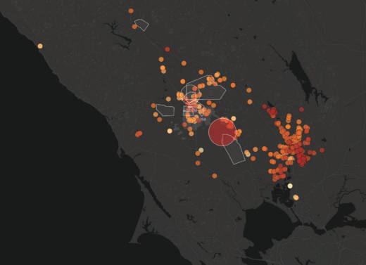
One of the major issues centered around timely evacuation orders. Sonoma County officials sent more than 20,000 reverse 911 calls on the first night of the fires to warn residents to evacuate.

But our analysis of those calls and radio traffic between dispatchers and first responders -- as seen in the map below -- shows that evacuations were requested before the SoCo Alerts were actually sent.

Sponsored

The map does not include opt-in text and email alerts sent by Sonoma County and Napa County officials. Napa County also has a system that can send reverse 911s called Nixle Dial. However, they did not utilize it until 1:38 p.m. on Oct. 9.

Where the Fires Burned and Who Was Called to Evacuate

Sonoma County officials sent more than 20,000 reverse 911 calls on the first night of the fires to warn residents to evacuate. But an analysis of thousands of 911 calls and radio traffic between dispatchers and first responders shows that evacuations were requested long before the SoCo Alerts were actually sent. The map does not include opt-in text and email alerts sent by Sonoma County and Napa County officials.

*It is unknown at what time people died or were critically injured on that night.
Sources: Sonoma and Napa counties, Cal Fire, cities of Santa Rosa, Napa and American Canyon
Graphic by Alexandra Kanik and Lisa Pickoff-White. Research by Peter Arcuni, Ingrid Becker, Sonja Hutson, Marisa Lagos, Sukey Lewis, Lisa Pickoff-White and Vinnee Tong

lower waypoint
next waypoint
State Prisons Offset New Inmate Wage Hikes by Cutting Hours for Some WorkersFresno's Chinatown Neighborhood To See Big Changes From High Speed RailErik Aadahl on the Power of Sound in FilmCecil Williams, Legendary Pastor of Glide Church, Dies at 94KQED Youth Takeover: How Can San Jose Schools Create Safer Campuses?How to Attend a Rally Safely in the Bay Area: Your Rights, Protections and the PoliceWill Less Homework Stress Make California Students Happier?Rainn Wilson from ‘The Office’ on Why We Need a Spiritual RevolutionNurses Warn Patient Safety at Risk as AI Use Spreads in Health CareSilicon Valley House Seat Race Gets a Recount